poor brine spill remediation
DESCRIPTION
From Bad To Worst: The Consequences of a Poor Brine Spill Remediation PlanTRANSCRIPT

From Bad To Worst: The Consequences of a Poor Brine
Spill Remediation Plan
Carla Landrum1, Cas Bridge1, Ean Garvin1, Dan Weber1, Jennifer Busch-Harris2,Kerry Sublette2 and Bryan Tapp1
1Department of Geoscience; 2Department of Chemical EngineeringCenter for Applied Biogeosciences
The University of Tulsa

Tallgrass Prairie Preserve (TGP)
• 39,000-acre nature preserve
• Purchased in 1989 by The
Nature Conservancy
• Oil production still occurs
Photos credited to: Oklahoma Center for Geospatial Information (OCGI), 2003

STB Site HistorySite impacted with brine in 2002 due to multiple leaks in a gathering line located on a steep slope.
Recommended Remediation Plan• Add hay and fertilizer to increase water
infiltration and mobilize salts• Anticipating the down-slope migration and
possible pooling of displaced salts, a subsurface drainage system to collect leachate was recommended
• Only hay and fertilizer application were actually implemented.

Through Flow
TGP Clay Layer
Brine Spill
Surface RunoffLeaching
Site Topography: An Issue
Capillary rise
Salt Seep

• Capillarity can be described as the migration of soil moisture against the forces of gravity– Occurs in unsaturated soil environments
• Three contributing factors of capillary action– Pore size in the soil matrix– Surface tension of soil water– Wettability of soil mineral particles
What is Capillary Migration?

The Importance of Understanding Capillary Action
• Capillary action causes the unexpected migration of brine within the soil– Has proven to negate remediation efforts – The same forces causing the vertical migration of brine also cause
the LATERAL migration of brine• Important to consider in measuring the true extent of brine
contamination within the soil over time
• Helps explain the persistence and growth of brine scars • Does your remediation strategy consider the consequences
associated with capillary migration?
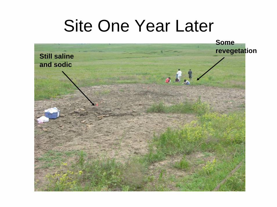
Site One Year LaterStill saline and sodic
Some revegetation

STB Brine Spill
Seep
?

Materials and Methods
• Electrical TerrainConductivity Meter(Geonics EM-31)
• Trimble Differential Unit
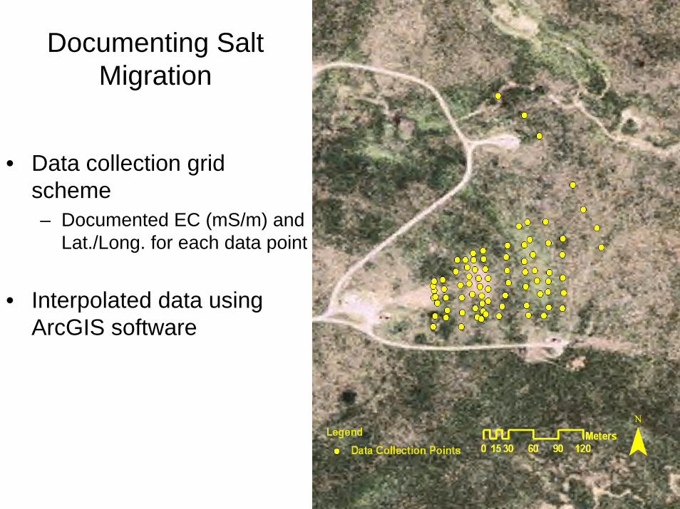
• Data collection grid scheme– Documented EC (mS/m) and
Lat./Long. for each data point
• Interpolated data using ArcGIS software
Documenting Salt Migration


Conclusion• A successful remediation plan for a brine spill has to take into consideration
where the salt will go. Salts have to go somewhere.• This geographic area is characterized by a relatively shallow and impermeable
clay layer so moving salts vertically out of the root zone was not an option. The result of neglecting this simple fact:
– Seep produced by migrating salts• Slope• Capillary migration
– Further transport of salts beyond the seep
• Necessary to implement drainage system, holding pond, or some other means to collect salts when natural patterns of drainage do not lead to adequate dilution of the salt over a large area
• Deviating from a comprehensive remediation strategy to save money in the short term has resulted the need now for an even more costly and labor intensive effort to remediate site
– Much more substantial artificial drainage system now required

Future Work
• Expand data collection grid in Southeast direction
• Use EM-31 to document salt migration at other sites
Acknowledgements• The University of Tulsa
– Center for Applied Biogeosciences• The Nature Conservancy• Integrated Petroleum Environmental
Consortium