porong and hot mud disaster
DESCRIPTION
Project Cities and SustainabilityTRANSCRIPT
A. Background
The Sidoarjo District (Kabupaten Sidoarjo) is one of the East Java
Province’s districts, which is located between 112.50 – 112.90 Longitude and 7.30 –
7.50 Latitude and 63,438,534 hectare wide, is the smallest district in East Java
Province. The Sidoarjo district is divided into 18 subdistricts (Kecamatan) and
353 villages (Desa and Kelurahan). Based on 2001 data Sidoarjo population was
1,293,111 person. Porong is one of Sidoarjo subdistricts, which is located around
40 Km south of Surabaya. Since May 29th 2006 Porong had faced a disaster that is
the mud volcano eruption. This mud was spurting up around 5,000 cubic meters a
day at first and now it is more like 130,000 cubic metres a day constantly
(Williamson, 2007). This has created a lake of mud and caused approximately 600
ha of land and villages to be buried and more than 10,000 people to become
domestic refugees. Moreover, based on The National Planning Body’s
(BAPPENAS) calculations, this disaster has caused infrastructure damage of 7.6
quintillion Rupiah or around 1 billion Australian dollars.
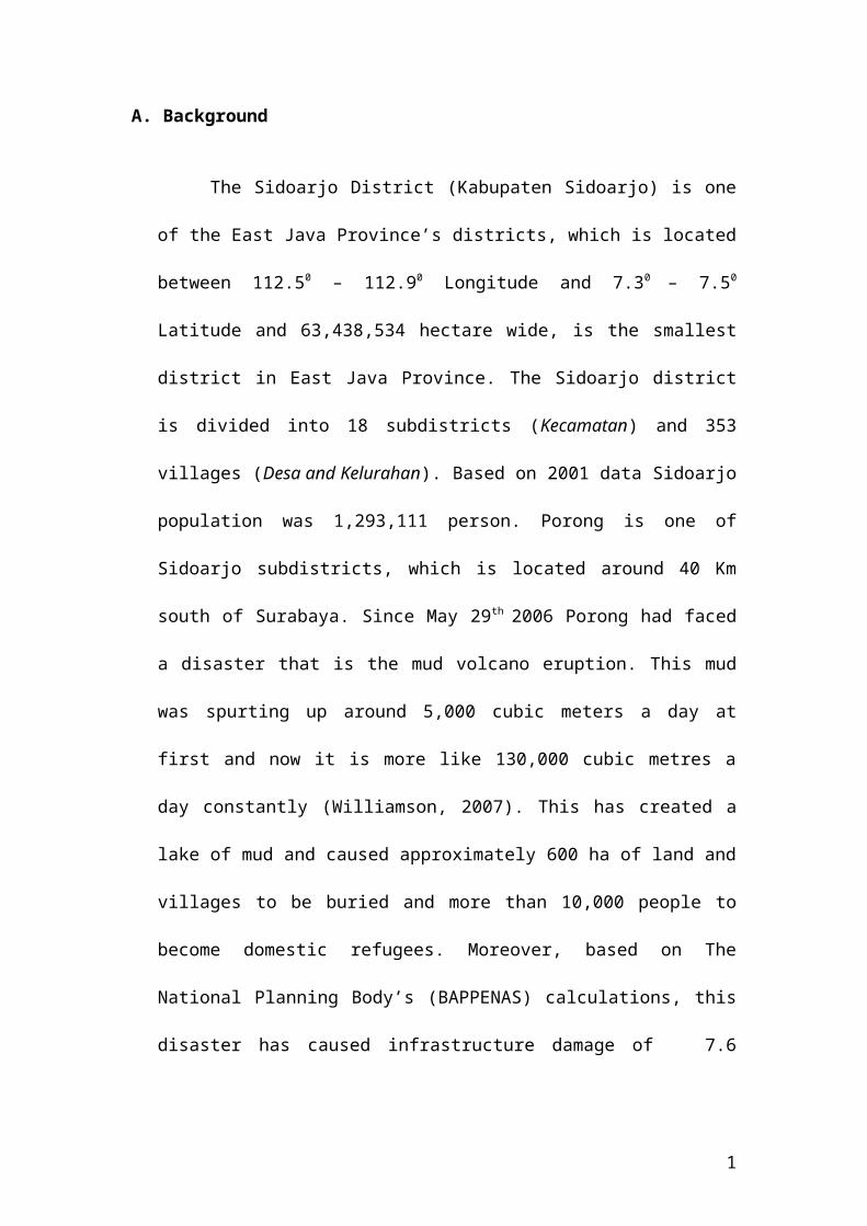
Figure1The Map Location of the Mud
Sources: Centre for Remote Imaging, Sensing and Processing, 2008
Sources: East Java Province Tourism board, 2008
1
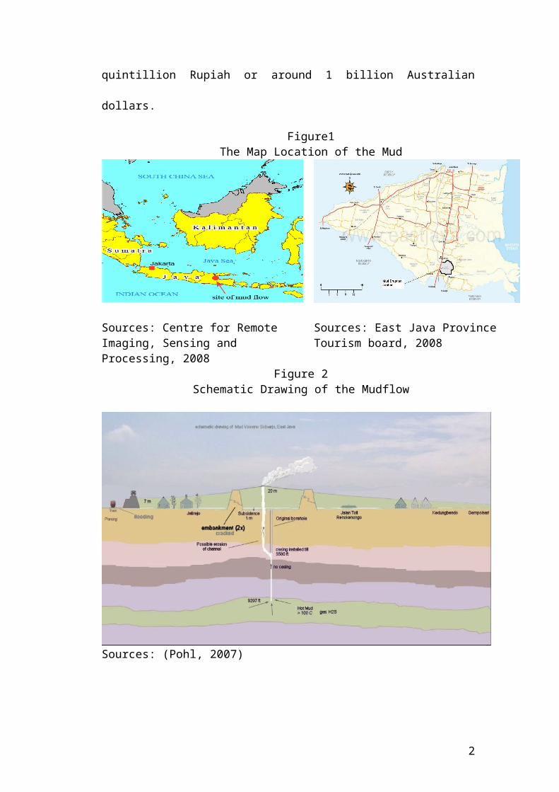
Figure 2Schematic Drawing of the Mudflow
Sources: (Pohl, 2007)
Public opinion adjudged that this disaster was triggered by oil drilling
activity conducted by PT Lapindo Brantas. Actually this drilling was
subcontracted to PT Medici Citra Nusantara, which is owned by the Bakrie Group
as well. It arose as a result of PT Lapindo Brantas’s failure to install a ‘casing’ to
cover the drilling well as required by Indonesian mining regulations. The mud
leaking occurred at a depth of around 1,800 metres (Pohl, 2007).
Most experts agree that the Porong Mud volcano was caused by the
underground blowout. Underground blowout is un-controlled flowing of fluids
that flow into the weakest areas. The weakest areas could be the areas that have
high permeability and high porosities or flow into the fracture zone in surrounds
casing shoe of the drilling activities (BPK Report, 2007). Interestingly there are
two opinions that explain the causes of the underground blowout. The first
opinion explains that drilling activities caused the mud volcano eruptions. Davies
2
(2007) analyse that the mud volcano that erupt in Porong is caused by a high-
pressure aquifer that is initiated by the fracture propagation in the multi-
kilometres depth. The nearest human activity on that region was the drilling
activity in BJP1 Well.
Whereas the other opinion mentions that this mud volcano was triggering
Jogjakarta earthquake on 27 of May 2006. That caused fracture zone in Porong.
This opinion is parallel to BPPT (Badan Pengkajian dan Penerapan Teknologi -
Agency for the Assessment and Application of Technology)
workshop that held on 6 October 2006 and 20-21 February 2007. In that workshop
BPPT concluded that the saucers of the mud are come from 1000-2000 meter
depth. The mud erupted to the surface because of the tectonic activities that
related to geo-hydrology and geothermal. In short the mud volcano in Porong was
triggered by the earthquake in Jogjakarta (Istadi, 2007; Budi, 2008).
Figure 3The Recent Picture of the Mud Eruption Centre
Sources: Kompas March 17,2008
3

B. PROBLEM IDENTIFICATION
Since the spraying out of hot poisonous mud almost a year and half ago, this
disaster has changed regional and provincial development planning. As Bridgman &
Davis (1998:p.34) comment since the problems have been identified, a private
concern such as an oil-drilling leak has been transformed into a policy issue.
Stone (1989:pp.281-282) point out three aspects that should be understood to
establish priorities. Firstly, the actors those involve must be identified and
understandable. In this case besides understanding the people who were displaced, the
others people who were affected indirectly such as the businesses that daily used the
freeway must be also recognized. Secondly is that, the multiple effects of the
problems must be identified. For example the mudflow not only disturbs the
distribution of goods but also disturbs the ecosystem as well. The next aspect is that
clear and well define policies is needed to solves the problems that have emerged.
1. Hot and Hazardous Mud
According to Dwi Andreas Santosa the Executive Director Indonesian Centre
for Biodiversity and Biotechnology (ICBB) that analysed the content of the Lapindo
Mud in early December 2006 found that the Lapindo Mud has Cd (Cadmium) 10.45
ppm (parts per million), Cr (Chromium ) 105.44 ppm, As (arsenic) 0.99 ppm, and Hg
(Mercury) 1.96 ppm (Antara, 2006). Moreover another research that was conducted
by the Public Works Department of East Java province found that the content of Hg
was bigger, namely 2.5 ppm. (Mawardi, 2006). Moreover according to an
environmental analysis initiated by the East Java Regional Development Office,
Sidoarjo Regional Environment and Mining Office, and PT Lapindo Brantas Inc., the
4

mud contains phenol at concentrations exceeding the maximum residue limit. Phenol
is toxic to fish and aquatic vegetation, not to mention human health (Pohl, 2007).
In addition, regarding to the mud microbiology analyses that were also
conducted by the ICBB showed that the Lapindo mud has dangerous bacteria such as
Coliform, Salmonella and Staphylococcus Aureus (Antara, 2006). Furthermore, this
mud volcano has H2S (hydrogen sulphide) gas radiation from the centre of the
gushing mud as well. Whereas It was reported that levels of H2S at 700 parts per
million (ppm) on the first day of the mud flow but this dropped to 3 ppm on the
second day and apparently zero on the third. In addition Small amounts of H 2S
continue to spew out from the site, at certain levels that make the air smell foul (Down
to Earth, 2006). However, other research that analyzed the mud characteristic that
was conducted by PT Energi Mega Persada classified that the mud as non-hazardous
and non-toxic (Pohl, 2007).
2. Businesses Relocation
Hamzirwan (2007) stated that at least 20 factories with 2,500 employees have
been closed and approximately 1,000 workers were fired because their factories have
been buried. Tempo (January 22, 2007) reported at least 15,000 factory workers lost
their jobs. Moreover the executive director of Greenomics Indonesia in Kompas
(2007, April 27) estimated that this disaster would reduce the East Java domestic
gross product by 10 % or Rp 469.2 quintillion. Moreover BPK (Badan Pemeriksa
Keuangan-the Finance Auditor Board) (2007) calculate that approximatley 71,383.37
Million rupiah potencial income from that region was lost.
5

Figure 4Industrial Area in Porong Buried
Sources: hotmudflow , wordpress,2006 Sources: Farm1,2006
Based on the Sidoarjo Regency’s Department of Small and Medium Business and
Cooperation data, it is reported that around 2,299 small business and medium
enterprises have collapsed and become bankrupt, and 80 % from those were small
businesses (2.299 Usaha Mati Karena Lumpur Panas - 2,299 Businesses Bankrupt
Because Of Lapindo Mud, 2007)
Moreover, Sidoarjo Deputy Regent Syaiful Illah (Interviewed by
Tempo) (January 22, 2006) estimated that this mudflow has reduced rice fields
productivity by around 12 tons of unhusked rice per hectare for every harvesting
season. The detail data shows that rice field areas that were affected by the mud are
in fourteen villages with 722.35 hectare wide (BPK, 2007).
3. Public Transportation Routes, Gas and Water Installations Relocation
The effects from this disaster are potentially to reduce national
economic growth by 1.03 %. In addition it also likely reduces the regional gross
domestic product of Sidoarjo by 90, 2 % (Lumpur Lapindo Turunkan Pertumbuhan -
Lapindo Mud Reducing the Economic Growth, 2007). This is because the mud
buried the freeway on the kilometer 37 – 39. Moreover the free way Fly Over in
6

Porong was cracked by subsiding effect on the 30 cm depth. Therefore this fly over
was demolished on December 28, 2008 (BPK, 2007). Beside that this mud threatened
the main road and the railway disrupting the distribution of goods in East Java
province especially in Sidoarjo regency.
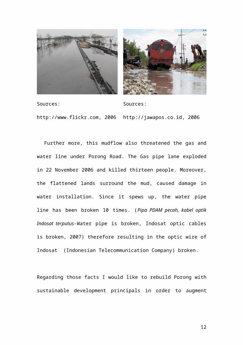
Figure 5The Buried Freeway and Threatened Railway in Porong
Sources: http://www.flickr.com, 2006 Sources: http://jawapos.co.id, 2006
Further more, this mudflow also threatened the gas and water line under Porong
Road. The Gas pipe lane exploded in 22 November 2006 and killed thirteen people.
Moreover, the flattened lands surround the mud, caused damage in water installation.
Since it spews up, the water pipe line has been broken 10 times. (Pipa PDAM pecah,
kabel optik Indosat terputus-Water pipe is broken, Indosat optic cables is broken,
2007) therefore resulting in the optic wire of Indosat (Indonesian Telecommunication
Company) broken.
Regarding those facts I would like to rebuild Porong with sustainable development
principals in order to augment the economic potencies surrounding the mud dissaster
location
7

C. DESCRIPTION PROJECT AREA
The Project location is in the Porong sub-district that has had mud volcano eruption
since May 2006. The wide of this area is approximately 471 ha. (BPK report, 2007)
Conversely, the local newspaper mentions that approximately 600 ha of land and
villages were submerged, farmland was ruined, businesses and schools closed.
Moreover, livelihoods lost as the mud inundated the surrounding area (Pohl, 2007).
This area consists of ten villages in three subdistricts. Fives villages in Porong
subdistrict, two Village in Tanggulangin subdistrict and three villages in Jabon
subdistrict.
Table 1Villages that is Buried by the Mud
Villages Subdistrict Siring
PorongRenokenongoJatirejoMindiKetapangKedungbendo
TanggulanginSentulBesuki
JabonKedungcangkringPejarakanSources: BPK Report, Pohl, etc
8

Figure 6Kedung Bendo Village that is Buried by the Mud
Sources: Detik.com, 2006
Figure 7The Disaster Map
Sources: Adopted from The Presidential decree Number 14/2007, 2008
9

1. Sidoarjo Regency Economic and Porong Position
Based on 2001 data Sidoarjo population was 1.293.111 person and has local
income (Pendapatan Asli daerah-PAD) Rp. 133,790.02 million (15.7 Million AU$)
and taxation was the biggest contributor. Moreover, Sidoarjo is the second richest
region after Surabaya.
In the last decade Sidoarjo experience roughly 5 % of growth (The Sidoarjo
Statistic Board, 2006). This growth was supported by industries activities that are
concentrated in three areas, firstly in Waru subdistrict second in Sidoarjo subdistrict
and in Porong subdistrict. Porong is one of Sidoarjo sub district, which is located
around 40 Km south of Surabaya. Porong economy activities were supported by 19
Villages with 17, 954 Households. The use of land Porong has 845.37-hectare
housing areas, 24.63-hectare industry areas, 5.09-hectare mining areas and 1,287.24-
hectare agriculture areas. (The Sidoarjo Statistic Board, 2006)
In order to maximise the growth government create triangle growth pole
program that is called as SIBORIAN. SIBORIAN is a kind of integrated area that
would be develops in three subdistricts East Sidoarjo, Jabon and Krian (Sidoarjo
Government, 2006).
10

Figure 8Jabon Industrial Estate Development Plan
Sources: Adopted from Sidoarjo Government, 2006
Jabon is one of Sidoarjo sub districts, which located around 5 kilometres east
of Porong. Planned Jabon Industrial area would be designated for manufacture
industries or other industries that could be paralyse to Provincial industrial areas
especially in PIER (Pasuruan Industrial Estate). Which PIER location is
approximately 30 kilometres south east of Jabon. The Jabon Industrial area has been
prepared around 2.450 (two thousand four hundred and fifty) hectares (Sidoarjo
Government, 2006).
Jabon sub district is relatively isolated compare the other sub district, which
means Jabon does not have appropriate road such as artery road or freeway or high
way. The way to get into Jabon is through Porong or Villages road from
11
Tanggulangin or Bangil artery road. Therefore when the Porong freeway buried the
access to this sub district was disturbed.
The main issues that the mud disaster influenced the Sidoarjo economic
growth negatively is that because the mud buried the one and the only freeway in the
East Java and threaten the main road that is used for goods distribution.
The national finance auditor board (2007) estimates that the economy cost that
would occur from 2006-2015 is approximately 32,895,970 Million Rupiah. This cost
consist from direct economic cost 9,890,364 million Rupiah or 60,46% , indirect
economic cost 7,407,440 Million Rupiah or 22,52%, and the smallest is relocation
cost 5,599,160 million Rupiah or 17,02%. Whereas Indonesia annual budget for 2007
was only 763,570 Million Rupiah which means that Indonesia government should
looking for best solutions that would not disturbs the national annual budget.
Therefore it is estimated that this disaster are estimated reducing national economic
growth by 1.03 % per year.
D. VISION FOR THE FUTURE OF PORONG
In order to keep the prosperity of Sidoarjo, there are at least two essential
policies that should be taken. Firstly the government should shift Porong to the new
location and adjust the other growth pole that is planned. Secondly the government
should localize the mud flood effects and develops unaffected area surround disaster
location with appropriate infrastructure. This project would create and suggest not
only minimizing and localizing the mud flood effects and develop unaffected area
surrounding the disaster location with appropriate infrastructure. As Jacobs (1995,
p20) states that citizens are not only belong to their respective origin but also belong
to the world. Which mean every single person would be attached to his or her place
12
not only natural places but also urban places. Moreover he underlines that the
important thing about the places is a place for sharing and for expressing ideas. This
means that Sustainability development is a kind of development that involved the
societies as active actors.
1. Assumptions Used
This project is based on four assumptions. The first is that the mud would still
erupt for more than 30 years and never stop. The second is that the subsiding land
could be predicted accurately. The next assumption is that the compensation fee for
the victims is cleared and the last but not least is that the Mud could be localised and
isolated.
2. Developing The Surrounding Area
Even shifting Porong to the other area is the most adequate method that could
fulfil all the stakeholders; the victims, the government and the suspect company but
developing the surrounding the disaster area is essential. To develop this area at least
there are three stages that should be taken. The first stage is localizing and
neutralizing the Mud. The second stages is replaced the entire infrastructure that are
threaten by this mud to save area. And the last is developing the economic potencies
surround disaster location.
2.1 Localizing and neutralizing the Mud
Neutralizing the hazardous content of the mud volcanos is urgent not only to
prevent pollution but also to prepare the mud as row material certain commodity such
pottery industry or other handy crafts. The minister of environmental decree number
42/1996 states that the tolerable oil and fat in water is 50 milligram per litter and has
pH level among 6 to 9.
13

According to Johannes Sudarsono the manager health, safety and environment
PT Lapindo Brantas Inc. states that the separation among mud and water could full fill
the ministry of environmental standards. This was base on the laboratory tested in the
Sepuluh Nopember Institute of Technology (ITS), The East Java road maintenance
department (Bina Marga Jawa Timur), and Succofindo. From those laboratory test
shows that the separation water and the mud could reduce the hazardous content of
the mud and result in neutral Mud pH and water. (Sunudyantoro.2006)
2.1.1 Localizing the mud flood
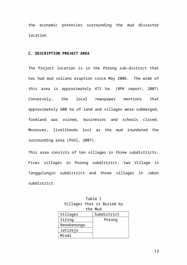
In order to localizing the mud spread, the authority board build dams. There
are five dams that was build to localize the mud. The first dam is along the un-buried
freeway. The second dam is on the south along the housing area. The third area is
along the rail way and Porong road. The fourth dam is from the spillway to the north
and the fifth is along the Tanggulangin Anggun Sejahtera housing area in
Kedungbendo village. That could be seen on the picture below
14

Figure 9The Five Dam Surround the Mud Eruption Centre
Sources : Adapted Centre for Remote Imaging, Sensing and Processing, 2008
2.1.2 Neutralizing the Mud
In order to neutralizing the mud, the authorities was to build containment
'basins' or 'ponds' by enclosing areas of land within earth walls, or levees. Until
January 2007 the authority board has had build 11 ponds that have ± 251, 9 Hectare
and 16 Km length. The detail could be seen on Table below.
15

Table 2The Ponds Capacity
Pond/ basin Location Wide (Ha) Capacity estimation
Maximum capacity
%
Pond A and B
Renokenongo 29.5 1,180,000 1,167,000 95
Pond C-1 Kedungbendo 3 60,000 57,000 95Pond 1,2,3,4,c-2
Jatirejo 94 4,450,000 4,361,000 95
Pond 5 MindiPejarakanKedungcangkringBesuki
90 3,600,000 1,800,000 50
Pond Snubbing
BJP-1 Siring 35.4 2,124,000 2,017,800 95
Total 251.9 11,744,000 9,402,800 80.06Rest 2,341,200 19.94Sources: BPK Report, 2007
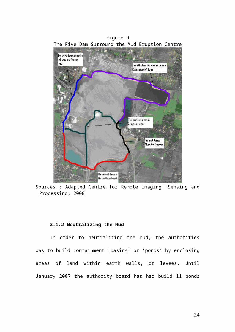
The first aim in building the pond is to localize and neutralize the mud.
Therefore it is important that to filter the mud at least in to three stages. The first filter
is to catalysing the hazardous content of the mud to the air (Zone 1). The second filter
is to separate the mud and the water in order to keep the neutrality of the water from
certain mineral (Zone 2) and the last is channelling the mud to the river or to the area
that is could be use as storage area for pottery industry (Zone 3). The design of this
pound should have a canal that is functioned as control tools if the pond is out of
capacity. The detail design could be seen on the figure below.
16

Figure 10The Staging of the Filtering Pond
Sources: Adapted from Centre for Remote Imaging, Sensing and Processing ,2008
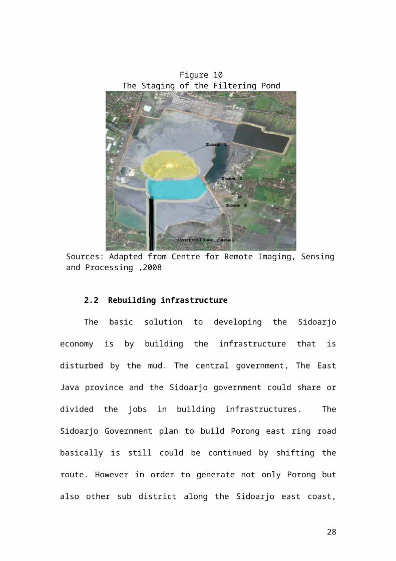
2.2 Rebuilding infrastructure
The basic solution to developing the Sidoarjo economy is by building the
infrastructure that is disturbed by the mud. The central government, The East Java
province and the Sidoarjo government could share or divided the jobs in building
infrastructures. The Sidoarjo Government plan to build Porong east ring road
basically is still could be continued by shifting the route. However in order to
generate not only Porong but also other sub district along the Sidoarjo east coast, the
Sidoarjo government have two choices. Firstly is that the Sidoarjo government up
grade the villages’ road that channelling the Sidoarjo east ring road that is recently
ended in Candi Subdistrict through the freeway on the kilometre 45 which not buried.
The second alternative is up grading the road from Ngaban market through kali
Kalitengah Village and Kalidawir village. This alternative from Kalidawir could
17

continue the Porong east ring road plan. From these alternatives the first alternative
would give the biggest multiplier effect to the villages that is passed by the “road”.
Beside the local government plan, the central government has planned to
build this infrastructure especially to redevelop the freeway. There are three options to
develop or to shift the freeway.
Figure 11The Suggested Alternative Infrastructures Map
Sources: Modified from Google Earth, 2008
2.3 Rebuild the buries freeway
The Indonesian Ministry of Public Works propose at least three alternatives to
re building the freeway (Public Work Department Website, 2007). The first
alternative is to rebuild the highway by constructing an elevated road above the
18

Porong arterial road. This alternative is predicted to need approximately 1.7
trillions rupiah for 7 kilometres road. This alternative is the fastest route and the
easiest because the land does not need expropriating, but it has the higher risk
because of the subsiding land a round mud flood.
The second alternative is to construct a new road starting from the existing
road through western Porong that has length around 9.5 kilometres. This
alternative is difficult to implement due to dense population, therefore it is
difficult to expropriate the land for construction.
The last alternative is to build a new road around 10.7 kilometres and this
alternative is the safer alternative because the location is far from the mudflow
explosion centre. This alternative as well as the second alternative involves the
expropriating land.
2.4 Continuing the Sidoarjo East Ring Road
Continuing the Sidoarjo East ring road is seemed the most reasonable plan. This
option could up grading the villages’ road from the end of Sidoarjo east ring road in
Candi Village. This development approximately builds 30 kilometres villages road
and would cross the proposed Jabon Industrial areal that is planned under SIBORIAN
planing. This alternative up grade the villages street such as Kendal Pecabean
Village, Sanganewu, Setul in Tanggulangin subdistrict and finish in Mrisen, Porong
subdistrict. In Mrisan-Glagaarum the road could be separated in to two directions
firstly this “east ring” road could be united with the freeway on the kilometre 45. The
second direction is the road is build to the east Through Permissan Village and
Balonggabus Village. The end of this road would be in the Gondanglegi high road.
19

2.5 Build a New Freeway and a Railway
The new freeway that is suggested is located in the eastern Sidoarjo and
Surabaya that goes along to the coast, and it is connected to the Suramadu Bridge, the
Surabaya seaport and Juanda airport
Figure 12Surabaya- Sidoarjo existing and Propose Freeway and Highway
Sources: Adopted from East Java Province Tourism board; Engineering and Consulting Firms Association, 2008
Besides developing the east freeway, building railway along the freeway is
recommended. Both new infrastructures are not only become alternative
transportation but also could generate development in eastern of Sidoarjo.
Those transportation infrastructures could channelling the PIER in Rembang
to Jabon Industrial area and have direct access through the Juanda airport and the
Tanjung Perak seaport.
20

3 Developing Economic Potential
3.1 Pottery Industry
Based on the X-ray spectrometer analysis, the mud test produced the following
results for the composition of the solid fraction of the mud: Iron 83, 1%, Silicon 4,
1%, Potassium 4, 1%, Calcium 4, 1%, Titanium 1, 8%, Chlorine 1, 6% (Pohl, 2007).
Moreover, another test that uses certain burning technique shows that the mud could
be use as ceramic raw material.
Recently the people surrounding the mud disaster area use the mud as the raw
material for making brick and clay roof. Regarding that, the government could
encourage people to make other industry such as ceramic or pottery industry by
clustering the area and provide a certain assistances that could give guidance to the
community to create good products. The Pottery industry areas are suggested to be
located in the east of mud location that closes to the proposed industrial area in Jabon.
This Industry could absorb the forced unemployment that is caused by the
mud such as the factories labour or the farmer, which their work place buried.
3.2 Tourism
According to Sofian Hadi operational deputy of the Sidoarjo mud disaster
Mitigation board, the mud that was spurted up in Porong has high Iodine content
around 6000 ppm. Therefore it is has potential to become mud spa material (Minarak,
2007). The high quality mud that consists of certain mineral could be used as
cosmetics such as mudpacks, mud soaps.
21

Besides that the tourist attraction could be developed such as mud ski or
outdoor activities in mud areas such as a mega mud tub, mud wrestling, mud sliding, a
mud prison, and mud military training and so on. Korea and Turkey have developed
tourism based on mud. For example in the Daecheon beach in Korea. In this beach
has special attractions held every June. These attractions are called a mud festival. In
this festival the tourist could have unique activity experiences based on mud such as
getting submerged in a grand mud tub or Children enjoying a kid-size mud tub. The
other activities that could be found in this festival such as mud sliding, a mud prison
and mud hand printing. Beside those activities, the participants could join in mud
wrestling. In which two equally muddy partners wrestle in mud arena. Interestingly in
this festival there are photo contests. When the participants got too muddy they are
offered to join in this photo contest. They are asked to pose in unique poses with
muddy form. Even not win the contest it is believed that mud photo contests are
good ways to capture some good memories of messy days in mud festival.
The location that suggested as Mud tourism centre is in the south of the mud
pond near the Porong River. This area could be developed with shopping centre and
recreation centre base on mud. The detail could be seen on the picture below.
22

Figure 13The Suggested Mud Tourism Area and the Pottery Area
Source: Modified from Google earth, 2008
Beside develop the mud tourism; the government could develop adventures
activities along the Porong River. Indeed the safety from these activities must be
considerate. Such as build towers along the river route are needed for the lifeguard.
3.3 Geothermal Power Station
The hot mud eruption in Porong actually could be used to generate power
through geothermal energy. This energy basically is from deep within the Earth where
temperatures can reach up to 6000°C. At a depth of five kilometres from the Earth’s
surface, the temperature decreases to around 200°C. Until May 6, 2008 there are 85
eruption centres surrounding Porong (Surya; May 6, 2008). From these potencies
could be considerate to plan a geothermal power plant. Such a geothermal power
23
station would not only to get the energy through generators but also could manage the
eruption volume of the mud. The simple design of the geothermal could be seen from
the Birdsville geothermal power station in Queensland.
Figure 14Birdsville Geothermal Power Station
150 KW Electric Capacity
Sources: Queensland Government, 2008
From that design it clear can be seen that the geothermal power plan is not only
produce electricity power but also could produce water and in the Porong case I
personally believed that could manage the sprawling of the mud as well.
E CONCLUSION
It cannot be denied that every policy is always related to politics (Ramesh &
Howlett, 2003: p.89). However the targeting policy must be reached in order to give
satisfaction to the citizens. Actually the mud disaster is not big enough to disturb
Sidoarjo economy if this area not dependent of the freeway and Porong road.
Therefore integrated and sustainable development is needed. In the mudflow case in
Porong, an equitable policy needs to reduce the wider effects, such as practicing
24

sustainability development by building a new infrastructure that uses existing local
roads by channelling that road to the Sidoarjo east ring road as a sort term solution.
However long-term solutions are needed such as building railway from Bangil trough
the proposed Jabon industrial area that go along until the Juanda airport. Afterwards
that rail way is connected to Wonokromo station (the existing railway). As Newman
and Kenworthy (1999, 22) state development that ignores the sustainability aspect is
development that misses out the rapid innovation process and would have to wait a bit
longer to catch up.
25

REFERENCES
2.299 Usaha Mati Karena Lumpur Panas (2,299 businesses bankrupt because of Lapindo mud). 2007. Kompas. January 12. Accessibility from: http://www.kompas.com/ver1/Nusantara/0701/12/112514.htm. (Retrieved October 18, 2007).
Antara. 2006. Kandungan Logam Berat Dalam Lumpur Lapindo Meningkat. Thursday Desember 14. Accessibility: http://www.mediacenter.or.id/pusatdata/27/tahun/2006/bulan/12/tanggal/14/id/1313/ (Accessed March 21,2008)
Bola Beton Tembus Pusat Semburan (Concrete Balls Insert into the Mud). 2007. Jawa Pos. February 25. Accessibility: http://www.jawapos.co.id/index.php?act=detail&id=8233.(Retrieved February 25, 2007).
BPK (Badan Pemeriksa Keuangan- Financial Auditor Body). 2007. Laporan Pemeriksaan Atas Penanganan Semburan Lumpur Panas Sidoarjo. (The audit of Sidoarjo Hot Mud Mitigation). Accessibility from :http://www.bpk.go.id/doc/hapsem/2007i/disc1/APBN/117_Penanganan_Semburan_Lumpur_Panas_Sidoarjo.pdf( Retrieved May 02,2008).
Budi ,Kurniasihi. 2008. BPPT Simpulkan Lumpur Lapindo Bencana Alam (BPPT Concluded That Lapindo Mud is Natural Disaster). Tempointeraktif, Tuesday 18 march. Accessibility from : http://www.tempointeraktif.com/hg/nasional/2008/03/18/brk,20080318-119419,id.html (Retrieved May 04, 2008)
Bull, R. 1994 Disaster economic: Disaster Management Training Programme. Accessibility: from UN Disaster Management Training Programs website: http://www.undmtp.org/english/disaster_economics/disaster_econ.pdf. (Retrieved September 25, 2007)
Bridgman, P & Davis, G. 2004. The Australian policy handbook. New South Wales: Allen & Unwin.
Dad.2007. Potensi Manfaat Lumpur Sangat Tinggi (the High Potnecies of theMud). Accesibility from: http://main.minaraklj.com/content/view/231/51/ (Retrieved May12,2008).
Davies .Richard J.2007. Birth of a mud volcano: East Java, 29 May 2006. Geological Society of America (GSA Today) volume 17 No.7 February. Accessibility: http://www.walhi.or.id/attachment/d016df19778a7c563cd1c99afe29c43a/d8e46e5bd18a77d25eb39afaa39a9479/birth%20of%20mud%20volcano.pdf (Retrieved May 20,2008)
26

East Java mudflow disaster. 2006. In Down to earth No. 71, November. Accessibility: International Campaign for Ecological Justice in Indonesia website: http://dte.gn.apc.org/71mud.htm.( Retrieved August 30, 2007)
Energi Mega Persada. 2007. Chronology of Banjarpanji. Accessibility : http://www.energi-mp.com/chronology.asp.(Retrieved October 18, 2007).
Engineering and Consulting Firms Association, Japan Nippon Koei co., ltd.2007. Project Formation Study on Surabaya Toll Ring Road Construction Project. Accesibility from : http://www.ecfa.or.jp/japanese/act-pf/h18/ppp/nk_surabaya.pdf( retreieved may 02,2008)
Gelder, J.W and Denie,s. 2007. The Financing of the Three Brantas PSC Companies. In Friend Of The Earth International. Accessibility : Friend Of The Earth Europe website: http://www.foeeurope.org/publications/2007/Brantas_financing.pdf. (Retrieved August 30, 2007).
Gersto,L.N. 2004. Public Policy Making. Newyork,London: ME Sharpe.
Hamzirwan. 2007. Lumpur Panas Yang Bikin Mulas (Hot Mud Made Sick) [Electronic Version].Kompas March 24. Accessibility: www.greenomics.org/news%5CNews_20070324_ko2.doc –.( Retrieved September 3, 2007).
Indonesia. National secretariat. 2007. Masa Kerja Timnas Penanggulangan Lumpur Lapindo Diperpanjang (The Mitigation National Team Working Period is Extensioned) [Electronic Version]. Accessibility: http://www.setneg.go.id/index2.php?option=com_content&do_pdf=1&id=169( Retrieved October 1, 2007).
Indonesia. National Website. 2006. Snubbing Unit Gagal Atasi Semburan, Lapindo Siapkan Skenario Kedua (Snubbing Unit Failed, Lapindo Prepare The Second Scenario)[ Electronic Version}. Accessibility: http://www.indonesia.go.id/id/index.php?option=com_content&task=view&id=1413&Itemid=687.( Retrieved October 18, 2007)
Indonesia. Public Work Department. 2007. Three Alternatives of Porong-Gempol toll road relocation [Electronic Version]. Accessibility:http://www.pu.go.id/index.asp?link=Humas/news2003/ppw301106put.htm.( Retrieved October 3, 2007).
Indonesia. Presidential Website. 2007. Keterangan Pers Presiden Mengenai Penyelesaian Lumpur Lapindo (Presidential press release for Lapindo mud mitigation) [Electronic Version}. Accessibility : fromhttp://www.presidenri.go.id/index.php/pers/presiden/2007/06/27/270.html.( Retrieved October 18, 2007)
27
Indonesia. 2007. Presidential decree number 14. about the Lumpur Sidoarjo Mitigation Board. Accsesibility: http://els.bappenas.go.id/upload/undang-undang/perpres-14-2007.pdf( Retrieved Pebruary18,2008)
Indonesia. National Constitution. 1989. The 1945 Constitution of the Republic of Indonesia the third amendments. From the website of Law and Human rights Department: http://www.ham.go.id/images/sjdi/uud45_pertama.pdf (Retrieved March 26, 2009).
Istadi, Bambang.2007. LUSI - Birth of a Mud Volcano (History and impact of Mud Volcano disaster in East Java). Accesibility : http://balikpapan.spe.org/images/balikpapan/articles/51//Birth%20of%20a%20Mud%20Volcano%20v2.pdf.( Retrieved May 20,2008)
Jacobs,J.1969. The Economy of Cities. Penguin, Ringwood (Vic) Chapter 3: the valuable inefficiencies and Impracticalities of Cities.
Kingdon, J.W. 1995. Agendas, alternatives, and public Policies. 2nd ed. 196-208. New York: Harper Collins. Reprinted in Public Policy Analysis (POL430) Unit Reader 2007, 69-75. Murdoch: Murdoch University.
Lapindo Brantas shirking its responsibility for damage caused by the mud volcano in Sidoarjo, Indonesia (2007). In Friend Of The Earth International. Retrieved August 30, 2007, from Friend Of The Earth Europe website: http://www.foeeurope.org/publications/2007/exec_summ_banks_Indonesian_mud_flow.pdf.
Lumpur Lapindo Turunkan Pertumbuhan (Lapindo mud reducing the economic growth) 2007. Kompas. April 27, 2007. Accessibility from: http://www.kompas.com/ver1/Ekonomi/0704/17/185447.htm. (Retrieved October 18, 2007).
Luapan Lumpur Panas di Porong, Sidoarjo. (the Hotmud wide-spread in Porong, Sidoarjo). (2006) In Evaluasi Perkembangan Ekonomi, Perbankan & Sistem Pembayaran Jawa Timur Triwulan II–2006. Retrieved September 3, 2007, from Bank Indonesia website: http://www.bi.go.id/NR/rdonlyres/5538C89F-AB50-4BE7-98E7-ACA69F3051B3/5829/Boks1.pdf.
Mawardi, Adi. 2006. Kandungan Kimia Lumpur Panas Lapindo Diambang Batas. From the website of Tempo Interaktif Thursday,Juni 15. : http://www.tempointeraktif.com/hg/nusa/jawamadura/2006/06/15/brk,20060615-78933,id.html (Acceseed February 24, 2008).
Media Indonesia. (2007). Lapindo telah cairkan rp14.448 miliar dana relokasi sementara. ( Lapindo Gave Rp 14,448 billion for compensation). Retrieved September 28, 2007 from http://www.mediaindonesia.com/berita.asp?id=110947).
28

Newman,P.&Kenworthy,J. 1999. Sustainability and Cities. Overcoming Automobile Dependence.Island Press: Washington D.C
Pipa PDAM Pecah, Kabel Optik Indosat Terputus (Water pipe is broken, Indosat optic cables is broken). 2007. Kompas. October 1. Accessibility : http://www.kompas.com/kompas-cetak/0710/01/utama/3885456.htm.(Retrieved October 3, 2007)
Pohl,Christine.2007. Lapindo Brantas and the Mud Volcano Sidoarjo, Indonesia. Accessibility:http://www.foeeurope.org/publications/2007/LB_mud_volcano_Indonesia.pdf.( Retrieved August 30, 2007)
Queensland Government.2008 Renewable energy. Accessibility from: http://www.epa.qld.gov.au/register/p00395aa.pdf( Retrieved May 20,2008).
Sidoarjo Government.2006.Gambaran Umum Siborian (A general portrait of Siborian). Accessibility from: http://www.sidoarjokab.go.id/?content=05-investasi/siborian/siborian_ina.htm (Retrieved February 21,2008).
The Sidoarjo Statistic Board.2007. Sidoarjo in Figure 2006. Accessibility: http://www.sidoarjokab.go.id/03-bank_data/06-sidoarjo-angka/index.php (Retrieved March 01,2008)
Stone, Debora A. 1989. Causal Stories and the formation of policy agendas. Political Science quarterly 104 (2): 281-300 Reprinted in Public Policy Analysis (POL430) Unit Reader 2007, 12-22. Murdoch: Murdoch University.
Sugiarto, Toto. 2007. Interpelasi kasus lapindo (Lapindo case interpelation)[Electronoic version].Kompas June 18. Accessibility From: http://www.kompas.com/kompas-cetak/0706/18/opini/3604214.htm(Retrieved September 11, 2007).
Sumotarto,Untung, Design of a Geothermal Energy Dryer for Beans and Grains Drying In Kamojang Geothermal Field, Indonesia . Accessibility: http://geoheat.oit.edu/bulletin/bull28-1/art5.pdf(Retrieved May 20,2008)
Sunudyantoro.2006. Air Lumpur Lapindo Memenuhi Baku Mutu. From the website of Tempo Interaktif, September 30: http://www.tempointeraktif.com/hg/nusa/jawamadura/2006/09/03/brk,20060903-83209,id.html (Accessed February 24,2008)
Taylor,S. et. al. 1997. Educational policy and the politics of change. London: Routledge.
29

Tempo Interactive.(January 22, 2007). Pengungsi korban lumpur porong mencapai 14 ribu orang lebih ( 14 thousand refugees of Lumpur Lapindo)[Electronic Version]. Accessibility from http://www.tempointeraktif.com/hg/nusa/jawamadura/2007/01/22/brk,20070122-91695,id.html.( Retrieved September 28, 2007)
Tempo Interactive. ( February 9, 2007). Pemerintah usulkan tambahan anggaran bencana ( The Government increase the emergency fund)[Electronic Version]. Accessibility From: http://www.tempointeraktif.com/hg/nasional/2007/02/09/brk,20070209-92905,id.html.(Retrieved October 3, 2007).
Tempo Interactive. (July 15, 2006). Penyumbatan Semburan Lumpur Lapindo makin sulit (more difficult to stop the lapindo mud eruption)[Eletronic Version]. Accessibility From: http://www.tempointeraktif.com/hg/nusa/jawamadura/2006/07/15/brk,20060715-80192,id.html.(Retrieved October 18, 2007).
Visit Korea.2006. Boryeong Mud Festival. Accesilibity : http://www.visitkorea.or.kr/enu/SI/SI_EN_3_6.jsp?cid=260537 (Retrieved May 1,2008)
Williamson, L. 2006. Java Villages Drown in Mud Lake [Electronic version]. BBC News October 05. Accessibility from: http://news.bbc.co.uk/2/hi/asia-pacific/5408850.stm.( Retrieved August 30, 2007).
World Health Organization. 2006. Hot Mud Flood, Sidoarjo, East Java. Accessibility from WHO website: www.who.int/entity/hac/crises/idn/sitreps/indonesia_east_java_sitrep6_23nov2006.pdf -.( Retrieved August 30, 2007).
30