port of nome strategic development plan - mcdowell … of nome . strategic ... 11 figure 5. port of...
TRANSCRIPT

Port of NomeStrategic Development Plan
January 2016

Port of Nome Strategic Development Plan
Prepared for:
City of Nome
Prepared by:
Juneau Anchorage
January 2016
McDowell Group Anchorage Office 1400 W. Benson Blvd., Suite 510 Anchorage, Alaska 99503
McDowell Group Juneau Office 9360 Glacier Highway, Suite 201 Juneau, Alaska 99801
Website: www.mcdowellgroup.net
Prepared with assistance from:
Nome Port Commission:
Jim West
Tony Cox
Megan Alvanna-Stimpfle
Charlie Lean
Rolland Trowbridge
Michael Sloan
Doug Johnson
Joy Baker, Port Director

Table of Contents
Chapter One: Introduction ....................................................................................................... 1 Chapter Two: Nome Port and Harbor Facilities ...................................................................... 3
Description of Port and Harbor ................................................................................................ 3 Uplands .................................................................................................................................... 6 A Strategic Regional Port .......................................................................................................... 6 Port Activity .............................................................................................................................. 8
Chapter Three: Development Landscape .............................................................................. 13 Fisheries ................................................................................................................................. 13 Mining Activity ....................................................................................................................... 14 Visitor Industry ....................................................................................................................... 16 National Security and Public Safety ........................................................................................ 18 Research ................................................................................................................................. 19 Oil and Gas Support ............................................................................................................... 20 Deep Draft Arctic Port ............................................................................................................ 21
Chapter Five: Port Development Strategies .......................................................................... 23 Competitive Position .............................................................................................................. 23 Capital Projects ...................................................................................................................... 24 Port Engagement and Outreach ............................................................................................. 25
Appendix: Port Development Graphics ................................................................................. 27
List of Tables
Table 1. Port of Nome Development Projects ................................................................................... 4 Table 2. Aviation Activity at Nome Airport, 2014 ............................................................................. 7 Table 3. Port of Nome Total Vessel Port Calls, 1990—2015 ........................................................... 12 Table 4. Nome Census Area Commercial Fishing Activity, 2005—2014 ......................................... 13 Table 5. Norton Sound Seafood Products Harvest, 2015 ................................................................ 14 Table 6. Alaska Visitor Volume, by Transportation Market, 2014 .................................................... 16 Table 7. Nome Cruise Ship Traffic, 2006—2015 (2016 proj.) ......................................................... 17 Table 8. Western and Northern Alaska Cruise Traffic, 2015 ............................................................ 17
List of Figures
Figure 1. Port of Nome Revenue by Source, FY1990—FY2015 ......................................................... 9 Figure 2. Port of Nome Gravel Total Volume and Revenue, FY1990—FY2015 .................................. 9 Figure 3. Port of Nome Fuel Total Volume and Revenue, FY1990—FY2015 ................................... 10 Figure 4. Port of Nome Freight Total Volume and Revenue, FY1990—FY2015 ............................... 11 Figure 5. Port of Nome Total Vessel Port Calls, by Type, 1990—2015 ............................................ 11

Port of Nome Strategic Development Plan McDowell Group, Inc. Page 1
Chapter One: Introduction
The Port of Nome, located just south of the Arctic Circle, is strategically positioned to serve national, state,
regional, and local needs. Nome is the regional transshipment hub for many Western Alaska communities that
rely on the port for movement of heating oil and gasoline, construction supplies, non-perishable food, gravel,
and other cargo. Recently selected by the Corps of Engineers (COE) as the Arctic Deep Draft Port (DDP) site,
Nome is poised to play an increasingly important role in a changing Arctic. This document describes the Port
of Nome and its activities, summarizes industrial activity in the region facilitated by the port, details the recent
COE Deep Draft Port designation, and identifies ways the port can position itself for continued growth and
stimulate further regional economic development.
Nome is a town of 3,800 residents situated on the shore of the Bering Sea near the southern end of Seward
Peninsula. Nome’s most significant employment sectors include state and local government (27 percent of
jobs); education and health services (26 percent); and trade, transportation, and utilities (17 percent).1 By the
regional standard in Western Alaska, Nome is a well-developed regional hub offering daily jet service; a port
and network of roads; relatively reliable telecommunications; and water, wastewater, and sewage services. The
community offers a level-four trauma center, fire department, and expects to receive upgraded fiber optic
connectivity by 2016.2
The cost of living in Nome is
elevated relative to state and
national levels. Groceries cost 60
percent more in Nome than in
Anchorage. A gallon of gas often
exceeds $5.00 per gallon, and
the average home costs $8,457
to heat per year, more than triple
the cost of the average
Anchorage home.3
While the ice-free season is gradually increasing, Nome’s port is typically closed six months of the year when
seasonal ice prevents vessel operations.4 Consequently, the ice-free period between June and December is very
busy, with vessels bringing goods to be utilized in Nome or transshipped to communities throughout the
region. Commercial fishing activity in the port increases in the summer when harvesters target primarily salmon,
halibut, and king crab.
1 State of Alaska Department of Labor, 2014. 2 http://www.adn.com/article/20150510/arctic-spanning-fiber-optic-project-moves-ahead-alaska. 3 https://www.ahfc.us/efficiency/research-information-center/housing-assessment/. 4 Personal Communication, Joy Baker, Port Director, City of Nome, December, 2015.

Port of Nome Strategic Development Plan McDowell Group, Inc. Page 2
Improvements have been made to the Port of Nome for nearly a century. Construction of Nome’s original
jetties began in 1919 and were complete by 1923.5 A seawall protecting Nome was constructed in the early
1950s and the 3,000 ft. armor stone causeway was built in 1985. Two sheet pile docks located on the causeway
were operational by the early 1990s, currently providing a port depth of -22 feet mean lower low water (MLLW).
The addition of the east breakwater in 2006 significantly increased port capabilities by decreasing the number
of days port operations were limited due to weather. Completion of the 210-foot Middle Dock in 2015 added
much needed moorage space. Expected construction of a Deep Draft Port facility on Nome’s existing causeway
would add significant cargo capacity and allow larger vessels to moor at the port.
Located in close proximity to the Bering Strait, residents of Nome and nearby communities are observing
increased vessel traffic due to industrial and recreational activity. In 2009, 280 vessels transited the Bering Strait;
just four years later, this figure increased to a record 480 vessels. Vessel traffic from the Russian side of the
Bering Strait has increased as well. In 2014, 53 vessels used the Northern Sea Route; a sizeable increase over
2010 when just four vessels used this route. 6
Vessel Activity in Northwest Alaska, 2015
Source: Marine Exchange.
5 http://www.poa.usace.army.mil/Portals/34/docs/operations/RH/nome/2012NomeHarborPIProject.pdf. 6 Marine Exchange, 2015.

Port of Nome Strategic Development Plan McDowell Group, Inc. Page 3
Chapter Two: Nome Port and Harbor Facilities
The Port of Nome offers the most developed and capable maritime infrastructure in Western Alaska. This
chapter describes the port’s infrastructure, role in the region, and activity.
Description of Port and Harbor
Since the early 1900’s, the Port of Nome has served as a regional hub for commerce and community
development. After a century of activity and investments, Nome’s port facilities serve a wide variety of
customers, including subsistence and commercial fishermen, gold dredgers, regional shippers, tourism
operators, public research and enforcement vessels, and vessels engaged in operations north of the Arctic Circle.
Nome’s outer harbor is composed of a 3,000-foot causeway, three sheet pile docks, and a breakwater to the
east. Shipping companies use these docks for loading and unloading cargo, gravel, and refined petroleum
products. The shallower inner harbor is located at the mouth of the Snake River and includes the Small Boat
Harbor and Snake River development. This harbor supports smaller vessels including gold dredging operations,
commercial fishing, and recreation travelers. In general, the outer harbor is used for incoming cargo and fuel
and outgoing gravel. The inner harbor facilitates redistribution of these and other supplies to outlying
communities.
Port of Nome, 2015
Source: City of Nome.7
7 Note: Unless otherwise specified, all photos in report are used with permission from the City of Nome or Garrett Evridge.
Port of Nome Strategic Development Plan McDowell Group, Inc. Page 4
As a public port, Nome is open for all commercial and non-commercial users. The COE conducts annual
dredging of the navigation channels and maneuvering basins. The City of Nome is responsible for dredging of
berthing areas in front of the sheet pile docks. Vessel activity at the outer harbor typically occurs following
breakup in June and concludes in November. The inner harbor usually freezes over in October and the outer
harbor is iced-in by December. Nome residents use the frozen port as a transportation corridor for commuting,
hunting, and fishing.
A major advantage of the port is a narrow tidal range, generally no more than 1.5 feet. However, during storm
events, tidal surges can significantly affect water levels. During heavy southerly storms, vessels are prevented
from mooring at causeway docks because of wave action. The water level at the port fluctuates significantly
depending on the direction and duration of wind. A sustained southerly wind can increase water levels in the
port by six feet while a northerly wind can reduce water levels by the same amount.
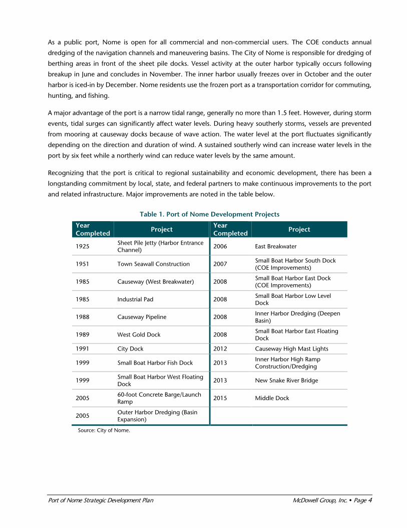
Recognizing that the port is critical to regional sustainability and economic development, there has been a
longstanding commitment by local, state, and federal partners to make continuous improvements to the port
and related infrastructure. Major improvements are noted in the table below.
Table 1. Port of Nome Development Projects
Year Completed
Project Year Completed
Project
1925 Sheet Pile Jetty (Harbor Entrance Channel)
2006 East Breakwater
1951 Town Seawall Construction 2007 Small Boat Harbor South Dock (COE Improvements)
1985 Causeway (West Breakwater) 2008 Small Boat Harbor East Dock (COE Improvements)
1985 Industrial Pad 2008 Small Boat Harbor Low Level Dock
1988 Causeway Pipeline 2008 Inner Harbor Dredging (Deepen Basin)
1989 West Gold Dock 2008 Small Boat Harbor East Floating Dock
1991 City Dock 2012 Causeway High Mast Lights
1999 Small Boat Harbor Fish Dock 2013 Inner Harbor High Ramp Construction/Dredging
1999 Small Boat Harbor West Floating Dock
2013 New Snake River Bridge
2005 60-foot Concrete Barge/Launch Ramp
2015 Middle Dock
2005 Outer Harbor Dredging (Basin Expansion)
Source: City of Nome.

Port of Nome Strategic Development Plan McDowell Group, Inc. Page 5
Outer Harbor
The outer harbor handles the majority of cargo and
refined products moving through the port. Three
docks offering -22.5 feet MLLW are located on a
3,000-foot causeway. The 200-foot City Dock is
equipped with marine headers to handle bulk fuel
deliveries. It can also be used to fuel vessels and load
barges destined for regional communities. The City
Dock is currently the primary location for unloading
mainline cargo barges. Completed in 2015, the 210-
foot Middle Dock is situated between the City Dock
and the West Gold Dock and will also be used for
unloading mainline cargo. Construction concluded
in 2015, and after minor dredging of the berthing
area, the dock will be in service by spring of 2016.
The West Gold Dock is 190 feet; it handles nearly all of the rock and gravel movement for the region. It is also
the primary location to load and unload heavy equipment. A significant challenge is that gravel ramps must be
built for roll-on/roll-off (RoRo) equipment with frequent conflicts due to differing heights of the barges and the
fixed height of the dock. Completion of the Middle Dock has solved this problem by providing a ramp sloped
at 10 percent built into the dock.
The opening between the breakwater and the causeway is approximately 500 feet at 0 feet MLLW. It serves as
the access to both causeway docks and the Snake River entrance into the Small Boat Harbor. Buoys outline the
-12 feet MLLW navigation channel from the outer harbor entrance into the inner harbor. Vessels can shelter in
the outer harbor to avoid weather.
Inner Harbor
The inner harbor is comprised of the Small Boat Harbor, various dock faces, and development along the Snake
River, including a 60-foot wide concrete launch ramp and an elevated RoRo high ramp. The Nome Small Boat
Harbor has a depth of -10 feet MLLW and offers protected mooring for small vessels alongside sheet pile and
floating docks. Smaller cargo vessels and landing craft load and unload cargo, equipment, and gravel at the
inner harbor sheet pile docks and ramps. Refined petroleum products are discharged and loaded at the inner
harbor’s east dock for export to surrounding villages.
The launch ramp and adjacent high ramp provides bulk cargo carriers with a suitable location closer to the
causeway and industrial pad to trans-load freight to landing craft and RoRo equipment barges. The location
also has approximately two acres of uplands for container, gravel, vessel, and equipment storage. The high
ramp was built in 2013 to add capacity for efficient loading and unloading of landing craft.
A fish processing plant owned by Norton Sound Economic Development Corporation (NSEDC) is located in
the inner harbor. Approximately 100 gold dredges, 25 fishing vessels, and 25 other vessels (tugs, sailboats, and
subsistence fishing boats), comprise the inner harbor fleet. This fleet operates locally and in Norton Sound.

Port of Nome Strategic Development Plan McDowell Group, Inc. Page 6
Uplands
The Port of Nome currently has
approximately 43 acres of uplands
available for vessel haul out, storage,
and other uses by commercial users. A
wide array of vessels, including gold
dredges, commercial fishing vessels,
tenders, and landing crafts, are pulled
from the water using trailers or airbags
to overwinter on shore. As port activity
increased, and as more vessels have
been hauled out, additional uplands
have been sought. The City is in the process of acquiring seven acres of land, previously owned by the Air
Force, to expand uplands. Additional uplands will eventually be developed from an 18-acre site located north
of the tank farm.
Nome’s Middle Beach is zoned open space/recreation and commercial, and portions may eventually be used
for development of marine related services. The area next to the harbor itself is zoned commercial, while the
area to the west of the new inner harbor entrance and along the west bank of Snake River is zoned industrial.
The area along the east side of the Snake River (also known as Belmont Point) is zoned general use.
A Strategic Regional Port
Nome plays a vital role in Northwest Alaska, serving as a transportation hub for air, road, and marine activities.
Nome is a staging ground for operations north of the Bering Strait. In the spring, equipment and materials are
brought to Nome in anticipation of the ice-free season. In the fall, Nome serves as a demobilization center for
companies operating in the Arctic. Dutch Harbor, located approximately 800 miles to the south, is the closest
port offering deep-water maritime facilities. Both Bethel and Dillingham offer relatively developed shallow-
water facilities.
Lynden Transport offers scheduled freight service to Nome, including the Alaska Provider and the Nenana
Provider, barges measuring 250 X 70 and 400 X 100 feet, respectively. Alaska Logistics provides monthly barge
service from Seward and Seattle, typically from June to October. Western Towboat provides seasonal tug service
in the region with four tugs, the largest of which is 120 feet. Crowley specializes in distribution of refined
petroleum products. In addition to operating a 4.6 million gallon tank farm in Nome, Crowley operates a fleet
of barges used to transport refined products from offshore tankers to Nome and smaller communities. Crowley
also provides spill response and support services to the oil and gas industry. Both Delta Western and Vitus
Marine also provide shipping services for movement of refined products into Nome.
Bonanza Fuel, a subsidiary of the Sitnasuak Native Corporation, also operates a commercial petroleum tank
farm in Nome with storage capacity of 5.9 million gallons. Bonanza provides trucked delivery of fuel and
propane products to Nome and the surrounding road system, aviation fuel wing delivery at the Nome airport,
and is the primary supplier of marine grade fuel to vessels at the Nome port & harbor.

Port of Nome Strategic Development Plan McDowell Group, Inc. Page 7
Nome’s aviation connectivity is an important regional asset with considerable movement of passengers and
freight. Two paved runways (6,000 and 6,175 feet, respectively) at the Nome Airport facilitate regional flights,
daily service from Anchorage, and occasional charter flights to Russia. In 2014, nearly 60,000 passengers flew
into and out of the Nome Airport on scheduled carriers. Freight volume totaled nearly 13 million pounds and
more than 22 million pounds of mail moved through the airport. The 1,950 foot gravel strip at the Nome City
Field is used mainly by smaller, privately owned single-engine planes.
Table 2. Aviation Activity at Nome Airport, 2014
Category Inbound Outbound
Passengers 57,984 58,228
Freight (lbs.) 9,146,519 3,841,584
Mail (lbs.) 15,299,443 6,710,602
Origin/destinations* 51 64
*Includes both direct international and domestic flights. Source: BTS.
Nome is connected to nearby communities, camps, and industrial sites by more than 230 miles of road. Three
main routes are open seasonally and terminate in Teller, Council, and at the Kougarok River. The State of Alaska
has explored the construction of a new transportation corridor between Nome and interior Alaska. The
proposed road or railway would provide access between numerous regional communities and mineral deposits
to the State’s road, rail, and port system. The State estimates that residents in affected communities would
realize annual savings of $19.1 million, or $3,900 per person. Improved access to mineral deposits, such as
Illinois Creek, a potential placer mine, and deposits in the Ambler mining district, would save mining operations
$120 million annually in the transport of fuel, freight, and mine concentrates. In addition to these economic
benefits and potential for new high-paying jobs, the corridor would improve access to public services for
residents in currently isolated communities. 8
Approximately 60 communities ranging from Dutch Harbor to Barrow have received shipments from the Port
of Nome in recent years. Gravel, sand, and rock comes from local gravel pits or the Cape Nome Quarry, located
12 miles east of Nome. Additionally, vessels destined for the North Slope often utilize Nome for fueling or
minor provisioning. For example, Shell’s recent exploration activity in the Chukchi Sea resulted in an increase
of vessel calls in Nome.
8 http://www.dot.alaska.gov/stwdplng/cip/stip/projects/Assets/Western_Access_COC.pdf.

Port of Nome Strategic Development Plan McDowell Group, Inc. Page 8
Communities Connected to the Port of Nome
Source: City of Nome.
Port Activity
Movement of fuel, freight, and gravel are the main sources of revenue and activity at the Port of Nome. Over
the last ten years, the port has handled an annual average of 53,000 tons of gravel, rock, and sand; 34,000
tons of freight; and 13.1 million gallons of refined products. This port activity has generated more than
$700,000 annually during this period. While gravel, rock, and sand volume tends to fluctuate due to
construction project demand, shipments of refined products have been relatively stable. Freight volume has
grown steadily over the last ten years, climbing to a record 56,500 tons in FY2013.

Port of Nome Strategic Development Plan McDowell Group, Inc. Page 9
Figure 1. Port of Nome Revenue by Source, FY1990—FY2015
Source: City of Nome.
Gravel, Sand, and Rock
Shipments of materials (including gravel, sand, and rock) from Nome throughout the region and as far south
as Dutch Harbor are an important, but volatile, portion of Port of Nome activity. Volume is driven by
construction activity in the region, and is closely tied to the State of Alaska’s capital budget. The Cape Nome
quarry, located 12 miles from Nome, is an important source of armor rock which is used throughout the region
for seawalls, breakwaters, and causeways. Containing approximately one hundred years of supply, rock from
the site is high-grade and durable, properties difficult to find in the region.9
Materials are mined near Nome, trucked to the causeway, loaded onto barges using a conveyer system, and
transported to final markets. Demand for these shipments is driven primarily by capital construction projects,
including harbor and airport development. The relationship between the State capital budget and gravel
shipments was evident after materials volume fell drastically following nearly 170,000 tons shipped in FY2010.
While volume is likely to be modest in the near future due to continued small capital budgets, it is expected
materials from Nome will continue be utilized for construction projects in the region. In the event State capital
budgets increase, volume will likely increase to previous levels.
Figure 2. Port of Nome Gravel Total Volume and Revenue, FY1990—FY2015
Note: Figures include both inbound and outbound shipments. Source: City of Nome.
9 Personal Communication, Joy Baker, Port Director, City of Nome, December, 2015.
$-
$200,000
$400,000
$600,000
$800,000
$1,000,000
Gravel Freight Fuel
$-
$50,000
$100,000
$150,000
$200,000
$250,000
-
50,000
100,000
150,000
200,000
FY90
FY91
FY92
FY93
FY94
FY95
FY96
FY97
FY98
FY99
FY00
FY01
FY02
FY03
FY04
FY05
FY06
FY07
FY08
FY09
FY10
FY11
FY12
FY13
FY14
FY15
Gra
vel R
even
ue
Vol
ume
(ton
s of
gra
vel)
Gravel Volume Gravel Revenue

Port of Nome Strategic Development Plan McDowell Group, Inc. Page 10
Refined Products
Refined petroleum products are transported from the port to tank farms through a city-owned pipeline.
Crowley, Bonanza Fuel, and the Nome Joint Utility System maintain the three tank farms connected to the
pipeline. While the majority of fuel stored in local tank farms is used in Nome, the pipeline can be used to load
fuel barges and fuel vessels. Port officials indicate marine retail fuel sales are increasing as more vessels are
transiting the area. Since 2000, approximately one-third of all refined products brought through the port are
either redistributed to other communities or used to fuel vessels.
Figure 3. Port of Nome Fuel Total Volume and Revenue, FY1990—FY2015
Note: Figures include both inbound and outbound shipments. Source: City of Nome.
Freight
Freight shipments have
grown steadily since the
late 1980s, peaking in
FY2013 at slightly more
than 56,500 tons.
Customers pay the port
between $5.78 and $11.55
per ton in tariffs. Freight
volume has increased due
to outbound shipments of
contaminated soils, and
inbound and outbound
shipments of construction
materials for projects
around the region. Since
2000, approximately 40
percent of all inbound
freight is redistributed to
smaller communities. Freight is typically unloaded from barges using forklifts, or when possible, a RoRo
configuration is used. Shippers provide their own stevedoring and unloading services.
$-
$100,000
$200,000
$300,000
$400,000
$500,000
-
5,000,000
10,000,000
15,000,000
20,000,000
FY90
FY91
FY92
FY93
FY94
FY95
FY96
FY97
FY98
FY99
FY00
FY01
FY02
FY03
FY04
FY05
FY06
FY07
FY08
FY09
FY10
FY11
FY12
FY13
FY14
FY15
Fuel
Rev
enue
Vol
ume
(gal
lon
s o
f fu
el)
Fuel Volume Fuel Revenue

Port of Nome Strategic Development Plan McDowell Group, Inc. Page 11
Figure 4. Port of Nome Freight Total Volume and Revenue, FY1990—FY2015
Note: Figures include both inbound and outbound shipments. Source: City of Nome.
Vessel Operations
Vessel traffic has increased substantially, from 34 vessels in 1990 to 635 in 2015. The increase was driven by
fuel and cargo, recreational, government, and dredge activity. This vessel activity provides the community of
Nome with important economic activity when crew and visitors spend money at restaurants, hotels, and stores.
With the outer harbor dredged to -22.5 MLLW, many larger vessels anchor and use smaller skiffs or inflatables
to come ashore. Additionally, as vessel traffic increases, congestion forces some vessels to anchor until space is
available. Approximately 12 vessels anchored offshore in 2007, increasing to a record 123 vessels in 2015.
Figure 5. Port of Nome Total Vessel Port Calls, by Type, 1990—2015
Source: City of Nome.
$-
$100,000
$200,000
$300,000
$400,000
$500,000
- 10,000 20,000 30,000 40,000 50,000 60,000
FY90
FY91
FY92
FY93
FY94
FY95
FY96
FY97
FY98
FY99
FY00
FY01
FY02
FY03
FY04
FY05
FY06
FY07
FY08
FY09
FY10
FY11
FY12
FY13
FY14
FY15
Frei
gh
t R
even
ue
Vo
lum
e (t
on
s o
f ca
rgo
)Freight Volume Freight Revenue
0
100
200
300
400
500
600
700
Bulk Cargo and Fuel Cruise ShipsLocal Vessel Activity Gravel and Equipment BargesGovernment Ships Miscellaneous Vessels

Port of Nome Strategic Development Plan McDowell Group, Inc. Page 12
The offshore gold mining fleet has increased drastically in recent years, rising from five in 2008 to more than
100 in 2015. The remainder of the local fleet includes approximately 25 commercial fishing vessels and 25
other miscellaneous vessels.
Table 3. Port of Nome Total Vessel Port Calls, 1990—2015
Year Total Calls Year Total Calls Year Total Calls
2015 635 2006 162 1997 129
2014 498 2005 155 1996 139
2013 496 2004 164 1995 130
2012 444 2003 170 1994 128
2011 271 2002 237 1993 110
2010 296 2001 146 1992 111
2009 301 2000 160 1991 49
2008 234 1999 158 1990 34
2007 184 1998 145
Note: These figures do not include vessels anchored offshore. Source: City of Nome.

Port of Nome Strategic Development Plan McDowell Group, Inc. Page 13
Chapter Three: Development Landscape
This chapter includes an overview of regional development activities that have current and future implications
for the Port of Nome.
Fisheries
Nome is the regional hub for commercial
fisheries in the Norton Sound region. The
fishing fleet of approximately 25 local
vessels harvest crab, salmon, and halibut.
In the last decade, the number of
fishermen harvesting seafood has nearly
doubled from 99 in 2005 to 184 in 2014.
Over the same time period, seafood
harvest volume has fluctuated, while
overall earnings and value have increased.
The increase in earnings is due mainly to
increased king crab and salmon harvests.
Table 4. Nome Census Area Commercial Fishing Activity, 2005—2014
Year Number of Fishermen
Who Fished Total Pounds
Landed Estimated
Gross Earnings
2005 99 3,675,242 $1,950,620
2006 109 2,503,126 $1,848,108
2007 116 1,693,153 $2,143,879
2008 126 1,980,283 $3,298,712
2009 125 1,673,268 $2,781,989
2010 168 3,102,448 $3,324,156
2011 178 3,284,769 $4,165,684
2012 199 1,842,563 $4,046,342
2013 216 2,792,756 $4,196,135
2014 184 2,642,235 $4,409,997
Source: CFEC.
Norton Sound Seafood Products
Norton Sound Seafood Products (NSSP) is the main processor in Norton Sound. The operation is located at the
port. In 2015, NSSP processed more than three million pounds of king crab, salmon, and halibut in Nome,
Unalakleet, and Savoonga with buying stations in Shaktoolik, Golovin, Moses Pt. (Elim), and Koyuk. More than
$4.5 million was paid to resident crab, halibut, and salmon fishermen in the 2015 commercial fishing season
and another $2.1 million in wages were paid to 267 NSSP employees.

Port of Nome Strategic Development Plan McDowell Group, Inc. Page 14
Table 5. Norton Sound Seafood Products Harvest, 2015
Fishery Number of Harvesters
Total Harvest (pounds)
Amount Paid to Harvesters
Crab 36 428,656 $2,353,826
Salmon 137 2,496,834 $1,927,552
Halibut 24 52,994 $230,446
Source: Norton Sound Seafood Products.
Most of NSSP’s salmon processing occurs in Unalakleet, while crab, halibut, and small amounts of salmon are
processed in NSSP’s Nome facility. In Savoonga, small amounts of halibut are processed. Six vessels support
commercial fishing operations including tendering of seafood from harvest grounds to processing plants. A
seventh vessel, a new 49-foot shallow draft tender, is being built in Homer which is expected to be operational
by summer of 2016.
Mining Activity
Mining has played a vital role in Nome’s development and will continue to do so in years to come. Since 1880,
the Nome mining district has produced the state’s third largest quantity of gold, behind Fairbanks (Fort Knox
Mine) and Juneau (Kensington and Greens Creek mine). 10 In addition to a long history of placer mining in the
region, there are a number of mining prospects in the region that could stimulate shipment of equipment,
supplies, and construction materials through the port if they progress to advanced exploration or development.
In recent years, the discovery of a high-
grade graphite deposit has attracted
attention from developers and investors.
Several other deposits, most of them gold
deposits, have attracted exploration
programs during the past five years by
established world-class mineral exploration
and development companies. Described
below are some key prospects that could
impact port operations during mineral
exploration, development, and operation.
Offshore dredging around Nome is conducted by a wide variety of mainly floating dredges, including small
pontoon vessels to large barges. Highlighted by the Discovery Channel’s Bering Sea Gold television show,
record gold prices and availability of offshore leases resulted in a significant increase in active gold dredges,
from just three in 2004 to a record 128 in 2012.11 Today, roughly 100 dredges mine in two recreation areas
along the coast or in dedicated leases. While most mining activity occurs in the ice-free summer months, some
mining occurs from the ice during the winter.
10 Alaska’s Mineral Industry 2014, Special Report 70. Alaska Department of Natural Resources Division of Geological & Geophysical Surveys. 11 City of Nome.

Port of Nome Strategic Development Plan McDowell Group, Inc. Page 15
Graphite Creek prospect is currently the nation’s largest and highest grade large flake graphite deposit.
Graphite One Resources is exploring the deposit and working to advance the project beyond exploration to
develop an operating mine. Production is anticipated to begin in 2017.12
Rock Creek Mine is an open-pit gold mine located 6 miles north of Nome with probable reserves of 325,000
ounces of gold. NovaGold Resources Inc. operated the mine briefly for two months in 2008, but then halted
operation and eventually divested themselves from the project. In 2012, Bering Straits Native Corporation
(BSNC) purchased the mine and land. However, in 2015, BSNC entered into an agreement to sell the mine
equipment and completed reclamation of the disturbed ground. 13
Seward Peninsula Mining Activity, 2015
The region surrounding the Kugruk Prospect has produced more than 500,000 ounces of placer gold. NANA
Regional Corporation is currently exploring the prospect and has identified underground zones of significant
gold mineralization. The Anugi Prospect was recently the site of exploration in 2010 and 2012 by NANA.
Primary mineralization of the region includes zinc, lead, and silver.
The Bluff Prospect and Council Prospect first saw mining activity in the early 1900s during the Nome gold rush.
Most recently, in 2010 and 2011, Millrock Resources Inc. explored the Bluff Prospect for gold through drilling
and geophysical exploration programs. Between 2010 and 2012, Millrock Resources Inc. and Kinross Gold
12 Alaska Deep Draft Arctic Port System Feasibility Study: A Subset of the Alaska Regional Ports Study, Economics Appendix B; U.S. Army Corps of Engineers; January 2015. 13 http://www.adn.com/article/20151117/gold-dreams-scrapped-defunct-mine-near-nome
Port of Nome Strategic Development Plan McDowell Group, Inc. Page 16
Corporation conducted geochemical and drilling exploration programs on the Council Prospect. The Kelly
Creek Prospect hosts gold mineralization and was explored through drilling programs in 2010 and 2011 by
Graphite One Resources (then named Cedar Mountain Exploration). While exploration efforts ceased in 2012-
2013, these prospects still offer potential.
Visitor Industry
Alaska attracts nearly 2 million visitors annually, with the vast majority traveling during the five-month summer
period. Data in the table below is the most current information published by the State of Alaska on estimated
visitor volume; the summer period is 2014 and the winter is October 2014 to April 2015. Cruise passengers
represented nearly 60 percent of summer visitation. Preliminary estimates for summer 2015 reflect growth in
cruise and air travel.
Table 6. Alaska Visitor Volume, by Transportation Market, 2014
Summer Winter Annual
Cruise 967,500 0 967,500
Air 623,600 274,900 898,500
Highway/ferry 68,500 11,900 80,400
Total 1,659,600 286,800 1,946,400
Source: Alaska Visitor Statistics Program VI (AVSP). Notes: Summer refers to May-September; winter refers to October-April. Air visitors entered and exited Alaska by air; cruise passengers spent at least one night onboard a cruise ship; highway/ferry visitors entered or exited Alaska by highway or ferry.
Visitor Traffic
The last time out-of-state visitation to Nome was measured was in summer 2011, when visitor volume was
estimated at 4,000.14 Visitors who traveled to the Far North region (including Nome, Kotzebue, and Barrow)
spent an average of $1,820 per person while in Alaska, compared to an average of $941 per person for visitors
traveling to other regions in Alaska. Of this amount, an estimated $251 per person was spent in the Far North
region.
Cruise ships calling at Nome have historically been small ships with capacity of less than 250 passengers. The
2015 schedule saw five calls including the L’Austral, Le Soleal, and Le Boreal (Ponant Cruises), Bremen (Hapag
Lloyd Cruises), and Silver Discoverer (of Silversea Cruises). The 2016 cruise season is projecting growth for
visitation in Nome with four port calls, including one by the 1,080 passenger Crystal Serenity. In addition to the
passengers reflected in the table below, crew accounts for another 30 percent to 70 percent of visitor volume,
depending on the cruise line and vessel.
14 Alaska Visitor Statistics Program VI, prepared by McDowell Group for Alaska Department of Commerce, Community, and Economic Development.

Port of Nome Strategic Development Plan McDowell Group, Inc. Page 17
Table 7. Nome Cruise Ship Traffic, 2006—2015 (2016 proj.)
Passengers Port Calls
2006 621 5
2007 500 5
2008 640 5
2009 949 8
2010 308 2
2011 528 4
2012 522 3
2013 1,039 8
2014 1,218 8
2015 640 5
2016 (proj.) 1,504 4
Source: Cruise Line Agencies of Alaska.
Regional Cruise Traffic Outlook
Cruise traffic in western and northern Alaska communities reflect vessels transitioning between Alaska and Asia
markets as well as vessels sailing on Arctic itineraries. Although regional cruise traffic is relatively small when
compared to the overall Alaska market, response capabilities are limited in Western Alaska. A vessel emergency
could have tremendous impact on the port and the community’s emergency response capabilities.
Table 8. Western and Northern Alaska Cruise Traffic, 2015
Port Passengers Port Calls
Adak 90 1
Attu 90 1
Dutch Harbor/Unalaska 4,112 8
Kodiak 13,559 12
Nome 640 5
Point Barrow 120 1
St. Mathew 477 3
St. Paul 305 2
Source: Cruise Line Agencies of Alaska.
The 2016 cruise season includes the following activity in Nome:
• The Crystal Serenity (1,080 passengers and 655 crew) of Crystal Cruises will stop once in Nome as
part of a 32-day voyage from Seward through the Northwest Passage, ending in New York City.
Other Alaska port calls include Kodiak and Dutch Harbor. Arctic port calls include villages in
Northwest Territories, Nunavut, and Greenland. The Crystal Serenity is the first large cruise ship to
sail the Northwest Passage, and will cost approximately $24,000 per passenger.
• The Silver Discoverer (120 passengers and 30 crew) of Silversea Cruises will call once at Nome, as part
of a 12-day voyage that starts in Nome before sailing to the Russian Far East, returning to Alaska via

Port of Nome Strategic Development Plan McDowell Group, Inc. Page 18
the St. Paul Islands, Dutch Harbor, and several Alaska Peninsula villages before completing the cruise
in Seward. The 12-day voyage costs around $10,000 per person.
• The Soleal (264 passengers and 139 crew) of Ponant Cruises will begin a 12-day voyage in Nome,
ending in Seward. Other ports on the itinerary include Kodiak, Dutch Harbor, St. Paul, and Anadyr
(Russia), among other villages. Passenger fares begin at approximately $6,400 per person.
• The Hanseatic (175 passengers and 125 crew) of Hapag-Loyd Cruises will sail on a 30-day voyage
from Nome to Norway, via Russia. Passenger fares start around $27,000 per person.
Additional cruise activity in the Arctic in 2016 includes the voyages listed below. While most of the Arctic cruise
activity is in Norway, Iceland, and Greenland, it is important to recognize the growing interest in Arctic cruise
experiences.
• Lindblad Expeditions (the cruise line associated with National Geographic) will offer seven Arctic
cruise itineraries in 2016. Destinations include Norway, Greenland, Iceland, Baffin Island, and
Ellesmere Islands.
• Royal Caribbean will offer an 11-night Arctic Circle cruise that includes Norway and Denmark along
with scenic destinations above the Arctic Circle.
• Ponant Cruises will offer ten Arctic itineraries (in addition to their one Alaska itinerary) that stop in
Norway, Iceland, Greenland, and Svalbard Islands.
• Hurtigruten, a Norway-based shipping and cruise line, will offer seven Arctic itineraries, including
ports in Norway, Greenland, and Iceland.
• Hapag-Loyd will offer six Arctic itineraries (in addition to their one Alaska itinerary) that stop in
Norway, Greenland, Iceland, and the Canadian Arctic.
• Quark Expeditions will offer over a dozen Arctic itineraries that explore the Russian and Canadian
Arctic, Greenland, Iceland, Svalbard Islands, and Norway.
National Security and Public Safety
U.S. Coast Guard
Coast Guard operations in Nome date back to the community’s early beginnings during the Gold Rush at the
start of the 20th Century. In 1905, the Coast Guard opened a station in Nome and endowed it with the mission
to protect sailors and vessels in regional waters. At
that time, the Coast Guard worked just in waters
proximal to Nome. The station remained active
until 1949.
Today, burgeoning economic activity in the Arctic
has driven the Coast Guard to expand its presence
beyond Nome to encompass waters even outside
of U.S. territorial waters. Nome continues to
contribute to the Coast Guard’s mission in the
Arctic, although no large facilities or year-round
personnel have been installed in the community Photo Credit: U.S. Coast Guard, Petty Officer 1st Class Sara Francis.

Port of Nome Strategic Development Plan McDowell Group, Inc. Page 19
since the Coast Guard closed the Nome station in 1949. Rather, the Coast Guard transports supplies and
personnel north on a seasonal, as-needed basis.
Nome, located on the Seward Peninsula along Alaska’s western coast, and with more developed infrastructure
than other regional communities, is uniquely capable to support the Coast Guard’s Arctic fleet. Resupply cargo
as well as Coast Guard personnel arrive in Nome by transport on C-130 aircraft. In 2015, six different Coast
Guard vessels called on Nome nine times, totaling 15 days in port. While the Maple, Alex Haley, and Sycamore
could moor in the outer harbor, the Sherman, Healy, and Munro anchored offshore, primarily because of depth
restrictions.
Another Coast Guard mission in Nome is the inspection and regulation of local marine vessels. The service
brings north personnel and equipment from other Alaska bases for seasonal and temporary assignment to
oversee local fishing and dredge mining vessels. Additionally, Nome hosts a Coast Guard transmitter that boosts
communication between the Coast Guard, vessels, and helicopters in the Arctic.
Elsewhere in the Arctic, the Coast Guard provides seasonal emergency support, typically consisting of
helicopters and support personnel. Located in Kotzebue, Barrow, and Deadhorse, these efforts are relatively
small, and rely heavily on distant bases, such as the Kodiak Air Station which is located more than 1,000 nautical
miles from Nome.
The Coast Guard is working on establishing shipping lanes in the Bering Strait which will concentrate vessel
activity. Additionally, the Coast Guard is actively pursuing acquisition of additional ice-breaking capacity as two
of its three icebreakers are nearly 40 years old. President Obama’s visit to Alaska in 2015 brought attention to
the relative lack of U.S. icebreakers. In addition to other Arctic-specific policy goals announced during his visit,
the President supports accelerating the timeline of accruing an additional Coast Guard ice-breaker, from 2022
to 2020.15
National Guard
Nome hosts a detachment of an aviation unit of the Alaska Army National Guard. The unit operates Black Hawk
helicopters in support of search and rescue missions throughout the state. Both full-time and part-time
personnel make up Nome’s National Guard presence. National Guard facilities include an armory, a vehicle
maintenance facility, and an aviation operating facility.
Research
With the potential for commercial, transit, national security, search and rescue, cruise tourism, and other
maritime activities, there are a number of important research initiatives that have a direct impact on Arctic
planning, maritime infrastructure needs, and port development in Nome. The port was called on 140 times in
2015 from vessels conducting research in the Arctic and Sub-Arctic.
One incident in 2012 drew international attention when the Coast Guard cutter Healy, the U.S.’s only operating
polar ice breaker, escorted a Russian tanker to deliver an emergency fuel delivery through more than 300 miles
15 https://www.whitehouse.gov/the-press-office/2015/09/01/fact-sheet-president-obama-announces-new-investments-enhance-safety-and

Port of Nome Strategic Development Plan McDowell Group, Inc. Page 20
of ice to reach Nome. Healy broke a path to within a half mile of the Nome port entrance as it was unable to
get closer to shore due to the shallow draft. With this incident, the Institute of Northern Engineering and the
Alaska University Transportation Center created the Marine North research program to focus on Arctic maritime
transportation, in collaborative efforts with UAF’s Geophysical Institute and International Arctic Research
Center.16
Navy
U.S. Navy vessels have used the Port of Nome sparingly. In 2012, the USNS Sumner, an oceanographic survey
vessel, anchored offshore, unable to dock due to draft limitations. If able, the Navy would use the port to refuel,
transship cargo, and shelter from storms.
National Oceanographic and Atmospheric Administration (NOAA)
In the Arctic, NOAA conducts extensive hydrographic surveys to chart the ocean floor. NOAA vessels involved
in this mission include the R/V Fairweather and R/V Rainier, which stopped a combined five times in Nome for
logistical support during the 2015 season. Hydrographic surveying commands the scope of NOAA’s current
Arctic activity, but the administration supports other oceanographic research that could play a role in future
Arctic efforts.
University of Alaska Fairbanks
The recently constructed R/V Sikuliaq (operated by the University of Alaska Fairbanks and homeported in
Seward) traveled to the Arctic Ocean in 2015, stopping in Nome three times for a total of 12 days.
Oil and Gas Support
According to the U.S. Geological Survey, the area north of the Arctic Circle has an estimated 90 billion barrels
of undiscovered, technically recoverable oil, 1,670 trillion cubic feet of technically recoverable natural gas, and
44 billion barrels of technically recoverable natural gas liquids in 25 geologically defined areas. These resources
account for about 22 percent of the undiscovered, technically recoverable resources in the world. The Arctic
accounts for about 13 percent of the undiscovered oil, 30 percent of the undiscovered natural gas, and 20
percent of the undiscovered natural gas liquids in the world. About 84 percent of the estimated resources are
expected to occur offshore. 17 The Outer Continental Shelf (OCS) waters off of Alaska’s northern coastline
encompass the Chukchi Sea and the Beaufort Sea. The Chukchi Sea is believed to hold about 15 billion barrels
of recoverable oil and about 76 trillion cubic feet of recoverable natural gas.
In February 2008, Shell successfully bid $2.1 billion to acquire 275 lease blocks in the Chukchi Sea, in addition
to its $44 million bid in 2005, for 84 leases in the Beaufort Sea. In mid-August 2015, Shell was granted
permission to drill. However, as of the summer of 2015, only two wells had been drilled, one each in the
Chukchi (Burger) and Beaufort (Sivulliq) prospects. Results from the drilling program were deemed insufficient
16 http://ine.uaf.edu/autc/2012/08/20/marine-north-research-program-on-arctic-maritime-infrastructure-needs/. 17 http://www.usgs.gov/newsroom/article.asp?ID=1980#.VkONAL-nGwg.

Port of Nome Strategic Development Plan McDowell Group, Inc. Page 21
to continue, and Shell announced they would be abandoning OCS exploration "for the foreseeable future" in
the October 2015.18
During the same February 2008 lease sale, Statoil acquired 16 leases, 14 of which were joint bids with ENI
Petroleum, in the Chukchi Sea (about 37 miles north of Shell’s Burger prospect). ConocoPhillips acquired leases
to its Devil's Paw prospect, also in the Chukchi Sea. Both Statoil (Amundsen prospect) and ConocoPhillips
announced in 2012 they are deferring any work on their respective Alaska OCS leases. In the fall of 2015, Statoil
announced it was ending its exploration efforts in Alaska. Many of these companies’ leases are valid until 2018.
Oil and gas development in the region will increase activity at the Port of Nome. Port calls would increase from
vessels traveling through the region, refined product throughput could increase, and construction of industrial
sites in the region and to the north may mean increased cargo throughput.
Deep Draft Arctic Port
Beginning in 2008, the COE and
State of Alaska Department of
Transportation and Public Facilities
began efforts to identify an optimal
site for development of a DDP
capable of handling increased
maritime traffic and industrial
activity in the Alaska Arctic. In 2012
the Alaska Deep Draft Arctic Port
System Study began to examine a
study area which included more than
3,000 miles of coastline stretching
from Kuskokwim Bay to the
U.S./Canadian border.
In addition to benefits connected to oil and gas development activity, the study identified other positive
changes resulting from the establishment of a DDP. These benefits include local and regional economic growth,
increased public and environmental safety, and a strategic U.S. presence in the Arctic.19 A total of 13 different
sites were examined and compared using the following considerations:
• Mission Proximity: How far is the site from offshore oil and gas leases, existing and potential mining
operations, shipping lanes, and distribution hubs?
• Intermodal Connections: What kind and capacity does the site offer in terms of intermodal
connections (E.g., airport, road, rail, port)?
• Uplands Support: How developed is the site? Does the site already offer capacity to distribute goods
to regional communities? 18 http://www.shell.us/about-us/projects-and-locations/shell-in-alaska/shell-in-alaska-news-and-media-releases/2015-media-releases/shell-updates-on-alaska-exploration.html. 19 Alaska Deep Draft Arctic Port System Feasibility Study: A Subset of the Alaska Regional Ports Study, Economics Appendix B; U.S. Army Corps of Engineers; January 2015.

Port of Nome Strategic Development Plan McDowell Group, Inc. Page 22
• Water Depth: How far offshore the site is -35/-45 feet MLLW?
• Navigation Accessibility: To what degree does icing, predominant winds, tidal fluctuations, waves,
or currents limit the site’s ability for maritime operations?
Following these comparisons and other analysis, in February of 2015 Nome was selected as the preferred site
for a DDP. Nome’s Causeway would be extended by 2,150 feet, a 450-foot dock will be added, and dredging
to -28 feet MLLW will allow larger vessels access to the port. According to the COE, this project will cost an
estimated $211 million with the City of Nome paying approximately $113 of the total. Analysis conducted in
2015 by Rodell Consulting indicates the City of Nome does not have the financial means to independently
finance its portion.20 The City is currently evaluating potential strategies for public-private partnerships, as well
as legislatively decreasing Nome’s cost sharing proportion.
In the fall of 2015, Shell’s decision to suspend exploration activity in the Arctic prompted the COE to “pause”
the ADAPSS as much of the positive benefits resulting from development of an Arctic port are connected to oil
and gas activity. However, the City of Nome is confident the benefits of this project will ensure eventual
completion.21 These benefits include national security and sovereignty, life safety, environmental protection,
economic growth, and cultural sustainability.22 Consequently, the City is pursuing funding which will allow
completion of design work, and help facilitate eventual construction of the DDP. Detailed drawings of this
expansion are located in the appendix.
20 City of Nome — Deep Draft Arctic Port Finance Strategy; Rodell Consulting; October 2015. 21 http://www.nomealaska.org/egov/documents/1445642239_09478.pdf. 22 Personal communication, Joy Baker, Port Director, City of Nome, December, 2015.

Port of Nome Strategic Development Plan McDowell Group, Inc. Page 23
Chapter Five: Port Development Strategies
Competitive Position
The following summary of strengths and challenges are based on input from Port of Nome officials, industry,
and community leaders; and review of Nome Comprehensive Plan 2020 and other port and community
development plans.
Strengths
• Nome serves as a critical hub including:
o Industrial support services.
o Medical facilities and emergency response.
o Regional transportation linkages including road, air, and marine systems.
o International air connections, including Russia.
• Given the coastal location, the port is ice-free sooner and longer than other ports in the region.
• Municipal support for the port and regional development.
• Regional economic assets include minerals, seafood, and sand/gravel/rock.
• A growing commercial fishing sector.
• Arctic shipping activity and local fleet growth.
• National recognition of infrastructure gaps in the U.S. Arctic.
• COE selection of Nome as the preferred location for the DDP.
• Available area for additional uplands.
• Partnership opportunities with Alaska Native Claims Settlement Act corporations, Community
Development Quota groups, port customers, and Nome Chamber to support infrastructure
development, attract investment, acquire equipment, provide services, and marketing.
Challenges
• Underdeveloped port potential.
• Harbor congestion.
• Ice precludes operation during winter and spring months.
• Significant financial resources are needed to pursue construction of the DDP, and possibly alternative
business operations model.
• Higher energy and operating costs affect regional economic development potential.
• The State of Alaska’s near-term fiscal situation will likely result in modest capital budgets, potentially
reducing throughput at the port.

Port of Nome Strategic Development Plan McDowell Group, Inc. Page 24
Capital Projects
The following projects have been identified by City and Port officials as priorities.
Short-term (up to one year)
• Security: The Port was recently awarded a $202,000 grant from the Department of Homeland Security
to install security cameras in the port and harbor.
• Seawall Repair: The seawall protecting the City of Nome is located just east of the port facility, and
runs along the coastline of the downtown area. Completed in 1951 by the COE, the seawall is in need
of repair to replace missing armor stone and core rock damaged by 65 years of Bering Sea storms. The
port anticipates repairs will be made just prior to breakup in the late spring of 2016.
• Cape Nome Jetty: Damaged in 2011 by a large-scale winter storm, the city-owned jetty is in need of
repair. This repair qualifies for funding from the Federal Emergency Management Service (FEMA), with
work tentatively scheduled for 2016.
• Deep Draft Port Planning: In addition to collection of bathymetry and wave data, existing design and
construction planning efforts for the DDP should be maintained. Current state capital requests total
$3.25 million.
Medium-term (two to five years)
• Travel Lift and Haul-out: As the local commercial fishing and dredge fleet has grown, a travel lift and
haul-out facility is of increasing importance. Anticipated to be located along the west wide of the Snake
River in the inner harbor, the infrastructure and shore-side facility would cost an estimated $4.5 million,
with another $300K-$450K for a 150-ton travel lift. NSEDC has expressed interest potentially in
supporting this project at some level.
• Uplands: Two new sites are slated for use as uplands, and will increase the port’s capacity for maritime
operations. A seven-acre site currently owned by the Air Force is in progress of being conveyed to the
City of Nome, and should be operational by 2016/17. An 18-acre site located north of the port pad
fuel tank farms, was acquired from Nome Gold in 2012. This area will require a significant amount of
fill (possibly 500,000 yards) to level and prepare for port activity.
• Dredging: In addition to the annual maintenance dredging of the navigation channel and outer harbor
basin by the Corps of Engineers, the Port performs periodic dredging of the outer and inner harbor
berthing areas along the docks. In an effort to reduce damages to the inner harbor fleet during routine
late summer and fall low water events, the Port is seeking Congressional authorization to have the
Corps of Engineers dredge the federal area to -12’ MLLW. Dredging the berthing area adjacent to the
newly-constructed Middle Dock to -22.5 MLLW is expected to be done in the late spring of 2016. A
portion of the West Snake River area close to the proposed travel lift and Snake River Floats has been
dredged to -4’ MLLW, but should be dredged deeper in anticipation of eventual development.
• Port Road Project: Listed in the Statewide Transportation Improvement Plan, a nearly one-mile section
of road that bisects the port will be widened and resurfaced. Drainage will be improved, and various
safety and pedestrian-specific upgrades will be completed. The work is estimated to cost $6.8 million
with the City of Nome responsible for $268,000.

Port of Nome Strategic Development Plan McDowell Group, Inc. Page 25
• Garco Building: Built by Kiewit in 1985 and transferred to city-ownership in 1988, the Garco Building
is one of the few covered areas available for port activity. The building is in need of maintenance and
upgrades, and is currently under evaluation for improvements.
• Stevedoring: Consider establishing a training program so the port can provide longshore labor to port
users.
Long-term (more than five years)
• Snake River Floats: Located just north of the area identified for the travel lift and haul-out facility,
floating docks are needed to support small vessel operations, both recreational and commercial, to
alleviate congestion in the Small Boat Harbor floating docks system.
• Pump-out Station: A pump-out stations for vessel wastewater and sewage is needed.
• Small-vessel Fuel Station: A station located in the inner harbor where vessels can purchase gasoline,
diesel, and lubricants is needed. This would reduce the risk of spills from vessel operators transporting
fuel on their own.
• Small Boat Launch Facility: Located on the Snake River, this facility will be used to launch/stage small
dredges and recreation and subsistence boats. The likelihood of accidents will decrease as smaller
vessels would be concentrated in the river, away from larger vessels in the inner harbor.
• Small Watercraft Moorage: Vessels small enough to travel under the Snake River Bridge will be able
to use this facility to moor. Users are expected to be primarily small subsistence and recreation boats.
• Maritime Industrial Services: Designate the area on the West side of Snake River in the inner harbor
as a Harbor Industrial Development Zone for vessel services such as diving, welding, machine shop,
ship’s chandlery, vessel agent, and other marine service offices.
• Breasting Dolphins: Located in the outer harbor and south of the extended causeway, breasting
dolphins will function primarily as protected moorage, assisting vessels waiting for dock facilities or
needing to provision/exchange crew.
• Outer Harbor Dock Expansion: An additional dock, constructed north of the West Gold dock, will
increase moorage capacity and reduce port congestion. Dredging will need to be conducted in the
berthing and approach areas.
• Storage and Bonded Warehouse: Monitor warehouse availability for port-related activity.
Port Engagement and Outreach
Attracting commercial activity to Nome and the port is not a task to be undertaken by the port alone. In
all industry sectors, it is important to build relationships and provide information about the Port of Nome
and community assets early in the planning process. The following strategies are recommended:
• Mitigate the potential loss of momentum and institutional knowledge on the DDP project by
maintaining communication and visibility with officials at the COE, Arctic Port Studies Group,
congressional delegation, Coast Guard, and other key federal agencies.
• Coordinate with Nome legislators; the Alaska Department of Transportation & Public Facilities,
Commerce, and Military and Veterans Affairs; and the Office of the Governor on infrastructure needs,

Port of Nome Strategic Development Plan McDowell Group, Inc. Page 26
capital budget requests, and changes in Port and community capabilities. Special emphasis should be
placed on securing funding for the DDP development
• Secure agreements with users of the Northern Sea Route and Northwest Passage to use Nome as a way
station and administrative/emergency response center.
• Showcase Nome and Western Alaska infrastructure and services to groups leading on Arctic policy
development such as the Arctic Council, Alaska Arctic Policy Commission, and International Maritime
Organization. Monitor Coast Guard efforts to develop shipping lanes in the Bering Strait.
• Market port and community facilities to vessels engaged in resource development, research, tourism,
and recreation.
• Maintain regular communications with vessel and industry service providers including Marine
Exchange, marine pilots, Cruise Line Agencies of Alaska, and Cruise Lines International Association.
• Coordinate with City, Chamber, and business community representatives to ensure visibility at key
forums that can affect Port activity. Examples include the Resource Development Council annual
conference, Alaska Travel Industry Association convention, Mineral Exploration Roundup in Vancouver,
and selected Arctic development forums.
• Continue to work with the Alaska Department of Environmental Conservation and Coast Guard on
proper use of emergency tow packages. Pursue establishment of Nome as a test site for evolving
response technology, such as sea anchors.23
• Explore potential for natural gas deliveries to Nome and outlying communities.
• Coordinate with NSEDC on opportunities for facility and vessel expansion, storage, equipment needs,
and other services.
• Develop plan for land accreting at the Sand Spit that will rise above the flood plain and be available for
commercial development.
• Ensure that Port priories are reflected in community documents including comprehensive plans, capital
budget requests, emergency and disaster response strategies, and economic development plans.
23 http://glosten.com/project-spotlight-emergency-ship-arrest-sea-anchor/.

Port of Nome Strategic Development Plan McDowell Group, Inc. Page 27
Appendix: Port Development Graphics
Graphics detailing the Port of Nome’s current and future infrastructure are found on the following four pages.

UPLA
ND
S D
EVEL
OPM
ENT
P O R T O F N O M ESTRATEGIC DEVELOPMENT PLAN
JANUARY 2016
Private Property
Land not currently ownedby the City of Nome
City of Nome Property
Future Infrastructure
Dredging
8000 1600 FT400 1200
OU
TER H
ARBO
R D
EVEL
OPM
ENT
DEE
P W
ATE
R B
ASIN
DEV
ELO
PM
ENT

1
U P L A N D S D E V E L O P M E N T
Private Property
Land not currently ownedby the City of Nome
City of Nome Property
Future Infrastructure
Dredging
1 Container and Laydown Area2 Cargo and Launch Ramp3 Inner Harbor High Ramp4 Private Property5 Boat Travel Lift6 Service Area7 Dredge to -8 ft MLLW8 Private Property9 Belmont Small Boat Launch10 Small Watercraft Moorage11 Storage and Bonded Warehouse12 Small Boat Launch Facility13 Private Property14 Land Leased Out by the City of Nome15 Boat Storage and Laydown Area16 Future Storage Pad17 Future Container Laydown Area18 NSEDC Fish Plant & Freezer Plant19 Fish Dock20 Floating Docks21 Low Level Dock22 East Dock23 South Dock24 Ramp and Floating Docks
4000 800 FT200 600
12
3
4
5
6
8
14
15 9
18
20
21
22
23
11
10
17
12
16
713
19
24
P O R T O F N O M ESTRATEGIC DEVELOPMENT PLAN
JANUARY 2016

O U T E R H A R B O R D E V E L O P M E N T
Private Property
Land not currently ownedby the City of Nome
City of Nome Property
Future Infrastructure
Dredging
25 400 ft Open Cell Sheet PileTM Dock26 Existing West Gold Open CellTM Dock27 Existing Middle Dock Open CellTM
28 Existing City Dock Open CellTM
29 Dredge to -28 ft MLLW30 Breasting Dolphins
3000 600 FT150 450
26
27
28
25
29
30
30
30
30
P O R T O F N O M ESTRATEGIC DEVELOPMENT PLAN
JANUARY 2016

D E E P W A T E R B A S I N D E V E L O P M E N T
Private Property
Land not currently ownedby the City of Nome
City of Nome Property
Future Infrastructure
Dredging
31 Spur to be removed32 West Mooring Piers33 650 ft Open Cell Sheet PileTM Dock34 Causeway Extension35 Breasting Dolphins36 Dredge to -35 ft MLLW37 Removable Gangway
3000 600 FT150 450
33
32
32
36
34
31
35
35
35
35
37
P O R T O F N O M ESTRATEGIC DEVELOPMENT PLAN
JANUARY 2016