potential applications of geo-africa - earth observations 1st core... · potential applications of...
TRANSCRIPT

Potential Applications of
GEO-Africa
presentation at the 1st GEO-Africa Core Team Meeting22nd – 23rd February 2010
GEO Secretariat, Geneva – Switzerland
ByGarba Sambo Hassan1 and Dr Abba Kagu2
[email protected]@yahoo.com
1Lake Chad Basin Commission, N’Djamena, Chad2Center for Arid Zone Studies, University of Maiduguri - Nigeria

Lake Chad Basin Commission, Lake Chad Basin Commission, NN’’DjamenaDjamena
Member States: Nigeria, Niger, Libya, Chad, CAR & Cameroon; Member States: Nigeria, Niger, Libya, Chad, CAR & Cameroon; [email protected]
Outline
�Introduction
�EO Satellite needs in Africa
�Challenges to Africans
�Potential Downstream Applications
�Changes enable by GEO-Africa
�Conclusion

Lake Chad Basin Commission, Lake Chad Basin Commission, NN’’DjamenaDjamena
Member States: Nigeria, Niger, Libya, Chad, CAR & Cameroon; Member States: Nigeria, Niger, Libya, Chad, CAR & Cameroon; [email protected]
� Human security and poverty alleviation are inconceivable without sustainable development, SD. ECONOMIC GROWTH is nowadays substituted with SD.
� Access to reliable and adequate geospatial information (GI) stimulate growth and sustainable development of any nation. Over 80% of socio-economic benefits are based on quality and accurate information on natural resources and other geospatial data.
� Accessibility to satellites images when needed in Africa is still difficult (huge challenges: archive/current, cloud free, data policy, regular continental wide coverage at medium resolution, etc).
� This presentation dwells on potentials of EO satellites applications in Africa
Introduction

Lake Chad Basin Commission, Lake Chad Basin Commission, NN’’DjamenaDjamena
Member States: Nigeria, Niger, Libya, Chad, CAR & Cameroon; Member States: Nigeria, Niger, Libya, Chad, CAR & Cameroon; [email protected]
EO Satellite needs in Africa� For an effective management of any SD, monitoring of
our environmental status and its changes in both time and space is most essential. Earth observation (EO) satellites play a vital role in the collection and dissemination of geospatial information, in a very timely manner to provide crucial inputs required for addressing a variety of societal problems of the developing countries, particularly in the areas of natural resources management, disaster monitoring and management and agricultural production among others (as identified by GEO-Africa technical specification’s white paper).
� Hence, steady continental wide coverage at medium and high temporal resolution is needed for attainment of MDG.

Lake Chad Basin Commission, Lake Chad Basin Commission, NN’’DjamenaDjamena
Member States: Nigeria, Niger, Libya, Chad, CAR & Cameroon; Member States: Nigeria, Niger, Libya, Chad, CAR & Cameroon; [email protected]
Challenges to Africans
� In most African countries, spatial data are often missing,
where exit (gaps) – or out dated and become less useful.
Attainment of SD obviously becomes difficult.
� Most African regions lack reliable monitoring systems that
would enable good understanding of the societal problems.
� There are serious challenges in the use of existing EO
system (available archived and current EOS, difficulties in
acquiring free cloud areas and lack of rational ground
receiving stations for medium resolution optical EO, poor
data policy. Others are poor continental wide coverage, lack
of operational applications, low manpower and
infrastructure base (ICT, power, etc).

Potential Downstream Applications
In terms of Socio-economic:
1. Natural Resources Management;
2. Agricultural resources management;
3. Land use/cover
4. Risk management;
5. Health; and
6. Infrastructure development

Lake Chad Basin Commission, Lake Chad Basin Commission, NN’’DjamenaDjamena
Member States: Nigeria, Niger, Libya, Chad, CAR & Cameroon; Member States: Nigeria, Niger, Libya, Chad, CAR & Cameroon; [email protected]/05/2008 p7
Crédit UNEP
AgricultureTo develop a sustainable &
social agriculture
Natural Resources
ManagementPreservation of environmental
assets
Coastal & MarineCoastline preservation and sustainable development of
offshore activities
Land useLand planning, management
of land use
Risk management
To mitigate impacts of natural hazards hitting Africa
Potential downstream applications

Lake Chad Basin Commission, Lake Chad Basin Commission, NN’’DjamenaDjamena
Member States: Nigeria, Niger, Libya, Chad, CAR & Cameroon; Member States: Nigeria, Niger, Libya, Chad, CAR & Cameroon; [email protected]
Natural Resources Management
In the economic world, What you do not measure, you cannot manage. This is an everlasting dictum. In the natural resources, various development projects indicated the use of EO systems to measure and monitor the resources for their effective management: e.g.
� Forest/Vegetation/Fishing management –preservation of environmental assets;
� Water resources management through better understanding of the Water Cycle;
Lake Chad Basin Commission, Lake Chad Basin Commission, NN’’DjamenaDjamena
Member States: Nigeria, Niger, Libya, Chad, CAR & Cameroon; Member States: Nigeria, Niger, Libya, Chad, CAR & Cameroon; [email protected]
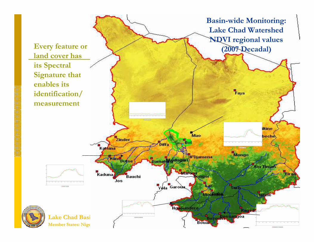
Every feature or
land cover has
its Spectral
Signature that
enables its
identification/
measurement
-0.2
0
0.2
0.4
0.6
0.8
Jan Feb Mar Apr May Jun Jul Aug Sep Oct Nov Dec
Desert 2007 Desert 2008
-0.2
0
0.2
0.4
0.6
0.8
Jan Feb Mar Apr May Jun Jul Aug Sep Oct Nov Dec
Mao 2007 Mao 2008
-0.2
0
0.2
0.4
0.6
0.8
Jan Feb Mar Apr May Jun Jul Aug Sep Oct Nov Dec
Dutse 2007 Dutse 2008
-0.2
-0.1
0
0.1
0.2
0.3
0.4
0.5
0.6
0.7
0.8
Jan Feb Mar Apr May Jun Jul Aug Sep Oct Nov Dec
Ngaoundere 2007 Ngaoundere 2008
-0.2
0
0.2
0.4
0.6
0.8
Jan Feb Mar Apr May Jun Jul Aug Sep Oct Nov Dec
Bossangoa 2007 Bossangoa 2008
Basin-wide Monitoring:
Lake Chad Watershed
NDVI regional values
(2007 Decadal)

Lake Chad Basin Commission, Lake Chad Basin Commission, NN’’DjamenaDjamena
Member States: Nigeria, Niger, Libya, Chad, CAR & Cameroon; Member States: Nigeria, Niger, Libya, Chad, CAR & Cameroon; [email protected]
Basin Scale Monitoring of Water related issues
Monthly average Vegetation cover of LCB (2007)
Vegetation Peak in
Lake Chad Watershed
(Oct. 2007)
Decadal
Vegetation 2007

Lake Chad Basin Commission, Lake Chad Basin Commission, NN’’DjamenaDjamena
Member States: Nigeria, Niger, Libya, Chad, CAR & Cameroon; Member States: Nigeria, Niger, Libya, Chad, CAR & Cameroon; [email protected]
African dust affecting air quality in Europe (30 October 2001) (after Scientific American: Global Transport of Dust, 2002)
Dust particles carry micro-organisms to Central America, possibly triggering disease outbreaks (after SeaWifsimagery, 26 Feb, 2000)
Sand and Dust Storms

Lake Chad Basin Commission, Lake Chad Basin Commission, NN’’DjamenaDjamena
Member States: Nigeria, Niger, Libya, Chad, CAR & Cameroon; Member States: Nigeria, Niger, Libya, Chad, CAR & Cameroon; [email protected]
GeoAfrica for Lake Chad Water Cycle Regime
Figure 3
�Weekly and Monthly capturing of the Lake with Geo-Africa enable: Minimum, Maximum and Seasonally Flooded Water Extent = Good Monitoring tool.
LCWCR

Lake Chad Basin Commission, Lake Chad Basin Commission, NN’’DjamenaDjamena
Member States: Nigeria, Niger, Libya, Chad, CAR & Cameroon; Member States: Nigeria, Niger, Libya, Chad, CAR & Cameroon; [email protected]
C A M E R O O N
N I G E R I A
N I G E RC H A D
")
BOL
Ala
Liwa
Mani
Kala
Rann
Yebi
BAGA
Kuwa
NGALA
DIKWA
Arege
MARTE
Diffa
Ngouri
Tourba
Woulki
MAKARI
Gajibo
KUKAWA
Bousso
Rig-Rig
Duiguia
Goulfey
Ngelewa
MONGUNOGAJIRAM
Nguigmi
Isseirom
Djimtilo
Djarmaya
Kousseri
Logumane
Kalelawa
Baga_Sola
Massakory
Massaquet
Gudunbali
Hile_Halifa
Ndjamena
Legend
Minimum Water Extent
0 20 40 60 80 10010Km
C A M E R O O N
N I G E R I A
N I G E RC H A D
")
BOL
Ala
Liwa
Mani
Kala
Rann
Yebi
BAGA
Kuwa
NGALA
DIKWA
Arege
MARTE
Diffa
Ngouri
Tourba
Woulki
MAKARI
Gajibo
KUKAWA
Bousso
Rig-Rig
Duiguia
Goulfey
Ngelewa
MONGUNOGAJIRAM
Nguigmi
Isseirom
Djimtilo
Djarmaya
Kousseri
Logumane
Kalelawa
Baga_Sola
Massakory
Massaquet
Gudunbali
Hile_Halifa
Ndjamena
0 20 40 60 80 10010Km
Legend
Maximum Water Extent
N
C A M E R O O N
N I G E R I A
N I G E RC H A D
LegendSeasonally Flooded Areas1,189.89 SqKm
")
BOL
Ala
Liwa
Mani
Kala
Rann
Yebi
BAGA
Kuwa
NGALA
DIKWA
Arege
MARTE
Diffa
Ngouri
Tourba
Woulki
MAKARI
Gajibo
KUKAWA
Bousso
Rig-Rig
Duiguia
Goulfey
Ngelewa
MONGUNOGAJIRAM
Nguigmi
Isseirom
Djimtilo
Djarmaya
Kousseri
Logumane
Kalelawa
Baga_Sola
Massakory
Massaquet
Gudunbali
Hile_Halifa
Ndjamena
0 20 40 60 80 10010KmN
Lake Chad Water Cycle Regime 2001
1969.98
3159.17
1189.98
0
500
1000
1500
2000
2500
3000
3500
Minimum Water Extent Maximum Water Extent Seasonally Flooded Vegetation
Class Names
Sur
face
Are
a (K
m2)
Concerns Fish Yield
Prediction
High Temporal
resolution for flood
capture gives more
accurate prediction

Lake Chad Basin Commission, Lake Chad Basin Commission, NN’’DjamenaDjamena
Member States: Nigeria, Niger, Libya, Chad, CAR & Cameroon; Member States: Nigeria, Niger, Libya, Chad, CAR & Cameroon; [email protected]
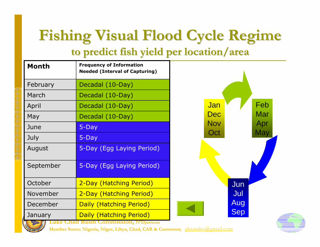
Fishing Cycle Regime (FVCR)
� Fishing Visual Cycle Regime (FVCR) = Ability to use EO satellite images to predict Fish Yield within wetlands or Floodplains.
� At Stake: Lack of regular spatial and temporal resolution images, hence, difficult, inaccurate prediction and impossible to observe/realize the FVCR.
� With GEO-Africa, higher temporal and medium resolution can monitor fishing activity per location (Lakes/Floodplains) ondaily/weekly basis effectively as well as to determine accurate areas of recession.
Rule: Gradual recession + Wider area coverage = Better for Fishing
Lake Chad Basin Commission, Lake Chad Basin Commission, NN’’DjamenaDjamena
Member States: Nigeria, Niger, Libya, Chad, CAR & Cameroon; Member States: Nigeria, Niger, Libya, Chad, CAR & Cameroon; [email protected]
Fishing Visual Flood Cycle RegimeFishing Visual Flood Cycle Regimeto predict fish yield per location/areato predict fish yield per location/area
FebMarAprMay
JunJulAugSep
JanDecNovOct
Daily (Hatching Period)January
Daily (Hatching Period)December
2-Day (Hatching Period)November
2-Day (Hatching Period)October
5-Day (Egg Laying Period)September
5-Day (Egg Laying Period)August
5-DayJuly
5-Day June
Decadal (10-Day)May
Decadal (10-Day)April
Decadal (10-Day)March
Decadal (10-Day)February
Frequency of Information
Needed (Interval of Capturing)Month

Lake Chad Basin Commission, Lake Chad Basin Commission, NN’’DjamenaDjamena
Member States: Nigeria, Niger, Libya, Chad, CAR & Cameroon; Member States: Nigeria, Niger, Libya, Chad, CAR & Cameroon; [email protected]/05/2008 p16
Typical Water Resource Applications : Monitoring Lake Chad
2 3 /0 1 /1 9 9 92 3 /0 1 /1 9 9 9 2 5 /0 1 /1 9 9 82 5 /0 1 /1 9 9 8 2 1 /0 1 /1 9 9 72 1 /0 1 /1 9 9 7
Varition o f standardised Annual Discharge on Chari Varition o f standardised Annual Discharge on Chari Varition o f standardised Annual Discharge on Chari Varition o f standardised Annual Discharge on Chari
River River River River
-2
-1.5
-1
-0.5
0
0.5
1
1.5
2
2.5
1955 1965 1975 1985 1995
Year
Stand
ardize
d Ann
ual D
isch
arge
Lake Chad WCR

Lake Chad Basin Commission, Lake Chad Basin Commission, NN’’DjamenaDjamena
Member States: Nigeria, Niger, Libya, Chad, CAR & Cameroon; Member States: Nigeria, Niger, Libya, Chad, CAR & Cameroon; [email protected]
Monthly Surface Water Area of Lake Chad (September 2006 - March 2007)
2380.16
1,874.48
2,457.91
2,630.782,673.602,673.602,673.602,673.60
2,503.87
1,000.00
1,200.00
1,400.00
1,600.00
1,800.00
2,000.00
2,200.00
2,400.00
2,600.00
2,800.00
1-S
ep-0
6
8-S
ep-0
6
15-S
ep-0
6
22-S
ep-0
6
29-S
ep-0
6
6-O
ct-0
6
13-O
ct-0
6
20-O
ct-0
6
27-O
ct-0
6
3-N
ov-0
6
10-N
ov-0
6
17-N
ov-0
6
24-N
ov-0
6
1-D
ec-0
6
8-D
ec-0
6
15-D
ec-0
6
22-D
ec-0
6
29-D
ec-0
6
5-Ja
n-07
12-J
an-0
7
19-J
an-0
7
26-J
an-0
7
2-F
eb-0
7
9-F
eb-0
7
16-F
eb-0
7
23-F
eb-0
7
Period
Sur
face
Are
a (S
qKm
)
Lake CHad (Sept 2006 - Mar 2007)

Lake Chad Basin Commission, Lake Chad Basin Commission, NN’’DjamenaDjamena
Member States: Nigeria, Niger, Libya, Chad, CAR & Cameroon; Member States: Nigeria, Niger, Libya, Chad, CAR & Cameroon; [email protected]
OperationalisationOperationalisationOperationalisationOperationalisationOperationalisationOperationalisationOperationalisationOperationalisation
Seasonal Seasonal Seasonal Seasonal Seasonal Seasonal Seasonal Seasonal
characteristicharacteristicharacteristicharacteristicharacteristicharacteristicharacteristicharacteristi
cscscscscscscscs
State and State and State and State and State and State and State and State and
potential potential potential potential potential potential potential potential
growing of growing of growing of growing of growing of growing of growing of growing of
vegetation vegetation vegetation vegetation vegetation vegetation vegetation vegetation
cover cover cover cover cover cover cover cover
Global Global Global Global Global Global Global Global
Changes Changes Changes Changes Changes Changes Changes Changes
intensityintensityintensityintensityintensityintensityintensityintensity
Changes Changes Changes Changes Changes Changes Changes Changes
detection, detection, detection, detection, detection, detection, detection, detection,
Dynamics Dynamics Dynamics Dynamics Dynamics Dynamics Dynamics Dynamics
monitoring monitoring monitoring monitoring monitoring monitoring monitoring monitoring
Hot Spots Hot Spots Hot Spots Hot Spots Hot Spots Hot Spots Hot Spots Hot Spots
IdentificationIdentificationIdentificationIdentificationIdentificationIdentificationIdentificationIdentification
0
20
40
60
80
100
120
1 2 3 4 5 6 7 8 9 10 11 12 13 14 15 16 17 18
Décades
NDVI
NDVI max
20
40
60
80
100
120
140
160
Temps (années)
Jours
0
20
40
60
80
100
120
1 2 3 4 5 6 7 8 9 10 11 12 13 14 15 16 17 18
Décades
NDVI
Date d’émergence
y = 0.0002x + 0.1676
R2 = 0.8112
y = 0.0002x + 0.1638
R2 = 0.7232
0.20
0.25
0.30
0.35
0.40
0.45
0.50
0.55
0.60
0 500 1000 1500 2000
PPéériodismeriodisme de la de la
vvééggéétationtationDates dDates dDates dDates d’é’é’é’émergencemergencemergencemergence.
RRéésilience de la silience de la
vvééggéétationtationMaximum et lMaximum et lMaximum et lMaximum et lMaximum et lMaximum et lMaximum et lMaximum et l’’’’’’’’amplitude de amplitude de amplitude de amplitude de amplitude de amplitude de amplitude de amplitude de
llllllll’’’’’’’’indice de vindice de vindice de vindice de vindice de vindice de vindice de vindice de vééééééééggggggggéééééééétationtationtationtationtationtationtationtation
Dynamique de Dynamique de
vvééggéétationtationLongueur des cycles de Longueur des cycles de Longueur des cycles de Longueur des cycles de Longueur des cycles de Longueur des cycles de Longueur des cycles de Longueur des cycles de
vvvvvvvvééééééééggggggggéééééééétationtationtationtationtationtationtationtation
Potentiel de la Potentiel de la
vvééggéétationtationProductivitProductivitProductivitProductivitProductivitProductivitProductivitProductivitéééééééé primaire et primaire et primaire et primaire et primaire et primaire et primaire et primaire et
biomassebiomassebiomassebiomassebiomassebiomassebiomassebiomasse
Typical Land Cover Applications : Vegetation Monitoring

Lake Chad Basin Commission, Lake Chad Basin Commission, NN’’DjamenaDjamena
Member States: Nigeria, Niger, Libya, Chad, CAR & Cameroon; Member States: Nigeria, Niger, Libya, Chad, CAR & Cameroon; [email protected]
Typical Agriculture Applications
Mapping Agriculture Extent
Main zones of production for food and commercial crops
⇒ Continent-wide
⇒ Seasonal need
Characterizing Farming System Classes
Determine cropland extent, enumerate crop types and monitor crop growth
⇒ Continuous observation for all production zones
Assessing Land potential (suitability)
Combined major biophysical constraints : land, climate, water, etc.
⇒ Region-dependant

Lake Chad Basin Commission, Lake Chad Basin Commission, NN’’DjamenaDjamena
Member States: Nigeria, Niger, Libya, Chad, CAR & Cameroon; Member States: Nigeria, Niger, Libya, Chad, CAR & Cameroon; [email protected]
Agricultural Resources Management
� Climate modeling for Farmland Operations = Determination of:
�Onset of rainfall;
�Retreat of rainfall;
�Best Planting period; and
�Duration of rainfall;
� At Stake: Above important farmland operations are presently impossible due to lack of regular spatial and temporal resolution in most situations.
Onset & Retreat

Lake Chad Basin Commission, Lake Chad Basin Commission, NN’’DjamenaDjamena
Member States: Nigeria, Niger, Libya, Chad, CAR & Cameroon; Member States: Nigeria, Niger, Libya, Chad, CAR & Cameroon; [email protected]
Modelling for Farmland
Operations/Food Security Early Warning
� With GeoAfrica, specified locations within Lake Chad Basin can be captured at least 5-day interval, continuously as the satellite is right above the Basin. Thus, Onset and Retreat of Rainfall can be determined from images.
�Also the Satellite helps to choose:
�Best Planting days (from NDVI measurements)
�Monitors Crop growths and Actual Cultivable extent per location.

Lake Chad Basin Commission, Lake Chad Basin Commission, NN’’DjamenaDjamena
Member States: Nigeria, Niger, Libya, Chad, CAR & Cameroon; Member States: Nigeria, Niger, Libya, Chad, CAR & Cameroon; [email protected]
Determination of Crop Growing, Peak & Harvest in Ir rigation Site, 2007
0
0.1
0.2
0.3
0.4
0.5
0.6
0.7
0.8
0.9
Jan
Mar
May Ju
l
Sep Nov
ND
VI V
alue
Irrigation Site Growing Cycle Average Minimum Maximum
1st Best Onset Date 21 Feb
2nd Cropping:Best Onset Date10 September
1st Grow ing Period = 4 months, 10 days01 Apr to 11 August 2007
2nd Grow ing Period = 2months, 16 days17 Sept to 21 Nov 2007
Grow ing Peak 21 June
Figure 7

Lake Chad Basin Commission, Lake Chad Basin Commission, NN’’DjamenaDjamena
Member States: Nigeria, Niger, Libya, Chad, CAR & Cameroon; Member States: Nigeria, Niger, Libya, Chad, CAR & Cameroon; [email protected]
� Objective:� To undertake rapid mapping for improved derivation of agricultural statistics (area under cultivation, crop estimation, etc) using remote sensing technology and help clear up the discrepancies in published statistics
� Current Methodology:� High resolution images (QuickBird, Ikonos, etc) are interpreted based on a vector dot-grid matrix.
� Raster land use / land cover maps are generated from the dot-grid matrix
� The interpretation is used to monitor and extract agricultural statistics from low resolution images (e.g MODIS, MERIS) that have higher repeat
ESTIMATING AGRICULTURAL STATISTICS IN ETHIOPIAUSING THE RAPID LAND COVER MAPPER (RLCM) APPROACH

Lake Chad Basin Commission, Lake Chad Basin Commission, NN’’DjamenaDjamena
Member States: Nigeria, Niger, Libya, Chad, CAR & Cameroon; Member States: Nigeria, Niger, Libya, Chad, CAR & Cameroon; [email protected]
Maize and Sorghum Production Areas in Ethiopia

Lake Chad Basin Commission, Lake Chad Basin Commission, NN’’DjamenaDjamena
Member States: Nigeria, Niger, Libya, Chad, CAR & Cameroon; Member States: Nigeria, Niger, Libya, Chad, CAR & Cameroon; [email protected]
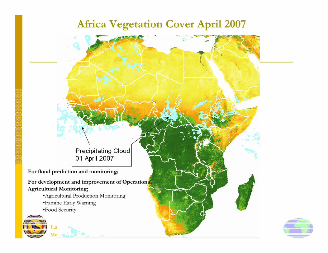
Risk management
� Variability in seasonal inundation levels → loss of crops; destruction of infrastructure.
� Use GEO-Africa images (areal extent of water) in conjunction with radar altimeter data (flood level height) to relate with precipitating cloud (MSG) for EARLY EARLY WARNING SYSTEMWARNING SYSTEM to determine uncertainties associated with seasonal flood inundations.
Lake Chad Basin Commission, Lake Chad Basin Commission, NN’’DjamenaDjamena
Member States: Nigeria, Niger, Libya, Chad, CAR & Cameroon; Member States: Nigeria, Niger, Libya, Chad, CAR & Cameroon; [email protected]
Africa Vegetation Cover April 2007
For flood prediction and monitoring;
For development and improvement of Operational
Agricultural Monitoring;
•Agricultural Production Monitoring
•Famine Early Warning
•Food Security

Lake Chad Basin Commission, Lake Chad Basin Commission, NN’’DjamenaDjamena
Member States: Nigeria, Niger, Libya, Chad, CAR & Cameroon; Member States: Nigeria, Niger, Libya, Chad, CAR & Cameroon; [email protected]
Damages due to Floods

Lake Chad Basin Commission, Lake Chad Basin Commission, NN’’DjamenaDjamena
Member States: Nigeria, Niger, Libya, Chad, CAR & Cameroon; Member States: Nigeria, Niger, Libya, Chad, CAR & Cameroon; [email protected]
Malaria Risk MappingRisk Maps based on Vegetation Health (VHI), Moisture Conditions (VCI) and Thermal Conditions (TCI). All estimations from AVHRR. Correlation of Annual Malaria Incidence (AMI) with Moisture Index (VCI) is possible

Lake Chad Basin Commission, Lake Chad Basin Commission, NN’’DjamenaDjamena
Member States: Nigeria, Niger, Libya, Chad, CAR & Cameroon; Member States: Nigeria, Niger, Libya, Chad, CAR & Cameroon; [email protected]
� Repetitivity (just in time)
� Spatial Resolution
� Area of Coverage
Changes Enabled by GEOChanges Enabled by GEO--AfricaAfrica
OCTOBRE
d1d2
d3d4
d5d6
d7../..
2000d14
d15d16
d17
d13
d18
Dekad
Vegetation Index
MAI
MIN
MAX
AMPLITUDE
DateSTART
DateMAX
1/2 Length
AMOUNT or AVERAGE

Lake Chad Basin Commission, Lake Chad Basin Commission, NN’’DjamenaDjamena
Member States: Nigeria, Niger, Libya, Chad, CAR & Cameroon; Member States: Nigeria, Niger, Libya, Chad, CAR & Cameroon; [email protected]
Conclusion
� SD is achieved through access to reliable, timely and adequate geospatial information. African countries are faced with numerous challenges in terms of accessibility, regular spatial and temporal resolutions in most disaster situations. Hence, the need for prediction and early warning system.

Thank you for your kind attention