practice with pride - eurogeologists
TRANSCRIPT


2
EUROPEAN GEOLOGIST is published by the
European Federation of Geologists C/o Service Geologique de Belgique
13, Rue Jenner B-1040 Bruxelles, Belgium
Tel: +32 2 6270412 e-mail: [email protected]
web: www.eurogeologists.de
The board of EFG PRESIDENT
EurGeol Gareth Jones Conodate International Ltd. 7, Dundrum Business Park
Windy Arbour Dublin 14, Ireland
VICE-PRESIDENT Dr. Uros Herlec
Dept. of Geology The University
Ljubljana, Slovenia Tel 00 3864 1256 633
Dept. fax. 00 386 14 704 560
SECRETARY-GENERAL EurGeol. Dr. Antoine Bouvier
1 rue Leon Migaux F-91341 Massy, France Tel: 0033 1 39540749
TREASURER EurGeol. Dr. Carlo Enrico Bravi
Largo Richini, 8 20122 Milano, Italia
Tel: +39 02 58303527 Fax: +39 02 76007182
EDITOR Maureen Mc Corry
e-mail: [email protected] ASSISTANT EDITOR
Steen Laursen
Printed by Tiskarna Koper
Graficno podjetje d.o.o. Ulica 15, Maja 19
6000 Koper, Slovenia Fax: 386 5 6631177
ISSN: 1028 - 267X
Cover photograph. Supplies arrive on
Ella Island, NE Greenland for groups using
the expedition hut and military base. Ella
Island has acted as a base for expeditions
from the Copenhagen Geocenter during
2000-2001. The foreground consists of
ridges of upper Precambrian siliciclastics
including tilloids, whereas in the back
ground the mountains comprise a thick suc
cession of lower Ordovician platform car
bonates (Photo: David A. T. Harper).
Foreword
PRACTICE WITH PRIDE by Gareth Ll Jones, President
This is the last editorial that I shall write to you as President of the Federation. It has been an iinmense privilege to have been allowed to serve the Federation and the 75,000 geologists across Europe that we speak for.
During the three year term of this Board, we have stabilised and re-organised the finances, structured our work plans and budgets, upgraded the website, put the magazine on a sound financial footing, moved the office from Paris to Brussels and appointed an Agency Chief in Brussels (see details later in this magazine). From this base we have engaged the European Commission on topics including Sludge Disposal, Raw Materials Supply, Professional Recognition, Educational Degree Supplements, etc. With our north American colleagues we organised the first International Professional Geology Conference inAlicante in 2000.
Intertwined throughout all of this work is the fundamental theme of our professional quality standard, the title of European Geologist (EurGeol). This was a central plank of the Federation when it was formed in 1980 and, since 1993 when it came into being, it has been adopted by thirteen of our member national associations. Since then, in line with the development of the geological profession in Europe and around the world and of other professions across Europe, we have upgraded the title to the new uniform standard. The title now rests on four solid pillars:
* Academic Qualification, a minimum of four years at an approved university course
* Professional Experience, five years in the area of expertise claimed Continuing
* Professional Development, mandatory participation in an approved CPD scheme
* Code of Ethics, adherence to the EFG code backed by a Disciplinary Committee.
In many areas regulatory authorities are restricting acceptance of reporting to "Competent Persons". The definition of these is practically identical to that of our four pillars, so that Irish and Canadian government departments and stock exchanges have already accepted the holders of EurGeol titles as Competent Persons. Since we have been taking part in the evolution of this standard, we have been able to set up reciprocity agreements with the USA and we are in negotiation with Canada.
Also in Spain the recent adoption into law of the ICOG Statutes has included the right ofEurGeols to practise geology there. So we extend many congratulations to our Spanish colieagues.
But, most importantly for us·, in Brussels the European Commission is coming to realise the value of the title and its quality assurance as the "passport" for the mobility of geologists across Europe. Very soon it will be essential for professional practice everywhere. Our title is beginning to function, not only across Europe as originally planned, but also around the world. So if you are a college lecturer, explorationist, hydrologist, engineering geologist, miner, waste disposal geologist, geophysicist, biost;tatigrapher, etc., obtain and maintain your European Geologist title and be proud of it as you practise.
EurGeol. Gareth Ll. Jones PGeo President European Federation of Geologists [email protected]
Throughout his term, the President's sponsors from Ireland have been: Enterprise Oil, Enterprise Energy Ireland, CRH Group, Castlemore Quarries, K.T.Cullen & Co., CSA Group. They are sincerely thanked for their support.

Table of Contents
Geocenter Copenhagen 4 First national Swiss geologists' day 8 President's Report for 2001 9 The EFG's Brussels office 11 New statutes for geologists in Spain 14 Financial Report 2001 15 Secretary General's Report 17 Call for partners 18 Geological and hydrogeological problems in Italy 20 In memory ( obituary) 22 World Geologists 23 Geological overview of Swissmetro 25 New EurGeols 31 Book Review: Trilobite! Eyewitness to evolution 34 Rocks and wines in Slovakia 35 Modelling of geomagnetic field moves into a new era 39
© Copyright 2001 The European Federation of Geologists
All rights reserved. No reproduction, copy or transmission of this publication may be made without written permission. No responsibility is assumed
by the Publisher for any injury and/or damage to persons or property as a matter of products liability, negligence, or otherwise, or Jyom any use or
operation of any methods, products, instructions or ideas contained in the material herein. Although all advertising material is expected to conform
to ethical (medical) standards, inclusion in this publication does not constitute a guarantee or endorsement of the quality or value of such product
or of the claims made by its manufacturer.
Although the articles in this Magazine are subjected to scientific editiag, they are not peer-reviewed
3
i~; t: f.:

Geocenter Copenhagen:
A museum's role in an international centre -for Earth Science
by David A. T. Harper and Minik T. Rosing
Geocenter Copenhagen will formally open in September 2002 when all the participating institutions become co-located within the same building complex. The Geocenter institutions are the Geological and Geographical institutes, the Geological Museum, the Geological Survey of Denmark and Greenland (GEUS) together with the Danish Lithosphere Centre (DLC). The new Geocenter will combine the diverse academic and more commercial aspects of the earth sciences in the Copenhagen area with a view to enhancing the advisory, research and teaching functions of state bodies within a centre of international status. Although much of the development of the geological sciences in Denmark originated at the Geological Museum in Copenhagen, the museum has occupied a more marginal position while the negotiations continue on the future and shape of an international centre for earth science on 0ster Voldgade. Nevertheless as the centre's momentum gathers, the need for the careful management of collections, new and relevant exhibitions together with a focus for the dissemination of geological information will accelerate. These roles already supplement the strong traditions of research in the museum together with its participation in the teaching of both undergraduate and postgraduate students.
4
Le Geocentre de Copenhague sera officiellement ouvert en septembre 2002. II regroupera les actuels Instituts de Geologie et de Geographie, le Musee de Geologie, le Bureau de Recherches geologiques du Danemark et du Groenland (GEUS) ainsi que le Centre d'Etude de la Lithosphere danois (DLC). Ce Geocentre combinera les divers aspects des Sciences de la Terre, tant universitaires que commerciaux, afin d'ameliorer les fonctions de conseil, de recherche et d'enseignement dans la region de Copenhague au sein d'un organisme de statut international. Bien qu'une part importante du developpement de la recherche geologique au Danemark ait eu lieu au sein du Musee de Geologie de Copenhague, ce dernier n'occupe qu'une position marginale dans les negociations visant a definir la forme et le futur de ce centre de recherche international a 0ster Voldgade. Cependant, alors que le projet prend forme, les besoins pour une bonne gestion des collections, pour la creation de nouvelles expositions de qualite ainsi que pour un effort de la diffusion d'informations geologiques vont de plus en plus se faire sentir. Ces fonctions s'ajoutent deja a une forte tradition de recherche au sein du Musee ainsi qu'a sa participation aux programmes d'enseignement a tous les niveaux.
El Geocentro Copenhague, que agrupa los Institutos Geol6gico y Geografico, el Museo Geol6gico, el Servicio Geol6gico de Dinamarca y Groenlandia y el Centro Danes de la Litosfera, se inaugurara oficialmente en Septiembre de 2002. El nuevo Geocentro combinara distintos aspectos academicos y los mas comerciales de las ciencias dela tierra en la zona de Copenhague, con el fin de potenciar las funciones de asesor[a, investigaci6n y docencia de los organismos estatales, en un centro de categorfa internacional. Aunque la mayor parte del desarrollo de las ciencias geol6gicas en Dinamarca se origin6 en el Museo de Geolog[a en Copenhague, el museo ha ocupado una p9sici6n mas marginal en las negoci~ciones en marcha sobre el futuro y la forma de un centre internacional para las ciencias de la tierra en 0sterVolgade. Sin embargo, a medida que el centre se constituye, la necesidad de una organizaci6n cuidadosa de las colecciones, de exposiciones nuevas y relevantes, con una atenci6n especial a la diseminaci6n de la informaci6n geol6gica, se incrementa. Estos papeles complementan la ya enraizada tradici6n de investigaci6n en el museo, y su participaci6n en la docencia, tanto durante los estudios de licenciatura como posteriormente a la obtenci6n de la misma.

The Past Although the University of Copenhagen was founded by King Christian I in 1479, it was unlikely that geology appeared on the curriculum until after the Reformation in 1537 when Peder S0rensen (aka Petrus Severinus) made significant advances in the development of the natural sciences. The first cohorts of Danish scholars in this rapidly evolving area of academia had both Paneuropean contacts and mobility; their students were sent to study abroad and two in particular, Bartholin and Stensen were to have a major influence on not only medicine and science in Denmark but made fundamental contributions to the conceptual bases of these areas of knowledge. Thomas Bartholin (1616-1680) was undoubtedly one of the greatest anatomists of his generation. Although he researched an unpublished thesis on fossil shark teeth his most significant contribution to geology was almost certainly his pupil Steno (Fig. I). Niels Stensen (aka Nicolaus Steno: 1638-1687) was born in Copenhagen and following studies in anatomy and medicine at university both in Copenhagen and Paris, Steno was appointed court physician to the Grand Duke Ferdinand II in Florence. He was converted to catholicism and returned to Copenhagen as Professor of Anatomy. Steno later returned to Florence to take holy orders and after his death was sanctified. He was, however, resporisible for some remarkable discoveries that helped form the basis for the early development of geology and palaeontology. Steno's careful anatomical comparisons between fossil sharks' teeth and those of living forms further developed the researches of his mentor Batholin.
More holistic, and perhaps more influential, were his studies in the Appenines, exposed in the hills and valleys of Tuscany. Here Steno unravelled the Law of Superposition of Strata, still the most fundamental concept in any stratigraphical investigation. Although the folded rocks of the Appenines now form part of the Alpine chain, the strata were originally deposited horizontally with oldest rocks
David Harper and Minik Rosing are respectively Deputy Director and Director of the Geological Museum, Copenhagen.
For more information, see the Geocenter's web-page: www.geocenter.dk
forming the base of the sedimentary pile and the youngest rocks on top. In his last and probably most famous treatise, 'De solido intra solidum naturaliter contento dissertationis prodromus', published in Florence in 1669, Steno established the primary relationships between various groups of strata in Tuscany; clear in this study was his understanding of sedimentary processes and importance and significance of marine and terrestrial fossils. Mountains and volcanoes had not existed since the beginning of time, but were part of an evolving world modified by escaping gases, fire and running water.
Some hundred years later teaching programmes in geology were established in the University of Copenhagen aided by the presentation to the university of fossil, mineral and rock collections from Count A.G. Moltke. Material had already been assembled by Ole Worm (1588-1654) in the so- called Museum Wormianum. Worm's collections had a chequered career first passing into the possession of King Frederik III; although there is no doubt a significant part of the collections of the Royal Cabinet of Curiosities now
Figure 2. 'The Coffee Club ' in 1908 (Geological Museum's archives). These regular meetings between staff at the museum and the Geological Survey of Denmark acted as geology's thinktank for at least the next 20years.
Figure J. Nicolaus Steno (Niels Stensen) investigating the strata of the Tuscan Appenines:from a mural in the Geological Museum by Oscar Mathiessen (Photo: David A.T. Ha1pe1)
exist in the collections of the museum, details of provenance have long since disappeared. When the Faculty of Science was formally established in 1850, geology was centred on 'Grev Moltkes Universitetet tilh0rende Mineralogiske Museum' in Frue Plads. J.G. Forchammer (1794-1865), a student of the famous physicist H.C. 0rsted, held the chair in mineralogy and 'geognosi' together with the directorship of the Mineralogical Museum.
During the latter part of the l 9'h Century geology was again on the move. J. F. Johnstrup (1818-94) was instrumenc ta! in the establishment of the Commission for the Scientific Stuqy of Greenland in 1876, and the founding of the Danish Geological Survey (DGU) in 1888. The new museum building on 0ster Vodgade 5-7 was completed during 1893, a year before Johnstrup 's death. During the later stewardship of the influential Arne Noe-
5

Figure 3. The Copenhagen Geocenter (Photo: David A. T. Harper). Entrance to the complex on 0ster Voldage I O which will combine four of the organizations comprising the Geocenter.
Nygaard (1908-1991) geology continued to expand. A chair in the Geology of Denmark was established in 1943 followed by a professorship in Palaeontology in 1945. The Geological Survey of Greenland was established in 1946 and during the 1960s escalating student numbers required urgent action.
The core of geological activity was fragmented during 1967 with the expansion and movement of the teaching environment to 0ster Voldgade 10, where within the Geological Institute, the departments of General Geology, Historical Geology and Palaeontology, Mineralogy and Petrology evolved soon afterwards. The museum was renamed 'The Geological Museum' in 1976, more accurately.
6
Figure 4. The Geological Museum (Photo Walter Kegel Christensen) during the celebrations of 100 years on 0ster Voldgade in 1993.
reflecting the collections, functions and scope of 0ster Voldgade 5-7. Independence was complete, when the museum received its own budget in 1991.
In almost 500 years of geological research in Copenhagen, the science has diversified and moved from a platform built on specimen-based investigations to more holistic programmes based on an understanding of Earth Science processes, arguably returning to the aspirations of Steno and many of his contemporaries. Copenhagen Geocenter will bring together again the many active but disparate strands of geology in the greater Copenhagen area.
The Geocenter Geocenter Copenhagen developed from a consultation document published in 1995 promoting the concept of the centre based on input from a wide range of government departments and other organizations. The centre itself is located in a prime location within the central Copenhagen area. The Geological and Geographical institutes together with GEUS and the DLC are situated within the complex at 0ster
Voldgade I O (Fig. 3) whereas the museum remains in its original, purpose-built complex at 0ster Voldgade 5-7 (Fig. 4). All five institutes will be linked together on 0ster Voldgade, adjacent to the King's Gardens, the Botanical Gardens, the Art Gallery and the Rosenborg Palace.
The Geocenter will have a combined staff of about 550 and will be linked by common research and teaching programmes together with joint access to laboratory and library facilities. To date much of the discussions have focused on the research and teaching capacity of the Geocenter together with its importance as a source of advice to Government and other organizations on a range of problems and developments in the earth sciences. Nevertheless such discussion has helped develop and sharpen the museum's own role in this type of centre. Museums remain the most effective method of disseminating knowledge through their exhibitions, education and outreach programmes. In addition the museum will continue its strong role in providing common library facilities for the centre and of course bringing new and exciting · developments in the science to the general public.
The Future The development of the centre with modem laboratories together with strong and dynamic research teams will form not only the basis for much multidisciplinary research within Denmark, but will also act as a focus for international research programmes. It is hoped that many research programmes will also bridge the gap between basic research and mJre applied and strategic research projects. The centre is also poised to enhance its role as the gateway to research programmes in the Arctic regions with particular reference to Greenland (Fig.5) and also as a logistic manager for international expeditions.
Expectations are high and the future is bright. It is hoped the centre will rapidly establish itself as one of the 10 leading geoscience research and education complexes in Europe. Within the area of education the centre will offer a broad range of courses within the earth sciences for the 1000 or so bachelor and candidate students following degree programmes in geology, geophysics and geography. Moreover a large cast of specialists will be available to assist the research training of the 50 Ph.D. students within the Geocenter system.

Figure 5. Lauge Koch 's expedition hut on Ella island (Photo David A.T. Harper); in the background the spectacular rocks of the upper Precambrian Eleanore Bay Supergroup. The field centre has acted as a base for expeditions to the region by the Palaeozoic Group in Copenhagen (2000-2001), whose members are drawn from the Geological Museum, Geological Institute and GEUS. It is one of a number ofjoint collaborations within the Copenhagen Geocenter involving fieldbased research on Greenland.
The Geological Museum, in common with most similar institutions in Europe, must face many challenges. Not least is its ability to educate and entertain all strands of the public in the geological sciences. During the coming years the upgrading of the museum's collection facilities and electronic databases, together with new
' \
\
and more vibrant exhibitions and outreach programmes will continue in tandem with the museum's active participation in research and teaching programmes within the centre. The museum's responsibility for the centre's library facilities will continue as will its focus for public interest in Danish geoscience. The Geocenter will
do much to stimulate geology in Europe but will also emphasise the role of the museum, its collections and exhibitions and place it more firmly again at the core of Danish geology.
www.idromin.com [email protected]
FoundEJli in the sixties, ldrorrif n is a multipourpose consulting company operating in many fields
Via Ugo Foscolo, 8 I - 20121 Milan
ph. +39.02.86.46.04.91 fax +39.02.86.46.05.79
NATURAL RESOURCES
CIVIL ENGINEERING
WATER f PLANNING~
l I
I i
DESIGN & ARCHITECTURE ~ I
ldromin is a member of "Geologos del Mundo" (world geologists) and operates P.lS Jtalian Delegate of this NGO organization
7

First national Swiss eologists'
by EurGeol. Thomas Imbach and EurGeol. Johannes van Stuijvenberg
The Swiss Association of Geologists CHGEOL organised its first National Geologist's Day which was held on February 22, 2002 in Lucerne's internationally famous Cultur- and Congresszentrum (KKL), an impressive work of the french star-architect Jean Nouvel.
CHGEOL invited all professional geologists, all university earth scientists including students of geology and all geologists from the administration. More than 500 geologists participated in the event, more than a quarter of the active geoscene of Switzerland. The Swiss Association of Geologists thanks Dottore Carlo Enrico Bravi, official representative from the European Federation of Geologists, for his participation. The official programme allowed enough time to meet and chat with friends.
The first National Geologists' Day was organised as a fair for suppliers and service companies who support geologists in their daily business. The reaction from the 27 attending suppliers was really extraordinary and they used the opportunity to display their products and services and to discuss them with the geologists. The spectrum of exhibitors was very wide; drilling companies, chemical laboratories and companies specializing in the rehabilitation of contaminated sites, companies offering off-site decontamination setvices of soil and water, companies specializing in all kinds of geophysical services, in drinking water treatment systems, groundwater monitoring and gas emission monitoring systems. Others offered geotechnical surveys, field instruments and lab techniques as well as precautionary measures against natural hazards. Even a developer of earth science software was present while 'AlpTransit Ltd.' presented its management services of the biggest tunnelling project in Switzerland. Last
8
but not least the education and the professional development of geologists were also chosen as central themes by several exhibitors.
The highlight of the first Nationa; Geologists' Day was the witty, philosophical and very stimulating speech of Minister of State Moritz Leuenberger about politics and geology in general, and in particular about finity and infinity, the human being and the cosmos, about his personal belief in the transitory, in sustainability, Kyoto and US-President George Bush -and about '1' important c' est la rose'.
His speech was followed by a fascinating reading by the Swiss writer Peter Weber focusing on geology in literature.
Minister of
State Moritz
Leuenberger
addresses
Swiss geolo
gists
The first National Geologists' Day was a very successful event which left participants, exibitors and sponsors fully satisfied, so much so, that more than 70 new members including many students signed up for membership of CHGEOL on that very day ( an increase of more than 20%!).
For more information about our first National Geologist's Day see www.chgeol.org. On its homepage CHGEOL offers you more details about the official programme, participants, exhibitors, sponsors and special guests; you will also find pictures of the event and the speech of Minister of State Moritz Leuenberger.

President's Report for 2001
Summary Czech Republic and Iceland elected to Full Membership New Brussels Office opened Brussels Agency Chief appointed EU / EC Contacts developed Reporting Code for Reserves & Resources adopted Contacts developed with CCPG, Canada andAIPG, USA 3 Licensed Bodies appointed European Geologist magazine develops EurGeols recognised as Competent Persons
The mission of the EFG is to promote the profession and practice of geology and its relevance and this report for 2001 reflects the development of the Federation on several fronts. The Board has been very busy in spite of the almost constant state of flux. Uros Herlec, Slovenia, settled in very well as Vice-President replacing Johannes van Stuivenberg, Switzerland. In September Detlev Doherr, Germany, took over as the EU Delegate from hardworking Marianne Vasard Nielsen, Denmark, but had to resign in early 2002, since when John Clifford, Ireland, has been an EU Advisor to the Board. When the Secretary-General Antoine Bouvier, France became based in Chad he had to resign in late 2001, though he was able to oversee the continued production of EuroGeoPages. The one reliable constant throughout has been the steady hand of the Treasurer Carlo Bravi on the finances.
In Cracow, Poland in June, the Czech Republic and Iceland were elected to Full Membership of the Federation. They join the nations of Belgium, Finland, France, Germany, Hungary, Ireland, Italy, Lux-
by EurGeol. Gareth Ll. Jones PGeo <[email protected] >
embourg, The Netherlands, Poland, Portugal, Slovakia, Slovenia, Spain, Sweden, Switzerland and the United Kingdom. In addition to these, Bulgaria, Norway, Romania, Turkey and c~.nada are Observers, while the American association is an Associate Member.
The new office in Brussels was officially opened in December by Niall Andrews MEP who cut the ribbon. Last year we appointed lobbyist Ora.Isabel Fernandez as Brussels Agency Chief. She maintains contacts with the Commission and facilitates us when we make presentations to them on topics such as the Environment. These achievements are extremely important to the future of the Federation as they give a full-time listening post to, and contact point for, the European Commission and Parliament. Already this has borne fruit with increased visibility for the Federation.
The European Commission, in reply to a question by Mr. Gerard Collins MEP early last year on the development of the EurGeol title, confirmed that it "fully supports this move by the EFG, since it is likely to facilitate free movement of geologists within the Community". As part of the process to improve this free movement, the Federation was invited to make a detailed submission on the subject to the Commission. It is a Commission objective to shortly puplish a policy proposal on the "The Futur~ Regime for Professional Recognition" within the EU.
Other progress in Europe includes Spain, where the EurGeol title is now enshrined in law. As a result, holders of the title will have the same rights and privileges to register with ICOG as a Spanishqualified geologist. In addition, in Canada the Canadian Securities Administrators have now announced that they will accept someone who holds the EurGeol title as
a Competent Person for the purpose of signing off reports submitted to the Canadian stock exchanges. Similarly the Irish Government's Exploration and Mining Division will also accept someone who holds the EurGeol title as a Competent Person.
The EurGeol title was relaunched through the setting up of a Registration Authority (to replace the Registration Committee) and Licensed Bodies (National Associations able to nominate EurGeols directly). ICOG (Spain), IGI (Ireland) and GeolSoc (UK) have been approved as Licensed Bodies.
Richard Fox, GeolSoc, was accepted as the new Chair of the Registering Committee / Authority, replacing Eric Groessens, UBLG (Belgium), who was thanked for his dedicated work carried out over the 6 years of his two terms as Chair. Early indications in 2002 are that this move has been vei:y successful with a sharp increase in applications for the title, which is now available at a much reduced fee.
Council decided that it vfould become mandatory for all holders of our professional title of European Geologist (EurGeol.) to adopt CPD. This is vital for the EurGeol title to keep pace with the requirements for professional development around the world and to help bring about mutual recognition of professional titles.
The EFG Council Meeting in Cracow, Poland in June 2001, was hosted by Polskie Towarzystwo Geologiczne, Polish delegate Andrzej Slaczka and the Director of the Geological Institute ofCracow, Prof Dr. Hab Tadeusz Peryt. This was a very pleasant and successful meeting where we also met Dr. Tadeusz Bachleda-Curus, Chief Geologist of Poland, deputy Minister of Environment. Emile Elewaut, Secretary General of Eurogeosurveys was a
9

guest speaker who outlined their activities and areas where we may be able to cooperate.
A new Code for Reporting of Mineral Exploration Results, Mineral Resources and Ore Reserves was adopted in Cracow, this is to work in parallel with that being developed by the UN. Guest speaker Norman Miskelly, Deputy Chairman, International Relations - JORC, rated the new Code as an excellent Document. The Code is intended to educate first, to promulgate and to be a common framework in the mineral industry. It will be a model for the World Code to be elaborated during the coming years by experts from Europe, USA, Canada, South Aftica, Australia & UK who have already discussed the terms of references.
The European Geologist magazine No. 11 was edited by Steen Laursen in Denmark. Maureen Mc Corry took over as editor of No. 12 and we are pleased to continue this arrangement for 2002. We have to thank the Vice-President, Uros Herlec, who has organised the printing and distribution from Slovenia.
The December informal working Council meeting has become an important part of the Federation's calendar, for planning the short and long-term future of the EFG. Last December we finalised a 5-yearplan for 2002 -2006 to be approved in Berne. It also allows delegates to follow our contacts with the European Commission a~d to make contacts of their own.
10
As EFG President, this year apart form the normal Board and Council meetings, in May I attended the annual meeting of the Canadian Council of Professional Geoscientists in St. Andrews, New Brunswick, where the Provinces signed their mutual mobility agreement. This visit also furthered discussions on mutual recognition and reciprocity agreements between CCPG and EFG. In July I went to a meeting in the Geological Society, London of the Working Group on the relaunch of the title. In September / October at the annual meeting of the American Institute of Professional Geologists in St. Louis, Missouri, I continued the work between
From left: Dorothy GuyOhlsen, European Commission, Isabel Fernandez, EFG and Pieter Laga, Service Geologique de Belgique.
Gareth Jones EFG (left) and Helgi To1fason, Iceland at the EFG stand at the 25th Nordic Geological Winter Meeting, Rejkjavik, Jamiary 2002.
AIPG and EFG, and also conveyed sympathy and support from Europe to America in the wake of the September 11th atrocities. In November at the 2nd German Geology Day in Bonn, Germany I addressed the BDG meeting which was debating setting up an umbrella body. In January 2002 at the biannual Scandinavian Geology Winter Meeting in Reykjavik, Iceland I spoke to the five countries involved.
I look forward to the next three years of continued progress, focused contacts with the European Commission and vital development of our profession. I wish my successor all success.
The EFG's Brussels office
by Dr. Isabel Fernandez Fuentes and EurGeol. John A Clifford PGeo
In this article we give a general description of the work that is being done through the newlyestablished office of the European Federation of Geologists in Brussels as well as a general outline of the work programme planned for 2002. We also describe in some detail the current contacts with and our participation in the consultation process of the European Commission. The objective of all these activities is to promote the profession and practice of geology in Europe.
The EFG formally established its Brussels office in December 200 I. Irish MEP, Mr. Niall Andrews officiated at the opening ceremony. The office is located in the Belgian Geological Survey. The EFG is grateful to the Director of the Survey, and to the UBLG, Belgium-Luxembourg Delegation, for providing these facilities. The
Dra. Isabel Fernandez Fuentes European Federation of Geologists, c/o Service Geologique Belgique, 13 rue Jenner, I 040 Brussels Belgium tel 00.32.2.627 0412 fax 00.32.2.627 0427 e-mail: [email protected]
Cet article presente une description generale du travail en cours dans le bureau de la Federation Europeenne des Geologues en Bruxelles, ainsi que une descripci6n generale du programme de travail etabli pour la presente annee 2002. De une maniere plus detaillee se resume les activites realisees jusqu'au present en relation avec les differentes Directions Generales de la Comisi6n Europeenne. Ainsi se decrivent les contactes etablies y la participation dans les differentes forums et consultations lancees par la Comisi6n Europeenne, dans l'objectif de manifester la presence de la profession de la geologie dans le contexte social europeen.
EFG considers itself extremely fortunate in having an office in such a central location, close to the major European Institutions. Dr. Isabel Fernandez Fuentes, a Brussels-based Spanish geologist specialised in geophysics and geotechnics, has day-to-day responsibility for managing the office. This professional background for the Agency Chief is clearly of benefit in communicating the EFG Mission and Objectives to thy7European Commission and Parliamefif. ·
It is intended that the office will provide a service for EFG Delegations, Constituent National Associations and individual European Geologist members in developing contacts, identifying relevant policy initiatives, and providing supp01i in relation to the European Union activities. For this to succeed it is vital that the EFG gives high priority to networking at EU/EC level.
En este articulo se presenta una descripci6n general del trabajo que se viene realizando en la oficina de la Federaci6n Europea de Ge61ogos en Bruselas, asi como, una descripci6n general del programa de trabajo establecido para el presente ano 2002. De forma mas detallada resumimos las actividades realizadas hasta el momenta en relaci6n con las distintas Direcciones Generales dentro de la Comisi6n Europea. Asi seran descritos contactos establecidos y participaci6n en distintos foros y consultas realizados por la Comisi6n Europea, teniendo coma objetivo manifestar la presencia de la profesi6n de la geologfa en el contexto social europeo.
This article reports on the activities of the office during the past few;months. It is intended that such reports will become a regular feature with the obje9tive of keeping the Delegations and European Geologist members fully informed.
General EFG office activity The general terms of reference given to the Brussels office are to: I. Manage the affairs of the Brussels office, under the direction of the EFG Board, reporting on financial matters on a monthly basis to the EFG Treasurer and on other matters to the EU Delegate. 2. Review and monitor EC Work Plan to identify programs and initiatives of interest and relevance to the EFG and to alert the EFG Board in a timely manner. 3. Assist the Board, Council and Working Groups in communicating and liaison with the European Commission and Par-
11

liament, and with other relevant bodies, associations and agencies. 4. Represent the EFG to the European Commission and Parliament reflecting the policy decisions made by the EFG Board and Council. 5. Assist the Board and Council in promoting the EFG, and its professional title.
European Commission relationships Since September 2001 the EFG has been communicating and working with the following EC General Directorates:
DG Enterprise: Raw Material Supply Group
DG Environment: Waste Environmental Liability Other activities in DG Environment of interest to EFG
DG Employment: Commission's Action Plan for skills and mobility
DG Education and Culture Leonardo, Community Vocational Training Action Programme, Erasmus, European Thematic Network
DG Internal Market Directive for recognition of titles
DG Education and DG Internal Market: Cedefop
DG Energy & Transport: Engineering Geology in Europe
DG Enterprise Raw Material Supply Group Following a meeting with DG Enterprise the EFG was invited to join the Raw Material Supply Group and attended a plenary session of the Group on 8th March 2002. All Members States and Candidates States were represented at the meeting, as were the different sectors of the natural resources industry, trade and professional associations. At the meeting reports were presented reports by a number ofWorking Groups, including:
WG Sustainable Development Indicators
WG Safe operations of mining
WG Enlargement
Information was also presented on Commission initiatives:
Directive on mining waste
White paper "Strategy for a future Chemicals Policy" COM(2001 )88
12
Seveso II Directive
Best Available Techniques reference doc-ument on mining waste management
DG Environment Waste The EFG has participated in the consultation process on the management of waste resulting from prospecting, extraction, treatment, and storage of mineral resources. The documentation on this consultation is available at:
http://europa.eu.int/comm/environment/ waste/mining. htm
Any members who are interested in participating in this discussion should contact the EFG office.
Environmental Liability The EFG and EuroGeoSurvey have been working to develop a common position on the Directive on Environment Liability with regard to the prevention and restoration of environmental damage, COM(2002) 17 PROVISIONAL VERSION. The objective is to stress the importance of geology to the process, and of having a qualified geologist sign-off geological studies and reports.
A Call for Proposal 2002, Ref ENV. A.1.1 Restoring environmental damage and Ref ENV. A 1.2. Evaluation can be accessed at: http://europa.eu.int/comm/ environment/ funding/general/annexa2002_en.htrn
Others initiatives within DG Environment which may be ofinterest to the EFG membership include:
1. The EFG has been invited to participate at Green Week on 15th -19th April 2002 in Brussels.
2. A Call for Proposals under a Community Action Program promoting NGOs active in the field of environmental protection.
3. Global Monitoring for Environment and Security (GMES). Outline GMES EC Action Plan (Initial Period: 200 I -2003), COM(2001)609 final.
4. The Six Environment Action Program of the European Community 2001-2010 Water management and protection. Other dangerous substances: Protection of groundwater http://europa.eu.int/scadplus/leg/ en/lvb/1280 I 7 .htm
5. Environment and Agriculture, Public Consultation on Soil Paper
6. Civil Protection & Environment Emergencies
DG Employment After study of the communication Commission's Action Plan for Skills and Mobility, which was developed by DG Employment, in conjunction with DG Education and DG Internal Market, an important connection was recognized between the objectives of mobility as set out in the document and the recognition of the EurGeol title.
The EFG office contacted the official person responsible for this communication, and made a submission detailed our views. A copy of this submission can be accessed through the Institute of Geologists of Ireland website at www.igi.ie.
DG Education Leonardo, Community Vocational Training Action Programme
This Communication is centered on the creation of a European Life Long Leaming ("LLL") space and the exchange ofbest practices and experiences to define common problems, ideas and priorities. To facilitate this, the Commission plans to develop a database on courses, best practices, and to exchange information and experiences in relation to LLL. The EFG proposes to participate in this action to ensure that CPD programs developed by the EFG and its constituent national associations are included in the database.
A related activity on the validation of diplomas and formal certificates, and of non-formal and informal learning is managed by the Commission and by CEDEFOP. The EFG has also submitted views to this forum.
Another theme of interest for EFG in this communication is tlfo European dimension of information, guidance and counseling. The manner in which the Commission develops this theme may serve as a model for EFG in relation to the training courses for CPD.
Erasmus, European Thematic Network for the Co-ordination of Geology/Geophysics Education and Profession The EFG participated in a meeting of co-ordinators of Pre-Proposals on 25th January. Th objective of this meeting was to inform the thematic networks of the programme and of the Commission's objective to promote excellence in education and training. In the context of the objective the Commission presented proposals on action plans for improving the quality of education, open education and training in the society and with third coun-

tries, improving relations between education and industry and promoting mobility.
Information was also presented on another major initiative aimed at ensuring that curricula and certifications at higher education levels in key subject areas reflect the needs of the labour market. Geology is one of the subject areas included in the proposal.
As a follow-up a Pre-Application Proposal was developed and presented by EFG Vice-President Dr. Uros Herlec. This was one of the 10 proposals approved in the pre-selection phase for the Erasmus 2002 Program. Regrettably, when it came to submitting the formal application, there was insufficient response from EFG delegates to develop a network group.
DG Internal Market Directive.for recognition of titles The new EC Directive for Recognition of Titles will be presented at the European Council meeting. This Directive has the objective of ensuring transparency of title recognition procedures to promote mobility within the regulated professions. This Directive has been developed following consultation with members of the Forum for Recognition of Titles. The EFG participated in this consultation process and submitted views on" The Future Regime for Professional Recognition" within the European Union.
Another EC Action Plan relates to recognition of titles for professions that are
regulated only in some countries. EFG participation in this process has direct relevance to recognition of the EurGeol titles.
DG Education- DG Internal Market Cede.fop The EFG was invited to a meeting on European qualifications at sector/branch level, which was organized by CEDEFOP on 22nd January 2002. At the meeting CEDEFOP gave information on a conference on "Social dialogue and European qualifications" planned for 23rd - 24th September 2002 in Copenhagen.
A short presentation was made by the EFG at the meeting on both the Federation and the EurGeol title. The EFG have now been invited to make a more detailed presentation in Copenhagen using the EurGeol title as a templak example.
DG Energy & Transport DG Energy and Transport Unit on Road Safety, Technical Standards and Technology were made aware that the EFG, in association with the IAEG (International Association of Engineering Geology) are developing guidelines for Engineering Geology in Europe.
The ultimate objective for EFG in developing these guidelines is to ensure that geology, and geological expertise, is an integral part of the design, planning and implementation of major engineering activities through a "Draft Proposal for an European Directive on Geological-Geo-
EFG Agency Chief in Brussels, Dra. Isabel Fernandez Fuentes.
technical Studies on Private and Public Work".
Conclusions If the Brussels office is to effectively represent the EFG mission to the European Commission, Parliament, and to otherrelevant European agencies it is essential that EFG Council delegates and individual members participate in developing EFG policies, and assist in networking to communicate those policies.
Niall Andrews MEP cuts the ribbon at the official opening of the EFG Brussels Office, Belgian Geological Survey, December 2001, whilst Gareth Jones looks 011.
13

i' H 1'
I' II
t •I'; ',' I
I I
II
iJ\
New statutes for geologists in Spain
During the last term, the Ilustre Colegio de Geologos (ICOG) has achieved an extrordinary success which will mean a fundamental turning point in the history of professional geology in Spain. The Spanish government approved by Royal Decree the new statutes of the ICOG. The new statutes incorporate a provision for the European Geologist (EurGeol.) title in its Art 14. Art 63 contains a definition and scope for the National Professional Titles Vetting Committee (Comision Nacional de Evaluacion de Titulos Profesionales) and includes the responsibility of evaluating the applications for the EurGeol. title, issued by the European Federation of Geologists. This will be the first time that both the EurGeol. title and the Federation are mentioned in the Spanish Official Bulletin, providing them with an official backing for their existence and activity, by the Spanish Government.
The Continual Professional Development (CPD) Plan is almost complete and will include, apart from the EurGeol title re-launch within the new system, several new professional titles which will be issued by the ICOG by speciality and in particular the Professional Expert Witness Title. The ICOG is also preparing a Certification Plan to obtain certification by the Spanish Standarisation Institute (AENOR) of the Registration of Projects Procedure and of the CPD Plan
The ICOG has now been transferred to the authority of the Ministry of the Environment.
Statutes
1. Study, identification and classification of geological materials and processes, as well as the results of such processes.
14
by EurGeol. Manuel Regueira
2. Study, identification and classification of fossil remains, including the signals of organic activity.
3. Research, development and quality control of geological processes applied to industry, construction, mining, agriculture, environment and services.
4. Geological, geochemical, petrographic, mineralogical and spectrographic studies and tests and any other technique applied to geological materials.
5. Geological and thematic mapping related to Earth Sciences.
6. Technical and scientific advice in geological subjects.
7. Production, transformation, handling, preservation, identification and quality control of geological and mining resources.
8. Reports, studies and projects for the production, transformation and control in relation with geological and mining resources.
9. Drafting and management of exploration and research projects of geological and mining resources.
10. Management and execution of protection perimeters, research and utilisation projects of mineral waters, industrial waters, thermal waters and human supply waters for dwellings and industrial complex.
11. Planning and rational exploitation of geological, mining, energy and environmental resources and renewable energies.
12. Identification, study and control of phenomenon affecting Environment preservation.
13. Organisation and management of Natural Protected Spaces whatever the degree of protection, geological Parks and Science Museums.
14. Studies, reports and projects dealing with mining and industrial pollution
15. Environmental Impact Studies.
16. Project drafting and direction of Reclaiming Plans and Projects of areas affected by mining activities.
17. Studies and projects for the protection and decontamination of soils affected by industrial, agricultural and human activities in general.
18. Studies and projects for the location, construction and sealing ofurban solid waste deposits and safe disposal sites for industrial and radioactive wastes.
19. Management of Urban, Industrial and Agricultural Wastes General Planning
20. Environmental sensitivity plans management.
21. Environmental Protection activities.
22. Study, evaluation, diffusion and protection of the Spanish Geological and Paleontological heritage.
23. Geological, paleontologicalandenvironmental education. Edudational and recreational geology.
24. Education of geology.
25. Hydrological and hydrogeological studies and projects for the investigation, research, location, extraction, control, exploitation and management of water resources.
26. Identification and delimitation of the Hydraulic and Maritime Public Domain.
27. Oceanographic studies.
28. Geological studies related to coastline dynamics and beach regeneration
29. Ground studies in Civil works and building for geological characterisation.

30. Geological engineering studies, preprojects and projects
31. Quality control in geological characterisation of soils.
32. Technical management and supervision of reconnaissance drilling projects, sampling, "in situ" and laboratory tests
33. Technical management, supervision and follow-up of field research campaigns for geological characterisation of locations in preliminary studies, pre-projects and projects of civil works and buildings.
34. Seismic and geophysical studies and projects in geological characterisation of sites.
35. Natural and geological hazards studies.
36. Management and drafting of geological an environmental studies for municipal and regional land-use planning projects.
37. Soil projects, studies and mapping.
John Clifford (Ireland) cot•gratulates Manuel Regueira (left) and Luis Suarez (right) on the approval of the new Statutes for Geologists in Spain.
38. Studies and projects ofremote sensing and geographical infonnation systems applied to geology
39. Planetary geology
40. Any other professional act!Vlty related to geology and Earth Sciences.
Financial Report 200l
The year 200 I has been a real transition year for the EFG. We have had a change of office, with the opening of Bruxelles and the closing of Paris, as well as taking over the complete management of the EUROPEAN GEOLOGIST Magazine (issues of N° 11 and N° 12). This activity was something new for the Board.
The final STATEMENT OF ACCOUNTS is therefore somehow different from the BUDGET 200 I which was approved in Alicante, and a comparison with it will be ofno use. Anyhow, from
by EurGeo/. C.E.Bravi, EFG Treasurer
the financial point of view, the aforementioned Budget has not been exceeded.
Two matters have to be reported:
I) The President's Sponsorship
2) The "Contribution-in-kind" , that has to be considered and added in order to give evidence and increase the real value of our Federation.
The two points above have been discussed and approved at the Board Meeting in Bruxelles , 9-11 March last. Ai, the President's Sponsorship has really been
of great value and help to the EFG, it has been put into the Accounts as an INCOME and as an EXPENSE.
The "closing of year 2001" includes some "EXPECTED INCOME", mainly coming from "Magazine N. 0 11 and N. 0
12, extra copies and refunds for mailing costs" and " STILL DUE at 31.12.2001" These last are the debts related to 2001, which have been paid in January 2002.
All debts have already been regularly paid ... but "expected income" (still difficult to collect ! ! ) has been taken into
15

INCOME€ 2001 STATEMENT OF
ACCOUNTS Remaining from 31/12/2000 Fees from National Associations EurGeol Titles EurGeol Renewals AIPG (USA) contribution President's sponsorship Bank interest
2002 Fees paid in 2001 EXPECTED INCOME EurGeol Titles + renewals Magazine ADS to be collected Extra copies N° 11 Refund mailing costs N° 11 Contribution for film preparation Extra copies N° 12 Refund mailing + transport costs N° 12
TOTAL INCOME (A+ Al + B)
account. The "Contribution-in-kind" has been
shown separately, taking into account the number of days that each member of the Board has worked for the EFG, and evaluating this work on the basis of the "daily
3.066,00 32.809,00
2.100,00 675,00 500,00
15.000,00 20,00
A 54.170,00 Al 7.375,00
375,00
2.020,00 2.600,00 2.350,00
400,00 5.200,00 3.500,00
B 16.445,00
77.990,00
SUMMARY
INCOME FEES 2002 - paid 2001 EXPECTED INCOME
EXPENSES AT 31/12/2001 "STILL DUE" AT 31/12/2001
BANK SITUATION EXISTING 31/12/2001 Credit Lyonnaise - Paris Banca Brignone - Milan
54.170,00 7.375,00
16.445,00 77.990,00
55.790,00 7.752,00
63.542,00
4.094,69 10.291,96 14.386,65
rate per Country" published as "International Standard Classification of Occupation". The "Category 1" -managers of small enterprises - has been taken into account.
added value to the EFG Annual Balance is the fact that an improved balance can better influence EU Commission Officers, whom the EFG is addressing to obtain recognition and possible grants for Special Projects. The importance of introducing such an
CONTRIBUTION-IN-KIND
All the remaining topics of the enclosed STATEMENT are more or less those foreseen in the 2001 BUDGET. They seem to be very easy to understi;tnd and do not require any additional comment. The Statement was examined during the Bruxelles Board Meeting last March and was sent for comments and approval to the Internal Auditors : C. AKERMAN -Sweden- ; L. SUAREZ ORDONEZ -Spain- ; J.M. QUERNANDEL -France-.
EFG BOARD 2001
According to daily rates of International Standard Classifo:ation of Occupations (ISCO-88 (COM)) - Category 1
Euro/day Days Euro ITALY 384,00 50 days 19.200,00 SLOVENIA 217,00 50 days 10.850,00 IRELAND 228,00 Not Sponsored
50 days 11.400,00 DENMARK 382,00 25 days 9.550,00 GERMANY 409,00 25 days 10.225,00 FRANCE 312,00 40 days 12.480,00
TOTAL 73.705,00
16
ii I:)
I I:= t i (-'.·
I
,::-('

EXPENSES€ Debts related to 2000 paid in 2001 (see "Assets and Liabilities" year 2000) Paris Office: Rent + expenses Paris Office:
Secretarial work 6 months Accounting work 6 months Setting up EurGeol list Invoicing 2002 fees + N° 11 EGM New EurGeols EurGeols renewals Different works July-Dec. Mail - Eurogeopages - Photocopy - stationery Telephone + fax
Sub-total
Bruxelles Office staff Setting up office Telecom Stationery Secretarial work Sub-total
Treasurer's expenses (Phone+ fax+ mailing+ stationery, etc.)
Eur. Geol. Magazine Printing N° 11 Mailing N° 11 Printing N° 12 Sub-total
President's meetings and travel (Paris-Bruxelles-Canada-Kracow, London, USA, Bonn)
Board+ EU Delegate (travel+ lodging expenses) including all previous debts (4 meetings)
Travel to Bruxelles (special meetings) Registration committee Contingencies (printing EUR-GEOLS Awards, etc.) Bank: charges + expenses Sub-total
Total A
"Still Due" at 31/12/2001 (paid Jan 2002) EG Magazine Editors Travel reimbursement to board (G. LI Jones) EG FILM preparation VISA (Hotel Bruxelles Dec. 2001) Road transport (Spain + Sweden) EG N° 12 packing+ mailing (refund Uros Herlec)
TotalB
TOTAL EXPENSES (A+ B)
3.556,00 915,00
1.850,00 1.200,00
600,00 180,00 220,00 320,00 710,00 480,00 375,00
10.406,00
6.850,00 500,00 380,00 100,00 260,00
8.090,00
460,00
2.465,00 1.442,00 4.704,00 8.611,00
15.000,00
11.627,00 732,00 180,00 258,00 426,00
28.223,00
55.790,00
2.300,00 200,00 828,00 690,00
1.005,00 2.729,00
7.752,00
63.5421)0
Secretary
General's
Report by EurGeol. Antoine Bouvier
From January 2001 to August 2001 when I had to go to Chad for professional reasons, I worked on four main topics:
- preparing documents along with the Board and dispatching them to the Delegates for the Krakow Council meeting;
- closing the EFG office in Paris for its installation in Brussels;
- controlling the EurGeol situation regarding new members and renewal status;
- issuing the Eurogeopages booklet after calling for member contribution.
In addition, I did some lobbying for the EurGeol title with the French geologists (UFG) who show a lack of enthusiasm for the title.
After August 2001, unable from Chad to attend Board meetings in Brussels I was able only to comment on EFG documents and draft reports and to continue with issuing the Eurogeopages.
17

Call for partners in the International Network For Education in the field of geology/
geophysics for University Departments, NGOs, Governmental Institutions and Industry
The University of Ljubljana, Department of Geology, through Uros Herlec, vice president ofEFG, will apply in November 2002 for the Socrates/Erasmus - Transnational Cooperation Project funding on "European Thematic Network for Coordination of Geology/Geophysics Education and Profession".
The EU SOCRATES/ERASMUS project scheme supports improving the quality and the "European dimension" of higher education and includes both universities and «extra-university» institutions. The participating countries can be the 15 Member States of the European Union, the 3 countries of the European Economic Area (Iceland, Liechtenstein and Norway) and all the Associated Countries in Central and Eastern Europe, as well as Cyprus and Malta which are eligible for funding. Other countries are welcome too. Only higher educational institutions are eligible to coordinate the EU SOCRATES/ERASMUS projects. NGO's are also eligible for funding.
The main goal of the project "European Thematic Network for Coordination of Geology/Geophysics Education and Profession" is to continue the work of Jean Michele Quenardel and the EFG Working Group on Education (Educational Dossier, presented atAlicante Conference) to compare all elements of geology studies in Europe. The EFG with the new working group (to be approved in june 2002 in Berne), will prepare a dossier on "European Standards of Geology Education and Profession" (to be discussed and confirmed).
The EFG through the vice president and the board will coordinate the project. We need you -readers of the European
18
By EurGeol. Uros Herlec
Geologist- to inform/find appropriately experienced academics and/or other partners willing to cooperate in the topic in all eligible member countries. One of the main goals is to define the similarities and differences in geology/geophysics education within individual countries and between all countries. We expect partners to provide detailed data about the length of study and the curriculum at their department etc. and to be ready to answer long questionnaires.
European Thematic Network for the Coordination of Geology/Geophysics Education and Profession (project outline) Co-ordination of Geology/Geophysics Education and Profession in Europe will be achieved through the individual partners and representative bodies of Geology/ Geophysics higher education institutions of all countries and the European Federation of Geologists (EFG).
The European Federation of Geologists (EFG) represents the European geologists/ geophysicists through the national representative bodies of each member country. At the moment 20 member countries represent more than 75,000 geoscientists. There are 4 observer countries, which are to join the EFG in the near future. The EFG represents the geological profession in Europe, safeguarding and promoting the present and future interests of the geological profession in Europe (see Objectives, inside back cover). It also promotes a European policy on geology/geophysics with regard to:
• the responsible use of the Earth's natural resources, and in particular: energy resources, mineral and con-
struction material resources, and water resources;
• environmental pollution;
• geological problems in land development, in environmental protection and the exploitation of primary raw materials.
The representative bodies of each member country within EFG include members from all higher education institutions i.e. departments/faculties and will assure the involvement of all higher educational geology/geophysics institutions in providing the necessary data.
Higher education institution partners will contribute to the methodology for collecting and comparing the data.
Objectives of network activities The main objectives of the project "European Thematic Network for /he Co-ordination of Geology/Geophysics Education and Profession" are:
• to enable the exchange of experience and information, and to compare the title, length of study, and all elements of the curriculum ( courses, subjects, taught lessons/lab/fieldwork/working experience of all higher geology/ geophysics pre- and post-graduate study programs in Europe;
• to define the existing »European core curriculum« and the differences in curricula of Geology/Geophysics in various institutions;
• to promote the harmonisation of standards in geology/geophysics education and training within the European Union while retaining cultural diversity;

• to establish contacts with geology/ geophysics continuing education providers and professionals in a range of universities and companies throughout Europe;
• to provide a forum in which ideas about the role of universities within continuing education, including those on effective strategies and techniques and on innovative ways to develop continuing education throughout Europe, can be discussed;
• to develop a forum for good professional practice in the study of geology/ geophysics, to foster and advance the dissemination of this good practice,
• to provide a global forum and a standing conference with a multiplier effect;
• to provide an accurate and rapid source of information on university continuing education in European countries;
• to help to strengthen the contacts of the higher education institutions with the professions in European countries;
• to encourage the exchange of infonnation between universities and employers to identify their changing continuing education needs;
• to provide academic and administrative support to expand !continuing education in European countries;
• to provide opportunities for continuous staff development through staff exchange;
• to continue work on the definition of the title Eurogeologist (EurGeol) and the related professional titles;
• to define present and future institutional educational needs of the profession;
• to define the needs for lifelong learning - for the continuous professional development, and to assist the countries with this;
• to assist the countries on the mutual recognition of their academic and professional qualifications;
• to promote the code of professional ethics;
• to address the European dimensions in the study of geology/geophysics and consider cross-disciplinary issues of common interest for future co-operation within the subject area.
Any European institution involved m the higher education and training of geologists/ geophysics is invited to join.
Methods of work Higher educational institutions will provide keys and data for defining specific geological topics covered/taught within different subjects of geology/geophysics studies. The first questionnaire will be developed to cover aspects of higher education characterisation.The second questionnaire will cover curriculum. The third questionnaire will cover post-university lifelong learning/continuous professional development needs of professionals in geology/ geophysics. The fourth questionnaire will create a database oflifelong learning/continuous professional development topics, which could be offered to the profession by the universities. The exchange of ideas and the development of the questionnaires will be conducted by means of electronic communication. Finalisation will be d:me at the meeting of all involved members.
All departments ofhigher education on the field of geology/geophysics in Europe and all national professional representative bodies headed by European Federation of Geologists must be included by answering the questionnaires.
Working programme First year:
First three months:
- to prepare and distribute the first questionnaire which will cover aspects of higher education characterisation of every department (subjects taught, lectures/ laboratory work/ practical work/ fieldwork/working experience, type of examination, formal length of study/statistics on the real length of study);
- to enable the exchange of experience and information on the Internet.
Second three months:
- to prepare and distribute the second questiommire, which will cover aspects of curriculum thought-textbook chapter topic d,efinition within subjects;
- to finisli0
";urvey of higher education systems of studying and examination.
Third three months:
- to prepare and distribute the third questionnaire which will cover aspects of post-university lifelong learning/ continuous professional development needs of professionals in geology/ geophysics.
Fourth three months:
- to finalise a curriculum database of most European Geology/Geophysics departments - current state in 24 European countries.
In the second year: First halfofthe year:
- to define the "European core curriculum in geology/geophysics" and differences in higher education systems.
Second half of the year:
- to define current status of post-university lifelong learning/continuous professional development
to define needs of professionals in geology/ geophysics lifelong learning/ continuous professional development
In the third year:
- start to distribute experience and information;
- to invite departments to evaluate results of the survey and (if necessary) haimonise curricula to the standards of "core curriculum in geology/ geophysics higher education;
- to provide contacts with geology/ geophysics continuing education providers and professionals in a range of universities and companies throughout Europe;
- to provide a forum on continuing education, including those on effective strategies and techniques and on innovative ways to develop continuing education throughout Europe;
- to develop a forum for good professional practice in the st;udy of geology/ geophysics, to foster ~nd advance the dissemination of this good practice,
- to provide a global foru:tn and a standing conference with a multiplier effect;
- to provide an accurate and rapid source of information on university continuing education in European countries on the Internet.
19

I·'"'-: ~~------------------------------------------------
ii I,
Geological and hydrogeological problems in Italy
Attention the international community! by EurGeol. Prof Floriano Villa 1 and EurGeol. Dr. Carlo Enrico Bravi 2
Two main problems are highlighted in this article, which the authors think require the attention of the international community. The first problem is of particular interest for all those countries associated with the Alpine range. It has been ascertained that an increase in temperature is raising thermal zero, o0c, to higher altitudes than previously. Debris deposits, formerly frozen and therefore stable, are now melting, causing great instability. The phenomenon is one of the main causes of landslides on most alpine slopes. The second problem is related to the future of Venice and its lagoon. A comment is given on the so-called MOSE project and on the recent approval for a considerable number of gas wells that could be drilled very close to the world famous lagoon.
The influence of climatic changes in the Alpine zones The Italian peninsula is structurally penalized by a fragile and delicate morphological structure. It consists of a narrow boot
1 Applied Geology Office Largo Richini, 8 20121 Milano 2 Idromin srl : Whole earth service consulting group Via Ugo Foscolo, 8 20121 Milano
20
Les auteurs pensent que les deux problemes souleves dans cet article doivent retenir !'attention de la communaute internationale. Le premier presente un interet particulier pour tousles pays de la chaine alpine. On a en effet mis en evidence qu'un accroissement de la temperature faisait monter l'isotherme 0°C a une altitude plus elevee qu'auparavant. Les eboulis qui etaient geles et done tres stables fondent maintenant ce qui provoque une grande instabilite. Ce phenomene est une des causes principales des glissements de terrain dans la plupart des pentes alpines. Le deuxieme probleme est lie a l'avenir de Venise et de sa lagune : le projet MOSE est commente ainsi que !'approbation recente du forage de puits gaziers tres pres de la fameuse lagune.
shaped land area extending from North to South, with two ranges of mountains; the Appennines running North - South, enclosed by two Seas, that strongly limit the general characteristics of the hydrographic surface water system, and the Alps running West - East. These mountain chains are separated by the only plain, the Po valley, which enables the Alpine hydrographic water system to have a better extension, with watercourses of a certain length, characterized by a more
En este artfculo los autores senalan dos problemas principales que requieren la atenci6n de la comunidad internacional. El primero de estos problemas es de especial interes para todos los pafses enlazados con la cadena de montanas alpinas. Se ha averiguado que un incremento de la temperatura esta elevando el o0c a altitudes mas altas de aquellas en las que se daba antes. Los dep6sitos de debris que estaban congelados y, por lo tanto, tenfan una buena estabilidad, se derriten ahora y ello produce una gran inestabilidad. El fen6meno es una de las principales causas de deslizamientos en la mayorfa de las pendientes alpinas. El segundo problema esta relacionado con el future de Venecia y su lagoon. A este respecto, se hace un cbmentario en el denominado proyecto Mose y en la reciente aprobaci6n de un considerable numero de pozos de gas que deberfan perforarse muy cerca del mundialmente famoso lagoon.
controllable flow. Surface hydrography and its erosive, transport and depositional activity, determine the most major problem, which is connected with soil protection.
The Alps and Appennines contain a great number of main and secondary mountain basins, which mark the starting point for a proper regulation of the whole hydrographic system or rather the beginning of a hydrogeological disorder that may spread like an untreatable cancer to

all the areas down the mountain side as well as in the plain.
The main and secondary mountain basins are characterized by a very changeable and differential morphology and composition, owing to the unsafe lithology, the different structural exposure and the slope, influenced by stratigraphy and tectonics. Therefore each basin and often each secondary basin represents a single separate problem.
The Alpine range in particular must have felt the morphological influence of glacial activities, which led to alterations, often fundamental in the progression of cavities and slopes, thus creating quite large deposits of incoherent and loose rocks, producing numerous accumulations of layer debris. The Apennines, on the other hand, mainly due to the presence of clayey deposits, show an inborn weakness and high vulnerability to the erosive activity of surface water. Another effect is apparent in a less obvious way but yet not less evident. Owing to a permanent temperature below zero, there are areas of constantly frozen ground, the so called "permafrost", well known from Siberian areas.
Also in the Alpine areas, above 2500 metres, temperatures below 0° Centrigrade have existed for centuries which have caused a kind of permafrost, affecting the areas below the cover of snow or ice. The ground is not generally composed of compact rock but consists of very loose deposits of morain or detritus; permafrost is therefore the ideal cement to link cobblestone with sand granules, assuring a strong cohesion and an important stability even on steep or near-vertical slopes.
The increase in temperature and the raising of thermal zero in the last century from 2500/2600 metres to higher altitudes ( even by as much as 200 metres or more), have caused the gradual thaw of glacial and detrital mass and the beginnig of an upheaval, slowly spreading to the whole Alpine region, causing a geomorphological and hydrogeologic instability, which cannot but have after-effects on the stability of the whole mountain mass, with an increase in landslides, subsidence and higher frequency of landslips and mudflows.
On September the 24th 1993 the historical center of Brig in Switzerland was submerged for the first time in its history by a flood of mud and debris; according to ongoing research, even the disastrous landslide which occurred in Val Pola
(Valtellina - northern Italy) in July 1987, might be due to the thawing of permafrost which exposed the defences of the higher parts of the mountain to the influence of the flood that took place during that period.
Continuing research indicates that, over the next 50 years, with a further increase in temperature of between I O and 2° Centigrade, thermal zero will rise a further 500 metres, with disastrous results.
Venice and its Lagoon: What is the future? The protection of the lagoon The city of Venice, its lagoon and the stretch of sea surrounding it, are threatened by two very serious dangers; the first is of natural origin, "aqua alta" (high water), while the second is man made: the proposed drilling of83 gas (methane) wells in the Northern Adriatic Sea.
The phenomenon of high water which covers the town is due to a number of different causes; the tide, the South-East wind, eustatic and subsidence problems and overdigging of the canals for oil transport to Porto Marghera; in the last decade the high tide phenomenon occurred with a frequency of I O cases per year with water higher than I 00 cm above sea level and 5 cases per year with water higher than 120 cm. The greater frequency of high water has been caused by the hydrogeological alterations that man has introduced to the lagoon.
In order to remove these serious threats two types of intervention are now under discussion: one, the soft option, consisting of a hydrogeological rearrangement of the lagoon area, which was damaged by anthropic actions, accompanied by a gradual lifting (120-130 cm) of the threatened buildings; such an action is already in progress in many parts of the town.
The second project which is much more massive, would consist of the creation of mobile dams (MOSE project), which would rise with the increase of the tide, preventiqg the entrance of salt water into the lagoo; and the city. This intervention would require the emplacement in the lagoon of huge quantities of reinforced concrete to hold the mooring foundations for the bulkheads. The former action is obviously ecologically compatible whereas the latter has failed the Environmental Impact Evaluation assessment (the VIA Commission, extremely negative); yet the Government through CIPE and the Ministry for Infrastructur-e have
already given a positive approval for the beginning of work.
The critical comments on the MOSE project, particularly pinpointed by Professor C. Piccoli, may be thus summarized:
a) such a massive project in such a frail environment as the Venice Lagoon should be duly tested before being applied and carried out. In fact it is not possible to try it out. Trials were conducted on only one bulkhead, which is not satisfactory. A real test may take place only when the complete project will be carried out and then it will no longer be "testing" but execution.
b) in the event of a rise of sea level due to already known eustatism, if the bulkheads can stop the high water phenomenon, they are not in a position to withstand exceptional tides.
c) the MOSE project will have very high costs for maintanence and for materials that will always be submerged in sea water
d)it is a 'definitive' project because, as it is moored to the bottom, there is no possible reversibility in case it does not work.
e) another thing that has not been taken into consideration by the MOSE project and which is part of the special 1973 Law for Venice, is the need for gradual intervention that can be amended in case it proves to be harmful for the integrity of the Lagoon and the preservation of the city.
Future sea drilling As far as the second threat hanging over the Lagoon City is concerµed, the project by AGIP MINERARIA approved with CIPE resolution on 21 D,ecember 2001, is to develop and improve 15 gasfields in the Adriatic Sea within 12 nautical miles of the coast, in the stretch of sea between the parallels at the mouth of the Tagliamento River and the mouth of the Po River (Goro branch), by drilling 83 wells and setting up 15 fixed platforms.
Gas extraction from the subsoil would very likely increase the subsidence phenomenon, which is already in progress in Venice, and might cause an environmental calamity in such a delicate situation, and of such important landscape value, if a drilling accident should occur with hydrocarbon pollution.
A bill brought before Parliament asks for the extension to the Venice lagoon
21

___ ....... --------------------------------------------------------
of the prohibition of hydrocarbon extraction, since it is effective in Naples (Gulf), Salemo (Amalficoast) and the Egadi Isles. Politicians and technicians are involved in discussions on the above matters but have not yet reached an agreement on the most suitable action to be carried out.
The inhabitants of Venice have the impression that their problems are not being tackled in the right way; they say that Venice is not sinking; its altimetrical position, after several centuries, is the same as that established by the ancient Venetian people. The city needs a kind of "social refurbishing", so that the inhabitants may continue to live in their city. It is useless to start building the MOSE to defend a city, which is deprived of the life of its citizens.
It is necessary to inform the world of these problems, since Venice belongs to the world community.
View of one of the many canals in Venice (photo Dave Harper)
ANGI (Associazione Nazionale Geologi Italiani) has moved to Largo Richini, 8 20122 Milano, Italy. Tel: 0039 02 58303527 Fax:0039 02 76007182
In memory (Obituary) by C.E.Bravi A.NG.I Milan
Professor Ardito Desio, age 104, died in Rome on the 13th December 2001. He was an internationally known geoscientist, appllied geologist and explorer whose life was dedicated to Geology in the widest sense of the word. He founded the first Institute of Geology in Italy (Milan University), the National Association of
Geologists (A.N.G.I.) in 1948 and the Order of Geologists (ONG) in 1967. His very long professional life is summarised below. The very special personality of the man and the scientist will surely remain a dear memory for all those who had the fortune to meet him.
1920 1929 1931-40
1954 1955-75 1962 1966-80 1987-88 1990
22
Graduated in Natural Sciences at Florence University First expedition to Karakorum region Crossing of Sahara by camel. Expeditions organised to Iran, Libya, Ethiopia, Albania Conquered K2, the world's second highest peak Five expeditions to Karakorum region First Italian explorer to reach the South Pole Several expeditions to Birmania and Tibet Geological expeditions to Sinkiand, Mount Everest and Nepal Aged 93, he officially opened the famous Pyramid Laboratory on Mount Everest (see No. 9, European Geologist)

World Geologists
(Geologos Del Mundo)
Projects completed or in development World Geologists started this year with
the final stages of the project "Geological Hazards and Vulnerability at the San Miguel Volcano in El Salvador" (financed by the DIPECHO program of Humanitarian Aid Office of the European Commission) and with the beginning of new projects in El Salvador:
"Diagnosis and inventory oflandslide risk areas in the zones affected by last year's earthquakes in Usulutlan, El Salvador", which has the financial support of the Generalitat of Catalufta and began this year, in January.
"Public water supply using underground water for the villages ofRompici6n y Barrancones (La Union Department, El Salvador)", financed by the Nando Peretti Foundation and begun in March 2002.
"Training workshop on geological hazards in the territorial administration (Nejapa, El Salvador)", financed by UNESCO and developed in March 2002.
World Geologists, with these projects, becomes one of the NGOs with most projects in development in El Salvador. This will increase with the new projects that we will try to carry out in the coming months.
San Miguel Volcano project There is one big volcano in the municipality of San Miguel whose shape is due to the intermittent accumulation on its slopes of volcanic material produced since 1586. This volcano is now in a phase of gas emissions. If an eruption started with substantial amounts of lava, it could cause serious damage to the surrounding area
by Juan Luis Garcia Acedo, President, and Yolanda Gonzalez, Co-ordinator
and could even affect the town of San Miguel, located I OK.m from the volcano.
These deposits produce rough slopes, many gullies, reduced consolidation and lack of vegetation and are thus more vulnerable to downslope erosion due to heavy rain in the rainy seasons ( 6 months each year). These movements cause serious damage to the villages, the coffee plantation and the communication routes located at the volcano base. Most of the population relies on coffee exploitation which produces a direct impact on the ground surface (there is intensive exploitation without control of the indigenous vegetation).
World Geologists projects involve collaboration between different parties, institutional mainly, in order to try to eliminate the geological h¥ards in the San Miguel Municipality.c'Phe specific objectives of the project are:
To increase knowledge of natural hazards and the vulnerability of this area, prepare risk maps, construct engineering works that can mitigate the risks (gabions, retaining walls, barriers, drainage, etc.) and establish alarm systems.
To teach the people of these communities to manage the risk and to make the appropriate decisions in order to llVoid
or to mitigate the damage of naturally occuring events.
17.627 people will directly benefit from this project. It was coordinated by the geologist Dolors Ferres and several specialists from World Geologists took part. In addition, we collaborated with CEPRODE, a NGO from El Salvador. The project, which took more than a year to develop, had the financial support of ECHO (European Commission Humanitarian Aid Office).
Inventory of areas at risk due to landslides in Usulutlan This project attempts to mitigate (partially at least) the emergency situation caused by last year's earthquakes in El Salvador. It consists of the diagnosis and inventory of potential risk areas where landslides may occur, as well as a classification of the risk. This work will b.e very useful in giving the Administration the decision tools to mitigate hazards anq:vulnerability and to manage the territory more effectively.
Two geologists from our NGO, Isabel Ramirez and Carolina Torrecilla, are working on the project, which is coordinated by Juli Rubio. The project is planned to end in July. Maps will be produced showing risk areas and a set of recommendations to help mitigate the hazards that affect those zones. The most important objective will be to articulate the technical part of risk prevention in the planning and territorial management process in El Salvador on both an institutional and individual level so as to aid participation in community work. This will allow proper hazard prevention.
23

The project is being financed by the Generalitat of Cataluiia.
Fresh water supply to Rompicion andBarrancones In March 2002, work began on this project which was financed by Nanda Peretti Foundation, Rome (Italy). The two villages of Barrancones and La Rompici6n are situated in the delta area of the River Goascaran, which marks the border with Honduras in the south-eastern part of the country. The project will attempt to solve the problem of the lack of public drinking water in the villages of La Rompici6n and Barracones. Here the 1630 inhabitants have only the polluted water from the Goascoran river to drink.
C. E. Bravi, Delegate of our NGO in Italy, is the coordinator of the project, along with the hydrogeologists J. L. Garcia, President of world Geologists, and Francisco Contreras. All preliminary survey work has already been accomplished. An area of about 40km2 has already been geologically and hydrogeologically mapped. All wells in the mapped area have been investigated and water samples have been collected. There are no drilled wells in the area east of LA UNION.
All the wells are normally very shallow (5-6 m from ground level), all are hand dug and contain very little water. Very few of them are equipped with a pump. The water has a high salt content and is generally not good for drinking purposes with the exception of the northern part of the explored area.
Geophysical investigation by means of electrical soundings (n. 9) has been accomplished in the southern part of the mapped area, in order to explore the areas close to the two villages.
Taking into consideration the data obtained from geological mapping, struc-
DELEGATE IN ITALY C. E. Bravi Via ugo Foscolo 8 20121 Milano Tel.: 02.86460491 E-mail: [email protected]
WORLD GEOLOGISTS SUECIA Robert Lilljequist Knutbygrand 14 SE-194 51 Upplands Vasby Tel./Fax: +46 8 590 949 75 E-mail: [email protected] www.geologosdelmundo.org
24
turn! interpretation of aerial photographs and the geophysical investigation, four localities for exploratory drilling have been located. The first drilling has already been started in a logistic position between the two villages. First and second drillings will be accomplished before the heavy rain season (beginning of May), as they are located in an area which is easily flooded. There should be no problems for drilling in the third and fourth locations in the northern area.
Good relations have been established with the local inhabitants, who have also signed an agreement for cooperation and the future running of the water system. A very good connection has been established with the office in LA UNION of "Ministerio Medio Ambiente y Recursos Naturales".
Formation of Nejapa workshop El Salvador is a country with problems associated with geological hazards, where there are frequent natural disasters caused by very active geological processes (seismic, volcanic, hydrogeological, landslides etc).
This project involved the establishment of a practical workshop on geological hazards in the municipality ofNejapa. This activity was included in the "lst International Meeting about cooperation for the local development in the municipalities of El Salvador", that was carried out in Nejapa from February to March of this year and covered subjects such asterritorial management ( urbanism and architecture), geography, natural resources, among others.
The workshop involved the inclusion of 21 geoscientists and municipal technicians in the evaluation, study, prediction and prevention of Geological Hazards management. The participants in the course studied the most interesting
DELEGATION OF ARAGON Av. Tenor Fleta, 42 I O 4• 50007 Zaragoza Tel./fax: +34 976 37 35 02 E-mail: [email protected]
DELEGATION OF EL SALVADOR Av. Monsefior Romero y 3• calle poniente. Edificio Catastro San Miguel Tel./fax: (503) 6614182 E-mail: [email protected]
aspects for them, such as analysis of specific problems in El Salvador, study of the different strategic plans of the municipalities, support for the work of some of the participants. Furthermore, future works of cooperation with the Nejapa and Soyapango municipalities were established.
Nejapa municipality will be the indirect beneficiary because of the results and conclusions that were reached in the different meetings developed in this municipality.
The course was given by two professors from World Geologists, coordinated by the Delegate of our NGO in El Salvador, with the collaboration of an engineer. The workshop, held between 19th and 23th of March, had the financial support of UNESCO and was organized with the cooperation of the Nejapa Municipality.
Future projects - "Course in General Geology at the
University of San Salvador", with the collaboration of the Technical University of Catalufia, Universidad Complutense of Madrid and The University of San Salvador. The course will include the modules: general geology, cartography, vulcanology, seismology, hydrogeology, geological enginiering and environmental geology.
- "Construction of nine wells inside of the construction program ofbasic infrastructures for rural communities in the region of Bobo-Dioulasso (Burkina Fasso )", that will be made in collaboration with the NGO Architects without Frontiers.
- Project of construction of a water system for human cons\.unption and the use of the water for irrigation in Cotacachi (Ecuador).
CENTRAL OFFICE Av. Reina Victoria 8, 4°B 28003 Madrid (SPAIN) Tel.: +34 91 553 24 03 Fax: +34 91 553 03 43 E-mail: [email protected]
DELEGATION OF ASTURIAS Cl Perez Ayala 3, Esc. Izq. 33007 Oviedo Tel./fax: +34 985 27 04 27 E-mail: [email protected]
DELEGATION OF CATALUNA Cl. Suissa n° 34 B 08211 Castellar de! Valles Tel.: +34 93 714 46 99 E-mail: [email protected]

Geological overview of Swiss metro
The high-speed and high-capacity passenger subway Swissmetro will connect all major cities in the northern Alpine molassic basin of Switzerland. In addition, there are plans to include traffic systems in neighbouring European countries in the Swissmetro concept. In this project, geological, hydrogeological and geotechnical studies have been conducted with particular consideration to technical and civil engineering related conditions and parameters. Besides standard engineering geological work, the most critical geological issues addressed in the study and presented in this article include: deep glacial erosion and thick Quaternary valley fills, gas related problems, karst hydrogeology in the Jura Mountains, deep saline aquifers and neotectonics in the area of the Tabular Jura and Rhinegraben. The study shows that the Swissmetro project is feasible from geological and geotechnical perspectives.
Given the rugged topography, the high population density and an increasing awareness of environmental issues, it is hoped that a high speed underground transport system may provide an overall successful solution to Swiss transportation needs (Fig.I). The system will result
1 Dr. Streiff AG, CH-8640 Rapperswil, Switzerland [email protected] http:/ /www.geostreiff.ch 2 Prof. em. Engineering Geology, Federal Institute of Technology (ETH), Zurich, Switzerland
by D. Estoppey 1 and C. Schindler 2
Le nouveau metro a haute vitesse et capacite, nomme Swissmetro, reliera toutes les villes principales dans le bassin molassique de la Suisse. En outre, les systemes de transport public existants seront inclus dans le concept de Swissmetro. Des etudes geologiques, hydrogeologiques et geotechniques ont ete entreprises qui prennent en compte les contraintes liees a la construction de I' ouvrage. Les questions geologiques les plus critiques abordees dans l'etude sont: · I' hydrogeologie du karst du Jura, la problematique du gas, la neotectonique dans la region du Jura tabulaire et du Rheingraben, I' erosion glaciaire profonde et les terrains meubles Quaternaires a grande epaisseur. L'etude principale prouve que le projet de Swissmetro est faisable du point de vue geologique et geotechnique
in improved energy and economy efficiency as well as geographic mobility. Performance will be evaluated based on train velocity, safety concerns and economic profitability. The two line segments presented in '.this paper form elements of the new Swissmetro rail network which is to complement the existing rail transportation system.
The Swissmetro project is based upon four specific and complementary technological components:
- The infrastructure, consisting of two parallel tunnels, stations and maintenance caverns, will be located entirely underground.
Swissmetro es un metro de alta capacidad de pasajeros y velocidad que conectara las principales ciudades suizas situadas en la cuenca molasica alpina septentrional de Suiza. Asf mismo, existen planes para incorporar el concepto de Swissmetro en los pa[ses europeos vecinos. En este proyecto se han realizado estudios geologicos, hidrogeologicos y geotecnicos teniendo en cuenta los parametros y condiciones tecnicas e ingenieriles relacionadas. Ademas del trabajo de ingenierfa geologica tradicional, los aspectos geologicos mas crfticos abordados en este estudio y presentados en este artfculo son: la erosion glaciar profunda y los potentes rellenos cuaternarios del valle, la problematica del gas, la hidrogeologfa karstica de las Montafias Jura, los acufferos salinos profundos y la neotectonica en la region tabular del Jura y del graben del Rhin. El estudio muestra que el proyecto de Swissmetro es factible desde un pJnto de vista geologico y geotecnico.
- A partial vacuum in the tunnels will reduce air resistance and energy requirements for propulsion.
- The propulsion system will use linear electric engines fixed to tunnel wall elements.
- The contact-free magnetic suspension and guiding system will allow for maximum velocities of 400 to 500 km/h.
The two single-track tunnels should form a water- and airtight environment (Fig. 2). The Swissmetro stations will be located in close proximity to the existing railway stations and will be accessible from the surface by high capacity
25

Paris Legend
Segments worked out in main study
'llr • V Stuttgart
Strasbourg "9'"" Franz-Joseph Strauss
• .,,0 MUnchen
Additional segments of over-all study
Swiss Extensions
European Links
CII Airports
O Stations in cities
see Figure 3
Satolas "'"'? _.e,"'"'
a·· Lyon
Figure I. Swissmetro segments including different components of planned network
elevators. Intermediate shafts are planned at intervals of 10 to 15 km. During the construction phase these will serve the dual purpose of providing access for the installation of tunnel boring machines and for the removal of excavated material. In the operational phase they will contain the technical support system. Down-scaling from the presently proposed two-tunnel system to a one-tunnel layout may be necessitated by future technical developments and security aspects.
Geological investigations along the preliminary tunnel routes need to respect certain technical and geological constraints: (1) high curve radii of 10 km both vertically and horizontally; (2) tunnel segments ofup to 15 km length; (3) existing underground structures in cities; (4) the system's high sensitivity to differential ground movements; and (5) commonly difficult soil conditions ( e.g. Zurich, Lucerne, Basle ). As a new element a vertical switch was provided. These new components necessitate the construction oflarge underground caverns.
Procedure and methods The objectives of this study include the investigation of the geological, geotechnical and hydrogeological conditions along the proposed Swissmetro routes. Based on these investigations, more suitable routes can be suggested, if necessary. The assessment of these conditions is based on both published and unpublished literature including reports from consulting and governmental investigations, as well as
26
.•· ....... · ..
.. .. . . .
· existing geological maps. No additional field work was performed. As such the study involves:
- the definition of the problem
- the definition of the study perameter
- the compilation and review of avail-able data and observations
- the selection of the route with the most favorable geological conditions
- synthesization of the data presented in form of geological cross-sections
- the identification of zones requiring further data acquisition or specification of particular problem areas
- the proposal of possible solutions
- the preparation of written summaries including maps and cross-sections
Geological aspects of Swissmetro first stage General remarks As all elements ofSwissmetro are located below the surface and the topography along the routes is rugged, the thickness of the overburden varies drastically, from a few meters to 600 m. All stations will be constructed in rock formations with a cover of at least 30 m.
Furthermore all tunnels are located below the groundwater table and will drain the surrounding rock mass during their excavation. The expected inflow quantities are low in the Molasse zone (Fig. 3), with the exception of several zones that are tectonically disturbed or involve layers of coarse grained sandstones and/or conglomerates. Heavier inflows are also expected for the Basle -Zurich segment, in the Tabular and Foldi;d Jura, due to frequent fault zones and karstic systems.
The hydrogeological conditions are a primary concern given that the tunnels must fonn a water- and airtight seal. Drainage would only be possible outside the lining, a difficult procedure with potentially high environmental impact. More likely, no drainage facilities will be included allowing the watertable quickly to return to its original levels. For deeper sections, the water pressure around the tunnel will reach 10 to 20 bar or more. This is in contrast to the partial vacuum created within the cavity. In addition, the tunnels mostly traverse strata with low permeability. It is expected that at depth, groundwater or pore fluid in clayey strata will display increased total dissolved fluid contents of great age. This may be the result of either mixing of ascending deep groundwater with shallow groundwater or of formation water trapped by stratigraphic or lithological constraints when combined with high pressure differentials between the outside and the inside of the tunnels. These chemical attributes may
From a civil engineering perspective, the following minimal requirements need to be satisfied:
Tunnel: Two parallel tunnels, waterand airtight, no drainage permitted through tunnel.
Diameter of inner tunnel: 5 m
Distance between tunnels: 25 m
Diameter of connecting galleries:3 m
Excavation by TBM
Temperature: 35 °C
Horizontal alignment:
Min. horizontal radius 3,000 m (low velocity)
Min. horizontal radius I 0,000 m (high velocity)
Vertical alignment:
Minimum vertical radius:10,000 m
Minimum inclination: ± 0.3 %
Maximum inclination: (high velocity) (low velocity)
Intermediate shafts:
± 1.5 % ±3.0%
Diameter of inner shaft 16 m
Stations:
Length of boarding platform 100 m
Vertical switch:
Total length of the cavern: 770 m
Maximum height: 16.5 m

Fixed linear motors on-board
Levitation inductor
Emergency break and levitation system
Figure 2. Schematic cross-section of a one-track tunnel with transportation vehicle.
Sm
cause extremely aggressive and corrosive conditions for the tunnel concrete. The choice and use of construction materials and sealing must therefore be carefully planned.
The freshwater Molasse largely consists of marls and shales which are also a common component of Dogger and Lias formations. The swelling properties of these clay-rich sedimentary rocks are well known from previous tunnelling experiences and cause problems during excavation due to significant volumetric increases and/or subsequently when prevented, additional pressures on the lining. Fortunately, contact with the anhydrites of the Trias formations between Basle and Zurich can be avoided through route selection. The danger caused by settling due to dissolution of Triassic evaporites is nearly negligible.
The youngest rock formations (Upper Freshwater Molasse, Fig. 5) are of midMiocene age. Deposition was later followed by uplift and erosion. During the Quaternary, abrupt and intricate climate changes caused several major advances of alpine glaciers. During the Riss glaciation period, nearly all of Switzerland was blanketed by ice. During the peak of the last glaciation period (Wurm), the ice only partially filled the valleys in the Molasse
region. During the glacial retreat a cover of moraine, moraine barriers across the valleys, lake sediments and fluvial deposits were left behind. The glacier advances during the Quaternary enlarged the valleys and overdeepened their floors to depths of one to two hundred meters below the actual alluvial surface or lake
Figure 3. Tectonic map showing the BasleZurich and BerneZurich segments of the Swissmetro.
level. The valley fills are very heterogeneous with sudden changes of facies, gaps during sedimentation and frequent unconformities.
Geological aspects demonstrated in two Swissmetro segments Figure 3 shows the location of the two Swissmetro sections on a tectonic map of northern Switzerland (Basle - Zurich, Berne - Zurich). The course of these routes was laid out by an interdisciplinary team of civil engineers, traffic engineers and engineering geologists. Further constraints were applied by the regional geology and technical requirements. Particular emphasis was given to three aspects along the Basle-Zurich segment, namely hydrogeology, abundance of natural gas and neotectonics. For the section BerneZurich, the aspect of crossing Quaternary valley fills was considered.
Segment Baste-Zurich Geology The Swissmetro segment connecting the airports of Basle and Zurich lies in the northern part of Switzerland. The geology displays a wide spectrum of rock types and the following tectonic elen:rents may be differentiated:
1 Zurich a Biinz valley b Reuss valley 2 Zurich Airport
3 Baste city and Airport 4Berne
c Limmat valley
Quaternary valley fills of particular concern
Molasse
Subalpine Molasse
Tabular Jura
Folded Jura
Crystalline Hercynian massive
Faults
Swissmetro line sections
27

Stratigraphy Formation Hydrogeological characterisation Hydrochemistry Quaternary --- Important aquifer for water supply, locally with low permeability layers Ca-HCOJ
OSM i::- Various aquifer transmissivities, e.g. in sandstone layers and channels
Tertiary OMM ......... Regional aquifer Ca-Mg-HCOJ
USM I'--,; Various aquifer transmissivities, e.g. in sandstone layers and channels
------Eocene -Paleokarstic systems, filled with red clays (high ferry oxide content) rich in iron
Kimmeridgian K Regional aquifer, mostly karst in carbonate rocks. occasional porous groundwater flow
Oxfordian Malm Effinger K Efflnger Schichten: Generally low permeability with sporadic karstic features Ca-HCOJ
Schichten
Bath.-Callov. Very low permeability
K East: Parkinsoniaschichten: Low permeability
Dogger Bajocian West: Hauptrogenstein: Regional aquifer, mostly karstic and some porous groundwater flow Ca-HCOJ
Aalenian Low to very low permeability. mostly porous groundwater flow Ca-{Mg)-HCOJ-(SO,)
Lias Low permeability, both porous and fracture groundwater flow, rarely karst Ca-Mg-HCO,
~ Karst Aquifer Aquitard
Figure 4. Summary of hydrogeological and hydrochemical characteristics of shallow groundwater.
(I) The Rhinegraben in the vicinity of Basle represents a deep-reaching intracontinental rift system. Within this structure the tunnel first cuts through shallow Quaternary flu vial gravels and sands. Towards the eastern boundary, Tertiary deposits prevail.
(2) The eastern element of the Rhinegraben border fault is dominated by Jurassic sediments such as marls and various limestones.
(3) The last segment primarily crosses Tertiary Molasse sediments. It is interrupted by marked erosional features with Quaternary fills and by the eastern-most anticline of the Jura chain.
Hydrogeology The hydrogeological setting is dominated by massive rock formations. According to the hydrogeological characterisation, the route Basle-Zurich may be divided into four main types: (1) Pluvial Quaternary valley fills. (2) Quaternary glacial sediments such as moraines, fluvioglacial deposits and lacustrine sediments. (3) In the Tertiary sediments, groundwater flow is expected to take place mostly within isolated joints and fractures with discharge rates of up to 4 1/s or more. Porous groundwater flow rates are not expected to exceed 1 1/s per tunnel kilometre. (4) In the Folded as well as in the Tabular Jurassic sediments, groundwater flows in the more permeable horizons; in fissured
28
formations, along faults but preferably in karstic cavities.
Figure 4 presents a summary of the general hydrogeological characteristics of various formations as derived from previous investigations. In the consolidated Jura formations, aquifers alternate with impermeable layers. The flow system is complicated by tectonic and fault structures as well as by karst features. Excavation activities will create artificial pressure sinks in this system. While water is allowed to discharge into the tunnel during construction, the air- and watertight tunnel construction specific to Swissmetro is expected to allow the formation water pressure to regain its natural distribution after completion. Alternative relief measures in the case of extreme overpressures are also being considered.
The chemical characteristics of the shallow karst groundwater of the Malm carbonates or of the "Hauptrogenstein" generally pose few problems (see Fig. 4). The flow systems are generally local in extent and the groundwater's age rarely exceeds a few years.
Groundwater or pore fluids at greater depth of tunneling, for example in the Effinger, the Opalinus or the Lias formation, are expected to display increased total dissolved solids and increased ages. In particular, high sulphate and chloride concentrations are exemplified by the mineral spring ofLostorf with a maximum TDS of2.5 g/1. Gas
The northern part of Switzerland and the Rhinegraben are noted for strucl.Ur-
ally complex hydrocarbon occurrences. Source rocks are found within different strata and at various depths (Permocarbonian trough, Mesozoic, Molasse sediments). Furthermore, hydrocarbons of various evolutionary degrees have been observed, for example as natural gas leakage in boreholes and tunnels. However, to date, no exploitable oil and gas reservoirs have been identified in the northern part of Switzerland and the southern Rhinegraben.
Fissures and faults may connect gasbearing Permo-Carboniferous formations with the overlying sediments. Thus in the central Molasse basin as well as in the Jura and the Rheingraben, hydrocarbons or their derivative products may occur in tunnels, provided that the rock is fissured or porous. Although these ocpurrences are of limited extent and volume, the potential for explosions does exist. Appropriate precautionary measures must be taken to keep the risk at a reasonable level.
N eotectonics in the area of the Tabular Jura and Rhinegraben Localized seismic activity is present in the Basle-Hochrhine region along the eastern limit of the Rhinegraben (Dinkelberg) and the adjacent areas. The risks posed to a tunnel by these neotectonic activities in a hard rock setting with more than I 00 m of overburden are two-fold: (I) The seismic loading induced by an earthquake may cause structural damage. This risk, however, is minor at this depth. (2) Active and irreversible movements in the underground represent a greater threat to the

West
Biinz valley
::'.\~<£if//'J·~~,,,_: ,----,-~__::;:.:., /::::::....:..;:::;::...:.i; ·1
2
Quaternary
CJ r7 ~
CJ Tertiary
3 4 5 6 7
Glacial lacustrine deposits
Early to late Wlirm gravels
Moraines from last glaciation
Reuss valley
8 9 10 II
CJ ~ l_:,-J --
Limmat valley
12 13 14 15 16
East
Elevation {m a.s.l.}
600
500
400
300
200
17 18 Distance {kmJ
Moraine deposits, fluviatile and lacustrine sediments
Riss gravels
Cover gravels (Deckenschotter)
Swissmetro tunnel
CJ Upper Freshwater Molasse (mid Miocene)
Upper Marine Molasse (Helvetian)
~ [77"77 ~
Upper Marine Molasse (Burdigalian)
Lower Freshwater Molasse (Aquitanian)
Figure 5. Geological cross-section through three typical Quaternary valleys.
tunnel. They may happen discretely along faults or diffusely over the full width of large fault zones.
The Swissmetro route crosses two important active fault zones in the region east ofBasle, the Rhinegraben border fault and a cluster of secondary faults related to the Dinkelberg. The Rhinegraben border fault best typifies the neotectonic activity.
The very complex fault geometry may be traced readily along the surface. In contrast, the definition of local fault systems and their major faults at depth is difficult. The following average total slip rates have been determined over the period from the Quaternary to present (Low et. al. 1989):
Rhinegraben: 0.06 - 0.08 mrn/y Rhinegraben border fault: 0.15 -0.2 mrn/y Dinkelberg: 0.06 - 0.2 mrn/y
The occurrence of three large earthquakes in the past 8500 years on the Basle-
Rheinach fault yields a mean uplift rate of0.21 mrn/y and is compatible with geodetic and seismic estimates of uplift rate farther north in the Rhinegraben (Meghraoui et. al. 2001 ). These successive ruptures on the normal fault indicate the potential for strong ground movements in the region of Basle and should be taken into account to refine the seismic hazard estimates along the Rhinegraben.
It is necessary to analyse in detail the local neotectonic conditions for all critical faults along the Swissmetro route. This analysis should be based on three types of information: (I) a qualitative and quantitative synthesis of the Quaternary tectonic activity in the investigation area, (2) a qualitative and quantitative description of the present da'y seismotectonic activity and (3) the results from parametric and deterministic modelling of possible surface deformations at the site. New investigations including observations along fault zones are in progress.
Swissmetro route Berne-Zurich Geology The Swissmetro route between Berne and Zurich lies entirely within the Molasse
Basin of Switzerland. The near subsurface geology in the project area is controlled by Tertiary and Quaternary sediments (mostly fluvial and glacial in origin). The Molasse formations consist of various marls, sandy marls, sandstones, calcareous sandstones and conglomerates. The thickness of the flat-lying strata varies from centimetres to tens of metres. The top layers generally are er.oded and the
? weathered zone extends up to 4 m below the surface. .
For the most part the Molasse formations are covered by glacial and postglacial deposits. Areas between valleys are usually covered by coherent ground moraine. Many of the valleys were shaped by glacial erosion and later partly filled with Quaternary sediments. Deep glacial erosion and Quaternary valley fills
The lithology and general characteristics of the Molasse formations are well known and are rather favourable to tunnel construction. However, crossing the glacially overdeepened valleys with their Quaternary fills presents a true challenge. The valley fills are very heterogeneous, consisting of moraine deposits, lacustrine sediments, and fluvial gravel, sand and silt deposits.
29

One of the main objectives for the projection of the Swissmetro route between Berne and Zurich was to bypass, as much as possible, the unfavourable Quaternary valley fills. Wherever possible, the tunnels will follow the Molassic rock by lowering their elevation. In addition, the hydrogeological conditions have to be studied with care because the fluvial gravels and sands hold some of the most important groundwater reserves in the Molasse zone of Switzerland. It has, therefore, been attempted to cross the valleys where the fill is made up of terminal moraine deposits. Because of their grain composition and the consolidation induced by the former glacier front, these deposits are heterogenous but predominantly of aquiclude quality. Accordingly, any significant negative effects on the groundwater flow systems may be pre-empted.
The crossing of the Biinz valley represents a special case. An open-cut constrnction method was chosen because of the relatively flat surface topography, the relative sparsity of buildings and a more or less homogeneous geology.
The Reuss valley consists of moraines, fluviatile and lacustrine sediments which were deposited along the fluctuating glacial front. Too little information is available to define the complex geological strncture of the eastern part of the Reuss valley. At best the tunnel will rnn through the sandstones of Upper Marine Molasse. However, it is uncertain what depths the overlying lacustrine sediments reach and whether moraine or fluviatile sediments may occur at tunnel level.
The Limmat valley, shown in the eastern part of the profile, is characterised by a highly variable geological strncture. The normal consolidated deposits are underlain by somewhat overconsolidated sediments of the fluctuating glacial front. In addition, the eastern end of the valley fills contain moraine material from the last glaciation period. The fluviatile sediments in the central part of the section are relatively permeable and will reduce the stability conditions when excavated. The generally complex geometries of these sediments form a very heterogeneous groundwaterflow domain which must be taken into consideration by the detailed project design.
Conclusions The geology of the first stage of Swissmetro is controlled by four major tectonic units: (1) the Molasse Basin with Tertiary
30
and Quaternary sediments (mainly offluvial and glacial origin), (2) the Folded Jura with Mesozoic sediments and Molasse rocks (mainly of shallow marine origin), (3) the Tabular Jura with Mesozoic sediments and Molasse rocks and ( 4) the southwestern end of the Rhinegraben area with deep Tertiary and Quaternary valley fills.
The results of this study show that, from a geological and geotechnical point of view, the feasibility of the Swissmetro project is favourable. The route segment between Basle and Zurich crosses a complex geological setting including a considerable variety of tectonic and lithological elements. Observations from previous tunnel projects in the area have shown that the associated problems may be overcome with appropriate civil engineering methods and techniques. Because of thi;: tightly sealed constrnction of the Swissmetro tunnel, particular attention needs to be paid to hydraulic overpressures. Furthennore the high salinity of the groundwater and the possibility of natural gas abundance are an additional concern.
Although the section Berne - Zurich lies entirely within the relatively favourable Molasse Basin, problems may arise where wide glacial valleys, filled with low consolidated or permeable Quaternary sediments, need to be crossed.
References Fechtig, E.h.R. et al.1996. Swissmetro
Pilotstrecke Basel-Ziirich, Bautechnik.
Unpubl.
Fechtig, E.h.R. et al.1997. Swissmetro Pilot
strecke Bem-Ziirich, Bautechnik. Unpubl.
Low, S., Jenni, J.-P., and Blanc, B. 1989.
Quantification of surface faulting potential
in a low to moderate active region: an exam
ple from the southern Rhinegraben area:
Bulletin of the International Association of
Engineering Geology, v. 40, p. 111-117.
Meghraoui, M., Delouis, B., Matthieu Ferry,
M., Giardini, D., Huggenberger, P., Spot
tke, I., Michel Granet, M., 2001. Active
Normal Faulting in the Upper Rhine Graben
and Paleoseismic Identification of the 1356
Basel Earthquake: Science 293, pp 2070 -
2073.
Schindler, C. & D. Estoppey. & T. Herold.
1996. Geologischer Zwischenbericht,
Swissmetro-Strecke Basel - Ziirich.
Unpubl.
Schindler, C. & D. Estoppey 1997. Geol
ogischer Zwischenbericht, Swissmetro
Strecke Bern - Ziirich. Unpubl.
ACKNOWLEDGEMENTS
We thank L. Schlickenrieder, E. Eberhardt and B. Oddsson for /their comments and the Swissmetro SA for their permission to publish these results.

New EurGeols Number Date of Award Surname First Name National Association
245 February 2002 Kennedy Michael (Ben) IGI 246 February 2002 Krahn Harmut IGI 247 February 2002 McManus Niall IGI 248 February 2002 Menuge Julian IGI 249 February 2002 O'Connor Peter IGI 250 February 2002 O'Sullivan Paul IGI 251 February 2002 Twomey Lloyd IGI 252 February 2002 Bennett RP GS 253 February 2002 Chaplow R GS 254 February 2002 Nickless EFP GS 255 February 2002 Smith RI GS 257 February 2002 Holmes R GS 258 February 2002 Callow TF GS 259 February 2002 Miles PR GS 260 February 2002 Wilson KS GS 261 February 2002 Dumble JP GS 262 February 2002 Merefield JR GS 263 February 2002 Reid JM GS 264 February 2002 Ritchie JS GS 265 February 2002 Brewer TS GS 266 February 2002 Noakes MA GS 267 February 2002 Hume WEW GS 268 February 2002 Palmer MJ GS 269 February 2002 Cooper AH GS 270 February 2002 Dominy SC GS 271 February 2002 Winter MG GS 272 February 2002 Hunt BJ GS 273 February 2002 Taylor J GS 274 February 2002 Aspinall WP GS 275 February 2002 Lowe NA GS 276 February 2002 Davies JP GS 277 February 2002 Bland DW GS !
278 February 2002 McKenzie AJ GS 279 February 2002 Davies JR GS ; 280 February 2002 Lingwood PF GS 281 February 2002 Tisdale DC GS 282 February 2002 Wilson M GS 283 February 2002 Smith TM GS 284 February 2002 Hooker PJ GS 285 February 2002
~n MA GS
286 February 2002 ,~ · inson JDF GS 287 February 2002 Penn IE GS 288 February 2002 Rogers ME GS 289 February 2002 Bunter MAG GS 290 February 2002 Courts AR GS 291 February 2002 Frost ES GS 292 February 2002 Bailey EP GS 293 February 2002 Smith RGD GS 294 February 2002 Jones RL GS 295 February 2002 Townend M GS
31

32
Number Date of award Surname First Name National Association
296 February 2002 Wagstaff SJ GS 297 February 2002 Morgan-Jones WTR GS 298 February 2002 Morigi AN GS 299 February 2002 Rigby PJ GS 300 February 2002 Holmes R GS 301 February 2002 Bellis AJD GS 302 February 2002 Moir KC GS 303 February 2002 Brookfield NJ GS 304 February 2002 Floyd JD GS 305 February 2002 English LTP GS 306 February 2002 Reay DM GS 307 February 2002 Carpenter D GS 308 February 2002 Alexander WR GS 309 February 2002 Riley LA GS 310 February 2002 Bowell RJ GS 311 February 2002 Worley NE GS
Resigned EurGeols *
Number Surname First Name National Association 029 Duncan Neil GS 042 Burke Ernest UBLG 044 Debaty Jean Marc UBLG 072 Petzold Buckhard K Alfred BDG 080 Duvant Francois UFG 081 Granger Jean-Luc UFG 088 Coppier Gilles UFG 116 Willis Matthew GS 127 Duncan Ian Gordon GS
Retired EurGeols 004 074 084
Dempster Clement Salvayre
The EFG notes, with regret, the death of EurGeol No. 079 from UFG.
Ernest Muschoti
AlanN Gerald Henri
IGI UFG UFG
* According to our records. Contact National Association for details.

Professional nvironmental Consultancy

Trilobite! Eyewitness to evolution
Richard Fortey, 2000.
Flamingo, an imprint of HarperCollins
Publishers. 269 pp. ISBN 0 00 655138
6. Recommended price: £6. 99 (paper-
back).
Trilobites are not the most obvious subject for a best-selling popular science paperback. But although many of the pages of National Geographic and Time Magazine are devoted to dinosaur extinction and hominid evolution, it is in fact invertebrates, such as the trilobites, that have contributed most to our understanding of evolutionary processes together with the history of life and past environments on our planet. Trilobites are complex marine arthropods, that persisted for some 300 million years through virtually all of the Palaeozoic Era. The group diversified into a spectacular range of forms and as part of a rich mobile benthos the trilobite animal developed a variety of adaptations for many different life styles.
Richard Fortey takes us on a journey through the Trilobita, developing, in his lucid style, a number of broader themes relevant to the understanding of science as a whole. The book opens with Discovery and a sense of wonder seen through the perspective of Thomas Hardy's character Stephen Knight, who is confronted by the eyes of a fossil trilobite in Beeny Cliff. Trilobites are beautiful and fascinating fossil animals. Nevertheless only careful scrutiny of the fossils themselves leads to an understanding of the group through a rigorous study of the animal's skeleton or shell; such studies fonn the basis of the book's first chapter. One of the first repotis of the group, by Dr Lhwyd in 1698, noted the occurrence of'Flat-Fish' in limestones near Llandeilo. These trilobites, Ogygiocarella debuchii, were not recognized as a distinct group of animals until nearly a hundred years later. Much is now known of the detailed skeletal structure of the tri-
34
lobite most notably through the researches of Harry Whittington. But trilobites were once living animals; the next two chapters on 'Legs' and 'Crystal Eyes' unfold aspects of the ecology and the many different life styles within the class. Evidence of the limbs of trilobites are very rarely preserved; none the less attempts at their reconstruction led by Walcott, Beecher and more recently by Harry Whittington and John Almond determined that trilobite legs were in fact complex, comprising both articulated walking limbs and respiratory limbs equipped with gills. Much of our understanding of trilobite vision is due to the meticulous researches of Euan Clarkson, spanning 40 years of careful study; the trilobite possessed one of the oldest sight systems, composed of calcite crystals, with a remarkable field of view and clarity of vision. While much is now known regarding the so called 'functional morphology' of the trilobite animal, much data are also available regarding the early diversification or radiation of the group during the early to mid Cambrian. Trilobites both participated in and witnessed the Cambrian explosion, currently an arena for vigorous and in part personalized debate. In a short chapter, headed Museum, Richard Fortey gives us an insight into his own world of museology and research; the concept of the type collection and rules of nomenclature are essential and fundamental components of any palaeontological research programme and form the indisputable foundation of our science. But back to the plot and a Matter of Life and Death discusses the modes of evolution established for the group. Here core evolutionary concepts such as gradualism, punctualism and heterochrony are illustrated with a range of examples; notably our undertsanding of many of these evolutionary mechanisms hinge on the careful study of trilobite material.
Trilobites are indeed fascinating animals but are they of any geological consequence? Undoubtedly, yes! The next two chapters deal with the application of trilobite distributions to the charting of past continental configurations and our understanding of geological time. Many continental reconstructions of the Early Palaeozoic are based on the arrangement of ancient, latitudinally-dependent trilobite provinces, whereas since trilobite have evolved with time, key taxa act as flags for intervals of geological time, facilitating the correlation of strata. The final
chapter draws together much of the subject matter of the book to demonstrate the roles of science and the scientist in a dynamic and probably much misunderstood environment.
The unifying theme of the book, presented as a subplot, is Richard Fortey's own career. He has participated in most of the strands of trilobite research narrated in the book. So we meet him first as an adolescent collecting trilobites from the Cambrian rocks exposed at Caerfai Bay while his mother knitted and later as a student collecting Ordovician trilobites on the arctic island ofSpitzbergen under less hospitable conditions. His participation in the disparity and diversity debates associated with the Cambrian explosion and his researches on trilobite distributions, evolutionary mechanisms and adaptations are weaved into the fabric of the book together with a number of approp1iate anecdotes.
The book is beautifully illustrated with a series of black and white plates together with occasional figures running through the text; the index is particularly helpful. The text is written in Fortey's engaging style already developed in his previous best sellers,' The Hidden Landscape' and 'Life: An Unauthorized Biogeography' But 'Trilobite!' through its narrative helps further to clarify the scientific method and places palaeontology firmly within the vanguard of contemporary science.
David A T Harper (Professor of Palaeontology, Geological Museum, Copenhagen)

Rocks and wines in Slovakia by Vladimir Bezakl, Milos Suk2, Bohumil Molakl
This year the 27 th World Congress of Vine and Wine will take place in Bratislava (Slovakia). Its central theme is "Grape vines and wine as reflected by science". The world of wine producers is focused on the search for characteristic differences in wines produced in the individual regions where, besides the variety of vine and climate, the geological substratum also plays a significant role. Books have already been published on this theme in several countries and in Slovakia such a book was issued in 1999. Besides the relationship of geological conditions to vine growing, this book also deals with paleontological vine history, vine growing history and viticultural regionalization in the Slovak Republic.
In 1935 the International Congress of Wine Producers in Lausanne heard an opening address by Maurice Lugeon, a well known French geologist, in which he acknowledged close relationships between geology and wines. His point marked the beginning of a publication wave with several volumes and encyclopaedia devoted to wine/geology relationships, published in France, Hungary, Czech Republic, Slovakia and several other countries.
"Kamen a vino" ("Rocks and Wines"), is the title of a booklet issued recently by the Geological Survey of Slovakia (Bezak, V., Suk, M. et al., 1999, Fig. 1 ). It concerns vinegrowing and wine produc-
1 Geological Survey of Slovakia, Bratislava, Slovak Republic 2 Masaryk Univerzity, Brno, Czech Republic
Cette annee deja le 27-eme Congres Mondial · de la Vigne et du Vin aura lieu a' Bratislava (Slovaquie). Son theme central est "Vigne et vins dans le miroir de la science".Le monde de viticulture est oriente pour chercher les differences caracteristiques des vins produits dans les regions particulieres et sauf la variete de la vigne et le climat c' est aussi le soubassement geologique qui joue un role significatif. Sur ce theme livres deja ont ete publies dans des pays plusieurs, en Slovaquie un livre de cette sorte est publie en 1999. Sauf la relation entre les conditions geologiques et la cultivation de la vigne ce livre aussi s'occupe de I' histoire paleontologique de la vigne, de l'histoire paleontologique de la vigne, de I' histoire des vignobles et de la division regionale de la viticulture dans la Republique slovaque.
tion in Slovakia from its early history to the present and summarizes related data. Although, the authors used poetic linkage in its title, the booklet approaches the geology/wine interface rather scientifically but some space is left for a few verses and witty drawings. Anyone more or less familiar with viniculture will find pieces of interesting information in this slender volume which was meant in some way to help promote the knowledge and marketability of Slovak wines.
Palaeontology The palaeontological chapter tells us about the earliest fossil remnants of the vine family plants. They were found in some 150 Ma old Jurassic rocks. A fossil precursor of the recent grape-bearing vine was found in the surroundings of Champagne, France, in about 70 Ma old Cretaceous rocks. During Tertiary times several vine genera were growing over most of the northern hemisphere and the find$ .
Este ano tendra lugar en Bratislava (Eslovaquia) el XXVII Congreso Mundial de la Vina y el Vino. Su principal tema es "Vina y Vines reflejados en la ciencia". El mundo viticultor se centra en la busqueda de diferencias caracterfsticas de los vines producidos en distintas regiones; en esto, ademas de la variedad de la vina y del clima, juega un importante papel tambien el estrato geol6gico. Sabre este tema ya se editaron libros en varies pafses, en Eslovaquia se edit6 un libro parecido . Ademas de la relaci6n entre las condiciones geol6gicas y la viticultura, este libro trata asimismo la historia paleontol6gica de la vina, la historia de la viticultura y las distintas regiones vinfcolas de la Republica Eslovaca.
indicate vine growth even in what is now Siberia, England and Greenland. In today's Slovakia, leaves ofVitis teutonica species were found near Vysny
1Ska~nik,
Bystricka and Mociar near Banska Stiavnica (Sitar 1973 ). At the beginning of Quaternary times, glaciation iprevented most vines from growing in the north and only at a few locations was the climate mild enough for this flora to sustain its reproducibility.
History Although the fossil finds do not allow the study of the relationships between the wild Vitis vinifera and the cultivated species Vitis vinifera sativa, the indications are that its cultivation began in the Katchli plain in the Indus valley some I 0,000 years ago. In contrast to the views of some historians, vines in Slovakia were grown long before the 12th century's German colonization and also predated the Roman presence in the 1st century A.D. as well as
35

the Celtic settlements. Vinegrowing was introduced some 3,000 years ago by the early Indo-Europeans who came through the Middle East and Danube river valley during the later stages of the Iron Age (Zeliezovce and Nitra cultures). However, both the archaeological finds from Celtic settlements in Smolenice, Bratislava, Zemplin and Velka Maca and the Greek and Roman ancient chronicles indicate a strong Mediterranean influence.
The booklet also tells how in the year 894 the Hungarian tribes entered Tokay, the area straddling today's Hungarian -Slovakian border, and found vineyards cultivated by native people and how the famous wine borrowed its name from "Stokaj", an old Slavic word for confluence and a name of a mountain overgrown with vines at the confluence of the Bodrog and Tisa rivers.
Vine-growing regions Since the beginning of medieval times three vinegrowing regions were recognized in today's Slovakia; the Eastern Slovakian, the Southern-Central Slovakian and the Male Karpaty Mts. regions.
In the first, Tokay species "Lipovina", "Furmint" "Golden Muskatel" and others were grown mainly in the Zemplin Mts. on the slopes overlooking the Tisa rivers and its Bodrog and Latorica tributaries and in the area north-east of Slovenske Nove Mesto. The basement there is made up of rhyolite and andesite tuft's, the soil composition is excellent and the climate
is favourable for vinegrowing. The best conditions in which to
grow highly demanding species, such as Sauvignon, Cabernet-Sauvignon, Dievcie hrozno (Maiden's grape),. Rheinish and Welsh Riesling prevail in the surroundings of Nitra and Modry Kamen in Central Slovakia and southwards in adjoining Hungary.
The third region of continuous vinegrowing since prehistoric times lies on the slopes of the Male Karpaty Mts. (Fig. 2). In the 13th century several local vinegrowing settlements were promoted to become royal towns and obtained various privileges. In Bratislava, the hub of this region and recent capital of Slovakia, the Wine and Viniculture Research Institute was established in 1924 and soon its presence became felt countrywide. Apart from other accomplishments, this Institute also compiled special maps showing vinegrowing regions and assessed the suitability of various areas, soils, climates and geological environments for particular species.
The authors note, however, that in other countries, e.g. USA, the influence of geological factors upon sustainable quality and specific features of each wine are even more closely monitored. No vinegrowing statute is granted to an owner who fails to submit these features for presentation in the USGS geological maps. In Slovakia, the Wine Management Law No. 3 3 l 2/ 1996 distinguishes Male Karpaty Mts., Nitra, Southern Slovakian, Middle
Figure 2. Male Karpaty vinegrowing region - the village Sv. Jur (St. George) close to BratislaYa.
36
Figure 1. Title page of publication "Kamen a vino"
Slovakian, Eastern Slovakian regions and Tokay (Fig. 3) as vinegrowing regions and also lists some vinegrowing villages.
Influence of geology The intensity with which the geological basement influences wine properties can be best seen in the regions producing rare sorts of wines. In the French Bourgogne the Chardonnay white wine grows exclusively on an Upper Jurassic marlstone unit and in Beaujolais the best Camay wine with a strong and distinct bouquet and colour grows on soils covering the Plateau Central granites. But another type of Beaujolais having a fine taste pnd less distinct colour grows on schists. The Burgundian vines grow on soils covering Jurassic limestones and shales.
The authors also attempt to characterize and to judge some of the Slovak wines. They compare robust, full Silvaner from Pezinok, growing on soils covering the Bratislava Massif granite, with fine, light wine from Vinica growing on sands of the Southern Slovakian Basin, or with a distinct, bouquet-rich Silvaner from Levice which partly grows on volcanic soils. They also advise how to distinguish between two red Frankovka wines, the one from Dolne Oresany and the other from Bratislava. In their views, the former has a fine, cinnamon flavour and a distinct bouquet, while the latter, growing on soils of the Bratislava Granite Massif, has a manly hardness and a beautiful colour.

t-Ig. ::i. Slovak vInegrowing regions on s1mpI1t1ed geological map ot Slovakia
Vinegrowing regions: 1- Male Karpaty, 2- Nitra, 3- Southern Slovakian, 4- Middle Slovakian, 5- Eastern Slovakian, 6-Tokay
-
Fcr.ricum (mosUyMeS0Z0lC)
~Flyshbe!t ~ (Krosnozone.Magurazonej - Veporicum crysta1hne basement
- Klippen be-It - Veooricum and Zemplimcum cover um {Lale Palaozotc to Mesozoic)
- Tatncum crystallinebasemer.t
-
Hron1cum {latePa!eozo1ctoMesozo1e}
-
Tatncum coverumt {mostly Mesozoic)
Figure 3. Slovak vinegrowing regions
They lament our lack of knowledge of the effects on wine of the biochemical background and the rock basements. Because many attributes of this complicated biochemical alchemy cannot be followed in detail, they conclude that the ratios of significant elements, such as potassium, magnesium and manganese are an important influence on both growth and productivity of vines, together with factors such as chemical composition of the rock environment, physical character of soil, temperature and climatic conditions. The rock basement composition may more strongly influence the individuality and particular features of a wine than its quality. As an example they use the wines from Male Karpaty in which the variability of properties contrasts with the uniformity of nutrient-deficient soils.
The vinegrowers make mistakes planting new vineyards without knowing what soil types and geological environments
-
Gemencum (Early Paleozoic)
are available. In the old vinegrowing regions the new vineyards are so planted as to produce as much juice as possible, which should not normally result in a loss of the wine's quality, but certainly it shouldn't help produce a sought-after trade mark.
Albeit our forefathers knew little about geology, they certainly had a fine sense for geological setting and which ground is best to set the new vineyard into. The importance of this sense was fully acknowledged during the past century. Because the, g/omorphological boundaries between.different areas in the Slovakian Western Carpathians depended on geological setting, to date division of the wine producing regions very well reflects geological structure.
To study the influence of soil composition and properties upon wines one should also consider that the vine roots reach as deep as 16 m, but they receive nutrients only from the absorption zone. Despite their ability to grow on almost all types
10km o ;,.=,,..---,:- ~- ~ ~
- Mebaucum
Tumai<um
-S11ic1cum
50km
rn Inner Caroath,an Paleogene Budn txisin
LJ Neogene sediments
Neogene volcamcs
Ill] mamfaults
of soil, each species prefers one particular type. Disputes about how important a particular factor is are active and often diverse. While the French wine producers assume the soil compbsition is the most important (i.e. the soil's chemistry), Americans stress its physigal properties.
The vines extract most biogenic elements from soil in water solutions and the most important nutrients are nitrogen, phosphorus, potassium, calcium, magnesium and some trace elements. To make these elements soluble, the hydrogen ions that constrain the acid/base ratio in the environment must be active.
Extreme deviations from neutral reaction reduce the extractability of most mobile nutrients P, K and Mg and micronutrients Zn, Cu, Mn, Mo, Band Fe from soils. A soil's pH depends mainly on its mineralogical composition. In areas underlain by crystalline rocks, such as granites and gneisses, acid soil types prevail, whereas in the areas floored by sediments and mafic rocks the soils have
37

mostly neutral, or carbonatic soils. Humus in soil influences the tempera
ture balance and the trace element concentration, but ifs effects upon the wellbeing of vines are poor and the wine quality suffers. Hence, some producers claim that the less humus, the better the wine.
Natural hazards Of the geological processes that may negatively influence vine cultivation, the authors cite volcanic activity, landslides, floods and earthquakes. Because the best soils are likely to be found in volcanic areas, the slopes of extinct as well as active volcanoes are sought for vinegrowing. In Slovakia, the former are represented by the southern slopes ofStiavnica stratovolcano and by the eastern Slovakian Tokay region. In Europe generally, the volcanic hazard is greatest to vineyards on the slopes of the Etna and Mt. Vesuvius volcanoes, the latter producing the famous Lacrimae Christi vesuviani. Worldwide, the volcanicity jeopardises most the wine production in Chile and Japan.
Landslide hazards threaten where the vineyards lie on southern and/or steep slopes. A good example of how risky such a setting may be is the 1853 landslide that destroyed 14 vineyards situated on the Radobyl hill near Litomerice, Czech Republic.
In Slovakia flood risk is minor because most vineyards lie outside inundation zones. Earthquake risk is also negligible, but in other regions, such as Japan, Cal-
ifomia, Chile and Crimea, vinegrowers must consider possible losses due to phenomena such as tsunamis, which may accompany earthquakes.
Ecological factors As with any other farming activity, vinegrowing also affects ecology and landscape. In some areas vinegrowers plant vines in rows running downslope thus weakening the resistance to erosion and allowing precipitation water and/or other gravitational agents to wash away and/or remove the topsoil. Although, anti-erosive landscaping of the vineyards may be more expensive and may somewhat complicate the access to cultivation mechanisms, it should be applied because not only does it prevent soil erosion, but it also curbs water run-off and helps improve soil properties and moisture retention.
Another ecological mistake the vinegrowers should avoid is the use of unsuitable fertilizers and overfertilization.
The authors also highlight how earth scientists actively help modem wine processing through the search for good quality bentonite, diatomite, sulpur and glass manufacturing materials.
French geologist G. Pomerol used to walk through vineyards searching for the sources of a wine's flavour. Such walks could inspire our talents too, and the results could be guide books, maps showing tours and pathways through the vinegrowing areas, descriptions of rocks and soils, historical and folklore curiosities,
Dr. Robert Font, CPG, PG, EurGeol President
Geoscience Data Management
gourmet specialities, or designs of fancy covers and labels.
The authors conclude that Slovak wines deserve much more appreciation than they enjoy and mention Stevenson· s attempt to redress this in his World Wines Encyclopaedia ( 1993) by praising their impulsiveness and variability. But there is surely much more to our wines than that, so let's have another look, urge the authors.
Humorous drawings and verses in the booklet remind both geologists and nongeologists of their encounters with wines and how the old Roman saying "in vino veritas" works even today. Thanks to wine for bringing us fun, optimism and rediscovering the world of the imagination.
References Bezak, V., Suk, M. 1999: Kamen a vino. Geological Survey of Slovakia
Sitar, V. 1973: Die fossile Flora sarmaticher Sedimente aus der Umgebung von Mociar in der Mittleren Slowakei. Acta geol. geogr. Univ. Comen., Geol., Bratislava, 26.
Stevenson, T. 1988: Sotheby"s World Wine Encyclopedia. Dorling Kindersley Ltd., London (Slovak Edition, 1993, Gemini, Bratislava).
Our geoscientists specialize in database entry of G&G and engineering records.
38
Petroleum geoscience and geohazards courses also available on CD ROM
214-213-9331 Cell www.geodm.com [email protected]
P. 0. Box 864424, Piano, Texas 75086 - USA

Modelling of geomagnetic field moves into a new era*
Data from two current satellite missions in low-Earth orbit, 0rsted and CHAMP, are providing a detailed picture of the Earth's internal magnetic field. The field models made from these measurements can be used in several ways to tell us about the Earth1s interior. The long wavelength field can be used to make models of the magnetic field at the core-mantle boundary, the top of the geodynamo. These models can be used to map fluid flow at the top of the core, in turn a useful constraint for other studies. Field wavelengths less than 3000km probe the magnetic field of the lithosphere. Although the interpretation of this component of the field is difficult, it has potential to provide great insight into continental scale tectonic structure and processes. New satellite missions are planned which will further improve our understanding of the geomagnetic field.
Richard Holme is at GeoForschnugsZentrum Potsdam, Telegrafenberg, 14469 Potsdam, Germany. E-mail: [email protected]
Nils Olsen is at Danish Space Research Institute, Juliane Maries Vej 30, DK-2100 Copenhagen 0, Denmark.
Richard Holme and Nils Olsen are responsible for field modelling for the CHAMP and 0rsted projects respectively.
by Richard Holme and Nils Olsen
Les donnees provenant de deux missions basse-orbite en cours, 0rsted et CHAMP, offrent une image detaillee du champ magnetique interne de la terre. Les modeles emanant de ces mesures peuvent etre utilises de diverses manieres pour interpreter l1interieur de la Terre. Les mesures de grandes longueurs d1ondes peuvent etre utilisees pour calculer des modeles du champ magnetique a la limite manteau-noyau, c'est-a-dire au sommet de la dynamo geomagnetique. Ces modeles peuvent etre utilises pour cartographier les mouvements de fluides au sommet du noyau, ce qui represente une contrainte interessante pour differents types d'etudes. Les mesures d1une longueur d'onde inferieur a 3000 km sonde le champ magnetique de la lithosphere . Bien que 11interpretation de cette composante du champ magnetique est difficile, ii possede un potentiel tres interessant pour comprendre les structures et processus tectoniques a l1echelle continentale. De nouvelles missions satellites sont prevues qui permettront une meilleure comprehension du champ geomagnetique terrestre.
The study of the E;i,rth's geomagnetic field has a long history, arguably boasting the first truly modem scientific study (William Gilbert's De Magnete, published in 1600). The basic theory (that the magnetic field is a potential field) and methods of modelling were worked out by Gauss in the 1830s, and a considerable array of permanent observing stations, magnetic observatories, has been developed over the years. Over 100 stations are active, many with continuous or almost continua
Dates procedentes de dos misiones de seguimiento en la orbita baja de la Tierra, Orsted y CHAMP dan una imagen detallada del campo magnetico interno de la Tierra. Los modelos de campo obtenidos con estas medidas pueden ser usados en distintos maneras para hablarnos del interior de la Tierra. La alta longitud de onda puede ser usada para obtener modelos de campo magnetico en el limite nucleo-manto, de interes en geodinamico. Estes modelos pueden ser usados coma mapas de If neas de flujo desde la superficie del nucleo, que a su vez es de interes para otros estudios. La baja longitud de onda de campo magnetico investiga por debajo de 3000 km que corresponde a la litosfera. Aunque la interpretaci6n de este componente en el campo es diffcil, tiene un alto potencial dentro de la teut6nica a escala continental y procesos. Son planificadas nuevas misiones por satelite que continuaran a mejorar nuestro coMcimiento sabre el campo geomagnetico.
ous records over a century in duration. They provide a unique data set for deriving geomagnetic models and mathematical descriptions ( expansions of the magnetic potential into series of spherical harmonics) of the observations. A study of the geomagnetic field relies heavily on such models, and therefore their determination is a key research area. However, this determination has been hampered by data limitations, in particular large gaps in data coverage. While much can be done
39
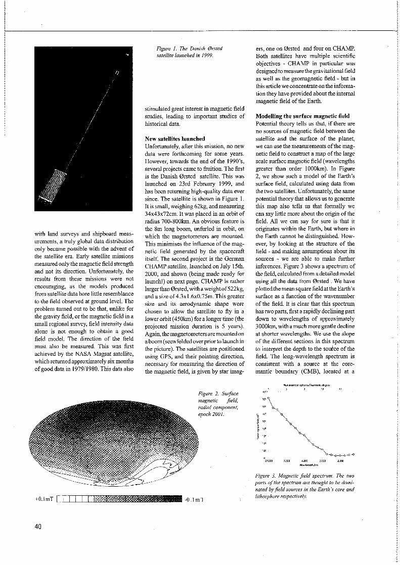
with land surveys and shipboard measurements, a truly global data distribution only became possible with the advent of the satellite era. Early satellite missions measured only the magnetic field strength and not its direction. Unfortunately, the results from these missions were not encouraging, as the models produced from satellite data bore little resemblance to the field observed at ground level. The problem turned out to be that, unlike for the gravity field, or the magnetic field in a small regional survey, field intensity data alone is not enough to obtain a good field model. The direction of the field must also be measured. This was first achieved by the NASA Magsat satellite, which returned approximately six months of good data in 1979/1980. This data also
+O.lmT [ 1 T I I I /qvfffllft
40
Figure I. The Danish @rsted satellite launched in 1999.
stimulated great interest in magnetic field studies, leading to important studies of historical data.
New satellites launched Unfortunately, after this mission, no new data were forthcoming for some years. However, towards the end of the l 990's, several projects came to fruition. The first is the Danish 0rsted satellite. This was launched on 23rd February 1999, and has been returning high-quality data ever since. The satellite is shown in Figure I. It is small, weighing 62kg, and measuring 34x43x72cm. It was placed in an orbit of radius 700-800km. An obvious feature is the 8m long boom, unfurled in orbit, on which the magnetometers are mounted. This minimises the influence ~fthe magnetic field generated by the spacecraft itself. The second project is the German CHAMP satellite, launched on July 15th, 2000, and shown (being made ready for launch!) on next page. CHAMP is rather larger than 0rsted, with a weightof522kg, and a size of 4.3xl.6x0.75m. This greater size and its aerodynamic shape were chosen to allow the satellite to fly in a lowerorbit (450km) fora longer time (the projected mission duration is 5 years). Again, the magnetometers are mounted on a boom ( seen folded over prior to launch in the picture). The satellites are positioned using OPS, and their pointing direction, necessary for measuring the direction of the magnetic field, is given by star imag-
Figure 2. Sltlface magnetic field, radial component, epoch 2001.
-0.1 ml
ers, one on 0rsted and four on CHAMP. Both satellites have multiple scientific objectives - CHAMP in particular was designed to measure the gravitational field as well as the geomagnetic field - but in this article we concentrate on the information they have provided about the internal magnetic field of the Earth.
Modelling the surface magnetic field Potential theory tells us that, if there are no sources of magnetic field between the satellite and the surface of the planet, we can use the measurements of the magnetic field to construct a map of the large scale surface magnetic field (wavelengths greater than order I 000km). In Figure 2, we show such a model of the Earth's surface field, calculated using data from the two satellites. Unfortunately, the same potential theory that allows us to generate this map also tells us that formally we can say little more about the origin of the field. All we can say for sure is that it originates within the Earth, but where in the Earth cannot be distinguished. However, by looking at the structure of the field - and making assumptions about its sources - we are able to make further inferences. Figure 3 shows a spectrum of the field, calculated from a detailed model using all the data from 0rsted . We have plotted the mean square field at the Earth's surface as a function of the wavenumber of the field. It is clear that this spectrum has two parts, first a rapidly declining part down to wavelengths of approximately 3000km, with a much more gentle decline at shorter wavelengths. We use the slope of the different sections in this spectrum to interpret the depth to the soutce of the field. The long-wavelength spectrum is consistent with a source at the coremantle boundary (CMB), located at a
1010
10 27.000
Wavenumber,sphericalharmonicdegree 5 9 13 17
7.300 4.200
Wavelength.km 3.000 2.300
Figure 3. Magnetic field spectrum. The two parts of the spectrum are thought to be dominated by field sources in the Earth 's core and lithosphere respectively.

-16 -14 -12 -10 -8 -6 -4 -2 0 2 4 6 8 10 12 14 16
scalar anomaly [nTI
~ ~ ~ 4 ~ ~ ~ 0 1 2 3 4 5 6 7 Depth /Height in km
Figure 4. Magnetic field at the core-mantle bounda,y, radial component, epoch 2001.
Figure 5. Model of core flow, epoch 2001.
Figure 6. CHAMP scalar magnetic anomaly field map (courtesyofStefanMaus, GFZ Potsdam, Germany).
Figure 7. Effect of high and low bandpassing on a topographic map. The magnetic _field anomaly map is even more difficult to interpret!
depth of 2900km. The CMB is the top of the accepted region of generation of the Earth's field - a hydromagnetic dynamo in the electrically conductive, liquid iron Earth's outer core. The spectrum at shorter wavelengths is consistent with much shallower sources, within the Earth's lithosphere - a combination of field induced by the core main field, and remnant magnetism from rocks that have cooled in the past, and have "frozen in" the ambient field at the time of their formation.
Using the magnetic field data With these assumptions, we use the geomagnetic field to probe the structure and dynamics of the Earth. Figure 4 shows a map of the long-wavelength field extrapolated to the CMB, on the assumption that the surface field with a wavelength longer than 3000 km is dominated by this source. The Earth's continents are superimposed to provide a geographical reference. Compared with the map of the field at the Earth's surface (Figure 2), the field is much stronger ( compare the different scales), and the detailed field structure becomes clear; at the Earth's surface, shorter wavelengths are attenuated by distance from the source. The map we produce is similar to maps produced previously (in particular using Magsat for 1980, but also using historical data for earlier periods), but does show differences. In particular, the patches of magnetic field near the equator in the Atlantic hemisphere have been moving steadily westwards - it is this movement that produces the phenomenum at the Earth's surface known as westward drift. However, this drift is far from uniform: i6. particular, strong concentrations of field at approximately ± 70° latitude remailli remarkably fixed over time.
We can use the change of the field with time (the secular variation) to elucidate the physics of the core. Imagine putting dye into a river. The movement of the dye will tell us about the structure of water flow in the river, until the dye eventually diffuses away. The magnetic field provides a similar tracer for the flow at the top of the core. From estimates of the electrical conductivity in the core, we believe that the effects of diffusion are small on time scales of less than a century: thus, we may use the secular variation to map the flow. While simple to state, this problem is not straight-fo1ward: additional assumptions about the nature of the flow are required, in particular that
41

Figure 8. CHAMP satellite being prepared for transportation to launch site. (Picture courtesy R. Bock, GFZ Potsdam, Germany).
it is large scale. Figure 5 shows a model of the flow at the surface of the core in 2001, calculated from a model of the magnetic field and secular variation determined from 0rsted data. Again, the continents are included only to provide a reference frame. Note the scale of the flow arrows: 20km/yr is five orders of magnitude greater than the velocities of plate tectonic motion associated with flow in the Earth's mantle. We see several clear features, in particular a large counterclockwise gyre under the Indian ocean, another under the Northern Pacific ocean, and strong westward flow under the Atlantic, which is responsible for the "westward drift". Note however, that the equatorial flow under the Indian and Pacific oceans is much weaker, and in some places even eastward. This demonstrates clearly that to understand processes in the core, we must consider models of the magnetic field at the CMB, and not at the Earth's surface. Flow models such as those produced here provide information about the dynamics of the flow in the core, allowing modelling of decadal variations in the rate of Earth rotation, and constraint of the computer simulations of the geodynamo that are being produced by a number of different groups.
Crustal anomaly field What about the field wavelengths less than 3000 km? Because it is in a lower orbit,
42
CHAMP measurements are particularly sensitive to these. Figure 6 presents a map of what is generally called the crustal anomaly field (produced by Stefan Maus, GFZ Potsdam, Germany). This is the field strength at satellite altitude after subtraction of the core field. As can be seen, this field shows much detailed structure. Particularly strong anomalies are seen near Bangui in Africa, near Kursk in Russia, Kentucky in the USA, east and south Australia and near the North Pole. The general form of the map confirms previous models obtained from Magsat data, but with much lower noise - in particular, the field over the oceans is seen to be very smooth and oflow amplitude, as we might expect, due to the lesser thickness and greater homogeneity of oceanic, compared to crustal lithosphere. This map contains a wealth of information about large scale geological structure and tectonic processes, but unfortunately this information is very difficult to extract! The signal is both high and low bandpassed: short wavelengths are unknown due to the limited resolution of the data, whilst long wavelengths are screened by the much stronger field from the core. To demonstrate this effect, Figure 7 shows an equivalent bandpass applied to a model of global topography and bathymetry. While it is still possible to make out the outlines of many of thecontinents, it would be difficult to interpret topography from such a map. This
problem carries over to the magnetic field - we would expect a very strong signal from the contrast between oceanic and continental crust, but large parts of this signal are masked by the core field. Considerable progress has been made in understanding this signal, with forward and inverse modelling incorporating geological data, but much remains to be done.
The exciting results from these missions are leading to further missions, promising yet better data. One is already flying: The 0rsted 2 experiment on board the Argentine SAC-C satellite. Several are in the planning stage, includingAMPERE, a French proposal, and Swarm, a European Space Agency proposal for multiple satellites led from Denmark. The future appears bright, both for the measurements as well as for the increased understanding of the Earth that they will allow.
* Due to a printing error in EGM 12, this article did not appear in fit!! and is reprinted here
Web sites for further information:
0rsted:http://web.dmi.dk/fsweb/ projects/oersted/
CHAMP:http://op.gfz-potsdam.de/ champ/

European Federation of Geologists (EFG) The European Federation of Geologists was established in Paris in 1980 during the 26th International Congress of Geology. In the same year the Statutes were presented to the European Economic Community in Brussels.
The Council of the EFG is composed of the representatives of the national associations of geologists of Belgium-Luxembourg (UBLG), Czech Republic (CAEG), Finland (YKL), France (UFG), Germany (BDG), Hungary (MFT), Iceland (GSI), Ireland (IGI), Italy (ANG!), Netherlands (KNGMG), Poland (PTG), Portugal (APG), Slovakia (SGS), Slovenia (SGD), Spain (I COG/AGE), Sweden (SN), Switzerland (CHGEOL), United Kingdom (GS), whilst the American institute is an Associate Member. There are observer associations from Austria, Bulgaria, Greece, Norway, Romania, Turkey and Canada. The EFG currently represents about 75,000 geologists across Europe.
Mission To promote the profession and practice of geology and its relevance.
Objectives
I. To promote and facilitate the establishment and implementation of national arrangements for recognising geologists who, through academic training and appropriate periods of relevant experience in the profession and practice of geology, are qualified to be designated as EurGeol.
2. To organise meetings and conferences to discuss issues related to the profession and practice of geology.
3. To co-ordinate the activities of member national organisations in preparing briefing papers on geological issues and presenting these to European bodies, national governments and other relevant organisations.
4. To maintain contact with the European Commission and respond in timely manner to requests for information.
5. To communicate, through meetings and other means, the relevance of geology to the resolution of issues of concern to society.
6. To promote the establishment of best practice for training of geologists.
7. To safeguard and promote the present and future interests of the geological profession in Europe, including:
- to guarantee the free movement of geologists in Europe, with the mutual recognition of their academic and professional qualifications by the adoption of the title of European Geologist (EurGeol.).
- to promote the harmonisation of education and training.
- to define and protect the title of geologist and related professional titles.
- to promote the code of professional ethics of the EFG.
- to provide advice and assistance to constituent member National Associations.
Submission of articles to European Geologist Magazine The EFG calls for quality articles for future issues of European Geologist. Submissions should be in English and between 1000 and 3000 words, although longer articles may be considered. An abstract of between 100 and 150 words should be included in English, French and Spanish. Articles should be sent via e-mail to the Editor at [email protected] or on disc to Kaplevej 7, 2830 Virum, Denmark. Photographs or graphics are very welcome and should be sent to the Editor as tif or jpg files, preferably on ed.
Deadline for submission 30 March and 30 September.
Advertisements Prices for advertisements
Full page ( colour) Half page (colour) Quarter page ( colour) Full page (black and white) Half page (black and white) Quarter page (black and white) Business card size Preferential location Price for special pages: Outside back cover ( colour) Second page ( colour) Second last page ( colour)
Data for European Geologist Magazine Number of issues printed: Periodicity: Print mode: Size: Deadline: Published: Advertisement delivered as computer file: For graphics remember to include fonts.
One Insertion 820Euro 420 Euro 220Euro 420Euro 220Euro 120 Euro 90 Euro
25%plus
1200 Euro 1000 Euro 1000 Euro
Two Insertions 1320 Euro 670 Euro 350 Euro 670 Euro 350 Euro 200 Euro 150 Euro
1900 Euro 1600 Euro 1600 Euro
6000 2 times a year
Offset A4 (210 mm x 297 mm)
30 March, 30 September. 30 May, 30 November
EPS, TIFF
I 6000 issues of European Geologist are dis-tributed among professional geologists all over Europe. They are sent to the;European countries National Federations of Geologists, and these national organisations distribute them to their members. These include geologists working in companies as well as at universities.
Layout of the magazine is made in Adobe Indesign for PC.
Method of payment:
Invoice after publication
Subscription Rates: Annual subscription to the Magazine: 13 Euro
Contact: Maureen Mc Corry Kaplevej 7 2830 Virum, Denmark e-mail: [email protected]
43

Das 3--Erfol INlm .... ..... gs . Drei Voraussetzungen braucht's fur optimale geologische Oaten: 1. einen guten Geologen (----+ Sie und 1hr Bedurfnis !) 2. einen versierten Stump-Bohrmeister 3. einen kompetenten Stump-Messtechniker
Wir bieten Ihnen: Sondierbohrungen und Messtechnik aus einem Haus. Kundennah, in der ganzen Schweiz.
't' ~ Stump Bohr AG www.stump.ch
Worldwide Geoservices
Rue General Wangennee 15, B-1040 Bruxelles.
Tel: +32 2 735 12 08 Fax: +32 2 733 10 18
email: [email protected]
www.csa.ie
■ CSA House, 7 Dundrum Business Park, Windy Arbour, Dublin 14, Ireland Tel: +353 1 296 4667 Fax: +353 1 296 4676 email: [email protected]