pradhan mantri krishi sinchai yojana - … · irrigation planning report for buldana district of...
TRANSCRIPT

Irrigation Planning Report for BULDANA District of Maharashtra State (India)
1
PRADHAN MANTRI KRISHI
SINCHAI YOJANA
DISTRICT IRRIGATION PLAN
DISTRICT - BULDHANA
MAHARASHTRA

Irrigation Planning Report for BULDANA District of Maharashtra State (India)
2
Sr. No. CHAPTERS Pages
From - to
01 Introduction
1
02 Objectives
1
03 District Profile
2
04 Geomorphology and physiography
3-5
05 Drainage and watershed
5-7
06 Climate and rainfall
8-9
07 Landuse
10
08 River basin
11
09 Soil type
12-13
10 Agriculture Situation in the District 14-17
11 Hydrogeology 18-20
12 Groundwater scenarios 21
12.1 Present Scenarios 21-22
13 Water Resources
23
14 Irrigation Plan
24-26

Irrigation Planning Report for BULDANA District of Maharashtra State (India)
3
1. INTRODUCTION
The overreaching vision of Pradhan Mantri Krishi Sinchayee Yojana (PMKSY) will be to ensure access to some means of protective irrigation to all agricultural farms in the country( har khet ko paani) and to produce ‘per drop more crop’, thus bringing much desired rural prosperity.
The scheme will ensure the completion of long pending irrigation projects on priority and launch the ‘Pradhan Mantri Krishi Sinchayee Yojana’ with the motto of ‘Har Khet Ko Paani’. By harnessing rain water through ‘Jal Sanchay’ and ‘Jal Sinchan’, nurture water conservation and ground water recharge.
Micro irrigation will be popularised to ensure ‘Per drop-More crop’ . Creation of new water sources; repair, restoration and renovation of defunct water sources; construction of water harvesting structures, secondary & micro storage, groundwater development, enhancing potentials of traditional water bodies at village level will be taken on priority.
2. OBJECTIVE
The broad objectives of PMKSY will be:-
A. Enhance the physical access of water on the farm and expand cultivable area under assured irrigation (Har Khet ko pani).
B. Integration of water source, distribution and its efficient use, to make best use of water through appropriate technologies and practices.
C. Improve on-farm water use efficiency to reduce wastage and increase availability both in duration and extent.
D. Enhance the adoption of precision-irrigation and other water
saving technologies (More crop per drop).

Irrigation Planning Report for BULDANA District of Maharashtra State (India)
4
3.DISTRICT PROFILE
The Buldana district is a district in Amravati division of Maharashtra
state in western part of India. The district is bordered by Amravati and
Burhanpur district (M.P.) in North, Akola and Washim districts in East , Hingoli
and Jalna district on South and Jalgaon and Aurangabad in West. The district
head quarter Buldana is well connected to other parts of the state by a number
of good all weather roads. The National Highway No.6 leading to Dhule -
Calcutta passes through major part of the district. The district has 6 sub
divisions and 13 blocks. The district is mainly covered in Survey of India
topographic Sheet No. 55D/8 partly in 46 P and 56 A & lies between 19°51' to
21°17' North latitude and 75°57' to 76°49' East Longitude.
Map: 1 Location Map of Buldhana District
Irrigation Planning Report for BULDANA District of Maharashtra State (India)
5
4. GEOMORPHOLOGY AND PHYSIOGRAPHY
The Buldana district forms approximately a parallelogram having more
stretch along North-South direction rather than the East-West direction. The
district is nearly divided into two separate parts. Southern portion of the
district forms comparatively a table land than the Northern portion which is
plain. The ranges of Ajanta form a line of bifurcation in between the two
portions. Both the parts have nearly the equal area of the district. The
elevation of the table land portion ranges from 492m to 687 meters, while the
elevation of the plain area varies 246 m to259 m.
Southern portion of the district comprises of the two hilly ranges while
the northern portion is comparatively plain exception the northern most
portion is highly rugged area having the ranges of Satpuras with the direction
of NNE-SSW approximately. The two hilly ranges of southern portion are
named as southern & Central belts. The Central belt runs first NW-SE for near
about 64 k.m. the southern belt of hill ranges stretches from Dhad to Lonar in
the direction of NW-SE for a distance of 103 Km. the valley of Painganga
widens up steadily from 6 Km to 88 Km.for distance of 106 Km along NW-SE in
between these two hill ranges.
These two belts of hill ranges have formed many vallies through which
many streams feed the major rivers of the dist. The hill ranges have given rise
to many terrains along the foot hills which fall along the steep side marked by
cliffs.
The Central belt has numerous valleys opening mostly along the
Northern direction. First shallow and then widens to a large extent which
gradually sinks into the bigger plains.

Irrigation Planning Report for BULDANA District of Maharashtra State (India)
6
The physiography of the district has given rise to four major
characteristic land forms viz. (I) The hill and ghat section 2) The foot hill zones
3) The plateaus and 4) The Plains. This Classification of the land forms a very
important basis for both assessment and development of groundwater
resources of the district. The extents of such features are given in the following
table.
It is clear from the physiography that the plains and foot hil areas are
mostly the favorable areas where ground water development can take place.
The plain area and the foot hill area cover 69 percent of the tota geographical
area respectively. It means that only 69 % of the area is suitable for
groundwater development & 31% of area is unsuitable for the development.
Topographically, the district falls under three structural-cum-physical
units: a narrow, northern strip in the Jalgaon and Sangrampur thasil in the
Satpuda hills, the Payanghat or the Purna plains in the middle comprising the
tahsils of Malkapur, Nandura, Khamgaon , Shegaon, Jalgaon and Sangrampur
while the Buldhana plateau comprising the Chikhli and Mehakar , Lonar,
Deulgaon Raja and Sindkhed Raja tahsils to the south. The landscape in the
district is rich and varied, with gently sloping fertile riverine plains studded
with agriculturally prosperous villages standing in sharp contrast to the flat
undulation plateau country with patches of cultivation, broad open river
valleys and a monotonous scrub cover. The ghat country, deeply scoured by
gullies and ravines on the edge of the plateau and the sheer black walls of the
Satpuda scarps to the north add color to the variety of landforms.

Irrigation Planning Report for BULDANA District of Maharashtra State (India)
7
Map: 2 Geomorphology Map of Buldhana District
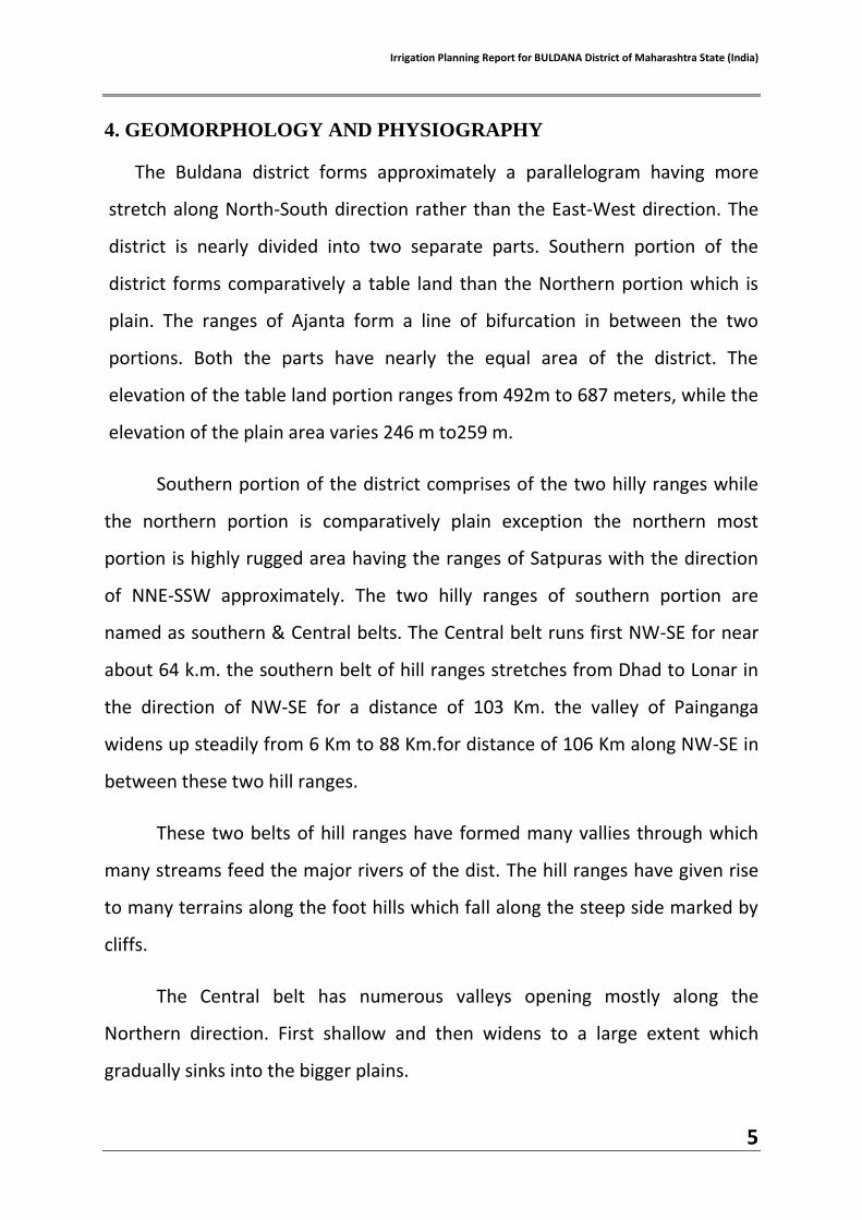
5. DRAINAGE AND WATERSHEDS
The district is entirely drained by three major drainage systems. The
Purna (Tapi) system covers the complete half of the area of the district. The
system is developed along the northern side of the district. The painganga
system & the purna (Godavari) system originates from the Ajanta hills & covers
the southern half portion of the district. The Purna Tapi is having the westerly
drainage system and the remaining two system i.e. of Painganga and Purna
(Godavari) have SE drainage system.
The river purna (Tapi) forms the major drainage in the district which
flows E to EW. It enters the district from Akola district and finally meets the
Tapi rivers in Jalgaon district. In the district it enters at the bed level 152
Mts.MSL and leaves 226 Mtrs.MSL.for a distance of 45 Km. The drainage

Irrigation Planning Report for BULDANA District of Maharashtra State (India)
8
pattern of this river is quite big. It has deposited the huge alluvial deposits on
the both banks. The river is perennial throughout the year.
Purna (Tapi) system is supported by the number of tributaries in the
district Nalganga. Vishwanganga, Gyanganga and Man rivers are the main
tributaries which are flowing from the southern portion of the river which are
originated from the Ajanta hill and run nearly 50 to 70 Km. when they meet
finally to Purna, These tributaties are seasonal and deposited alluvial deposits
at the both banks.
Wan and other major nalas are enriching the Purna (Tapi) system from
northern portion which originates from Satpura ranges and run approximately
30 to 40 Km. before meeting to Purna river.
The river Painganga has a total drainage of 90 Km.in the district and has
a Slope of 153 Mts. i.e. about 0.17 % it enters the district at 686 m amsl and
leaves at 533 m amsl.
The river purna (Godavari) has drainage of total length 45 Km. It enters
in the district at the bed level of 518 m amsl. and leaves the district at the bed
level of 479 m amsl.
All the rivers have a sub parallel to semi dendritic drainage pattern
which is controlled by structures of the bed rocks formed by deccan basalt lava
flows.Based on geomorphological setting and drainage pattern the district is
divided into 57watersheds
Irrigation Planning Report for BULDANA District of Maharashtra State (India)
9
Map: 3 Draingae & Waterbody Map of Buldhana District
Map: 4 Watershed Map of Buldhana District

Irrigation Planning Report for BULDANA District of Maharashtra State (India)
10
6. CLIMATE AND RAINFALL
The Climate of the district is characterized by a hot summer and general
dryness throughout the year except during the south-west monsoon season,
i.e. June to September. The winter season is from December to about the
middle of February followed by summer season which last up to May. June to
September is the south-west monsoon season, whereas October and
November constitute the post-monsoon season. The mean minimum
temperature is about 12°C and means maximum temperature is about 45°C.
Except during the monsoon season when the humidity is high, the air is
generally dry. The summer months are the driest with relative humidity
between 25 and 35 percent.
The normal annual rainfall over the district varies from about 711 mm to
911 mm . It is the minimum in the northern parts of the district around
Malkapur (711 mm) and Jalgaon (Jamod) (719 mm). The average annual rainfall
of last ten years (1996-2005) in the district varied from 539 mm (Nandura) to
845mm (Sindkhed Raja) The maximum spell of rainfall range from June to
September constitutes 85 percent of the annual rainfall. The month of July and
August being the rainiest month. The variation in rainfall from year to year in
the district is large. On an average number of rainy days in major part of the
district are 42 to 49 in a year and the same is presented in Table

Irrigation Planning Report for BULDANA District of Maharashtra State (India)
11
Map: 5 Rainfall Map of Buldhana District

Irrigation Planning Report for BULDANA District of Maharashtra State (India)
12
7. LANDUSE IN THE DISTRICT
The district has a total population of 25,88,039. And total area of
9,67,099 ha out of which Cultivable area is 760000ha , Forest area is 56000ha
and area under non agriculture purpose is 41000ha. 21.2 % is urban, 78.8 % is
rural area.

Irrigation Planning Report for BULDANA District of Maharashtra State (India)
13
8. RIVER BASINS
Total water resources available with the district is 1867.124 MCUM out
of which about 58.47 % is allocated for irrigation, 1.53 % for industrial and
8.24% is for domestic/drinking purpose. The region is going through
urbanization / industrialization. The total population dependent on
agriculture is 21,99,833 and total number of marginal farmers are 2,65,836
There are 2 major river basins viz Tapti and Godavari in the district. Their
drainage system is as given below .

Irrigation Planning Report for BULDANA District of Maharashtra State (India)
14
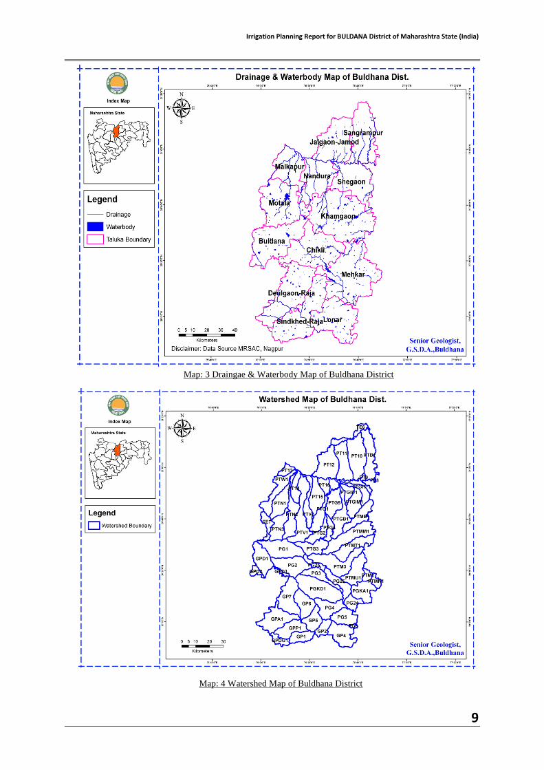
9.SOIL TYPE
The Satpudas have shallow, gravely and stony reddish soils. The soil over
the piedmont deposits is coarse, highly friable and is locally known as Malli soil
and is well suited for horticulture. To the south of the Satpuda piedmont, the
Alluvial plains are covered by deep Alluvial soil, locally known as Bharkali soil,
which are deep black, very fine in texture and highly retentive of moisture.
Southwards away from the river, the soils are replaced by Kali regular soils,
which are moderately deep. The soils of the plateau are Bhorandi or Khelk, a
thin yellowish coarse soil, often less than half meter deep. The upper plateau is
generally covered by shallow, black, brown or reddish soil. These are locally
known as Barad soils.
Availability of water often determines the nature and level of social
development of a region. The Purna basin lying in Western Vidarbha has
unique features in the whole of the country in that a deeply inland area has
extremely high innate soil and water salinity. A huge expanse of land mass of
otherwise exceptionally high soil fertility has come to degenerate into near
wastelands due to the high dissolved salts in the underground water, salts that
often leach up to the surface.
The area adjoining the Purna river having peculiar characteristics of soil
and groundwater i.e. salinity. The saline track is the region in which the soils
have excessive concentration of natural soluble salts, mainly of chlorides,
sulphates and carbonates of calcium, magnesium and sodium. In these soils,
the exchangeable sodium percentage is greater than 15 as a result the pH is
more than 8.5.
Irrigation Planning Report for BULDANA District of Maharashtra State (India)
15
The saline belt of the Purna basin covers 166 Villages of 5 Tahsils. These
villages suffer an acute problem of water for domastic and agricultural usage.
Even though the annual precipitation averages 800 mm, saline ground water
forces the rural population to practice only rain fed agriculture. As a result,
they are rendered vulnerable to weather induced risks and their lives are quite
pathetic.
Soil Types of the District: Major soils Area( 000ha) percentage
Deep black soil 342.0 35.4 Medium black soil 80.6 8.3
Shallow black soil 544.3 56.3 Others( saline )
Map: 8 Soil Map of Buldhana District

Irrigation Planning Report for BULDANA District of Maharashtra State (India)
16
10. AGRICULTURE SITUATION IN THE DISTRICT
Major crops of the district are Soybean, Cotton, Gram and Wheat second
major crop is Tur, Jowar, Maize, Green Gram, Black Gram and other crops are
Sunflowar, Safflower, Sesamum, Groundnut.
Existing Crop Pattern
The cropping pattern in an irrigated area depends should mainly on
(i) Availability of Water (ii) Type of Soil and land to be irrigated (iii) Climatic Conditions (iv) Value of produce and socio-economic aspects
Sr. No.
Season Crop Average Area ha.
Actual Sowing 2014 Area ha.
1 Kharip Sorghum 56300 20646
Cotton 244400 174339 Soyabean 208300 412103
Bajara 3500 2841
Maize 61100 30014 Tur 65000 69600
Green Gram 52500 12313 Black Gram 48400 11135
Groundnut 400 1050 Sesamum 4100 1581
Sunflower 2100 87
Sugarcane 1700 319 TOTAL 747800 736028
2 Rabbi Sorghum 16221 15828 Wheat 52940 57876
Gram 73910 122441
Maize 3330 12210 Sunflower 2300 49
Safflower 3100 373 TOTAL 151801 208777
Irrigation Planning Report for BULDANA District of Maharashtra State (India)
17
Sr. No.
Season Crop Average Area ha.
Actual Sowing 2014 Area ha.
3 Summer Maize 510 0
Sunflower 940 34 Groundnut 960 3364
Sesamum 130 0
Green Gram 48 0 TOTAL 2588 3398
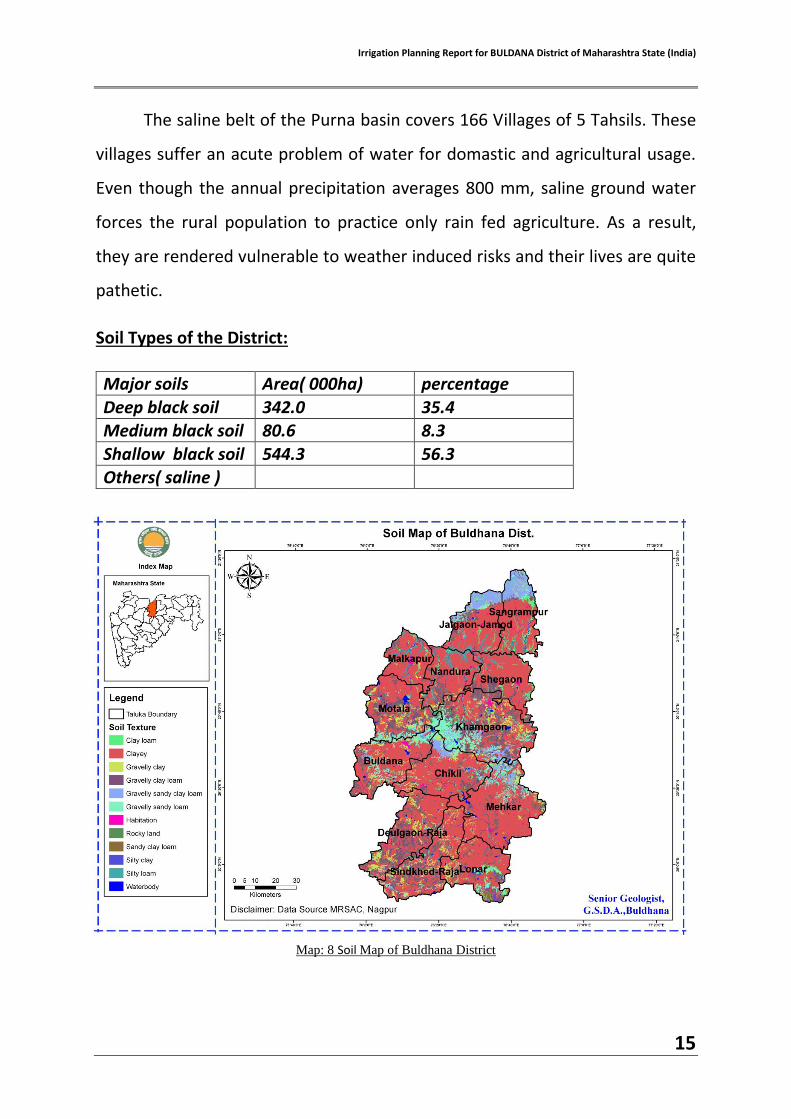
Existing Area under Rainfed Cultivation
(a) Rainfall during Monsoon (Max. Min & Average): Max – 119 mm (5 August 2015) Min – 0.1 mm (26 June, 22 & 23 Sept. 2015) Average – 713 mm
(b) Rainfall during non-monsoon (Max. Min & Average): Max – 30 mm (1 January 2015) Min – 0.4 mm (16 March 2015) Average – 72.9 mm
(c) Area under rainfed cultivation Total Area under cultivation -7,60,000 ha.

Irrigation Planning Report for BULDANA District of Maharashtra State (India)
18
Rainfed area – 730440 ha.
Area under each crop : Orchard / Fruits / Vegetables / Water Bodies like
ponds, tanks and lakes for aquatic Farming
Crops RainFed Irrigated Area (ha) Yield (t
/ha) Area (ha) Yield (t /ha)
--- Kharif Crop
i. Soyabean 412103 0.565 ii. Cotton (Bale) 174339 0.13
iii. Tur 69690 0.254 iv. Maize 30014 1.926
v. Kharp Jowar 20646 1.026
vi. Moong 12313 0.318 vii. Udid 11335 0.329
Sub Total 730440
--- Rabbi Crop
i. Gram 122449 0.68 ii. Wheat 57876 1.294
iii. R. Jowar 15828 0.783 iv. Maize 12210
v. Sunflower 373 vi. Safflower 49 0.524
Sub Total 150909 57876
-- Perennial
i. Custard Apple 259.60 3.50 ii. Grapes 37.30 14.00
iii. Pomegranate 842.10 6.51
iv. Orange 907.80 13.00 v. Sweet Orange 404.50 14.00
vi. Mango 285.50 3.80 vii. Banana 534.90 53.00
viii. Guava 355.20 14.50

Irrigation Planning Report for BULDANA District of Maharashtra State (India)
19
ix. K. Lime 320.70 4.00
x. Papaya 34.50 60.09 xi. Sapota 91.10 7.57
Sub Total 259.60 3813.60
-- Vegetable
i. Brinjal 308.10 13.50 ii. Cabbage 91.10 14.00
iii. Cauliflower 109.80 14.49 iv. Okra 129.80 5.50
v. Tomato 383.00 14.50
vi. Potato 250.30 36.30 vii. Onion 11920.00 16.80
Sub Total 13192.10
-- Spices
i. Ginger 191.10 3.41 ii. Turmeric 236.80 5.60
iii. Other Spices 1538.00 1.07 Sub Total 1965.90
-- Flowers
i. Chrysanthmum 14.80 1.49
ii. Marigold 94.50 6.50 iii. Rows 20.30 3.00
iv. Other Flowers 6.60 0.76 Sub Total 136.20

Irrigation Planning Report for BULDANA District of Maharashtra State (India)
20
11. Hydrogeology
Deccan Trap lava flows and Purna Alluvium are the major water bearing
formations of Buldhana district.
Hard Rock (Deccan Trap Basalt) Aquifer:
Major part of the district is covered by basaltic lava flows of upper
Cretaceous to lower Eocene age. The Deccan lava sequence is grouped under
Satpura group in the northern part whereas in southern part it is grouped
under Sahyadri group.
Deccan Trap Basalt forms an important water bearing formation of the
district. The disposition of vesicular unit and massive unit of different lava
flows has given rise to multi layered aquifer system. The water bearing capacity
of Vesicular Basalt largely depends upon size and shape of vesicles,density of
vesicles and the degree of inter connection of vesicles. Massive Basalt generally
does not possess primary porosity. However, Massive Basalt, which is
fractured, jointed and weathered posses’ water bearing capacity. Degree of
weathering and topographic setting also plays a major role in respect of
productivity. In Basalt, ground water occurs both in Vesicular and Massive
Basalt as well as inter flow zones in weathered mantle, fractured zones. In
general ground water occurs under water table conditions in shallow aquifer
and semi-confined to confined conditions in deeper aquifer. The unconfined
aquifer is developed due to the weathering and jointing of upper flow in Basalt
down to depth of 15-20 mbgl.
Soft Rock (Alluvium) Aquifer:
The northern part of the district on either side of Purna River is underlain
by thick Alluvial deposits of Pleistocene to Recent age and is termed as Purna
Alluvium. The Alluvium is also observed in a small patch southwest of Malkapur
and east of Khamgaon along the boundaries of district.The Alluvial valley lies in

Irrigation Planning Report for BULDANA District of Maharashtra State (India)
21
narrow belt and covers roughly about 1800 sq. km.The valley extends about 51
sq.km. in Buldhana district and it tapers towards the western end.In Alluvial
deposits, inter pore spaces in sand and gravel renders them a high degree of
porosity and permeability to make them a good ground water reservoir.
However lithological variation results in variable water yielding capacity
depending upon the sand-clay ratio. Purna Alluvium has a proven thickness of
more than 300 meters. Based on studies the entire thickness of Alluvium has
been divided into younger Alluvium and older Alluvium. The younger Alluvium
contains comparatively more sand layers and thus forms good aquifer. The
older Alluvium, which is more clayey with thin horizons of sand and silt forms a
comparatively lesser potential aquifer. In younger Alluvium ground water
generally occurs in confined to semi-confined conditions in the depth range of
11-40 m bgl, while in older Alluvium it occurs under confined conditions below
the depth of 40 m.
Aquifer Parameters
The principal water table aquifer in the district occurs down to a depth
of 15 meters below ground level and shows a great variation in its capacity to
yield water the massive units under favorable conditions of topography and
rocks weathering generally have slightly low yields as compared to the
vesicular units under similar conditions which have higher yields. The specific
capacities of wells tested vary from 10 to 200 liters per minutes of drawdown.
Specific yield varies from 1.6 percent to 13.5 percent. But generally it varies
from 4 percent to 6 percent. The transmissivity of phreatic aquifer ranges
between 18 and 80 m2/day.
Aquifer parameters for alluvial area, the transmissivity values ranged
from from 0.89 to 1575.96 m2/day and storativity ranges from 1.09 x 10⁻³ to
3.00 x 10⁻⁶. The transmissivity in Basalt ranges from 8.35 to 395.85 m2/day
Irrigation Planning Report for BULDANA District of Maharashtra State (India)
22
and the storativity varies between 8 x 10 -8 and 4.2 x 10 – 2.
It is observed that values of transmissivity and storativity are directly
proportionate to the cumulative thickness of the aquifer and the type of
aquifer.
Yields of Dugwells and Borewells
The yields of the wells are the functions of the permeability and
storativity of aquifer encountered. This varies with location, diameter and
depth of wells. There are mainly two types of ground water structures in the
district i.e., dugwells and borewells/Tubewells.
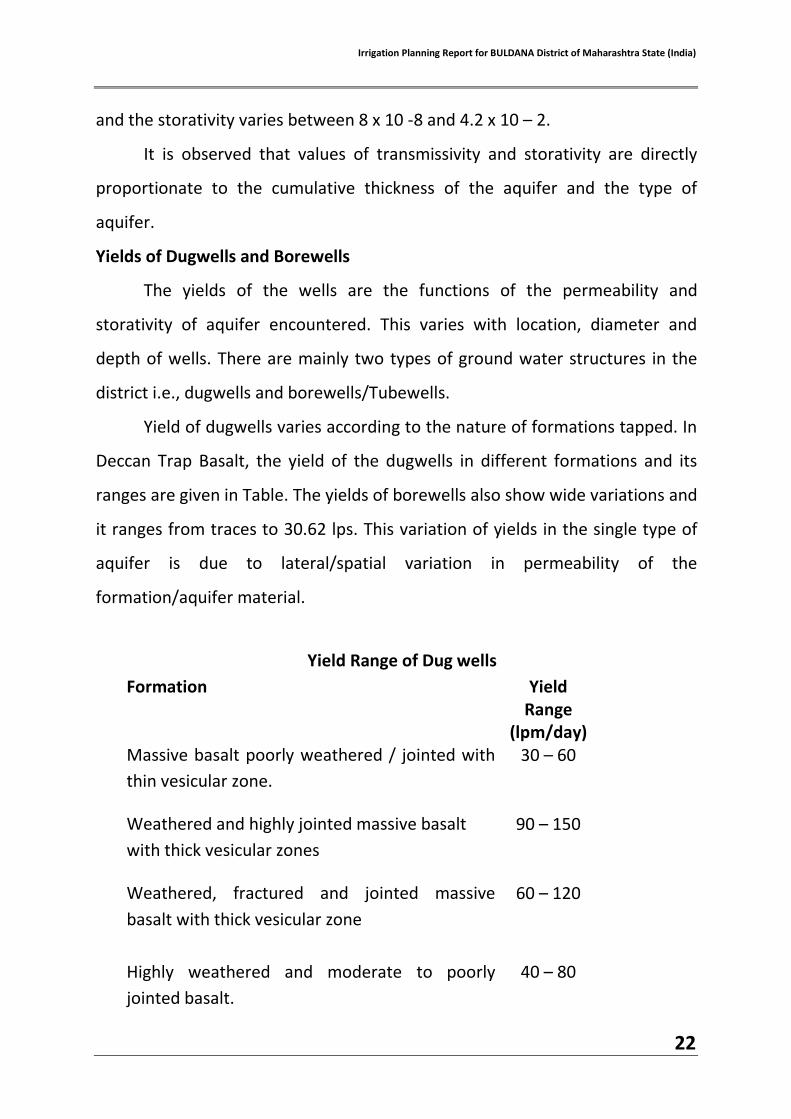
Yield of dugwells varies according to the nature of formations tapped. In
Deccan Trap Basalt, the yield of the dugwells in different formations and its
ranges are given in Table. The yields of borewells also show wide variations and
it ranges from traces to 30.62 lps. This variation of yields in the single type of
aquifer is due to lateral/spatial variation in permeability of the
formation/aquifer material.
Yield Range of Dug wells
Formation Yield Range
(lpm/day)
Massive basalt poorly weathered / jointed with
thin vesicular zone.
30 – 60
Weathered and highly jointed massive basalt
with thick vesicular zones
90 – 150
Weathered, fractured and jointed massive
basalt with thick vesicular zone
60 – 120
Highly weathered and moderate to poorly
jointed basalt.
40 – 80

Irrigation Planning Report for BULDANA District of Maharashtra State (India)
23
12. Groundwater Scenarios
Table-2
1998 2004 2007 2008 2011
Annual Recharge in ham
85636 69595 90518 91652 94162
Annual Draft in ham 20950 41644 64304 64151 65533
Total Irrigation Wells
32443 35596 57967 57967 59639
The ground water development has been growing at an exponential rate
in the district. The above table shows consistent growth in groundwater
irrigation and the number of wells. The groundwater development has almost
been doubled in the beginning of 2001.
12.1 Present scenarios
The district abstract showing details of Dynamic Ground water
Resources 2011-12 is given below –
Table-3
Total Number of Watersheds 57 Overexploited Watersheds 02
Critical watersheds 00 Semi – Critical watersheds 07
Poor Quality 00 Safe watersheds 48
Total No of Talukas 13 Total Geographical Area in Sq.Km. 9661
Command Area in Sq .Km. 624.89 Non Command Area in Sq.Km. 7314.98
Poor Quality Area in Sq.Km. 266.28 Irrigation wells and Borewells 59639
Total Annual GW Recharge 94162 ham Net annual GW availability 28629 ham
Gross Draft in ham 65533 ham

Irrigation Planning Report for BULDANA District of Maharashtra State (India)
24
District Water Account – Now the objective is to bring the rainfed area under irrigation by various
interventions under various schemes of both central and state governments
like
1. AIBP 2. IWMP 3. MGNREGA 4. RKVY 5. VIIDP 6. NRDWP 7. JALYUKT SHIVAR ABHIYAAN ( DPC, 8. CSR activities 9. CAIM 10. Mahatma Phule Jal Bhumi Sandharan Abhiyan Departments involved 1. Irrigation ( state, local sector, zilla parishad) 2. Agriculture (state, zilla parishad) 3. Zilla parishad 4. Forest 5. GSDA 6. NGOs, Banks (CSR) 7. Agricultural Universities

Irrigation Planning Report for BULDANA District of Maharashtra State (India)
25
13. WATER RESOURCES
Water availability in the district
WaterRequirement of the District
TOTAL Domestic 153.885
MCUM Agriculture 1091.787
MCUM Industry 28.63.00
MCUM TOTAL 1274.302
MCUM
Irrigation Projects (Major/Medium/Minor) Name of the
Project
Status NO OF PROJECTS
LIVE STORAGE
(MMCUM)
Gorss Command Area (GCA)
Ha.
Culturable Command
Area (CCA)Ha.
MAJOR Completed 4 304.66 92486 68290
MEDIUM
Ongoing 1 297.72 140400 112320
Total 5 602.38 232886 180610
Completed 7 136.12 45348 33794
MINOR
Ongoing 0 0 0 0
Total 7 136.12 45348 33794
Completed 99 197.087 53271 42788
0 to 100 ha.
Ongoing 15 55.465 11097 8680
future 21 26.074 4296 3581
Total 135 278.626 68664 55049
587 92.79 20900 20900
Surface Water MCUM Remarks
Minor Irrigation 255 Total Gross Storage considered as available water in Irrigation Projects.
Medium Irrigation 157.25
Major Irrigation 1119.86
Ground water (Wells, Tubewells)
268.9
TOTAL 1801.01

Irrigation Planning Report for BULDANA District of Maharashtra State (India)
26
GRAND TOTAL
734 1109.916 367398 290353
Irrigation Methods used
o Canal Irrigation -144464 ha (GCA) o River Irrigation (KT Weir, Lift Irrigation etc) - 222934 Ha (GCA) o Open well and Tube well – 98343 Ha.
14. IRRIGATION PLAN
It is intended to formulate a holistic irrigation plan for the district with the
main objectives as under:
To maximize crop yield in order to achieve food self sufficiency of the
region. (per drop more crop)
To increase the agriculture area under irrigation (har khet ko paani)
Area proposed to be covered under Drip / Sprinkler Irrigation during 2015-16
Sr. No.
No. of block
/Taluka Crop Spacing
No. of beneficiaries
Area (Ha.)
Total Cost Involved
Financial Outlay
Total
A. Drip Mango 10 M x 10 M 18 16.50 3.11 1.86
Irrigation 13 Tamarind 10 M x 10 M 5 5.00 0.94 0.56
Sapota 10 M x 10 M 8 12.00 2.26 1.36
Guava 6 M x 6 M 40 35.00 9.29 5.58
Cashewnut 6 M x 6 M 0 0.00 0.00 0.00
Citrus 6 M x 6 M 312 287.00 76.20 45.72
Amala 6 M x 6 M 20 19.50 5.18 3.11
C.apple 5 M x 5 M 148 116.00 34.97 20.98
Fig 5 M x 5 M 4 2.00 0.60 0.36
Ber 5 M x 5 M 5 5.00 1.51 0.90
Pomegranate 4 M x 4 M 60 60.00 19.08 11.45
Papaya 3 M x 3 M 82 62.00 22.66 13.60
Grapes 2 M x 2 M 10 8.00 5.09 3.05
Banana 1.5 M x 1.5
M 162 296.30 220.56 132.33
Vegetables 2.5 M x 0.6
M 89 78.00 42.90 25.74
1.8 x 0.6 120 112.00 78.50 47.10

Irrigation Planning Report for BULDANA District of Maharashtra State (India)
27
1.2 x 0.6 300 250.00 244.00 146.40
Flowers 2.5 M x 0.6
M 5 7.50 4.13 2.48
1.8 x 0.6 5 7.50 5.26 3.15
1.2 x 0.6 5 7.50 7.32 4.37
Sugarcane 1.5 M x 1.5
M 10 15.00 11.17 6.70
Cotton 1.2 x 0.6 9500 10230.00 7614.91 4568.94
Total Drip Irrigation 10908 11631.80 8409.60 5045.74
B. Portable Sprinkler Hort & Non- Hort Crops 7835 7650.00 1492.10 895.26
Total Portable Sprinkler Irrigation System 7835 7650.00 1492.10 895.26
C. Semi perment Sprinkler
Hort & Non- Hort Crops
Total Semi Permenent Sprinkler Irrigation System 0.00 0.000 0.00
D. Large Volume Sprinkler(Rain gun)
Hort & Non- Hort Crops
Total Large Volume Sprinkler Irrigation System 0.00 0.000 0.00
E. Admn. Cost @ 1 % 59.00
Grand Total ( A+B+C+D+E ) 18743 19281.80 9901.70 6000.00
Likewise for 5 years till 2020 (Under VIIDP) MICRO IRRIGATION
Year Area (Ha.) Financial outlay(in LAKHS)
2015-16 19281.80 6000.00
2016-17 21209.98 6600.00
2017-18 23330.48 7260.00
2018-19 25662.93 7986.00
2019-20 28230.12 8784.00
TOTAL 117715.31 36630.00

Irrigation Planning Report for BULDANA District of Maharashtra State (India)
28
Proposed increase in the Irrigation Potential
TOTAL FINANCIAL OUTLAY REQUIRED TO ACHIEVE OBJECTIVES OF PMKSY
YEAR FINANCIAL OUTLAY
PER DROP MORE
CROP
HAR KHET KO
PAANI
2015-16 6000.00 2752.25
2016-17 6600.00 2752.25
2017-18 7260.00 2752.25
2018-19 7986.00 2752.25
2019-20 8784.00 2752.25
TOTAL 36630.00 13762.25
Type of Projects Area to be
covered(HA) Amount(IN
LAKHS)
Minor Irrigation (AIBP+Others) 8462 3735
Medium Irrigation(AIBP) 0 0
Major Irrigation(AIBP+Others) 101088 0.00
Watershed Development(PMKSY) 18336.12 2200.34
Water Bodies (VIIDP) (KT weir, PT) 12807 583.16
Wells (NREGA ) (8125) 12187 243.75
FARM PONDS (NREGA, RKVY) 15000 7000.00
TOTAL 167880.12 13762.25

Irrigation Planning Report for BULDANA District of Maharashtra State (India)
29
List of maps
1.Location map of a district
2.Geomorphology map
3. Drainage and waterbody map
4.Watershed map
5.Rainfall map
6.Land use cover map
7.Basin map
8.Soil map
9.Cropping pattern map