pre- application 15/03779/preapp: land to rear of trent
TRANSCRIPT

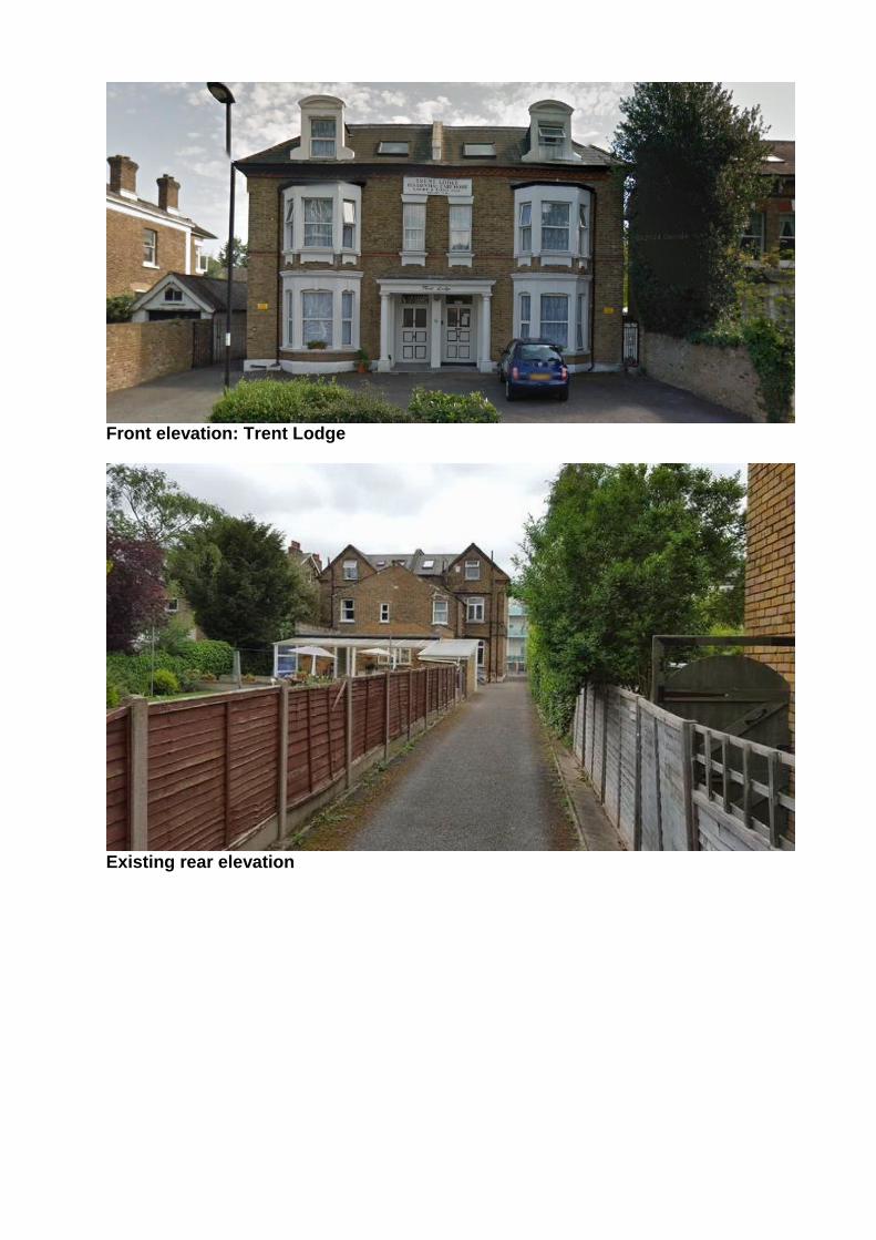
PRE- APPLICATION 15/03779/PREAPP: Land to rear of Trent Lodge Trent Lodge 6-8 Essex Road Enfield EN2 6TZ Proposal: Proposed demolition of existing garages to rear, subdivision of site and erection of a two storey block of 6 flats for use under class C3(b) assisted living ( 2 x studio, 4 x 1-bed) at rear, with accommodation in roof space and rear dormers, associated car parking and access via Tiptree Drive. Case Officer: R. Singleton
Site location

Above: Aerial views of site
Front elevation: Trent Lodge
Existing rear elevation

Existing access

Existing block plan

Proposed block plan

Existing plans and elevations
Proposed plans and elevations

Proposed floor plans Background The application site is located to the rear of Trent Lodge on the southern side of Essex Road, Enfield. It is located within the boundaries of Enfield Town Conservation Area. Although an Article 4 (2) Direction is currently in force in the area covering alterations to dwellinghouses, the application site is excluded from the Direction, and thus maintains most permitted development rights with the exception of those that are withdrawn on all Designated Land. The adjacent building, No. 4 (The Firs), is a locally listed building. Trent Lodge is cited in the Enfield Town Conservation Area Appraisal as making a positive contribution to the character of the area. Trent Lodge comprises a substantial semi-detached paired villa circa 1867-1896. The dwelling retains many original features and remains an excellent example of mid-Victorian domestic architecture. Stylistically, it comprises a two storey (with basement and attics), 2 bay villla of buff London Stock brick with slated hipped roof. The main elevation features double height canted bay windows and dormer windows to roof. A recessed entrance with plain portico supported by a Doric columns. The original sash and case windows have been extensively replaced. The front garden has been extensively replaced with hardstanding but an original boundary wall can still be seen. Trent Lodge is noted in the Enfield Town Conservation Area Character Appraisal as making a positive contribution to the area. Essex Road is predominantly residential in character and forms part of the ‘New Town’. Development began in 1853 when Cecil, Raleigh, Sydney and Essex Roads were laid out on a self-contained grid plan parallel, to the west of London Road. The existing buildings reflect

the confidence of the Victorian and Edwardian periods, and were built to accommodate the needs of the surge of new commuters following the full development of the railway and tramway systems post-1840. Most houses are of London stock brick, providing visual unity, but each street retains its own character deriving from scale, plot size and views. Essex Road designs are larger and more varied, some even flamboyant, and include five detached houses and, at the Town Park end, two opposed groups of smaller paired villas, whose more modest height allows the park gates and the view beyond to dominate the street vista.
Proposal The proposal is for the demolition of existing garages to rear, subdivision of the site and erection of a two storey block of 6 flats for use under class C3(b) assisted living ( 2 x studio, 4 x 1-bed) at rear, with accommodation in roof space and rear dormers, associated car parking and access via Tiptree Drive.

PLANNING APPLICATION 15/03775/FUL: 19 Turkey Street, Enfield, EN3 5TT Proposal: Conversion of single family dwelling house into 2 x 2-bed single family dwelling houses involving a single storey rear extension. Case Officer: C. Williams
Site location
Existing street views

Aerial views of site

Existing ground floor plan
Proposed ground floor plan

Existing front elevation
Proposed front elevation

Existing rear elevation
Proposed rear elevation

Background No. 19 Turkey Street is located immediately to the south of Turkey Brook within the boundaries of Turkey Street Conservation Area. The brook runs across the full width of the rear boundary and lies parallel to the road running from from East to West. To the North of the brook and the site lies Aylands Open Space, set between a late 20th-century housing estate and the railway which forms the western boundary of the Conservation Area. An Article 4 (2) Direction is in place in the Conservation Area, covering certain alterations to existing dwellings. The growth of the rural settlement of Turkey Street was linked to the industry that developed on the flat land beside the river and railway in the second half of the 19th century. No. 19 forms part of a group of mid-19thcentury semi-detached artisan cottages that are strung out along the main road and are thought to be linked to the former ‘Steam Mill (Flour)’ that was located nearby on the Turkey Brook. Historic Ordnance Survey maps suggest that the Steam Mill had been replaced by housing by 1896. Stylistically, the cottage is relatively plain but not devoid of merit (symmetrical design of 3 bays, with projecting central bay, hipped slated roof, central exposed brick chimney stack, replacement uPVC windows). Of interest architecturally is the unusual plan form with the main access door sited to the flank elevation rather than the front of the building.
Proposal The proposal is to subdivide the existing single dwelling into two separate dwellings (x2 bed) and create a new separate front vehicular access to each, in addition to the erection of an infill single storey rear extension.
Turkey Street Conservation Area Character Appraisal There are two sets of buildings contributing to the character of the Conservation Area. Nos. 1-7 and 15-21 (odd) on the Turkey Street road constitute the main impression of the Conservation Area from Turkey Street; they are four pairs of semi-detached cottages, each pair under a hipped roof, with a single central chimney-stack and with their main access door to the side rather than the front. (Front doors can now be seen at Nos. 15 and 17, and the new extension to the left.) Although all except nos. 1 and 3 have been considerably altered, with various combinations of modern windows, enlarged openings or side extensions, they retain sufficient similarity of form to be seen as a group, despite the fact that the 1930s public house, The Turkey, is located in the centre. They appear to have been originally all in stock brick, but only nos. 3, 5 and 7 retain a brick finish, although the brickwork at no. 3 has been painted. Nos. 1 and 3, appear to date from the mid 19th century; evidence from the 19th century OS maps indicates that nos. 15 and 17 were built after the demolition of the steam mill in the last decades of the 19th century, while nos.1, 3, 5, 7, 19 and 21 appear on the maps from 1866 onwards. Turkey Street Conservation Area Character Appraisal [p.15]

PLANNING APPLICATION 15/03542/FUL: Public Footpath Outside, 92 Aldermans Hill, London, N13 4PP Proposal: Change of use of public footpath to external seating area. Case Officer: Matthew Thode
Site location
Existing site

Proposed site plan
Precedent fixed seating

Precedent fixed seating

Existing seating plan

Proposed seating plan Proposal The proposal is for an area of seating to an adopted public footpath to the main shopping parade on Aldermans Hill. The proposed seating is described in the accompanying Design and Access statement as being movable and will only be placed outside during the café’s hours of operation. However, it is presumed that the proposed bench structure will be a permanent fixture in the streetscape.
Comments: Lakes Estate Conservation Area Study Group We wish to object to this application.

The area affected is public highway. It is a visually prominent corner at the west end of the parade of shops with a setback that echoes the plan-form of the bay window of the shop front. People walk diagonally across this space when turning into Lakeside Road from Aldermans Hill - much as they do when walking into Grovelands Road, where there is an identical setback of the building line. We are confused about what exactly the applicant is proposing; for some reason the 'existing plan' shows 6 tables and 24 chairs on this space. This is clearly misleading; there are no tables and chairs outside the premises at present.
To add to the confusion, two further drawings labelled by the Council as 'Proposed Seating Plan' and 'The Proposed Plan', have different dimensions to the seating area. These freehand drawings do not appear to be drawn to scale. The 'Proposed Seating Plan' shows an area with 4 tables, 16 chairs and a Y-shaped bench in an area 2.6m x 2.6m and 1.75m x 1.45m. The 'Proposed Plan' shows another different set of dimensions - 3.5m x 2.5m. This has the same layout of tables and chairs previously dimensioned 4.35m long and this has now somehow shrunk to 3.5m long. The proposal also includes a 1.75m long x 1.45m wide Y-shaped bench (described as a 'stool' by the applicant). The illustration of this bench shows that it would be a substantial structure. Contrary to what is stated in the Design and Access Statement, it is clearly far too big to move inside the premises outside business hours (as required anyway under the license for tables and chairs on the highway to enable cleaning of the pavement). The bench will obstruct the pavement for people with visual difficulties when the premises is closed and the other tables and chairs have been moved inside. We do not think that there is any scope for a permanently fixed or unfixed structure of this type on the pavement. For these reasons the y-shaped bench is unacceptable and we recommend that it should be deleted from the application. In our opinion there is not enough space for the proposed 4 tables and 16 chairs arranged in two rows. Once people are sat around them the layout will spread and it will result in a cluttered and unacceptably large area of the pavement being taken up by this furniture (together with the ubiquitous A Board and bin) and result in an unacceptably tight pinch point with the adjoining London Plane Tree. For these reasons the proposed 4 tables and 16 chairs is unacceptable and we recommend that the application is refused. Nevertheless we think that the application would be acceptable if it was revised to a single row of 2 tables and 8 chairs neatly tucked in against the side of the shop front.

PLANNING APPLICATION 15/04172/HOU: 74 The Chine, London, N21 2EH Proposal: Single storey side extension, part single, part 2-storey rear extension, raised patio and detached shed at rear and hard surfacing and new steps to front. Case Officer: M. Demetri
Site location
Background No. 74, The Chine comprises an interwar semi-detached dwelling circa. 1921- 1935 that is sited within the boundaries of the Grange Park Conservation Area. The dwelling is characteristic of inter-war speculative housing and has a strong Arts and Crafts influence, featuring a double height canted bay window (leaded lights) topped with a projecting half-timbered gable, canted oriel window and a hipped roof (clay tiled) with central exposed brick chimney stack over. An brick porch set on a canted plan with original half glazed timber door and clay tiles over is a prominent feature to the front elevation. The garden appears largely unaltered retains its original burr brick wall along the front boundary. Grange Park Conservation Area is formed of a cohesive group of houses and shops initially laid out and partly built between 1910 and 1914 by a single developer, and subsequently completed in the 1920s and 1930s. The designs of the existing dwellings draw on strong Arts and Crafts influences and consistently make use of high quality details and materials. The area retains a strong sense of architectural unity which is key to its special character and appearance of the area. No. 74 is cited in the Conservation Area Character Appraisal as a building contributing to the special interest of the area. Key views identified in the Appraisal are afforded northwards along the Chine. The Conservation Area is also covered by an Article 4 (2)

Direction which withdraws certain permitted development rights relating to dwelling houses. Proposal The proposal is for the demolition of the existing garage, stores and greenhouse and construction of a part single, part two storey rear and side extensions with alterations to the front driveway provide improved off street parking and a shed to the rear garden. The side extension is set back from the building line and has been designed to be subordinate in terms of massing and scale to the existing building. Materials are proposed to match existing.

PLANNING APPLICATION 15/03316/FUL: The Green Dragon, 889 Green Lanes, London, N21 2QP Proposal: Redevelopment of site to provide 7 x 3-bed, 3-storey town houses with sun terraces to front and rear and off street parking at front, conversion of former public house to provide a retail unit (A1) at ground floor with ancillary storage and staff facilities at first floor and 2 x 2-bed self contained flats at second floor involving a part single, part 2-storey rear and single storey side extension, external staircase, vehicular accesses to Vicars Moor lane, car park at rear and associated plant and landscaping. Case Officer: C. Williams
Site location
Background The Green Dragon comprises a substantial detached, double fronted former public house built in a distinctive mock Tudor style. The Public House is reputed to have opened in 1726, originally sited at the junction of Green Lanes and Green Dragon Lane. The establishment is thought to have moved to its current location at the bottom of Vicars Moor Lane at the end of the 18th century. The building was rebuilt in 1892 and later extensively remodelled in 1935. Under the current National Planning Policy Framework (2012), the Green Dragon Public House is deemed a non-designated heritage asset and considered a landmark feature in the area, of local historic and architectural interest.
Pre-application Advice Pre-application advice was sought by the applicants earlier this year. At the pre-application stage, the Development Management Team were not adverse to the conversion of the building and development on the site, in principle. However, it was recommended that any new elements should be focused to the rear of the building. It was also felt that the proposed 2 storey side extension with pyramidal roof competed with the symmetry of the double fronted mock tudor façade. Instead it was suggested that the massing and roofline of the rear extension should be broken up so that it could be read as a subordinate ancillary addition. It was considered that a lightweight structure (glazed/steel framed/timber cladding etc) with articulated elevations to the rear could read as a contemporary addition to the existing building without compromising the legibility of the main historic public house building. It was reiterated

that due to the architectural and historic significance of the building, any proposals should be sympathetic in terms of design and aim to retain as much historic fabric as possible. As the existing fenestration constitutes a key feature of the building, it was considered that it should be retained, particularly to the front and flank elevations.
Existing front elevation

Existing car park to rear
Existing rear elevation

Proposed development plan
3D Visualisation of previous scheme proposed at pre-application stage

Archive photographs of The Green Dragon Public House (circa pre-1935)

Existing front elevation
Existing rear elevation

Existing east elevation
Existing west elevation

Proposed housing units main elevation
Proposed rear elevations: Housing and former public house

Proposed rear elevation housing
Proposed former public house west elevation
Proposed housing west elevation

Proposed west elevation housing
East Elevation Section through site
Proposed street elevation: Housing and former public house

Proposed elevations

Proposal
The former Green Dragon Public House The proposal is for the conversion of the existing former public house under a mixed use scheme that will see the retention of the existing retail space at ground floor level with residential flats over. Under the proposed scheme, later extensions to the West and North elevations will be demolished and the existing building will be extended to the rear at ground and first floor level. The later steps and ramp to the front of the building will be removed in favour of new level access provided via the rear extension (main entrance to the building). Original building fabric is to be replaced on a like-for-like basis and only when deemed beyond repair. The existing windows and timber features, such as the half timbering and barge boards will be redecorated and the white paint removed to the upper floors. An external seating area constructed of brick and frameless glass is also proposed to the front elevation in an attempt to mitigate the existing difference in levels between the building internal floor level and the footpath. Access to the flats is proposed via the existing buildings sited along the Eastern boundary of the site.
Extension
The proposed extension is of a contemporary but contextual design that aims to take references in terms of materials and massing from the existing building. Proposed materials include red smooth faced, square terracotta blocks at ground floor level and orange brick in Flemish bond with a decorative ‘rib’ feature using a vertical protruding course of headers at first floor level. The windows are to be double glazed, powder coated aluminium (RAL 7016 grey). The residential stairs will be enclosed with aluminium perforated panels. The plant enclosure is to be of a profiled metal sheet fixed to metal posts. New Dwellings
7 additional 3 bed houses are proposed on the site along the Southern boundary with Vicars Moor Lane. All units comply with London Housing Design Guide standards and have terraces and a private garden to the rear. Stylistically the proposed dwellings are contemporary 3-storey houses with narrow frontages and pitched roofs over in reference to the prevailing building typologies in the area. The houses will be finished in orange brick at ground, first floor and the second floor and orange clay vertical tiles in an arrowhead pattern. Concealed roof slopes will be finished in concrete tiles and single ply membrane (concealed flat roof).

Materials palette