pre-construction notification to the u.s. army corps of
TRANSCRIPT
i
TransCanada Keystone XL Pipeline Project
Pre-Construction Notification to the U.S. Army Corps of Engineers Omaha District – Nebraska
Prepared for:
TransCanada Keystone Pipeline LP 700 Louisiana Street Houston, Texas 77002
Prepared by:
exp Energy Services, Inc. 1300 Metropolitan Blvd. Tallahassee, Florida 32308 Document Number TAL-KXL-1100-04-03 Date Submitted May 25, 2017

TransCanada
700 Louisiana Street
Houston, Texas 77002
Tel: (832) 320-5385
May 25, 2017
U.S. Army Corps of Engineers
8901 S 154th Street
Omaha, Nebraska 68138
RE: Keystone XL Pipeline Project – Nationwide Permit 12 Pre-Construction Notification
(PCN)
Dear
Please find attached the TransCanada Keystone Pipeline, LP (Keystone) Nationwide Permit
(NWP) 12 Pre-Construction Notification (PCN) package for the portion of the proposed Keystone
XL Pipeline Project (Project) located within the U.S. Army Corps of Engineers (USACE) Omaha
District in Nebraska.
The U.S. Department of State (DOS), as the lead federal action agency, issued the Final
Supplemental Environmental Impact Statement (FSEIS) in January 2014 and the Final
Environmental Impact Statement (FEIS) in August 2011. The FSEIS was prepared to address
Project changes since the August 2011 FEIS, most notably the route change implemented in
Nebraska and approved by the Governor in January 2013.
On January 24, 2017, President Trump issued a Presidential Memorandum Regarding
Construction of the Keystone XL Pipeline directing the USACE and other Federal permitting
agencies to process expeditiously Keystone’s permit applications for the Project. Keystone
submitted the application for a Presidential Permit on January 26, 2017, and it was subsequently
issued on March 23, 2017.
To assist with your review, the following documents are provided:
Standard Form 4345 (imbedded herein) – The standard Form 4345 and additional
information required for PCNs are included at the front of this package. The two waterbody
features requiring a PCN are addressed including information related to the applicable PCN
criteria, location, crossing length, anticipated construction method, and estimates of
temporary and permanent impacts. Information relative to non-PCN features are also
provided principally consisting of location and whether proposed impacts are temporary or
permanent. Keystone has adopted the USACE Regulatory Guidance Letter 16-01, dated
October 31, 2016, on jurisdiction of waters of the United States and is not requesting
jurisdictional concurrence due to the nature of the Project scope.
TransCanada
700 Louisiana Street
Houston, Texas 77002
Tel: (832) 320-5385
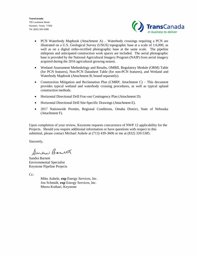
PCN Waterbody Mapbook (Attachment A) – Waterbody crossings requiring a PCN are
illustrated on a U.S. Geological Survey (USGS) topographic base at a scale of 1:6,000, as
well as on a digital ortho-rectified photographic base at the same scale. The pipeline
mileposts and anticipated construction work spaces are included. The aerial photographic
base is provided by the National Agricultural Imagery Program (NAIP) from aerial imagery
acquired during the 2016 agricultural growing season.
Wetland Assessment Methodology and Results, OMBIL Regulatory Module (ORM) Table
(for PCN features), Non-PCN Datasheet Table (for non-PCN features), and Wetland and
Waterbody Mapbook (Attachment B; bound separately).
Construction Mitigation and Reclamation Plan (CMRP; Attachment C) – This document
provides typical wetland and waterbody crossing procedures, as well as typical upland
construction methods.
Horizontal Directional Drill Frac-out Contingency Plan (Attachment D).
Horizontal Directional Drill Site-Specific Drawings (Attachment E).
2017 Nationwide Permits, Regional Conditions, Omaha District, State of Nebraska
(Attachment F).
Upon completion of your review, Keystone requests concurrence of NWP 12 applicability for the
Projects. Should you require additional information or have questions with respect to this
submittal, please contact Michael Aubele at (713) 439-3606 or me at (832) 320-5385.
Sincerely,
Sandra Barnett
Environmental Specialist
Keystone Pipeline Projects
Cc:
Mike Aubele, exp Energy Services, Inc.
Jon Schmidt, exp Energy Services, Inc.
Meera Kothari, Keystone
Table
Pre-Cons
Blocks 5
Block 12.
Block 13.
Block 14.
Block 15.
Block 16.
Block 17.
Block 18.
Block 19.
Block 20.
Block 21.
Block 22.
Block 23.
Block 24.
Block 25Waterbo
Block 26. Agencies
ListofFigure 1
Figure 2
ListofTable 1
Om
Table 2 Dist
Table 3 –
Table 4 –
ofConte
truction Notif
through 10.
Project Na
Name of W
Project Add
Location of
Other Locat
Directions t
Nature of A
Project Pur
Reason for
Types of M
Surface Are
Description
Is Any Porti
. Addressedy ..................
List of Othfor Work De
Figures– Keystone X
– Keystone X
Tables– Keystone aha District,
– Keystone rict Requiring
Keystone X
Keystone X
ts
ication for NW
Applicant’s Na
me or Title .....
aterbody .......
ress ..............
Project .........
ion Descriptio
o Site ............
ctivity ............
pose ..............
Discharge ....
aterial Being D
as in Acres o
of Avoidance
on of the Wor
s of Adjoinin.....................
er Certificationscribed in Thi
L Project - Pr
L Project - Hy
XL Pipeline PNebraska ......
XL Pipeline Pre-Constru
L Pipeline Pro
L Pipeline Pro
WP 12 ............
ame and Add
.....................
.....................
.....................
.....................
ons ................
.....................
.....................
.....................
.....................
Discharged ...
of Wetlands or
, Minimization
rk Already Co
ng Property .....................
ns or Approvs Application
roject Locatio
ydrologic Unit
Project – Pre-.....................
Project - Maction Notificat
oject - Pump S
oject -Permits
.....................
ress. ............
.....................
.....................
.....................
.....................
.....................
.....................
.....................
.....................
.....................
.....................
r Other Wate
n, and Comp
omplete? .......
Owners, L.....................
als/Denials R. ...................
n Map ..........
t Boundary M
-Construction.....................
ainline Watertion – Nebras
Station Locati
, Licenses, A
.....................
.....................
.....................
.....................
.....................
.....................
.....................
.....................
.....................
.....................
.....................
.....................
rs Filled ........
ensation .......
.....................
essees, etc., .....................
Received fro.....................
.....................
Map ................
n Notification .....................
body Crossiska ................
ions – Nebras
pprovals, and
.....................
.....................
.....................
.....................
.....................
.....................
.....................
.....................
.....................
.....................
.....................
.....................
.....................
.....................
.....................
Whose Pro.....................
m other Fede.....................
.....................
.....................
Requirement.....................
ngs within th.....................
ska ................
d Consultation
.....................
.....................
.....................
.....................
.....................
.....................
.....................
.....................
.....................
.....................
.....................
.....................
.....................
.....................
.....................
operty Adjoin.....................
ral, State, or .....................
.....................
.....................
t Analysis US.....................
e USACE O.....................
.....................
n Requiremen
iv
..... 11
..... 11
..... 11
..... 11
..... 11
..... 12
..... 12
..... 12
..... 12
..... 23
..... 24
..... 24
..... 24
..... 25
..... 25
s the ..... 25
Local ..... 25
..... 26
..... 27
SACE ..... 28
Omaha ..... 30
..... 31
nts 32
Listof
Attachme
Attachme(for PCN Mapbook
Attachme
Attachme
Attachme
Attachme
Attachm
nt A. Map Vo
nt B. Wetlanfeatures), N(bound sepa
nt C. Constr
nt D. Horizo
nt E. Horizon
nt F. 2017 N
ents
lume – PCN
d Assessmenon-PCN Datrately)
uction Mitigati
ntal Directiona
tal Directiona
ationwide Per
Waterbody M
nt Methodologasheet Table
on and Recla
al Drill Frac-ou
al Drill Site-Sp
rmits, Regiona
Mapbook
gy and Resue (for non-P
amation Plan
ut Contingenc
pecific Drawi
al Conditions
lts, OMBIL CN features)
cy Plan
ngs
, Omaha Dis
egulatory Mo, and Wetlan
trict, State of
odule (ORM) nd and Wate
Nebraska
v
Table erbody
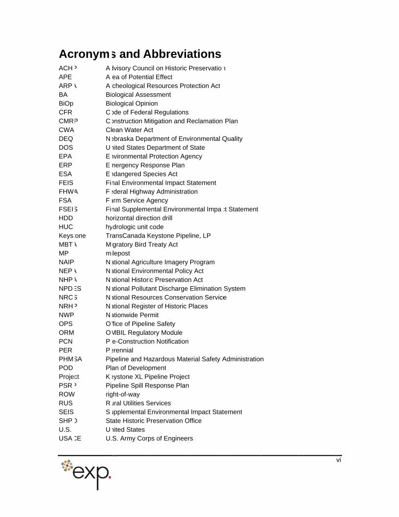
AcACHAPE ARPBA BiOp CFR CMRCWA DEQ DOS EPA ERP ESA FEIS FHWFSA FSEIHDD HUC KeysMBTMP NAIP NEPNHPNPDNRCNRHNWP OPS ORM PCN PER PHMPOD ProjePSRROWRUS SEIS SHPU.S. USA
ronymP A
AA A
BiBiC
P CClNUEEEFi
A FF
S Fihohy
tone TrA M
mN
A NA NES NS NP N
NOOPP
SA PiPl
ct KP Pi rig
RS
O StU
CE U.
s and Advisory Councrea of Potentiarcheological Rological Asseological Opinode of Federaonstruction Mean Water Acebraska Depanited States Dnvironmental mergency Resndangered Spnal Environmederal Highwaarm Service Anal Supplemeorizontal direcdrologic unit ansCanada Kigratory Bird Tilepost ational Agricuational Enviroational Historational Pollutaational Resouational Registationwide Perffice of PipelinMBIL Regulatre-Constructioerennial peline and Haan of Developeystone XL Pipeline Spill R
ght-of-way ural Utilities Supplemental Eate Historic Pnited States S. Army Corp
Abbrevicil on Historical Effect
Resources Proessment ion al Regulationsitigation and ct artment of EnDepartment ofProtection Agsponse Planpecies Act ental Impact ay AdministraAgency ental Environmction drill code
Keystone PipeTreaty Act
ulture Imageryonmental Policic Preservatioant Dischargeurces Conservter of Historic rmit ne Safety tory Module on Notification
azardous Matpment ipeline Projec
Response Plan
Services EnvironmentaPreservation O
ps of Enginee
ationsc Preservatio
otection Act
s Reclamation
vironmental Qf State gency
Statement ation
mental Impa
eline, LP
y Program cy Act on Act e Elimination Svation ServicePlaces
n
terial Safety A
ct n
al Impact StatOffice
ers
n
Plan
Quality
ct Statement
System e
Administration
tement
n
vi

USDUSFUSGWCSWest
A U.WS U.S U.B Wern W
S. DepartmenS. Fish and WS. Geologicaestern Canadestern Area P
nt of AgricultuWildlife Servicl Survey
dian SedimenPower Admin
ure ce
ntary Basin istration
v
vii
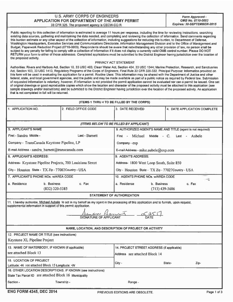

To sDepaConsForm
Bloc
Appli
TranSandKeys700 Hous(832)
Auth
MichDirecexp 1800 Hous(713)
Bloc
Keys
Bloc
The USANWP requiTablwateTablcontaThe incluAtta
Bloc
Not Distri
Pr
upplement thrtment of thtruction Notifi4345 are ref
ks 5 through
cant
sCanada Keysra Barnett – tone Pipeline Louisiana Strton, Texas 7320-5385
orized Agent
ael Aubele tor, Environm
Energy ServiWest Loop ton, TX 770439-3606
k 12. Projec
tone XL Pipel
k 13. Name o
Project will CE Omaha D
12 Conditirements. Te 1. The lobodies cros
e in Attachmined in the non-PCN wded in the Nchment B.
k 14. Projec
Applicable. ct and acros
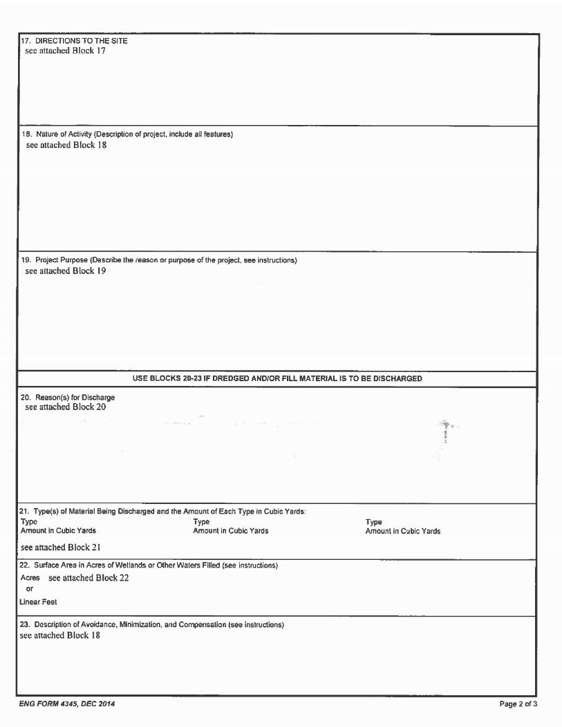
e-Constr
Departm
e attached Ue Army Permcation (PCN)erenced below
10. Applica
stone PipelineEnvironmentaProjects
eet, Suite 7007002-2700
mental & Reguces, Inc. South, Suite 827
t Name or Tit
ine Project (P
of Waterbody
cross two waistrict in Nebrons, the NW
he PCN requcations, hydred by the Prent B. The
Map Volume Petlands and won-PCN Data
t Address
The Project i the State of
ruction N
ment of the
United Statesmit, Form 43) requirementw and the tab
ant’s Name a
e, LP al Specialist
0
ulatory – Unite
50
tle
Project).
y
aterbodies (thraska that reqWP Programirements eva
rologic unit croject and reindividual PC
PCN Waterbowaterbodies asheet Table
s a linear piNebraska.
Notifica
e Army Pe
Army Corps345, additiots is included bles and figure
nd Address
ed States
he Niobrara quire the sub
m General aluated for thode (HUC), quiring PCN
CN waterbodyody Mapboofound withinand Wetland
peline within
tion for
mit Form
s of Engineenal informati
in the followes are prese
River and tmittal of a PC
Conditions, he Project in and other iare provided
y crossings k (Attachme the Projecd and Water
the jurisdic
NWP 12
4345
rs (USACE) Aon necessarying sections. nted after the
he Platte RivCN to the USAand/or Regio
Nebraska anformation red in Table 2 are illustratednt A) at a sct constructionbody Mapboo
tion of the U
1
2
Application foy for the Pre The Blocks Block text.
ver) within thACE based o
onal Conditiore provided lated to thesand the OR
d on the mapale of 1:6,000n footprint arok provided
SACE Omah
11
or e-in
he on on in
se M ps 0. re in
ha
Bloc
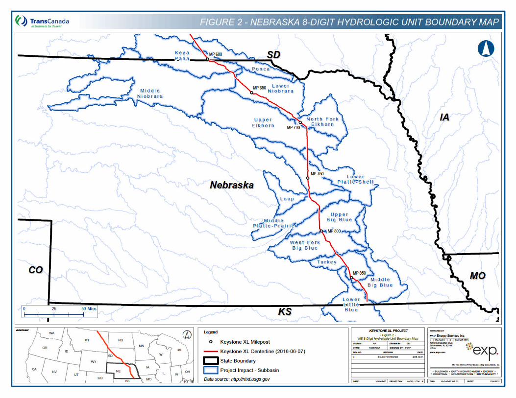
Figucounand in the
Bloc
Tablpipeli
Bloc
The
Pleapoint
The
accelando
Bloc
The the iway (at int
The pCanafacilitiGulf Coasprodcom
ENVI
The D(FSEissue2011 of impropmini
k 15. Locati
e 1 providesty. The locatiHolt Counties figure.
k 16. Other
e 2 and the ne milepost (
k 17. Directi
Niobrara Riv
e note that awill require l
Platte River C
ss along the wner notifica
k 18. Nature
primary activinstallation of ROW); 2) co
ervals along t
primary purpdian Sedimees near Ste
Coast area. t area. Th
uced crude omercial dema
RONMENTA
Department IS) in Janud for the ProjFEIS, most pacts to wet
erties; and bimal environm
on of Project
s a general oons of the twand the Platt
Location Des
ORM Table iMP) and by la
ons to Site
er crossing is
ny access aloandowner noti
rossing is loc
private road tion (please r
of Activity
ties within thea 36-inch stenstruction of he pipeline ro
ose of the prontary Basin (Wele City, NebrMost of the ce proposed ils, notably Bnd.
L IMPACTS A
of State (DOSary 2014, supject in Augusnotably the rolands, streamological resoental impact,
t
overview of to PCN featurte River at th
scriptions
in Attachmeatitude/longitu
s located at
ong the privatification (plea
cated at
and land paefer to Attach
e jurisdiction oeel pipeline wfive pump sta
oute in Nebras
oposed ProjecWCSB) cruderaska, for onwcrude oil wouProject woul
Bakken crude
AND MITIGA
S) issued a Fpplementing t 2011. The
oute change ms, rivers, anurces. The utilizing the
the overall Pre crossings (e border of
nt B providude coordina
te road and laase refer to A
arcel to be hment A).
of the USACwithin a standations; and ska.
ct is to provide oil from the ward deliverld be subseqd also provi oil that wou
ATION
Final Supplethe Final EnFSEIS addrein Nebraska.
nd other wateDOS conclumitigation
Project within (the Niobrara Merrick and P
e PCN waterbtes.
and parcel tottachment A
sed for the
E Omaha Disdard 110-foo) installation
e the infrastr border with
y to Cushing,quently delivide transpor
uld be on-loa
mental Envirnvironmental essed Project These docuers of the Uded that the
measures out
the State ofRiver at the b
Polk Counties
body crossin
o be used for ).
Please HDD exit po
strict in Nebrat-wide constrof mainline is
ucture to tranCanada to ex Oklahoma, ared to refiner
t capacity foded in Monta
onmental ImpImpact Stat
t changes sinments includenited States Project could
lined in both
1
f Nebraska bborder of Boy
s) are identifie
g locations b
the HDD ent
note that anint will requir
aska will be: uction right-osolation valve
nsport Westerxisting pipelinand the Texaries in the Gu
or domesticalana, subject t
pact Statemetement (FEISnce the Augued evaluation(U.S.); histord be built witthe FEIS an
12
by yd ed
by
ry
ny re
1) of-es
rn ne as ulf lly to
nt S) st
ns ric th nd
FSEIminirequFSEI
The and 2011.and iby thUSFthe BMarc
The and Natioexistilead consFSEI
Keyspipelienvir
The throu
Durinrerouidentibiolomitig(CM
S. Following mize environests. The mS.
DOS’s initial BWildlife Servi To accom
ssued the ree USFWS on WS subsequiOp (the north 16, 2017.
DOS, the Adother parties nal Historic ng Programmagency for
ultation with S.
tone is comne route coonmental imp
pipeline routgh:
Avoiding
Minimizinwetlands.
Crossing
Reducing
g consultatiotes were incfied. In adgical resourcation measureRP) (Attachm
Erosion a
Environm
Best man
issuance of mental impactodifications d
Biological Assce’s (USFWS
pany the devevised BA with May 15, 2013
ently completehern long-ear
visory Councildeveloped a Preservation Amatic Agreem
Section 106affected Nat
mitted to protenstruction proacts during co
e has been r
waterbody and
g the numbe
waterbodies p
the width of th
n activities worporated to dition, timing es, such as es are describent C), and in
nd sediment c
ental training o
agement prac
the FSEIS, Kts, improve cdo not signif
sessment (BAS’s) Biologicaelopment of tthe draft SEI
3, and is still ted a conferenred bat and ru
l on Historic PProgrammatiAct that was
ment in conjun6 complianceive American
cting waterboocedures andonstruction a
refined sever
d wetland cro
r of times th
perpendicular
he ROW to 85
with federal anavoid or minwindows we
spawning fisbed in the Prnclude:
controls imple
of all Project
ctices incorpo
Keystone impconstructabilitficantly chan
A) was finalizal Opinion (he SEIS, thIS (March 20the Section 7
nce opinion foufa red knot)
Preservation, c Agreementincluded in
nction with t conducted
n tribes as
odies, wetland a compliannd restoratio
ral times to r
ossings where
hat a single
ly whenever p
5 feet in satu
nd state agenimize impaere establishsh and threoject’s Cons
emented duri
workers and
rated into th
plemented mty, and addrge the concl
zed on May 1BiOp) was f DOS updat13). The fin
7 consultationor two specieand verified t
the State Hit for compliathe FEIS. T
he FSEIS. Iextensive g
summarized
ds, and their nce program n.
reduce wate
e feasible.
waterbody i
possible.
rated wetland
ncies and locts to signifihed in the atened/endantruction Mitiga
ng and after c
supervisors.
Project desi
inor modificatess agency ausions of the
19, 2011, andinalized on Sed the BA wital updated BiO record for ths listed after tthe standing
storic Preservnce with Secthe DOS amen addition, thovernment tin Section 3
associated reare designe
body and we
s crossed a
ds.
cal stakeholdcant resourceProject schedgered specieation and Rec
construction.
gn and constr
1
tions to furtheand landownee FEIS or th
d the U.S. FisSeptember 23th the USFWOp was issuee Project. Ththe issuance oof the BiOp o
vation Officertion 106 of th
ended the prioe DOS as tho governme
3.11.4.3 of th
esources. Thed to minimiz
etland impac
nd impacts t
ders, additiones or concerndule to protees. Additionclamation Pla
ruction.
13
er er he
sh 3,
WS ed he of
on
rs, he or he nt he
he ze
ts
to
al ns ct al
an
Keyserosistabil
THR
Withifolloamersturglong-fring(wheUSF
Who
The Greaarea HabitWildlifor sthe P
No diProje(HDdelinand lithe Haccetests. reve
The fuel withiincluclean
If pipcransurve
Wetland constructi
Spill prev
Hazardou
Clean-up, ROW and
tone’s CMRon and sedization/reveg
EATENED A
n the jurisdicwing federallicana), pipineon (Scaphireared bat (ed prairie orre applicable)WS and the
oping Crane
Project is witt Plains. Suiat major riveat along the fe Service a
uitable stoporoject area in
rect impacts ct. The Platt), so potent
eated boundmited humaDD electroni
ss the river t Disturbanc
getate followi
primary constspills and len whooping des measure
up spills that
eline construes during spriy of any wetl
and waterbodon and reclam
ention and cle
s materials ha
seeding, andProject distur
provides typiment controetation of the
ND ENDANG
tion of the USy listed threg plover (Chahynchus albu
Myotis septentchid (Platanth) are presenOS in a letter
hin the primatable whoopinr crossings inPlatte River
nd USFWS 20ver habitat wit
Nebraska.
to the whoope, Loup, and ial habitat lo
ary of the Platn access wouc guidance syo potentially e of non-foreng constructio
truction-relateaks from concrane roostings to minimize t may occur.
ction-related ng and fall mand or riverin
dy constructiomation of the c
ean-up proced
andling guide
d reclamationrbances.
pical proceduol measuresProject.
ERED SPEC
SACE Omahaeatened or aradrius melous), Americantrionalis), rufahera praeclarted in the 20r dated March
ary migration ng crane roosncluding the Pin Nebraska
005). In additthin wetlands
ping crane arNiobrara rive
oss, alterationte, Loup, andld be required
ystem that is awithdraw wa
ested vegetaton.
ed impacts wstruction mag and foraginthe likelihood
activities wermigration perine habitat are
on procedurecrossings.
dures.
lines.
n details to e
res for wetlas that will b
IES
a District in endangered odus), interin burying bea red knot (ra). Potenti013 BiOp ah 16, 2017 ar
pathway of sting and/or fPlatte, Loup, occurs seve
tion to the m, shallow ar
re anticipateers would be n, or fragmd Niobrara rivd within the associated w
ater for the pion within th
ould be distchinery. Theng habitat is d of a spill oc
re to occur iods, environ
eas potentially
s designed
ensure the
nd and watebe installed
Nebraska, pospecies: th
r least tern (etle (NicrophCalidris canual Project ind the confere described
the whoopingoraging habiand Niobrararal miles wesajor river croas of reserv
d from the cocrossed by h
entation wouers. Minimal iparian areaith the drillingroposed Proe HDD would
urbance and e chance fominimal. T
ccurring and
n close proximental moniy used by wh
to minimize i
effective stab
rbody crossinduring con
tential habitae whooping (Sternula antorus americatus rufa), and
mpacts and srence opinionbelow.
g crane throutats occur wita rivers. Desist of the Projssings, there oirs, and stoc
onstruction ofhorizontal direld be negligihand clearing
s of the river g equipment, ject’s HDD ad be allowed
potential expr constructionhe CMRP (Ato promptly r
mity to migrators would coooping crane
1
mpacts durin
ilization of th
ngs, as well anstruction an
t exists for thcrane (Gru
tillarum), pallnus), Northerd the Wester
survey findingn between th
ugh the centrhin the Projegnated Criticject (Canadiais the potenti
ck ponds with
f the proposeectional drillinible within thg of vegetatioin order to usand in order t
and hydrostat to complete
posure to sman-related spil
Attachment Crespond to an
ating whoopinomplete a briees. The surve
14
ng
he
as nd
he us id rn rn gs he
ral ct al
an al in
ed ng he on se to tic ely
all ls
C) nd
ng ef ey

woulProtooutlinissuedurinUSFdelaybirds time, compperiosightienvirProje
Dowsprin
Pipin
The suitaNebrwas indicPlatt
No diLoup,using
Indirbree
If copre-c0.25-pairs const
DowPlattpipin
Interi
AlonpopulDurinterns was Loup,
d be conductcol previousled in the 2d by the USFg the morninWS for furtheed within thehave left thand work
liance manads through inng locations onmental moct.
nshielding of g and fall wh
g Plover
Niobrara, Louble breeding aska. Durinone individuaation of breee rivers.
rect impacts and Niobrathe HDD me
ect impacts cding plover ar
nstruction weonstruction smile from thewithin 0.25-ruction within
nshielding of le, Loup, and g plover nest
or Least Tern
g the Nebrasations of thg field survewere observ
no indication and Platte ri
ed in the mory developed
012 TechnicaWS Nebraska
g surveys or ar instruction ae USFWS dee area. The tart time on
ger of whoopformation gatare within a
nitors would
lights would ooping crane
p, and Plattehabitat (i.e.
g field surveysl piping plove
ding was obse
to the pipingra rivers becthod.
ould result froe located with
re to occur duurveys and d Platte, Loup
mile of the co 0.25-mile of
ights would bNiobrara riveis located wit
ka portion of e interior leasys conducteded at the crosof breeding
vers.
ning before sby USFWS a
al Assistance a Ecological Sany time durind require thatermined distenvironmentathe survey
ing crane migthered from tha USFWS-apconduct prot
be used if nmigrations in
e river crossin, sand barss conducted er observed aerved within 0
plover or itscause pipeline
om increasedhin 0.25-mile
uring the plovdaily surveys , and Niobrar
onstruction arthe nest wou
be used if nighrs, if the HDhin 0.25-mile
the Project, st tern at the d during Julyssing of the Nwas observe
starting equipmand the Nebra
Letter for thServices Fielding the day, at all human tance of the al monitor woform. Add
gration locatihe whooping pproved distocol level su
nighttime woareas that p
ngs were iden, mud flats,during July at the crossin0.25-mile of t
s breeding he placement
d noise and of the Project
ver breeding would occur
ra river crosrea. If occuld be suspen
httime work iD site(s) lacof the HDD s
there is the crossings o
y of 2008 anNiobrara Riveed within 0.2
ment using taska Games he TransCad Office. If Keystone woactivity and cranes. Would record itionally, the ons during tcrane trackinance from rveys of the
k is necessrovide suitabl
ntified as hawetlands)
of 2008 and ng of the Nithe crossings
abitat would across the
human present.
season (Apriin coordinatiings to ensu
pied piping pded until the
s necessary fs vegetative
site(s).
potential for f the Platte, d 2011 and er and Loup 5-mile of the
he Whoopingand Parks Cada Keyston
whooping cranuld immediate
equipment staork would resthe sighting,
USFWS wohe spring andg program. I
construction aappropriate p
ary for the He habitat.
ving the potenwithin the P2011 and Junobrara River, of the Niobra
be anticipatedrivers would
nce at work s
l 15 through ion with the re that there lover nests anest is no lon
or the HDD cscreening, a
the occurrencLoup, and NJune 2012, iRiver, Loup R
crossings of
1
Crane SurveCommission ane XL Pipelinnes are sighteely contact th
art-up would bsume once thbird departur
ould notify thd fall migratof the migratoactivities, theportions of th
DD during th
ntial to supporoject area ne 2012, therbut there wa
ara, Loup, an
d at the Plattebe complete
site locations
September 1USFWS withare no nestin
are found, thenger active.
rossings of thand if an activ
ce of breedinNiobrara riverndividual lea
River, but therf the Niobrara
15
ey as ne ed he be he re he ry ry
en he
he
ort in re as nd
e, ed
if
), in
ng en
he ve
ng rs. st re a,
No dPlattbe cwoulguidaacce
The fuel sleast storesmall provirelatIndirbree
If codurindaily crossoccube su
Dowthe Ptern
Pallid
The the Pusing constapprentrafor eunlikand twateretur
Amer
SuitaPahaDurinHolt, AugustrappDurinoccu
irect impacts e, Loup, and ompleted by d be requirence system
ss these rivers
primary constpills and leatern habitat
d at least 10in volume a
des the best ed spills as ect impacts cding terns are
nstruction ocg the breedisurveys wouing to ensurpied interior lspended unti
nshielding of latte, Loup, a
nest is locate
Sturgeon
pallid sturgeolatte River in the HDD m
ruction. Waopriately screinment or entntrainment of ely event of he complian will require
ned to an upl
ican Burying
ble America, Boyd, and g the summAntelope, ast 17, 2012, ing. A total g these surred in north
to least ternthe Niobrara HDD methodd within the rthat is assocs to potentiall
truction-relates from constris minimal be
0 feet away frnd are cleanmanagement
previously brieould result frolocated withi
curs within 0ng season (Mld occur in coe that there aeast tern nesl the nest is n
lights would bnd Niobrara r
d within 0.25-m
n occurs in tMerrick and
ethod, direct imter withdrawaened and wotrapment of pfish or debris
a sturgeon bece manager wno additives
and area adja
Beetle
n burying beeHolt counties er of 2012, And Boyd counusing standarof 27 of thoseveys, no ABBwestern Holt co
n breeding hriver location. Minimal haiparian areas
ciated with thy withdraw w
ed impacts wruction machiecause all haom surface w
ned up quicklt practices to efly describeom increasedn 0.25-mile o
0.25-mile of tMay 1 througoordination ware no nestints are found,
no longer activ
be used if nigrivers, if the Hmile from the
he lower PlatPolk countie
mpacts to paals to supportould be withd
pallid sturgeons to be accor
ecoming entrawould immedand, after th
acent to the so
etle (ABB) haand has histo
ABB surveys nties (Hobackrd traps baite
e 54 locationsB were caughounty, but no
abitat would ns, because and clearing s of these rihe drilling eqwater for the
ould be distnery. The cazardous mawaters and thely. Additionareduce the d in the im
d noise and of the Project.
the Platte, Loh Septembe
with the USFg pairs withi then constrve.
ght-time workHDD site(s) laHDD site(s).
tte River, dos. Becausellid sturgeon t the HDD andrawn at an n. The intakerdance with ained, pumpindiately consuhe completionource as per t
abitat is locatorically occuwere conduk 2012). S
ed and checks resulted in cht in Boyd ot east of High
be anticipatpipeline placof vegetation vers in order uipment, an
Project’s HD
urbance and hance of conterials such ese types of
ally, Keystonpotential for imact evaluati
human presen
oup, and ther 1), then prWS within 0.n 0.25-mile uction within
k is necessaracks vegetati
wnstream frthis river crosare not anticnd hydrostatiappropriate
e screens wthe conditionng operationslt with the USn of hydrostthe CMRP.
ted along thred in Antel
cted at 54 siurveys occured for five trcapture in Kr Antelope chway 183.
ted at the croement across
and limited to use the H
d in order for and hydrosta
potential expstruction-relatas fuels and spills or leakse’s CMRP (Ampacts due toon for the whnce at work s
e Niobrara Re-construction25-mile from of the constru0.25-mile of t
ry for the HDve screening,
m the Projecssing would bipated as a rec test operatwithdrawal ruld be periods of the 2013s would immSFWS. Hydr
atic testing, w
e proposed Ppe County intes in northerred between ap nights folloya Paha andounties. Ca
1
ossings of ths the rivers whuman acces
HDD electronr equipment tatic tests.
posure to smated spills with
oils would bs generally ar
Attachment Co constructionhooping cranesite locations
River crossingn surveys aneach of thes
uction area. the nest wou
D crossings o, and an activ
ct’s crossing obe constructeesult of Projetions would bate to preve
dically checke3 BiOp. In thediately ceasrostatic testin
water would b
Project in Key upland arearn Keya PahaAugust 2 an
owing standar Holt countieptures of AB
16
he will ss nic to
all in
be re C) n-e. if
gs nd se If ld
of ve
of ed ct
be nt ed he se ng be
ya s. a,
nd rd s.
BB
Directrencunsuiwith vehicforagtake ActivicrossrequiLocalimplefuel s
Buryi(BedilevelacrosEquiand tempotherobjecconstpresorigin
In adincorpote
t impacts to th excavation table habitat,other utilitiesle traffic aning and increplace during ties that coings, and crements. Hized fuel spment a Spill pills, which
ng beetles, ick et al. 20s during peris the ROW
pment operatisoil would be orary and pewise directetives of reclaruction vege
erve approxial vegetation
dition to the porating the ntial direct or i
When woareas thaUSFWS.
Vehicle traccess ro
Constructireestablisconstructi
Prior to cwill be imthe constrand Nebr
Protective released one site w
Mowing aperiod to tis not plawhich refe
he ABB as a would result temporary h, and the pot
d exposure dase predationdaylight hoursuld potentiallertain work rDD crossings ills may occuPrevention Co
would mitigate
ncluding the A06). Under lods when they
as the site ons within thede-compacte
ermanent ROd by the landmation and rtation, use, a
mate pre-conscover and la
previously defollowing conndirect impac
rking in suitabt do not prov
affic used in ads when acc
on methods hment of naon ROW and
onstruction displemented in uction ROW
aska Games a
measures atABB with a ligill be impleme
nd windrowinemporarily renned to be stars to removal
result of consin temporary
habitat fragmetential mortal
during excavan on the Amers and construly require ligrequired aftewould requir
ur during coontrol and Co and avoid an
ABB, are sensaboratory coy are inactiveis prepared
e ROW woulded and veget
OW. Native downer. As evegetation aand capabilitystruction capand use.
escribed best nservation mects to the ABB
ble ABB habivide habitat fo
support of pcessing the co
will be useatural vegetaavoid long-te
sturbance anNebraska whin accordanceand Parks Co
the relocatioght cover (e.gented to incre
ng vegetationduce habitat arted prior to of mowed ve
struction durihabitat loss,
entation wherlity to eggs, ation. Artificrican burying uction areas ghting could r sunset dure 24-hour oonstruction, ountermeasurny short-term
sitive to soil onditions, ABe. During co
by removind compact thtation cover wvegetation stated in th
are to return y. This invability and s
managemeneasures as B:
itat, parking or ABB. Th
preconstructionstruction si
d involving ation to resterm impacts t
d grading forhere access ie with the Ne
ommission 20
on site such ., a leaf), and
ease the survi
n will be consuitability by
o the next caegetation fro
ng vegetatiopotential alte
re the pipelinlarvae, and ial lighting beetle. Mos
would not geinclude crit
e to weatheperation until however, Keyres Plan for poimpacts.
moisture and Bs seek soilnstruction, sog vegetation
e substrate. would be reseed would he Project Cthe disturbed
olves treatmtability in a
nt practices, Kpart of the p
and staging is will be do
on activities te.
sequential rore natural o ABB habita
r the ROW, trs available t
ebraska ABB 08).
s creating a td not releasinivability of rel
ducted after drying out thpture and relm an area to
n clearing, siteration of suitne is not alreadults througas the potent normal consnerally use artical pipeliner, safety, or the crossing
ystone wouldotential const
die quickly whs containing il moisture m and topsoilDuring reclamestablished wgenerally beMRP (Attachd areas to apent of soil asmanner cons
Keystone hasroposed Proj
areas will be ne in coordin
will be confin
eplacement osoil hydrolo
t.
rapping and ro remove aduTrapping Pro
tunnel in moisg more than ocated ABB.
the capture e soil surfaceocate windowavoid accumu
1
te grading, antable habitat tady collocate
gh constructiontial to disrustruction wourtificial lighting tie-ins, HDother Proje
g is completedd develop antruction-relate
hen desiccatehigh moisturay be reducel and grading
mation, sub-sowithin both th used, unles
hment C), thproximate pre
s necessary tistent with th
s committed tect to preve
pre-located nation with th
ned to specif
of topsoil anogy within th
relocating ABult beetles frootocol (USFW
st soil for eac50 ABB at an
and relocatioe if constructiow. Windrowingulation of gras
17
nd to ed on pt ld g.
DD ct d.
nd ed
ed re ed g. oil he ss he e-to
he
to nt
in he
fic
nd he
BB m
WS
ch ny
on on g, ss
West
The occuAntelroute
clippings done so tefforts aractive periactive peractive perabove grooffspring not be disbe repeatperiod, an
After captwill travel Septembeotherwise habitat anresponsibiwastes frinspector, full-color summarizoperating
Signs will habitat an
Keystone coordinatisuitable hathe constr
Keystone coordinati
Keystone operationHolt countABB presprovided f
Keystone USFWS would worfor ABB h
Keystone applied to ABB habit
ern Prairie Fr
western prairirence of the ope, and Boin Nebrask
on the soil suhat vegetatione completed, od in Nebrasiod, and the iod). June aund. Adult, r
ABB are activturbed (gradeed (e.g., trapd the ROW w
ure and relocathe ROW evr) to removebe attractived would inclulities of all wom the ROWand avoiding
Endangered Sed on the cain ABB habita
be posted ad reminding w
will downshion with USFabitat areas inuction site.
will downshion with the US
will provides impacts to ties in Nebrasence was conor habitat whe
will provide for an agreed-k with the USabitat, as agre
will set asidesupplementa
at failed, as a
inged Orchid
e fringed orchspecies were
one counties. a in 2012 alth
rface, will ben is at most the ROW wika (e.g., capROW distur
and August areproductive Ave and aboveed) before thep and relocatwould be distu
ation efforts avery couple oe any carcasse to the ABBude discussio
workers for theW each day,g bringing doSpecies Cardard. The caat.
at all access workers to foll
eld lighting aFWS in instan Keya Paha
eld lighting aSFWS at aux
e compensahe ABB as pa
ska. Compennfirmed in Nebere ABB have
funding for c-upon third-p
SFWS to ensueed among th
e funds for a al vegetation agreed among
hid is found ine completed a
No westernhough suitab
done to re8 inches in ll be disturbeture and relobance wouldactive periodABB are actie ground in Ae next activitye efforts worbed in Augu
are completeof days durinses that ma
B. Keystone on of habitate protection oreporting a
gs and cats with a pictu
ard will be h
points to theow special re
and install soances when a and Holt co
and install soxiliary facilities
ation for temart of a Habitasation would braska. In Nee not been fou
ompliance arty, such asure that vegehe DOS, the
restoration restoration t
g the DOS, t
n Nebraska. along the Projprairie fringedle habitat wa
move vegetatiheight. After ed (graded) cate efforts t take place s are times ve and abov
August. In ay period, capuld be repest before the
d in Nebraskg the ABB
y be present will train all biology, reof the speciny ABB sigto the ROWre of the ABhanded out
e ROW higestrictions in
odium vapor-construction
unties, to av
odium vapor-s within area
mporary coat Conservatbe based on
ebraska only, und.
monitoring. Ts a nongovetation restoraUSFWS, and
performance hat could be e USFWS, a
Surveys to asject route in Md orchids wer
as present in
on residue. Mthe capture
prior to the nake place durprior to the fwhen ABB a
e ground in Jreas where thture and relocted during thfollowing act
a, a biologist active period
within the Rworkers ope
asons for thees (including htings to an ). Keystone B and all of thto all constru
hlighting the the area.
type lights or activities woid attracting
type lights ors occupied by
nstruction anion Trust in Ktotal acres im no compens
The DOS will rnmental org
ation efforts wKeystone.
bond. The bnecessary if nd Keystone.
ssess habitatMay and Junere located aloseveral area
1
Mowing will band relocatio
next June ABring the Augufollowing Junare active anune; adult anhe ROW coucate efforts whe June activive period).
from Keyston(June throug
ROW that maerating in ABir decline, anremoving fooenvironmentwill produce his informatiouction worke
areas as AB
r equivalent would occur
the species t
r equivalent y the ABB.
nd permaneKeya Paha anmpacted wheration would b
designate thganization, thawere successf
bond would brestoration fo
.
t suitability ane 2012 in Hoong the Projeas, while othe
18
be on BB
st ne nd nd ld
will ve
ne gh ay BB nd od tal a
on rs
BB
in in to
in
nt nd re be
he at ful
be or
nd lt, ct er
areafringthe s
Conswhen displintrodCanafringspreoperconst
Keyspopulhabittimef
of potentialled orchid will pecies was de
truction of thvegetation i
ace plant couce or expada thistle, in
ed orchid. Kad of invasivation. Thesruction.
tone commitations. Keysat, but could rame:
Complete to the US
Keystone proposed Compensbe avoidconstructiand/or whcoordinati
Keystone dependenThis will btopsoil apsources in
Keystone wNebraska
Keystone part of a including total acreareas witCompenswestern p
Keystone identified guidelines or immedidesirable
y suitable habbe assumed tenied.
e Project cous cleared andmmunities fornd invasive pto the Projeceystone has e plant specie plans are i
s to implemtone will alseither not be s
habitat suitabFWS for revie
will re-route Project footp
ation through ed. Keystonon activities toen approved on with USFW
will reduce t on the circume done in coopropriately w the soil for u
will restore wGames and P
will provide cHabitat ConseKeya Paha a impacted whh suitable hation will not brairie fringed o
will restore aas suitable as follows. T
ately upon cospecies rea
bitat were notto be present
uld potentiallyd graded. Cor the lifetime plant speciesct area, potedeveloped wes as a consin the CMRP
entation of to apply the surveyed or w
bility surveys w.
the pipelineprint to the ea Habitat Co
ne will transo other locatioby the land o
WS.
the width ofmstances, in ordination wit
where populatse in reveget
et meadow hParks Commi
compensationervation Trustand Holt counhere western habitat that be provided foorchids and th
and monitor cfor the westThe disturbed
ompletion. Reches 75 per
t surveyed dt if suitable ha
y disturb weonstruction o
of the Projes, especially ntially contri
weed and vesequence of P (Attachm
the followinsame com
were surveyed
prior to cons
around indiextent practinservation Trplant individons where suowner if on
f the constrareas where
th the USFWtions have bation efforts i
abitat using ssion.
n for impacts t in areas whnties in Nebrprairie fringwere not sor habitat in hey were not
construction-tern prairie d areas shall evegetation shrcent. If this
ue to access abitat is pres
stern prairie permanent a
ect. Revegeleafy spurg
buting to the getation mon
the proposent C), and
g conservatiomitments to d outside of t
truction. Sur
vidual plantsable and/or rust will be pual plants th
uitable habitatprivate land.
uction ROWorchid popul
S. Keystone been identifin the ROW.
a seed mix ap
to the westhere the speraska. Comd orchid preurveyed duareas where sfound.
elated impacfringed orchbe reseeded hall be acce
seeding c
denial. The went but acces
fringed orchidauxiliary facilitation of the
e, Kentucky b decline of witoring plans
ed Project cowould be up
on measuresareas that prthe species ty
vey results wi
s or populatioallowed by trovided in arehat would bt is available,This action w
, the amounations have bwill salvage d to preserv
pproved by th
ern prairie frincies is likely tpensation wilsence was coring the bloosurveys were
cts to wet meid consistentconcurrent w
ptable when gnnot be acc
1
western prairss to survey fo
d communitieties also coupipeline cou
bluegrass, anwestern prairto prevent thnstruction an
pdated prior t
s for identifierovide suitabypical flowerin
ll be submitte
ons within ththe landowneeas that cannoe affected b when feasibwill be done
t of reductiobeen identifiedand segregat
ve native see
he USFWS an
nged orchid ato be impactel be based o
onfirmed and oming period
e completed fo
eadow habitat with USACwith the Projeground cover ocomplished b
19
rie or
es ld ld
nd rie he nd to
ed le
ng
ed
he er. ot by le in
on d. te
ed
nd
as ed on in d. or
ts CE
ct of by

North
The listinthe cand
At thpruddesigthat becothe bthe shabithabitdeter(USFThis HDD,are n
Rufa
The Septwas of bogroumigr
The rmore distriand nThe Of pbree
TherProjesofteand mudfl
The lsuitamollualong
Septembethe disturdesirable 15, all see
ern long-ear
northern longg, was listed ahange in fedoccurrences
e time the spent, but not dnation of critwhite nose me available at would likelpread of what would not at that meet mination thaWS, 2016), iis further su and the laco known hibe
Red Knot
ufa red knot ember 27, 20not analyzed th breeding
nds, reduced ations relative
ed knot exhithan 40 U.S.
bution througnorth to souted knot dep
articular conding grounds,
e is no breect. Most red r invertebrate estuarine haats, salt mar
ack of consible stop-ovesks may be the Project.
r 15 the yearbed areas. Tspecies reachded areas sh
ed bat
-eared bat, pas a threateneeral listing for are the same a
ecies was listeeterminable. ical habitat isyndrome is that demonsy increase theite-nose synbe beneficiathe definition
t disease, not is unlikely thpported by th of trees alonrnacula for th
(Calidris can13, and listedin the FSEIS.and nonbreed
prey availabto favorable
bited a wide hstates, and s
h its ability toh in the fall. Tends on seascern are habcoastal habit
ding or winteknots migrateprey. The pr
bitats with expshes, shallow
stent records habitat (e.g
consistently a
r of project coThe erosion bhes 75 percenall be properl
reviously a sed species bythe northern as discussed
ed, the USFW On April 25,
s not prudentthe primary trates that dee risk of vanddrome. In al to the specn of critical hot loss of crhat the northee minimal cle
ng the route inhis species fou
nutus rufa) wad by the USF The rufa red
ding habitat, dbility in the nofood and wea
historical rangseveral provino migrate morThe species tsonal migratiobitat areas intats, and othe
ring habitat fe along the earimary locatioposed intertid
w coastal impo
of red knot g., lack of bevailable), and
ompletion, thblanket shall nt. If the seely mulched t
species propy the USFWSlong-eared bin Section 3.
WS determin, 2015, the Ut for the northreat. Accoesignating thdalism and diaddition, descies because habitat (USFWritical habitatern long-earearing of treen Montana, und near the
as proposed WS as thread knot (red kndisruption to onbreeding rather conditi
ge, from Argences of Canare than 9,30typically overwon stopovers
the arctic ter food resou
for the red kastern shorelns for these tdal sedimentoundments, a
along the proeaches, mud it is unlikel
en an erosioremain in
ding can be prevent add
osed for EndS on April 2, at, the habita8.3.1 of the F
ed that desigUSFWS issuhern long-eording to the wintering sturbance anignating the there are n
WS, 2015a)., is the prim
ed bat would es along strSouth Dakota,
Project area
for threatentened on Janot) is considnatural pred
range, and ns.
ntina, Aruba, da. The red
0 miles from swinters alonbetween wi
undra ecosysrce areas.
knot along aine of the U.Stypes of food , sand, gravend lagoons.
oposed Projeflats, or sha that inland
n blanket shalplace until graccomplished itional erosion
angered Spec2015. With tht, range, migr
FSEIS.
nation of criticd its determired bat and
e USFWS, inhabitat as critd could potensummer hab
o areas withi Based on
mary threat tbe affected bams and rive, and Nebras
d status undnuary 12, 201ered threatenator cycles on
mismatches in
and the Bahknot has mainsouth to northg southern contering and bstems, which
ny portion of S., feeding onsources are
el, or cobble
ect is due to allow impoundtop-over hab
2
ll be placed oound cover oby Septembe
n.
cies Act (ESAhe exception oration pattern
cal habitat wanation that thacknowledge
nformation hatical habitat fontially increasbitat as criticin the summethe USFWS
to the specieby the Projecers, the use oka. Also ther
er the ESA o15; therefore, ned due to losn the breedinn the timing o
amas, north tntained a largh every springoastal habitatreeding area
h are used a
f the proposen mollusks ancoastal marinbeaches, tid
the paucity odments wheritat is commo
20
on of er
A) of s,
as he ed as or se al er
S’s es ct. of re
on it
ss ng of
to ge g, ts. s. as
ed nd ne al
of re on

CUL
Withicond217 161
RegabuffeArea side per t
Niobr
No cRivercondProgtraveresou
Platt
Two dumside Regiconc11, 2will b
PER
Pipeli
ConsROWinstalapprministrippreduAfter the templ
To incrossbasematestoretrenc
TURAL RES
n the jurisdicucted betwemiles of the pacres of prop
rding the arer was createdof Potential of the Niobrahe DOS Progr
ara River
ultural resour. Cultural reucted once aammatic Agrsed via the rces situated
e River
resources wp (25MK38) of the crossister of Historurred with th013. Concure traversed vi
MANENT FAC
ne Facilities
truction of t. Grading lation. Once
oximately 4 fmum of 5 fee
ing during eced 85-foot cthe welded popsoil will be oyed to cross
stall pipelineing method d on the presrial excavated on the banh materials
OURCES
tion of the USen 2008 and roposed pipe
osed auxiliary
as of the twod on either sEffect (APE). ra River wherrammatic Agr
ces were idesource surveyccess is granreement prioHDD techniq south of the
ere identified on the north sng. Both siteic Places (NR
e finding for thrence regardia the HDD te
CILITIES
he pipeline faof the work grading is co
eet of soil cot of cover for
xcavation, soilonstruction coipeline is instareplaced onunder signific
s under wateor use the HDence of waterd from the trks of the wate
may be tempo
SACE Omaha2013. In geline ROW, ro
y facility sites
PCN waterbide of the ceThe APE wa
re survey accreement prior
entified within ys along the snted. Surveyr to construcue, thereforecrossing.
within the Aside and onees are recomRHP). The Nhe one historng the histori
echnique and
acilities will rearea will es
omplete, a treover over the r waterbody l conservationorridor and tealled in the tre
n top of the scant highway
rcourses, KeDD crossing r at the time orench line at erbodies. Forrarily stored i
a District in Neneral, surveoughly 10 mile(e.g., pump
body features enterline at thas surveyed fcess was not to constructi
the 300-foosouth side of ys for the soction. As no, the Project
APE near the historic isolammended notNebraska Staic isolated fiic dump is pwill have no e
equire trees stablish a stench will be
buried pipelcrossings. n will be conemporarily stench, the susubsoil. Stan and railroad
ystone will admethod. Thof constructiwaterbody
r waterbodiesn-stream whi
ebraska, culys were perfes of propostations).
(Niobrara ahese crossingor cultural ret granted. Son.
t APE on thethe Niobrara uth side will oted above,
should hav
e Platte Riverated find (C6t eligible for ate Historic Pnd (C601PK0ending. As neffect on the
and vegetattable and sxcavated to aine in wetla
Where wetladucted througtoring the tobsoil will be bdard industrcrossings.
dopt the stane crossing ten. During orossings les greater thanle the trench
tural resourceormed along ed access roa
nd Platte Rivegs creating asources excepurveys will be
e north side oRiver is pendbe completedthe Niobrara
e no effect on
r consisting o601PK007FSnomination t
Preservation 07FS) via letoted above, thse resources.
ion to be cleafer work sua depth sufficnd and uplandnd conditions h salvaging to
psoil within thackfilled into y boring tech
ndard open-chnique will
pen-cut crossis than 30 fee 30 feet in wiis being exca
2
e surveys werapproximate
ads, and abo
ers), a 150-foo 300-foot-widpting the sout
e completed a
of the Niobrarding and will bd per the DOa River will bn any potenti
of one histor) on the souto the NationOffice (SHPOter dated Junhe Platte Rive
eared from thrface for pip
cient to providd areas and permit topso
opsoil from thhe ROW limitthe trench an
hniques will b
cut (wet or drybe determineing installatioet wide will bdth, excavateavated and th
21
re ely ut
ot de th as
ra be
OS be al
ric th al
O) ne er
he pe de
a oil he ts. nd be
y) ed n, be ed he
pipelipipelibe re
The specimethpipes dry arourestoflume
KeysRiverdeploand limakerequisuppup to herbdischWithiRiver Boyd River drillinthe cross
Auxili
Pum
Five vary watestreawatetempto wa
Pumsupplrelevappli
Valv
PipeliROWplacebe n
ne carried inne at waterb-established t
open cut, dry fications andod involves dplaced in th
method excepnd the constred and stabi pipes or pu
tone will use s. Activity byment of thmited equipup and hydrored for equiort the mainli20 feet in w
aceous state arge of dredn the USACat the intersand Holt coat the inters
g mud occur attached HDings are prov
ary Facilities
p Stations
pump stationfrom 7 to 1bodies are lm, a small bodies will borary impactters of the U.
p stations wiiers. Poweant constructcable approv
es
ne valves wi within fencment. Valve
o permanent f
to place and ody crossingsto the extent p
crossing met volume of fiverting the fle waterbody. t that pumps ruction work lized accordin
mp hoses are
HDD crossinetween the HDe HDD electroment access tostatic testingpment to carne hydrostaticidth on each
to accommged or fill m
E Omaha Distection of Key
unties, Elk Hoection of Merat the surface
D Frac-Out Cided in Attac
s will be cons8 acres in siocated within ephemeral se avoided du
s during constS. as a result
ll require elelines will be
ion and opeal processes.
ll be located ed enclosuress generally will in waters o
installed in s, the trench wpracticable.
hods involve flow at the tiow of water a The dam anand hoses warea. Once
ng to the CMRremoved.
ng method unDD entry and onic guidanceto carry a pumg of the HDDry and placec testing opeside of the w
modate aeriaaterial into wtrict in Nebraya Paha and orn River in Arrick and Polke of the grounContingency hment E.
tructed in Nebize. Pump sthe mapped
stream, and uring constructruction of thet of the constr
ectrical powee constructedrational perm
within pumps. Keystone
will be located f the U.S. for
the trench. will be backfil
two different me of crossiacross the trend pump dry would be use backfilling iRP (Attach
nder select rexit point w
e system, plmp to draw w
D pipe sectioe water withrations. Witwaterbody crol reconnaiss
waters of the ska, HDD crBoyd counti
Antelope Counk counties. Ind, Keystone Plan (Attac
braska adjacstation locati
d footprint fo a larger epction. The le pump statiruction and o
er that will d and operat
mits will be
p station facile will not imp
near existinvalves.
Immediately led, and orig
approaches ing. The daenching area method is si
ed instead of s completedent C) and t
rivers, includiuld generallacement of h
water from thn. Additional drawal pumhin the permossing will n
sance during U.S. is antiossings are es, Niobrara nty, Loup Rin the event will impleme
chment D).
ent to the pipons are pro Pump Statihemeral strarger ephemon. There wiperation of th
be supplied ted by elect
obtained by t
ities and at pact any wag roads to all
following instinal waterbod
dependent upam and flume
through one milar to the dflume pipes
, the waterbohe dam mate
ng the Niobr be limited to
hoses for wate waterbody f minor distur
ps and dewaanent easemeeed to be ma Project opecipated at H
planned for: tRiver at the
ver in Nance, that inadverte
ent the measuHDD drawi
eline ROW ovided in Tabon 25: a smeam. Theeral stream mll be no perme pump statio
by regional rical power uthese utilities
intervals alonters of the Uow easy acce
2
tallation of thdy contours w
pon waterbode dry crossinor more flum
dam and flumto move wateody banks arrials as well a
ara and Platt the temporater withdrawafor drilling murbance may btering lines tent, a swath oaintained in aerations. NDD crossing
the Keya Pahintersection oand the Platt
ent releases oures outlined ngs for thes
n sites that wble 3. Thremall intermitte
e two smallemay encounte
manent impacons.
power utilitieutilities and as through the
ng the pipelinU.S. with valvess. There w
22
he will
dy ng me me er re as
te ry al, ud be to of an No s.
ha of te of in
se
will ee nt er er ts
es all eir
ne ve
will
Acce
PermcurreAll wby thno p
TEM
Conspipelirail sdurinfills obridgany p
Cont
Each acresmobilsupp
Pipe
Pipe times acres
Railr
Sevesidin
Cont
Contcommemman
Acce
Temequip
Bloc
The crudonwawoulwouloil th
No di
ss Roads
anent accesntly intends tetlands or wae existing roaermanent imp
PORARY FA
truction of thne mainline. idings, and g clean-up af wetlands ae crossing alermanent im
ractor Yards
pipeline con in area. Cization, equiort activities.
Storage Yar
storage yardsand facilitat
in area.
oad Sidings
ral railroad sgs will genera
ractor Camps
actor Campmunities with bers in the agement staff
ss Roads
porary accesment at regu
k 19. Projec
primary purpe oil from the rd delivery t
d be subseqd also providat would be o
scharges to t
s roads will beo use existingterbodies locads will be avoacts to waters
CILITIES
e Project will These faciliti
access roads,fter pipeline cnd waterbodieong the ROWpacts (includi
struction segmontractor yarpment storag
s
s will be requie efficient tran
idings will belly be 20 acre
s may be eslimited houtotal workfo
. The contrac
s roads will lar intervals a
t Purpose
ose of the proborder with Co Cushing, Ouently delivere transport can-loaded in M
he Platte Rive
e required for g roads for thated adjacentoided during s of the U.S. a
require the ues include co, discussed iconstruction ies may be req
W. The constrng permanen
ment (spreadrds will be usge and main
red to stage pnsport to the
e used to faces in area.
tablished to sing resourc
orce, includinctor camps wo
be necessaralong the pipe
oposed ProjeCanada to exis
klahoma, andred to refinerapacity for domMontana, subj
er or Niobrara
pump statiohe permanent to or crossconstruction aas a result of
use of severontractor yardn more detas completed.quired to provruction and unt fill) to wetla
d) will have ased as mustentenance, tra
pipe along theROW. Pip
cilitate the un
minimize theces. Each sng contractould be appr
ry to provideeline route.
ct is to provisting pipelind the Texas ries in the mestically proect to comm
a River are an
ns and certait access roadd (either by and operationpermanent
al temporary s, contractor il below. T. As with thvide stable ase of tempornds or water
t least one coer points, foaining, and o
e proposed storage yard
nloading of p
e effects of spread will rs, inspectio
oximately 80
e ingress an
de the infrast facilities neGulf Coast ulf Coast ar
oduced crudercial deman
nticipated.
n valve locatiods to the exteexisting bridgin and therefoaccess road u
facilities not acamps, pipe
hese areas we pipeline ROccess as welary facilities wbodies.
ontractor yardr equipment other pipeline
pipeline route ds will be app
ipe from railc
the pipeline have approx
on staff, andacres in area
d egress for
tructure to traar Steele City,area. Most oea. The pro
e oils, notablyd.
2
ons. Keystonent practicableing or culvertsre there will b
use.
adjacent to thstorage yard
will be restoreOW, temporal as tempora
will not result
d, generally 3and personne constructio
to reduce haproximately 3
cars. Railroa
work force oximately 1,00d constructio.
r vehicles an
ansport WCS, Nebraska, fo
of the crude ooposed Projey Bakken crud
23
ne e. s)
be
he s,
ed ry ry in
30 el
on
ul 30
ad
on 00 on
nd
SB or oil ct
de

Bloc
Excarock) returthe eerositemp
No m
Bloc
Spoil watewatetimbewatewatecleancomp
Bloc
The watebounPlattthe Utwo wORM propAtta
As ppermin NeFor tfores10 to ease0.10 durin
For tHDD maincleari
Temcrossof coresto
k 20. Reason
vation of the within the R
ned to the pixtent practicon, and sediorary placem
aterial is anti
k 21. Types
(e.g., soil, sbody channebodies immr rip-rap or cbodies and bodies will li-up activities.letion of con
k 22. Surfac
surface areasheds defindaries within e River) withiSACE. The
waterbodies cTable in A
osed Project chment B.
roposed, the anent filling obraska. Fouhese four foted wetland to20-foot-wide
ment. The pacre at each g constructio
he one palusinstallation m
tained in a nng technique
porary equiping materialsnstruction. red and stabil
n for Dischar
pipeline trencOW in wetlanpeline trench, al. In additio
mentation, tement of fill, as d
cipated to be
of Material B
and, rocks) wels. Excavaediately after lean rock andwetlands. Mkely remain in These mate
struction.
e Areas in Ac
of wetlands ed by U.S. G
Montana). Tn the USACE
locations, hyrossed by thettachment Bconstruction f
constructionf any waters r of the five prested wetlao a palustrineswath maintaermanent implocation. Mecn or operation
trine forestedmethod, permon-forested sts will not be a
ment access c) will be compDisturbancesized after the
rge
ch will requireds and in somand the orig
on, to providmporary accedescribed belo
discharged to
Being Discha
will be excavaated material
the pipeline d flumes may
Materials utilizn place for lonerials will be r
cres of Wetla
and other waGeologic SurvThe Project wOmaha Distr
ydrologic unit e Project and B. The non-footprint are i
n of the Nebof the U.S. Tpalustrine fornds, the per
e scrub-shrub ained in a nonpact to each chanized clea
n.
d wetland locmanent impactate within theapplied at this
crossing matepletely remov associated
e bridging equ
e the temporme waterbodinal contours
de a stable ass across wow and in the
o the Platte
arged
ated from ths will be reis installed i
y be used to zed to providenger than 90 removed from
ands or Oth
aters crossevey (USGS) will impact twrict in Nebras
code (HUCrequiring PC
-PCN wetlanncluded in th
braska portiThe Project wrested wetlanrmanent impaand/or eme
n-forested staof the four
aring techniqu
cated along tcts were calce 50-foot pers location duri
erials (timber ved from wetlwith tempor
uipment acce
rary placemeies. These t
s and elevatiaccess and retlands and e CMRP (Att
River or Niobr
e pipeline treturned to thn the trenchprovide stable access thdays before
m within wetla
er Waters Fi
d by the pipeHUCs (see Fwo waterbodika that requir, and other iN are providds and wate Non-PCN D
n of the Prill cross five ds will be cract of the gent wetland ate within the palustrine foreues will not b
he ROW thaculated basedmanent pipeling construct
mats, timber ands and wary equipmess materials
nt of fill (e.g.,rench materia
ons will be re-reduce ruttingwaterbodies machment C).
ara River.
nch in wetlane trench in . In additione temporary ough wetlandbeing remov
ands and wate
led
line have beeFigure 2 for es (the Niobrre the submittnformation reed in Table 2 erbodies locaDatasheet Ta
oject will notpalustrine foreossed by the ermanent co was calculat50-foot perm
ested wetlande applied at t
t is not assocd on a 20-foine easemention or operati
rip-rap, and rterbodies at tnt access meare removed.
2
, trench spoilals will then b-established tg, compactio
may require th
nds and withwetlands an
n, timber mataccess acrosds and acros
ved during finerbodies at th
en divided intthe watersherara River antal of a PCN telated to thesbelow and th
ated within thble provided
t result in thested wetlandHDD method
onversion of ted based on
manent pipelinds is less thathese location
ciated with thoot-wide swatt. Mechanizeon.
rock and flumthe completioethods will b
24
s, be to n,
he
in nd ts, ss ss al
he
to ed nd to se he he in
he ds d. a a
ne an ns
he th
ed
me on be
Bloc
See
Bloc
No.
BlocAdjoi
Not a
BlocState
Tabl
k 23. Descri
Block 18 abo
k 24. Is Any
k 25. Addns the Wate
pplicable.
k 26. List o, or Local A
e 4 provides
ption of Avo
ve.
Portion of th
resses of Arbody
f Other Certgencies for W
a summary of
idance, Mini
he Work Alre
Adjoining Pro
ifications or Work Describ
other Project
mization, an
eady Comple
operty Own
Approvals/Dbed in This
t permits and
d Compens
ete?
ers, Lesse
Denials ReceApplication.
approvals.
ation
es, etc., Wh
eived from o
2
ose Propert
other Federa
25
ty
al,

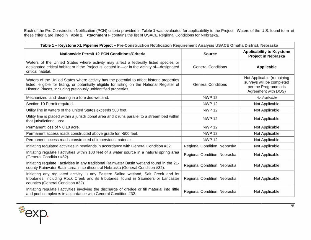
Eacthe
Wdecr
WlisH
M
Se
U
Uth
Pe
Pe
Pe
In
In(G
Inco
Intrico
Inan
ch of the Pre-Coese criteria are lis
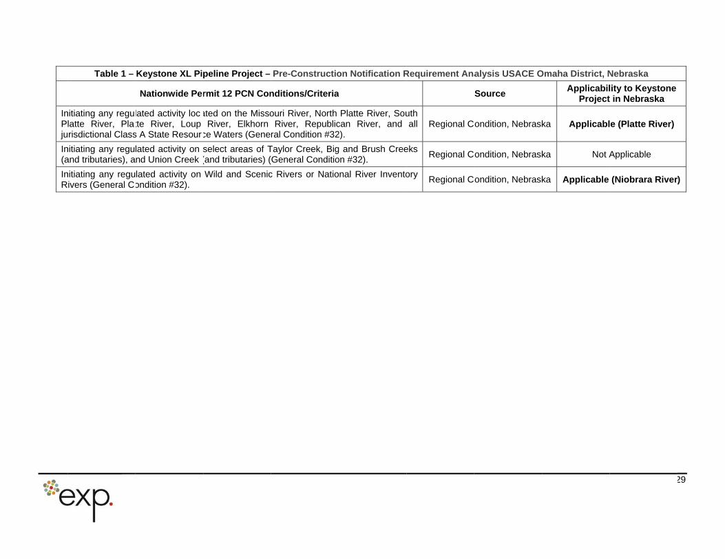
Table 1 –
Waters of the Unesignated critical ritical habitat.
Waters of the Unisted, eligible for istoric Places, in
Mechanized land
ection 10 Permit
tility line in water
tility line is placehat jurisdictional
ermanent loss of
ermanent access
ermanent access
nitiating regulated
nitiating regulateGeneral Conditio
nitiating regulateounty Rainwater
nitiating any regibutaries, includiounties (General
nitiating regulatend pool complex
nstruction Notificted in Table 2.
Keystone XL Pi
Nationwide Pe
nited States whehabitat or if the
ted States wherelisting, or poten
cluding previousl
clearing in a fore
required.
s of the United S
d within a jurisdiarea.
> 0.10 acre.
s roads construct
s roads construct
activities in peat
d activities within n #32).
d activities in any Basin area in so
ulated activity ing Rock Creek Condition #32).
d activities involves in accordance
ation (PCN) criterAttachment F con
peline Project –
rmit 12 PCN Con
re activity may Project is located
activity has the tially eligible for y unidentified pro
sted wetland.
tates exceeds 50
ctional area and it
ed above grade f
ed of impervious
tlands in accordan
100 feet of a wa
traditional Rainwuthcentral Nebras
n any Eastern Sand its tributarie
ing the dischargewith General Con
ria provided in Tantains the list of U
Pre-Constructio
nditions/Criteria
affect a federallyin—or in the vici
potential to affeclisting on the N
operties.
00 feet.
t runs parallel to a
or >500 feet.
materials.
nce with General
ater source in a
water Basin wetlaska (General Con
Saline wetland, Ss, found in Saun
e of dredge or filndition #32.
able 1 was evaluaUSACE Regional
on Notification R
y listed species nity of—designat
ct historic propertNational Register
a stream bed with
Condition #32.
natural spring ar
and found in the 2dition #32).
Salt Creek and nders or Lancas
ll material into rif
ated for applicabConditions for N
Requirement Ana
or ted Gener
ies of Gener
hin
Regional C
rea Regional C
21-Regional C
its ster Regional C
ffle Regional C
ility to the ProjectNebraska.
alysis USACE O
Source
ral Conditions
ral Conditions
NWP 12
NWP 12
NWP 12
NWP 12
NWP 12
NWP 12
NWP 12
ondition, Nebrask
ondition, Nebrask
ondition, Nebrask
ondition, Nebrask
ondition, Nebrask
t. Waters of the
Omaha District, N
ApplicabilProject
Ap
Not Applicsurveys w
per the PAgreeme
Not
Not A
Not A
Not A
Not A
Not A
Not A
ka Not A
ka Not A
ka Not A
ka Not A
ka Not A
U.S. found to m
Nebraska
lity to Keystone t in Nebraska
pplicable
cable (remaining will be completed Programmatic ent with DOS)
Applicable
Applicable
Applicable
Applicable
Applicable
Applicable
Applicable
Applicable
Applicable
Applicable
Applicable
Applicable
28
eet
InPlju
In(a
InR
Table 1 –
nitiating any regulatte River, Plarisdictional Class
nitiating any reguand tributaries), a
nitiating any reguivers (General C
Keystone XL Pi
Nationwide Pe
lated activity loctte River, Loup s A State Resour
lated activity on nd Union Creek
lated activity on ondition #32).
peline Project –
rmit 12 PCN Con
ated on the MissoRiver, Elkhorn
ce Waters (Gene
select areas of T(and tributaries) (
Wild and Scenic
Pre-Constructio
nditions/Criteria
ouri River, North River, Republic
ral Condition #32
Taylor Creek, BigGeneral Conditio
c Rivers or Natio
on Notification R
Platte River, Soucan River, and 2).
g and Brush Creeon #32).
onal River Invento
Requirement Ana
uth all Regional C
eks Regional C
ory Regional C
alysis USACE O
Source
ondition, Nebrask
ondition, Nebrask
ondition, Nebrask
Omaha District, N
ApplicabilProject
ka Applicabl
ka Not A
ka Applicable
Nebraska
lity to Keystone t in Nebraska
e (Platte River)
Applicable
(Niobrara River
29
)
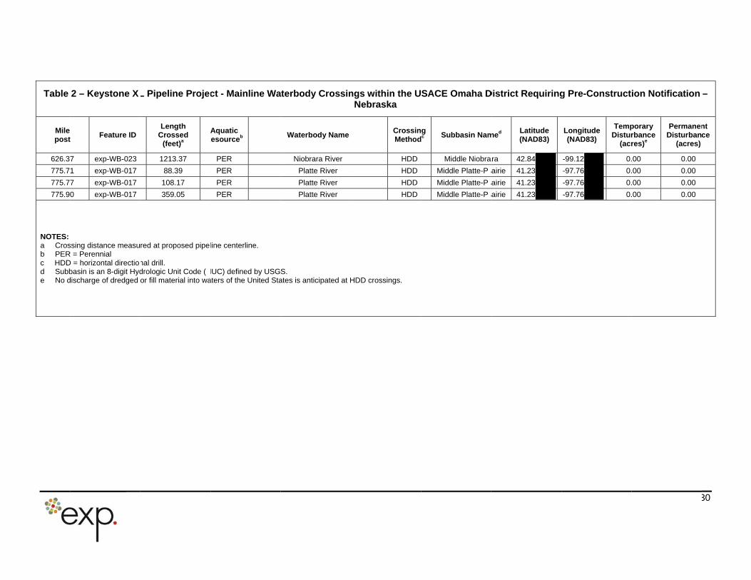
Table
Mile post
626.3
775.7
775.7
775.90
NOTES: a Crosb PERc HDDd Subbe No d
2 – Keystone X
t Feature ID
7 exp-WB-023
1 exp-WB-017
7 exp-WB-017
0 exp-WB-017
ssing distance measuR = Perennial D = horizontal directiobasin is an 8-digit Hyddischarge of dredged
L Pipeline Proje
Length Crossed
(feet)a
5 1213.37
5 88.39
108.17
6 359.05
red at proposed pipe
nal drill. drologic Unit Code (or fill material into wa
ct - Mainline Wa
Aquatic Resourceb
PER
PER
PER
PER
line centerline.
HUC) defined by USGaters of the United Sta
aterbody Crossin
Waterbody Name
Niobrara River
Platte River
Platte River
Platte River
S. ates is anticipated at H
ngs within the UNebraska
CrossinMethod
HDD
HDD
HDD
HDD
HDD crossings.
SACE Omaha D
g dc
Subbasin Nam
Middle Niobra
Middle Platte-P a
Middle Platte-P a
Middle Platte-P a
District Requiring
med Latitude (NAD83)
ara 42.84
rairie 41.23
rairie 41.23
rairie 41.23
g Pre-Construct
Longitude (NAD83)
TempDistur
(acr
-99.12 0.
-97.76 0.
-97.76 0.
-97.76 0.
ion Notification
porary rbance res)e
PermanenDisturban
(acres)
.00 0.00
.00 0.00
.00 0.00
.00 0.00
30
–
nt ce

Table 3 –
Pump St
PS-2
PS-2
PS-2
PS-2
PS-2
Keystone XL
ation ID
22
23
24
25
26
L Pipeline Pro
Milepo
655.2
708.7
765.1
819.9
876.5
oject - Pum
ost
2
7
1
9
5
p Station Lo
County
Holt
Antelope
Nance
Fillmore
Jefferson
cations – Neb
Acre
15.0
14.0
13.6
17.4
7.1
3
braska
es
0
0
6
4
31
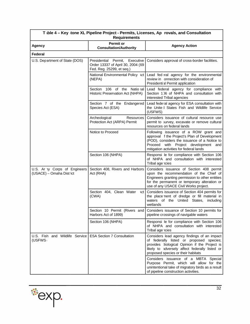
T
Agency
Federal
U.S. Dep
U.S. Ar(USACE)
U.S. Fish(USFWS
able 4 – Key
artment of State
my Corps of – Omaha Dist
h and Wildlif)
stone XL Pipe
e (DOS) PreOrFe
Na(N
SeHis
SeSp
ArcPro
No
Se
Engineers rict
SeAc
Se(C
SeHa
Se
e Service ES
eline Project Re
PermConsultatio
esidential Perder 13337 of Aed. Reg. 25299,
ational EnvironmEPA)
ection 106 ostoric Preserva
ection 7 of tpecies Act (ESA
cheological otection Act (A
otice to Proceed
ection 106 (NHP
ection 408, Rivct (RHA)
ection 404, CWA)
ection 10 Permarbors Act of 18
ection 106 (NHP
SA Section 7 Co
- Permits, Liequirements
mit or on/Authority
ermit, ExecutivApril 30, 2004 (, et seq.)
mental Policy
of the Natiotion Act (NHPA
the EndangerA)
ResourceRPA) Permit
d
PA)
vers and Harbo
lean Water
mit (Rivers a899)
PA)
onsultation
censes, Ap
ve 69
Considers
Act Lead fedreview in Presidenti
nal A)
Lead fedeSection 1interested
ed Lead fedethe Unite(USFWS)
es Considers permit to resources
Following approval (POD), coProceed mitigation
Responsiof NHPA Tribal age
ors Considers upon the Engineers for the peuse of any
Act Considers the placewaters owetlands
nd Considers pipeline cr
Responsiof NHPA Tribal age
Considers of federaprovides likely to proposed s
Considers Purpose Punintentionof pipeline
rovals, and C
Agency A
approval of cro
eral agency foonnection with al Permit applic
eral agency f06 of NHPA aTribal agencies
ral agency for Ed States Fish
issuance of csurvey, excavaon federal land
issuance of f the Project’s nsiders the isswith Project
activities for fed
le for complianand consulta
ncies
issuance of recommendatgranting permirmanent or temUSACE Civil W
issuance of Sement of dredgf the United
issuance of Sossings of navi
le for complianand consulta
ncies
lead agency flly listed or
Biological Opinadversely affecspecies or their
issuance ofPermit, which nal take of migrconstruction ac
Consultation
Action
oss-border facil
or the environconsideration o
cation
for complianceand consultatios
ESA consultatioand Wildlife S
cultural resourcate or remove cds
a ROW granPlan of Develo
suance of a Nodevelopment
deral lands
nce with Sectioation with inte
Section 408 tion of the Chission to other emporary alteraWorks project.
ection 404 permge or fill mated States, inc
Section 10 permgable waters
nce with Sectioation with inte
findings of an proposed sp
nion if the Proct federally lisr habitats
f a MBTA Swill allow fo
ratory birds as activities.
32
n
ities.
mental of
e with on with
on with Service
ce use cultural
nt and opment otice to t and
on 106 erested
permit hief of entities
ation or
mits for erial in cluding
mits for
on 106 erested
impact pecies; oject is sted or
Special or the a result
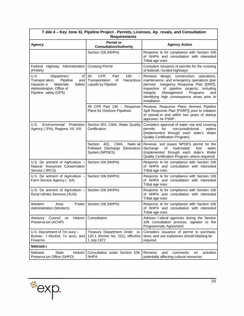
T
Agency
Federal (FHWA)
U.S. TransporHazardoAdministrPipeline
U.S. EnAgency (
U.S. DeNatural Service (
U.S. DeFarm Ser
U.S. DeRural Utili
Western Administr
Advisory Preserva
U.S. DepBureau Firearms
Nebrask
NebraskPreserva
able 4 – Key
Highway Adm
Departmentation, Pipelus Materials ation, Office of
Safety (OPS)
nvironmental EPA), Regions,
artment of AgResources CoNRCS)
artment of Agvice Agency (
artment of Agties Services (
Area ation (Western
Council ontion (ACHP)
artment of Tref Alcohol, To
a
State tion Office (SHP
stone XL Pipe
Se
ministration Cr
t of ine and
Safety
49TraLiq
49Pla
Protection VII, VIII
SeCe
SePoSy
riculture – nservation
Se
riculture – SA)
Se
riculture – RUS)
Se
Power )
Se
Historic Co
asury – acco, and
Tre121 J
Historic PO)
CoNH
eline Project Re
PermConsultatio
ection 106 (NHP
rossing Permit
9 CFR Pansportation quids by Pipelin
9 CFR Part 1ans for Onshore
ection 401, CWertification
ection 402, ollutant Dischaystem (NPDES)
ection 106 (NHP
ection 106 (NHP
ection 106 (NHP
ection 106 (NHP
onsultation
easury Depart20-1 (former NoJuly 1972
onsultation undHPA
- Permits, Liequirements
mit or on/Authority
PA)
Part 195of Hazardou
ne
94 – Response Pipelines
WA, Water Qual
CWA, Natioarge Eliminati)
PA)
PA)
PA)
PA)
ment Order o. 221), effectiv
der Section 10
censes, Ap
Responsiof NHPA Tribal age
Considers of federall
– us
Reviews maintenan(termed inspection Integrity identifying installation
se Reviews Spill Respof operatiapproves
ity Considers permits (implemenQuality Ce
nal on
Reviews discharge (implemenQuality Ce
Responsiof NHPA Tribal age
Responsiof NHPA Tribal age
Responsiof NHPA Tribal age
Responsiof NHPA Tribal age
Advises f106 consProgramm
No. ve
Considers store, and required
06, Reviews potentially
rovals, and C
Agency A
le for complianand consulta
ncies
issuance of pey funded highwa
design, consce, and emerg
Emergency Resof pipeline Management high consequ
Response Plaonse Plan [PSon and within he PSRP.
approval of wafor non-ju
ted through rtification Progr
and issues NPof hydros
ted through rtification Progr
le for complianand consulta
ncies
le for complianand consulta
ncies
le for complianand consulta
ncies
le for complianand consulta
ncies
ederal agenciesultation proceatic Agreemen
issuance of use explosives
and commeaffecting cultur
Consultation
Action
nce with Sectioation with inte
ermits for the crays
struction, opergency operationsponse Plan [
projects, inct Programsuence areas p
ans (termed PRP]) prior to intwo years of
ater use and crrisdictional each state’s ram)
PDES permit fstatic test each state’s ram, where req
nce with Sectioation with inte
nce with Sectioation with inte
nce with Sectioation with inte
nce with Sectioation with inte
s during the Sss; signator tt
permit to purs should blastin
ents on acral resources
33
n
on 106 erested
rossing
rations, ns plan [ERP]), cluding
and prior to
Pipeline nitiation startup
rossing waters Water
for the water Water
quired)
on 106 erested
on 106 erested
on 106 erested
on 106 erested
Section to the
rchase, g be
ctivities
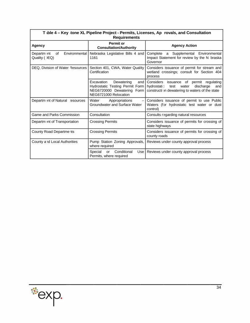
T
Agency
DepartmQuality (
DEQ, Div
Departm
Game an
Departm
County R
County a
able 4 – Key
ent of EnvDEQ)
ision of Water
ent of Natural
d Parks Comm
ent of Transpor
oad Departme
nd Local Autho
stone XL Pipe
ironmental Ne11
Resources SeCe
ExHyNENE
Resources WaGr
ission Co
tation Cr
nts Cr
rities Puwh
SpPe
eline Project Re
PermConsultatio
ebraska Legisla61
ection 401, CWertification
xcavation Deydrostatic TestiEG6720000 DEG6721000 Re
ater Approroundwater and
onsultation
rossing Permits
rossing Permits
ump Station Zohere required
pecial or Cermits, where re
- Permits, Liequirements
mit or on/Authority
ative Bills 4 a
WA, Water Qual
ewatering aing Permit Forewatering For
elocation
opriations d Surface Wate
s
s
oning Approva
Conditional Usequired
censes, Ap
nd Complete Impact StaGovernor
ity Considers wetland cprocess
nd rm rm
Considers hydrostaticonstructi
– er
Considers Waters (fcontrol)
Consults r
Considers state highw
Considers county roa
ls, Reviews u
se Reviews u
rovals, and C
Agency A
a Supplemeatement for rev
issuance of prossings; cons
issuance ofc test wateon dewatering to
issuance of por hydrostatic
egarding natura
issuance of peways
issuance of peds
nder county ap
nder county ap
Consultation
Action
ental Environview by the N
permit for streasult for Sectio
f permit reger discharge o waters of the
permit to use test water o
al resources
ermits for cross
ermits for cross
pproval process
pproval process
34
n
mental braska
am and on 404
gulating and
state
Public or dust
sing of
sing of
s
s
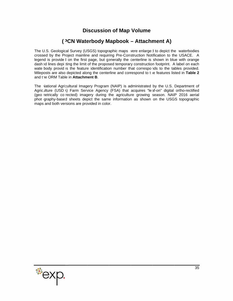
The UcrosslegendashwateMilepand t
The Agric(geophotmaps
(
U.S. Geologiced by the Prd is provideed lines depibody providosts are alsohe ORM Tabl
National Agriulture (USDmetrically coography-base and both ver
Di
PCN Wate
cal Survey (Uroject mainlind on the first cting the limit es the feature depicted aloe in Attachm
cultural ImagA) Farm Servrrected) imagd sheets deprsions are pro
iscussion
erbody M
SGS) topograne and requir
page, but gof the propose identificatio
ong the centement B.
ery Program vice Agency gery during tpict the samovided in colo
n of Map
Mapbook
aphic maps ring Pre-Conenerally the sed temporaron number thrline and corr
(NAIP) is ad(FSA) that
the agricultue informationr.
Volume
– Attachm
were enlargestruction Notcenterline is y construction
hat corresporespond to t
dministrated acquires “lere growing n as shown
ment A)
d to depict theification to thshown in blun footprint. Ands to the tahe features lis
by the U.S. af-on” digital season. NAIon the USG
3
e waterbodiehe USACE. ue with orangA label on eacables providedsted in Table
Department oortho-rectifie
P 2016 aeriGS topograph
35
es A
ge ch d. 2
of ed al ic

Attachment A: Map Volume
PCN Wetland and Stream Features
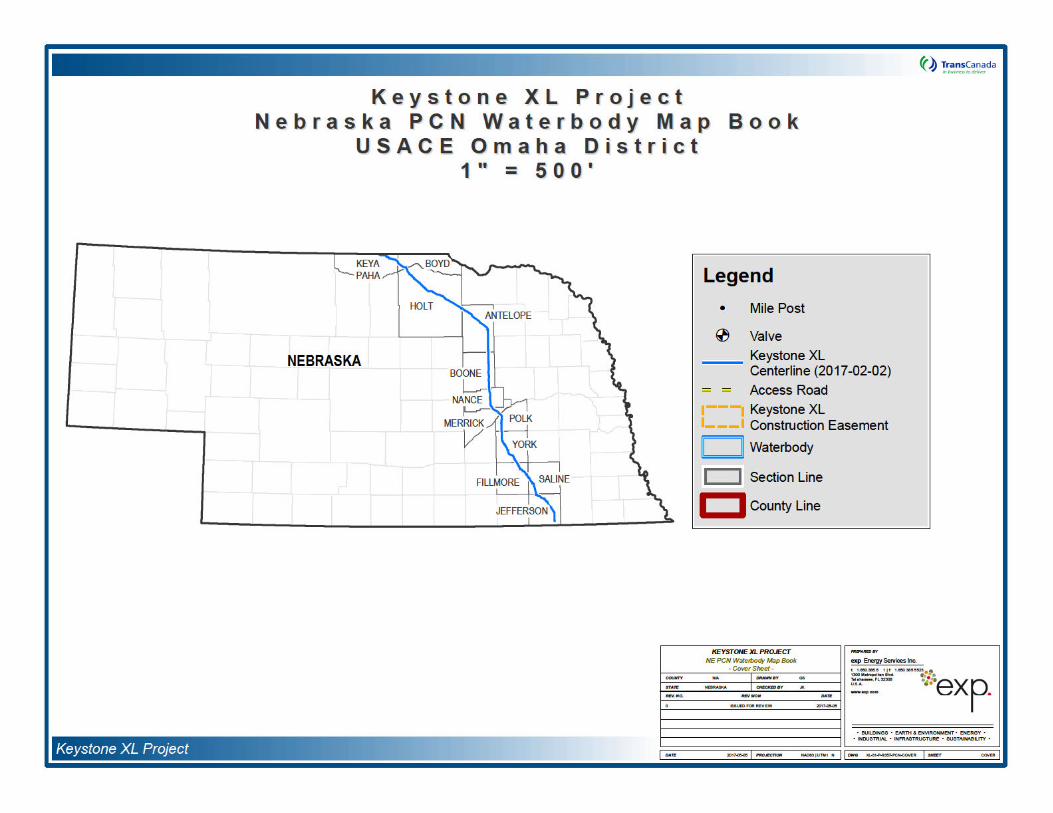


Attachment B:
Wetland Assessment Methodology and Results
OMBIL Regulatory Module (ORM) Tables
Non-PCN Datasheet Tables
Wetland and Waterbody Map Book

Wetland Assessment Methodology and Results

Tra
WetlOm
Prepar
TransC700 LoHousto
Prepar
exp En1300 MTallaha DocumTAL-KX Date SMay 25,
nsCana
and Asha Dist
ed for:
anada Keysuisiana Street n, Texas 770
ed by:
ergy Serviceetropolitan Blssee, Florida
ent Number L-1100-04-0
ubmitted 2017
da Key
sessmenrict – Ne
one Pipeline
02
s Inc. vd. 32308
6
ystone X
nt Methoebraska
e, LP
XL Pip
odolog
eline Pr
and R
roject
esults

Acro
CWA
ESA
FAC
FACW
FEMA
GIS
GPS
Keyston
NHD
NRCS
NWI
OBL
ORM
PCN
Project
RHA
RPW
TNW
U.S.
USACE
USDA
USEPA
USFW
USGS
nym Gl
Clea
Envi
Facu
Facu
Fed
Geo
Glob
e Tran
Natio
Natu
Natio
Oblig
OM
Pre-
Key
Rive
Rela
Trad
Unite
Unite
Unite
Unite
Unite
Unite
ssary
n Water Act
ronmental Stu
ultative
ultative-Wet
eral Emergenc
graphic Inform
al Positioning
sCanada Key
onal Hydrogra
ral Resources
onal Wetlands
gate
BIL Regulatory
Construction N
stone XL Pipe
rs and Harbor
tively perman
itional naviga
ed States
ed States Arm
ed States Dep
ed States Env
ed States Fish
ed States Geo
udy Area
cy Manageme
mation System
g System
ystone Pipelin
aphy Dataset
s Conservatio
s Inventory
y Module
Notification
line Project
rs Act
nent waters
ble waters
my Corps of En
partment of Ag
vironmental Pr
h and Wildlife
ological Surve
ent Agency
m
e, LP
on Service
ngineers
griculture
rotection Age
Service
ey
ncy
i
1.0 I
TransCawaterboNebrasjurisdictiapproxifootprinthe OMfeaturesNotifica
1.1
The U.Clean W
The USinundatunder nconditiodefinitio
The Cle
a.
b.
c.
d.
e.
f.
g.
ntroduc
anada Keystdies from Ju
ka. The wetlonal waters
mate boundat (as part of tBIL Regulato) and on thtion (PCN).
Regulatio
S. Army CorpWater Act (CW
ACE and the ed or saturatormal circumns. Wetlandn takes into c
an Water Act
All waters interstate or
All interstate
All other watsand flats, wdegradation waters:
1. Which ar
2. From wh
3. Which ar
All impound
Tributaries o
The territoria
Wetlands adj(a) through (
tion
one Pipeline, Lne 2008 throuand and waterof the United ries of each fhe Environmery Module (ORe wetland an
ns and Def
s of EngineerA) and Sectio
U.S. Environmed by surface stances do sus typically incluonsideration t
(CWA; 1977)
which are currforeign comm
waters includ
ters such as etlands, slougor destruction
re or could be
ich fish or she
re used or cou
ments of water
f waters identi
l seas;
acent to wateg).
LP (Keystoneugh May 201rbody assessStates (U.S.)feature. All fntal Survey ARM) Table (fond waterbody
finitions
rs (USACE) reon 10 of the R
mental Protecor groundwa
upport, a prevude swamps, three distinct e
) defines the te
rently used, oerce, includin
ing interstate
intrastate lakghs, prairie pon of which co
used by inter
ellfish are or c
uld be used fo
rs otherwise d
ified in paragr
ers (other than
e) conducted 7 for the prment and de exist within features that
Area [ESA]), or PCN featurey feature ma
egulates watRivers and Har
ction Agency ater at a freqvalence of ve
marshes, boenvironment
erm "waters
or were usedg all waters
wetlands;
kes, rivers, stotholes, wet mould affect in
rstate or forei
could be take
or industrial p
defined as wa
raphs (a) thro
n waters that
both desktooposed Keystlineation werthe proposed were identifi
are summarizes) and Nonpping in Att
ers of the Unirbors Act (R
(USEPA) defiuency and dgetation typigs, and othel parameters:
of the United
d in the paswhich are sub
reams (inclumeadows, platerstate or fo
gn travelers f
n and sold in i
urpose by ind
ters of the Un
ugh (d) abov
are themselve
and field anaone XL Pipele conducted t Project areaed within the ed in this docPCN Datashe
achment B o
ted States unHA).
ne wetlands auration sufficiecally adapted r similar areas hydrology, so
States" as:
t, or may beject to the ebb
ding intermitteaya lakes, or nreign comme
or recreationa
nterstate or fo
ustries in inter
nited States un
e;
es wetlands) i
alyses of wetline Project (Pto determine is and to deteproposed co
cument and liseet Table (forf the Pre-Co
nder Section 4
as “those areaent to supportfor life in satu
s” (USACE 19oil, and vege
e susceptible b and flow of t
ent streams), natural pondsrce including
al or other purp
oreign comme
rstate comme
nder the defin
identified in pa
2
tlands and Project) in if potential ermine the onstruction sted within r non-PCN onstruction
404 of the
as that are t, and that urated soil 987). This tation.
to use in the tide;
mudflats, s, the use,
any such
poses; or
erce; or
erce.
nition;
aragraphs
h.
1.2
In additiincludeboth the
1. Waste trequirem123.11(
Waters of tdeterminatiopurposes of
Technical
on to applyid the guidan desktop and
Section II: S
A. RHA S
B. CWA S
1. W
a
Section III:
B. Charact
1. Ch
(i
2. Ch
(i
C. Significphysical
Section IV:
A. SuppoHydro(USD
reatment sysents of the CW
m), which also
he United Sn of an area'sthe CWA, the
Approach
ng the definitice from the U
field analyses
ummary of Fi
ection 10; Nav
ection 404;
aters of the U.S
. Presence: T(RPWs); NoRPWs; DireIsolated wa
CWA Analysis
eristics of trib
aracteristics o
i) Physical Ch
(c) Flow reDiscontinuo
aracteristics o
) Physical Ch
(c) Wetland
ant Nexus Det relationship.
Data Sources
rting Data: USgraphy Datas) Natural Re
stems, includWA (other tha meet the crite
States do nos status as pfinal authority
on of waters USACE Appros. In particula
indings:
vigable waters
S.;
Traditional Naon-RPWs; Weect/indirect flowaters.
s:
utary and its a
of non-TNWs t
haracteristics
gime, Definedous ordinary h
of wetlands ad
haracteristics
d Adjacency D
termination:
s:
SACE navigaet (NHD); US
esource Cons
ding treatmean cooling poneria of this de
ot include pprior convertey regarding C
of the Uniteoved Jurisdic iar, Keystone
s;
avigable Wateetlands adjacw into TNWs,
adjacent wetla
that flow direc
;
d bed and bahigh water m
djacent to no
Determination
Carry capacit
able waters lSGS Topogrservation Se
nt ponds onds as define
efinition) are n
rior convertd cropland WA jurisdicti
d States to iional Determprincipally app
rs (TNWs); Rent to, directl, RPWs, Non
ands;
ctly or indirec
nk, Observablrk.
-TNW that fl
n with Non-TN
y; habitat/life
isting; U.S. aphic Mappirvice (NRCS
r lagoons dd in 40 Code ot waters of th
d cropland. y any other f
on remains wit
ts assessmenination Form plied:
Relatively Permy abutting TNWRPWs; Impou
tly into TNW;
le ordinary hig
ow directly or i
NW.
cycle; nutrient
Geological Sung; U.S. Dep) Soil Survey
esigned to of Federal Re
he United Sta
Notwithstanfederal agencth the USEPA
nt effort, Keys(Appendix B
manent WaterWs, RPWs, Nundments; an
gh water mark
indirectly into
t transfer; othe
urvey (USGSpartment of Ays; National
3
meet the egulations
ates.
nding the cy, for the A.
stone also ; 2007) in
rs Non-nd
k, and
TNW;
er
) National Agriculture
Wetlands
2.0
The follimplemincludinevaluat
2.1
Prior to constru
The objintersecof the U
The desources
2.1.1
AccessiproposeProject iof the pwidth alsurveye
Using cfield datimplemDelineatDelineatcorridor
InventMappi
Assess
owing sectiented by traig the pipelined to determi
Desktop
conducting tction footprint
USGS NHD.
USGS 7.5-m
USDA NRC
U.S. Fish &
Aerial Photo
FEMA floodp
USGS Land
ectives of thited by the prSACE Omah
sktop analysinoted above
Field Surv
ble areas seld pipeline alis collocated roposed centigned on the d in their enti
ommon wetlaa sheets, plaented the “thtion Manual tion Manual: and analyze
ory (NWI) Mng; Aerial Pho
ent Meth
ons describe ned biologistse, pump stat
ne the location
nalysis
he environme(as part of the
inute Topogra
S Soil Surveys
Wildlife Servic
graphy (2008
lain/flood haz
Use and Land
s data reviewoposed Projeca District.
s was recentincluding Nat
ey
ected for field gnment was with existing perline and 200centerline of
rety. Land pa
nd survey toont indicator lisree-paramete(USACE 198
Great Plains Rd vegetation, s
apping; Fedotography; an
hods
the backgros. The Projtions, and otn of wetlands
ental field sure ESA) using
aphic Quadran
s.
e (USFWS) N
through 2015
zard mapping.
d Cover Data.
w using the act areas. If n
ly reassessetional Agricultu
verification w300 feet in w
pipelines, the s0 feet on the each proposercels were on
ols such as sts, and visualr” approach s87) and the Region (2.0; Usoils, and hyd
eral Emerged previous d
ound informatect’s propos
ther auxiliary and waterbo
rvey activitiesthe following
ngle Maps.
NWI Maps.
5).
above-mentioecessary, furt
d in 2017 apure Imagery
ere surveyed width centeredsurvey width non-collocateed access ro
nly surveyed if
hovels and s observation
set forth in tRegional S
USACE 2010rology to det
ency Managetermination
tion that waed constructareas whet
dies and land
s, Keystone csources:
ned sourcesther delineati
pplying the mProgram aeri
by trained bid on the prowas adjusted ed side. Accad. Pump stf landowner p
oil augers, thfor plant iden
he 1987 U.S.upplement to ). Biologists
ermine uplan
ement Agenc.
s utilized anion footprint her permaneuse type.
completed a d
were to idenons will be co
ost current val photography
ologists. The posed pipelinto 100 feet o
ess roads wertations and teermission for
he Munsell Sotification, the Army Corps the Corps
collected datad/wetland bou
cy (FEMA) F
nd methods (as part of tnt or tempor
desktop analy
ntify waters ofonducted at th
versions of thy dated 2016.
ESA corridore. In areas wn the collocatre surveyed 1
emporary facilaccess was g
oil Color Charbiological sur
s of Engineersof Engineersa points withinndaries.
4
Floodplain
that were the ESA), rary, were
ysis of the
f the U.S. he request
e multiple .
r along the where the ted portion 100 feet in lities were granted.
rt, USACE rvey crews s Wetland s Wetland n the ESA

DominaWetlanvegetatifacultatirecordedrapid teand prorequire
Soils wcharactCorporapresent.
HydroloUSGS typically and secdrainag
Applicabank slconditio
2.1.2
As descmet the data poiwetland visited.
Trimbleused to
Identifielabeled
F = Fea
N = tea
CC = tw
000 = n
Alternati(e.g., “eaddition
F_UTM
nt vegetation ds: North Plaion, more thve-wet (FACd and an assst for hydropblematic hyd
ments that wo
ere examineeristics (hue, tion 1992). S
gical characttopographic associated
condary indice patterns).
ble data werope, stream ns, and distur
Document
cribed in the wetland critent within the delineation fi
® GPS Pathfrecord wetla
d features alin the followi
ture Type (str
m number
o-letter Coun
umber of feat
vely, some fxp“) and/or eto the nome
_000, where
was identifiedns Region 4
an 50 percenW), or facultaessment of thhytic vegetatirophytic vegetuld allow the a
d in the fieldvalue, and
Soils were the
eristics were maps, FEMA with wetlands aators of wetla
e gathered forflow direction bances. Wat
ation
USACE Wetlaria were labelewetlands and eld data form
inder™ PRO-nd and waterb
ong the surveyng manner: F-
eam, wetland
ty abbreviatio
ure within eac
eatures were xtensions of pnclature descr
d and classifie(USFWS 198t of the dom
ative (FAC). he dominant son, the domitation were caarea to be cla
d by excavachroma) we
en evaluated
determined bFlood Hazarand wetland hand hydrolog
r each waterband type, wa
erbody Data S
and Delineatied as wetlandin immediatel
m. Photograph
-XRS and Tribody locations
y corridor werN-CC-000, wh
d habitat, etc.)
n
ch county, rep
labeled with previously-idenribed above, th
ed according 88). In order
minant speciesA list of sp
species madnance test, talculated an
assified as an
ating soil pitere recorded to determine
by field obsed Maps, andhabitats. Fiely were pres
body feature iater appearanSheets were
ion Manual (ds. Vegetatioly adjacent uphs were take
imble GeoXT with sub-me
re distinctly nahere:
presentative to
additional syntified featurhese features
to the Nationfor an area
s identified mecies identifie. Hydrophythe prevalenc assessed toarea domina
s ranging frusing Munswhether indi
vation as w NWI maps d observatio
ent (e.g. satu
ncluding: ordnce, stream completed fo
USACE 1987n, soil, and h
plands and wn showing a
T TM Global Pter accuracy.
amed to disti
o each team
mbols where s were deline
s were labeled
al List of Planto be considemust be consed within the ic vegetation e index, mor determine if ted by hydrop
om 12 to 2sell Soil Colocators of hydr
ell as examinto identify dis
ns were maderated soils, s
inary high wasubstrate, aqr each surveye
), areas wherydrology dataere then enterrepresentative
ositioning Sys
nguish each f
desktop delineated during sd using one of
nt Species thaered to supposidered obliga
survey area indicators incphological adthe vegetatio
phytic vegetati
inches deeor Charts (Kric (wetland) s
ing aerial phostinct features
e to determinestanding surfa
ater mark, bauatic habitatsed stream cro
re all three pa were collectered onto a stae view of eac
stem (GPS) u
feature. Feat
neation was csubsequent suf the following
5
at Occur in ort wetland ate (OBL),
was then cluding the daptations, on met the on.
p. Color Kollmorgen soils were
otographs, s that are
e if primary ace water,
nk height, s, channel ossing.
arameters ed at each andardized ch wetland
units were
tures were
conducted urveys. In g systems:

UTM =
or
F_TROW
TROW
or
exp_F_
exp = c
or
F0000,
0000 =
or
S0ADD
S0ADD
After cocreated surveyefield dat
3.0
The resuin the fo
3.1
WetlanDeepwand otgeomor
Within twetland
Universal Tra
W_000, wher
= company n
000, where
ompany nam
where
number of fe
00, where
= desktop str
llection, GPSusing ESRI
d features wia sheets, pho
Results
ults of the wellowing sectio
Wetlands
ds were classater Habitats hers by provphic, chemic
he proposed s were identif
27 indivi
5 individ
nsverse Merc
e
ame
e
ature within co
eam feature
/GeographicaArcMap™ 10
thin the propootographs, and
tland and watens.
ified accordinof the United iding uniform
al, and biologic
Project constied and are ca
dual palustrine
ual palustrine
ator
ounty, represe
al Information 0.3.1 softwarosed Project cd GPS survey
erbody deskto
ng to the CowStates (Cowa
mity of concecal factors.
truction footprategorized as
e emergent w
forested wetla
entative to ea
System (GIre. Maps wconstruction fy data were c
op assessme
wardin Systemardin 1979). epts and ter
rint, in the US:
wetlands.
ands.
ch team
S) data were ere created iootprint (Attaompiled and m
nts and field
m, as describThis hierarchms used to
SACE Omaha
added to a Gn GIS to illuchment B of tmaintained by
surveys for the
ed in Classificical system adefine wetla
a District in N
GIS databaseustrate the locthe PCN). Ad
y Keystone.
e Project are
cation of Wetids resource
ands using h
Nebraska, 32
6
e that was cations of dditionally,
presented
tlands and managers
hydrologic,
individual
3.2
WaterbfeaturesdetermiOpen wconsist perennicontain
Within tcrossin
Waterbod
odies include (i.e., ponds, ned from reviaterbody featof intermittenal waterbodiea well-define
he proposed gs of waterbo
38 indivi
59 indivi
110 indi
1 individ
1 individ
3 individ
ies
d linear water lakes). Line
ewing availabures were clat/ephemeral ss were identifd bed and ban
Project constdies were iden
dual crossings
dual crossings
vidual crossing
ual crossing o
ual crossing o
ual crossings
features (i.e.,ear waterbodible data (e.g.assified as postreams/washefied as well. Tnk with channe
truction footprntified and are
s of perennial
s of intermitten
gs of epheme
of an open wat
of a man-made
of man-made
streams, rives were cla, maps) and nds or lakes. es with well These perennelized structu
rint in the Ue categorized
waterbodies.
nt waterbodi
ral waterbodi
ter waterbody
e open water
e ditches.
ers, and man-sified by usinclude man The majorit
o poorly definial features re.
SACE Omahas:
s.
es.
y.
body.
made ditchese as observed-made ditchey of waterbodned bed and generally hold
a District in N
s) as well as od in the field es, streams, adies that werebank structurd water year-r
Nebraska 212
7
open water and/or as
and rivers. e identified res. Many round and
individual

4.0
Barkley,K
CowardG
CowardhU
Great PK
HaddocK
HarringP
HitchcoY
Kirt, R. S
Knobel, E
Kollmor
E
Ladd, DP
Mitsch, Y
Niering,
Reed, a
StepheK
Referenc
T. M. 1983. ansas. 176 p
in, Lewis M. 1overnment P
in, L. M., V. abitats of the SFWS/OBS-7
lains Flora Aansas. Lawr
k, Michael J. ansas. Lawr
ton, H. D. 19ress. Athen
ck, A. S. 197ork. 1051 pa
R., H. Tweedtipes Publishi
Edward. 19d. Dover Pu
gen Corporati
dition.
. and F. Obelants of the P
William J. anork. 722 pag
William A., aildflowers.
P. B., Jr. 198nd Wildlife S
ns, Homer A. ansas. Lawr
es
Field Guide tages.
979. Classifirinting Office,
arter, F. C. GUnited States79/31. 103 pp
ssociation (Gence, Kansas
2005. Wildflence, Kansas
77. How to Is, Ohio. 142
1. Manual ofges.
ie, and R. L. Sng. Champa
80. Field Guiblications, Inc
on. 1990. M
rle. 2005. Tarairie Midwes
d James G. Ges.
nd Nancy C. Alfred A. Knop
8. National Liervice Biologic
1969. Trees,ence, Kansas.
to the Commo
cation of WetWashington,
olet, and E. T. U.S. Fish an.
PFA). 1986.s. 1408 pages
flowers and Gs. 374 pages.
Identify Grasspages.
f the Grasses
Simonds. 19ign, Illinois. 1
ide to the Grac. New York
Munsell Soil Co
allgrass Prairist. Globe Peq
Gosselink. 19
Olmstead. 1pf. New York.
ist of Plant Spcal Report 88
, Shrubs, and . 256 pages.
on Weeds of
lands and DD.C.
T. LaRoe. 197nd Wildlife Se
Flora of the s.
Grasses of Ka
ses and Gra
s of the United
95. Prairie 56 pages.
asses, Sedgek. 1051 pag
olor Charts.
ie Wildflowerquot Press.
993. Wetlan
992. The A. 887 pages.
pecies that O(24). 244 pa
d Woody Vines
Kansas. Uni
epwater Hab
9. Classificatrvice, Biologi
Great Plains.
nsas: A Fiel
slike Plants.
d States. 2n
Plants of the
s and Rusheses.
Munsell Color
s 2: A Field Guilford, Con
s. 2nd Ed.
dubon Socie
Occur in Wetlges.
s in Kansas.
versity Press o
itats of the Un
ion of wetlandcal Services P
University P
Guide. Univ
Swallow Pre
d Ed. Dover P
Midwest: Iden
s of the Unite
Division, Balt
Guide to Commnecticut. 272
Van Nostrand
ty Field Guide
ands: Nationa
University Pre
of Kansas. La
nited States. U
ds and deepwProgram.
Press of
versity Press o
ss, Ohio Univ
Publications,
tification and
d States. 2nd
timore, MD. R
mon Wildflowpages.
d Reinhold. N
e to North Am
al Summary.
ess of
8
awrence,
U.S.
water
of
versity
Inc. New
Ecology.
d
Revised
wers and
New
merican
U.S. Fish
U.S. Ded
U.S. De2
United N
United DVi
United S
United
United Su
U.S. FisHD
U.S. FisR
United
partment of Aatabase. 200
partment of A006. Fort Wo
States DeparFSAM, Third
States Army elineation Macksburg, Mis
States Army upplement to
Mass.
States Army
States Departrvey. http://w
h and Wildlifabitats of the C. FWS/OBS
h and Wildlifetrieved Sept
States Geolog
Agriculture, Na6-2007. Fort W
Agriculture, Nath Texas: USD
tment of AgricEdition, 2nd A
Corps of Enginnual. Technicsissippi.
Corps of Enginthe Corps of
Corps of Engin
ment of Agricuebsoilsurvey.n
e Service. 200United States-79/31., U.S.
e Service. 198ember 2006, f
ical Survey (U
atural ResourcWorth Texas: U
atural ResourcDA NRCS.
culture (USDAAmendment,
neers, Environcal Report Y-8
neers, EngineEngineers W
neers (USACE
ulture (USDA)nrcs.usda.gov/
06. NWIDBA.Cs. U.S. DepartFish and Wild
88. National Lifrom http://ww
USGS) 7.5-Mi
ces ConservUSDA NRCS
ces Conserv
A). 1994. NDecember 2
nmental Labor87-1, U.S. Ar
er Research etland Deline
E). 2016. Re
), 1932, Natu/app/. Access
CONUS_wettment of the Indlife Service,
st of Plant Sww.fws.gov/nw
inute Topogr
tion Service. .
tion Service.
ational Food S0, 1996.
ratory. 1987. my Engineer
and Developation Manual
ulatory Guida
ral Resourcessed August 5
_poly: Classifinterior, Fish Branch of Hab
pecies that Owi/plants.htm.
aphic Quadra
Soil Survey G
U.S. General
Security Act m
Corps of EngWaterways Ex
ment Center. 2: Great Plains
ance Letter No
s Conservatio, 2008
cation of Wetland Wildlife Sebitat Assessm
ccur In Wetlan
ngle Maps.
Geographic (S
Soil Map (ST
manual, 180-V
ineers Wetlanxperiment Sta
2008. Interim s Region, Vick
o. 16-01.
n Service We
lands and Deervice, Washi
ment, Washing
nds, Region F
9
SSURGO)
TATSGO).
V-
nd ation,
Regional ksburg,
eb Soil
epwater ngton,
gton, D.C.
Five.

OMBIL Regulatory Module (ORM) Tables
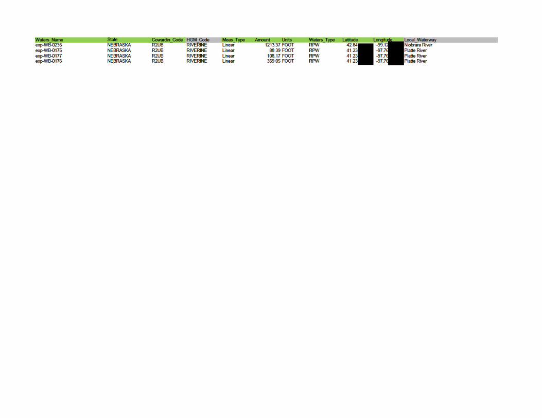

Waters_Name Name Activity Resource_Type Permanent_Loss Impact_Durationexp-WB-0235 Niobrara River Other (directional boring, aerial or submarine crossings) River/Stream NOexp-WB-0175 Platte River Other (directional boring, aerial or submarine crossings) River/Stream NOexp-WB-0177 Platte River Other (directional boring, aerial or submarine crossings) River/Stream NOexp-WB-0176 Platte River Other (directional boring, aerial or submarine crossings) River/Stream NO
Non-PCN Datasheet Tables
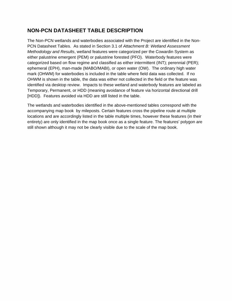
NON-PCN DATASHEET TABLE DESCRIPTION
The Non-PCN wetlands and waterbodies associated with the Project are identified in the Non-PCN Datasheet Tables. As stated in Section 3.1 of Attachment B: Wetland Assessment Methodology and Results, wetland features were categorized per the Cowardin System as either palustrine emergent (PEM) or palustrine forested (PFO). Waterbody features were categorized based on flow regime and classified as either intermittent (INT); perennial (PER); ephemeral (EPH), man-made (MABO/MABI), or open water (OW). The ordinary high water mark (OHWM) for waterbodies is included in the table where field data was collected. If no OHWM is shown in the table, the data was either not collected in the field or the feature was identified via desktop review. Impacts to these wetland and waterbody features are labeled as Temporary, Permanent, or HDD (meaning avoidance of feature via horizontal directional drill [HDD]). Features avoided via HDD are still listed in the table.
The wetlands and waterbodies identified in the above-mentioned tables correspond with the accompanying map book by mileposts. Certain features cross the pipeline route at multiple locations and are accordingly listed in the table multiple times, however these features (in their entirety) are only identified in the map book once as a single feature. The features’ polygon are still shown although it may not be clearly visible due to the scale of the map book.

N_to_S_Ord Milepost County Name Feature_ID + Cowardin OHWM_ft Latitude Longitude Impacts1 601.19 Keya Paha UNNAMED TRIBUTARY TO BUFFALO CREEK exp‐WB‐0316 EPH 42.99 ‐99.53 Temporary2 602.18 Keya Paha Unnamed Tributary to Buffalo Creek S311KP002 EPH 2.0 42.98 ‐99.52 Temporary3 602.19 Keya Paha Unnamed Tributary to Buffalo Creek S311KP002 EPH 2.0 42.98 ‐99.52 Temporary4 602.20 Keya Paha Unnamed Tributary to Buffalo Creek S311KP002 EPH 2.0 42.98 ‐99.52 Temporary5 604.50 Keya Paha Dry Creek S311KP001 INT 15.0 42.98 ‐99.47 Temporary6 605.82 Keya Paha Indian Creek S311KP005 INT 4.0 42.98 ‐99.45 Temporary7 606.33 Keya Paha Pond S311KP006 MABO 42.98 ‐99.44 Temporary8 606.33 Keya Paha Unnamed Tributary to Shingle Creek S311KP007 EPH 20.0 42.98 ‐99.44 Temporary9 607.55 Keya Paha Unnamed Tributary to Shingle Creek S311KP008 EPH 15.0 42.97 ‐99.42 Temporary10 607.90 Keya Paha Shingle Creek S311KP009 PER 3.0 42.96 ‐99.41 Temporary11 610.80 Keya Paha wolf creek S316KP007 INT 8.0 42.94 ‐99.37 Temporary12 611.90 Keya Paha Unnamed Tributary to Keya Paha River S311KP018 EPH 10.0 42.95 ‐99 35 Temporary13 613.06 Keya Paha Unnamed Tributary to Keya Paha River S311KP011 EPH 15.0 42.94 ‐99 33 Temporary14 613.43 Keya Paha Unnamed Tributary to Keya Paha River S316KP002 INT 12.0 42.94 ‐99.32 Temporary15 613.45 Keya Paha Unnamed Tributary to Keya Paha River S316KP002 INT 12.0 42.94 ‐99.32 Temporary16 613.72 Keya Paha Spotted tail creek S316KP001 PER 3.0 42.94 ‐99.32 Temporary17 613.80 Keya Paha Spotted tail creek S316KP001_1 PER 3.0 42.94 ‐99.31 Temporary18 615.35 Keya Paha Dry run creek S316KP005 int 12.0 42.93 ‐99.29 Temporary19 615.39 Keya Paha Dry run creek S316KP005 int 12.0 42.93 ‐99.29 Temporary20 615.89 Keya Paha Unnamed Tributary to Alkali Creek exp‐WB‐0238 INT 42.93 ‐99.28 Temporary21 617.22 Keya Paha Alkali Creek exp‐WB‐0227 PER 42.91 ‐99.26 Temporary22 618.39 Boyd KEYA PAHA RIVER S311BD003 PER 42.90 ‐99.25 HDD23 621.45 Boyd Big Creek S311BD001 EPH 15.0 42.87 ‐99.21 Temporary24 626.78 Holt Unnamed Tributary to Niobrara River exp‐WB‐0250 PER 42.83 ‐99.12 Temporary25 627.07 Holt Beaver Creek exp‐WB‐0228 PER 42.83 ‐99.12 Temporary26 627.08 Holt Beaver Creek exp‐WB‐0228 PER 42.83 ‐99.12 Temporary27 627.11 Holt Beaver Creek exp‐WB‐0228 PER 42.83 ‐99.12 Temporary28 629.83 Holt Unnamed Tributary to Niobrara River exp‐WB‐0248 PER 42.79 ‐99.10 Temporary29 631.95 Holt Unnamed Tributary to Big Sandy Creek exp‐WB‐0370 EPH 42.77 ‐99.07 Temporary30 631.99 Holt Unnamed Tributary to Big Sandy Creek exp‐WB‐0370 EPH 42.77 ‐99.07 Temporary31 632.98 Holt Big Sandy Creek exp‐WB‐0230 PER 42.76 ‐99.05 Temporary32 635.35 Holt Unnamed Tributary to Big Sandy Creek exp‐WB‐0239 PER 42.74 ‐99.02 Temporary33 640.29 Holt Unnamed Tributary to Brush Creek exp‐WB‐0024 INT 42.69 ‐98.95 Temporary34 640.59 Holt Unnamed Tributary to Brush Creek exp‐WB‐0025 INT 42.69 ‐98.95 Temporary35 640.60 Holt Unnamed Tributary to Brush Creek exp‐WB‐0025 INT 42.69 ‐98.95 Temporary36 641.53 Holt Unnamed Tributary to Brush Creek exp‐WB‐0027 INT 42.68 ‐98.93 Temporary37 642.79 Holt Brush Creek exp‐WB‐0029 EPH 42.67 ‐98.92 Temporary38 647.15 Holt North Branch Eagle Creek exp‐WB‐0031 PER 42.62 ‐98.86 Temporary39 649.63 Holt Middle Branch Eagle Creek S302HT001 PER 10.0 42.60 ‐98.82 Temporary40 650.70 Holt UNNAMED TRIBUTARY TO MIDDLE BRANCH EAGLE CRE exp‐WB‐0319 EPH 42.59 ‐98.80 Temporary41 653.40 Holt East Branch Eagle Creek exp‐WB‐0034 INT 42.59 ‐98.75 Temporary42 656.90 Holt Honey Creek exp‐WB‐0038 INT 42.56 ‐98.70 Temporary43 658.95 Holt Blackbird Creek S306HT003 EPH 4.0 42.55 ‐98.66 Temporary44 659.51 Holt Unnamed Tributary to Blackbird Creek S301HT001 EPH 1.0 42.55 ‐98.65 Temporary45 660.12 Holt Unnamed Tributary to Blackbird Creek exp‐WB‐0371 EPH 42.55 ‐98.64 Temporary46 661.58 Holt Unnamed Tributary to Redbird Creek exp‐WB‐0378 EPH 42.54 ‐98.61 Temporary47 661.59 Holt Unnamed Tributary to Redbird Creek exp‐WB‐0378 EPH 42.54 ‐98.61 Temporary48 661.99 Holt Unnamed Tributary to Redbird Creek exp‐WB‐0350 EPH 42.54 ‐98.61 Temporary49 662.04 Holt Unnamed Tributary to Redbird Creek exp‐WB‐0350 EPH 42.54 ‐98.60 Temporary50 663.38 Holt Redbird Creek exp‐WB‐0039 PER 42.53 ‐98.58 Temporary51 663.38 Holt Redbird Creek exp‐WB‐0039 PER 42.53 ‐98.58 Temporary52 663.39 Holt Redbird Creek exp‐WB‐0039 PER 42.53 ‐98.58 Temporary53 664.90 Holt Unnamed Tributary to Redbird Creek exp‐WB‐0045 INT 42.52 ‐98.56 Temporary
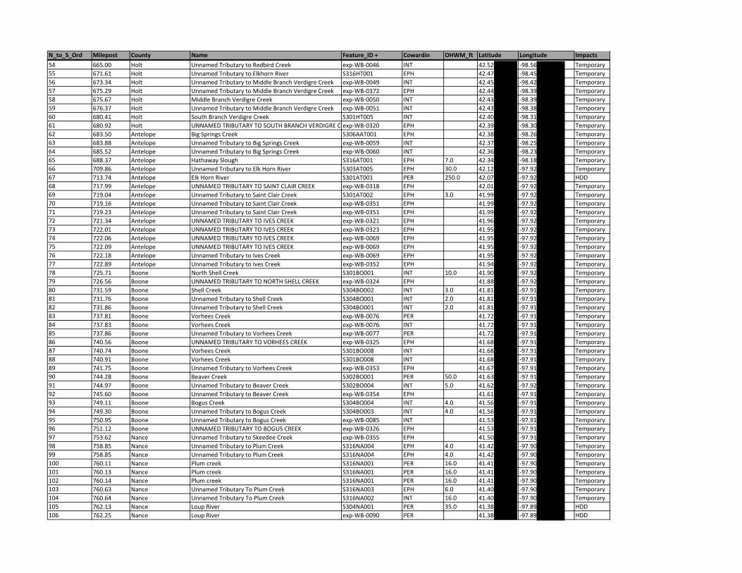
N_to_S_Ord Milepost County Name Feature_ID + Cowardin OHWM_ft Latitude Longitude Impacts54 665.00 Holt Unnamed Tributary to Redbird Creek exp‐WB‐0046 INT 42.52 ‐98.56 Temporary55 671.61 Holt Unnamed Tributary to Elkhorn River S316HT001 EPH 42.47 ‐98.45 Temporary56 673.34 Holt Unnamed Tributary to Middle Branch Verdigre Creek exp‐WB‐0049 INT 42.45 ‐98.42 Temporary57 675.29 Holt Unnamed Tributary to Middle Branch Verdigre Creek exp‐WB‐0372 EPH 42.44 ‐98.39 Temporary58 675.67 Holt Middle Branch Verdigre Creek exp‐WB‐0050 INT 42.43 ‐98.39 Temporary59 676.37 Holt Unnamed Tributary to Middle Branch Verdigre Creek exp‐WB‐0051 INT 42.43 ‐98.38 Temporary60 680.41 Holt South Branch Verdigre Creek S301HT005 INT 42.40 ‐98.31 Temporary61 680.92 Holt UNNAMED TRIBUTARY TO SOUTH BRANCH VERDIGRE C exp‐WB‐0320 EPH 42.39 ‐98.30 Temporary62 683.50 Antelope Big Springs Creek S306AAT001 EPH 42.38 ‐98.26 Temporary63 683.88 Antelope Unnamed Tributary to Big Springs Creek exp‐WB‐0059 INT 42.37 ‐98.25 Temporary64 685.52 Antelope Unnamed Tributary to Big Springs Creek exp‐WB‐0060 INT 42.36 ‐98.23 Temporary65 688.37 Antelope Hathaway Slough S316AT001 EPH 7.0 42.34 ‐98.18 Temporary66 709.86 Antelope Unnamed Tributary to Elk Horn River S303AT005 EPH 30.0 42.12 ‐97.92 Temporary67 713.74 Antelope Elk Horn River S301AT001 PER 250.0 42.07 ‐97.92 HDD68 717.99 Antelope UNNAMED TRIBUTARY TO SAINT CLAIR CREEK exp‐WB‐0318 EPH 42.01 ‐97.92 Temporary69 719.04 Antelope Unnamed Tributary to Saint Clair Creek S301AT002 EPH 3.0 41.99 ‐97.92 Temporary70 719.16 Antelope Unnamed Tributary to Saint Clair Creek exp‐WB‐0351 EPH 41.99 ‐97.92 Temporary71 719.23 Antelope Unnamed Tributary to Saint Clair Creek exp‐WB‐0351 EPH 41.99 ‐97.92 Temporary72 721.34 Antelope UNNAMED TRIBUTARY TO IVES CREEK exp‐WB‐0321 EPH 41.96 ‐97.92 Temporary73 722.01 Antelope UNNAMED TRIBUTARY TO IVES CREEK exp‐WB‐0323 EPH 41.95 ‐97.92 Temporary74 722.06 Antelope UNNAMED TRIBUTARY TO IVES CREEK exp‐WB‐0069 EPH 41.95 ‐97.92 Temporary75 722.09 Antelope UNNAMED TRIBUTARY TO IVES CREEK exp‐WB‐0069 EPH 41.95 ‐97.92 Temporary76 722.18 Antelope Unnamed Tributary to Ives Creek exp‐WB‐0069 EPH 41.95 ‐97.92 Temporary77 722.89 Antelope Unnamed Tributary to Ives Creek exp‐WB‐0352 EPH 41.94 ‐97.92 Temporary78 725.71 Boone North Shell Creek S301BO001 INT 10.0 41.90 ‐97.92 Temporary79 726.56 Boone UNNAMED TRIBUTARY TO NORTH SHELL CREEK exp‐WB‐0324 EPH 41.88 ‐97.92 Temporary80 731.59 Boone Shell Creek S304BO002 INT 3.0 41.81 ‐97.91 Temporary81 731.76 Boone Unnamed Tributary to Shell Creek S304BO001 INT 2.0 41.81 ‐97.91 Temporary82 731.86 Boone Unnamed Tributary to Shell Creek S304BO001 INT 2.0 41.81 ‐97.91 Temporary83 737.81 Boone Vorhees Creek exp‐WB‐0076 PER 41.72 ‐97.91 Temporary84 737.83 Boone Vorhees Creek exp‐WB‐0076 INT 41.72 ‐97.91 Temporary85 737.86 Boone Unnamed Tributary to Vorhees Creek exp‐WB‐0077 PER 41.72 ‐97.91 Temporary86 740.56 Boone UNNAMED TRIBUTARY TO VORHEES CREEK exp‐WB‐0325 EPH 41.68 ‐97.91 Temporary87 740.74 Boone Vorhees Creek S301BO008 INT 41.68 ‐97.91 Temporary88 740.91 Boone Vorhees Creek S301BO008 INT 41.68 ‐97.91 Temporary89 741.75 Boone Unnamed Tributary to Vorhees Creek exp‐WB‐0353 EPH 41.67 ‐97.91 Temporary90 744.28 Boone Beaver Creek S302BO001 PER 50.0 41.63 ‐97.91 Temporary91 744.97 Boone Unnamed Tributary to Beaver Creek S302BO004 INT 5.0 41.62 ‐97.92 Temporary92 745.60 Boone Unnamed Tributary to Beaver Creek exp‐WB‐0354 EPH 41.61 ‐97.91 Temporary93 749.11 Boone Bogus Creek S304BO004 INT 4.0 41.56 ‐97.91 Temporary94 749.30 Boone Unnamed Tributary to Bogus Creek S304BO003 INT 4.0 41.56 ‐97.91 Temporary95 750.95 Boone Unnamed Tributary to Bogus Creek exp‐WB‐0085 INT 41.53 ‐97.91 Temporary96 751.12 Boone UNNAMED TRIBUTARY TO BOGUS CREEK exp‐WB‐0326 EPH 41.53 ‐97.91 Temporary97 753.62 Nance Unnamed Tributary to Skeedee Creek exp‐WB‐0355 EPH 41.50 ‐97.91 Temporary98 758.85 Nance Unnamed Tributary to Plum Creek S316NA004 EPH 4.0 41.42 ‐97.90 Temporary99 758.85 Nance Unnamed Tributary to Plum Creek S316NA004 EPH 4.0 41.42 ‐97.90 Temporary100 760.11 Nance Plum creek S316NA001 PER 16.0 41.41 ‐97.90 Temporary101 760.13 Nance Plum creek S316NA001 PER 16.0 41.41 ‐97.90 Temporary102 760.14 Nance Plum creek S316NA001 PER 16.0 41.41 ‐97.90 Temporary103 760.63 Nance Unnamed Tributary To Plum Creek S316NA003 EPH 6.0 41.40 ‐97.90 Temporary104 760.64 Nance Unnamed Tributary To Plum Creek S316NA002 INT 16.0 41.40 ‐97.90 Temporary105 762.13 Nance Loup River S304NA001 PER 35.0 41.38 ‐97.89 HDD106 762.25 Nance Loup River exp‐WB‐0090 PER 41.38 ‐97.89 HDD
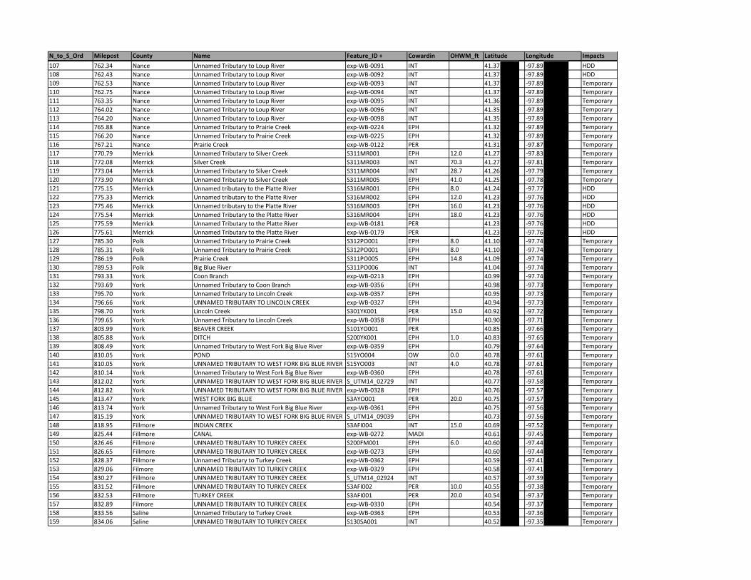
N_to_S_Ord Milepost County Name Feature_ID + Cowardin OHWM_ft Latitude Longitude Impacts107 762.34 Nance Unnamed Tributary to Loup River exp‐WB‐0091 INT 41.37 ‐97.89 HDD108 762.43 Nance Unnamed Tributary to Loup River exp‐WB‐0092 INT 41.37 ‐97.89 HDD109 762.53 Nance Unnamed Tributary to Loup River exp‐WB‐0093 INT 41.37 ‐97.89 Temporary110 762.75 Nance Unnamed Tributary to Loup River exp‐WB‐0094 INT 41.37 ‐97.89 Temporary111 763.35 Nance Unnamed Tributary to Loup River exp‐WB‐0095 INT 41.36 ‐97.89 Temporary112 764.02 Nance Unnamed Tributary to Loup River exp‐WB‐0096 INT 41.35 ‐97.89 Temporary113 764.20 Nance Unnamed Tributary to Loup River exp‐WB‐0098 INT 41.35 ‐97.89 Temporary114 765.88 Nance Unnamed Tributary to Prairie Creek exp‐WB‐0224 EPH 41.32 ‐97.89 Temporary115 766.20 Nance Unnamed Tributary to Prairie Creek exp‐WB‐0225 EPH 41.32 ‐97.89 Temporary116 767.21 Nance Prairie Creek exp‐WB‐0122 PER 41.31 ‐97.87 Temporary117 770.79 Merrick Unnamed Tributary to Silver Creek S311MR001 EPH 12.0 41.27 ‐97.83 Temporary118 772.08 Merrick Silver Creek S311MR003 INT 70.3 41.27 ‐97.81 Temporary119 773.04 Merrick Unnamed Tributary to Silver Creek S311MR004 INT 28.7 41.26 ‐97.79 Temporary120 773.90 Merrick Unnamed Tributary to Silver Creek S311MR005 EPH 41.0 41.25 ‐97.78 Temporary121 775.15 Merrick Unnamed tributary to the Platte River S316MR001 EPH 8.0 41.24 ‐97.77 HDD122 775.33 Merrick Unnamed tributary to the Platte River S316MR002 EPH 12.0 41.23 ‐97.76 HDD123 775.46 Merrick Unnamed tributary to the Platte River S316MR003 EPH 16.0 41.23 ‐97.76 HDD124 775.54 Merrick Unnamed Tributary to the Platte River S316MR004 EPH 18.0 41.23 ‐97.76 HDD125 775.59 Merrick Unnamed Tributary to the Platte River exp‐WB‐0181 PER 41.23 ‐97.76 HDD126 775.61 Merrick Unnamed Tributary to the Platte River exp‐WB‐0179 PER 41.23 ‐97.76 HDD127 785.30 Polk Unnamed Tributary to Prairie Creek S312PO001 EPH 8.0 41.10 ‐97.74 Temporary128 785.31 Polk Unnamed Tributary to Prairie Creek S312PO001 EPH 8.0 41.10 ‐97.74 Temporary129 786.19 Polk Prairie Creek S311PO005 EPH 14.8 41.09 ‐97.74 Temporary130 789.53 Polk Big Blue River S311PO006 INT 41.04 ‐97.74 Temporary131 793.33 York Coon Branch exp‐WB‐0213 EPH 40.99 ‐97.74 Temporary132 793.69 York Unnamed Tributary to Coon Branch exp‐WB‐0356 EPH 40.98 ‐97.73 Temporary133 795.70 York Unnamed Tributary to Lincoln Creek exp‐WB‐0357 EPH 40.95 ‐97.73 Temporary134 796.66 York UNNAMED TRIBUTARY TO LINCOLN CREEK exp‐WB‐0327 EPH 40.94 ‐97.73 Temporary135 798.70 York Lincoln Creek S301YK001 PER 15.0 40.92 ‐97.72 Temporary136 799.65 York Unnamed Tributary to Lincoln Creek exp‐WB‐0358 EPH 40.90 ‐97.71 Temporary137 803.99 York BEAVER CREEK S101YO001 PER 40.85 ‐97.66 Temporary138 805.88 York DITCH S200YK001 EPH 1.0 40.83 ‐97.65 Temporary139 808.49 York Unnamed Tributary to West Fork Big Blue River exp‐WB‐0359 EPH 40.79 ‐97.64 Temporary140 810.05 York POND S15YO004 OW 0.0 40.78 ‐97.61 Temporary141 810.05 York UNNAMED TRIBUTARY TO WEST FORK BIG BLUE RIVER S15YO003 INT 4.0 40.78 ‐97.61 Temporary142 810.14 York Unnamed Tributary to West Fork Big Blue River exp‐WB‐0360 EPH 40.78 ‐97.61 Temporary143 812.02 York UNNAMED TRIBUTARY TO WEST FORK BIG BLUE RIVER S_UTM14_02729 INT 40.77 ‐97.58 Temporary144 812.82 York UNNAMED TRIBUTARY TO WEST FORK BIG BLUE RIVER exp‐WB‐0328 EPH 40.76 ‐97.57 Temporary145 813.47 York WEST FORK BIG BLUE S3AYO001 PER 20.0 40.75 ‐97.57 Temporary146 813.74 York Unnamed Tributary to West Fork Big Blue River exp‐WB‐0361 EPH 40.75 ‐97.56 Temporary147 815.19 York UNNAMED TRIBUTARY TO WEST FORK BIG BLUE RIVER S_UTM14_09039 EPH 40.73 ‐97.56 Temporary148 818.95 Fillmore INDIAN CREEK S3AFI004 INT 15.0 40.69 ‐97.52 Temporary149 825.44 Fillmore CANAL exp‐WB‐0272 MADI 40.61 ‐97.45 Temporary150 826.46 Fillmore UNNAMED TRIBUTARY TO TURKEY CREEK S200FM001 EPH 6.0 40.60 ‐97.44 Temporary151 826.65 Fillmore UNNAMED TRIBUTARY TO TURKEY CREEK exp‐WB‐0273 EPH 40.60 ‐97.44 Temporary152 828.37 Fillmore Unnamed Tributary to Turkey Creek exp‐WB‐0362 EPH 40.59 ‐97.41 Temporary153 829.06 Filmore UNNAMED TRIBUTARY TO TURKEY CREEK exp‐WB‐0329 EPH 40.58 ‐97.41 Temporary154 830.27 Fillmore UNNAMED TRIBUTARY TO TURKEY CREEK S_UTM14_02924 INT 40.57 ‐97.39 Temporary155 831.52 Fillmore UNNAMED TRIBUTARY TO TURKEY CREEK S3AFI002 PER 10.0 40.55 ‐97.38 Temporary156 832.53 Fillmore TURKEY CREEK S3AFI001 PER 20.0 40.54 ‐97.37 Temporary157 832.89 Filmore UNNAMED TRIBUTARY TO TURKEY CREEK exp‐WB‐0330 EPH 40.54 ‐97.37 Temporary158 833.56 Saline Unnamed Tributary to Turkey Creek exp‐WB‐0363 EPH 40.53 ‐97.36 Temporary159 834.06 Saline UNNAMED TRIBUTARY TO TURKEY CREEK S130SA001 INT 40.52 ‐97.35 Temporary
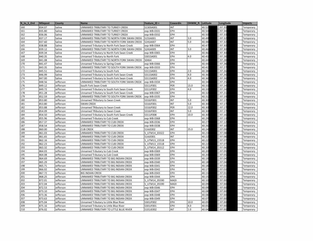
N_to_S_Ord Milepost County Name Feature_ID + Cowardin OHWM_ft Latitude Longitude Impacts160 834.07 Saline UNNAMED TRIBUTARY TO TURKEY CREEK S130SA001 INT 40.52 ‐97.35 Temporary161 835.80 Saline UNNAMED TRIBUTARY TO TURKEY CREEK exp‐WB‐0331 EPH 40.50 ‐97.34 Temporary162 836.06 Saline UNNAMED TRIBUTARY TO TURKEY CREEK exp‐WB‐0332 EPH 40.50 ‐97.33 Temporary163 837.17 Saline UNNAMED TRIBUTARY TO NORTH FORK SWAN CREEK S15SA001 INT 3.0 40.49 ‐97.32 Temporary164 837.60 Saline UNNAMED TRIBUTARY TO NORTH FORK SWAN CREEK S2ASA007 INT 5.0 40.48 ‐97.32 Temporary165 838.88 Saline Unnamed Tributary to North Fork Swan Creek exp‐WB‐0364 EPH 40.47 ‐97.30 Temporary166 839.12 Saline UNNAMED TRIBUTARY TO NORTH FORK SWAN CREEK S2ASA005 INT 3.0 40.46 ‐97.30 Temporary167 839.34 Saline Unnamed Tributary to North Fork Swan Creek exp‐WB‐0365 EPH 40.46 ‐97.30 Temporary168 840.35 Saline Unnamed Tributary to North Fork S301SA001 EPH 4.0 40.45 ‐97.28 Temporary169 841.08 Saline UNNAMED TRIBUTARY TO NORTH FORK SWAN CREEK S0464 EPH 40.44 ‐97.28 Temporary170 841.47 Saline Unnamed Tributary to Spring Creek exp‐WB‐0366 EPH 40.44 ‐97.28 Temporary171 843.35 Saline UNNAMED TRIBUTARY TO SOUTH FORK SWAN CREEK exp‐WB‐0333 EPH 40.41 ‐97.27 Temporary172 845.51 Saline Unnamed Tributary to South Fork S311SA001 EPH 2.0 40.38 ‐97.26 Temporary173 846.99 Saline Unnamed Tributary to South Fork Swan Creek S311SA002 EPH 4.0 40.36 ‐97.26 Temporary174 847.00 Saline Unnamed Tributary to South Fork Swan Creek S311SA002 EPH 4.0 40.36 ‐97.26 Temporary175 848.56 Jefferson UNNAMED TRIBUTARY TO SOUTH FORK SWAN CREEK exp‐WB‐0334 EPH 40.34 ‐97.25 Temporary176 849.12 Jefferson South Fork Swan Creek S311JF001 PER 15.0 40.33 ‐97.24 Temporary177 849.72 Jefferson Unnamed Tributary to South Fork Swan Creek S311JF002 EPH 4.0 40.33 ‐97.24 Temporary178 851.28 Jefferson Unnamed Tributary to South Fork Swan Creek exp‐WB‐0367 EPH 40.32 ‐97.21 Temporary179 852.59 Jefferson UNNAMED TRIBUTARY TO SOUTH FORK SWAN CREEK exp‐WB‐0335 EPH 40.31 ‐97.19 Temporary180 853.80 Jefferson Unnamed TRibutary to Swan Creek S316JF001 INT 5.0 40.30 ‐97.17 Temporary181 853.80 Jefferson SWAN CREEK S316JF001 INT 5.0 40.30 ‐97.17 Temporary182 853.88 Jefferson Unnamed TRibutary to Swan Creek S316JF002 PER 12.0 40.30 ‐97.17 Temporary183 854.09 Jefferson Unnamed TRibutary to Swan Creek S316JF003 INT 5.0 40.30 ‐97.17 Temporary184 854.50 Jefferson Unnamed Tributary to South Fork Swan Creek S311JF008 EPH 10.0 40.30 ‐97.16 Temporary185 855.96 Jefferson Unnamed Tributary to Cub Creek exp‐WB‐0368 EPH 40.29 ‐97.13 Temporary186 857.37 Jefferson UNNAMED TRIBUTARY TO CUB CREEK exp‐WB‐0336 EPH 40.27 ‐97.12 Temporary187 858.54 Jefferson UNNAMED TRIBUTARY TO CUB CREEK exp‐WB‐0338 EPH 40.26 ‐97.10 Temporary188 860.00 Jefferson CUB CREEK S1AJE002 INT 25.0 40.24 ‐97.09 Temporary189 861.03 Jefferson UNNAMED TRIBUTARY TO CUB CREEK S_UTM14_03322 EPH 40.23 ‐97.08 Temporary190 861.65 Jefferson UNNAMED TRIBUTARY TO CUB CREEK S1AJE001 INT 40.22 ‐97.08 Temporary191 862.16 Jefferson UNNAMED TRIBUTARY TO CUB CREEK S_UTM13_15518 EPH 40.22 ‐97.07 Temporary192 862.23 Jefferson UNNAMED TRIBUTARY TO CUB CREEK S_UTM13_15518 EPH 40.22 ‐97.07 Temporary193 863.32 Jefferson UNNAMED TRIBUTARY TO CUB CREEK S_UTM14_05512 EPH 40.20 ‐97.06 Temporary194 864.03 Jefferson Unnamed Tributary to Cub Creek exp‐WB‐0369 EPH 40.20 ‐97.05 Temporary195 864.08 Jefferson Unnamed Tributary to Cub Creek exp‐WB‐0369 EPH 40.20 ‐97.05 Temporary196 864.69 Jefferson UNNAMED TRIBUTARY TO BIG INDIAN CREEK exp‐WB‐0339 EPH 40.19 ‐97.04 Temporary197 865.29 Jefferson UNNAMED TRIBUTARY TO BIG INDIAN CREEK exp‐WB‐0340 EPH 40.18 ‐97.04 Temporary198 865.71 Jefferson UNNAMED TRIBUTARY TO BIG INDIAN CREEK exp‐WB‐0341 EPH 40.18 ‐97.03 Temporary199 866.02 Jefferson UNNAMED TRIBUTARY TO BIG INDIAN CREEK exp‐WB‐0342 EPH 40.17 ‐97.03 Temporary200 867.72 Jefferson BIG INDIAN CREEK exp‐WB‐0343 EPH 40.15 ‐97.01 Temporary201 868.25 Jefferson UNNAMED TRIBUTARY TO BIG INDIAN CREEK exp‐WB‐0344 EPH 40.15 ‐97.01 Temporary202 872.01 Jefferson UNNAMED TRIBUTARY TO BIG INDIAN CREEK S_UTM14_05590 MADI 40.10 ‐97.00 Temporary203 872.04 Jefferson UNNAMED TRIBUTARY TO BIG INDIAN CREEK S_UTM14_05590 MADI 40.09 ‐97.00 Temporary204 872.53 Jefferson UNNAMED TRIBUTARY TO BIG INDIAN CREEK exp‐WB‐0346 EPH 40.09 ‐97.00 Temporary205 873.10 Jefferson UNNAMED TRIBUTARY TO BIG INDIAN CREEK exp‐WB‐0347 EPH 40.08 ‐97.00 Temporary206 873.36 Jefferson UNNAMED TRIBUTARY TO BIG INDIAN CREEK exp‐WB‐0348 EPH 40.08 ‐97.00 Temporary207 873.63 Jefferson UNNAMED TRIBUTARY TO BIG INDIAN CREEK exp‐WB‐0349 EPH 40.07 ‐97.00 Temporary208 875.04 Jefferson Unnamed Tributary to Little Blue River S301JF002 EPH 10.0 40.05 ‐97.00 Temporary209 875.16 Jefferson Unnamed Tributary to Little Blue River S301JF001 EPH 4.0 40.05 ‐97.00 Temporary210 876.02 Jefferson UNNAMED TRIBUTARY TO LITTLE BLUE RIVER S101JE002 INT 1.0 40.04 ‐97.00 Temporary
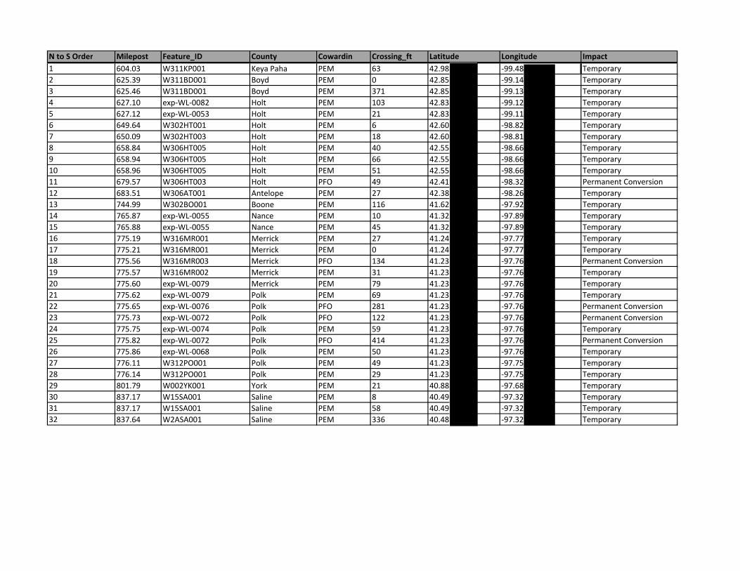
N to S Order Milepost Feature_ID County Cowardin Crossing_ft Latitude Longitude Impact1 604.03 W311KP001 Keya Paha PEM 63 42.98 ‐99.48 Temporary2 625.39 W311BD001 Boyd PEM 0 42.85 ‐99.14 Temporary3 625.46 W311BD001 Boyd PEM 371 42.85 ‐99.13 Temporary4 627.10 exp‐WL‐0082 Holt PEM 103 42.83 ‐99.12 Temporary5 627.12 exp‐WL‐0053 Holt PEM 21 42.83 ‐99.11 Temporary6 649.64 W302HT001 Holt PEM 6 42.60 ‐98.82 Temporary7 650.09 W302HT003 Holt PEM 18 42.60 ‐98.81 Temporary8 658.84 W306HT005 Holt PEM 40 42.55 ‐98.66 Temporary9 658.94 W306HT005 Holt PEM 66 42.55 ‐98.66 Temporary10 658.96 W306HT005 Holt PEM 51 42.55 ‐98.66 Temporary11 679.57 W306HT003 Holt PFO 49 42.41 ‐98.32 Permanent Conversion12 683.51 W306AT001 Antelope PEM 27 42.38 ‐98.26 Temporary13 744.99 W302BO001 Boone PEM 116 41.62 ‐97.92 Temporary14 765.87 exp‐WL‐0055 Nance PEM 10 41.32 ‐97.89 Temporary15 765.88 exp‐WL‐0055 Nance PEM 45 41.32 ‐97.89 Temporary16 775.19 W316MR001 Merrick PEM 27 41.24 ‐97.77 Temporary17 775.21 W316MR001 Merrick PEM 0 41.24 ‐97.77 Temporary18 775.56 W316MR003 Merrick PFO 134 41.23 ‐97.76 Permanent Conversion19 775.57 W316MR002 Merrick PEM 31 41.23 ‐97.76 Temporary20 775.60 exp‐WL‐0079 Merrick PEM 79 41.23 ‐97.76 Temporary21 775.62 exp‐WL‐0079 Polk PEM 69 41.23 ‐97.76 Temporary22 775.65 exp‐WL‐0076 Polk PFO 281 41.23 ‐97.76 Permanent Conversion23 775.73 exp‐WL‐0072 Polk PFO 122 41.23 ‐97.76 Permanent Conversion24 775.75 exp‐WL‐0074 Polk PEM 59 41.23 ‐97.76 Temporary25 775.82 exp‐WL‐0072 Polk PFO 414 41.23 ‐97.76 Permanent Conversion26 775.86 exp‐WL‐0068 Polk PEM 50 41.23 ‐97.76 Temporary27 776.11 W312PO001 Polk PEM 49 41.23 ‐97.75 Temporary28 776.14 W312PO001 Polk PEM 29 41.23 ‐97.75 Temporary29 801.79 W002YK001 York PEM 21 40.88 ‐97.68 Temporary30 837.17 W15SA001 Saline PEM 8 40.49 ‐97.32 Temporary31 837.17 W15SA001 Saline PEM 58 40.49 ‐97.32 Temporary32 837.64 W2ASA001 Saline PEM 336 40.48 ‐97.32 Temporary
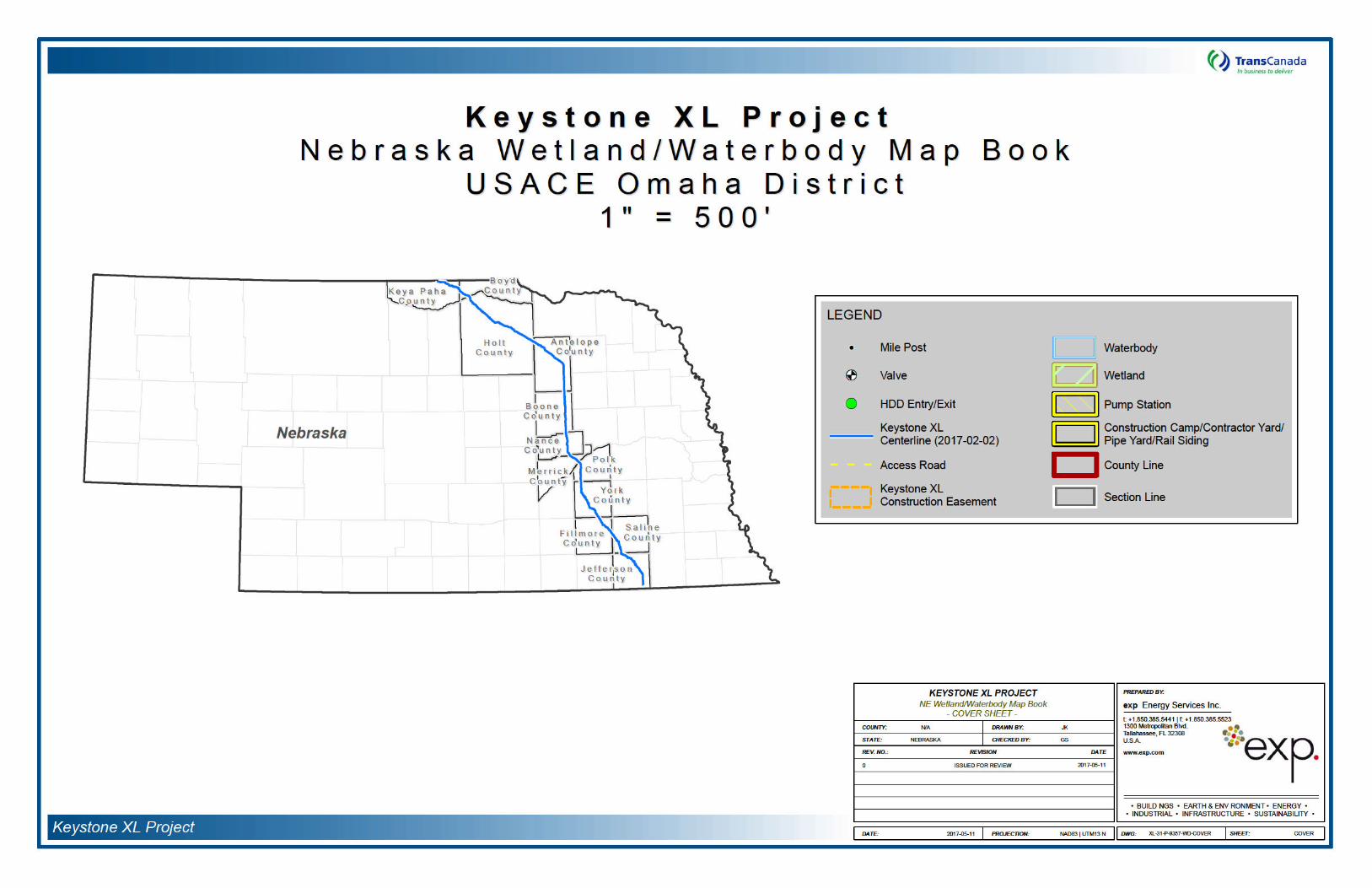


Attachment C:
Construction Mitigation and Reclamation Plan

KEYSTONE XL PROJECT
CONSTRUCTION, MITIGATION,
AND RECLAMATION PLAN
April 2012 Rev. 4

Keystone XL Project
-This page intentionally left blank-
March 2013
CONSTRUCTION MITIGATION AND RECLAMATION PLAN
1.0 INTRODUCTION
2.0 GENERAL CONDITIONS 2.1 Training 2.2 Environmental Inspection 2.3 Advance Notice of Access to Property Prior to Construction 2.4 Other Notifications 2.5 Damages to Private Property 2.6 Appearance of Worksite 2.7 Access 2.8 Aboveground Facilities 2.9 Minimum Depth of Cover 2.10 Non-Hazardous Waste Disposal 2.11 Hazardous Wastes 2.12 Noise Control 2.13 Weed Control 2.14 Dust Control 2.15 Off Road Vehicle Control 2.16 Fire Prevention and Control 2.17 Road and Railroad Crossings 2.18 Adverse Weather 2.19 Cultural Resources
3.0 SPILL PREVENTION AND CONTAINMENT 3.1 Spill Prevention
3.1.1 Staging Area 3.1.2 Construction Right of Way
3.2 Contingency Plans 3.3 Equipment 3.4 Emergency Notification 3.5 Spill Containment and Countermeasures
4.0 UPLANDS (AGRICULTURAL, FOREST, PASTURE, RANGE AND GRASS LANDS) 4.1 Interference with Irrigation Systems 4.2 Clearing 4.3 Topsoil Removal and Storage 4.4 Grading 4.5 Temporary Erosion and Sediment Control
4.5.1 General 4.5.2 Sediment Barriers 4.5.3 Trench Plugs 4.5.4 Temporary Slope Breakers (Water Bars) 4.5.5 Drainage Channels or Ditches 4.5.6 Temporary Mulching 4.5.7 Tackifier
4.6 Stringing
TRANSCANADA KEYSTONE PIPELINE, LP -i- April 2012
Rev. 4
CONSTRUCTION MITIGATION AND RECLAMATION PLAN
4.7 Trenching 4.7.1 Trench Dewater/Well Points
4.8 Welding, Field Joint Coating, and Lowering In 4.9 Padding and Backfilling 4.10 Clean Up 4.11 Reclamation and Revegetation
4.11.1 Relieving Compaction 4.11.2 Rock Removal 4.11.3 Soil Additives 4.11.4 Seeding 4.11.5 Permanent Erosion and Sediment Control 4.11.6 Fences 4.11.7 Farm Terraces 4.11.8 Right-of-Way and Pipeline Markers
4.12 Pasture and Range Lands 4.13 Forested Lands 4.14 Residential and Commercial/Industrial Areas
4.14.1 Residential and Commercial Areas 4.14.2 Site – Specific Plans 4.14.3 Landowner Complaint Resolution Procedure
4.15 Fragile Soil Clean Up and Reclamation/Revegetation 4.15.1 General 4.15.2 Right-of-Way Construction 4.15.3 Right-of-Way Reclamation 4.15.4 Post - Construction
4.16 Operations and Maintenance
5.0 DRAIN TILE SYSTEMS 5.1 General 5.2 Identification and Classification of Drain Tile Systems
5.2.1 Publicly Owned Drain Tiles 5.2.2 Privately Owned Drain Tiles
5.3 Mitigation of Damage to Drain Tile Systems 5.3.1 Non-interference with Drain Tile 5.3.2 Non-disturbance of Drain Tile Mains 5.3.3 Relocation or Replacement of Existing Drain Tiles Prior to Construction 5.3.4 Future Drain Tiles/Systems 5.3.5 Other Mitigation Measures
5.4 Responsibility for Repair of Drain Tile Systems 5.4.1 Local Drain Tile Contractor Repair 5.4.2 Pipeline Contractor Repair 5.4.3 Landowner/Tenant Repair
5.5 Drain Tile Repairs 5.5.1 Temporary Repairs During Construction 5.5.2 Permanent Repairs
5.6 Inspection/Acceptance of Drain Tile Repairs
TRANSCANADA KEYSTONE PIPELINE, LP -ii- April 2012
Rev. 4
CONSTRUCTION MITIGATION AND RECLAMATION PLAN
6.0 WETLAND CROSSINGS 6.1 General 6.2 Easement and Workspace 6.3 Vehicle Access and Equipment Crossing 6.4 Temporary Erosion and Sediment Control 6.5 Wetland Crossing Procedures
6.5.1 Dry Wetland Crossing Method 6.5.2 Standard Wetland Crossing Method 6.5.3 Flooded Push/Pull Wetland Crossing Method
6.6 Restoration and Reclamation
7.0 WATERBODIES AND RIPARIAN LANDS 7.1 General 7.2 Easement and Workspace 7.3 Vehicle Access and Equipment Crossings 7.4 Waterbody Crossing Methods
7.4.1 Non-flowing Open Cut Crossing Method 7.4.2 Flowing Open Cut Crossing Method of Minor, Intermediate, and Major
Waterbodies 7.4.3 Flowing Stream Crossing – Dry Flume Method 7.4.4 Flowing Stream Crossing – Dry Dam and Pump Method 7.4.5 Horizontal Directional Drill Crossings 7.4.6 Horizontal Bore Crossings
7.5 Clearing 7.6 Grading 7.7 Temporary Erosion and Sediment Control 7.8 Trenching 7.9 Pipe Installation 7.10 Backfilling 7.11 Stabilization and Restoration of Stream Banks and Slopes
8.0 HYDROSTATIC TESTING 8.1 Testing Equipment Location 8.2 Test Water Source and Discharge Locations 8.3 Filling the Pipeline 8.4 Dewatering the Pipeline
8.4.1 Splash Pup 8.4.2 Splash Plate 8.4.3 Plastic Liner 8.4.4 Straw Bale Dewatering Structure
TRANSCANADA KEYSTONE PIPELINE, LP -iii- April 2012
Rev. 4
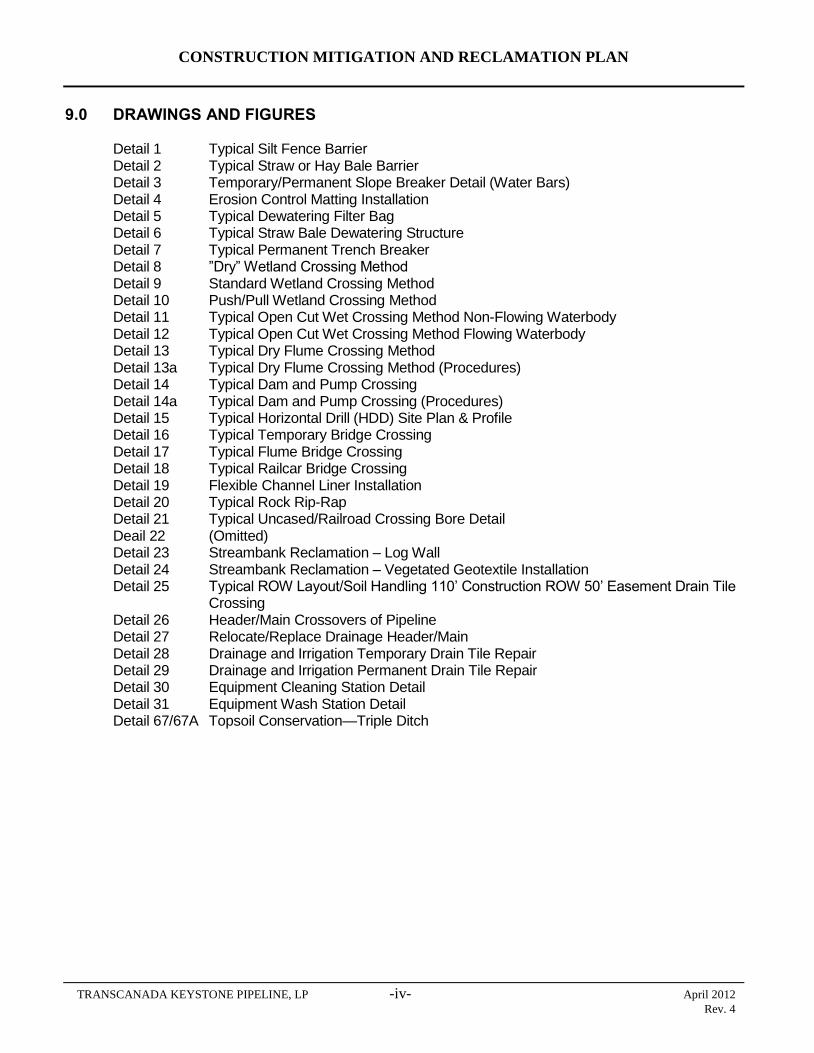
CONSTRUCTION MITIGATION AND RECLAMATION PLAN
9.0 DRAWINGS AND FIGURES
Detail 1 Typical Silt Fence Barrier Detail 2 Typical Straw or Hay Bale Barrier Detail 3 Temporary/Permanent Slope Breaker Detail (Water Bars) Detail 4 Erosion Control Matting Installation Detail 5 Typical Dewatering Filter Bag Detail 6 Typical Straw Bale Dewatering Structure Detail 7 Typical Permanent Trench Breaker Detail 8 ”Dry” Wetland Crossing Method Detail 9 Standard Wetland Crossing Method Detail 10 Push/Pull Wetland Crossing Method Detail 11 Typical Open Cut Wet Crossing Method Non-Flowing Waterbody Detail 12 Typical Open Cut Wet Crossing Method Flowing Waterbody Detail 13 Typical Dry Flume Crossing Method Detail 13a Typical Dry Flume Crossing Method (Procedures) Detail 14 Typical Dam and Pump Crossing Detail 14a Typical Dam and Pump Crossing (Procedures) Detail 15 Typical Horizontal Drill (HDD) Site Plan & Profile Detail 16 Typical Temporary Bridge Crossing Detail 17 Typical Flume Bridge Crossing Detail 18 Typical Railcar Bridge Crossing Detail 19 Flexible Channel Liner Installation Detail 20 Typical Rock Rip-Rap Detail 21 Typical Uncased/Railroad Crossing Bore Detail Deail 22 (Omitted) Detail 23 Streambank Reclamation – Log Wall Detail 24 Streambank Reclamation – Vegetated Geotextile Installation Detail 25 Typical ROW Layout/Soil Handling 110’ Construction ROW 50’ Easement Drain Tile
Crossing Detail 26 Header/Main Crossovers of Pipeline Detail 27 Relocate/Replace Drainage Header/Main Detail 28 Drainage and Irrigation Temporary Drain Tile Repair Detail 29 Drainage and Irrigation Permanent Drain Tile Repair Detail 30 Equipment Cleaning Station Detail Detail 31 Equipment Wash Station Detail Detail 67/67A Topsoil Conservation—Triple Ditch
TRANSCANADA KEYSTONE PIPELINE, LP -iv- April 2012
Rev. 4
CONSTRUCTION MITIGATION AND RECLAMATION PLAN
1.0 INTRODUCTION
The construction, mitigation, and reclamation requirements described in this Plan apply to work on all of TransCanada Keystone Pipeline, L.P.’s (Keystone’s) Keystone XL Project (Project) lands, including the following;
uplands, including agricultural (cultivated or capable of being cultivated) lands, pasture lands; range lands; grass lands; forested lands; lands in residential, commercial, or industrial areas; lands in public rights of way; and lands in private rights-of-way;
wetlands; and
waterbodies and riparian areas.
Keystone, during the construction, operation, and maintenance of the Project, shall implement the construction, mitigation, and reclamation actions contained in this Plan to the extent that they do not conflict with the requirements of any applicable federal, state, or local rules and regulations, or other permits or approvals that are applicable to the Project. Additionally, Keystone may deviate from specific requirements of this Plan on specific private lands as agreed to by landowners or as required to suit actual site conditions as determined and directed by Keystone. All work must be in compliance with federal, state, and local permits.
The Project will be designed, constructed, operated and maintained in a manner that meets or exceeds applicable industry standards and regulatory requirements. Keystone’s Integrity Management Plan and Emergency Response Plan outlines the preventative maintenance, inspection, line patrol, leak detection systems, SCADA, and other pipeline integrity management procedures to be implemented during operation of the Project.
2.0 GENERAL CONDITIONS
2.1 Training
Experienced, well-trained personnel are essential for the successful implementation of this Plan. Keystone and its Contractors shall undergo prevention and response, as well as safety training. The program shall be designed to improve awareness of safety requirements, pollution control laws and procedures, and proper operation and maintenance of equipment.
The construction contractor (Contractor), and all of his subcontractors shall ensure that persons engaged in Project construction are informed of the construction issues and concerns and that they attend and receive training regarding these requirements as well as all laws, rules and regulations applicable to the work. Prior to construction, all Project personnel will be trained on environmental permit requirements and environmental specifications, including fuel handling and storage, cultural resource protection methods, stream and wetland crossing requirements, and sensitive species protection measures.
TRANSCANADA KEYSTONE PIPELINE, LP 1 April 2012
Rev. 4
CONSTRUCTION MITIGATION AND RECLAMATION PLAN
Different levels of training shall be required for different groups of Contractor personnel. Contractor supervisors, managers, field foremen, and other Contractor personnel designated by Keystone shall attend a comprehensive environmental training session. All other Contractor personnel shall attend a training session before the beginning of construction and during construction as environmental issues and incidents warrant. Additional training sessions shall be held for newly assigned personnel prior to commencing work on the Project.
All Contractor personnel shall attend the training session prior to entering the construction right-of-way. All Contractor personnel shall sign an acknowledgement of having attended the appropriate level of training and shall display a hard hat sticker that signifies attendance at environmental training. In order to ensure successful compliance, Contractor personnel shall attend repeat or supplemental training if compliance is not satisfactory or as new, significant new issues arise.
All visitors and any other personnel without specific work assignments shall be required to attend a safety and environmental awareness orientation.
2.2 Environmental Inspection
Keystone will use Environmental Inspectors on each construction spread. The Environmental Inspectors will review the Project activities daily for compliance with state, federal and local regulatory requirements. The Environmental Inspectors will have the authority to stop specific tasks as approved by the Chief Inspector. They can also order corrective action in the event that construction activities violate the provisions of this Plan, landowner requirements, or any applicable permit requirements.
2.3 Advance Notice of Access to Property Prior to Construction
Prior to initially accessing landowners’ property, Keystone shall provide the landowner or tenant with a minimum of 24 hours prior notice unless otherwise negotiated with the landowner and as described in the Project line list). Additionally, the landowner or tenant shall be provided with Keystone contact information. Landowners may utilize contact information to inform Keystone of any concerns related to construction.
Prior notice shall consist of a personal contact, a telephone contact, or delivery of written notice to the landowner to inform the landowner of whereby the landowner or tenant is informed of Keystone's intent to initially access the land. The landowner or tenant need not acknowledge receipt of written notice before Keystone can enter the landowner's property.
Keystone will coordinate with managers of public lands to reduce conflicts between construction activities and recreational uses. Keystone will consult with land managers on state and federal lands regarding any necessary construction and maintenance restrictions consistent with management and use of such lands. Damages from disruption of recreational uses of private lands will be the subject of compensation negotiations with individual landowners.
TRANSCANADA KEYSTONE PIPELINE, LP 2 April 2012
Rev. 4
CONSTRUCTION MITIGATION AND RECLAMATION PLAN
If pipeline activities occur during the winter season Keystone will consult with the appropriate regulatory agencies to establish the appropriate protective measures to avoid or mitigate wildlife seasonal, timing or migration concerns.
2.4 Other Notifications
The Contractor shall notify, in writing, both Keystone and the authority having jurisdiction over any road, railroad, canal, drainage ditch, river, foreign pipeline, or other utility to be crossed by the pipeline at least 48 hours (excluding Saturdays, Sundays, and statutory holidays), or as specified on the applicable permit(s), prior to commencement of pipeline construction, in order that the said authority may appoint an inspector to ensure that the crossing is constructed in a satisfactory manner.
The Contractor shall notify Keystone immediately of any spill of a potentially hazardous substance that creates a sheen on a wetland or waterbody, as well as any existing soil contamination discovered during construction.
The Contractor shall immediately notify Keystone of the discovery of previously unreported historic property, other significant cultural materials, or suspected human remains uncovered during pipeline construction.
The Contractor shall immediately notify Keystone of a Project-related injury to or mortality of a threatened or endangered animal.
2.5 Damages to Private Property
Pipeline construction activities shall be confined to the construction right-of-way, temporary work space, additional temporary work space, and approved access routes.
Keystone shall reasonably compensate landowners for any construction-related damages caused by Keystone which occur on or off of the established pipeline construction right-of-way.
Keystone shall reasonably compensate landowners for damages to private property caused by Keystone beyond the initial construction and reclamation of the pipeline, to include those damages caused by Keystone during future construction, operation, maintenance, and repairs relating to the pipeline.
2.6 Appearance of Worksite
The construction right-of-way shall be maintained in a clean, neat condition at all times. At no time shall litter be allowed to accumulate at any location on the construction right-of-way. The Contractor shall provide a daily garbage detail with each major construction crew to keep the construction right-of-way clear of trash, pipe banding and spacers, waste from coating products, welding rods, timber skids, defective materials and all construction and other debris immediately behind construction operations unless otherwise approved by Keystone. Paper from wrapping or coating products or lightweight items shall not be permitted to be scattered by the wind.
TRANSCANADA KEYSTONE PIPELINE, LP 3 April 2012
Rev. 4

CONSTRUCTION MITIGATION AND RECLAMATION PLAN
The traveled surfaces of roads, streets, highways, etc. (and railroads when applicable) shall be cleaned free of mud, dirt, or any debris deposited by equipment traversing these roads or exiting from the construction right-of-way.
2.7 Access
Prior to the pipeline's installation, Keystone and the landowner shall reach a mutually acceptable agreement on the route that shall be utilized by the Contractor for entering and exiting the pipeline construction right-of-way should access to the construction right-of-way not be practicable or feasible from adjacent segments of the pipeline construction right-of-way, public road, or railroad right-of-way.
All construction vehicles and equipment traffic shall be confined to the public roads, private roads acquired for use by Keystone, and the construction right-of-way. If temporary private access roads are constructed, they shall be designed to maintain proper drainage and shall be built to minimize soil erosion.
Sufficiently sized gaps shall be left in all spoil and topsoil wind rows and a hard or soft plug shall be left in the trench at all temporary private access roads and obvious livestock or wildlife trails unless the landowner agrees prior to construction that these access points can be blocked during construction.
All construction-related private roads and access points to the right-of-way shall be marked with signs. Any private roads not to be utilized during construction shall also be marked.
2.8 Aboveground Facilities
Locations for aboveground facilities shall be selected in a manner so as to be as unobtrusive as reasonably possible to ongoing agricultural or other landowner activities occurring on the lands adjacent to the facilities. If it is not feasible, to avoid interference, such activities shall be located so as to incur the least hindrance to the adjacent agricultural operations (i.e., located in field corners or areas where at least one side is not used for cropping purposes) provided the location is consistent with the design constraints of the pipeline. Aboveground facilities shall avoid floodplains and wetlands to the maximum extent possible. Additionally, they shall be located to avoid existing drain tile systems to the extent possible. To further reduce visual impacts from aboveground pipeline facilities and structures, Keystone will comply with standard industry painting practices with respect to aboveground facilities. Keystone will address any visual aesthetics issues with landowners in individual consultations.
2.9 Minimum Depth of Cover
The pipeline shall be installed so that the top of the pipe and coating is a minimum depth of 5 feet below the bottom of waterbodies including rivers, creeks, streams, ditches, and drains. This depth shall normally be maintained
TRANSCANADA KEYSTONE PIPELINE, LP 4 April 2012
Rev. 4
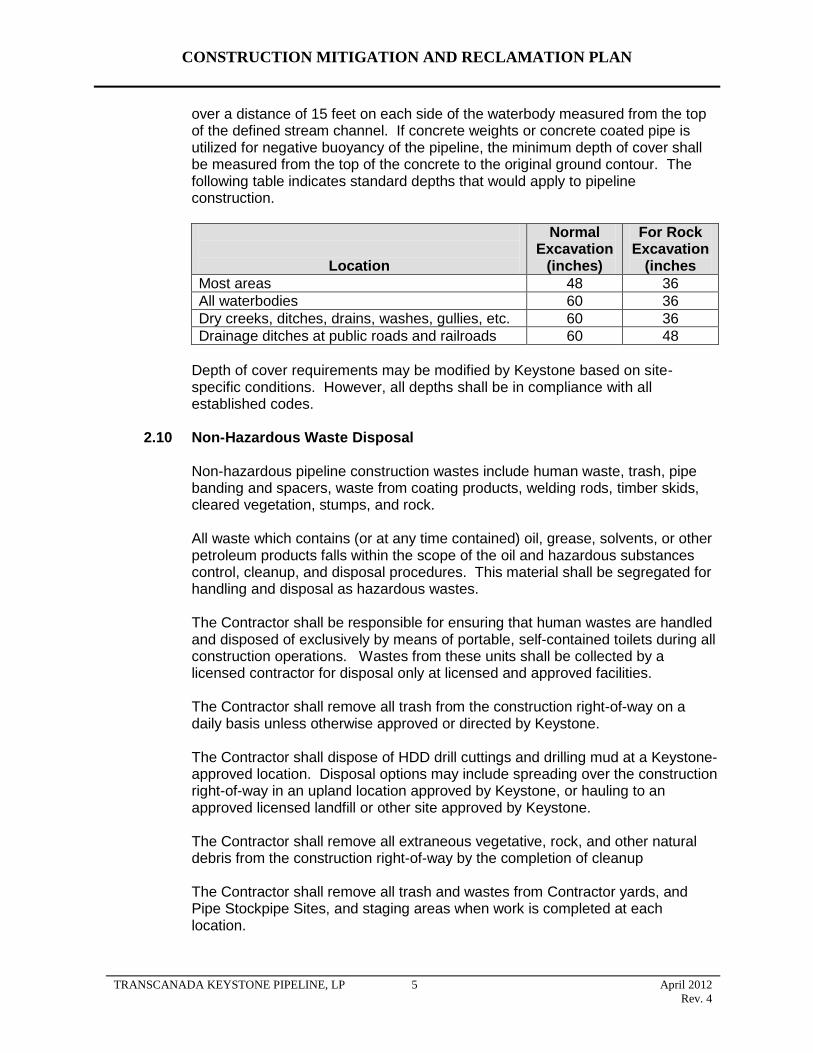
CONSTRUCTION MITIGATION AND RECLAMATION PLAN
over a distance of 15 feet on each side of the waterbody measured from the top of the defined stream channel. If concrete weights or concrete coated pipe is utilized for negative buoyancy of the pipeline, the minimum depth of cover shall be measured from the top of the concrete to the original ground contour. The following table indicates standard depths that would apply to pipeline construction.
Location
Normal Excavation
(inches)
For Rock Excavation
(inches
Most areas 48 36
All waterbodies 60 36
Dry creeks, ditches, drains, washes, gullies, etc. 60 36
Drainage ditches at public roads and railroads 60 48
Depth of cover requirements may be modified by Keystone based on site-specific conditions. However, all depths shall be in compliance with all established codes.
2.10 Non-Hazardous Waste Disposal
Non-hazardous pipeline construction wastes include human waste, trash, pipe banding and spacers, waste from coating products, welding rods, timber skids, cleared vegetation, stumps, and rock.
All waste which contains (or at any time contained) oil, grease, solvents, or other petroleum products falls within the scope of the oil and hazardous substances control, cleanup, and disposal procedures. This material shall be segregated for handling and disposal as hazardous wastes.
The Contractor shall be responsible for ensuring that human wastes are handled and disposed of exclusively by means of portable, self-contained toilets during all construction operations. Wastes from these units shall be collected by a licensed contractor for disposal only at licensed and approved facilities.
The Contractor shall remove all trash from the construction right-of-way on a daily basis unless otherwise approved or directed by Keystone.
The Contractor shall dispose of HDD drill cuttings and drilling mud at a Keystone-approved location. Disposal options may include spreading over the construction right-of-way in an upland location approved by Keystone, or hauling to an approved licensed landfill or other site approved by Keystone.
The Contractor shall remove all extraneous vegetative, rock, and other natural debris from the construction right-of-way by the completion of cleanup
The Contractor shall remove all trash and wastes from Contractor yards, and Pipe Stockpipe Sites, and staging areas when work is completed at each location.
TRANSCANADA KEYSTONE PIPELINE, LP 5 April 2012
Rev. 4

CONSTRUCTION MITIGATION AND RECLAMATION PLAN
The Contractor shall dispose of all waste materials at licensed waste disposal facilities. Wastes shall not be disposed of in any other fashion such as un-permitted burying or burning.
2.11 Hazardous Wastes
The Contractor shall ensure that all hazardous and potentially hazardous materials are transported, stored, and handled in accordance with all applicable legislation. Workers exposed to or required to handle dangerous materials shall be trained in accordance with the applicable regulator and the manufacturer's recommendations.
The Contractor shall dispose of all hazardous materials at licensed waste disposal facilities. Hazardous wastes shall not be disposed of in any other fashion such as un-permitted burying or burning.
All transporters of oil, hazardous substances, and hazardous wastes shall be licensed and certified according to the applicable state vehicle code. Incidents on public highways shall be reported to the appropriate agencies.
All hazardous wastes being transported off-site shall be manifested. The manifest shall conform to requirements of the appropriate state agency. The transporter shall be licensed and certified to handle hazardous wastes on the public highways. The vehicles as well as the drivers must conform to all applicable vehicle codes for transporting hazardous wastes. The manifest shall conform to 49 CFR Parts 172.101, 172.202, and 172.203.
If toxic or hazardous waste materials or containers are encountered during construction, the Contractor shall stop work immediately to prevent disturbing or further disturbing the waste material and shall immediately notify Keystone. The Contractor shall not restart work until clearance is granted by Keystone.
2.12 Noise Control
The Contractor shall minimize noise during non-daylight hours and within 1 mile of residences or other noise-sensitive areas such as hospitals, motels or campgrounds. Keystone shall abide by all applicable noise regulations regarding noise near residential and commercial/industrial areas. The Contractor shall provide notice to Keystone if noise levels are expected to exceed bylaws for a short duration. Keystone will give advanced notice to landowners within 500 feet of right-of-way prior to construction, limit the hours during which construction activities with high-decibel noise levels are conducted, coordinate work schedules, and ensure that construction proceeds quickly through such areas. The Contractor shall minimize noise in the immediate vicinity of herds of livestock or poultry operations, which are particularly sensitive to noise.
Keystone will set up a toll-free telephone line for landowners to report any construction noise-related issues.
TRANSCANADA KEYSTONE PIPELINE, LP 6 April 2012
Rev. 4
CONSTRUCTION MITIGATION AND RECLAMATION PLAN
2.13 Weed Control
Keystone will prepare a weed management plan for each state crossed by the project, as required. In general, these plans will consider the following measures listed below.
Prior to mobilization for the Project, the Contractor shall thoroughly clean all construction equipment, including timber mats, prior to moving the equipment to the job site to limit the potential for the spread of noxious weeds, insects and soil-borne pests. The Contractor shall clean the equipment with high-pressure washing equipment.
Prior to construction, Keystone will mark all areas of the right-of-way which contain infestations of noxious, invasive species or soil-borne pests. Such marking will clearly indicate the limits of the infestation along the right-of-way. During construction, the Contractor shall clean the tracks, tires, and blades of equipment by hand (track shovel) or compressed air to remove excess soil prior to movement of equipment out of weed or soil-borne pest infested areas, or utilize cleaning stations to remove vegetative materials using water under high pressure (see detail Drawings 30 and 31).
In areas of isolated weed populations, the Contractor shall strip topsoil from the full width of the construction right-of-way and store the topsoil separately from other topsoil and subsoil. The Environmental Inspectors will identify these locations in the field prior to grading activities.
The Contractor shall use mulch and straw or hay bales that are free of noxious weeds for temporary erosion and sediment control.
The Contractor shall implement pre-construction treatments such as mowing prior to seed development or herbicide application to areas of noxious weed infestation prior to other clearing, grading, trenching, or other soil disturbing work at locations identified in the construction drawings.
Keystone will implement Best Management Practices (BMPs) for conducting vegetation control where necessary before and after construction. Typical agricultural herbicides, developed in consultation with county or state regulatory agencies, will be used. Herbicide types will be determined based on the weed species requiring control. The Contractor shall apply herbicides, where required, within one week, or as deemed necessary for optimum mortality success, prior to disturbing the area by clearing, grading, trenching, or other soil disturbing work. Herbicides shall be applied by applicators appropriately licensed or certified by the state in which the work is conducted. All herbicides applied prior to construction shall be non-residual or shall have a significant residual effect no longer than 30 days. Herbicides applied during construction shall be non-residual. Keystone will implement BMPs in the use of pesticides and herbicides along the pipeline corridor to reduce potential impacts to avian and wildlife species.
The Contractor shall not use herbicides in or within 100 feet of a wetland or waterbody.
TRANSCANADA KEYSTONE PIPELINE, LP 7 April 2012
Rev. 4

CONSTRUCTION MITIGATION AND RECLAMATION PLAN
After pipeline construction, on any construction right-of-way over which Keystone will retain control over the surface use of the land after construction (i.e., valve sites, metering stations, pump stations, etc.), Keystone shall provide for weed control to limit the potential for the spread of weeds onto adjacent lands used for agricultural purposes. Any weed control spraying performed by Keystone shall be done by a state-licensed pesticide applicator.
Keystone shall be responsible for reimbursing all reasonable costs incurred by owners of land adjacent to aboveground facilities when the landowners must control weeds on their land which can be reasonably determined to have spread from land occupied by Keystone’s aboveground facilities.
2.14 Dust Control
The Contractor shall at all-time control airborne dust levels during construction activities to levels acceptable to Keystone. The Contractor shall employ water trucks, sprinklers or calcium chloride as necessary to reduce dust to acceptable levels. Utilization of calcium chloride is limited to roads.
Dust shall be strictly controlled where the work approaches dwellings, farm buildings, and other areas occupied by people and when the pipeline parallels an existing road or highway. This shall also apply to access roads where dust raised by construction vehicles may irritate or inconvenience local residents. The speed of all Contractor vehicles shall be controlled in these areas. Emissions from construction equipment combustion, open burning, and temporary fuel transfer systems and associated tanks will be controlled to the extent required by state and local agencies through the permit process.
The Contractor shall take appropriate precautions to prevent fugitive emissions caused by sand blasting from reaching any residence or public building. The Contractor shall place curtains of suitable material, as necessary, to prevent wind-blown particles from sand blasting operations from reaching any residence or public building.
Additional measures may be required by state regulations or local ordinances. The Contractor will comply with all applicable state regulations and local ordinances with respect to truck transportation and fugitive dust emissions.
2.15 Off Road Vehicle Control
Keystone shall offer to landowners or managers of forested lands to install and maintain measures to control unauthorized vehicle access to the construction right-of-way where appropriate. These measures may include the following unless otherwise approved or directed by Keystone based on site specific conditions or circumstances:
signs;
fences with locking gates;
slash and timber barriers, pipe barriers, or boulders lined across the
TRANSCANADA KEYSTONE PIPELINE, LP 8 April 2012
Rev. 4
CONSTRUCTION MITIGATION AND RECLAMATION PLAN
construction right-of-way; and
conifers or other appropriate trees or shrubs across the construction right-of-way.
2.16 Fire Prevention and Control
The Contractor shall comply with all federal, state, county and local fire regulations pertaining to burning permits and the prevention of uncontrolled fires. The following mitigative measures shall be implemented to prevent fire hazards and control of fires:
A list of relevant fire authorities and their designated representative to contact shall be maintained on site by construction personnel.
Adequate firefighting equipment shall be available on site in accordance with the applicable regulatory requirements shall be available on site.
The level of forest fire hazard shall be posted at the construction office (where visible for workers) and workers shall be made aware of the hazard level and related implications.
The Contractor shall provide equipment to handle any possible fire emergency. This shall include, although not be limited to, water trucks; portable water pumps; chemical fire extinguishers; hand tools such as shovels, axes, and chain saws; and heavy equipment adequate for the construction of fire breaks when needed.
Specifically, the Contractor shall supply and maintain in working order an adequate supply of fire extinguishers for each crew engaged in potentially combustible work such as welding, cutting, grinding, and burning of brush or vegetative debris.
In the event of a fire, the Contractor shall immediately use resources necessary to contain the fire. The Contractor shall then notify local emergency response personnel.
All tree clearing activities are to be carried out in accordance with local rules and regulations for the prevention of forest fires.
Burning shall be done in compliance with state, county, or local applicable regulations.
Any burning will be done within the right-of-way. Only small piles shall be burned to avoid overheating or damage to trees or other structures along the right-of-way.
Flammable wastes shall be removed from the construction site on a regular basis.
Flammable materials kept on the construction site must be stored in approved containers away from ignition sources.
Smoking shall be prohibited around flammable materials.
Smoking shall be prohibited on the entire construction site when the fire hazard is high.
TRANSCANADA KEYSTONE PIPELINE, LP 9 April 2012
Rev. 4

CONSTRUCTION MITIGATION AND RECLAMATION PLAN
2.17 Road and Railroad Crossings
Construction across paved roads, highways, and railroads will be in accordance with the requirements of the road and railroad crossing permits and approvals obtained by Keystone. In general, all major paved roads, all primary gravel roads, highways, and railroads will be crossed by boring beneath the road or railroad. Detail drawing 21 illustrates a typical bored road or railroad crossing. Boring requires the excavation of a pit on each side of the feature, the placement of boring equipment in the pit, and boring a hole under the road at least equal to the diameter of the pipe. For long crossings, sections can be welded onto the pipe string just before being pulled through the borehole. Boring will result in minimal or no disruption to traffic at road or railroad crossings. Each boring will be expected to take 1 to 2 days for most roads and railroads and up to 10 days for long crossings such as interstate or four-lane highways.
Most smaller, unpaved roads and driveways will be crossed using the open-cut method where permitted by local authorities or private owners. The open-cut method will require temporary closure of the road to traffic and establishment of detours. If no reasonable detour is feasible, at least one lane of traffic will be kept open, except during brief periods when it is essential to close the road to install the pipeline. Most open-cut road crossings can be finished and the road resurfaced in 1 or 2 days. Keystone will take measures, such as posting signs at open-cut road crossings, to ensure safety and minimize traffic disruptions.
2.18 Adverse Weather
The Contractor shall restrict certain construction activities and work in cultivated agricultural areas in excessively wet soil conditions to minimize rutting and soil compaction. In determining when or where construction activities should be restricted or suspended during wet conditions, the Contractor shall consider the following factors:
the extent that rutting may cause mixing of topsoil with subsoil layers or damage to tile drains;
excessive buildup of mud on tires and cleats;
excessive ponding of water at the soil surface; and
the potential for excessive soil compaction.
The Contractor shall implement mitigative measures as directed by Keystone in order to minimize rutting and soil compaction in excessively wet soil conditions which may include:
restricting work to areas on the spread where conditions allow;
using low ground weight, wide-track equipment, or other low impact construction techniques;
limiting work to areas that have adequately drained soils or have a cover of vegetation ,such as sod, crops or crop residues, sufficient to prevent mixing of topsoil with subsoil layers or damage to drain tiles; and
TRANSCANADA KEYSTONE PIPELINE, LP 10 April 2012
Rev. 4

CONSTRUCTION MITIGATION AND RECLAMATION PLAN
installing geotextile material or construction mats in problem areas.
“Stop work” authority will be designated to the chief inspector but will be implemented when recommended by the Environmental Inspector.
2.19 Cultural Resources
Keystone intends to avoid cultural resources to the extent practicable by rerouting the pipeline corridor and related appurtenances, avoiding construction activities on properties listed in or eligible for listing in the National Register of Historic Places (NRHP), as well as boring or using HDD through culturally sterile soils.
The Contractor shall implement the measures outlined in any unanticipated discovery plan or any Programmatic Agreement that is adopted to minimize disturbance to cultural sites and shall take immediate action as outlined in the Programmatic Agreement if any unanticipated cultural discovery is encountered during construction.
The preferred treatment of any historical property or culturally significant site is avoidance. Where required, Keystone will monitor the construction spread using a cultural resource monitor working under the direction of a professional who meets the standards of the Secretary of the Interior’s Historic Preservation Professional Qualification Standards (48 FR 44716, September 29, 1983).
Prior to commencing construction, Keystone also will provide an appropriate level of training to all construction personnel so that the requirements of any unanticipated discovery plan or Programmatic Agreement are understood and unanticipated discoveries quickly identified.
In the event an unanticipated cultural discovery is made, the Contractor will immediately halt all construction activities within a 100-foot radius, including traffic; notify the Keystone Environmental Inspector; and implement interim measures to protect the discovery from looting or vandalism. The appropriate federal, state, local, or tribal authorities will be notified of discovery within 48 hours of the initial find. Construction will not proceed within the 100-foot radius of discovery site until all mitigation measures defined in the Programmatic Agreement are concluded and Keystone receives approval from the appropriate agencies that construction may resume. No work or activity within the 100-foot buffer area may take place until approvals are communicated at the spread level by the lead Environmental Inspector.
3.0 SPILL PREVENTION AND CONTAINMENT
Spill prevention and containment applies to the use and management of hazardous materials on the construction right-of-way and all ancillary areas during construction. This includes the refueling or servicing of all equipment with diesel fuel, gasoline, lubricating oils, grease, and hydraulic and other fluids during normal upland applications and special applications within 100 feet of perennial streams or wetlands.
TRANSCANADA KEYSTONE PIPELINE, LP 11 April 2012
Rev. 4
CONSTRUCTION MITIGATION AND RECLAMATION PLAN
Keystone will prepare a project-specific Spill Prevention Containment and Countermeasure (SPCC) Plan. The Contractor shall provide additional information to complete the SPCC Plan for each construction spread, and shall provide site-specific data that meets the requirements of 40 CFR Part 112 for every location used for staging fuel or oil storage tanks and for every location used for bulk fuel or oil transfer. Each SPCC Plan will be prepared prior to introducing the subject fuel, oil, or hazardous material to the subject location.
3.1 Spill Prevention
3.1.1 Staging Areas
Staging areas (including Contractor yards and pipe stockpile sites) shall be set up for each construction spread. Bulk fuel and storage tanks will be placed only at Contractor yards. No bulk fuel and storage tanks will be placed in the construction ROW. Hazardous materials at staging areas shall be stored in compliance with federal and state laws. The following spill prevention measures shall be implemented by the Contractor:
Contractor fuel trucks shall be loaded at existing bulk fuel dealerships or from bulk tanks set up for that purpose at the staging area. In the former case, the bulk dealer is responsible for preventing and controlling spills.
The Environmental Inspector shall inspect the tank site for compliance with the 100-foot setback requirement and approve the tank site prior to installing bulk fuel or storage tanks on the construction yard.
Fuels and lubricants shall be stored only at designated staging areas. Storage of fuel and lubricants in the staging area shall be at least 100 feet away from the water's edge. Refueling and lubrication of equipment shall be restricted to upland areas at least 100 feet away from streams and wetlands.
Contractors shall be required to perform all routine equipment maintenance at the staging area and recover and dispose of wastes in an appropriate manner.
Fixed fuel dispensing locations will be provided with secondary containment to capture fuel from leaks, drips, and overfills.
Temporary liners, berms, or dikes (secondary containment) shall be constructed around the aboveground bulk tanks, providing 110 percent containment volume of the largest storage tank or trailer within the containment structure, so that potential spill materials shall be contained and collected in specified areas. Tanks shall not be placed in areas subject to periodic flooding or washout.
Drivers of tank trucks are responsible for safety and spill prevention during tank truck unloading. Procedures for loading and unloading tank trucks shall meet the minimum requirements established by the Department of Transportation.
TRANSCANADA KEYSTONE PIPELINE, LP 12 April 2012
Rev. 4

CONSTRUCTION MITIGATION AND RECLAMATION PLAN
Drivers of tank trucks are responsible for setting brakes and chocking wheels prior to off loading. Warning signs requiring drivers to set brakes and chock wheels shall be displayed at all tanks. Proper grounding of equipment shall be undertaken during fuel transfer operations. Drivers shall observe and control the fueling operations at all times to prevent overfilling the temporary tank.
Prior to departure of any tank truck, all vehicle outlets shall be examined closely by the driver for leakage, tightened, adjusted or replaced to prevent Ieakage while in transit.
A supply of sorbent and barrier materials sufficient to allow the rapid containment and recovery of spills shall be maintained at each construction staging area. Sorbent and barrier materials shall also be utilized to contain runoff from contaminated areas.
Shovels and drums shall be kept at each of the individual staging areas. In the event that small quantities of soil become contaminated, shovels shall be utilized to collect the soil and the material shall be stored in 55-gallon drums. Large quantities of contaminated soil may be bio-remediated on site or disposed in an approved landfill, subject to government approval, or collected utilizing heavy equipment, and stored in drums or other suitable containers prior to disposal. Should contamination occur adjacent to staging areas as a result of runoff, shovels or heavy equipment shall be utilized to collect the contaminated material. Contaminated soil shall be disposed of in accordance with state and federal regulations.
Temporary aboveground tanks shall be subject to visual inspection on a monthly basis and when the tank is refilled. Inspection records shall be maintained. Operators shall routinely keep tanks under close surveillance and potential leaks or spills shall be quickly detected.
Visible fuel leaks shall be reported to the Contractors' designated representative and corrected as soon as conditions warrant. Keystone's designated representative shall be informed.
Drain valves on temporary tanks shall be locked to prevent accidental or unauthorized discharges from the tank.
Oil and other hazardous materials stored in 350-gallon totes, 55-gallon drums, 5-gallon pails, smaller retail-size containers or other portable containers will be staged or stored in areas with a secondary temporary containment structure. Secondary containment structures may consist of temporary earthen berms with a chemical resistant liner, or a portable containment system constructed of steel, PVC, or other suitable material. The secondary containment structure will be capable of containing 110 percent of the volume of material stored in these areas.
Keystone may allow modification of the above specifications as necessary to accommodate specific situations or procedures. Any modifications must comply with all applicable regulations and permits.
TRANSCANADA KEYSTONE PIPELINE, LP 13 April 2012
Rev. 4
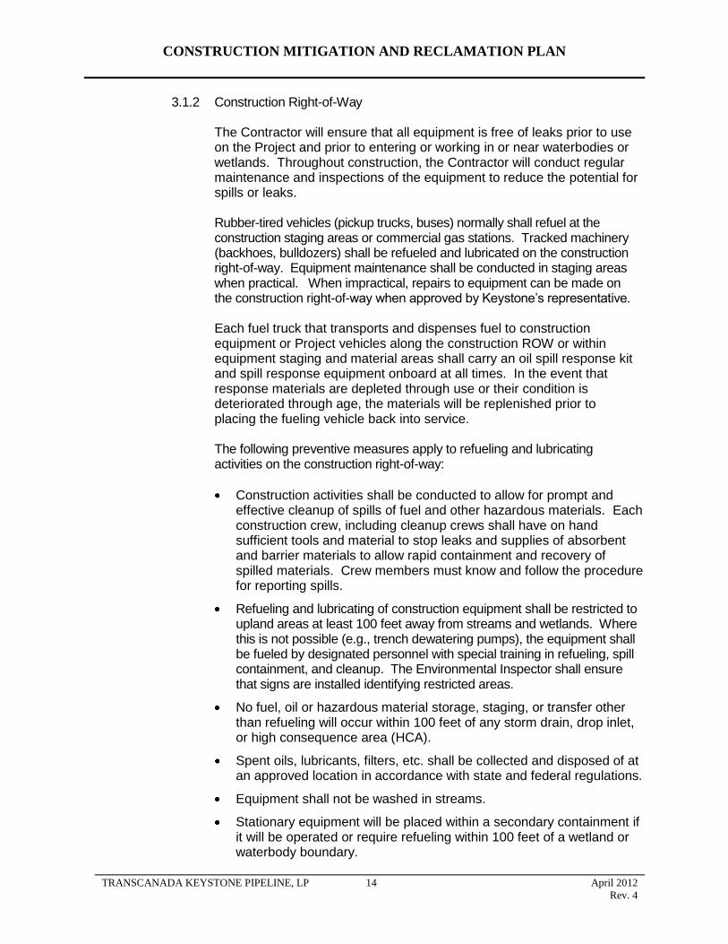
CONSTRUCTION MITIGATION AND RECLAMATION PLAN
3.1.2 Construction Right-of-Way
The Contractor will ensure that all equipment is free of leaks prior to use on the Project and prior to entering or working in or near waterbodies or wetlands. Throughout construction, the Contractor will conduct regular maintenance and inspections of the equipment to reduce the potential for spills or leaks.
Rubber-tired vehicles (pickup trucks, buses) normally shall refuel at the construction staging areas or commercial gas stations. Tracked machinery (backhoes, bulldozers) shall be refueled and lubricated on the construction right-of-way. Equipment maintenance shall be conducted in staging areas when practical. When impractical, repairs to equipment can be made on the construction right-of-way when approved by Keystone’s representative.
Each fuel truck that transports and dispenses fuel to construction equipment or Project vehicles along the construction ROW or within equipment staging and material areas shall carry an oil spill response kit and spill response equipment onboard at all times. In the event that response materials are depleted through use or their condition is deteriorated through age, the materials will be replenished prior to placing the fueling vehicle back into service.
The following preventive measures apply to refueling and lubricating activities on the construction right-of-way:
Construction activities shall be conducted to allow for prompt and effective cleanup of spills of fuel and other hazardous materials. Each construction crew, including cleanup crews shall have on hand sufficient tools and material to stop leaks and supplies of absorbent and barrier materials to allow rapid containment and recovery of spilled materials. Crew members must know and follow the procedure for reporting spills.
Refueling and lubricating of construction equipment shall be restricted to upland areas at least 100 feet away from streams and wetlands. Where this is not possible (e.g., trench dewatering pumps), the equipment shall be fueled by designated personnel with special training in refueling, spill containment, and cleanup. The Environmental Inspector shall ensure that signs are installed identifying restricted areas.
No fuel, oil or hazardous material storage, staging, or transfer other than refueling will occur within 100 feet of any storm drain, drop inlet, or high consequence area (HCA).
Spent oils, lubricants, filters, etc. shall be collected and disposed of at an approved location in accordance with state and federal regulations.
Equipment shall not be washed in streams.
Stationary equipment will be placed within a secondary containment if it will be operated or require refueling within 100 feet of a wetland or waterbody boundary.
TRANSCANADA KEYSTONE PIPELINE, LP 14 April 2012
Rev. 4

CONSTRUCTION MITIGATION AND RECLAMATION PLAN
Keystone may allow modification of the above specifications as necessary to accommodate specific situations or procedures. Any modifications must comply with all applicable regulations and permits.
3.2 Contingency Plans
The Contractor shall develop emergency response procedures for all incidents (e.g., spills, leaks, fires) involving hazardous materials which could pose a threat to human health or the environment. The procedures shall address activities in all work areas, as well as during transport to and from the construction right-of-way and to any disposal or recycling facility.
3.3 Equipment
The Contractor shall retain emergency response equipment in all areas where hazardous materials are handled or stored. This equipment shall be readily available to respond to a hazardous material emergency. Such equipment shall include, but not be limited to, the following:
first aid supplies;
phone or communications radio;
protective clothing (Tyvek suit, gloves, goggles, boots);
hand-held fire equipment;
absorbent material and storage containers;
non-sparking bung wrench and shovel; and
brooms and dust pan.
Hazardous material emergency equipment shall be carried in all mechanic and supervisor vehicles. This equipment shall include, at a minimum:
first aid supplies;
phone or communications radio;
2 sets of protective clothing (Tyvek suit, gloves, goggles, boots);
1 non-sparking shovel;
6 plastic garbage bags (20 gallon);
10 absorbent socks and spill pads;
Hand-held fire extinguisher;
barrier tape; and
2 orange reflector cones.
Fuel and service trucks shall carry a minimum of 20 pounds of suitable commercial sorbent material.
TRANSCANADA KEYSTONE PIPELINE, LP 15 April 2012
Rev. 4
CONSTRUCTION MITIGATION AND RECLAMATION PLAN
The Contractor shall inspect emergency equipment weekly, and service and maintain equipment regularly. Records shall be kept of all inspections and services.
3.4 Emergency Notification
Emergency notification procedures between the Contractor and Keystone shall be established in the planning stages of construction. A Keystone representative shall be identified to serve as contact in the event of a spill during construction activities. In the event of a spill meeting government reporting criteria, the Contractor immediately shall notify the Keystone representative who, in turn, shall notify the appropriate regulatory agencies.
Any material released into water that creates a sheen must be reported immediately to Keystone. The Contractor is required to notify Keystone immediately if there is any spill of oil, oil products, or hazardous materials that reaches a wetland or waterbody. Incidents on public highways shall be reported to Keystone and the appropriate agencies by Keystone.
If a spill occurs on navigable waters of the United States, Keystone shall notify the National Response Center (NRC) at 1-800-424-8802. For spills that occur on public lands, into surface waters, or into sensitive areas, the appropriate governmental agency’s district office also shall be notified.
3.5 Spill Containment and Countermeasures
In the event of a spill of hazardous material, Contractor personnel shall:
notify the appointed Keystone representative;
identify the product hazards related to the spilled material and implement appropriate safety procedures, based on the nature of the hazard;
control danger to the public and personnel at the site;
implement spill contingency plans and mobilize appropriate resources and manpower;
isolate or shutdown the source of the spill;
block manholes or culverts to limit spill travel;
initiate containment procedures to limit the spill to as small an area as possible to prevent damage to property or areas of environment concern (e.g., watercourses); and
commence recovery of the spill and cleanup operations.
When notified of a spill, the Keystone representative shall immediately ensure that:
Action is taken to control danger to the public and personnel at the site.
Spill contingency plans are implemented and necessary equipment and manpower are mobilized.
TRANSCANADA KEYSTONE PIPELINE, LP 16 April 2012
Rev. 4

CONSTRUCTION MITIGATION AND RECLAMATION PLAN
Measures are taken to isolate or shutdown the source of the spill.
All resources necessary to contain, recover and clean up the spill are available.
Any resources requested by the Contractor from Keystone are provided.
The appropriate agencies are notified. For spills which occur on public Iands, into surface waters or into sensitive areas, the appropriate federal or state managing office shall also be notified and involved in the incident.
For a land spill, berms shall be constructed with available equipment to physically contain the spill. Personnel entry and travel on contaminated soils shall be minimized. Sorbent materials shall be applied or, if necessary, heavily contaminated soils shall be removed to an approved facility. Contaminated sorbent materials and vegetation shall also be disposed of at an approved facility.
For a spill threatening a waterbody, berms or trenches shall be constructed to contain the spill prior to entry into the waterbody. Deployment of booms, skimmers, and sorbent materials shall be necessary if the spill reaches the water. The spilled product shall be recovered and the contaminated area shall be cleaned up in consultation with spill response specialists and appropriate government agencies.
4.0 UPLANDS (AGRICULTURAL, FOREST, PASTURE, RANGE AND GRASS LANDS)
4.1 Interference with Irrigation Systems
If existing irrigation systems (flood irrigation, ditch irrigation, pivot, wheel, or other type of spray irrigation systems), irrigation ditches, or sheet flow irrigation shall be impacted by the construction of the pipeline, the following mitigative measures shall be implemented unless otherwise approved or directed by Keystone:
If it is feasible and mutually acceptable to Keystone and the landowner or landowner's designate, temporary measures shall be implemented to allow an irrigation system to continue to operate across land on which the pipeline is being constructed.
If the pipeline or temporary work areas intersect an operational (or soon to be operational) pivot or other spray irrigation system, Keystone shall establish with the landowner or landowner's designate an acceptable amount of time the irrigation system may be out of service. If an irrigation system interruption results in crop damages, either on the pipeline construction right-of-way or off the construction right-of-way, the landowner shall be compensated reasonably for all such crop damages.
If the pipeline or temporary work areas intersect an operational sheet flow irrigation system, Keystone shall establish with the landowner or landowner's designate an acceptable amount of time the irrigation system may be out of service. If an irrigation system interruption results in crop
TRANSCANADA KEYSTONE PIPELINE, LP 17 April 2012
Rev. 4
CONSTRUCTION MITIGATION AND RECLAMATION PLAN
damages, either on the pipeline construction right-of-way or off the construction right-of-way, the landowner shall be compensated reasonably for all such crop damages.
Irrigation ditches that are active at the time of construction shall not be stopped or obstructed except for the length of time to install the pipeline beneath the ditch (typically, one day or less) unless otherwise approved or directed by Keystone.
4.2 Clearing
The objective of clearing is to provide a clear and unobstructed right-of-way for safe and efficient construction of the pipeline. The following mitigable measures shall be implemented:
Construction traffic shall be restricted to the construction right-of-way, existing public roads, and approved private roads.
Construction right-of-way boundaries including pre-approved temporary workspace shall be clearly staked to prevent disturbance to unauthorized areas.
If crops are present, they shall be mowed or disced to ground level unless an agreement is made for the landowner to remove.
Burning is prohibited on cultivated land.
Construction right-of-way at timber shelterbelts in agricultural areas shall be reduced to the minimum necessary to construct the pipeline.
4.3 Topsoil Removal and Storage
The objective of topsoil handling is to maintain topsoil capability by conserving topsoil for future replacement and reclamation and to minimize the degradation of topsoil from compaction, rutting, loss of organic matter, or soil mixing so that successful reclamation of the right-of-way can occur. The following mitigative measures shall be implemented during topsoil removal and storage unless otherwise approved or directed by Keystone based on site-specific conditions or circumstances. All work shall be conducted in accordance with applicable permits.
In areas designated for topsoil segregation, the actual depth of the topsoil, to a maximum depth of 12 inches, will be stripped from:
o The area excavated above the pipeline; or
o The area above the pipeline plus the spoil storage; or
o The area above the pipeline plus the working side; or
o Entire ROW
as required by applicable permit agreements with the landowner or as dictated by site-specific conditions.
TRANSCANADA KEYSTONE PIPELINE, LP 18 April 2012
Rev. 4

Stripped topsoil is to be stockpiled in a windrow along the edge of the right-of-way. The Contractor shall perform work in a manner to minimize the potential for subsoil and topsoil to be mixed.
Under no circumstances shall the Contractor use topsoil to fill a low area.
If required due to excessively windy conditions, topsoil piles shall be tackified using either water or a suitable tackifier (liquid mulch binder).
Gaps in the rows of topsoil will be left in order to allow drainage and prevent ponding of water adjacent to or on the right-of-way.
Topsoil shall not be utilized to construct ramps at road or waterbody crossings.
In areas with defined saline or sodic soil concerns, a triple-ditch method will be used to segregate problem soils as indicated in Detail 67 and 67A.
If frozen topsoil conditions are encountered during winter construction, specialized construction equipment (i.e. ripping, frozen topsoil cutter, road reclaimer, etc) may be required to adequately segregate and conserve topsoil resources.
4.4 Grading
The objective of grading is to develop a right-of-way that allows the safe passage of equipment and meets the bending limitations of the pipe. The following mitigative measures shall be implemented during grading unless otherwise approved or directed by Keystone based on site-specific conditions or circumstances. However, all work shall be conducted in accordance with applicable permits.
All grading shall be undertaken with the understanding that original contours and drainage patterns shall be re-established to the extent practicable..
Agricultural areas that have terraces shall be surveyed to establish pre-construction contours to be utilized for restoration of the terraces after construction.
On steep slopes, or wherever erosion potential is high, temporary erosion control measures shall be implemented.
Bar ditches adjacent to existing roadways to be crossed during construction shall be adequately ramped with grade or ditch spoil to prevent damage to the road shoulder and ditch.
Where the construction surface remains inadequate to support equipment travel, timber mats, timber riprap, or other method shall be used to stabilize surface conditions.
The Contractor shall limit the interruption of the surface drain network in the vicinity of the right-of-way using the appropriate methods:
providing gaps in the rows of subsoil and topsoil in order to prevent any accumulation of water on the land;
CONSTRUCTION MITIGATION AND RECLAMATION PLAN
TRANSCANADA KEYSTONE PIPELINE, LP 19 April 2012
Rev. 4
CONSTRUCTION MITIGATION AND RECLAMATION PLAN
preventing obstructions in furrows, furrow drains, and ditches;
installing flumes and ramps in furrows, furrow drains, and ditches to facilitate water flow across the construction right-of-way and allow for construction equipment traffic; and
installing flumes over the trench for any watercourse where flow is continuous during construction.
4.5 Temporary Erosion and Sediment Control
4.5.1 General
Temporary erosion and sediment control measures shall be installed immediately after initial disturbance of the soil, maintained throughout construction (on a daily basis), and reinstalled as necessary until replaced by permanent erosion control structures or restoration of the construction right-of-way is complete.
Specifications and configurations for erosion and sediment control measures may be modified by Keystone as necessary to suit actual site conditions. However, all work shall be conducted in accordance with applicable permits.
The Contractor shall inspect all temporary erosion control measures at least daily in areas of active construction or equipment operation, weekly in areas with no construction or equipment operation, and within 24 hours of each significant rainfall event of 0.5 inches or greater. The Contractor shall repair all ineffective temporary erosion control measures as expediently as practicable.
4.5.2 Sediment Barriers
Sediment barriers shall be constructed of silt fence, staked hay or straw bales, compacted earth (e.g., drivable berms across travel lanes), sand bags, or other appropriate materials.
The Contractor shall install sediment barriers in accordance with Details 1 and 2 or as otherwise approved or directed by Keystone. The Contractor is responsible for properly installing, maintaining, and replacing temporary and permanent erosion controls throughout construction and cleanup. In wetland or riparian zones, the Contractor will install sediment control structures along the construction right-of-way edges prior to vegetation removal where practicable. The aforementioned sediment barriers may be used interchangeably or together depending on site-specific conditions. In most cases, silt fence shall be utilized where longer sediment barriers are required.
Sediment barriers shall be installed below disturbed areas where there is hazard of offsite sedimentation. These areas include:
the base of slopes adjacent to road crossings;
TRANSCANADA KEYSTONE PIPELINE, LP 20 April 2012
Rev. 4
CONSTRUCTION MITIGATION AND RECLAMATION PLAN
the edge of the construction right-of-way adjacent to and upgradient of a roadway, flowing stream, spring, wetland, or impoundment;
trench or test water discharge locations where required;
where waterbodies or wetlands are adjacent to the construction right-of-way; (the Contractor shall install sediment barriers along the edge of the construction right-of-way as necessary to contain spoil and sediment within the construction right-of-way)
across the entire construction right-of-way at flowing waterbody crossings;
right-of-way immediately upslope of the wetland boundary at all standard (saturated or standing water) wetland crossings as necessary to prevent sediment flow into the wetland; (Sediment control barriers are not required at “dry” wetlands.)
along the edge of the construction right-of-way within standard (saturated or standing water) wetland boundaries as necessary to contain spoil and sediment within the construction right-of-way. Sediment control barriers are not required at “dry” wetlands (Detail 8).
Sediment barriers placed at the toe of a slope shall be set a sufficient distance from the toe of the slope, if possible, in order to increase ponding volume.
Sediment control barriers shall be placed so as not to hinder construction operations. If silt fence or straw bale sediment barriers (in lieu of drivable berms) are placed across the entire construction right-of-way at waterbodies, wetlands, or upslope of roads, a provision shall be made for temporary traffic flow through a gap for vehicles and equipment to pass within the structure. Immediately following each day’s shutdown of construction activities, a row of straw bales or a section of silt fence shall be placed across the up gradient side of the gap with sufficient overlap at each end of the barrier gap to eliminate sediment bypass flow, followed by bales tightly fitted to fill the gap. Following completion of the equipment crossing, the gap shall be closed using silt fence or straw bale sediment barrier.
The Contractor shall maintain straw bale and silt fence sediment barriers by removing collected sediment and replacing damaged bales. Sediment shall be removed and placed where it shall not reenter the barrier when sediment loading is greater than 40 percent or if directed by Keystone. If straw bale filters cannot be cleaned out due to access problems, the Contractor shall place a new row of sediment barriers upslope.
The Contractor shall use mulch and straw bales that are free of noxious weeds. Mulch or straw bales that contain evidence of noxious weeds or other undesirable species shall be rejected by the Contractor.
TRANSCANADA KEYSTONE PIPELINE, LP 21 April 2012
Rev. 4
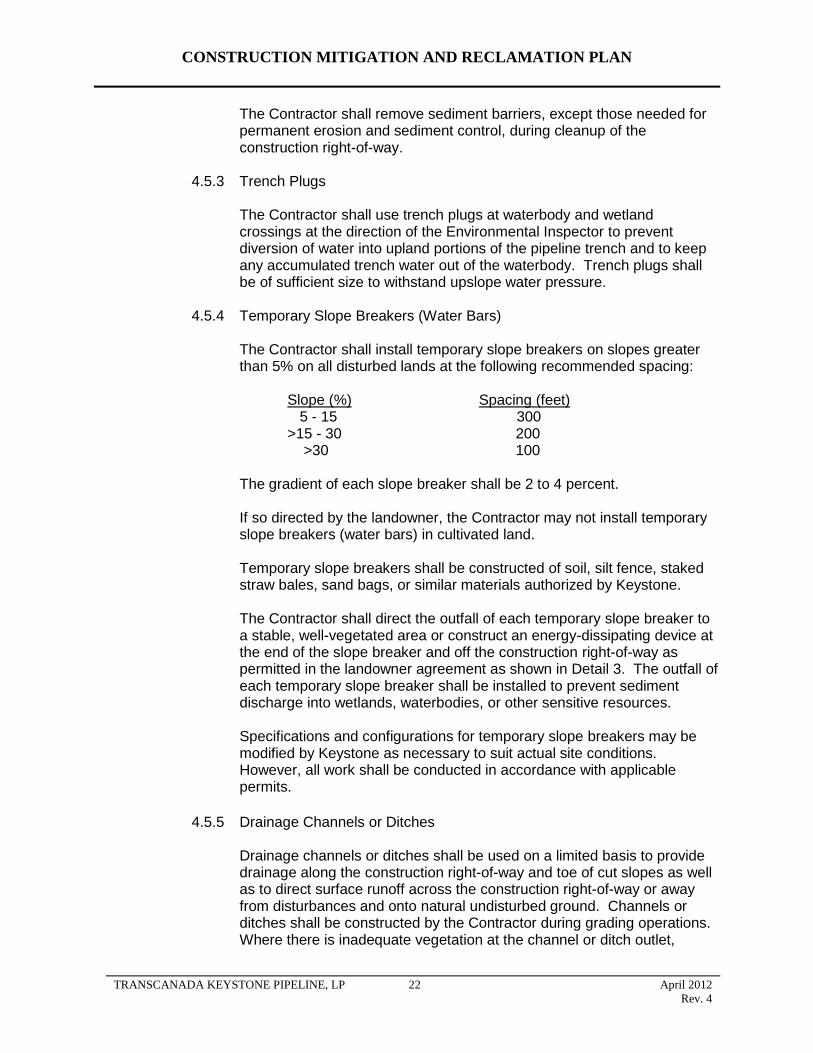
CONSTRUCTION MITIGATION AND RECLAMATION PLAN
The Contractor shall remove sediment barriers, except those needed for permanent erosion and sediment control, during cleanup of the construction right-of-way.
4.5.3 Trench Plugs
The Contractor shall use trench plugs at waterbody and wetland crossings at the direction of the Environmental Inspector to prevent diversion of water into upland portions of the pipeline trench and to keep any accumulated trench water out of the waterbody. Trench plugs shall be of sufficient size to withstand upslope water pressure.
4.5.4 Temporary Slope Breakers (Water Bars)
The Contractor shall install temporary slope breakers on slopes greater than 5% on all disturbed lands at the following recommended spacing:
Slope (%) Spacing (feet) 5 - 15 300
>15 - 30 200 >30 100
The gradient of each slope breaker shall be 2 to 4 percent.
If so directed by the landowner, the Contractor may not install temporary slope breakers (water bars) in cultivated land.
Temporary slope breakers shall be constructed of soil, silt fence, staked straw bales, sand bags, or similar materials authorized by Keystone.
The Contractor shall direct the outfall of each temporary slope breaker to a stable, well-vegetated area or construct an energy-dissipating device at the end of the slope breaker and off the construction right-of-way as permitted in the landowner agreement as shown in Detail 3. The outfall of each temporary slope breaker shall be installed to prevent sediment discharge into wetlands, waterbodies, or other sensitive resources.
Specifications and configurations for temporary slope breakers may be modified by Keystone as necessary to suit actual site conditions. However, all work shall be conducted in accordance with applicable permits.
4.5.5 Drainage Channels or Ditches
Drainage channels or ditches shall be used on a limited basis to provide drainage along the construction right-of-way and toe of cut slopes as well as to direct surface runoff across the construction right-of-way or away from disturbances and onto natural undisturbed ground. Channels or ditches shall be constructed by the Contractor during grading operations. Where there is inadequate vegetation at the channel or ditch outlet,
TRANSCANADA KEYSTONE PIPELINE, LP 22 April 2012
Rev. 4

CONSTRUCTION MITIGATION AND RECLAMATION PLAN
sediment barriers, check berms, or other appropriate measures shall be used to control erosion.
4.5.6 Temporary Mulching and Cover Crops
Unless otherwise directed by Keystone, the Contractor shall apply temporary seed and/or mulch on disturbed construction work areas that have been inactive for one month or are expected to be inactive for a month or more. The Contractor shall not apply temporary mulch in cultivated areas unless specifically requested by the landowner or in areas particularly prone to erosion. The Contractor shall not apply mulch within wetland boundaries.
Temporary mulch of straw or equivalent applied on slopes shall be spread uniformly to cover at least 75 percent of the ground surface at an approximate rate of 2 tons per acre of straw or its equivalent. Mulch application on slopes within 100 feet of waterbodies and wetlands shall be increased to an approximate rate of 3 tons per acre.
All seed that is used as a temporary cover crop will be approved and/or provided by Keystone.
4.5.7 Tackifier
When wetting topsoil piles with water does not prevent wind erosion, the Contractor shall temporarily suspend topsoil handling operations and apply a tackifier to topsoil stockpiles at the rate recommended by the manufacturer. The type of Tackifier will be approved by Keystone.
Should construction traffic, cattle grazing, heavy rains, or other related construction activity disturb the tackified topsoil piles and create a potential for wind erosion, additional tackifier shall be applied by the Contractor.
4.6 Stringing
The objective of stringing is to place the line pipe along the construction right-of-way for bending and welding in an expedient and efficient manner.
The Contractor shall utilize one or more of the following mitigative measures as applicable and when necessary to reduce compaction on the working side of the right-of-way or as directed by Keystone. However, all work shall be conducted in accordance with applicable permits.
prohibiting access by certain vehicles;
using only machinery possessing low ground pressure (tracks or extra-wide tires);
limiting access and thus minimizing the frequency of all vehicle traffic;
digging ditches to improve surface drainage;
TRANSCANADA KEYSTONE PIPELINE, LP 23 April 2012
Rev. 4

CONSTRUCTION MITIGATION AND RECLAMATION PLAN
using timber riprap, matting, or geotextile fabric overlain with soil; and
stopping construction for a period of time.
4.7 Trenching
The objective of trenching is to provide a ditch of sufficient depth and width with a bottom to continuously support the pipeline. During trenching operations, the following mitigative measures shall be implemented unless otherwise approved or directed by Keystone based on site-specific conditions or circumstances. All work shall be conducted in accordance with applicable permits.
Where required, subsoil shall be segregated from topsoil in separate, distinct rows with a separation that shall limit any admixing of topsoil and subsoil during handling.
Triple ditch soil handling will be completed at sites identified by Keystone according to Detail 67 and 67A to prevent soil degradation.
Gaps must be left in the spoil piles that coincide with breaks in the strung pipe to facilitate natural drainage patterns and to allow the passage of livestock or wildlife.
Trenching operations shall be followed as closely as practicable by lower in and backfill operations to minimize the length of time the ditch is open.
Construction debris (e.g., welding debris) and other garbage shall not be deposited in the ditch.
If trenching, pipe installation and backfill operations take place during frozen soil conditions, final clean-`up (including additional trench compaction, subsoil feathering, final contouring and topsoil replacement) will be delayed until the subsoil and topsoil thaw completely the following spring/summer. A pronounced subsoil berm will be left over the trench line until final clean-up takes place to account for settlement of thawing backfill. Gaps will be left in the berm to maintain cross-ROW drainage
The Contractor shall prepare a blasting plan that is applicable to any locations where blasting will be necessary adjacent to existing high pressure pipelines, overhead or underground utilities, farm operations, or public crossings. The Contractor and its blasting supervisor shall be thoroughly familiar with and comply with the rules and regulations of Occupational Safety and Health Administration (OSHA) and all federal, state, county and local regulations governing blasting operations. Keystone will file the blasting plan with applicable state or local jurisdictions, where required. Excavation and blasting along the ROW may uncover paleontological resources of scientific value. Keystone will consult with the appropriate regulatory agencies in each state on the applicability and requirements for Paleontological Resource Protection Plans. Keystone will prepare and file plans addressing vertebrate fossils with any respective states, as required.
Should blasting be necessary for removal of rock, the following mitigative measures may be implemented:
TRANSCANADA KEYSTONE PIPELINE, LP 24 April 2012
Rev. 4

CONSTRUCTION MITIGATION AND RECLAMATION PLAN
The Contractor shall use non-electric initiation systems for all blasting operations. If required by the blasting plan, blasting will be monitored for vibration levels and peak particle velocity. This work shall be performed by a third-party vibration monitoring consultant hired by and reporting to the Constructor Representative. The Contractor shall arrange for detonations to be carried out in cooperation with this consultant.
Prior to using explosives, the Contractor shall advise residents of the immediate area, in order to prevent any risk of accidents or undue disturbances.
No blasting shall be done without approval of the Constructor Representative. Prior to any detonation of explosives in the vicinity of a loaded line, dwelling, structure, overhead or underground utility, farm operation, or public crossings, a minimum of 48 hour’s notice shall be given to the Constructor Representative, in order that the appropriate people can be notified and the upstream and downstream mainline valves can be staffed.
The Contractor shall obtain all necessary permits and shall comply with all legal requirements in connection with the use, storage, and transportation of explosives.
Blasting mats or subsoil may be piled over the trench line to prevent rock from being blown outside the construction right-of-way.
Each blasting location shall be cleared and cleaned up before and after all blasting operations.
Blasting shall be carried out during regular, daylight working hours.
The Contractor shall at all times protect his workers and the public from any injury or harm that might arise from drilling dust and the use of explosives.
Only workers thoroughly experienced in handling explosives shall be permitted to supervise, handle, haul, load or shoot explosives. In those jurisdictions where the licensing of blasters is mandatory, the Contractor shall provide the Constructor Representative with proof of the required certification for every person so required.
The drilling pattern shall be set in a manner to achieve smaller rock fragmentation (maximum 1 foot in diameter) in order to use as much as possible of the blasted rock as backfill material after the pipe has been padded in accordance with the specifications.
Blasting testing of surface-water resources and water wells within 150 feet of the centerline will be performed in compliance with all applicable permits.
4.7.1 Trench Dewatering/Well Points
The Contractor shall make all reasonable efforts to discharge trench water in a manner that avoids damage to adjacent agricultural land, crops, and pasture. Damage includes, but is not limited to, the inundation of crops for more than 24 hours, deposition of sediment in ditches, and the deposition of gravel in fields or pastures.
TRANSCANADA KEYSTONE PIPELINE, LP 25 April 2012
Rev. 4
CONSTRUCTION MITIGATION AND RECLAMATION PLAN
If trench dewatering is necessary in an area where salt damage to adjacent crops is evident, the Environmental Inspector shall conduct a field conductivity test on the trench water before it is discharged. If the conductivity of the trench water is determined to potentially affect soil quality, it shall not be discharged to areas where salt damage to crops is evident, but shall be directed as feasible so that water flows over a well vegetated, non-cropland area or through an energy dissipater and sediment barrier.
When pumping water from the trench for any reason, the Contractor shall ensure that adequate pumping capacity and sufficient hose is available to permit dewatering as follows:
No heavily silt-laden trench water shall be allowed to enter a waterbody or wetland directly but shall instead be diverted through a well vegetated area, a geotextile filter bag, or a permeable berm (straw bale or Keystone approved equivalent).
Trench water shall not be disposed of in a manner which could damage crops or interfere with the functioning of underground drainage systems.
The Contractor shall screen the intake hose and keep the hose either one foot off the bottom of the trench or in a container to minimize entrainment of sediment.
4.8 Welding, Field Joint Coating, and Lowering In
The objectives of welding, field joint coating, and lowering in are to provide continuous segments of pipeline, to provide corrosion protection to the weld areas of the pipeline, and to place the pipeline in the center of the trench, without stress, at the required depth of cover. The following mitigative measures shall be followed during pipe welding, field joint coating, and lowering in, unless otherwise specified by Keystone in response to site-specific conditions or circumstances. All work shall be conducted in accordance with applicable permits.
Shavings produced during beveling of the line pipe are to be removed immediately following this operation to ensure that livestock and wildlife do not ingest this material. When welding operations create a continuous line of pipe that may be left in the right-of-way for an extended period of time due to construction or weather constraints, a gap in the welded pipe shall be provided to allow for access at farm road crossings and for passage of livestock and wildlife.
Prior to the application of epoxy powder, urethane epoxy, or other approved pipe coatings, a tarp shall be placed underneath the pipe in wetlands to collect any overspray of epoxy powder and liquid drippings. Excess powder, liquid, or other hazardous materials (e.g. brushes, rollers, gloves) shall be continuously collected and removed from the construction right-of-way and disposed of in a manner appropriate for these materials.
TRANSCANADA KEYSTONE PIPELINE, LP 26 April 2012
Rev. 4
CONSTRUCTION MITIGATION AND RECLAMATION PLAN
4.9 Padding and Backfilling
The objective of padding and backfilling is to cover the pipe with material that is not detrimental to the pipeline and pipeline coating. The following mitigative measures shall be utilized during backfilling, unless otherwise approved or directed by Keystone based on site-specific conditions or circumstances. All work shall be conducted in accordance with applicable permits.
Excessive water accumulated in the trench shall be eliminated prior to backfilling.
In the event it becomes necessary to pump water from open trenches, the Contractor shall pump the water and discharge it in accordance with the requirements of the Stormwater Pollution Prevention Plan (SWPPP) in order to avoid damaging adjacent areas. Detail 5 and Detail 6 provide typical examples of dewatering structures.
If it is impossible to avoid water-related damages (including inundation of crops for more than 24 hours, deposition of sediment in ditches and other water courses, and the deposition of gravel in fields, pastures, and any water courses), Keystone shall reasonably compensate the landowners for the damage and/or shall correct the damage so as to restore the land, crops, pasture, water courses, etc. to their pre-construction condition.
All pumping of water shall comply with existing drainage laws and local ordinances relating to such activities and provisions of the Clean Water Act.
Prior to backfilling, all drain tile shall be permanently repaired, inspected, and the repair documented as described in Section 5.5.
Prior to backfilling, trench breakers shall be installed on slopes where necessary to minimize the potential for water movement down the ditch and potential subsequent erosion.
During backfill, the stockpiled subsoil shall be placed back into the trench before replacing the topsoil.
Topsoil shall not be utilized for padding the pipe.
Backfill shall be compacted to a minimum of 90% of pre-existing conditions where the trench line crosses tracks of wheel irrigation systems (pivots).
To reduce the potential for ditch line subsidence, spoil shall be replaced and compacted by backhoe bucket or by the wheels or tracks of equipment traversing down the trench.
The lesser of 4 feet or the actual depth of topsoil cover, shall not be backfilled with soil containing rocks of any greater concentration or size than existed prior to pipeline construction in the pipeline trench, bore pits, or other excavations.
4.10 Cleanup
The objective of cleanup activities shall be to prepare the right-of-way and other disturbed areas to approximate pre-activity ground contours where appropriate and to replace spoil and stockpiled material in a manner which preserves soil
TRANSCANADA KEYSTONE PIPELINE, LP 27 April 2012
Rev. 4

CONSTRUCTION MITIGATION AND RECLAMATION PLAN
capability and quality to a degree reasonably equivalent to the original or that of representative undisturbed land. The following mitigative measures shall be utilized during cleanup, unless otherwise approved or directed by Keystone based on specific conditions or circumstances. All work shall be conducted in accordance with applicable permits.
Cleanup shall occur immediately following backfilling operations when weather or seasonal conditions allow.
All garbage and construction debris (e.g., lathing, ribbon, welding rods, pipe bevel shavings, pipe spacer ropes, end caps, pipe skids) shall be collected and disposed of at approved disposal sites.
The right-of-way shall be re-contoured with spoil material to approximate pre-construction contours and as necessary to limit erosion and subsidence. Loading of slopes with unconsolidated spoil material shall be avoided during slope re-contouring. Topsoil shall be replaced after re-contouring of the grade with subsoil. The topsoil shall be replaced on the subsoil storage area and over the trench so that after settling occurs, the topsoil's approximate original depth and contour (with an allowance for settling) shall be achieved.
Where topsoil has been segregated, subsoil shall not be permanently placed on top of topsoil.
Surface drainage shall be restored and re-contoured to conform to the adjacent land drainage system.
Erosion control structures such as permanent slope breakers and cross ditches shall be installed on steep slopes where necessary to control erosion by diverting surface run-off from the right-of-way to stable and vegetated off right-of-way areas.
During cleanup, temporary sediment barriers such as silt fence and hay bale diversions will be removed; accumulated sediment will re-contoured with the rest of the ROW; and permanent erosion controls will be installed as necessary.
After construction, all temporary access shall be returned to prior construction conditions unless specifically agreed with the landowner or otherwise specified by Keystone.
Warning signs, aerial markers, and cathodic protection test leads shall be installed in locations in compliance with U.S. Federal code and in locations that shall not impair farming operations where practicable.
All bridges, fences and culverts existing prior to construction shall be restored to meet or exceed approximate pre-construction conditions. Caution shall be utilized when re-establishing culverts to ensure that drainage is not improved to a point that would be detrimental to existing waterbodies and wetlands.
All temporary gates installed during construction shall be replaced with permanent fence unless otherwise requested by the landowner.
TRANSCANADA KEYSTONE PIPELINE, LP 28 April 2012
Rev. 4

CONSTRUCTION MITIGATION AND RECLAMATION PLAN
4.11 Reclamation and Revegetation
The objectives of reclamation and revegetation are to return the disturbed areas to approximately pre-construction use and capability. This involves the treatment of soil as necessary to preserve approximate pre-construction capability and the stabilization of the work surface in a manner consistent with the initial land use.
The following mitigative measures will be utilized unless otherwise approved or directed by Keystone based on site specific conditions or circumstances. However, all work shall be conducted in accordance with applicable permits.
4.11.1 Relieving Compaction
Compaction will typically be relieved in subsoils that have received substantial construction traffic, as determined by Keystone, prior to replacing and respreading topsoil. Compaction will typically not be relieved in topsoils that have been left in place and that have not been driven on. Any rock that is brought to the surface during decompaction activities will be removed until the quantity, size, and distribution of rock is equivalent to that found on adjacent land as determined by the Environmental Inspector. Compaction will typically be relieved as follows:
Compacted cropland compacted shall be ripped a minimum of 3 passes at least 18 inches deep and all pasture shall be ripped or chiseled a minimum of three passes at least 12 inches deep before replacing topsoil.
Areas of the construction right-of-way that were stripped for topsoil salvage shall be ripped a minimum of 3 passes (in cross patterns, as practical) prior to topsoil replacement. The approximate depth of ripping shall be 18 inches (or a lesser depth if damage may occur to existing drain tile systems). After ripping, the subsoil surface shall be graded smooth and any subsoil clumps broken up (disc and harrow) in an effort to avoid topsoil mixing.
The de-compacted construction right-of-way shall be tested by the Contractor at regular intervals for compaction in agricultural and residential areas. Tests shall be conducted on the same soil type under similar moisture conditions in undisturbed areas immediately adjacent to the right-of-way to approximate pre-construction conditions. Penetrometers or other appropriate devices shall be used to conduct tests
Topsoil shall be replaced to pre-existing depths once ripping and discing of subsoil is complete up to a maximum of 12 inches. Topsoil compaction on cultivated fields shall be alleviated with cultivation methods by the contractor.
If there is any dispute between the landowner and Keystone as to what areas need to be ripped or chiseled, the depth at which compacted areas should be ripped or chiseled, or the necessity or
TRANSCANADA KEYSTONE PIPELINE, LP 29 April 2012
Rev. 4
CONSTRUCTION MITIGATION AND RECLAMATION PLAN
rates of lime and fertilizer application, the appropriate NRCS shall be consulted by Keystone and the landowner.
Plowing under of organic matter including wood chips and manure, or planting of a green crop such as alfalfa to decrease soil bulk density and improve soil structure or any other measures in consultation with the Natural Resource Conservation Service (NCRS) shall be considered if mechanical relief of compaction is deemed not satisfactory.
In the first year after construction, Keystone will inspect the ROW to identify areas of erosion or settling. Subsequently, Keystone will monitor erosion and settling through aerial patrols, which are part of Keystone’s Integrity Management Plan, and through landowner reporting. Landowner reporting will be facilitated through use of Keystone’s toll-free telephone number, which will be made available to all landowners on the ROW. Landowner reporting also may be facilitated through contact with Keystone’s field offices.
Keystone plans to minimize impacts on soil productivity that may result from construction activities, but recognizes that some short- to long-term decreases in agricultural productivity are possible. Keystone recognizes its responsibility to restore agricultural productivity on the pipeline ROW and to compensate landowners for demonstrated decreases in productivity that may result from any degradation of agricultural soils along the ROW.
4.11.2 Rock Removal
Rocks that are exposed on the surface due to construction activity shall be removed from the right-of-way prior to and after topsoil replacement This effort will result in an equivalent quantity, size and distribution of rocks to that found on adjacent lands, as determined by the Environmental Inspectors.
Clearing of rocks may be carried out with a mechanical rock picker or by manual means, provided that preservation of topsoil is assured. Rock removed from the right-of-way shall be hauled off the landowner’s premises or disposed of on the landowner’s premises at a location that is mutually acceptable to the landowner and to Keystone.
4.11.3 Soil Additives
If site-specific conditions warrant and if agreed to by the landowner, the Contractor shall apply amendments (fertilizer and soil pH modifier materials and formulations) commonly used for agricultural soils in the area and in accordance with written recommendations from the local soil conservation authority, land management agencies, or landowner. Amendments shall be incorporated into the normal plow layer as soon as possible after application.
TRANSCANADA KEYSTONE PIPELINE, LP 30 April 2012
Rev. 4
CONSTRUCTION MITIGATION AND RECLAMATION PLAN
4.11.4 Seeding
The final seed mix shall be based on input from the local Natural Resource Conservation Service and the availability of seed at the time of reclamation. The landowner may request specific seeding requirements during easement negotiations.
Certificates of seed analysis are required for all seed mixes to limit the introduction of noxious weeds.
Seed not utilized within 12 months of seed testing shall be approved by Keystone prior to use. Seeding shall follow cleanup and topsoil replacement as closely as possible. Seed shall be applied to all disturbed surfaces (except cultivated fields unless requested by the landowner) as indicated on the construction drawings
If mulch was applied prior to seeding for temporary erosion control, the Contractor shall remove and dispose of the excess mulch prior to seedbed preparation to ensure that seedbed preparation equipment and seed drills do not become plugged with excess mulch; and to support an adequate seedbed; and to ensure that seed incorporation or soil packing equipment can operate without becoming plugged with mulch.
Identified seeding areas shall be seeded as specified by Keystone. Seeding rates shall be based on pure live seed.
Weather conditions, construction right-of-way constraints, site access, topography and soil type shall influence the seeding method to be used (i.e., drill seeding versus broadcast seeding).
The Contractor shall delay seeding as directed by Keystone until the soil is in the appropriate condition for seeding.
The Contractor shall use a Truax brand or Keystone approved equivalent-type drill seeder equipped with a cultipacker designed and equipped to apply grass and grass-legume seed mixtures with mechanisms such as seed box agitators to allow even distribution of all species in each seed mix, with an adjustable metering mechanism to accurately deliver the specified seeding rate and with a mechanism such as depth bands to accurately place the seed at the specified depth.
The Contractor shall operate drill seeders at an appropriate speed so the specified seeding rate and depth is maintained, as directed by Keystone.
The Contractor shall calibrate drill seeders so that the specified seeding rate is planted. The row spacing on drill seeders shall not exceed 8 inches.
The Contractor shall plant seed at depths consistent with the local or regional agricultural practices.
TRANSCANADA KEYSTONE PIPELINE, LP 31 April 2012
Rev. 4

CONSTRUCTION MITIGATION AND RECLAMATION PLAN
Broadcast or hydro seeding, used in lieu of drilling, shall utilize NRCS-recommended seeding rates. Where seed is broadcast, the Contractor shall use a harrow, cultipacker, or other equipment immediately following broadcasting to incorporate the seed to the specified depth and to firm the seedbed.
The Contractor shall delay broadcast seeding during high wind conditions if even distribution of seed is impeded.
The Contractor shall hand rake all areas that are too steep or otherwise cannot be safely harrowed or cultipacked in order to incorporate the broadcast seed to the specified depth.
Hydro seeding may be used, on a limited basis, where the slope is too steep or soil conditions do not warrant conventional seeding methods. Fertilizer, where specified, may be included in the seed, virgin wood fiber, tackifier, and water mixture. When hydro-seeding, virgin wood fiber shall be applied at the rate of approximately 3,000 pounds per acre on an air-dry weight basis as necessary to provide at least 75% ground cover. Tackifier shall consist of biodegradable, vegetable-based material and shall be applied at the rate recommended by the manufacturer. The seed, mulch, and tackifier slurry shall be applied so that it forms a uniform, mat-like covering of the ground.
Keystone shall work with landowners to discourage intense livestock grazing of the construction right-of-way during the first growing season by utilization of temporary fencing or deferred grazing, or increased grazing rotation frequency.
4.11.5 Permanent Erosion and Sediment Control
The Contractor shall restore all existing landowner soil conservation improvements and structures disturbed by pipeline construction to the approximate pre-construction line and grade. Soil conservation improvements and structures include, but are not limited to, grassed waterways, toe walls, drop inlets, grade control works, terraces, levees, and farm ponds.
4.11.5.1 Trench Breakers
The Contractor shall install trench breakers in steep terrain where necessary to limit the potential for trench line erosion and at the base of slopes adjacent to waterbodies and wetlands.
Trench breakers shall be constructed of materials such as sand bags, sand/cement bags, bentonite bags, or other suitable materials by the Contractor (Detail 7). The Contractor shall not use topsoil in trench breakers.
TRANSCANADA KEYSTONE PIPELINE, LP 32 April 2012
Rev. 4
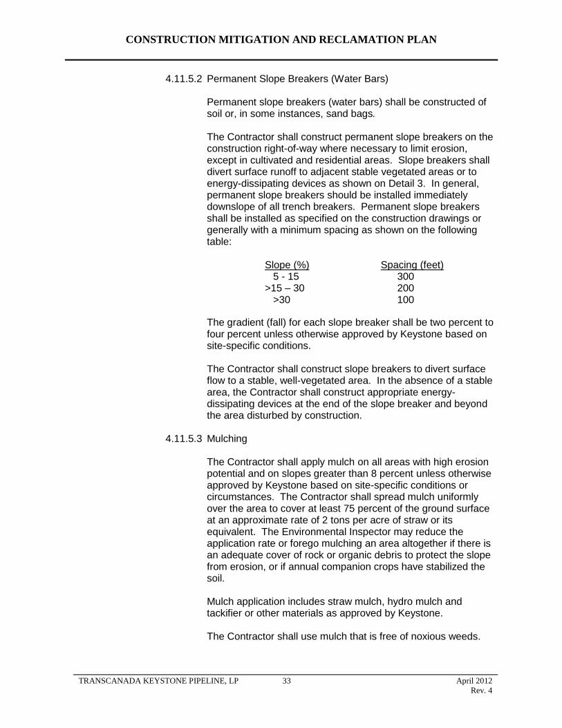
CONSTRUCTION MITIGATION AND RECLAMATION PLAN
4.11.5.2 Permanent Slope Breakers (Water Bars)
Permanent slope breakers (water bars) shall be constructed of soil or, in some instances, sand bags.
The Contractor shall construct permanent slope breakers on the construction right-of-way where necessary to limit erosion, except in cultivated and residential areas. Slope breakers shall divert surface runoff to adjacent stable vegetated areas or to energy-dissipating devices as shown on Detail 3. In general, permanent slope breakers should be installed immediately downslope of all trench breakers. Permanent slope breakers shall be installed as specified on the construction drawings or generally with a minimum spacing as shown on the following table:
Slope (%) Spacing (feet) 5 - 15 300
>15 – 30 200 >30 100
The gradient (fall) for each slope breaker shall be two percent to four percent unless otherwise approved by Keystone based on site-specific conditions.
The Contractor shall construct slope breakers to divert surface flow to a stable, well-vegetated area. In the absence of a stable area, the Contractor shall construct appropriate energy-dissipating devices at the end of the slope breaker and beyond the area disturbed by construction.
4.11.5.3 Mulching
The Contractor shall apply mulch on all areas with high erosion potential and on slopes greater than 8 percent unless otherwise approved by Keystone based on site-specific conditions or circumstances. The Contractor shall spread mulch uniformly over the area to cover at least 75 percent of the ground surface at an approximate rate of 2 tons per acre of straw or its equivalent. The Environmental Inspector may reduce the application rate or forego mulching an area altogether if there is an adequate cover of rock or organic debris to protect the slope from erosion, or if annual companion crops have stabilized the soil.
Mulch application includes straw mulch, hydro mulch and tackifier or other materials as approved by Keystone.
The Contractor shall use mulch that is free of noxious weeds.
TRANSCANADA KEYSTONE PIPELINE, LP 33 April 2012
Rev. 4
CONSTRUCTION MITIGATION AND RECLAMATION PLAN
The Contractor shall apply mulch immediately following seeding. The Contractor shall not apply mulch in wetlands.
If a mulch blower is used, the majority of strands of the mulching material shall not be shredded to less than 8 inches in length to allow anchoring. The Contractor shall anchor mulch immediately after application to minimize loss by wind and water.
When anchoring (straw crimping) by mechanical means, the Contractor shall use a tool specifically designed for mulch anchoring with flat, notched disks to properly crimp the mulch to a depth of 2 to 3 inches. A regular farm disk shall not be used to crimp mulch. The crimping of mulch shall be performed across the slope of the ground, not parallel to it. In addition, in areas of steep terrain, tracked vehicles may be used as a means of crimping mulch (equipment running up and down the hill to leave crimps perpendicular to the slope), provided they leave adequate coverage of mulch.
In soils possessing high erosion potential, the Contractor may be required to make two passes with the mulch-crimping tool; passes must be as perpendicular to the others as possible.
When anchoring with liquid mulch binders (tackifiers), the Contractor shall use a biodegradable tackifier derived from a vegetable-based, organic source. The Contractor shall apply mulch binders at rates recommended by the manufacturer.
The Contractor shall limit the use of tackifiers for anchoring straw and the use of hydromulch and tackifier to areas that are too steep or rocky to safely or effectively operate mechanical mulch-anchoring tools. No asphalt-based tackifiers shall be used on the Project.
4.11.5.4 Erosion Control Matting
Erosion control matting shall be applied where shown on the construction drawings as shown on Detail 4. The Contractor shall anchor the erosion control matting with staples or other approved devices.
The Contractor shall use erosion control matting made of biodegradable, natural fiber such as straw or coir (coconut fiber).
The Contractor shall prepare the soil surface and install the erosion control matting to ensure it is stable and the matting makes uniform contact with the soil of the slope face or stream bank with no bridging of rills, gullies, or other low areas.
TRANSCANADA KEYSTONE PIPELINE, LP 34 April 2012
Rev. 4
CONSTRUCTION MITIGATION AND RECLAMATION PLAN
4.11.5.5 Riprap and Stream Bank Stabilization
Disturbed banks of streambeds and waterbodies shall be restored to their approximate original contours unless otherwise directed. Erosion protection shall be applied as specified in the construction drawings.
Most restored banks will be protected through the use of flexible channel liners installed as specified in Detail 19.
If the original stream bank is excessively steep and unstable and/or flow conditions are severe, a more stable final contour may be specified and alternate stabilization measures may be installed.
Alternate stabilization measures may consist of rock riprap, bio-stabilization, or engineered structures such as brush layering, logwalls, cribwalls, or vegetated geo-grids. See Details 20, 23, and 24.
Stream bank riprap structures shall consist of a layer of stone underlain with approved filter fabric or a gravel filter blanket. Riprap shall extend from the stabilized streambed to the top of the stream bank. Native rock shall be utilized wherever practicable.
4.11.6 Fences
Upon completion of all backfilling, cleanup, and restoration, including mulching and seeding of the construction right-of-way, permanent repairs shall be made to all fences by using either the original material or good quality new material similar to existing fences.
Historic fences shall be carefully reassembled by hand from the original material. Where the original material has deteriorated to a state that makes it unsalvageable, replacement material similar to the original shall be used if possible.
4.11.7 Farm Terraces
Keystone will work with landowners and farm service agencies to ensure restoration of farm terraces to their pre-construction function. Keystone may elect to negotiate a fair settlement with the landowner to employ a local land leveling contractor to restore the terrace.
Before any groundwork is performed in areas with farm terraces, Keystone will conduct a civil survey to document the location and contours of each terrace. Both the channel contour and the terrace berm will be surveyed within the construction right-of-way and up to 100 feet on either side of the ROW boundaries. The pre-construction survey will
TRANSCANADA KEYSTONE PIPELINE, LP 35 April 2012
Rev. 4
provide a baseline to ensure the proper restoration of the terrace following construction.
CONSTRUCTION MITIGATION AND RECLAMATION PLAN
The Contractor will maintain the pre-disturbance drainage of water along the terrace channel and will install temporary flume pipe for this purpose. As necessary, temporary erosion control measures such as water bars and sediment barriers will be installed and maintained throughout construction to reduce the potential for soil erosion along or off the construction ROW.
Following installation of the pipe, the trench will be backfilled, and the Contractor will restore the terrace contours as agreed to with the landowner.
Should the landowner agree to have a local contractor restore the terraces, the Contractor will backfill the trench and restore the terrace using typical compaction methods for pipeline construction with the understanding that the landowner’s contractor will re-excavate the location and re-install the terrace utilizing land levelling equipment and special compaction methods.
Should the landowner desire the Contractor to restore the terraces, the pipeline contractor will compact the trench before the terrace berm is replaced. Following restoration of the terraces, final contours and grades will be re-surveyed and documented with survey notes. Keystone will perform post-construction monitoring and inspection with the landowner’s concurrence. Should the terraces require further work, Keystone will either compensate the landowner to perform the work or arrange for a local contractor to perform the work.
4.11.8 Right-of-Way and Pipeline Markers
Upon completion of all backfilling, cleanup and restoration, including mulching and seeding of the construction right-of-way, and during the time when the Contractor is making permanent repairs to fences, the Contractor shall install pipeline markers on each side of all roads, railroads, fence lines, stream crossings, and other areas where the pipeline markers do not conflict with intended land use.
4.12 Pasture and Range Lands
The following mitigative measures shall be implemented in addition to the requirements previously stated in Sections 4.1 thru 4.11 unless otherwise approved by Keystone based on site-specific conditions or circumstances. All work shall be conducted in accordance with applicable permits.
Access across the right-of-way during construction shall be provided at locations requested by landowners, if practicable.
Shavings produced during pipe bevel operations are to be removed immediately to ensure that livestock and wildlife do not ingest this material.
TRANSCANADA KEYSTONE PIPELINE, LP 36 April 2012
Rev. 4

CONSTRUCTION MITIGATION AND RECLAMATION PLAN
Litter and garbage shall be collected and removed from the construction site at the end of the day’s activities.
Temporary gates shall be installed at fence lines for access to the construction right-of-way. These gates shall remain closed at all times. Upon completion of construction, the temporary gates shall be removed and the permanent fence replaced.
Feeding or harassment of livestock or wildlife is prohibited.
Construction personnel shall not be permitted to have firearms or pets on the construction right-of-way.
All food and wastes shall be stored and secured in vehicles or appropriate facilities.
Areas of disturbance in native range shall be seeded with a native seed mix after topsoil replacement.
Improved pasture shall be seeded with a seed mix approved by individual landowners.
4.13 Forested Lands
Mitigation measures are required to ensure that pipeline construction activities have a minimal impact on forested lands.
Clearing, grubbing, and grading of trees, brush, and stumps shall be performed in accordance with the following mitigative measures in addition to the requirements previously stated in Sections 4.1 thru 4.11 unless otherwise approved or directed by Keystone based on site-specific conditions or circumstances. Keystone will address mitigation, reclamation and remediation measures with individual landowners and comply with any applicable state requirements. These measures include non-vegetative remediation to reverse impacts on windbreaks, shelterbelts, and living snow fences. Where the pipeline follows an existing ROW in forested areas, Keystone attempted to route
the pipeline as close as practical to the existing ROW. All work shall be
conducted in accordance with applicable permits.
Prior to the start of clearing activity, right-of-way boundaries, including pre-approved temporary workspaces, shall be clearly staked to prevent disturbance of unauthorized areas.
If trees are to be removed from the construction right-of-way, Keystone shall consult with the landowner or landowner's designate to see if there are trees of commercial or other value to the landowner. Timber shall be salvaged as per landowner request.
If there are trees of commercial or other value to the landowner, Keystone shall allow the landowner the right to retain ownership of the trees with the disposition of the trees to be negotiated prior to the commencement of land clearing and included in the easement agreement.
If not performed by the landowner, the construction right-of-way Contractor may salvage all marketable timber from designated areas.
TRANSCANADA KEYSTONE PIPELINE, LP 37 April 2012
Rev. 4
CONSTRUCTION MITIGATION AND RECLAMATION PLAN
Tree stumps shall be grubbed to a maximum of 5 feet on either side of the trench line and where necessary for grading a level surface for pipeline construction equipment to operate safely.
Keystone shall follow the landowner's or landowner designee's desires as stated in the easement agreement regarding the disposal of trees, brush, and stumps of no value to the landowner by burning, burial, etc., or complete removal from any affected property.
Timber salvage operations shall use cut-off-type saw equipment. Felling shall be undertaken in a manner that minimizes butt shatter, breakage, and off ROW disturbance. Skidders or alternate equipment shall be used to transport salvaged logs to stacking sites.
Trees shall be felled to fall toward the center line of the right-of-way to avoid breaking trees and branches off ROW. Leaners (felled trees that inadvertently fall into adjacent undisturbed vegetation) shall be salvaged.
Trees and slash falling outside the right-of-way shall be recovered and disposed..
Salvaged logs shall be limbed and topped before removal from the construction right-of-way. Log decks (if required) shall be oriented to best facilitate loading by picker trucks and be located adjacent to the working side of the right-of-way, where possible.
The Contractor shall not be allowed to dispose of woody debris in wooded areas along the pipeline right-of-way.
Pruning of branches hanging over the right-of-way shall be done only when necessary for construction. Any branch that is broken or seriously damaged should be cut off near its fork and the collar of the branch preserved.
All tree wastes, stumps, tree crowns, brushes, branches, and other forest debris shall be either burned, chipped (using a mobile chipper), or removed from the right-of-way according to Keystone instructions contained in the specific mitigation measures. Burial of this waste material on the site by the Contractor shall require the landowner’s authorization. Chips must not be spread over cultivated land. However, they may be spread and incorporated with mineral soil over the forest floor at a density that shall not prevent revegetation of grass.
Stump removal and brush clearing shall be done with bulldozers equipped with brush rakes to preserve organic matter.
Decking sites shall be established: (1) approximately 2000 feet apart in timbered areas; (2) on sites located on approved temporary workspace in existing cleared areas; (3) in non-merchantable stands of timber; or (4) if no other options are available, in merchantable timber stands. Deck sites shall be appropriately sized to accommodate the loading equipment.
If the landowner does not want the timber, the Contractor shall remove decked timber from the construction right-of-way and transport it to a designated all-weather access point or mill
4.14 Residential and Commercial/Industrial Areas
4.14.1 Residential and Commercial Areas
TRANSCANADA KEYSTONE PIPELINE, LP 38 April 2012
Rev. 4
The principal measures that shall be used to mitigate impacts on existing residential and commercial areas include the following unless otherwise directed or approved by Keystone based on site-specific conditions or circumstances. All work shall be conducted in accordance with applicable permits.
notifying landowners prior to construction;
posting warning signs as appropriate;
reducing the width of construction right-of-way, if practicable, by eliminating the construction equipment passing lane, reducing the size of work crews, or utilizing the “stove pipe” or “drag section” construction techniques;
removing fences, sheds, and other improvements as necessary for protection from construction activities;
to the extent possible, preserving mature trees and landscaping while ensuring the safe operation of construction equipment;
fencing the edge of the construction work area that is within 25 feet to a residence for a distance of 100 feet on either side of the residence to ensure that construction equipment and materials, including the spoil pile, remain within the construction work area;
limiting the hours during which operations with high-decibel noise levels (i.e., drilling and boring) can be conducted;
limiting dust impact through prearranged work hours and by utilizing dust minimization techniques;
ensuring that construction proceeds quickly through such areas, thus minimizing exposure to nuisance effects such as noise and dust;
maintaining access and traffic flow during construction activities, particularly for emergency vehicles;
cleaning up construction trash and debris daily;
fencing or plating open ditches during non-construction activities;
if the pipeline centerline is within 25 feet of a residence, ensuring that the trench is not excavated until the pipe is ready for installation and that the trench shall be backfilled immediately after pipe installation; and
immediately after backfilling the trench, restoring all lawn areas, shrubs, specialized landscaping, fences, and other structures within the construction work area to its pre-construction appearance or the requirements of the landowner. Restoration work shall be done by personnel familiar with local horticultural and turf establishment practices.
to the extent possible, preserving mature trees and landscaping while ensuring the safe operation of construction equipment;
4.14.2 Site-Specific Plans
CONSTRUCTION MITIGATION AND RECLAMATION PLAN
TRANSCANADA KEYSTONE PIPELINE, LP 39 April 2012
Rev. 4

CONSTRUCTION MITIGATION AND RECLAMATION PLAN
For any residence or commercial/industrial building closer than 25 feet to the construction work area, Keystone shall prepare a site-specific construction plan. The plan shall include:
a description of construction techniques to be used;
a dimensioned site plan that shows, at a minimum:
a description of how Keystone would ensure that the trench is not excavated until the pipe is ready for installation and that the trench is backfilled immediately after pipe installation.
the location of the residence or commercial/industrial area in relation to the new pipeline;
the edge of the construction work area;
the edge of the new permanent construction right-of-way; and
other nearby topographical obstacles including landscaping, trees, structures, roads, parking areas, ditches, and streams; and
4.14.3 Landowner Complaint Resolution Procedure
Keystone shall implement a landowner complaint procedure as follows:
Landowners should first contact the construction spread office to express their concern over restoration or mitigation of environmental damages on their property. The Construction Manager or his designated representative shall respond to the landowner within 24 hours of receipt of the phone call.
If the landowner has not received a response or is not satisfied with the response, he can contact Keystone’s representative at 1-877-880-4881. The landowner should expect a response within 48 hours.
4.15 Fragile Soil Clean-up and Reclamation/Revegetation
4.15.1 General
Fragile soil types are a result of the high percentage of sand content that exists within the surficial soil. Theses soil types exist within regions found in southern South Dakota and central Nebraska and fragile due to their inherent high wind and water erosion potential, low water holding capacity and arid nature of the region, rolling to steep terrain and usually consists of predominantly native prairie landscapes and supports a variety of uses such as livestock grazing, wildlife habitat and recreational opportunities.
4.15.2 Right-of-way Construction
KXL will educate construction personnel regarding these areas and the necessity to strictly adhere to Project Best Management Practices (BMPs) designed to minimize impacts.
TRANSCANADA KEYSTONE PIPELINE, LP 40 April 2012
Rev. 4
CONSTRUCTION MITIGATION AND RECLAMATION PLAN
Minor route re-alignments will be incorporated through these areas to avoid particularly erosion-prone locations, such as ridge tops and existing blowouts as much as practicable.
KXL will avoid highly saturated areas, such as wetland, to the maximum extent possible.
Construction soil handling procedures will strive to reduce the width of disturbance to the native prairie landscape by adopting “Trench-line or Blade-width stripping procedures where practicable.
Topsoil conservation will be conducted on all areas where excavation occurs.
Topsoil piles will be protected from erosion through matting, mulching, watering or tackifying as deemed practicable.
Traffic management limitations will be employed on specific areas possessing high erosion potential or sensitive habitat.
4.15.3 Right-of-Way Reclamation
Native seed mixes will be developed with input from the local NRCS offices and through collaboration with regional experts. All seed will be certified noxious weed-free and will be calculated on a pure live seed (PLS) basis.
Straw or native prairie hay may be used as mulch, applied to the right-of-way and crimped into the soil to prevent wind erosion. All mulch will be documented as noxious weed-free.
Land imprinting may be employed to create impressions in the soil, thereby reducing erosion, improving moisture retention and creating micro-sites for seed germination.
Sediment logs or straw wattles will be used in place of slope breakers (short terraces) that are constructed of soil. Using sediment logs will result in less soil disturbance to the right-of-way.
Photodegradable matting will be applied on steep slopes or areas prone to extreme wind exposure such as north- or west-facing slopes and ridge tops. Biodegradable pins will be used in place of metal staples to hold the matting in place.
Keystone will work with landowners to evaluate fencing the right-of-way from livestock, or alternatively, provide compensation to rest a pasture until vegetation can become established. Management concerns such as livestock access to water or movement within a pasture would be incorporated as necessary.
4.15.4 Post-Construction
Keystone is committed to post-construction monitoring and repair and will monitor reclamation on the right-of-way for several years and repair
TRANSCANADA KEYSTONE PIPELINE, LP 41 April 2012
Rev. 4
CONSTRUCTION MITIGATION AND RECLAMATION PLAN
erosion and reseed poorly revegetated areas as necessary. During monitoring, landowners are informed of our efforts and intentions.
A noxious weed management plan will be established on these lands pending consultation with state and county experts
4.16 Operations and Maintenance
Operations and maintenance programs, such as vegetation management, pipeline maintenance, integrity surveys, and hydrostatic testing, may have an impact on the final reclamation of the right-of-way. To ensure the integrity of the facility and land surface reclamation of the right-of-way is maintained after completion of construction and that regulatory requirements are adhered to during operations, the following measures shall be implemented unless otherwise directed by Keystone in response to site-specific conditions or circumstances. All work shall be conducted in accordance with applicable permits.
Keystone shall monitor the pipeline right-of-way and all stream crossings for erosion or other potential problems that could affect the integrity of the pipeline. Any erosion identified shall be reclaimed as expediently as practicable by Keystone or by compensating to the landowner to reclaim the area.
Trench depressions on ditch line that may interfere with natural drainage, vegetation establishment, or land use shall be repaired as expediently as practicable by Keystone or by compensating the landowner to repair the area.
Post-construction monitoring inspections shall be conducted after the first growing season to determine the success of revegetation, unless otherwise required by permit. Areas which have not been successfully re-established shall be revegetated by Keystone or by compensation of the landowner to reseed the area. If, after the first growing season, revegetation is successful, no additional monitoring shall be conducted unless otherwise required by permit.
In non-agricultural areas, revegetation shall be considered successful if, upon visual survey, the density and cover of non-nuisance vegetation are similar in density and cover to adjacent undisturbed lands, unless otherwise required by permit.
In agricultural areas, revegetation shall be considered successful if crop yields are similar to adjacent undisturbed portions of the same field.
Restoration shall be considered successful if the surface condition is similar to adjacent undisturbed lands, construction debris is removed (unless requested otherwise by the landowner or land managing agency), revegetation is successful, and drainage has been restored.
Weed control measures shall be implemented as required by any applicable plan and in conjunction with the landowner.
Keystone shall be responsible for correcting tile line or irrigation system
TRANSCANADA KEYSTONE PIPELINE, LP 42 April 2012
Rev. 4

CONSTRUCTION MITIGATION AND RECLAMATION PLAN
repairs that fail, provided those repairs were made by Keystone. Keystone shall not be responsible for tile line or irrigation system repairs which Keystone compensated the landowner to perform.
When requested by owners in cultivated land, Keystone shall monitor the yield of land impacted by construction with the help of agricultural specialists. If yield deficiencies are indicated compared to yields on unaffected land, Keystone will compensate the landowner for reduced yields and shall implement procedures to return the land to equivalent capability.
In residential areas, landowners may use the right-of-way provided they do not interfere with the rights granted to Keystone. Trees, bushes, structures, including houses, tool sheds, garages, poles, guy wires, catch basins, swimming pools, trailers, leaching fields, septic tanks, and any other objects not easily removable, shall not be permitted on the permanent construction right-of-way without the written permission of Keystone, because they could impair access for maintenance of the pipeline.
Keystone shall maintain communication with the landowner and tenant throughout the operating life of the pipeline to allow expedient communication of issues and problems as they occur. Keystone shall provide the landowner with corporate contact information for these purposes. Keystone shall work with landowners to prevent excessive erosion on lands disturbed by construction. Reasonable methods shall be implemented to control erosion. These may not be implemented if the property across which the pipeline is constructed is bare cropland which the landowner intends to leave bare until the next crop is planted.
If the landowner and Keystone cannot agree upon a reasonable method to control erosion on the landowner's property, the recommendations of the appropriate NRCS office shall be considered by Keystone and the landowner.
5.0 DRAIN TILE SYSTEMS
5.1 General
If underground drainage tile is damaged by the pipeline installation, it shall be repaired in a manner that ensures the tile line's proper operating condition at the point of repair. Keystone may elect to negotiate a fair settlement with the affected county or landowner for repair of the damaged drain tile. In the event the landowner chooses to have the damaged tile repaired by Keystone, the Contractor shall follow these guidelines and procedures to identify the location of drain tiles, to mitigate damages to drain tiles prior to and during construction, to repair drain tiles damaged during installation of the pipeline, to inspect the proper repair of drain tiles, and to provide post-construction monitoring to determine any impacts caused by repair of drain tiles. Since all public and private drain tile systems are unique, i.e., varying age, depth of cover, type of material, geometry on the land, etc., it is not possible to develop a standard procedure for resolving each county’s or landowner’s drain tile issues. These guidelines provide a basis on which to develop site specific methodology to mitigate damage and to repair drain tiles affected by construction of the Project. A typical right-of-way layout and typical orientation for crossing drain tiles is provided in Detail 25. Typical header and main
TRANSCANADA KEYSTONE PIPELINE, LP 43 April 2012
Rev. 4

CONSTRUCTION MITIGATION AND RECLAMATION PLAN
crossovers are provided in Details 26 and 27. Actual measures will be developed based on site-specific information unique to specific installations. However, all work will be conducted in accordance with applicable permits.
5.2 Identification and Classification of Drain Tile Systems
Personnel shall attempt to identify and classify existing drain tile systems by meeting with local public officials and county engineers, and individual private landowners and tenants.
5.2.1 Publicly Owned Drain Tiles
Personnel shall identify and meet with the responsible county or local authority responsible for publicly owned drain tiles. Publicly owned drain tiles shall be identified and documented on the Project’s 1” = 2000’ USGS quad strip maps and additional data collected for input into an electronic spreadsheet by county, township, range, and section; responsible agency; and size, type, and depth of cover (if known). This data shall be cross-referenced to the centerline survey to be completed by Keystone. Additionally, any public records including maps or easement instruments on the drain tiles shall be acquired as well as any requirements of the local authority for installation of the pipeline.
5.2.2 Privately Owned Drain Tiles
Right-of-way agents shall meet with landowners and tenants of privately owned land along the route. As a minimum, the right-of-way agents shall ascertain the data concerning drain tiles outlined in a landowner questionnaire. The questionnaire requests data concerning: type of drain tile system; size, type of material, and depth of cover; preference for repair of drain tiles; and identification of local drain tile contractors. These data shall be collected into an electronic spreadsheet for utilization by right-of-way personnel in negotiating payments for easements and damages and by engineering or construction personnel for inclusion in specifications for the construction Contractor.
5.3 Mitigation of Damage to Drain Tile Systems
Keystone shall undertake mitigation measures to reduce damage to publicly and privately owned drain tile systems prior to and during installation of the pipeline.
5.3.1 Non-interference with Drain Tile
The Project shall be installed at a depth of cover and elevation so as not to interfere with the elevation and grade of existing drain tiles where practicable. Where not practicable, Keystone shall pursue alternative mitigation measures mutually acceptable to the landowner and jurisdictional agencies. Typically, the pipeline shall be installed below the elevation of drain tiles with a minimum clearance of 12 inches. Detail 25, Typical Right-of-Way Layout/Soil Handling, represents a typical drain tile crossing by the
TRANSCANADA KEYSTONE PIPELINE, LP 44 April 2012
Rev. 4
CONSTRUCTION MITIGATION AND RECLAMATION PLAN
pipeline with additional temporary work space to facilitate handling of topsoil and trench spoil created by the additional depth of cover for the pipeline.
5.3.2 Non-disturbance of Drain Tile Mains
Publicly owned and privately owned drain tile mains shall be identified through the processes identified in Section 5.2. Drain tile mains are essential to the overall drainage system of a land area and if disturbed, may require excessive pumping/dewatering of the pipe trench unless temporarily repaired and maintained until permanently repaired.
Keystone shall review drain tile mains and consider their size, flow rate, type of material, depth of cover, and geographic location. If determined to be practicable and reasonable for construction, the drain tile main shall not be cut and repaired during mainline installation (a pipe section shall be left out and installed by a tie-in crew without damaging the drain tile main).
5.3.3 Relocation or Replacement of Existing Drain Tiles Prior to Construction
In many instances, drain tile systems that have been installed after the installation of adjacent existing pipelines were installed with “headers” parallel to the existing pipeline with periodic jump overs as depicted on Detail 26, Header/Main Crossovers of Keystone XL Pipeline. The distance of these headers from the existing pipeline may vary.
Some of these drain tile headers may be most effectively relocated and/or replaced to the east of the Project. The existing header will be capped and made into a single drain tile as depicted on Detail 27, Relocate/Replace Drainage Header/Main. This could reduce the number of drain tile crossings on a particular landowner’s property by a significant quantity, thereby reducing the risk that repairs will fail.
5.3.4 Future Drain Tiles/Systems
Keystone shall attempt to determine where public agencies and private landowners or tenants are proposing to install drain tile systems in the future. These locations shall be input into an electronic spreadsheet by county, township, range, and section; landowner or responsible public agency; and proposed size and depth of cover. Keystone shall endeavor to construct the pipeline at a depth and elevation to accommodate the future installation of the proposed drain tile systems.
5.3.5 Other Mitigation Measures
Other mitigation measures that may be implemented during installation of the pipeline are as follows:
not removing topsoil from the working side of the construction right-of-way to prevent crushing of drain tile by heavy equipment;
spreading ditch and spoil side topsoil (not subsoil) over the working side to provide additional soil depth to protect existing drain tiles;
TRANSCANADA KEYSTONE PIPELINE, LP 45 April 2012
Rev. 4

CONSTRUCTION MITIGATION AND RECLAMATION PLAN
restricting the work of the pipe lower in crew if ground conditions are too wet to adequately support the heavy equipment;
limiting travel of heavy equipment the working lane of the construction right-of-way where possible;
limiting travel of heavy equipment to one pass over the drain tile per work crew where possible; and
removing and replacing topsoil during drain tile replacement should tile be crushed on the working side of the right-of-way.
5.4 Responsibility for Repair of Drain Tile Systems
Temporary and permanent drain tile repairs shall be the responsibility of the Contractor. The physical repairs shall be made by qualified and experienced drain tile repair personnel.
5.4.1 Local Drain Tile Contractor Repair
Keystone shall identify and qualify local drain tile contractors in the geographical area of the pipeline route from interviews with local public officials, landowners, tenants, and drain tile contractors. The preferred responsibility for permanent repair of drain tiles shall be for the pipeline Contractor to subcontract the supervision and repair to local reputable drain tile contractors acceptable to the landowners and tenants.
5.4.2 Pipeline Contractor Repair
In the event local drain tile contractors are not available to subcontract the supervision and repair, permanent repair shall be made with the Contractor’s supervision, equipment, and labor.
5.4.3 Landowner/Tenant Repair
The landowner or tenant may agree to take responsibility for the permanent repair of his drain tiles if not precluded by regulatory agency. The landowner or tenant shall be requested to ensure his ability to coordinate and complete the drain tile repair in a timely manner to allow the pipeline Contractor to completely backfill the damaged drain tile for repair by landowner/tenant in the immediate future. Keystone shall require that its representative be present to ensure the permanent drain tile repairs are made in accordance with the minimum requirements of this manual.
5.5 Drain Tile Repairs
The Contractor shall endeavour to locate all tile lines within the construction right-of-way prior to and during installation so repairs can be made if necessary.
5.5.1 Temporary Repairs During Construction
Drain tiles damaged or cut during the excavation of the trench shall be marked with a lath and ribbon in the spoil bank. Care shall be taken to
TRANSCANADA KEYSTONE PIPELINE, LP 46 April 2012
Rev. 4
locate markers where the chance of disturbance shall be minimized and a written record maintained of each drain tile crossing. A work crew following the pipeline trench crew shall complete a temporary repair to allow continuing flow. Detail 28, Temporary Drain Tile Repair, depicts the materials and installation procedure to complete the temporary repair. If a drain tile line shall not be temporarily repaired, the open ends of the drain tile shall be screened to prevent entry of foreign materials and small animals.
5.5.2 Permanent Repairs
Permanent repairs shall be made for all drain tiles damaged by installation of the pipeline.
5.5.2.1 Ditch Line Only Repairs
If water is flowing through a damaged tile line, the tile line shall be immediately and temporarily repaired until such time that permanent repairs can be made. If tile lines are dry and water is not flowing, temporary repairs are not required if the permanent repair is made within 7 days of the time damage
occurred. The temporary repair shall be removed just prior to lowering in the pipeline.
Drain tiles must be permanently repaired before the pipeline trench is backfilled and within 14 days of construction completion, weather and soil conditions permitting. All tile lines shall be repaired with materials of the same or better quality as that which was damaged. The drain tile marker shall not be removed until the tile repairs have been inspected, approved, and accepted by Keystone’s inspectors, the county inspectors, where applicable, and the landowner or tenant. Detail 29, Permanent Repair Method of Drain Tiles, depicts the minimum materials and installation procedure to complete a permanent repair.
5.5.2.2 Ditch Line and Temporary Work Space Repairs
Prior to making the permanent drain tile repair, the Contractor shall probe a segmented sewer rod with a plug that is not more than 15% smaller than the internal diameter of the drain tile to determine if additional damage has occurred to the drain tile. If the probe does not freely insert into the drain tile across the temporary workspace of pipeline construction, the Contractor shall excavate, expose, and repair the damaged drain tile to its original or better condition.
CONSTRUCTION MITIGATION AND RECLAMATION PLAN
TRANSCANADA KEYSTONE PIPELINE, LP 47 April 2012
Rev. 4
CONSTRUCTION MITIGATION AND RECLAMATION PLAN
5.6 Inspection/Acceptance of Drain Tile Repairs
Drain tile repairs shall be inspected by Keystone construction inspectors, county inspectors, as applicable, and the landowner or tenant or his representative.
Keystone shall designate inspector(s) for the sole purpose and responsibility for inspection of all repairs of drain tiles. These inspectors shall be, if possible, employed from local drain tile installation contractors, local farmers with extensive drain tile experience, or previously employed or retired employees of local jurisdictions familiar with drain tile installation and repair. In the event that a sufficient quantity of inspectors from these sources is not available, Keystone shall conduct in-the-field training seminars on drain tile repair for additional inspection personnel.
Inspection personnel shall observe the permanent repair of all drain tiles to ensure the replacement drain tile is: (1) the proper size and type; (2) installed at the proper grade; (3) properly supported and backfill beneath the drain tile is properly placed and compacted; and (4) properly tied into the existing drain tile. The inspection shall be documented on the Drain Tile Inspection Report Form.
A drain tile repair shall not be accepted until Keystone’s construction inspector and the landowner or tenant or designated representative approves the inspection form.
TRANSCANADA KEYSTONE PIPELINE, LP 48 April 2012
Rev. 4
CONSTRUCTION MITIGATION AND RECLAMATION PLAN
6.0 WETLAND CROSSINGS
6.1 General
Wetland boundaries shall be clearly marked in the field with signs and/or highly visible flagging during construction.
In the event a waterbody crossing is located within or adjacent to a wetland crossing, the measures of both Section 6 - Wetland Crossings and Section 7 -Waterbodies and Riparian Lands shall be implemented to the extent practicable.
A dry wetland is defined in Section 6.5.1. In these wetlands, equipment can traverse the wetland without the support of mats or timber riprap.
A standard wetland environment typically has soils that are saturated and non-cohesive. Difficult trenching conditions are likely resulting in excessively wide trenches. In these wetland environment types, supplemental support in the form of timber riprap or prefabricated equipment mats may be required for construction equipment to safely and efficiently operate.
A flooded wetland involves the presence of standing water over much of the wetland area. Equipment typically cannot traverse the wetland and must generally move around that portion of the area. Access is typically limited to marsh backhoes or equipment working from flexifloats or equivalents.
Keystone may allow modification of the following specifications as necessary to accommodate site-specific conditions or procedures. Any modifications must still comply with all applicable regulations and permits.
6.2 Easement and Workspace
The Contractor shall maintain wetland boundary markers during construction in all areas and until permanent seeding is complete in non-cultivated areas.
The width of the construction right-of-way shall be reduced to 85 feet or less in standard wetlands unless non-cohesive soil conditions require utilization of a greater width and unless the USACE or other regulatory authority authorizes a greater width.
The Contractor shall locate extra work areas (such as staging areas and additional spoil storage areas) shall be at least 10 feet away from wetland boundaries, where topographic conditions permit.
The Contractor shall limit clearing of vegetation between extra work areas and the edge of the wetland to the construction right-of-way and limit the size of extra work areas to the minimum needed to construct the wetland crossing.
TRANSCANADA KEYSTONE PIPELINE, LP 49 April 2012
Rev. 4
CONSTRUCTION MITIGATION AND RECLAMATION PLAN
6.3 Vehicle Access and Equipment Crossing
The only access roads, other than the construction right-of-way, that the Contractor shall use in wetlands are those existing public roads and private roads acquired by Keystone from the landowner shown on the construction drawings.
To the extent practicable, the Contractor’s construction equipment operating in saturated wetlands or wetlands with standing water shall be limited to that needed to clear the construction right-of-way, dig the trench, fabricate and install the pipeline, backfill the trench, and restore the construction right-of-way.
If equipment must operate within a wetland containing standing water or saturated soils, the Contractor shall use the following methods for equipment access unless otherwise approved by Keystone based on site-specific conditions:
wide-track or balloon-tire construction equipment; and
conventional equipment operated from timber and slash (riprap) cleared from the right-of-way, timber mats, or prefabricated equipment mats.
6.4 Temporary Erosion and Sediment Control
The Contractor shall install sediment barriers across the entire construction right-of-way immediately upslope of the wetland boundary at all standard wetland crossings, as necessary, to prevent sediment flow into the wetland. Sediment barriers must be properly maintained by the Contractor throughout construction and reinstalled as necessary. In the travel lane, these may incorporate removable sediment barriers or drivable berms. Removable sediment barriers can be removed during the construction day, but shall be re-installed after construction has stopped for the day or when heavy precipitation is imminent. The Contractor shall maintain sediment barriers until replaced by permanent erosion controls or restoration of adjacent upland areas is complete. The Contractor shall not install sediment barriers at wetlands designated as “dry” unless otherwise specified by Keystone.
Where standard wetlands are adjacent to the construction right-of-way, the Contractor shall install sediment barriers along the edge of the construction right-of-way as necessary to prevent a sediment flow into the wetland.
6.5 Wetland Crossing Procedures
The following general mitigative procedures shall be followed by the Contractor in all wetlands unless otherwise approved or directed by Keystone based on site-specific conditions. All work shall be conducted in accordance with applicable permits.
limit the duration of construction-related disturbance within wetlands to the extent practicable;
TRANSCANADA KEYSTONE PIPELINE, LP 50 April 2012
Rev. 4

CONSTRUCTION MITIGATION AND RECLAMATION PLAN
use no more than two layers of timber riprap to stabilize the construction right-of-way;
cut vegetation off at ground level leaving existing root systems in place and remove it from the wetland for disposal;
limit pulling of tree stumps and grading activities to directly over the trench line unless safety concerns require the removal of stumps from the working-side of the construction ROW;
segregate a maximum of 12 inches of topsoil from the area disturbed by trenching in dry wetlands, where practicable;
restore topsoil to its approximate original stratum, after backfilling is complete;
dewater the trench in a manner to prevent erosion and heavily silt-laden flowing directly into any wetland or waterbody;
remove all timber riprap and prefabricated equipment mats upon completion of construction;
locate hydrostatic test manifolds outside wetlands and riparian areas to the maximum extent practicable;
prohibit storing hazardous materials, chemicals, fuels, lubricating oils, or perform concrete coating activities in a wetland, or within 100 feet of any wetland boundary;
perform all equipment maintenance and repairs upland locations at least 100 feet from waterbodies and wetlands;
avoid parking equipment overnight within 100 feet of a watercourse or wetland;
prohibit washing equipment in streams or wetlands;
install trench breakers and/or seal the trench to maintain the original wetland hydrology, where the pipeline trench may drain a wetland;
attempt to refuel all construction equipment in an upland area at least 100 feet from a wetland boundary (otherwise follow the procedures outlined in Section 3); and
avoid sand blasting in wetlands to the extent practicable. If sandblasting is performed within a wetland, the Contractor shall place a tarp or suitable material in such a way as to collect as much waste shot as possible and dispose of the collected waste. The Contractor shall clean up all visible deposits of wastes and dispose of the waste at an approved disposal facility.
Specific procedures for each type of wetland crossing method are listed below and shall be designated on the construction drawings but may be modified depending on site conditions at the time of construction. All work shall be conducted in accordance with applicable permits.
6.5.1 Dry Wetland Crossing Method
TRANSCANADA KEYSTONE PIPELINE, LP 51 April 2012
Rev. 4

CONSTRUCTION MITIGATION AND RECLAMATION PLAN
Topsoil shall be segregated. Pipe stringing and fabrication may occur within the wetland adjacent to the trench line or adjacent to the wetland in a designated extra workspace.
The dry wetland crossing procedure depicted in Detail 8 shall be used where this type of wetland is identified on the construction drawings. The following are exceptions to standard wetland crossing methods:
The width of the construction right-of-way for upland construction is maintained through the wetland.
Where extra work areas (such as staging areas and additional spoil storage areas) are designated on the construction drawings, they may be placed no closer than 10 feet from the wetland's edge.
Seeding requirements for agricultural lands shall be applied to farmed wetlands.
6.5.2 Standard Wetland Crossing Method
Topsoil stripping is impracticable due to the saturated nature of the soil. Pipe stringing and fabrication may occur within the wetland adjacent to the trench line or adjacent to the wetland in a designated extra workspace. Based upon the length of a standard wetland crossing and presence of sufficient water to float the pipe, the Contractor may elect to install a standard wetland crossing utilizing the “push/pull” method.
The standard wetland crossing procedure depicted in Detail 9 shall be used where this type of wetland is identified on the construction drawings.
Procedures unique to standard wetlands include:
limiting construction right-of-way width to a maximum of 85 feet unless site conditions warrant a wider width;
utilizing low-ground-pressure construction equipment or support equipment on timber riprap or timber mats; and
installing sediment barriers across the entire right-of-way where the right-of-way enters and exits the wetland.
6.5.3 Flooded Push/Pull Wetland Crossing Method
Where standing surface water or high groundwater levels make trenching difficult, trench widths up to 35 feet are common. Topsoil stripping is impossible due to the flooded conditions. Pipe stringing and fabrication is required adjacent to the wetland in a designated extra workspace. Using floatation devices, the pipe string is pushed and pulled from the extra workspace to the trench.
The Push/Pull wetland crossing procedure as depicted in Detail 10 shall be used where water is sufficient to float the pipeline in the trench and other site conditions allow.
TRANSCANADA KEYSTONE PIPELINE, LP 52 April 2012
Rev. 4
CONSTRUCTION MITIGATION AND RECLAMATION PLAN
Clean metal barrels or Styrofoam floats may be used to assist in the flotation of the pipe. Metal banding shall be used to secure the barrels or floats to the pipe. All barrels, floats, and banding shall be recovered and removed upon completion of lower in. Backfill shall not be allowed before recovery of barrels, floats, and banding.
6.6 Restoration and Reclamation
All timber riprap, timber mats, and prefabricated equipment mats and other construction debris shall be removed upon completion of construction. As much as is feasible, the Contractor shall replace topsoil and restore original contours with no crown over the trench. Any excess spoil shall be removed from the wetland. The Contractor shall stabilize wetland edges and adjacent upland areas by establishing permanent erosion control measures and revegetation, as applicable, during final clean up.
For each standard wetland crossed, the Contractor shall install a permanent slope breaker and trench breaker at the base of slopes near the boundary between the wetland and adjacent upland areas. The Contractor shall locate the trench breaker immediately upslope of the slope breaker.
The Contractor shall not use fertilizer, lime, or mulch in wetlands unless required in writing by the appropriate land management agency.
All wetland areas within conservation lands or easements will be restored to a level consistent with any additional criteria established by the relevant managing agency.
TRANSCANADA KEYSTONE PIPELINE, LP 53 April 2012
Rev. 4

CONSTRUCTION MITIGATION AND RECLAMATION PLAN
7.0 WATERBODIES AND RIPARIAN AREAS
7.1 General
The Contractor shall comply with requirements of all permits issued for the waterbody crossings by federal, state or local agencies.
Waterbody includes any areas delineated as jurisdictional natural or artificial stream, river, or drainage, and other permanent waterbodies such as ponds and lakes:
Minor Waterbody includes all waterbodies less than or equal to 10 feet wide at the water's edge at the time of construction.
Intermediate Waterbody includes all waterbodies greater than 10 feet wide but less than or equal to 100 feet wide at the water's edge at the time of construction.
Major Waterbody includes all waterbodies greater than 100 feet wide at the water's edge at the time of construction.
In the event a waterbody crossing is located within or adjacent to a wetland crossing, the Contractor, to the extent practicable, shall implement the provisions of both Section 6 - Wetland Crossings and Section 7 - Waterbodies and Riparian Areas.
The Contractor shall supply and install advisory signs in a readily visible location along the construction right-of-way at a distance of approximately 100 feet on each side of the crossing and on all roads which provide direct construction access to waterbody crossing sites. Signs shall be supplied, installed, maintained, and then removed upon completion of the Project. Additionally, signs shall be supplied and installed by the Contractor on all intermediate and major waterbodies accessible to recreational boaters warning boaters of pipeline construction operations.
The Contractor shall not store hazardous materials, chemicals, fuels, lubricating oils, or perform concrete coating within 100 feet of any waterbody. The Contractor shall not refuel construction equipment within 100 feet of any waterbody. If the Contractor must refuel construction equipment within 100 feet of a waterbody, it must be done in accordance with the requirements outlined in Section 3. All equipment maintenance and repairs will be performed in upland locations at least 100 feet from waterbodies and wetlands. All equipment parked overnight shall be at least 100 feet from a watercourse or wetland, if possible. Equipment shall not be washed in streams or wetlands.
Throughout construction, the Contractor shall maintain adequate flow rates to protect aquatic life and to prevent the interruption of existing downstream uses.
Keystone may allow modification of the following specifications as necessary to accommodate specific situations or procedures. Any modifications must comply with all applicable regulations and permits. Keystone will complete site-specific
TRANSCANADA KEYSTONE PIPELINE, LP 54 April 2012
Rev. 4

CONSTRUCTION MITIGATION AND RECLAMATION PLAN
crossing plans for certain waterbody crossings if required by the applicable regulatory agencies during federal or state permitting processes.
7.2 Easement and Work Space
The permanent easement, temporary work space, additional temporary work space, and any special restrictions shall be depicted on the construction drawings. The work shall be contained within these areas and be limited in size to the minimum required to construct the waterbody crossing.
The Contractor shall locate all extra work areas (such as staging areas and additional spoil storage areas) at least 10 feet from the water's edge if practicable.
At all waterbody crossings, the Contractor shall install flagging across the construction right-of-way at least 10 feet from the water’s edge prior to clearing and ensure that riparian cover is maintained where practicable during construction.
7.3 Vehicle Access and Equipment Crossings
The Contractor shall inspect equipment for fluid leaks prior to entering or crossing over waterbodies.
Equipment bridges shall be installed at all flowing waterbodies and as directed by the Keystone EI. Equipment crossings shall be constructed as described in Details 16, 17 and/or 18.
Equipment crossings shall be perpendicular to drainage bottoms wherever possible.
Erosion and sediment control barriers will be installed and maintained around vehicle access points as necessary to prevent sediment from reaching the waterway.
The Contractor shall be responsible for the installation, maintenance, and removal of all temporary access crossings including portable bridges, bridges made from timber or mats, flumes, culverts, sand bags, subsoil, coarse granular material, and riprap.
The Contractor shall ensure that culverts and flumes are sized and installed of sufficient diameter to accommodate the existing flow of water and those that may potentially be created by sudden runoffs. Flumes shall be installed with the inlet and outlet at natural grade if possible.
Where bridges, culverts or flumes are installed across the work area, the Contractor shall be responsible for maintaining them (e.g. preventing collapse, clogging or tilting). All flumes and culverts shall be removed as soon as possible upon completion of construction.
TRANSCANADA KEYSTONE PIPELINE, LP 55 April 2012
Rev. 4
CONSTRUCTION MITIGATION AND RECLAMATION PLAN
The width of the temporary access road across culverts and flumes and the design of the approaches and ramps shall be adequate for the size of vehicle and equipment access required. The ramps shall be of sufficient depth and constructed to prevent collapse of the flumes, and the approaches on both sides of the flume shall be feathered.
Where culverts are installed for access, the culvert shall be of sufficient length to convey the stream flow through the construction zone.
The Contractor shall maintain equipment bridges to prevent soil from entering the waterbody.
7.4 Waterbody Crossing Methods
Construction methods pertinent to waterbody crossings are presented below. Selection of the most appropriate method at each crossing shall be depicted on the construction drawings but may be amended or changed based on site-specific conditions (i.e., environmental sensitivity of the waterbody, depth, and rate of flow, subsurface soil conditions, and the expected time and duration of construction) at the time of crossing. Construction will involve dry-ditch techniques at crossings where the timing of construction does not adequately protect environmentally sensitive waterbodies, as determined by the appropriate regulatory authority. Where required, horizontal directional drilling (HDD) will be used at designated major and sensitive waterbodies crossings. Each waterbody crossing shall be accomplished using one of the following construction methods:
Non-flowing Open Cut Crossing Method - (Detail 11)
Flowing Open Cut Crossing Method – Minor, Intermediate or Major Waterbody - (Detail 12)
Flowing Stream Crossing – Dry Flume Method - (Detail 13)
Flowing Stream Crossing – Dry Dam-and-Pump Method - (Detail 14)
Horizontal Directional Drill Crossing - (Detail 15)
Horizontal Bore Crossing - (Detail 21)
In conjunction with the appropriate jurisdictional agency, Keystone will develop specific crossing plans for major water bodies that contain recreationally or commercially important fisheries, or are classified as special use. Keystone will consult with state fisheries agencies with respect to applicable construction windows for each crossing and develop specific construction and crossing methods for open cuts in conjunction with USACE permitting and USFWS consultation.
7.4.1 Non-flowing Open Cut Crossing Method
The Contractor shall utilize the Non-flowing Open Cut Crossing Method (Detail 11) for all waterbody crossings (ditches, gullies, drains, swales, etc.) with no perceptible flow at the time of construction. Should site conditions change and the waterbody is flowing at the time of
TRANSCANADA KEYSTONE PIPELINE, LP 56 April 2012
Rev. 4

CONSTRUCTION MITIGATION AND RECLAMATION PLAN
construction, the Contractor shall install the crossing utilizing the Flowing Open Cut Crossing Method (Detail 12) unless otherwise approved by Keystone.
7.4.2 Flowing Open Cut Crossing Method of Minor, Intermediate, and Major Waterbodies
For minor waterbody crossings, except where the flume method is used, the Contractor shall complete construction in the waterbody (not including blasting, if required) as shown on Detail 12 within 24 hours if practicable.
For intermediate waterbodies, the Contractor shall attempt to complete trenching and backfill work within the waterbody (not including blasting if required) within 48 hours if practicable as shown on Detail 12.
The Contractor shall construct each major waterbody crossing in accordance with a site-specific plan as shown in the construction drawings. The Contractor shall complete in-stream construction activities as expediently as practicable.
7.4.3 Flowing Stream Crossing – Dry Flume Method
Where required, the Contractor shall utilize the Flowing Open Cut Crossing – Dry Flume Method as shown on Detail 13 with the following "dry ditch" techniques:
Flume pipe shall be installed after blasting (if necessary), but before any trenching.
Sand bag, sand bag and plastic sheeting diversion structure, or equivalent shall be used to develop an effective seal and to divert stream flow through the flume pipe (some modifications to the stream bottom may be required in order to achieve an effective seal).
Flume pipe(s) shall be aligned to prevent bank erosion and streambed scour.
Flume pipe shall not be removed during trenching, pipe laying, or backfilling activities, or initial streambed restoration efforts.
All flume pipes and dams that are not also part of the equipment bridge shall be removed as soon as final clean up of the stream bed and bank is complete.
7.4.4 Flowing Stream Crossing – Dry Dam-and-Pump Method
Where specified in the construction drawings, the Contractor shall utilize the Flowing Open Cut Crossing – Dry Dam-and-Pump Method as shown on Detail 14. The dam-and-pump crossing method shall meet the following performance criteria:
sufficient pumps to maintain 1.5 times the flow present in the stream at the time of construction;
TRANSCANADA KEYSTONE PIPELINE, LP 57 April 2012
Rev. 4

CONSTRUCTION MITIGATION AND RECLAMATION PLAN
at least one back up pump available on site;
dams constructed with materials that prevent sediment and other pollutants from entering the waterbody (e.g., sandbags or clean gravel with plastic liner);
screen pump intakes installed;
streambed scour prevented at pump discharge; and
dam and pumps shall be monitored to ensure proper operation throughout the waterbody crossing.
7.4.5 Horizontal Directional Drill Crossings
Where required, the horizontal directional drill method as shown on Detail 15 shall be utilized for designated major and sensitive waterbodies. The Contractor shall construct each directional drill waterbody crossing in accordance with a site specific plan as shown in the construction drawings.
Drilling fluids and additives utilized during implementation of a directional drill shall be non-toxic to the aquatic environment.
The Contractor shall develop a contingency plan to address a frac-out during a directional drill. The plan shall include instructions for monitoring during the directional drill and mitigation in the event that there is a release of drilling fluids. Additionally, the waterbody shall be monitored downstream by the Contractor for any signs of drilling fluid.
The Contractor shall dispose of all drill cuttings and drilling mud as permitted by the appropriate regulatory authority at a Keystone-approved location. Disposal options may include spreading over the construction right-of-way in an upland location approved by Keystone or hauling to an approved licensed landfill or other site approved by Keystone.
7.4.6 Horizontal Bore Crossings
Where required, the horizontal bore method as shown on Detail 21 shall be utilized for crossing waterbodies. The Contractor shall construct each horizontal bore waterbody crossing in accordance with a site specific plan as shown in the construction drawings.
7.5 Clearing
Except where rock is encountered and at non-flowing open cut crossings, all necessary equipment and materials for pipe installation must be on site and assembled prior to commencing trenching in a waterbody. All staging areas for materials and equipment shall be located at least 10 feet from the waterbody edge. The Contractor shall preserve as much vegetation as possible along the waterbody banks while allowing for safe equipment operation.
TRANSCANADA KEYSTONE PIPELINE, LP 58 April 2012
Rev. 4

CONSTRUCTION MITIGATION AND RECLAMATION PLAN
Clearing and grubbing for temporary vehicle access and equipment crossings shall be carefully controlled to minimize sediment entering the waterbody from the construction right-of-way.
Clearing and grading shall be performed on both sides of the waterbody prior to initiating any trenching work. All trees shall be felled away from watercourses.
Plant debris or soil inadvertently deposited within the high water mark of waterbodies shall be promptly removed in a manner that minimizes disturbance of the waterbody bed and bank. Excess floatable debris shall be removed above the high water mark from areas immediately above crossings.
Vegetation adjacent to waterbody crossings by horizontal directional drill or boring methods shall not be disturbed except by hand clearing as necessary for drilling operations.
7.6 Grading
The construction right-of-way adjacent to the waterbody shall be graded so that soil is pushed away from the waterbody rather than towards it whenever possible.
In order to minimize disturbance to woody riparian vegetation within extra workspaces adjacent to the construction right-of-way at waterbody crossings, the Contractor shall minimize grading and grubbing of waterbody banks. To the extent practicable, grubbing shall be limited to the ditch line plus an appropriate width to accommodate safe vehicle access and the crossing.
7.7 Temporary Erosion and Sediment Control
The Contractor shall install and maintain sediment barriers across the entire construction right-of-way at all flowing waterbody crossings.
The Contractor shall install sediment barriers immediately after initial disturbance of the waterbody or adjacent upland. Sediment barriers must be properly maintained throughout construction and reinstalled as necessary (such as after backfilling of the trench) until replaced by permanent erosion controls or restoration of adjacent upland areas is complete.
Where waterbodies are adjacent to the construction right-of-way, the Contractor shall install and maintain sediment barriers along the edge of the construction right-of-way as necessary to contain spoil and sediment within the construction right-of-way.
7.8 Trenching
The following requirements apply to all waterbody crossings except those being installed by the non-flowing open cut crossing method.
All equipment and materials shall be on site before trenching in the active channel of all minor waterbodies containing state-designated fisheries, and in
TRANSCANADA KEYSTONE PIPELINE, LP 59 April 2012
Rev. 4

CONSTRUCTION MITIGATION AND RECLAMATION PLAN
intermediate and major waterbodies. All activities shall proceed in an orderly manner without delays until the trench is backfilled and the stream banks stabilized. The Contractor shall not begin in-stream activity until the in-stream pipe section is complete and ready to be installed in the waterbody.
The Contractor shall use trench plugs at the end of the excavated trench to prevent the diversion of water into upland portions of the pipeline trench and to keep any accumulated upland trench water out of the waterbody. Trench plugs must be of sufficient size to withstand upslope water pressure.
The Contractor shall conduct as many in-stream activities as possible from the banks of the waterbodies. The Contractor shall limit the use of equipment operating in waterbodies to that needed to construct each crossing.
The Contractor shall place all spoil from minor and intermediate waterbody crossings and upland spoil from major waterbody crossings in the construction right-of-way at least 10 feet from the water's edge or in additional extra work areas. No trench spoil, including spoil from the portion of the trench across the stream channel, shall be stored within a waterbody unless the crossing cannot be reasonably completed without doing so.
The Contractor shall install and maintain sediment barriers around spoil piles to prevent the flow of spoil into the waterbody.
Spoil removed during ditching shall be used to backfill the trench usually with a backhoe, clamshell, or a dragline working from the waterbody bank. Sand, gravel, rockshield, or fill padding shall be placed around the pipe where rock is present in the channel bottom.
7.9 Pipe Installation
The following requirements apply to all waterbody crossings except those being installed by the non-flowing open cut crossing method.
A "free stress" pipe profile shall be used at all minor, intermediate, and major waterbodies with gradually sloping stream banks. The "box bend" pipe profile may be used for intermittent and major waterbodies with steep stream banks.
The trench shall be closely inspected to confirm that the specified cover and adequate bottom support can be achieved, and shall require Keystone approval prior to the pipe being installed. Such inspections shall be performed by visual inspection and/or measurement by a Keystone representative. In rock trench, the ditch shall be adequately padded with clean granular material to provide continuous support for the pipe.
The pipe shall be pulled into position or lowered into the trench and shall, where necessary, be held down by suitable negative buoyancy control, as-built recorded and backfilled immediately to prevent the pipe from floating.
The Contractor shall provide sufficient approved lifting equipment to perform the pipe installation in a safe and efficient manner. As the coated pipe is lowered in,
TRANSCANADA KEYSTONE PIPELINE, LP 60 April 2012
Rev. 4

it shall be prevented from swinging or rubbing against the sides of the trench. Only properly manufactured slings, belts, and cradles suitable for handling coated pipe shall be used. All pipes shall be inspected for coating flaws and/or damage as it is being lowered into the trench. Any damage to the pipe or coating shall be repaired.
7.10 Backfilling
The following requirements apply to all waterbody crossings except those being installed by the non-flowing open cut crossing method.
Trench spoil excavated from waterbodies shall be used to backfill the trench across waterbodies.
After lowering in is complete, but before backfilling, the line shall be re-inspected to ensure that no skids, brush, stumps, trees, boulders, or other debris is in the trench. If discovered, such materials or debris shall be removed from the trench prior to backfilling.
For each major waterbody crossed, the Contractor shall install a trench breaker at the base of slopes near the waterbody unless otherwise directed by Keystone based on site specific conditions. The base of slopes at intermittent waterbodies shall be assessed on site and trench breakers installed only where necessary.
Slurred muck or debris shall not be used for backfill. At locations where the excavated native material is not acceptable for backfill or must be supplemented, the Contractor shall provide granular material approved by Keystone.
If specified in the construction drawings, the top of the backfill in the stream shall be armored with rock riprap or bio-stabilization materials as appropriate.
7.11 Stabilization and Restoration of Stream Banks and Slopes
The Contractor will restore the contours of the bed and banks of all waterways immediately after pipe installation and backfill, except over the travel lane. Travel lanes and bridges may stay in place until hydrostatic testing and cleanup are complete. All materials used to support construction activities will be removed from waterbodies and wetlands, including, but not limited to, flumes, mats, plastic sheeting, and sandbags.
The stream bank contour shall be re-established. All debris shall be removed from the streambed and banks. Stream banks shall be stabilized and temporary sediment barriers shall be installed within 24 hours of completing the crossing if practicable.
Approach slopes shall be graded to an acceptable slope for the particular soil type and surface run off controlled by installation of permanent slope breakers. Where considered necessary, the integrity of the slope breakers shall be ensured by lining with erosion control blankets.
CONSTRUCTION MITIGATION AND RECLAMATION PLAN
TRANSCANADA KEYSTONE PIPELINE, LP 61 April 2012
Rev. 4

CONSTRUCTION MITIGATION AND RECLAMATION PLAN
Immediately following reconstruction of the stream banks, the Contractor shall install seed and flexible channel liners on waterbody banks as shown in Detail 19.
If the original stream bank is excessively steep and unstable or flow conditions are severe, or if specified on the construction drawings, the banks shall be stabilized with rock riprap, gabions, stabilizing cribs, or bio-stabilization measures to protect backfill prior to reestablishing vegetation.
Stream bank riprap structures shall consist of a layer of stone, underlain with approved filter fabric or a gravel filter blanket in accordance with Detail 20. Riprap shall extend from the stabilized streambed to the top of the stream bank. Where practicable, native rock shall be utilized.
Bio-stabilization techniques which may be considered for specific crossings are shown in Details 23 and 24.
The Contractor shall remove equipment bridges as soon as possible after final clean up.
8.0 HYDROSTATIC TESTING
8.1 Testing Equipment Location
The Contractor shall provide for the safety of all pipeline construction personnel and the general public during hydrostatic test operations by placing warning signs in populated areas.
The Contractor shall locate hydrostatic test manifolds 100 feet outside wetlands and riparian areas to the maximum extent practicable.
8.2 Test Water Source and Discharge Locations
Keystone is responsible for acquiring all permits required by federal, state and local agencies for procurement of water and for the discharge of water used in the hydrostatic testing operation. Keystone shall provide the Contractor with a copy of the appropriate withdrawal/discharge permits for hydrostatic test water. The Contractor shall keep water withdrawal/discharge permits on site at all times during testing operations.
Any water obtained or discharged shall be in compliance with permit notice requirements and with sufficient notice for Keystone's Testing Inspector to make water sample arrangements prior to obtaining or discharging water. Keystone will obtain water samples for analysis from each source before filling the pipeline. In addition, water samples will be taken prior to discharge of the water, as required by state and federal permits.
In some instances sufficient quantities of water may not be available from the permitted water sources at the time of testing. Withdrawal rates may be limited as stated by the permit. Under no circumstances shall an alternate water source be used without prior authorization from Keystone.
TRANSCANADA KEYSTONE PIPELINE, LP 62 April 2012
Rev. 4
CONSTRUCTION MITIGATION AND RECLAMATION PLAN
The Contractor shall be responsible for obtaining any required water analyses from each source to be used in sufficient time to have a lab analysis performed prior to any filling operations. The sample bottle shall be sterilized prior to filling with the water sample. The analysis shall determine the pH value and total suspended solids. Each bottle shall be marked with:
source of water with pipeline station number;
date taken;
laboratory order number; and
name of person taking sample.
Staging/work areas for filling the pipeline with water will be located a minimum of 100 feet from the waterbody or wetland boundary if topographic conditions permit. The Contractor will install temporary sediment filter devices adjacent to all streams to prevent sediments from leaving the construction site.
The Contractor shall screen the intake hose to prevent the entrainment of fish or debris. The hose shall be kept at least 1 foot off the bottom of the waterbody. Refueling of construction equipment shall be conducted a minimum distance of 100 feet from the stream or a wetland. Pumps used for hydrostatic testing within 100 feet of any waterbody or wetland shall be operated and refueled in accordance with Section 3.
During hydrostatic test water withdrawals, the Contractor will maintain adequate flow rates in the waterbody to protect aquatic life and provide for downstream uses, in compliance with regulatory and permit requirements.
The Contractor shall not use chemicals in the test water. The Contractor shall not discharge any water containing oil or other substances that are in sufficient amounts as to create a visible color film or sheen on the surface of the receiving water.
Selected road, railroad, and river crossing pipe sections may be specified to be pre-tested for a minimum of 4 hours. The water for pre-testing of any road and railroad crossings shall be hauled by a tanker truck from an approved water source. Water for pre-testing of a river crossing may be hauled or taken from the respective river if it is an approved water source. Since the volume of water utilized in these pre-tests shall be relatively small, the water shall be discharged overland along the construction right-of-way and allowed to soak into the ground utilizing erosion and sediment control mitigative measures.
Selection of final test water sources will be determined based on site conditions at the time of construction and applicable permits.
TRANSCANADA KEYSTONE PIPELINE, LP 63 April 2012
Rev. 4
CONSTRUCTION MITIGATION AND RECLAMATION PLAN
8.3 Filling the Pipeline
After final positioning of the pipe, the Contractor shall fill the pipe with water. Pipe ends shall not be restrained during the fill. The fill pump shall be set on a metal catch pan of sufficient dimensions to contain all leaking lubricants or fuel and prevent them from entering the water source. The suction inlet must be placed in a screened enclosure located at a depth that shall not allow air to be drawn in with the water. The screened enclosure shall be such that the fill water is free of organic or particulate matter.
The Contractor shall provide a filter of the back flushing or cartridge type with a means of cleaning without disconnecting the piping. The filter shall have the specifications of 100 mesh screen. If the cartridge type is used, a sufficient quantity of cartridges shall be on hand at the filter location. The Contractor shall install the filter between the fill pump and the test header. The Contractor shall be responsible for keeping the back flush valve on the filter closed during the filling operation. The Contractor shall be responsible for the proper disposal of materials back flushed from the filter or filter cartridges. The Contractor shall not be allowed to back flush the filter into the stream or other water source.
During water-filling of the pipeline, the Contractor shall employ fill pumps capable of injecting water into the pipeline at a maximum rate of approximately 0.7 to 1.0 mile per hour, except as limited by permits or the maintenance of adequate flow rates in the waterbody, as follows:
Nominal OD Max GPM
36” 3000
The Contractor shall maintain flow rates as necessary to protect aquatic life, provide for all waterbody uses, and provide for downstream withdrawals of water by existing users.
In areas where zebra mussels are known to occur, all equipment used during the hydrostatic test withdrawal and discharge will be thoroughly cleaned before being used at subsequent hydrostatic test locations to prevent the transfer of zebra mussels or their larvae (veligers) to new locations.
8.4 Dewatering the Pipeline
The Contractor shall comply with state-issued NPDES permits for discharging test water.
The Contractor shall not discharge any water containing oil or other substances that are in sufficient amounts as to create a visible color film on the surface of the receiving water.
The Contractor shall not discharge into state-designated exceptional value waters, waterbodies which provide habitat for federally listed threatened or endangered species, or waterbodies designated as public water supplies, unless appropriate federal, state, and local permitting agencies grant written permission.
TRANSCANADA KEYSTONE PIPELINE, LP 64 April 2012
Rev. 4

CONSTRUCTION MITIGATION AND RECLAMATION PLAN
To avoid impacts from introduced species, no inter-basin transfers (discharge) of hydrostatic test water will occur.
The discharge operation will be monitored and water samples will be taken prior to the beginning of the discharge to ensure that it complies with the Project and permit requirements. If required by state permits, additional water quality testing will be conducted during discharge, in accordance with permit conditions.
The Contractor shall calculate, record, and provide to Keystone the day, date, time, location, total volume, maximum rate, and methods of all water discharged to the ground or to surface water in association with hydrostatic testing.
The Contractor shall regulate the pig velocity discharge rate (3000 gpm maximum), use energy dissipation devices, and install sediment barriers, as necessary, to prevent erosion, streambed scour, suspension of sediments, or excessive stream flow. Water must be disposed of using good engineering judgment so that all federal, state, and local environmental standards are met. Dewatering lines shall be of sufficient strength and be securely supported and tied down at the discharge end to prevent whipping during this operation.
To reduce the velocity of the discharge, The Contractor shall utilize an energy-dissipating device described as follows:
8.4.1 Splash Pup
A splash pup consists of a piece of large diameter pipe (usually over 20" outside diameter) of variable length with both ends partially blocked that is welded perpendicularly to the discharge pipe. As the discharge hits against the inside wall of the pup, the velocity is rapidly reduced and the water is allowed to flow out either end. A variation of the splash pup concept, commonly called a diffuser, incorporates the same design, but with capped ends and numerous holes punched in the pup to diffuse the energy.
8.4.2 Splash Plate
The splash plate is a quarter section of 36-inch pipe welded to a flat plate and attached to the end of a 6-inch discharge pipe. The velocity is reduced by directing the discharge stream into the air as it exits the pipe. This device is also effective for most overland discharge.
8.4.3 Plastic Liner
In areas where highly erodible soils exist or in any low flow drainage channel, it is a common practice to use layers of Visqueen (or any of the new construction fabrics currently available) to line the receiving channel for a short distance. One anchoring method may consist of a small load of rocks to keep the fabric in place during the discharge. Additional best management practices, such as the use of plastic sheeting or other material to prevent scour, will be used as necessary to prevent excessive sedimentation during dewatering.
TRANSCANADA KEYSTONE PIPELINE, LP 65 April 2012
Rev. 4
CONSTRUCTION MITIGATION AND RECLAMATION PLAN
8.4.4 Straw Bale Dewatering Structure
Straw bale dewatering structures are designed to dissipate and remove sediment from the water being discharged. Straw bale structures are used for on land discharge of wash water and hydrostatic test water and in combination with other energy dissipating devices for high volume discharges. A straw bale dewatering structure is shown In Detail 6. A dewatering filter bags may be sued as an alternative to show bale dewatering structures. A dewatering filter bag is shown in Detail 5.
TRANSCANADA KEYSTONE PIPELINE, LP 66 April 2012
Rev. 4


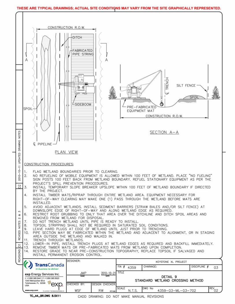


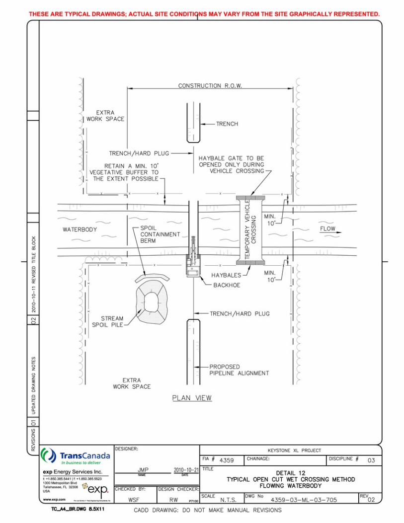


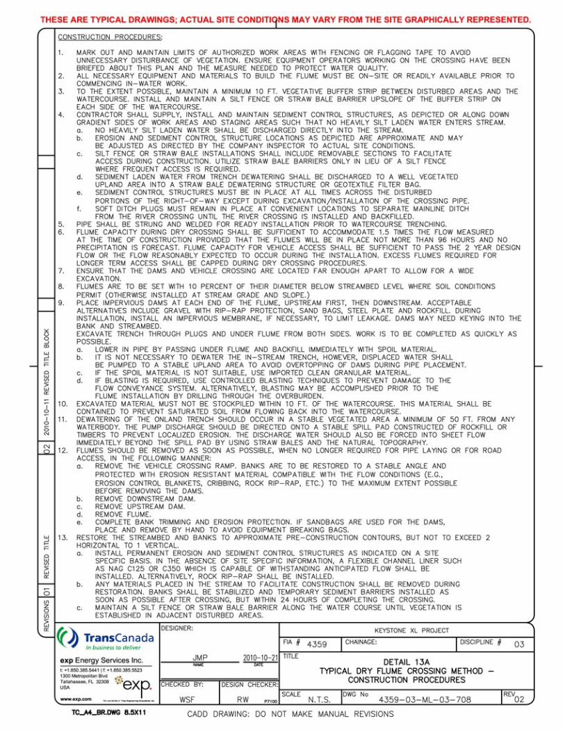
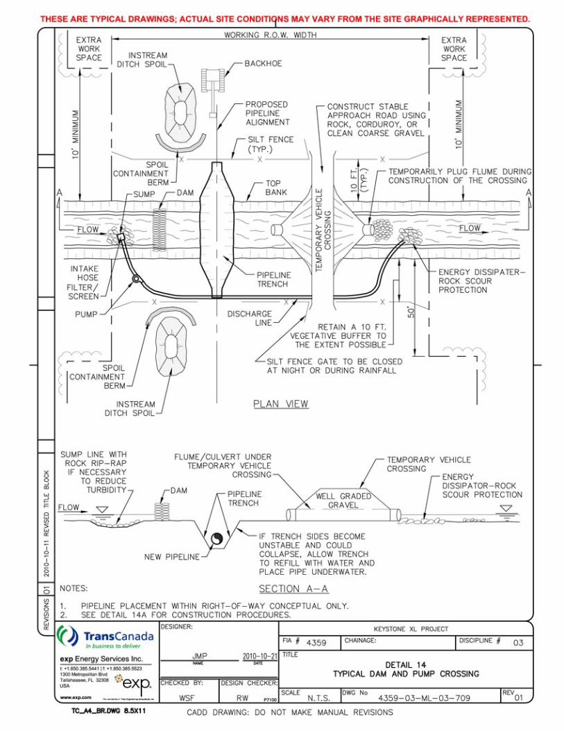


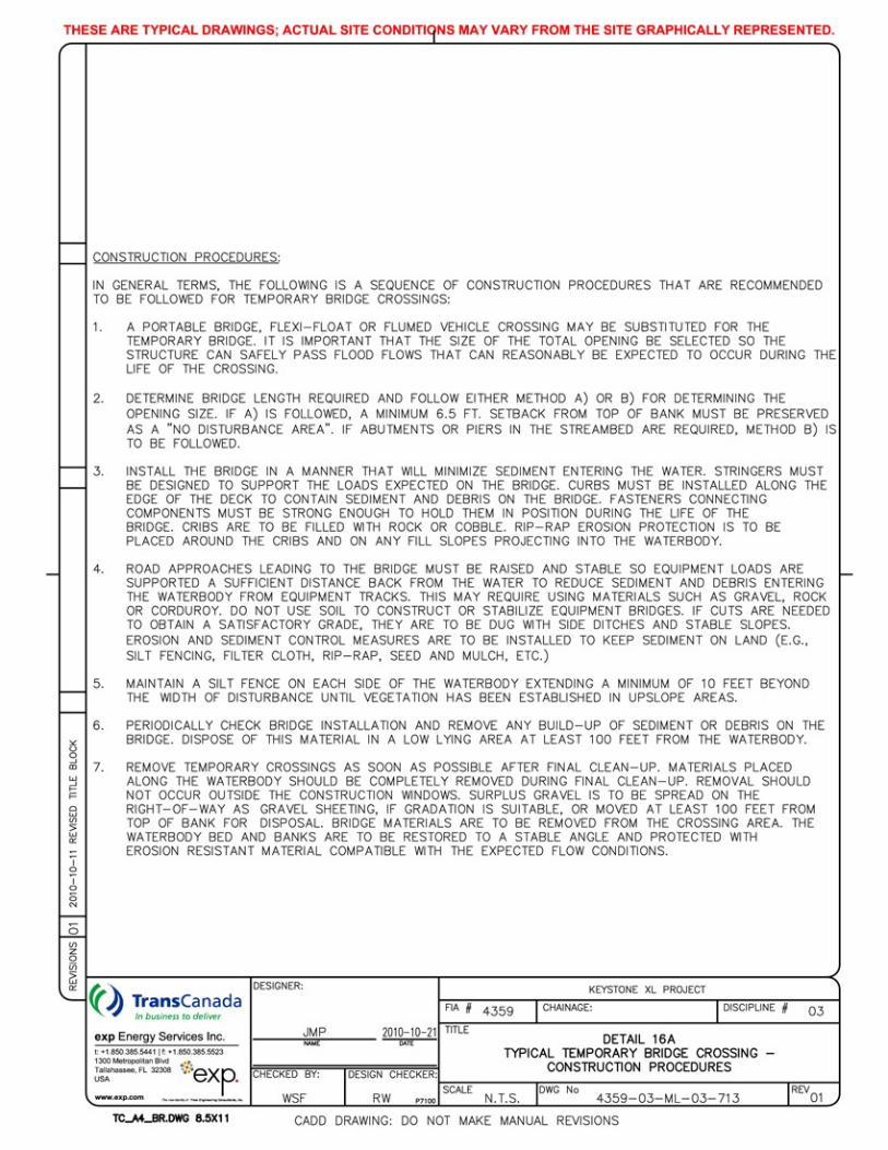
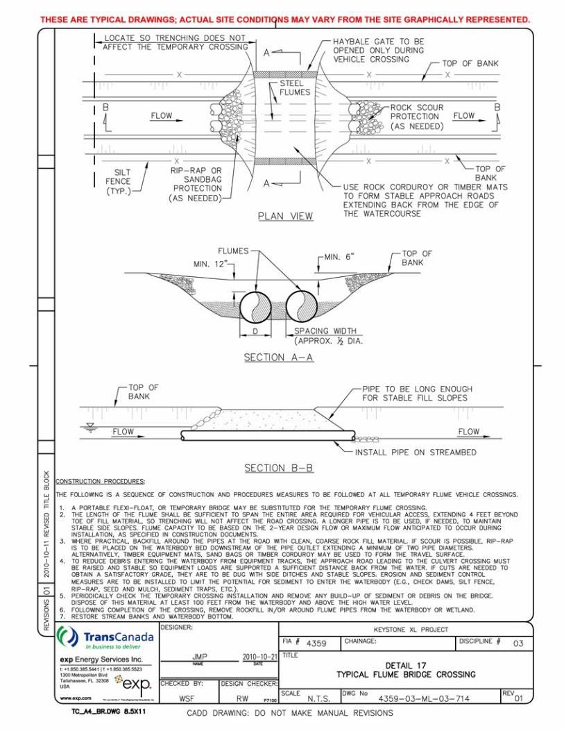


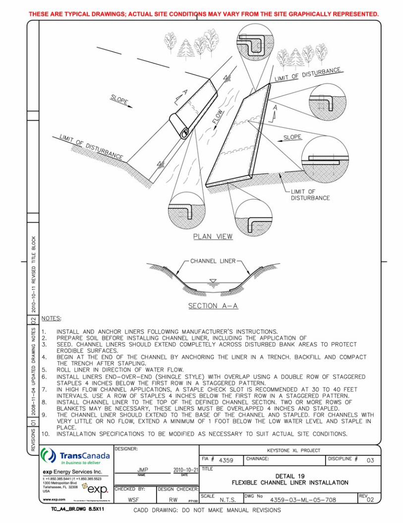
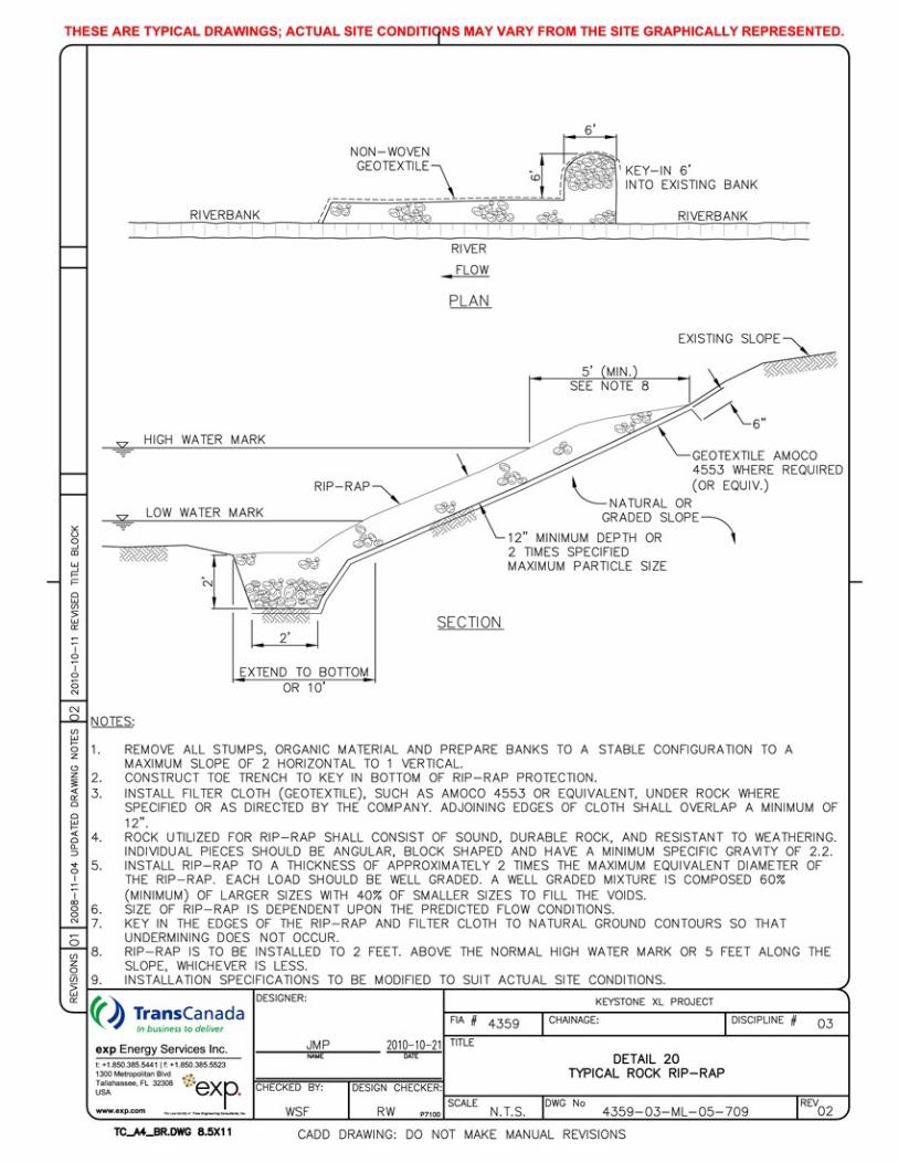
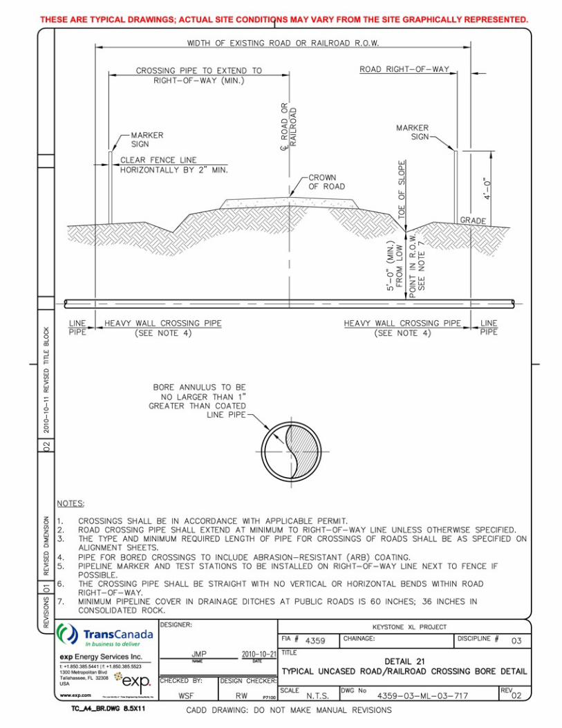


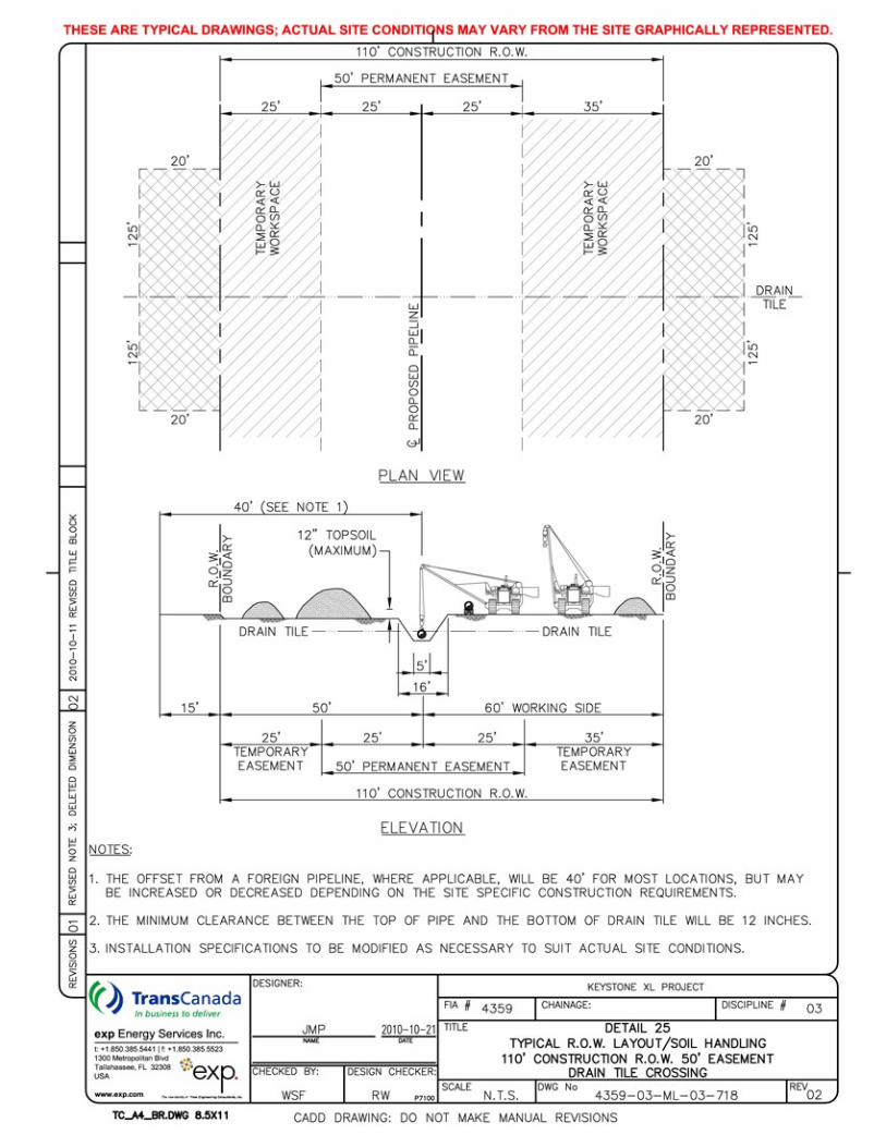
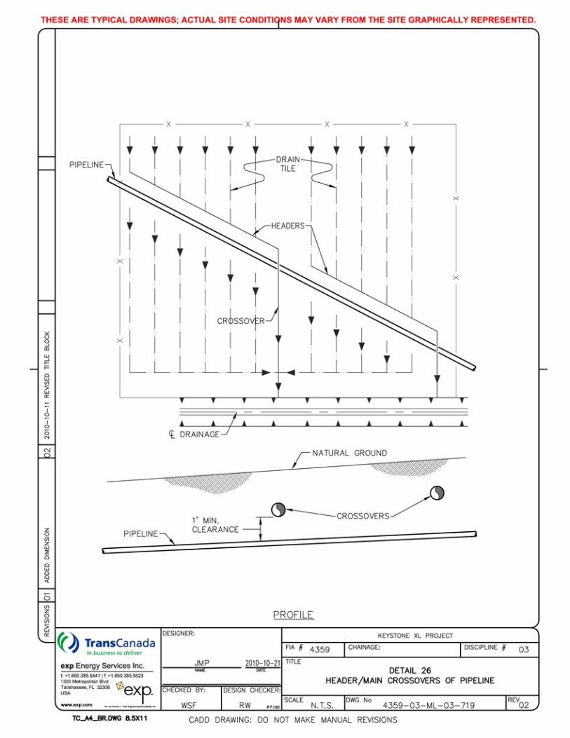
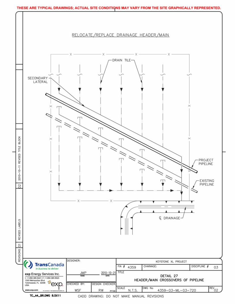
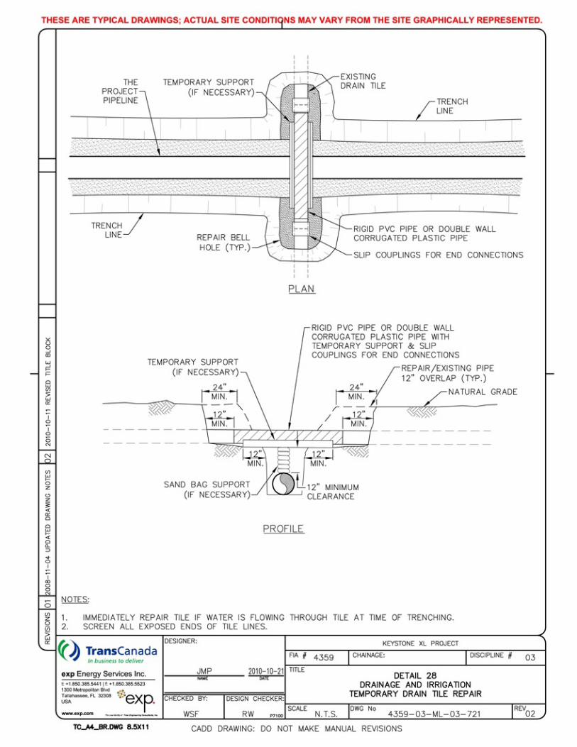
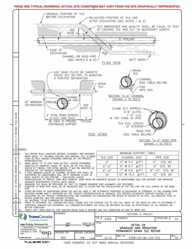

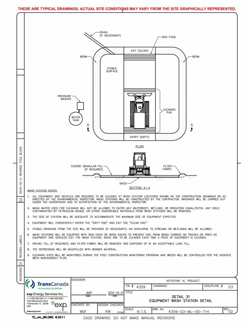

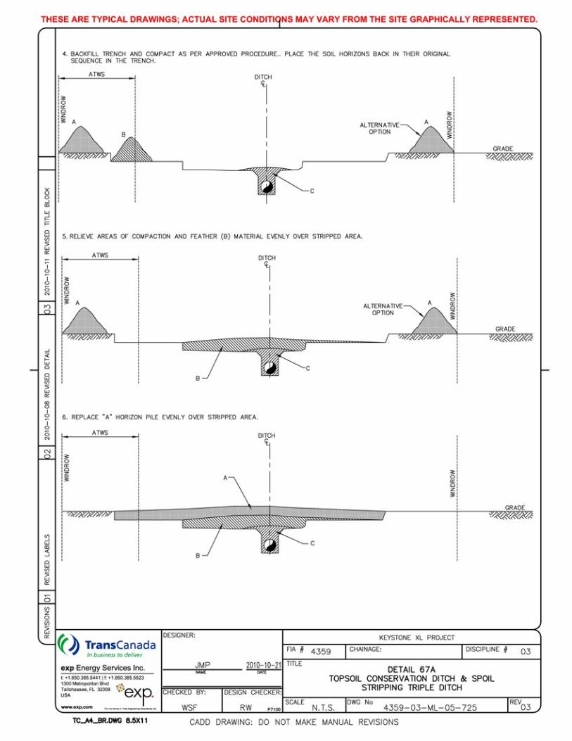

Keystone XL Project
-This page intentionally left blank-
March 2013

Attachment D:
Horizontal Directional Drill Frac-out Contingency Plan

Keystone XL Pipeline Project
HORIZIONTAL DIRECTIONAL DRILL FRAC-OUT CONTINGENCY PLAN
Prepared for:
TransCanada PipeLines Limited 450-1st Street, S.W.
Calgary, Alberta T2P 5H1
exp Energy Services, Inc.
1300 Metropolitan Boulevard, Suite 200 Project No: Tallahassee, Florida 32308 Telephone: (850) 385-5441 Revision No: Facsimile: (850) 385-5523 Issue Date: August 31, 2011
KEYSTONE XL FRAC-OUT CONTINGENCY PLAN
i
Table of Contents
1. Introduction ...................................................................................................... 1
2. Drilling Fluid and Drilling Fluid System ......................................................... 2
3. HDD Contractor Responsibilities and Requirements .................................. 3
4. Fluid Migration Detection ................................................................................ 4
5. Corrective Action for an Inadvertent Release ............................................... 5
6. Containment of Drilling Fluid Release ........................................................... 7
7. Clean-up of Releases ...................................................................................... 8
8. Agency Notification Procedures .................................................................... 9
KEYSTONE XL FRAC-OUT CONTINGENCY PLAN
1
1. Introduction
This horizontal directional drilling mud contingency plan provides specific procedures and steps to contain the inadvertent releases of drilling mud (frac-outs) during pipeline installations using horizontal direction drilling (HDD) techniques. Keystone will designate a representative that will coordinate the implementation of this plan and perform any environmental agency communications in the event of a frac-out during the project.
KEYSTONE XL FRAC-OUT CONTINGENCY PLAN
2
2. Drilling Fluid and Drilling Fluid System
The HDD process involves the use of a drilling fluid (also referred to as drilling mud) made up primarily of water. Bentonite clay is added to the water to enhance lubricating, spoil transport and caking properties of the drilling fluid. Bentonite is a naturally occurring, non-toxic, inert substance that meets NSF/ANSI 60 NSF Drinking Water Additives Standards and is frequently used for drilling potable water wells. The primary purpose of drilling fluid is to power the downhole cutting tools, remove cuttings from the drill hole, stabilize the hole, and act as a coolant and lubricant during the drilling process.
The drilling fluid is prepared in a mixing tank containing both new and clean recycled drilling fluid. The fluid is pumped at rate of 100 to 1,000 gallons per minute (gpm) through the center of the drill pipe to the cutters. Return flow is through the annulus created between the wall of the boring and the drill pipe. The cuttings are then carried back to either the entry or the exit pit, depending on a combination of elevation difference and drilling/hole opening direction.
Once in the entry pit, the fluid moves to the pickup pit to be pumped to the fluid processing equipment. Typically, shaker screens, desanders and desilters remove increasingly finer cuttings from the drilling fluid. The cleaned and recycled fluid is returned to the mixing tank and pumps for reuse in the borehole. Following completion of the drill, cuttings and clay will be disposed of in accordance with all applicable federal, state and local environmental regulations. Accordingly, this material may be made available to landowners for use, mixed with native soil and buried on site with landowner permission, or disposed of in a landfill. The HDD method has the potential for loss or seepage of drilling fluid into the native material through which the drill passes. In some cases, the drilling fluid may be forced to the surface resulting in what is commonly referred to as an inadvertent release or a frac-out. While one of the positive aspects of the HDD method is the avoidance surface disturbance, surface disturbances may occur when there is an inadvertent release of drilling fluid. Drilling fluid release is typically caused by pressurization of the drill hole beyond the containment capability of the overburden soil material or due to inherent weaknesses within the overlying soils such as a fissure or other pathway. In some cases, the pathway can be associated with boreholes advanced for geotechnical investigations or by bridge or building pilings.
The HDD operation is a closed system to minimize the discharge of drilling mud, fluids, and cuttings outside of the work area. To minimize the possibility of fluid escape, mud pits shall be used to contain the drilling fluids. The drilling fluids are cleaned and recycled to the extent possible. Tanks or dumpsters will be installed in lined pits. Care will be taken to prevent the fluids from getting into the soil and to prevent groundwater from entering the pits.

KEYSTONE XL FRAC-OUT CONTINGENCY PLAN
3
3. HDD Contractor Responsibilities and Requirements
The HDD contractor is responsible for execution of the HDD operation, including actions for detecting and controlling the inadvertent release of drilling fluid. Keystone will closely supervise the progress and actions of the HDD contractor through the use of onsite inspection teams.
The HDD contractor will be required to conduct the HDD operation in compliance with the project specific Spill Prevention Control and Countermeasure Plan (SPCC) which includes specifies the types and quantities of equipment to be provided, which would typically consist of a tracked hydraulic excavator, straw or hay bales, stakes to secure bails, silt fence, sand bags, shovels, pumps, and any other materials or equipment deemed necessary and adequate to contain and clean up inadvertent releases. The contractor will also provide for a vacuum truck and operator to be on call during drilling operations, such that the vacuum truck can respond and be on-site within three hours of notification.
The Contractor will provide a site-specific plan for each HDD crossing, identifying any site-specific requirements and provisions to be made to meet special site conditions. Ancillary items must be readily available during drilling operations including a light tower in case cleanup operations are needed after dark, a boat with relevant safety equipment during the crossing of large water bodies, and leak free hose to allow pumping spilled drilling mud for mitigation where small creeks or drainages are involved.
KEYSTONE XL FRAC-OUT CONTINGENCY PLAN
4
4. Fluid Migration Detection
Drilling crews and the Keystone inspection personnel will be responsible for monitoring and detection of frac-outs. The most obvious signs of a frac-out are the visible pooling of drilling mud on the surface or a sudden decease in mud volume during drilling operations or loss in drilling mud pressure. The annular pressure will be specified in the HDD contract. Drilling and mud system personnel will observe alterations in drilling pressure or the volume of drilling fluid return and immediately report reductions or anomolies to the foreman and Keystone personnel. The contract will specify the use of an Electronic Data Recorder (EDR) to monitor volumes, pressures and other HDD operations.
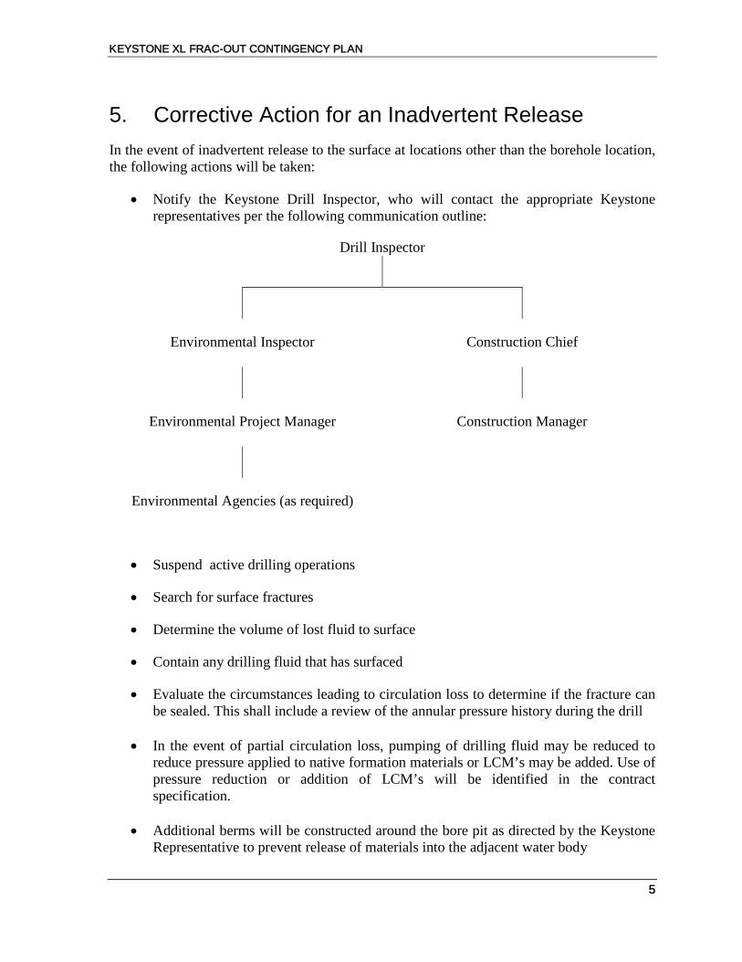
KEYSTONE XL FRAC-OUT CONTINGENCY PLAN
5
5. Corrective Action for an Inadvertent Release
In the event of inadvertent release to the surface at locations other than the borehole location, the following actions will be taken:
• Notify the Keystone Drill Inspector, who will contact the appropriate Keystone representatives per the following communication outline:
Drill Inspector
Environmental Inspector Construction Chief
Environmental Project Manager Construction Manager
Environmental Agencies (as required)
• Suspend active drilling operations
• Search for surface fractures
• Determine the volume of lost fluid to surface
• Contain any drilling fluid that has surfaced
• Evaluate the circumstances leading to circulation loss to determine if the fracture can be sealed. This shall include a review of the annular pressure history during the drill
• In the event of partial circulation loss, pumping of drilling fluid may be reduced to
reduce pressure applied to native formation materials or LCM’s may be added. Use of pressure reduction or addition of LCM’s will be identified in the contract specification.
• Additional berms will be constructed around the bore pit as directed by the Keystone
Representative to prevent release of materials into the adjacent water body

KEYSTONE XL FRAC-OUT CONTINGENCY PLAN
6
• The contractor will pump the spill in an attempt to recover all of the spilled fluid for
disposal
• Measures will be implemented (berm, silt fence, and/or hay bale installation) to prevent silt laden water from flowing into the water body.
• If hand tools cannot contain a small on-land release, small collection sumps may be
constructed to pump the released material into the mud processing system.
• Sump pumps or vacuum trucks will be used to remove and dispose of any drilling fluids.
KEYSTONE XL FRAC-OUT CONTINGENCY PLAN
7
6. Containment of Drilling Fluid Release
Immediately following the detection of the inadvertent drilling fluid release, containment and clean-up operations shall commence and Keystone will notify all appropriate authorities. For releases on land, Contractor shall use straw bales, silt fences, sand bags and earth berms to prevent fluid from migrating or flowing from the immediate area of the discharge. If the volume released is too small for containment measures or if the release occurs in an environmentally sensitive area where release of containments can cause additional damage, the receiving area will be allowed to dry naturally. If there is a threat to a sensitive resource or a threat to public safety, HDD activities will cease immediately.
In cases of inadvertent releases to open water or flooded wetlands, it may impractical or impossible to contain the release. For releases in shallow water, the HDD contractor shall install staked sediment barriers as described in the Keystone XL Construction Mitigation and Reclamation Plan (CMRP). Removal by vacuum truck may be attempted if deemed appropriate. The decision to proceed with the drilling operation will be at the sole discretion of the Keystone representative after all methods to seal off the location of the discharge identified in the SPCC Plan have been attempted. Underwater releases may be allowed to dissipate where cleanup would cause more damage than leaving the material in place. Where cleanup can be accomplished without causing additional damage, the cleanup of the spill will be conducted. The regulating agency with jurisdiction over the operation will be advised of planned actions in response to spills, when those actions do not include complete removal of the spilled material.
KEYSTONE XL FRAC-OUT CONTINGENCY PLAN
8
7. Clean-up of Releases
The clean-up shall commence after the release is contained. Clean-up shall include removal of all visible drilling fluid located in accessible areas. Removal methods will vary based on the volume of the release and the site specific conditions. Removal equipment may include vacuum trucks, loader and track hoe buckets, small pumps, shovels, buckets, brooms and squeegees. If the release occurs in a sensitive area, it may be necessary to pump the fluid into an upland area for additional containment and disposal. After removal of the released drilling fluid, the release area will be returned as close to the original condition as feasible. It may be necessary to store the drilling fluid residue on-site prior to disposal. On-site storage will include secondary containment with the capacity of 110 percent of the volume of drilling fluid residue to be stored.
Any water discharged from the HDD operation will be discharged through filter bags, or other approved dewatering structure, to contain suspended solids.
KEYSTONE XL FRAC-OUT CONTINGENCY PLAN
9
8. Agency Notification Procedures If an inadvertent release is discovered, steps will be taken to contain the release as described in Section 4. It will be reported in accordance with the Keystone communication outline. The appropriate agency(s) will be consulted regarding the nature of the release the corrective actions to be applied and any additional measures necessary to minimize potentially adverse environmental impacts. In the event an HDD crossing cannot be successfully completed, an alternative crossing plan will be developed and its implementation will be coordinated with the appropriate agencies.

Attachment E:
Horizontal Directional Drill Site-Specific Drawings


Attachment F:
2017 Nationwide Permits, Regional Conditions, Omaha District, State of Nebraska

2017 Nationwide Permits Regional Conditions
Omaha District State of Nebraska
1. Wetlands Classified as Peatlands – Preconstruction Notification Requirement. For all NWPs, permittees shall notify the Nebraska Regulatory Office in accordance with General Condition No. 32 (PCN) prior to initiating any regulated activity in peatlands found. Peatlands are permanently or seasonally saturated and inundated wetlands where conditions inhibit organic matter decomposition and allow for the accumulation of peat.
2. Waters Adjacent to Natural Springs – PCN Requirement. For all NWPs, permittees shall notify the
Nebraska Regulatory Office in accordance with General Condition No. 32 (PCN) prior to initiating any regulated activity located within 100 feet of the water source in natural spring areas.
For the purpose of this condition, a spring water source is defined as any location where there is flow emanating from a distinct point at any time during the growing season. Springs do not include seeps and other groundwater discharge areas where there is no distinct point source of waters. Springs do not include drain tile outlets.
3. Rainwater Basin Wetlands – PCN Requirement. For all NWPs, permittees shall notify the
Nebraska Regulatory Office in accordance with General Condition No. 32 (PCN) prior to initiating any regulated activity in any traditional Rainwater Basin wetlands found in the 21 county Rainwater Basin area of south central Nebraska. The following link provides a map showing the general location of the Rainwater Basin geographic area: http://www.fws.gov/refuge/rainwater basin wmd/.
4. Eastern Saline Wetlands, Salt Creek and its tributaries, including Rock Creek and its tributaries,
in Saunders or Lancaster Counties – PCN Requirement.
a. For all NWPs, permittees shall notify the Nebraska Regulatory Office in accordance with General Condition No. 32 (PCN) prior to initiating any regulated activity within any Eastern Saline wetlands, Salt Creek, and its tributaries, including Rock Creek and its tributaries, found in Saunders or Lancaster Counties. The map located at the end of this document shows the Salt Creek Tiger Beetle recovery areas and projects in these areas will receive additional analysis.
b. All mitigation involving Eastern Saline wetlands shall be conducted pursuant to the Eastern Saline Mitigation Guidelines. The Guidelines can be found at: http://www.nwo.usace.army.mil/Missions/Regulatory-Program/Nebraska/Mitigation/
5. Riffle and Pool Complexes—PCN Requirement. For all NWPs, permittees shall notify the Corps in
accordance with General Condition No. 32 (PCN) prior to initiating any regulated activity involving the discharge of dredge or fill material into riffle and pool complexes.
Riffle and pool complexes are defined as “Steep gradient sections of streams are sometimes characterized by riffle and pool complexes. Such stream sections are recognizable by their hydraulic characteristics. The rapid movement of water over a coarse substrate in riffles results in a rough flow, a turbulent surface, and high dissolved oxygen levels in the water. Pools are deeper areas associated with riffles. Pools are characterized by a slower stream velocity, a steaming flow, a smooth surface, and a finer substrate. Riffle and pool complexes are particularly valuable habitat for fish and wildlife.”

6. Missouri River, North Platte River, South Platte River, Platte River, Loup River, Elkhorn River, Republican River and all jurisdictional Class A State Resource Waters – PCN Requirement. For all NWPs, permittees shall notify the Nebraska Regulatory Office in accordance with General Condition No. 32 (PCN) prior to initiating any regulated activity located on the above named rivers and waters. A list of Class A State Resource Waters can be found at: http://nlcs1.nlc.state.ne.us/epubs/E6500/R015.0117-2006.pdf
7. Taylor Creek (and tributaries), Big and Brush Creeks (and tributaries), and Union Creek (and
tributaries) – PCN Requirement. For all NWPs due to the potential presence of Topeka Shiner, permittees shall notify the Nebraska Regulatory Office in accordance with General Condition No. 32 (PCN) prior to initiating any regulated activity located on Taylor Creek and its associated tributaries in Madison County, Big and Brush Creeks and their associated tributaries in Cherry County and the segment of Union Creek and its associated tributaries in Madison and Stanton Counties located in the area that is bounded by Nebraska Highway 121 to the west, Nebraska Highway 57 to the east, the Platte County line to the south and 833rd Road (main east-west road between Village of Enola and Village of Stanton, Nebraska) to the north.
8. Wild and Scenic Rivers, National River Inventory Rivers – PCN Requirement. For all NWPs,
permittees shall notify the Nebraska Regulatory Office in accordance with General Condition No. 32 (PCN) prior to initiating any regulated activity located on the Niobrara National Scenic River, the Missouri National Recreational River, or any National River Inventory river.
The following link provides a map showing the location of the Niobrara National Scenic River: https://www.nps.gov/niob/planyourvisit/maps.htm
The following link provides a map showing the location of the Missouri National Recreational River: https://www.nps.gov/mnrr/planyourvisit/maps.htm
The following link provides a map showing the location of the Nebraska Rivers listed on the National River Inventory list: https://www.nps.gov/ncrc/programs/rtca/nri/states/ne.html
9. Revegetation of Disturbed Areas – All NWPs.
a. All areas adjacent (contiguous, bordering, neighboring) to jurisdictional waters disturbed by construction shall be revegetated with appropriate perennial, native grasses and forbs and maintained in this condition. In accordance with Executive Order 13112, the use of invasive species and non-native species is not appropriate for revegetation of disturbed areas. A cover crop may be planted to aid in the establishment of native vegetation. The disturbed areas shall be reseeded concurrently with the project or immediately upon completion. Revegetation shall be acceptable when ground cover of appropriate perennial, native grasses and forbs reaches 75%. If this seeding cannot be accomplished by September 15 in the year of project completion, then an erosion blanket shall be placed on the disturbed areas. The erosion blanket shall remain in place until ground cover of appropriate perennial, native grasses and forbs reaches 75%. If the seeding can be accomplished by September 15, all seeded areas shall be properly mulched to prevent erosion.
b. When the vegetation has become established, all temporary erosion control materials shall be removed from the project site. Biodegradable or photodegradable materials need not be removed.
10. Temporary Structures/Work/Fill
a. All NWPs
i. The use of dredged material in the construction of temporary structures or used for
temporary work or used as temporary fill shall not be allowed. The term “dredged material” is defined as material that is excavated or dredged from waters of the U.S. All temporary fill material shall be obtained from an upland source.
ii. Upon completion of the construction activity, all temporary fill material shall be removed in its entirety from the water of the U.S. to an upland area and the affected area shall be restored to its pre-construction condition. Wetlands disturbed by temporary construction shall be seeded with appropriate native hydrophytic species.
iii. General Condition No. 13 (Removal of Temporary Fills) is amended by adding the following: When temporary fills are placed in wetlands, a horizontal marker (i.e. fabric, certified weed-free straw, a ground survey with minimum accuracy of 0.10-foot, etc.) must be used to demarcate the existing ground elevation of wetlands that will be temporarily filled during construction, in order to restore the wetlands to pre-project conditions.
b. NWPs with a PCN Requirement
In addition to the above Regional Conditions in “a”, the following apply to NWPs with a PCN requirements.
i. A proposal for the temporary structure/work/fill, if not already provided, shall be submitted 14 days prior to construction and authorized/verified by the Nebraska Regulatory Office prior to the commencement of construction.
ii. The Nebraska Regulatory Office shall be notified with documentation (i.e. photos) when the site has been restored to its pre-project condition.
11. Stream Channelization Projects – All NWPs. Stream channelization is defined as “The
manipulation of a stream’s course, condition, capacity or location that causes more than minimal interruption of normal stream processes. A channelized stream remains a water of the United States.”
a. Permittees must notify the Corps in accordance with General Condition No. 32 (PCN) prior to straightening, relocating and/or shortening an existing stream channel. The total channel length reduction for all ephemeral, intermittent or perennial channels must be less than 100 feet. Stream channel length includes the length flowing through culverts or similar structures.
b. Activities can result in the loss of no more than 300 linear feet of stream bed. Loss of stream bed includes the distance flowing through new culverts or similar structures as a result of the activity.
c. Buffer strips must be set along both sides of a channelized, relocated, or other new stream channel. Buffers shall be at least 50 feet wide and start at the top of the high bank of the channel. Buffers will be accepted on a 4H:1V slope or flatter and if proposed the 50 foot measurement will start at the OHW. New buffers in disturbed areas shall be revegetated with a mixture of perennial grasses, forbs and trees as appropriate. In accordance with Executive Order 13112, the use of invasive species and non-native species is not appropriate for revegetation of disturbed areas or buffers. An initial cover crop may be planted to aid in the establishment of native vegetation. Buffers established where appropriate native species and slopes are present do not need to be re-graded or replanted.
d. The Corps may allow a waiver of this condition on a case-by-case basis if the Corps determines the activity will result in only minimal adverse effects. The applicant must request

the waiver in writing and provide documentation and environmentally based reasons to support the waiver request. The Corps will only grant the waiver upon a written determination that the NWP activity will result in minimal adverse effects.
12. PCN for All Nationwide Activities within Reservation Boundaries
All NWPs requested by applicants other than the Tribal Authority for use within the reservation boundaries of Indian Country in Nebraska require preconstruction notification to the Omaha District Engineer and coordination with the Tribal Authority. All other terms and conditions of the NWPs and regional conditions apply in Indian Country regardless of the applicant.
REGIONAL CONDITIONS APPLICABLE TO SPECIFIC NATIONWIDE PERMITS
NWP 13 – Bank Stabilization – PCN Requirement. All permittees shall notify the Nebraska Regulatory Office in accordance with General Condition No. 32 (PCN) prior to initiating any regulated activity under NWP 13. NWP 16 – Return Water From Upland Contained Disposal Areas – PCN Requirement. All permittees shall notify the Nebraska Regulatory Office in accordance with General Condition No. 32 (PCN) prior to initiating any regulated activity under NWP 16. NWP 23 - Approved Categorical Exclusions – PCN Requirement. All permittees shall notify the Nebraska Regulatory Office in accordance with General Condition No. 32 prior to initiating any regulated activity under NWP 23. In addition to information required by General Condition No. 32 (PCN), the applicant must identify the approved categorical exclusion that applies in Regulatory Guidance Letter (RGL) 05-07 or the appropriate Corps RGL and provide documentation that the project fits the categorical exclusion.