preliminary only - timaru
TRANSCRIPT

issue date reason
file
CAD ref:
date
QA checkdrawndesign
approved
scale @ A1
dwg issue
contractor to locate all existing services & verify all dimensions before commencing workDisclaimer: This document shall only be reproduced in full with approval from a Davis Ogilvie engineer
P:\29700\29746 TDC-PC 170619-Broughs Gully\Dwg\29746a-PL01-Lot_Layout_Comparison-B.dwg
Engineers - Surveyors - Planners
Also - Nelson, Christchurch, Greymouth
Ph. 03 688 8350 / 0800 888 350
P.O. Box 359 Timaru, NZ
14 The Terrace, Timaru 7940
Davis Ogilvie (Aoraki) & Partners Ltd
BPL01
29746a
1:1500
07-17
PMJ MKPMJ
LOT LAYOUT COMPARISON
LAND OWNER SUBMISSION EVALUATION
BROUGH'S GULLY ISP (V10a), WASHDYKE
TIMARU DISTRICT COUNCIL
NOT FOR CONSTRUCTION
PRELIMINARY ONLY
·
·
·
·
·
issue date reason
file
CAD ref:
date
QA checkdrawndesign
approved
scale @ A1
dwg issue
contractor to locate all existing services & verify all dimensions before commencing workDisclaimer: This document shall only be reproduced in full with approval from a Davis Ogilvie engineer
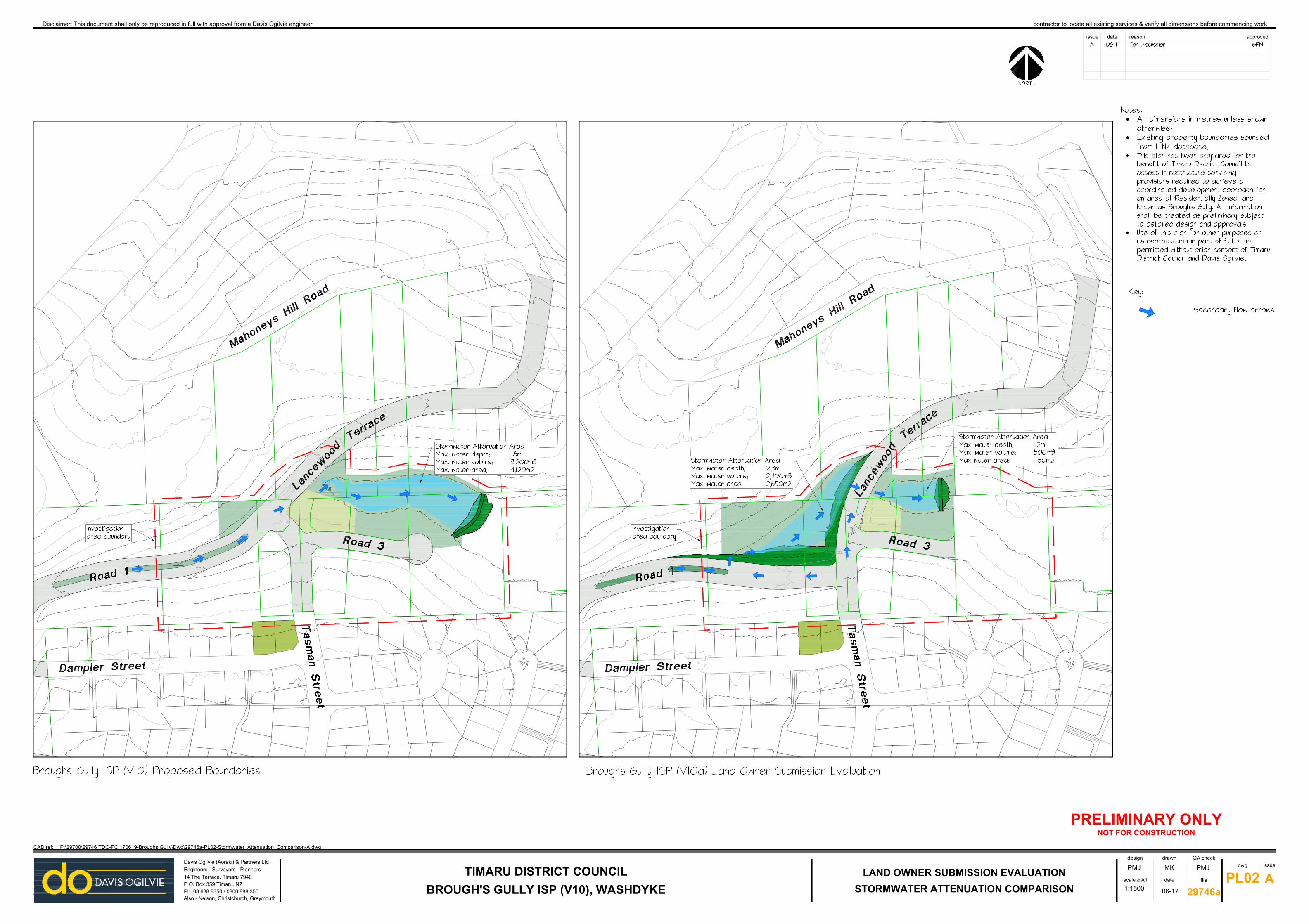
P:\29700\29746 TDC-PC 170619-Broughs Gully\Dwg\29746a-PL02-Stormwater_Attenuation_Comparison-A.dwg
Engineers - Surveyors - Planners
Also - Nelson, Christchurch, Greymouth
Ph. 03 688 8350 / 0800 888 350
P.O. Box 359 Timaru, NZ
14 The Terrace, Timaru 7940
Davis Ogilvie (Aoraki) & Partners Ltd
APL02
29746a
1:1500
06-17
PMJ MKPMJ
STORMWATER ATTENUATION COMPARISON
LAND OWNER SUBMISSION EVALUATION
BROUGH'S GULLY ISP (V10), WASHDYKE
TIMARU DISTRICT COUNCIL
NOT FOR CONSTRUCTION
PRELIMINARY ONLY
·
·
·
·

issue date reason
file
CAD ref:
date
QA checkdrawndesign
approved
scale @ A1
dwg issue
contractor to locate all existing services & verify all dimensions before commencing workDisclaimer: This document shall only be reproduced in full with approval from a Davis Ogilvie engineer
P:\29700\29746 TDC-PC 170619-Broughs Gully\Dwg\29746a-PL03-Road_Layout_Comparison-B.dwg
Engineers - Surveyors - Planners
Also - Nelson, Christchurch, Greymouth
Ph. 03 688 8350 / 0800 888 350
P.O. Box 359 Timaru, NZ
14 The Terrace, Timaru 7940
Davis Ogilvie (Aoraki) & Partners Ltd
BPL03
29746a
1:1500
07-17
PMJ MKPMJ
ROAD LAYOUT COMPARISON
LAND OWNER SUBMISSION EVALUATION
BROUGH'S GULLY ISP (V10), WASHDYKE
TIMARU DISTRICT COUNCIL
·
·
·
·
issue date reason
file
CAD ref:
date
QA checkdrawndesign
approved
scale @ A1
dwg issue
contractor to locate all existing services & verify all dimensions before commencing workDisclaimer: This document shall only be reproduced in full with approval from a Davis Ogilvie engineer
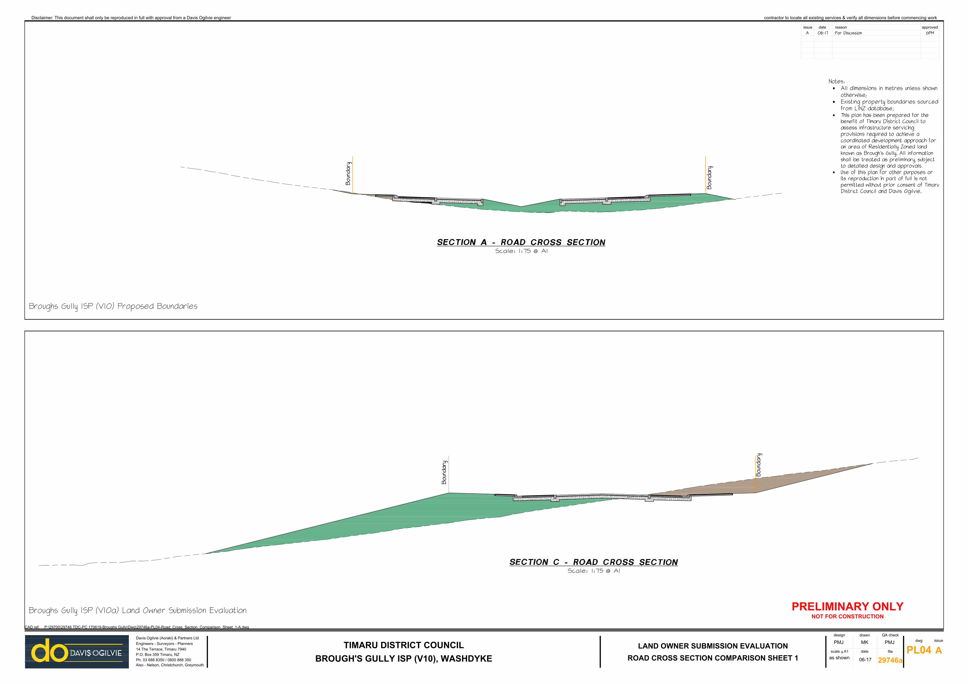
P:\29700\29746 TDC-PC 170619-Broughs Gully\Dwg\29746a-PL04-Road_Cross_Section_Comparison_Sheet_1-A.dwg
Engineers - Surveyors - Planners
Also - Nelson, Christchurch, Greymouth
Ph. 03 688 8350 / 0800 888 350
P.O. Box 359 Timaru, NZ
14 The Terrace, Timaru 7940
Davis Ogilvie (Aoraki) & Partners Ltd
APL04
29746a
as shown
06-17
PMJ MKPMJ
ROAD CROSS SECTION COMPARISON SHEET 1
LAND OWNER SUBMISSION EVALUATION
BROUGH'S GULLY ISP (V10), WASHDYKE
TIMARU DISTRICT COUNCIL
NOT FOR CONSTRUCTION
PRELIMINARY ONLY
·
·
·
·

issue date reason
file
CAD ref:
date
QA checkdrawndesign
approved
scale @ A1
dwg issue
contractor to locate all existing services & verify all dimensions before commencing workDisclaimer: This document shall only be reproduced in full with approval from a Davis Ogilvie engineer
P:\29700\29746 TDC-PC 170619-Broughs Gully\Dwg\29746a-PL05-Road_Cross_Section_Comparison_Sheet_2-A.dwg
Engineers - Surveyors - Planners
Also - Nelson, Christchurch, Greymouth
Ph. 03 688 8350 / 0800 888 350
P.O. Box 359 Timaru, NZ
14 The Terrace, Timaru 7940
Davis Ogilvie (Aoraki) & Partners Ltd
APL05
29746a
as shown
06-17
PMJ MKPMJ
ROAD CROSS SECTION COMPARISON SHEET 2
LAND OWNER SUBMISSION EVALUATION
BROUGH'S GULLY ISP (V10), WASHDYKE
TIMARU DISTRICT COUNCIL
NOT FOR CONSTRUCTION
PRELIMINARY ONLY
·
·
·
·