prime wetlands report, phase ii - center harbor nh
TRANSCRIPT

CENTER HARBOR PRIME WETLANDS COMPLETION PROJECT
SNAKE RIVER
Snake River in Fall
Rick Van de Poll, Ph.D. Ecosystem Management Consultants
30 N. Sandwich Rd. Center Sandwich, NH 03227
603-284-6851 [email protected]
February 2012
Submitted to:
Center Harbor Conservation Commission NH DES Wetlands Bureau

CONTENTS
Center Harbor Prime Wetlands Location Map i Executive Summary ii
Acknowledgments iii
I. Overview 1 II. Office & Field Methods 1
A) Office Methods 1 B) Field Methods 2 C) Wetland Assessment 3
III. Results / Discussion of Findings 4
A) General Findings 4 B) Specific Findings 5
IV. Conclusions & Recommendations 7
V. References 8 Figures & Tables
Gen. Location Map of Center Harbor Prime Wetlands i Fig. 1 Snake River from Waukewan bridge 1 Fig. 2 Snake River wetland edge 3 Table 1. Prime Wetlands of Center Harbor 4 Table 2. Comparison of 1991 vs. 2011 NH Method values 5 Fig. 3 Snake River recreationist 7 Fig. 4 Snake River marsh showing Fogg Hill 8
Appendices (available at Town Offices with original printed report)
A. Maps Snake River #70 Cover Types A-1 Snake River #70 Hydric Soils A-2
B. Spread Sheets & Charts NH Method Spreadsheet Summary B-1 to B-4 NH Method FVI Summary Chart B-5
C. 2011 NH Method Wetland Assessment Sheets C-1 to C-14 D. Copy of Town Warrant showing 2011 voting results D-1

C e n t e r H a r b o rC e n t e r H a r b o r
Ne w
Ha m
pt o
n
Ne w
Ha m
pt o
n
Hale Swamp
Snake River
Hawkins Pond
Leroux Wetland
Paquette Wetland
Johnson-Perkins Wetland
88
-
5,600 0 5,6002,800 Feet
1,300 0 1,300650 Meters
ABOUT THIS MAP
C E N T E R H A R B O R P R I M E W E T L A N D SC E N T E R H A R B O R P R I M E W E T L A N D S
i
i
Generalized Prime Wetland Location Map
LegendRoads
Center Harbor Prime Wetlands 2
Ecol_Int0.550
0.551 - 0.750
0.751 - 0.830
0.831 - 0.880
0.881 - 0.960
Designated Prime Wetlands
Town Boundary
Half-mile Buffer Area
Political Boundaries
i

ii
SUMMARY
Beginning in January 2011 a comprehensive inventory and evaluation was conducted on the Snake River wetland complex in Center Harbor, New Hampshire. Initial mapping indicated a 50+ acre wetland complex along the town line of New Hampton and Center Harbor between Winona Lake and Lake Waukewan. Updated color infrared aerial photography and selective field surveys were used to delineate and map the wetlands on the Center Harbor side, and later in the summer of 2011, on the New Hampton side. Using the NH GRANIT data for the town line as the southern boundary, a total of 57.2 acres was mapped for the Snake River wetland complex, with 24.6 acres lying in Center Harbor and 32.6 acres lying in New Hampton. Based on conversations with the Center Harbor Conservation Commission, several lateral inflow seepage swamps were not included in the designation of the candidate prime wetland area. Office–based assessments in February 2011 followed the Method for the Comparative Evaluation of Non-tidal Wetlands in New Hampshire, or the ‘NH Method’ (N.H. Department of Environmental Services, 1991). The following functional values of wetlands were assessed: 1) Ecological Integrity 2) Wetland Wildlife 3A) Finfish – Rivers and Streams 3B) Finfish – Lakes and Ponds 4) Educational Site Potential 5) Visual/Aesthetic Quality 6) Water-based Recreation 7) Flood Control Potential 8) Groundwater Use Potential 9) Sediment Trapping 10) Nutrient Attenuation 11) Shoreline Anchoring and Dissipation of Erosive Forces 13) Historical Site Potential 14) Noteworthiness Note that functional value #12, Urban Quality of Life, was not assessed owing to the rural character of Center Harbor at the time of the evaluation. Field data was transferred to the NH Method data sheets in the office following the field surveys. GPS data was uploaded into ArcGIS 9.2 project files and individual maps prepared according to the specifications of the NH Method. In August 2011, based on an ARM Fund application opportunity, the New Hampton side of the Snake River complex was visited and evaluated. The following report summarizes the findings of the field and map work, and provides a synopsis of the functional values that are latent within this remarkable wetland complex that spans two townships and provides the major inflow to the Lake Waukewan’s water supply.

iii
Acknowledgments The author would like to thank the following individuals and organizations for their support during this project: Center Harbor Conservation Commission: Bruce Bond, Chair Gwen Bronson
Maureen Criasia-Volz Karen Karagozian Randy Mattson, Selectmen’s Representative Harry Viens Joann Wood Ralph Kirshner, Chair, New Hampton Conservation Commission Lakes Region Planning Commission Squam Lakes Conservation Society (for digital approximations of tax parcels) Lakes Region Conservation Trust (for conservation parcel data) NH Natural Heritage Program (for rare plant information) NH Fish & Game Department (for rare animal information)
Snake River from Waukewan Road bridge
Center Harbor Prime Wetlands Update Project – Snake River _____________________________________________________________________________________________
Van de Poll / EMC Page 1
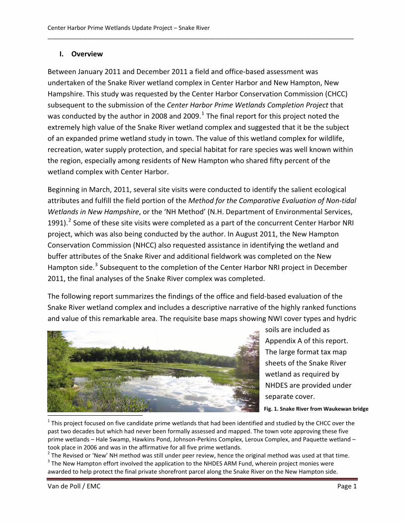
I. Overview
Between January 2011 and December 2011 a field and office‐based assessment was undertaken of the Snake River wetland complex in Center Harbor and New Hampton, New Hampshire. This study was requested by the Center Harbor Conservation Commission (CHCC) subsequent to the submission of the Center Harbor Prime Wetlands Completion Project that was conducted by the author in 2008 and 2009.1 The final report for this project noted the extremely high value of the Snake River wetland complex and suggested that it be the subject of an expanded prime wetland study in town. The value of this wetland complex for wildlife, recreation, water supply protection, and special habitat for rare species was well known within the region, especially among residents of New Hampton who shared fifty percent of the wetland complex with Center Harbor.
Beginning in March, 2011, several site visits were conducted to identify the salient ecological attributes and fulfill the field portion of the Method for the Comparative Evaluation of Non‐tidal Wetlands in New Hampshire, or the ‘NH Method’ (N.H. Department of Environmental Services, 1991).2 Some of these site visits were completed as a part of the concurrent Center Harbor NRI project, which was also being conducted by the author. In August 2011, the New Hampton Conservation Commission (NHCC) also requested assistance in identifying the wetland and buffer attributes of the Snake River and additional fieldwork was completed on the New Hampton side.3 Subsequent to the completion of the Center Harbor NRI project in December 2011, the final analyses of the Snake River complex was completed.
The following report summarizes the findings of the office and field‐based evaluation of the Snake River wetland complex and includes a descriptive narrative of the highly ranked functions and value of this remarkable area. The requisite base maps showing NWI cover types and hydric
soils are included asAppendix A of this report.The large format tax mapsheets of the Snake Riverwetland as required byNHDES are provided underseparate cover.
1 This project focused on five candidate prime wetlands that had been identified and studied by the CHCC over the past two decades but which had never been formally assessed and mapped. The town vote approving these five prime wetlands – Hale Swamp, Hawkins Pond, Johnson‐Perkins Complex, Leroux Complex, and Paquette wetland – took place in 2006 and was in the affirmative for all five prime wetlands. 2 The Revised or ‘New’ NH method was still under peer review, hence the original method was used at that time. 3 The New Hampton effort involved the application to the NHDES ARM Fund, wherein project monies were awarded to help protect the final private shorefront parcel along the Snake River on the New Hampton side.
Fig. 1. Snake River from Waukewan bridge

Center Harbor Prime Wetlands Update Project – Snake River _____________________________________________________________________________________________
Van de Poll / EMC Page 2
II. Office and Field Methods a. Office Methods
The first step in completing the prime wetlands survey was to review existing maps and data contained in the CHCC files. This included the original 1982 wetland map by Barry Keith, the revised mylar map and print maps containing the best known location and name of each of the designated wetlands, as well as a summary folder containing tabular descriptions and additional notes and sketches completed by volunteers in the 1980’s. The approximate location of the Snake River was compared against the latest version of the Center Harbor tax map, and the eight parcel owners identified where private property permission would need to be granted access on foot. Given the pre‐existing access provided by the major property owner along the Snake River, it was determined that further property permissions were not required, especially since most of the wetland complex was easily accessible by boat.
Office work also included obtaining the pertinent GIS (Geographic Information System) data files from Complex Systems Research Center in Durham, NH, which houses the NH GRANIT GIS database. Most of the latter data had already been purchased by the author, although the new aerial photography flown by NHDOT had not yet been released. In May of 2011, the 1‐foot pixel color infrared aerial photographs were released; therein providing high resolution, shade differentiated imagery of wetland areas throughout the study area. These were used extensively to corroborate GPS‐based field data and to provide accurate map sequences among NWI cover types and “cool” versus “warm” soils.
b. Field Methods
Roadside surveys of the Snake River took place throughout the study time period, especially since Waukewan Road and Winona Road both traverse and border the Snake River. Visual checks were made in all seasons, notably in March when migratory waterfowl were at a peak. Part of the latter effort was to attempt to regain records of the one noteworthy wildlife species that formerly nested in the Snake River marsh, the pied‐billed grebe. Not recorded as a nesting species since the 1970’s, this once common freshwater marsh obligate has all but disappeared from New Hampshire (Foss 1994, Hunt, 2011).
Wetland delineations for the Snake River were mostly conducted by remote interpretation of the above‐described color infrared photography, although the entire New Hampton shoreline as well as portion of the northwestern Center Harbor shoreline was estimated using a Garmin 12XL hand‐held GPS unit.4 GPS surveys took place on March 11, 28, August 2, and October 4, 2011. Wetland boundaries were mostly determined by the prevalence of hydrophytic
4 Precision on this unit varied between 2.9 and 6.8 m depending on cover and time of day.

Center Harbor Prime Wetlands Update Project – Snake River _____________________________________________________________________________________________
Van de Poll / EMC Page 3
vegetation, although hydric soils were confirmed on the New Hampton side on August 2 using a Dutch soil auger and Version 7 of the Field Indicators of Hydric Soils in the United States (USDA NRCS 2010). Given the limitations of time and the scope of the project no attempt was made to perform a Routine Onsite Method for delineating wetlands associated with the Snake River complex.
c. Wetland Assessment
The wetland assessment utilized the Method for the
Comparative Evaluation of Non‐tidal Wetlands in New Hampshire (NHDES, Ammann and Stone 1991), or the “NH Method,” for evaluating the functions and values of the Snake River wetland.5 This was the method used for the first five prime wetlands in Center Harbor, and was appropriately applied to the Snake River evaluation in spite of it being a single wetland complex. The ability to compare findings with the first five wetlands demonstrated the high functional value of the Snake River relative to the highest valued wetlands in Center Harbor.
As in the initial prime wetland completion project, the field analysis provided site specific information on the character of the wetland buffer, the number of occupied residences within 500 feet of the wetland boundary, the land use around and within the wetland, the nature of public access and proximity to schools, the viewing points from roadside and off‐road points, the types of plant communities present, and the “wetland control length” or WCL. The latter is a term used in the method that describes the type of constriction to the downstream flow of waters passing through the wetland, such as a culvert, bridge, or beaver dam. These were measured in feet in the field, and used in the calculation of flood storage potential.
In terms of the final configuration of the Snake River prime wetland relative to all of the contributing surface waters in the vicinity, it was decided at one of the CHCC meetings to hold the edge of the to‐be‐designated prime wetland to the downslope portions of the main river channel area. In three cases adjacent seepage swamps were eliminated from the prime wetland boundary because of their low relative value, the prevalence of poorly drained soils, and the previously impacted forest types. In one case, it appeared that the powerline right‐of‐way had altered the hydrology to bring about the creation of a forested and scrub‐shrub swamp that eventually drained into the Snake River. Similarly, two other seepage swamps were eliminated even though they were associated with small intermittent stream systems that made their way to the main wetland basin at the bottom of the hill. Each of these areas is depicted on the associated maps of the candidate prime wetland.
5 Since the 2nd edition of the NH Method came out in mid‐2011, the wetland evaluation was redone (see below).
Fig. 2. Most of the wetland edges of the Snake River, as depicted at right, involved fairly distinct wetland boundaries, especially in Center Harbor.

Center Harbor Prime Wetlands Update Project – Snake River _____________________________________________________________________________________________
Van de Poll / EMC Page 4
III. Results / Discussion of Findings a. General Findings
The Snake River wetland complex is comprised of roughly 57.2 acres, 24.6 acres of which lies in Center Harbor with the balance, 34.6 acres, lying in New Hampton. It is largely comprised of open marsh with an aquatic bed and a slow, meandering stream. Scrub‐shrub and forested swamps border both sides, although the edge along Fogg Hill in Center Harbor is fairly narrow. The table below summarizes the Snake River wetland complex in relation to the previously designated prime wetlands in Center Harbor:
Table 1. Prime Wetland Summary – Center Harbor
CENTER HARBOR PRIME WETLAND INVENTORY - SIZE & LOCATION
CODE NAME SIZE (ac)
SIZE - C.H.
TAX MAP #'s NEAREST ROAD(S) ZONING
52 Paquette Wetland Complex 18.48 18.48 Sheet 4 Route 3 RR,C
54-55 Hale Swamp 123.17 96.68 Sheet 3 Route 3, Waukewan Road RR
58a-d Leroux Wetland Complex 17.52 17.52 Sheet 1, 3 McCrillis Hill Road RR
79-80 Hawkins Pond 31.40 31.40 Sheet 1 Hawkins Pond Road, Piper Hill Road RR
88 Johnson-Perkins Wetland Complex 26.30 26.30 Sheet 1 Piper Hill Road RR
70 Snake River 57.2 24.6 Sheet 1 Waukewan Road, Winona Rd RR
SUM 274.07 214.98
ZONING RR = Rural Residential
C = Commercial
The center of the Snake River wetland is comprised of a slow‐moving, third‐order stream meander. Although imprecisely delimited, the centerline of the meander forms the boundary between Center Harbor and New Hampton.

Center Harbor Prime Wetlands Update Project – Snake River _____________________________________________________________________________________________
Van de Poll / EMC Page 5
Thirteen functional values were initially calculated for the Snake River candidate prime wetland, as shown below and depicted in Appendix B. Since the evaluation method was completed last spring a new version of the NH Method has since been published and widely circulated in the state.6 The ‘new’ NH Method (Method for Inventorying and Evaluating Freshwater Wetlands in New Hampshire 2011, Stone et al. 2011) was published in July. For this reason, a comparative chart is provided below of the assessment results for the Snake River complex as a whole using the 1991 method versus the 2011 method. [Note that the range of scores for each function was changed from a 0 – 1 point scale in 1991 to a 0 – 10 point scale in 2011.7]
Table 2. Comparative values for the Snake River wetland complex using 1991 versus 2011 NH Methods
Snake River Functional Value Assessment ‐ 1991 Method vs. 2011 Method
1991 2011 1991 2011 Ecological Integrity .83 7.5 Flood Control 1.0 4.8
Wetland Wildlife Habitat .84 8.1 Groundwater Use 1.0 5.5
Finfish Habitat – Rivers & Streams .83 7.7 Sediment Trapping .95 6.4
Finfish habitat – Lakes & Ponds .68 N/A Nutrient Attenuation .90 5.7
Educational Potential .74 9.3 Shoreline Anchoring 1.0 7.8
Visual/Aesthetic Quality .96 9.3 Historical Site 0.0 N/A
Water‐based Recreation .98 7.2 Noteworthiness 1.0 40.0
The above values indicate a consistently high rating for ecological integrity, wildlife habitat, fish & aquatic life support, educational potential, scenic quality, water‐based recreation, and shoreline anchoring. The ‘new’ NH Method indicates a slightly lower value for flood control, groundwater, sediment trapping, and nutrient transformation. Flood control (storage) was significantly modified in the 2011 version of the NH Method, hence the much lower score (4.6). Noteworthiness values between the two methods are incomparable since they were ranked on a very different basis.
b. Specific Findings
The following page provides a descriptive summary of the proposed Snake River prime wetland.
6 The official publication date of the ‘new’ NH Method was July 11, 2011. 7 The Noteworthiness function aggregates 10 points each for every ‘yes’ answer and so can exceed 10 points.

Center Harbor Prime Wetlands Update Project – Snake River _____________________________________________________________________________________________
Van de Poll / EMC Page 6
CENTER HARBOR PRIME WETLANDS COMPLETION PROJECT PRIME WETLAND SUMMARY
PRIME WETLAND: Snake River #: 70 ACRES: 57.2 (24.6 in Center Harbor) LOCATION: Off Waukewan Road just upstream from town line at Lake Waukewan Elevation: 540 ft. Flow Direction: Southeast Ave. Slope: 0 ‐ 1 % % Forested: 24.9 % Emergent/Scrub‐Shrub: 31.4 % Open Water: 43.7 %Upland Islands: 0 GENERAL LAND USE: Type: Rural Residential Zoning: RR Snake River sits between a moderately fragmented portion of the upper Lake Waukewan residential area and the southwest slopes of the undeveloped Fogg Hill. Waukewan Road and Winona Road borders the Snake River wetland complex on the south and west sides, respectively, and some lakeshore cottages are within 500 feet of the northwest (Lake Winona) and southeast (Lake Waukewan) part of the wetland. Almost the entire eastern and northern shoreline below Fogg Hill is undeveloped, however, and the general land use in the 500 foot buffer is light with sporadic forestry. The principal input of nutrients is from road salt along the aforementioned roadways, as well as probable discharges from Lake Winona septic systems, as noted in the latest VLAP report.
Prime Wetland Description: The Snake River wetland is the largest, naturally occurring aquatic bed marsh in Center Harbor. The water quality mediation function is extremely critical as the Snake River serves as the largest filtering wetland upstream of the Lake Waukewan water supply. The wetland also traps sediment and transforms road salt and other pollutants from the associated roadway run‐off. It has incredibly high wildlife value (see below) and maintains an active warmwater fishery that is optimized by recreationists throughout the year. Canoeists and kayakers can be seen during all summer months as there is an excellent put‐in and small parking area on the Center Harbor side of Waukewan Road. Its proximity to two main thoroughfares makes it an excellent education and research site for local townspeople and university students alike. Wildlife Habitat Description: The Snake River’s relatively deepwater habitat is partly maintained by beaver, and large dam and lodge can be found about mid‐way upstream. It is a very high value migratory waterfowl stop‐over locale, and in spite of the recent absence of nesting pied‐billed grebes and common loons, both species have been regularly seen in the Snake River marsh in migration, along with countless rafts of dabbling ducks, diving ducks, geese, and long‐legged waders. The scrub‐shrub and forested portion on the New Hampton side contains some excellent wildlife habitat, wherein evidence of moose, bear, deer, otter, mink, fisher, raccoon, weasel, coyote and fox has been recorded. The marsh supports a high diversity of invertebrates, including several uncommon dragonflies, marsh beetles, and snails. Rare & Endangered Species / Exemplary Natural Communities: none of recent record Issues of Concern:
• Increasing levels of TP & TN from upstream septic systems • Increasing levels of chlorides from associated road salt inputs • Degradation/overuse of parking area and canoe/kayak put‐in

Center Harbor Prime Wetlands Update Project – Snake River _____________________________________________________________________________________________
Van de Poll / EMC Page 7
IV. Conclusions and Recommendations The Center Harbor Prime Wetlands Completion Project (Van de Poll 2009) provided a field‐based assessment of the five prime wetlands that were approved by town vote in 2006 and approved by NHDES in 2010. In the final section of that report a recommendation was made to expand the prime wetlands mapping and assessment effort to include some of the other noteworthy wetlands in Center Harbor. The first wetland candidate on the list was the Snake River. By a large measure this wetland complex provides some of the highest value functionality to the surface water systems of town. As noted above, it has incredible water quality enhancement value, very high wildlife habitat value especially for migratory waterfowl, as well as some of the highest values for education potential and scenic quality of all six wetlands that have been carefully analyzed.
Perhaps one of the most heartening attributes of nominating this wetland complex to the list of primes in Center Harbor is the fact that nearly 95% of the New Hampton side of the Snake River has been protected in perpetuity. With a cooperative effort between three towns and two watershed advisory groups, all but the very northwestern shoreline is now under a conservation easement. Plans are already underway to establish signage and a trail system through the upland buffer area, which include some high value black ash‐red maple seepage swamps. Further, there are ongoing efforts to do the same on the Center Harbor side of the wetland in order to further protect this land from development. On the conservation side of this effort is the difficulty of access and the very steep, rocky slopes that characterize the southwestern base of Fogg Hill.
The Snake River, when compared to the five existing prime wetlands using the 1991 NH Method, scored as high or higher than any other wetland for the following functions:
a) Stream‐related finfish habitat (.68) b) Education Potential (.74) c) Scenic / Aesthetic Quality (.96) d) Water‐based Recreation (.98) e) Flood Control (1.0) f) Groundwater Use Potential (1.0) g) Sediment Trapping (.95) h) Nutrient Attenuation (.90) i) Shoreline Anchoring (1.0) j) Noteworthiness (1.0)
Fig. 3 The Snake River attracts a wide variety of recreationists

Center Harbor Prime Wetlands Update Project – Snake River _____________________________________________________________________________________________
Van de Poll / EMC Page 8
This represents 10 of the 13 functions assessed for the five existing prime wetlands. In terms of overall functionality of the wetland systems in Center Harbor, the Snake River complex tied for the highest scoring wetland overall. This fact is reflected in the point value sum ranking process that the initial five wetlands were subjected to during the initial assessment project. Based on cumulative point values that are directly reflected in the town’s master plan, the Snake River wetland was tied for first in the number of value points it generated. A visual depiction of this result can be seen in the chart on Appendix B‐2.
A testament to the fact that the town understands the value of the Snake River wetland complex is the result of the March 2011 Town Warrant, wherein the results were 262 in the affirmative, and 71 in the negative. The margin of passage was extremely high and reflected the general support of the Planning Board, Conservation Commission, and the Board of Selectmen during the hearing process in 2010. Barring any concerns on the part of nominating a wetland that shares its boundary with another town (as was the case with Hale Swamp in 2009), it is apparent that the next and final step in the prime wetland designation process is in the hands of the State of New Hampshire.
Respectfully submitted;
Rick Van de Poll, Ph.D. , CWS #110 Ecosystem Management Consultants
Fig. 4 Snake River marsh from Waukewan Road showing Fogg Hill in distance

Center Harbor Prime Wetlands Update Project – Snake River _____________________________________________________________________________________________
Van de Poll / EMC Page 9
I. References
Ammann, A., and A.L. Stone. 1991. Method for the Comparative Evaluation of Non‐tidal Wetlands in New Hampshire. Concord, NH: NH Department of Environmental Services.
Boyd, Lynn. 2001. Buffer zones and beyond: Wildlife use of wetland buffer zones and their protection
under the Massachusetts Wetland Protection Act. Project report to the Department of Natural Resources Conservation, University of Massachusetts, July. Duplicated.
Colburn, E.A. ed. 1991. Certified! A Citizen's Step‐by‐Step Guide to Protecting Vernal Pools. 4th ed. Lincoln: Massachusetts Audubon Society.
Cowardin, L.M., V. Carter, F.C. Golet, and E.T. LaRoe. 1979. Classification of Wetlands and Deepwater Habitats of the United States. U.S. Fish and Wildlife Service. FWS/OBS – 79/31. Washington, D.C.: Government Printing Office.
DeGraaf, R.M., M. Yamasaki. B.B. Leak, and J.W. Lanier. 1992. New England Wildlife: Management of Forested Habitats. Radnor, PA: USDA Forest Service, Northeastern Forest Experiment Station, GTR NE‐144.
DeGraaf, Richard, and Mariko Yamasaki. 2001. New England Wildlife. 2nd ed. Amherst: University of Massachusetts and the Northeast Forest Experiment Station, USDA. Gen. Tech. Rpt. NE‐108.
Foss, Carol, ed. 1994. Atlas of Breeding Birds in New Hampshire. Dover: Arcadia. (Published for the Audubon Society of New Hampshire).
GAP Analysis Project. 1999. Land cover types of New England. Digital data supplied by Complex Systems Resources Center, Durham, NH. December.
Godin, A.J. 1977. Wild Mammals of New England. Baltimore: John Hopkins University Press.
Harris, L.D. 1984. The Fragmented Forest: Island Biogeography Theory and the Preservation of Biodiversity. Chicago: University of Chicago Press.
http://www.gencourt.state.nh.us/rsa/html/indexes/482‐A.html
Kanter, J., R. Suomala, and E. Snyder. 2001. Identifying and Protecting New Hampshire’s Significant Wildlife Habitat, A Guide for Towns and Conservation Groups. Concord, NH: NH Fish & Game Department.
Leak, W.B. 1979. Habitat Mapping in New England. Upper Darby, PA: USDA Forest Service, NE Forest Experiment Station.
Lyons, Charles, Eugene Boudette, et. al. 1997. New Hampshire Bedrock Geology Map (with annotations). NH Department of Environmental Services, Concord, NH.
NAAMP. 2001. North American Amphibian Monitoring Project website: http://www.pwrc.usgs.gov/naamp/
NH Department of Environmental Services. 1995. Lakes and Ponds Report. Concord: NHDES.

Center Harbor Prime Wetlands Update Project – Snake River _____________________________________________________________________________________________
Van de Poll / EMC Page 10
NH GRANIT. 2001. GIS data from Complex System Resources Center, Durham, NH.
NH Natural Heritage Bureau. 2011. Rare and endangered species list published by the NH Natural Heritage Inventory, Concord, NH. July.
New England Interstate Water Pollution Control Commission. 2003. Field Identification of Hydric Soils. v3. Concord, MA: NEIWPCC.
Pilgrim, Sidney. 1978. Soils of New Hampshire. Durham: US Department of Agriculture Soil Conservation
Service.
Scarola, John, F. 1987. Freshwater Fishes of New Hampshire. Concord: New Hampshire Fish & Game Department.
Silver, H. 1957. A History of New Hampshire furbearers. Survey report 6. Concord: NH Fish & Game Department.
Sperduto, D. D., and William F. Nichols. 2004. Natural Communities of New Hampshire. Ben Kimball, ed.
New Hampshire Natural Heritage Bureau and The Nature Conservancy. Department of Resources and
Economic Development, Concord, New Hampshire.
Stone, Amanda, and Frank Mitchell, ed.s. 2011. Method for Inventorying and Evaluating Freshwater Wetlands in New Hampshire. Durham: UNH Cooperative Extension
Taylor, J. 1993. The Amphibians and Reptiles of New Hampshire. Concord: NH Fish & Game Dept.
U.S. Army Corps of Engineers. 2010. Interim Regional Supplement to the Corps of Engineers Wetland Delineation Manual: Northcentral and Northeast Region. Vicksburg, MI: U.S. Army Engineer Research and Development Center.
U.S. Army Corps of Engineers. 1987. Wetlands Delineation Manual. Technical Report 1‐3‐87.
Washington, D.C.: Government Printing Office. United States Department of Agriculture Natural Resources Conservation Service. 2011. New Hampshire
State‐wide Numerical Soils Legend. Durham, NH: USDA, NRCS.
United States Department of Agriculture Natural Resources Conservation Service. 2010. Field Indicators of Hydric Soils in the United States, Version 7.0. L.M. Vasilas, G.W. Hurt, and C.V. Noble (eds.) USDA, NRCS, in cooperation with the National Technical Committee for Hydric Soils.
United States Department of Agriculture (USDA). 2009. Natural Resource Conservation Service. Soil Data Mart: http://soildatamart.nrcs.usda.gov/
U.S. EPA. 2001. Protocols for Rapid Bioassessments of Wetlands: http://www.epa.gov/OWOW/monitoring/techmon.html
Van de Poll, R. 2011. Natural Resources of Center Harbor, December 2011. Final Report to the Town of Center Harbor and the Lakes Region Planning Commission. December.

Center Harbor Prime Wetlands Update Project – Snake River _____________________________________________________________________________________________
Van de Poll / EMC Page 11
Van de Poll, R. 2009. Center Harbor Prime Wetlands Completion Project, Belknap County, NH. Final Report submitted to the Center Harbor Conservation Commission and the NH Department of Environmental Services Wetlands Bureau. May.
Van de Poll, R. 2007. Effingham Wetland Inventory and Protection Project. Final report to the Town of Effingham, State of New Hampshire Department of Environmental Services Water Resources Bureau, and the NH State Conservation Committee. June.
Van de Poll, R.D. 1996. Natural and cultural resource inventories: A guide to comprehensive methods for the private landowner in New England. Doctoral thesis. The Union Institute. UMI Publications. Cincinnati, OH.

!.
!.
!.
!.
h

!.
!.
!.
!.
h
![
![IA
IA
IA
New Hampton
Center Harbor
194A
296A
658B
194A15
296A
15
296A
296A
296A15
658B
549
549658B
194A
647B
1,500 0 1,500750 Feet
340 0 340170 Meters
S N A K E R I V E RS N A K E R I V E R
C E N T E R H A R B O R P R I M E W E T L A N D SC E N T E R H A R B O R P R I M E W E T L A N D S
Legend
IA Parking
![ Viewpoint
h Rare & Endangered Species
!. Vernal Pools
Streams
Snake River Wetland - Center Harbor
Adjacent Uplands Within 500 Feet
Snake River Wetland - Center HarborSOIL_CODE
15 Searsport
194A Catden, ponded
296A Catden, Var.
549 Peacham, v. stony
647B Pillsbury, v. stony
658B Pillsbury & Peacham
Snake River Wetland
Center Harbor Lots - Approx.
-
This map was created from NH GRANIT data sources, including the 2010 1-foot color infrared photographs, NH DOT roadway center-lines (2010), and 1987 USGS hydrography. Wetlands were primarily derived from the aerial photographs, as well as from roadside, and in some cases, off-road surveys using a Garmin12XL GPS unit(precision 3.9 - 7.8 m). All boundaries approximate. NOT TO BE USED FOR SURVEY PURPOSES.VdP/ EMC Jan 2011.
ABOUT THIS MAP
S i z e i n C e n t e r H a r b o r : 2 4 . 6 a c r e sS i z e i n N e w H a m p t o n : 3 2 . 6 a c r e s
T o t a l S i z e : 5 7 . 2 a c r e sT o t a l N u m b e r o f S o i l T y p e s : 8
S i z e i n C e n t e r H a r b o r : 2 4 . 6 a c r e sS i z e i n N e w H a m p t o n : 3 2 . 6 a c r e s
T o t a l S i z e : 5 7 . 2 a c r e sT o t a l N u m b e r o f S o i l T y p e s : 8