proceedings of buffers best evidence conference proceedings.pdf · proceedings of buffers best...
TRANSCRIPT
1
Proceedings of
Buffers Best Evidence Conferenceheld at King�s College, London, Ontario
May 3, 2000

this page is intentionally blank

ContentsOur Sponsors ........................................................................................................... 4Preface ........................................................................................................... 5Agenda ........................................................................................................... 6Purpose of the Conference ........................................................................................ 7Welcome ........................................................................................................... 8The Big Picture ......................................................................................................... 9What�s happening in Carolinian Canada.................................................................... 13Ecological Needs, Minimum Standards, and Planning Realities .............................. 24Afternoon Workshops ............................................................................................... 40Lessons Learned, Angus Norman ............................................................................ 41Context and Approaches to Planning for Buffer Areas, Barbara Rosser .................. 42What Rural Landowners are Telling Us, Tracey Ryan .............................................. 43Take It To the Limit, Jane Bowles ............................................................................ 44Protecting the Back Forty, Muriel Andreae .............................................................. 45Suburban Myths, Michelle Kanter ............................................................................ 46Drawing the Line, Bonnie Bergsma .......................................................................... 47Criteria for Effectiveness, Linda Harvey ................................................................... 48Community Assertiveness, Hal Schraeder ................................................................ 49Supplemental Material .............................................................................................. 51Criteria for Effective Implementation, Linda Harvey ................................................ 52Vegetative Buffer Strips and Wetlands, Angus Norman ........................................... 60Ecological Buffers, City of London .......................................................................... 75Provincial Policy Statement 2.3 ............................................................................... 77Best Policies, OPPI ................................................................................................... 79Definition & Purpose of Buffers and Setbacks, EEPAC, C of L............................... 80Performance Management Zone, EEPAC, C of L .................................................... 82Recommended Buffer Widths ................................................................................... 83Workshop Evaluation Summary................................................................................ 86Conference Evaluation .............................................................................................. 88Conference Participants ............................................................................................ 92
Proceedings of
Buffers Best Evidence Conferenceheld at King�s College, London, Ontario
May 3, 2000

Our Sponsors
This Conference was made possible by the generous financial support, bothdirect and through gift-in-kind contributions, from the following:
Core financing for Conference planning,co-ordination and promotion wasprovided by the Urban League of London.
Financial support to for conference costs and to sponsor student registration andthe publication and distribution of the Proceedings was received from the McIlwraithField Naturalists, the Federation of Ontario Naturalists, the MiddlesexStewardship Committee, and the London Community Foundation Endowment forHeritage and from King�s College.
Sponsorship of registration forrepresentatives of non-governmentalorganizations and members ofenvironmental advisory groups wasgenerously provided byEarth Tech (Canada) Inc.
Gift in kind contributions foradministrative support, promotion andprinting was provided by the City ofLondon Planning Department.
The McIlwraith Field Naturalists
of London Ontario Incorporated

Preface
Thanks are due to Don Gordon for initiating this important confer-ence and for his encouragement and guidance throughout this project.Our speakers and workshop leaders deserve much thanks for their sub-stantial contribution of their professional expertise and experience toprovide the grist for the mill of discussions. The workshop recordersextended this to all by providing a useful synopsis at the Plenary.
On the technical side, I extend thanks and appreciation to Tom Joryand his staff at King�s who provided tape recordings of sufficient qual-ity for transcription and to Mike Sukava for the dubbing. A very spe-cial acknowledgement is owing to Kellie Ross for her transcription ofthe tape recordings. Transcription of voices speaking at some distancefrom the microphone muffled by the sounds of others in the room is achallenge that deserves recognition.
On the matter of transcription, these Proceedings of the Best Evi-dence represent our best effort at capturing what was said. If the intentof your statement is incorrectly given here, please accept my personalapology.
Due to both technical and scheduling difficulties the publicationmissed the target by 3 months. My sincere apologies to those whocould have benefitted from this sooner. I hope, however, that you willbe able to use this book as a reference and source for good ideas toassist you and your municipality firstly, in framing a policy for buffersthat serve the ecological needs of the natural heritage system based onthe best evidence; and, secondly, as a source creative and effectiveways to implement that policy.
I hope that we will be able to stay connected and to share with eachother the best achievable policy that can obtained in each municipality.One method that be useful is the Federation of Ontario Naturalist dis-cussion forum at <www.fon.org/zzzzzzz>.
- Bill DeYoung

6
Agenda
Time Title 9:15 to 10:00 East Foyer Registration and Displays
10:00 to 10:15 Welcome: Bill De Young, Event ChairThe Big Picture:
10:15 to 11:00 Round Robin ReportsWhat�s happening in Carolinian Canada
11:00 to 11:15 Refreshment Break
11:15 to 12:15 Ecological Needs, Provincial Minimum Standards, andPlanning Realities
12:15 to 1:15 Fresh Air Enjoy a splendid view of the Thames RiverDining Room Luncheon
1:15 to 2:00 Riparian: Lessons LearnedWoodlands: Take it to the limitImplementation: Drawing the Line
2:00 to 2:45 Riparian:Context and Approaches to Planning for Buffer Areas
Wodlands:Protecting the back forty
Implementation:Criteria for Effectiveness
2:45 to 3:00 Refreshment Break
3:00 to 3:45 Riparian:What Rural Landowners Telling Us
Woodlands:The Ring Around the ESA and Other Suburban Myths
Implementation:Community Assertiveness
3:45 to 4:45 Toward An Ideal Municipal Planning Guideline for Buffers
Don Gordon,Carolinian Canada
Speaker
Buffers �Best Evidence� Conference the prevailing opinion on buffers for natural areas
3 May 2000King�s College, London, Ontario
Panel Discussion:Jane BowlesJack ImhofGary Epp
Plenary
Angus NormanJane BowlesBonnie Bergsma
Barb Rosser
Muriel Andreae
Linda Harvey
Tracey Ryan
Michelle Kanter
Hal Schraeder

7
IntroductionPurpose of the Conference
The purpose of many conferences is to bring together a group of peoplewho typically belong to the same professional organization. This confer-ence distinguishes itself by deliberately bringing together numerous com-munities of individuals. The invitation list was targetted to municipal plan-ners, conservation authority staff, environmental consultants, planning con-sultants, naturalist organizations, students and volunteer members of mu-nicipal advisory committees. The attendance at the conference reflectedthis broad spectrum of individuals. What they have in common is a desireto find a workable solution to the question of the need for, the characteris-tics of , and the implementation of buffers.
The advertised purpose was to discuss the need for buffers and how toimplement municipal guidelines for protected natural areas. We said thatwe would listen to the best evidence about why management of protectednatural areas is essential to maintaining the features and functions of differ-ent habitats; to identify where buffers are required; to identify the neces-sary characteristics of buffers; to discuss how to manage buffer zones; todiscuss buffer guidelines for municipal planning; and, to move toward aminimum performance standard for buffers in Carolinian Canada.
Progress was made on all aspects. The definition of a buffer was not de-clared before the conference and throughout the day several variations onthe theme were proferred. The need for a common understanding andagreement on a working definition for buffers and setbacks was called forby many. A few examples are found within the text from the speakers andin the supplemental material toward the back of this book. As well, agree-ment on process for determining where and what kind of a buffer may berequired was spoken of by many. Within this planning process must comeagreement on the approach to the enviroment. Does protection precededevelopment or is the natural heritage system the residue of the landscapewhich is not developed? Should the focus be on drawing lines around akey feature or do we know enough to provide protection and maintenanceof the functions of the natural heritage system by establishing buffers?
The many unanswered questions from the conference include definitions,process, approach to what to protect (a whole unit or the core), ownershipand management, and effective implementation of buffers for the benefit ofthe natural heritage system. Local solutions based on site-specific needsmodelled on minimum standards for assessment, evaluation, interpretationand application seems to me to the outcome of the day.
- Bill DeYoung

8
Good morning. Thank you for coming to the Carolinian Canada Buff-ers Best Evidence Conference.
Does anyone know what a buffer is? Well, I hope we�ll have a cleardefinition by the end of the day. First, I�d like to say, on behalf of King�sCollege, welcome to King�s College. They are one of our sponsors, andGerald Killan is the Principal and he asked me to express his happiness anddelight that you are able to use King�s College facilities for this conference.Gerald Killan is very active in environmental issues, including being on theOntario Parks Commission and the Thames River Heritage River Designa-tion project.
I�ll be the Event Chair. My name is Bill De Young, I am a member ofEEPAC, The Environmental and Ecological Planning Advisory Committeefor the City of London. If there are any questions or issues throughout theday, just try to track me down and I will try to help out. Importantly, Iwould ask the workshop leader to meet with me, in this corner here, at11:00 when we have our break, and we will do some last minute prepara-tion for workshops in the afternoon.
At this time, I would like to introduce to you Don Gordon with CarolinianCanada, who has some remarks.
WelcomeBill De Young Event Chair

9
The Big PictureDon Gordon, Carolinian Canada
Thanks Bill. They won�t be long. That�s one of the best things aboutbeing in the driver�s chair for something like this. You don�t actually haveto speak for any length of time, you can let other people do the work. I amvery glad to see you all here. It has been a stressful day for our conferenceorganizer. We exceeded our expectations for the numbers, so I hope youwill bear with us in some of the shuffling back and forth we need to do.This is a nice comfortable room and I�m sure we�re going to have a greatsuccess.
I think most of you probably are familiar with the name CarolinianCanada, though you might not be quite clear on what it is. CarolinianCanada is a coalition of non-government organizations, government agen-cies, and individuals who all share a common commitment to stem the lossand promote a significant increase in the size and quality of natural areaswithin this eco-region.
Today we�ve been able to accomplish this conference only with the sup-port of some very generous sponsors who have made it possible for us.Bill has already mentioned King�s College who have provided the facilities,but I would also like to thank the Urban League of London, Earth TechCanada, the City of London, the Middlesex Stewardship Committee, theFederation of Ontario Naturalists and the McIlwraith Field Naturalists. Inpart, their contributions have made it possible for a number of students toattend, as well as community representatives from community volunteerorganizations through a bursary program. There are number of studentsscattered around among us today, and I think more will be joining us as theday goes through. I would encourage them all to participate fully and askquestions. We have got some of the most knowledgeable people you�llfind here today with us, and, for the rest of you, if you find yourself sittingat lunch with a student, please make him feel welcome because promotingstudent opportunity is a very important part of what Carolinian Canadadoes.
I�d like to talk for a moment about why we are interested in this topic.Carolinian Canada, as you know, for a number of years focused on a seriesof Carolinian Canada sites. These were key unprotected sites, but thisisland of green approach has failed to work in addressing the degradationof our natural heritage system. We have found, that as conservation sci-ence has advanced, natural values can only be protected within a networkof core areas and connecting links, with each piece functioning as part of abig picture. Carolinian Canada has recently undertaken a mapping andanalysis to project a vision of what a healthy and sustainable natural net-work could look like. There is a display across the road that will give youa taste of this, and in the coming months we�ll have more and more educa-tional materials surrounding this vision of a �Big Picture�.
our sponsors
the Big Picture:a vision of what a healthyand sustainable naturalnetwork could look like

10
The �Big Picture� is not something that is going to be accomplishedovernight, but will be a multi-generational project to bring our natural her-itage system back up to a sustainable level in this part of the world. So,why is it important to restore the natural systems in Carolinian Canada? Inthe first place, the losses to our natural heritage are severe and there can beno question that we have taken our system down further than it can man-age. We have now got to the point where we have threatened the air andwater quality; and, in turn, human health and all of this is going to have avery negative impact upon the economy of our region in short order.
The environment and the economy are on the same side of the balancesheet, and those who speak of balancing the environment against theeconomy and vice versa have got it all wrong�what they really mean isthat they want to sacrifice the future for short term financial gain today. Ithink we have got to break this notion that they are competing interests;rather, if we are going to have a vibrant economy and a vibrant life for ourchildren, we have to find a way to move both of these agendas forwardtogether. Canadians pride themselves on their natural environment. Wehave poll after poll tell us how Canadians take a great sense of their iden-tity from the wildness and the strength of Canada, the land of lakes andrivers. Well, the sad truth is that Carolinian Canada, this eco-region, is themost degraded and abused landscape in the entire Great Lakes basin. Thereis nothing to be proud of in that, I think, so there is a challenge to us toaddress the situation.
It has been our observation that local planning authorities are the keystrategic players in conserving and enhancing our natural features in thisregion, and, for this reason, we are increasingly developing programs thatwe hope will be of some use to planning authorities, municipal govern-ments, conservation authorities and the development community that workswith them, so that we get better planning. At a government level, rightfrom the highest level, we haven�t had enough resources put into the plan-ning process to provide clear direction and standards. The provincial gov-ernment, not individuals within it, but the government as a whole, has kindof dropped the ball here and has left it to competing interests to duke it outat the Ontario Municipal Board. The result of this is that municipal taxpay-ers and the proponents of development are all paying a heavy price, and thepiecemeal results that are achieved are neither efficient nor effective.
Our hope today is that, with an exchange of experience and knowledge,we are going to be able to help you to achieve, better, quicker, and lessexpensive planning decisions. I expect we are going to hear a variety ofopinions today, and while we may try and forge some common interest,I�m sure there is a diversity of opinion on the topic and, hopefully, we haveassembled a good panel of facilitators today to tease out these differentideas. I�d like to remind you, again, that this is a participatory conferenceand we hope that you will share experiences from your own jurisdiction,war stories good and bad.
environment and theeconomy
role of government
we have threatened theair and water quality;and, in turn, human
health
piecemeal results that areachieved are neitherefficient nor effective

11
Perhaps, before I finish, while I�ve still got my soapbox here, I�d like tochallenge a few of the myths that I believe are hampering efforts at goodplanning. The first of these myths is that we can continue to grow withoutlimits. We have already surpassed the carrying capacity of the region byremoving too much natural cover; and, if we are going to achieve a healthyenvironment and a vibrant economy, we are going to have to leave behindthe status quo and look for new ways to have smart growth. The secondmyth would be that private property rights are absolute and unlimited. Sadto say, but one�s right of property extends only so far as it does not dimin-ish the rights of neighbours and the community. Property is not inheritedfrom our forebears; it is held in trust for our children. A property owner�sright of enjoyment is constrained by their duty of stewardship. The thirdmyth is that land use planning is expropriation without compensation. Thisis nonsense. Governments not only have a right, but they have a duty toimpose land use conditions for public benefit. Speculators do not sharetheir profits with society and society has no responsibility for their losses.
I guess I�m wearing my heart on my sleeve here, and we�ll hear a varietyof opinions. Certainly, I expect to hear opinions that run contrary to whatI have said, but I hope that you are all going to take something from thisday that�s going to help you fit your pieces into the big picture, and thattogether we can adopt a strategy that leads to smart growth in this part ofthe world, not simply open for business at all costs.
Thank you very much, and I hope you enjoy the day.
three myths:
growth without limits
private property rights
expropriation withoutcompensation

12
RoundRobinReports
In this session we would like you to introduce yourself and tell us whereyou come from and how buffers are part of the work that you do. You canuse your own style but the following questions may guide you.
Your name __________________________________________________________________
Name of Municipality/Township or organization:_____________________________________
Has your Municipality completed sub-watershed studies? ____ Yes ____ No
If no, will these begin in the next year?
Does the Official Plan have environmental protection policies to establish a natural heritage
system? ____ Yes ____ No ____ Don�t know
Does the Municipality Official Plan have a Buffer Policy? ____ Yes ____ No ____ Don�t know
Are there buffer policy implementation guidelines? ____ Yes ____ No ____ Don�t know
Are there buffer management guidelines? ____ Yes ____ No ____ Don�t know
A question that I hope to have answered today is __________________________________
___________________________________________________________________________
___________________________________________________________________________
___________________________________________________________________________
In the past year we
___________________________________________________________________________
___________________________________________________________________________
___________________________________________________________________________
In the coming year we hope to
___________________________________________________________________________
___________________________________________________________________________
___________________________________________________________________________

13
Thank you very much for laying out the challenge of the day, and Ithink you clearly laid out what the issues are for us today, so thank you forthat. To echo what Don has said, I hope that it�s a day of dialogue anddiscerning the best path that we can all follow together. In order to get asense of who is here in the room with us and where you are from, and whatyour expectations are of the day, we�ve allowed time for a round robinsession. This just means stand up at your place if you have a loud enoughvoice, or if you don�t, I encourage you to come and use the microphone,and tell us a little bit about where you�re from, the name of the municipalityor organization you represent, and tell us why buffers are important to you.What are the issues that you�ve experienced in the last little while? Whatdo you hope to achieve in the next little while? For instance, does yourmunicipality have a sub-watershed study yet? And if not, when is it sched-uled to be completed? If you�ve got a sub-watershed study completed, arethe recommendations being implemented? If they are not being imple-mented, what�s needed to make it happen?
Those are the kinds of issues that I have suggested for standing up andspeaking. The floor is open for the first brave soul to take it away.
**********My name is Trish Mass and I am an aquatic biologist at the Grand River
Conservation Authority. I am just going to read off my sheet here. Someof our municipalities have begun some sub-watershed studies, others are inthe process of just starting them. We do have official plans that establishnatural heritage systems in them. We have a municipal official planner whohas established policies along with our municipalities. Other municipalitiesdon�t even have official plans, but we are starting that this year. Bufferpolicy implementation, guidelines, yes. Buffer management guidelines, yesas outlined in official plan documents. The question that I have is - What isthe best way to implement buffers in established areas, by that I mean mu-nicipal parks? In the past year we have managed, in our group, to establishvarying buffers in parks, agricultural areas and industrial properties. In thecoming year, we hope to publicize them, monitor their effectiveness, evaluatetheir value to the public and evaluate any of the challenges ahead.
**********My name�s Sandra Malcic, I�m from the Toronto and Region Conserva-
tion Authority. We work with a number of municipal partners over a broadjurisdiction. We completed the watershed study in conjunction with theMinistry of Natural Resources and other small municipal partners. Wevote for our municipal partners to have official plans and environmentalprotection policies to protect the natural heritage system in them. A lot ofour municipal partners have buffer policies, implementation guidelines,and the guidelines are somewhat less formal. The question that I hope tohave answered today is some direction on the tools and assignments re-quired to protect more than the existing conditions, which includes not
Disclaimer:This transcription is our best effort from the tape recordings.If the intent of your statement is incorrectly given here, please accept our apologies.
Round Robin Reports
What�s happeningin Carolinian
Canada
What is the best way toimplement buffers in
established areas
tools and assignmentsrequired to protect more
than the existingconditions

14
only buffers, but connections, corridors and linkages for things that are noton the landscape today. In the past year, the Toronto Region ConservationAuthority has, for several years been a part of natural heritage strategy.That strategy includes recognition of the existing conditions as well asdevising a strategy to protect the broader regional picture, including someof those things that I mentioned corridors and linkages for things that arenot on the landscape today including buffers, configuration, shape, size, etcetera and natural features, and in the upcoming year we hope to developpolicies at the Conservation Authority around that natural heritage systemto be used for municipal planning as a process and hope to work with ourmunicipalities to help them adopt it through their plans and other mecha-nisms that the municipality has.
**********My name is Domenic Lunardo of the City of Vaughn and am partnered
with the Toronto Conservation Authority. We do have environmental poli-cies in our official plans, but I think that what we are struggling to bridgingthe gap between policies and implementation. How big the buffer shouldbe? Do we actually need a buffer? I think someone mentioned aboutcompensation for buffers. We are fortunate to have an acquisition policywithin our OP to acquire new lands in public ownership; not all woodlotsbut a percentage of them. So what I�m hoping to get out of today�s sessionis how we bridge the gap in policy which everyone seems to buy into -these good policies, including the development community, but I think wefail within the serious limitations.
**********My name�s Brian Henshaw. I�m a consultant working in mostly Dur-
ham region. The thing I would like to get out of this workshop is anunderstanding of what a buffer is. Somebody mentioned it before, but I amreally interested in stimulating debate about the critical function zone thatsupports natural features that you are interested in and the area of land, forwhatever it might be, that should go outside of that critical function zone.I think we concentrate too much on drawing a line around a feature with-out thinking about how the attributes and functions actually work outsideof the key feature, and that�s really the language that we need. I think weall need to speak the same language, so that maybe critical function zone,adjacent lands area, and barriers are all part of a booklet. I think whensomebody says buffer that everyone thinks of a different thing. That is thefirst hurdle that we need to get past in my opinion.
**********My name is Jim Robb, our organization is Friends of the Rouge Water-
shed and we work for the watershed in the eastern GTA Markam,Stouffville, Richmond Hill. In terms of sub-watershed studies, the _______offers some protection to ______ parks and the area north of the Steelesregion is undergoing the final stages of the Rouge Park management plan.But there is kind of disconnect there between the Conservation Authoritywhich looks at the watershed issues and Rouge Park plan which is lookingat a green space issue and I don�t think we�ve got the sub-watershed stud-ies in place yet to extend. We do have some overall studies which _____
to protect the broaderregional picture,
including some of thosethings that I mentioned
corridors and linkages forthings that are not on the
landscape today includingbuffers
bridging the gap betweenpolicies and
implementation
we concentrate too muchon drawing a line arounda feature without thinkingabout how the attributesand functions actuallywork outside of the key
feature

15
better sub-watershed studies. The official plans do have environmentalprotection policies, but I agree there is a great disconnect between thepolicies and implementation.
Markham has less than 5% forest cover and is probably similar to someparts of southwestern Ontario The York region official plan which coversthat area has a 25% forest cover objective and yet it has been going back-wards ever since it has been passed. There is no implementation strategyto set milestones for acquisition and funding to actually reach those objec-tives, as I see it. In terms of buffer management guidelines, the GRCA hasa standard 10 metre setback, we find that woefully inadequate. In terms ofthe pressures that developing areas have: trails, ________ external forcesof development, so I would like to see more evidence that could be broughtto bear. Good scientific evidence to influence public policy to expand thebuffers so we actually can contain these areas to protect them from over-use to external forces.
In the past year, our organization has worked with a lot of partnersthroughout the watershed, to plant and maintain over 20,000 new treesand shrubs. We have employed several young university graduates and co-op students and volunteers from schools and community groups and wehave restored the vegetation along approximately 3 kilometres of the Rougeand have restored about 15 hectares of habitat. The restoration combinedshrubs, wild flowers and trees, so there is some progress that�s positive inthe Rouge Watershed but development is so fast the areas are shrinking asthe pressures increase.
**********My name is John Nemeth, I am the manager of Environmental Services
for the Town of Richmond Hill. I think what I want to get out of yourconference today is an understanding of why almost our planning is beingdone at the Ontario Municipal Board. Almost every square inch of themunicipality has got an application on it that is at a potential point now ofactually severing the corridors from all the Oak Ridges Moraine. I�d liketoday to come to some sort of an understanding or get some sort of aglimmer of hope of how we could get the land development industry andthe Ontario Municipal Board and the municipalities all on the same line asto what a buffer is, its importance, and its ecological function.
**********I�m Caroline Barker from the Town of Ajax. The Town has just com-
pleted an integrated ecological review of identifiable natural features. Wealso just adopted our new official plan which has afforded a level of protec-tion to all features identified in the ecological review. We have identified atwo-tiered system of protection whereby we protect our features throughenvironmental protection and adjacent to that, there are required buffersalso designated for environmental protection. Also, we have our environ-mental resources which we use to connect to our environmental protectionresources whereby we are requiring detailed environmental impact studiesto establish the buffers required. In the absence of an environmental im-
a standard 10 metresetback, we find thatwoefully inadequate
a two-tiered system ofprotection whereby we
protect our featuresthrough environmental
protection and adjacent tothat, there are requiredbuffers also designated
for environmentalprotection
understanding of whyalmost our planning is
being done at the OntarioMunicipal Board

16
pact study we have established minimum buffers. Lastly, we are requiringenvironmental reviews prior to development that is adjacent to or withinan identified environmental features. So, today I would like work on im-plementation portion of buffers and I hope to gain an understanding of theecological importance of buffers and how they are affected by human ac-tivities.
**********I�m Bridget Roach, I am a grad student from the University of Western
Ontario. My master�s thesis is on evaluating the floodplain policy of theCity of London. I am glad to be here with people who are actually in-volved in the industry and implementing the guidelines or policies for buff-ers. In particular, I am interested in the size of the buffers and whetherbuffer policies are adhered to for a particular development.
**********Dan Schaefer of the Middlesex Stewardship Committee. I guess what I
would like to get out of today�s workshop is just some ideas of how toinfluence landowners to establish riparian buffers, maybe there is more thanone way. In the last year, we have been working with landowners to try todevelop a bit of a buffer program and we just recently received a bit ofmoney from Eco-Action so we will be establishing some buffers in theCounty. We are also working with Upper Thames and the County of Mid-dlesex and Nature Conservancy and Carolinian Canada to do a naturalheritage study, in the County and we hope that will have a big effect to-wards buffers, also.
**********I am Hal Schraeder. I�m from the Ministry of Natural Resources. I�m a
Provincial Public Servant and I�ve come to help you. I�m struggling withthe idea that maybe I�m becoming a widespread believer that buffers arekind of a panacea to what ails the progressive rehabilitation of our naturalheritage system and I�m looking to have that discussed in the context ofnatural heritage system management. The Ministry of Natural Resourcesfor the Province has published a natural heritage technical manual, andwhat we are trying to do is influence the municipalities to actually applysome of the work that is espoused in that manual, because we can�t dothings to people, as you well know.
**********My name is William Pol, I�m with the Ministry of Municipal Affairs and
Housing. I am here to help Hal Schraeder help you. I just started with theMinistry about a month ago and I think, from a planning perspective forlocal municipalities, with the approvals of planning, moving from Torontoto the London Regional office, we may be able to help the local municipali-ties access information a bit quicker through us and Hal. Today I�d like tolearn more about changing some of the community values with respect tobuffers and natural heritage features so that the Province and the localmunicipalities don�t have to use more institutional policies or zoning regu-lations to protect the features that, I think, the community really values.
**********
how to influencelandowners to establish
riparian buffers
I�m a Provincial PublicServant and I�ve come to
help you
I am here to help Halhelp you

17
My name is Andrew Beck, I from the Essex Conservation Authority.In the Essex region, we have put together a sub-watershed analysis, its ourfinal diversity conservation strategy which we plan to be implementing inthe coming year. It targets various areas of concern both private and pub-lic land where we can implement different techniques such as buffers. Ithink the question I would like to have answered today is more from aneconomic standpoint. I�m kind of interested in some tangible incentivesthat landowners can understand, that would offset or give them reason toput a buffer strip on their land. I think that is an important aspect in theEssex region. In the past we have worked with landowners as well asprivate sector businesses and municipalities to do a lot of buffer work anda lot of stream stabilization. In the coming year, we hope to implement thisconservation strategy.
**********My name is Brett Lusyk, I am landscape architect for the Town of
Oakville Parks and Recreation Department and I hope to answered today,or to identify a process to amend the current Planning Act to apply for amechanism to secure significant woodlot or natural areas without penaliz-ing the existing parkland dedication requirements. And also, I would askour good friends from the Provincial Government to help us out in that weare facing tremendous pressures within our development areas even thoughwe go through extensive sub-watershed studies and identify significantnatural features and woodlots. The bottom line is money and reimburse-ment to the developers. We go through hoops on every plan to try andsecure those areas. As someone else has already indicated, it�s a matter ofa gap between the policies, you know, those warm fuzzy feelings and thosewarm fuzzy statements and the actual reality. We have seen woodlots carvedup in the Town of Oakville. We have made our best efforts to save as muchas possible, and I think we have done a tremendous job; but, the problem ishow do we execute those warm fuzzy feelings when we�ve had a lack ofsupport throughout the senior levels of government to do that.
**********My name is Linda Harvey, I�m with EEPAC of London right now and
had worked on environmental planning which was carried out in BC onVancouver Island. We don�t have an OMB. We have lawyers. And wehave the province. In the planning business what we have to do is workaround the planning issues for the communitiy. By negotiating and takinga different approach because it is cheaper and to get buy-in from others forenvironmental policies. We are coming at this from a different angle.What I�d like to get out of today a sense of what is happening in Ontarioand see if I can take my experience from BC and learn from you guys, andactually put them to use here in London through EEPAC in terms of wetlandsand buffers to protect them.
**********
tangible incentives thatlandowners can
understand, that wouldoffset or give them reason
to put a buffer strip ontheir land
to secure significantwoodlot or natural areas
without penalizing theexisting parkland
dedication requirements

18
I�m Rob Milne and I am representing Watershed Report Card today andsome Lake Simcoe Naturalists and a couple of NGOs. With the WatershedReport Card we have developed a series of manuals to help small commu-nity leaders to go out and assess the health of your watershed. We tried, inthe assessment part, to take a functional approach and part of that dealswith buffers and look at the movement between uplands and low land ar-eas. With functional approach we were trying the look at the academicliterature on that we see that there is a real problem when you try to put adistance on a buffer. We have the policy numbers, but we didn�t want to goto policy. So I what I hope to get out of today is to see where the scientificliterature is coming from or where we are getting that with these distances.It is really difficult. Every different species has a different buffer distanceand different elements sometimes, so it is really complicated. The otherthing is, with the Lake Simcoe Naturalists in the field, we are dealing withup in Georgina we are dealing with an area of green land designed that wasgreat, but it is not officially accepted in the plan. So when you are trying topreserve corridors and buffers and that you are finding it very difficultwhen you are dealing with documents that you should do all this stuff,when it actually comes to planning it is usually ignored. Those are some ofthe things I�d like to address today.
**********I am Dave Wake, I�m wearing two hats today. I do environmental plan-
ning for the Ministry of Transportation, I also do a lot of work for theMcllwraith Field Naturalists here in London on natural areas issues. I thinkthat no matter which way you are looking at it, as several other speakershave mentioned already, there is a need for a better understanding of whatbuffers are really about, and what we are trying to achieve, so that we canall have intelligent conversations around the table, and I think that fromboth sides we have some consistency in that understanding we stand abetter chance of really achieving something. I think there are a lot of posi-tive opportunities here for a good exchange of information from a range ofexperiences.
**********My name is Michelle Kanter and I am with the Nature Conservancy of
Canada. I guess we approach buffers in two different ways. One is__________ We should think about buffers, but there are opportunities toget a core area to build a buffer around it to give the land a breather andperhaps using some of those tools .. to be a bit more creative about how weregulatory or policy [end of tape]
**********My name is Gregg Barrett and I am with the City of London. I guess a
lot of things that I�d like to get out of this are mostly within the context ofimplementation. I want to echo, I think, a lot of things that have been saidalready, but try to come up with some understanding as to what are appro-priate buffers. Some of you have already mentioned that you have differ-ent buffer standards for different species of plants or animals or whatever.We have to try to come up with some common understanding, I think,withinthe context of that we work in, too. Should we have different buffer stand-
need for a betterunderstanding of what
buffers are really about,and what we are trying to
achieve

19
ards, or maybe even different expectations within the urban setting, andshould we be looking at something that may not be entirely scientificallypure, but would still help us meet the intent and deal with the fact that weare within an urban context, so that we are not dealing with a pure naturalsystem? I guess, probably because it�s the last one that it�s going to be thebiggest one, it�s the one that I think we probably all grapple with the most.How do we move beyond the compensation issue? It�s not just cash, it�snot just that you have to pay for lost opportunity. I think we have to cometo some understanding as to what the role and the function of these issueswhen we are talking about buffers and then try to integrate those withdevelopment plans and with development expectations so that we are notconstantly sitting down and saying �Okay, we�ll meet you part way, buthow much are you going to pay us for it?� I don�t think that that shouldeven be on the table.
**********I�m Christine Patty and I am the Coordinator of the Friends of Second
Marsh Stewardship program in Oshawa. We are a non-government or-ganization and Departmental ___ with the City of Oshawa and multiplecommunity groups and Rotary Clubs. We have a sort of different perspec-tive than a lot of you here. Some of the things that we have done is havecommunity groups adopt city parks to increase the buffers that are alongthe streams. A lot of things that we are going to be doing in the next littlewhile is working with private landowners who actually own land along thestreams. I guess that�s why I�m here today, is to learn more about how Icould work with landowners and how to really get them interested in es-tablishing these buffers on their lands. A lot of them are aware that theyare losing a lot of land each year to erosion and some of them are veryinterested, for that reason, but others are still a little bit suspicious of usingland fornaturalization.
**********I�m Doris Campbell and I am a volunteer with the Dorchester Mill Pond
Committee and development________ is surrounded by just a very smallband of Carolinian forest and that is surrounded by a very minor ________.A very complex filtering process and ________ private property.________long negotiation with Environment Canada funding for the projectto coordinate this. In the process we have produced a lot of material forthe homeowner and for the schools about restoration, buffers around theMill Pond, resident training programme about garlic mustard removal.About 50% of the homeowners adjacent to the pond are supportive. Someare not at all____ We are also concerned with other areas in the townshipsuch as the Dorchester Swamp which is an ANSI. A subdivision is beingbuilt very close to it. They didn�t request input from those outside of theboundary for the application______ but we have we have just established acommittee.
**********
we are within an urbancontext
we are not dealing with apure natural system
how I could work withlandowners to get theminterested in establishing
these buffers on theirlands

20
I�m Deanna Peterson, and I�m another one of those students that youhad mentioned. I�m doing my Master�s at the U of T in area of Forestryand I am studying what edge characteristics make an urban________ for-est more susceptible to a major high dying rate of vegetation and theseedge characteristics include_______ . Stable buffers are what interest meand finding out if they increase the likelihood of invasion by exotic plantsand also I would like to know what kind of buffers these Municipalitieshave for the different municipalities ________
**********My name is Ken Forgeron, and I am a planner with the Region of Niagara
and we have done very little watershed planning. Our environmental poli-cies are probably 25 years out of date. We�re begging, borrowing andstealing from the best examples of raw material such as Bonnie�s group inLondon and Hamilton Wentworth and are trying to develop a sort of land-scape approach to natural heritage and environmental management. Weare expecting a big battle this coming year. We�ve had a bit of an experi-ence, particularly from the farming community, which I am really inter-ested in the answers to all of the questions that were posed today. They areall very relevant to our questions, particularly the agricultural community -who seem to give us the roughest time. All of our councillors in Niagaraseem to receive same comments from farmers. Number one, they don�tlike to protect the natural areas. Number two, they don�t want to providebuffers, and the compensation issue is certainly one we are going to haveaddress whether we like it or not. Despite this _______ farmers really feelthat other parts of society benefit from their work on their property, theylose some of their land and some economic opportunities. They feel thatwildlife are only things that feed on their crops and they can�t sit outsidebecause of mosquitoes. All of these kinds of things-we think that farmersare people too, and don�t get some of the benefits. But, anyway, we haveto face those on a day-to-day basis and make informed decisions and wehaven�t even addressed the development industry within the urban setting.So we really need to sell this to the farming community first and I amlooking for some ammunition to deal with the farmers and get good man-agement policies in our regional plan, or it could be another 25 years be-fore we have this opportunity again.
**********My name is Jason Budd, I work for Knutson Planning here in London
and we represent developers and I think it comes down to being an issue ofutility, where in a business there is basically generated fby demand that wegenerate as a populous that work and live in urban areas and grow natu-rally and as a result, someone has to build the houses. You can�t get some-thing for nothing. There is an intrinsic value to certain things, but thedevelopers, the business man who is trying to make a living, and I justwanted to bring that point up. I think that�s basically it. I hope I didn�t puta thorn in anyone�s side yet. I�m open for discussion on this when we gointo it later on this afternoon, but I just thought I�d bring up the fact thatthere is a real money issue here, and there is also an issue of making aliving, putting food on the table.
**********
Our environmentalpolicies are probably 25
years out of date
farmers feel that otherparts of society benefitfrom their work on their
property

21
My name is Ron I�ll be presenting for the Region of Halton and I willtalk about inputting into their planning Department effectively putting meas-urable goals in their official plan______ this year. Measurable environ-mental goals stuck in there so that there is something to grade things against.Also, we are going to hand over to the EAC committee effectively an audi-tor�s function. It will be able to take the information from the region andenvironmental information and actually audit it against the measurable goalswithin the OP so that the region will actually know what we are gaining orlosing at any time over the next five years. We are also going to be devel-oping woodland policies. From what I understand about woodlands, theyare effectively not on the landscape but we�ll be identifying areas that don�thave trees today but could be woodlands. We will be developing wildlifepolicies and natural heritage policies that goes far beyond anything wehave ever done to the moment. We are going to actually try to be puttingthe values of the citizens of the region actually into this environmentalplan. There is no good any longer to be identifying things on the land-scape. What we want to do is understand from the public if they wantclean air and what price they are going to have to pay for it. If they wantclean water, what is the price they are going to have to pay for it, and so onand so forth.
We are effectively going to use woodland buffers as a way of actuallymaking sure that our recharge areas are protected and the stream waterquality will be maintained at its current level and that we are going toactually start to improve. We are going to bring in satellite industries as abasis doing a lot of this stuff and a monitoring program both for surfaceground waters and woodland areas themselves.
The whole purpose of this is actually to help integrate the environmen-tal information and bring it into the planning process. For too long wehave spent a huge amount of money and resources and time, especially forwatershed studies, and only a small little wee piece of it can actually getinto the planning process. This is fairly destructive. The idea is to hack outall the rest of that stuff from the sub-watershed plans at the moment andget rid of it. The reason is this, if we don�t start completing these studies,we can�t input the plan and the planning decisions are made in the setting ofwhile they�re studies are still going on. We no longer can sustain that. So,as a result, we are going to streamline all the processes so that the informa-tion gets into the current planning system then try to change the planningsystem so that more information can get in. That is the management ap-proach, that is the way we are going to look at this stuff, and there aregoing to be experiments which effectively report to people which thingsactually work and which things are failing so that nobody repeats the failures.
**********

22
Canadian Wildlife service for the Federal Environment Canada. I workout of the Guelph office. I am a biologist. I work on wetlands, species atrisk and sustainable agriculture. We are currently launching a program thatsome of you may be aware of. Species at risk or endangered specieslegislation has been tabled. We are developing a part of that overall pro-gram to recover species at risk. In Ontario and in Canada most of thespecies in need of recovery are in the Carolinian zone. We are developinga habitat enrichment program for increasing progressive recovery and pre-vention of species becoming further at risk. I am most interested today tolearn the answers to the questions that we have just heard ____ threateningthe environment the most need of an answer and I am intrigued, I guess,and interested to learn about the municipal perspective.
**********
Bill: Thank you to all who participated and those who haven�t yethad their chance to speak can speak during the workshops later this after-noon, or during the panel discussion which will follow the refreshmentbreak.
When I listened to the different people speaking, I generated an issueslist and there are some common things in there and I think that the agendathat is structured for today will address many of the questions that wereraised today. One of the things I heard, that was very important, was thatthere is a community of communities present in this room, and that is verygood. I am very happy to know that there is a mixture of people workingat the grassroots community level, people working at the municipal plan-ning level, and the environmental consultants who are out there helping usmediate the satisfaction of our needs. It�s trying to balance the public goodand the private right. It is a very difficult challenge and the workshops arestructured in that way, that there are three themes. There is the scientific/technical advice and there are community values, and they have to be mediated through municipal policy. That is a tough job for all the plannerswho are here, and if there are any politicians, even tougher, I suppose.
We heard that some of the planning decisions are made at the OMB andin Dorchester they are made by community action. There are differentways to make policy. The central issue that I heard was implementation.Some municipalities are very proud of the policy that they have and theygo to the extent of calling them warm and fuzzy feelings and that's anaccolade, but there has to be some implementation, and that will be onetheme in one part of the workshops. The other issue was economic incen-tive, and, in contrast to that, it is the non-regulatory approach. And so, isit by regulation, is it strictly a matter of utility and dollars and cents and, asGreg said, 'it's either 5% or cash in lieu, or let's meet you halfway'. That'snot good enough. The other thing I heard was the importance of languageand that was the first question that I asked-does anybody have a simpledefinition of buffers? I don't think there is a clear simple one, but will take
implementation
regulatory or non-regulatory solutions
issues list
OMB making policydecisions
a community ofcommunities working tobalance the publlic good
and the private right

23
notes during the day and will try to work towards a clear understanding ofthe common language. I heard the use of the phrase adjacent lands. I onlyheard it once, but in the Provincial policy statement, there is a separateclause dealing specifically with adjacent lands and that's where the notionof buffers comes into play.
The other thing I did not hear was the use of the word setback and thatwill be some part of the discussion for today. That gets down to the me-chanics of how to implement the buffer. The other part was what is thefunction of a buffer and what are we trying to achieve by it, and that's partof the scientific evidence, and there will be workshops on the technicaladvice and trying the establish if we have got the right technical advice andif we know what it is that we are trying to protect and what the minimumwidths are. If we only had minimum widths, do we get minimum habitat ordo we get functional habitat?
Another thing I heard was having a target set in the sub-watershed planof 25% natural heritage system coverage and some municipalities have30%. Carolinian Canada is recommending 30% natural cover in a plan-ning area. That looks good on paper, and it even looks better on a map,but can we achieve it on the landscape? That will be something to beaddressed today as well. I hope, John, that there is a glimmer at the endof the day.
That concludes the Round Robin.
Disclaimer:This transcription is our best effort from the tape recordings.If the intent of your statement is incorrectly given here, please accept our apologies.
Provincial PolicyStatement & adjacent
lands
buffer function
targets

24
It�s exciting to hear the enthusiasm amongst all of you. You are obviousmaking connections, either old friends, or making new ones and that�s goodto hear. At this time, I would like to introduce the panel to you to help usset the tone and style for the balance of the day. We already establishedthat, I think, quite well during the Round Robin session, but I�d like toreinforce that that today we have a community of communities represented.
On our panel this morning, I�m very pleased to introduce, on my farright, Gary Epp. Gary Epp is a PhD Ecologist and he works with EarthTech. He is a senior Ecologist with Earth Tech and he has been in theconsulting business for the last 11 years. His clients include: developers,the London Development Institute, the Urban Development Institute, nu-merous conservation authorities, and, recently, the City of London. So, hefulfills his role as an ecologist working on both sides of the fence, as itwere.
Next to Gary, in the middle of the panel, is Jane Bowles. Jane is a PhDEcologist. She has been a free-lance ecologist for the last 18 years and, inaddition, teaches part-time in the Departments of Plant Sciences and Ge-ography at the University of Western Ontario. As well, she has served onEPAC for the City of London for about 7 years and was active throughoutthe sub-watershed study process that was there and she hasn�t quite suf-fered burnout, because she is with us today.
Next to Jane, on my right is Jack Imhof. Jack is an ecologist and hisspecialty is aquatic and watershed planning and he has been with the Min-istry of Natural Resources for the past 21 years. One of his areas of inter-est is ecological restoration in riparian habitats.
What I�d like them to talk about is their point of view on what a bufferis, what are the needs or function for having a buffer, what is the Provincialpolicy statement or Provincial policy generally and Planning Act say abouthow can we protect buffers, do we have the right to protect buffers; andalso to talk about what are the planning realities, what�s happening on theground and what�s happening at City Planning and at the Board hearingsabout how lines are drawn on maps. To start it off, I�d like to ask Gary Eppto do that.
Each panelist has five to seven minutes to make their presentation. Theneach panelist may take two minutes to respond and again at the conclusionof all three. In about half an hour, the floor will be open and you may directquestions to the panelists.
Panel Discussion:Ecological Needs, Minimum Standards, and
Planning Realities
Gary Epp
Jane Bowles
Jack Imhof
Introductions:

25
Gary Epp: I�m glad that Bill clarified the fact that I�m not solely adeveloper�s consultant, but I might be here to provide, what some mayconsider, a dissenting voice. I�m here to say, in my opinion, a standardiza-tion of buffers is the wrong approach to looking at preventing impacts onnatural systems.
By way of a brief definition, in my mind, buffers are areas of land withinwhich management practices are conducted to prevent impacts on naturalregions. Basically, they are geared towards the features and functions andbe relative to those natural impacts of adjacent land use. Why should buff-ers not be standardized? I think that there are a couple reasons. One beingthat ecological systems are very complex and diverse and I don�t thinkwe�ll have too much argument on that and therefore, in any given situation,we have to look at the complexity of the particular ecological system thatwe are dealing with. Secondly, land use impacts are highly variable. Imag-ine the difference between a park adjacent to a natural feature might bevery different from, say, an ore smelting plant. And, lastly, the knowledgebase for buffers and how we determine buffers-at least to come up with anystandards-is very limited. There are certain areas where there is a lot moreinformation than others. Riparian buffer information is a lot greater thaninformation for forests or for any other types of other uses.
I don�t think that we�ve got the knowledge base upon which we candevelop standards and I think that what we need to do is look at the eco-logical buffers on a site-specific basis. I have a point to put on the develop-er�s consultant path and not only from that perspective, I think from bothsides of the equation, preservationists and developers, the principal buffersolutions are the way to go. We really need to have some rationale for whya buffer gets developed and what it�s aimed to do. So, buffers shouldprovide a specific function and that should be based on ecological require-ments of the features and functions that you are dealing with, and also, thepotential impact. So, if you are looking at that ore smelting plant, what arethe potential impacts of that plant, and how do we prevent those impactsfrom occurring on a natural feature, and what is it about that natural fea-ture that we want to protect-is it a rare species, is it an uncommon forestcommunity, is it a riparian zone? Standards provide distances and that�sabout it. Beyond that, there is not much you can do. I know that in theplanning realm there is real need to provide some sort of conclusive an-swers and numbers. One number is good, but, in my opinion, there is nomagic pill that provides us with the answer for even groups of types of ecosystems by applying buffers.
I think what�s needed are guidelines, preferable process for determin-ing buffers. So, some sort of credible process by which we determine what
Ecological Needs,Provincial Minimum Standards, and
Planning Realities
ecological systems arevery complex and diverse
land use impacts arehighly variable
the knowledge base forbuffers is very limited
need to look at theecological buffers on a
site-specific basis

26
is the most appropriate buffer is for a particular scenario. One of the waysthat we, in our work, go about establishing buffers, and I�ll try not to spendtoo much time on this, is that there are two areas after we have definedwhat exactly the ecological features are that we want to protect. As muchas we don�t like to claim that ecological systems have defined boundaries,when we come to dealing with ecological systems, from a planning con-text, we do have to provide some kind of definition of the area. So that isthe first step in determining some sort of buffer. But the two main areas, inmy opinion, are the ecological requirement and the proposed land use re-quirement. So, what really needs to be done is to first identify the featuresand functions of that ecological system you want to protect, develop somemanagement objectives based on those requirements and then determinewhat the management implementation requirements might be for buffers,and this applies also to the main focus of the management plan for thatfeature itself. Also, you need to identify the proposed land use is that youare buffering the system from, to determine what potential developmentimpacts might be and come up with some sort of mitigation measures thatyou can combine with those requirements to come up with a suitable bufferfor that particular scenario. The way we do this is in discrete managementunits, because for any large development scenario, you may have a mix ofproposed land uses adjacent to a mix of ecological features, and the juxta-position of those two different bodies is what you have to look at for deter-mining a buffer. And, then that buffer comes into the larger environmentalmanagement plan for a particular area.
So, this is the type of thing that I think we should be working towards,as opposed to providing standards that really can�t be applied to everyscenario. I think it is the sensibility of that process that provides us withthe opportunity to avoid unnecessary OMB hearings. It also provides cred-ibility at the Board to provide you with some sort of guideline for justifyingyour buffers, but I think in terms of avoiding that unnecessary step, thistype of a credible process of municipal level or provincial level will provideus with ways of avoiding disputes and negotiating some sort of acceptablebuffers that both parties, municipalities, preservation groups and develop-ers can live with. Thank you.
**********Jane Bowles: I agree very much with what Gary said at the beginning,
that it is problem of complex issues in setting standard boundaries at a setdistance. There are definite problems with that. It should be a case to caseconsideration for each circumstance, but, the problem at the end, was anice flow chart and a nice model that says that yes, this is the managementunit. That�s usually where the disagreement starts, and that still ends upbeing the municipality�s ecologists against the developer�s ecologists, andwho is right and where the boundary should be drawn, and who writes theimpact statement, and whether all the impacts are really considered, be-cause these problems are not simple problems. There is still a big gap inthe implementation of how this is done. There are a lot of mistakes beingmade, and, as somebody said earlier, this makes of what�s been done up todate a howling failure.
**********
first identify the featuresand functions of that
ecological system youwant to protect, develop
some managementobjectives based on those
requirements and thendetermine what the
managementimplementation
requirements might be forbuffers
identify the proposed landuse is that you are
buffering the system from,to determine what
potential developmentimpacts might be and
come up with some sort ofmitigation measures

27
Jack Imhof: I have to admit that I have a tendency, like Jane, to agreequite a bit with what Gary said at the beginning. You�ll probably hear mevoicing a lot of his similar comments in the next few minutes. Again, thebiggest problem with all these things, and I do not have solutions eitheryet, is the actual implementation on the ground of all these wonderful ideasthat we are all discussing here. But I will make a slight disagreement withJane that I don�t mind making horrible mistakes as long as I learn fromthem and adjust myself and try to do something better the next time. Ithink that�s been the challenge of all municipalities, and this is why it�sreally wonderful to see everybody here. Let�s learn from each other�s mis-takes. I think we learn a lot faster than with a few occasional successstories. So let�s learn from our mistakes and see that we don�t repeat themin every municipality each year over the next five or six years. I think thatmistakes are okay, and my wish is that we should be documenting betterhow we are approaching this, and how we are trying to implement it, andwe should be sharing that information. As an example, for storm watermanagement, the best management practice is there is an organization calledSWAMP (Storm Water Assessment Management Program) which is moreor less funded partly by government and partly by NGO�s and the industrywhich basically monitors new ideas on storm water management and re-ports back to everybody every couple of years and provides documenta-tion of what they have learned from these sort of things. Maybe for buffers,we should develop that process as well.
I suppose I have to have a definition of buffer. First of all, I�ll tell youwhere I�m coming from right away, most of the focus of my career hasbeen looking very generally at forms and functions of watersheds, espe-cially to the lakes and rivers extending to the land adjacent to them some-times called riparian systems. One of the things I�ll be talking about willapply more so to a very broad topic that is within the valley itself and theriver. I�ll leave the constructs for an upland habitat and the environment topeople like Jane, and Angus Norman and others who spend much more oftheir time solving those difficult questions.
When I think of buffers, first of all, one has to realize that buffers are ahuman instrument. It is not an ecological feature; it is a human instrumentby which we separate a certain human use from some recognized or iden-tified natural feature that we wish to protect. In fact, that�s how we usuallyapply buffers. These things can be placed in a way that they provide someform of function to protect those special natural features and also the ulti-mate objective is that they will ensure these features persist in time. Thedifficulty with all of this is trying to understand the pathways by whichdegradative processes occur and how they affect critical natural featuresand then ensuring that you have designed your buffer to capture thosepathways and modify processes.
I guess my one statement over Provincial standards is going to comeright now, and it has been voiced by others already. My approach to the
we should be documentingbetter how we are
approaching this, andhow we are trying toimplement it, and we
should be sharing thatinformation
buffers are a humaninstrument. It is not an
ecological feature

28
program, what I call contextual planning, contextual from the standpointof truly understanding how these systems function. Some feel that you canmake understandable decisions based upon the potential effect the changein use on that landscape. So, my comment is that if we rely on minimumstandards, we will be left with a minimum environment. We have to gobeyond the concept of standard. That�s there to provide a certain mini-mum requirement, but that may not be what society wants. If you, as acommunity, want something much more, then you are going to have tomove well beyond that, which means very difficult and complex politicalprocess, which everyone is quite well aware of.
So, again, planning from a standpoint of the environment has to be con-textual. We have to understand the system we are trying to maintain. Justgetting back to the old thing that ecologists talk about-composition, struc-ture, and function. Just because you�ve got the features delineated doesn�tmean you understand how they function and what is driving and maintain-ing that system. If you don�t understand what is driving and maintainingthat system how can you look after it. So, at some point, you have tounderstand some level of the biophysical interactions, chemical interac-tions which provide, at some level, the understanding of fundamental causeand effect relationships. Now this gets back to the old idea of fundamentalecological theory that everything is connected to everything else, whicheverybody thinks, �Oh my God, that means that we will be in planning andstudying forever�, but one comment that should be made is that not every-thing is incredibly important.
There are a lot of drivers; maybe a few drivers in the aid of environmen-tal systems and everything else are secondary loops. They are still impor-tant and modify the system, but is usually only half a dozen drivers that arereally effect or maintain that system at some state, so we need to sort thatout as well. The reason we need to sort out the contextual information isthat this is the type of information that we need to plug into our traditionalprocess. It doesn�t usurp our traditional process on a political boundarylevel, but provides context. If you are in a municipality that derives watersupply, for example from a recharge area outside of its political boundariesthen we cannot manage our water supply if we only worked within thepolitical boundaries. We have to understand where it comes from so thatwe can work with the municipality in the up slope to ensure the preserva-tion of our resource. This would be the same for wetland feature or what-ever else you have. You have to know where the water is coming from thatsustains that system and the nutrients and energy.
The other comment that people said, well what�s that persistent viewthat land classification what have you, it all depends on the type of questionyou are asking and the type of environment that you are into so that you�reinto management of a large ungulates on a landscape, big things like moose,
if we rely on minimumstandards, we will be left
with a minimumenvironment
Just because you�ve gotthe features delineated
doesn�t mean youunderstand how theyfunction and what is
driving and maintainingthat system
usually only half a dozendrivers that are reallyeffect or maintain thatsystem at some state

29
then you probably will be looking at managing the forest on a very broadlandscape. Using the Ecological Land Classification System. If you areworried about fish and rivers, then you use watershed as your analyticaltool, because watershed better defines where the critical environment forthat animal, which is water,-comes from. So using water as an example,we look at higher planning on a very coarse or a very fine scale. Watershedanalysis would feed into, say, a regional plan. The watershed regional planwould feed into the official planning process, the valley segment or channelof the riparian zone would lead into a secondary plan and with site analysiswould then feed into your plan of subdivision. Each one gives you moreand more detailed information as a guide and they often complement oneanother. That is just an example within the catchment. Again, this infor-mation is necessary and goes back to what Gary was saying: this providesyou with the understanding of how my activities are going to affect thefeatures of the society and local areas that society decides are important.In that situation, then, we create buffers on certain landscapes to ensurethat the pathways that have a negative effect on the system are modified orcaptured and that the process we want to protect, ensure the protection ofthe given function. Thank you.
**********JaneBowles: I agree with what Jack said, it�s a complicated process
and there are things to be considered, that can be considered, that are im-portant and other things have to fall into that, kind of less important, butyou have to take less notice of them category, because otherwise it gets toocomplicated and you just have to throw up your hands and walk away,which we can�t afford to do.
**********Gary: I hate to keep on this track of agreeing on points. I�ll try and
find something. But I think some of what Jack has said supports the notionof determining buffers on a site-specific basis and that is the part of theargument-we have to understand the systems that we are buffering in orderto provide an appropriate buffer in any particular scenario. Now, I think,certainly, when we�re dealing with the different contexts of planning fromsub-watershed right down to draft plans, there should be a refinement asJack says, but I think some of that needs some sort of a process that we canall live with. I think there needs to be a buy-in on a process. I agree withJane to a certain extent-that pretty flow charts don�t do it. What we needis a buy-in to that process to determine how buffers get dealt with on a site-specific basis. I think one of the points that I�d like to make in terms ofsome of the student input here is that one of the things that is really lacking,in my opinion, is a solid research base to provide us with scientific knowl-edge for coming up with appropriate buffers. We�ve done a great deal ofliterature search on buffers, and there seems to be a lot in Jack�s field, butnot as much in other fields, and there is a real need for basic research ondevelopment-related impacts and different requirements for buffers, forspecies and for eco systems, different communities, buffer needs at differ-ent levels. No matter how credible the process is, we need sufficient scien-tific knowledge on which to base decisions within that process.
**********
it gets too complicatedand you just have to throw
up your hands and walkaway, which we can�t
afford to do.
Each one gives you moreand more detailed
information as a guideand they often
complement one another.
there is a real need forbasic research on
development-relatedimpacts and different
requirements for buffers,for species and for eco
systems, differentcommunities, buffer needs
at different levels

30
Jane: Gary has more or less summed up what I was going to say. I�llstart off, again, by defining what a buffer is. It�s really an interspace be-tween two adjacent land use regions. It may be wide or narrow dependingon the circumstances, and we know quite a lot. We need information aboutwhat function the buffer has. We know quite a lot about what edge effectsare and this is just some of the edge effect that you get on a natural area.Some things that you have to consider, and all of the impacts and manyothers, have various distances over which they operate and, as Gary said,there is quite a lot of literature about this, but the literature doesn�t alwaysconform to itself and it depends on what you are studying. A lot of thestudies aren�t particularly well done. So we have a range of edge effectswhich could be interpreted as how wide a buffer should be. It varies be-tween 600 metres and about 5 or 10 or 15. So this is a problem. We havesome information, but we don�t have sufficient information.
There are also other things to consider, and that is things like the aspectand the exposure, so these are site-specific. The specific habitat that youare trying to protect, what the adjacent land uses are, and also what theexisting edge or existing buffer is like. If you look at this type you knowthe type of buffer is very important, as well as how long it�s been estab-lished, the age of it, how well developed it is, whether it�s in an expandingstate or static state, whether it has a hard or a soft edge, whether it is awide edge or a narrow one. All these things have to be considered.
Now the important thing, and I think it is sort of on the minds of all thepeople here, it�s not what the established buffer is, because we have a numberof remnant woodlots in Ontario that have been established for several tomany decades and these have edges developed on them and they have, to acertain extent, a buffer. What the problem is, is the land use change thatoccurs with urban development buffers because you get the buffers beingshaved off. You get boundaries drawn around where habitat ends andthat�s very much the case of how the ecologist would see the habitat. Bitsof woodlot remain in upland, talking about terrestrial buffers not just ripar-ian buffers. Habitats get fragmented so entirely new edges get createdwith entirely new impacts.
The other difference, that is completely unstudied, is what the changesin the adjacent land use is from, say, an agricultural to an urban develop-ment. There is limited literature so far in looking at these impacts of urbandevelopment land use next to natural areas, and what literature there issuggests these impacts are nearly always detrimental. So what we havehere is a change in the impact and humans in their activities, and the thingsthat accompany humans-and I�m talking about pets and things-tend to bevery aggressive in their impact on the edge. So, these impacts tend to bemuch more extensive than the impacts in agricultural areas. I�m talkingabout things like recreation, people getting in and cutting down trees forfirewood. Encroachment, which Doris talks about, around the Mill Pondin Dorchester where the backyards come to the edges of the woodlot thenpeople expropriate a few more metres, several to many, for compost heapsand wood piles, lawns and that kind of thing. Pets, garbage, pets get in andadd to the degradation problem. So, it seems to me that where we should
a buffer is an interspacebetween two adjacent
land use regions
specific habitat that youare trying to protect, what
the adjacent land usesare, and also what the
existing edge or existingbuffer is like
Habitats get fragmentedso entirely new edges getcreated with entirely new
impacts
backyards come to theedges of the woodlot thenpeople expropriate a fewmore metres, several to
many, for compost heapsand wood piles, lawns and
that kind of thing

31
be having bigger and better and more rigorous buffers for around woodlotsor natural areas in urban settings, we are actually doing away with themand giving in to the minimum. I have never yet in my wildest hopes ordreams seen anything where the Provincial Policy Statements of 50 metresfor a woodlot or 120 metres for a wetland which, as a possible zone ofinterest, has never been achieved or established or set. This hasn�t hap-pened. Usually, you are lucky if you get a fence outside the edges of thewoodlot . That, to me, is problem. We need bigger buffers and we�recreating smaller ones.
**********Gary: I am going to disagree with a little bit of that and not simply for
argument�s sake. I think, certainly, some of the fundamental stuff that Janetalked about, I agree with, but some of the issues related to adjacent landuses and impacts resulting from some of the, I guess, residential types ofland uses that Jane talked about cannot always be dealt with within a buffer,and I think that although this is a discussion on buffers, I think we have tolook at buffers within the context of an overall environmental managementplan, some of which involves public education, and some of which involvesbuffers, some of which involves management of the ecological feature andfunction that we are trying to protect. Certainly, providing some outra-geous distance would prevent land owners from walking that distance anddepositing compost in a natural area, but I think an effective educationprogram and public participation program, woodlot stewardship programscan do a lot more to that end than providing some distance within thebuffer that may or may not work. So, in that sense, I don�t think buffersprovide all the solutions to some of the impacts coming from particularland use.
**********Jack: I hate to agree with Gary, because he�s a consultant he told me.
But I will agree with Jane that I have seen where we�ve placed buffers andthen people have more or less trashed them. There is no doubt that that canoccur, but I will agree with Gary that it is an educational system, and peo-ple have to realize those buffers are there for their benefit, not just for theenvironment it�s trying to protect. I can think of Idlewood subdivision upin Chickapee in Kitchener that John Plank designed quite a few years ago,in which he spent probably more time working with the people who boughtthe houses in the subdivision to explain to them why it was important thanthe actual time being spent in designing the system, which works very, verywell. But he felt, and I agree, that people have to take ownership of theirlocal environment and given the fact that there are many fewer of us left inProvincial government and Conservation Authorities, and so on, peoplethat live adjacent to these features have to take ownership. If they don�ttoo bad. If they lose the environment, it�s too bad. So, our role as provin-cial agencies these days is to facilitate, to help provide the community withthe information and tools, but ultimately they have to take ownership. Thisgets back to the educational aspect.
**********
We need bigger buffersand we�re creating
smaller ones.
an effective educationprogram and public
participation program,woodlot stewardship
programs can do a lotmore to that end than
providing some distancewithin the buffer that may
or may not work
people have to takeownership of their local
environment

32
Bill: I�d like to open the floor to questions from the audience, and,because it�s a large room, it may be necessary to go to the microphone, butat least project your voice as best you can, and you may direct it to theentire panel, or to a specific person.
**********Question from floor I guess for the sake of discussion purposes,
I want to take a little bit of issue with the three notable members. I thinkpart of the problem we�re finding with planning is that planning is based onstandards, setbacks�side yard setbacks, front yard setbacks, road quarterwidths, and I think the whole planning process understands those and whileI agree with you it�s not the be all and end all, I think we need to havebigger minimum standards, and then from there work on more of theseissues of the sub-watershed plans and the different things, because, if wedon�t what we seem to be getting into is more and more money for consult-ants and for lawyers who argue it out, and it�s the best consultant or lawyerat the Ontario Municipal Board or the person with the most influence andcontacts with the Municipal Council and the most money to spend on theissue who ends up winning. So, I guess I�d like you to address that, but theplanning system really works on a lot of things like standard setbacks and Ithink we need to develop, perhaps on a watershed or sub-watershed basis,but some minimum standards and then from there go to the ecologicalcriteria and the feature and function issues. I hope you can comment onthat. One other thing that really bothers me is that we�re working from avery fragmented and damaged landscape and I think ecological potential issomething that gets totally lost. Areas where we have good fertile soilswith a good moisture content which are often near wetlands or near exist-ing forests or existing valleys are areas that have the best potential to berestored to protect feature and function, and I think we are totally losingthat. So, to all the panel, if you could reply to those two things-how theplanning system works on standards and what we�re doing in terms ofpotential.
**********Gary: I don�t see anything wrong with additional money for consult-
ants. Certainly I can understand your position, particularly when it comesto having some standards that can be applied. The danger I see in havingstandards set out that can be applied by just about anyone in any particularscenario is that the appropriate work to determine appropriate buffers for aparticular scenario doesn�t get done. And when financial constraints existfor municipalities, and this is something I�ve taken issue with on the Natu-ral Heritage Reference Manual, is what happens when budgets get cut�this is nothing against planners or municipal planning bodies�is that thatmanual and the numbers that are in the manual get applied to plans withoutappropriate thought being given, and without the expertise being appliedto those different scenarios. I think that minimum standards or setbackswork for things such as building setbacks for geotechnical purposes, butbecause of the complexity of ecological systems, I think you do have to
Areas where we havegood fertile soils with agood moisture contentwhich are often near
wetlands or near existingforests or existing valleys
are areas that have thebest potential to be
restored to protect featureand function, and I thinkwe are totally losing that
danger in minimumstandards is that theappropriate work to
determine appropriatebuffers for a particular
scenario doesn�t get done

33
look at it on a site-specific basis and I think a credible process is the way togo. There are too many different combinations and permutations of adja-cent land uses and ecological systems to come up with a set standard, evena minimum standard. I think the danger that exists with minimum stand-ards is that that is what gets applied.
**********Jane: I�m almost agreeing with Gary again, a bit. If there is going to
be more money around, I�d like some more to be for the municipalities forreviewing the plans that consultants come up with because that�s one of thebig problems, is that plans, environmental impact statements and so on getmade by a consultant and, unless the municipality has expertise to see theflaws in such a plan, if any, then they tend to get rubber stamped, and that�sdangerous. With minimum standards, again, they can be a weapon becausepeople tend to go for the minimum standard and say, �well you know theminimum standard is x meters - we�ll go for that�, again, as Gary said,without any thought about what�s really needed, and sometimes the mini-mum may not be needed and sometimes a lot more than the minimum maybe needed. So that�s another problem. One of the concepts of buffers incore areas in protecting natural areas is a sort of idea developed by Nortonas much as anybody. You have a core area and then around it you establisha zone of protection to protect that minimum core. The problem is, thatjust simply doesn�t work in a landscape that is as fragmented as many ofthose we have in Ontario. We don�t have any core interior forest. We�reprotecting little remnants--the minimum--and it�s important to maintain thoseand give those as much protection as we can, and that may include extend-ing the boundaries of them and connecting them up and linking them toadjacent areas, and so on, which brings the whole buffer issue back into asort of natural heritage system issue rather than just protecting the core.
**********Jack: Not that I want to see more money to consultants, I will say
that I agree with Jane and Gary that, well first of all, one thing, I guess, wehave to live with are minimum standards that are in our various policydocuments and they are being used. I would much prefer, as you say, tohave them used as a start of the process rather than the endpoint, but asboth Gary and Jane have mentioned, we see that the fairly wealthy munici-palities can afford to try to do much better. The rural and poorer munici-palities, especially with the downloading of responsibilities, but again, withvery little money to increase their staff to contend with that download ofresponsibility, they basically just pull out the book and say �what�s theminimum�, and they apply it. To a large degree, a minimum standardsconcept was founded in engineering which ensured that certain standardswere met for certain types of physical interactions or principles. The diffi-culty is, when you�re dealing with environmental systems where there arephysical, chemical and biological interactions occurring, those standardsare a shot in the dark, and that�s where I think I�d rather have a credibleprocess. Again, it doesn�t have to be onerous and extremely extensive, but
extending the boundariesof them and connecting
them up and linking themto adjacent areas, and so
on, which brings thewhole buffer issue back
into a sort of naturalheritage system issue
rather than just protectingthe core
more money for themunicipalities for
reviewing the plans thatconsultants come up with
The difficulty is, whenyou�re dealing with
environmental systemswhere there are physical,chemical and biologicalinteractions occurring,
those standards are a shotin the dark, and that�s
where I think I�d ratherhave a credible process

34
it has to be fairly specific, and one of the other things we�ve been trying tosort out is whether or not could we classify landscapes. We have doneELC. Can we classify it on a biophysical basis within watersheds. As well,there are certain segments of channel form and structure that persist be-cause of certain aspects of slope and geology. If we can classify those,what type of functions do they have, then that shortens the planning proc-ess by understanding that certain classes of systems will operate in certainways. That could maybe help us to get beyond the minimum standards andto more of the functional end. Yes, we have to live with the fact that we dohave standards and we are applying them the best way possible. Our plan-ning process is probably a lot better than one anywhere else despite whatpeople think. It is probably one of the best ones that I have seen in NorthAmerica. But we do have to go much beyond that. I remember talking toone of my colleagues in Guelph, John Fitzgibbon, about watershed plansand my angst about whether or not Guelph was going to accept the Hanlonwatershed study. His comment was, who cares. He said, �It�s a publicdocument it�s the best thing going. It�s the best information that we possi-bly have on how the system functions. It�s in the public domain.�
**********Question from floor The broader functions that may be mentioned
in an ecological assessment. Additionally, I think that independent munici-palities and how much money they have to spend ___without minimumstandards to adhere to the minimum standards. In forcing them _______ Ibelieve the rationale for nothing over and over again, so I don�t know if Itotally agree that by setting minimum standards you are getting _______. Iagree that ecological assessments have to be undertaken to determine ap-propriate buffers, but I think there is real rationale for minimum standardsin the technically broader regional functions, and you can also allow somemunicipalities to have that callback against the ______. So, to get back tothe whole implementation aspect, and because minimum standards andbroader policies are no longer warm and fuzzy, you actually have somerules you can fall back on when it comes to implementation.
**********Gary: I�ll say something quickly. I think that when you are talking
about, and I do agree with you in part, and that is when you are looking atan area site-specifically, scale is a big issue and there is no reason why youcan�t to some extent come up with site-specific guidelines or ranges forbuffers within the watershed or sub-watershed. So, I think that comes intoplay within the context of sub-watershed and watershed planning study,and that really should be geared towards that sub-watershed and the fea-tures and functions within that sub-watershed. What, I guess, I wouldobject to is having a Provincial minimum standard applied to watershedsbecause I think your watershed is going to be very different than a water-shed in North Bay, versus a watershed in the Niagara region, so I think tothat degree there is no reason what you can�t come up with some sort ofranges for protection and requirements of implementing buffers within dif-
If we can classify those,what type of functions do
they have, then thatshortens the planning
process by understandingthat certain classes ofsystems will operate in
certain ways. That couldmaybe help us to getbeyond the minimum
standards and to more ofthe functional end.
site-specific guidelines orranges for buffers within
the watershed or sub-watershed

35
ferent areas without providing one number that absolutely gets applied, soyou can, quite simply, mandate an EIS to develop buffers and a processthrough which that gets determined, but also provide some sort of a man-agement zone within which those EIS�s have to be done and that�s part ofwhat comes through in the Provincial Policy Statement. The concept of anadjacent lands is the areas within which these types of studies have to de-termine various different environmental management requirements. So, inpart, I agree with you, but I wouldn�t want to put a hard and fast numberon the entire watershed, but certainly a requirement for it. I wouldn�t wantthat on a provincial level.
**********Question from floor My name is Max Shop, I�m a consultant
ecologist. I�d like to say I don�t know if throwing more money at theecologists is going to resolve the problem. Sorry about that Gary. I wouldagree with most of what the panel said, but I think that what didn�t comeup, perhaps, is the real gap between the process and the implementation,and I don�t think you really addressed the implementation part of it. Jane,I think in one of your responses that you brought out a key thing. Whatyou end up with when you go through that nice logical process is just thedevelopers� ecologists arguing with the municipalities� ecologists and Ithink that�s mostly a reflection of the fact that there are still a lot of un-knowns in terms of how big buffers should be and what the real impactsare, and possibly some degree a reflection of who we work for. My partneractually said, to get an argument you just have to put two ecologists in theroom, but maybe its just something inherent in our discipline. But, in anycase, to get to the implementation level, it seems that the difference be-tween the two points of view are going to get resolved either by plannersworking with developers and coming to some compromise and ecologistsare often cut out of that decision making, or it goes to the OMB, in whichcase the decisions are often made by the people who least understand thetechnical issues. I think those two things are to be avoided. I guess myquestion to panel is, although a process such as the one Gary outlined isprobably the best way to go academically, I think it really only works if weknow a little bit more about the impacts we are dealing with. Do you thinka set of minimum standards is an interim while we get our act together andtry to figure out exactly how wide buffers should be and what impacts are,at which point maybe we can go to just using some kind of a process toestablish these.
**********Jack: I was just thinking that I remember when we were invited by
Municipal Affairs and Housing to prepare the Provincial Policy Statementand our criteria to it, we said that we would like them to be based on goodscience and good information, and the answer back from them was �we�vegot six months, give us some standards�. Our comment was �that�s greatcan you help us with a little bit of cash flow in the longer term so that wecan collect the data to refine those numbers�, and the answer was, �what�s
adjacent lands is theareas within which thesetypes of studies have to
determine variousdifferent environmental
management requirements
minimum standards is aninterim while we get ouract together and try tofigure out exactly howwide buffers should be
and what impacts are, atwhich point maybe we cango to just using some kindof a process to establish
these

36
your problem�. So, ideally, and this gets back to it and you�re right, atsome point you have to make some decisions to start at some process. Iwould much rather see minimum standards set through a watershed-sub-watershed process at least to get some data to better refine things ratherthan that the standard that is applied across the Province. I also agree withthat you implementation is the key. The elegance is in the details, and I seemost of our fundamental big issue planning decisions made at the OMB.You are right, by the people who have the least amount of knowledge andunderstanding of the situation. So, the challenge is how we can try to getthe win-win. I cannot tell people what the answer is, all I can tell them iswhen it comes to how wide a buffer should be is what functions they aregoing to gain and lose as they reduce or expand that buffer, and it�s up tothem to decide. It is up to me to provide that information to the OMB andthen they can make that decision. That is the only process I can see. But,one thing that we have found is if you can get the developers and theirconsultants on board at the very beginning of the process of trying to sortthis out, usually you end up with a better product because people can seethe information together, there is nothing being hidden, and usually youcan work together towards this. We saw this happen through our sub-watershed planning and further implementation with the City of Waterloo.They were asked to do and Elora Creek watershed study and there werestill points of dissension here and there, but, in the main, most of the majorthings we wanted done with buffers were achieved, and that was in con-junction with the developers and their consultants.
**********Question from floor I am the Chair of the City of Walsn EAC
committee and I have a couple of questions. Do you believe that the bestplace to use the process that we are hearing today would be at the EIRstage and to make a request of the consultant and developer half way. Isthere something besides the normal checklist for an EIR that we should beadding into the process to ensure buffer requirements are understood.
**********
Jane: I think what Jack just said is really important, that it�s essentialto have some ground rules set out whether there are minimum standards,which I don�t particularly agree with, or whether there are ranges of rulesand sets of circumstances under which things should apply, because oncethings get to the stage of actually getting on the ground, and doing a sur-vey, usually someone has a grand vision of a subdivision or something intheir mind and is much harder to change that than to have them come in atthe beginning and know which areas they can and cannot develop in. Whenthis has been working for the wetland evaluation. Now everybody knowsthat they are not going to be able to develop in wetlands so they don�t eventry any more and so it�s getting the whole mind set, the whole attitude ofwhat needs to be taken care of at a much more fundamental stage thantrying to fight all these battles, and go to the OMB and have all thosedecisions made there.
**********
if you can get thedevelopers and their
consultants on board atthe very beginning of theprocess of trying to sort
this out, usually you endup with a better product

37
Question from floor This one is for Gary. I think that most peo-ple who have experience with buffers is analogous to a head gasket. Theyare very thin and they are subject to intense heat and they don�t work mostof the time. I think part of the solution, this is more of a comment again toGary. This is short list: there are five types of infrastructure in communi-ties - we�re talking urban areas so there has got to be some contextualparadigm within urban areas for the most part. We have a recreationalaesthetic infrastructure. Every community needs that. We have ecologicalinfrastructure and natural heritage system, and its coming into its own. Wehave a utility infrastructure, poles, wires, water pipes, and sewer lines. Wehave living or sedentary infrastructures where we, our species lives. Thenwe have our entrepreneurial infrastructure, where we busy ourselves dur-ing the other part of the day when we�re not at home. It strikes me that alot of the guidelines still needs to be reserved to elevating ecological infra-structure to the same level as the rest, because if that happens, all theseother infrastructures are well served by setbacks and buffers because peo-ple don�t tolerate minimum separation distances that have people living ontop of each other. Are we getting there, or are we going to continue tohave natural heritage systems as the residue of our settlement history onthe landscape?
**********Gary: Certainly I wouldn�t be justified in saying we are there, but I
would tend to agree with you that we have to elevate the importance ofecological systems and need to provide natural heritage networks that aresomewhat approaching sustainability or that should be the goal. I thinkwe�re getting there; we�re on the road to getting there. Don�t ask me howfar along that road we are, because I don�t think that anyone can say, but Ithink we are on the way to getting there. I think things like the implemen-tation of ESA criteria in official plans, the requirements for EIS�s for vari-ous different development proposals are all mechanisms by which we getthere. Now each of those have their implementation aches and pains, butreally, in order to provide something that will maximize the natural herit-age system, we have to go through that process, because to apply some-thing that we know nothing about in terms of stopping something down,we can�t justify, we don�t know how it�s going to work. It doesn�t neces-sarily provide us with any additional protection, it may be underachievingwhat we want, so I think that we have to recognize the importance anddeal with it accordingly, but deal with it through some sort of attempt tounderstand the system and how that system has impacts placed upon it.
**********Jack: Just one quick point. I felt the earth shudder under my feet a
few weeks ago when I got an e-mail with a paper that was presented at anengineering conference on water by a Municipal Engineer who was mak-ing an argument that rivers, streams and riparian zones flowing through anurban area should be managed as assets of the community, just as the infra-structure for pipes should be, and that it should be managed in a way that
five types of infrastructure
recreational ecological utility living entrepreneurial
elevating ecologicalinfrastructure to the same
level as the rest
sustainable naturalheritage networks
rivers, streams andriparian zones flowingthrough an urban areashould be managed as
assets of the community

38
maintains environmental health, because it provides service to the commu-nity. I have the paper and I�ll be happy to distribute it to anybody whowants it. It�s by Kevin Cober and Mary Trudeau from Ottawa Carleton. Ithink that that is a refreshing thought to begin the concept of trying tofigure out how that infrastructure should be better managed and viewed bythe community.
**********
Question from floor I am a consultant. I just want to say I reallydo think we do need minimum standards, but the minimum standards weneed are those that apply to EIS�s because, my experience is that not onlyare they all varying a lot, but also, the people who interpret them have hugedegrees of experience and abilities to do that and that�s where the mini-mum standards are required. I know we have the guidelines, but we needenforceable minimum standards for the EIS process, otherwise the wholething won�t work. Your flow chart won�t work unless we all do the samelevel. Just one example of that is just defining what the natural area is. Ifyou have a big wetland and adjacent upland old field, almost all consultantswill draw a line around the wetland and then buffer it, whereas, they don�teven know what the resources are, for instance, breeding water fowl thatare in that adjacent upland field. Is that part of the feature, or is that part ofthe booklet? And that�s where we need those solid guidelines and enforce-able minimum standards. That was a question.
Jane: Your voice is supposed to go up at the end. I reallyagree with that. I think a lot of the problem that we have with establishingwhere the boundaries are, and where the limits of development are, andwhere the buffers are, is because there are no standards for an EIS. Someof them are really bad that come out and some of them are really good.There are a lot of things in between. There are very few people in munici-palities who are qualified to make that judgment. There are a lot of deci-sions being made based on a nice glossy report with colour maps and pho-tos even if what�s in it is complete garbage. I do agree with that.
**********
Gary: I just wanted to say one thing. All our reports are good.I think, in terms of a credible process, certainly you need some standardsfor an EIS. The difficulty comes into play when you are dealing with dif-ferent systems, different development scenarios, different conditions underwhich you are trying to establish minimum requirements even for an EIS.One of the things that I found very helpful, and maybe Bonnie at the City ofLondon could hopefully support me one this, is that scoping meetings atthe beginning of an EIS process are extremely helpful. What a scopingmeeting does is it helps you to define requirements for an EIS, and it isfocused towards the particular development scenario, if that�s the case, orfor the particular feature and draws out important issues that need to be
scoping meetings at thebeginning of an EIS
process are extremelyhelpful
no standards for an EIS
enforceable minimumstandards for the EIS
process

39
dealt with during the process of conducting an EIS. Then you get buy-infrom both parties, the municipality and its EEPAC members as well as thedeveloper and the developer�s consultant. Then there is a clear under-standing as to what needs to be done to determine appropriate manage-ment practices, protection measures, whatever. I think that�s one of thesteps in a process that is critical when you are conducting any sort of envi-ronmental impact study. Within that is the determination of buffers. I thinkthat that�s one way of developing, again, on a site-specific basis, someminimum requirements for how these studies get done. It eliminates thedegree to which you have disagreement at the end. There is less disagree-ment on exactly what it was that was required of the study and more fo-cused on the findings of the study.
**********
Question from floor: Just a brief comment on the discussion of______. I read a lot and I am focused on that about an hour ago when wetalked about ______ shortcomings and a lot of time is spent on the frontend of an area. I think there would be a lot of gain in findings communitiesand so on and so forth. I find that as a reviewer of municipalities, that I�mreally disappointed in what comes out the ______. There�s lots we canbuild upon, but we don�t seem to get to the end of the process and that ispartly the community�s responsibility to make sure that the consultantscome back with visual presentation of management practice and guide-lines.
**********
Bill: Thank you, I think that kind of discussion will take place in theworkshops this afternoon on implementation. I�d like to thank those whoparticipated in this panel discussion. I�d like to especially thank our threepanelists who took the time to prepare for this session. They have verybusy schedules, and if you need to take some time to relax, and I�d like toencourage them to take a walk in the woods. Take a walk in CarolinianCanada and to go out there and get to relax, and to do what Steven Coveysays and �sharpen their saw�. But I hope they don�t bring their saw withthem when they go.
minimum requirementsfor how these
studies get done

40
Afternoon Workshops
Riparian
Lessons Learned
Context and Approaches to Planning for Buffer Areas
What Rural Landowners Telling Us
Wodlands
Take it to the limit
Protecting the back forty
The Ring Around the ESA and Other Suburban Myths
Implementation
Drawing the Line
Criteria for Effectiveness
Community Assertiveness
Angus Norman
Barb Rosser
Tracey Ryan
Jane Bowles
Muriel Andreae
Michelle Kanter
Bonnie Bergsma
Linda Harvey
Hal Schraeder
Bill: The three workshops went on simultaneously. It was not pos-sible for two-thirds of you to attend one of the workshops, so, in order toget as much benefit out of the day as possible, I arranged to have arecorder for each session to take notes. That person is going to come upnext and make a little synopsis of what they heard. The other reason fordoing this, is that everybody can get a full picture, or a sense of what hasgone on today, and to come closer to the language that we need to identifywhat a buffer is, can we define a buffer, and characterize the functions thatwe�re trying to protect? And also, what are some ideas that people havediscussed throughout the day about how to implement an effective bufferpolicy?
The first ones that I�d like to hear from are the Riparian Workshops.The first one was Angus Norman, who spoke. He was followed by BarbRosser and then by Tracey Ryan. So, in order, I�d like Steve to comeforward and Mike Leonard, and Rebecca, and then one after the other doyour sessions and that will hold the Riparian workshops together.
Plenary Session

41
First, I�d like to defer any questions to Angus Norman, who is the per-son who did the presentation. My name is Steve Couture, I work with theCity of London in the Planning Policy.
With regards to the �Riparian: Lessons Learned�. One of the key mes-sages, in fact, probably the key message is, we have a long way to go withregards to knowledge. Key take home points: Angus has done a litera-ture review. He is publishing something by way of a professional publica-tion that is a limited consolidation of the information, but slowly and surelywe are developing the base of knowledge with regards to riparian andwetland habitats and buffer areas. We are definitely better off in someareas than others. We have a better idea of what we need to look for. Weknow that buffer distances are variable due to the large number and hugenumber of factors that have to be studied, and site specific analysis makessense, but it is a very onerous and possibly expensive thing to do on aregular basis. So Dr. Epp, my apologies, but truthfully very expensive,very onerous to take on.
Suggestions for Actions: How do we go about creating buffers toprotect water quality and water quantity? We do need more funding,either through government organizations, private development or munici-pal involvement to establish the scientific base on these ecological func-tions and their interactions.
With regards to the recommendations: To the plenary, integration ofthis knowledge is very important, which will provide us with a better un-derstanding of the hydrological regime, a water budget that will not justfocus on the site, but on the area involved. End of pipe solutions, withregards to a comment, a question, that came forward from one gentleman.The end of pipe solution has been, for many many years, the simplest, mostcost effective solution. It is not necessarily the best one, as we are all find-ing out. The language that is used to communicate to the participants, thestakeholders and so forth, has to be simple language. For those who aretechnically oriented, experts and so forth, you have to be very simple interms of the jargon that you use when you are communicating your ideas.It is extremely useful to demonstrate, with example sites, real examples ofpeople who are involved in decision-making and, finally, they need to beproactive in identifying the natural heritage system. I think the primaryexample here is, you have to have your natural heritage polices in place,through your planning process. The Provincial Polices are there, the mu-nicipal polices, through your official plan can identify the natural heritageof a system. However, without that, you are really facing an uphill battle.
Riparian:LessonsLearned
- Angus Norman
we have a long way to gowith regards to knowledge
more funding, eitherthrough government
organizations, privatedevelopment or municipalinvolvement to establish
the scientific base onthese ecological functions
and their interactions
to be very simple in termsof the jargon that you use
when you arecommunicating your ideas
see pages 62-69 for anexcerpt from Angus
Norman�s �VegetativeBuffer Strips and
Wetlands�

42
My name is Mike Leonard. Barb Rosser spoke to the group on thatexciting piece of writing called Provincial Policy Statement 2.3. (Riparian:Context and Approaches to Planning for Buffer Areas.) I know I felt fiveyears younger the moment I walked into her conversation because she wastalking about the difference between have regard for as opposed as to beconsistent with. This took me back to 1995. Once stepping back throughthe Planning Act framework for eventually establishing buffers, riparianand otherwise, in Ontario, Barb dealt with some of the other legislativemechanisms. I know that she touched lightly on the Conservation Authori-ty�s Act, and I am certain that that has no connection with the fact that shecomes from Ailsa Craig, where, this summer they are recreating the his-toric event �Stock Car Racing on the Local Flood Plain�. So, if there areany discrepancies there, you can actually speak to her.
I think one of the more interesting aspects that Barb got into was thefact that, in looking at preservation of urban woodlands, (this is where Igot confused because I thought it was a buffers conference only, but any-way), she got into some of the precedents in various communities in On-tario, and especially an interesting one up in Vaughn where, depending onthe perspective of people in the room, either there was a great voluntarysense of stewardship from the development industry, or somebody who, Ithink, was a bit more cynical, mentioned that perhaps it was a limited formof extortion under the provisions to the Development Charges Act. I shouldsay at this point, I think the reason Vaughn probably is in the forefront isbecause, as a development services manager, they had the good foresightmany years ago to hire a landscape architect from the University of To-ronto.
I would close my presentation and comments on Barb�s presentation interms of saying that I think there were many more questions opened up. Ithink there were probably topics for three or four more days like this con-tained. And one of the more important ones, in closing, probably would berecounting Middlesex County�s experience. I don�t see Steve Evans herein the audience, so I�ll be quite blunt and frank. But, what happens when atthe front end of an upper tier official plan you devote a lot of resources tocharacterizing the natural environment, but what happens to Schedule A atthe back end of an upper tier plan when you haven�t had a chance to de-velop those strategies in context of the constituency�s mindset.
Riparian:Context and
Approaches toPlanning forBuffer Areas
- Barbara Rosser
other legislativemechanisms
stewardship from thedevelopment industry

43
My name is Rebecca Brewer, I�m a grade 11 student from Lucas Sec-ondary School. Please forgive me if I�ve missed a few key points. I�ll trymy best. This was the discussion with Tracey Ryan entitled �Riparian:What Rural Landowners are Telling Us�. Pretty much the purpose was tolearn the needs and concerns of private landowners instead of focussing somuch on the others. So, I found that the message was that we want tounderstand their side and facilitate them instead of them having to bend toour needs and wants. So, some really interesting points - the fact thatlandowners actually do undertake making buffers on their own. They don�talways need someone to come up to them and say, we want you to tryhaving a buffer here, or you have to do this. They actually do so on theirown without somebody having to come up to them.
Also, for the watersheds, the minimum buffer is 8 feet. That�s not a lot,but we found that you have to take that 8 feet because that 8 feet is betterthan nothing. Then you can work on that and build from that. At least youhave that much. A really interesting thing was that farmers have madebuffers mostly just to improve their stream bank stability to avoid erosion,to improve water quality, and improve fish and wildlife habitat and havebetter drain maintenance. It seems with our discussions before, that themain concern would be the wildlife coming and eating off their crops. Thisproblem is actually a very minor one for the farm landowners. They foundthat 90% of the farmers had placed buffers for the satisfaction of being agood steward, not because they had to, because they were pressured intoit, or for the money. They also found that most farmers involved withbuffers were part time farmers, so they had other income and they hadmore time to try to maintain the buffers.
We found we need to educate landowners. We can�t expect them toknow everything. There need to be more innovative techniques of incen-tives for farmers-not necessarily money. Buffers other than natural ones-we can�t just expect them to have a buffer that won�t benefit them at all.We still need to give them some economic gain since they have lost thatland to their crops and everything. So, maybe if it can still give them someeconomic gains like, maybe, having Christmas trees planted on there sothat after the birds migrate they can cut them down and sell them for Christ-mas trees and then replant, or even just having grass and let it grow andthen once the nesting is done you can cut it and feed it to the livestock. So,landowners have to be given options that they can adapt to their situation.You can�t give them specifics, because then that is going to frustrate themeven more. We need to provide them with examples of buffers so they cansee that we are also doing it too-not just expecting them to do it and puttingit all the responsibility on them. So, we need realistic expectations fromthem. We can�t expect them to give us so much of their land because that�swhat most of them making their living off of, so we can�t just say, give usall of this. We have to work with the landowners to determine acceptablebuffer widths because it will be dependent on how much land they have.
Riparian:What Rural
Landowners areTelling Us- Tracey Ryan
to learn the needs andconcerns of private
landowner
90% of the farmers hadplaced buffers for thesatisfaction of being a
good steward
more innovativetechniques of incentives
for farmers

44
Bill: The next series of workshops were on the Woodlands andUpland corridors theme. Jane Bowles, Muriel Andreae and Michelle Kanterspoke. I�d like to ask Leslie Adams, Jack Lorimer and David Wake in turnto come forward and to give their report on what they heard in the work-shops.
**********
My name is Leslie Adams and I sat in on the title of the session was�Woodlands: Take It To the Limit�. It was Jane Bowles who was ourpresenter. It is kind of hard to define what exactly we are trying to get at.We are a little bit all over the place, but the message that I would take awayfrom this is that, in general, we are dealing with fragmented areas when weare talking about buffers and we are not really sure of what the questionsare that we are trying to answer right now. Like, edge, buffer-what are welooking at right now?
Some of the key points, I would say, would be trying to identify whatvalues we are attempting to protect. Also, it would be important to evalu-ate the difference between how land is currently being used, and, when youare going to have the change, what degree of changes. When the zoning ischanged, how different are they pre- and post-land use change? Anotherthing that came out, that I felt was a key point was, we need to know whatservices are wanted and needed by the population, and we need to deter-mine if those services are met in the community. One of the examples thatwe were talking about was partying in the ESAs. Obviously there is a needfor that service in the community so it something that should be addressed.
We also looked at the fact that there really are four uses or four needsthat buffers serve. The ones that we basically addressed were looking at itfrom a filter for land use change. That would be one of the services andfunctions that a buffer may serve. We also touched on its conduit function-where you�re looking at it as a ring around an ESA where your trails arebeing put in or if you are looking at a connectivity between two patches ofwoodlot. Another area of function could be the habitat for species diver-sity.
We didn�t get into any issues pertaining to that and is a sink or sourcefor natural functions and resources. I guess the thing I would come awaywith-we really didn�t get into any plenary recommendations or ways tomove in the future, but some of the things we did get quite more in depthwould be looking at the edge and the way the edge is established in relationto how it will be when the land use is changed. We also looked at, if thebuffer has to be similar to the area it�s protecting. Do you want it to be acontinuous area and have buffers as a measure to mitigate land use change?We also talked a bit about thinking about cumulative impact, and we kindof came to an agreement that residential development takes away from theecological integrity of the area we are looking at.
Woodlands:Take It To the
Limit- Jane Bowles
identify what values weare attempting to protect
four uses or four needsthat buffers serve:
- a filter for land use
change
- a conduit for trails
around an ESA
- connectivity between
two patches of
woodlot
- habitat for species
diversity

45
My name is Muriel Andreae. The session I was facilitating was onMunicipal policy and I started by talking about an example from CaradocTownship, West of London, the site where this proposed subdivision, whichwill result in 16 acres out of a 66 acre woodland being developed. How-ever the woodland was not recognized in the OP or the ZB of the munici-pality. There is no council or public support for the woodland preserva-tion, so there was no municipal policy in that example. But that was theexample that I put on the overhead with the air photos just to start adiscussion of what sort of buffer should a significant woodland have.
One of the opinions was that it should be 120 metres. Start right there,120 metres away from the edge of the trees. Nobody in the room had sucha policy in place. Vaughn appeared to have the most detailed policy.Tableland woods are zoned. The zone line is at the point of the trees andone metre more. That becomes public land after negotiation with the de-velopers and the CA�s managing the woodlands under an agreement. Asubdivision agreement requires a chain link fence on the private propertywhich abuts that significant woodland. Tough negotiating; money is limit-ing. The best case is that someone had a seven and a half metre stripoutside of the drip line. Seven and a half metres being half of the 15 metresthat they went into the negotiating room with, basically. But, also interest-ing to me is that this strip outside of the drip line is to be naturalized, notused as a trail, which is something that we discussed in Strathroy, becausethe developer could then say, well that�s part of our recreational, we shouldget credit for that as recreation if we put the trail outside of the woodland.
Oakville has criteria to identify the significant woodlands, zoning is tothe drip line with an additional buffer on the northwest edge, i.e., the highwind direction, the cold wind direction edge in some cases. In that case,they put the fence on the public property and the public purse is maintain-ing the fence, because we�ve had discussions earlier in Jane�s session par-ticularly with residential and recreational encroachment into the wood-land. Dollars are limiting; they have only been able to acquire about a thirdot the woodlands. In London, there are new criteria for identifying signifi-cant woodlands in lesser sites, shall I say, they are requiring protection ofabout one third of the canopy of the woodland. Other municipalities feltthat survival of isolated trees on private lots was very unlikely. Individualtrees don�t equal a woodland.
Thinking back about it afterwards, I am getting quite discouraged aboutdiscussion of buffers and such a range in the room in terms of where peoplewere on municipal policy for buffers. I felt we really need to get naturalheritage areas into the policies. If more municipalities take part in a knowl-edgeable discussion of what the municipalities will do with their buffers.
Woodlands:Protecting the
Back Forty- Muriel Andreae
tableland woods arezoned at the point of thetrees and one metre more
7.5 m strip outside of thedrip line is to be
naturalized,not used as a trail

46
My name is David Wake. I attended Michelle Kanter�s discussion enti-tled �Woodlands: The Ring Around the ESA and Other Suburban Myths�.Michelle provided a number of very interesting myths that we thoughtabout.
If it has a tree, it�s an ESA, if it doesn�t have a tree, it needs mowing, orif I live near it it�s important. Just to give a sense of the thought stimulatingcomments that were put forward. I think the kind of messages that weheard is that there is a very strong need to understand the purpose andfunction of buffers and we need both policy and education. You can�tachieve good work on buffers without doing both.
Suggestions for action, for the need to involve the future residents, andmaybe that can be done by doing surveys of those already living adjacent tonatural areas. There is also a need, certainly from the point of view ofmunicipalities, to set a good example in one area of how these things canwork, and then, perhaps, we can achieve more in others.
In terms of recommendations, there is lots of science on ecologicalvalues of natural areas; but, we need to learn a lot more about the impactsof the adjacent land uses. We need to involve the communities. We needto consider recreational needs and desires of the people in those communi-ties. If there are to be buffers, we need to encourage appropriate useswithin them, and tools to get there would include monitoring and research,ongoing commitment, budget, and, always, stewardship of those in theadjacent properties.
Woodlands:Suburban Myths
- Michelle Kanter
there is a need formunicipalities to set a
good example
* if it has a tree, it�s an ESA,
* if it doesn�t have a tree,
it needs mowing,
* if I live near it,
it�s important

47
The third series of workshops were on implementation of buffer guide-lines. Bonnie Bergsma, Linda Harvey and Hal Schraeder made presenta-tions, and to hear what they presented I would invite Caroline Hart, MaureenJones and Tunde Otto to come forward to give their reports.
I�m Carolyn Hart, I attended Bonnie Bergsma�s presentation on �Draw-ing the Line�. The main message that we learned this afternoon was thatecosystems operate across the landscape and we can�t attempt to confinethem within lines that are drawn. We understood that we can, however, tryto implement an approach whereby we would work towards attempting tofind fixed-width, reasonable minimum buffers and determine site specificvariable width buffer prescriptions, based on models. However, we agreedthat these theoretical concepts are very difficult to argue at the OMB.
Two model approaches were discussed by Bonnie. She gave to us someexamples in the City of London whereby the whole patch approach is used.That means, the area under question on the site is looked at as a wholewhere the different components of that natural area add value to the whole,such as diversity. A buffer is established to protect the whole unit ratherthan only the individual feature. She also discussed a second approachknown as the core approach, whereby the core of the feature is identifiedfor protection. Two buffer zones are established around these cores. Veryminimum activity is permitted in the first zone while more activity may bepermitted in the second zone. These two approaches are examples of waysbuffers can be achieved for natural areas.
One of the other things that was discussed was the goal of buffers andwhat they are attempting to achieve. We agreed that they are necessary tominimize the impacts on the features and functions and to maximize longterm viability of the feature. We also need to achieve a balance betweenthe needs of people and the needs of wildlife through appropriate bufferdesign. Lastly, we need to acknowledge the natural limits on natural sys-tems and their functions.
Implementation:Drawing the
Line- Bonnie Bergsma
the goals of buffers areto minimize the impacts
on the features andfunctions and
to maximize long termviability of the feature
two models:the whole patch approach
orthe core approach
to find fixed-width,reasonable, minimum
buffers and determine sitespecific variable width
buffer prescriptions,based on models
48
Hi, I�m Maureen Jones with AquaforBeech. I was at Linda Harvey�ssession this afternoon and that was one of the implementation ones and wewere talking about the criteria for effective implementation of environmen-tal policy by local government. Linda gave a very good presentation witha handout that helped all of us, especially me for taking notes. Some of thekey messages that came out of that was that policy implementation is dif-ferent than effective implementation. So, you can have the policy, but thatdoesn�t necessarily mean it�s going to be effective. She indicated that localgovernment arena provides unique challenges and opportunities for imple-mentation and we also talked about how there is a need for bottom upapproaches rather than regulation and the imposition of standards. Lindatalked about six criteria for effective implementation and I will just runthrough those briefly.
The first one was that it produces tangible outcomes, both short termand long term, and she acknowledged or recognized the need that longterm outcomes require change in behaviour and that you also need to pro-vide the ways and means for implementation. The second criterion is thatit needs to recognize goals and objectives. The third one is that it needs toinclude provisions for performance, measuring, monitoring, and reporting.The fourth criterion was that effective implementation should cultivate co-operation and commitment; and, that is with all of the various partiesthat are involved and affected. The fifth was that effective implementationmust fit within the existing context�that being the physical, the commu-nity, organizational and regulatory context. The last criterion for effectiveimplementation is that it engages government and stakeholders in a proc-ess of collaboration, conflict and feedback to learn and adapt over time.She felt that conflict was a very useful and informative part of the processbecause it allows people to identify other factors that need to be consid-ered in implementation.
We didn�t really have any specific recommendations, I don�t think, thatcame out of the discussion, but some of the questions that came out of ourdiscussion were, how do you measure the effectiveness of implementa-tion? How do you rebuild or instill trust between various participants?There was some discussion about how trust tends to break down or hasbroken down between communities and developers and planning depart-ments, and so on. Another question was, how do you deal with conflictinggoals and objectives, and how do you involve the local community if onedoesn�t really exist yet. Somebody was talking about a rural situation wherethere really isn�t a local community that comes out to meetings and so on,so how do you involve that and ensure that those needs or values are rep-resentative and you can�t rely on special interest groups to necessarily rep-resent them. Some of these suggestions for action, that Linda mentioned,and that came out of our discussion, key things were to use indicators tomeasure, monitor and report. She identified the need for face to face com-munication and the need to include costs of management in implementa-tion plans.
Implementation:Criteria for
Effectiveness- Linda Harvey
there is a need for bottomup approaches rather
than regulation and theimposition of standards
include costs ofmanagement in
implementation plans
how do you measure theeffectiveness ofimplementation
[see pages 53-61 forLinda�s 6 criteria for
effective implementation]
49
Hello, my name is Tunde Otto and I will be speaking about HalSchraeder�s session. The goal was to talk about implementation and com-munity assertiveness. Hal began by putting forward a concept of whatmight be important for assertiveness, to consider the triple E solution, ashe called it. Effective, Efficient and Efficacious. Effective, we can allimagine what that is. Efficient, so does it perform well what you are imple-menting. Is it low maintenance or high maintenance, how efficient it is.Efficacious, which some of us do and don�t know what it is. Efficacious isused in the medical field to determine whether a treatment is effective. It isgiving you what you are looking for. We suggested that you could use this,as well, to assess whether what you have implemented is working. It wasraised whether what is theory is what is being practiced. Hal suggestedthat you should consider that you are never making mistakes; but, insteadyou are gaining experience. So, things are worth trying. He also wasquestioning and throwing this out to the group, as to whether or not goingto look at buffers, specifically, is a form of reductionism in the bigger pic-ture of ecology and ecosystems.
Then there was talk about the official plan. Is it a contract, or a vision?There was talk about it being a vision, from the group, and then again therewere some who thought it was a contract. The biggest question was, doesthe official plan show us where we want to be 20 years from now? Thenwe talked about the implementation of the official plan being the key to itseffectiveness. There were comments and discussion and some things wereabout the fact that the environmental agenda is really a local matter. So itcomes down more to the local official plan. Of course, the local officialplan is governed or parented by the greater official plan of the province.
There was the comment of thinking globally, acting locally. There wasdiscussion of educating the local community; isn�t that always the bottomline we come up with. Talk about educating children. And finally, talkabout how do we get discussions within the community, because every-body has their own interests. How do we get people to talk about theirinterests and work together, perhaps for a common goal or two or threecommon goals and how can everybody�s views be incorporated? This is,of course, in respect to the environment. Just in summary then, there wasthe role for the community. We also talked about the role for politiciansand meeting the community�s needs, as we are taxpayers and we are payingthe politicians who help meet our needs. Coming together to try to worktogether and communicate and find what makes people tick, as I men-tioned. For example, if they have clean water it might be a good sign theenvironment is healthy, but help them realize that we have to steward orconsider the environment in creating that effect, so that if we are active,proactive instead of retroactive, that might help sooner meet our needs.
Implementation:Community
Assertiveness- Hal Schraeder
the triple E solution:Effective Efficient
Efficacious
official plan: a contract, or a vision

50
Bill: Thank you to all the people who have made the reporting pres-entations. What we heard from them is that they received a lot from theworkshop presenters and I would like to ask each of the workshop pre-senters, to come forward and receive a token of acknowledgement of ourappreciation for their efforts in preparing for today�s workshops and pre-senting it. Angus, Barb, Tracey, Jane, Muriel, Michelle, Bonnie, Lindaand Hal, please come forward.
I�d like to let you know that there is so much information that waspresented this morning in the two sessions and then the note-taking and wehave just heard back through this last 45 minutes. There is so much infor-mation that you couldn�t all take it down and keep it all in your heads, sothere will be proceedings report and I am making a commitment to havingthat ready by June 15, in the mail by June 15, so we�ll see if I make mycommitment. That�s my target.
Due to both technical and scheduling difficulties the publication missedthe target by 3 months. My apologies to those who could have benefit-ted from this sooner.
Ideas for future conferences from the floor included:buffers, againGIScumulative effectsenivoronmental impact studies and how to do them rightmonitoring
**********

51
Supplemental Materialprovided by Workshop Leaders

52
Speaking NotesCriteria for Effective Implementation
of Environmental Policyby Local Government
ByLinda Harvey
Local Government
Level of government closest to the people- Directly accountable to citizens on a daily basis;- Also accountable to Provincial and Federal government
standards;- Sometimes, local and provincial priorities/values diverge.
Limited resources- Ability to generate revenue limited� property tax, user fees
etc., and grants from senior government.- Trend for senior government devolution of tasks requiring
local governments to do more with less.- Professional/technical capacity limited in some jurisdictions.
Limited statute authority- In environmental regulation, local governments may have
jurisdiction over some activities but not others within a land-scape unit, watershed, or ecosystem. (e.g. land use anddensity, but not forestry, aggregate extraction, or agriculture).
Implementation of environmental policies at the local govern-ment level requires consideration of these factors in order to beeffective. The following 6 criteria help delineate what makes im-plementation effective at the local level.
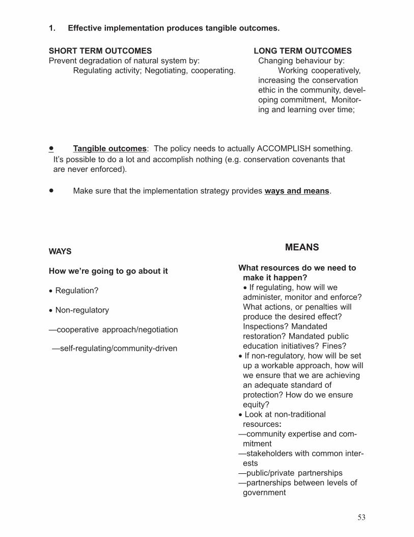
53
1. Effective implementation produces tangible outcomes.
· Tangible outcomes: The policy needs to actually ACCOMPLISH something.It�s possible to do a lot and accomplish nothing (e.g. conservation covenants thatare never enforced).
· Make sure that the implementation strategy provides ways and means.
WAYS
How we�re going to go about it
· Regulation?
· Non-regulatory
�cooperative approach/negotiation
�self-regulating/community-driven
SHORT TERM OUTCOMESPrevent degradation of natural system by:
Regulating activity; Negotiating, cooperating.
LONG TERM OUTCOMESChanging behaviour by:
Working cooperatively,increasing the conservationethic in the community, devel-oping commitment, Monitor-ing and learning over time;
MEANS
What resources do we need tomake it happen?
· If regulating, how will weadminister, monitor and enforce?What actions, or penalties willproduce the desired effect?Inspections? Mandatedrestoration? Mandated publiceducation initiatives? Fines?
· If non-regulatory, how will be setup a workable approach, how willwe ensure that we are achievingan adequate standard ofprotection? How do we ensureequity?
· Look at non-traditionalresources:
�community expertise and com-mitment
�stakeholders with common inter-ests
�public/private partnerships�partnerships between levels of
government
54
2. Effective implementation recognizes goals and objectives
· What do we want to doand how will be know when we�ve done it?
Ask this question often! Goals and objectives can provide ayardstick throughout the policy�s formulation, implementation,and review, keeping programs on track, and revealing the needto adapt and revise either the original goal or the implementa-tion plan to respond to new information.
· Align the implementation strategy as closeas possible to the goals and objectives.
(e.g. are there political aspects in the implementation strategythat will confound the ability to meet science-based goals &objectives?)
· Consensus on goals and objectives facili-tates implementation.
Where conflict prevents consensus, the conflict can result inlearning about other factors that need to be addressed.

55
3. Effective implementation includes the provision forperformance measurement, monitoring and reporting.
· Ensure that policy outcomes are having adesired effect- To prevent degradation of natural systems due to ineffec-
tive policy;- To maintain accountability to senior levels of government,
and the community;- To allow learning to occur.
· Use indicators to measure, monitor andreporton an ongoing basis- This provides an early warning system of negative im-
pacts, so activities can be adapted;- Information is available to meet senior government re-
quirements for accountability;- Learning and the concept of continual improvement are
hallmarks of performance measuring, monitoring andreporting on progress. Traditional �evaluation� and �audit-ing� are more judgemental/negative. .
�In simplest terms, an individual�s or society�s ca-pacity to improve their situation and contribute tothe well-being of the enveloping ecosystem, dependson taking action that leads to some positive outcome.If the nature of the outcome is not being recognizedand assessed against desired ends, little or no learn-ing occurs. If there is no such feedback, any im-provement is by chance if it occurs at all.�
Hodge, R.A., Hardi, P., and Bell, D. 1999. Seeing change Through the Lens ofSustainability. Background Paper Draft: 8 April 1999 for the workshop �BeyondDelusion: Science and Policy Dialogue on Designing Effective Indicators ofSustainable Development�, The International Institute For Sustainable Develop-ment, Costa Rica, 6-9 May, 1999. P. 1

56
4. Effective implementation cultivates co-operationand commitment.
· In the short-term, regulation and the imposition of standards areeffective in limiting human activity.- There are limits to how far regulation can go in protecting natural
areas, given what we know about local governments.- Enforcement is expensive and local governments are under
pressure to provide more with less.- If the community perceives some interest to be a priority, it has
the ability to zone and regulate land use to reflect these localvalues. These values may not priorize protection of natural areasover other land uses, leading to passive and active resistance topolicy.
· To protect natural systems over the long-term, a change has tooccur in the daily interaction between people and the land on
which we live
· Increasing the normative commitment of staff, politicians, and thecommunity is essential in substantively integrating natural area pro-tection into the variety of land uses identified by the community ashaving value.
· Choosing policy implementation processes that are cooperative,interactive and empowering vs. bureaucratic can increase nor-mative commitment.- Learning occurs through the experience of protecting the natural
environment.- Costs are shared as developers engage professionals vs. govern-
ment providing all of the issue identification, prescription andadvice.
- Direct costs to government are reduced through more efficientutilization of resources available in the community (e.g. EEPAC).
· Rationality affects commitment and compliance- The policy should be rational and scientifically defensible in order
to justify the restrictions that are being imposed on people�sactivity.

57
5. Effective implementation fits into anexisting context.
· Physical- Does the implementation plan take into account the physical
characteristics of the landscape and the nature of the systembeing protected?
Are different standards required for different types of wetlands:fens, bogs�?
Is a setback distance or buffer on flat terrain adequate for rollingtopography or steep slopes?
· Community- What are the values and priorities established by the public in
official community plans and zoning bylaws?
- Is there economic stress in the community that could undermineimplementation of an environmental policy?
- Is there interest in taking on a stewardship role, or does thecommunity rely on government to protect natural systems?
· Organizational- What level of experience and expertise does the municipality
have in implementing environmental policy?
- Will implementation of the policy be a significant divergence frompast practice? Is there likely to be commitment to the policy, orresistance and apathy?
- How many departments will be affected and how can efforts becoordinated to gain efficiencies in the implementation process?
- Is a change management plan necessary to guide the transitionperiod from past practice to the new way of providing service?
· Regulatory
- Does the implementation plan conflict or duplicate any existingFederal, Provincial or local government programs in place?

58
6. Effective implementation engages government andstakeholders in a process of collaboration, conflict andfeedback to learn and adapt over time.
· Conflicting values and competition for land use are a fact of lifein local government.
· Include conflict management in implementation plans as a wayto provide feedback and learn.
· Choose implementation tools that provide opportunities toinvolve people in the process of protecting natural areas. This helpsbuild normative commitment through participation and learning.
· Engage stakeholders in developing indicators, measuringperformance, monitoring, and reporting results. This can be ashared learning experience that can also help build normativecommitment.
Effective Implementation and Sustainability
· Effective policy implementation criteria contain some keythemes from implementation theory and everyday experience.
- taking the long-view to learn and adapt over time- enhancing normative commitment- forming partnerships and using cooperative approaches- taking a holistic view of the context of ecosystems and human
systems
These are also key concepts of sustainability.
· By creating a truly effective environmental policyimplementation strategy, local governments can movealong a parallel path toward more sustainablecommunities.

59
SUMMARY
Six Criteria For Effective Implementation
1 � Effective implementation produces tangibleoutcomes.
2 � Effective implementation recognizes goals andobjectives.
3 � Effective implementation includes the provisionfor performance measurement, monitoring andreporting.
4 � Effective Implementation cultivates co-operationand commitment.
5 � Effective implementation fits into an existingcontext.
6 � Effective Implementation engages governmentand stakeholders in a process of collaboration,conflict and feedback to learn and adapt overtime.

60
Vegetative Buffer Strips and Wetlands
Angus Norman -STTU -MNR-London
2000 03 05
Buffers " Best Evidence " Conference King's College, London, Ontario
Vegetative Buffer Strips and Wetlands

61
The following pages are excerpted from the book�Vegetative Buffer Strips and Wetlands� which is an up-to-date literature review by Angus Norman of the Ministry ofNatural Resources, Science and Technology Unit, London.

62
Vegetative Buffers for Wetland Protection and Provision of Habitatin Southern Ontario
Definitions and Descriptions
There are many definitions in the literature characterizing vegetation retained, created or man-aged adjacent to lakes, rivers and wetlands for purposes of water quality protection and the provi-sion and protection of habitat for a wide range of fish and wildlife species. Terms used include,riparian buffers, buffer strips, vegetated buffers, vegetated filter strips and filter strips.
The main features identified in this range of definitions and descriptions are:
§ They occur on lands adjacent to lakes, rivers, streams and wetlands§ They are often in a riparian zone§ The area may be periodically flooded§ The surface may be rough and the vegetation heterogeneous (vegetative buffer)§ The surface is smooth and the vegetation homogenous (vegetative filter)§ The vegetation may occur naturally or be planted§ The vegetation may or may not be managed · The band of vegetation may vary in
width§ They separate environmentally sensitive areas and development§ They lessen the impact of human disturbance§ They slow water runoff§ They reduce erosion§ They help stabilize banks§ They help protect water quality§ They provide some protection from non-point source pollution§ They trap sediment and other pollutants§ They provide habitat in the riparian zone§ They provide some habitat protection for the adjacent down-slope wetland/ water body§ They connect wetlands and other natural heritage features

63
Urban Considerations
In urban practice vegetative buffer strips are only one component in anintegrated stormwater management system.
A series of BMP�s should be utilized depending on the nature of the site,the nature of development and environmental protection goals andobjectives
Before development land in a watershed is available and costs ofestablishing a buffer strip and other best management practices at thattime are relatively low. Costs are comparatively low when an existinggrass or meadow area is reserved at the site before development begins
Further savings can be realized if the filter strip is used as an-on-siteerosion control practice during the construction phase of development. Ifa filter strip has been used as a sediment control measure during theconstruction phase, it is advisable to re-grade and re-seed the top edge ofthe strip.
A buffer strip to work effectively in an urban environment should:
1. have the top edge of the filter strip follow across the sameelevational contour
2. be equipped with some sort of level spreading device (i.e. a devicesuch as a shallow stone trench to convert concentrated flowsinto sheet flow)
3. be densely vegetated with a mix of erosion-resistant plant speciesthat effectively bind the soil
4. be graded to a uniform, even, and relatively low slope
5. if necessary have berms placed at 50 to 100 foot (15 to 30 m)intervals perpendicular to the top edge of the strip to preventrunoff from bypassing the strip

64
Widths
n absolute minimum - 6 m ( 20 feet ) -minimum - grade slope as closeto zero as drainage permits
n better performance -15 to 23 m + 1m for each 1 % increase in slope
n widths of 31m to 92 m needed for adequate removal of smallerparticles found in urban runoff
n If minimum width ( 6 m ) is used slopes should be graded as close tozero as drainage permits. Narrow filter strips to be effective in im-proving water quality must be managed as a lawn or short grassmeadow. These strips should be mowed 2 to 3 times a year to sup-press weeds and interrupt natural succession; clippings should thenhe removed.
n Wooded filter strips are preferred to grassed strips. If an existingwooded belt cannot be preserved at the site, the grassed strip shouldbe managed to gradually become wooded by intentional plantings.The maintenance required for a buffer strip depends on whether ornot natural vegetative succession is allowed to proceed. Under mostconditions, the gradual transformation from grass to meadow tosecond growth forest will enhance rather than detract from theperformance of wider buffer strips. This process can be enhancedwith intentional landscape plantings. Maintenance tasks and costs areboth sharply reduced for these �natural� buffer strips.
n To prevent concentrated flows from forming, it is advisable to haveeach buffer strip serve a contributing area of five acres or less.
n All buffer strips should be inspected on an annual basis for damage.Extra strip maintenance must be devoted in the first few months andyears to make sure the strip becomes adequately established includ-ing extra watering, fertilization and reseeding. Periodic spot repairs,watering and fertilization may be required to maintain a dense, vigor-ous growth of vegetation. Accumulated sediments deposited near thetop of the strip will need to be manually removed over time to keepthe original grade.

65
Recommendations
n Use good land use practices and best management practices to helpprotect both the wetland and the adjacent riparian zone.
n Use vegetated buffer strips to help protect the wetland.
n Use wide vegetated buffer strips wherever possible to help protectecological functions of the riparian zone.
n Manage runoff so that flow is shallow and uniform i.e. sheet flow.Use best management practices to help accomplish this.
n Assess the factors contributing to erosion, sedimentation, contami-nant and high nutrient runoff and utilize a series of bet managementpractices that are most appropriate.
n In all operations, try to maintain good ground cover to help controlerosion at the source.
n Avoid using minimum vegetative buffer widths wherever possible.
n Use wide buffer strips comprised of herbaceous vegetation, shrubsand trees wherever possible to help protect water quality and providewildlife habitat.
n Use settling basins to trap sediments and contaminants from inten-sive uses such as feed lots or in some urban situations before runoffreaches the vegetative buffer strip.
n In winter, during snowmelt and periods of high rainfall, use otherbest management practices to help reduce erosion, sedimentation andrunoff of high nutrient and contaminant levels.
n In intensive use situations such as certain farm or urban operationswhere space is limited, use herhaceous vegetation and mow it 2 or 3times per year and remove the cuttings.
n Use on slopes lcss than 10% or preferably 1css than 5%
n In urban situations, plan for space and management of vegetatedbuffer strips before construction.
n Inspect the buffer strip a few times per year to ensure there is adense vigorous growth of vegetation. Repair damage where neededas soon as possible.
n Riparian zones adjacent to wetlands are important for many speciesof wildlife that use wetlands. .

66
The following widths of vegetative buffer strip have been shown to helpprotect the ecological functions identified
Protection of bank erosion and sedimentation
Some protection from sedimentation and contaminantsSome habitat for edge species
Better protection from sedimentation and contaminantsHabitat for edge species
Good protection from sedimentation and contaminantsGood habitat for edge species
Good water quality protectionSupports some neo-tropical bird species
Good water quality protectionGood habitat for neo-tropical bird species and ground nesting waterfowl
Width ofVegetativeBuffer Strip
Ecological Function Protected
3 - 5 m
15 m
30 m
50 m
100 m
300 m

67
BUFFER ZONESFrom a planner perspective zoning by-laws are the most effective and
versatile regulatory tools that are used to implement the policies of anOfficial Plan.
Zoning, as a management tool for habitat protection, is used to differen-tiate between areas of development and areas of no development, or openspace. In the zoning of land, a buffer is a transition zone between two landuses that separates and protects one from the other. The width of thebuffer zone must be large enough to sustain the two land uses on either sidewithout conflict or impact.
From an ecologist perspective, drawing a hard line, or a zone boundary,on a map is contrary to the concept of ecosystem, because nature operateswithin fluxes and across gradients, not within lines (Riley & Mohr, 1994)and ecosystem boundaries are not fixed in time and space on the landscape.
In a fragmented landscape the boundaries of the remnant terrestrialpatches are based only in part on ecological criteria, but are strongly influ-enced by ownership patterns and past land uses. Thus any boundary be-tween natural vegetation and other land uses becomes our operational start-ing point. From there, defining an ecosystem boundary requires under-standing of the constraints, both natural and anthropogenic or technologi-cal that the ecosystem is operating under. This is where buffers play animportant role in the management of natural systems.
In order to define buffers, we must first define the goal.
GOALS OF BUFFERS- To minimize ecological impacts to features and functions of sites, and
maximize the long-term viability of natural systems and species(Riley & Mohr, 1994).
- To achieve a reasonable balance between the needs of people living ina community and the needs of wildlife - based on ecological princi-ples and the best scientific information available (Duerksen et al1997).
- to acknowledge the natural limits on system functions and not try toexceed them; and to acknowledge that anthropogenic constraints onsystem functions are potentially preventable, modifiable or removable(Merriam, 1994).
1. BUFFER ZONES2. GOALS OF BUFFERS3. DRAWING THE LINE -CORE/BUFFER CONCEPTversus WHOLE PATCHCONCEPT4. FIXED-WIDTH versus SITESPECIFIC BUFFERS5. REALITIES OF BUFFERMANAGEMENT ANDOWNERSHIP6. CASE EXAMPLES INLONDON
IMPLEMENTATION OF BUFFERSDRAWING THE LINE AND OTHER SITE-SCALE TOOLS
- Bonnie Bergsma
68
DRAWING THE LINES - CORE/BUFFER CONCEPT versusWHOLE PATCH CONCEPTHow we draw the line delineating the area to which buffers are applied
is a critical first step. In the fragmented landscape, setting ecological bounda-ries of natural areas based on what is left over is what we have to workwith. The determination of buffers is generally done after the ecologicalboundaries have been delineated. What do we include in ecological bounda-ries?
The Core/Buffer Concept is widely used in conservation planning ap-proaches, particularly in wilderness or more forested settings. In this ap-proach a process of identifying areas of relative degrees of sensitivity, sig-nificance and ecological features and functions is completed to the extentthat the natural area is separated into parts which are then treated individu-ally as having lesser or greater significance. A core area is identified forprotection. Buffers are added, generally two zones.
Where this type of functional approach has been used in fragmentedlandscapes, we do not end up with two buffer zones. As a rule, this corearea is always smaller than the whole patch. The shrubby vegetation, oryoung previously grazed forests, or disturbed forests or regeneration of-ten present on the edge of the existing natural area is defined as non-sig-nificant to the whole, cut out of the boundary and then a minimum widthadded back in under the heading of buffer. All it does is result in the protec-tion of a smaller internal area and the creation of new internal edges.
The concept would be more acceptable if multiple buffer zones are cre-ated with inner zones consisting of existing vegetation important to theintegrity of the area and sufficient to accommodate shifts in the ecosystemover time and an outer zone which may support compatible uses such aspassive recreational trails, vegetation restoration, stormwater managementfacilities and other softer development forms.
The Whole Patch Concept is one which is supported by the City ofLondon for Environmentally Significant Areas. All naturalized vegetationwithin the patch is identified for inclusion in the boundaries including rea-sonable amounts of shrub thickets, younger woodlands and plantations thatadd supporting habitat, diversity, connectivity, internal linkages, visual andspatial buffers, restoration opportunities and contribute to the ecologicalintegrity of the whole. The whole patch approach is an outward approachwhich looks at the fragment in relation to the role it plays or potentiallycould play, in the larger landscape in which it is situated.
The determination of buffers is done after the ecological boundarieshave been delineated. All lands required for buffer are designated in thesame open space zone as the patch. Other site management tools to reducethe size and intensity of the zone of disturbance to the natural area at thezone boundary are then included in the subdivision agreements or develop-ment agreements for site plans. These may include such things as: use re-strictions, tree protection and retention plans, controls on fencing and ac-cess, development phasing, controls on construction activities, etc.

69
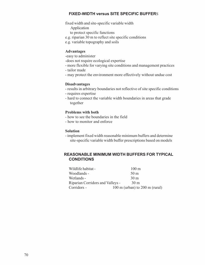
70
FIXED-WIDTH versus SITE SPECIFIC BUFFERS
fixed width and site-specific variable widthApplicationto protect specific functions
e.g. riparian 30 m to reflect site specific conditionse.g. variable topography and soils
Advantages-easy to administer-does not require ecological expertise- more flexible for varying site conditions and management practices- tailor made- may protect the environment more effectively without undue cost
Disadvantages- results in arbitrary boundaries not reflective of site specific conditions- requires expertise- hard to connect the variable width boundaries in areas that grade
together
Problems with both- how to see the boundaries in the field- how to monitor and enforce
Solution- implement fixed width reasonable minimum buffers and determine
site-specific variable width buffer prescriptions based on models
REASONABLE MINIMUM WIDTH BUFFERS FOR TYPICALCONDITIONS
Wildlife habitat - 100 mWoodlands - 50 mWetlands - 30 mRiparian Corridors and Valleys - 30 mCorridors - 100 m (urban) to 200 m (rural)

71
REALITIES OF BUFFER MANAGEMENT AND OWNERSHIP- we tend only to get the minimum that is achievable based on environ-
mental, social and economic interests, rather than what is ecologi-cally most appropriate.
- regulatory buffers require monitoring and enforcement to ensureeffectiveness.
- buffer boundaries must be clearly evident and easily identifiable to beenforced and monitored.
- as a rule, buffers are subject to reduction in size over time throughencroachment
- On blocks of land subject to site plan, or in rural areas, it is possible tohave a separate buffer zone identified and implemented and main-tained over time.
- On individual lots on plans of subdivision, it is not feasible to havemultiple zones and restrictions on lots for several reasons. First it iscumbersome to enforce and monitor a buffer that encompassesmultiple landowners. Second, it relies upon education and steward-ship initiatives which are voluntary and if not embraced by the owner,compromises the area which is to be protected.
- it is far easier and ecologically more viable to develop a managementprogram for the buffer as part of the larger open space block andmaintain it under one ownership, preferably public or other conserva-tion body.
- Regulatory approaches need to be balanced with integrated ap-proaches that include education and citizen involvement, cooperativemanagement coupled with buffer demonstration areas, financial andother incentive tools for landowners to conserve buffers, acquisitionprograms, private-sector initiatives, development agreements.

72
CASE STUDY 1 - LONDONSubdivision with single lots adjacent to an ESAlarge active river and tributarysteep slopes with seepage areaswildlife corridorformer apple orchardrare species
Buffer Goals1. Protect the Ecological Resource- protection of slopes for long term stability and encroachment- protection of watercourse- protection of a wildlife corridor- protection of existing natural vegetation- protection of seepage areas and ground water recharge/discharge = water balance2. Provide opportunity for enhancement- compensation for loss of orchard habitat- location of storm water management pond in between the fill line and flood line3. Provide social/recreational values- allowance for trail location behind lots
Parameters for buffers to extend to the rear lot line - all lines are mapped and thegreater of the lines becomes the boundary of the buffer
- use of minimum fixed width and variable buffers.- multiple zones within the buffer
1. Riparian buffer -minimum 30 m from the watercourse2. Slope buffer - minimum 10 m from the long term stable angle3. Vegetation buffer - to the edge of the existing naturalized vegetation (if trees meas-
ured at the outer drip line)4. Naturalization and trail areas - between the rear lots and the existing vegetation
CASE STUDY 2 - LONDON
Subdivision with Blocks adjacent to a locally significant wetland- riparian wetland- unusual skunk cabbage dominant gently sloping wetland- upland island- seepage slopes linkage to forested open space areas- water pipeline easement identified for recreational access- high ground water table
OMB Hearing on issues related to wetland boundary and buffers-approved 15 m riparian buffer-approved 5 -15 m wetland buffers-deferred areas on seepage slopes and linkage for further study-additional setbacks for rear yard areas and areas where no basements could be built.-designated buffers in a special open space zone, the area which could be used for
density calculations

73
SELECTED REFERENCES
Duerksen, C.J., D. Elliot, N. Thompson Hobbs, E. Johnson, J. R. Miller1997. Habitat Protection Planning: Where the Wild Things Are. Ameri-can Planning Association.
Gray, Merriam 1994. Managing the Land: A medium-term strategy forintegrating landscape ecology into environmental research and manage-ment. Forest Fragmentation and Biodiversity Project, Report No. 13. On-tario Forest Research Institute, Sault Ste. Marie.
Johnson, A.J. and D. Ryba 1992. A Literature Review of RecommendedBuffer Widths to Maintain Various Functions of Stream Riparian Areas.Prepared for King County Surface Water Management Division
Mitchell, Frank 1996. Vegetated Buffers for Wetlands and Surface Wa-ters: Guidance for New Hampshire Municipalities. Wetland Journal Vol 8(4): 4-8. Environmental Concern Inc.Maryland.
Noss, Reed 1995. Maintaining Ecological Integrity in RepresentativeReserve Networks. A World Wildlife Fund Canada/World Wildlife FundUnited States Discussion Paper.
Riley, John L. and Pat Mohr 1994. The Natural Heritage of SouthernOntario�s Settled Landscapes. A review of conservation and restorationecology for land-use and landscape planning. OMNR, Southern Region,Aurora.

74
In Duerkson et al. 1997. Habitat protection planning: Where the wildthings are. American Planning Association.
Table 3.2 The Scale/Tool Matrix

75
i) Ecological buffers serve to protect the ecological function and integ-rity of the Natural Heritage System. Buffers may be required around, oradjacent to, the shorelines of lakes, rivers and streams and other compo-nents of the Natural Heritage System.
ii) The location, width, composition and use of ecological buffers neces-sary to protect natural heritage areas from impacts of development onadjacent lands will be specified through a community planning study and/or an environmental impact study.
iii) In addition to buffer lands, additional techniques may be required inminimizing the impact of development on the Natural Heritage System,including but not limited to:
a) The use of site planning to orient the development away from naturalheritage areas;
b) The acceptance of lands immediately adjacent to natural heritageareas as part of the required parkland dedication for the proposed devel-opment;
c) The use of a setback from the boundary of natural heritage areas forreconstruction purposes;
d) Restriction of public access by providing a limited number of accesspoints to natural heritage areas; and
e) Other measures, such as fencing.
An example of policy in Official Plan language is this one from the City ofLondon Official Plan. This section along with the balance of other environ-mental policies in Chapter 15 were the subject of an Ontario MunicipalBoard hearing. The challenge by the London Development Institute wassubstantively rejected by the Board and some phrases were strengthened.The work that remains is to transfer this official plan language for policyguidance into effective day-to-day management procedures to ensure thatthe Natural Heritage System is ecologically viable.
The City shall prepare and adopt a Guideline Docu-ment setting out recommend criteria and param-eters to facilitate the identification of EcologicalBuffers.
Official Plan15.3.6
City of London
OMB DecisionNo. 1048, June3/99
Ecological Buffers

76this page is intentionally blank

77
2.3.1 Natural heritage features and areas will be protected from incom-patible development.
a) Development and site alteration will not be permitted in:· significant wetlands south and east of the Canadian Shield; and· significant portions of the habitat of endangered and threatened spe-
cies.b) Development and site alteration may be permitted in:
· fish habitat;· significant wetlands in the Canadian Shield;· significant woodlands south and east of the Canadian Shield;· significant valleylands south and east of the Canadian Shield;· significant wildlife habitat; and· significant areas of natural and scientific interest
if it has been demonstrated that there will be no negative im-pacts on the natural features or the ecological functions forwhich the area is identified.
2.3.2 Development and site alteration may be permitted on adjacent landsto a) and b) if it has been demonstrated that there will be no nega-tive impacts on the natural features or on the ecological functionsfor which the area is identified.
2.3.3 The diversity of natural features in an area, and the natural connec-tions between them should be maintained, and improved wherepossible.
2.3.4 Nothing in policy 2.3 is intended to limit the ability of agriculturaluses to continue.
Natural Heritage
Provincial PolicyStatement 2.3

78this page is intentionally blank

79
�All fish habitat is protected by federal legislation which is adminis-tered by the Ministry of Natural Resources in conjunction with the fed-eral Department of Fisheries and Oceans.
�All fish habitat, including that used seasonally, shall be protected.The Ministry of Natural Resources, or its designate, may be consultedwhen development is proposed which may affect fish habitat in order toascertain development alternatives that will achieve no net loss of pro-ductive capacity and seek a net gain of productive capacity wheneverfeasible. Development may be permitted if it does not harmfully alter,disrupt or destroy fish habitat. The relocation and redesign of develop-ment proposals is preferred over mitigation and compensation of fishhabitat. A net gain can be achieved through the restoration of degradedhabitat, the enhancement of existing habitat and/or creation of new habitatwhere possible.
Fish habitat protection may require a development setback and anappropriate vegetative buffer, the width of which will be determined inconsultation with the Ministry of Natural Resources.
Area municipalities are required to consult with the Ministry of NaturalResources and the conservation authority to determine environmentalprotection methods which will minimize or prevent fish habitat degra-dation, ensure no net loss of fish or fish habitat and protect the values ofSignificant Biotic Areas when maintaining municipal drains or estab-lishing new ones�(Region of Haldimand-Norfolk, 1997).1
1Official Plan for the Regional Municipality of Haldimand-Norfolk, p. 66-67
FISH HABITAT
developmentsetback and anappropriatevegetative buffer
An example of Official Plan text pertaining todevelopment setback and buffer.
This is taken from the section on �enhanced policies� in NATURAL HERITAGEPLANNING POLICY IN ONTARIO: A REVIEW OF COUNTY AND REGIONALOFFICIAL PLANS carried out by The Best Policies Working Group of theOntario Professional Planners Institute and published in August 1999.
Enhanced policies address the full range ofnatural heritage features as set forth in the Pro-vincial Policy Statement and the natural con-nections between them. Effective controls ondevelopment and site alteration within naturalheritage areas are in place.p. 15-17
Best Policies

80
Definition & Purpose of Buffers and Setbacks
- C of London, EEPAC proposal 991115
Setback� boundary between private and public� measured from feature (ESA, naturalized vegetation) to rear lot line� protect property from encroachment by public� protect individuals from hazards
Bufferssoft zone to protect natural function or feature
Objectives� control encroachment (rubbish, lawn extension, garden)� limit access� assert ownership� privacy (visual screen)� multiple-use objectives� recreation� public access and recreational utilization� reduce edge effect� wildlife/aquatic habitat maintenance/enhancement� water quality/water quantity
Authority forSection 15.6.12
The Subwatershed Plans identify �antifragmentation� areas which, if natural-ized, would have the greatest potential for enhancing the Natural Heritage Sys-tem. Naturalizing these areas would restore some of the historic habitat diversity.
Comprehensive Set of Policy Statements (Bill 163)Goal 1A ... the naturally vegetated or potentially revegetated areas that link or
border natural areas and provide ecological functions such as habitat, passage,hydrological flow, connection or buffering from adjacent impacts. They can oc-cur across or along uplands, lowlands or slopes. Ravine, valley, river and streamcorridors are further defined as landform depressions, usually with water flowingthrough or standing in them for some period of the year. Ravine, and valleycorridors may be defined locally by considerations such as their natural featuresand functions, minimum setbacks from crest of slope, top of ravine or valley bankor top of projected stable slope.

81

82
Performance Management Zone
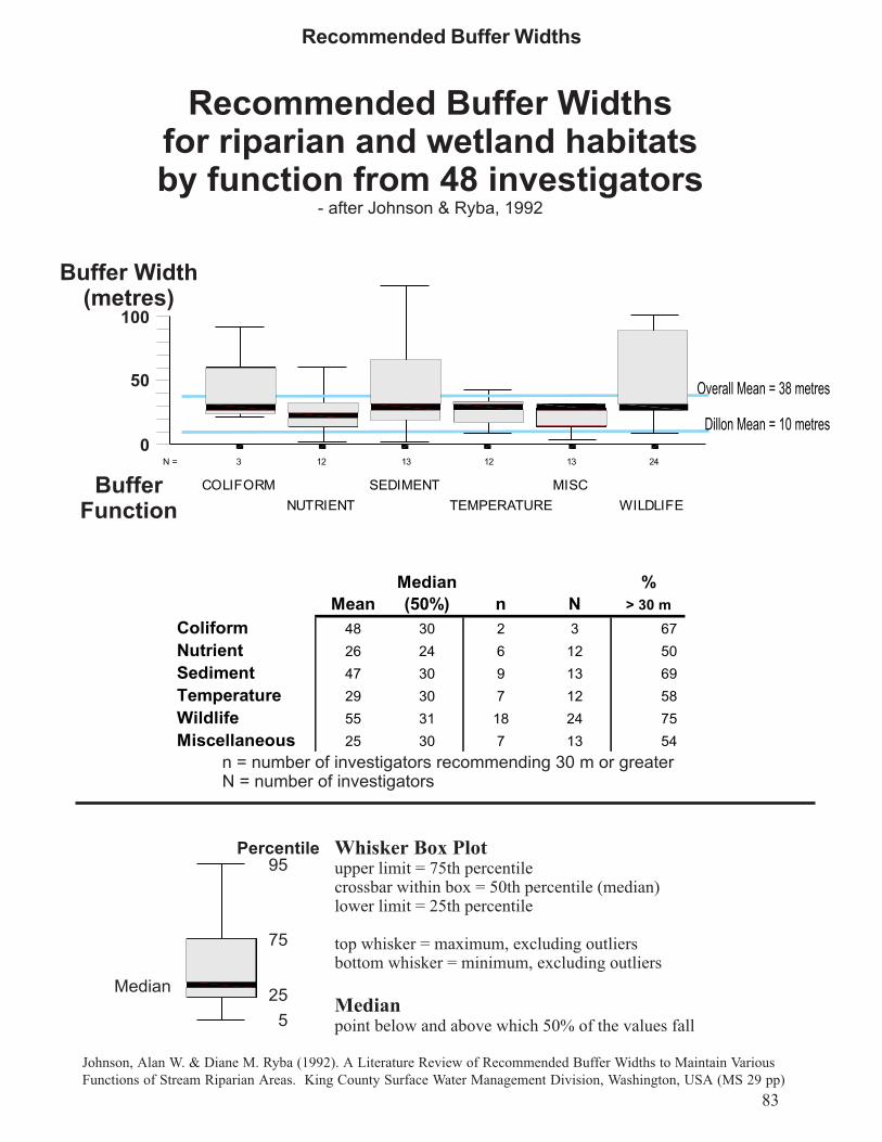
83
Johnson, Alan W. & Diane M. Ryba (1992). A Literature Review of Recommended Buffer Widths to Maintain VariousFunctions of Stream Riparian Areas. King County Surface Water Management Division, Washington, USA (MS 29 pp)
Recommended Buffer Widths

84

Angus Norman Barb Rosser Tracey Ryan
N Mean Median N Mean Median N Mean Median
Factors in choosing to attend [Scale 1 = Extremely Unimportant�7 = Extremely Important]
Relevance to work 15 5.27 5.0 18.0 5.17 5 12 4.50 5
Speaker 14 4.14 4.0 18.0 4.00 4 12 4.50 4.5
Title 16 4.94 5.0 18.0 5.06 5 12 5.33 5.5
Rating of [ Scale 1 = Very Poor � 5 = Very Good]
WorkshopFormat 15 3.40 3.0 18.0 3.72 4 11 4.27 4
FacilitationStyle 15 3.33 3.0 16.0 3.69 4 12 4.00 4
Presentation 15 3.20 3.0 18.0 3.94 4 12 4.33 4
Were your objectives achieved 11 0.45 0 16 0.88 1 10 1.00 1
Jane Bowles Muriel Andreae Michelle Kanter
N Mean Median N Mean Median N Mean Median
Factors in choosing to attend [Scale 1 = Extremely Unimportant�7 = Extremely Important]
Relevance to work 14 6.00 6 7 5.29 5 23 5.91 6
Speaker 13 4.46 4 7 4.14 4 22 3.68 3.5
Title 14 5.29 5 7 4.71 5 23 5.30 5
Rating of [ Scale 1 = Very Poor � 5 = Very Good]
WorkshopFormat 14 3.43 4 7 3.57 3 24 3.75 4
FacilitationStyle 14 3.93 4 7 4.00 4 23 3.74 4
Presentation 14 3.36 3 7 3.86 4 24 3.79 4
Were your objectives achieved 11 0.36 0 4 0.25 0 18 0.67 1
Bonnie Bergsma Linda Harvey Hal Schraeder
N Mean Median N Mean Median N Mean Median
Factors in choosing to attend [Scale 1 = Extremely Unimportant�7 = Extremely Important]
Relevance to work 13 6.92 7 17 5.12 5 7 6.29
6
Speaker 12 3.58 3.5 16 3.56 3 7 5.00 6
Title 13 5.00 5 17 4.41 4 7 5.86 6
Rating of [ Scale 1 = Very Poor � 5 = Very Good]
WorkshopFormat 13 3.54 4 16 3.50 4 7 4.43 5
FacilitationStyle 13 3.54 4 16 3.56 3.5 7 4.00 4
Presentation 13 3.62 4 16 3.94 4 7 4.43 4
Were your objectives achieved 12 0.58 1 14 0.50 0.5 7 0.86 1
OverallN Mean Median
Factors in choosing to attend [Scale 1 = Extremely Unimportant�7 = Extremely Important]
Relevance to work 126 5.6 6
Speaker 121 4.0 4
Title 127 5.1 5
Rating of [ Scale 1 = Very Poor � 5 = Very Good]
WorkshopFormat 125 3.7 4
FacilitationStyle 123 3.7 4
Presentation 126 3.8 4
Were your objectives achieved 103 0.6 1
Workshop Evaluation Summary

86

87
The majority of conference participants attended the conference to learn from others because ithad value for their work.
Reasons for attending this conference Mean Median Mode Percent ranking as 6 or 7
to improve knowledge 6.12 6 7 77to learn form others 6.13 6 6 77the value to my work 6 6 6 77the agenda 5.4 5 5 42PD Day 4.5 5 6 38Cost 4.3 4 4 27Financial Support 3 2 1 14
Generally, the facilities and food were rated as good. Two areas that should be improved are thesize and quality of the workshop rooms and better time management.
One of the workshop rooms was inappropriate for the number of delegates. A sign-up list attime of registration to determine the number of participants per session would enable achieving abalance.
A request for more time or a longer conference were written by many. The structure of theworkshops was also a common comment. It was suggested that the workshop leader deliver afocussed and short presentation and only after that to open the floor to discussion. The number oftimes that an individual may comment should be limited by setting out rules at the beginning andasking for agreement. Schedule five minute breaks between sessions.
Handouts and an early turn-around on the conference proceedings were requested.
Facilities Food Time ManagementKingsSite am Room WshopRooms Dining pm Room Preparation am break pm break Luncheon
N 69 68 69 67 64 67 68 67 66 68Mean 4.25 4.12 3.61 4.06 4.09 4.04 4.29 4.42 4.18 3.82Median 4 4 4 4 4 4 4 4 4 4Mode 4 4 4 4 4 4 4 5 4 4
Conference Evaluation

88
C - Comments beside questionsR - Recommendation to make a successful conference
Conference Cost & Student/ngo support C - thought cost was moderate, not low C - great to hear that high school and university studentswere here C - conf fee was not low
Facilities Directions to site & rooms C - confusing about where rooms were, where to go C - better directions to the conference and within site torooms C - better directions to the conference were needed C - Kings was easy to find; free parking is a plus Food C - fruit was great C - lunch was a little short C - afternoon refreshments outside was great; fresh fruitis always the key C - fabulous fruit C - lunch was disgusting C - should be reusable or recyclable cups and plates C - meat, fish, some protein needed for luncheon Morning Room C - morning room was hard to find C - dining room should have microphone for announce-ments and speeches C - more microphones throughout morning meeting room C - sound poor in morning sessions Workshop Rooms C - workshop rooms were small C - Room 176 was very warm and stuffy C - Rm 176 was tight; not enough seats C - Rm 176 was too small; lack of air C - Room 178 was bad C - Rm 176 too small; hot! C - Room 176 was too small C - room too small C - Room 176 was not good; too small; very stuffy C - workshops room were good except 174 C - workshop rooms were too small C - hard seats in workshop rooms C - student desks are hard for left-handers Afternoon Room C - lecture halls not very cheerful, no windows
Time Not enough time C - not enough time in afternoon plenary C - not enough time in morning panel C - not enough time C - not enough time though, to get into the ��meat�� ofthe matter C - too little time per sessions C - need more details and more time in plenary C - more time needed on this issue C - It is always easy to go over time; good job at keepingsessions almost on time C - morning panel was too short C - morning panel was too brief C - thanks for being on time C - too many things to cover, not enough time C - time mgt � too much to cover C - more time would have been useful C - too short a time to discuss in plenary session
C - no time to discuss conclusions R - although the workshop sessions seem too short awhole hour might be tiring and 3 sets probably couldn�t be held R - need 5 min break between sessions R - more time!Conference length C - one day is sufficient although probably benefit fromsecond meeting at a later date; with range of interests participat-ing�group not met before, should maybe have been 1.5 days C - one day not enough; a day of solutions to follow wouldhave been good C - one day is sufficient; but need to focus more C - one day sufficient for a brainstorm but not to get to asolution C - overall I think this type of conference required morethan one day to discuss the diverse topics that were presented. C - one day is insufficient, topic too vast C - one day is enough but I�d stay for more C - too much info to be reviewed in one afternoon R - either a 2 day conference or part of a series over aperiod of time R- It was too much information and too many topics for aone day workshop Suggestion C - would suggest earlier start but build in time fordisplays; many not set up before 10 as planned C - afternoon plenary was a good summary but hearingspeaker�s summaries is tiresome; could have been shorter C - I found the presentations too long in the afternoonwhich didn�t leave enough time for discussion C - plenary session helped but it went too fast C - much time spent discussing problems, but perhapsdue to time constraints there was little in the way of usefulconclusions at the end ie buffers �best evidence� C - needed more time for discussion, expected more��evidence�� to be presented C - have a timer for all sessions R - set aside as much time as possible for discussions.Try to encourage debates
Participation C - Round Robin at the beginning was good to fosterdiscussion throughout the day C - it was a good discussion but I did not learn anything newor have enough info exchange with practitioners in othermunicipalities C - very interesting issues; lots of viewpoints from differentagencies, groups and government C - most people seemed most focussed on how to get coreareas meaningfully protected and weren�t yet at the stage ofdealing with buffers C - I really enjoyed the contributions from different people inthe �audience� ie discussion format as opposed to lecture format C - It was an excellent forum for determining what does existin terms of buffer policy/knowledge and what need to be done toensure or initiate sound environmental planning R - do GTA, rural, small, intermediate town/city examples;look at differences, etc. R - Utilize actual case studies � have sessions on variousmunicipal case studies, planning process and impacts. Presentpoints of view of developers, municipalities, local EAC R - break into two groups � those with an in depth knowl-edge of issues; another for those who are trying to get a generalunderstanding of the issues R - more scientists that are studying buffers should have beenasked to present their data, ie Masters or PHD students current

research in this area R - focus on municipalities in general, not just London forthe benefit of those who are not from the area R - bit of overemphasis on London and City of London �suggest move next meeting to another Carolinian CanadaCommunity R- invite local decision makers � elected officials - for free R - more variety in participants: industry, business should bemore involved; more politicians also R - lots of municipal representatives; need developmentindustry input R - still need to engage agriculture, aboriginals and develop-ers � didn�t hear from these groups or feel they were repre-sented here.
Round Robin R - drop the round robin; end earlier C - morning intros good R - Round Robin excellent way to introduce issues and startdiscussions between attendees; well �facilitated�
Panel C - morning panel was intimidating C - morning panel was a good way to flush out range ofissues C - panel somewhat informative C - morning panel gave different points of view C - panel was a good discussion C - panel � not many questions C - panel discussion was mildly informative
Workshop R - smaller workshops if possible R - smaller groups to allow more complete participation R - could engage participants in smaller groups to work onexamples R - ask facilitators to get the group to begin with an agree-ment or acknowledgment that individuals can speak no morethan twice in each meeting R - Presenters should have presented info then allowquestions R - more interaction in smaller groups with more practicalexamples R - more opportunity for info exchange and discussion withpractitioners in othe municipalities R - provide more info on the workshops to help peopledetermine which workshops to attend R - need speakers to focus more on concrete examplesdemonstrating benefits and detriments emanating from thebuffers that were implemented; otherwise the conference tendsto hang too much on the general concepts R - I would suggest that sessions remained more focussed onthe issue at hand (sessions tended to stray away from buffersthemselves). R - one thing that I would recommend is to have a more indepth description of the workshops taking place R - handouts prior to the start of each presentation like LindaHarvey R - perhaps only 2 concurrent sessions, rather than 3 toensure one is able to get adequate information, and not miss toomany other discussions/sessions
Plenary C - afternoon plenary session � people reported presenta-tions; not sure about next step to clarify issues; thought after-noon session would be more facilitated workshop, but waspresentations with questions and comments; I only attendedimplementation sessions; bit rushed, not sure achieved consen-sus C - afternoon plenary clarified issues to a degree; time was alimit C - plenary clarified, sort of C - plenary clarified the need for more information C - afternon summary plenary session helped C - plenary provided more questions than answers C - plenary created more questions C - plenary clarified some issues C - plenary clarified somewhat
Overall Favourable C - overall the conference was very useful C - I thought the day was very well organized. I heard alot but I am still not ready to say I know how to implement abuffer plan. I hear that others are struggling, that the scientificinfo is lacking. C - the day gave me things to think about but not answers C - It illustrated a real need to show information, policies,etc. to protect vanishing ecosytems. C - This conference illustrated the great diversity andlevels of protection afforded natural open spaces (woodlots, etc.)with various communities. C - overall, I learned the things that I needed to know C - conf helped me to understand what�s going on withnatural area protection C - provides useful benchmarks from other areas C - I came away with a lot of new knowledge
Unfavourable C - no new information or specific targets C - conf provided little in the way of direction C - disappointed in outcome; too much focus on problemrather than solutions. C - overall, not useful; nothing new C - not sure question of buffers was answered R - covering a lot here; maybe more focus on one or twokey issues R - presentations were not really well organized; itseemed to be more of a discussion of what a person or munici-pality think that they have the best policies that work but notbacked by research R - define a small number of issues to address and focusdiscussion on those issues, Discussion at this conference wastoo dispersed to draw conclusions. It might have been better tofocus on one or two particular scenarios e.g. a buffer in an upland situation where urban development isproposed. R - need much more specific info; clearer more relevantexamples not just general ideas and overviews; use of examples,samples of municipalities where various distances have beenutilized R - tell all speakers to avoid use of all acronyms R- no recognition of political and financial realities andmechanisms to sell at these levels

Mixed C - There is so much more to cover; more questions askedthan answered C - conference somewhat useful, overall C - many questions raised but not answered C - re objectives: satisfaction is proportional to thereciprocal of expectations C - objectives � not set buffers but I suppose shouldn�texpect miracles C - some objectives were met C - Overall I was hoping to go away with a guideline todeveloping an achievable buffer policy C - objectives achieved partly; difficult subject C - objectives met half & half C - it should be if goals are focussed C - hoping for more examples plus research R - otherwise, very good structure
General C - so much focus on resident issues and not the forestissues C - It also illustrates the dire need to have mechanisms toacquire natural areas�buffer areas mean nothing if the resourceis lost! C - what about planning guideline C - difficult to focus on buffers C - implementation mechanisms more critical to me C - need more agreement on basic buffer parameters, usesame language C - more handouts please C - proceedings will help cover other workshops C - Tracey Ryan�s talk was very good C - King�s is a bad example for buffers C - need to decrease number of comments per person inworkshops C - buffers = something to polish your car with C - no urban perspective C - seemed to be most focussed on pleasing people thatlive next to buffers vs the ecological backing for buffers C - The groups were rather large which probably limitedthe input from most of the groups; not really a criticism, it justreflects the success of response to the workshop C- not enough details
Other R - recycle tags R - more displays; resource materials; experts contact list R - a rainy day so that we would have felt better about beingstuck inside; otherwise, well done! R - provide proceedings to take home with contact info tofollow up with any of the speakers R - I would very much appreciate a list of participantsincluding addresses. R - I am looking forward to receiving the information fromthe conference. R - beer R - be more practical about how things/policies are imple-mented
New Conference Themes R - Lobby to open the Planning Act to force addition 5%taken for natural areas separate from the 5% dedication forparkland!!! R - next conference re monitoring R - how to do an EIS R - how to evaluate cumulative effects R - monitoring R - monitoring R - how to evaluate performance of buffers R - profile successful buffer projects that have beenimplemented; provide tools and techniques R - monitoring guides and guidelines R - focus on an issue and seek solutions that can beapplied; or better understanding to bring solutions in one�slocal area R - need more ��how to�s�� R - next conference: cumulative effects, GIS, EIS guide-lines, defining core for natural area R - more case studies with technical info R - identify research needs and ways to achieve them R - next time monitoring R - future studies � EIS guidelines R - next conference on EIS R - EIS standards relying on speakers with local knowl-edge and broad view of topics R- next conference re doing EIS�s consistently R- Maybe have separate workshops for defining types ofbuffers, implementation of buffers, etc. R - perhaps working groups should be struck (ie technicalgroup, policy group, implementation group, stewardshipgroup) to provide more focus on issues R - needs a discussion paper ahead of time with alterna-tives presented for language and approaches, etc. to focuspurpose of conference; could include a literature ereview, afew tables R- need a better balance between identifying issues andimplementation mechanisms on this issue R- Focus on natural heritage system planning � this waslacking R- Focus on implementation and networking to makenecessary systemic changes to improve buffers � this waslacking R- need to explore the role of the Province of Ontario andits failure legislatively to provide the tools for municipalitiesto work with R- relationship to the Planning process needs to be furtherexplored R - I am involved in organizing the Riparian workshop. Icommend you on broad participation and engagement ofmunicipalities in today�s workshop. I would recommend youdo this again!

91this page is intentionally blank

Conference Participants Page 1 of 5
Name Affiliation Address Town Prov Code Fax e-mailLeslie Adams POWER 38 Mill Pond Dr Georgetown ON L7G 4S6 [email protected]
John Ambrose U of Guelph 34 Norwich St East Guelph ON N1H 2G6 519-767-1991 [email protected]
Muriel Andreae St Clair Region Conservation Authority 205 Mill Pond Cr Strathroy ON N7G 3P9 519-245-3348 [email protected]
Adele Arbour City of Thorold 8 Carleton St South, Box 1044 Thorold ON L2V 4A7 905-227-8137 [email protected]
Chris Audet Earth Tech Canada 45 Green Belt Dr Don Mills ON M3C 3K3 416-445-5276 [email protected]
Joni Baechler Urban League of London 23 Jennifer Gardens London ON N5X 3K2 519-660-6395 [email protected]
Gregg Barrett City of London, Parks Planning Box 5035, 300 Dufferin Ave London ON N6A 4L9 519-661-5397 [email protected]
Rob Barrs Development Engineering 361 Dufferin Ave London ON N6B 1Z5 519-672-4182 [email protected]
Rob Bayley City of Vaughan 2141 Major Mackenzie Dr Vaughan ON L6A 1T1 905-832-8545 [email protected]
Bonnie Bergsma C of L Parks Planning Box 5035, 300 Dufferin Ave London ON N6A 4L9 519-661-5397 [email protected]
Douglas Bocking Thames River Heritage River Designation 641 Hillcrest Dr London ON N6K 1A8 [email protected]
Teresa Bosco City of Toronto 500 University Ave, 4th Floor Toronto ON M5G 1V7 416-392-6657 [email protected]
Jane Bowles University of Western Ontario Dept of Plant Sciences London ON N6A 5B7 519-661-3935 [email protected]
Erick Boyd Twp of Middlesex Centre 10227 Ilderton Rd, RR 2 Ilderton ON N0M 2A0 519-666-0271 [email protected]
Rebecca Breuer Lucas Secondary School 571 Willowdale Ave London ON N5X 1J2 [email protected]
Jason Budd Knutson Planning Inc 562 Wellington St London ON N6A 3R5 519-858-0759 [email protected]
Tara Buonpensiero City of Brampton 2 Wellington St West Brampton ON L6Y 4R2 905-874-3369 [email protected]
Ron Burnett Development Engineering 361 Dufferin Ave London ON N6B 1Z5 519-672-4182 [email protected]
Steve Couture City of London, Planning Policy Box 5035, 300 Dufferin Ave London ON N6A 4L9 519-661-5397 [email protected]
Ken Dance Dance Environmental Inc 193 Lakeside Dr Kitchener ON N2M 4C7 519-570-1777 [email protected]
Kathleen Davis-Baas Caledon Environmental Advisory Committee 15849 Airport Road Caledon East ON L0N 1E0
Peter De Iulio Town of Flamborough 163 Dundas St East, Box 50 Waterdown ON L0R 2H0 905-689-3338 [email protected]
Bill De Young EEPAC, London 314 Cromwell Street London ON N6A 1Z6 519-645-8188 [email protected]
Norman DeFraeye Bird & Hale Ltd. 2 Carlton Street, Suite 1002 Toronto ON M5B J3 416-598-3903 [email protected]
Co
nferen
ce Particip
ants

Name Affiliation Address Town Prov Code Fax e-mailRosemary Dickinson Urban League 1118 St Anthony Rd London ON N6H 2P6 [email protected]
Chris Ellingwood Niblett Environmental Associates Box 160, 1484 Highway 7A Bethany ON L0A 1A0 705-277-1951 [email protected]
Ken Elliott Ministry of Natural Resources 659 Exeter Road London ON N6E 1L3 519-873-4645 [email protected]
Gary Epp Earth Tech Canada Suite 502 - 101 Frederick St Kitchener ON N2H 6R2 519-570-3379 [email protected]
David Featherstone Conservation Halton 2596 Britannia Rd W, RR 2 Milton ON L9T 2X6 905-336-7014 [email protected]
John Fleming City of London, Planning Policy Box 5035, 300 Dufferin Ave London ON N6A 4L9 519-661-5397 [email protected]
Martin Ford City of Kitchener Kitchener ON
Doug Forder Canadian Wildlife Service 4905 Dufferin St Downsview ON M3H 5T4 416-739-5845 [email protected]
Ken Forgeron Region of Niagara 2201 St Davids, Box 1042 Thorold ON L2V 4TM 905-641-5208 [email protected]
Don Fraser Gartner Lee 140 Renfrew Dr, Ste. 102 Markham ON L3Y 5V4 905-477-1456 [email protected]
Trevor Friesen Consultant 160 Palmer St Guelph ON N1E 2R6 519-824-9921 [email protected]
Noah Gaetz Maitland Valley Conservation Authority Goderich ON [email protected]
Anthony Goodban Goodban Ecological Consulting 879 Cabot Trail Milton ON L9T 3W4 905-693-9065 [email protected]
Don Gordon Carolinian Canada 793 William St London ON N5Y 2R7 519-439-3709 [email protected]
Terry Grawey City of London, Planning Sub-division Box 5035, 300 Dufferin Ave London ON N6A 4L9 519-661-5397 [email protected]
Dan Gregory Plant Ecologist 183 Old Upper Middle Rd Oakville ON L6H 1M2 905-845-6348 [email protected]
Carolyn Hart Town of Ajax 65 Harwood Ave Ajax ON L1S 2H9 905-686-0360 [email protected]
Linda Harvey EEPAC, London London ON [email protected]
Patty Hayman St Clair Region Conservation Authority 205 Mill Pond Cres Strathroy ON N7G 3P9 519-245-3348 [email protected]
Brian Henshaw Box 86 Brooklin ON L0B 1C0 905-655-5761 [email protected]
Sarah Henstock Town of Aurora 100 John West Way Aurora ON L4G 6J1 905-727-5025 [email protected]
Audrey Hollasch Town of Richmond Hill Box 300 Richmond Hill ON L4C 4Y5 905-771-2481 [email protected]
Thom Hunt City of Windsor 350 City Hall Square Windsor ON N9A 6S1 519-255-6680 [email protected]
Brian Hutchison The Jones Consulting Group 64 Cedar Pointe Dr, Unit 1403 Barrie ON L4N 5R7
Christina Idziak Forestry, U of Toronto 33 Willcocks St Toronto ON M5S 3B3 416-978-3834 [email protected]

Name Affiliation Address Town Prov Code Fax e-mailJack Imhof Ministry of Natural Resources Guelph ON [email protected]
Erin Jamieson Ausable Bayfield Conservation Authority RR 3 Exeter ON N0M 1S5 519-235-1963 [email protected]
Maureen Jones Aquafor Beech Ltd 200 Queens Ave, Ste 304 London ON N6A 1J3 519-642-4058 [email protected]
Michelle Kanter Nature Conservancy of Canada 121 Wyndham St N, Ste 202 Guelph ON N1H 4E9 519-826-9206 [email protected]
Doris Kanter Dorchester Mill Pond Dorchester ON
Orest Katolyk City of London, Planning Box 5035, 300 Dufferin Ave London ON N6A 4L9 519-661-5397 [email protected]
Susan Keir Keir Corp. 35 Anglesey Blvd Toronto ON M9A 3B6 416-239-4432 [email protected]
W.A. Kenney Forestry, U of Toronto 33 Willcocks St Toronto ON M5S 3B3 [email protected]
Lisa King Upper Thames River Conservation Authority 1424 Clarke Road London ON N5V 5B9 519-451-1188 [email protected]
Jim Kirchin City of Cambridge Box 669 Cambridge ON N1R 5W8 519-622-6184 [email protected]
Dan Kraus ESG International 361 Southgate Dr Guelph ON N1G 3M5 519-836-2493 [email protected]
Michael Leonard BioLogic 368 Oxford St East London ON N6A 1V7 519-645-2474
Jeff Leunissen City of London, Planning Sub-division Box 5035, 300 Dufferin Ave London ON N6A 4L9 519-661-5397 [email protected]
Jack Lorimer EEPAC, London 1625 Hillside Dr London ON N6G 2R1 [email protected]
Brett Lucyk Town of Oakville Oakville ON [email protected]
Domenic Lunardo City of Vaughan 2141 Major Mackenzie Dr Vaughan ON L6A 1T1 905-832-8545 [email protected]
Cynthia MacDonald Grand River Conservation Authority 400 Clyde Road Cambridge ON N1R 5W6 519-621-4844 [email protected]
Andrew Mack Essex Region Conservation Authority 350 Fairview Ave W Essex ON N8M 1Y6 519-776-8688 [email protected]
Andrew MacPherson City of London, Parks Planning Box 5035, 300 Dufferin Ave London ON N6A 4L9 519-661-5397 [email protected]
Joanne Magee Town of Oakville Oakville ON 905-338-4414 [email protected]
Sarah Mainguy North-South Environmental 4 Maple Leaf Lane, RR 3 Guelph ON N1H 6H9
Sandra Malcic Toronto Region Conservation Authority 5 Shoreham Dr Downsview ON M3N 1S4 416-661-6398 [email protected]
Susan Mariglia Town of Ajax Ajax ON 905-686-0360 [email protected]
Phillip Masschelein Sifton Properties Ltd Box 5099, 800-195 Dufferin London ON N6A 4M8 519-434-1009 [email protected]
Laurie Maynard Canadian Wildlife Service 75 Farquhar St Guelph ON N1H 3N4 519-826-2113 [email protected]

Name Affiliation Address Town Prov Code Fax e-mailMike McMurtry Ministry of Natural Resources 50 Bloomington Rd W Aurora ON L4G 3G8 905-713-7360 [email protected]
Heather McNeely City of London, Planning Box 5035, 300 Dufferin Ave London ON N6A 4L9 519-661-5397 [email protected]
Deanne Meadus U of Toronto 33 Willcocks St Toronto ON M5S 3B3 416-978-3834 [email protected]
Craig Merkley Upper Thames River Conservation Authority 1424 Clarke Rd London ON N5V 5B9 519-451-1188 [email protected]
Rob Milne Wilfred Laurier University 75 University Ave Waterloo ON N2L 3G1 519-725-1342 [email protected]
John Nemeth Town of Richmond Hill Box 300 Richmond Hill ON L4C 4Y5 905-771-3481 [email protected]
Angus Norman Ministry of Natural Resources 659 Exeter Rd London ON N6E 1L3 519-873-4645 [email protected]
Glenn O�Connor O�Connor Consultants 3310 South Service Rd, Suite Burlington ON L7N 3M6 [email protected]
Tunde Otto-Harris Halton EEAC RR 1 Limehouse ON L0P 1H0 905-825-8822 [email protected]
Kathleen Ovens Earth Tech Canada 101 Frederick St, Ste 502 Kitchener ON N2H 6R2 519-570-3379 [email protected]
Kristina Patte Friends of Second Marsh 206 King St E, Box 26066 Oshawa ON L1H 1C0 905-723-4762 [email protected]
William Pol Municipal Affairs & Housing 659 Exeter Rd London ON N6E 1L3 519-873-4018 [email protected]
Wayne Reeves City of Toronto 500 University Ave, 4th Floor Toronto ON M5G 1V7 416-392-6657 [email protected]
Jim Robb Friends of the Rouge Watershed 2259 Meadowvale Rd Scarborough ON M1X 1R2 416-431-0866 [email protected]
Serena Roberts 2459 Stoll Drive Oakvlle ON L6S 7K8 [email protected]
Bridget Roche University of Western Ontario London ON [email protected]
Barbara Rosser Planning Consultant 4688 Elginfield Rd Ailsa Craig ON N0M 1A0 519-293-3945 [email protected]
Tammie Ryall County of Middlesex 399 Ridout St N London ON N6A 2P1
Tracey Ryan Grand River Conservation Authority Cambridge ON [email protected]
Cathy Saunders Twp of Middlesex Centre 10227 Ilderton Rd, RR 2 Ilderton ON N0M 2A0 519-666-0271 [email protected]
Dan Schaefer Middlesex Stewardship Committee 353 Talbot St W Aylmer ON N5H 2S8 519-773-9014 [email protected]
Dave Schmitt City of Kitchener Box 1118, 82 Chandler Dr Kitchener ON N2G 4G7 519-741-2693 [email protected]
Hal Schraeder Ministry of Natural Resources Aylmer ON [email protected]
John Sennema Drewlo Holdings RR 3 Komoka ON N0L 1R0 519-472-8860 [email protected]
Mirek Sharp North - South Environmental 35 Crawford Cr, Ste. BU1, Box Campbellville ON L0P 1B0 905-854-0001 [email protected]

Name Affiliation Address Town Prov Code Fax e-mailJanet Smiderle 33 Marksam Rd Guelph ON N1H 1X1 [email protected]
April Souwand City of Cambridge 73 Water St N, Box 669 Cambridge ON N1R 5W8 519-622-6184 [email protected]
Barbara Steiner City of Kitchener Kitchener ON
David Stinson Ogemawahj Tribal Council Box 46, Rama Rd Rama ON 705-329-2509 [email protected]
Rob Thun Town of Oakville 1225 Trafalgar Rd, Box 310 Oakville ON L6J 5A6 905-338-4414 [email protected]
Ken Ursic Dougan & Associates 7 Waterloo Ave Guelph ON N1H 3H2 519-822-5389 [email protected]
Dave Wake Ministry of Transportation 659 Exeter Rd London ON N6E 1L3 [email protected]
Winifred Wake McIlwraith Field Naturalists 597 Kildare Road London ON N6H 3H8 [email protected]
Gerry Waldron Essex County Field Naturalists 7641 County Rd 20, RR 1 Amherstburg ON N9V 2Y7 519-736-1276 [email protected]
Frank Walsh Fisheries and Oceans 136 Crosbie Rd, Suite 301 St John�s NF A1B 3K3 709-772-2659 [email protected]
Sarah Ward Marshall Macklin Monaghan 80 Commerce Valley Dr East Thornhill ON L3T 7N4 905-882-1857 [email protected]
Gary Wilson City of Hamilton 71 Main St West Hamilton ON L8P 4Y5 905-546-4202 [email protected]
Jack Winkler Branching Out Tree Service 25 Queen Anne Circle London ON N6H 4B6
Debbie Wylie Bousfield, Dale, Harris, Cutler & Smith Inc 3 Church St, Ste 200 Toronto ON M5E 1M2 416-947-0781 [email protected]
Liz Yerex Grand River Conservation Authority Cambridge ON N1R 5W6 519-621-4945 [email protected]

this page is intentionally blank