programme activity design document ......major biosphere reserve in forested area in the planet, as...
TRANSCRIPT
__________________________________________________________________________________
PROGRAMME ACTIVITY DESIGN DOCUMENT AFFORESTATION/REFORESTATION PROJECT ACTIVITIES – Version 01
1
THE MONTE PASCOAL – PAU BRASIL ECOLOGICAL CORRIDOR:
CARBON, COMMUNITY AND BIODIVERSITY INITIATIVE
MONTE PASCOAL FARM. CPA#1
CONTENTS
A. General description of the proposed Programme Activity (CPA) B. Eligibility of CPA C. Estimation of net anthropogenic GHG removals by sinks D. Environmental impacts of Programme Activity E. Socioeconomic impacts of Programme Activity F. Stakeholders’ comments Annex 1: List of native species used for reforestation Annex 2: Detailed map and coordinates of project sites Annex 3: Contact information for project participants Bibliography
__________________________________________________________________________________
PROGRAMME ACTIVITY DESIGN DOCUMENT AFFORESTATION/REFORESTATION PROJECT ACTIVITIES – Version 01
2
CDM Programme Activity Design Document (CPA DD) prepared by AmbientalPV Ltda
www.ambientalpv.com First printing January 2009
__________________________________________________________________________________
PROGRAMME ACTIVITY DESIGN DOCUMENT AFFORESTATION/REFORESTATION PROJECT ACTIVITIES – Version 01
3
INDEX
A. General description of the proposed Programme Activity (CPA) ................................. 7 A.1. Title and reference of the PoA to which the CPA is added ......................................................... 7
A.2. Title of the CPA .......................................................................................................................... 7
A.3. Description of the CPA ............................................................................................................... 7
A.3.1.1. Timeframe .................................................................................................................. 10 A.4. Entity/individual responsible for CPA ...................................................................................... 11
A.5. Description of location and boundary of the CPA .................................................................... 11
A.5.1. Identification of the CPA ................................................................................................... 11
A.5.1.1. Host party(ies)of the CPA .......................................................................................... 11 A.5.1.2. Region, state, province, etc ........................................................................................ 11 A.5.1.3. City, town, community, etc ........................................................................................ 11
A.5.2. Detailed geographic delineation of the boundary of the CPA, including information allowing the unique identification of the proposed CPA .............................................................. 12
A.6. Technical description of the CPA ............................................................................................. 12
A.6.1. A concise description of the present environmental conditions of the land for the proposed CPA, including a description of climate, hydrology, soils, ecosystems (including land use) ...... 12
A.6.1.1. Geology ...................................................................................................................... 12 A.6.1.2. Climate ....................................................................................................................... 13 A.6.1.3. Vegetation cover and land use ................................................................................... 13
A.6.2. Species and varieties selected for the proposed CPA ........................................................ 16
A.6.3. A concise description of the presence, if any, of rare or endangered species and their habitats .......................................................................................................................................... 16
A.7. Description of legal title to the land, current land tenure and rights to carbon offset credits generated by the proposed CPA ........................................................................................................ 19
A.7.1. Land legal title and tenure .................................................................................................. 19
A.7.2. Rights of access to the sequestered carbon ........................................................................ 19
A.8. Assessment of the eligibility of land for the CPA ..................................................................... 20
A.9. Implementation Costs of the proposed CPA ............................................................................. 24
A.10. Duration of the CPA/crediting period ..................................................................................... 24
A.10.1. Starting date of the CPA and of the crediting period ....................................................... 24
A.10.2. Expected operational lifetime of the CPA ....................................................................... 24
A.10.3. Choice of the crediting period and related information ................................................... 24
B. Eligibility of CPA .............................................................................................................. 25 B.1. Justification of eligibility of the CPA to be included in the CPA ............................................. 25
B.1.1.1. Justification of the baseline scenario of the CPA as per eligibility criteria listed in the PoA .......................................................................................................................................... 25 B.1.1.2. Justification and demonstration of additionality of the CPA as per eligibility criteria listed in the PoA ....................................................................................................................... 25
__________________________________________________________________________________
PROGRAMME ACTIVITY DESIGN DOCUMENT AFFORESTATION/REFORESTATION PROJECT ACTIVITIES – Version 01
4
B.1.1.3. Justification of the methodological choices applied to the CPA as per eligibility criteria listed in the PoA .......................................................................................................... 25
B.2. Confirmation that the CPA is located within the geographical boundary of the PoA ............... 26
C. Estimation of net anthropogenic GHG removals by sinks ............................................ 30 C.1. Description of strata applied for ex-ante estimations ................................................................ 30
C.2. Estimation of the ex-ante baseline net GHG removals by sinks ............................................... 33
C.3. Estimation of ex-ante actual net GHG removals by sinks, leakage, and estimated amount of net anthropogenic GHG removals by sinks over the chosen crediting period ........................................ 33
C.3.1. Estimate of ex-ante actual net GHG removals by sinks ..................................................... 33
C.3.2. Estimate of the ex-ante leakage .......................................................................................... 33
C.3.3. Summary of the ex-ante estimation of net anthropogenic GHG removals by sinks .......... 35
C.3.4. Estimated amount of net GHG emissions reduction over the crediting period .................. 37
C.4. Application of the monitoring methodology ............................................................................. 38
C.4.1. Sampling design and stratification ..................................................................................... 38
C.4.2. Description of the monitoring plan .................................................................................... 40
D. Environmental impacts of Programme Activity ............................................................ 47 D.1. Indicate if the environmental analysis has been undertaken at the PoA level ........................... 47
D.2. Notes on Biodiversity Impact .................................................................................................... 47
D.3. Notes on the impact on Water & Soils ...................................................................................... 47
E. Socioeconomic impacts of Programme Activity ............................................................. 51 E.1. Indicate if the socio-economic impact analysis has been undertaken at the PoA level ............. 51
E.2. Analysis of socioeconomic impacts ........................................................................................... 51
E.2.1. Current conditions .............................................................................................................. 51
E.2.2. Baseline projections. “Without project” scenario ............................................................... 55
E.2.3. Expected results of the CPA. “With project” scenario ....................................................... 57
F. Stakeholders’ comments ................................................................................................... 64 F.1. Indicate if the stakeholder comments have been invited at the PoA level ................................. 64
F.2. Brief description of how comments by local stakeholders have been invited and compiled ..... 64
F.3. Summary of the comments received .......................................................................................... 65
F.4. Report on how due account was taken of any comments received ............................................ 65
Annex 1: List of native species used for reforestation ........................................................ 66 Annex 2: Detailed map and coordinates of project site ...................................................... 74 Annex 3: Contact information on project participants ...................................................... 75 Bibliography ........................................................................................................................... 76
__________________________________________________________________________________
PROGRAMME ACTIVITY DESIGN DOCUMENT AFFORESTATION/REFORESTATION PROJECT ACTIVITIES – Version 01
5
List of Acronyms
Afforestation and Reforestation A/R
Amazonian Radar Project (Projeto Radar na Amazonia) RADAM
Ammonia NH3
Association of Native People of Caraíva (Associação dos Nativos de Caraíva) ANAC
Beneficent Community Association of Nova Caraíva (Associação Comunitária Beneficente de Nova Caraíva) ASCBENC
Brazilian Forest Code (Código Florestal Brasileiro) BFC
Brazilian Institute for the Environment and Renewable Resources IBAMA
Brazilian Institute for Geography and Statistics IBGE
Carbon dioxide CO2
Carbon, Community and Biodiversity CCB
Clean Development Mechanism CDM
CDM Programme of Activities CPA
Conservation International Brazil CI-Brazil
Critical Ecosystem Partnership Fund CEPF
Diameter at Breast Height DBH
Geologic Service of Brazil CPRM
Geographic Information System GIS
Global Position Satellite GPS
Good Practice Guideline GPG
Greenhouse Gas GHG
Human Development Index HDI
Instituto BioAtlântica IBio
Intergovernmental Panel on Climate Change IPCC
Land Use, Land-Use Change and Forestry LULUCF
Leakage LK
Legal Reserve (Reserva Legal) RL
Ministry of the Environment MMA
Municipal Human Development Index HDI-M
Nitrogen Oxides NOx
__________________________________________________________________________________
PROGRAMME ACTIVITY DESIGN DOCUMENT AFFORESTATION/REFORESTATION PROJECT ACTIVITIES – Version 01
6
Nitrogen N
Nitrogen, Phosphorous and Potassium NPK
Nitrogen-Fixing Species NFS
Nitrous oxide N2O
Non-Governmental Organization NGO
Permanent Preservation Area (Área de Preservação Permanente) APP
Private Natural Heritage Reserve (Reserva Particular do Patrimônio Natural) RPPN
Project Design Document PDD
Programme of Activities PoA
Quality Assurance QA
Quality Control QC
Standard Operation Procedures SOP
The Nature Conservancy TNC
United Nations Educational, Scientific and Cultural Organization UNESCO
United Nations Framework Convention on Climate Change UNFCCC
World Conservation Union IUCN
__________________________________________________________________________________
PROGRAMME ACTIVITY DESIGN DOCUMENT AFFORESTATION/REFORESTATION PROJECT ACTIVITIES – Version 01
7
A. GENERAL DESCRIPTION OF THE PROPOSED PROGRAMME ACTIVITY (CPA)
A.1. Title and reference of the PoA to which the CPA is added
The Monte Pascoal - Pau Brasil Ecological Corridor: Carbon, Community & Biodiversity Initiative
A.2. Title of the CPA
The Monte Pascoal - Pau Brasil Ecological Corridor: Carbon, Community & Biodiversity Initiative
CPA#1. Monte Pascoal Farm.
A.3. Description of the CPA
The Central Corridor of the Atlantic Forest, which in Portuguese is called Mata Atlântica, is recognized as a biodiversity hotspot, the world’s biologically richest and most threatened ecosystems. Today only about 12% of the area remains covered by native forest (CEPF, 2001).
The project described in this CPA constitutes the first stage of an overarching reforestation scheme aiming at the establishment of a corridor that will join two significant protected fragments of Atlantic Forest: the Pau Brasil National Park and the Monte Pascoal National Park.
The corridor will promote biodiversity by providing a connection path for species living in both National Parks and some other Atlantic Forest remnants in the region. The corridor will be created mostly within the Caraíva River Basin and a small area around the Frades River, a severely deforested vacuum in the middle of the two parks.
Development of a major road infrastructure and the uncontrolled growth of the timber industry in the region intensified environmental degradation in the 1960s and 1970s, and today only a few small fragments of forests can be found in the area.
The property to be reforested in this CPA, Monte Pascoal Farm, property of Olival José Covre, is located in the rural zone of the municipality of Itabela, Bahia. The property includes a total of 96.8 hectares: 10.4 ha devoted to coffee; 58 ha devoted to cattle grazing (total 100 head), and 8 ha are devoted eucalyptus plantations. Monte Pascoal Farm includes 9.9 ha of land classified as APP (Permanent Preservation Area), of which 4.4 ha are located within the area to be restored.
The project activity proposed here will be executed by a network of institutions, each with a specific goal within the project. These institutions are The Nature Conservancy (TNC), Conservation
__________________________________________________________________________________
PROGRAMME ACTIVITY DESIGN DOCUMENT AFFORESTATION/REFORESTATION PROJECT ACTIVITIES – Version 01
8
International (CI), Instituto Bioatlântica, Instituto Cidade, Grupo Ambiental Naturezabela, Associação dos Nativos de Caraíva – ANAC (Association of Native People of Caraíva), Associação Comunitária Beneficente de Nova Caraíva – ASCBENC (Beneficent Community Association of Nova Caraíva) e Cooperativa de Reflorestadores de Mata Atlântica do Extremo Sul da Bahia – CooPlantar (Bahia Deep South Atlantic Forest Reforestation Cooperative). The main purpose of the project activity is to restore the environmental integrity of the area, specifically:
• To contribute to climate change mitigation by increasing carbon stocks through the growth of planted trees and the enhancement of natural regeneration;
• To provide valuable technical skills, work, and income to the local communities;
• To promote biodiversity through the creation of connected forest areas between Monte Pascoal and Pau Brasil National Parks;
• To increase the quality and stabilize the flow of the waters in the Caraíva River through the restoration and protection of springs and riparian zones;
• To reduce soil erosion.
To realize the objectives above, 17.4 ha of degraded areas will be restored through planting of native tree species and assisted natural regeneration on Monte Pascoal Farm in the municipality of Itabela.
Local residents, landowners and the organizations involved in the implementation of the project hold a view that the proposed project activity will contribute to the affected communities (capacity building, income) and the environment (biodiversity promotion and watershed protection), thus contributing to sustainable development.
In the proposed project activity, the local landowner will yield use rights to the lands to be restored, and a local cooperative will carry out the restoration activities, including planting and maintenance.
New work opportunities will be created by the project for local community members, who will be paid for their labor inputs. These opportunities will include reforestation activities (seed collection, seedling production, planting, maintenance) conducted through the local cooperative Cooplantar, as monitoring activities (carbon, biodiversity, community). All socio-economic monitoring activities will be conducted by members of local community associations.
Background
The Atlantic Forest Biome is considered world heritage in two ways. First, the Atlantic Forest is the major biosphere reserve in forested area in the planet, as recognized by the MaB program of UNESCO1.
1 MaB: Man and Biosphere. The MaB-UNESCO Biosphere Reserves System was established in the 1970’s, under the influence of the Stockholm Conference on the Environment. Three basic priorities govern all activities developed within Biosphere Reserves: conservation of nature its biodiversity, sustainable social development of populations local to the Reserve area, emphasizing traditional communities, and the promotion of environmental education and scientific knowledge. (COSTA, 1997, p.1)
__________________________________________________________________________________
PROGRAMME ACTIVITY DESIGN DOCUMENT AFFORESTATION/REFORESTATION PROJECT ACTIVITIES – Version 01
9
Second, the Atlantic Forest is considered a World Natural Heritage Site2. Out of seven Brazilian world heritage sites, three are located within the Atlantic Forest Biome. One of them is the Discovery Site, which includes areas of the states of Bahia and Espírito Santo.
It is a site of relevant historical importance for Brazilian and Western cultures, since it protects the first spot in the continent sighted by the Portuguese in America. Moreover, this area also shelters one of the last native populations of pau-brasil (the tree that gave name to the country), as well as indigenous communities and traditional populations, many of them descendants of the peoples that first interacted with the Europeans back in the 16th Century.
Besides its status as World Heritage, the Atlantic Forest domain in the state of Espírito Santo and the Southern part of the state of Bahia constitutes what is called the Central Corridor of the Atlantic Forest, considered a world biodiversity hotspot. It is one of the regions with the greatest concentration of biodiversity in the planet, in spite of the environmental degradation process suffered in the region since the 1500s, and accelerated in the last 60 years.
It is necessary to protect the Atlantic Forest and its remaining biodiversity in order to restore the ecological connectivity between fragments in some high priority regions such as the Central Corridor.
Extreme fragmentation of the type found in the project region, in Southern Bahia State, is a threat due to the risk of impoverishment of the genetic biodiversity of forest remnants.
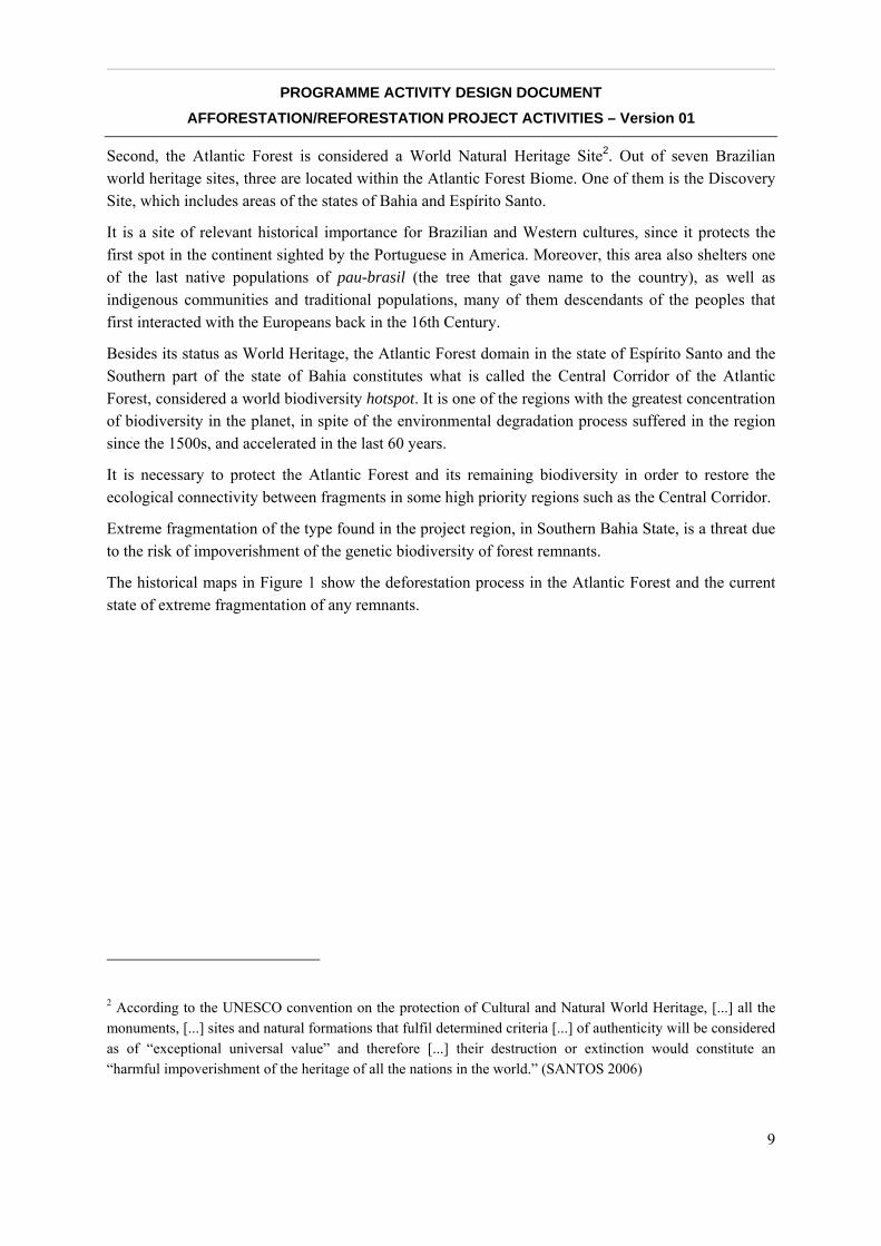
The historical maps in Figure 1 show the deforestation process in the Atlantic Forest and the current state of extreme fragmentation of any remnants.
2 According to the UNESCO convention on the protection of Cultural and Natural World Heritage, [...] all the monuments, [...] sites and natural formations that fulfil determined criteria [...] of authenticity will be considered as of “exceptional universal value” and therefore [...] their destruction or extinction would constitute an “harmful impoverishment of the heritage of all the nations in the world.” (SANTOS 2006)
__________________________________________________________________________________
PROGRAMME ACTIVITY DESIGN DOCUMENT AFFORESTATION/REFORESTATION PROJECT ACTIVITIES – Version 01
10
The protection and restoration of the Atlantic Forest constitutes a huge challenge facing difficulties proportional to the size and importance of the region. One of the key issues is the fact that an estimated 80% of all forest remnants in the region are located in private property.
The initiative presented here aims to establish a model of how to reach those private owners and have them involved in this great and worthwhile challenge.
A.3.1.1. Timeframe
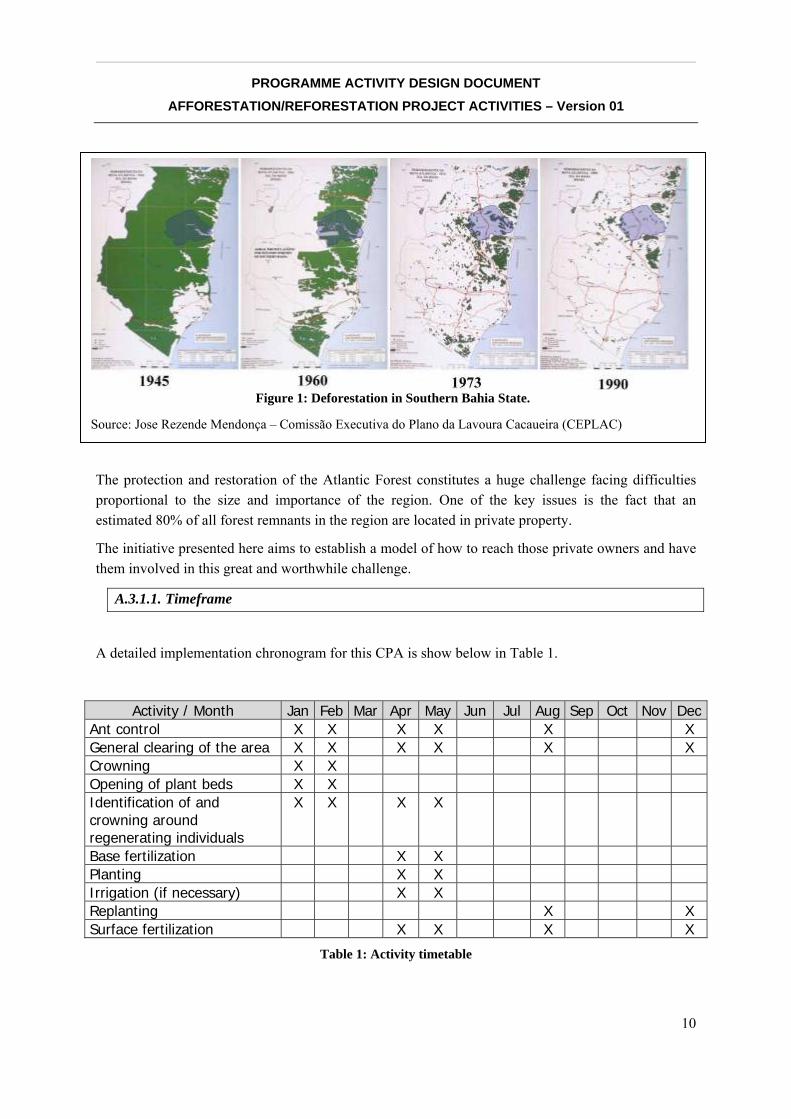
A detailed implementation chronogram for this CPA is show below in Table 1.
Activity / Month Jan Feb Mar Apr May Jun Jul Aug Sep Oct Nov DecAnt control X X X X X X General clearing of the area X X X X X X Crowning X X Opening of plant beds X X Identification of and crowning around regenerating individuals
X X X X
Base fertilization X X Planting X X Irrigation (if necessary) X X Replanting X X Surface fertilization X X X X
Table 1: Activity timetable
Figure 1: Deforestation in Southern Bahia State.
Source: Jose Rezende Mendonça – Comissão Executiva do Plano da Lavoura Cacaueira (CEPLAC)

__________________________________________________________________________________
PROGRAMME ACTIVITY DESIGN DOCUMENT AFFORESTATION/REFORESTATION PROJECT ACTIVITIES – Version 01
11
A.4. Entity/individual responsible for CPA
Role Name of Entity Private/public
Coordinating and managing entity/
CPA Implementer Instituto BioAtlântica Private
PoA Participant / CPA Implementer
The Nature Conservancy Brazil (TNC-BR) Private
CPA Participant Olival José Covre Private
A detailed description of each participant’s capabilities, functions and responsibilities within the project can be found in the PoA.
A.5. Description of location and boundary of the CPA
A.5.1. Identification of the CPA
A.5.1.1. Host party(ies)of the CPA
Brazil
A.5.1.2. Region, state, province, etc
The CPA will take place in the State of Bahia, northeastern Brazil.
A.5.1.3. City, town, community, etc
Municipalities affected: Itabela.
__________________________________________________________________________________
PROGRAMME ACTIVITY DESIGN DOCUMENT AFFORESTATION/REFORESTATION PROJECT ACTIVITIES – Version 01
12
A.5.2. Detailed geographic delineation of the boundary of the CPA, including information allowing the unique identification of the proposed CPA
The property in this CPA is called the Monte Pascoal farm, and it is located in the district of Monte Pascoal, along Highway BR 101, km 769, in the Municipality of Itabela, Bahia. It is located within the area covered by the Pau Brasil Ecological Corridor Project. Monte Pascoal and its location within the Project are extremely important because the property is visited by various producers of the region and can contribute significantly and positively to the expansion into new areas.
Georeferenced coordinate information of CPA#1 restoration area using UTM SAD 69 is described below:
Start Point 1 (453718; 8149975), Point 2 (453538; 8149826), Point 3 (453606; 8149651), Point 4 (453480, 8149574); go to Point 5 (543438; 8149642), Point 6 (453433; 8149752), Point 7 (453402; 8149893), Point 8 (453264; 8150021), Point 9 (453307; 8150053), Point 10 (453351; 8150094), continue in direction of Point 11 (453454; 8150109), go to Point 12 (453498; 8150126).
From Point 12 go to Point 13 (453539; 8150198), Point 14 (453564; 8150210), Point 15 (453546; 8150286), Point 16 (453608; 8150476), Point 17 (453826; 8150384), which returns to Start Point 1.
A.6. Technical description of the CPA
A.6.1. A concise description of the present environmental conditions of the land for the proposed CPA, including a description of climate, hydrology, soils, ecosystems (including land use)
A.6.1.1. Geology
Landform
The landscape is determined by sedimentary rocks of the Barreiras group Tertiary rocks. The main formation consists of plateaus crossed by valleys with steep slopes (called boqueirões) at the head of the rivers, and U-shaped valleys in the middle sections of the rivers, with wider lowlands formed by alluvial sediments.
There are also coastal sediments forming areas of sandy soil and specific vegetation, like the restingas on the coast and muçunungas inland.
Soils
The soil characteristics in the area are: yellow Podzol and Podzols in the coastal flake, reddish-yellow and dark-red Latosol over the crystalline soil, riverside soils, gleis and hydromorphic quartzose sands in the marine-riverside flat (Cavedon et al., 2000).
Hydrology
__________________________________________________________________________________
PROGRAMME ACTIVITY DESIGN DOCUMENT AFFORESTATION/REFORESTATION PROJECT ACTIVITIES – Version 01
13
River basins show, in general, an asymmetric distribution pattern due to the neo-tectonic tilting of blocks, where tributaries on one side of the river are longer and with gentle slopes, while tributaries on the other side are shorter with steeper slopes (Cavedon et al., 2000).
A.6.1.2. Climate
According to the Geological Service of Brazil (CPRM) the regional climate is superhumid (Af) in the Köppen classification, with rains predominantly in fall and winter, and without dry season. There is circulation of wet winds coming from the Atlantic Ocean, more intense during the summer months (Nimer, 1989). This wind behavior influences and maintains the moisture constant along the year.
The rainfall pattern shows a decreasing gradient from the coast towards the interior: Porto Seguro has an average rainfall record around 1,800 mm, while Eunápolis’ record is in the 1,300 mm (Aouad, 1998).
A.6.1.3. Vegetation cover and land use
Ecosystems
Most of the Central Corridor region, where the project will take place, was originally covered with Atlantic Rain Forest. During the settlement process in the region, wood collection (timber extraction or logging of hardwoods), cattle ranching, and agriculture, mostly coffee and papaya, led to deforestation and continues until today. Currently, about 12% of the area remains covered by native forest (CEPF, 2001).
“Pau Brasil” tree (Caesalpinia echinata), which was used as natural dye and reached high values in Europe during the 14th and 15th centuries, was the main activity responsible for the first deforestation cycle in the region. Deforestation today is due to cattle ranching and agriculture (coffee and papaya).
As a result of deforestation, several species that lived in the region are endangered and under threat of extinction, such as the southern brown howling monkey and the hook-billed hermit.
• Fauna
One of the most biodiverse areas of the Atlantic Forest is the southern Bahia region (Thomas & Carvalho, 1997).
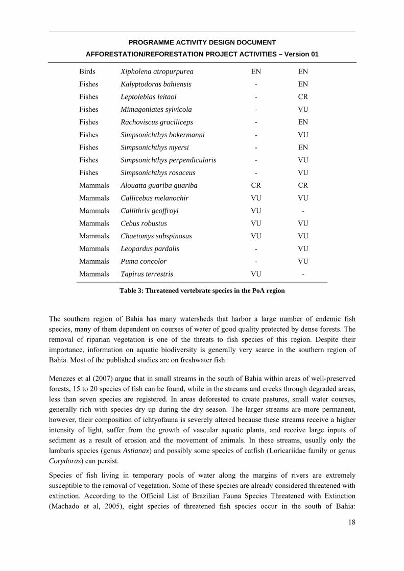
But this great biodiversity is seriously endangered. There are at least 19 species of terrestrial vertebrates considered threatened in the Caraíva River Basin, where 14 are birds and five are mammals.
Considering The World Conservation Union (IUCN) Red List of Threatened Species web-site (iucnredlist.org), it is worth noting the status of six species.
__________________________________________________________________________________
PROGRAMME ACTIVITY DESIGN DOCUMENT AFFORESTATION/REFORESTATION PROJECT ACTIVITIES – Version 01
14
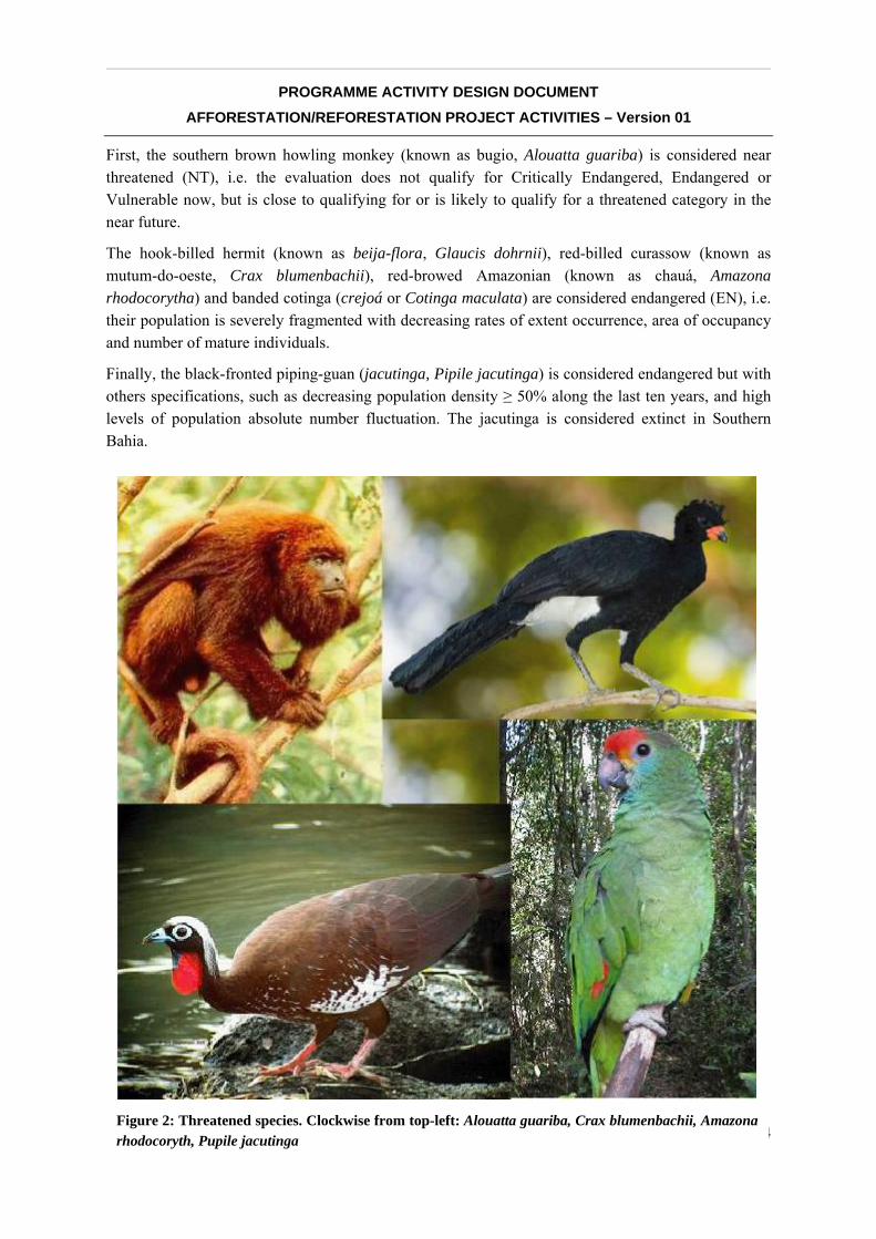
First, the southern brown howling monkey (known as bugio, Alouatta guariba) is considered near threatened (NT), i.e. the evaluation does not qualify for Critically Endangered, Endangered or Vulnerable now, but is close to qualifying for or is likely to qualify for a threatened category in the near future.
The hook-billed hermit (known as beija-flora, Glaucis dohrnii), red-billed curassow (known as mutum-do-oeste, Crax blumenbachii), red-browed Amazonian (known as chauá, Amazona rhodocorytha) and banded cotinga (crejoá or Cotinga maculata) are considered endangered (EN), i.e. their population is severely fragmented with decreasing rates of extent occurrence, area of occupancy and number of mature individuals.
Finally, the black-fronted piping-guan (jacutinga, Pipile jacutinga) is considered endangered but with others specifications, such as decreasing population density ≥ 50% along the last ten years, and high levels of population absolute number fluctuation. The jacutinga is considered extinct in Southern Bahia.
Figure 2: Threatened species. Clockwise from top-left: Alouatta guariba, Crax blumenbachii, Amazona rhodocoryth, Pupile jacutinga
__________________________________________________________________________________
PROGRAMME ACTIVITY DESIGN DOCUMENT AFFORESTATION/REFORESTATION PROJECT ACTIVITIES – Version 01
15
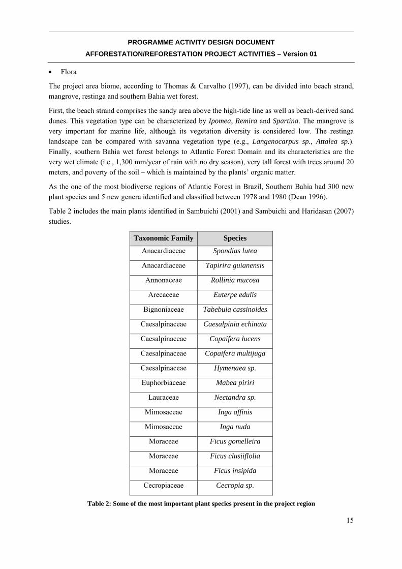
• Flora
The project area biome, according to Thomas & Carvalho (1997), can be divided into beach strand, mangrove, restinga and southern Bahia wet forest.
First, the beach strand comprises the sandy area above the high-tide line as well as beach-derived sand dunes. This vegetation type can be characterized by Ipomea, Remira and Spartina. The mangrove is very important for marine life, although its vegetation diversity is considered low. The restinga landscape can be compared with savanna vegetation type (e.g., Langenocarpus sp., Attalea sp.). Finally, southern Bahia wet forest belongs to Atlantic Forest Domain and its characteristics are the very wet climate (i.e., 1,300 mm/year of rain with no dry season), very tall forest with trees around 20 meters, and poverty of the soil – which is maintained by the plants’ organic matter.
As the one of the most biodiverse regions of Atlantic Forest in Brazil, Southern Bahia had 300 new plant species and 5 new genera identified and classified between 1978 and 1980 (Dean 1996).
Table 2 includes the main plants identified in Sambuichi (2001) and Sambuichi and Haridasan (2007) studies.
Taxonomic Family Species
Anacardiaceae Spondias lutea
Anacardiaceae Tapirira guianensis
Annonaceae Rollinia mucosa
Arecaceae Euterpe edulis
Bignoniaceae Tabebuia cassinoides
Caesalpinaceae Caesalpinia echinata
Caesalpinaceae Copaifera lucens
Caesalpinaceae Copaifera multijuga
Caesalpinaceae Hymenaea sp.
Euphorbiaceae Mabea piriri
Lauraceae Nectandra sp.
Mimosaceae Inga affinis
Mimosaceae Inga nuda
Moraceae Ficus gomelleira
Moraceae Ficus clusiiflolia
Moraceae Ficus insipida
Cecropiaceae Cecropia sp.
Table 2: Some of the most important plant species present in the project region
__________________________________________________________________________________
PROGRAMME ACTIVITY DESIGN DOCUMENT AFFORESTATION/REFORESTATION PROJECT ACTIVITIES – Version 01
16
A.6.2. Species and varieties selected for the proposed CPA
See Annex #1.
A.6.3. A concise description of the presence, if any, of rare or endangered species and their habitats
The Project Region
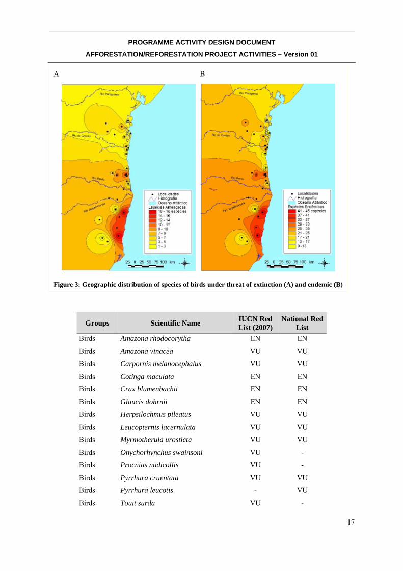
The project region is thus located within a key center of endemism of the Atlantic Forest – the Bahia Center, as evinced by information on terrestrial vertebrates, forest butterflies, and plants. The region harbors the largest forest remnants within the northeast range of the Atlantic Forest biome, comprising different physiognomies such as the ombrophylous forests, Tabuleiros forest - a special typology of dense ombrophylous forest, muçunungas (seasonally flooded vegetation), mangroves and coastal restinga forest. It also hosts one of the most important clusters of protected areas in the Central Corridor, including four national parks — Descobrimento, Monte Pascoal, Pau-Brasil, and Abrolhos — protecting a total of nearly 50,000 hectares of forest and 90,000 hectares of marine areas. The small river basins protected by these national parks are extremely important not only to Atlantic Forest biodiversity, but to the coral reefs and other marine ecosystems in the Abrolhos Bank and the Abrolhos Marine National Park, the richest coral reef area in the South Atlantic.
What remains of the Atlantic Forest in the area is home to an important part of the biome’s animal and vegetal species under threat of extinction. A large number of endemic species and species under threat of extinction inhabit the area (see Figure 3). Considering IUCN Red Lists and the National Red List, recent studies suggest the presence in the region of at least 15 threatened species of birds, eight primates, and eight species of fish (Table 3). In addition, 50 species of birds considered endemic. The region harbors many globally threatened and restricted range species, such as the robust tufted capuchin (Cebus robustus), the Brown howling monkey (Alouatta guariba), the thin-spined porcupine (Chaetomys subspinosus), the Red-billed curassow (Crax blumenbachii), the red-browed parrot (Amazona rhodochorytha), the Red-browed Amazon (Amazona rhodocorytha), the Banded cotinga (Cotinga maculata), the white-winged cotinga (Xipholena atropurpurea), the Black-fronted Piping-guan (Pipile jacutinga), the Hook-Billed Hummingbird (Glaucis dohrnii), and the band-tailed antwren (Myrmotherula urosticta), among others.
__________________________________________________________________________________
PROGRAMME ACTIVITY DESIGN DOCUMENT AFFORESTATION/REFORESTATION PROJECT ACTIVITIES – Version 01
17
Groups Scientific Name IUCN Red List (2007)
National Red List
Birds Amazona rhodocorytha EN EN
Birds Amazona vinacea VU VU
Birds Carpornis melanocephalus VU VU
Birds Cotinga maculata EN EN
Birds Crax blumenbachii EN EN
Birds Glaucis dohrnii EN EN
Birds Herpsilochmus pileatus VU VU
Birds Leucopternis lacernulata VU VU
Birds Myrmotherula urosticta VU VU
Birds Onychorhynchus swainsoni VU -
Birds Procnias nudicollis VU -
Birds Pyrrhura cruentata VU VU
Birds Pyrrhura leucotis - VU
Birds Touit surda VU -
A B
Figure 3: Geographic distribution of species of birds under threat of extinction (A) and endemic (B)
__________________________________________________________________________________
PROGRAMME ACTIVITY DESIGN DOCUMENT AFFORESTATION/REFORESTATION PROJECT ACTIVITIES – Version 01
18
Birds Xipholena atropurpurea EN EN
Fishes Kalyptodoras bahiensis - EN
Fishes Leptolebias leitaoi - CR
Fishes Mimagoniates sylvicola - VU
Fishes Rachoviscus graciliceps - EN
Fishes Simpsonichthys bokermanni - VU
Fishes Simpsonichthys myersi - EN
Fishes Simpsonichthys perpendicularis - VU
Fishes Simpsonichthys rosaceus - VU
Mammals Alouatta guariba guariba CR CR
Mammals Callicebus melanochir VU VU
Mammals Callithrix geoffroyi VU -
Mammals Cebus robustus VU VU
Mammals Chaetomys subspinosus VU VU
Mammals Leopardus pardalis - VU
Mammals Puma concolor - VU
Mammals Tapirus terrestris VU -
Table 3: Threatened vertebrate species in the PoA region
The southern region of Bahia has many watersheds that harbor a large number of endemic fish species, many of them dependent on courses of water of good quality protected by dense forests. The removal of riparian vegetation is one of the threats to fish species of this region. Despite their importance, information on aquatic biodiversity is generally very scarce in the southern region of Bahia. Most of the published studies are on freshwater fish.
Menezes et al (2007) argue that in small streams in the south of Bahia within areas of well-preserved forests, 15 to 20 species of fish can be found, while in the streams and creeks through degraded areas, less than seven species are registered. In areas deforested to create pastures, small water courses, generally rich with species dry up during the dry season. The larger streams are more permanent, however, their composition of ichtyofauna is severely altered because these streams receive a higher intensity of light, suffer from the growth of vascular aquatic plants, and receive large inputs of sediment as a result of erosion and the movement of animals. In these streams, usually only the lambaris species (genus Astianax) and possibly some species of catfish (Loricariidae family or genus Corydoras) can persist.
Species of fish living in temporary pools of water along the margins of rivers are extremely susceptible to the removal of vegetation. Some of these species are already considered threatened with extinction. According to the Official List of Brazilian Fauna Species Threatened with Extinction (Machado et al, 2005), eight species of threatened fish species occur in the south of Bahia:
__________________________________________________________________________________
PROGRAMME ACTIVITY DESIGN DOCUMENT AFFORESTATION/REFORESTATION PROJECT ACTIVITIES – Version 01
19
Mimagoniates sylvicola (VU), Rachoviscus graciliceps (EN), Leptolebias leitaoi (CR); Simpsonichthys bokermanni (VU), Simpsonichthys myersi (EN), Simpsonichthys perpendicularis (VU), Simpsonichthys rosaceus (VU), Kalyptodoras bahiensis (EN).
A.7. Description of legal title to the land, current land tenure and rights to carbon offset credits generated by the proposed CPA
A.7.1. Land legal title and tenure
Legal title to the land
All areas in this CPA are private lands belonging to the Monte Pascoal Farm (Fazenda Monte Pascoal), located in the municipality of Itabela in the state of Bahia. The legal owner of Monte Pascoal Farm is Olival José Covre, who has legal title and registry to the land.
Current land tenure and legal status
The private owners have absolute title to the land.
All lands in this CPA currently comply with labor, environmental, and tax laws. All relevant documents accompany this CPA.
Land use
In this CPA, the areas to be reforested have either been abandoned for quite some time or are used for cattle ranching, either continuously or sporadically.
A.7.2. Rights of access to the sequestered carbon
Rights of access to the sequestered carbon
Under the carbon contract, the owner of property included in this CPA, Olival José Covre, enters into a binding agreement with The Nature Conservancy (TNC) ceding the rights of any carbon offsets from the reforestation activities to TNC.
Under the same contract, the owner warrants TNC and its partners in this initiative access to the CPA areas within his property, the Monte Pascoal Farm, in order to perform all activities related to the reforestation effort.
Instituto BioAtlântica generally signs contracts with landowners. However, when investors and buyers of the PoA prefer to sign a contract with TNC, CI, or another institution from the consortium, the organization that signs this contract will also be responsible for signing the contract with the landowner. This is the case for CPA #1.
__________________________________________________________________________________
PROGRAMME ACTIVITY DESIGN DOCUMENT AFFORESTATION/REFORESTATION PROJECT ACTIVITIES – Version 01
20
A.8. Assessment of the eligibility of land for the CPA
Based on CDM rules “Annex 16, Procedures to define the eligibility of lands for afforestation and reforestation project activities”3 no forest can be present within the project boundaries between December 31, 1989, and the start of the project activity. Proof of forest absence could take the form of aerial photographs or satellite imagery from 1989 or before, or official government documentation confirming the lack of forests. Where proof does not exist, multiple independent, officially witnessed statements by local community members are sufficient.
The Brazilian Interministerial Commission for Climate Change (Comissão Interministerial para Mudanças Climáticas), in its resolution no. 2, defines forests as lands having growing trees with:
• A minimum tree crown cover of 30%;
• A minimum area of 1 hectare; and
• A minimum potential height of 5 meters at maturity.
These threshold values of the forest definition from the Brazilian governmental agency comply with the UNFCCC definition and are used for this A/R project activity.
Following CDM procedures it has been shown that the land where the project activities will be applied was not a forest (according to the definition above) in 1990, and is not a forest today. The methodology to assess the eligibility of the project area is described below:
Evaluation of Land Use Change through Multitemporal Analysis
Today, geoprocessing and remote sensing techniques are frequently used to identify and monitor landscape and environmental changes. One technique is multitemporal analysis, which consists of preparing, comparing, and interpreting images of the same area on different dates to identify land use change over time.
Multitemporal analysis is important for monitoring and managing natural resources and urban development because it provides a quantitative analysis of the spatial distribution of the population or resource of interest—forest, in this case. Remote sensing works by detecting changes in radiance values that result from land cover changes.
Satellite Images
To perform the multitemporal study, images from Landsat Thematic and Enhanced Thematic Mapper were used, showing the following scenes:
215-072 - Landsat 30 meter resolution, dates 1990 and 2005
3 http://cdm.unfccc.int/EB/022/eb22_repan16.pdf
__________________________________________________________________________________
PROGRAMME ACTIVITY DESIGN DOCUMENT AFFORESTATION/REFORESTATION PROJECT ACTIVITIES – Version 01
21
It is important to notice that quality images with little or no clouds dated closer to the dates needed for the analysis were not available. It was also not possible to obtain images from the same period of the year, which would be ideal for the mapping.
Image Classification
Landsat scenes were classified under the supervised classification method, which defines land-use classes, such as forest (different levels of degradation and succession), pasture, agriculture and water, and uses them to classify the image. The “maximum likelihood” algorithm was used for the supervised classification, and four classes were considered separately for the study: forest and open areas (agriculture, pasture and highly disturbed areas). Because clouds and shadows from the two images were removed from the analysis, an extra error is expected.
The last stage of the classification process is filtering out individual or small clumps of pixels from another class, according to a minimum mapping unit area of one pixel. The process used was similar to convolution filtering, where each pixel is compared to the pixels surrounding it. A post-classification thematic change detection allows a comparison of each class between the first time period and the second, and then labels the change (or lack thereof).
In each image, a mask was used to eliminate the areas with Eucalyptus plantations, water, shadows and clouds. The software used was ERDAS 9.1.
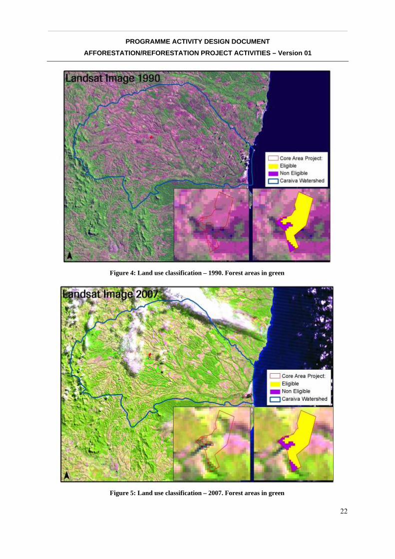
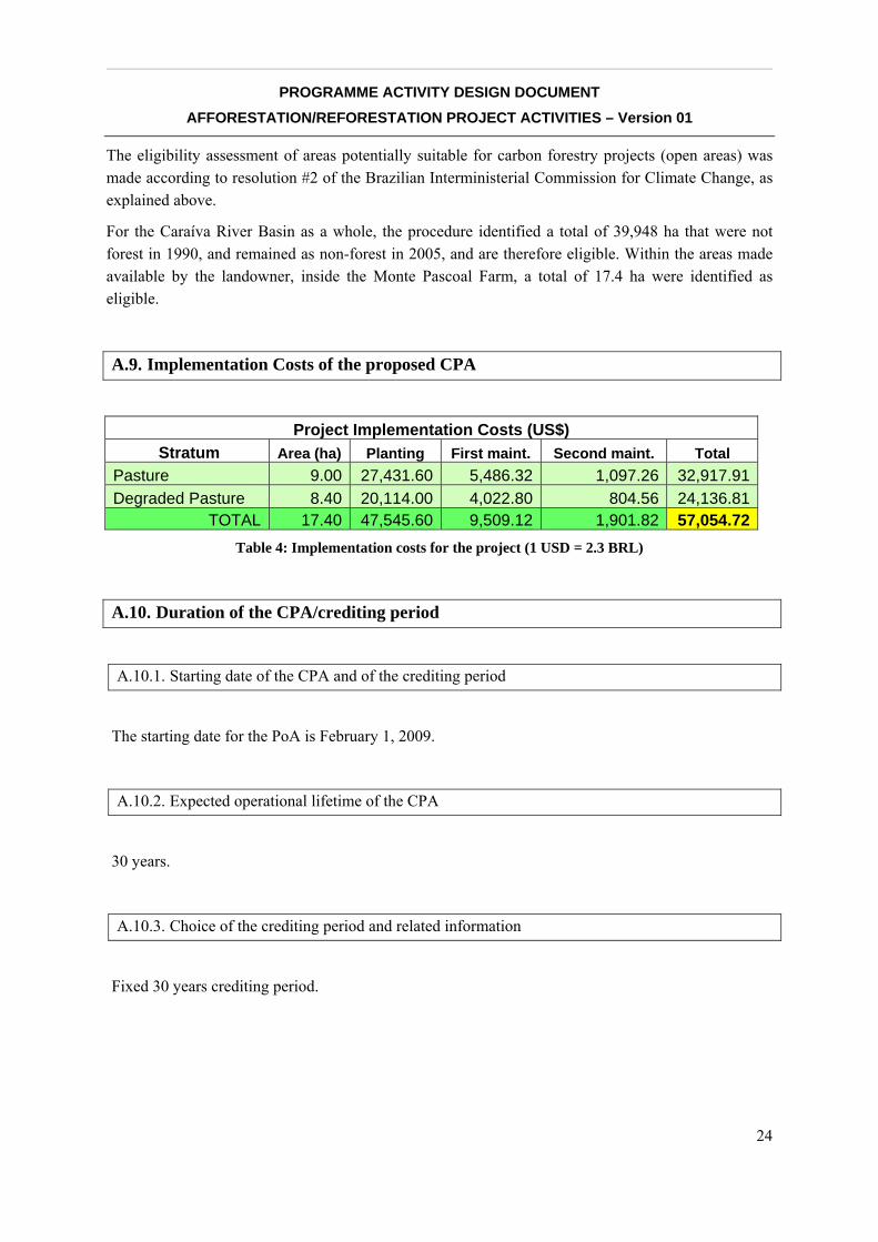
Figure 4 and Figure 5 show the results of the classification for 1990 and 2007.
Legend definition
The legend definition was established taking into account the information required for a carbon eligibility study, i.e.:
• Eligible
• Non-eligible
• Core Project Area (CPA #1, Monte Pascoal Farm, shown within the PoA area)
• Caraíva Watershed (PoA area)
__________________________________________________________________________________
PROGRAMME ACTIVITY DESIGN DOCUMENT AFFORESTATION/REFORESTATION PROJECT ACTIVITIES – Version 01
22
Figure 5: Land use classification – 2007. Forest areas in green
Figure 4: Land use classification – 1990. Forest areas in green

__________________________________________________________________________________
PROGRAMME ACTIVITY DESIGN DOCUMENT AFFORESTATION/REFORESTATION PROJECT ACTIVITIES – Version 01
23
Cross Tabulation
The cross tabulation consists in the “crossing” and superposition of images with different dates (1990-2005). This procedure compares all the pixels in an image with all the pixels in the other image with different date, looking for transformations that took place between the two periods under analysis.
From the 1990-2005 cross-tabulation (multitemporal analysis), it was possible to identify CDM-eligible deforested areas between Pau-Brasil and Monte-Pascoal National Parks (Caraíva River Basin and a small area around the Frades river).
Figure 6: CPA#1 location within Caraíva River Basin.
__________________________________________________________________________________
PROGRAMME ACTIVITY DESIGN DOCUMENT AFFORESTATION/REFORESTATION PROJECT ACTIVITIES – Version 01
24
The eligibility assessment of areas potentially suitable for carbon forestry projects (open areas) was made according to resolution #2 of the Brazilian Interministerial Commission for Climate Change, as explained above.
For the Caraíva River Basin as a whole, the procedure identified a total of 39,948 ha that were not forest in 1990, and remained as non-forest in 2005, and are therefore eligible. Within the areas made available by the landowner, inside the Monte Pascoal Farm, a total of 17.4 ha were identified as eligible.
A.9. Implementation Costs of the proposed CPA
Project Implementation Costs (US$) Stratum Area (ha) Planting First maint. Second maint. Total
Pasture 9.00 27,431.60 5,486.32 1,097.26 32,917.91Degraded Pasture 8.40 20,114.00 4,022.80 804.56 24,136.81
TOTAL 17.40 47,545.60 9,509.12 1,901.82 57,054.72Table 4: Implementation costs for the project (1 USD = 2.3 BRL)
A.10. Duration of the CPA/crediting period
A.10.1. Starting date of the CPA and of the crediting period
The starting date for the PoA is February 1, 2009.
A.10.2. Expected operational lifetime of the CPA
30 years.
A.10.3. Choice of the crediting period and related information
Fixed 30 years crediting period.
__________________________________________________________________________________
PROGRAMME ACTIVITY DESIGN DOCUMENT AFFORESTATION/REFORESTATION PROJECT ACTIVITIES – Version 01
25
B. ELIGIBILITY OF CPA
B.1. Justification of eligibility of the CPA to be included in the CPA
B.1.1.1. Justification of the baseline scenario of the CPA as per eligibility criteria listed in the PoA
Baseline scenario criteria for including a CPA into the PoA are:
• The proposed CPA must be within the Caraíva River Basin.
• Current land use/cover on the CPA areas must be one or more of the types described in this PoA: pasture or degraded pasture.
• The only current commercial use of the CPA areas is cattle ranching, despite the fact that the properties can have other commercial uses as well in other areas that are not the CPA.
B.1.1.2. Justification and demonstration of additionality of the CPA as per eligibility criteria listed in the PoA
Additionality assessment criteria for including a CPA into the PoA are:
• The proposed CPA must be within the Caraíva River Basin.
• Current land use/cover on the CPA areas must be one or more of the types described in this PoA: pasture or degraded pasture.
• The only current or planned commercial use of the CPA areas is cattle ranching, despite the fact that the properties can have other commercial uses as well in other areas that are not the CPA.
• The combined tool for assessing baseline and additionality described in this PoA (Section C.4) has been applied to the CPA, and the results are within the range defined by the PoA.
B.1.1.3. Justification of the methodological choices applied to the CPA as per eligibility criteria listed in the PoA
All methodological choices for the CPA will follow exactly the pattern described in the PoA.
__________________________________________________________________________________
PROGRAMME ACTIVITY DESIGN DOCUMENT AFFORESTATION/REFORESTATION PROJECT ACTIVITIES – Version 01
26
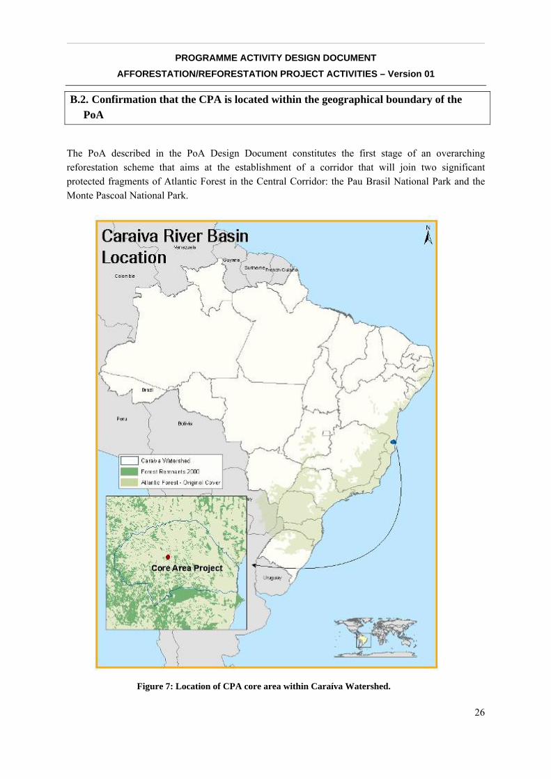
B.2. Confirmation that the CPA is located within the geographical boundary of the PoA
The PoA described in the PoA Design Document constitutes the first stage of an overarching reforestation scheme that aims at the establishment of a corridor that will join two significant protected fragments of Atlantic Forest in the Central Corridor: the Pau Brasil National Park and the Monte Pascoal National Park.
Figure 7: Location of CPA core area within Caraíva Watershed.

__________________________________________________________________________________
PROGRAMME ACTIVITY DESIGN DOCUMENT AFFORESTATION/REFORESTATION PROJECT ACTIVITIES – Version 01
27
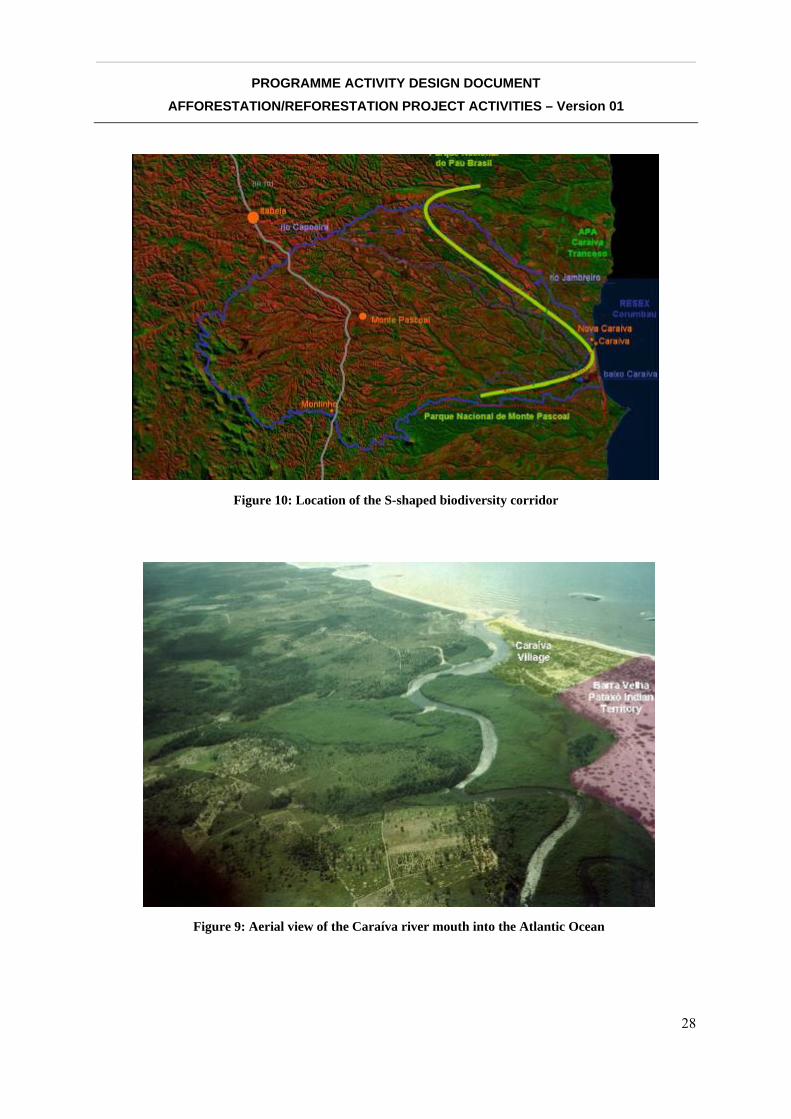
With the goal of connecting the two national parks and thus establishing a biodiversity corridor, the areas selected for reforestation are located along a “S” shaped land track that starts from Pau Brasil National Park in the North, follows South-East the Jambreiro and Capoeira Rivers all the way to the Atlantic Ocean, and continues back West following the Caraíva River up to Monte Pascoal National Park (see Figures 7 to 9).
The corridor will promote biodiversity by providing a connection path for species living in both National Parks and some other Atlantic Forest remnants in the region. The corridor will be created mostly within the Caraíva River Basin and a small area around the Frades River, a severely deforested vacuum in the middle of the two parks.
The Caraíva River Basin is located between coordinates 16º 35’ South and 16º 55’ South, and 39º 07’ West and 39º 37’ West.
It has a total area of 1310 km² (131.000 ha), and drains parts of two municipalities, Porto Seguro and Itabela, in the State of Bahia. Maximum distance East-West is 55 km, and 34 km North-South in the central part. About 38% of the Basin is located in the municipality of Porto Seguro, and 62% in Itabela.
Figure 8: Caraíva River Basin
__________________________________________________________________________________
PROGRAMME ACTIVITY DESIGN DOCUMENT AFFORESTATION/REFORESTATION PROJECT ACTIVITIES – Version 01
28
Figure 10: Location of the S-shaped biodiversity corridor
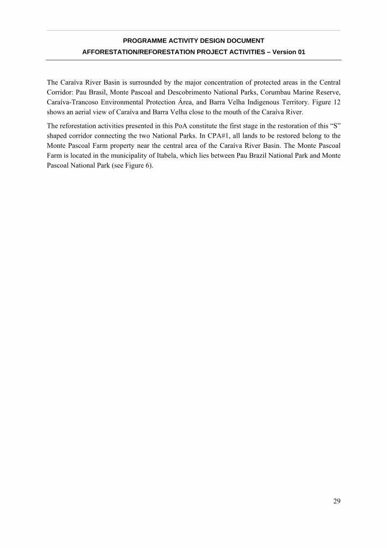
Figure 9: Aerial view of the Caraíva river mouth into the Atlantic Ocean
__________________________________________________________________________________
PROGRAMME ACTIVITY DESIGN DOCUMENT AFFORESTATION/REFORESTATION PROJECT ACTIVITIES – Version 01
29
The Caraíva River Basin is surrounded by the major concentration of protected areas in the Central Corridor: Pau Brasil, Monte Pascoal and Descobrimento National Parks, Corumbau Marine Reserve, Caraíva-Trancoso Environmental Protection Área, and Barra Velha Indigenous Territory. Figure 12 shows an aerial view of Caraíva and Barra Velha close to the mouth of the Caraíva River.
The reforestation activities presented in this PoA constitute the first stage in the restoration of this “S” shaped corridor connecting the two National Parks. In CPA#1, all lands to be restored belong to the Monte Pascoal Farm property near the central area of the Caraíva River Basin. The Monte Pascoal Farm is located in the municipality of Itabela, which lies between Pau Brazil National Park and Monte Pascoal National Park (see Figure 6).
N
__________________________________________________________________________________
PROGRAMME ACTIVITY DESIGN DOCUMENT AFFORESTATION/REFORESTATION PROJECT ACTIVITIES – Version 01
30
C. ESTIMATION OF NET ANTHROPOGENIC GHG REMOVALS BY SINKS
C.1. Description of strata applied for ex-ante estimations
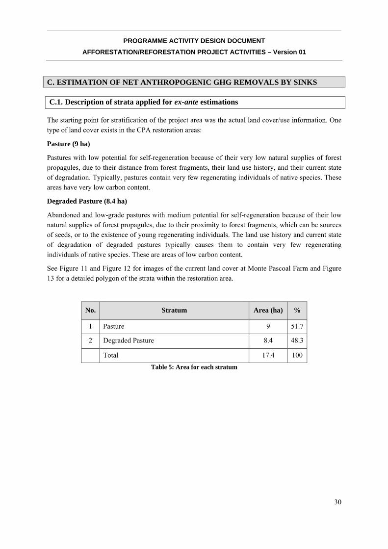
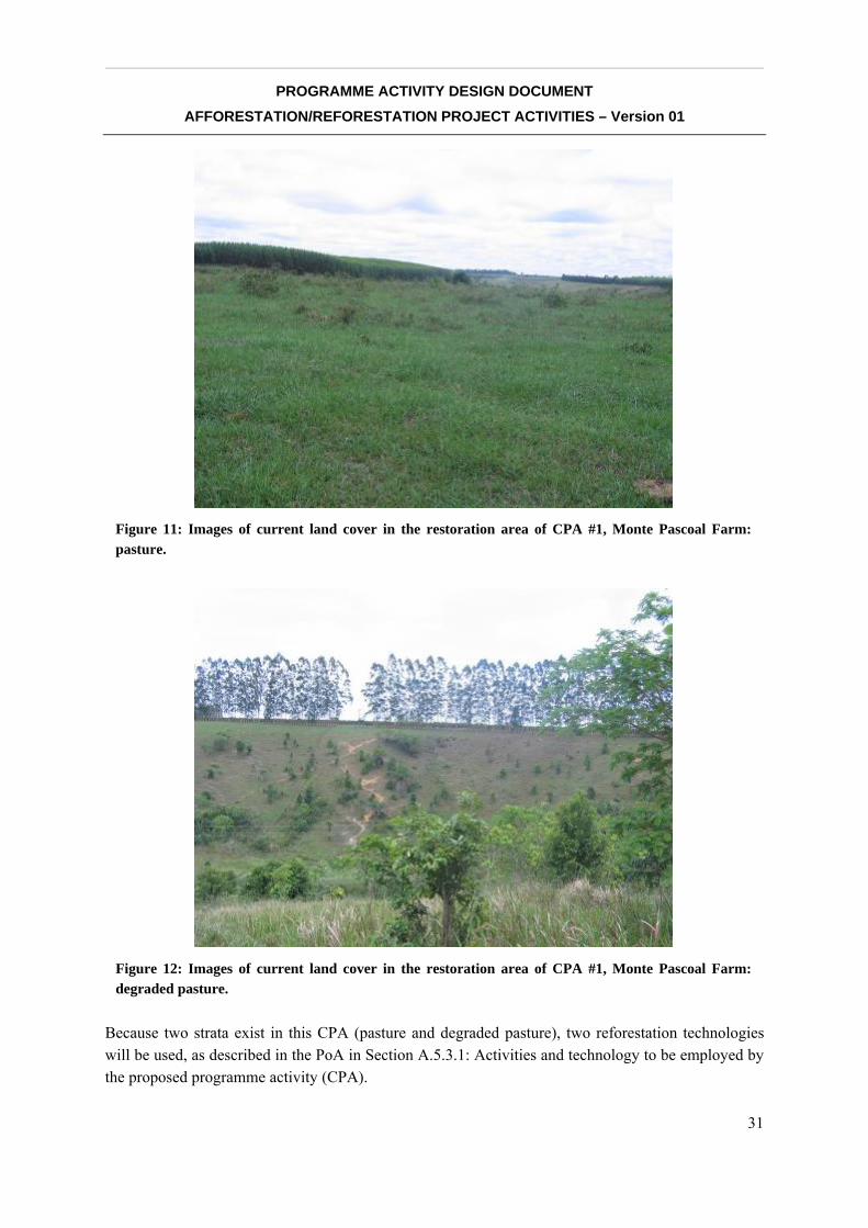
The starting point for stratification of the project area was the actual land cover/use information. One type of land cover exists in the CPA restoration areas:
Pasture (9 ha)
Pastures with low potential for self-regeneration because of their very low natural supplies of forest propagules, due to their distance from forest fragments, their land use history, and their current state of degradation. Typically, pastures contain very few regenerating individuals of native species. These areas have very low carbon content.
Degraded Pasture (8.4 ha)
Abandoned and low-grade pastures with medium potential for self-regeneration because of their low natural supplies of forest propagules, due to their proximity to forest fragments, which can be sources of seeds, or to the existence of young regenerating individuals. The land use history and current state of degradation of degraded pastures typically causes them to contain very few regenerating individuals of native species. These are areas of low carbon content.
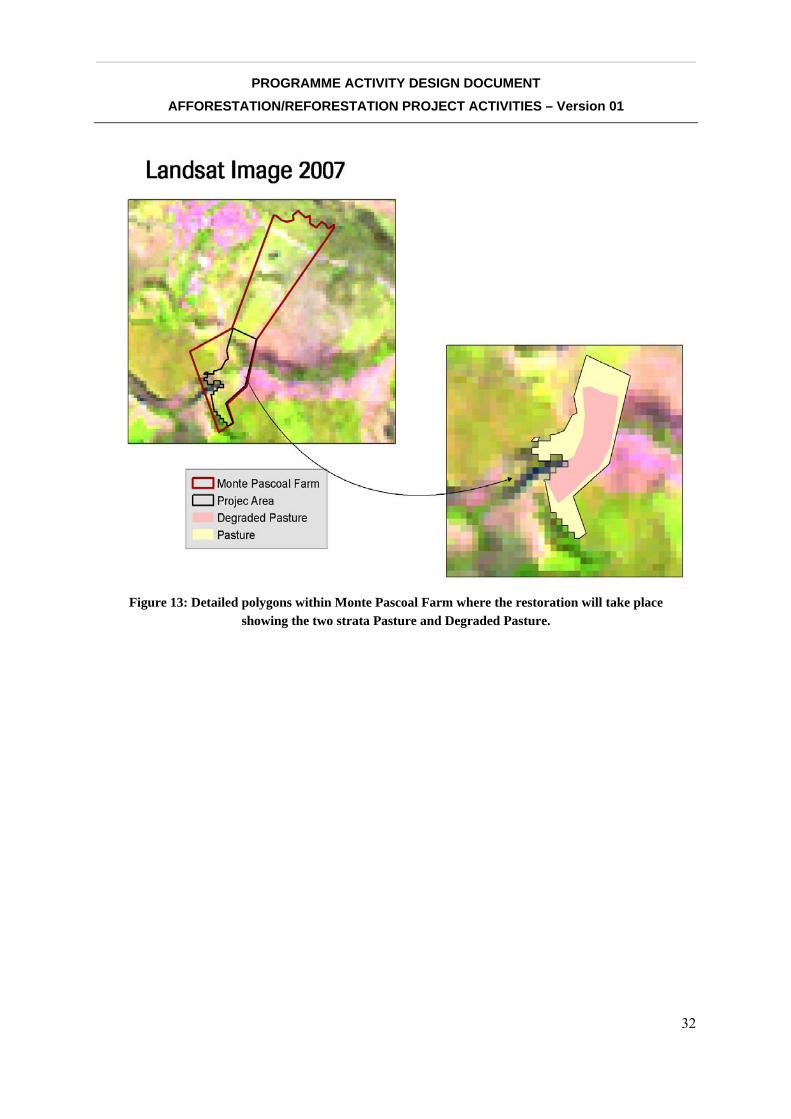
See Figure 11 and Figure 12 for images of the current land cover at Monte Pascoal Farm and Figure 13 for a detailed polygon of the strata within the restoration area.
No. Stratum Area (ha) %
1 Pasture 9 51.7
2 Degraded Pasture 8.4 48.3
Total 17.4 100 Table 5: Area for each stratum
__________________________________________________________________________________
PROGRAMME ACTIVITY DESIGN DOCUMENT AFFORESTATION/REFORESTATION PROJECT ACTIVITIES – Version 01
31
Because two strata exist in this CPA (pasture and degraded pasture), two reforestation technologies will be used, as described in the PoA in Section A.5.3.1: Activities and technology to be employed by the proposed programme activity (CPA).
Figure 11: Images of current land cover in the restoration area of CPA #1, Monte Pascoal Farm: pasture.
Figure 12: Images of current land cover in the restoration area of CPA #1, Monte Pascoal Farm: degraded pasture.
__________________________________________________________________________________
PROGRAMME ACTIVITY DESIGN DOCUMENT AFFORESTATION/REFORESTATION PROJECT ACTIVITIES – Version 01
32
Figure 13: Detailed polygons within Monte Pascoal Farm where the restoration will take place showing the two strata Pasture and Degraded Pasture.
__________________________________________________________________________________
PROGRAMME ACTIVITY DESIGN DOCUMENT AFFORESTATION/REFORESTATION PROJECT ACTIVITIES – Version 01
33
C.2. Estimation of the ex-ante baseline net GHG removals by sinks
Zero.
C.3. Estimation of ex-ante actual net GHG removals by sinks, leakage, and estimated amount of net anthropogenic GHG removals by sinks over the chosen crediting period
C.3.1. Estimate of ex-ante actual net GHG removals by sinks
The actual net greenhouse gas removals by sinks represent the sum of the verifiable changes in carbon stocks in the carbon pools within the project boundary, minus the increase in non-CO2 GHG emissions measured in CO2 equivalents by sources that are increased as a result of the implementation of an A/R project activity, while avoiding double counting, within the project boundary, attributable to the A/R project activity.
The ex-ante estimation of these values is based on equation 12 as described in AR-ACM0001. The change in carbon stocks can be calculated using the formula below. Here it represents the annual changes. The values are presented in section E.3.4 of each CPA for every year of the first crediting period, as well as the totals for the whole period.
EPACTUAL GHGCC −Δ=Δ
Where:
ACTUALCΔ = Actual net greenhouse gas removals by sinks; (tons CO2-e)
PCΔ = Sum of the changes in above-ground and below-ground biomass carbon stocks in the project scenario; (tons CO2-e)
EGHG = Increase in non-CO2 GHG emissions by sources within the project boundary as a result of the implementation of the A/R project activity (tons CO2-e / year).
C.3.2. Estimate of the ex-ante leakage
Leakage (LK) represents the increase in GHG emissions by sources that occurs outside the boundary of the A/R CPA activity that is measurable and attributable to the A/R CPA activity. Two sources of leakage are covered by methodology AR-ACM0001: GHG emissions due to activity displacement and GHG emissions due to increase in use of wood posts for fencing.
__________________________________________________________________________________
PROGRAMME ACTIVITY DESIGN DOCUMENT AFFORESTATION/REFORESTATION PROJECT ACTIVITIES – Version 01
34
Of these sources of leakage, not one applies to this reforestation project activity. However, GHG emissions caused by vehicle fossil fuel combustion due to transportation of seedling, workers, staff and harvest products to and/or from project sites will be carefully monitored and controlled by the developers of this PoA. Therefore, these emissions will be accounted for but not estimated or included in the calculation of net anthropogenic GHG removals by sinks.
The first source considered in the methodology is the displacing of pre-project activities such as grazing and wood gathering. In this PoA, wood gathering does not generally occur in the CPA areas, and this fact will be monitored during the monitoring events at the site. Typically, landowners do use the CPA areas, especially those belonging to the “pasture” stratum, for cattle grazing.
When the carbon option was presented to the owners of the property, they saw reforestation based on carbon credit financing as an opportunity to regularize their property to the existing APP and RL law without any investment on their part.
The areas to be reforested are used today mainly for cattle operations of low productivity. Property owners in the PoA are willing to absorb the relatively small opportunity cost of eliminating cattle in those areas in exchange for a “clean environmental record” for the property.
Property owners will gradually remove the cattle currently grazing in the CPA areas, and this fact will be monitored through monthly site visits. During these site visits, the monitoring agent will also verify that the property owner is complying with the contract. In addition, indirect monitoring will be used for verification, by checking that the forest cover on the property, outside of the project areas, does not decrease, monitored every five years using satellite images. Monitoring allows the PoA developers to ensure that the plantings and assisted natural regeneration will develop into forests.
Therefore, there is no leakage related to the displacement of grazing activities. In fact, there is an additional reduction of emissions due to the elimination of some cattle heads. In any case, to remain conservative, those reductions in emissions will not be calculated.
The second source covered by the methodology, the use of wood posts for fencing, does not apply. Although some fencing will be used in each CPA area, all the wood posts will come from Eucalyptus from certified operations, and therefore no leakage from this source needs to be accounted for.
This PoA will control and monitor fuel consumption for implementation, maintenance and monitoring activities. The developers of this PoA will keep track of fossil fuels used during vehicle transport to and from the CPA areas, but these GHG emissions are not part of the leakage emissions calculations. Based on the equations proposed by previous methodologies4, annual emissions due to leakage can be calculated.
4 Equations 31, 32, 33 and 34 in approved methodology AR-AM0003, version 03
__________________________________________________________________________________
PROGRAMME ACTIVITY DESIGN DOCUMENT AFFORESTATION/REFORESTATION PROJECT ACTIVITIES – Version 01
35
C.3.2.1. Proposed measures to be implemented to minimize potential leakage
The only source of leakage in this project is combustion of fossil fuels due to transportation, which is insignificant and not part of methodology AR-ACM0001. Even so, educational activities will be performed to inform project participants of the importance of minimizing fuel consumption in transportation activities for the benefit of the environment and for the PoA. Personal preference has a direct influence on the amount of GHGs emitted due to vehicle transportation.
Wood gathering that might occur within the CPA boundary during the growth of the planted trees is a minimal risk to this PoA and will be accounted for during monitoring of biomass stock. Cattle removal will be monitored during monthly site visits, community monitoring events, and indirectly through satellite images.
C.3.3. Summary of the ex-ante estimation of net anthropogenic GHG removals by sinks
The net anthropogenic GHG removals by sinks is the actual net GHG removals by sinks minus the baseline net GHG removals by sinks minus leakage. The following general formula, based on AR-ACM00015, can be used to calculate the net anthropogenic GHG removals by sinks of the PoA, in tons CO2-e:
LKCCC BSLACTUALAR −Δ−Δ=
where
ARC = Net anthropogenic greenhouse gas removals by sinks; (tons CO2-e)
ACTUALCΔ = Actual net greenhouse gas removals by sinks –as described in section C.5.3 of the
PoA; (tons CO2-e)
BSLCΔ = Baseline net greenhouse gas removals by sinks –as described in section C.5.2 of the
PoA; (tons CO2-e)
LK = Leakage –as described in section C.5.4 of the PoA (tons CO2-e)
Note: ΔCBSL = 0 for this PoA.
5 Equation 39 of the AR-ACM0001, version 02

__________________________________________________________________________________
PROGRAMME ACTIVITY DESIGN DOCUMENT AFFORESTATION/REFORESTATION PROJECT ACTIVITIES – Version 01
36
This formula is used to calculate annual values of net anthropogenic GHG removals by sinks. The values for every year of the crediting period are shown in section C.3.4, as well as the totals for the whole period.
__________________________________________________________________________________
PROGRAMME ACTIVITY DESIGN DOCUMENT AFFORESTATION/REFORESTATION PROJECT ACTIVITIES – Version 01
37
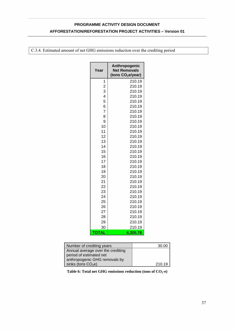
C.3.4. Estimated amount of net GHG emissions reduction over the crediting period
Year Anthropogenic Net Removals
(tons CO2e/year) 1 210.192 210.193 210.194 210.195 210.196 210.197 210.198 210.199 210.19
10 210.1911 210.1912 210.1913 210.1914 210.1915 210.1916 210.1917 210.1918 210.1919 210.1920 210.1921 210.1922 210.1923 210.1924 210.1925 210.1926 210.1927 210.1928 210.1929 210.1930 210.19
TOTAL 6,305.76
Number of crediting years 30.00 Annual average over the crediting period of estimated net anthropogenic GHG removals by sinks (tons CO2e) 210.19
Table 6: Total net GHG emissions reduction (tons of CO2-e)
__________________________________________________________________________________
PROGRAMME ACTIVITY DESIGN DOCUMENT AFFORESTATION/REFORESTATION PROJECT ACTIVITIES – Version 01
38
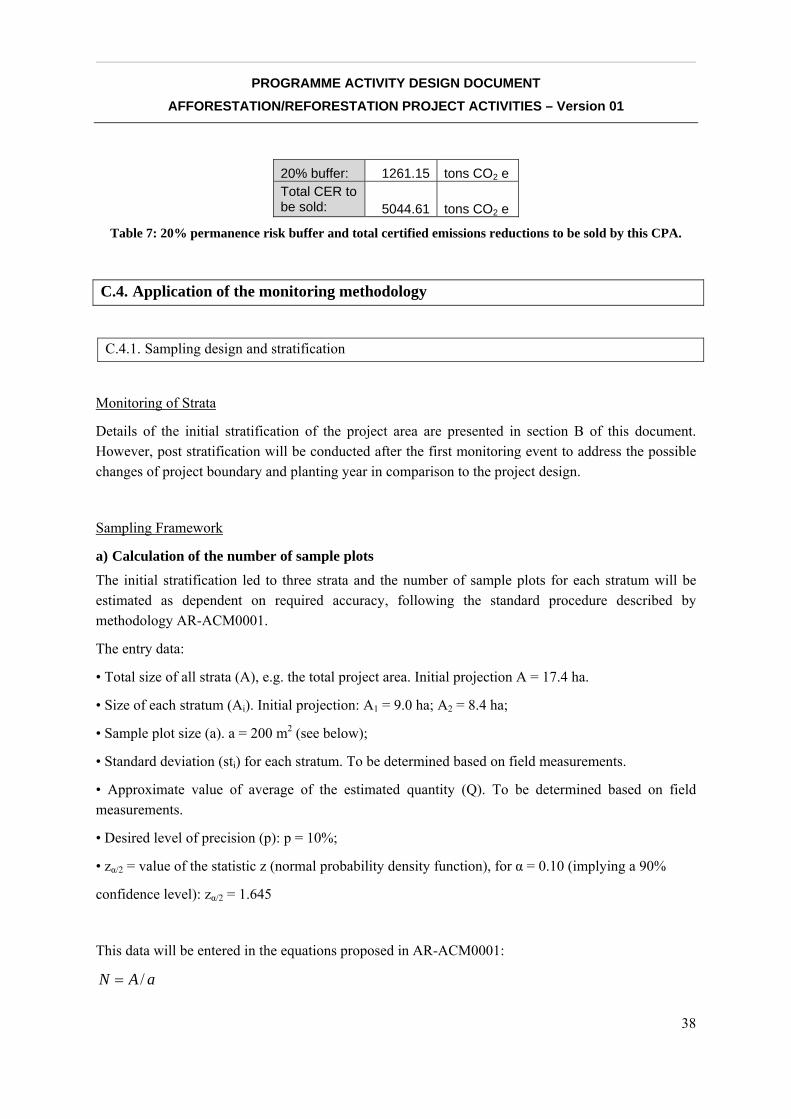
20% buffer: 1261.15 tons CO2 e Total CER to be sold: 5044.61 tons CO2 e
Table 7: 20% permanence risk buffer and total certified emissions reductions to be sold by this CPA.
C.4. Application of the monitoring methodology
C.4.1. Sampling design and stratification
Monitoring of Strata
Details of the initial stratification of the project area are presented in section B of this document. However, post stratification will be conducted after the first monitoring event to address the possible changes of project boundary and planting year in comparison to the project design.
Sampling Framework
a) Calculation of the number of sample plots
The initial stratification led to three strata and the number of sample plots for each stratum will be estimated as dependent on required accuracy, following the standard procedure described by methodology AR-ACM0001.
The entry data:
• Total size of all strata (A), e.g. the total project area. Initial projection A = 17.4 ha.
• Size of each stratum (Ai). Initial projection: A1 = 9.0 ha; A2 = 8.4 ha;
• Sample plot size (a). a = 200 m2 (see below);
• Standard deviation (sti) for each stratum. To be determined based on field measurements.
• Approximate value of average of the estimated quantity (Q). To be determined based on field measurements.
• Desired level of precision (p): p = 10%;
• zα/2 = value of the statistic z (normal probability density function), for α = 0.10 (implying a 90%
confidence level): zα/2 = 1.645
This data will be entered in the equations proposed in AR-ACM0001:
aAN /=
__________________________________________________________________________________
PROGRAMME ACTIVITY DESIGN DOCUMENT AFFORESTATION/REFORESTATION PROJECT ACTIVITIES – Version 01
39
aAN ii /=
PQE ⋅=
where
N = Maximum possible number of sample plots in the project area
Ni = Maximum possible number of sample plots in stratum i
E = Allowable error
And the number of sampling plots would be calculated using the equations:
( )∑
∑
=
=
⋅+⎟⎟⎟
⎠
⎞
⎜⎜⎜
⎝
⎛⋅
⎥⎦
⎤⎢⎣
⎡⋅
=L
iii
L
iii
stNzEN
stNn
1
2
2
2
2
1
α
( )ii
L
iii
L
iii
i stN
stNzEN
stNn ⋅⋅
⋅+⎟⎟⎟
⎠
⎞
⎜⎜⎜
⎝
⎛⋅
⋅=
∑
∑
=
=
1
2
2
2
1
α
All necessary rounding will be made towards the nearest higher integer number.
b) Size of the sampling plots
The sampling plot area has major influence on the sampling intensity and time and resources spent in field measurements. The area of a plot depends on the stand density. Therefore, increasing the plot area decreases the variability between two samples. According to Freese (1962), the relationship between coefficient of variation and plot area can be denoted as follows:
2
121
22 a
aCVCV =
where a1 and a2 represent different sample plot areas and their corresponding coefficient of variation (CV). Thus, by increasing the sample plot area, variation among plots can be reduced permitting the use of small sample size at the same precision level. Usually, the size of plots is between 100 m2 for dense stands and 1000 m2 for open stands.
__________________________________________________________________________________
PROGRAMME ACTIVITY DESIGN DOCUMENT AFFORESTATION/REFORESTATION PROJECT ACTIVITIES – Version 01
40
The sampling plot size for the proposed reforestation project has been set at 200 m2.
c) Random plot allocation
Following the recommendations in AR-ACM0001, the permanent sample plots shall be located systematically with a random start. This is accomplished with the help of a GIS script.
d) Monitoring frequency
Although the verification and certification shall be carried out every five years after the first verification until the end of the crediting period (paragraph 32 of decision 19/CP.9), monitoring interval may be less than five years. However, to reduce the monitoring cost, the monitoring intervals shall coincide with verification time, i.e., five years of interval.
C.4.2. Description of the monitoring plan
a) Measuring and estimating carbon stock changes over time
The growth of individual trees on plots shall be measured at each time interval. Diameter at breast height (DBH), commercial height, canopy height and species of each tree on the sampling plot will be recorded during each monitoring period. The carbon stock changes in the tree biomass will then be estimated using nationally developed equations pertinent to the region.
The monitoring procedure involves the following steps for all trees present in every sampling plot:
• Step 1: Measure and record the species, diameter at breast height (DBH, at 1.3 m above ground), commercial height and canopy height for each tree with a DBH greater than 5 cm.
• Step 2: Calculate aboveground carbon stock (in tons) in living biomass using the allometric equation developed and published by Carvalho & Scolforo (2008) for the combined watersheds of the Mucuri, São Mateus, Jucuruçu, and Buranhém Rivers in Minas Gerais bordering the south of Bahia State:
)ln(*1611.0)ln(0004.21076.9)ln( HDBHC +∗+−=
Where
C = Carbon stock, in tons;
DBH = Diameter at Breast Height, in cm;
H = Total Height, in m.
Sum the carbon stocks in the sample plot:
∑=
=spjN
ljjtspijtreeAB CFHDBHfC
,
1,,,,_ *),(
__________________________________________________________________________________
PROGRAMME ACTIVITY DESIGN DOCUMENT AFFORESTATION/REFORESTATION PROJECT ACTIVITIES – Version 01
41
Where:
tspijtreeABC ,,,,_ = Carbon stock in above-ground biomass of trees of species j on sample plot sp of stratum i at time t; (tons C)
jCF = Carbon fraction of dry matter for species or type j; (tons C t-1 d.m.)
),( HDBHf j = Allometric equation for species j linking diameter at breast height (DBH) and height (H) to above-ground biomass of living trees; (tons d.m. tree-1)
i = 1, 2, 3, … MPS strata in the project scenario
j = 1, 2, 3, … SPS trees species in the project scenario
l = 1, 2, 3, … Nj,sp sequence number of individual trees of species j in sample plot sp
t = 1, 2, 3, … t years elapsed since the start of the A/R project activity
• Step 3: Calculate below-ground carbon stock in living biomass:
The below-ground biomass will be obtained from the estimate of the above-ground biomass via a root-shoot ratio (R). The value for (R) will be the IPCC GPG default value6 of the root-shoot ratio for “primary tropical/sub-tropical moist forest;” that is, R = 0.22, as mentioned in Section C.5.3.1.
The following formulas will be used:
jtspijtreeABtspijtreeBB RCC ∗= ,,,,_,,,,_
where
tspijtreeBBC ,,,,_ = Carbon stock in below-ground biomass of trees of species j in plot sp in stratum i at time t, (tons C)
tspijtreeABC ,,,,_ = Carbon stock in above-ground biomass of trees of species j in plot sp in stratum i at time t, (tons C)
jR = Root-shoot ratio for species j (dimensionless); IPCC default value for project species = 0.22
• Step 4: Calculate total carbon stock in the biomass of all trees present in the sample plot sp in stratum i at time t:
∑=
+=PSS
jtspijtreeBBtspijtreeABtspitree CCC
1,,,,_,,,,_,,, )(
Where:
6 Table 3A.1.8. Annex 3.A.1 IPCC Good Practice Guidance for Land Use, Land-Use Change, and Forestry.

__________________________________________________________________________________
PROGRAMME ACTIVITY DESIGN DOCUMENT AFFORESTATION/REFORESTATION PROJECT ACTIVITIES – Version 01
42
tspijtreeC ,,,, = Carbon stock trees on plot sp of stratum i at time t; (tons C)
tspijtreeABC ,,,,_ = Carbon stock in above-ground biomass of trees of species j on sample plot sp of stratum i at time t; (tons C)
tspijtreeBBC ,,,,_ = Carbon stock in below-ground biomass of trees of species j in plot sp in stratum i at time t, (tons C)
i = 1, 2, 3, … MPS strata in the project scenario
j = 1, 2, 3, … SPS trees species in the project scenario
l = 1, 2, 3, … Nj,sp sequence number of individual trees of species j in sample plot sp
t = 1, 2, 3, … t years elapsed since the start of the A/R project activity
• Step 5: Calculate the mean carbon stock in above and below-ground biomass for each stratum:
TCC
CC titreetitreetiBGtiAG
1,,2,,,,,,
−=Δ+Δ
Where:
tiAGC ,,Δ = Annual carbon stock change in above-ground biomass of trees for stratum i; (tons C yr-1)
tiBGC ,,Δ = Annual carbon stock change in below-ground biomass of trees for stratum i; (tons C yr-1)
titreeC ,, = Carbon stock in trees in stratum i, at time t; (tons C)
T = Number of years between monitoring time t2 and t1 (T= t2-t1); (yr)
i = 1, 2, 3, … MPS strata in the project scenario
t = 1, 2, 3, … t years elapsed since the start of the A/R project activity
b) Measuring and estimating GHG emissions by sources increased as a result of project activities
None of the possible factors considered by methodology AR-ACM0001 that may cause an increase of GHG emissions by sources within the project boundary as a result of the implementation of the A/R activity are present in this PoA. However, project developers will monitor and control the N2O emissions caused by nitrogen fertilization practices.
Emissions of GHG due to burning fossil fuels for transportation within the project boundaries are negligible. In any case all the emissions due to burning fossil fuel for transportation will be accounted for as leakage, without considering whether the transportation happened outside (usual) or inside (rare) the project boundaries.
__________________________________________________________________________________
PROGRAMME ACTIVITY DESIGN DOCUMENT AFFORESTATION/REFORESTATION PROJECT ACTIVITIES – Version 01
43
Equations proposed by previous methodologies,7 can be used to estimate annual N2O emissions caused by nitrogen fertilization.
c) Leakage
Leakage due to fossil fuel combustion from vehicles is not part of AR-ACM0001. However, the developers of this PoA will control and monitor this fossil fuel use by using the following steps and equations proposed by previous methodologies.8
• Step 1: Collecting the traveled distance of different types of vehicles using different fuel types.
• Step 2: Determining emission factors for different types of vehicles using different fuel types. Countryspecific emission factors shall be developed and used if possible. Default emission factors provided in the IPCC Guidelines and updated in the GPG 2000 may be used if there are no locally available data.
• Step 3: Estimating the GHG emissions using bottom-up approach described in GPG 2000 for energy sector9.
Cattle removal will be monitored during monthly site visits, community monitoring events, and indirectly through satellite images to check that the forest cover on the property, outside of the project areas, does not decrease. This will be monitored every five years using satellite images.
d) Quality Control (QC) and Quality Assurance (QA) procedures applied to the monitoring process
To ensure the net anthropogenic GHG removals by sinks to be measured and monitored precisely, credibly, verifiably and transparently, a quality assurance and quality control (QA/QC) procedure will be implemented.
Reliable field measurements
To ensure the reliable field measurements,
• Standard Operating Procedures (SOPs) for each step of the field measurements, including all detail phases of the field measurements and provisions for documentation for verification purposes are proposed and they will be adjusted periodically.
• Training courses on the field data collection and data analysis will be held for persons involved in the field measurement process. The training courses will ensure that each field-team member is
7 Equations 22, 28, 29 and 30 in approved methodology AR-AM0003, version 03 8 Equations 22, 28, 29 and 30 in approved methodology AR-AM0003, version 03 9 Equations 100,101, and 102 described in approved methodology AR-AM0003, version 03.
__________________________________________________________________________________
PROGRAMME ACTIVITY DESIGN DOCUMENT AFFORESTATION/REFORESTATION PROJECT ACTIVITIES – Version 01
44
fully aware of all procedures and the importance of collecting data as accurately as possible. To achieve this, both classroom examination and field examination will be conducted, and only those that have passed the examination can join the team.
Verification of field data collection
To verify that plots have been installed and the measurements taken correctly,
• 20% of randomly selected plots will be re-measured by teams from each other
• 10% of randomly selected plots will be re-measured by independent qualified team.
• Key re-measurement elements include the location of plots, DBH and tree height.
• The re-measurement data will be compared with the original measurement data. Any errors found will be corrected and recorded. Any errors discovered will be expressed as a percentage of all plots that have been rechecked to provide an estimate of the measurement error. If the difference between the re-measurement and original measurement is higher than 10%, all the sample plots will be measured again.
QA/QC for data entry and analysis
To minimize the possible errors in the process of data entry, the entry of field data will be reviewed by an independent expert team and compared with independent data to ensure that the data are realistic. Communication between all personnel involved in measuring and analyzing data will be used to resolve any apparent anomalies before the final analysis of the monitoring data is completed.
QA/QC for data maintenance and archiving
Due to the long-term nature of project activities, data storage and maintenance is very important. Data archiving will take both electronic and paper forms, and copies of all data will be provided to each project participant. All electronic data and reports will also be copied on durable media such as CDs and copies of the CDs are stored in multiple locations. The archives include:
• Copies of all original field measurement data and data analysis spreadsheet;
• Estimates of the carbon stock changes in all pools and non-CO2 GHG and corresponding calculation spreadsheets;
• GIS products;
• Copies of the measuring and monitoring reports.
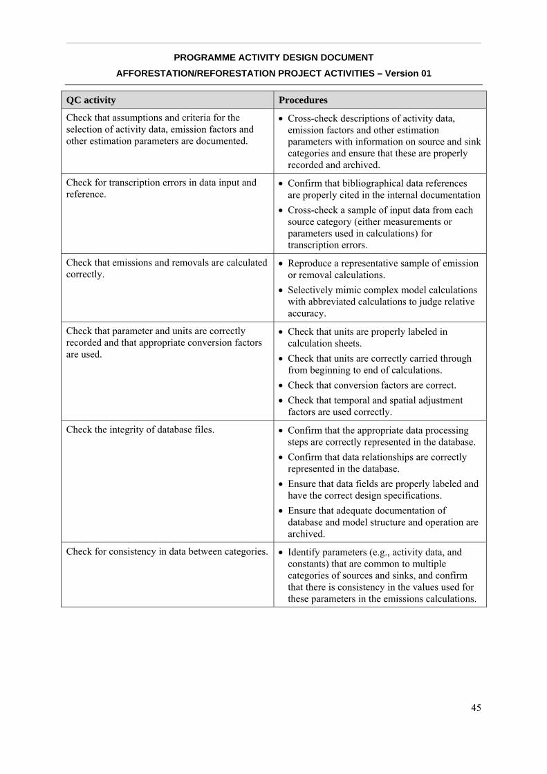
__________________________________________________________________________________
PROGRAMME ACTIVITY DESIGN DOCUMENT AFFORESTATION/REFORESTATION PROJECT ACTIVITIES – Version 01
45
QC activity Procedures
Check that assumptions and criteria for the selection of activity data, emission factors and other estimation parameters are documented.
• Cross-check descriptions of activity data, emission factors and other estimation parameters with information on source and sink categories and ensure that these are properly recorded and archived.
Check for transcription errors in data input and reference.
• Confirm that bibliographical data references are properly cited in the internal documentation
• Cross-check a sample of input data from each source category (either measurements or parameters used in calculations) for transcription errors.
Check that emissions and removals are calculated correctly.
• Reproduce a representative sample of emission or removal calculations.
• Selectively mimic complex model calculations with abbreviated calculations to judge relative accuracy.
Check that parameter and units are correctly recorded and that appropriate conversion factors are used.
• Check that units are properly labeled in calculation sheets.
• Check that units are correctly carried through from beginning to end of calculations.
• Check that conversion factors are correct. • Check that temporal and spatial adjustment
factors are used correctly.
Check the integrity of database files. • Confirm that the appropriate data processing steps are correctly represented in the database.
• Confirm that data relationships are correctly represented in the database.
• Ensure that data fields are properly labeled and have the correct design specifications.
• Ensure that adequate documentation of database and model structure and operation are archived.
Check for consistency in data between categories. • Identify parameters (e.g., activity data, and constants) that are common to multiple categories of sources and sinks, and confirm that there is consistency in the values used for these parameters in the emissions calculations.
__________________________________________________________________________________
PROGRAMME ACTIVITY DESIGN DOCUMENT AFFORESTATION/REFORESTATION PROJECT ACTIVITIES – Version 01
46
Check that the movement of inventory data among processing steps is correct
• Check that emission and removal data are correctly aggregated from lower reporting levels to higher reporting levels when preparing summaries.
• Check that emission and removal data are correctly transcribed between different intermediate products.
Check that uncertainties in emissions and removals are estimated or calculated correctly.
• Check that qualifications of individuals providing expert judgment for uncertainty estimates are appropriate.
• Check that qualifications, assumptions and expert judgments are recorded. Check that calculated uncertainties are complete and calculated correctly.
• If necessary, duplicate error calculations on a small sample of the probability distributions used by Monte Carlo analyses.
Undertake review of internal documentation • Check that there is detailed internal documentation to support the estimates and enable reproduction of the emission and removal and uncertainty estimates.
• Check that inventory data, supporting data, and inventory records are archived and stored to facilitate detailed review.
• Check integrity of any data archiving arrangements of outside organizations involved in inventory preparation.
Check time series consistency. • Check for temporal consistency in time series input data for each category of sources and sinks.
• Check for consistency in the algorithm/method used for calculations throughout the time series.
Undertake completeness checks. • Confirm that estimates are reported for all categories of sources and sinks and for all years.
• Check that known data gaps that may result in incomplete emissions estimates are documented and treated in a conservative way.
Compare estimates to previous estimates. • For each category, current inventory estimates should be compared to previous estimates, if available. If there are significant changes or departures from expected trends, recheck estimates and explain the difference.
__________________________________________________________________________________
PROGRAMME ACTIVITY DESIGN DOCUMENT AFFORESTATION/REFORESTATION PROJECT ACTIVITIES – Version 01
47
D. ENVIRONMENTAL IMPACTS OF PROGRAMME ACTIVITY
D.1. Indicate if the environmental analysis has been undertaken at the PoA level
Yes.
D.2. Notes on Biodiversity Impact
Net impact
The project aims to increase the chances of regional persistence of endemic and threatened species by improving the connectivity between two of the largest forest fragments remaining in the Caraíva River Basin and its environment. The effect of fragmentation on the forest structure and the remaining fauna and flora diversity has been assessed in different parts of the Atlantic Forest. It is a complex matter and the information obtained shows that fragmentation of the natural landscape affects the quality and quantity of the available habitat, and consequently the survival of species, especially those endemic and threatened. Reforestation projects contribute to forest habitat enlargement, to the buffering of forest remnants and to the improvement of forest habitat connectivity; therefore, they are essential for enhancing the resiliency of biodiversity in the area. The recuperation of connectivity between the national parks in Southern Bahia, through the Caraíva River Basin, can influence the spatial distribution of forest fragments and the permeability of the landscape matrix. The restoration efforts can also positively affect the dynamics of loss and the colonization of fauna and flora in the remainders of the Atlantic Forest, which is essential for the long-term permanence of populations of local species.
The strategy proposed in this initiative is especially valuable because the Caraíva River Basin lies in the core of the Complexo do Descobrimento, a set of forest zones located between Pau-Brasil National Park and Descobrimento National Park, the largest and closest fragments of protected Atlantic Forest in the Northeast of Brazil, offering a unique opportunity for re-building forest connection. These Focus Areas will receive specific actions aiming at the reduction of pressure on biodiversity, and actions directed towards the establishment of forest connectivity throughout the territory.
D.3. Notes on the impact on Water & Soils
Net impact
Although it is a widely accepted concept, the positive relationship between forests and water resources is a difficult generalization to prove, particularly in reference to the quantity (flow), quality (load of sediments and nutrients) and constancy (elimination of pulses of erratic flow). A great variety of factors in one watershed can strongly influence the final result: predominance of uses and vegetative types, including species used in forest monocultures, topography, geological and
__________________________________________________________________________________
PROGRAMME ACTIVITY DESIGN DOCUMENT AFFORESTATION/REFORESTATION PROJECT ACTIVITIES – Version 01
48
pedological aspects, rainwater cycles, and the temporal and spatial scale chosen to study the cause-effect relationship, etc. (Calder, 2002; Kiersch & Tognetti, 2002).
In the case of the areas concerned in this PoA, however, the conversion of pasture to native forest cover in the riparian areas would bring benefits more easily proven by the relationship of forests and water resources, that is, protection against erosion. Because watersheds with healthy forests export the lowest levels of sediment of any cover type (Brooks et al., 1997), forests are often looked to as a means of reducing levels of downstream sediment. The high infiltration rate in natural, mixed forests reduces the incidence of surface runoff and reduces erosion transport. Also, the reduced soil water pressure and the binding effect of tree roots enhance slope stability, which tends to reduce erosion (Calder, 2002). Besides helping to stabilize stream banks, riparian forests help to reduce wastewater and chemical discharge into water bodies from upland areas and maintain cooler water temperatures, thus improving dissolved oxygen levels in water (Brooks et al., 1997). These effects, in turn, are likely to bring positive effects on aquatic biodiversity.
The biological communities in riverbed environments are strongly influenced by physical and chemical characteristics of the river system along the upstream-downstream gradients (Vannote et al., 1980), such as the cycles of flow and temperature, structural characteristics of the fluvial channel and its margins, frequency and intensity of disturbances, penetration of light, etc. Thus, the state of biological communities usually reflects the environmental changes occurring in the watershed. These include, for example, the increase in nutrient load in the system, by input (point or diffuse) of nutrients, sediment input (e.g. from erosion), increased light penetration and alteration of temperature cycles in the water course (by the removal of riparian forest cover), chemical pollutants (fertilizers, pesticides), changes in flow (dams for holding water), etc. The deterioriation of the condition of the water and/or the structure of the water courses frequently leads to the loss of taxa sensitive to pollution, the domination of tolerant taxa, and the general decrease in the taxonomic richness or significant changes in the composition and functional roles of the community.
Thus, the developers of this PoA expect that the restoration of native forest cover in the vicinity of the drainage basins will have a very important role in the reconstitution of biological communities and the restoration of ecological processes typical of upstream areas. In these areas, the smaller drainage basins are typically shaded by riparian forests that, on the one hand, restricts primary productivity, but on the other hand, constitutes the main source of organic material and debris (e.g. leaf litter, branches, and riparian fruits) and of nutrients used by biological communities. Finally, in these areas the riparian forests constitute the main foundation of livelihood of an expressive diversity (and biomass) of macroinvertebrates living in the benthic zone (various organisms that live on, in, or near the substrate of bodies of water, such as aquatic insects, mollusks, annelids and crustaceans, among others) and fish.
The restoration of riparian forest cover contributes not only to the conservation of river ecosystems and their associated biodiversity, but also to the conservation of populations of animal species and terrestrial plants through the increase in available forest habitat and of the connectivity between remaining forests in the region and the restoration of key ecological processes in these environments. The role of forest remnants and riparian forest corridors in maintaining biodiversity in the local landscape should be considered essential, whether the surrounding context is predominantly pasture
__________________________________________________________________________________
PROGRAMME ACTIVITY DESIGN DOCUMENT AFFORESTATION/REFORESTATION PROJECT ACTIVITIES – Version 01
49
or eucalyptus monoculture. Many studies have shown that, while areas of native regeneration and exotic tree plantations can provide complementary conservation services, the value of primary forests remnants for biodiversity conservation is irreplaceable (Barlow et al., 2007).
The expected impact on aquatic biodiversity with the implementation of this PoA is an increase in diversity of freshwater fish, as a function of the increase in water quality of the bodies of water in the areas to be restored. Over time, the habitat-dependent species, including those threatened with extinction, will establish viable populations in the region, contributing to the regional persistence of these species.
Off-site impact
In the context of the region concerned, a likely scenario of change in soil use and occupation is the introduction of eucalyptus monocultures to substitute the pasture areas currently on the barren plateaus.
Concerning terrestrial biodiversity, the introduction of forest monocropping to substitute pasture can mean the transition to an environmentally friendlier matrix. This will be particularly effective if there are concurrent efforts to restore or protect the dense network of permanent protection areas (APP), represented by areas along the edges of local water basins, and to protect the native forest remnants.
A eucalyptus monoculture constitutes a shaded environment that, although unsuitable as forest habitat for much of the native fauna (food supply and shelter, for example), minimizes the adverse microclimatic effects typical of contact between native forest remnants and open formations such as pastures, which are inhospitable for forest fauna and flora. This contributes to the mitigation of “edge effect.”
Other negative factors of the edge effect can be equally mitigated in this scenario, such as by the reduction of forest fire risk (given the protection of forest use) and the isolation of populations of fauna averse to crossing inhospitable environments, such as open pasture areas.
On the other hand, the potential negative impacts on biodiversity with the introduction of eucalyptus are associated with the management of the planting. The application of defensive agricultural products for the control of pests can contaminate water courses and soil. The increase in transport of people and of motorized vehicles during the various phases of the planting may drive away fauna. Such impacts are local and can be easily mitigated with the adoption of appropriate techniques for management and cutting in the eucalyptus plantations.
Forest plantations have proven to provide soil protection against erosion and to reduce the damage caused by rain, wind, and solar radiation. Eucalypt also promotes soil stabilization by developing a surface layer of organic material that improves porosity and rainwater retention (Mora & Garcia, 2000).
Eucalyptus plantations established in inappropriate areas, such as land recommended for agricultural crops, steep sloping terrain, and river banks, have been known to cause interference in the quality of water and in soil conservation. With the subsequent adoption of new silviculture concepts and modern land use planning, many plantations were established in areas not recommended for agriculture, mainly because of the chemical composition of the soil (high levels of aluminum and low
__________________________________________________________________________________
PROGRAMME ACTIVITY DESIGN DOCUMENT AFFORESTATION/REFORESTATION PROJECT ACTIVITIES – Version 01
50
phosphorus). These plantations led to a significant reduction in erosion caused by strong winds. New management techniques also favor leaving a permanent cover on the soil surface by maintaining a layer of forest residues and promoting the rapid regeneration of trees after the harvest. This permanent cover protects against erosion. Using adequate soil preparation equipment and proper soil conservation techniques also brings significant gains in productivity (Mora & Garcia, 2000).
Eucalyptus trees absorb a considerable amount of nutrients from the soil, which are stored in the leaves, bark, and wood tissues. To minimize the impact of wood harvesting on the soil nutrient balance, which removes nutrients from the field, branches and bark are left at the site. Ashes from wood-fired boilers are also incorporated into the soil. The continuous balance between the the replenishment of nutrients at the site and the loss of nutrients through erosion, harvesting or burning of residues is very important, and many measures are recommended to assure nutrient recycling. These include: land-use planning with well-defined protected areas and areas to be planted; use of contour planting whenever possible; use of minimum cultivation techniques when preparing the area for planting; rational use of fertilizers; leaving all bark, leaves, and branches in the field after harvest; and using machinery and equipment that cause less negative impact on the soil (Mora & Garcia, 2000).
__________________________________________________________________________________
PROGRAMME ACTIVITY DESIGN DOCUMENT AFFORESTATION/REFORESTATION PROJECT ACTIVITIES – Version 01
51
E. SOCIOECONOMIC IMPACTS OF PROGRAMME ACTIVITY
E.1. Indicate if the socio-economic impact analysis has been undertaken at the PoA level
Yes. Additional details specific to the current CPA are provided below.
E.2. Analysis of socioeconomic impacts
E.2.1. Current conditions
The whole concept of the ecological corridor between Monte Pascoal National Park and Pau-Brasil National Park affects mostly the Caraíva River Basin and a small area around the Frades River just south of Pau-Brasil National Park. The area includes parts of the municipalities of Porto Seguro and Itabela.
Parts of the Caraíva River Basin are located within the Caraíva-Trancoso Environmental Protection Area and in the outskirts of Monte Pascoal and Pau Brasil National Parks. The Caraíva River meets the ocean at the Corumbau Extractivism Marine Reserve, with its southern area part of the Barra Velha Pataxó’s Indigenous Territory.
The main cities in the municipalities of Porto Seguro and Itabela are located outside the Caraíva River Basin, which includes only a few urban centers and indigenous villages. The two communities most affected by the project are the villages of Caraíva and Nova Caraíva (municipality of Porto Seguro), with a total population of 1,400. Monte Pascoal is another community that will be affected by the project, particularly by CPA#1, and it will be researched and information documented during the PoA. With each CPA added to the PoA, any new communities identified as being affected by the project will be researched accordingly.
Caraíva is one of the oldest villages in Brazil and is considered national heritage. Likely founded the same year as Porto Seguro, it was established as an advanced Jesuit post for the indoctrination of Indians. Its native population is mostly composed of indigenous descendants of the Pataxó ethnic group with strong family links to the residents of Barra Velha indigenous territory.
The recent arrival of tourism (since the 1980s), although not as strong as in neighboring Porto Seguro, Arraial d’Ajuda or Trancoso, caused enough real estate pressure to result in the creation of a new urban center, Nova Caraíva, today with a population slightly bigger than the historic village.
In the neighborhood of the project areas, within the Caraíva River Basin, the major urban center is Monte Pascoal, Itabela municipality, with 6,000 inhabitants and located 2 km from the main highway BR 101. Other urban centers in the area are Montinho (1,200 inhabitants, Itabela municipality and also close to the highway), the Indigenous villages of Barra Velha (2,400 inhabitants), Boca da Mata (1,100 inhabitants) and other smaller villages.
__________________________________________________________________________________
PROGRAMME ACTIVITY DESIGN DOCUMENT AFFORESTATION/REFORESTATION PROJECT ACTIVITIES – Version 01
52
Outside the basin lie the city of Itabela (head of the municipality, 30,000 people), the Trancoso urban center (15,000 people, Porto Seguro municipality), and the Itaporanga and Imbiriba Indigenous villages (2,000 people combined, Porto Seguro municipality).
Both Itabela and Porto Seguro have low municipality human development indexes (HDI-M) in comparison with the Brazilian average.
Porto Seguro has an average HDI-M of 0.699 (0.651 for income HDI, 0.662 for longevity HDI, and 0.783 for educational HDI). Itabela has an average of 0.637 (0.637 for Income HDI, 0.543 for longevity HDI, and 0.717 for educational HDI).
Compared to the 5507 total Brazilian municipalities, Porto Seguro ranks in 3010th position and Itabela in 3985th position.
These low HDI indexes are reflections of the indexes in the state of Bahia, where overall HDI in 2000 was 0.688, the 22nd of the 26 states in the country. The average index for the whole country is 0.792, ranked the 63rd in the world.
By virtue of this project’s demand, and in the absence of specific census data for these districts, research of primary socioeconomic data was conducted, focusing on those indicators that could suffer impacts from the projects: number of inhabitants, number of native residents, number of working people per family, family income and education. Carried out with limited resources, this research does not exclude the need for a new survey after the project’s certification with more details and the inclusion of more data. This detailed survey would serve as a definitive baseline for monitoring socioeconomic impacts of the project, as presented in the monitoring plan of the PoA in Section E.5. The interviews in Caraíva and Nova Caraíva, the responsibility ofANAC and ASCBENC, were carried out by women residents from May to July 2008. The research on native residents, also the responsibility of ANAC, and on socioeconomic data of participating farms, the responsibility of Naturezabela, were carried out in October 2008.
According to data from local clinics, 155 families permanently live in Caraíva and 186 in Nova Caraíva. Ninety-two adult members of resident families were interviewed in Caraíva (59% of families) along with 147 adult family members of Nova Caraíva (79% of families). The average number of people per family is 3.7 in Caraíva and 3.5 in Nova Caraíva, which leads to a total population estimate of 1225 people in the two urban centers (580 in Caraíva and 645 in Nova Caraíva). Of these, only 295 inhabitants are native to the historic village of Caraíva, about 23% of the total population of the two districts.
All the communities include a significant percentage of families below the poverty line, defined by IBGE as those whose income per capita is lower tha 50% of the national minimum wage, or R$208 per member of the family. Also, a significant number of families in a situation of extreme poverty characterized by IBGE as those whose income per capita is lower than 25% of minimum wage, or R$104 per member of the family, as shown in Table 8.
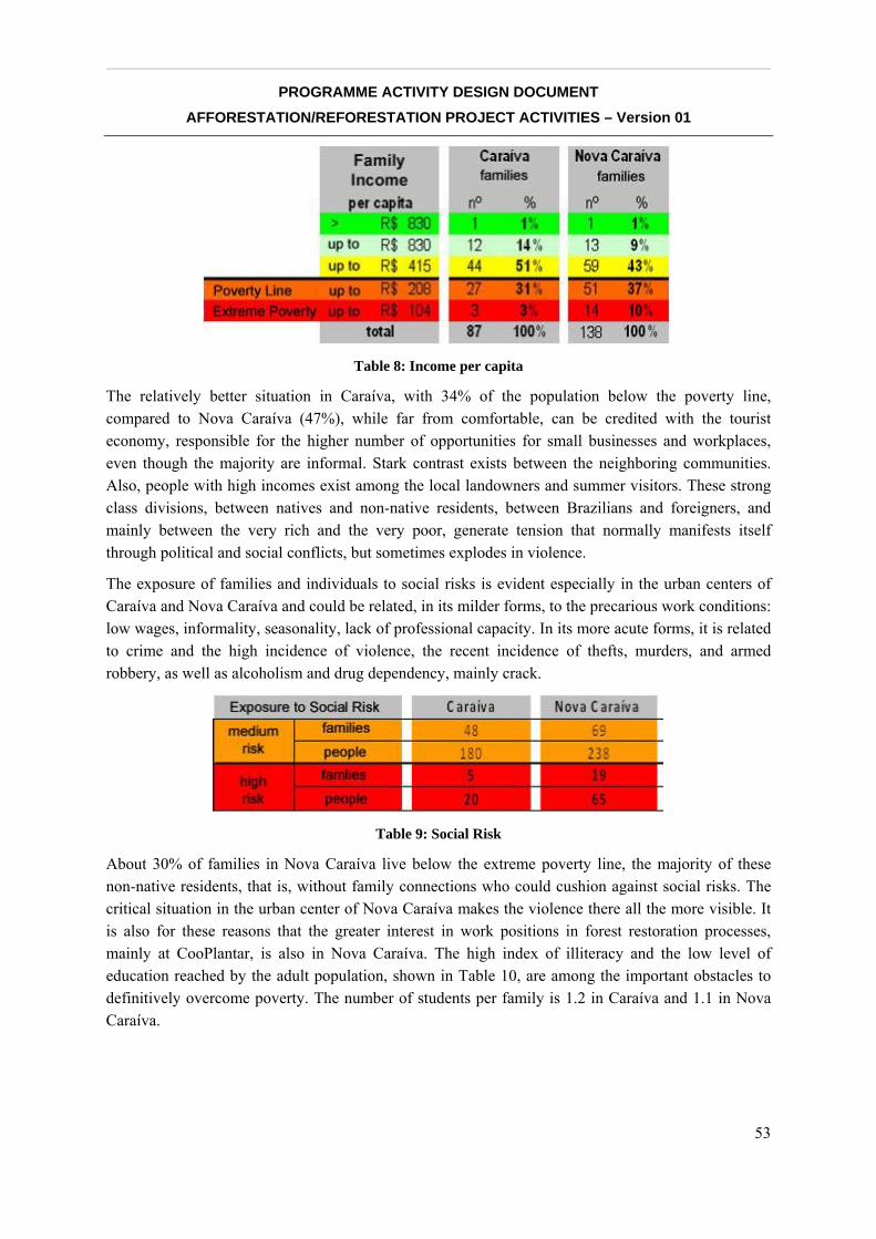
__________________________________________________________________________________
PROGRAMME ACTIVITY DESIGN DOCUMENT AFFORESTATION/REFORESTATION PROJECT ACTIVITIES – Version 01
53
Table 8: Income per capita
The relatively better situation in Caraíva, with 34% of the population below the poverty line, compared to Nova Caraíva (47%), while far from comfortable, can be credited with the tourist economy, responsible for the higher number of opportunities for small businesses and workplaces, even though the majority are informal. Stark contrast exists between the neighboring communities. Also, people with high incomes exist among the local landowners and summer visitors. These strong class divisions, between natives and non-native residents, between Brazilians and foreigners, and mainly between the very rich and the very poor, generate tension that normally manifests itself through political and social conflicts, but sometimes explodes in violence.
The exposure of families and individuals to social risks is evident especially in the urban centers of Caraíva and Nova Caraíva and could be related, in its milder forms, to the precarious work conditions: low wages, informality, seasonality, lack of professional capacity. In its more acute forms, it is related to crime and the high incidence of violence, the recent incidence of thefts, murders, and armed robbery, as well as alcoholism and drug dependency, mainly crack.
Table 9: Social Risk
About 30% of families in Nova Caraíva live below the extreme poverty line, the majority of these non-native residents, that is, without family connections who could cushion against social risks. The critical situation in the urban center of Nova Caraíva makes the violence there all the more visible. It is also for these reasons that the greater interest in work positions in forest restoration processes, mainly at CooPlantar, is also in Nova Caraíva. The high index of illiteracy and the low level of education reached by the adult population, shown in Table 10, are among the important obstacles to definitively overcome poverty. The number of students per family is 1.2 in Caraíva and 1.1 in Nova Caraíva.
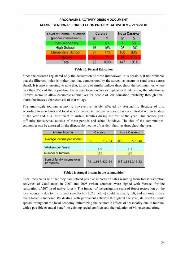
__________________________________________________________________________________
PROGRAMME ACTIVITY DESIGN DOCUMENT AFFORESTATION/REFORESTATION PROJECT ACTIVITIES – Version 01
54
Table 10: Formal Education
Since the research registered only the declaration of those interviewed, it is possible, if not probable, that the illiteracy index is higher than that demonsrated by the survey, as occurs in rural areas across Brazil. It is also interesting to note that, in spite of similar indices throughout the communities, where less than 25% of the population has access to secondary or higher-level education, the situation in Caraíva seems to allow economic alternatives for people of low education, probably through small tourist businesses characteristic of that village.
The small-scale tourism economy, however, is visibly affected by seasonality. Because of this, according to merchants and local service providers, income generation is concentrated within 40 days of the year and it is insufficient to sustain families during the rest of the year. This creates great difficulty for survival outside of these periods and school holidays. The size of the communities’ economies can be assessed by the disposable income of resident families throughout the year.
Table 11: Annual income in the communities
Local merchants said that they had noticed positive impacts on sales resulting from forest restoration activities of CooPlantar, in 2007 and 2008 (when contracts were signed with Veracel for the restoration of 207 ha of native forest). The impact of increasing the scale of forest restoration on the local economy due to this project (see Section E.2.3 below) could be clearly felt, and not only from a quantitative standpoint. By dealing with permanent activites throughout the year, its benefits could spread throughout the local economy, minimizing the economic effects of seasonality due to tourism, with a possible eventual benefit to existing social conflicts and the reduction of violence and crime.
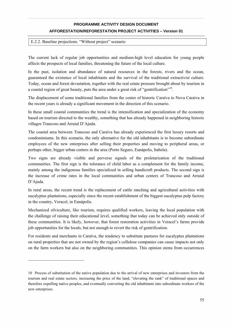
__________________________________________________________________________________
PROGRAMME ACTIVITY DESIGN DOCUMENT AFFORESTATION/REFORESTATION PROJECT ACTIVITIES – Version 01
55
E.2.2. Baseline projections. “Without project” scenario
The current lack of regular job opportunities and medium-high level education for young people affects the prospects of local families, threatening the future of the local culture.
In the past, isolation and abundance of natural resources in the forests, rivers and the ocean, guaranteed the existence of local inhabitants and the survival of the traditional extractivist culture. Today, ocean and forest devastation, together with the real estate pressure brought about by tourism in a coastal region of great beauty, puts the area under a great risk of “gentrification”10.
The displacement of some traditional families from the center of historic Caraíva to Nova Caraíva in the recent years is already a significant movement in the direction of this scenario.
In these small coastal communities the trend is the intensification and specialization of the economy based on tourism directed to the wealthy, something that has already happened in neighboring historic villages Trancoso and Arraial D’Ajuda.
The coastal area between Trancoso and Caraíva has already experienced the first luxury resorts and condominiums. In this scenario, the only alternative for the old inhabitants is to become subordinate employees of the new enterprises after selling their properties and moving to peripheral areas, or perhaps other, bigger urban centers in the area (Porto Seguro, Eunápolis, Itabela).
Two signs are already visible and perverse signals of the proletarization of the traditional communities. The first sign is the tolerance of child labor as a complement for the family income, mainly among the indigenous families specialized in selling handicraft products. The second sign is the increase of crime rates in the local communities and urban centers of Trancoso and Arraial D’Ajuda.
In rural areas, the recent trend is the replacement of cattle ranching and agricultural activities with eucalyptus plantations, especially since the recent establishment of the biggest eucalyptus pulp factory in the country, Veracel, in Eunápolis.
Mechanized silviculture, like tourism, requires qualified workers, leaving the local population with the challenge of raising their educational level, something that today can be achieved only outside of these communities. It is likely, however, that forest restoration activities in Veracel’s farms provide job opportunities for the locals, but not enough to revert the risk of gentrification.
For residents and merchants in Caraíva, the tendency to substitute pastures for eucalyptus plantations on rural properties that are not owned by the region’s cellulose companies can cause impacts not only on the farm workers but also on the neighboring communities. This opinion stems from occurrences
10 Process of substitution of the native population due to the arrival of new enterprises and investors from the tourism and real estate sectors, increasing the price of the land, “elevating the rank” of traditional spaces and therefore expelling native peoples, and eventually converting the old inhabitants into subordinate workers of the new enterprises.
__________________________________________________________________________________
PROGRAMME ACTIVITY DESIGN DOCUMENT AFFORESTATION/REFORESTATION PROJECT ACTIVITIES – Version 01
56
of the last decade, when the first FLONIBRA11 farms, today properties of Veracel, went through this process. This reduced the supply of jobs without qualifications in rural areas, which reduced the demand for trade in Caraíva.12
According to these residents and merchants, the direct impact would fall on workers with low levels of schooling who are the eventual service providers on cattle and papaya farms (fence repairs, clearing pastures, etc), not residents of the rural properties. These workers would have little to no chance of being absorbed by the silviculture activities of the companies, which is almost completely based on a mechanized system of production, or by manufacturing and administrative activities, due to their low level of schooling.
If proven true, this phenomenon could be directly linked to plantations on lands of the cellulose companies themselves, since these companies do not have any other productive activity on their properties, with the exception of native forest restoration. On the other hand, the substitution of pastures with forests planted in the Monte Pascoal Pau Brasil Corridor on properties not belonging to cellulose companies has not presented these characteristics. This is because most of the time, the landowners maintain their previous economic activities, mainly ranching. This aspect may reduce, but not eliminate, the socioeconomic impacts mentioned previously.
The region’s cellulose companies claim, using IBGE census data, that the rural exodus verified in the region is not significantly different from the averages of neighboring communities. In addition, they present results that actually show a positive balance in the number of jobs after the arrival of forest plantations. However, no demographic or socioeconomic studies are available to detect the small flows and impacts perceived by inhabitants of Caraíva to establish reliable information on this issue. Therefore, this should be considered a plausible hypothesis of the impacts on the supply of jobs on rural properties that opt for the implementation of forest plantations to substitute other existing productive crops, as has been the tendency recently in the Monte Pascoal Pau Brasil Corridor.
The “without the project” scenario following this trend foresees, therefore, an increase in rural unemployment and the migration of this population to the outskirts of urban centers around the Monte Pascoal Pau Brasil Corridor in the municipalities of Porto Seguro, Eunápolis, Itabela and Itamaraju. The possibility to mitigate this impact depends strongly on the social responsibility policies of the cellulose companies, to the extent that they begin to support sustainable income generating activities in the communities, such as handicraft, forest extractivism, etc. In addition, absorption and training by the outsource companies can contribute to the mitigation of the expected impacts, especially in terms of low-skilled labor for native forest restoration activities linked to environmental conditions and to the social responsibility of these companies.
The “with the project” scenario, using this trend, can contribute to the mitigation of these impacts, to the extent that the project increases jobs in forest restoration activities on rural properties not belonging to the cellulose companies. Even the issue of raising the education level can have a
11 Florestal Nipo-Brasileira 12 The Nova Caraíva urban center did not yet exist during the first eucalyptus plantings.
__________________________________________________________________________________
PROGRAMME ACTIVITY DESIGN DOCUMENT AFFORESTATION/REFORESTATION PROJECT ACTIVITIES – Version 01
57
significant impact on cooperative activities. Aware of the legal obligation to include illiterate workers in a work cooperative (by virtue of jurisprudence of labor justice) and interested in attracting workers with extensive experience in rural services, the founders of Cooplantar, during their creation, explained their intention to direct a large part of the cooperative funds to sustain literacy courses and basic education for adults.
The possibility of permanence for the native people living with dignity in Caraíva depends on the generation of solid alternative job opportunities, on traditional inhabitants having a leading role in political and economic processes, and on finding development paths compatible with the desires of native families. These native families publicly express their will to remain in the area despite the strong pressure from the real estate market.
Both in small urban centers and rural areas, the future scenario without forest restoration projects is the disruption of social relationships in the communities, and the loss of control over traditional lands and over the evolutionary process of local history and culture.
E.2.3. Expected results of the CPA. “With project” scenario
Net impact
This initiative is based on the principle that the recuperation of the Atlantic Forest will occur only if locals, traditional inhabitants, and farmers stay as actors of the reforestation activities, besides being the depositaries of projected results in the medium and long term.
In conjunction with the forest restoration activities that would build ecological corridors, the project will encourage and support the inclusion and empowering of local agents, as well as the strengthening of local organizations.
The citizens of Caraíva and Nova Caraíva are already leading actors, but rural landowners are not yet engaged in the process. This project, and especially the overall ecological corridor initiative, holds as one of its goals the inclusion of local farmers as main actors in the process of restoration and protection of the Atlantic Forest on their own properties.
The creation of job opportunities and income for communities exposed to social risks is an honest and powerful way to obtain support for environmental protection and restoration. Most of the resources obtained from the sale of carbon credits will be dedicated to the retribution of local agents involved in forest restoration and environmental and social monitoring activities. The recruitment of Cooplantar’s members for forest restoration activities and of community associations for project monitoring will be the main way of transferring income to the local people.
This option strengthens all the proposed objectives of the project, promoting the development of a production chain associated with environmental restoration, and thus reinforcing the notion that communities linked to waters and forests already have high value. This perspective reverts the logic of the recent process that assigned material value to the predation of natural resources through forest cutting and animal hunting.
__________________________________________________________________________________
PROGRAMME ACTIVITY DESIGN DOCUMENT AFFORESTATION/REFORESTATION PROJECT ACTIVITIES – Version 01
58
A parallel fundraising effort will find complementary resources for the implementation of a continuing professional education process on the project area, giving priority to segments that value the existence of forests, such as forest restoration activities and low impact eco-tourism.
The project has as short term goals (4 years):
• The creation of 50 jobs (minimum of 25 for descendents of indigenous peoples and women) offered to cooperative members in the first 4 years of the project;
• Direct influx of R$ 3.2 million (~US$ 1.9M) for the local workers’ salaries;
• Strengthening of local community associations and capacity building for their members for planning, managing and monitoring the project;
• Expansion of eligible areas for CCB certification through the inclusion of new farmers as actors;
• Inclusion of new local agents from nearby communities in the social mobilization process for forest recovering activities focused on climate, community and biodiversity;
• Provide wide publicity/visibility to the project activities, results and generated knowledge.
Long terms goals, associated with the overarching ecological corridor initiative (10 and 30 years):
• Increase the average income of the communities involved;
• Increase the region’s social capital – creation of new organizations and capacity building for their members for planning and shared management of ecological corridors;
• Raise the educational level, professional skills, and socio-environmental entrepreneurism of the local agents involved in the projects.
Risks and mitigation measures
A few potential risks for the community were identified:
1. Potential feeling of loss of authorship, authority and leadership over environmental restoration processes taking place in the region, with their place taken by organizations bigger and/or foreign to the area, and by big rural landowners.
2. Potential perception by local community organizations of loss of prestige and financial resources that would go to Cooplantar.
3. Potential feeling by inhabitants and families not directly affected by the project of being excluded from the project’s benefits.
These risks will be minimized by the following mitigation plan:
1. Inclusion of organizations that co-authored the original project idea in decision and knowledge production processes, especially in activities related to the monitoring of community benefits.
2. Implementation of a project for the institutional strengthening and professionalization of the members of local organizations.
__________________________________________________________________________________
PROGRAMME ACTIVITY DESIGN DOCUMENT AFFORESTATION/REFORESTATION PROJECT ACTIVITIES – Version 01
59
3. Generate, maximize and make explicit indirect community benefits.
Offsite impacts
The economic activities developed in the rural areas where the project will take place (mainly extensive cattle ranching and eucalyptus silviculture) do not provide many opportunities for local jobs. Other agricultural activities present in the area, such as coffee, papaya and passion fruit, are not directed towards the local market, and small family properties with subsistence agriculture will not be affected by this project.
Tourism activities, a significant provider of local jobs, will not suffer any negative impacts from the project activities. In fact, they will indirectly profit from the project due to the benefit from eco-tourism branding and activities, and from the improved international image of the region.
It is concluded, therefore, that there will not be any negative impacts outside the project areas.
The project may, however, cause negative impacts in the case of significant substitution of pasture and productive areas by new forests implemented with project resources in Legal Reserves (RL) and Permanent Protection Areas (APP), with the eventual possibility of unemployment for the rural workers on these properties.
Data supplied by rural landowners indicate that, in the activity dominating the region, cattle-ranching, (encompassing about 80% of properties), one worker is necessary for every 300 ha of pasture, while on dairy farms this relationship is about 1 worker for every 50 ha. In this way, the most probable scenario is that the implementation of 1000 ha of forests, in cases in which they occur only in productive areas, could put four to eight jobs at risk.
The owners of the prospective farms have stated that they do not intend to eliminate any jobs due to this initiative. Even so, in the case that this occurs with the enlargement of the PoA scale, it has been proposed as a mitigation measure that Cooplantar offer jobs giving priority to these workers who became unemployed on the participating properities, if they are interested.
Capacity building In the processes of Participatory Action Research that will be used in this project and that were used in local projects in the past, all the activities are implemented mainly by groups not considered elites, in this case native people from Caraíva and Nova Caraíva, a majority of them descendants of the Pataxó indigenous ethnic group. Local community organizations will be responsible for representing the communities in the process of participatory management of the project, without preference for the eventural direct participation of residents at the meetings to be carried out in the communities.
The participation of women in earlier projects that eventually led to this proposal was significant, if not the majority. The women are representated in supervisory roles and councils of all the local organizations, and they make up the majority of the directorship of Grupo Ambiental Naturezabela. However, there has never existed a special effort to balance the gender ratio, which has allowed the men in the organizations (with the exception of Naturezabela) to continue in the majority. While the
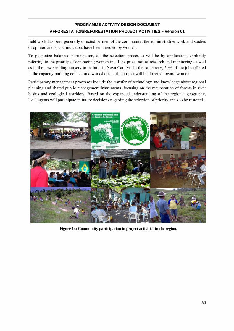
__________________________________________________________________________________
PROGRAMME ACTIVITY DESIGN DOCUMENT AFFORESTATION/REFORESTATION PROJECT ACTIVITIES – Version 01
60
field work has been generally directed by men of the community, the administrative work and studies of opinion and social indicators have been directed by women.
To guarantee balanced participation, all the selection processes will be by application, explicitly referring to the priority of contracting women in all the processes of research and monitoring as well as in the new seedling nursery to be built in Nova Caraíva. In the same way, 50% of the jobs offered in the capacity building courses and workshops of the project will be directed toward women.
Participatory management processes include the transfer of technology and knowledge about regional planning and shared public management instruments, focusing on the recuperation of forests in river basins and ecological corridors. Based on the expanded understanding of the regional geography, local agents will participate in future decisions regarding the selection of priority areas to be restored.
Figure 14: Community participation in project activities in the region.
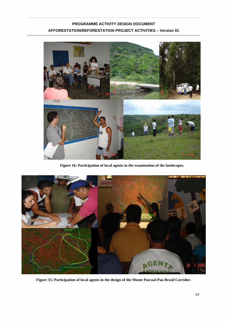
__________________________________________________________________________________
PROGRAMME ACTIVITY DESIGN DOCUMENT AFFORESTATION/REFORESTATION PROJECT ACTIVITIES – Version 01
61
Figure 16: Participation of local agents in the examination of the landscapes.
Figure 15: Participation of local agents in the design of the Monte Pascoal-Pau Brasil Corridor.
__________________________________________________________________________________
PROGRAMME ACTIVITY DESIGN DOCUMENT AFFORESTATION/REFORESTATION PROJECT ACTIVITIES – Version 01
62
The participative management of the project includes the transfer of technology and knowledge of regional planning instruments and shared public management, and it emphasizes the recuperation of forests in watersheds and ecological corridors and monitoring of the socioeconomic impacts of these activities. Once the regional geography is better understood, local agents can participate in the decisions about the selection of priority areas to be restored.
Much as earlier projects in the Caraíva River watershed, the “ecology of scholars”13 concept will be applied, which breaks from the principle of trust and appreciation for local knowledge and promotes a productive convergence of these with modern science. In the development of these projects, the local knowledge of residents about geography, local customs, pathways, soil use, and the properties in the project area have already revealed themselves fundamental to reaching positive results in the adherence of rural properties to environmental recuperation. The local agents can demonstrate the effectiveness of their knowledge with the consolidation of the official IBGE maps (correcting names and positions of rivers on the maps), which are also fundamental in making explicit the objectives and negotiations for ceding land for restoration by the rural landowners.
The project’s partner organizations will be responsible for the transfer of knowledge and capacity building for local agents through workshops, courses, and internship and exchange activities.
Instituto Cidade is responsible for promoting capacity building workshops, opinion research, and socioeconomic data surveys of beneficiaries and other interested parties, as well as land planning workshops and preparing for the prospecting of new properties. These workshops will use new participative techniques for structuring interviews to guarantee that the local demands for knowledge are incorporated in the research. Four annual workshops will be promoted, the first of which will detail the structuring of themes, while the rest will serve for updates and training of local agents.
13 Concept created by Boaventura de Sousa Santos, See: SANTOS, B. S. A gramática do tempo: para uma nova cultura política. São Paulo: Cortez, 2006.
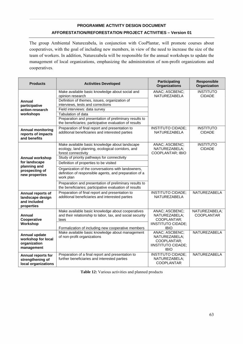
__________________________________________________________________________________
PROGRAMME ACTIVITY DESIGN DOCUMENT AFFORESTATION/REFORESTATION PROJECT ACTIVITIES – Version 01
63
The group Ambiental Naturezabela, in conjunction with CooPlantar, will promote courses about cooperatives, with the goal of including new members, in view of the need to increase the size of the team of workers. In addition, Naturezabela will be responsible for the annual workshops to update the management of local organizations, emphasizing the administration of non-profit organizations and cooperatives.
Products Activities Developed Participating Organizations
Responsible Organization
Annual participative action-research workshops
Make available basic knowledge about social and opinion research
ANAC; ASCBENC; NATUREZABELA
INSTITUTO CIDADE
Definition of themes, issues, organization of interviews, tests and corrections Field interviews: data survey Tabulation of data Preparation and presentation of preliminary results to the beneficiaries; participative evaluation of results
Annual monitoring reports of impacts and benefits
Preparation of final report and presentation to additional beneficiaries and interested parties
INSTITUTO CIDADE; NATUREZABELA
INSTITUTO CIDADE
Annual workshop for landscape planning and prospecting of new properties
Make available basic knowledge about landscape ecology, land planning, ecological corridors, and forest connectivity
ANAC; ASCBENC; NATUREZABELA;
COOPLANTAR; IBIO
INSTITUTO CIDADE
Study of priority pathways for connectivity Definition of properties to be visited Organization of the conversations with landowners, definition of responsible agents, and preparation of a work plan Preparation and presentation of preliminary results to the beneficiaries; participative evaluation of results
Annual reports of landscape design and included properties
Preparation of final report and presentation to additional beneficiaries and interested parties
INSTITUTO CIDADE; NATUREZABELA
NATUREZABELA
Annual Cooperative Workshop
Make available basic knowledge about cooperatives and their relationship to labor, tax, and social security laws
ANAC; ASCBENC; NATUREZABELA; COOPLANTAR;
IINSTITUTO CIDADE; IBIO
NATUREZABELA; COOPLANTAR
Formalization of including new cooperative members
Annual update workshop for local organization management
Make available basic knowledge about management of non-profit organizations
ANAC; ASCBENC; NATUREZABELA; COOPLANTAR;
IINSTITUTO CIDADE; IBIO
NATUREZABELA
Annual reports for strengthening of local organizations
Preparation of a final report and presentation to further beneficiaries and interested parties
INSTITUTO CIDADE; NATUREZABELA;
COOPLANTAR
NATUREZABELA
Table 12: Various activities and planned products
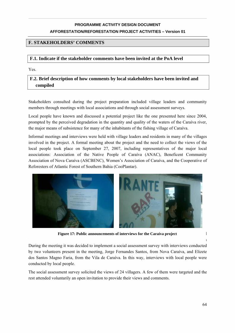
__________________________________________________________________________________
PROGRAMME ACTIVITY DESIGN DOCUMENT AFFORESTATION/REFORESTATION PROJECT ACTIVITIES – Version 01
64
F. STAKEHOLDERS’ COMMENTS
F.1. Indicate if the stakeholder comments have been invited at the PoA level
Yes.
F.2. Brief description of how comments by local stakeholders have been invited and compiled
Stakeholders consulted during the project preparation included village leaders and community members through meetings with local associations and through social assessment surveys.
Local people have known and discussed a potential project like the one presented here since 2004, prompted by the perceived degradation in the quantity and quality of the waters of the Caraíva river, the major means of subsistence for many of the inhabitants of the fishing village of Caraíva.
Informal meetings and interviews were held with village leaders and residents in many of the villages involved in the project. A formal meeting about the project and the need to collect the views of the local people took place on September 27, 2007, including representatives of the major local associations: Association of the Native People of Caraíva (ANAC), Beneficent Community Association of Nova Caraíva (ASCBENC), Women’s Association of Caraíva, and the Cooperative of Reforesters of Atlantic Forest of Southern Bahia (CooPlantar).
During the meeting it was decided to implement a social assessment survey with interviews conducted by two volunteers present in the meeting, Jorge Fernandes Santos, from Nova Caraíva, and Maria During the meeting it was decided to implement a social assessment survey with interviews conducted by two volunteers present in the meeting, Jorge Fernandes Santos, from Nova Caraíva, and Elizete dos Santos Magno Faria, from the Vila de Caraíva. In this way, interviews with local people were conducted by local people.
The social assessment survey solicited the views of 24 villagers. A few of them were targeted and the rest attended voluntarily an open invitation to provide their views and comments.
Figure 17: Public announcements of interviews for the Caraíva project
__________________________________________________________________________________
PROGRAMME ACTIVITY DESIGN DOCUMENT AFFORESTATION/REFORESTATION PROJECT ACTIVITIES – Version 01
65
The survey was announced through event notices posted (see pictures below) in prominent and popular places. It took the form of an open desk, available for three weeks, were anyone could go to obtain further information about the project and fill out a questionnaire.
The list of interviewees included well known community leaders such as the of the above mentioned associations ANAC, ASBENC and CooPlantar, a member of the Women’s Association of Caraíva, the director and several teachers of the local school, health workers, merchants, pastors of the local Evangelical Church, and local fishermen.
This allowed the analysis of levels of support at the household and community level. Interviewees were informed of key elements of the proposed project and asked to state preferences and issues of concern.
F.3. Summary of the comments received
The questionnaire filled out by the interviewees during the survey included direct questions about climate change and how it affects the region, and about the reforestation project and whether it would have a positive or negative impact on them, especially in terms of jobs and income.
The survey shows that 87% of the interviewees know what climate change is, and 70% cited specific negative effects of climate change in the region, showing their awareness on the subject.
Regarding the project, 81% had a positive opinion, while 5% was neutral and the rest said they would need more information before stating their opinion. Twenty-two out of 24 interviewees thought the project could generate jobs and income if it emphasized participation by locals.
When asked how the project could improve the area, the most popular answers were an increase in vegetation (5/24) and sustainable jobs (5/24).
F.4. Report on how due account was taken of any comments received
Given the high value placed on employment benefits, the distribution of employment will be a responsibility of Cooplantar, a local cooperative formed by members of the communities involved, which will ensure that this is done equitably.
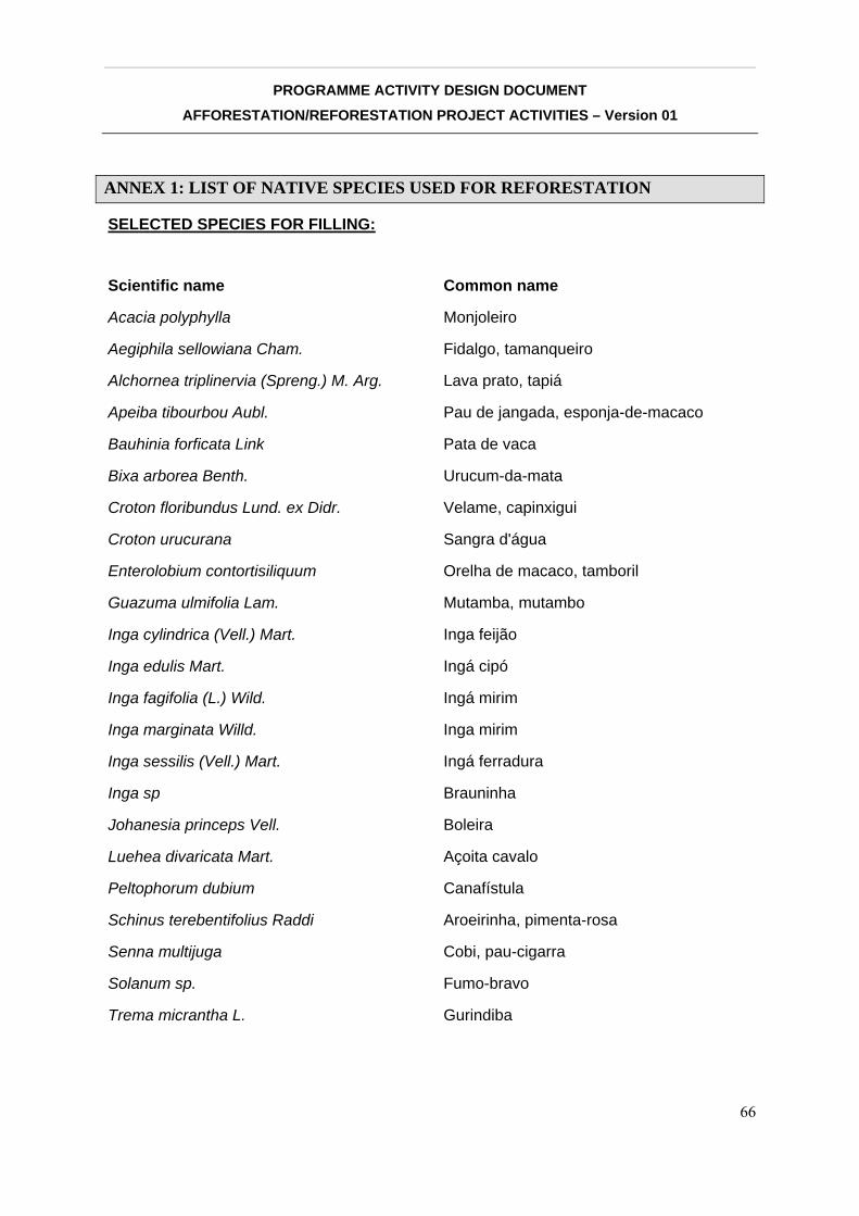
__________________________________________________________________________________
PROGRAMME ACTIVITY DESIGN DOCUMENT AFFORESTATION/REFORESTATION PROJECT ACTIVITIES – Version 01
66
ANNEX 1: LIST OF NATIVE SPECIES USED FOR REFORESTATION
SELECTED SPECIES FOR FILLING:
Scientific name Common name
Acacia polyphylla Monjoleiro
Aegiphila sellowiana Cham. Fidalgo, tamanqueiro
Alchornea triplinervia (Spreng.) M. Arg. Lava prato, tapiá
Apeiba tibourbou Aubl. Pau de jangada, esponja-de-macaco
Bauhinia forficata Link Pata de vaca
Bixa arborea Benth. Urucum-da-mata
Croton floribundus Lund. ex Didr. Velame, capinxigui
Croton urucurana Sangra d'água
Enterolobium contortisiliquum Orelha de macaco, tamboril
Guazuma ulmifolia Lam. Mutamba, mutambo
Inga cylindrica (Vell.) Mart. Inga feijão
Inga edulis Mart. Ingá cipó
Inga fagifolia (L.) Wild. Ingá mirim
Inga marginata Willd. Inga mirim
Inga sessilis (Vell.) Mart. Ingá ferradura
Inga sp Brauninha
Johanesia princeps Vell. Boleira
Luehea divaricata Mart. Açoita cavalo
Peltophorum dubium Canafístula
Schinus terebentifolius Raddi Aroeirinha, pimenta-rosa
Senna multijuga Cobi, pau-cigarra
Solanum sp. Fumo-bravo
Trema micrantha L. Gurindiba
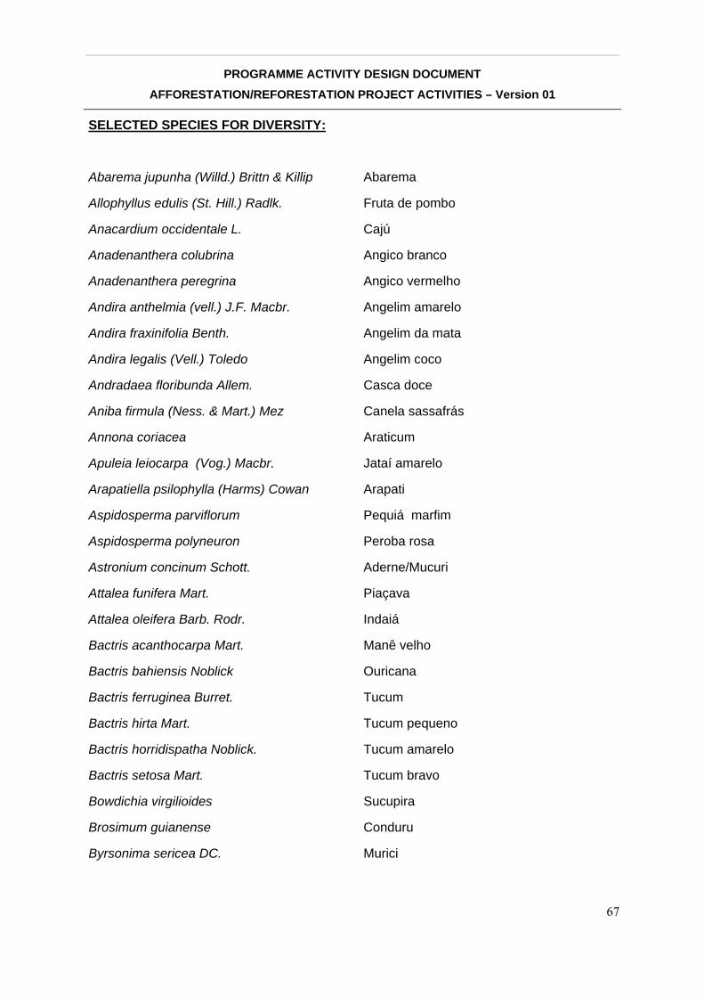
__________________________________________________________________________________
PROGRAMME ACTIVITY DESIGN DOCUMENT AFFORESTATION/REFORESTATION PROJECT ACTIVITIES – Version 01
67
SELECTED SPECIES FOR DIVERSITY:
Abarema jupunha (Willd.) Brittn & Killip Abarema
Allophyllus edulis (St. Hill.) Radlk. Fruta de pombo
Anacardium occidentale L. Cajú
Anadenanthera colubrina Angico branco
Anadenanthera peregrina Angico vermelho
Andira anthelmia (vell.) J.F. Macbr. Angelim amarelo
Andira fraxinifolia Benth. Angelim da mata
Andira legalis (Vell.) Toledo Angelim coco
Andradaea floribunda Allem. Casca doce
Aniba firmula (Ness. & Mart.) Mez Canela sassafrás
Annona coriacea Araticum
Apuleia leiocarpa (Vog.) Macbr. Jataí amarelo
Arapatiella psilophylla (Harms) Cowan Arapati
Aspidosperma parviflorum Pequiá marfim
Aspidosperma polyneuron Peroba rosa
Astronium concinum Schott. Aderne/Mucuri
Attalea funifera Mart. Piaçava
Attalea oleifera Barb. Rodr. Indaiá
Bactris acanthocarpa Mart. Manê velho
Bactris bahiensis Noblick Ouricana
Bactris ferruginea Burret. Tucum
Bactris hirta Mart. Tucum pequeno
Bactris horridispatha Noblick. Tucum amarelo
Bactris setosa Mart. Tucum bravo
Bowdichia virgilioides Sucupira
Brosimum guianense Conduru
Byrsonima sericea DC. Murici

__________________________________________________________________________________
PROGRAMME ACTIVITY DESIGN DOCUMENT AFFORESTATION/REFORESTATION PROJECT ACTIVITIES – Version 01
68
Byrsonima stipulacea A. Juss. Murici açu
Cabralea canjerana (Vell.) Mart. Cangerana
Caesalpinia echinata Lamark Pau brasil
Caesalpinia ferrea Mart. Pau ferro
Calophylum brasiliensis Camb. Guanandi
Cariniana estrellensis (Raddi) Kuntze Jequitibá branco
Cariniana legalis (Mart.) Kuntze Jequitibá rosa
Carpotroche brasiliensis Endl. Fruta de cotia
Caryocar edulis Pequi
Casearia decandra Jacq. Aderninho
Casearia sylvestris Sw. Aderninho da capoeira
Cecropia glaziovi Snethalage Embaúba roxa
Cecropia hololeuca Miq. Embaúba prateada
Cecropia pachystachya Embaúba folha pequena
Cedrella odorata L. Cedro
Centrolobium microchaete Putumuju
Centrolobium robustum Putumuju
Centrolobium tomentosum Putumuju
Chrysophyllum splendens Spreng. Bapeba
Citharexylum myrianthum Cham. Tarumã
Clarisia racemosa R. & Pav. Oiticica
Copaifera lucens Dwyer Óleo copaíba
Cordia magnoliifolia Cham. Baba de boi
Cordia trichotoma Louro Pardo
Couma rigida Mucugê
Couratari asterotricha Prance Imbirema
Coussapoa microcarpa Mata pau
Cupania oblongifolia Mart. Camboatá
Cupania vernalis Camb. Camboatá
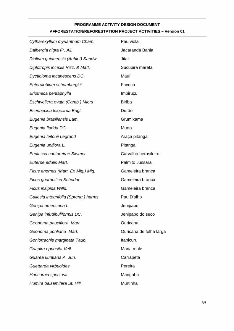
__________________________________________________________________________________
PROGRAMME ACTIVITY DESIGN DOCUMENT AFFORESTATION/REFORESTATION PROJECT ACTIVITIES – Version 01
69
Cytharexyllum myrianthum Cham. Pau viola
Dalbergia nigra Fr. All. Jacarandá Bahia
Dialium guianensis (Aublet) Sandw. Jitaí
Diplotropis incexis Rizz. & Matt. Sucupira mareta
Dyctioloma incanescens DC. Mauí
Enterolobium schomburgkii Faveca
Eriotheca pentaphylla Imbiruçu
Eschweilera ovata (Camb.) Miers Biriba
Esenbeckia leiocarpa Engl. Durão
Eugenia brasiliensis Lam. Grumixama
Eugenia florida DC. Murta
Eugenia leitonii Legrand Araça pitanga
Eugenia uniflora L. Pitanga
Euplassa cantareirae Slwmer Carvalho berasileiro
Euterpe edulis Mart. Palmito Jussara
Ficus enormis (Mart. Ex Miq.) Miq. Gameleira branca
Ficus guaranitica Schodat Gameleira branca
Ficus insipida Willd. Gameleira branca
Gallesia integrifolia (Spreng.) harms Pau D'alho
Genipa americana L. Jenipapo
Genipa infudibuliformis DC. Jenipapo do seco
Geonoma pauciflora Mart. Ouricana
Geonoma pohliana Mart. Ouricana de folha larga
Goniorrachis marginata Taub. Itapicuru
Guapira opposita Vell. Maria mole
Guarea kuntiana A. Jun. Carrapeta
Guettarda virbuoides Pereira
Hancornia speciosa Mangaba
Humira balsamifera St. Hill. Murtinha
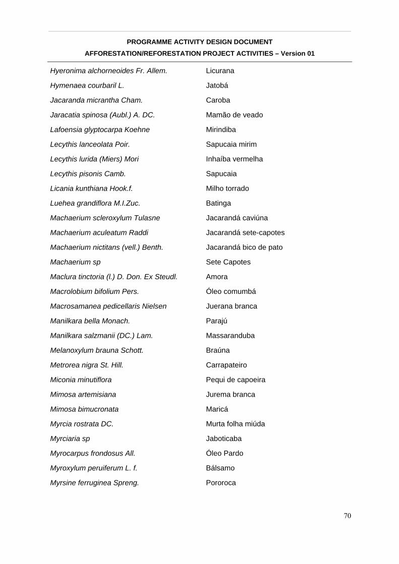
__________________________________________________________________________________
PROGRAMME ACTIVITY DESIGN DOCUMENT AFFORESTATION/REFORESTATION PROJECT ACTIVITIES – Version 01
70
Hyeronima alchorneoides Fr. Allem. Licurana
Hymenaea courbaril L. Jatobá
Jacaranda micrantha Cham. Caroba
Jaracatia spinosa (Aubl.) A. DC. Mamão de veado
Lafoensia glyptocarpa Koehne Mirindiba
Lecythis lanceolata Poir. Sapucaia mirim
Lecythis lurida (Miers) Mori Inhaíba vermelha
Lecythis pisonis Camb. Sapucaia
Licania kunthiana Hook.f. Milho torrado
Luehea grandiflora M.I.Zuc. Batinga
Machaerium scleroxylum Tulasne Jacarandá caviúna
Machaerium aculeatum Raddi Jacarandá sete-capotes
Machaerium nictitans (vell.) Benth. Jacarandá bico de pato
Machaerium sp Sete Capotes
Maclura tinctoria (l.) D. Don. Ex Steudl. Amora
Macrolobium bifolium Pers. Óleo comumbá
Macrosamanea pedicellaris Nielsen Juerana branca
Manilkara bella Monach. Parajú
Manilkara salzmanii (DC.) Lam. Massaranduba
Melanoxylum brauna Schott. Braúna
Metrorea nigra St. Hill. Carrapateiro
Miconia minutiflora Pequi de capoeira
Mimosa artemisiana Jurema branca
Mimosa bimucronata Maricá
Myrcia rostrata DC. Murta folha miúda
Myrciaria sp Jaboticaba
Myrocarpus frondosus All. Óleo Pardo
Myroxylum peruiferum L. f. Bálsamo
Myrsine ferruginea Spreng. Pororoca

__________________________________________________________________________________
PROGRAMME ACTIVITY DESIGN DOCUMENT AFFORESTATION/REFORESTATION PROJECT ACTIVITIES – Version 01
71
Myrsine umbellata Mez. Pororoca
Nectandra menbranaceae Louro Graveto
Nectandra rigida Louro amarelo
Neoraputia alba Arapoca
Ocotea odorifera (Vell.) Rohwer Canela sassafrás
Ormosia arborea (Vell.) Harms. Olho de cabra
Parapiptadenia pteosperma Angico vermelho
Parkia pendula Juerana vermelha
Peltogyne angustifolia Ducke Roxinho
Peltogyne confertifolia Pau roxo
Pera glabrata (Schott.) Baill. Sete Cascas
Peschiera fuchsiaefolia Miers Leiteira
Piptadenia paniculata Benth. Angico
Plathypodium elegans Vogel Jacarandá branco
Platycyanus regnelli Benth. Pau pereira
Platymenia foliolosa Benth. Vinhático
Polyandrococos caudescens Buri
Pouroma guianensis Aubl. Tararanga
Pouteria caimito (Ruiz & Pav.) Radlk. Abiu
Pouteria grandiflora (DC.) Baehni Bapeba
Protium heptaphyllum Amescla
Psidium cattleianum Sabine Araça amarelo
Psidium rufum DC. Araça roxo
Pterigota brasiliensis Fr. All. Pau rei
Pterocarpus violaceus Vogel Pau sangue
Ramisia brasiliensis Oliver Roda saia
Rheedia gardneiana Planch. et. Triana Bacupari
Rollinia bahiensis Maas & Westre Pinha da mata
Rollinia mucosa (Jacq.) Baill Araticum/Conde
__________________________________________________________________________________
PROGRAMME ACTIVITY DESIGN DOCUMENT AFFORESTATION/REFORESTATION PROJECT ACTIVITIES – Version 01
72
Rollinia mucosa (Jacquin) Baill. Pinha da mata
Scheflera morototoni (Aubl.) B. Mg. Matataúba
Schinus terebentifolius Raddi Aroeirinha
Senna macranthera Fedegoso
Simaruba amara Aubl. Pau paraíba
Sorocea bonplandii (Baill.) Burger Folha de serra
Sorocea guilleminiana Amora branca
Sparattosperma leucanthum Cinco folhas
Spondias macrocarpa Engl. Cajazeira
Spondias venulosa Mart. exEngl. Cajá grande
Sterculia chicha St. Hill Arichichá
Stryphnodendron pulcherrimum Faveiro
Styrax ferruginea Laranjeira da mata
Swartzia euxylophora Rizz. & Matt. Arruda
Sweetia fruticosa Spreng. Sucupira amarela
Syagrus botryophora (Mart.) Becc. Pati
Symphonia globulifera L. Landirana
Tabebuia chrysotricha Ipê tabaco
Tabebuia heptaphylla (Vell.) Toledo Ipê roxo
Tabebuia impetiginosa Ipê rosa
Tabebuia roseo-alba Ipê branco
Tabebuia serratifolia (Vahl) Nichols Ipê amarelo
Tapirira guianensis Aubl. Pau pombo
Terminalia kuhlmannii Alwan & Stace Araça dágua
Thyrsodium schomburgkianum Camboatá Vermelho
Tibouchina granulosa Quaresmeira
Toulicia oblongifolia Mart. Cheiro de barata
Trichilia pallida Swartz Camaçari
Trichilia silvatica DC. Camaçari
__________________________________________________________________________________
PROGRAMME ACTIVITY DESIGN DOCUMENT AFFORESTATION/REFORESTATION PROJECT ACTIVITIES – Version 01
73
Vataireopsis araroba Angelim amargoso
Virola oleifera (Schott) A.C. Smith. Bicuíba Vermelha
Vochysia sp Cinzeiro
Xylopia brasiliensis Spreng. Pindaíba pimenteira
Xylopia emarginata Mart. Pindaíba
Xylopia involucrata M.C. Dias Pindaíba
Zanthoxylum rhoifolium Lam. Mamica de porca
Zanthoxylum riedelianum Engl. Mamica de porca
Zeyheria tuberculosa Ipê felpudo
Zollernia latifolia Benth. Orelha de onça
__________________________________________________________________________________
PROGRAMME ACTIVITY DESIGN DOCUMENT AFFORESTATION/REFORESTATION PROJECT ACTIVITIES – Version 01
74
ANNEX 2: DETAILED MAP AND COORDINATES OF PROJECT SITES
See attached map and coordinates in pdf format.
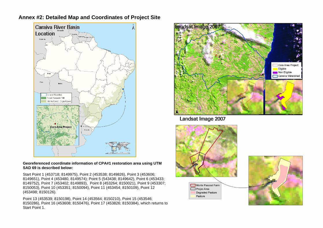
Georeferenced coordinate information of CPA#1 restoration area using UTM SAD 69 is described below: Start Point 1 (453718; 8149975), Point 2 (453538; 8149826), Point 3 (453606; 8149651), Point 4 (453480, 8149574); Point 5 (543438; 8149642), Point 6 (453433; 8149752), Point 7 (453402; 8149893), Point 8 (453264; 8150021), Point 9 (453307; 8150053), Point 10 (453351; 8150094), Point 11 (453454; 8150109), Point 12 (453498; 8150126).
Point 13 (453539; 8150198), Point 14 (453564; 8150210), Point 15 (453546; 8150286), Point 16 (453608; 8150476), Point 17 (453826; 8150384), which returns to Start Point 1.
Annex #2: Detailed Map and Coordinates of Project Site
__________________________________________________________________________________
PROGRAMME ACTIVITY DESIGN DOCUMENT AFFORESTATION/REFORESTATION PROJECT ACTIVITIES – Version 01
75
ANNEX 3: CONTACT INFORMATION FOR PROJECT PARTICIPANTS
Instituto BioAtlântica
Beto Mesquita [email protected]
The Nature Conservancy
Gilberto Tiepolo [email protected]
Conservation International Brazil
Luis Paulo Pinto [email protected]
Instituto Cidade
Paulo Dimas [email protected]
Grupo Ambiental Naturezabela
José Fancisco de Azevedo Júnior [email protected]
Cooplantar
Carlo Alberto Bobbio [email protected]
ANAC
Maria D'Ajuda Batista da Silva [email protected]
ASCBENC
José Dilson da Silva Dias [email protected]
AmbientalPV Ltda
Guilherme Prado Valladares [email protected]
__________________________________________________________________________________
PROGRAMME ACTIVITY DESIGN DOCUMENT AFFORESTATION/REFORESTATION PROJECT ACTIVITIES – Version 01
76
BIBLIOGRAPHY
Alger, K.; Caldas, M. (1994). The declining cocoa economy and the Atlantic Forest of southern Bahia, Brazil: conservation attitudes of cocoa planters. The Environmentalist, 14: 107-19.
Aouad, M. (1998). Projeto Porto Seguro – Santa Cruz Cabrália: clima. Salvador: CPRM, v.1, Programa de Informações Básicas para Gestão Territorial – GATE, 48p.
Begon, M.; Harper, J.L.; Townsend, C.R. (2006). Fundamentos em Ecologia. Artmed, p.592.
Barlow, J.; Gardner, T. A.; Araujo, I. S.; et al. (2007). Quantifying the biodiversity value of tropical primary, secondary, and plantation forests. PNAS 104(47):18555–18560.
Brooks, K.N., Ffolliott, P.F., Gregersen, H.M. & DeBano, L.F. 1997. Hydrology and the management of watersheds. 2nd edition. Ames, Iowa, USA, Iowa State University Press.
Brown, S. (1997). Estimating Biomass and Biomass Change of Tropical Forests: a Primer. FAO Forestry Paper 134, Rome, Italy.
Calder, I.R. (2002). Forests and Hydrological Services: Reconciling public and science perceptions. Land Use and Water Resources Research 2: 2.1–2.12
Campos, J.C.C., Leite, H.G., Da Silva, G.F., Soares, C.P.B., Carneiro, J.A. (2001). Estimação de volumes do tronco e da copa de árvores de povoamentos mistos. Revista Árvore, 25 (4):471-480
Carvalho, P.E.R. (1994). Espécies florestais brasileiras: recomendações silviculturais, potencialidades e uso da madeira. Colombo: EMBRAPA-CNPF; Brasília: EMBRAPA-SPI, 1994. 639 p
Carvalho, L. M., & Scolforo, J. R. (2008). Inventário Florestal de Minas Gerais: Equações de Volume, Peso de Matéria Seca e Carbono para Diferentes Fitofisionomias da Flora Nativa. Lavras: Editora UFLA.
Carvalho, P.E.R. (2003). Espécies Arbóreas Brasileiras – Vol 1. Curitiba, EMBRAPA-CNPF/SPI.
Cavedon, A.D.; Shinzato, E.; Jacques, P.D. (orgs.) (2000). Projeto Porto Seguro – Santa Cruz Cabrália: Levantamento de reconhecimento de solos, capacidade de uso das terras e uso do solo e cobertura vegetal. CPRM/SA, v.4, 90p.
Chichignoud, M.; Deon, G.; Deteinne, P.; Parant, B.; Vantomme, P. (1990). Tropical Timber Atlas of Latin America. ITTO/CTFT, Yokohama, p. 218.
__________________________________________________________________________________
PROGRAMME ACTIVITY DESIGN DOCUMENT AFFORESTATION/REFORESTATION PROJECT ACTIVITIES – Version 01
77
Cordeiro, P.H.C. (2003). Padrões de distribuição geográfica da avifauna, com ênfase nas espécies endêmicas e ameaçadas, nos remanescentes de mata atlântica no sul da Bahia. In: Prado P.I., Landau E.C., Moura R.T., Pinto L.P.S., Fonseca G.A.B., Alger K. (orgs.) (2003). Corredor de Biodiversidade na Mata Atlântica do Sul da Bahia. Publicação em CD-ROM. IESB/CI/CABS/UFMG/UNICAMP. Ilhéus
Costa, J.P.O. (1997). Avaliação da Reserva da Biosfera da Mata Atlântica – Cinco anos depois de seu reconhecimento pelo programa MaB-UNESCO. Série Gestão da RBMA, 6: 1-48.
Critical Ecosystem Partnership Fund (CEPF) (2001). Atlantic Forest Biodiversity Hotspot. Ecosystem Profile, 29p.
Dean, W. (1996). A Ferro e Fogo: A História e a devastação da Mata Atlântica brasileira. Companhia das Letras, São Paulo, 484p.
Fedalto, L.C.; Mendes, I.C.A.; Coradin, V.T.R. (1989). Maderas da Amazônia. Descrição do lenho de 40 espécies ocorrentes na Floresta Nacional do Tapajós. Inst. Bras. Meio Ambiente Recurs. Nat. Renov. IBAMA. Brasilia
Franco, M.; Holz, B.; Kaule, G.; Kleyer, M.; Menezes, M.; Pereira, J.M.; Trevisan, S. (1994). Program of environmental development of the rainforest region in Bahia, Brazil-development of a methodology. University of Stuttgart, Stuttgart, Germany.
Freese, F. (1962). Elementary Forest Sampling. USDA Handbook 232. GPO Washington, DC.
Galetti, M.; Alves-Costa, C.P. & Cazetta, E. (2003). Effects of forest fragmentation, anthropogenic edges and fruit colour on the consumption of ornithocoric fruits. Biological Conservation 111: 269–273
Gehring, C.; Park, S.; Denich, M. (2004). Liana allometric biomass equations for Amazonian primary and secondary forest. Forest Ecology and Management 195 (69-83)
Girão, L.C.; Lopes, A.V.; Tabarelli, M.; Bruna, E.M. (2007). Changes in tree reproductive traits reduce functional diversity in a fragmented Atlantic Forest landscape. PloS One, 9: 1-12. (e908. doi:10.1371/journal.pone.0000908.)
Hulme, M., & Sheard, N. (1999). Climate Change Scenarios for Brazil. Norwich, UK: Climate Research Unit.
IPCC. (2002). IPCC Technical Paper V: Climate Change and Biodiversity. In H. Gitay, D. Suarez, & R. Watson (Ed.). Intergovernmental Panel on Climate Change.
IPCC. (2007). Working Group II Report: Impacts, Adaptation, and Vulnerability. Intergovernmental Panel on Climate Change.
__________________________________________________________________________________
PROGRAMME ACTIVITY DESIGN DOCUMENT AFFORESTATION/REFORESTATION PROJECT ACTIVITIES – Version 01
78
Jankowsky, I. P.(1990). Madeiras brasileiras. Caxias do Sul: Spectrum, v.1, 172 p.
Kiersch, B. & Tognetti, S. (2002). Land-water linkages in rural watersheds: Results from the FAO electronic workshop. Land Use and Water Resources Research 2:1.1– 1.6
Klapproth, J. C., & Johnson, J. E. (2000). Understanding the Science Behind Riparian Forest Buffers: Effects on Water Quality. Retrieved from http://www.ext.vt.edu/pubs/forestry/420-151/420-151.html
Lorenzi, H. (1992). Árvores brasileiras: manual de identificação e cultivo de plantas arbóreas nativas do Brasil. 2e. Nova Odessa. Plantarum. v.2. 368p.
Lorenzi, H. (1998). Árvores brasileiras: manual de identificação e cultivo de plantas arbóreas nativas do Brasil. Nova Odessa. Plantarum. 368p.
Mainieri, C; Chimelo, J. P. (1989). Fichas de características de madeiras brasileiras. São Paulo: Instituto de Pesquisa tecnológicas. 407 p.
Mayr, E. (1997). The objects of Selection. Proceedings of National Academy of Science USA, 94(6): 2091-2094.
Menezes, P. (2006). O Cidadão como sujeito de governo: planejamento e gestão pública compartilhada na bacia do rio Caraíva.Belo Horizonte: IGC UFMG, 100p.
Myers, N.; Mittermeier, R. A.; Mittermeier, C. G.; da Fonseca, G. A. B.; Kent, J. (2000) Biodiversity
Hotspots for Conservation Priorities. Nature, 403: 853-858.
Nimer, E. (1989) Climatologia do Brasil. IBGE. Rio de Janeiro, 421p.
Noffs, P. S.; Gallie, L. F.; Gonçalves, J. C. (2000). Recuperação de Áreas Degradadas da Mata Atlântica: Uma experiência da CESP – Companhia Energética de São Paulo. Série Recuperação, caderno 3. Reserva da Biosfera da Mata Atlântica, UNESCO; 26 p.
Oliveira, S.J. & BACHA, C.J.C. (2003). Avaliação do cumprimento da Reserva Legal no Brasil. Revista de Economia e Agronegócio. V. 1, No. 2. p 177- 203.
Pardini, R. (2004). Effects of forest fragmentation on small mammals in an Atlantic Forest landscape. Biodiversity Conservation, 13: 2567-2586.
Paula, J.E. & Alves, J.L. (1997). Madeiras nativas: Anatomia, dendrologia, dendrometria, produção e uso. Brasília, Gráfica Gutemberg, 543p.
Raboy, R.E.; Christman, M.C.; Dietz, J.M. (2004). The use of degraded and shade cocoa forests by Endangered golden-headed lion tamarins Leontopithecus chrysomelas. Oryx, 38: 75-83.
__________________________________________________________________________________
PROGRAMME ACTIVITY DESIGN DOCUMENT AFFORESTATION/REFORESTATION PROJECT ACTIVITIES – Version 01
79
Rodrigues, R.R.; Gandolfi, S. (2003). Avanços e perspectivas na recuperação de áreas dentro dos Programas de Adequação Ambiental. Anais do Seminário Temático sobre Recuperação de Áreas Degradadas, São Paulo. Instituto de Botânica, p.5-6.
Rodrigues, R.R.; Gandolfi, S. (2004). Conceitos, tendências e ações para a recuperação de florestas ciliares Rodrigues, R.R.; Leitão Filho, H.F. (Ed.) Matas ciliares: conservação e recuperação. 3 ed., São Paulo: EDUSP, p.235-247.
Saatchi, S.; Agosti, D.; Alger, K.; Delabie, J.; Musinsky, J. (2001). Examining fragmentation and loss of primary forest in the southern Bahian Atlantic Forest of Brazil with radar imagery. Conservation Biology, 15: 867-875.
Sambuichi, R.H.R. (2001). Fitossociologia e diversidade de espécies arbóreas em Cabruca (Mata Atlântica raleada sobre plantação de cacau) na região sul da Bahia, Brasil. Acta Botânica Brasileira, 16(1): 89-101.
Sambuichi, R.H.R.; Haridasan, M. (2007). Recovery of species richness and conservation of native Atlantic forest trees in the cacao plantations of southern Bahia in Brazil. Biodiversity Conservation, 16: 3681-3701.
Santos, Boaventura de Sousa (2006). A gramática do tempo: para uma nova cultura política. São Paulo: Cortez, 2006.
Siqueira, L. P; Mesquita, C. A. B. (2007). Meu pé de Mata Atlântica: experiências de recomposição florestal em propriedades particulares no corredor central - 1. ed. - Rio de Janeiro : Instituto BioAtlântica, 2007. 188p.
Souza, Amaury Paulo, Nilton Cesar Fiedler, and Carlos Cardoso Machado (1997). Environmental impacts of harvesting forest plantations in mountainous terrain. Voluntary paper prepared for the XI World Forestry Congress, Antalya, Turkey, 13-22 Oct 1997.
Souza, F.M.; Batista, J.L.F. (2004). Restoration of seasonal semideciduous forests in Brazil: influence of age and restoration design on forest structure. Forest Ecology and Management, v.191, p.185-200.
Thomas, W.W.; de Carvalho, A.M.V. (1997). Atlantic moist forest of southern Bahia, In: Davis, S.D.; Heywood, V.H.; MacBryde, O.H.; Hamilton, A.C. (eds.), Centers of plant diversity: a guide and strategy for their conservation, vol. 3. IUCN-WWF Press, London, p.364-368.
Tiepolo G., Calmon, M. A., Ferreti, A. R. (2002). Measuring and Monitoring Carbon Stocks at the Guaraqueçaba Climate Action Project, Paraná, Brazil. Taiwan Forestry Research institute Extension Series, 153:98-115.
Vannote, R.L., Minshall, G., Cummins, K.W., Sedell, J.R. & Cushing, C.E. (1989). The river continuum concept. Can. J. Fish. Aquat. Sci. 37: 130-137.