project its
TRANSCRIPT
7/26/2019 Project ITS
http://slidepdf.com/reader/full/project-its 1/35
Department of Civil Engineering \ Transportation
Faculty of Engineering & Built Environment
The National University of Malaysia
Semester II - Session 2015/2016
KKKA6424
Urban Traffic Management System
Final ProjectPropose a suitable Intelligent Transport System
For KARADA City in Baghdad
Done By
AMEER ABDUL ADHEEM HUSSIEN (P81466)
ALLA JABER ESSA ALNAJI (P81573)
ABDULLAH HAYAL KHALAF (P81460)
Lecturer
PROF. DATO' IR. DR RIZA ATIQ ABDULLAH BIN O.K. RAHMAT
Dr. MUHAMAD NAZRI BIN BORHAN

7/26/2019 Project ITS
http://slidepdf.com/reader/full/project-its 2/35
2
Table of Contents
Contents Page
1- Introduction ………………………………………………………...... 3
2- Problem Statement …………………………………………………. 3
3- Objectives of Study …………………………………………………. 4
4- Area of Study …………………………………………….……….…. 4
5- Literature Review ……………………………………………………. 8
6- Components Of ITS …………………………………………………. 9
6- 1. Overal architecture of the system ……………………..……. 11
6- 2. Traffic Control system …………………………………..……. 12
6- 3. Smart Surveillance System ……………………….…………. 15
6- 4. Variable massage system (VMS) …………...………………. 18
6- 5. Public Transport Management System ………..…………… 21
6- 6. Communication System ………………………………...……. 23
7- Study methodology …………………………………………………. 25
8- Estimation Cost ………………………………………..……………. 34
9- Conclusion ………………………………………………..…………. 35

7/26/2019 Project ITS
http://slidepdf.com/reader/full/project-its 3/35
3
1- Introduction:
The world is urbanizing rapidly, and population densities are increasing.
An United Nation reports estimate approximately 70 percentage from the
world’s population will live in cities in (2050) This growth is expanding
demands on urban infrastructures of all kinds , world cities reveals that
although cities face unique transportation challenges, their leaders share
a number of common ambitions. Most strive for green environment, less
congested cities and improved traffic flow , However, the constraints of
tight capital budgets are driving an increased focus on the need to better
manage transport demand and supply through deploying intelligent
transport systems (ITS)The majority of cities are at an early stage in
understanding and realizing the full potential of ITS .
2- Problem Statement:
The traffic at the intersection during peak hours is regularly and very
crowded as results to the huge number of cars reaching the carrying
capacity of the road. Long queues at the intersections are another
problem facing traffic stream , as well as the overtaking on the traffic
light signals , Exceeded the speed limit , The spread of crime in some
roads, All of these requires need to development of an integrated
intelligent system to control and monitor Those offenses and traffic jams
and reduce them.

7/26/2019 Project ITS
http://slidepdf.com/reader/full/project-its 4/35
4
3- Objectives of Study:
1- To upgrade current situation of traffic flow.
2- To ensure the safety of the traffic users.
3- To propose mechanism of action during incident/breakdown.
4- To give real time information to the users.
4- Area of Study:
KARADA city is the area of Baghdad is located on the eastern side of
the Tigris River, Its area about (16.8 Km²), and a population about
250,000 people, KARADA is considered one of the most commercial
areas in Baghdad, as well as there are two main Universities in Iraq in
this area are (Baghdad University) & the (University of Nahrain), this
area suffer from the traffic congestion and traffic violations in peak hours
and normal times also.
In this study we will choose four intersections (2 is four leg intersection &
2 roundabouts) as an example of our study to propose a suitable
Intelligent Transport System deployment.

7/26/2019 Project ITS
http://slidepdf.com/reader/full/project-its 5/35
5
The picture explains our study area & the intersections witch we choose them.

7/26/2019 Project ITS
http://slidepdf.com/reader/full/project-its 6/35
6
Some Pictures of our Study area:
Baghdad University Intersection
ALHURIA Roundabout

7/26/2019 Project ITS
http://slidepdf.com/reader/full/project-its 7/35
7
ALMASBAH Intersection
University of Baghdad

7/26/2019 Project ITS
http://slidepdf.com/reader/full/project-its 8/35
8
5- Literature Review:
ITS stands for Intelligent Transportation Systems. ITS is a national program
aimed at using modern computers and communications to make travel
smarter, faster, safer and more convenient.
Here are a few of the ways ITS helps:
Intelligent traffic control systems help us by reducing the time we
spend stopped at red lights or waiting on freeways when an accident
occurs.
Traveler information systems help us by giving us current, multi-
modal information on travel conditions allowing us to make smarter
choices about how, when and where to travel.
Advanced transit systems help transit agencies operate more
efficiently and provide travelers with real time information that makes
using transit easier and more attractive.
Intelligent commercial vehicle systems will help commercial vehicle
operator’s process the paperwork associated with moving goods.
These systems will also help public agencies improve safety by
inspecting the vehicles that need it the most.

7/26/2019 Project ITS
http://slidepdf.com/reader/full/project-its 9/35
9
6- Components Of ITS:
Our proposal must include:
1. Overall architecture of the system.
2. Traffic Control system.
3. Smart surveillance system.
4. Variable massage system (VMS).
5. Public Transport Management system.
6. Communication system.
VMS
Speed Camera Traffic Light

7/26/2019 Project ITS
http://slidepdf.com/reader/full/project-its 10/35
01
Proposed Urban Traffic Management System:
The development of the proposal is still at an early stage, but specific areas
that are being considered for inclusion include improved the coordination of all
network management areas will help to carry out the highway authority by the
Traffic Management, for example, enabling a quicker response to incidents on
the network, thereby reducing delays to both car travelers and public transport
users alike.
This will include improving the way the following systems work together :
Traffic signals.
Improved coordination of road works, special events.
New traffic information message signs.
Out of hours cover and emergency response to highways incidents.

7/26/2019 Project ITS
http://slidepdf.com/reader/full/project-its 11/35
00
6- 1. Overal architecture of the system:
(ITS) Architecture provides a common framework for planning,
defining and integrating intelligent transportation systems. It was
developed through broad participation from transportation
practitioners, systems engineers, system developers, technology
specialists, consultants, etc. over the last ten years. The architecture
defines:
The functions that are required for (ITS), (i.e. collection of traffic
information).
The physical entities or subsystems where these functions reside,
(i.e. the roadside or the vehicle).
The information flows and data flows that connect these functions
and physical subsystems together into an integrated system.

7/26/2019 Project ITS
http://slidepdf.com/reader/full/project-its 12/35
02
6- 2. Traffic Control system:
In crowded cities, it is difficult to implement a normal traffic control
system, because of the variation of flow of roads vehicles during
different period of time, many parameters must be considered to
develop a certain traffic control system.
Major activities in our study area includes equipping non signalized
intersections with the appropriate types of signals and developing
Intelligent Intersections Network centrally managed and coordinated
by integrated management system.
In our study area we will use Scats as a system for the traffic control.
Scats (Sydney Coordinated Adaptive Traffic System):
It is a fully adaptive urban traffic control system that optimizes traffic
flow, as well as self-calibrating software minimizes manual
intervention, which can result in substantial operational cost savings.
Why choose scats in our study area:
SCATS has been continually developed for over 40 years and sold to
27 countries, delivering real and measurable reductions in road travel
times and delays.
(KARADA) city currently need to this system to reduce congestion
also, to increase the overall system efficiency.

7/26/2019 Project ITS
http://slidepdf.com/reader/full/project-its 13/35
03
These subsystems are defined as:
The main control subsystem, which is responsible of the original
traffic control including traffic period for each section of traffic
lights.
Intelligent sensors subsystem, which is responsible to give
priority to the emergency vehicles passing through the interring
roads to the intersection .
To use SCATS we need:
A SCATS-compatible Traffic Signal Controller .
A centralized computer system to manage all Traffic Signal
Controllers.
A reliable communications network for the centralized computer
system to exchange data with all Traffic Signal Controllers in
your city.
Vehicle detectors at each intersection, usually in the form of
loops in the road pavement.
Advantages of use SCATS:
Reduced Costs.
Proven Performance.
Global Traffic Solution.
Highly Configurable.
Flexible Integration.

7/26/2019 Project ITS
http://slidepdf.com/reader/full/project-its 14/35
04
The city's SCATS adaptive control system is fully automatic, but
operators can make adjustments to the system if necessary.
This picture from SCATS Doha city in Qatar. Qatar introduced the
system in preparation for the World Cup 2026 & another picture
explain the connect sensor between the smart signal and emergency
vehicles.

7/26/2019 Project ITS
http://slidepdf.com/reader/full/project-its 15/35
05
6- 3. Smart Surveillance System:
The smart surveillance system consists of the smart cameras and the
microprocessors which are connected to the control room computer.
The integration of these advanced image sensors with high-
performance processors into an embedded system facilitates new
application classes such as smart cameras. Smart cameras not only
capture images or video sequences, they further perform high-level
image processing such as motion analysis and face recognition on-
board and transmit the (compressed) video data as well as the
extracted video information via a network.

7/26/2019 Project ITS
http://slidepdf.com/reader/full/project-its 16/35
06
Some Advantages of use Smart surveillance system:
1- Actual queue length for vehicle stopped at the stop bar.
2- Improve safety and reduce congestion at intersections.
3- Stopped vehicle on a specific lane or in the center of intersection.
4- Average vehicle waiting time at the stop bar.
According to the achieve objectives for our study, it has been assumed
in our study area that smart surveillance cameras will be positioned
over every traffic lane, including, streets, parking lots, etc. It has also
been assumed that the resolution of (M-JPEG) video sequences
recorded by these cameras should not be less than (4CIF). In other
words, the expected minimum resolution of processed video frames is
(704 × 576 pixels).
In the case of MMR (make and model recognition) the returned
metadata contains an alias name identifying the make and model of
the car, which have been predicted by the classifier built into the
module. In the case of LPR (license plate recognition) however, the
metadata contains the text read from the license plate by the
embedded OCR tool.

7/26/2019 Project ITS
http://slidepdf.com/reader/full/project-its 17/35
07
Determine parameters of the camera system as shown in the picture.
Model of Camera which have been mentioned used in Abu Dhabi & Doha As shown
in the picture.

7/26/2019 Project ITS
http://slidepdf.com/reader/full/project-its 18/35
08
6- 4. Variable massage system (VMS):
Variable massage system is an electronic traffic signs can be placed in
a wide range of places like highways, major road junctions, and urban
arteries. Typically installed at the above the roadway, the VMS uses
text and graphics in monochrome or color. The versatility of variable
message signs makes them suitable for providing traffic information for
a variety of situations including emergencies, construction, and road
closures. The VMS can also be used to communicate events and
activities, public office schedules, waste collection, parking availability,
and travel warnings in several languages.
Variable message signs can be placed in the streets, intersections
and roundabouts of our study area (KARAD) city. Typically installed at
the side or above the roadway, like this attached pictures:

7/26/2019 Project ITS
http://slidepdf.com/reader/full/project-its 19/35
09
The places specified in blue refer to the proposed VMS in our study area.
Types of VMS which we can use in our study area:
Light Emitting diode (LED).
Flip disk.
Fiber optic.
Hybrid.
Some pictures for Types of VMS

7/26/2019 Project ITS
http://slidepdf.com/reader/full/project-its 20/35
21
Table explains the VMS Technology Advantages and Disadvantages:

7/26/2019 Project ITS
http://slidepdf.com/reader/full/project-its 21/35
20
6- 5. Public Transport Management System:
Intelligent Public Transportation Systems (IPTS) are a subsystem of
Intelligent Transportation Systems (ITS), which aim to control public
transportation networks, to maintain their performance, and to
provide users (passengers and decision makers) with up-to-date
information about trips and network operating conditions. To reach
these aims, IPTS rely on several technologies that can be
embedded within different control architectures .
City life and urbanization have introduced mobility problems and
raised issues concerning transportation of both people and goods.
Public transport (also known as public transportation or public
transit) refers to shared passenger transport service, which is
available for use by the general public.
KARAD city suffer from randomly of public transport management
system so that, Creating (IPTS) in our study area for follow reasons:
Automatic Vehicle Location Systems: provide decision makers
with real-time information about vehicles, such as location, speed
and direction of vehicles, and information about delays due to
disturbances, such as traffic congestion, accidents, bad weather
conditions, or road repair work.

7/26/2019 Project ITS
http://slidepdf.com/reader/full/project-its 22/35
22
Traveler Information Systems: provide passengers with real-time
information about the operating conditions of the network, such as
scheduled shuttles and arrival and departure times of vehicles.
Automatic Passenger Counters: (APC) count on-board
passengers and those waiting for vehicles at stop stations.
Geographic Information Systems: ( GIS) allow an instant
mapping and follow up of the progress of vehicles on their
routes. GIS also allow for the design and implementation of new
routes and shuttles.
The Picture below explain the parts of IPTS

7/26/2019 Project ITS
http://slidepdf.com/reader/full/project-its 23/35
23
6- 6. Communication System:
What is the important of communication system in transport
management ?
On highways, down inner-city streets, through tunnels and railway
crossings. An endless stream of cars, trains, buses. Traffic is a
complex, nonstop challenge for major city centers and small
communities alike. Coordinating traffic, staying on top of its ebbs and
flows, is a complex, demanding task for emergency support
personnel, city planners and transportation system operators
everywhere.
Reliable network communications are a critical necessity for
monitoring and managing increasingly complex transportation
infrastructures.
There are lots of Communication system types have been applied in
the world one of the best systems is (GMV), what is GMV and why we
briefer to use it in our study area:
GMV is leader in Transit Fleet Management and Passenger
Information Systems this system is installed in over 100 operators in
more than 65 cities around the world in countries such as Spain,
Malaysia, Poland, Hungary, and India.
The core of this system is a GPS tracking system used in conjunction
with data transmission by means of the selected communications
system (Radio, GSM/GPRS/UMTS/Trunking/TETRA/etc.).
7/26/2019 Project ITS
http://slidepdf.com/reader/full/project-its 24/35
24
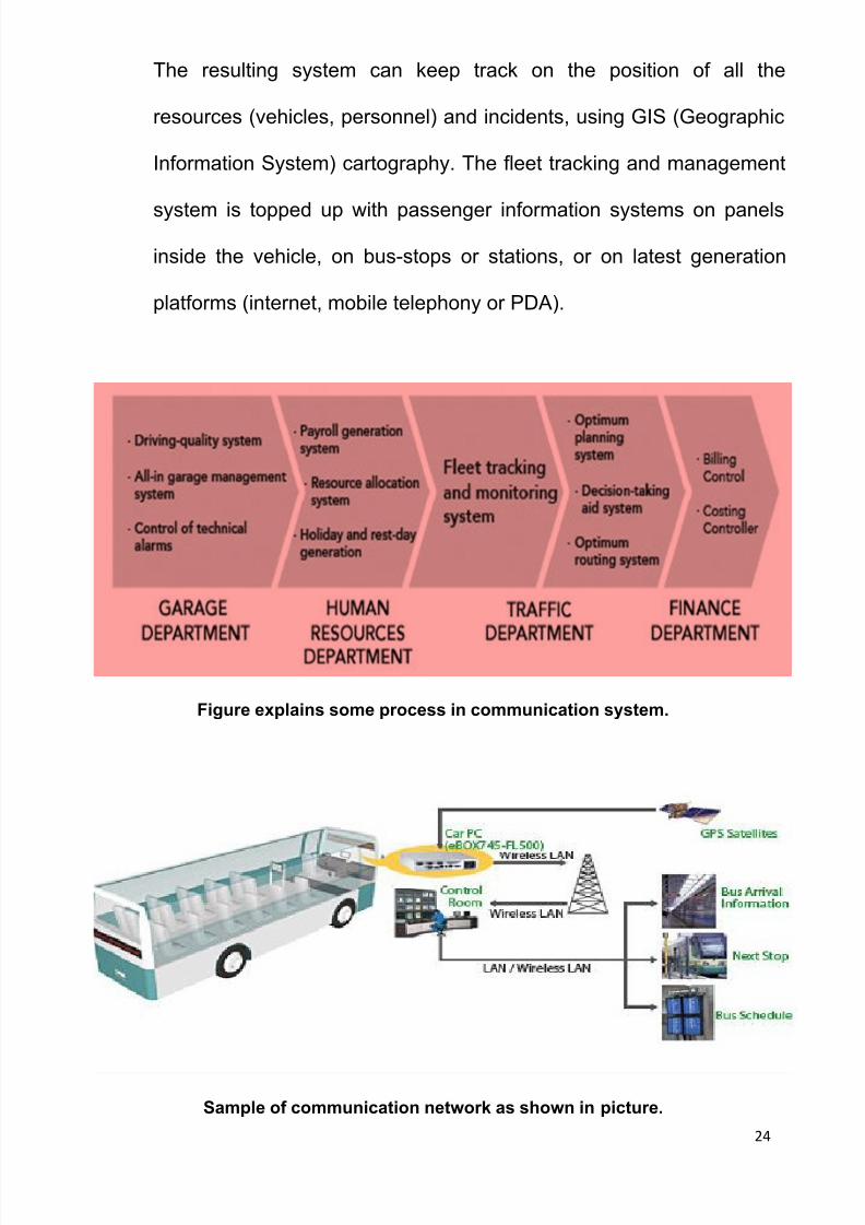
The resulting system can keep track on the position of all the
resources (vehicles, personnel) and incidents, using GIS (Geographic
Information System) cartography. The fleet tracking and management
system is topped up with passenger information systems on panels
inside the vehicle, on bus-stops or stations, or on latest generation
platforms (internet, mobile telephony or PDA).
Figure explains some process in communication system.
Sample of communication network as shown in picture.

7/26/2019 Project ITS
http://slidepdf.com/reader/full/project-its 25/35
25
7- Study methodology:
DATA COLLECTION
Our data was through previous study and during peak hour where, we tooka number of vehicles and number of lane, distance from intersection to
another one and the study supposed the peak hour is at 8:00 A.M.
Network of Case Study
Collect data
Data that
used in ourcalculation
Software
using in ourStudy
DetermineGreen time
split
DetermineIntersection
offset
Proposeintelligent
BUGHDADA UNIVERSITY INTERSECTION
AL-HURIA ROUNDABOUT
AL-MASBAH INTERSECTION

7/26/2019 Project ITS
http://slidepdf.com/reader/full/project-its 26/35
26
TRAFFIC VOLUME
BY USING SIDRA 6.0

7/26/2019 Project ITS
http://slidepdf.com/reader/full/project-its 27/35
27
SITE LAYOUT
TRAFFIC VOLUME

7/26/2019 Project ITS
http://slidepdf.com/reader/full/project-its 28/35
28
TRAFFIC VOLUME

7/26/2019 Project ITS
http://slidepdf.com/reader/full/project-its 29/35
29
Table Shows PCU coefficients
INTERSECTION BAGHDAD UNIVERSITY

7/26/2019 Project ITS
http://slidepdf.com/reader/full/project-its 30/35
31
ALMASBAH INTERSECTION
ANALYSIS OF RESULT
After findings manually result, we did analyze by using SIDRA
INTERSECTION 6.0 to get best cycle time for the intersection to see which
one more environmentally. However we seen the result of Software is more
comfortable and also the equation of cycle time should apply when the
saturation of the lane is less than 1.

7/26/2019 Project ITS
http://slidepdf.com/reader/full/project-its 31/35
30
Cycle of time is 200 sec

7/26/2019 Project ITS
http://slidepdf.com/reader/full/project-its 32/35
32
Cycle time is 200

7/26/2019 Project ITS
http://slidepdf.com/reader/full/project-its 33/35
33
DISCUSSION OF RESULT OF TRAFFIC SYSTEM Communication system with traffic signalized will be a great idea to
avoid problems of traffic congestion on the roads. Changing of type
signalized from fixed time to actuate with detector and connecting
with sensor to make movement fluency. From our study and during
analysis of the intersection and roundabout. The LOS for them is F
and that mean the saturation of flow is more than 1 .
Apply of VMS.
Architecture of the Smart Camera For traffic surveillance the entire smart camera is packed into a single
cabinet which is typically mounted in tunnels and aside highways.
The electrical power is either supplied by a power socket or by solar
panels. Thus, our smart camera is exposed to harsh environmental
influences such as rapid changes in temperature and humidity as well
as wind and rain. It must be implemented as an embedded system
with tight operating constraints such as size, power consumption and
temperature range.

7/26/2019 Project ITS
http://slidepdf.com/reader/full/project-its 34/35
34
Architecture
As depicted in Figure 2.1, the smart camera is divided into three major
parts: (i) the video sensor, (ii) the processing unit, and (iii) the
communication unit.
8- Estimation Cost:

7/26/2019 Project ITS
http://slidepdf.com/reader/full/project-its 35/35
9- Conclusion:
Multi-plan timing system could be set based on computed timing that gives
optimum traffic flows. The optimization procedure includes individual
controller setting and offset timing to minimize stopping and maximize flows
that give progressive flows with maximum bandwidth. Optimizing existing
traffic controllers. It is undeniable that setting up a ITS system in our study
area would be a very wise decision as it will help to lessen the congestion
in (KARADA City ) and also will benefits the town here as has smoother
traffic flow.