proposed extension of existing cemetery, eastern suburbs
TRANSCRIPT

Proposed Extension of Existing Cemetery, Eastern Suburbs Memorial Park, Matraville Flora and Fauna Assessment Prepared for Southern Metropolitan Cemeteries Trust
June 2019

P r o p o s e d E x t e n s i o n o f E x i s t i ng C em e t er y , E as t e r n S u b u r b s M em or i a l P ar k , M a t r a v i l l e – F F A
© E CO LO G IC A L A U S T RA L IA P T Y LT D ii
DOCUMENT TRACKING
Item Detail
Project Name Proposed Extension of Existing Cemetery, Eastern Suburbs Memorial Park, Matraville – Flora and Fauna Assessment
Project Number 19SUT12897
Project Manager Kirsten Velthuis
Prepared by Mitchell Scott, Kirsten Velthuis
Reviewed by Matthew Dowle; Frank Lemckert
Approved by Mathew Dowle; Frank Lemckert
Status Draft
Version Number 1
Last saved on 7 June 2019
Cover photo Upper left: Coastal Sand Tea-tree Banksia Scrub in the study area; upper right: Yellow-tailed Black Cockatoo; lower: the south-western corner of the study area; lower right: the southern boundary of the study area (images: Mitchell Scott).
This report should be cited as ‘Eco Logical Australia 2019. Proposed Extension of Existing Cemetery, Eastern Suburbs Memorial Park, Matraville – Flora and Fauna Assessment. Prepared for Southern Metropolitan Cemeteries Trust.’
ACKNOWLEDGEMENTS This document has been prepared by Eco Logical Australia Pty Ltd.
Disclaimer This document may only be used for the purpose for which it was commissioned and in accordance with the contract between Eco Logical Australia Pty Ltd and Southern Metropolitan Cemeteries Trust. The scope of services was defined in consultation with Southern Metropolitan Cemeteries Trust, by time and budgetary constraints imposed by the client, and the availability of reports and other data on the subject area. Changes to available information, legislation and schedules are made on an ongoing basis and readers should obtain up to date information. Eco Logical Australia Pty Ltd accepts no liability or responsibility whatsoever for or in respect of any use of or reliance upon this report and its supporting material by any third party. Information provided is not intended to be a substitute for site specific assessment or legal advice in relation to any matter. Unauthorised use of this report in any form is prohibited.
Template 29/9/2015

P r o p o s e d E x t e n s i o n o f E x i s t i ng C em e t er y , E as t e r n S u b u r b s M em or i a l P ar k , M a t r a v i l l e – F F A
© E CO LO G IC A L A U S T RA L IA P T Y LT D iii
Contents Executive summary ................................................................................................................................ vi
1 Introduction ................................................................................................................................. 1
1.1 Study area .................................................................................................................................... 1
1.2 Description of the project .............................................................................................................. 1
1.3 Key Terms .................................................................................................................................... 1
2 Statutory framework ................................................................................................................... 3
2.1 Environment Protection Biodiversity Conservation Act 1999 ....................................................... 3
2.2 Biodiversity Conservation Act 2016 .............................................................................................. 3
2.3 Environmental Planning and Assessment Act 1979 .................................................................... 3
2.4 Biosecurity Act 2015 ..................................................................................................................... 4
2.5 Randwick Local Environmental Plan 2012 ................................................................................... 4
2.6 Randwick Development Control Plan (DCP) 2012 ....................................................................... 4
3 Methods ....................................................................................................................................... 5
3.1 Literature review ........................................................................................................................... 5
3.1.1 Likelihood of occurrence ............................................................................................................... 5
3.2 Site inspection .............................................................................................................................. 5
3.3 Impact Assessment ...................................................................................................................... 6
3.4 Site inspection limitations ............................................................................................................. 6
4 Results ......................................................................................................................................... 7
4.1 Literature review ........................................................................................................................... 7
4.2 Site inspection .............................................................................................................................. 7
4.2.1 Vegetation communities ............................................................................................................... 7
4.2.1.1 Coastal Sand Tea-tree Banksia Scrub– PCT 771 ........................................................................ 7
4.2.1.5 Natural or modified foreshore ....................................................................................................... 8
4.2.1.6 Seagrass Meadows ...................................................................................................................... 8
4.2.2 Flora .............................................................................................................................................. 9
4.2.3 Threatened flora ........................................................................................................................... 9
4.3 Fauna and fauna habitat ............................................................................................................... 9
4.3.1 Fauna habitat ................................................................................................................................ 9
4.3.2 State and Regional Priority Weeds, and Weeds of Regional Concern ........................................ 9
5 Impact Assessment .................................................................................................................. 12
5.1 Direct impacts ............................................................................................................................. 12
5.2 Indirect impacts .......................................................................................................................... 12
5.3 Key threatening process ............................................................................................................. 12

P r o p o s e d E x t e n s i o n o f E x i s t i ng C em e t er y , E as t e r n S u b u r b s M em or i a l P ar k , M a t r a v i l l e – F F A
© E CO LO G IC A L A U S T RA L IA P T Y LT D iv
5.4 Commonwealth Significance Assessment (EPBC Act) .............................................................. 13
5.5 Biodiversity Conservation Act 2016 ............................................................................................ 13
6 Conclusion ................................................................................................................................ 14
References ............................................................................................................................................. 15
Appendix A Likelihood of occurrence ................................................................................................ 16
Appendix B Flora and fauna species list ............................................................................................ 34
List of figures Figure 1: Study area, subject site, and development footprint ................................................................... 2
Figure 2: Vegetation communities mapped within the study area ........................................................... 11
List of tables Table 1: Area clearing threshold ................................................................................................................ 3
Table 2: Weather conditions during the site inspection ............................................................................. 6
Table 3: Vegetation communities within study area ................................................................................... 8
Table 4: Greater Sydney RSWMP State and Regional Priority Weeds, and Weeds of Regional Concern, recorded within the study area ................................................................................................................. 10
Table 5: Direct impacts to vegetation communities.................................................................................. 12
Table 6: Likelihood of occurrence and requirement of impact assessment for threatened fauna species .................................................................................................................................................................. 17
Table 7: Likelihood of occurrence and requirement of impact assessment for threatened flora species 32
Table 8: Flora species list ......................................................................................................................... 34
Table 9: Fauna species list ....................................................................................................................... 38
P r o p o s e d E x t e n s i o n o f E x i s t i ng C em e t er y , E as t e r n S u b u r b s M em or i a l P ar k , M a t r a v i l l e – F F A
© E CO LO G IC A L A U S T RA L IA P T Y LT D v
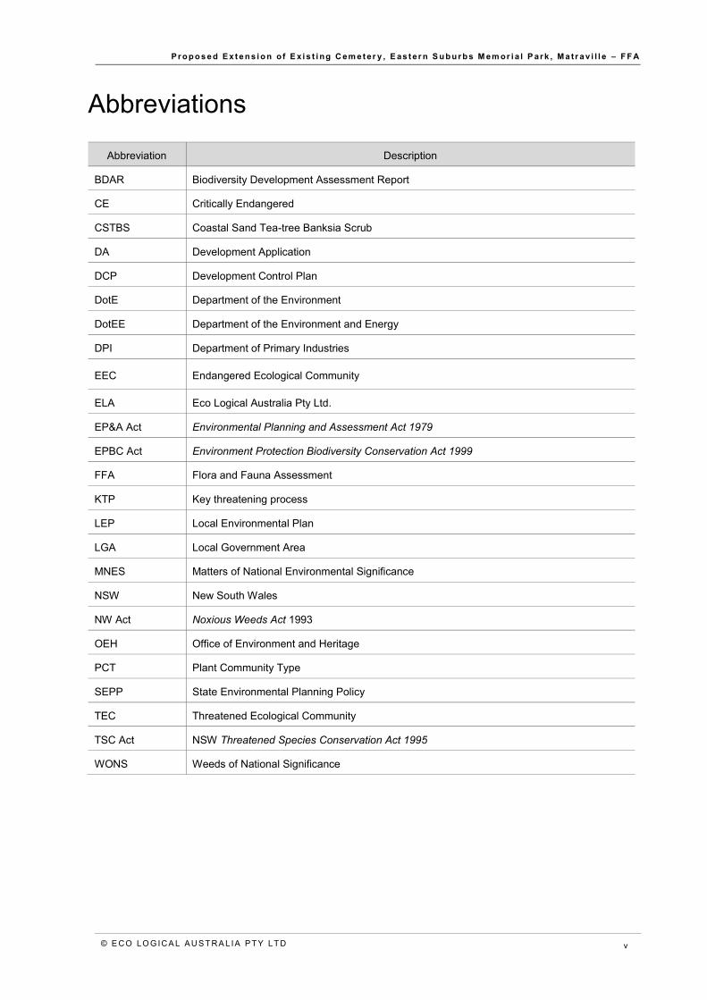
Abbreviations
Abbreviation Description
BDAR Biodiversity Development Assessment Report
CE Critically Endangered
CSTBS Coastal Sand Tea-tree Banksia Scrub
DA Development Application
DCP Development Control Plan
DotE Department of the Environment
DotEE Department of the Environment and Energy
DPI Department of Primary Industries
EEC Endangered Ecological Community
ELA Eco Logical Australia Pty Ltd.
EP&A Act Environmental Planning and Assessment Act 1979
EPBC Act Environment Protection Biodiversity Conservation Act 1999
FFA Flora and Fauna Assessment
KTP Key threatening process
LEP Local Environmental Plan
LGA Local Government Area
MNES Matters of National Environmental Significance
NSW New South Wales
NW Act Noxious Weeds Act 1993
OEH Office of Environment and Heritage
PCT Plant Community Type
SEPP State Environmental Planning Policy
TEC Threatened Ecological Community
TSC Act NSW Threatened Species Conservation Act 1995
WONS Weeds of National Significance

P r o p o s e d E x t e n s i o n o f E x i s t i ng C em e t er y , E as t e r n S u b u r b s M em or i a l P ar k , M a t r a v i l l e – F F A
© E CO LO G IC A L A U S T RA L IA P T Y LT D vi
Executive summary Eco Logical Australia (ELA) was commissioned by Southern Metropolitan Cemeteries Trust to provide a Flora and Fauna Assessment (FFA) to accompany a rezoning application for proposed works adjacent in Gwea Reserve (Lot 4858, D.P. 752015) and the adjacent council-owned land (Lot 7301; D.P. 1139143) (hereafter referred to collectively as the study area). The study area (comprising of approximately 5.32 ha) is located in Randwick Local Government Area (LGA). The concept plan proposes to remove most of the vegetation within the study area to expand Eastern Suburbs Memorial Park.
A site inspection was conducted on 17 July 2017 to verify the presence of native vegetation (and assign to a Plant Community Type – PCT), threatened ecological communities, and threatened species and / or their habitat. The following vegetation communities were recorded within the study area:
• Coastal Sand Tea-tree Banksia Scrub (CSTBS) – PCT 771 • Beach Spinifex Grassland – PCT 1204.
No threatened species of flora or fauna were recorded during the site inspection.
Nine (9) weeds identified in the Greater Sydney Regional Strategic Weed Management Plan 2017 (Greater Sydney RSWMP) were recorded within the study area, including four weeds of State-determined Priority, one weed of Regional Priority, and four weeds of Regional Concern.
In November 2016 the NSW parliament passed the Biodiversity Conservation Act 2016 (BC Act). For a local development under Part 4 of the Environmental Protection and Assessment Act 1979 (EP&A Act), the Biodiversity Offsets Scheme (BOS) and Biodiversity Assessment Method (BAM) applies, and a Biodiversity Development Assessment Report (BDAR) may be required under the BC Act if all or part of the study site is included on the OEH Biodiversity Values Map or if the development exceeds the native vegetation clearing threshold for the lot size.
The proposal would remove approximately 0.65 ha of native vegetation from within the study area (Section 5), which is above the clearing threshold for a lot of this size and thus offsetting under the BC Act would be required.
Impacts under the BC Act are offset by the following options: • purchasing and retiring a calculated number of credits relative to the impact of the proposed works • paying money into the ‘Biodiversity Fund’ with a premium.

P r o p o s e d E x t e n s i o n o f E x i s t i ng C em e t er y, E as t e r n S u b u r b s M em or i a l P ar k , M a t r a v i l l e – F F A
© E CO LO G ICA L A U S T R A L IA P T Y LT D 1
1 Introduction Eco Logical Australia (ELA) was commissioned by Southern Metropolitan Cemeteries Trust to provide a Flora and Fauna Assessment (FFA) to accompany a rezoning application for proposed works adjacent in Gwea Reserve (Lot 4858, D.P. 752015) and the adjacent council-owned land (Lot 7301; D.P. 1139143) (hereafter referred to collectively as the study area).
1.1 Study area
The study area (comprising of approximately 5.32 ha) is located in Randwick Local Government Area (LGA), and is bound by Military Road to the north, Prince of Wales Drive to the west, Port Botany to the south, and Eastern Suburbs Memorial Park to the East (Figure 1). The concept plan comprises of the majority of the study area, but excludes the foreshore.
The study area appears to have been previously used for land fill and subsequently invaded by weeds, but does include some remnant native vegetation. The study area is currently zoned as RE1 – Public Recreation under the Randwick Local Environmental Plan (LEP) 2012. The planning proposal seeks to amend Schedule 1 of the LEP to add ‘cemeteries’ as an additional permitted use for the site.
1.2 Descript ion of the project
The concept plan proposes to remove most of the vegetation within the study area to expand Eastern Suburbs Memorial Park, located adjacent to the study area. ELA understands that all vegetation, including canopy trees, are proposed to be removed from within the subject site. The indicative Landscape Masterplan also includes the construction of an access way form the subject site to the foreshore (Figure 1).
This report has been prepared to support a re-zoning application, and fieldwork undertaken before the commencement of the BC Act. A Biodiversity Development Assessment Report (BDAR) under the BC Act will be required to accompany the final Development Application (DA), once the proposed works have been finalised.
1.3 Key Terms
The following terminology will be used in the report:
• Subject site: the area of direct impact, shown in Figure 1. • Study area: the area surveyed for the proposal including those areas likely to be directly or
indirectly affected by the proposal. In this assessment the ‘subject site’ and ‘study area’ are equivalent.
• Locality: the same meaning as ascribed to a local population of a species or local occurrence of an ecological community.

P r o p o s e d E x t e n s i o n o f E x i s t i ng C em e t er y, E as t e r n S u b u r b s M em or i a l P ar k , M a t r a v i l l e – F F A
© E CO LO G ICA L A U S T R A L IA P T Y LT D 2
Figure 1: Study area and development footprint

P r o p o s e d E x t e n s i o n o f E x i s t i ng C em e t er y, E as t e r n S u b u r b s M em or i a l P ar k , M a t r a v i l l e – F F A
© E CO LO G ICA L A U S T R A L IA P T Y LT D 3
2 Statutory framework 2.1 Environment Protection Biodiversity Conservation Act 1999
The Environment Protection Biodiversity Conservation Act 1999 (EPBC Act) is Commonwealth legislation that deals with Matters of National Environmental Significance (MNES). Impacts to MNES are assessed through application of a significance assessment. Where a development or activity has the potential to have a significant impact on a MNES, a referral is made to the Department of the Environment and Energy (DotEE). The Department determines whether the activity can proceed with no further assessment by the Commonwealth, or whether it will be a controlled action for which an Environmental Impact Assessment must be supplied. The Act also allows for Strategic Assessments which assess a policy, plan or program rather than individual developments.
2.2 Biodiversity Conservation Act 2016
In November 2016 the NSW parliament passed the BC Act that, among other things, introduces new requirements for biodiversity assessment and requires proponents to offset certain biodiversity impacts through the purchase and retirement of biodiversity credits. For a local development under Part 4 of the EPA & Act, the BOS and BAM may be triggered by the following means:
• Area clearing threshold- exceeding the area clearing threshold associated with the minimum lot size for the property will trigger entry into the BOS (Table 1). Where the study site does not have a minimum lot size, total area of the site is used instead.
• whether the impacts occur on an area mapped on the Biodiversity Value Map
Table 1: Area clearing threshold
Minimum lot size associated with the property
Threshold for clearing native vegetation, above which the BAM and offsets scheme apply
Less than 1 ha 0.25 ha or more
1 ha to less than 40 ha 0.5 ha or more
40ha to less than 1000 ha 1 ha or more
1000 ha or more 2 ha or more
The Randwick LEP 2012 does not contain a minimum lot size for the study area, in which case the size of the study area is used as the minimum lot size. The study area is 5.32 ha and the clearing threshold is therefore 0.5 ha or more.
2.3 Environmental Planning and Assessm ent Act 1979
The Environmental Planning and Assessment Act 1979 (EP&A Act) is the principal planning legislation for NSW, providing a framework for the overall environmental planning and assessment of development proposals. The EP&A Act places a duty on the determining authority to adequately address a range of environmental matters including maintenance of biodiversity and the likely impact to threatened species, populations or ecological communities. This proposal will be assessed as a local development under Part 4 of the EPA & Act.

P r o p o s e d E x t e n s i o n o f E x i s t i ng C em e t er y, E as t e r n S u b u r b s M em or i a l P ar k , M a t r a v i l l e – F F A
© E CO LO G ICA L A U S T R A L IA P T Y LT D 4
2.4 Biosecurity Act 2015
On 1 July 2017 the NSW Biosecurity Act 2015 (BA Act) repealed the NSW Noxious Weeds Act 1993. Each region in NSW now has a Regional Strategic Weed Management Plan (RSWMP) which has been developed by a Regional Weed Committee. The RSWMP identifies State-determined Priority Weeds, Regional Priority Weeds, and Weeds of Regional Concern. Under the BA Act, all private land owners, managers, and all other people dealing with weed species have a general biosecurity duty to use appropriate measures to deal with weed species, including prevention, elimination, or minimisation of negative impacts. Land control authorities are responsible for conducting inspections and enforcing the BA Act (GSLLS 2017).
2.5 Randwick Local Environmental Plan 2012
Under the Randwick Local Environment Plan (LEP) Clause 6.5 Terrestrial Biodiversity states:
(1) The objective of this clause is to maintain terrestrial biodiversity by: (a) protecting native fauna and flora, and (b) protecting the ecological processes necessary for their continued existence, and (c) encouraging the conservation and recovery of native fauna and flora and their habitats.
(2) This clause applies to land identified as “Biodiversity” on the Terrestrial Biodiversity Map.
The study area is not located on land identified as ‘Biodiversity’.
2.6 Randwick Development Control Plan (DCP) 20 12
General controls relating to biodiversity are listed in DCP Section B4 -Landscaping and Biodiversity- 3.1 Existing vegetation and natural features:
Significant natural features and vegetation on the site, such as rocky outcrops, cliff lines, water bodies, trees, shrubs and groundcover vegetation should be retained and incorporated into the landscape design of the development.
Objective: To conserve and incorporate significant natural features and vegetation of the site as part of the landscape design.
Controls:
i) Maximise the retention and protection of existing vegetation including trees, shrubs and groundcover vegetation.
ii) Retain and incorporate existing natural features, such as cliffs and rock outcrops, into the landscape design, where possible.
iii) Retain and stockpile topsoil for reuse in the landscaped area.
Note: Refer to DCP section B5- Preservation of Trees and Vegetation for more detailed requirements on tree works.

P r o p o s e d E x t e n s i o n o f E x i s t i ng C em e t er y, E as t e r n S u b u r b s M em or i a l P ar k , M a t r a v i l l e – F F A
© E CO LO G ICA L A U S T R A L IA P T Y LT D 5
3 Methods 3.1 Literature review
A literature review was undertaken to identify the threatened species, populations and ecological communities that could potentially occur within the study area. The following documentation and mapping was reviewed:
• BioNet (Atlas of NSW Wildlife) database search (5 km) for threatened species, populations and ecological communities listed under the BC Act (OEH 2017a).
• EPBC Act Protected Matters Search Tool (5 km) for threatened and migratory species, populations and ecological communities listed under the Commonwealth EPBC Act (DotEE 2017a&b).
• Threatened flora and fauna species associated with vegetation types located within the study area.
• OEH Threatened Species Profiles (OEH 2017b). • Randwick DCP 2012 and Randwick LLEP 2012 • Aerial mapping and vegetation mapping (OEH 2013), to assess the extent of vegetation
including mapped threatened ecological communities (TECs) listed under the BC Act and / or EPBC Act.
• Any additional material relevant to the project.
3.1.1 Likelihood of occurrence Aerial photography (SIXmaps and Google Earth) of the study area and surrounds were reviewed to identify the extent of vegetation cover and landscape features.
Species from the Atlas of NSW Wildlife, and Protected Matters Search Tool were combined to produce a list of threatened species that may occur within the study area (“subject species”) (Appendix A). The likely occurrence of threatened species, endangered populations and communities in the study area was determined based on the location of database records, the likely presence or absence of suitable habitat on the subject site, and knowledge of the species’ ecology. A list of potentially “affected species” was then identified (those that were defined as “yes”, “likely” or having “potential” to occur in the study area)
Five terms for the likelihood of occurrence of species are used in this report:
• “yes” = the species was or has been observed in the study area • “likely” = a medium to high probability that a species uses the study area • “potential” = suitable habitat for a species occurs in the study area, but there is insufficient
information to categorise the species as likely to occur, or unlikely to occur • “unlikely” = a very low to low probability that a species uses the study area, and • “no” = habitat in the study area and in its vicinity is unsuitable for the species.
Following the site inspection, this list of “affected species” was refined with an understanding of the local environment and available habitat in the study area. The likelihood table in Appendix A reflects the final list of species and their likelihood of occurrence.
3.2 Site inspection The site inspection aimed to:

P r o p o s e d E x t e n s i o n o f E x i s t i ng C em e t er y, E as t e r n S u b u r b s M em or i a l P ar k , M a t r a v i l l e – F F A
© E CO LO G ICA L A U S T R A L IA P T Y LT D 6
• validate the extent and condition of native vegetation including TECs. • identify the presence of threatened species or populations or their habitat,. • identify noxious weeds • any other potential ecological constraints.
Detailed flora and fauna assessments were not undertaken and were not considered necessary given the highly modified nature of the site. Weather conditions during the site inspection were clear (Table 2).
Table 2: Weather conditions during the site inspection
Date Temperature (°C)
Rainfall (mm) Max wind speed
(km/h) Minimum Maximum
17 July 2017 7.5 19.9 0 NW 26
*Weather observations were taken from www.bom.gov.au Sydney Airport AMO (station 066037) (temperature, wind speed and
rainfall)
3.3 Impact Assessment
Those threatened species, populations and threatened ecological communities known, likely or with potential to occur in the study area and be adversely affected by the proposed works (as identified in the Likelihood of Occurrence table) were subject to the NSW Assessment of Significance and / or Commonwealth Significant Impact Criteria.
These assessments are applied to help determine whether the proposed works will significantly impact these threatened entities and are outlined in Section 5.
Since the commencement of the BC Act (25 August 2017), an additional BDAR report will be required to accompany the submission of a DA as clearing thresholds for native vegetation have been reached.
3.4 Site inspection l imitations
This assessment was not intended to provide an inventory of all species present across the site but instead an overall assessment of the ecological values of the site with emphasis on threatened species, endangered ecological communities and key fauna habitat features. It is important to note that some species may not have been detected on the site during the inspection as they may be cryptic or seasonal and only detectable during flowering or during breeding. In this case, the likelihood of their occurrence on site has been assessed based on the presence of potential habitat.

P r o p o s e d E x t e n s i o n o f E x i s t i ng C em e t er y, E as t e r n S u b u r b s M em or i a l P ar k , M a t r a v i l l e – F F A
© E CO LO G ICA L A U S T R A L IA P T Y LT D 7
4 Results 4.1 Literature review
The literature review identified 7 threatened flora species and 61 threatened fauna species listed under the BC Act and / or EPBC Act, which may have the potential to occur within a 5 km radius of the study area, and / or are associated with the PCTs present within the study area. An assessment of the likelihood of occurrence of threatened species within the study area is in Appendix A and was used to guide the site inspection methodology. Note, the likelihood of occurrence provided in Appendix A represents the assessment following the site inspection results. No threatened species have previously been recorded within the study area.
4.2 Site inspection
4.2.1 Vegetation communities Broad scale vegetation mapping of the area has mapped the entire study area as Coastal Sand Tea-tree Banksia Scrub (CSTBS) (OEH 2013). This vegetation community is not listed as a TEC under the BC Act or the EPBC Act.
However, one similar vegetation community that is a TEC is located within 10 km of the study area:
• Eastern Suburbs Banksia Scrub in the Sydney Basin Bioregion (ESBS), listed as an Endangered Ecological Community (EEC) under the BC Act, and Endangered under the EPBC Act (also referred to as Coastal Sand Mantle Heath – OEH 2013).
Due to the composition of species within the study area, it was determined that this vegetation community was not present. However, the following vegetation communities were identified within the study area:
4.2.1.1 Coastal Sand Tea-tree Banksia Scrub– PCT 771 The site inspection identified a fragment patch (approximately 1.67 ha) of remnant vegetation in the centre and north of the study area (
Dominant mid-storey species included Banksia integrifolia (Coastal Banksia), Leptospermum laevigatum (Coast Teatree), and occasional Angophora costata (Sydney Red Gum). Midstorey included native species Acacia longifolia subsp. sophorae (Coastal Wattle), Acacia longifolia subsp. longifolia (Sydney Golden Wattle), Pittosporum undulatum (Native Daphne), Notolaea sp., Westringia longifolia (Long-leaved Westringia), Melaleuca nodosa (Prickly-leaved Paperbark) and Banksia ericifolia (Heath-leaved Banksia), and exotic species Chrysanthemoides monilifera (Bitou Bush) and Lantana camara (Lantana). Ground cover included some native species such as Lomandra longifolia (Spiny-headed Mat-rush) and Commelina sp., but was dominated by exotic species. These exotic species included Bidens pilosa (Cobblers Pegs), Ehrharta erecta (Panic Veldtgrass), Brassica sp., and Opuntia sp. (Prickly Pear).
Coastal Sand Tea-tree Banksia Scrub (CSTBS) (landscaped)
Within the above CSTBS is a small patch (approximately 0.1 ha) of landscaped CSTBS mapped on the northern portion of the study area . This vegetation appeared to be landscaped with the introduction of species native to this vegetation community. Canopy species included Banksia integrifolia, Allocasuarina distyla (Scrub She-oak), Eucalyptus sp., and Angophora costata. Midstorey species included Leptospermum laevigatum (Coast Teatree) and Acacia longifolia subsp. longifolia (Sydney Golden

P r o p o s e d E x t e n s i o n o f E x i s t i ng C em e t er y, E as t e r n S u b u r b s M em or i a l P ar k , M a t r a v i l l e – F F A
© E CO LO G ICA L A U S T R A L IA P T Y LT D 8
Wattle). Ground cover included native species Lomandra longifolia and Dianella sp., and exotic species Ehrharta erecta.
4.2.1.2 Beach Spinifex Grassland – PCT 1204
A small band (approximately 3 m wide and 0.02 ha) was mapped on the south-east portion of the study area between the foreshore and the remainder of the site. This mapped area was dominated by Spinifex sericeus (Hairy Spinifex).
4.2.1.3 Weeds
The locations mapped as weeds within the study area (approximately 2.04 ha in total; were dominated by Lantana camara and Chrysanthemoides monilifera, but also included other exotic species such as Ricinus communis (Castor Oil Plant), Araujia sericifera (Moth Vine), Cestrum parqui (Green Cestrum), Ipomoea cairica (Coastal Morning Glory), Bidens pilosa, Ehrharta erecta, Erythrina corallodendron (Coral Tree), and Verbena bonariensis (Purpletop).
4.2.1.4 Cleared area
The study area includes approximately 1.01 ha of cleared land, primarily in a strip along the eastern side of the study area adjacent to Eastern Suburbs Memorial Park. Groundcover was dominated by exotic species including Eragrostis curvula (African Lovegrass). Two lines of planted Cupaniopsis anacardioides (Tuckeroo) occur in the north-east corner of the study area.
4.2.1.5 Natural or modified foreshore Approximately 0.57 ha of foreshore has been mapped on the southern boundary of the study area, consisting of natural sandy beach and artificial concrete sea wall and walkways.
4.2.1.6 Seagrass Meadows Seagrass meadows are mapped offshore within 1 km of the study area, however, none was identified to occur within the study area.
Table 3: Vegetation communities within study area
Vegetation community Area (ha)
Coastal Sand Tea-tree Banksia Scrub (CSTBS) – PCT 771 1.67
(includes Coastal Sand Tea-tree Banksia Scrub [CSTBS] - landscaped) (0.10)
Beach Spinifex Grassland – PCT 1204 0.02
Weeds 2.04
Cleared area 1.01
Natural or modified foreshore 0.57
Seagrass Meadows – PCT 1913 0.00
Total 5.32
*Figures rounded to two decimal places

P r o p o s e d E x t e n s i o n o f E x i s t i ng C em e t er y, E as t e r n S u b u r b s M em or i a l P ar k , M a t r a v i l l e – F F A
© E CO LO G ICA L A U S T R A L IA P T Y LT D 9
4.2.2 Flora A total of 29 native flora species and 29 exotic flora species were identified within the study area during the site inspection (Appendix B).
4.2.3 Threatened flora No threatened flora species listed under the BC Act or EPBC Act were recorded during the site inspection and given the highly disturbed nature of the study area, it is unlikely that any threatened flora would occur.
4.3 Fauna and fauna habitat
4.3.1 Fauna habitat The study area does not contain any drainage lines or inundations. No hollow-bearing trees were recorded within the study area during the site inspection.
The study area contains flowering species from the Myrtaceae and Proteaceae families, which are potential foraging habitat for birds and mammals, including threatened species such as the Grey-Headed Flying Fox (Pteropus poliocephalus). Flowering species representing foraging habitat include Angophora costata and Banksia integrifolia.
No threatened fauna species were recorded during the site inspection. However, the site may contain intermittent and / or marginal foraging habitat for some threatened fauna. Eight native fauna species and two exotic fauna species were recorded during the site inspection.
4.3.2 State and Regional Priority Weeds, and Weeds of Regional Concern Nine (9) weeds identified in the Greater Sydney RSWMP were recorded within the study area (Table 4). This includes four weeds of State-determined Priority, one weed of Regional Priority, and four weeds of Regional Concern.
All weeds recorded within the study area should be managed according to strategies outlined in GSLLS 2017.

P r o p o s e d E x t e n s i o n o f E x i s t i ng C em e t er y, E as t e r n S u b u r b s M em or i a l P ar k , M a t r a v i l l e – F F A
© E CO LO G ICA L A U S T R A L IA P T Y LT D 10
Table 4: Greater Sydney RSWMP State and Regional Priority Weeds, and Weeds of Regional Concern, recorded within the study area
Family Species Name Common Name State-
determined Priority Weeds
Regional Priority Weeds
Weeds of Regional Concern
Apocynaceae Araujia sericifera Moth Vine - - Yes
Solanaceae Cestrum parqui Green Cestrum - Yes -
Asteraceae Chrysanthemoides monilifera* Bitou Bush Yes - -
Rosaceae Cotoneaster sp. - - - Yes
Poaceae Eragrostis curvula African Lovegrass - - Yes
Convolvulaceae Ipomoea cairica Coastal Morning Glory - - Yes
Verbenaceae Lantana camara Lantana Yes - -
Cactaceae Opuntia sp. Prickly Pear Yes - -
Asteraceae Senecio madagascariensis Fireweed Yes - -
* Although Chrysanthemoides monilifera (Bitou Bush) is located within the study area, it is not located within the ‘bitou bush biosecurity zone’

P r o p o s e d E x t e n s i o n o f E x i s t i ng C em e t er y, E as t e r n S u b u r b s M em or i a l P ar k , M a t r a v i l l e – F F A
© E CO LO G ICA L A U S T R A L IA P T Y LT D 11
Figure 2: Vegetation communities mapped within the study area

P r o p o s e d E x t e n s i o n o f E x i s t i ng C em e t er y, E as t e r n S u b u r b s M em or i a l P ar k , M a t r a v i l l e – F F A
© E CO LO G ICA L A U S T R A L IA P T Y LT D 12
5 Impact Assessment 5.1 Direct impacts
An assessment of likely direct impacts from the proposed works has been included below based on the proposed works. A summary of the likely direct impacts is outlined in Table 5.
Table 5: Direct impacts to vegetation communities
Vegetation community Study area (ha) Area to be impacted
(subject site) (ha)
Coastal Sand Tea-tree Banksia Scrub (CSTBS) – PCT 771 1.67 0.65
(includes Coastal Sand Tea-tree Banksia Scrub [CSTBS] - landscaped)
(0.1) (0.00)
Beach Spinifex Grassland – PCT 1204 0.02 0.00
Weeds 2.04 1.36
Cleared area 1.01 0.46
Natural or modified foreshore 0.57 0.01
Seagrass Meadows – PCT 1913 0.00 0.00
Total 5.32 2.48
*Figures rounded to two decimal places
5.2 Indirect impacts
The proposed works have the potential to impact adjacent foreshore and marine environment. Negative impacts could include:
• increased sediment, erosion and nutrient flow • edge effects, such as possible increase in weeds around the proposed footprint • soil and vegetation disturbance.
The management of potential indirect impacts can be more specifically detailed at the DA stage once the design is finalised.
5.3 Key threatening process
Two Key Threatening Processes (KTP) listed under Schedule 4 of the BC Act are relevant to the proposed works (OEH 2017c). These are:
• Clearing of native vegetation • Invasion, establishment and spread of Lantana.

P r o p o s e d E x t e n s i o n o f E x i s t i ng C em e t er y, E as t e r n S u b u r b s M em or i a l P ar k , M a t r a v i l l e – F F A
© E CO LO G ICA L A U S T R A L IA P T Y LT D 13
5.4 Commonwealth Signif icance Assessment (EPBC Act)
The EPBC Act establishes a process for assessing the environmental impact of activities and developments where “Matters of National Environmental Significance‟ (MNES) may be affected. Under the Act, any action which “has, will have, or is likely to have a significant impact on a MNES” is defined as a “controlled action”, and requires approval from the Commonwealth Department of the Environment (DotE) which is responsible for administering the EPBC Act.
Specific ‘Significant Impact Criteria’ are provided for each MNES, except for threatened species and ecological communities, in which case separate criteria are provided for species listed as endangered and vulnerable under the EPBC Act.
There are no MNES or species, populations, or ecological communities listed under the EPBC Act, likely to occur within the study area. Therefore, a significance assessment is not required.
5.5 Biodiversity Conservation Act 2016
The proposed works are required to be assessed under the BC Act as it exceeds the threshold of native vegetation to be cleared. . The study area is 5.32 ha (between 1 ha and 40 ha) and thus the threshold area of clearing is 0.5 ha. Therefore if 0.5 ha or greater native vegetation is cleared, offsets are required.
The development footprint would remove approximately 0.65 ha of native vegetation from within the study area (Section 5), and thus offsetting would be required. Impacts under the BC Act are offset by the following options:
• purchasing and retiring a calculated number of credits relative to the impact of the proposed works • paying money into the ‘Biodiversity Fund’ with a premium.
Under the BC Act, serious and irreversible impacts are impacts that:
• will cause a further decline of the species or ecological community that is currently observed, estimated, inferred or reasonably suspected to be in a rapid rate of decline, or
• will further reduce the population size of the species or ecological community that is currently observed, estimated, inferred or reasonably suspected to have a very small population size, or impact on the habitat of a species or ecological community that is currently observed, estimated, inferred or reasonably suspected to have a very limited geographic distribution, or
• impact on a species or ecological community that is unlikely to respond to measures to improve habitat and vegetation integrity and is therefore irreplaceable.
OEH have outlined candidate species (and their habitat) that meet the SAII principles and criteria (Appendix 2, OEH 2017d). No vegetation community, or species of flora or fauna, identified within the study area by this FFA are identified as a candidate for SAII by OEH (2017d). Any threatened species or habitat component of a threatened species not listed in Appendix 2 is unlikely to meet the relevant SAII principles. However, a decision-maker may still consider whether a species is likely to meet the relevant SAII principles based on an assessment against the criteria (OEH 2017d).

P r o p o s e d E x t e n s i o n o f E x i s t i ng C em e t er y, E as t e r n S u b u r b s M em or i a l P ar k , M a t r a v i l l e – F F A
© E CO LO G ICA L A U S T R A L IA P T Y LT D 14
6 Conclusion
This report has been prepared to support a re-zoning application to be submitted by Southern Metropolitan Cemeteries Trust for the expansion of the Eastern Suburbs Memorial Park.
The following vegetation communities were recorded within the study area:
• Coastal Sand Tea-tree Banksia Scrub (CSTBS) – PCT 771 • Beach Spinifex Grassland – PCT 1204.
No threatened species of flora or fauna were recorded during the site inspection.
Nine (9) weeds identified in the Greater Sydney RSWMP were recorded within the study area, including four weeds of State-determined Priority, one weed of Regional Priority, and four weeds of Regional Concern.
For a local development under Part 4 of the EP&A Act, the BOS will be triggered if the development exceeds the native vegetation clearing threshold for the lot size. The proposed development will trigger the BOS as it exceeds the native vegetation clearing threshold of 0.5 ha. The development would remove approximately 0.65 ha of native vegetation from within the study area (Section 5), and thus a BDAR will and offsetting under the BC Act would be required.
Impacts under the Biodiversity Conservation Act 2016 are offset by the following options: • purchasing and retiring a calculated number of credits relative to the impact of the proposed works • paying money into the ‘Biodiversity Fund’ with a premium.

P r o p o s e d E x t e n s i o n o f E x i s t i ng C em e t er y, E as t e r n S u b u r b s M em or i a l P ar k , M a t r a v i l l e – F F A
© E CO LO G ICA L A U S T R A L IA P T Y LT D 15
References Department of the Environment and Energy- Australian Government (DotEE) 2017a. SPRAT Profiles. Available at http://www.environment.gov.au/cgi-bin/sprat/public/sprat.pl. Accessed July 2017
Department of the Environment and Energy - Australian Government (DotEE) 2017b. EPBC Act Protected Matters Report. Available: http://www.environment.gov.au/epbc/pmst/. Accessed July 2017.
Greater Sydney Local Land Services (GSLLS) 2017. Greater Sydney Regional Strategic Weed Management Plan (GSRSW) 2017 – 2022. NSW Government.
Office of Environment and Heritage (OEH) 2013. The Native Vegetation of the Sydney Metropolitan Area (v2.0). NSW Government.
Office of Environment and Heritage (OEH) 2017a. Atlas of NSW Wildlife. Available: http://wildlifeatlas.nationalparks.nsw.gov.au/wildlifeatlas/watlas.jsp. Accessed July 2017.
Office of Environment and Heritage (OEH) 2017b. Threatened Species Profiles. Available: http://www.environment.nsw.gov.au/threatenedspecies. Accessed July 2017.
Office of Environment and Heritage (OEH) 2017c. Schedule 4: Key threatening processes. Available at: https://www.legislation.nsw.gov.au/~/view/act/2016/63/sch4. Accessed July 2017.
Office of Environment and Heritage (OEH) 2017d. Guidance to assist a decision-maker to determine a serious and irreversible impact. Available: http://www.environment.nsw.gov.au/resources/bcact/guidance-decision-makers-determine-serious-irreversible-impact-170204.pdf. Accessed August 2017.

P r o p o s e d E x t e n s i o n o f E x i s t i ng C em e t er y, E as t e r n S u b u r b s M em or i a l P ar k , M a t r a v i l l e – F F A
© E CO LO G ICA L A U S T R A L I A P T Y LT D 16
Appendix A Likelihood of occurrence An assessment of likelihood of occurrence was made for threatened and migratory species identified from the database search. Five terms for the likelihood of occurrence of species are used in this report. This assessment was based on database or other records, presence or absence of suitable habitat, features of the proposal site, results of the site inspection and professional judgement. Some Migratory or Marine species identified from the Commonwealth database search have been excluded from the assessment, due to lack of habitat. The terms for likelihood of occurrence are defined below:
• “known” = the species was or has been observed on the site • “likely” = a medium to high probability that a species uses the site • “potential” = suitable habitat for a species occurs on the site, but there is insufficient information to categorise the species as likely to occur, or
unlikely to occur • “unlikely” = a very low to low probability that a species uses the site • “no” = habitat on site and in the vicinity is unsuitable for the species.
An assessment of significance was conducted for threatened species or ecological communities that were recorded within the study area or had a higher likelihood of occurring and were not recorded during the site visit. It is noted that some threatened fauna species that are highly mobile, wide ranging and vagrant may use portions of the study area intermittently for foraging. For these fauna species, the habitat present and likely to be impacted is not considered to be important to the threatened species, particularly in relation to the amount of similar habitat remaining in the surrounding landscape. As such, an assessment of significance in reference to State or Commonwealth legislation was not considered necessary.
The records column refers to the number of records occurring within 5 km of the study area, as provided by the Atlas of NSW Wildlife (BioNet) and Protected Matters Search Tool database search.
Information provided in the habitat associations’ column has primarily been extracted (and modified) from the Commonwealth Species Profile and Threats Database (DotEE 2017a+b) and the NSW Threatened Species Profiles (OEH. 2017b).

P r o p o s e d E x t e n s i o n o f E x i s t i ng C em e t er y, E as t e r n S u b u r b s M em or i a l P ar k , M a t r a v i l l e – F F A
© E CO LO G ICA L A U S T R A L I A P T Y LT D 17
Table 6: Likelihood of occurrence and requirement of impact assessment for threatened fauna species
Scientific Name Common Name TSC
Status EPBC Status
Habitat Likelihood of Occurrence
Impact Assessment
Required
Amphibians
Crinia tinnula^ Wallum Froglet V Acidic swamps on coastal sand plains (typically in sedgelands and wet heathlands), drainage lines, and swamp sclerophyll forests.
No, no potential habitat within
the study area. No
Litoria aurea Green and Golden Bell Frog
E1 V Marshes, dams and stream-sides, particularly those containing Typha spp. (bullrushes) or Eleocharis spp. (spikerushes). Some populations occur in highly disturbed areas.
No, no potential habitat within
the study area. No
Aves
Anthochaera phrygia^ Regent Honeyeater E4A CE Eucalypt woodland and open forest, wooded farmland and urban areas with mature eucalypts, and riparian forests of Casuarina cunninghamiana (River Oak).
No No
Ardenna carneipes Flesh-footed Shearwater
V M Marine. Unlikely, study area contains
marginal potential habitat
which would only be
periodically used by this species.
No

P r o p o s e d E x t e n s i o n o f E x i s t i ng C em e t er y, E as t e r n S u b u r b s M em or i a l P ar k , M a t r a v i l l e – F F A
© E CO LO G ICA L A U S T R A L I A P T Y LT D 18
Scientific Name Common Name TSC
Status EPBC Status
Habitat Likelihood of Occurrence
Impact Assessment
Required
Artamus cyanopterus cyanopterus^
Dusky Wood Swallow V Sclerophyll forest, woodland, coastal scrub and wooded farmland.
Unlikely, study area contains
marginal potential habitat
which would only be
periodically used by this species.
No
Botaurus poiciloptilus Australasian Bittern E1 E Permanent freshwater wetlands with tall, dense vegetation, particularly Typha spp. (bullrushes) and Eleocharis spp. (spikerushes).
Unlikely, study area contains
marginal potential habitat
which would only be
periodically used by this species.
No
Calidris alba Sanderling V M Coastal areas on low beaches of firm sand, near reefs and inlets, along tidal mudflats and lagoons; rarely recorded in near-coastal wetlands.
Unlikely, study area contains
marginal potential habitat
which would only be
periodically used by this species.
No

P r o p o s e d E x t e n s i o n o f E x i s t i ng C em e t er y, E as t e r n S u b u r b s M em or i a l P ar k , M a t r a v i l l e – F F A
© E CO LO G ICA L A U S T R A L I A P T Y LT D 19
Scientific Name Common Name TSC
Status EPBC Status
Habitat Likelihood of Occurrence
Impact Assessment
Required
Calidris canutus Red Knot E, M Intertidal mudflats, sandflats sheltered sandy beaches, estuaries, bays, inlets, lagoons, harbours, sandy ocean beaches, rock platforms, coral reefs, terrestrial saline wetlands near the coast, sewage ponds and saltworks. Rarely inland lakes or swamps.
Unlikely, study area contains
marginal potential habitat
which would only be
periodically used by this species.
No
Calidris ferruginea Curlew Sandpiper E1 CE, M "Littoral and estuarine habitats, including intertidal mudflats, non-tidal swamps, lakes and lagoons on the coast and sometimes inland.”
Unlikely, study area contains
marginal potential habitat
which would only be
periodically used by this species.
No
Calidris tenuirostris Great Knot V CE, M Intertidal mudflats or sandflats, including inlets, bays, harbours, estuaries and lagoons.
Unlikely, study area contains
marginal potential habitat
which would only be
periodically used by this species.
No

P r o p o s e d E x t e n s i o n o f E x i s t i ng C em e t er y, E as t e r n S u b u r b s M em or i a l P ar k , M a t r a v i l l e – F F A
© E CO LO G ICA L A U S T R A L I A P T Y LT D 20
Scientific Name Common Name TSC
Status EPBC Status
Habitat Likelihood of Occurrence
Impact Assessment
Required
Callocephalon fimbriatum
Gang-gang Cockatoo V • In spring and summer, found in tall mountain forests and
woodlands, particularly in heavily timbered and mature wet
sclerophyll forests. In autumn and winter, the species often
moves to lower altitudes in drier more open eucalypt forests
and woodlands, particularly box-gum and box-ironbark
assemblages, or in dry forest in coastal areas and often
found in urban areas.
Unlikely, study area does not
contain forest or woodland vegetation
No
Calyptorhynchus lathami
Glossy Black-Cockatoo
V Open forest and woodlands of the coast and the Great Dividing Range where stands of sheoak occur. No No
Charadrius leschenaultii
Greater Sand-plover V V, M Almost entirely restricted to coastal areas in NSW, mainly on sheltered sandy, shelly or muddy beaches or estuaries with large intertidal mudflats or sandbanks.
Unlikely, study area contains
marginal potential habitat
which would only be
periodically used by this species.
No
Charadrius mongolus Lesser Sand-plover V E, M Almost entirely coastal in NSW, using sheltered bays, harbours and estuaries with large intertidal sandflats or mudflats, sandy beaches, coral reefs and rock platforms.
Unlikely, study area contains
marginal potential habitat
which would only be
No

P r o p o s e d E x t e n s i o n o f E x i s t i ng C em e t er y, E as t e r n S u b u r b s M em or i a l P ar k , M a t r a v i l l e – F F A
© E CO LO G ICA L A U S T R A L I A P T Y LT D 21
Scientific Name Common Name TSC
Status EPBC Status
Habitat Likelihood of Occurrence
Impact Assessment
Required
periodically used by this species.
Dasyornis brachypterus^
Eastern Bristlebird E1 E Central and southern populations inhabit heath and open woodland with a heathy understorey. In northern NSW, habitat comprises open forest with dense tussocky grass understorey.
Unlikely No
Diomedea exulans Wandering Albatross E1 V, M Marine. Unlikely, study area contains
marginal potential habitat
which would only be
periodically used by this species.
No
Diomedea gibsoni Gibson's Albatross V V Marine. Unlikely, study area contains
marginal potential habitat
which would only be
periodically used by this species.
No
Epthianura albifrons White-fronted Chat population in the Sydney Metropolitan
E2 "Saltmarsh of Newington Nature Reserve and in grassland on the northern bank of the Parramatta River”.
Unlikely, study area contains
marginal potential habitat
No

P r o p o s e d E x t e n s i o n o f E x i s t i ng C em e t er y, E as t e r n S u b u r b s M em or i a l P ar k , M a t r a v i l l e – F F A
© E CO LO G ICA L A U S T R A L I A P T Y LT D 22
Scientific Name Common Name TSC
Status EPBC Status
Habitat Likelihood of Occurrence
Impact Assessment
Required
Catchment Management Area
which would only be
periodically used by this species.
Glossopsitta pusilla^ Little Lorikeet V Dry, open eucalypt forests and woodlands, including remnant woodland patches and roadside vegetation.
Unlikely, there are no records within 5 km of the study area
No
Gygis alba White Tern V Oceanic islands, offshore waters. Unlikely, study area contains
marginal potential habitat
which would only be
periodically used by this species.
No
Haematopus fuliginosus^
Sooty Oystercatcher V Rocky headlands, rocky shelves, exposed reefs with rock pools, beaches and muddy estuaries.
Unlikely, study area contains
marginal potential habitat
which would only be
periodically used by this species.
No

P r o p o s e d E x t e n s i o n o f E x i s t i ng C em e t er y, E as t e r n S u b u r b s M em or i a l P ar k , M a t r a v i l l e – F F A
© E CO LO G ICA L A U S T R A L I A P T Y LT D 23
Scientific Name Common Name TSC
Status EPBC Status
Habitat Likelihood of Occurrence
Impact Assessment
Required
Haematopus longirostris
Pied Oystercatcher E1 Intertidal flats of inlets and bays, open beaches and sandbanks.
Unlikely, study area contains
marginal potential habitat
which would only be
periodically used by this species.
No
Haliaeetus leucogaster^
White-bellied Sea-Eagle
V Freshwater swamps, rivers, lakes, reservoirs, billabongs, saltmarsh and sewage ponds and coastal waters. Terrestrial habitats include coastal dunes, tidal flats, grassland, heathland, woodland, forest and urban areas.
Unlikely, study area contains
marginal potential habitat
which would only be
periodically used by this species.
No
Lathamus discolour^ Swift Parrot E1 CE Box-ironbark forests and woodlands. No No
Limicola falcinellus Broad-billed Sandpiper
V M Sheltered parts of the coast such as estuarine sandflats and mudflats, harbours, embayments, lagoons, saltmarshes and reefs.
Unlikely, study area contains
marginal potential habitat
which would only be
No

P r o p o s e d E x t e n s i o n o f E x i s t i ng C em e t er y, E as t e r n S u b u r b s M em or i a l P ar k , M a t r a v i l l e – F F A
© E CO LO G ICA L A U S T R A L I A P T Y LT D 24
Scientific Name Common Name TSC
Status EPBC Status
Habitat Likelihood of Occurrence
Impact Assessment
Required
periodically used by this species.
Limosa limosa Black-tailed Godwit V M "Usually sheltered bays, estuaries and lagoons with large intertidal mudflats and/or sandflats. Further inland, it can also be found around muddy lakes and swamps.”
Unlikely, study area contains
marginal potential habitat
which would only be
periodically used by this species.
No
Macronectes giganteus
Southern Giant Petrel E1 E, M Marine. No No
Macronectes halli Northern Giant-Petrel V V, M Marine. No No
Neochmia ruficauda Star Finch E4 E The Star Finch (eastern) occurs within the Desert Channels, Burdekin and Fitzroy (Queensland) Natural Resource Management Regions. It has been recorded from damp grasslands, sedgelands, or grassy woodlands near permanent water or areas of regular inundation. Occasionally, individuals have been reported in disturbed habitat and suburban areas.
No, this species only occurs in
central Queensland.
No
Neophema chrysogaster
Orange-bellied Parrot
E4A CE Winter habitat is mostly within 3 km of the coast in sheltered bays, lagoons, estuaries, coastal dunes and saltmarshes. Also
Unlikely, study area contains
marginal
No

P r o p o s e d E x t e n s i o n o f E x i s t i ng C em e t er y, E as t e r n S u b u r b s M em or i a l P ar k , M a t r a v i l l e – F F A
© E CO LO G ICA L A U S T R A L I A P T Y LT D 25
Scientific Name Common Name TSC
Status EPBC Status
Habitat Likelihood of Occurrence
Impact Assessment
Required
small islands and peninsulas, saltworks, golf courses, low samphire herbland and taller coastal shrubland.
potential habitat which would
only be periodically used by this species.
Ninox strenua^ Powerful Owl V Woodland, open sclerophyll forest, tall open wet forest and rainforest. No No
Numenius madagascariensis^
Eastern Curlew CE, M Estuaries, bays, harbours, inlets and coastal lagoons, intertidal mudflats or sandflats, ocean beaches, coral reefs, rock platforms, saltmarsh, mangroves, freshwater/brackish lakes, saltworks and sewage farms.
Unlikely, study area contains
marginal potential habitat
which would only be
periodically used by this species.
No
Pandion cristatus Eastern Osprey V Coastal areas near shallow waters. Unlikely, study area contains
marginal potential habitat
which would only be
periodically used by this species.
No

P r o p o s e d E x t e n s i o n o f E x i s t i ng C em e t er y, E as t e r n S u b u r b s M em or i a l P ar k , M a t r a v i l l e – F F A
© E CO LO G ICA L A U S T R A L I A P T Y LT D 26
Scientific Name Common Name TSC
Status EPBC Status
Habitat Likelihood of Occurrence
Impact Assessment
Required
Pezoporus wallicus wallicus
Eastern Ground Parrot
V Coastal or subcoastal low heathland and sedgeland. Unlikely, study area contains
marginal potential habitat
which would only be
periodically used by this species.
No
Polytelis swainsonii Superb Parrot V V Box-gum woodland, Box-Cypress-pine and Boree Woodlands and River Red Gum Forest. No No
Procelsterna cerulea Grey Ternlet V Marine. Unlikely, study area contains
marginal potential habitat
which would only be
periodically used by this species.
No
Ptilinopus superbus Superb Fruit-Dove V Inhabits rainforest and similar closed forests where it forages high in the canopy, eating the fruits of many tree species such as figs and palms. It may also forage in eucalypt or acacia woodland where there are fruit-bearing trees.
Unlikely, no woodland or
forest. No

P r o p o s e d E x t e n s i o n o f E x i s t i ng C em e t er y, E as t e r n S u b u r b s M em or i a l P ar k , M a t r a v i l l e – F F A
© E CO LO G ICA L A U S T R A L I A P T Y LT D 27
Scientific Name Common Name TSC
Status EPBC Status
Habitat Likelihood of Occurrence
Impact Assessment
Required
Stagonopleura guttata
Diamond Firetail V "Grassy eucalypt woodlands, open forest, mallee, Natural Temperate Grassland, secondary derived grassland, riparian areas and lightly wooded farmland.”
Unlikely, study area contains
marginal potential habitat
which would only be
periodically used by this species.
No
Sternula albifrons^ Little Tern E1 M Sheltered coastal environments, harbours, inlets and rivers. Unlikely, study area contains
marginal potential habitat
which would only be
periodically used by this species.
No
Stictonetta naevosa Freckled Duck V Freshwater swamps and creeks, lakes, reservoirs, farm dams and sewage ponds. No No
Thalassarche cauta Shy Albatross V V Marine. No No
Thalassarche melanophris
Black-browed Albatross
V V Marine. No No

P r o p o s e d E x t e n s i o n o f E x i s t i ng C em e t er y, E as t e r n S u b u r b s M em or i a l P ar k , M a t r a v i l l e – F F A
© E CO LO G ICA L A U S T R A L I A P T Y LT D 28
Scientific Name Common Name TSC
Status EPBC Status
Habitat Likelihood of Occurrence
Impact Assessment
Required
Xenus cinereus^ Terek Sandpiper V M Mudbanks and sandbanks near mangroves, rocky pools and reefs, and occasionally up to 10 km inland around brackish pools.
Unlikely, study area contains
marginal potential habitat
which would only be
periodically used by this species.
No
Invertebrates
(None recorded)
Fish and other marine species Unlikely
Epinephelus daemelii Black Rockcod V V Caves, gutters and beneath bomboras on rocky reefs. Small juveniles are often found in coastal rock pools, and larger juveniles around rocky shores in estuaries.
No No
Macquaria australasica
Macquarie Perch E1 E River and lake habitats, especially the upper reaches of rivers and their tributaries. No No
Prototroctes maraena Australian Grayling V Coastal rivers and streams, fresh and brackish coastal lagoons. No No
Carcharias taurus Grey Nurse Shark E4A CE Temperate inshore coastal waters. Key habitat sites along the coast of NSW and southern Qld generally have sandy-
No No

P r o p o s e d E x t e n s i o n o f E x i s t i ng C em e t er y, E as t e r n S u b u r b s M em or i a l P ar k , M a t r a v i l l e – F F A
© E CO LO G ICA L A U S T R A L I A P T Y LT D 29
Scientific Name Common Name TSC
Status EPBC Status
Habitat Likelihood of Occurrence
Impact Assessment
Required
bottomed gutters or rocky caves and are in the vicinity of inshore rocky reefs or islands.
Carcharodon carcharias
Great White Shark V V, M Inshore waters around rocky reefs and islands, and often near seal colonies. No No
Rhincodon typus Whale Shark V, M Oceanic and coastal, tropical to warm-temperate waters. Often seen far offshore, but also comes close inshore and sometimes enters lagoons of coral atolls.
No No
Mammals (excluding bats)
Arctocephalus forsteri New Zealand Fur-seal
V Prefers rocky parts of islands with jumbled terrain and boulders. No No
Arctocephalus pusillus doriferus
Australian Fur-seal V Rocky parts of islands with flat, open terrain. No No
Dugong dugon Dugong E1 M Wide shallow protected bays, wide shallow mangrove channels and in the lee of large inshore islands. Will also occupy deeper waters.
No No
Eubalaena australis Southern Right Whale
E1 E, M Marine. No No
Megaptera novaeangliae
Humpback Whale V V, M Marine. No No

P r o p o s e d E x t e n s i o n o f E x i s t i ng C em e t er y, E as t e r n S u b u r b s M em or i a l P ar k , M a t r a v i l l e – F F A
© E CO LO G ICA L A U S T R A L I A P T Y LT D 30
Scientific Name Common Name TSC
Status EPBC Status
Habitat Likelihood of Occurrence
Impact Assessment
Required
Mammals (microbats and fruitbats) Unlikely
Miniopterus australis^ Little Bentwing-bat V Moist eucalypt forest, rainforest, vine thicket, wet and dry sclerophyll forest, Melaleuca swamps, dense coastal forests and banksia scrub.
Unlikely No
Miniopterus schreibersii oceanensis^
Eastern Bentwing-bat
V Rainforest, wet and dry sclerophyll forest, monsoon forest, open woodland, paperbark forests and open grassland.
Unlikely. May occasionally
forage over site. No
Myotis macropus^ Southern Myotis V Foraging habitat is waterbodies (including streams, or lakes or reservoirs) and fringing areas of vegetation up to 20m. Unlikely No
Pteropus poliocephalus^
Grey-headed Flying-fox
V V Subtropical and temperate rainforests, tall sclerophyll forests and woodlands, heaths and swamps as well as urban gardens and cultivated fruit crops.
Unlikely. May occasionally forage in site.
No
Saccolaimus flaviventris^
Yellow-bellied Sheathtail-bat
V Almost all habitats, including wet and dry sclerophyll forest, open woodland, open country, mallee, rainforests, heathland and waterbodies.
Unlikely. May occasionally
forage over site. No
Reptiles
Caretta caretta Loggerhead Turtle E1 E, M Marine. Nesting occurs on beaches. No No
Chelonia mydas Green Turtle V V, M Marine. Nesting occurs on beaches. No No

P r o p o s e d E x t e n s i o n o f E x i s t i ng C em e t er y, E as t e r n S u b u r b s M em or i a l P ar k , M a t r a v i l l e – F F A
© E CO LO G ICA L A U S T R A L I A P T Y LT D 31
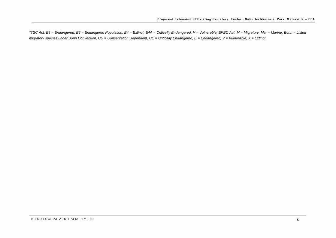
* TSC Act: E1 = Endangered, E2 = Endangered Population, E4 = Extinct, E4A = Critically Endangered, V = Vulnerable; EPBC Act: Bonn = Listed migratory species under Bonn Convention, CD = Conservation Dependent, CE = Critically Endangered, E = Endangered, V = Vulnerable, X = Extinct; FM Act: E1 = Endangered, E2 = Endangered Population, E4 = Extinct, E4A = Critically Endangered, V = Vulnerable
**Note: Some marine and migratory species have been excluded from this Likelihood of Occurrence analysis
^associated with PCT type present within the study area

P r o p o s e d E x t e n s i o n o f E x i s t i ng C em e t er y, E as t e r n S u b u r b s M em or i a l P ar k , M a t r a v i l l e – F F A
© E CO LO G ICA L A U S T R A L I A P T Y LT D 32
Table 7: Likelihood of occurrence and requirement of impact assessment for threatened flora species
Scientific Name Common Name TSC Status EPBC Status
Habitat Likelihood
of Occurrence
Impact Assessment
Required
Acacia terminalis subsp. terminalis^
Sunshine Wattle E1 E Coastal scrub and dry sclerophyll woodland on sandy soils.
Potential
No, this conspicuous species was not detected during the
site inspection
Callistemon linearifolius
Netted Bottle Brush V Dry sclerophyll forest. No No
Eucalyptus nicholii Narrow-leaved Black Peppermint
V V Dry grassy woodland, on shallow soils of slopes and ridges. No No
Pterostylis sp. Botany Bay
Botany Bay Bearded Orchid
E1 E "Coastal heath dominated by Melaleuca nodosa and Baeckea imbricata on skeletal sandy soils derived from sandstone.” Unlikely No
Senecio spathulatus Coast Groundsel E1 Frontal dunes in coastal areas. Unlikely No
Syzygium paniculatum^
Magenta Lilly Pilly E1 V "Subtropical and littoral rainforest on gravels, sands, silts and clays.” No No
Thelymitra atronitida Black-hooded Sun Orchid
E4A "At Cape Solander recorded from shallow black peaty soil in coastal heath on sandstone. In the Bago area recorded in open forest with a heathy understorey on well drained sand or clay-loam soils.
No No
P r o p o s e d E x t e n s i o n o f E x i s t i ng C em e t er y, E as t e r n S u b u r b s M em or i a l P ar k , M a t r a v i l l e – F F A
© E CO LO G ICA L A U S T R A L I A P T Y LT D 33
*TSC Act: E1 = Endangered, E2 = Endangered Population, E4 = Extinct, E4A = Critically Endangered, V = Vulnerable; EPBC Act: M = Migratory; Mar = Marine, Bonn = Listed migratory species under Bonn Convention, CD = Conservation Dependent, CE = Critically Endangered, E = Endangered, V = Vulnerable, X = Extinct

P r o p o s e d E x t e n s i o n o f E x i s t i ng C em e t er y, E as t e r n S u b u r b s M em or i a l P ar k , M a t r a v i l l e – F F A
© E CO LO G ICA L A U S T R A L I A P T Y LT D 34
Appendix B Flora and fauna species list Table 8: Flora species list
Family Species Name Common Name State-
determined Priority Weeds
Regional Priority Weeds
Weeds of Regional Concern
Fabaceae subf. Mimosoideae Acacia falcata Hickory Wattle
Fabaceae subf. Mimosoideae Acacia longifolia subsp. longifolia Sydney Golden Wattle
Fabaceae subf. Mimosoideae Acacia longifolia subsp. sophorae Coastal Wattle
Myrtaceae Acmena smithii Lilly Pilli
Asteraceae Ageratina adenophora Crofton Weed
Casuarinaceae Allocasuarina distyla Scrub She-oak
Myrtaceae Angophora costata Sydney Redgum
Apocynaceae Araujia sericifera* Moth Vine - - Yes
Proteaceae Banksia ericifolia Heath-leaved Banksia
Proteaceae Banksia integrifolia Coastal Banksia
Asteraceae Bidens pilosa* Cobblers Pegs - - -
Brassicaceae Brassica sp. -
Phyllanthaceae Breynia oblongifolia Coffee Bush
Bromeliaceae Bromeliad sp. Bromeliad

P r o p o s e d E x t e n s i o n o f E x i s t i ng C em e t er y, E as t e r n S u b u r b s M em or i a l P ar k , M a t r a v i l l e – F F A
© E CO LO G ICA L A U S T R A L I A P T Y LT D 35
Family Species Name Common Name State-
determined Priority Weeds
Regional Priority Weeds
Weeds of Regional Concern
Aizoaceae Carpobrotus glaucescens* Pigface - - -
Solanaceae Cestrum parqui* Green Cestrum - Yes -
Asteraceae Chrysanthemoides monilifera* Bitou Bush Yes - -
Commelinaceae Commelina cyanea -
Asteraceae Conyza sp.* - - - -
Rosaceae Cotoneaster sp.* - - - Yes
Sapindaceae Cupaniopsis anacardioides Tuckeroo
Poaceae Cynodon dactylon* Couch - - -
Apiaceae Daucus glochidiatus Native Carrot
Phormiaceae Dianella sp. -
Poaceae Ehrharta erecta* Panic Veldtgrass - - -
Poaceae Eragrostis curvula* African Lovegrass - - Yes
Fabaceae Erythrina corallodendron* Coral Tree - - -
Myrtaceae Eucalyptus sp. -
Cyperaceae Ficinia nodosa Knobby Club-rush
Proteaceae Hakea gibbosa Needlebush
Brassicaceae Hirschfeldia incana* Hairy Brassica - - -

P r o p o s e d E x t e n s i o n o f E x i s t i ng C em e t er y, E as t e r n S u b u r b s M em or i a l P ar k , M a t r a v i l l e – F F A
© E CO LO G ICA L A U S T R A L I A P T Y LT D 36
Family Species Name Common Name State-
determined Priority Weeds
Regional Priority Weeds
Weeds of Regional Concern
Asteraceae Hypochaeris radicata* Catsear - - -
Convolvulaceae Ipomoea cairica* Coastal Morning Glory - - Yes
Myrtaceae Kunzea ambigua Tick Bush
Verbenaceae Lantana camara* Lantana Yes - -
Myrtaceae Leptospermum laevigatum Coast Teatree
Poaceae Lolium sp.* Ryegrass - - -
Lomandraceae Lomandra longifolia Spiny-headed Mat-rush
Facaceae subf. Faboideae Medicargo sp.* - - - -
Myrtaceae Melaleuca nodosa Prickly-leaved Paperbark
Poaceae Melenus sp.*
Oleaceae Notolaea sp. -
Cactaceae Opuntia sp.* Prickly Pear Yes - -
Oxalidaceae Oxalis sp.* -
Pittosporaceae Pittosporum undulatum Native Daphne
Plantaginaceae Plantago lanceolata* Lamb’s Tongues - - -
Euphorbiaceae Ricinus communis* Castor Oil Plant - - -
Asteraceae Senecio madagascariensis* Fireweed Yes - -

P r o p o s e d E x t e n s i o n o f E x i s t i ng C em e t er y, E as t e r n S u b u r b s M em or i a l P ar k , M a t r a v i l l e – F F A
© E CO LO G ICA L A U S T R A L I A P T Y LT D 37
Family Species Name Common Name State-
determined Priority Weeds
Regional Priority Weeds
Weeds of Regional Concern
Poaceae Setaria parviflora* - - - -
Asteraceae Sonchus oleraceus* Common Sowthistle - - -
Poaceae Spinifex sericeus Hairy Spinifex
Poaceae Sporobolous africanus* Parramatta Grass - - -
Caryophyllaceae Stellaria media* Chickweed - - -
Asteraceae Taraxacum sp.* - - - -
Aizoaceae Tetragonia tetragonoides Native Spinach
Fabaceae subf. Faboideae Trifolium sp.* - - - -
Verbenaceae Verbena bonariensis* Purpletop - - -
Lamiaceae Westringia longifolia Long-leaved Westringia
*Introduced species

P r o p o s e d E x t e n s i o n o f E x i s t i ng C em e t er y, E as t e r n S u b u r b s M em or i a l P ar k , M a t r a v i l l e – F F A
© E CO LO G ICA L A U S T R A L I A P T Y LT D
Table 9: Fauna species list
Family Species Name Common Name
Sturnidae Acridotheres tristis* Common Myna
Meliphagidae Anthochaera carunculata Red Wattlebird
Cacatuidae Calyptorhynchus funereus Yellow-tailed Black Cockatoo
Laridae Chroicocephalus novaehollandiae Silver Gull
Campephagidae Coracina novaehollandiae Black-faced Cuckoo-shrike
Maluridae Malurus cyaneus Super Fairywren
Estrildidae Neochmia temporalis Red-browed Finch
Phalacrocoracidae Phalacrocorax varius Pied Cormorant
Rhipiduridae Rhipidura leucophrys Willy Wagtail
Sturnidae Sturnus vulgaris* Starling
*Introduced species

© E CO LO G ICA L A U S T R A L I A P T Y LT D
HEAD OFFICE Suite 2, Level 3 668-672 Old Princes Highway Sutherland NSW 2232 T 02 8536 8600 F 02 9542 5622
SYDNEY Suite 1, Level 1 101 Sussex Street Sydney NSW 2000 T 02 8536 8650 F 02 9542 5622
HUSKISSON Unit 1, 51 Owen Street Huskisson NSW 2540 T 02 4201 2264 F 02 9542 5622
CANBERRA Level 2 11 London Circuit Canberra ACT 2601 T 02 6103 0145 F 02 9542 5622
NEWCASTLE Suites 28 & 29, Level 7 19 Bolton Street Newcastle NSW 2300 T 02 4910 0125 F 02 9542 5622
NAROOMA 5/20 Canty Street Narooma NSW 2546 T 02 4302 1266 F 02 9542 5622
COFFS HARBOUR 35 Orlando Street Coffs Harbour Jetty NSW 2450 T 02 6651 5484 F 02 6651 6890
ARMIDALE 92 Taylor Street Armidale NSW 2350 T 02 8081 2685 F 02 9542 5622
MUDGEE Unit 1, Level 1 79 Market Street Mudgee NSW 2850 T 02 4302 1234 F 02 6372 9230
PERTH Suite 1 & 2 49 Ord Street West Perth WA 6005 T 08 9227 1070 F 02 9542 5622
WOLLONGONG Suite 204, Level 2 62 Moore Street Austinmer NSW 2515 T 02 4201 2200 F 02 9542 5622
GOSFORD Suite 5, Baker One 1-5 Baker Street Gosford NSW 2250 T 02 4302 1221 F 02 9542 5622
DARWIN 16/56 Marina Boulevard Cullen Bay NT 0820 T 08 8989 5601 F 08 8941 1220
BRISBANE Suite 1, Level 3 471 Adelaide Street Brisbane QLD 4000 T 07 3503 7192 F 07 3854 0310
ADELAIDE 2, 70 Pirie Street Adelaide SA 5000 T 08 8470 6650 F 02 9542 5622