proposed lowe’s home improvement center · proposed lowe’s home improvement center dennis, ......
TRANSCRIPT
\\vhb\proj\Wat-LD\11822.00\reports\May 2013 TIAS\TIAS_May-06-2013-Final.doc
Traffic Impact and Access Study
Proposed Lowe’s Home Improvement Center
Dennis, Massachusetts
Prepared for Lowe’s Home Centers, Inc. 1605 Curtis Bridge Road Wilkesboro, North Carolina 28697 Prepared by /Vanasse Hangen Brustlin, Inc. Transportation, Land Development, Environmental Services 101 Walnut Street P.O. Box 9151 Watertown, Massachusetts 02472 617.924.1770 May 2013

\\vhb\proj\Wat-LD\11822.00\reports\May 2013 TIAS\TIAS_May-06-2013-Final.doc i Table of Contents
Table of Contents
Introduction .................................................................................................................................................. i
Project Description ...................................................................................................................... i Study Methodology ..................................................................................................................... i
Existing Conditions .................................................................................................................................... 3
Study Area ................................................................................................................................. 3 Roadway Geometry ................................................................................................................... 4
Roadways .................................................................................................................. 4 Intersections ............................................................................................................... 4
Roadway Jurisdiction ................................................................................................................. 9 Traffic Volume Data ................................................................................................................... 9 Seasonality of Count Data ....................................................................................................... 10 Public Transportation ............................................................................................................... 11 Vehicular Crash History ........................................................................................................... 12
Future Conditions ..................................................................................................................................... 16
Background Traffic Growth ...................................................................................................... 16 Historic Traffic Growth ............................................................................................. 16 Site-Specific Growth ................................................................................................ 17 No-Build Traffic Volumes ......................................................................................... 17
Future Roadway Conditions .................................................................................................... 17 Trip Generation ........................................................................................................................ 19 Trip Distribution and Assignment ............................................................................................. 21
Traffic Operations Analysis ..................................................................................................................... 22
Level-of-Service and Delay Criteria ......................................................................................... 22 Level-of-Service Analysis ........................................................................................................ 23
Signalized Intersection Capacity Analyses .............................................................. 23 Unsignalized Intersection Capacity Analyses .......................................................... 25 Roadway Link Capacity Analysis ............................................................................. 27 Freeway Weave Analyses ....................................................................................... 29
Mitigation ................................................................................................................................................... 31
Transportation Demand Management ..................................................................................... 31 Intersection/Roadway Safety Mitigation ................................................................................... 33
Congestion Management ......................................................................................... 40 Fair Share Mitigation ................................................................................................ 41
Conclusion ................................................................................................................................................ 46

\\vhb\proj\Wat-LD\11822.00\reports\May 2013 TIAS\TIAS_May-06-2013-Final.doc ii List of Tables
List of Tables
Table Title Page
Table 1 Peak Season Existing Traffic Volumes .................................................................. 10
Table 2 Vehicular Crash Data (2008 - 2010) ....................................................................... 13
Table 2 Vehicular Crash Data (2008 - 2010) continued ....................................................... 14
Table 3 Proposed Project Trip Generation Breakdown ...................................................... 20
Table 4 Proposed Project Trip Distribution ........................................................................ 21
Table 5 Signalized Intersection Capacity Analysis Summary – Peak Summer Season .... 24
Table 6 Unsignalized Intersection Capacity Analyses - Peak Summer Season ................. 26
Table 7 Roadway Link Analysis Summary – Peak Summer Season .................................. 27
Table 8 Level-of Service Criteria for Weave Areas ............................................................. 29
Table 9 Ramp Weave Section Capacity Analysis Summary .............................................. 30
Table 10 Trip Reduction Requirement Calculation ............................................................... 33
Table 11 Signalized Intersection Capacity Analysis Summary – With Mitigation ................. 40
Table 12 Fair Share Mitigation Assessment ......................................................................... 44
Table 13 Mitigation Plan Cost Summary ............................................................................... 45

\\vhb\proj\Wat-LD\11822.00\reports\May 2013 TIAS\TIAS_May-06-2013-Final.doc iii List of Figures
List of Figures
Figure Title Follows Page
1 Site Location Map ..................................................................................................... 1
2 Study Area Intersection Geometry ............................................................................ 4
3 Roadway Jurisdiction Map ........................................................................................ 9
4 2013 Existing Weekday Evening Peak Hour Traffic Volumes ................................ 10
5 2013 Existing Saturday Midday Peak Hour Traffic Volumes .................................. 10
6 2018 No Build Weekday Evening Peak Hour Traffic Volumes ............................... 15
7 2018 No-Build Saturday Midday Peak Hour Traffic Volumes ................................. 15
8 Project Trip Distribution ........................................................................................... 19
9 2018 Build Weekday Evening Peak Hour Traffic Volumes ..................................... 19
10 2018 Build Saturday Midday Peak Hour Traffic Volumes ....................................... 19
11 Proposed Roadway Improvements – Route 134 Corridor ...................................... 31
12 Proposed Roadway Improvements – Theophilus F. Smith Road ........................... 31

\\vhb\proj\Wat-LD\11822.00\reports\May 2013 TIAS\TIAS_May-06-2013-Final.doc iv Executive Summary
Executive Summary
Vanasse Hangen Brustlin, Inc. (VHB) has prepared a traffic impact and access study (TIAS) for the proposed Lowe’s Home Improvement Center (the “Project”) to be located along Theophilus F. Smith Road in Dennis, Massachusetts. As designated on the land use vision map for the Town of Dennis, the site is located in an Economic Center. The site currently consists of approximately 15.2 acres of land which currently house the local Dick and Ellie’s Flea Market and the Inflatable Park during the summer season. The existing uses on site will be eliminated and as such existing traffic associated from the existing uses will be eliminated as part of the project. The proposed project would involve the redevelopment of the site to include an approximately 135,018 sf Lowes Home Improvement Center with 371 parking spaces. Access to the site would be provided by three driveways on Theophilus F. Smith (TFS) Road. The easternmost driveway will be an unsignalized T-type intersection with TFS Road which will be designated for truck delivery. The middle site driveway will be a T-type intersection with TFS Road and will be limited to right-turn in/right-turn out access. The westernmost driveway will be under traffic signal control and will involve the realignment of Enterprise Road to form the southbound approach to the intersection. By introducing the traffic signal and realigning Enterprise Road to align with the site driveway, we are providing access management along this corridor. Based on a review of the anticipated trip generation and trip distribution for the proposed project, a study area was established. The study area was established also in part based on a review of the RPP and the RPP Functional Classification of Cape Cod Roadways Map, and through consultations with both the Town of Dennis and Cape Cod Commission. Using this approach, the project study area includes the following 21 intersections: Theophilus F. Smith Road and Site Driveways (3) Theophilus F. Smith Road at Duck Pond Road/S. Gages Way Route 134 and Theophilus F. Smith Road Route 134 and Market Place/Patriot Square Access Driveway Theophilus F. Smith Road and Enterprise Road Main Street at High Bank Road Old Bass River Road at Bob Crowell Road Old Bass River Road at Mayfair Road Route 134 and Route 6 Interchange (four-intersections) Route 134 at Airline Road Route 134 and Bob Crowell Road

\\vhb\proj\Wat-LD\11822.00\reports\May 2013 TIAS\TIAS_May-06-2013-Final.doc v Executive Summary
Route 134 and Upper County Road Route 134 and Main Street (Route 28) S. Gages Way at Great Western Road Great Western Road at Depot Street (Harwich) Depot Street at Depot Road (Harwich) Manual turning movement counts [collecting peak hour data] were conducted at each of the study-area intersections during the weekday evening peak period from 4:00 PM to 6:00 PM and the Saturday midday peak period from 11:00 AM to 1:00 PM in August 2012. Concurrent with the TMCs, 24-hour automatic traffic recorder (ATR) counts were conducted at the following three locations: Route 134 south of Route 6 Theophilus F. Smith Road east of Route 134 Enterprise Road north of Theophilus F. Smith Road The proposed project is expected to result in a total of 2,104 net new trips (1,052 entering/1,052 exiting) on a typical weekday and 3,912 net new trips (1,956 entering/1,956 exiting) on a typical Saturday. The proposed project is expected to result in a total 215 net new vehicle trips (117 entering/98 exiting) during the weekday evening peak hour and 301 net new vehicle trips (157 entering/144 exiting) during the Saturday midday peak hour. Capacity analyses were conducted for each of the study area intersections and roadway links under 2013 Existing conditions, 2018 No-Build conditions (without the proposed development), and 2018 Build conditions (with the proposed development). Based on the results of these analyses and the anticipated site-generated traffic, the proponent will implement the following measures as part of the proposed transportation initiatives of the proposed project: Provide a comprehensive Transportation Demand Management Program (TDM) Provide monetary contribution in accordance with MPS TR0.4 Implement intersection safety and/or capacity enhancements at:
o Theophilus F. Smith Road and Enterprise Road/Site Driveways o Route 134 and Theophilus F. Smith Road o Route 134 and Market Place/Patriot Square Access Driveway o Route 134 and Route 6 Eastbound Ramps o Route 134 and Route 6 Westbound Ramps o Route 134 and Airline Road o Route 134 and Bob Crowell Road o Route 134 and Main Street (Route 28) o Route 134 at Center Street
Provide Fair Share contribution towards additional improvements in the study area

\\vhb\proj\Wat-LD\11822.00\reports\May 2013 TIAS\TIAS_May-06-2013-Final.doc vi Executive Summary
Overall, VHB concludes that the implementation of the above-mentioned mitigation measures not only accommodates future site-generated traffic but also improves some existing operational deficiencies in the vicinity of the site.

\\vhb\proj\Wat-LD\11822.00\reports\May 2013 TIAS\TIAS_May-06-2013-Final.doc 1 Introduction
Introduction
This traffic study documents the findings of the traffic evaluation conducted for the project including an assessment of existing conditions, projection of future traffic volumes without and with the proposed development, analysis of impacts of the proposed development and recommendations for improving existing capacity deficiencies as well as to offset project related traffic impacts.
Project Description
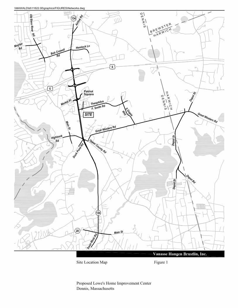
The site, which is located on Theophilus F. Smith Road in Dennis, Massachusetts, currently consists of approximately 15.2 of land which currently house the local Dick and Ellie’s Flea Market and the Inflatable Park during the summer season. The proposed project would involve the redevelopment of the site to include an approximately 135,018 sf Lowes Home Improvement Center with 371 parking spaces. The existing uses on site would be eliminated. Access to the proposed site would be provided by three driveways (two unsignalized and one signalized with a realigned Enterprise Road). Figure 1 shows the Project site in relation to the surrounding area.
Study Methodology
This traffic assessment has been conducted in three stages. The first stage involved an assessment of existing traffic conditions within the project area including an inventory of existing roadway geometry; observations of traffic flow, including daily and peak period traffic counts; and a review of vehicular crash data. The second stage of the study established the framework for evaluating the transportation impacts of the proposed project. Specific travel demand forecasts for the project were assessed along with future traffic demands on the study area roadways due to projected background traffic growth and other proposed area development that will occur, independent of the proposed development. The year 2018, a five-year time horizon, was selected as the design year for analysis for the preparation of this traffic impact and access assessment to satisfy the Executive Office of Environmental Affairs/Executive Office of Transportation [EOEA/EOT] guidelines and CCC DRI requirement.
1
\\vhb\proj\Wat-LD\11822.00\reports\May 2013 TIAS\TIAS_May-06-2013-Final.doc 2 Introduction
The third and final stage involved conducting traffic analyses to identify both existing and projected future roadway capacities and demands. This analysis was used as the basis for determining potential project impacts and potential mitigation measures.

\\vhb\proj\Wat-LD\11822.00\reports\May 2013 TIAS\TIAS_May-06-2013-Final.doc 3 Existing Conditions
Existing Conditions
Evaluation of the transportation impacts associated with the proposed project requires a thorough understanding of the existing transportation system in the project study area. Existing transportation conditions in the study area include roadway geometry, traffic controls, daily and peak period traffic flow, and vehicular crash information data. Each of these elements is described in detail below.
Study Area
Based on a review of the anticipated trip generation and trip distribution for the proposed project, a study area was established. The study area was established also in part based on a review of the RPP and the RPP Functional Classification of Cape Cod Roadways Map and through consultation with CCC and the Town of Dennis. Using this approach, the project study area will include the following 21 intersections: Theophilus F. Smith Road and Site Driveways (3) Theophilus F. Smith Road at Duck Pond Road/S. Gages Way Route 134 and Theophilus F. Smith Road Route 134 and Market Place/Patriot Square Access Driveway Theophilus F. Smith Road and Enterprise Road Main Street at High Bank Road Old Bass River Road at Bob Crowell Road Old Bass River Road at Mayfair Road Route 134 and Route 6 Interchange (four-intersections) Route 134 at Airline Road Route 134 and Bob Crowell Road Route 134 and Upper County Road Route 134 and Main Street (Route 28) S. Gages Way at Great Western Road Great Western Road at Depot Street (Harwich) Depot Street at Depot Road (Harwich) The existing conditions evaluation consisted of an inventory of the traffic control; roadway, driveway, and intersection geometry in the study area; the collection of daily and peak period traffic volumes; and a review of recent vehicular crash history.
2

\\vhb\proj\Wat-LD\11822.00\reports\May 2013 TIAS\TIAS_May-06-2013-Final.doc 4 Existing Conditions
Roadway Geometry
The major travel routes and intersections within the study area are described below. Figure 2 shows the observed existing geometry and traffic control at each study-area intersection.
Roadways
Route 134
Route 134 within the study area ranges from a two-lane to a four-lane roadway running generally in a north-south direction. Route 134 is under local jurisdiction with the exception of the section of roadway at the Route 6 interchange. The posted speed limit along Route 134 varies between 35 mph and 45 mph. Land use along Route 134 predominantly consists of commercial uses in the vicinity of the project site, with some residential uses north of the Route 6 interchange.
Theophilus F. Smith Road
Theophilus F. Smith Road (TFS Road) within the study area is a two-lane roadway running generally in an east-west direction. TFS Road is under local jurisdiction and provides two travel lanes with variable shoulder widths. The posted speed limit along TFS Road varies between 25 mph and 35 mph within the study area. Land use along TFS Road is a mix of retail, industrial and other commercial uses.
Intersections
The following sections describe the study-area intersections in detail.
Theophilus F. Smith Road at S. Gages Way/Duck Pond Road
Four-legged unsignalized intersection Intersection is under all-way STOP control All approaches provides a single general purpose lane Southbound leg provides access to the Transfer Station No sidewalks are provided at the intersection No crosswalks are provided at the intersection Land use in the area is primarily commercial and industrial


\\vhb\proj\Wat-LD\11822.00\reports\May 2013 TIAS\TIAS_May-06-2013-Final.doc 5 Existing Conditions
Theophilus F. Smith Road at Enterprise Road
Three-legged unsignalized intersection Southbound approach provides a general purpose lane and is under STOP control Eastbound and Westbound approach provide a single general purpose lane No sidewalks are provided at the intersection No crosswalks are provided at the intersection Land use in the area is primarily retail, including Cranberry Square Plaza,
Cumberland Farms, and Entertainment Cinemas
Route 134 at Theophilus F. Smith Road
Three-legged signalized intersection Northbound approach provides two general purpose lanes Southbound approach provides two general purpose lanes and an exclusive left-turn
lane Westbound approach provides exclusive left and right-turn lanes A two-way left-turn lane is present just south of Theophilus F. Smith Road Sidewalk is provided along the east side of Route 134 A crosswalk is provided across Theophilus F. Smith Road Land use in the area is primarily retail, including two gas stations and the Mid-Cape
Home Center
Route 134 at Market Place/Patriot Square Access
Four-legged signalized intersection Northbound and Southbound approaches provide an exclusive left-turn lane and
two general purpose lanes Eastbound and Westbound approaches provide an exclusive left-turn lane, a through
lane, and a channelized right-turn lane Sidewalk is provided along the east side of Route 134 A crosswalk is provided across Route 134 south of Market Place Land use in the area is primarily retail, including Patriot Square and Market Place
shopping centers
Main Street/Old Bass River Road at High Bank Road
Four-legged unsignalized intersection Intersection is under all-way STOP control All approaches provides a single general purpose lane Sidewalk is provided along the east side of Old Bass River Road and Main Street A crosswalk is provided across the westbound approach Land use in the area is primarily residential

\\vhb\proj\Wat-LD\11822.00\reports\May 2013 TIAS\TIAS_May-06-2013-Final.doc 6 Existing Conditions
Old Bass River Road at Bob Crowell Road
Three-legged unsignalized intersection Westbound approach is under STOP control All approaches provides a single general purpose lane Sidewalk is provided along the east side of Old Bass River Road A crosswalk is provided across the westbound approach Land use in the area consists of residential properties, the Johnny Kelley Recreation
Area, the former site of the Dennis DPW, and a multi-unit public apartment building
Old Bass River Road at Mayfair Road
Three-legged unsignalized intersection Eastbound approach is under STOP control All approaches provides a single general purpose lane Sidewalk is provided along the east side of Old Bass River Road A crosswalk is provided across the eastbound approach Land use in the area consists of residential properties, a Masonic Lodge, and a multi-
unit public apartment building
Route 134 at Route 6 Eastbound Ramps
Full cloverleaf interchange Route 134 northbound provides two general purpose lanes Route 134 southbound provides a single lane general purpose lane Route 6 eastbound off ramp provides an exclusive lane to Route 134 southbound but
is under YIELD control No sidewalks are provided at the intersection No crosswalks are provided at the intersection Land use in the area is a mix of commercial and residential
Route 134 at Route 6 Westbound Ramps
Full cloverleaf interchange Route 134 northbound provides a through lane and an exclusive right-turn lane Route 134 southbound provides a single lane general purpose lane No sidewalks are provided at the intersection No crosswalks are provided at the intersection Land use in the area is primarily residential

\\vhb\proj\Wat-LD\11822.00\reports\May 2013 TIAS\TIAS_May-06-2013-Final.doc 7 Existing Conditions
Route 134 at Bob Crowell Road
Four-legged signalized intersection Northbound approach provides an exclusive left-turn lane and a general purpose
lane Southbound approach provides an exclusive left-turn lane, a through lane, and a
general purpose lane Eastbound approach provides a general purpose lane and a channelized right-turn
lane Westbound approach provides a single general purpose lane Sidewalk is provided along the west side of Route 134 north of Bob Crowell Road No crosswalks are provided at the intersection Land use in the area includes retail, residential, and the police station
Route 134 at Airline Road
Three-legged unsignalized, Y-type intersection Westbound approach is under STOP control All approaches provides a single general purpose lane Sidewalk is provided along the west side of Route 134 No crosswalks are provided at the intersection Land use in the area consists of residential properties and the Doane Beal & Ames
funeral home
Route 134 at Upper County Road
Five-legged signalized intersection Northbound and Southbound approaches provide an exclusive left-turn lane, two
general purpose lanes, and a brief channelized right-turn lane Eastbound approach provides an exclusive left-turn lane and a general purpose lane Westbound approach provides a general purpose lane and an exclusive right-turn
lane Duck Pond Road is the fifth leg and is one way traveling away from the intersection Sidewalk is provided along the north side of Upper County Road and the east side of
Route 134. No crosswalks are provided at the intersection Land use in the area is primarily residential
\\vhb\proj\Wat-LD\11822.00\reports\May 2013 TIAS\TIAS_May-06-2013-Final.doc 8 Existing Conditions
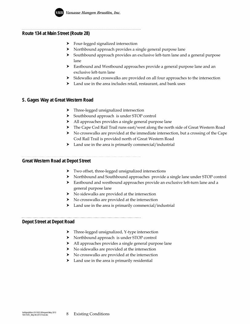
Route 134 at Main Street (Route 28)
Four-legged signalized intersection Northbound approach provides a single general purpose lane Southbound approach provides an exclusive left-turn lane and a general purpose
lane Eastbound and Westbound approaches provide a general purpose lane and an
exclusive left-turn lane Sidewalks and crosswalks are provided on all four approaches to the intersection Land use in the area includes retail, restaurant, and bank uses
S. Gages Way at Great Western Road
Three-legged unsignalized intersection Southbound approach is under STOP control All approaches provides a single general purpose lane The Cape Cod Rail Trail runs east/west along the north side of Great Western Road No crosswalks are provided at the immediate intersection, but a crossing of the Cape
Cod Rail Trail is provided north of Great Western Road Land use in the area is primarily commercial/industrial
Great Western Road at Depot Street
Two offset, three-legged unsignalized intersections Northbound and Southbound approaches provide a single lane under STOP control Eastbound and westbound approaches provide an exclusive left-turn lane and a
general purpose lane No sidewalks are provided at the intersection No crosswalks are provided at the intersection Land use in the area is primarily commercial/industrial
Depot Street at Depot Road
Three-legged unsignalized, Y-type intersection Northbound approach is under STOP control All approaches provides a single general purpose lane No sidewalks are provided at the intersection No crosswalks are provided at the intersection Land use in the area is primarily residential
\\vhb\proj\Wat-LD\11822.00\reports\May 2013 TIAS\TIAS_May-06-2013-Final.doc 9 Existing Conditions
Roadway Jurisdiction
Roadways within the Town of Dennis are either under the jurisdiction of the Town of Dennis or MassDOT. Within the project study area, all roadways are under local jurisdiction with the exception of Route 6 and Route 28, and a section of Route 134 at the Route 6 interchange which are under MassDOT jurisdiction. Figure 3 illustrates the roadway jurisdiction designations within the study area.
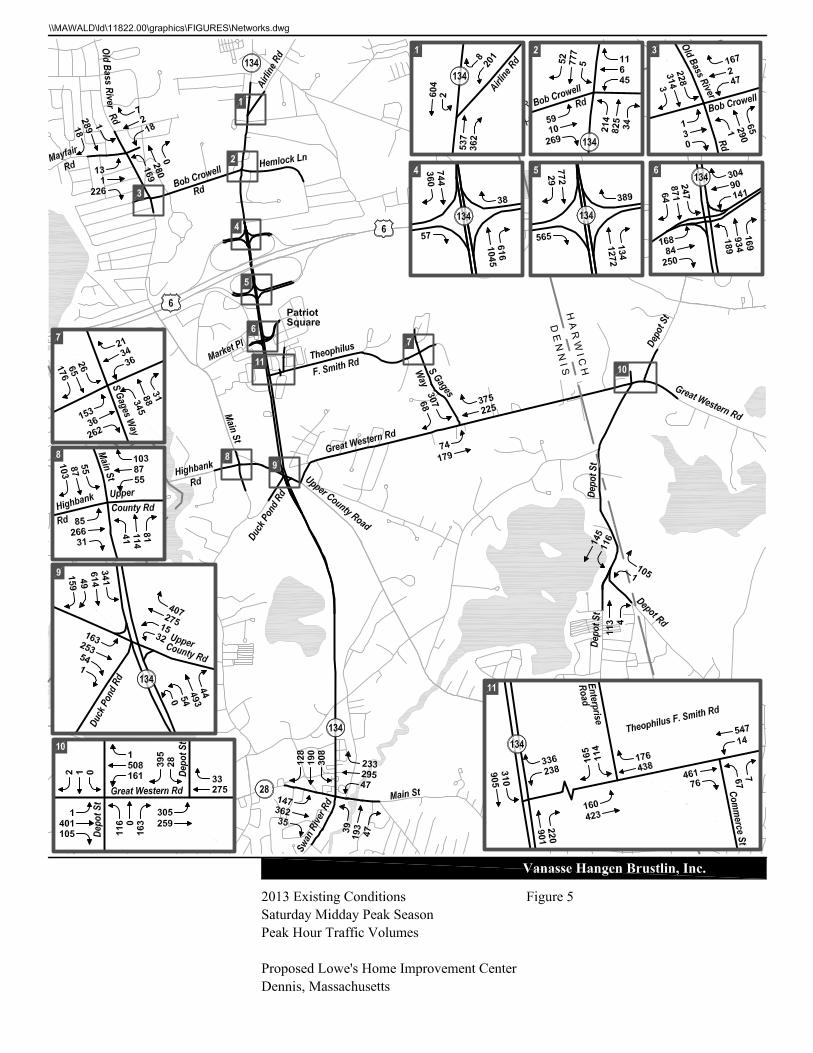
Traffic Volume Data
Manual turning movement counts [collecting peak hour data] were conducted at each of the study-area intersections during the weekday evening peak period from 4:00 PM to 6:00 PM, and the Saturday midday peak period from 11:00 AM to 1:00 PM. It is during these two periods when the combination of site traffic and area background traffic are at their most critical level. These counts were conducted in August 2012, which represents peak summer conditions (except for the intersection of Depot Street at Depot Road, which was counted in September 2012). The weekday evening peak period is consistent with typical peak commuter traffic periods, and coincide with the expected peak periods for traffic entering and exiting the proposed site. The Saturday midday peak period is consistent with the typical peak of shopping/commercial activity and turn-over for summer rental properties. These periods represent the most critical traffic volume conditions. Based on the TMCs, the weekday evening peak period generally occurred from 4:00 to 5:00 PM and the Saturday midday peak period occurred from 11:00 AM to 12:00 PM. Concurrent with the TMCs, 72-hour automatic traffic recorder (ATR) counts were conducted on Route 134, Theophilus F. Smith Road, and Enterprise Road. A summary of the ATR traffic data is presented in Table 1. All traffic count data is contained in the Appendix.


\\vhb\proj\Wat-LD\11822.00\reports\May 2013 TIAS\TIAS_May-06-2013-Final.doc 10 Existing Conditions
Table 1 Peak Season Existing Traffic Volumes
Weekday Weekday PM Peak Period Saturday Saturday Midday Peak Period ADT a Volume b K c Dir. Dist d ADT a Volume b K c Dir. Dist d
Route 134 Northbound
south of Route 6 16,900 1,410 8.3% 100% NB 16,750 1,340 8.0% 100% NB
Route 134 Southbound
south of Route 6 17,220 1,365 7.9% 100% SB 16,850 1,340 8.0% 100% NB
Theophilus F. Smith Road
east of Route 134 10,900 900 8.3% 57% WB 10,220 1,090 10.7% 53% WB
Enterprise Road
north of Theophilus F Smith Rd. 5,260 415 7.9% 53% SB 5,820 530 9.1% 54% SB
a daily traffic expressed in vehicles per day. Based on daily volumes for Thursday August 23, 2012 and Saturday August 25, 2012. Exact peak
hours of the ATRs may not coincide with the peak hour of the TMCs. b peak period volumes expressed in vehicles per hour c percent of daily traffic that occurs during the peak period d directional distribution of peak period traffic
Seasonality of Count Data
Comparison of traffic count data with historic seasonal data available from the Cape Cod Traffic Counting Report 2012 indicated that August traffic counts represent peak summer season conditions. This report also shows that August counts are approximately 31.6 percent higher than the average annual month conditions and the September counts are approximately 8.7 percent higher than the average annual month conditions and approximately 17.4 percent below peak summer season conditions. As such, the average conditions capacity analysis contained in the Appendix was conducted using the CCC Seasonal Adjustment Factors, which is 0.76 to adjust August volumes and 0.92 to adjust September volumes to average month conditions. A factor of 1.21 was applied to the September volumes to adjust them to peak summer season conditions. Figures 4 and 5 illustrate the 2013 Existing weekday evening and Saturday midday peak hour traffic volumes, respectively.

\\vhb\proj\Wat-LD\11822.00\reports\May 2013 TIAS\TIAS_May-06-2013-Final.doc 11 Existing Conditions
Public Transportation
Several transit services are currently provided on Cape Cod. The following information was provided by the Cape Cod Regional Transit Authority (CCRTA). The Proponent is exploring opportunities to bring public transportation to the site, which would be accommodated with a transit stop on site.
Cape Cod Regional Transit Authority
The Cape Cod Regional Transit Authority (CCRTA) oversees local bus service on Cape Cod. There are six, year-round, fixed-route services provided by CCRTA including The SeaLine, The Villager, and The H2OLine, Flex Route, Bourne Route, and Sandwich Route. All buses are wheelchair accessible and equipped with bicycle racks. All SeaLine, Villager, and H2OLine routes connect at the Plymouth & Brockton bus terminal in downtown Hyannis. CCRTA also offers “demand response service” through three separate lines; (1) ADA Paratransit Service is a door-to-door, shared-ride service for those eligible individuals who are unable to use the CCRTA fixed route services. It is a comparable service to the fixed route service schedule in that it operates during the same hours and travels within the ¾ of a mile of the fixed route service areas; (2) DART Service (Dial-a-Ride Transportation) is a daily general public service that is a door-to-door, ride by appointment, transportation service. This service is available to all Cape Cod residents for any purpose; and (3) Boston Hospital Transportation is a service that runs four days a week, by reservation, transportation service to 15 Boston area hospitals. The BHT has bus stops in Wellfleet, Eastham, Orleans, Harwich, the Barnstable Commuter Lot, and the Sagamore Commuter Lot. While six fixed-route services are provided by the CCRTA, only one of these fixed routes serves the Town of Dennis, which is the H2OLine. The H2OLine travels from the Hyannis Transportation Center to Stop & Shop in Orleans. One of the stops on this route is at Patriot Square, which is adjacent to the proposed Lowe’s site. As part of the proposed project, the Proponent will work with the CCRTA to provide transit service to the site through a stop on the H2OLine.
\\vhb\proj\Wat-LD\11822.00\reports\May 2013 TIAS\TIAS_May-06-2013-Final.doc 12 Existing Conditions
Vehicular Crash History
To identify potential vehicle crash trends in the study area, reported vehicular crash data for the study-area intersections and roadway links was obtained from MassDOT for the years 2008 through 2010, the most recent three-year history available. A summary of the MassDOT vehicle crash history and crash rates is presented in Table 2. This data is contained in the Appendix. The 2010 MassDOT average crash rates for signalized and unsignalized intersections for District 5 [the MassDOT district designation for Dennis] are 0.77 and 0.60, respectively. As shown in Table 2, eight intersections within the study area have a crash rate higher than the MassDOT District 5 average rate. Ten intersections in total have experienced three or more crashes per year over the past three years: Route 134 at Theophilus F. Smith Road Route 134 at Market Place/Patriot Square Route 134 at Route 6 Eastbound Ramps Route 134 at Route 6 Westbound Ramps Route 134 at Bob Crowell Road Route 134 at Airline Road Theophilus F. Smith Road at Enterprise Road/Cumberland Farms/Cranberry Sq. Route 134 at Upper County Road Route 134 at Main Street (Route 28) Route 134 at Center Street In accordance with RPP MPS TR1.3 for locations experiencing three or more crashes per year, “The applicant shall be required to implement the needed safety improvements as determined by the Commission…” Discussion of proposed improvements is provided in Chapter 5, Mitigation. In addition to the standard intersection crash analysis, the CCC requested that a collision diagram be prepared for the weave section on Route 134 southbound between the Route 6 eastbound off ramp and the Patriot Square Driveway. The Town of Dennis Police Department assisted VHB by compiling vehicle crash data for this section of roadway from 2009 to March 2013. Based on this data, only four crashes were reported on this roadway segment, which is less than one crash per year. It should also be noted that only one of these crashes is potentially attributable to weaving maneuvers from the Route 6 eastbound off ramp to Patriot Square. The collision diagram and the crash reports provided by the Town of Dennis are provided in the Appendix.

\\vhb\proj\Wat-LD\11822.00\reports\May 2013 TIAS\TIAS_May-06-2013-Final.doc 13 Existing Conditions
Table 2 Vehicular Crash Data (2008 - 2010)
Route 134 at
Theophilis Smith Road
Route 134 at Patriot Square/ Market Place
Route 134 at Route 6 EB
Ramps
Route 134 at Route 6 WB
Ramps
Route 134 at Route 6
Interchange (not located)
Route 134 at Bob Crowell
Road/ Hemlock
Lane
Route 134 at Airline
Road
Theophilus F. Smith Road at
Enterprise Road/
Cumberland Farms/ Condo
Driveway
Theophilus F. Smith Road at Gages Way
Old Bass River Road at Mayfair
Road
Old Bass River Road
at Bob Crowell
Road
Great Western Road at Depot Street (East)
Great Western Road at Depot Street (West)
Great Western Road at Gages Way
Route 134 at Upper County Road/
Duck Pond Road
Main Street at Highbank
Road/ Upper
County Road
Route 134 at Main Street/ Swan
River Road
Depot Street at Depot
Road
Signalized? Yes Yes No No -- Yes No No No No No No No No Yes No Yes No MassDOT Average Crash Rate 0.77 0.77 0.60 0.60 -- 0.77 0.60 0.60 0.60 0.60 0.60 0.60 0.60 0.60 0.77 0.60 0.77 0.60 Calculated Crash Rate 0.47 0.96 0.39 0.35 -- 1.27 0.69 1.68 0.13 0.52 0.39 0.35 0.12 0.40 0.98 0.46 0.84 0.41 Exceeds Average? No Yes No No -- Yes Yes Yes No No No No No No Yes No Yes No
Year 2008 2 13 4 2 12 6 5 17 0 2 1 1 0 0 11 6 6 1 2009 9 12 5 3 21 9 1 2 1 2 3 2 1 2 10 1 9 0 2010 4 14 6 6 15 11 7 6 0 2 1 2 1 3 12 1 4 1 Total 15 39 15 11 48 26 13 25 1 6 5 5 2 5 33 8 19 2 Average 5.00 13.00 5.00 3.67 16.00 8.67 4.33 8.33 0.33 2.00 1.67 1.67 0.67 1.67 11.00 2.67 6.33 0.67
Collision Type Angle 3 8 2 0 1 2 9 13 0 3 3 2 0 4 8 5 7 0 Head-on 0 1 0 0 1 1 0 0 0 0 0 0 0 0 0 0 0 0 Rear-end 9 22 13 9 34 18 3 8 1 2 1 2 1 1 19 2 8 0 Rear-to-rear 0 2 0 0 0 0 0 1 0 0 0 0 0 0 0 0 0 0 Sideswipe, opposite direction 0 0 0 1 0 1 1 1 0 0 0 0 0 0 0 1 0 0 Sideswipe, same direction 1 3 0 0 6 2 0 1 0 1 1 0 0 0 3 0 1 1 Single-vehicle crash 1 3 0 1 6 2 0 1 0 0 0 1 1 0 3 0 3 1 Unknown 0 0 0 0 0 0 0 0 0 0 0 0 0 0 0 0 0 0 Not reported 1 0 0 0 0 0 0 0 0 0 0 0 0 0 0 0 0 0 Total 15 39 15 11 48 26 13 25 1 6 5 5 2 5 33 8 19 2
Crash Severity Fatal injury 0 0 0 0 0 0 0 0 0 0 0 0 0 0 0 0 0 0 Non-fatal injury 2 9 0 6 6 1 1 4 1 1 2 0 0 2 9 1 6 0 Property damage only (none injured) 12 29 15 5 41 25 12 20 0 5 3 5 2 3 24 7 13 2 Unknown 1 0 0 0 1 0 0 1 0 0 0 0 0 0 0 0 0 0 Not reported 0 1 0 0 0 0 0 0 0 0 0 0 0 0 0 0 0 0 Total 15 39 15 11 48 26 13 25 1 6 5 5 2 5 33 8 19 2
Time of day Weekday, 7:00 AM - 9:00 AM 1 5 2 0 6 3 1 3 0 0 3 1 0 1 4 1 1 0 Weekday, 4:00 PM - 6:00 PM 1 8 4 7 7 3 2 3 0 1 0 0 0 1 4 1 4 0 Saturday, 11:00 AM - 2:00 PM 0 4 1 2 4 1 1 1 0 0 0 0 0 1 0 0 2 0 Weekday, other time 9 15 2 1 23 13 6 13 1 5 1 3 2 2 20 3 8 1 Weekend, other time 4 7 6 1 8 6 3 5 0 0 1 1 0 0 5 3 4 1 Total 15 39 15 11 48 26 13 25 1 6 5 5 2 5 33 8 19 2
Pavement Conditions Dry 12 33 13 9 40 15 9 18 1 3 4 4 2 5 25 7 16 2 Wet 2 6 2 1 6 10 4 7 0 3 1 1 0 0 6 1 2 0 Snow 0 0 0 1 2 1 0 0 0 0 0 0 0 0 2 0 1 0 Sand, mud, dirt, oil, gravel 0 0 0 0 0 0 0 0 0 0 0 0 0 0 0 0 0 0 Not reported 1 0 0 0 0 0 0 0 0 0 0 0 0 0 0 0 0 0 Total 15 39 15 11 48 26 13 25 1 6 5 5 2 5 33 8 19 2 Non Motorist (Bike, Pedestrian) 0 1 0 0 0 0 0 1 0 6 0 0 0 0 1 0 2 0
Source: MassDOT vehicle crash data.

\\vhb\proj\Wat-LD\11822.00\reports\May 2013 TIAS\TIAS_May-06-2013-Final.doc 14 Existing Conditions
Table 2 Vehicular Crash Data (2008 - 2010) continued
Theophilus F. Smith Road Route 134 S. Gages Way Great Western Road Depot Street Bob Crowell Road Old Bass River Road Route 134 at
Route 134
to Site
Drive W
Site Drive
W to Site
Drive E
Site Drive
E to Truck
Site Drive
Truck Site
Drive to S.
Gages Way
Theophilus F. Smith
Road to Upper
County Road
Upper
County Road
to Route 28
Theophilus F. Smith
Road to Patriot
Square Access Road
Patriot Square
Access Road to
Route 6 EB Ramps
Route 6 EB Ramps
to Route 6 WB
Ramps
Route 6 WB
Ramps to Bob
Crowell Road
Bob Crowell
Road to
Airline Road
Theophilus F. Smith
Road to Great
Western Road
S. Gages Way to
Depot Street
Great Western
Road to Depot
Road
Route 134 to Old
Bass River Road
Bob Crowell Road
to Mayfair Road Center Street
Year
2008 1 0 1 0 6 13 4 0 0 0 3 0 0 1 0 2 6
2009 0 0 0 0 4 8 3 0 0 4 2 0 3 3 0 0 5
2010 0 0 0 3 5 15 8 0 0 0 3 0 0 0 1 0 4
Total 1 0 1 3 15 36 15 0 0 4 8 0 6 4 1 2 15
Average 0.33 0 0.33 1 5 12 5 0 0 1.33 2.67 0 2 1.33 0.33 0.67 5
Collision Type
Angle 1 0 0 1 6 8 8 0 0 1 2 0 0 1 0 0 5
Head-on 0 0 0 0 0 1 0 0 0 0 0 0 0 0 0 0 0
Rear-end 0 0 0 5 5 12 4 0 0 3 6 0 4 0 0 1 5
Rear-to-rear 0 0 0 0 0 0 0 0 0 0 0 0 0 0 0 0 0
Sideswipe, opposite direction 0 0 0 0 0 2 1 0 0 0 0 0 1 0 0 0 2
Sideswipe, same direction 0 0 0 0 0 1 1 0 0 0 0 0 0 1 1 0 0
Single-vehicle crash 0 0 0 1 3 12 1 0 0 0 0 0 1 0 0 1 3
Unknown 0 0 0 0 0 0 0 0 0 0 0 0 0 2 0 0 0
Not Reported 0 0 1 0 1 0 0 0 0 0 0 0 0 0 0 0 0
Total 1 0 1 3 15 36 15 0 0 4 8 0 6 4 1 2 15
Severity
Fatality injury 0 0 0 0 0 8 0 0 0 0 0 0 0 0 0 0 0
Non-fatal injury 0 0 0 1 2 0 3 0 0 1 3 0 1 1 0 2 4
Property-damage only (none injured) 1 0 0 1 11 26 10 0 0 3 5 0 5 3 1 0 11
Unknown 0 0 0 0 0 0 0 0 0 0 0 0 0 0 0 0 0
Not Reported 0 0 1 1 2 2 2 0 0 0 0 0 0 0 0 0 0
Total 1 0 1 3 15 36 15 0 0 4 8 0 6 4 1 2 15
Time of day
Weekday, 7:00 AM - 9:00 AM 0 0 0 1 0 3 0 0 0 0 0 0 0 0 1 0 1
Weekday, 4:00 PM - 6:00 PM 0 0 0 0 3 3 4 0 0 0 0 0 2 0 0 0 2
Saturday, 11:00 AM - 2:00 PM 0 0 0 0 0 2 0 0 0 1 1 0 0 0 0 1 2
Weekday, other time 1 0 0 2 10 18 8 0 0 3 5 0 2 3 0 0 5
Weekend, other time 0 0 1 0 2 10 3 0 0 0 2 0 2 1 0 1 5
Total 1 0 1 3 15 36 15 0 0 4 8 0 6 4 1 2 15
Pavement Conditions
Dry 1 0 1 2 11 23 13 0 4 6 0 5 2 1 0 11
Wet 0 0 0 1 4 3 2 0 0 0 2 0 0 0 0 2 2
Snow 0 0 0 0 0 10 0 0 0 0 0 0 1 1 0 0 2
Sand, mud, dirt, oil, gravel 0 0 0 0 0 0 0 0 0 0 0 0 0 0 0 0 0
Not Reported 0 0 0 0 0 0 0 0 0 0 0 0 0 1 0 0 0
Total 1 0 1 3 15 36 15 0 0 4 8 0 6 4 1 2 15
Non Motorist (Bike, Pedestrian) 0 0 0 0 1 1 0 0 0 0 0 0 0 0 0 0 1
Source: MassDOT vehicle crash data

\\vhb\proj\Wat-LD\11822.00\reports\May 2013 TIAS\TIAS_May-06-2013-Final.doc 15 Existing Conditions
As shown in the second page of Table 2, which focuses on the crash history of the study area roadway links, there are three links that experienced over three crashes per year over their entire length during the most recent three years. Route 134 between Patriot Square and TFS Road experienced a total of 15 crashes from 2008 to 2010. Of these 15 crashes, the majority of them were spread out over the length of this link, with the exception of a group of 8 crashes that were reported at the access points for the Gulf Station and Cumberland Farms. It should be noted that as part of the Cumberland Farms redevelopment project, improvements are being proposed to the site access on Route 134. The two existing wide curb cuts will be consolidated to one driveway and left turns will be prohibited from the site onto Route 134. These access improvements will improve safety in this area. Route 134 between TFS Road and Upper County Road experienced a total of 15 crashes over the three year review period. Review of the geolocation of these crashes based on the MassDOT crash records showed that there is no concentration of crashes at any single point on this roadway link that experiences more than three crashes per year. Route 134 between Upper County Road and Route 28 experienced a total of 36 crashes over the three year review period. Review of the geolocation of these crashes based on the MassDOT crash records showed that 15 of the crashes occurred at the intersection of Rotue 134 and Center Street. The remaining crashes were spread across the roadway link in low concentrations. Based on the crash frequency, VHB provided a detailed summary of the crashes at the intersection of Route 134 at Center Street in the second page of Table 2. The crash summary for this intersection shows that 10 of the 15 crashes were angle and rear end crashes, suggesting that vehicles are attempting to accept short gaps in mainline traffic when turning from the side street. Given that both of the minor street approaches to this intersection are skewed, sight distance can be compromised. Measures recommended to improve this condition are summarized in Chapter 5, Mitigation.
\\vhb\proj\Wat-LD\11822.00\reports\May 2013 TIAS\TIAS_May-06-2013-Final.doc 16 Future Conditions
Future Conditions
Traffic volumes in the study area were projected to the year 2018, reflecting a typical five-year traffic-planning horizon. Independent of the project, volumes on the roadway network under year 2018 No Build conditions were assumed to include existing traffic and new traffic resulting from background traffic. Anticipated site-generated traffic volumes were added to the year 2018 No Build traffic volumes to reflect the year 2018 Build conditions in the study area.
Background Traffic Growth
Traffic growth on area roadways is a function of the expected land development, economic activity, and changes in demographics. A frequently used procedure is to estimate an annual percentage increase and apply that increase to study-area traffic volumes. An alternative procedure is to identify estimated traffic generated by specific planned major developments that would be expected to affect the project study area roadways. For the purpose of this assessment, both methods were utilized.
Historic Traffic Growth
VHB conducted research to determine the historic growth rate for traffic in this area as well as other planned developments that may affect traffic within the study area for the proposed project. Based on information contained in the Cape Cod 2012 Traffic Counting Report, traffic has decreased at a rate of -0.74 percent per year Cape-wide over the last ten years (2002 – 2012). As described in this report, the Town of Dennis is considered to be part of the Mid Cape region, in which traffic decreased at a rate of -1.06 percent per year between 2002 and 2012. To provide a conservative analysis, and based on discussions with the CCC Transportation Staff, a background growth rate of 0.5 percent per year was applied. The historic growth data provided in the Cape Cod 2012 Traffic Counting Report is contained in the Appendix.
3

\\vhb\proj\Wat-LD\11822.00\reports\May 2013 TIAS\TIAS_May-06-2013-Final.doc 17 Future Conditions
Site-Specific Growth
In addition to the historic traffic growth, VHB contacted representatives of the CCC and the Town of Dennis to identify any other development projects planned within the vicinity of the site. Based on these discussions, there is currently one development project proposed in this area that would affect traffic volumes in the vicinity of the site. Just to the west of the proposed project, Cumberland Farms is planning to reconfigure their existing gas station/retail site. The project involves the demolition of the existing gas pumps and retail space and the construction of a new 4,221 sf Cumberland Farms convenience store, eight gas pumps, 2,001 sf of retail space, and a 2,970 sf drive-thru bank. Traffic volumes associated with the proposed redevelopment were taken from the October 2012 Traffic Impact Study prepared for the project by McMahon Associates. This project is currently under construction. As noted previously, the existing seasonal uses on the site (Dick & Ellie’s Flea Market and The Inflatable Park) will be eliminated as part of the proposed redevelopment. As is discussed in detail the Trip Generation section of this chapter, trip generation credit will be taken for a portion of the traffic generated by the existing uses since traffic associated with these uses will be eliminated from this area. However, to provide a conservative assessment of traffic in the vicinity of the site, the remainder of the peak season traffic generated by the existing uses will not be removed from the roadway system.
No-Build Traffic Volumes
The 2018 No Build traffic volumes were developed by applying the 0.5 percent per year growth rate to the existing conditions volumes and adding the project traffic associated with the proposed Cumberland Farms redevelopment project. Figures 6 and 7 display the resulting 2018 No Build peak hour traffic volumes.
Future Roadway Conditions
Another factor affecting background traffic conditions is the implementation of roadway improvements within the study area. Three roadway improvement projects have been identified by the Town of Dennis and MassDOT. The following text was obtained from the MassDOT Project Information website and provides a summary of project details and anticipated schedule: RECONSTRUCTION ON ROUTE 134 FROM ROUTE 28 TO UPPER
COUNTY ROAD Work on this project includes milling, resurfacing and full depth roadway reconstruction of Route 134 from Route 28 to Upper County Road. The proposed


\\vhb\proj\Wat-LD\11822.00\reports\May 2013 TIAS\TIAS_May-06-2013-Final.doc 18 Future Conditions
cross section will provide two 11-foot travel lanes and two 5-foot shoulders/bike lanes, and a 5 foot ADA/AAB compliant walk on the east side of Route 134. Additional proposed work includes traffic signal upgrades at the Upper County Road intersection, pedestrian accommodations, drainage improvements, guard rail upgrades, pavement markings and signage installation. Construction began following the summer of 2012.

\\vhb\proj\Wat-LD\11822.00\reports\May 2013 TIAS\TIAS_May-06-2013-Final.doc 19 Future Conditions
BRIDGE REPLACEMENTS - UPPER COUNTY ROAD & ROUTE 28 OVER SWAN POND RIVER The bridge carrying Upper County Road over the Swan Pond River is to be replaced with a three-span continuous superstructure. The existing Main Street Bridge over Swan Pond River is to be replaced with a three-span continuous superstructure system. The curb-to-curb width of the bridge shall be 40 feet, with a 6 foot sidewalk on both sides. During construction, traffic will be shifted to a temporary bridge that will be built to the south of the existing bridge. Construction began following the summer of 2012.
DENNIS/YARMOUTH - CAPE COD RAIL TRAIL EXTENSION FROM ROUTE 134 TO STATION AVENUE Work on this project consists of the construction of a 5.2 mile multi-user path. The path is an extension of the Cape Cod Rail Trail. The proposed path begins east of Route 134 in Dennis and extends to the Yarmouth/Barnstable Town Line. Construction is expected to begin in the winter of 2013/2014.
No other roadway improvement projects were identified within the vicinity of the Project site other than routine maintenance.
Trip Generation
The proposed redevelopment would involve the construction of an approximately 135,018 sf Lowes Home Improvement Center with 371 parking spaces. For trip generation purposes, additional outdoor sales and storage area were added to the building area to provide a conservative assessment. The total square footage (135,018 sf) is comprised of 127,683 sf of building area and garden center, 3,420 sf of outdoor sales area, and 3,915 sf of outdoor storage on the back of the building. To estimate the site-generated traffic, the Institute of Transportation Engineers’ (ITE) publication Trip Generation, 9th Edition was utilized. For the purposes of this evaluation, trip generation estimates were conducted using standard ITE data for Land Use Code (LUC) 862 (Home Improvement Superstore). Table 3 summarizes the estimated vehicle trips for the future retail use of the property. Under existing conditions, the site is occupied during the summer and shoulder months by Dick & Ellie’s Flea Market and the Inflatable Park. With the proposed project in place, both uses will be removed from the site and therefore the traffic from these uses will be eliminated. For the purpose of this analysis, an annualized credit for the elimination of the existing uses is allowed under the RPP MPS TRO.2 at the discretion of the Commission. Based on detailed discussion with CCC staff prior to preparation of this document, the traffic credit was calculated on an annual basis since the existing uses are seasonal. This approach to adjusting the existing volumes was suggested to VHB by Commission staff at a meeting and included the following:

\\vhb\proj\Wat-LD\11822.00\reports\May 2013 TIAS\TIAS_May-06-2013-Final.doc 20 Future Conditions
Adjust existing driveway counts from August to an average condition for the months the businesses are open. Use an average of the CCC Seasonal Adjustment Factors for the months of May, June, July, August, September, and October.
Annualize the existing site traffic by dividing the number of operating days (101) by 365, which yields a factor of 0.277 to assess an annual average condition.
Estimate weekday daily and Saturday daily traffic volumes based on K-factors available for comparable retail and recreational uses available in ITE Trip Generation, 9th Edition. To provide a conservative assessment, the highest K-factors available for the comparable land uses were utilized.
It should also be noted that according to Technical Bulletin 96-003, “…a 25% reduction of peak hour trip generation is allowed for the purposes of analyzing peak hour impacts.” As such, the trip generation projections summarized in Table 3 assume the full 25 percent credit. The trip generation calculations, prepared in accordance with ITE guidelines and Technical Bulletin 96-003, are summarized in Table 3. The detailed Trip Generation calculations are provided in the Appendix.
Table 3 Proposed Project Trip Generation Breakdown
Time Period Direction
Gross Total
Trip Generation a
Existing Trip
Generation b
5% Credit for
Interconnection c
25% Trip
Reduction d
Net Total
Trips
Pass-By
Trips e
Net New
Trips
Weekday Daily Enter 2,075 -108 -98 -467 1,402 350 1,052
Exit 2,075 -108 -98 -467 1,402 350 1,052
Total 4,150 -216 -196 -934 2,804 700 2,104
Weekday Morning Enter 180 0 -9 -43 128 31 97
Peak Hour Exit 167 0 -8 -40 119 31 88
Total 347 0 -17 -83 247 62 185
Weekday Evening Enter 223 -8 -11 -51 153 36 117
Peak Hour Exit 205 -18 -9 -44 134 36 98
Total 428 -26 -20 -95 287 72 215
Saturday Daily Enter 3,829 -168 -183 -870 2,608 652 1,956
Exit 3,829 -168 -183 -870 2,608 652 1,956
Total 7,658 -336 -366 -1,740 5,216 1,304 3,912
Saturday Midday Enter 311 -20 -15 -69 207 50 157
Peak Hour Exit 298 -25 -14 -65 194 50 144
Total 609 -45 -29 -134 401 100 301
a Trip Generation estimate based on ITE LUC 862 (Home Improvement Superstore) for 135,018 SF store using Peak Hour of Generator
b Based on traffic counts conducted at the existing site driveway in August 2012, adjusted according to CCC recommended methodology
c Project will allow an interconnection to the adjacent Cranberry Square site
d In accordance with RPP Goal TR2 and Technical Bulletin 96-003
e Pass-by Traffic assumed to be 25% per state and CCC guidelines

\\vhb\proj\Wat-LD\11822.00\reports\May 2013 TIAS\TIAS_May-06-2013-Final.doc 21 Future Conditions
Consistent with EOEEA and CCC guidelines, a pass-by rate of 25 percent was utilized to determine the amount of “new” traffic that will be generated by the Project. As shown in Table 3, the proposed project is expected to result in a total of 2,104 net new trips (1,052 entering/1,052 exiting) on a typical weekday and 3,912 net new trips (1,956 entering/1,956 exiting) on a typical Saturday. The proposed project is expected to result in a total 215 net new vehicle trips (117 entering/98 exiting) during the weekday evening peak hour and 301 net new vehicle trips (157 entering/144 exiting) during the Saturday midday peak hour.
Trip Distribution and Assignment
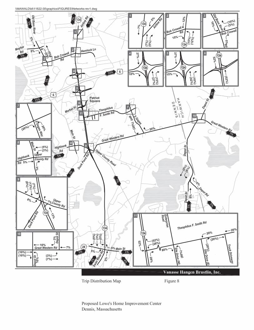
The directional distribution of traffic approaching and departing the Project is a function of several variables: population densities, shopping opportunities, competing uses, existing travel patterns, and the efficiency of the roadways leading to the site. The trip distribution for the Project was developed based on a population-based gravity model utilizing the 2010 U.S. Census data for all Cape communities. Based on the distribution of population within the projected market trade area, arrival and departure patterns for project-related traffic were estimated and adjusted, if appropriate, based on known local factors such as locations of competing opportunities and efficiency of local roadways. The assignment of site-generated traffic to specific travel routes was based on observed traffic flow conditions on available routes, and the assumption that most motorists will seek the fastest and most direct routes to and from the Site. The traffic distribution proposed has been reviewed in detail with CCC staff prior to this filing as requested by the Town of Dennis. Refer to the Appendix for the trip distribution calculations as well as a map illustrating the distribution of the peak hour project trips. The anticipated trip distribution is summarized in Table 4 and illustrated in Figure 8. Table 4 Proposed Project Trip Distribution
Direction (To/From)
Travel Route
Percent Assigned to Route
North Route 134 52% South Route 134 28% East S. Gages Way 20%
Total All Routes 100%
The projected site-generated traffic volume, summarized in Table 3, was distributed on the study area roadways using the trip distribution shown in Table 4 and added to the 2018 No Build peak hour traffic volumes to develop the 2018 Build peak hour traffic volumes. These 2018 Build traffic volumes are shown in Figures 9 and 10.


\\vhb\proj\Wat-LD\11822.00\reports\May 2013 TIAS\TIAS_May-06-2013-Final.doc 22 Traffic Operations Analysis
Traffic Operations Analysis
Measuring existing traffic volumes and projecting future traffic volumes quantifies traffic within the study area. To assess quality of flow, roadway capacity analyses were conducted with respect to the 2013 Existing conditions and projected 2018 No Build and Build traffic volume conditions. Capacity analyses provide an indication of the adequacy of the roadway facilities to serve the anticipated traffic demands. In accordance with CCC guidelines, capacity analyses were conducted for both Peak Summer Season and Average Month traffic conditions. The analysis summary tables provided in this chapter contain the results of the Peak Summer Season analyses. All Average Month capacity analyses are contained in the Appendix with corresponding summary tables.
Level-of-Service and Delay Criteria
Level-of-service (LOS) is the term used to denote the different operating conditions that occur on a given roadway segment under various traffic volume loads. It is a qualitative measure of the effect of a number of factors including roadway geometrics, speed, travel delay, freedom to maneuver, and safety. Level-of-service provides an index to the operational qualities of a roadway segment or an intersection. Level-of-service designations range from A to F, with LOS A representing the best operating conditions and LOS F representing the worst operating conditions.
4

\\vhb\proj\Wat-LD\11822.00\reports\May 2013 TIAS\TIAS_May-06-2013-Final.doc 23 Traffic Operations Analysis
For this study, capacity analyses were completed for the signalized and unsignalized study area intersections and roadway links. Level-of-service (LOS) designation is reported differently for signalized, unsignalized, and roadway links. For signalized intersections, the analysis considers the operation of each lane or lane group entering the intersection and assigns a LOS designation to each. Overall intersection data is then calculated in order to represent the overall conditions at the intersection. For unsignalized intersections, however, the analysis assumes that traffic on the mainline is not affected by traffic on the side streets. The LOS is determined primarily for left turns from the main street and all movements from the minor street. The study of an unsignalized intersection is, for the most part, done by observing the most critical movement, which is most often the left turn out of the side street. For roadway links, the roadway geometrics determine the link capacity and the link traffic volume-to-capacity ratio is used to assess level-of-service. The evaluation criteria used to analyze area intersections and roadway links is based on the 2000 Highway Capacity Manual (HCM)1 and are included in the Appendix.
Level-of-Service Analysis
Levels-of-service analyses were conducted for the 2013 Existing, 2018 No Build, and 2018 Build conditions for the signalized and unsignalized study-area intersections.
Signalized Intersection Capacity Analyses
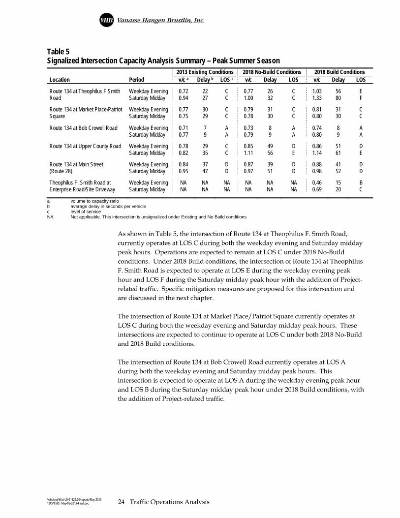
Table 5 presents a summary of the capacity analyses for the signalized intersections in the study area. The capacity analyses worksheets are included in the Appendix.
1 Highway Capacity Manual, HCM2000, Transportation Research Board, Washington, DC. (2000)
\\vhb\proj\Wat-LD\11822.00\reports\May 2013 TIAS\TIAS_May-06-2013-Final.doc 24 Traffic Operations Analysis
Table 5 Signalized Intersection Capacity Analysis Summary – Peak Summer Season 2013 Existing Conditions 2018 No-Build Conditions 2018 Build Conditions Location Period v/c a Delay b LOS c v/c Delay LOS v/c Delay LOS Route 134 at Theophilus F Smith Weekday Evening 0.72 22 C 0.77 26 C 1.03 56 E Road Saturday Midday 0.94 27 C 1.00 32 C 1.33 80 F Route 134 at Market Place/Patriot Weekday Evening 0.77 30 C 0.79 31 C 0.81 31 C Square Saturday Midday 0.75 29 C 0.78 30 C 0.80 30 C
Route 134 at Bob Crowell Road Weekday Evening 0.71 7 A 0.73 8 A 0.74 8 A Saturday Midday 0.77 9 A 0.79 9 A 0.80 9 A Route 134 at Upper County Road Weekday Evening 0.78 29 C 0.85 49 D 0.86 51 D Saturday Midday 0.82 35 C 1.11 56 E 1.14 61 E Route 134 at Main Street Weekday Evening 0.84 37 D 0.87 39 D 0.88 41 D (Route 28) Saturday Midday 0.95 47 D 0.97 51 D 0.98 52 D Theophilus F. Smith Road at Weekday Evening NA NA NA NA NA NA 0.46 15 B Enterprise Road/Site Driveway Saturday Midday NA NA NA NA NA NA 0.69 20 C
a volume to capacity ratio b average delay in seconds per vehicle c level of service NA Not applicable. This intersection is unsignalized under Existing and No Build conditions
As shown in Table 5, the intersection of Route 134 at Theophilus F. Smith Road, currently operates at LOS C during both the weekday evening and Saturday midday peak hours. Operations are expected to remain at LOS C under 2018 No-Build conditions. Under 2018 Build conditions, the intersection of Route 134 at Theophilus F. Smith Road is expected to operate at LOS E during the weekday evening peak hour and LOS F during the Saturday midday peak hour with the addition of Project-related traffic. Specific mitigation measures are proposed for this intersection and are discussed in the next chapter. The intersection of Route 134 at Market Place/Patriot Square currently operates at LOS C during both the weekday evening and Saturday midday peak hours. These intersections are expected to continue to operate at LOS C under both 2018 No-Build and 2018 Build conditions. The intersection of Route 134 at Bob Crowell Road currently operates at LOS A during both the weekday evening and Saturday midday peak hours. This intersection is expected to operate at LOS A during the weekday evening peak hour and LOS B during the Saturday midday peak hour under 2018 Build conditions, with the addition of Project-related traffic.

\\vhb\proj\Wat-LD\11822.00\reports\May 2013 TIAS\TIAS_May-06-2013-Final.doc 25 Traffic Operations Analysis
The intersection of Route 134 at Upper County Road currently operates at LOS C during both the weekday evening and Saturday midday peak hours. This intersection is planned to be modified as part of the aforementioned roadway project along Route 134 between Route 28 and Upper County Road. With the modifications at this intersection, it is expected to operate at LOS D during the weekday evening peak hour and LOS E during the Saturday midday peak hour under both 2018 No Build and Build conditions. The intersection of Route 134 at Main Street currently operates at LOS D during both the weekday evening and Saturday midday peak hours. It is expected to continue to operate at LOS D during the peak hours under 2018 No Build conditions. With the addition of Project-related traffic, the intersection is expected to continue to operate at LOS D during the weekday evening peak hour and is expected to operate at LOS E during the Saturday midday peak hour. Specific mitigation measures are proposed for this intersection and are discussed in the next chapter. Detailed tables with operations and vehicle queues summarized by movement are provided in the Appendix. Discussion of proposed improvements at these locations are contained in Chapter 5 Mitigation.
Unsignalized Intersection Capacity Analyses
The analytical methodologies typically used for the analysis of unsignalized intersections use conservative analysis parameters, such as high critical gaps2. Actual field observations indicate that drivers on minor streets generally accept smaller gaps in traffic than those used in the analysis procedures and therefore experience less delay than reported by the analysis software. Consequently, the analysis results tend to overstate the actual delays experienced in the field. For this reason, the results of the unsignalized intersection analyses should be considered highly conservative. Table 6 presents a summary of the capacity analyses for the unsignalized intersections in the study area. The capacity analyses worksheets are included in the Appendix.
2 ‘critical gap’ is defined as the minimum time, in seconds, between successive major-stream vehicles, in which a
minor-street vehicle can make a maneuver

\\vhb\proj\Wat-LD\11822.00\reports\May 2013 TIAS\TIAS_May-06-2013-Final.doc 26 Traffic Operations Analysis
Table 6 Unsignalized Intersection Capacity Analyses - Peak Summer Season Side Street Peak 2013 Existing Conditions 2018 No-Build Conditions 2018 Build Conditions Location Movement Period Dem a v/c b Del c LOS d Dem v/c Del LOS Dem v/c Del LOS Theophilus F. Smith Road at NB LTR Weekday Evening 307 0.49 13 B 320 0.51 13 B 341 0.55 14 B Duck Pond Rd/S. Gages Way NB LTR Saturday Midday 464 1.06 > 50 F 481 1.13 > 50 F 512 1.20 > 50 F Theophilus F. Smith Road at SB LR Weekday Evening 253 1.08 > 50 F 259 1.16 > 50 F NA NA NA NA Enterprise Road SB LR Saturday Midday 279 1.40 > 50 F 287 1.54 > 50 F NA NA NA NA Theophilus F. Smith Road at NB LR Weekday Evening 74 0.25 18 C 76 0.26 19 C 13 0.02 11 B East Site Driveway(right –in/right-out)
NB LR Saturday Midday 74 0.45 35 D 76 0.49 38 E 21 0.05 13 B
Theophilus F. Smith Road at NB LR Weekday Evening NA NA NA NA NA NA NA NA 4 0.01 11 B Truck Driveway NB LR Saturday Midday NA NA NA NA NA NA NA NA 4 0.02 21 C Main Street at Highbank Rd. EB LTR Weekday Evening 475 1.12 > 50 F 488 1.16 > 50 F 494 1.18 > 50 F EB LTR Saturday Midday 382 0.87 41 E 393 0.94 > 50 F 401 0.98 > 50 F Old Bass River Road at WB LTR Weekday Evening 257 0.79 40 E 266 0.84 48 E 280 0.93 > 50 F Bob Crowell Road WB LTR Saturday Midday 216 0.75 43 E 224 0.81 51 F 246 0.96 > 50 F Old Bass River Road at EB LTR Weekday Evening 181 0.40 16 C 186 0.42 17 C 191 0.43 17 C Mayfair Road EB LTR Saturday Midday 240 0.43 15 C 247 0.45 16 C 254 0.47 17 C Route 134 at Route 6 EB R Weekday Evening 670 2.07 > 50 F 687 2.22 > 50 F 705 2.44 > 50 F Eastbound Off Ramp EB R Saturday Midday 565 2.10 > 50 F 579 2.27 > 50 F 603 2.61 > 50 F Route 134 at Route 6 EB R Weekday Evening 152 0.48 22 C 156 0.51 24 C 168 0.58 28 D Westbound Off Ramp WB R Saturday Midday 38 0.23 24 C 39 0.24 25 C 39 0.26 27 D Route 134 at Airline Road WB LR Weekday Evening 193 1.53 > 50 F 201 1.51 > 50 F 207 1.63 > 50 F WB LR Saturday Midday 209 2.02 > 50 F 217 2.35 > 50 F 225 2.72 > 50 F S. Gages Way at Great SB LR Weekday Evening 313 0.74 34 D 326 0.79 39 E 345 0.85 47 E Western Road SB LR Saturday Midday 375 1.21 > 50 F 390 1.30 > 50 F 419 1.45 > 50 F Great Western Road at NB LR Weekday Evening 250 1.13 > 50 F 257 1.23 > 50 F 269 1.40 > 50 F Depot Street (West) NB LR Saturday Midday 279 1.61 > 50 F 287 1.77 > 50 F 302 2.07 > 50 F Great Western Road at SB LR Weekday Evening 332 0.64 22 C 343 0.68 25 C 346 0.70 26 D Depot Street (East) SB LR Saturday Midday 423 0.78 30 D 436 0.83 35 D 441 0.86 39 E Depot Street at Depot Road WB LR Weekday Evening 104 0.16 10 B 106 0.17 10 B 112 0.18 10 B WB LR Saturday Midday 106 0.15 10 A 109 0.15 10 A 117 0.16 10 A
a demand in vehicles per hour for unsignalized intersections; the demand applies to only the most critical street approach or lane group b volume-to-capacity ratio for the critical movement c delay of critical approach only, rounded to the nearest whole second d level of service of the critical movement NA Driveway does not exist under this scenario LTR shared left, through, right L left R right
As shown in the Table 6, the critical movements at the intersections of T.F. Smith Road at S. Gages Way, T.F. Smith Road at Enterprise Road, Main Street at Highbank Road, Route 134 at the Route 6 EB Off-Ramp, Route 134 at Airline Road, Great Western Road at S. Gages Way, and Great Western Road at Depot Street (West)

\\vhb\proj\Wat-LD\11822.00\reports\May 2013 TIAS\TIAS_May-06-2013-Final.doc 27 Traffic Operations Analysis
currently operate at LOS F during one or both of the peak analysis periods. These movements are expected to continue to operate at LOS F under the 2018 No Build and 2018 Build conditions scenarios. The intersection of Old Bass River Road at Bob Crowell Road currently operates at LOS E during both the weekday evening and Saturday midday peak hours and is expected to continue to operate at LOS E under 2018 No Build conditions. This intersection is expected to operate at LOS F during both peak hours under 2018 Build conditions with the addition of Project-related traffic. As mentioned above, the results of the unsignalized intersection analysis should be considered highly conservative.
Roadway Link Capacity Analysis
Capacity analyses were conducted for the eight roadway links identified in the study area using HCS Two-Lane Highways and HCS Multi-Lane Highways. Capacity analyses were conducted for 2013 Existing conditions and the 2018 No-Build and Build conditions. The results of the peak month conditions are shown in Table 7.
Table 7 Roadway Link Analysis Summary – Peak Summer Season
2013 Existing Conditions 2018 No Build Conditions 2018 Build Conditions Roadway Link Period Density LOS* Density LOS Density LOS
Multilane Analysis Route 134 between: Route 6 Eastbound Ramps and Market Place/ Patriot Square Northbound Weekday Evening 16.3 B 16.9 B 17.5 B Saturday Midday 16.2 B 16.8 B 17.6 B Southbound Weekday Evening 16.2 B 16.8 B 17.5 B Saturday Midday 15.5 B 16.0 B 17.0 B Market Place/Patriot Square and Theophilus F. Smith Road Northbound Weekday Evening 14.4 B 14.9 B 15.5 B Saturday Midday 14.6 B 15.1 B 16.0 B Southbound Weekday Evening 14.1 B 14.6 B 15.3 B Saturday Midday 14.7 B 15.2 B 16.1 B Theophilus F. Smith Road and Upper County Road Northbound Weekday Evening 12.5 B 13.0 B 13.4 B Saturday Midday 12.7 B 13.1 B 13.6 B Southbound Weekday Evening 13.0 B 13.5 B 13.9 B Saturday Midday 13.9 B 14.3 B 14.8 B

\\vhb\proj\Wat-LD\11822.00\reports\May 2013 TIAS\TIAS_May-06-2013-Final.doc 28 Traffic Operations Analysis
Table 7 (Continued) 2013 Existing Conditions 2018 No Build Conditions 2018 Build Conditions
Roadway Link Period V/C ** LOS V/C LOS V/C LOS Two Lane Analysis
Route 134 between: Upper County Road and Main Street (Route 28) Weekday Evening 0.36 C 0.37 C 0.38 C Saturday Midday 0.46 D 0.48 D 0.49 D Route 6 Westbound Ramps and Bob Crowell Road Weekday Evening 0.62 D 0.65 D 0.66 D Saturday Midday 0.75 E 0.78 E 0.80 E Bob Crowell Road and Airline Road Weekday Evening 0.51 D 0.52 D 0.53 D Saturday Midday 0.57 D 0.59 D 0.60 D
Route 6 EB Ramps and Route 6 WB Ramps Weekday Evening 0.53 D 0.56 D 0.58 D Saturday Midday 0.62 D 0.64 D 0.67 D
Bob Crowell Road between: Route 134 and Old Bass River Road Weekday Evening 0.19 B 0.19 B 0.20 B Saturday Midday 0.21 B 0.22 B 0.23 B Old Bass River Road between: Bob Crowell Road and Mayfair Road Weekday Evening 0.33 C 0.34 C 0.35 C Saturday Midday 0.35 C 0.36 C 0.37 C Bob Crowell Road and Highbank Road Weekday Evening 0.25 B 0.25 B 0.26 B Saturday Midday 0.27 B 0.28 B 0.29 C Highbank Road between: Main Street and Route 134 Weekday Evening 0.40 C 0.41 C 0.42 C Saturday Midday 0.35 C 0.36 C 0.36 C Great Western Road between: Upper County Road and S. Gages Way Weekday Evening 0.17 A 0.18 A 0.18 A Saturday Midday 0.19 B 0.20 B 0.20 B S. Gages Way and Depot Street Weekday Evening 0.34 C 0.35 C 0.36 C Saturday Midday 0.38 C 0.39 C 0.41 C Depot Street between: Great Western Road and Depot Road Weekday Evening 0.19 B 0.19 B 0.20 B Saturday Midday 0.21 B 0.22 B 0.22 B Upper County Road Between: Route 134 and Great Western Road Weekday Evening 0.44 D 0.45 D 0.46 D Saturday Midday 0.49 D 0.50 D 0.51 D Theophilus F. Smith Road Between: Truck Driveway and S. Gages Way Weekday Evening 0.22 B 0.23 B 0.24 B Saturday Midday 0.35 C 0.37 C 0.39 C S. Gages Way Between: Theophilus F. Smith Road and Great Western Road Weekday Evening 0.22 B 0.23 B 0.24 B Saturday Midday 0.29 C 0.30 C 0.32 C
* LOS -- Level-of-Service. ** V/C= Volume to Capacity Ratio
As shown in Table 7, all roadway links within the study area currently operate at LOS D or better during the peak hours. Under future 2018 No Build and Build conditions, the roadway links are expected to operate at LOS D or better. There are

\\vhb\proj\Wat-LD\11822.00\reports\May 2013 TIAS\TIAS_May-06-2013-Final.doc 29 Traffic Operations Analysis
no changes in LOS between No Build and Build conditions. The roadway link analyses worksheets are included in the Appendix.
Freeway Weave Analyses
The analyses of weaving conditions along freeways facilities is based on procedures presented in Chapter 24 – Freeway Weaving Methodology, in the HCM. The procedure focuses on the interaction between two or more crossing traffic streams traveling in the same direction. A common weaving segment is formed by a one-lane freeway on-ramp followed by a one-lane freeway off-ramp, with the two connected by an auxiliary lane. The analysis takes into account geometric and operational factors such as the length of the weaving section; free-flow vehicle speed along the freeway facility; and the number of vehicles in the weaving lanes. The focus of the analysis is within the weaving segment itself, where vehicles must attempt to find gaps and also accelerate or decelerate as they traverse the weaving segment. Table 8 – Level of Service Criteria for Weave Areas shows the Level-of-Service criteria for weaving segments. Table 8 Level-of Service Criteria for Weave Areas
Vehicle Density a
Level of Service Freeway Weaving
Segment
Multilane and Collector-Distributor Weaving
Segments
A <10 <12
B >10 – 20 >12 – 24
C >20 – 28 >24 – 32
D >28 – 35 >32 – 36
E >35 – 43 >36 – 40
F >43 >40
Source: Highway Capacity Manual, Transportation Research Board, National Research Council, Washington, D.C., 2000. a Passenger cars per mile per lane. (pc/mi/ln)
Based on concerns raised by the Town of Dennis and the Cape Cod Commission, weave analyses were conducted for the existing weave along Route 134 southbound between the Route 6 eastbound off-ramp and Theophilus F. Smith Road for 2013 Existing, 2018 No Build, and 2018 Build conditions. A summary of the weave analysis is presented in Table 9 - Weave Segment Capacity Analysis Summary, with the detailed analysis sheets provided in the Operational Analyses section of the Appendix.

\\vhb\proj\Wat-LD\11822.00\reports\May 2013 TIAS\TIAS_May-06-2013-Final.doc 30 Traffic Operations Analysis
Table 9 Ramp Weave Section Capacity Analysis Summary
2013 Existing Conditions 2018 No Build Conditions 2018 Build Conditions
Location/Period Demand Density LOS Demand Density LOS Demand Density LOS
Route 6 EB Off Ramp to SB Left Turn Lane at Theophilus F. Smith Road
Weekday Evening 1,367 21.8 C 1,413 22.0 C 1,474 23.2 C Saturday Midday 1,337 21.2 C 1,381 22.0 C 1,463 23.6 C
Demand total volume in the weaving section
Density in passenger cars per mile per lane
LOS Level of Service
As shown in Table 9, the weave segment currently operates at LOS C during both the weekday evening and Saturday midday peak hours under 2013 Existing conditions. It is expected to continue to operate at LOS C under future No Build and Build conditions.

\\vhb\proj\Wat-LD\11822.00\reports\May 2013 TIAS\TIAS_May-06-2013-Final.doc 31 Mitigation
Mitigation
The preceding analysis of the 2013 Existing conditions and projected future traffic demands in the 2018 No Build and Build conditions indicate that traffic volumes during the peak-hour periods show some minor impact at select study area intersections. The proponent has proposed a combination of structural and non-structural mitigation measures to address the potential impacts of the proposed project. The proposed measures are identified below.
Transportation Demand Management
The goal of the TDM plan is to reduce the project’s overall traffic impact through the implementation of measures that are aimed at minimizing the use of single-occupancy vehicles. The Proponent will implement a number of measures that will contribute toward the reduction of vehicular traffic to and from the site. The following text describes in detail, the project’s Transportation Demand Management program.
Ridesharing
The Proponent will promote ridesharing to its employees via car pools. Information regarding carpooling and its benefits will be distributed to all employees, interested carpooler names will be posted in the employee area, and a notice of interested carpoolers will be listed in the facility newsletter. Additionally, a guaranteed ride home program, in the case of an emergency for registered ride-sharers, will be provided via a local taxi service. Preferential parking spaces will be designated for employees that rideshare. Financial incentives will be established to encourage employees to rideshare. The on-site transportation coordinator will continue to ensure that the ridesharing program is consistently promoted and provided.
5

\\vhb\proj\Wat-LD\11822.00\reports\May 2013 TIAS\TIAS_May-06-2013-Final.doc 32 Mitigation
Public Transit
To encourage the use of transit by employees to the Lowe’s site, transit schedule and route information will be provided in the employee areas. In addition, the Proponent is working with the CCRTA to provide bus service to the site. To accommodate this bus service, the Proponent would provide a bus shelter on site at a location jointly determined to be appropriate by the Proponent and the CCRTA. As stated in Technical Bulletin 96-003, “The trip reduction program should include securing (or maintaining) a bus stop and/or shelter at the location and employee/customer use incentives such as discount passes, posted schedules, etc. The credit for developments with adjacent year round service is 5% and with seasonal only service (running a minimum of eight weeks including July and August), 2.5% of the average daily traffic.” The Proponent will work with the CCRTA to establish a permanent stop on the H2O Line, which is a year round service allowing the project a 5% traffic credit.
Bicycle and Pedestrian Measures
Bicycling and walking to the project site may be attractive to some employees and local residents who live nearby especially with the Cape Cod Rail Trail adjacent to the site. To facilitate bicycle access to the site, secure bicycle storage racks will be provided near building entrances. To encourage pedestrian activity to the site, an area for taxi pick-up will be designated for patrons who walk to the stores, but wish to take a taxi home. Information on local taxi services, including telephone numbers will be available at the customer service desk. Sidewalk and crosswalks improvements will also be implemented on site and on TFS Road along the entire site frontage and extending to Route 134.
On-site Services
Employees make mid-day trips during their breaks and at lunchtime to conduct personal business. On-site services could reduce the need for employees to leave the site to conduct errands during the day. The following on-site services will be provided on-site to decrease employee mid-day trip-making: Employee refrigerators Employee microwaves Vending machines Direct deposit of paychecks As currently proposed, the Trip Reduction Plan will cost approximately $15,000 the first year and an additional $5,000 to maintain during subsequent years. The full cost of this Plan will be assumed by the Proponent. As currently proposed, this Trip Reduction Plan includes amenities that would result in employee and patron trip reductions beyond the 5% credit outlined in the Technical Bulletin for a permanent bus stop on site. However, to provide a conservative assessment, it is assumed that
\\vhb\proj\Wat-LD\11822.00\reports\May 2013 TIAS\TIAS_May-06-2013-Final.doc 33 Mitigation
the Trip Reduction Plan will reduce equivalent average annual daily trips by 5% (187 trips), which falls short of the trip reduction goal by approximately 280 vehicles per day. By providing the transit stop on-site alone, a 5% credit is available based on the RPP Technical Bulletin so with that and all of the other TDM measures proposed, application of only a 5% credit is a very conservative approach. As stated in RPP MPS TR0.4, “For DRIs located within Economic Centers, the applicant may choose to meet certain trip-reduction and congestion standards of the RPP as identified in this MPS by making a payment of funds based on the DRI’s daily or peak hour trip generation. The applicant may elect to pay either $500 per daily trip or $5,000 per peak hour trip as determined by MPS TR0.1 to mitigate all trip reduction and congestion impacts (the “transportation mitigation payment)”. Utilizing this strategy, the monetary contribution to account for the shortfall in the 12.5% Trip Reduction Requirement is summarized in Table 10.
Table 10 Trip Reduction Requirement Calculation
Daily Trip Generation*
12.5% Reduction Requirement
5% TDM Credit
Shortfall (Assuming 5% TDM Success)
Monetary Contribution
3,738 467 187 280 $140,000
* Based on trip generation projections summarized in Table 3. Please refer to the Appendix for the detailed trip generation calculations.
vpd = vehicles per day
As shown in Table 10, the monetary contribution in accordance with MPS TR0.4 is $140,000 to offset the shortfall in the trip reduction requirement.
Intersection/Roadway Safety Mitigation
It is recognized that operations of the intersection of will degrade slightly between the No-Build and Build conditions at certain study area locations. The following text summarizes future conditions operations and measures proposed by the proponent to address impacts within the study area. Figure 11 shows proposed improvements along the Route 134 corridor and Figure 12 shows proposed improvements along Theophilus F. Smith Road.

ST
OP
8
3
,4
4
8
s
f S
a
le
s
F
lo
o
r
1
2
7
,6
8
3
s
f T
o
ta
l (B
u
ild
in
g
a
n
d
G
a
rd
e
n
C
e
n
te
r)
L
O
A
D
IN
G
Z
O
N
E
L
O
A
D
IN
G
Z
O
N
E
L
O
A
D
IN
G
Z
O
N
E
9
4
K
D
E
E
P
(M
O
D
IF
IE
D
)
X
X
X
X
X
X
X
X
X
X
V
A
N
V
A
N
V
A
N
Vanasse Hangen Brustlin, Inc.
\\vhb\proj\Wat-LD\11822.00\graphics\FIGURES\Route132-rev1.dwg
Proposed Roadway ImprovementsRoute 134 CorridorProposed Lowe's Home Improvement CenterDennis, Massachusetts
Figure 11
0 75 150 Feet

S
T
O
P
83,448 sf S
ales F
loor
127,683 sf T
otal (B
uilding and G
arden C
enter)
LO
AD
IN
G Z
ON
E
LO
AD
IN
G Z
ON
E
LO
AD
IN
G Z
ON
E
94K
D
EE
P
(M
OD
IF
IE
D)
X
X
X
X
X
X
X
X
X
X
VA
N
VA
N
VA
N
Vanasse Hangen Brustlin, Inc.
\\vhb\proj\Wat-LD\11822.00\graphics\FIGURES\Route132-rev1.dwg
Proposed Roadway ImprovementsTheophilus F. Smith RoadProposed Lowe's Home Improvement CenterDennis, Massachusetts
Figure 12
0 40 80 Feet

\\vhb\proj\Wat-LD\11822.00\reports\May 2013 TIAS\TIAS_May-06-2013-Final.doc 34 Mitigation
Intersections
Route 134 at Center Street
While Route 134 at Center Street is not a study area intersection, safety improvements are proposed to comply with the RPP and Technical Bulletin 96-003. As shown in Table 2, the intersection of Route 134 at Center Street experienced 15 crashes over the three year review period. The crash summary for this intersection shows that 10 of the 15 crashes were angle and rear-end crashes, suggesting that vehicles are attempting to accept short gaps in mainline traffic when turning from the side street. Center Street intersects Route 134 to form a four-way unsignalized intersection with the Center Street eastbound and westbound approaches operating under STOP sign control. Both of the Center Street approaches to this intersection are skewed, which can compromise sight distance depending on how the stopped vehicle is aligned. In addition, the location and condition of the STOP bar plays an important role in how the side street vehicles are positioned as they approach Route 134. VHB will implement improvements at this intersection geared toward improving sight distance from the minor street approaches. In addition, it is important to make sure that vehicles traveling on Route 134 are aware of the upcoming intersection at Center Street. Currently there is only one sign on Route 134 southbound alerting drivers to the presence of the intersection. VHB will work with the Town and the CCC to implement appropriate signage along Route 134 in advance of this intersection.
Route 134 at Theophilus F. Smith Road
Under 2018 No Build conditions, this intersection is expected to operate at LOS C during both the weekday evening and Saturday midday peak hours. Under 2018 Build conditions with the proposed project in place, this intersection is expected to operate at LOS E during the weekday evening peak hour and LOS F during the Saturday midday peak hour. As such, improvements have been proposed at the intersection to accommodate the future traffic volumes. The improvements include changing the lane assignment along the TFS Road approach to an exclusive left-turn lane and a shared left-turn/right-turn lane. The length of the two-lane section will also be extended by approximately 100 feet. Optimization of the traffic signal timing, phasing, and cycle length are also proposed. The results of this analysis are shown in Table 11 and generally indicate that these measures will bring operations to acceptable levels (LOS B during the weekday evening peak hour and LOS D during the Saturday midday peak hour). The proponent will implement these changes as part of the mitigation for the proposed project.

\\vhb\proj\Wat-LD\11822.00\reports\May 2013 TIAS\TIAS_May-06-2013-Final.doc 35 Mitigation
It should be noted that the Town of Dennis had commented on the proposed geometric modifications, particularly with regards to whether or not allowing left-turn movements from the existing right-turn lane would negate the benefits of maintaining the existing exclusive right-turn signal phase and the ability of right-turning vehicles to make right turns on red. While the overlapping right-turn signal phase would be eliminated under the proposed configuration, vehicles would still be able to make a right turn on red. VHB acknowledges that the right-turn volume is significantly higher than the left-turn volume, but the capacity analysis shows that from an overall operations and queue management standpoint, the proposed geometry is more beneficial and accomplishes one of the Town’s goals of managing queue lengths along the TFS Road corridor. The Town also mentioned the possibility of providing an additional turning lane on the westbound approach. However, there is very limited right of way available in this area and such widening does not appear feasible. As such, it is important to make the best use of the available pavement width and the proposed geometry provides the best operations and queue management.
Route 134 at Market Place/Patriot Square
Under 2018 No Build and Build conditions, this intersection operates at acceptable levels (LOS C) during both the weekday evening and Saturday midday peak hours. This intersection is currently coordinated with the intersection of Route 134 at Theophilus F. Smith Road. With the implementation of the improvements at Route 134/TFS Road, this intersection will be retimed to remain in coordination. With the improvements, the intersection of Route 134 at Market Place/Patriot Square will continue to operate at LOS C during both the weekday evening and Saturday midday peak hours. As shown in Table 2, there has been a high frequency of rear end crashes (22 of 39 crashes were rear end). Based on observations, lane striping appeared to be in good condition at this intersection. The frequency of rear end crashes suggests a potential issue with the clearance interval and/or red light running at this intersection. As part of the project, VHB will investigate whether the current clearance intervals programmed properly, determine if they are adequate for the intersection, and will optimize traffic signal timings as part of this effort.
Route 134 at Route 6 Eastbound Ramps
As shown in Table 2, this intersection has experienced a high frequency of rear-end crashes. Under existing conditions, the movement from Route 6 eastbound is accommodated by an exclusive right turn lane along the ramp that enters into its own lane on Route 134 southbound. However, this movement is unnecessarily under yield sign control under existing conditions. Based on observations, motorists often appear confused on how to appropriately traverse this intersection and motorists are often seen stopping on the ramp and waiting for a gap in the southbound Route 134 traffic before entering the traffic stream. This happens even though motorists exiting the ramp have a dedicated lane southbound on Route 134 and this is likely the primary cause of the rear-end crash frequency.

\\vhb\proj\Wat-LD\11822.00\reports\May 2013 TIAS\TIAS_May-06-2013-Final.doc 36 Mitigation
During the early stages of the proposed project, VHB and the Proponent had numerous discussions with the Town of Dennis regarding the safety at this location. At the request of the Town, VHB investigated the feasibility of putting the ramp movement under traffic signal control. Initial investigation of signalization revealed that traffic signal warrants are not met, and preliminary discussions with MassDOT revealed that they are not in support of this approach. VHB has prepared various conceptual layouts that address the issue of vehicles confusing the free movement for a yield movement. The Proponent has also arranged and participated in a meeting with MassDOT, the Town of Dennis, and CCC staff to discuss this location and possible improvement opportunities. Based on this discussion, additional analyses including the safety review of the Route 134 corridor between the ramp and Theophilus F. Smith Road was conducted and incorporated into this document. In addition, it was determined during discussions with MassDOT that a very similar treatment was recently implemented at the intersection of the Route I-195 Eastbound Off Ramp and Faunce Corner Road in Dartmouth, Massachusetts. As part of the conceptual development for the improvements proposed at the Route 6 Eastbound Off Ramp, VHB conducted a site visit of this intersection in Dartmouth. VHB also retrieved crash records for this intersection before and after the implementation of the improvements. While the improvements have only been fully operational for just over a year, fewer crashes were reported after the improvements were put in place. In addition, VHB met with a representative of the Massachusetts State Police, whose station location is located approximately 100 yards north of this intersection and they have great familiarity with this intersect. They suggested that the improvement has improved safety and has made a difference in how vehicles traverse the intersection. Figure 11 demonstrates the proposed solution that provides an extension of the lane separation and adds physical protection between the ramp traffic and Route 134 southbound traffic as well as appropriate lane designation signage. The Proponent will continue to work with the Town and the CCC to refine this layout and will implement these improvements as part of the proposed project.
Route 134 at Route 6 Westbound Ramps
Under existing conditions, the current interchange design at the intersection of Route 134 northbound at the Route 6 westbound ramps does not provide a proper lane transition over the bridge. The lane striping currently provides two travel lanes northbound on Route 134, but the outside lane turns directly into an exclusive right-turn lane for the Route 6 westbound on ramp. VHB acknowledges that based on the cross section of the bridge over Route 6, there is not adequate width to provide tapers to drop a through lane while also providing the exclusive right-turn lane onto Route 6. However, additional warning signage and clear lane striping could improve safety at this location and reduce the likelihood of drivers getting “trapped” in the right-turn lane when they intend to continue traveling northbound on Route 134. VHB will work with the Town and the CCC to develop improvements to the signage and striping at this location.

\\vhb\proj\Wat-LD\11822.00\reports\May 2013 TIAS\TIAS_May-06-2013-Final.doc 37 Mitigation
Route 134 at Bob Crowell Road
This intersection currently operates at LOS A during the weekday evening and Saturday midday peak hours and is expected to continue to operate at LOS A under future 2018 No Build and Build conditions. While no operational issues exist at this intersection, there has been a high frequency of rear end crashes (18 of 26 crashes were rear end). Based on observations, lane striping appeared to be in good condition at this intersection. The frequency of rear end crashes suggests a potential issue with the clearance interval and/or red light running at this intersection. As part of the proposed project, VHB will investigate whether the current clearance intervals programmed properly, determine if they are adequate for the intersection, and will optimize traffic signal timings as part of this effort.
Route 134 at Airline Road
This intersection experienced a total of 13 crashes over the three-year study period, 9 of which were angle crashes. Based on field observations and the details in the crash data, the frequency of angle crashes suggests that vehicles on the side street are accepting gaps in Route 134 traffic that are not adequate. It is also possible, based on field observations, that speeds on Route 134 could be a contributing factor. Field observations also showed that the existing striping along the Airline Road approach is not clean and is in relatively poor condition. In addition, the height and placement of signage inhibits sight distance for some vehicles. It appears that some placards on the bottom half of the wooden way finding signage have been removed to provide better sight distance, but the placards on the top half of the signs partially impede sight distance for taller vehicles. In addition, the placement of these signs is not ideal. VHB recommends restriping this intersection, modifying the location and/or placement of signage, and the installation of additional speed limit signage on Route 134 in the vicinity of this intersection.
Route 134 at Upper County Road
As discussed in Chapter 3, Future Conditions, this intersection is part of a MassDOT roadway improvement project. As part of the MassDOT project, the traffic signal at this intersection will be upgraded and pedestrian accommodations will be provided. It is anticipated that the proposed improvements at this location, which are scheduled for construction in late 2012, will improve the overall safety at the intersection.

\\vhb\proj\Wat-LD\11822.00\reports\May 2013 TIAS\TIAS_May-06-2013-Final.doc 38 Mitigation
Route 134 at Main Street (Route 28)
Based on the capacity analysis summarized in Chapter 4, this intersection currently operates at LOS D during the weekday evening and Saturday midday peak hours. This intersection is expected to continue to operate at LOS D under 2018 future No Build. Under 2018 Build conditions, the intersection is expected to continue to operate at LOS D during the weekday evening peak hour and Saturday midday peak hours. Vehicle queues, particularly on the westbound approach, suggest that the traffic signal timing plan is not optimized to meet the demands on each approach of this intersection. As part of the proposed project, the Proponent will modify the traffic signal timing to optimize operations of each approach. In addition, the vehicle crash data shows a high frequency of angle crashes at this intersection, which often indicates an issue with red light running. In this case, based on field observations, the crash history suggests that vehicles making a southbound left turn often continue to make that maneuver after the southbound lead phase has expired. As part of the retiming of this signal, VHB will investigate the adequacy of the southbound lead phase length as well as the clearance intervals programmed into the signal and will adjust those inputs accordingly to improve safety. With an optimal timing plan for the traffic signal, the intersection will operate at LOS D during both of the peak hours, with reduced queuing along the Main Street westbound approach to the intersection.
Theophilus F. Smith Road at Enterprise Road/Cumberland Farms/Cranberry Square/Proposed Site Access
Under existing conditions, Cumberland Farms and Cranberry Square intersect with TFS Road approximately 200 feet east of Route 134. Enterprise Road intersects with TFS Road approximately 275 east of Route 134. As part of the access plan for the proposed project, Enterprise Road will be realigned to the east and will form the southbound approach to the proposed signalized westerly access driveway. The realignment will move Enterprise Road approximately 100 feet to the east, which will provide additional separation from Cumberland Farms and Cranberry Square. The eastbound and westbound approaches to the intersection will be widened to provide an exclusive left-turn lane, a through lane, and an exclusive right-turn lane. Enterprise Road will be widened to provide an exclusive right-turn lane and a shared through/left-turn lane. The northbound approach will also provide an exclusive right-turn lane and a shared through/left-turn lane. A summary of the sight distance for this intersection as well as the other two access points is provided in the Appendix.

\\vhb\proj\Wat-LD\11822.00\reports\May 2013 TIAS\TIAS_May-06-2013-Final.doc 39 Mitigation
It is important to note that the layout of this intersection was the subject of extensive discussions with the Town of Dennis prior to the submission of the DRI application and numerous alternatives were evaluated at the Town’s request. The primary concerns of the Town were the spacing between Route 134 and Enterprise Road, the interaction of traffic at the driveways to Cumberland Farms/ Cranberry Square, and alignment of proposed driveway and Enterprise Road. The Town wanted to maximize the spacing of the access points, which led to the proposed relocation of Enterprise Road to align with the proposed Lowe’s driveway. During all of these discussions and supplemental discussions with the CCC leading to the development of the TIAS, a roundabout option was not suggested as desirable or something that should be considered. To be responsive to recent comments about the potential application of a roundabout, VHB prepared a conceptual layout of a roundabout at this location assuming a single lane roundabout that is capable of accommodating tractor trailers (site oriented), trucks to the transfer station, and fire apparatus. Based on roundabout design standards, a single-lane compact roundabout would need to have a minimum inscribed circle diameter of 120 feet to accommodate the anticipated activity at this intersection. As shown on the concept plan (provided in the Appendix), this would cause significant encroachment on the properties on both sides of TFS Road, including land outside of the control of the project Proponent. In addition, on the north side of TFS Road, there is a significant difference in grade, requiring substantial earthwork and installation of what would be a large retaining wall on the Patriot Square parcel. A roundabout at this location would encroach into the Patriot Square parcel further than the signalized option thereby resulting in more parking loss on this parcel which is unacceptable to the property owner. Furthermore, given the Town’s concerns about the traffic activity along this section of TFS Road with regard to the interaction of the access points at Cumberland Farms and Cranberry Square, installation of a roundabout leaves no opportunity for vehicle queue management in the eastbound direction. While the signalized capacity analysis suggests that vehicle queuing is not expected to be a problem, there is always the opportunity to install vehicle queue detection for the signalized Lowe’s Driveway/Enterprise Road and TFS Road in the future if the Town deemed it necessary. In addition, the spacing between the existing traffic signal at Route 134 and TFS Road and the entry/exit to a roundabout is far less than the minimum desired spacing requirements. For the purpose of analyzing potential operations at this intersection assuming a single lane roundabout as outlined in the concept, SIDRA analyses were conducted for the peak periods with the project in place. The results indicate that the Saturday midday peak hour operations would be at a LOS D but the queues along the TFS Road critical eastbound approach would be more than 400 feet, completely filling the storage pocket between Route 134 and Enterprise/Lowe’s Driveway and blocking access to Cranberry Square and Cumberland Farms. For these primary reasons, installation of a roundabout does not appear feasible or desirable.
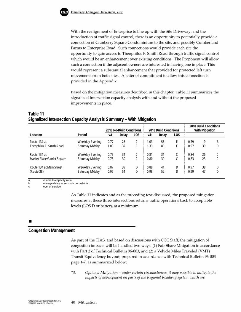
\\vhb\proj\Wat-LD\11822.00\reports\May 2013 TIAS\TIAS_May-06-2013-Final.doc 40 Mitigation
With the realignment of Enterprise to line up with the Site Driveway, and the introduction of traffic signal control, there is an opportunity to potentially provide a connection of Cranberry Square Condominium to the site, and possibly Cumberland Farms to Enterprise Road. Such connections would provide each site the opportunity to gain access to Theophilus F. Smith Road through traffic signal control which would be an enhancement over existing conditions. The Proponent will allow such a connection if the adjacent owners are interested in having one in place. This would represent a substantial enhancement that provided for protected left turn movements from both sites. A letter of commitment to allow this connection is provided in the Appendix. Based on the mitigation measures described in this chapter, Table 11 summarizes the signalized intersection capacity analysis with and without the proposed improvements in place.
Table 11 Signalized Intersection Capacity Analysis Summary – With Mitigation
2018 No-Build Conditions 2018 Build Conditions 2018 Build Conditions
With Mitigation Location Period v/c Delay LOS v/c Delay LOS Route 134 at Weekday Evening 0.77 26 C 1.03 56 E 0.79 19 B Theophilus F. Smith Road Saturday Midday 1.00 32 C 1.33 80 F 0.97 39 D Route 134 at Weekday Evening 0.79 31 C 0.81 31 C 0.84 26 C Market Place/Patriot Square Saturday Midday 0.78 30 C 0.80 30 C 0.83 23 C Route 134 at Main Street Weekday Evening 0.87 39 D 0.88 41 D 0.97 38 D (Route 28) Saturday Midday 0.97 51 D 0.98 52 D 0.99 47 D
a volume to capacity ratio b average delay in seconds per vehicle c level of service
As Table 11 indicates and as the preceding text discussed, the proposed mitigation measures at these three intersections returns traffic operations back to acceptable levels (LOS D or better), at a minimum.
Congestion Management
As part of the TIAS, and based on discussions with CCC Staff, the mitigation of congestion impacts will be handled two ways: (1) Fair Share Mitigation in accordance with Part 2 of Technical Bulletin 96-003, and (2) a Vehicle Miles Traveled (VMT) Transit Equivalency buyout, prepared in accordance with Technical Bulletin 96-003 page 1-7, as summarized below: “3. Optional Mitigation – under certain circumstances, it may possible to mitigate the
impacts of development on parts of the Regional Roadway system which are

\\vhb\proj\Wat-LD\11822.00\reports\May 2013 TIAS\TIAS_May-06-2013-Final.doc 41 Mitigation
impacted by fewer than 25 trips through a transit equivalency buyout. The applicant should discuss the possibility of using this buyout with the CCC before applying it. If approved for use by the CCC, the following procedure should be followed:
(a.) The applicant should choose a study area wide cutoff for actual peak hour mitigation by selecting a number of new peak hour trips of less than 25.
(b.) For all links inside the “cutoff”, a summation of the vehicle miles of travel (VMT) covered in the actual mitigation plan should be calculated by multiplying the number of peak hour peak season trips on each Regional Roadway link by the length of each link, and summing over the links inside the cutoff.
(c.) The overall VMT of the project should be calculated by multiplying the project’s new peak hour trips by the “analysis trip length” as defined in Part 3 of these guidelines.
(d.) The remaining VMT to be mitigated should be calculated by subtracting the result of (2.) from the result of (3.). This net VMT should be mitigated through a fee paid to CCC/Barnstable County based on the transit equivalency of this VMT as outlined in Part 3 of these guidelines. These funds will be expended by the CCC to improve transportation in the project’s study area and/or town(s) and/or according to MPS 4.1.3.4.
(e.) The applicant is still responsible for providing mitigation as directed by MPS 4.1.3.4 and other RPP requirements for all links and intersections inside the cutoff area.”
Regarding specific impacted intersections, MPS TR3.4 states, “At all adversely impacts locations, mitigation shall be proposed and funded to maintain year-round Level of Service at ‘no-build’ conditions”. At locations within the study area that experience a drop in level of service based on the Build conditions analysis, fair share mitigation will be proposed to address such impacts, as described in the following section.
Fair Share Mitigation
In addition to the intersection/roadway mitigation and the TDM strategies proposed as part of the project, the Proponent has proposed “fair share” improvements within the study area. It is important to note that the following mitigation is proposed to achieve compliance with the RPP and will supplement the proposed TDM program and intersection/roadway mitigation measures that have already been discussed. It should also be noted that the fair share contribution values contained in Table 12 were prepared in accordance with Technical Bulletin 96-003 and were calculated based on the trip generation and trip distribution discussed in Chapter 3 Future Conditions. The fair share mitigation provides a contribution towards additional improvements to the transportation infrastructure throughout this area. The following section describes the program.

\\vhb\proj\Wat-LD\11822.00\reports\May 2013 TIAS\TIAS_May-06-2013-Final.doc 42 Mitigation
Intersections
Old Bass River Road at Bob Crowell Road
Under 2018 No Build conditions, independent of the proposed project, this unsignalized intersection is expected to operate at LOS E during the weekday evening and Saturday midday peak hour periods, respectively. Under 2018 Build conditions with the proposed project in place, this intersection is expected to continue to operate at LOS F during peak hours. An evaluation of the vehicle crash history for this intersection showed only a total of five crashes over the three-year study period. In terms of intersection capacity, the only feasible means of increasing capacity would be through the installation of a traffic signal. The Proponent will make a fair share contribution towards such an improvement as shown in Table 12.
Route 134 at Theophilus F. Smith Road
Under 2018 No Build conditions, independent of the proposed project, this unsignalized intersection is expected to operate at LOS C during the weekday evening and Saturday midday peak hour periods. Under 2018 Build conditions with the proposed project in place, this intersection is expected to operate at LOS E and LOS F during the weekday evening and Saturday midday peak hour periods, respectively. Mitigation has been proposed that results in this intersection operating at LOS C during the weekday evening peak hour and LOS D during the Saturday midday peak hour. To comply with the MPS TR3.4, this intersection must be brought back to No Build level of service. To accomplish this, a right-turn lane could be installed on the Route 134 northbound approach. The Proponent will make a fair share contribution towards such an improvement as shown in Table 12.
Route 134 at Route 6 Westbound Off Ramp
Under 2018 No Build conditions, independent of the proposed project, this unsignalized intersection is expected to operate at LOS C during the weekday evening and Saturday midday peak hour periods. Under 2018 Build conditions with the proposed project in place, this intersection is expected to continue operate at LOS D during both peak hours. In terms of intersection capacity, the most feasible means of increasing capacity would be through the installation of a second southbound travel lane. The Proponent will make a fair share contribution towards such an improvement as shown in Table 12.
\\vhb\proj\Wat-LD\11822.00\reports\May 2013 TIAS\TIAS_May-06-2013-Final.doc 43 Mitigation
Great Western Road at Depot Street (East)
Under 2018 No Build conditions, independent of the proposed project, this unsignalized intersection is expected to operate at LOS C during the weekday evening peak hour and LOS D during the Saturday midday peak hour. Under 2018 Build conditions with the proposed project in place, this intersection is expected to continue operate at LOS C during the weekday evening peak hour but will drop to LOS D during the Saturday midday peak hour. In terms of intersection capacity, the only feasible means of increasing capacity would be through the installation of a traffic signal. The proponent will make a fair share contribution towards such an improvement as shown in Table 12.
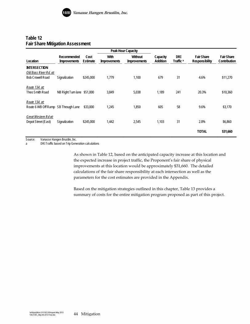
\\vhb\proj\Wat-LD\11822.00\reports\May 2013 TIAS\TIAS_May-06-2013-Final.doc 44 Mitigation
Table 12 Fair Share Mitigation Assessment Peak Hour Capacity
Location
Recommended Improvements
Cost Estimate
With Improvements
Without Improvements
Capacity Addition
DRI Traffic a
Fair Share Responsibility
Fair Share Contribution
INTERSECTION Old Bass River Rd. at: Bob Crowell Road Signalization $245,000 1,779 1,100 679 31 4.6% $11,270 Route 134. at: Theo Smith Road NB Right Turn lane $51,000 3,849 5,038 1,189 241 20.3% $10,360 Route 134. at: Route 6 WB Off Ramp SB Through Lane $33,000 1,245 1,850 605 58 9.6% $3,170 Great Western Rd at: Depot Street (East) Signalization $245,000 1,442 2,545 1,103 31 2.8% $6,860 TOTAL $31,660 Source: Vanasse Hangen Brustlin, Inc. a DRI Traffic based on Trip Generation calculations
As shown in Table 12, based on the anticipated capacity increase at this location and the expected increase in project traffic, the Proponent’s fair share of physical improvements at this location would be approximately $31,660. The detailed calculations of the fair share responsibility at each intersection as well as the parameters for the cost estimates are provided in the Appendix. Based on the mitigation strategies outlined in this chapter, Table 13 provides a summary of costs for the entire mitigation program proposed as part of this project.

\\vhb\proj\Wat-LD\11822.00\reports\May 2013 TIAS\TIAS_May-06-2013-Final.doc 45 Mitigation
Table 13 Mitigation Plan Cost Summary
Mitigation Action
Description
Approximate First Year Cost *
Approximate Annual Cost
Transportation Demand Management
Program
Proposed TDM Program including:
Ridesharing program
Bicycle/Pedestrian amenities (with transit stop on site)
On-site services for employees, patrons, and residents
$15,000 $5,000
Trip Reduction (MPS TR2.11) Monetary contribution in accordance with MPS
TR0.4 $140,000 NA
Level of Service/Congestion
Management (MPS TR3.4)
Intersection and site access capacity
improvements along TFS Road $690,000 NA
Congestion Impact Mitigation (MPS
TR3.6)
Monetary contribution to offset increase in vehicle
miles traveled $676,600 NA
Fair Share Improvements (MPS TR3.6) Five locations summarized in Table 12 $31,660 NA
Safety Improvements (MPS TR1.1) Mitigation measures at 9 locations:
Theophilus F. Smith Road and Enterprise Road/Site Driveways
Route 134 and Theophilus F. Smith Road
Route 134 and Market Place/Patriot Square Access Driveway
Route 134 and Route 6 Eastbound Ramps
Route 134 and Route 6 Westbound Ramps
Route 134 at Airline Road
Route 134 and Bob Crowell Road
Route 134 and Main Street (Route 28)
Route 134 at Center Street
$75,000 NA
Total Program Cost $1,628,260 $5,000
* The costs provided in Table 13 are estimates and may need to be modified during the review process. Cost estimates, specific mitigation commitments, and
allocation of funds are subject to change based on CCC Staff review.

\\vhb\proj\Wat-LD\11822.00\reports\May 2013 TIAS\TIAS_May-06-2013-Final.doc 46 Mitigation
Conclusion
Vanasse Hangen Brustlin, Inc. (VHB) has prepared to submit a traffic impact and access study (TIAS) for the proposed Lowe’s Home Improvement Center. Access to the site would be provided by three driveways on TFS Road. The easternmost driveway will be an unsignalized T-type intersection with TFS Road which will be designated for truck delivery. The middle site driveway will be a T-type intersection with TFS Road and will be limited to right-turn in/right-turn out access. The westernmost driveway will be under traffic signal control and will involve the realignment of Enterprise Road to form the southbound approach to the intersection. By introducing the traffic signal and realigning Enterprise Road to align with the site driveway, we are providing access management along this corridor. The study area for the project included the following 21 intersections: Theophilus F. Smith Road and Site Driveways (3) Theophilus F. Smith Road at Duck Pond Road/S. Gages Way Route 134 and Theophilus F. Smith Road Route 134 and Market Place/Patriot Square Access Driveway Theophilus F. Smith Road and Enterprise Road Main Street at High Bank Road Old Bass River Road at Bob Crowell Road Old Bass River Road at Mayfair Road Route 134 and Route 6 Interchange (four-intersections) Route 134 at Airline Road Route 134 and Bob Crowell Road Route 134 and Upper County Road Route 134 and Main Street (Route 28) S. Gages Way at Great Western Road Great Western Road at Depot Street (Harwich) Depot Street at Depot Road (Harwich) The proposed project is expected to result in a total of 2,104 net new trips (1,052 entering/1,052 exiting) on a typical weekday and 3,912 net new trips (1,956 entering/1,956 exiting) on a typical Saturday. The proposed project is expected to result in a total 215 net new vehicle trips (117 entering/98 exiting) during the weekday evening peak hour and 301 net new vehicle trips (157 entering/144 exiting) during the Saturday midday peak hour.
6

\\vhb\proj\Wat-LD\11822.00\reports\May 2013 TIAS\TIAS_May-06-2013-Final.doc 47 Mitigation
Capacity analyses were conducted for each of the study area intersections and roadway links under 2013 Existing conditions, 2018 No-Build conditions (without the proposed development), and 2018 Build conditions (with the proposed development). Based on the results of these analyses and the anticipated site-generated traffic, the proponent will implement the following measures: Comprehensive Transportation Demand Management Program Provide monetary contribution in accordance with MPS TR0.4 Intersection safety and/or capacity enhancements at:
o Theophilus F. Smith Road and Enterprise Road/Site Driveways o Route 134 and Theophilus F. Smith Road o Route 134 and Market Place/Patriot Square Access Driveway o Route 134 and Route 6 Eastbound Ramps o Route 134 and Route 6 Westbound Ramps o Route 134 and Airline Road o Route 134 and Bob Crowell Road o Route 134 and Main Street (Route 28) o Route 134 at Center Street
Fair Share contribution towards additional improvements in the study area Overall, VHB concludes that the implementation of the above-mentioned mitigation measures not only accommodates future site-generated traffic but also improves some existing operational deficiencies in the vicinity of the site.