public consultation 2017 - highways england · technical appraisal report public consultation 2017....
TRANSCRIPT

Volu
me
1A303 StonehengeAmesbury to Berwick Down Technical Appraisal Report
Public Consultation 2017

A303 Amesbury to Berwick Down | HE551506
Table of contents
Chapter Pages
Executive summary 1 Purpose of report 1
Problems and opportunities 1
Scheme objectives 2
Options identification 2
Initial Corridor appraisal – Design Fix A 2
Development of route options within corridors – Design Fix B 5
Initial route options appraisal – Design Fix C 6
Further route options appraisal 9
Appraisal summary 14
Programme 14
Overall Summary 15
1 Introduction 16 1.1 Purpose of this report 16
1.2 Scheme context 16
1.3 Scheme history 18
1.4 Technical reports 27
1.5 Structure of the report 27
2 Planning brief 30 2.1 Introduction 30
2.2 Client Scheme Requirements 30
2.3 Expansion on headline requirements 30
3 Existing conditions 32 3.1 Engineering conditions 32
3.2 Environmental status 49
3.3 Environmental conditions 50
3.4 Social conditions 56
3.5 Distributional conditions 58
3.6 Maintenance and repair strategy statement 59
3.7 Other relevant factors 62
4 Planning context 64 4.1 Introduction 64
4.2 UK Legislation and European Directives 64
4.3 National policy 66
4.4 Other relevant policy and strategy 68
4.5 Local policy 70
5 Initial corridors appraisal 72 5.1 Introduction 72
5.2 Initial corridors identification and appraisal 72

A303 Amesbury to Berwick Down | HE551506
HE551506-AA-GEN-SWI-RP-CX-000020 |P13, S0| 21/12/2016
6 Development of route options within corridors 104 6.1 Introduction 104
6.2 Basis of geometric design 104
7 Initial route options appraisal 118 7.1 Introduction 118
7.2 Route option proposals for assessment 118
7.3 Appraisal methodology 118
7.4 Corridor D route options assessment 124
7.5 Corridor F route options assessment 133
7.6 Conclusions 144
8 Description of route options for further appraisal 145 8.1 Introduction 145
8.2 Route descriptions 145
8.3 Road layout 149
8.4 Highway design relaxations and departures from standards 150
8.5 Junction and side roads strategy 150
8.6 Carriageway lighting 153
8.7 Impact on existing utilities 153
8.8 Proposed structures 154
8.9 Public Rights of Way (PRoW) 155
8.10 Tunnel design with Route Options D061 and D062 155
8.11 Earthworks 157
8.12 Surface water drainage 158
8.13 Buildability 159
9 Client Scheme Requirements and policy assessment 162 9.1 Introduction 162
9.2 Assessment methodology 162
9.3 Assessment 163
9.4 Summary and conclusions 167
10 Traffic analysis and modelling 170 10.1 Introduction 170
10.2 Initial corridors appraisal (Design Fix A) traffic modelling 170
10.3 Initial route options appraisal (Design Fix C) traffic modelling 175
10.4 Further WebTAG appraisal traffic modelling 180
10.5 Road layout and standards 186
10.6 Conclusions 191
11 Economic assessment 194 11.1 Introduction 194
11.2 Overview 194
11.3 Presentation of results 196
11.4 Approach 196
11.5 Results – Typically monetised impacts (initial BCR) 208
11.6 Results – Other transport and economic impacts (adjusted BCR) 209

A303 Amesbury to Berwick Down | HE551506
HE551506-AA-GEN-SWI-RP-CX-000020 |P13, S0| 21/12/2016
11.7 Results – Other Monetised Impacts 209
11.8 Results – supplementary approach to wider economic benefits 210
11.9 Sensitivity Tests 210
11.10 Programmatic Appraisal 211
11.11 Economic assessment conclusions 212
12 Social assessment 215 12.1 Introduction 215
12.2 Assessment methodologies 215
12.3 Assessment 220
12.4 Conclusions 224
13 Distributional impact assessment 226 13.1 Introduction 226
13.2 Assessment methodology 227
13.3 Assessment 228
14 Safety assessment 234 14.1 Introduction 234
14.2 Impact on road user 234
14.3 Impact during construction, maintenance, operation and demolition (CDM) 241
15 Operational assessment 243 15.1 Introduction 243
15.2 Schemes operating regime 243
15.3 Driver compliance 245
15.4 Conclusion 245
16 Technology assessment 246 16.1 Introduction 246
16.2 Option design implications of ITS systems 246
16.3 Regional Control Centre systems and sub systems 247
16.4 Conclusion 248
17 Maintenance assessment 249 17.1 Introduction 249
17.2 Maintenance and repair strategy for civils 249
17.3 Maintenance and repair strategy for technology 250
17.4 Conclusion 250
18 Environmental assessment 252 18.1 Introduction 252
19 Stakeholder engagement 268
20 Appraisal summary 277 20.1 Introduction 277
20.2 Appraisal Summary Tables (ASTs) 281
21 Programme 284
21.1 Introduction 284
21.2 Key milestones 284

A303 Amesbury to Berwick Down | HE551506
HE551506-AA-GEN-SWI-RP-CX-000020 |P13, S0| 21/12/2016
22 Overall Summary 285
GLOSSARY 288
GLOSSARY DESCRIPTIONS 292
Appendix A Existing conditions 303
A.1 Existing features 304
A.2 Existing public utilities 305
A.3 Existing geology mapping 306
A.4 Existing traffic, journey time and accident data 307
A.5 Environmental constraints 308
Appendix B Initial corridors appraisal (Design Fix A) 309
B.1 Historical routes 310
B.2 Corridors identified 311
B.3 Environmental assessment methodology and scoring assessment 312
B.4 Client Scheme Requirements 313
B.5 Environmental NPSNN assessment 314
B.6 EAST assessment 315
B.7 Better performing corridors 316
Appendix C Development of route options within preferred corridors (Design Fix B) 317
C.1 Corridor D with historic routes 318
C.2 Corridor D rationalised route options 319
C.3 Corridor D route options for initial appraisal 320
C.4 Corridor F with historic routes 321
C.5 Corridor F rationalised route options 322
C.6 Corridor F historic route rationalisation table 323
C.7 Corridor F refined route options 327
C.8 Corridor F route options for initial appraisal 328
Appendix D Initial route option assessment (Design Fix C) 329 D.1 Initial route option assessment (Design Fix C) 330
Appendix E Route options for further appraisal 331 E.1 Route options for further appraisal (D001, D003 and F010) 332
E.2 Intermediate route options (D031, D032 and F010) 333
E.3 Amended route options for further appraisal (D061, D062 and F010) 334
Appendix F Description of route options for further appraisal 335 F.1 Route Option D061 proposed layout 336
F.2 Route Option D062 proposed layout 337
F.3 Route Option F010 proposed layout 338
Appendix G Client Scheme Requirements and policy assessment 339 G.1 Client Scheme Requirements and policy assessment 340
Appendix H Assessment summary 341
H.1 Appraisal summary tables 342

A303 Amesbury to Berwick Down | HE551506
HE551506-AA-GEN-SWI-RP-CX-000020 |P13, S0| 21/12/2016
Table of Figures
Figure 1 Options identification process ...................................................................... 2
Figure 2 Better performing corridor options (Design Fix A) ........................................ 5 Figure 3 Corridor D route options for initial appraisal ................................................. 7 Figure 4 Corridor F route options for initial appraisal ................................................. 9 Figure 5 Route options for further appraisal ..............................................................10 Figure 1-1 A303/A30 trunk route and Amesbury to Berwick Down scheme ...........16
Figure 1-2 Schemes to deliver an Expressway to the South West ........................18 Figure 1-3 Examples of alternative routes considered ...........................................20 Figure 1-4 Scheme published in 2003 for A303 Stonehenge Improvement ..............23 Figure 1-5 Plan showing location of relocated Stonehenge Visitor Centre ............25 Figure 1-6 Highways England's Project Control Framework structure ......................27
Figure 3-1 A303 Amesbury to Berwick Down scheme assessment area ...............32 Figure 3-2 Proximity of Stonehenge to the A303 ...................................................33 Figure 3-3 Climate graph – Boscombe Down ............................................................35
Figure 3-4 Distribution of traffic on the A303 at Stonehenge .....................................43 Figure 3-5 A303 – Westbound daily traffic by day and month ...................................44 Figure 3-6 A303 – Eastbound daily traffic by day and month ....................................44 Figure 3-7 A303 through traffic (between Hampshire border and Winterbourne Stoke) ..................................................................................................................................46 Figure 3-8 Accident section locations ........................................................................48
Figure 3-9 Accident sections between Amesbury to Berwick Down ..........................49 Figure 5-1 Options identification process ..................................................................72 Figure 5-2 Corridor A - Surface routes more than 1km north of A303 (outside WHS) ..................................................................................................................................75 Figure 5-3 Corridor B - Surface routes more than 1km north of A303 (at least partially within WHS) ..............................................................................................................76 Figure 5-4 Corridor C - Surface routes within 1.0 km of the existing A303 (at least partially within WHS) .................................................................................................77 Figure 5-5 Corridor D - Partially tunnelled route options within 1.0km (on plan) of the existing A303 (partially within WHS)..........................................................................78 Figure 5-6 Corridor E - Surface routes and more than 1km south of A303 (at least partially within WHS) .................................................................................................79 Figure 5-7 Corridor F (north) – Surface routes south of A303 (outside WHS) and north of Salisbury ...............................................................................................................80 Figure 5-8 Corridor F (south) - Routes south of A303 (outside WHS) and north of Salisbury ...................................................................................................................81 Figure 5-9 Corridor G - Surface route south of A303 (outside WHS) and South of Salisbury ...................................................................................................................82
Figure 6-1 Rural dual carriageway cross section ....................................................105 Figure 10-1 Existing road network with indicative corridor appraisal routes tested .172 Figure 10-2 2041 PM peak forecast traffic flows – Corridor D .................................176 Figure 10-3 2041 PM peak forecast traffic flows – Difference from Do Minimum – Corridor D ................................................................................................................177
Figure 10-4 2041 PM peak forecast traffic flows – Option F010 ..............................177 Figure 10-5 2041 PM peak forecast traffic flows – Difference from Do Minimum – Option F010 ............................................................................................................178
Figure 10-6 2041 PM peak forecast traffic flows – Option F004 ..............................178 Figure 10-7 2041 PM peak forecast traffic flows – Difference from Do Minimum – Option F004 ............................................................................................................179

A303 Amesbury to Berwick Down | HE551506
HE551506-AA-GEN-SWI-RP-CX-000020 |P13, S0| 21/12/2016
Figure 10-8 2041 PM peak forecast traffic flows – Option F005 ..............................179 Figure 10-9 2041 PM peak forecast traffic flows – Difference from Do Minimum – Option F005 ............................................................................................................180 Figure 10-10 Local model area containing detailed modelling ................................181
Figure 10-11 SATURN highway modelling process ................................................183 Figure 15-1 Potential northern diversion of high load route option ..........................245 Figure 19-1 Stakeholder engagement and communications strategy documents ...268
Table of Tables
Table 1 Route options length and journey time comparison ......................................10 Table 2 CSR assessment summary ..........................................................................14 Table 3-1 Existing carriageway – Miscellaneous minor junctions ..............................36
Table 3-2 Existing laybys ..........................................................................................38 Table 3-3 Existing public utilities ...............................................................................40 Table 3-4 Existing technology equipment ..................................................................42 Table 3-5 Accidents by severity and year ..................................................................48
Table 3-6 CO2 emissions associated with road transport in Wiltshire, South Somerset and North Dorset for 2014 .........................................................................................51 Table 3-7 Statutory and non-statutory designated sites ............................................53 Table 3-8 Existing structures .....................................................................................60
Table 3-9 Carriageway lighting ..................................................................................62 Table 3-10 Corridor scheme assumptions .................................................................63
Table 4-1 Wiltshire Core Strategy strategic objectives and core policies ..................70 Table 4-2 Wiltshire Local Transport Plan goals and strategic objectives...................71
Table 5-1 Five point scoring scale .............................................................................84 Table 5-2 EAST: Overall scores for each of the five cases ......................................91 Table 5-3 Five point scoring scale ........................................................................93
Table 5-4 Results of assessment against Client Scheme Requirements ..............94 Table 5-5 Results of assessment against NPSNN environmental criteria .........95
Table 5-6 Details of the assessment against EAST Cases ......................................99 Table 5-7 Overall Corridor assessment summary ..................................................100 Table 6-1 Corridor D design review 1 summary ................................................110 Table 6-2 F001, F004 and F005 route option drivers .............................................114
Table 6-3 Development of Route Options F010, F011 and F012 ...........................115 Table 7-1 Qualitative scale for degree of fit with CSRs ...........................................120 Table 8-1 Opening Year AADT values on A303, peak hour and 12 hour flows (DMRB 46/97 - Table 2.1) ....................................................................................................149 Table 8-2 Forecast AADT on A303 .........................................................................149 Table 8-3 2039 AADT flows on the proposed A303 ................................................151 Table 9-1 Client Scheme Requirements summary table .........................................163
Table 9-2 National policy summary table ................................................................165 Table 9-3 Local policy summary table .....................................................................166 Table 10-1 Routes tested ........................................................................................171 Table 10-2 Network speed curves ...........................................................................173 Table 10-3 Passenger car unit (PCU) factors ..........................................................184
Table 10-4 Future Corridor CRF and stresses without scheme - Neutral month (March) ................................................................................................................................187 Table 10-5 Future Corridor CRF and stresses without scheme - Summer month (August) ...................................................................................................................188

A303 Amesbury to Berwick Down | HE551506
HE551506-AA-GEN-SWI-RP-CX-000020 |P13, S0| 21/12/2016
Table 10-6 Future Corridor CRF and stresses with scheme - Neutral month (March) ................................................................................................................................189 Table 10-7 Future Corridor CRF and stresses with scheme - Summer month (August) ................................................................................................................................190
Table 10-8 Traffic flows in time periods for future years – Option D061 ..................192 Table 10-9 Traffic flows in time periods for future years – Option D062 ..................192 Table 10-10 Traffic flows in time periods for future years – Option F010 ................193 Table 11-1 Respondents ‘Willing to Pay’ for the Proposed Scheme .......................203 Table 11-2 Aggregate Willingness to Pay/Accept ...................................................204
Table 11-3 Upper and Lower Bound Estimates .......................................................204 Table 11-4 Monetised Landscape Impacts (excluding removal of existing A303) £m 2010 Prices and Values ..........................................................................................206
Table 11-5 A303/A30/A358 Route option scheme assumptions .............................206 Table 11-6 A303/A30/A358 corridor scheme assumptions .....................................207 Table 11-7 Scheme level appraisal: initial BCR (‘Most likely’ cost estimates) .........208 Table 11-8 Scheme level appraisal: adjusted BCR (‘Most likely’ cost estimates) ................................................................................................................................209
Table 11-9 Appraisal Results Including Monetised Heritage and Landscape Impacts ................................................................................................................................209 Table 11-10 Scheme Level Appraisal:.....................................................................210
Table 11-11 Sensitivity Test: Low Capital Cost .......................................................210 Table 11-12 Sensitivity Test: High Capital Cost ......................................................211 Table 11-13 Sensitivity Test: High Traffic Growth ...................................................211
Table 11-14 Sensitivity Test: Low Traffic Growth ....................................................211
Table 11-15 Programmatic Appraisal ......................................................................212 Table 11-16 Economic Appraisal Results – Initial and Adjusted BCRs ...................213 Table 11-17 Economic Appraisal Results – Initial and Adjusted BCRs ...................213
Table 12-1 Journey quality assessment scale .........................................................217 Table 12-2 Assessment of change in severance .....................................................218
Table 12-3 Overall severance assessment scale ....................................................218 Table 12-4 Assessment of change in security .........................................................219 Table 12-5 Overall security assessment scale ........................................................219 Table 12-6 Assessment of change in affordability ...................................................219
Table 12-7 Overall option values assessment scale ...............................................220 Table 12-8 Social impacts summary .......................................................................225 Table 13-1 Distributional impacts scoring ................................................................227
Table 13-2 Distribution impacts summary ...............................................................233
Table 18-1 Route Option D061 quantitative noise effects .......................................257 Table 18-2 Route Option D062 quantitative noise effects .......................................258 Table 18-3 Route Option F010 quantitative noise effects........................................259
Table 18-4 TAG local air quality assessment results summary ...............................260 Table 18-5 TAG greenhouse gas assessment results summary .............................260 Table 18-6 Summary of environmental assessment outcomes ...............................266 Table 19-1 Details of stakeholder working groups and forums ................................269 Table 19-2 Key findings from stakeholder responses..............................................273
Table 20-1 Route options journey time comparison ................................................277 Table 20-2 Social impacts summary .......................................................................279 Table 20-3 Distribution impacts summary ...............................................................280
Table 20-4 AST assessment comparison ............................................................282 Table 20-5 Summary of assessment within the ASTs .............................................283

A303 Amesbury to Berwick Down | HE551506
HE551506-AA-GEN-SWI-RP-CX-000020 | P13, S0 21/12/2016 PAGE 1 OF 301
Executive summary
Purpose of report
This Technical Appraisal Report (TAR), produced as part of the Project Control Framework (PCF) Stage 1 (Options identification), reports on the existing problems and constraints along the study area of the existing A303 between Amesbury and Berwick Down. This includes the unique constraint created by the road passing through the heart of Stonehenge, Avebury and Associated Sites World Heritage Site (WHS), within 165 metres of the iconic, ancient stone circle. Building on previous studies, the TAR reports on potential alternative sustainable solutions for this section of the A303, detailing the identification, sifting and appraisal of route options to determine which should be taken forward for Public Consultation.
Problems and opportunities
The key problems and opportunities that the A303 Amesbury to Berwick Down scheme would address are:
Stonehenge, Avebury and Associated Sites World Heritage Site (WHS) – At its closest point the existing A303 passes within 165 metres of the Stonehenge monument and creates highly intrusive sights and sounds of traffic, detracting from an ideally tranquil rural setting for the Stones. The existing A303 runs through the heart of the WHS dividing it in two. This impacts on people’s experience and understanding of the WHS, by limiting the safe mobility of visitors and opportunities to explore the area south of the A303. Stonehenge is an important economic asset in its own right, both in respect of its iconic status and the 1.3 million visitors it attracts each year.
Local and regional economy – The A303 is recognised as a strategic route to the South West. Enhancing this corridor is expected to deliver region-wide economic benefits by improving regional connectivity, facilitating planned growth in housing and jobs, and by improving the perceptions of tourists who use the A303 to travel to the region.
Strategic traffic issues – The section of the A303 between Amesbury and Berwick Down operates at almost twice its capacity with an Annual Average Daily Traffic (AADT) of 24,000 vehicles. The congestion experienced at weekends and during the summer months results in lengthy delays for users, with increased journey times westbound past Stonehenge of up to an hour on Saturdays in August.
Local traffic issues – Local communities are directly affected both by traffic on the A303, and also that which is seeking to avoid congestion and delays on the main route. This has a severe impact on communities at busy times. For example, on a typical Friday in August, traffic volumes on the A360 through Shrewton are nearly 60% higher than on a normal weekday.
Safety –The rate of personal injury accidents on this section of the A303 is higher than the national average for A roads.
Environment and community – The A303 passes through a rural area of gentle rolling chalk downland with expansive views. The tranquillity of the landscape in the WHS is disturbed by views of traffic on the A303 and the associated constant background noise. The A303 passes through the village of Winterbourne Stoke, much of which is a Conservation Area. Existing road safety and traffic calming infrastructure have a damaging effect on the character and setting of the village. High traffic noise levels and reduced air quality impact on the quality of everyday life for residents.
Local communities and the WHS – The A303 creates a physical barrier between the WHS and the local community of Amesbury. Redirecting the A303 presents an opportunity to reconnect Amesbury with the WHS.

A303 Amesbury to Berwick Down | HE551506
HE551506-AA-GEN-SWI-RP-CX-000020 | P13, S0 21/12/2016 PAGE 2 OF 301
Scheme objectives
The scheme objectives have been formulated both to address the identified problems and to take advantage of the opportunities that new infrastructure would provide.
The objectives are defined in the Department for Transport’s (DfT’s) Client Scheme Requirements (CSRs) which respond directly to the need for change:
Transport – To create a high quality route that resolves current and predicted traffic problems and contributes towards the creation of an Expressway between London and the South West.
Economic growth – In combination with other schemes on the route, to enable growth in jobs and housing by providing a free flowing and reliable connection between the East and the South West peninsula.
Cultural heritage – To contribute to the conservation and enhancement of the WHS by improving access both within and to the site.
Environment and community – To contribute to the enhancement of the historic landscape within the WHS, to improve biodiversity along the route and to provide a positive legacy to communities adjoining the road.
Success will constitute the delivery of a scheme which realises these objectives.
Options identification
Process
A three stage process of options identification and sifting was followed to shortlist route options to be subsequently taken through the further more detailed appraisal to confirm the route options for consultation.
The three stages of options identification and sifting are outlined in Figure 1 below and were defined as follows:
a) Design Fix A – Initial Corridor Options appraisal to identify preferred corridor options. b) Design Fix B – Development of possible route options within preferred corridors. c) Design Fix C – Initial route options appraisal to identify options for further appraisal.
Figure 1 Options identification process
Initial Corridor appraisal – Design Fix A
Identification of corridor options
There have been a wide range of proposed solutions to traffic problems on the A303 at Stonehenge over many years. A review was undertaken of some 60 route options that have been proposed by Government, stakeholders and the public in the past. These options were grouped into a series of corridors which contained route options with similar characteristics.
DESIGN FIX A - INITIAL
CORRIDOR APPRAISAL
DESIGN FIX B - ROUTE OPTIONS DEVELOPMENT
DESIGN FIX C - INITIAL ROUTE
OPTIONS APPRAISAL
RECOMMENDED ROUTE OPTIONS
FOR CONSULTATION
FURTHER WebTAG
APPRAISAL

A303 Amesbury to Berwick Down | HE551506
HE551506-AA-GEN-SWI-RP-CX-000020 | P13, S0 21/12/2016 PAGE 3 OF 301
This resulted in eight corridors, representing the groups of route options described as follows, and illustrated in Appendix B2:
Corridor A – Surface routes north of the existing A303 (wholly outside WHS).
Corridor B – Surface routes north of the existing A303 (partially inside WHS).
Corridor C – Surface routes within 1.0 km of the existing A303 (as the route options pass through the WHS).
Corridor D – Routes including a tunnel (at least partially within the WHS).
Corridor E – Surface routes south of the existing A303 (at least partially inside WHS).
Corridor F (north) – Surface routes south of the existing A303 (wholly outside WHS) and north of Salisbury.
Corridor F (south) – Surface routes south of the existing A303 (wholly outside WHS) and north of Salisbury, further south than Corridor F (north).
Corridor G – Surface routes south of the existing A303 (wholly outside WHS) and south of Salisbury.
The objective of this phase of the selection process (Design Fix A) was to undertake a multi-criteria assessment of the eight corridors and ultimately to recommend corridor(s) to be taken forward for further consideration.
The assessment and appraisal methodology used the following three criteria:
a) Client Scheme Requirements. b) Web-based Transport Appraisal Guidance’s (WebTAG) Early Assessment and Sifting
Tool (EAST).
c) National Policy Statement for National Networks (NPSNN) environmental aspects.
Key outcomes of the appraisal
Surface route options within the WHS (Corridors B, C and E)
Surface route options within the WHS would offer transport benefits and could be delivered at a lower cost than a tunnelled solution but would be considered unacceptable from a cultural heritage point of view.
A surface route close to the existing A303 would fail to reduce severance within the WHS and would cause substantial harm to the Outstanding Universal Value (OUV) of the site.
Options involving a surface route to the north or south of the existing A303 would reduce the visual and noise impacts of the road on the Stonehenge monument itself but any such route would still affect the character of the WHS and would also cause substantial harm to the OUV of the site.
National Trust and Historic England have identified that a surface route through the WHS has the potential to ‘compound and multiply’ the harmful effects of the existing A303 and they would be unable to support surface dualling due to these very large adverse effects. They considered the harmful effects to be of such a large scale that it would likely lead to the inclusion of the WHS within the UNESCO’s World Heritage “in danger” list and may even lead to the loss of the WHS designation for Stonehenge and Avebury.
Tunnelled Routes within the WHS (Corridor D)
A tunnelled route through the WHS would reduce severance within the WHS and improve the setting of key assets such as Stonehenge. The surface elements may cause adverse effects on the character of the WHS but it is considered that substantial harm can be avoided

A303 Amesbury to Berwick Down | HE551506
HE551506-AA-GEN-SWI-RP-CX-000020 | P13, S0 21/12/2016 PAGE 4 OF 301
with appropriate design. A tunnelled route has the potential to contribute to the enhancement of the historic landscape within the WHS. Notwithstanding its high capital cost, a tunnelled route would deliver transport and economic benefits in line with the objectives for the scheme.
Surface Routes outside the WHS (Corridors A, F (north and south) and G)
Because of the location of adjacent settlements, there is limited scope to realign the A303 to the north of the WHS (Corridor A), however, a route that would skirt the northern boundary of the WHS was considered. Such an option would reduce severance within the WHS, but it would also have substantial harmful impacts on other sensitive assets. On balance, the harmful impacts would outweigh the benefits associated with the removal of the A303 through the WHS.
Corridor F surface route options to the south of the WHS would remove the A303 from the WHS in its entirety. This would bring substantial benefits by reducing severance and improving the setting of key assets, including the Stonehenge monument. These benefits would need to be balanced against adverse environmental effects of constructing a longer route within a high quality, unspoilt landscape with the associated loss of habitats.
Surface route options to the south of the WHS would also offer a less direct route for through traffic and would therefore offer reduced transport benefits. More traffic would also remain or divert onto local roads, giving rise to adverse impacts on local villages and communities.
A surface route to the south of Salisbury was also considered (Corridor G). The length of such an option would lead to substantially increased habitat loss and severance compared to other corridors and it would also impact a significant number of communities and designated nature conservation sites. This option, whilst offering improved access to Salisbury would also fail to reduce journey times for users of the A303 through this section. On this basis, the corridor was not considered to meet the transport and environmental objectives of the scheme.
Better performing corridor options
On the basis of the initial assessments, as summarised above, Corridors A, B, C, E and G were not taken forward for further consideration. This left tunnel options within Corridor D and surface options within Corridor F (north) and Corridor F (south) being taken forward for further consideration in Design Fix B. These are shown in Appendix E and also in Figure 2 below.

A303 Amesbury to Berwick Down | HE551506
HE551506-AA-GEN-SWI-RP-CX-000020 | P13, S0 21/12/2016 PAGE 5 OF 301
Figure 2 Better performing corridor options (Design Fix A)
Development of route options within corridors – Design Fix B
Design Fix B involved identifying the most appropriate route options for assessment within the two better performing corridors identified from Design Fix A. The route options were chosen to best represent the range of historical routes within each corridor.
Corridor D route options – Tunnelled options through the WHS
The purpose of a tunnelled solution would be to remove the A303 from the most sensitive part of the WHS, thereby reducing severance and enhancing the character of the WHS.
In respect of the length of the tunnel, an appropriate balance would need to be achieved between affordability and impact. The Road Investment Strategy (RIS) outlines the Government’s intention to construct a tunnel of at least 1.8 miles (2.9 km). A tunnel of approximately 2.9km would deliver benefits to the setting of significant features in the Stonehenge landscape and would also allow the portal locations to be sited optimally to the west of the Normanton Down Barrow Group and to the east of the ceremonial route of The Avenue.
A range of alternative tunnel alignments with various portal locations were developed with the tunnel portals positioned such that the road would no longer be visible from Stonehenge.
A number of options with longer 4.5km tunnel solutions were also developed with the tunnels running the full width of the WHS. This removed any surface route sections of these options within the WHS resulting in increased benefits for the WHS.

A303 Amesbury to Berwick Down | HE551506
HE551506-AA-GEN-SWI-RP-CX-000020 | P13, S0 21/12/2016 PAGE 6 OF 301
To the western end of the scheme, a bypass of Winterbourne Stoke was included in line with scheme requirements. Route options both to the north and south of Winterbourne Stoke were considered.
Corridor F route options - Surface route options to the south of the WHS
Within the surface corridor to the south of the WHS, three possible route options were identified which sought to minimise impacts on local villages in this area and to reduce adverse impacts on the high quality landscape and biodiversity.
The most northerly option would pass close to the southern boundary of the WHS and to the south of Winterbourne Stoke before re-joining the A303 at Berwick Down. The most southerly option would pass to the south of the village of Little Dunford, passing between Berwick Down and Stapleford, avoiding the Area of Outstanding Natural Beauty (AONB), before reconnecting with the existing A303 to the west of Winterbourne Stoke. All route options were aligned to avoid impact to Boscombe Down Airfield.
In general terms, the more southerly route options would cost more and would deliver reduced transport benefits by increasing the length of the A303 for through traffic. Additionally, the further south that the A303 is realigned, the more traffic remains on or diverted to local roads, with adverse impacts on local villages and communities.
Initial route options appraisal – Design Fix C
Assessment methodology
The methodology used to appraise and sift the route options, within the better performing Corridors D and F, followed the same principles of the corridors’ assessment and used the Options Assessment Framework contained in the WebTAG Transport Appraisal Process, based around the Transport Business Case Five Case Model criteria. The assessment primarily focused on the Strategic Fit assessment (fit with policy and CSRs) and the Value for Money assessment which includes impact on the economy and the environment.
Corridor D route options initial appraisal
Route options incorporating 4.5km tunnels were assessed as having significantly higher estimated scheme costs that were considered to be unaffordable and were not considered further in the assessment.
The remaining Corridor D route options each incorporated a 2.9km tunnel under part of the WHS and were approximately 13km in overall length. These are illustrated in Figure 3, and are summarised as follows:
Route Option D001: Approximately 2.9km length tunnel with route running north of Winterbourne Stoke, eastern tunnel portal located east of The Avenue and the western tunnel portal located west of Normanton Gorse to minimise visual impact to and from Stonehenge.
Route Option D003: Approximately 2.9km length tunnel with route running south of Winterbourne Stoke, eastern tunnel portal located east of The Avenue and the western tunnel portal located west of Normanton Gorse to minimise visual impact to and from Stonehenge.
Route Option D021: Approximately 2.9km length tunnel with route running north of Winterbourne Stoke, eastern tunnel portal located west of The Avenue and the western tunnel portal located further west of Normanton Gorse.

A303 Amesbury to Berwick Down | HE551506
HE551506-AA-GEN-SWI-RP-CX-000020 | P13, S0 21/12/2016 PAGE 7 OF 301
Route Option D022: Approximately 2.9km length tunnel with route running south of Winterbourne Stoke, eastern tunnel portal located west of The Avenue and the western tunnel portal located further west of Normanton Gorse.
Figure 3 Corridor D route options for initial appraisal
The assessment and comparison of these four Corridor D route options demonstrated all options were comparable in terms of the Strategic Fit (fit with policy and CSRs), Financial (scheme costs) and Delivery (deliverability and acceptability) cases. However, there were notable differences within the Value for Money assessment, specifically in terms of environmental impact.
In terms of their impact on the WHS, all of the options would improve the setting of many Scheduled Monuments central to the OUV of the WHS, including Stonehenge itself.
The eastern tunnel portal location for options D001 and D003 would enable the reconnection of The Avenue which is considered a very substantial benefit. The resulting western tunnel portal location with options D001 and D003 has the potential to cause substantial harm to the Normanton Down Barrow Group and other important monuments, ultimately harming the OUV of the WHS. Careful attention to the design and associated mitigation would be required during design development of both options, to reduce its impact on these key assets.
In comparison options D021 and D022 perform less well. Whilst the western tunnel portal location lies further west away from the Normanton Down Barrow Group than options D001 and D003, with the impacts here being lower in scale and number, there are still a number of significant adverse effects on the setting of scheduled monuments, including the Normanton Down Barrow Group. In addition the eastern tunnel portal location to the west of

A303 Amesbury to Berwick Down | HE551506
HE551506-AA-GEN-SWI-RP-CX-000020 | P13, S0 21/12/2016 PAGE 8 OF 301
The Avenue would result in additional severance of The Avenue that would likely directly effect the OUV of the WHS.
There was little to differentiate between the options of routing to the north or south of Winterbourne Stoke.
Of the four remaining Corridor D options, it was concluded that the likely best performing, affordable route options were Options D001 and D003 with the environmental benefits of the eastern tunnel portal being east of The Avenue which was supported by the key stakeholders.
Corridor F route options initial appraisal
The three options within Corridor F run south of the WHS connecting to the existing A303 west of Winterbourne Stoke and east of Amesbury. Completely removing the A303 from within the WHS would substantially improve the setting of over 100 Scheduled Monuments and would provide significant benefits for the WHS in terms of conservation, access and visitor experience.
These route options are shown on Figure 4 below, and are summarised as follows:
Route Option F004: Surface route running from the A303 in the west between Berwick St. James and Stapleford avoiding the AONB. The route continues between Middle Woodford and Lower Woodford, crossing the River Avon avoiding existing buildings and then passes to the south of Boscombe Down Airfield before connecting back to the existing A303 east of Amesbury.
Route Option F005: Surface route running from the A303 in the west between Berwick St. James and Stapleford avoiding the AONB. The central section runs south of the Little Durnford and then passes to the south of Boscombe Down Airfield, following the same alignment as route F004 before reconnecting with the existing A303 east of Amesbury.
Route Option F010: Surface route running from the A303 in the west between Winterbourne Stoke and Berwick St. James. The route then continues east, keeping to the south of the WHS boundary but north of Upper Woodford before running south of the Boscombe Down Airfield following the same alignment as Route Options F004 and F005 before reconnecting with the existing A303 east of Amesbury.

A303 Amesbury to Berwick Down | HE551506
HE551506-AA-GEN-SWI-RP-CX-000020 | P13, S0 21/12/2016 PAGE 9 OF 301
Figure 4 Corridor F route options for initial appraisal
The assessment and comparison of the three Corridor F route options clearly demonstrated that option F010 out-performed the other two route options across all the assessment criteria, with its shorter length and associated journey time and economic benefits and with the reduced environmental and social impacts.
Further route options appraisal
Further development of Corridor D route options
Further design development was undertaken on the position of the eastern portal in relation to the existing A303. It was found that the portal could be moved further to the south to be as close as practicable to the existing road whilst allowing traffic flow on the existing road to be maintained during construction. The decision was made to incorporate this change into these route options and by doing so D001 was updated and re-named as D031 and D003 was updated and re-named as D032.
As part of the option selection and assessment work on revised Route Options D031 and D032, a programme of geophysical surveys was undertaken to investigate the possible presence of buried archaeological features along the two options. This identified two Neolithic long barrows and a henge-type enclosure to the east of the A360 and within the likely construction footprint of both options. These were considered to be important archaeological features that contribute to the OUV of the WHS. These features were considered to be adversely affected by the D031 and D032 route options and the decision was made to adjust both route options by moving them locally further to the south to avoid physical impact on these assets.
The amendment of the two route options also aimed to accommodate the junction intentions for each option and maintain full standard highway geometry, whilst minimising impact on key environmental constraints and maintaining the balanced earthworks strategy where

A303 Amesbury to Berwick Down | HE551506
HE551506-AA-GEN-SWI-RP-CX-000020 | P13, S0 21/12/2016 PAGE 10 OF 301
possible. These changes were introduced into D031 and D032 and the revised route options were re-named as D061 and D062 respectively.
The further WebTAG route options appraisal, as recorded in the second half of this report assesses the three route options as D061, D062 and F010 as shown on Figure 5.
Figure 5 Route options for further appraisal
Further appraisal of Route Options
The best performing amended route options D061, D062 and F010 have then been subject to a further full WebTAG appraisal to determine the route options to be taken forward to public consultation and further design development.
Traffic and journey times
The increase in the new overall A303 route length with the three route options and the associated journey time savings were calculated between the adjacent existing intersections with the A36 and the A338 outside of the scheme and the results are provided in Table 1 below.
Table 1 Route options length and journey time comparison
Route options
Approximate increased length of route between A36
and A338 compared with existing
(km)
Average journey time between A36 and A338
(mins)
Average journey time savings from do-
minimum
(mins)
D061 0.4 13 4
D062 0.4 13 4

A303 Amesbury to Berwick Down | HE551506
HE551506-AA-GEN-SWI-RP-CX-000020 | P13, S0 21/12/2016 PAGE 11 OF 301
Route options
Approximate increased length of route between A36
and A338 compared with existing
(km)
Average journey time between A36 and A338
(mins)
Average journey time savings from do-
minimum
(mins)
F010 4.1 14.25 2.75
The modelling also indicated that the longer F010 route option would lead to more long distance traffic using the local road network (rat running), more than doubling the volume of traffic currently diverting through the villages of Durrington, Larkhill and Shrewton. This would lead to increased noise, worsened air quality and a greater likelihood of accidents along the local roads and through the local communities.
Scheme Costs
Indicative scheme costs, discounted to 2010 prices, appropriate to this stage in the scheme development were developed.
Perceived scheme benefits for each of the options have also been developed based upon the traffic forecast model in order to inform the emerging Appraisal Summary Tables (ASTs) as well as allowing the reporting of indicative Benefit to Cost Ratios (BCRs).
Economic assessment
The purpose of the economic assessment was to provide a quantified assessment of value for money. The results of the economic assessment are summarised in the BCR for the scheme options.
The economic assessment of the scheme options was undertaken in accordance with WebTAG guidance. Typically, the appraisal of transport schemes is focussed on the benefits delivered to users in respect of faster journeys and reduced vehicle operating costs. However, in view of the objectives of the scheme, an innovative approach to the economic assessment was taken which considers impacts on the WHS, so far as they can be monetised.
If assessed only on the basis of those impacts which are typically monetised in transport appraisal, the BCRs for the three options were as follows:
• Route Option D061 - 0.5
• Route Option D062 - 0.6
• Route Option F010 - 0.3
On this basis, the tunnelled options (Route Option D061 and D062) were slightly preferred to the surface route option (F010) on transport and economic grounds. There is no significant difference between the economic performances of the two tunnelled options. Whilst D061 and D062 are preferred, the differences between the tunnelled and surface route options is relatively slight. It should also be noted that the ranking of options is sensitive to key assumptions (most notably project costs) for which there is some uncertainty at this stage.
However, the final judgement of value for money for the A303 Amesbury to Berwick Down must consider the impacts on the WHS and the wider non-monetised landscape and environmental impacts.

A303 Amesbury to Berwick Down | HE551506
HE551506-AA-GEN-SWI-RP-CX-000020 | P13, S0 21/12/2016 PAGE 12 OF 301
Quantifying impacts on the WHS is highly challenging and required an innovative approach. In accordance with HM Treasury Green Book guidance, a Contingent Valuation study was undertaken which sought to place a value on the benefits of removing the A303 from the vicinity of Stonehenge. The study focussed on the value placed on the scheme – In relation to noise reduction, increased tranquillity, visual amenity and reduced landscape severance at Stonehenge – by visitors to Stonehenge, A303 road users and the population of the UK more widely.
The benefits of removing the road from the WHS were balanced against monetised estimates of the adverse impacts of the scheme options on the landscape more generally. Such impacts would be particularly severe for F010 which would involve the construction of an offline dual carriageway through an otherwise tranquil rural environment.
The ranged BCRs for the scheme options when such impacts were included are as follows:
Route Option D061 - 1.3 – 1.5
Route Option D062 - 1.4 – 1.6
Route Option F010 - 1.4 – 1.7
With this broader perspective the scheme would deliver benefits in excess of costs, whilst the BCRs for the options are of a similar magnitude.
It should also be noted that the appraisal results at this stage are likely to understate the benefits of the scheme. A complementary approach to wider economic benefits assessment was implemented which is intended to provide a more tailored assessment of the economic impact of the scheme. This assessment indicates that wider economic benefits were likely to be higher than the WebTAG based Wider Impacts methodology suggests.
Furthermore, analysis was undertaken which demonstrates that the transport and economic benefits of the A303 Amesbury to Berwick Down scheme are greater when considered as part of the overall Expressway programme.
Taking these factors into account, at this stage of the assessment, the A303 Amesbury to Berwick Down was assessed as being a ‘medium’ value for money scheme.
Social Impact assessment
The Social Impacts assessment considered the impact of the scheme on both local residents and users of the transport network. The assessment identified no differences between Route Options D061 and D062. The key differentiators between F010 and D061/D062 were Physical Activity and Severance, with F010 performing worse with the increased number of communities and numbers of pedestrians considered to be affected by the options. F010 also scores slight worse in terms of affordability with the increased length and vehicle operating costs.
Distributional impacts assessment
The distributional impacts assessment considered the variance of transport intervention impacts across different social groups. Overall, there is no significant difference in impact between Route Options D061 and D062, and these perform better than the surface route option with fewer criteria having adverse impacts.
Safety assessment
All options were assessed to have a positive impact upon on road safety as the existing section of the route has a high accident record, and all new options would increase capacity

A303 Amesbury to Berwick Down | HE551506
HE551506-AA-GEN-SWI-RP-CX-000020 | P13, S0 21/12/2016 PAGE 13 OF 301
and be designed to high safety standards. As a result of having shorter travel distances, options D061 and D062 were assessed to have the potential to deliver greater in-service accident benefits over option F010.
In relation to Construction, Design, and Management (CDM) safety assessment, Options D061 and D062 would involve significant tunnel construction, a highly specialised and technically complex activity, which was considered to be a significant construction risk activity, but was assessed as manageable. The options would also include the construction of a significant viaduct across the River Till, which would mean a significant amount of working at height over a water hazard, another significant but manageable construction risk. Route Option F010 would require two significant viaducts over the River Till and River Avon.
Operational, technology and maintenance assessments
In terms of performance against the assessment criteria of operation, technology and maintenance, all options performed to a similar level with Route Options D061 and D062 requiring enhanced operation and maintenance technology features specific to the tunnel.
Engagement with public body stakeholders
Engagement with statutory consultees has been ongoing through Spring and Summer 2016 to keep them informed of the development and appraisal of corridors and route options with feedback incorporated into the process.
Environmental assessment
WebTAG environmental appraisals were undertaken on each of the three route options.
For all options it is predicted that properties affected in the study area would experience low levels of change in noise, with a small number of properties assessed as experiencing noise nuisance. All options would provide noise benefits, with the level of noise reduction around Winterbourne Stoke better for Route Option D062 and Route Option F010 having further noise benefits for properties in Amesbury.
In terms of greenhouse gases all options would result in an increase in user carbon, with F010 resulting in the greatest increase due to vehicle flows and the much longer distance travelled. For air quality, the increase in vehicle flows and the much longer distance travelled for F010 would also result in the highest NOx emissions. For all options air quality receptors within 200m would experience a reduction in exposure to PM10 emissions, leading to improved local air quality. This improvement is offset for all options by the overall increase in exposure to NOx leading to an overall reduction in air quality.
In terms of landscape both D061 and D062 would have a Moderate Adverse effect with scope for further mitigation during design development. For F010 the magnitude of change and the sensitivity of the high quality rural landscape along the approximate 21.5 km length and the visual impacts of the highly intrusive crossing of the Upper Avon Valley would result in a Very Large Adverse effect on the landscape with limited scope for mitigation.
For the historic environment, both Route Options D061 and D062 would result in an overall Neutral score compared with a Large Beneficial effect for F010. In terms of the WHS, F010 would also result in a Large Beneficial effect, whilst D061 would result in a Slight/Moderate Beneficial effect and D062 a slightly greater Moderate Beneficial effect. These differences are due to the routing of D062 west of the western portal where it avoids important archaeological remains and uses local topography to better fit into the landscape of the WHS.

A303 Amesbury to Berwick Down | HE551506
HE551506-AA-GEN-SWI-RP-CX-000020 | P13, S0 21/12/2016 PAGE 14 OF 301
For Route Options D061 and D062 biodiversity and the water environment have both been assigned the same level of Large Adverse effect, with potential effects on water environment predicted to substantially reduce post construction. For biodiversity, mitigation through design development is predicted to result in a reduction in the scale of impact. Route Option F010 crosses 2.4km a Special Protection Zone 2 (SPZ) which is reflected in the Moderate Adverse assessment for water environment. For biodiversity F010 is nearly twice the length of D061 and D062 and at surface level would result in a Very Large Adverse effect. This is due to the direct adverse impacts to internationally (European) and nationally designated ecological sites.
Client Scheme Requirements
The performance of the route options was assessed against the Client Scheme Requirements and the relevant national and local policy objectives. The results of the CSR assessment are illustrated within Table 2 below based on a three-point scale (3 – Strong alignment; 2 – Moderate alignment; and 1 Weak alignment).
Table 2 CSR assessment summary
Document Client Scheme Requirements D061 D062 F010
Client Scheme Requirements
Transport: to create a high quality route that resolves current and predicted traffic problems and contributes towards the creation of an Expressway between London and the South West
3 3 2
Economic growth: in combination with other schemes on the route, to enable growth in jobs and housing by providing a free flowing and reliable connection between the East and the South West peninsula
3 3 2
Cultural heritage: to contribute to the conservation and enhancement of the WHS by improving access both within and to the site
2 2 3
Environment and community: to contribute to the enhancement of the historic landscape within the WHS, to improve biodiversity along the route, and to provide a positive legacy to communities adjoining the road
3 3 2
In overall terms, Route Options D061 and D062 align more closely with CSRs and the relevant national and local policy objectives than F010.
Appraisal summary
Appraisal Summary Tables (ASTs) were produced for each of the three route options to collate all the assessments against the criteria of Economy, Environmental, Social and Distributional impacts and Public Accounts.
A comparison of the ASTs for each of the options would conclude that, on balance, options D061 and D062 perform better than option F010 in terms of the assessed impacts. Key differentiators are the significant additional benefits experienced by road users travelling on the shorter route options within Corridor D. This compares with the more favourable performance of F010 in terms of impact on the Historic Environment and its lower overall scheme cost estimate, against a much longer route with a bigger footprint within a high quality landscape through local communities.
Programme
Route Options D061 and D062 could be delivered to meet the Road Investment Strategy (RIS) programme dates and achieve a start on site by March 2020. Route Option F010

A303 Amesbury to Berwick Down | HE551506
HE551506-AA-GEN-SWI-RP-CX-000020 | P13, S0 21/12/2016 PAGE 15 OF 301
would require additional survey information leading to a 12 month delay relative to Route Options D061 and D062, and thus would achieve a later start on site date of March 2021.
Overall Summary
From the appraisal undertaken, it is recommended that the following route options are taken forward to Stage 2 for public consultation and further design development and appraisal to determine the preferred route for the scheme:
Route Option D061 – 2.9km length tunnel with route running north of Winterbourne Stoke, the eastern tunnel portal located east of The Avenue and the western tunnel portal located west of Normanton Gorse.
Route Option D062 – 2.9km length tunnel with route running south of Winterbourne Stoke, the eastern tunnel portal located east of The Avenue and the western tunnel portal located west of Normanton Gorse.

A303 Amesbury to Berwick Down | HE551506
HE551506-AA-GEN-SWI-RP-CX-000020 | P13, S0 21/12/2016 PAGE 16 OF 301
1 Introduction
1.1 Purpose of this report
1.1.1 This Technical Appraisal Report (TAR) reports on the existing problems and constraints along the study area of the existing A303 between Amesbury and Berwick Down. This includes the unique constraint created by the road passing through the heart of Stonehenge, Avebury and Associated Sites World Heritage Site (WHS), within 165 metres of the iconic, ancient stone circle. Building on previous studies, the TAR reports on potential alternative sustainable solutions for this section of the A303, detailing the identification, sifting and appraisal of route options to determine which should be taken forward for Public Consultation.
1.1.2 In summary, the purpose of this report is to:
Validate the need for the scheme under the terms of reference set out in Highways England's Planning Brief for the scheme.
Identify and appraise sustainable options following the Department for Transport’s (DfT’s) Transport Analysis Guidance (TAG).
Describe, with relevant detail, alternative route options investigated and set out reasons for rejection of any of those alternatives.
Advise on the option(s) for Public Consultation.
1.1.3 An explanation of terminology used in this report is included within the glossary for guidance.
1.2 Scheme context
1.2.1 The A303 Amesbury to Berwick Down scheme forms part of the A303/A30 trunk route, as illustrated in Figure 1-1. The route provides vital east-west connectivity between London and the South West and is also part of the Trans-European Network-Transport (TEN-T).
Figure 1-1 A303/A30 trunk route and Amesbury to Berwick Down scheme
HE551506-AA-HML-SWI-SK-CX-000001

A303 Amesbury to Berwick Down | HE551506
HE551506-AA-GEN-SWI-RP-CX-000020 | P13, S0 21/12/2016 PAGE 17 OF 301
1.2.2 The A303 runs for approximately 150km from Junction 8 of the M3 near Basingstoke towards Taunton and Exeter. After 135km, the A303 reaches Ilminster and the Southfields Roundabout junction with the A358, which then continues for 15km to Taunton and Junction 25 with the M5. The A303 continues towards Exeter, passing through the Blackdown Hills Area of Outstanding Natural Beauty (AONB). About 10km before Honiton it joins the A30 and then continues as the A30 for some 35km to J29 with the M5 at Exeter. From here the A30 continues for another 175km to Penzance.
1.2.3 As well as serving long distance traffic, the A303 also serves intermediate regional destinations via connecting major north-south route options, including:
A34 trunk road which runs between Southampton and the Midlands, carrying considerable freight traffic to and from the port.
A338 principal road which runs from Bournemouth, via Salisbury, towards Marlborough and Swindon.
A36 trunk road which links Southampton and Salisbury with Warminster, Trowbridge and onwards to Bath and Bristol.
A350 principal road which runs from Poole, via Blandford Forum, Shaftesbury and Warminster, towards Trowbridge and on to Chippenham.
A37 principal road which connects Weymouth, Dorchester and Yeovil to Bristol.
1.2.4 The A303 also has an important local function - providing access to various small and medium sized settlements along the route.
1.2.5 The A303 'spine', and its wider network connections, are therefore vital to the economic prosperity of the South West by enabling the efficient movement of people and goods. However, current levels of service do not reflect the importance of the route as part of the Strategic Road Network (SRN). In particular there are several single carriageway sections (totalling more than 55km) where customers suffer unreliable journeys, with long delays and an increased risk of accidents. Congestion problems are acute on weekends and during summer months, when over an hour can be added to a typical journey from London to Exeter. Frustrations are great for many of the 6 million visits to the South West made annually via the A303 by residents of London and the south-east, as well as many of the 2 million overseas visitors to the region.
1.2.6 With the South West economy needing better levels of transport service, the region's Councils and Enterprise Partnerships have been calling for improvements to be made. They believe such improvements could create more than 20,000 jobs and generate more than £40bn Gross Value Added contribution over 60 years.
Expressway to the South West
1.2.7 Recognising the importance of the A303/A30/A358 Corridor and the problems along it, the Government has committed in its Road Investment Strategy (RIS) (https://www.gov.uk/government/publications/road-investment-strategy-for-the-
‘Transformation of the A303/A30/A358 route to the south-west will revolutionise perceptions of the region’s accessibility, bring about a
step-change in unlocking our area’s competitive potential and deliver a more prosperous economy’
Chairman of the Heart of the south-west Local Enterprise Partnership

A303 Amesbury to Berwick Down | HE551506
HE551506-AA-GEN-SWI-RP-CX-000020 | P13, S0 21/12/2016 PAGE 18 OF 301
2015-to-2020-road-period) to create an 'Expressway' to the South West via the A303/A358 route by 2029. The Expressway is intended to transform connectivity to and from the South West, providing a consistent and dependable service to customers. A key aspiration is to achieve 'mile a minute' journey times by creating free-flowing traffic conditions along the whole route.
1.2.8 Creating the Expressway involves upgrading the entire A303/A358 route between the M3 and Taunton to dual carriageway standard and upgrading junctions to remove congestion bottlenecks. A series of eight major improvement schemes along the A303/A358 was identified as part of an overall investment package for the entire A303/A358/A30 corridor. The eight schemes along the A303/A358 route are illustrated in Figure 1-2 below, along with the section of A303/A30 from Southfields to Honiton, which will not be part of the Expressway, but where smaller-scale measures are proposed to improve safety and journey quality for road users.
Figure 1-2 Schemes to deliver an Expressway to the South West
1.2.9 Within the RIS, three major improvements were prioritised and committed to start before the end of the first RIS period (2015/16 to 2019/20):
Dualling the A358 between Taunton and Southfields.
Dualling the A303 between Sparkford and Ilchester.
Dualling the A303 between Amesbury and Berwick Down, including the construction of a tunnel at least 2.9km long as the road passes Stonehenge.
1.2.10 This sets the wider strategic context for the Amesbury to Berwick Down scheme, which has an extensive background history in the search for an affordable, acceptable solution, as described below.
1.3 Scheme history
1.3.1 Proposals for the improvement of the A303 between Amesbury and Berwick Down have been the subject of extensive study and consultation since 1991. The main events providing background context to the current scheme are:
HE551506-AA-HML-SWI-SK-CX-000002
A303 Amesbury to Berwick Down | HE551506
HE551506-AA-GEN-SWI-RP-CX-000020 | P13, S0 21/12/2016 PAGE 19 OF 301
1991-93: Initial route identification
1993: Public Consultation
1994-95: Further route identification
1995: Planning Conference
1996: Scheme withdrawn from Roads Programme
1998: Scheme re-introduced to Roads Programme
1999: Public Consultation
1999: Preferred Route announced (with 2km cut-and-cover tunnel)
2000-02: Review of tunnel options
2002: 2.1km bored tunnel announced
2003-04: Draft Orders and Public Inquiry
2005-07: Post-Inquiry scheme Review
2007: Scheme withdrawn from Roads Programme
2013: New Visitor Centre opened for Stonehenge
2014: A303/A30/A358 Corridor Feasibility Study
2014: Scheme re-introduced to Roads Programme
1.3.2 The above events are summarised below:
1.3.3 1991-93: Initial route identification - During this period, over 50 possible route options were considered for the scheme within four broad route corridors:
Far Northern corridor - Routes north of the existing A303, passing between Shrewton and Winterbourne Stoke via Larkhill, Durrington and Bulford.
Local corridor - Routes falling within 1km either side of the existing A303 and providing a bypass of Winterbourne Stoke.
Near Southern corridor - Routes taking advantage of many dry valleys found in the WHS landscape to the near south of the existing A303.
Far Southern corridor - Routes dropping south of the existing A303 from Berwick Down, crossing the downland between the Till and Avon Valleys then turning north to re-join the existing A303 in the vicinity of Amesbury.
1.3.4 The range of route options is illustrated on Figure 1-3 below. Following initial assessment, shortlisted options were selected for presentation to the Landscape Advisory Committee (LAC) in July 1992. (The LAC was at that time the relevant advisory body on route options.) Advice received from the LAC indicated a preference for a northern bypass of Winterbourne Stoke (Red or Blue route), with the Blue route being more favoured than Red because of its reduced landtake in open countryside. To the east, the LAC supported the Yellow route, within a 500m long tunnel past Stonehenge. The Grey (surface) route was recommended for further consideration if the Yellow (tunnel) route was rejected.

A303 Amesbury to Berwick Down | HE551506
HE551506-AA-GEN-SWI-RP-CX-000020 | P13, S0 21/12/2016 PAGE 20 OF 301
Figure 1-3 Examples of alternative routes considered
1.3.5 1993: Public consultation - Following the recommendations of the LAC, the Red, Blue, Yellow and Grey route options were taken forward for Public Consultation in April 1993. But there was no consensus on a preferred solution, and both Yellow and Grey route options would have necessitated the acquisition of land held inalienably by the National Trust, who advised that they would be obliged to require the Government to invoke Special Parliamentary Procedure to acquire the land affected. As a result, it was decided to investigate further options in order to determine a way forward.
1.3.6 1994-95: Further route identification - In February 1994, the Royal Fine Art Commission (RFAC) (subsequently replaced by the Commission for Architecture and the Built Environment (CABE) in 1999, which in turn merged with the Design Council in 2011) provided comments on the scheme. They thought that the Grey route, in following the lie of the land south of Stonehenge, would impinge on the fine but not unique landscape, but they also believed it would "provide a humane solution for the motorist which the long tunnel would not". They considered that partial tunnelling could address the problem of National Trust inalienable land. They also encouraged further investigation of northern route options. Then, in July 1994, a one-day international conference was hosted by English Heritage and the National Trust to debate solutions both for a road improvement and a new visitor centre for Stonehenge. In recognition of widespread concerns expressed by many, and particularly by English Heritage and the National Trust, the Yellow and Grey route options were withdrawn by the then Minister for Transport at the conference because their environmental impact on the WHS was considered to be unacceptable. The finding of the conference was in favour of further investigation of northern route options and longer tunnel solutions. This led to the Purple route options being developed. Various lengthy tunnel options were also considered along the line of the existing A303 and these were taken forward into the 1995 Planning Conference.
1.3.7 1995: Planning conference - In September 1995, the Highways Agency held a Public Exhibition on the new route options. Additionally, a Planning Conference
Highways England, June 2003, A303 Stonehenge Improvement Environmental Statement

A303 Amesbury to Berwick Down | HE551506
HE551506-AA-GEN-SWI-RP-CX-000020 | P13, S0 21/12/2016 PAGE 21 OF 301
was then held in November 1995 to give the public and other interested organisations an opportunity to explore and debate possible ways of overcoming the problems on this stretch of trunk road. The Conference was independently chaired. It was attended and supported throughout by organisations including English Heritage, the National Trust, Department of National Heritage, the Ministry of Defence, Council for British Archaeology, Wiltshire Archaeology and Natural History Society, County, District and Parish Councillors and residents from local communities. The Highways Agency did not advocate any particular route and the Conference was free to look at all possible solutions. The Conference rejected the surface northern route options, because their impacts were deemed unacceptable, and instead supported, in principle, a 4km long tunnel under the WHS, but recognised the difficulty of funding such a scheme from the Roads Programme. The Conference also recognised the urgent need for a bypass of Winterbourne Stoke.
1.3.8 1996: Scheme withdrawn from roads programme - The 4km long tunnel solution favoured by the Planning Conference was carefully considered, but was not considered an affordable solution, even recognising the importance of the WHS. The Government made it clear that, without an alternative source of funding being found, there was no prospect of the longer tunnel solution being pursued at that time. The scheme was therefore withdrawn from the Roads Programme in 1996.
1.3.9 1998: Scheme re-introduced to roads programme - 'Exceptional Environmental scheme' emerges. In late 1997 Ministers from the Department for Culture, Media and Sport (DCMS) and the then Department of the Environment, Transport and the Regions (DETR) reviewed the potential improvement of this stretch of A303. This included proposals initiated by English Heritage for the on-line dualling of the A303 in a 2km cut-and-cover tunnel. These proposals were an attempt to find an acceptable, affordable solution, and had the support, in principle, of the National Trust. The proposals followed the same line as the Yellow route considered at the 1993 Public Consultation, but with the length of tunnel increased from 500m to 2km. A joint working party comprising representatives from DETR, DCMS, Government Office for the South West, English Heritage, National Trust and the Highways Agency was established to oversee further study. English Heritage believed that the impacts of the Yellow, Grey and Purple surface route options made them unacceptable on heritage grounds alone. The study concluded that the proposed 2km on-line tunnel would provide significant benefits to the setting of Stonehenge within the WHS and that any new impacts would be restricted to the vicinity of the existing road. The support of English Heritage and the National Trust meant that it was seen as being deliverable. However, the higher cost and lower economic return of this tunnel option meant that it was likely that additional funds from other sources would be required. The Stonehenge Improvement (including the Winterbourne Stoke Bypass) with a 2km cut-and-cover tunnel was announced as an 'Exceptional Environmental Scheme' in 'A New Deal for Trunk Roads in England' in July 1998. At least a third of the funding was to be provided from heritage sources, in recognition that the tunnel was being provided specifically to secure environmental benefits for Stonehenge WHS.
1.3.10 January 1999: Public consultation - The scheme announced in July 1998 formed an integral part of the Government's vision for the WHS as set out in the 'Stonehenge Master Plan' (English Heritage and National Trust 1999), which included a proposed new Visitor Centre adjacent to the A303/A345 Countess Roundabout. Public Consultation commenced in January 1999 with a public

A303 Amesbury to Berwick Down | HE551506
HE551506-AA-GEN-SWI-RP-CX-000020 | P13, S0 21/12/2016 PAGE 22 OF 301
exhibition staged jointly by the Highways Agency and English Heritage, supported by DETR, DCMS, the National Trust and Wiltshire Council. There was general agreement between these parties on the significant environmental benefits afforded to the WHS by the 2km cut-and-cover tunnel. In general, the proposals received good support, with only limited opposition. There was also strong support for the scheme to be extended at its eastern end to incorporate grade-separated improvement of Countess Roundabout.
1.3.11 June 1999: Preferred route announcement - A Preferred Route, incorporating an on-line 2km cut-and-cover tunnel, was announced in June 1999.This was the first time that the Highways Agency had been able to promote the A303 scheme with widespread support and a realistic prospect of funding. Previous attempts to find solutions at Stonehenge via affordable schemes, delivering transport benefits alone, had never won sufficient support. It was the agreement of Treasury to innovative joint funding from transport and heritage sources (in recognition of the environmental benefits), combined with the support of the major landowner - the National Trust - that provided the basis of a partnership that was seen as being able to secure the delivery of the scheme. With the scheme also being essential to the delivery of the WHS Management Plan objectives, support for the Preferred Route and tunnel also came from the International Committee on Monuments and Sites (ICOMOS), advisors to UNESCO's World Heritage Committee. The World Heritage Committee in turn supported the general approach adopted for dealing with the problems of the WHS through the Stonehenge Master Plan, noting in 2001 ICOMOS's confirmation that they were in full agreement with the proposals for a 2km cut-and-cover tunnel. The Secretary of State for Transport then made a follow-up announcement, in July 2000, confirming that grade-separated improvement of Countess Roundabout would also be included in the scheme.
1.3.12 2000-02: Review of tunnel options - Following the Preferred Route announcement, other tunnel options were reviewed to ensure the best investment decision could be taken to provide a solution. Construction from the surface had consistently been shown to be less costly, but it was recognised that a cut-and-cover tunnel would cause greater disturbance during construction than a bored option and would have greater potential for damaging undiscovered archaeological assets. A bored tunnel option was therefore deemed worthy of further assessment. During the process, it was identified that an extension of the tunnel by 100m in an easterly direction would bring significant benefits by taking the tunnel portal further away from King Barrow Ridge and Stonehenge Cottages. This 100m extension was therefore added to the options for further investigation. Additionally, various organisations including English Heritage, the National Trust, ICOMOS (UK), the Campaign for the Protection of Rural England (CPRE), the Wiltshire Archaeological and Natural History Society (WANHS) and the Council for British Archaeology (CBA), as well as a number of individuals, wished to compare the benefits and costs of a long bored tunnel. It was agreed with these parties that the layout of the long bored tunnel would be similar to that identified at the 1995 Planning Conference, and would extend over a distance of approximately 4.5km. The limits of this tunnel would be a point west of Longbarrow Roundabout and a point east of where The Avenue (ancient ceremonial route between Stonehenge and the River Avon) crosses the existing A303. During discussions on the portal locations for a tunnel (held with the National Trust, ICOMOS (UK), CBA, WANHS and CPRE), a further intermediate option (2.7km long) was identified. This combined the western portal location for the 2.0km/2.1km tunnel option with the eastern portal location of the 4.5km option. The comparison between all the assessed tunnel options was

A303 Amesbury to Berwick Down | HE551506
HE551506-AA-GEN-SWI-RP-CX-000020 | P13, S0 21/12/2016 PAGE 23 OF 301
reported in A303 Stonehenge Improvement Comparison of Tunnel Options and presented to Ministers in late 2002.
1.3.13 December 2002: 2.1km bored tunnel announced - On 10 December 2002 the Secretary of State for Culture, Media and Sport and the Secretary of State for Transport jointly announced that: "after reviewing the options, and taking advice from English Heritage, we have agreed that the Government's preferred option is a 2.1km bored tunnel. This will enable the long overdue improvements at Stonehenge to go ahead in a way which protects the unique environment of Stonehenge as well as improving journey times and safety for vehicles travelling to and from the South West." Ministers were persuaded that the tunnel length should be extended from 2.0km to 2.1km and that the method of construction should change from cut-and-cover to bored, but they were not persuaded that the longer tunnel options would secure sufficient additional environmental benefits to justify the further additional costs of investment that would arise. As part of the decision making on the choice of tunnel, the funding agreement between DCMS and DfT was revised to the effect that DCMS would contribute a fixed sum of £70m towards the construction cost.
1.3.14 2003-04: Draft orders and public inquiry - The draft line, de-trunking, slip road, side road and compulsory purchase Orders and Environmental Statement for the A303 Stonehenge Improvement, with its 2.1km bored tunnel were published in June 2003 on the basis of the Published scheme illustrated in Figure 1-4 below.
Figure 1-4 Scheme published in 2003 for A303 Stonehenge Improvement
1.3.15 Objections to the draft orders - Led to a public inquiry being held into the Published scheme between 17 February 2004 and 11 May 2004. The Inspector's report was published on 20 July 2005 with recommendations that the Orders for the Published scheme be made as drafted, subject to minor modifications.
1.3.16 2005-07: Post-inquiry review - Coincident with the publication of the Inspector's report in July 2005, the Government announced that a detailed review of options to
Highways England, June 2003, A303 Stonehenge Improvement Environmental Statement
A303 Amesbury to Berwick Down | HE551506
HE551506-AA-GEN-SWI-RP-CX-000020 | P13, S0 21/12/2016 PAGE 24 OF 301
ease congestion on the A303 and improve the setting of Stonehenge would be carried out before taking a final decision on the Inspector's report. The reason for the review was that there had been a significant increase in the estimated construction cost of the scheme since the public inquiry (from £192m to £292m at 2003 prices) and the Government wished to determine whether the bored tunnel still represented value for money and remained the best option for delivering improvements to the A303 and the WHS. The review was overseen by a cross-Government Steering Group and included public consultation (January - April 2006), comparing shortlisted options with the Published scheme. Tolling was also considered as a funding option, but was dismissed because the associated toll plaza would give rise to significant environmental implications, and because traffic would be likely to divert from the A303 onto less satisfactory roads. Overall the review confirmed that there was no ready solution that satisfied all the criteria of being affordable, acceptable and deliverable. The findings were reported in A303 Stonehenge Improvement scheme Review - Stage 1 & Stage 2 reports.
1.3.17 December 2007: scheme withdrawn from roads programme - Following the post-inquiry review, the scheme was withdrawn from the roads programme on 6 December 2007 with the accompanying Government statement: "…we have now concluded that due to significant environmental constraints across the whole of the WHS, there are no acceptable alternatives to the 2.1 km bored tunnel scheme. However, when set against our wider objectives and priorities, we have concluded that allocating more than £500 million for the implementation of this scheme cannot be justified and would not represent best use of taxpayers' money…” At the same time, the Government recognised that their decision to withdraw the scheme meant that English Heritage's proposals for a new Stonehenge Visitor Centre adjacent to Countess Roundabout could not proceed as planned. This was because the new access arrangements were dependent on the withdrawn scheme, firstly for accommodating safe highway access to the new Centre, and secondly, for closure of the A344 at Stonehenge for visitors to walk freely and safely around the monument. Accordingly, the Government made a commitment to exploring alternative ways of improving the immediate setting of Stonehenge and the visitor experience, which included means by which the A344 junction with the A303 could be safely closed.
1.3.18 December 2013: New visitor centre opened for Stonehenge - Working in partnership, English Heritage, National Trust, Highways Agency and Wiltshire Council developed alternative plans for a new Visitor Centre located at Airman's Corner (A360/B3086 junction), accommodated by junction upgrading at Longbarrow Roundabout (A303/A360) and Airman's Corner designed to facilitate safe access and enable closure of the A344. Planning consent was granted in February 2010, and the new Centre was opened in December 2013. This was followed by removal of the old Visitor Centre from its site next to the Stones and 'grassing' of the A344, which has served to provide a significant improvement to the immediate setting of Stonehenge since the original tunnelling of the A303 was proposed, as illustrated in Figure 1-5 below.

A303 Amesbury to Berwick Down | HE551506
HE551506-AA-GEN-SWI-RP-CX-000020 | P13, S0 21/12/2016 PAGE 25 OF 301
Figure 1-5 Plan showing location of relocated Stonehenge Visitor Centre
1.3.19 The changing context at Stonehenge has fed into revisions of the WHS Management Plan. The current (2015) version also includes the Statement of Outstanding Universal Value (OUV) for the WHS that was developed since the withdrawal of the scheme in 2007, and was approved by UNESCO in 2013. These Management Plan revisions and Outstanding Universal Value set a different framework for assessing the impact on the WHS compared with the scheme that was taken through public inquiry in 2004.
1.3.20 2014: A303/A30/A358 Corridor Feasibility study - Notwithstanding the improvements secured for Stonehenge WHS and its visitors by the new facilities, significant problems remain - the A303, as the main trunk route to the South West, continues to run through the heart of the WHS, severing the northern and southern halves, and users continue to suffer from regular congestion. The problems of congestion continue to arise further west along the route where the standard drops from dual to single carriageway. This prompted a South West multi-agency group of partners (including Somerset, Devon and Dorset County Councils, Wiltshire Council and the Heart of the South West Local Enterprise Partnership) to campaign strongly for a whole route improvement of the A303/A30/A358 corridor on the basis of the substantial economic benefits it would bring to the region (ref. http://www.somerset.gov.uk/policies-and-plans/schemes-and-initiatives/a30-a303-a358-improvement-project/). This campaigning and business case evaluation fed into the Government's 2013 spending review, following which it announced plans for the biggest ever upgrade of the strategic national roads network. The accompanying HM Treasury document, Investing in Britain's Future (June 2013), set out the programmes of infrastructure investment, including an A303/A30/A358 feasibility study designed to "identify and fund solutions to tackle some of the most notorious and longstanding road hotspots in the country'. The study was carried out

A303 Amesbury to Berwick Down | HE551506
HE551506-AA-GEN-SWI-RP-CX-000020 | P13, S0 21/12/2016 PAGE 26 OF 301
in in 2014, culminating in a final report containing a Strategic Outline Business Case for investments along the A303/A30/A358 corridor (ref. https://www.gov.uk/government/uploads/system/uploads/attachment_data/file/410459/a303-stage-3-report.pdf). For the section of the A303 past Stonehenge, the study's Business Case for the Corridor Considered two tunnel options of either 2.5km or 2.9km in length (as well as a northern route option just south of Larkhill). These tunnel options were informed by parallel work undertaken by English Heritage and National Trust as reported in Preliminary Outline Assessment of the impact of A303 improvements on the OUV of the Stonehenge Avebury and Associated Sites World Heritage property (December 2014). English Heritage and National Trust assessed the impacts of the following options (benchmarked against the existing road and a 4.5km long tunnel which had its origins in the 1995 planning conference):
2.1km tunnel as presented at the 2004 public inquiry.
2.5km tunnel, with portal locations extended 200m beyond the portal locations for the withdrawn 2.1km tunnel close to the line of the existing A303.
2.9km tunnel, as for the previous option but with the western portal extended by a further 400m westwards close to the line of the existing A303.
2.9km tunnel, as previous option but with the western portal taken to a location south of the existing A303 in the bottom of a dry valley to screen its presence.
1.3.21 Their conclusion was that the 2.1km option would have "negligible beneficial impact of slight significance" on the WHS, but that any of the 2.5km or 2.9km options would achieve "a beneficial change of large/very large significance in the impact of the A303 on the Stonehenge component of the Stonehenge, Avebury and Associated Sites World Heritage property."
1.3.22 December 2014: Scheme re-introduced to roads programme - On 1 December 2014, the Government published its Road Investment Strategy for 2015-20 containing proposals for creating an A303/A358 Expressway to the South West including dualling of the A303 from Amesbury to Berwick Down, with a twin-bored tunnel at least 2.9km long through the WHS. The Government has also included the A303/A30/A358 corridor (with the dualling of the A303) in its National Infrastructure Plan as one of its 'Top 40 priority infrastructure investments'. Another subsequent event of note in 2015 was the Advisory Mission. This began the ongoing and proactive relationship between the Stonehenge scheme and the ICOMOS and the UNESCO World Heritage Centre, of accommodating the sharing of information and advice. The accompanying Report on the Joint World Heritage Centre/ICOMOS Advisory Mission to Stonehenge, Avebury and Associated Sites (ref.https://historicengland.org.uk/whats-new/news/icomos-unesco-report-recognises-benefits-of-tunnel-at-stonehenge) stated that “with good design and construction controls, and respecting essential archaeological and heritage management measures, the tunnelled length of the road would be expected to have a beneficial impact on the attributes of Outstanding Universal Value. However, the siting and design of the tunnel portals, approach cuttings/embankments, entry/exit ramps, mitigation measures and the temporary construction works have the potential to adversely impact Outstanding Universal Value”. This was balanced against the potential for adverse impact on the OUV caused by the location of the tunnel portals and by the surface works within the WHS. Among its recommendations, ICOMOS wished to see Heritage Impact Assessments (HIAs) for assessing impacts on OUV being undertaken in accordance with the ICOMOS Guidance on Heritage Impact Assessments (2011), and particularly wished to see

A303 Amesbury to Berwick Down | HE551506
HE551506-AA-GEN-SWI-RP-CX-000020 | P13, S0 21/12/2016 PAGE 27 OF 301
consideration being given to locating the eastern portal to the east of where The Avenue crosses the line of the existing A303.
1.3.23 Next steps – The above description has informed the Pre-project Strategy, Shaping and Prioritisation of the A303 Amesbury to Berwick Down scheme, illustrated in Figure 1-6 below as the start of Highways England's Project Control Framework (PCF).
Figure 1-6 Highways England's Project Control Framework structure
1.3.24 Highways England commissioned the Arup-Atkins Joint Venture (AAJV) in January 2016 to undertake the Options Phase for the scheme, starting in January 2016. This Technical Appraisal Report represents the conclusion of the Option Identification Stage, leading into Public Consultation planned for early 2017 and Preferred Route selection by mid-2017. The timing of subsequent phases and stages is geared towards achieving a start of construction in March 2020.
1.4 Technical reports
1.4.1 There are a number of detailed technical reports on traffic modelling and forecasting, economic assessment and on environmental assessment that are referenced in this report as follows:
Traffic Data Collection Report.
Local Model Validation Report.
Traffic Forecasting Report.
Economic Assessment Report.
Environmental Assessment Report (EAR).
Appraisal Summary Tables and Supporting Worksheets Report.
Initial Route Options Development – Design Fix C Environmental Report.
1.4.2 A description of these reports is included within the glossary to this report.
1.5 Structure of the report
1.5.1 The report is structured into the following chapters:
Chapter 2: Planning brief - describes the Scheme Brief from Highways England, capturing the Client Scheme Requirements (CSRs).
Chapter 3: Existing conditions - describes the existing A303 between Amesbury and Berwick Down, the problems and constraints posed by the built and natural environment along the route and within the study area for the scheme, especially in relation to the WHS.
Chapter 4: Planning context - describes the policy, legislative and planning context for the scheme.
Highways England, April 2003, The Project Control Framework Handbook, Ver. 2.0

A303 Amesbury to Berwick Down | HE551506
HE551506-AA-GEN-SWI-RP-CX-000020 | P13, S0 21/12/2016 PAGE 28 OF 301
Chapter 5: Initial corridors appraisal – describes the early sifting process applied to the large number of historical routes which were grouped into corridors containing routes of similar character.
Chapter 6: Development of route options within corridors – details the engineering development of route options within the remaining corridors to best represent the historic routes to be taken forward for initial route appraisal.
Chapter 7: Initial route options appraisal – describes the initial appraisal carried out on the identified route options within the corridors.
Chapter 8: Description of route options for further appraisal – details the route options recommended to be taken forward for further appraisal following the sifting process described in Chapters 5 to 7 above. These route options will form the subject of the assessment described in the remainder of the report.
Chapter 9: Client Scheme Requirements (CSRs) and policy assessment - assessment of the alignment of the shortlisted route options against the CSRs for the scheme, and with relevant local and national planning, transport and economic policy objectives.
Chapter 10: Traffic analysis - summarises the traffic modelling and the accompanying analysis that was performed to inform the design and assessment of the scheme through the stages and its effects, positive and negative.
Chapter 11: Economic assessment - summarises the economic analysis that was undertaken to determine the relative economic benefits of the 'do-something' shortlisted route options.
Chapter 12: Social assessment - describes the assessment of the route options’ impacts on commuting and other users, capturing the social impacts (that have not been considered by the economic or environmental assessments) on: accidents, physical activity, security, severance, journey quality, option values, accessibility and personal affordability.
Chapter 13: Distributional impacts assessment - describes the assessment of the route options’ impacts on different social groups across a range of indicators, namely: user benefits, noise, air quality, accidents, security, severance, accessibility and personal affordability.
Chapter 14: Safety assessment - describes the relative safety considerations of the route options as they arise during construction and during future operation and maintenance.
Chapter 15: Operational assessment - describes the relative operational considerations of the route options.
Chapter 16: Technology assessment - describes the relative technology considerations of the route options as they arise in relation to the operation of the Expressway.
Chapter 17: Maintenance assessment - describes the relative maintenance considerations of the route options.
Chapter 18: Environmental assessment - describes the impacts of the route options on the built and natural environment and on people across the topics of: noise, air quality, greenhouse gases, landscape, townscape, historic environment, biodiversity and the water environment.
Chapter 19: Consultation with stakeholders – sets out the strategy to be employed to involve stakeholders in the appraisal and selection process and the feedback.

A303 Amesbury to Berwick Down | HE551506
HE551506-AA-GEN-SWI-RP-CX-000020 | P13, S0 21/12/2016 PAGE 29 OF 301
Chapter 20: Appraisal summary - summarises the pros and cons of the route options taking into consideration all the above assessments, including presenting Appraisal Summary Tables.
Chapter 21: Programme - describes the timescales for the continuing development and delivery of the scheme route options through the subsequent Project Control Framework (PCF) stages.
Chapter 22: Overall Summary – summarises the sifting and the relative merits of the route options described in this TAR and advises on which should be considered for Public Consultation.
Glossary: An explanation of terminology used in this report is included within the glossary for guidance.

A303 Amesbury to Berwick Down | HE551506
HE551506-AA-GEN-SWI-RP-CX-000020 | P13, S0 21/12/2016 PAGE 30 OF 301
2 Planning brief
2.1 Introduction
2.1.1 The Planning Brief for the A303 Amesbury to Berwick Down scheme is set out in the Department for Transport’s (DfT’s) Client Scheme Requirements (CSRs). They cover a high-level definition of the transport challenges and issues, objectives, project outputs and value for the scheme.
2.1.2 The scheme is defined as a Nationally Significant Infrastructure Project (NSIP) and will seek development consent under the provisions of the Planning Act 2008.
2.2 Client Scheme Requirements
2.2.1 The objectives of the scheme are defined in the four CSRs as follows:
Transport – To create a high quality route that resolves current and predicted traffic problems and contributes towards the creation of an Expressway between London and the South West.
Economic growth – In combination with other schemes on the route, to enable growth in jobs and housing by providing a free flowing and reliable connection between the East and the South West peninsula.
Cultural heritage – To contribute to the conservation and enhancement of the WHS by improving access both within and to the site.
Environment and community – To contribute to the enhancement of the historic landscape within the WHS, to improve biodiversity along the route and to provide a positive legacy to communities adjoining the road.
2.3 Expansion on headline requirements
2.3.1 The CSRs provide an overall framework of objectives. However, to assist with measuring performance against the CSRs, each of the four headline CSRs was expanded to provide a series of more detailed requirements.
Transport
The road will be designed to modern standards and, in addition, to perform as an Expressway.
The design of the road and connections with the local network will address issues of congestion, resilience and reliability. It will reduce risk of traffic diverting onto local roads.
Road safety will be improved to at least the national average for a road of this type.
Economic growth
The road capacity, together with Non-Motorised User (NMU) provision, will be increased to dual carriageway all-purpose between Amesbury and Berwick Down, linking with existing dual carriageways to the East and West.
Grade separated junctions will be introduced to create a road that meets Expressway standards, designed to accommodate foreseeable traffic growth.
Grade separation will also assist traffic and NMU wishing to cross the A303 and so stimulate local economic activity and reduce severance.

A303 Amesbury to Berwick Down | HE551506
HE551506-AA-GEN-SWI-RP-CX-000020 | P13, S0 21/12/2016 PAGE 31 OF 301
Cultural heritage
The existing road will be downgraded as it passes through the WHS for use by non-motorised users and for access.
The strategic route will be redirected so as to reduce its site and sound impacts on the WHS. The redirected route will treat archaeological features with sensitivity and will protect the Outstanding Universal Value (OUV) of the WHS. It will seek to minimise any damage to or loss of archaeology.
Grade separated junctions will be introduced in place of at-grade junctions on the A303 within the length of the scheme, improving access onto and off the A303, with well-designed signing to access the WHS.
Where the road passes through the WHS it will have an iconic identity and be of good design. As far as is practicable and without compromise to safety, the design will seek to accommodate the specific needs of the WHS.
Learning associated with any excavation within the WHS will be ensured, by working sensitively and in close collaboration with key heritage stakeholders.
Environment and community
Land no longer forming the public highway within the WHS will be returned to the adjoining landowner. Where practicable and with the permission of the owner, it will be landscaped in accordance with the adjoining land.
Biodiversity within new landscaping along the route will ensure a net addition over that which exists currently.
The A303 will bypass Winterbourne Stoke and the existing road will be de-trunked as it passes through the village. This will improve the quality of life for the residents of the village.
Disruption to road users and local residents during the construction of the scheme will be minimised as far as is reasonably practicable. Also, opportunities for materials re-use will be sought as far as is practicable. Opportunities for mitigating impacts will be actively pursued in close consultation with communities.
Learning and finds during the development of the scheme will be presented to local schools and communities. Presentations will be given to local and regional forums to raise awareness of the scheme, its timing and the potential economic benefits likely to result from an improved road network, as well as employment and supply chain opportunities during construction.
The scheme will aspire to achieve a Civil Engineering Environmental Quality Assessment and Award scheme (CEEQUAL) rating of excellent.

A303 Amesbury to Berwick Down | HE551506
HE551506-AA-GEN-SWI-RP-CX-000020 | P13, S0 21/12/2016 PAGE 32 OF 301
3 Existing conditions
3.1 Engineering conditions
3.1.1 The scheme study area and the existing engineering conditions including the existing infrastructure, topography, land uses, and traffic conditions are described below with the key existing features shown in Appendix A1.
Description of the locality
3.1.2 The scheme is to improve the approximately 12km long section of the existing A303 single and dual carriageway between west of the village of Winterbourne Stoke at Berwick Down and just east of the Countess Roundabout in Amesbury. The scheme assessment area is shown in Figure 3-1.
Figure 3-1 A303 Amesbury to Berwick Down scheme assessment area
3.1.3 The existing A303 is located in the civil parishes of Berwick St. James, Winterbourne Stoke, Wilsford cum Lake, Amesbury Bulford and Cholderton. The A303 Amesbury to Berwick Down scheme assessment area lies in the civil parishes of Shrewton, Winterbourne Stoke, Berwick St. James, Stapleford, Durrington, Amesbury, Wilsford cum Lake, Woodford, Durnford, Winterbourne, Idmiston, Allington, Newton Tony, Cholderton and Bulford which are located within the unitary authority of Wiltshire Council. The study area is generally rural in character, with substantial areas of arable farming.
3.1.4 The main settlements are Amesbury, Winterbourne Stoke, Berwick St. James, Bulford, Durrington, Larkhill, Shrewton, Stapleford, Middle Woodford and villages

A303 Amesbury to Berwick Down | HE551506
HE551506-AA-GEN-SWI-RP-CX-000020 | P13, S0 21/12/2016 PAGE 33 OF 301
in surrounding of Lower Woodford and other villages along Avon Valley. The historic city of Salisbury lies just to the south of the study area.
3.1.5 The main roads within the study area are the A303 Basingstoke to Honiton trunk road, A36 Southampton to Bath road, A338 Poole to Besselsleigh (Oxford) road, A345 Salisbury to Marlborough and A360 Salisbury to Devizes road.
3.1.6 The study area is dominated by the presence of the Stonehenge, Avebury and Associated Sites World Heritage Site (WHS), which occupies an area of approximately 27km2 and is bounded by the A360 and A345 and bisected by the existing A303. The WHS attracts more than 1.3m visitors each year, generating over 300,000 car trips and 30,000 coach trips to and from the site. At its closest point the existing A303 is only approximately 165 metres from the world famous Stonehenge Monument as shown in Figure 3-2.
Figure 3-2 Proximity of Stonehenge to the A303
3.1.7 The study area contains a number of Ministry of Defence installations, primarily at Boscombe Down airfield, Bulford Camp, Larkhill Camp. The Porton Down Defence Science and Technology Laboratory and the Salisbury Plain Defence Training Estate both lie close to the study area.
3.1.8 In addition to the WHS the study area contains a number of nationally and internationally important environmental areas. These include: Special Areas of Conservation (European designation); Sites of Special Scientific Interest (SSSI) (national designation); National Nature Reserve (NNR) (national designation), Area of Outstanding Natural Beauty (AONB) (national designation). These are located along the River Till, River Avon and River Wylye Valleys and north east of Bulford camp (SAC), Yarnbury Castle and Parsonage Down National Nature Reserve

A303 Amesbury to Berwick Down | HE551506
HE551506-AA-GEN-SWI-RP-CX-000020 | P13, S0 21/12/2016 PAGE 34 OF 301
(SSSI), Parsonage Down National Nature Reserve (NNR), Cranborne Chase (AONB).
Topography, land Use, property and industry
3.1.9 The existing A303 lies within the Salisbury Plain and West Wiltshire Downs National Character Area (NCA) 132. The Salisbury Plain and West Wiltshire Downs is strongly influenced by the underlying chalk, the chalk downs having a characteristic rounded landform containing dry valleys running down into larger more fertile river valleys which contain settlements.
3.1.10 The downland landscape is typically composed of large arable fields with few hedges or trees (with lowland calcareous grassland covering 14% of the NCA), punctuated by geometric copses (mixed woodland covers 4% of the NCA), and with extensive views, particularly from the ridgelines. In contrast the river valleys contain low lying small-scale fields, woodland on valley slopes and settlements, and are much more enclosed.
3.1.11 The WHS including Stonehenge and The Avenue is internationally important with both Scheduled Monuments and listed buildings (primarily listed milestones) contributing to its unique landscape. It contains a remarkably intact and complete prehistoric landscape of interrelated monuments and assets. Within and outside the WHS there is considerable potential for as yet undiscovered archaeology of schedulable quality.
3.1.12 Three European nature conservation sites are located within the study area: the River Avon Special Area of Conservation (SAC), Salisbury Plain SAC and Salisbury Plain Special Protection Area (SPA). Parsonage Down NNR is also within the study area. A further two European nature conservation sites designated for their bat populations are located within 30km.
3.1.13 The principal communities are Amesbury to the east and Winterbourne Stoke to the west. Also within the study area are a number of villages including Berwick St James and Stapleford along the B3083 and Little Durnford, Lower Woodford, Middle Woodford, and Upper Woodford along the River Avon.
3.1.14 Numerous Public Rights of Way (PRoW) including, bridleways, byways, footpaths and cycle routes are located within the area. Although recreational land uses occur at Stonehenge and Woodhenge, the land use is principally agricultural, dominated by arable crops and permanent pasture on steep slopes and around archaeological sites. The banks of the Rivers Till and Avon are managed for fishing.
3.1.15 Several employment sites exist across the study area, particularly in the east at Amesbury but also to the south of Amesbury at High Post.
Climate
3.1.16 The nearest Met office climate station is located at Boscombe Down and data collected from this station was summarised in the Climate Graph in Figure 3-3. The climate is classified as Cfb by the Köppen-Geiger system, equating to a temperate climate with a warm summer and without a dry season. The location of the proposed scheme experiences significant rainfall throughout the year. The minimum average rainfall of 48.9 mm is experienced in July and maximum average rainfall of 84 mm is experienced in November. The average annual rainfall is 749 mm with the temperature rarely below -4°C or exceeding 26°C.

A303 Amesbury to Berwick Down | HE551506
HE551506-AA-GEN-SWI-RP-CX-000020 | P13, S0 21/12/2016 PAGE 35 OF 301
3.1.17 The altitude throughout the scheme study area varies, with Boscombe Down situated at 126 m above mean sea level. The average annual wind speed at 10 m is 9 knots at Boscombe Down and an average of 1690 hours of sunshine are experienced annually. The likelihood of snow falling is highest in early February.
Figure 3-3 Climate graph – Boscombe Down
Existing highway network
3.1.18 Heading east from Berwick Down, the road reduces from dual two-lane carriageway to a two-lane single carriageway with a total width of approximately 7.3 m. The road then drops at a maximum grade of 7% into the valley of the River Till at Winterbourne Stoke over a distance of approximately 2.2 km.
3.1.19 Traffic calming measures in Winterbourne Stoke include a reduction from the national speed limit to 40 mph. Speed limit signage and road markings, a signalised pedestrian crossing, street lighting and a speed camera are all situated within Winterbourne Stoke. There is also direct frontage housing / commercial uses, as well as a number of minor road priority junctions, including the B3083 which links the A360 at Shrewton to the A36 towards Salisbury.
3.1.20 The width of the carriageway reduces to approximately 6.3 m at the River Till Bridge, remaining below 7.3 m for a further 380 m in the easterly direction. The single carriageway then climbs out of Winterbourne Stoke, beyond the River Till at a 7% grade and into a sharp horizontal curve. The road widens back to approximately 7.3 m east of Winterbourne Stoke and follows a winding alignment for 2.2km to the junction with the A360 at Longbarrow Roundabout.
3.1.21 The single carriageway follows the existing topography east of the Longbarrow Roundabout, along a relatively straight alignment to Stonehenge where the alignment then drops at a grade of approximately 5% to Stonehenge Bottom.
3.1.22 There are a number of accesses to Byways Open to All Traffic (BOAT) through this section which provide access to the WHS landscape.
3.1.23 The carriageway is on a 6 m embankment at the location of the now historical A344 junction. The junction between the existing A303 and the A344 was closed in 2013
HE551506-AA-GEN-SWI-CS-YE-000001
A303 Amesbury to Berwick Down | HE551506
HE551506-AA-GEN-SWI-RP-CX-000020 | P13, S0 21/12/2016 PAGE 36 OF 301
as part of improvements to visitor facilities and the A344 largely removed in this area.
3.1.24 East of Stonehenge Bottom, the road climbs at 4.5% grade and transitions back to a dual carriageway west of the former A344 junction. The dual carriageway passes through a cutting of approximately 10 m before meeting the A345 north of Amesbury at the Countess Roundabout. This junction was designed with future provision for grade separation.
Traffic regulation orders (TROs)
3.1.25 Two traffic regulation orders (TROs) currently apply within the study area:
Temporary TRO 2016 No. 918 – Prevention of any vehicle proceeding westwards on the A303 to turn right into Byway 12.
TRO 2001 No. 2919 – Prevention of any vehicle to wait on any part of any carriageway, other than a layby, except upon the direction of, or with the permission of, a police constable in uniform or a traffic warden.
Junctions
3.1.26 Excluding minor accesses, there are five existing major junctions on this section of the A303 which are listed from west to east as follows:
Staggered priority junction with the B3083 in Winterbourne Stoke.
Priority T-junction with Church St in Winterbourne Stoke.
Priority roundabout junction with the A360 at Longbarrow Roundabout.
Westbound slip road, Stonehenge Road from Amesbury onto A303.
Priority roundabout junction with the A345 at Countess Roundabout.
3.1.27 Various minor public and private accesses have also been identified along this section of the A303 and are identified in Table 3-1 below and shown on the key existing features shown in Appendix A1.
Table 3-1 Existing carriageway – Miscellaneous minor junctions
Approximate Chainage
Means of Access
0750 Private farm access (north and south)
1100 Private farm access (south)
1900 Private farm access (south)
1900 Rest area with entry and exit points from A303 (north)
1950 Private farm access (north)
2200 Private access (north)
2300 Private access (north)
2380 Private access (north)
2550 Private access (south)
2600 – 3000 Various private accesses through Winterbourne Stoke (north and south)
2800 Signalised pedestrian crossing
4600 Private farm access (north)
6300 Private farm access (south)
7100 Byway 12 (north and south)

A303 Amesbury to Berwick Down | HE551506
HE551506-AA-GEN-SWI-RP-CX-000020 | P13, S0 21/12/2016 PAGE 37 OF 301
Approximate Chainage
Means of Access
7500 Byway 11 (south)
8050 Pedestrian access (north)
8425 Private farm access (south)
8725 Private farm access (north)
8800 Access to Stonehenge Cottages
8850 Access (north)
Byways and non-motorised user facilities
3.1.28 Travelling west to east along the scheme length, the following Non-Motorised User (NMU) route options directly intersect with the existing A303:
Around 600m east of Yarnbury Castle, Byways Steeple Langford 3 and Berwick St James 4 cross the existing A303. This a non-signalised crossing, with a gap in the central reservation.
At the northern end of Bridleway Berwick St James 3 where it meets the existing A303 on Berwick Down.
At the junction between Footpath Winterbourne Stoke 3, Winterbourne Stoke High Street and Berwick Road.
At the junctions; between Bridleway Winterbourne Stoke 4, Winterbourne Stoke Church Street and Winterbourne Stoke High Street; and between Footpath Winterbourne Stoke 7 and Winterbourne Stoke High Street.
At the junctions; between Byway Winterbourne Stoke 6B and Winterbourne Stoke High Street; and between Winterbourne Stoke High Street and an Unclassified Road heading south from the existing A303.
At the intersection between Byway Amesbury 12 and the existing A303, about 500m east of Stonehenge.
At the junction between Bridleway Amesbury 10, on King Barrow Ridge, and the existing A303, immediately to the west of Stonehenge Cottages.
Bridleway Amesbury 44 passes over the existing A303 via a footbridge, around 500m east of Countess Roundabout.
Maintenance facilities
3.1.29 The section of the existing A303 being improved comprises both dual and single carriageway standard and notably has no hard strip. It is expected that full lane closures are implemented throughout periods of maintenance using roadside equipment, necessitating contraflow under traffic management on the single carriageway portion of the existing A303. Various laybys were identified in the Highways England Asset Visualisation Information System (AVIS) database as shown on the plan in Appendix A1 and summarised against chainages on the existing carriageway in Table 3-2.
3.1.30 It is assumed these are currently used by the Asset Support Contractor (ASC) for temporary lay down of equipment and vehicles while undertaking maintenance activities.
3.1.31 Additionally to the lay-bys, there is a maintenance road providing access to communications cabinet in the central island of Countess roundabout. Limited maintenance access facilities were identified at Longbarrow Roundabout. No maintenance steps were identified in the AVIS database.

A303 Amesbury to Berwick Down | HE551506
HE551506-AA-GEN-SWI-RP-CX-000020 | P13, S0 21/12/2016 PAGE 38 OF 301
Table 3-2 Existing laybys
Approximate Chainage (m) Carriageway
0170 – 0235 North
0290 – 0365 South
1185 – 1220 South
1825 – 1940 North
2705 – 2715 South
2750 – 2770 North
2800 – 2810 North
5445 – 5515 North
5855 – 5925 South
9190 – 9235 North
9195 – 9235 South
Water quality and drainage
3.1.32 The existing river and groundwater catchments within the study area are discussed below within Section 3.8.18.
3.1.33 The means of collection for the highway surface water runoff along the length of the existing A303 (within the limits of the proposed works) is either by a kerb and gully system or filter drains. Both systems discharge into soakaway ditches, which run adjacent to the highway verges. These ditches are dry most of the time (except during or after a rainfall event) though in some locations, particularly in the vicinity of Countess Roundabout, they may remain wet due to the presence of a high water table. No highway surface water runoff attenuation, spillage containment and/or treatment areas were identified within the study area.
3.1.34 Although the section of highway between Countess Roundabout and Stonehenge Cottages appears to have been constructed more recently (in comparison with the single two-lane section to the west), the drainage systems are of a similar nature and do not include any treatment or attenuation of surface water runoff. To the west of Countess Roundabout, a soakaway ditch adjacent to the eastbound carriageway connects into one adjacent to the westbound carriageway via a culvert beneath the A303; this in turn discharges into the River Avon.
3.1.35 According to a previous survey undertaken by the Balfour Beatty Carillion Joint Venture (BBCJV) there was no evidence to suggest that the existing drainage system along the Countess Roundabout to Stonehenge Cottages section of the route is functioning inadequately.
3.1.36 In addition to the existing culvert to the west of Countess Roundabout, the survey also identified another culvert beneath the existing A303 to the east of the roundabout. A soakaway ditch adjacent to the eastbound carriageway connects to one adjacent to the westbound carriageway via this culvert, which in turn discharges into the River Avon.
A303 Amesbury to Berwick Down | HE551506
HE551506-AA-GEN-SWI-RP-CX-000020 | P13, S0 21/12/2016 PAGE 39 OF 301
3.1.37 The existing drainage system does not include any silt/pollution containment devices, therefore there is a high potential that this could be flushed out and washed directly into the River Avon. Apart from the two A303 culverts in the vicinity of Countess Roundabout, no other culverts were found that cross beneath the existing A303 between the eastern and western limits of the scheme.
3.1.38 To the west in the Till valley a kerb and gulley system discharges direct into the River Till via one-way flap valves.
Public utilities
3.1.39 Twenty eight statutory undertakers and other third party organisations were contacted to investigate existing public utilities. Fourteen have confirmed that they have apparatus in the study area.
3.1.40 As shown in the Existing Public Utilities plans in Appendix A2, public utilities exist predominately parallel to the existing A303 corridor and in the vicinity of the Countess Roundabout junction with the A345. A review of the information received from the affected utility providers has identified the following assets within the study area:
High voltage electricity cables.
Low voltage electricity cables.
Foul sewers.
Water mains.
Fibre optic cables.
Gas mains.
Petroleum products pipeline.
Telecommunication cables.
3.1.41 A brief summary of the known existing public utilities associated with the existing A303 corridor is provided in Table 3-3.

A303 Amesbury to Berwick Down | HE551506
HE551506-AA-GEN-SWI-RP-CX-000020 | P13, S0 21/12/2016 PAGE 40 OF 301
Table 3-3 Existing public utilities
Approximate Chainage* (m) Public utilities
2410 Esso Petroleum Company Limited (existing Fawley-Avonmouth
utility pipeline)
0000 - 13000 Highways England - Area 2 drainage and street lighting - Somerset
Avon Wiltshire & Gloucestershire
0000 - 13000 Instalcom - Level 3 Global Crossing (UK) & PEC and Fibernet UK
2250 - 3710 Openreach - British Telecommunications
5460 - 13000
9480 SSE - Southern Electric Power Distribution (Extra High Voltage – above ground) 11800
1490
SSE - Southern Electric Power Distribution (High Voltage –above and below ground)
2370
5140
8080 – 9100
9680 - 11700
12050
12500
2000 – 2370
SSE - Southern Electric Power Distribution (Low Voltage –above and below ground)
2690 - 2910
4940 - 5450
8580 - 9000
9680 – 11700
12050
12500
0000 - 13000 Virgin Media
2370 - 2590
Wessex Water - Water
2730 - 2980
8240 - 9780
11600
12350 - 13000
11500 - 12200 Wessex Water - Sewer
2400
Wiltshire Council - Drainage 2790
2960
8870
2740 Wiltshire Council - Street Lighting
11600
*Refer Existing Features Plan in Appendix A1.

A303 Amesbury to Berwick Down | HE551506
HE551506-AA-GEN-SWI-RP-CX-000020 | P13, S0 21/12/2016 PAGE 41 OF 301
Geology and hydrogeology
Regional geology
3.1.42 The area comprises primarily Chalk geology with a weathered mantle of varying thickness. The Chalk is overlain by Head deposits in dry valleys and alluvial deposits in river valleys as shown in Appendix A3. The chalk outcropping at the surface is predominantly Seaford Chalk which is almost pure calcium carbonate with frequent flint bands.
3.1.43 Bodies of phosphatic chalk, a variably cemented sandy chalk with pelletal phosphatic grains, were identified to the south of Stonehenge. The presence of the phosphatic chalk was not known prior to the ground investigations carried out for the previous published scheme between 2000 and 2002.
Hydrogeology
3.1.44 The permeability of the chalk is typically high but spatially variable. It is generally highest beneath river valleys and dry valleys and lowest within the intervening interfluve areas. Due to the permeable nature of the chalk, direct runoff of rainfall is negligible but sub-surface flow beneath dry valleys can be substantial. The Rivers Avon and Till are fed mainly by groundwater issuing from the chalk aquifer.
3.1.45 Groundwater levels in the chalk aquifer respond rapidly to recharge events at the surface and significant changes in groundwater level can occur over a short period of time and between summer and winter.
Existing technology
3.1.46 Details of existing technology equipment including communications networks and traffic signals within the A303 scheme study area were provided by Highways England as shown in Table 3-4.
3.1.47 The following key technology assets were identified:
Countess Roundabout is traffic signalised.
Traffic signalised pedestrian crossing in Winterbourne Stoke.
Various Traffic Monitoring Units (TMUs) electronic loops located throughout study area.
Automatic Number Plate Recognition (ANPR) unit located at the Porton Road overpass (Solstice Park).
Traffic Appraisal Modelling and Economics (TAME) and Emergency Roadside Telephone (ERT) located approx. 300m east of Longbarrow Roundabout, on northern side of carriageway.
Closed Circuit Television (CCTV) located at Solstice Park, on the south-eastern side of the Porton Road overpass.
Fixed speed camera at Winterbourne Stoke.

A303 Amesbury to Berwick Down | HE551506
HE551506-AA-GEN-SWI-RP-CX-000020 | P13, S0 21/12/2016 PAGE 42 OF 301
Table 3-4 Existing technology equipment
System Equipment type Grid reference location
Traffic signals Junction RAB SU1533242032
Traffic signals Crossing SU0766241084
NTIS TAME SU1026841516
NTIS TMU SU0602540694
NTIS TMU SU1375141976
NTIS TMU SU1399942038
NTIS TMU SU1686742100
NTIS ANPR SU1682142108
ERT Trunk Road SU1022141500
CCTV Camera SU1683642060
Traffic
3.1.48 This section provides details of the existing traffic conditions for the A303 between Amesbury and Berwick Down. For further details of existing traffic conditions and journey time delays refer to Appendix A4.
3.1.49 The A303/A30/A358 suffers from high levels of congestion and poor journey time reliability. In part this is because much of the route is trying to accommodate levels of traffic flow well in excess of its capacity.
Traffic Characteristics of the A303 Amesbury to Berwick Down
3.1.50 A Corridor Feasibility study1 undertaken in 2015 identified the section between Amesbury and Berwick Down amongst five sections of the corridor with the greatest transport issues and challenges. The A303 Amesbury to Berwick Down caters for 3.9 million journeys per annum in each direction. As illustrated in Figure 3-4 its strategic importance is reflected in the fact that nearly half (48%) of journeys past Stonehenge are long distance with both origin and destination being more than 30
1 Analysis based on Historical Journey Time Data provided by Trafficmaster Ltd
‘We consciously decide not to travel on the A303 on a Friday, especially in the afternoon, because it can involve so much wasted time. We also deter deliveries on Friday if possible. This is not a sensible solution for any business.’
Managing Director, Hill Brush Company Ltd, Mere, Wiltshire.

A303 Amesbury to Berwick Down | HE551506
HE551506-AA-GEN-SWI-RP-CX-000020 | P13, S0 21/12/2016 PAGE 43 OF 301
miles away with an additional 33% having either an origin or destination further than 30 miles. In contrast only 11% of journeys on this section of the A303 are wholly within 10 miles of Stonehenge.
Figure 3-4 Distribution of traffic on the A303 at Stonehenge
3.1.51 The highest traffic flows along the existing route are found at the eastern and western extremities of the corridor, with flows varying between 35,000 and 50,000 vehicles per day. Many of the sections towards the middle of the corridor have flows between 20,000 and 25,000 vehicles per day.
3.1.52 From the roadside interviews undertaken in 2015, around 25% of vehicles on the Stonehenge section of the A303 are vans or goods vehicles. Of the remaining 75% car traffic, the bulk of trips (40%) are made for leisure reasons with 25% commuting and 10% on business purposes.
Traffic characteristics - Seasonality and weekly variation
3.1.53 Figure 3-5 and Figure 3-6 show the distribution of daily traffic volume across the year (2013) using data from Highways England Traffic Information System (HATRIS) database. They clearly demonstrate the significance of the summer period as the peak traffic level occurs in July (westbound) and August (eastbound).
HE551506-AA-VTR-SWI-CS-CX-000001

A303 Amesbury to Berwick Down | HE551506
HE551506-AA-GEN-SWI-RP-CX-000020 | P13, S0 21/12/2016 PAGE 44 OF 301
Figure 3-5 A303 – Westbound daily traffic by day and month
Figure 3-6 A303 – Eastbound daily traffic by day and month
3.1.54 Additionally, there is a noticeable difference in the patterns of demand between the two directions. In the westbound direction, Friday carries the largest traffic volumes throughout the year whilst in the opposite eastbound direction, Friday is still the busiest day of the week although not by the same margin, with Sunday tending to
HE551506-AA-HGN-SWI-CS-YT-000009
HE551506-AA-HGN-SWI-CS-YT-000008

A303 Amesbury to Berwick Down | HE551506
HE551506-AA-GEN-SWI-RP-CX-000020 | P13, S0 21/12/2016 PAGE 45 OF 301
have the next highest volumes. This suggests the general trend of travel to the South West at the end of the week with the reverse journey occurring on Sundays.
Public transport
3.1.55 There is only one bus stop that lies directly on the existing A303 within the scheme constraints. This is located in the centre of Winterbourne Stoke at the T-junction between the A303 and the B3083, travelling northbound towards Shrewton. Other bus stops are spread across the study area, with a higher concentration in close proximity to the local towns including Amesbury, Bulford, Durrington, Larkhill and Shrewton.
Congestion and stress
3.1.56 An approach to understanding the impact of traffic flow on network performance is to calculate the network "stress" using traffic flow data compared with the Congestion Reference Flow (CRF). The CRF is the maximum achievable hourly throughput on a link expressed in terms of Annual Average Daily Traffic (AADT). Links which operate with flows in excess of this value (i.e. above 100%) are likely to suffer from operational issues and congestion, including flow breakdown and queuing. Where the stress factor lies between 85% and 100% turbulent traffic conditions will also be experienced during peak periods.
3.1.57 As expected, when the CRF is determined for the A303 adjacent to Stonehenge, stress factors above 1.0 are evident for each direction and in both neutral month and summer periods, as shown in Table 10-4 and Table 10-5 in Chapter 10. The section to the west of Winterbourne Stoke (Section 1) also exhibits high stress levels, particularly in the summer.
Existing capacity
3.1.58 Road capacity is the theoretical limit on the average number of vehicles per hour that can travel along a section of road. For high flows, i.e. between the full capacity and 85% of the capacity, the interaction between vehicles on the road becomes significant, leading to a fall in average journey times and increased variability in these journey times.
3.1.59 Reviews of flow versus capacity of the existing network have focussed on three key sections of the A303 which currently operate as a single carriageway:
West of Winterbourne Stoke.
Between Winterbourne Stoke and A360.
Between A360 and A345.
3.1.60 The typical one direction hourly capacity of a single carriageway road such as represented by these sections of the A303 was estimated at 1,250 vehicles. This is based on the Department for Transport (DfT) WebTAG Unit M3.1 (Highway Assignment Modelling). The corresponding 85% level, at which point flow breakdown occurs, is estimated at 1,050 vehicles per hour per direction. Examination of the average hourly flows across the full year suggest that for long periods the section of the existing A303 between A360 and A345 operates at above the 85% level. As the analysis considers average traffic flow levels over the whole year and hence does not specifically identify the much higher flow levels experienced in the summer months and at weekends when flows exceed the capacity levels by significant amounts, the scale of the issue is likely to be significantly worse. Although the section west of Winterbourne Stoke experiences

A303 Amesbury to Berwick Down | HE551506
HE551506-AA-GEN-SWI-RP-CX-000020 | P13, S0 21/12/2016 PAGE 46 OF 301
lower average flows, the existence of the lower speed limit of 40 mph and the signalised pedestrian crossing would act to reduce the effective capacity of the section below the 1,250 vehicles used in the analysis.
Impact on Other Routes
3.1.61 The issue of ‘rat running’ was investigated by analysing the ANPR data gathered in August 2014. Figure 3-7 highlights the alternative route options followed by traffic travelling west along the A303 and diverting off the trunk road in August. Weekend and weekday traffic movements were compared. In the normal Monday to Thursday weekday period only 4% of the traffic is encouraged by congestion to leave the main A303 route. However, the situation changes on Fridays and Saturdays when 18% and 16% of traffic respectively leaves the A303 and uses local roads. Figure 3-7 also presents the principal route options followed by the traffic on the local roads and highlights the communities affected by the additional traffic. The figure shows the main alternative routes used by traffic making a journey on the A303 through the area; other minor routes are also followed by diverting traffic.
3.1.62 The volumes of eastbound traffic which divert onto local roads shows a similar distribution to those for westbound traffic, although the volumes are lower, because the eastbound delays are not as large and hence the traffic diverting from the A303 is diminished.
3.1.63 Analysis of the cumulative effects of traffic leaving the A303 corridor to travel on minor roads through the local communities to the north of Stonehenge has demonstrated the severe impacts on these communities, particularly in summer.
Figure 3-7 A303 through traffic (between Hampshire border and Winterbourne Stoke)
3.1.64 Furthermore, given the busy nature of the A303 during heavily trafficked periods, motorists undertaking strategic journeys may consider using wider route options to
HE551506-AA-VTR-SWI-PP-CX-000001

A303 Amesbury to Berwick Down | HE551506
HE551506-AA-GEN-SWI-RP-CX-000020 | P13, S0 21/12/2016 PAGE 47 OF 301
bypass the A303 completely. For example instead of using the M3, A303, A350 and A30 to travel between the M25 and Exeter. Motorists may choose to use alternative route options (e.g. the M4, M5, or the M3, M27, A31, A35 and A30).
3.1.65 The use of inappropriate route options by through traffic, including Heavy Goods Vehicles (HGVs), represents a safety issue whilst also adding to air and noise pollution in the villages affected.
Journey times and reliability
3.1.66 The congestion caused by peak traffic levels and limited capacity create significant delays for traffic on the A303 between Amesbury and Berwick Down. This is reflected in measures of journey time reliability. The ‘On Time Reliability’ measure, calculates the proportion of journeys on a section of the network which are completed within a set reference time, based on historical data on that particular section of road. For the A303 Amesbury to Berwick Down, the On Time Reliability Measure, shows that, of the 3.9 million annual journeys in each direction on this stretch, just 67% of eastbound journeys and 59% of westbound journeys are ‘on time’; hence westbound journeys are less reliable than eastbound.
3.1.67 In particular the road suffers from unreliability during the inter-peak (10.00 to 16.00) period and the PM period (16.00:19:00); this reflects the higher traffic flows in the inter-peak and PM peak periods, particularly in the westbound direction, as demonstrated in Figure 1.4 and Figure 1.5 in Appendix A4. .
3.1.68 Reliability is particularly poor on Fridays. This accords with the fact that traffic flows are significantly higher on Fridays than other weekdays as shown in Figure 3-5 and Figure 3-6.
3.1.69 Vehicle tracking data, shown in Figure1.6 and Figure 1.7 in Appendix A4, indicates average journey times for a trip from Exeter to London increase from 2 hours and 32 minutes on a weekday (Monday to Thursday) in March to 3 hours 51 minutes on a Friday in August – an increase in average journey times of 1 hour and 18 minutes, or more than 50%. A large part of the delays for the whole corridor occur on the section of the A303 past Stonehenge with delays approaching 50 minutes on a Friday in August for the this section alone, as shown in Figure1.8 and Figure 1.9 in Appendix A4
Accidents
3.1.70 Personal Injury Accident (PIA) data was obtained for the most recent ten year period (2005 to 2014) for the section of the A303 between Amesbury to Berwick Down and split up into four separate sections:
Dual carriageway section to the east of the single carriageway section.
Countess Roundabout.
Longbarrow Roundabout.
Remaining single carriageway section.
3.1.71 Figure 3-8 illustrates the four sections of corridor; a buffer of 100m was applied to the corridor to capture the accidents at the junctions.

A303 Amesbury to Berwick Down | HE551506
HE551506-AA-GEN-SWI-RP-CX-000020 | P13, S0 21/12/2016 PAGE 48 OF 301
Figure 3-8 Accident section locations
3.1.72 Table 3-5 shows the breakdown of PIAs on the A303 study Corridor from Amesbury to Berwick Down. The table shows that there were a total of 215 accidents on the Corridor for the ten year period, with 17% (36) Killed or Seriously Injured (KSIs). The overall accident totals are decreasing. The five-year period 2005-2009 accounts for 60% (130) of all accidents, with 58% (21) of KSIs. The subsequent five-year period 2010-2014 shows an average of 17 accidents per year. Although the 2012 the total drops to 9 accidents, this includes two fatal and two serious (44% KSI). The closure in June 2013 of the junction between A303 and A344 adjacent to Stonehenge removed an accident black spot and therefore improved the accident record.
Table 3-5 Accidents by severity and year
Year 2005 2006 2007 2008 2009 2010 2011 2012 2013 2014 Total
Fatal 1 2 1 1 2 1 8
Serious 2 6 5 1 3 4 4 2 1 28
Slight 27 16 29 18 19 14 15 5 17 19 179
Total 29 23 36 19 23 18 20 9 18 20 215
3.1.73 Figure 3-9 shows the four sections of the A303 between Amesbury to Berwick Down, across which the 215 total accidents are distributed. Further breakdown of accidents by severity for each section is detailed in Appendix A4. The 8km single carriageway section accounts for 55% (119) of the accidents, with a significant proportion of KSIs (58%). The dual carriageway section (although shorter at 3.5km)

A303 Amesbury to Berwick Down | HE551506
HE551506-AA-GEN-SWI-RP-CX-000020 | P13, S0 21/12/2016 PAGE 49 OF 301
accounts for 13% (27) of accidents, although that includes 25% (9) of the total KSIs. The Countess Roundabout that adjoins the dual carriageway section has the second highest total (37) although this comprises mainly slight accidents (91%). Similarly, at Longbarrow Roundabout the accidents are almost all slight in severity.
Figure 3-9 Accident sections between Amesbury to Berwick Down
3.1.74 Accidents within a 3km buffer around the current A303 has also been analysed to understand accident patterns on the surrounding road network. Drivers may use these roads as alternative route options during periods of congestion. This analysis helps inform the impact of the scheme on the wider road network and the following key points were identified. Further details can be found in Appendix A4.
3.1.75 Analysis of accident rates between 2005 and 2014 suggests that total accidents within the 3km buffer are decreasing. There is also a higher rate of accidents in the summer than in the winter, which aligns with higher daily traffic flows; Wednesday had the highest number of accidents. Whilst accidents on the A303 concentrated towards the extremities of the 3km buffer, there is a more general distribution of accidents on local roads including The Packway and A345.
3.1.76 Further details of the existing accident statistics for this section of the A303 and the 3km buffer are provided in Appendix A4.
3.2 Environmental status
3.2.1 The existing A303 passes through the WHS. The WHS is internationally important for its complexes of outstanding prehistoric monuments. At Stonehenge the monuments include The Avenue, the Cursuses, Durrington Walls, Woodhenge and the densest concentration of burial mounds in Britain currently known.
3.2.2 The Cranborne Chase and West Wiltshire Downs AONB lies within the South West of the study area.
05
101520253035404550556065707580859095
100105
A_Dual Carriageway Countess Rbt C_Single Carriageway Longbarrow_Rbt Within Buffer
A303 Corridor Sections Accident by Severity
Fatal Serious SlightHE551506-AA-HGN-SWI-CS-YT-000014

A303 Amesbury to Berwick Down | HE551506
HE551506-AA-GEN-SWI-RP-CX-000020 | P13, S0 21/12/2016 PAGE 50 OF 301
3.2.3 The River Avon Special Area of Conservation (SAC) includes the Rivers Till to the west and River Avon to the east of the WHS, which both run north to south through the study area. The Salisbury Plain SAC and Special Protection Area (SPA) which comprises several component parts, and includes a number of Special Sites of Scientific Interest (SSSI), is located to the north and east of the study area.
3.2.4 Within the study area the main human receptors comprise settlements at Winterbourne Stoke, Amesbury, Berwick St James, Larkhill, Shrewton, Durrington and Bulford, close to the existing A303 corridor and also further settlements to the south including Salisbury, Stapleford and numerous villages within the Woodford Valley.
3.3 Environmental conditions
3.3.1 A general description of environmental conditions and constraints within the study area are set out below. These have been mapped and are included in Appendix A5.
Noise
3.3.2 The study area is predominantly rural in nature. Road traffic noise from the existing A303 is a readily appreciable source of noise that affects the setting of the WHS. Other sources of road traffic noise include the A360 and A36. The existing A303 passes close to residential properties at Winterbourne Stoke, and the A345 runs through Amesbury and adjacent to Larkhill and Durrington. The area is subject to occasional aircraft noise from light aircraft and military aircraft.
3.3.3 There are two noise Important Areas (IAs) identified by Highways England associated with the A303 in Winterbourne Stoke and three IAs associated with local authority roads in Amesbury.
Air quality
3.3.4 The air quality study area for the scheme is within the boundaries of Wiltshire Council, Test Valley Borough Council, North Dorset District Council and South Somerset District Council.
3.3.5 Diffusion tube monitoring undertaken by Highways England suggests that exceedances of the annual mean NO2 Air Quality Strategy (AQS) objective are unlikely to occur in close proximity to the A303. Wiltshire Council has however declared a total of eight Air Quality Management Areas (AQMAs) due to exceedances of the annual mean NO2 objective, three in Salisbury and one each in Bradford-on-Avon, Westbury, Marlborough, Devizes and Calne. However, the nearest AQMAs to the Scheme are those in Salisbury (between 7km - 11km from the study area).
Greenhouse gases
3.3.6 The total CO2 emissions from the road transport sector for the local authorities included in the study area are shown in Table 3-6.
3.3.7 As Wiltshire contains a longer road network and a greater population, this results in higher emissions from road transport compared to the other authorities.

A303 Amesbury to Berwick Down | HE551506
HE551506-AA-GEN-SWI-RP-CX-000020 | P13, S0 21/12/2016 PAGE 51 OF 301
Table 3-6 CO2 emissions associated with road transport in Wiltshire, South Somerset and North Dorset for 20142
Local Authority CO2 Emissions (kilotonnes)
North Dorset 120.9
South Somerset 339.8
Wiltshire 1,173.0
Test Valley 285.5
Landscape
Landscape Character
3.3.8 According to the Natural England, National Character Assessment, the baseline area falls within the Salisbury Plain and West Wiltshire Downs NCA 132. The chalk downs have a characteristic rounded landform containing dry valleys running down into larger more fertile river valleys which contain settlements. The downland landscape is typically composed of large arable fields with few hedges or trees, punctuated by geometric copses and with extensive views, particularly from the ridgelines. In contrast the river valleys contain low lying small-scale fields, woodland on valley slopes and settlements, and are much more enclosed.
3.3.9 Regional and local landscape character areas as defined in the South Wiltshire/Salisbury District Landscape Character Assessment (2008) form the basis of the Web-based Transport Analysis Guidance (WebTAG) assessment. Those covered by the study area for all route options include:
Bourne Chalk Valley.
Boscombe Chalk Downland.
Upper Avon Chalk Valley.
Larkhill Winterbourne Downland.
Till Chalk Valley.
Tilshead Chalk Down
Landscape designations
3.3.10 The Stonehenge, WHS covers a large part of the study area. The quality of the WHS landscape within the study area was improved since its inscription in 1986 through the extensive reversion of arable fields to permanent grassland on National Trust land. The decommissioning and restoration to grassland of the former visitor facilities, together with the stopping up and grassing over of the A344 road between its junction with the A303 (Stonehenge Bottom) and its junction with Byway AMES12, has improved the landscape setting of the Stonehenge Monument by reducing the visual and noise intrusion of traffic. The WHS landscape within the study area is therefore considered to be a landscape receptor of high sensitivity.
3.3.11 A small part of the West Wiltshire Downs and Cranborne Chase AONB extends into the study area to the South West of Winterbourne Stoke. The AONB comprises a nationally recognised landscape and is considered to be a landscape receptor of high sensitivity.
3.3.12 The remainder of the study area falls within the ‘Special Landscape Area’ as designated in the Wiltshire Core Strategy (Saved policy C6 from the Salisbury
2 Department of Energy and Climate Change, UK local authority and regional carbon dioxide emissions national statistics, June 2016

A303 Amesbury to Berwick Down | HE551506
HE551506-AA-GEN-SWI-RP-CX-000020 | P13, S0 21/12/2016 PAGE 52 OF 301
District Local Plan 2011). The relevant section of the Local Plan states that the landscape in these areas, whilst generally not of as such high quality as within the Cranborne Chase and West Wiltshire Downs AONB, is considered worthy of being preserved.
3.3.13 Registered Parks and Gardens within the study area include Amesbury Abbey (Grade II*), Heale House (Grade II*), Lake House (Grade II) and Wilbury (Grade II). These are considered to be landscape receptors of high sensitivity.
3.3.14 There are a large number of heritage Conservation Areas throughout the study area, particularly along river valleys. These are considered to be landscape receptors of high sensitivity.
3.3.15 North of the A303, west of the Countess Roundabout there are a group of small clumps of trees, known as the 'Nile Clum' which are of historical interest and are subject to a Tree Preservation Order (TPO275). Small belts of trees South West of the Countess Roundabout (TPO52) and within the grounds of St Mary Church (TPO6) are also subject to Tree Preservation Orders.
Townscape
3.3.16 The townscape baseline considers urban settlements within the study area that were not classified within landscape character areas in the South Wiltshire/Salisbury District Landscape Character Assessment (2008). Small settlements and villages are inherently covered in the landscape assessment for the landscape character area within which they reside. However, there is a gap in the coverage of landscape character areas within the study area as Amesbury, Durrington and Bulford were considered ‘urban’ and therefore did not form part of the South Wiltshire/Salisbury District Landscape Character Assessment.
3.3.17 Amesbury lies 12km north of Salisbury on the southern edge of Salisbury Plain, and partly within the WHS. The settlement is likely to have developed at a crossing point of the River Avon. Amesbury was the centre for a widespread royal estate during the Saxon period, and the abbey was founded in AD979. It is probable that the town itself grew up around these establishments4. By medieval times, an important route from London to the South West passed through the town, now represented by the A303 to the north.
3.3.18 Amesbury is primarily a residential settlement. It is a historic town, recognised as being the oldest continuously inhabited settlement in the UK. Part of the town centre is a Conservation Area, along with Amesbury Park and Amesbury Abbey (Amesbury CA) and Coneybury House (West Amesbury CA). The historic core lies within a meander in the River Avon which contains it to the north, west and south.
3.3.19 Durrington lies about 1.9km to the north of the A303 and approximately 2km to the north of Amesbury. It is located on the south-eastern edge of Salisbury Plain just outside and adjacent to the north-eastern corner of the WHS. The historic part of the settlement, to the north of the village, has been a focus for settlement since Saxon times. Recent domestic development, mainly to the south of the settlement, has impacted on the quality of the historic core, which has lost much evidence of its agricultural origins. Main streets are aligned north-south, reflecting the two
4 South Wiltshire/Salisbury District Landscape Character Assessment (2008)

A303 Amesbury to Berwick Down | HE551506
HE551506-AA-GEN-SWI-RP-CX-000020 | P13, S0 21/12/2016 PAGE 53 OF 301
manors that the original village was based around. The northern part of the village is a Conservation Area.
3.3.20 Bulford lies approximately 1.2km to the north of the A303 and 1.7km northeast of the Countess Roundabout at Amesbury. It is located on the south-eastern edge of Salisbury Plain, 1.3km outside the north-eastern corner of the WHS. Bulford Conservation Area is located at the north-western side of the village, where it abuts the south-eastern tip of Durrington, as the A3028 crosses the River Avon. The area has been associated with the military since about 1897 and Bulford Camp is located to the east of the village.
Historic Environment
3.3.21 The A303 currently passes through the WHS. The part of the WHS around Stonehenge contains numerous nationally and internationally important monuments which together constitute one of the world's finest assemblages of prehistoric remains. The agreed Statement of Outstanding Universal Value (SOUV) for the WHS states that "The World Heritage property Stonehenge, Avebury and Associated Sites is internationally important for its complexes of outstanding prehistoric monuments. Stonehenge is the most architecturally sophisticated prehistoric stone circle in the world, while Avebury is the largest. Together with inter-related monuments, and their associated landscapes, they demonstrate Neolithic and Bronze Age ceremonial and mortuary practices resulting from around 2000 years of continuous use and monument building between circa 3700 and 1600 BC. As such they represent a unique embodiment of our collective heritage."
3.3.22 There are a large number of designated and non-designated assets within the study area. This includes scheduled monuments, listed buildings, non-designated buildings of historic interest, conservation areas, registered parks and gardens.
Biodiversity
3.3.23 There are a large number of designated sites within the study area including all those listed below in Table 3-7 which are valued on whether they are of international, national or local value.
3.3.24 The study area varies depending on the receptors considered, e.g. 2km for internationally designated sites, 1km for national and 500m for local sites and priority habitats.
Table 3-7 Statutory and non-statutory designated sites
Designated site Valuation of resource
River Avon SAC International (European)
Salisbury Plain SAC International (European)
Salisbury Plain SPA International (European)
River Avon System SSSI National
River Till SSSI National
Parsonage Down SSSI National
Parsonage Down NNR National
Yarnbury Castle SSSI National
Steeple Langford Down SSSI National
Porton Meadows SSSI National

A303 Amesbury to Berwick Down | HE551506
HE551506-AA-GEN-SWI-RP-CX-000020 | P13, S0 21/12/2016 PAGE 54 OF 301
Designated site Valuation of resource
Salisbury Plain SSSI National
Countess Farm Swamp CWS Local
Countess Cutting CWS Local
Normanton Down RSPB Reserve Local
Parsonage Down CWS Local
Little Down, Upper Woodford CWS Local
Little Down East CWS Local
High Post Golf Course CWS Local
Idmiston Down CWS Local
Ogbury Ring CWS Local
Boscombe Down Railway Line CWS Local
Porton Meadow – East CWS Local
Yarnbury Castle Verge WCC 2-25 PRV Local
Berwick St. James Road Verge. WCC 2-28 PRV Local
3.3.25 There are a number of priority habitats within the study area. Priority habitats are taken as principal habitats for the conservation of biodiversity listed under Section 41 of the Natural Environment and Rural Communities Act 2006. . Priority habitats in the study area include deciduous woodland, lowland fens, lowland calcareous grassland, coastal and floodplain grazing marsh, good quality semi-improved grassland and lowland meadows.
3.3.26 There are a number of hedgerows present within the study area of varying quality and include four broad categorisations: intact mature hedgerow, defunct mature, intact managed and tree lines.
3.3.27 A desk study search for records of protected and notable species of fauna and flora identified SPA/Schedule 1 birds, bats, otter, great crested newts, water vole, lichens (Stonehenge Lichens), reptiles (slow worm, common lizard and grass snake), badgers and s41 mammals (brown hare, polecats, West European hedgehogs).
3.3.28 Within the River Avon and River Till and their associated floodplains, there are various water dependant endangered species, such as, but not limited to Desmoulin's whorl snail, white-clawed freshwater crayfish, brown trout.
Water environment
Surface water
3.3.29 There are three Water Framework Directive (WFD, 2000/60/EC) surface water bodies within the study area. These include:
The River Avon (Upper).
River Bourne (Hampshire Avon).
The Till (Hampshire Avon).

A303 Amesbury to Berwick Down | HE551506
HE551506-AA-GEN-SWI-RP-CX-000020 | P13, S0 21/12/2016 PAGE 55 OF 301
3.3.30 These fall within the South West River Basin District (RBD) as set out within the River Basin Management Plan (RBMP)5 and are designated by the Environmental Assessment (EA) as Protected Areas under the WFD.
3.3.31 There are other surface watercourses which are not classified under the WFD, but which may contribute to the overall quality and status of the classified waterbodies and may potentially interact with the route corridors. The location and number of these will be confirmed at the next assessment stage.
Groundwater
3.3.32 The study area is underlain by an extensive Chalk Aquifer which is named as a WFD groundwater body called the Upper Hampshire Avon. The groundwater body has a chemical status of good and was assigned as very high importance.
3.3.33 The Chalk has a high fracture permeability and a high porosity, meaning that the aquifer can usually provide a high level of water storage. These types of aquifer may support water supply and/or river base flow on a strategic scale.
3.3.34 To the east of the River Avon, the study area passes through an outer groundwater Source Protection Zone (SPZ). SPZs are zones that show the risk of contamination from any activities that might cause pollution to public drinking water supply. The SPZ within the study area is classified as SPZ 2 which represents the outer zone and is defined by a 400 day travel time from a point below the water table.
3.3.35 Due to the chalk environment, there are significant groundwater flows in the area, particularly in Stonehenge Bottom which it understood is a highly permeably zone. Water levels are known to fluctuate over the course of a year.
3.3.36 A large part of the flow in the Avon is derived from groundwater but the Avon also has other inputs including flow from the Gault Formation and Upper Greensand Formation aquifer to the north and runoff inputs from the town of Amesbury, other settlements to the north and the A345.
3.3.37 The River Till is also a chalk stream which rises within the study area. This is thought to be entirely groundwater fed in its upper reaches. North of Winterbourne Stoke is Winterbourne Stream which only flows above ground for certain periods of the year.
Fluvial flood risk
3.3.38 Both the River Avon and River Till have Flood Zone 2 and Flood Zone 3 associated with them which are within areas with limited existing development.
3.3.39 Other surface watercourses, drainage ditches, pluvial, groundwater and other sources of flood risk are unknown at the time of reporting but will be confirmed as part of the next assessment stage.
Water dependent ecology
3.3.40 Within the River Avon and River Till and their associated floodplains, there are various water dependant endangered species, such as, but not limited to Desmoulin's Whorl Snail, White-clawed Freshwater Crayfish, Brown Trout
5 South West RBMP https://www.gov.uk/government/collections/river-basin-management-plans-2015#south-west-river-basin-district-rbmp-2015
A303 Amesbury to Berwick Down | HE551506
HE551506-AA-GEN-SWI-RP-CX-000020 | P13, S0 21/12/2016 PAGE 56 OF 301
Materials
3.3.41 Based on previous ground investigation information, it is anticipated that a mixture of non-hazardous, inert and hazardous wastes may arise from the scheme.
3.3.42 Summarised below is a description of anticipated waste arisings:
a. The A303 Countess Roundabout Safety Scheme Ground Investigation Report6 identified an area of potentially hazardous waste within the Made Ground at Countess Roundabout due to elevated concentrations of hydrocarbons. Other waste arisings in this area were characterised as non-hazardous.
b. Phosphatic chalk that has been encountered south of Stonehenge may be classified differently to ‘normal chalk’ (usually classified as inert waste) on account of the different chemical make-up. However there is currently insufficient data to assess the classification. The leachability of the phosphate and the geotechnical properties of the phosphatic chalk will impact on whether it can be reused and if so how and where it can be placed.
c. The A303 Longbarrow Roundabout Improvement Scheme Ground Investigation Report7 highlights that all three tested samples (around Longbarrow Roundabout) contained exceedances for benzo(a)pyrene and one out of the three samples contained exceedances of chrysene when compared to human health criteria using Soil Screening Values (SSVs) (residential with garden). The report concluded that waste arisings from the improvement works at Longbarrow Roundabout were to be disposed of as non-hazardous waste, and that any pavement that contained coal-tar based tarmac should be disposed of as hazardous waste.
d. The A303 Stonehenge Improvement Interpretive Report on Phase 2 Ground Investigation8 identified an area of historic landfilling, to the north-east of Winterbourne Stoke, which potentially contains demolition debris and asbestos. A borehole sample in this area contained elevated levels of poly-aromatic hydrocarbons (PAHs). Furthermore, the report identified Made Ground at the historic Yarnbury Castle area along the A303, which comprised sandy gravel with tarmac and glass. Asbestos waste is classified as hazardous, while the other waste arisings may be classified as non-hazardous and/ or inert.
e. Within the Stapleford area, The A36 Wylye Earthworks Ground Investigation Report identifies material classed as hazardous waste in a soil sample located in that area.
3.4 Social conditions
Physical activity
3.4.1 The existing alignment of the A303 through Winterbourne Stoke includes provision of pedestrian footpaths on both sides of the road. These pavements are provided to the eastern and western extents of the village.
6 Balfour Beatty Mott MacDonald, ‘A303 Countess Roundabout Safety Scheme Ground Investigation Report’, April 2010. 7 A303 Longbarrow Roundabout Improvement Scheme Ground Investigation Report (Balfour Beatty Mott MacDonald, 2010) 8 Phase 2 Ground Investigation (Mott MacDonald Highways Agency, 2002)

A303 Amesbury to Berwick Down | HE551506
HE551506-AA-GEN-SWI-RP-CX-000020 | P13, S0 21/12/2016 PAGE 57 OF 301
3.4.2 A footpath is provided along the west-bound side of the carriageway between Stonehenge Road and an undesignated pedestrian crossing which joins the pedestrian route along the decommissioned A344 on the east-bound side of the A303. This crossing does not constitute a designated safe crossing point as there are no road signs warning motorists of the crossing.
3.4.3 At Countess Roundabout, pedestrian footpaths are limited with pedestrian access between the northern and southern sides of the junction provided via a subway which is not considered to be very attractive to users.
3.4.4 A series of PRoW cross and adjoin the A303. This network of PRoW provides access for NMUs between rural communities and Amesbury and is of recreational and amenity value to users. Signage distinguishing footpaths is provided at each instance where a PRoW crosses the A303, however there is no existing provision for safe designated crossings. In addition to the provision for non-motorised users along the A303 being limited, the user experience of the PRoW is poor and route options are undesirable for users due to high traffic flows and vehicle speeds.
3.4.5 Within the River Till and River Avon Valleys an extensive network of Public Rights of Way link the villages of Berwick St James, Stapleford, Winterbourne Stoke, Upper, Middle and Lower Woodford, Great Durnford and Little Durnford. This network provides access to the wider countryside and is of recreational and amenity value to users. The small size of these villages and the linear nature of development along minor C roads results in a high level of interconnectivity in terms of access to Woodford Valley Primary School, a number of churches, pubs and other community facilities and services.
Journey quality
3.4.6 Solstice Park provides access from the A303 to roadside services including a filling station, convenience store, a range of restaurants and a hotel. In addition, the village of Winterbourne Stoke and the Countess Roundabout service area provide facilities for both motorised travellers and non-motorised users.
3.4.7 The existing alignment provides open views of the rural landscape associated with the WHS on the east and west approaches to Stonehenge contributing to views of Stonehenge within 165m of the road.
3.4.8 Congestion along the single carriageway section of the route between Amesbury and Berwick Down is common and severe during peak periods resulting in congestion and long queues on both approaches. The resulting high traffic volumes and low traffic speed as a consequence triggers high driver stress and frustration.
Security
3.4.9 The majority of the existing A303 is unlit, with limited lighting at Longbarrow Roundabout, Countess Roundabout and through Winterbourne Stoke. There is informal surveillance provided by the constant flow of traffic along the road.
Accessibility
3.4.10 There is only one bus stop that lies directly on the existing A303. This is located in the centre of Winterbourne Stoke at the T-junction between the A303 and the B3083, travelling northbound towards Shrewton. The other bus stops are spread across the study area, with a higher concentration in close proximity to the local towns including Amesbury, Bulford, Durrington, Larkhill and Shrewton.

A303 Amesbury to Berwick Down | HE551506
HE551506-AA-GEN-SWI-RP-CX-000020 | P13, S0 21/12/2016 PAGE 58 OF 301
Affordability
3.4.11 There are no tolls on the existing route, and no public transport services with associated fares travelling along the existing alignment, although there are bus services in the wider area and one that crosses the existing route on the B3083. Vehicle operating costs are currently high due to congestion on the route.
Severance
3.4.12 The existing A303 severs the community of Winterbourne Stoke and a number of Public Rights of Way in the vicinity of the village. Within Winterbourne Stoke a number of community facilities including a pub and petrol station are situated on the north side of the A303 whereas the majority of the village’s population is situated to the south. Within the WHS a number of PRoW which provide access to Stonehenge from surrounding communities are severed by the A303. No designated pedestrian crossings are provided in these instances. The existing A303 creates severance for residents of Countess Road when accessing facilities in Amesbury, an underpass of a substandard design provides the only designated crossing point.
3.4.13 An extensive network of PRoW provide links between neighbouring villages of Winterbourne Stoke, Berwick St. James and Stapleford in the River Till Valley and the villages of Upper, Middle and Lower Woodford, Great Durnford and Little Durnford in the River Avon Valley. This network provides non-motorised access to services and community facilities within these villages.
3.4.14 Within the villages of Shrewton, Larkhill and Durrington rat running associated with the congested A303 results in increased severance for residents accessing community facilities and services.
Option values
3.4.15 There are no railway stations or bus services travelling along the existing A303, although there are bus services in the wider area and one that crosses the existing alignment on the B3083.
3.5 Distributional conditions
3.5.1 No Lower Super Output Areas9 (LSOAs) in the most deprived quintile for income (Index of Deprivation, 2015) were identified close to the scheme.
3.5.2 There are lower levels of children in the scheme area than in England as a whole, but pockets with high concentration of children can be found in Amesbury, Larkhill, Durrington, Bulford and Shrewton, and there are also several schools in the area. Levels of older people in the area are higher than the national average for both the tunnel route options, and in line with national averages for the surface route, with concentrations in Amesbury, Durrington, Berwick St James, Lower and Middle Woodford and Porton.
3.5.3 Levels of households without access to cars are lower than the national average, and particularly low for areas close to the surface route, although there is one pocket with high levels of no car households in central Amesbury.
9 A geographic area used for the reporting of statistics in the Census – LSOAs have a population of 1000-3000 and contain 400-1200
households.

A303 Amesbury to Berwick Down | HE551506
HE551506-AA-GEN-SWI-RP-CX-000020 | P13, S0 21/12/2016 PAGE 59 OF 301
3.5.4 Levels of people claiming Disability Living Allowance are slightly lower than the national average, with no areas with high concentrations close to the scheme.
3.5.5 Levels of women in the scheme area are in line with the national average for both of the tunnel route options, and below average for the surface route, with concentrations in Shrewton, Durrington, Amesbury and Great Durnford.
3.5.6 Levels of Black and Minority Ethnic residents are far below national levels, with no concentrations close to the scheme.
3.6 Maintenance and repair strategy statement
General
Current maintenance
3.6.1 The A303 is a trunk road and is part of the Strategic Road Network (SRN). It is owned, maintained and operated by Highways England and its area teams and contractors. The A303 falls under the Area 2 region of the network. Highways England appointed the current Area 2 ASC in July 2012 to run until 2017, with the contract covering a total of 1,094km of carriageway, 1,253 structures and 63km of footways. The ASC has to satisfy the Area 2 Specific AMOR and performs the following services:
Network management.
Routine and cyclical maintenance.
Winter maintenance.
Maintenance and improvement scheme delivery.
Bridge maintenance.
Scheme development, design and delivery.
Asset management.
3.6.2 The AMOR specifies that the ASC must take a risk based approach in developing and undertaking the aforementioned maintenance regimes, with the aim of providing the best value for money for Highways England. Limited details of current ASC Area 2 maintenance regimes were available at the time of writing of this report. The following maintenance regimes were confirmed by the ASC, through Highways England:
Routine Maintenance – Clearing of gullies to take place. No programmed dates.
Reactive Maintenance – Due to the reactive nature of this maintenance regime, ongoing assessments take place with maintenance taking place as required.
Weekly inspections – Carried out every Saturday with fortnightly safety inspections carried out on Wednesdays.
3.6.3 Maintenance activities can be carried out from the existing maintenance facilities identified. Notably, there are very few such facilities available within the study area of the scheme.
Winter maintenance
3.6.4 The current ASC undertakes winter and severe weather maintenance in accordance with the Highways Agency Routine and Winter Service Code. There are no formal arrangements between the current ASC and Wiltshire Council,

A303 Amesbury to Berwick Down | HE551506
HE551506-AA-GEN-SWI-RP-CX-000020 | P13, S0 21/12/2016 PAGE 60 OF 301
however, a representative from Wiltshire Council recently attended the ASC Severe Weather Desk Exercise.
3.6.5 The current ASC has identified three vulnerable areas during severe weather conditions in the vicinity of the scheme:
Solstice Park to Cholderton – Long and steep gradient causing heavy goods vehicles (HGVs) to lose traction and consequently obstruct both traffic and snow clearance / de-icing operations.
Winterbourne Stoke to Yarnbury – Risk of snow drifting particularly at field accesses, causing localised drifts which can catch drivers by surprise on an otherwise clear road.
Deptford and Berwick Down – Long and steep gradient.
3.6.6 The ASC has identified potential sites to accommodate National Vehicle Recovery Manager (NVRM) resources. These resources could operate to clear stricken HGVs on the gradients to the top of the gradient or side of the road, respectively. This option had never been exercised at the time of writing of this report.
Traffic management restrictions for maintenance
3.6.7 There are no known traffic management restrictions for maintenance, other than the high volumes of traffic and delays currently experienced by road users within the study area.
Programmed works
3.6.8 Future programmed maintenance and repair works within the study area have been requested from Highways England. The existing structures within the study area are next subject to general inspections in April 2017. Principal inspections are due to take place in 2018.
Existing assets
Structures
3.6.9 AAJV has undertaken a study of the existing structures along the existing A303 corridor. This includes all structures supporting the highway with a span greater than 900mm and all structures spanning over the highway.
3.6.10 The study compiled information provided by Highways England, namely the latest Principal Inspection and the historic drawings. A site visit and walkover survey was undertaken (12.08.16) to validate this information is both accurate and complete. Additionally, the site visit sought to identify any visible and obvious defects or features which might impact on any option for the A303 scheme. A summary of this study is provided in Table 3-8.
Table 3-8 Existing structures
Structure & location
Detail Notes
Ratfyn Bridleway Overbridge
MP: 109.50
Supporting Bridleway
Form 3-span steel footbridge, 55m long, 2.4m wide
Date built 1969
Condition Fair
Capacity Pedestrian
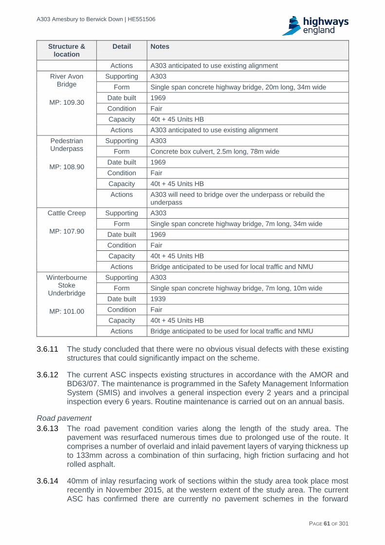
A303 Amesbury to Berwick Down | HE551506
HE551506-AA-GEN-SWI-RP-CX-000020 | P13, S0 21/12/2016 PAGE 61 OF 301
Structure & location
Detail Notes
Actions A303 anticipated to use existing alignment
River Avon Bridge
MP: 109.30
Supporting A303
Form Single span concrete highway bridge, 20m long, 34m wide
Date built 1969
Condition Fair
Capacity 40t + 45 Units HB
Actions A303 anticipated to use existing alignment
Pedestrian Underpass
MP: 108.90
Supporting A303
Form Concrete box culvert, 2.5m long, 78m wide
Date built 1969
Condition Fair
Capacity 40t + 45 Units HB
Actions A303 will need to bridge over the underpass or rebuild the underpass
Cattle Creep
MP: 107.90
Supporting A303
Form Single span concrete highway bridge, 7m long, 34m wide
Date built 1969
Condition Fair
Capacity 40t + 45 Units HB
Actions Bridge anticipated to be used for local traffic and NMU
Winterbourne Stoke
Underbridge
MP: 101.00
Supporting A303
Form Single span concrete highway bridge, 7m long, 10m wide
Date built 1939
Condition Fair
Capacity 40t + 45 Units HB
Actions Bridge anticipated to be used for local traffic and NMU
3.6.11 The study concluded that there were no obvious visual defects with these existing structures that could significantly impact on the scheme.
3.6.12 The current ASC inspects existing structures in accordance with the AMOR and BD63/07. The maintenance is programmed in the Safety Management Information System (SMIS) and involves a general inspection every 2 years and a principal inspection every 6 years. Routine maintenance is carried out on an annual basis.
Road pavement
3.6.13 The road pavement condition varies along the length of the study area. The pavement was resurfaced numerous times due to prolonged use of the route. It comprises a number of overlaid and inlaid pavement layers of varying thickness up to 133mm across a combination of thin surfacing, high friction surfacing and hot rolled asphalt.
3.6.14 40mm of inlay resurfacing work of sections within the study area took place most recently in November 2015, at the western extent of the study area. The current ASC has confirmed there are currently no pavement schemes in the forward

A303 Amesbury to Berwick Down | HE551506
HE551506-AA-GEN-SWI-RP-CX-000020 | P13, S0 21/12/2016 PAGE 62 OF 301
programme. However, the ASC has identified two pavement sites which are early on in their planned process:
A303 Longbarrow Roundabout Eastbound and Westbound.
A303 Winterbourne Stoke to Yarnbury Castle Eastbound and Westbound.
Carriageway lighting
3.6.15 The three main areas of carriageway lighting on the A303 within the study area are at Winterbourne Stoke, Longbarrow Roundabout and Countess Roundabout. Additionally, the slip roads on and off the existing A303 are lit at Solstice Park and the Solstice Park Porton Road flyover is lit.
3.6.16 Table 3-9 summarises the locations of existing lights, based on lighting plans received from Highways England on 30th September 2016.
3.6.17 The Longbarrow Roundabout is lit by ceramic (CPO) luminaires on aluminium street lighting columns. It is understood that this equipment was installed during the remodelling of the Longbarrow roundabout in the last 5 years and that obsolescence and non-availability of replacement components is becoming a problem. There is no lighting of route destination signs, such as advanced direction signs. The ‘Turn Left’ signs and ‘Keep Left’ bollards are lit with LEDs on the roundabout islands and splitter islands respectively.
3.6.18 The Countess Roundabout is lit by standard fluorescent (MCF/U) luminaires on street lighting columns. There is no lighting of route destination signs, such as advanced direction signs. The ‘Turn Left’ signs and ‘Keep Left’ bollards are lit on the roundabout islands and splitter islands respectively.
3.6.19 The single carriageway through Winterbourne Stoke is lit by high pressure sodium (SON/T) luminaires on steel street lighting columns. A number of street signs are lit with standard fluorescent (MCF/U) luminaires.
Table 3-9 Carriageway lighting
Location Column street
lights Lit signs Lit bollards Subway
Countess Roundabout 37 14 2 1
Longbarrow Roundabout 16 6 2 0
Winterbourne Stoke 15 2 0 0
Solstice Park slip roads (north) 25 7 0 0
Solstice Park slip roads (south) 8 4 0 0
3.7 Other relevant factors
3.7.1 As detailed in the Introduction section of this report, the A303/A30/A358 Feasibility Study identified eight highway improvements along the corridor. The DfT's RIS 2015/16 - 2019/20 Road Period (RIS 1) identified the following three schemes to start construction within the period:
A303 Amesbury to Berwick Down.
A303 Sparkford to Ilchester.

A303 Amesbury to Berwick Down | HE551506
HE551506-AA-GEN-SWI-RP-CX-000020 | P13, S0 21/12/2016 PAGE 63 OF 301
A358 Southfields to M5 Motorway (Junction 25).
3.7.2 The other schemes are scheduled to start within the future RIS periods.
3.7.3 Due to the common timescales for the three RIS 1 schemes, there was a coordinated approach between the three schemes. This was based around regular liaison meetings with the teams designed to share research and analysis, experience and best practice, particularly in the modelling and appraisal of the schemes.
3.7.4 Table 3-10 includes the current estimates of the year of opening for each scheme.
Table 3-10 Corridor scheme assumptions
Section Location Description Assumed opening year
1 A303 Amesbury to
Berwick Down
12km of dual carriageway and junction improvements
2024
2 A303 Wylye to Stockton Wood
3.9km mainly ‘on-line’ dual carriageway
2028
3 A303 Chicklade Bottom to Mere
12km of part ‘on-line’ and part ‘off-line’ dual carriageway and
associated junction improvements
2028
4 A303 Sparkford to Ilchester
5.5km of part ‘on-line’ and part ‘off-line’ dual carriageway and
associated junction improvements
2023
5 A303 Podimore Roundabout
Junction improvement (grade separated)
2028
6 A303 Cartgate Roundabout
Junction improvement (grade separated)
2028
7 A303 South Petherton to Southfields
10km of ‘on-line’ dual carriageway 2028
8 A358 Southfields to M5 Motorway (Junction 25)
14km of part ‘on-line’ and part ‘off-line’ dual carriageway and
associated junction improvements
2023
9 A303 Southfields to
Honiton
Combination of various (relatively small) section of improvements
along the 23km length
2028
A303 Amesbury to Berwick Down | HE551506
HE551506-AA-GEN-SWI-RP-CX-000020 | P13, S0 21/12/2016 PAGE 64 OF 301
4 Planning context
4.1 Introduction
4.1.1 This chapter provides an overview of the legislation and planning policy which is relevant to the scheme. An application for development consent will be required to demonstrate compliance with the relevant European Directives, UK legislation and national policy. This section sets out and describes each of these.
4.2 UK Legislation and European Directives
Planning Act 2008 (the Act)
4.2.1 As the proposed scheme is for the construction and alteration of a highway in England, for which the Secretary of State is the Highways Authority, it is a Nationally Significant Infrastructure Project under Section 14 of the Act. This means the scheme requires a Development Consent Order to be granted by the Secretary of State, following a recommendation by the Planning Inspectorate.
4.2.2 The Planning Act 2008 sets out the process for the consideration of applications for development consent. It requires the developer to carry out consultation before making an application. Once an application is made, there are statutory time limits placed on most stages of its consideration.
4.2.3 Section 104 of the Act prescribes that a decision on whether or not to grant consent must have regard to:
Any National Policy Statement (NPS) which has effect in relation to the type of development.
Any marine policy documents (if relevant).
Any local impact report.
Any matters prescribed in relation to the type of development.
Any other matters which are important and relevant.
4.2.4 In the case of highways, an application will be considered primarily against the National Policy Statement for National Networks (NPSNN).
Habitats Directive and Habitats Regulations
4.2.5 The Habitats and Wild Birds Directives conserve particular habitats and species across the European Union by protecting a network of functionally linked sites. These are known as the Natura 2000 network. The UK is also obligated to protect these sites by virtue of a number of international agreements such as The Convention on Wetlands of International Importance, called the Ramsar convention.
4.2.6 The Habitats Regulations transpose into UK law the requirements of these Directives. They set out the iterative process by which plans, projects or programmes should be assessed by a "Competent Authority" (the Secretary of State for Transport in this case), in order to ensure they do not have an adverse effect on the integrity of a European designated site.
4.2.7 This is ascertained through a screening process to establish whether likely significant effects could occur as a result of the project, based on the outputs of the environmental assessment. If effects are likely, the onus is on the developer to
A303 Amesbury to Berwick Down | HE551506
HE551506-AA-GEN-SWI-RP-CX-000020 | P13, S0 21/12/2016 PAGE 65 OF 301
provide enough information for the Competent Authority to carry out an Appropriate Assessment. This will consider whether any likely effects will adversely affect the integrity of the site in view of its conservation objectives. This assessment will have to be provided as part of an application for development consent. Natural England is the statutory nature conservation body who will inform the Competent Authority (Secretary of State for Transport, in this instance), regarding impacts on European designated sites.
4.2.8 If an adverse effect on the integrity of a European site is shown to occur as a result of the Appropriate Assessment, derogation can be pursued which would allow the decision-maker to grant consent. The sequential tests which would be applied to this are:
There must be no feasible alternative to the plan or project.
There must be Imperative Reasons of Overriding Public Interest (IROPI) for the scheme.
Compensatory measures must be secured (prior to construction) to maintain the coherence of the network. It will need to be proven that like for like compensatory habitat is secured and deliverable to the decision-maker.
Environmental Impact Assessment
4.2.9 The Environmental Impact Assessment (EIA) Regulations (The Infrastructure Planning (EIA) Regulations 2009) set out the process of environmental impact assessment for nationally significant schemes. This includes that the applicant may request a Scoping Opinion from the Planning Inspectorate, who will consult with a number of statutory consultees on the proposed scope of the assessment. The regulations also stipulate that scheme promoters of Nationally Significant Infrastructure Projects (NSIPs) must state in their Statement of Community Consultation how they will consult on Preliminary Environmental Information.
4.2.10 Schedule 5, Part 1 of the Regulations states the information which should be included in an environmental statement, principally:
Description of the development.
An outline of the alternatives studied.
Description of the aspects of the environment likely to be affected.
Description of the likely significant effects of the environment.
Measures to reduce prevent and offset these effects.
A non-technical summary.
4.2.11 The EIA Directive (2014/52/EU) is expected to be transposed into UK law in 2017. The Directive refers to the previously titled environmental statements as EIA Reports, which will be required to be in line with the scoping opinion when one has been requested. It includes requirements for the EIA process to consider the impacts of the development on climate change, human health and resource efficiency.

A303 Amesbury to Berwick Down | HE551506
HE551506-AA-GEN-SWI-RP-CX-000020 | P13, S0 21/12/2016 PAGE 66 OF 301
4.3 National policy
National Policy Statement for National Networks (NPSNN)
4.3.1 The NPSNN sets out Government policy for the need for, and delivery of, nationally significant road and rail projects. The policy states that the Government will deliver national networks that meet the long term needs of the country and support a thriving and prosperous economy.
4.3.2 Chapter 2 of the NPSNN sets out the following strategic objectives:
Networks with the capacity and connectivity and resilience to support national and local economic activity and facilitate growth and create jobs;
Networks which support and improve journey quality, reliability and safety;
Networks which support the delivery of environmental goals and the move to a low carbon economy; and
Networks which join up our communities and link effectively to each other.
4.3.3 It states a critical need to improve the road network to address congestion, providing safe, resilient and expeditious networks which support social and economic activity. These improvements may also address impacts of networks on quality of life and the environment10. A well-functioning road network is stated as critical to supporting national and regional economies11 .
4.3.4 The Government's policy to address this need is to bring forward enhancements and improvements to the existing network. This includes improvements to trunk roads, in particular dualling of single carriageway strategic trunk roads to increase capacity and improve performance and resilience.
4.3.5 Chapter 3 of NPSNN sets the need for improvements to the road network in the context of wider Government policies. These include:
Environment and social impacts: networks should be designed to minimise social and environmental impacts and improve quality of life; the principles of the National Planning Policy Framework (NPPF) and Planning Practice Guidance (PPG), as well detailed policy set out in Chapter 5 of the NPSNN should be followed to mitigate effects.
Emissions: the Government supports the switch to Ultra Low Emission Vehicles (ULEVs), and predicts that increases to emissions as a result of improvements to the road network will be very small as a result of current and future commitments to meet legally binding targets.
Safety: the Government intends to remain a world leader in road safety, and scheme promoters are expected to take opportunities to improve road safety, employing the most modern and effective safety measures where proportionate.
Technology: innovative technologies will be monitored for their benefits and risks, but are not expected to alleviate the need to address current congestion problems or negate the need for improvements to the road network.
Sustainable transport: the Government expects applicants to use reasonable endeavours to address the needs of pedestrians and cyclists. This includes investing in locations where the national road network severs communities and
10 NPSNN paragraph 2.2. 11 NPSNN paragraph 2.13.

A303 Amesbury to Berwick Down | HE551506
HE551506-AA-GEN-SWI-RP-CX-000020 | P13, S0 21/12/2016 PAGE 67 OF 301
acts as a barrier to cycling and walking by addressing historic problems, retrofitting solutions, and ensuring safety for cyclists on junctions.
Accessibility: applicants should improve access wherever possible through delivering schemes which take all opportunities for improvements in accessibility for all users, including disabled users, of the strategic road network.
Road tolling and charging: the Government's policy is not to introduce road pricing for key trunk roads on the strategic road network.
4.3.6 Chapter 4 sets out the assessment principles for the consideration of highway schemes. In particular it states that subject to the detailed policies and protections in this NPSNN, and the legal constraints set out in the Planning Act, that there is a presumption in favour of granting development consent for NSIP projects, such as the proposed scheme.
4.3.7 When considering an application for development consent, the Secretary of State will consider its benefits including for economic growth, job creation, and environmental improvement. This will be considered against adverse impacts of the scheme including long-term cumulative impacts. Such applications are required to be supported by a business case prepared in accordance with Treasury Green Book principles.
4.3.8 The policy states that projects subject to The Infrastructure Planning EIA Regulations 2009 should include an environmental statement with the application. As part of this, the impacts from reasonably foreseeable schemes should be considered in the assessment. The maximum extent of the project's possible impact should be assessed where there are details which are yet to be finalised. The policy also sets out that the application should provide sufficient information for the carrying out of an appropriate assessment by the Secretary of State for Transport, where proposals are likely to have a significant effect on a European designated site.
4.3.9 In relation to alternatives, it is stated that all schemes should be subject to an options appraisal, which should also consider viable modal alternatives. However, where schemes were subject to an options appraisal to achieve their status within road investment strategies, option testing may not need to be considered by the decision maker.
4.3.10 The policy requires principles of good design to inform projects from their inception. The design should work to mitigate the impact of the project in terms of the environment, safety and sustaining operational efficiency. Proposed schemes which are fit for purpose and sustainable can contribute towards the area in which they are located; applicants should demonstrate how the design process has contributed to these aims.
4.3.11 Applicants will have to consider climate change adaptation in the siting, location, design, construction and operation of proposed schemes. This includes demonstrating that there are no critical features that will be affected by the effects of climate change in the long term; this is to be based on the Government's climate change risk assessment and consultation with statutory bodies. The policy also sets out that pollution control, nuisance and statutory nuisance, safety, security, and health should be considered by applicants in the design of their schemes.

A303 Amesbury to Berwick Down | HE551506
HE551506-AA-GEN-SWI-RP-CX-000020 | P13, S0 21/12/2016 PAGE 68 OF 301
4.3.12 Chapter 5 of the NPS sets out the assessment framework against which the application will be considered. The contents of this chapter will be used by the decision maker to establish whether the applicant has considered the necessary areas of assessment. The areas which must be considered are outlined below:
Air quality.
Carbon emissions.
Biodiversity.
Waste management.
Civil and military aviation and defence interests.
Coastal change.
Dust, odour, artificial light, smoke, steam.
Flood risk.
Land instability.
The historic environment (this includes impacts on WHS).
Land use including open space, green infrastructure, and greenbelt.
Noise and vibration.
Impacts on transport networks.
Water quality and resources.
4.4 Other relevant policy and strategy
4.4.1 In addition to the NPSNN, other documents which may be considered important and relevant to the scheme are summarised below.
National Planning Policy Framework (NPPF)
4.4.2 The NPPF provides a framework for the designation of local plans by local authorities and for the consideration of planning applications in England. The policy puts a presumption in favour of sustainable development at the heart of decision making for planning applications made to the local authority.
4.4.3 Paragraph 3 of the NPPF confirms that the framework does not contain any specific policies for nationally significant infrastructure projects as contained in national policy statements. However, paragraph 3.3 of NPSNN expects applicants to avoid and mitigate environmental and social impacts of schemes in line with the principles set out in the NPPF and the Government's planning guidance.
Road Investment Strategy 1 (RIS 1)
4.4.4 The Road Investment Strategy commits the Government to delivering a series of improvements and upgrades during the investment period. There is a requirement under section 3 of the Infrastructure Act 2015 for the Secretary of State and Highways England to deliver the commitments within the strategy.
4.4.5 The RIS sets out eight 'performance areas' for improved performance. These form the basis of the Performance Specification, setting out specific expectations for the SRN over the period to 2020.12 Performance areas relevant to the scheme include:
Making the network safer;
Improving user satisfaction;
Supporting the smooth flow of traffic;
12 DfT (2015) RIS1, chapter 7

A303 Amesbury to Berwick Down | HE551506
HE551506-AA-GEN-SWI-RP-CX-000020 | P13, S0 21/12/2016 PAGE 69 OF 301
Encouraging economic growth;
Delivering better environmental outcomes; and
Helping cyclists, walkers and other vulnerable users of the network.
4.4.6 In recognition of the strategic importance of the A303 corridor, the Government has committed to the creation of an Expressway between the south-east and the South West by 2029. A package of eight potential improvement projects was identified. As part of this, a scheme involving a 1.8 mile twin bored tunnel past Stonehenge, and a bypass for Winterbourne Stoke, was identified to be delivered as part of the investment period in RIS 1.
The Stonehenge and Avebury WHS Management Plan
4.4.7 The purpose of this Management Plan is to guide the care of the WHS in order to sustain its Outstanding Universal Value (OUV). The priority for the Management Plan is to encourage the sustainable management of the WHS, balancing its needs with those of the farming community, nature conservation, access, the landowners and the local community.
4.4.8 Part 2, Section 11 of the document sets out the issues relating to the management of roads and traffic in relation to the WHS. It states that roads and traffic have an adverse effect on the area of the WHS and its attributes of OUV.
4.4.9 The negative impact on setting and character within the WHS as a result of roads is primarily related to: loss of tranquillity; signage; related clutter; inappropriate design and light pollution.
4.4.10 The significant impacts of the A303 on the OUV of the WHS are described as: the division of the landscape and severance of key monuments; the setting of Stonehenge and The Avenue and other monuments of OUV (including several Barrow cemeteries); and visual and noise intrusion.
4.4.11 The Management Plan states that any solution for the A303 would need to be assessed for its likely impact on the WHS and its attributes of OUV. This includes the interrelationships of monuments, their settings and relationship to the landscape and integrity of the wider WHS landscape. The document refers to "Guidance on Heritage Impact Assessments for Cultural World Heritage Properties (ICOMOS, 2011)" for how significant developments should be assessed when proposed in the WHS.
4.4.12 The Management Plan prioritises the future of the A303 as the major road and traffic issue facing the Stonehenge area of the WHS.
4.4.13 Part 3 of the Management Plan outlines the aims and policies which govern the long and short term goals of managing the WHS; these are derived from the issues and opportunities identified in Part 2.
4.4.14 Aim 3 of the plan is to sustain the OUV of the WHS through conservation and enhancement of the whole site and is attributes. To achieve this, policy 3d prioritises the improvement of the WHS landscape by the removal, redesign or screening of existing infrastructure where opportunities arise.
4.4.15 Aim 6 of the plan regards the significant reduction of the negative impacts of roads and traffic on the WHS and its attributes, while increasing sustainable access to

A303 Amesbury to Berwick Down | HE551506
HE551506-AA-GEN-SWI-RP-CX-000020 | P13, S0 21/12/2016 PAGE 70 OF 301
the WHS. Policy 6a states the need to reduce the impacts of roads and traffic on the WHS, and increase safety to improve the ease and confidence where visitors can explore the WHS.
4.5 Local policy
Wiltshire Core Strategy (WCS)
4.5.1 Wiltshire Council’s WCS was adopted in January 2015. It contains policies relevant to all development decisions in Wiltshire. It does not include specific policies for the upgrading of the A303 between Amesbury and Berwick Down, and NPSNN contains the primary policy framework for the scheme. However, specific elements of local policy may be considered as important and relevant to the proposals. These include:
Table 4-1 Wiltshire Core Strategy strategic objectives and core policies
Strategic objective Relevant core policies
Strategic objective 1: delivering a thriving economy
Core policy 37: military establishments
Strategic objective 4: helping to build resilient communities
Core policy 48: supporting rural life
Strategic objective 5: protecting and enhancing the natural, historic and built environment
Core policy 50: biodiversity and geodiversity
Core policy 51: landscape
Core policy 55: air quality
Core policy 56: contaminated land
Core policy 59: the Stonehenge, Avebury and Associated Sites WHS and its setting. This policy states the obligation to protect, conserve, present and transmit to future generations the OUV of WHSs should be given precedence in decision-making.
Strategic objective 6: ensuring that adequate infrastructure is in place to support our communities
Core policy 66: strategic transport network.
Core policy 67: flood risk
Core policy 68: water resources
Core policy 69: protection of the River Avon Special Area of Conservation (SAC)
Amesbury area strategy Core policy 4: Spatial strategy for the Amesbury Community Area. As part of this the policy the Council intends to work collaboratively with the relevant agencies, such as Highways England, the Department for Transport and English Heritage, to achieve an acceptable solution for the dualling of the A303. This should be a solution which does not adversely affect the WHS and its setting.
Core policy 6: Stonehenge. This policy sets out criteria for development affecting the WHS.
Wiltshire Local Transport Plan (LTP)
4.5.2 The Wiltshire LTP for 2011-2026 sets out Wiltshire Council’s objectives, plans and indicators for transport in Wiltshire. The LTP includes supporting objectives to sit underneath the national transport goals, which provide the overarching priorities for transport in the county. Goals and objectives relevant to the proposals include:

A303 Amesbury to Berwick Down | HE551506
HE551506-AA-GEN-SWI-RP-CX-000020 | P13, S0 21/12/2016 PAGE 71 OF 301
Table 4-2 Wiltshire Local Transport Plan goals and strategic objectives
Goal Relevant strategic objectives
Support economic growth SO1: To support and help improve the vitality, viability and resilience of Wiltshire’s economy and market towns
SO4: To minimise traffic delays and disruption and improve journey time reliability on key routes
SO10: to encourage the efficient and sustainable distribution of freight in Wiltshire
SO16: To improve the resilience of the transport system to impacts such as adverse weather, climate change and peak oil
Reduce carbon emissions SO11: To reduce the level of air pollutant and climate change emissions from transport
Contribute to better safety, security and health
SO8: To improve safety for all road users and to reduce the number of casualties on Wiltshire’s roads
S09: To reduce the impact of traffic speeds in towns and villages
SO14: To promote travel modes that are beneficial to health
Promote equality of opportunity
SO5: To improve sustainable access to a full range of opportunities particularly for those people without access to a car
SO15: To reduce barriers to transport and access for people with disabilities and mobility impairment
Improve quality of life and promote a healthy environment
SO3: To reduce the impact of traffic on people’s quality of life and Wiltshire’s built and natural environment
SO7: To enhance Wiltshire’s public realm and streetscene
SO17: To improve access to Wiltshire’s countryside and provide a more useable public rights of way network
SO18: To enhance the journey experience of transport users
Swindon and Wiltshire Local Enterprise Partnership (LEP) Strategic Economic Plan (SEP)
4.5.3 The SEP sets out strategic objectives to stimulate investment in the Swindon and Wiltshire area over the period to 2026. These include:
Transport infrastructure improvements: we need a well-connected, reliable and resilient transport system to support economic and planned development growth at key locations
Place shaping: we need to deliver the infrastructure required to deliver our planned growth and regenerate our City and Town Centres, and improve our visitor and cultural offer.

A303 Amesbury to Berwick Down | HE551506
HE551506-AA-GEN-SWI-RP-CX-000020 | P13, S0 21/12/2016 PAGE 72 OF 301
5 Initial corridors appraisal
5.1 Introduction
5.1.1 The option generation and sifting process to sift route options for further WebTAG appraisal was split into three stages called Design Fix A, Design Fix B and Design Fix C as outlined in Figure 5-1 below. Descriptions of these are given below and explained in detail in further within this section.
Design Fix A: Corridor identification and initial sifting of corridors (refer to Chapter 5).
Design Fix B: Design development of route options within better performing corridors (refer to Chapter 6).
Design Fix C: Initial Appraisal and sifting of route options to identify options to take forward for further appraisal (refer to Chapter 7).
Figure 5-1 Options identification process
5.1.2 The high level sifting was undertaken at Design Fix A and only the better performing corridors that passed the identified criteria were shortlisted and passed through to Design Fixes B and C. It was at these design fixes that further development and assessment of the remaining options was considered with a view to collecting sufficient evidence to be able to distinguish the relative costs, benefits and impacts of the options under consideration.
5.2 Initial corridors identification and appraisal
Overview
5.2.1 An extensive range of potential route options had been developed as part of previous studies on this section of the A303 and the output from these were brought into this scheme study. This chapter is concerned with the initial sifting undertaken at Design Fix A. Note that the purpose of this process was to provide a high level assessment of the historical routes, and to reduce their number to those that will satisfy the Client Scheme Requirements (CSRs) and warrant further investigation.
5.2.2 Specifically, the purpose of Design Fix A is outlined as follows in paragraph 2.9.1 of the Department for Transport (DfT) document "Transport Analysis Guidance - The Transport Appraisal Process": An initial sift should therefore be undertaken to identify any 'showstoppers' which are likely to prevent an option progressing at a subsequent stage in the process.
5.2.3 The process involves discarding options that:
DESIGN FIX A - INITIAL
CORRIDOR APPRAISAL
DESIGN FIX B - ROUTE OPTIONS DEVELOPMENT
DESIGN FIX C - INITIAL ROUTE
OPTIONS APPRAISAL
RECOMMENDED ROUTE OPTIONS
FOR CONSULTATION
FURTHER WebTAG
APPRAISAL

A303 Amesbury to Berwick Down | HE551506
HE551506-AA-GEN-SWI-RP-CX-000020 | P13, S0 21/12/2016 PAGE 73 OF 301
Would clearly fail to meet the key objectives identified for the scheme.
Do not fit with existing local, regional and national programmes and strategies, and do not fit with wider Government priorities.
Would be unlikely to pass any of the following key viability and acceptability criteria (or represent significant risk):
- Deliverable in a particular economic, environmental, geographical or social context e.g. options which would result in severe adverse environmental impacts which cannot be mitigated or where the cost of doing so is too high.
- Technically sound. - Financially affordable. - Acceptable to stakeholders and the public.
Development of corridors
5.2.4 A number of historic options were identified during the Option Development Stage and a plan showing all the generated options is included in Appendix B1. These options were generated from a number of sources, such as:
Historical routes considered in previous studies.
Historical routes proposed by major stakeholders.
Historical routes proposed during public consultations and through Public Inquiry.
Routes proposed by other interested parties.
5.2.5 All these historical options were based on the provision of new dual 2 lane highway to solve the traffic capacity problems. They comprise either surface route through their full length of improvement or include the provision of a tunnel for at least part of the route length within the WHS.
5.2.6 The WHS was used as a key factor in determining corridor options to reflect the principal objective for Culture and Heritage which requires the scheme to contribute 'to the conservation and enhancement the WHS by improving access both within and to the site'.
5.2.7 Due to the large number of historical routes, for the purposes of initial assessment, sifting and development of route options for further appraisal, the route options were grouped into eight separate, and in some cases overlapping, corridors. The extent of each route corridor is defined by consideration of a number of factors:
Whether they would run within the WHS.
Their general distance from the existing A303 corridor.
Whether they would be wholly above ground or contain a tunnel.
5.2.8 Detailed corridor descriptions are provided below:
Corridor A - Surface routes more than 1km north of A303 (outside WHS).
Corridor B - Surface routes more than 1km north of A303 (at least partially within WHS).
Corridor C - Surface routes within 1.0 km of the existing A303 (at least partially within WHS).

A303 Amesbury to Berwick Down | HE551506
HE551506-AA-GEN-SWI-RP-CX-000020 | P13, S0 21/12/2016 PAGE 74 OF 301
Corridor D - Partially tunnelled route options within 1.0km (on plan) of the existing A303 (at least partially within WHS)13.
Corridor E - Surface routes and more than 1km south of A303 (partially within WHS).
Corridor F (north) - Surface routes south of A303 (outside WHS) and north of Salisbury14.
Corridor F (south) - Surface routes further south of A303 (outside WHS) and north of Salisbury.
Corridor G - Surface routes south of A303 (outside WHS) and South of Salisbury.
5.2.9 A plan showing the corridors identified with all of the associated historical routes is included in Appendix B2.
Corridor A - Surface routes more than 1km north of A303 (outside WHS)
5.2.10 Corridor A consists of surface route options more than 1km north of A303 (outside WHS) and is shown as narrow as it represents only a single historic route. It may be considered that given the very narrow spatial extent of Corridor A that the assessment is skewed against it, as in other corridors the breadth of the corridor may support a more favourable assessment on the basis that there is scope to avoid designations / receptors.
5.2.11 However in the case of Corridor A, it is difficult to avoid the receptors or to expand the corridor without resulting in further direct impacts or worsening impacts on receptors such as the Salisbury Plain Special Protection Area (SPA) / Special Area of Conservation (SAC) and communities at Larkhill, Durrington and Bulford. It is therefore concluded that extending the Corridor further north would not provide any additional feasible route options for consideration.
5.2.12 The corridor leaves the existing A303 south of Bulford Camp in the east, running approximately along the existing A3028 route through the southern extents of Bulford. Provision would need to be made to bring these sections of road up to Expressway standard for a 70mph All-purpose Dual Carriageway (D2AP) road and to provide alternative access to these villages. It crosses the River Avon between Durrington and Bulford and then runs parallel with The Packway through Durrington and Larkhill to the north of the WHS and through existing properties, before cutting across the southern fringe of part of the Salisbury Plain SPA / SAC. It then heads South West through open land between Shrewton and Winterbourne Stoke, crossing the River Till and re-joining the existing A303 east of Yarnbury Castle.
13 All historical tunnel options were proposed within the WHS. Some historical routes within Corridors B and C included short tunnelled sections of less than 1km in length. These route options were excluded from Corridor D as, in each case, the route’s fundamental characteristics and potential heritage impacts, were comparable to those of an at-grade route i.e. the very short tunnelled sections did not address the heritage aspects of the CSRs and so the route options did not fit the overall intent of Corridor D. 14 It was determined that whilst route options within corridor F were all located outside of the WHS and North of Salisbury, given the large width of the corridors, potential route options would result in very different performance in terms of the length and associated traffic movements, and the diversity and number of receptors that would be affected. The corridor was therefore split into F north and F south to allow for a clearer assessment of likely impacts across the corridor.

A303 Amesbury to Berwick Down | HE551506
HE551506-AA-GEN-SWI-RP-CX-000020 | P13, S0 21/12/2016 PAGE 75 OF 301
Figure 5-2 Corridor A - Surface routes more than 1km north of A303 (outside WHS)
5.2.13 Corridor A would avoid direct land-take within the WHS, which is considered to be a differentiator between corridors. However, the scheme would require a significant amount of land to be acquired. This would consist of greenfield land, Ministry of Defence (MoD) land and properties within Larkhill, Durrington, Bulford and potentially Winterbourne Stoke.
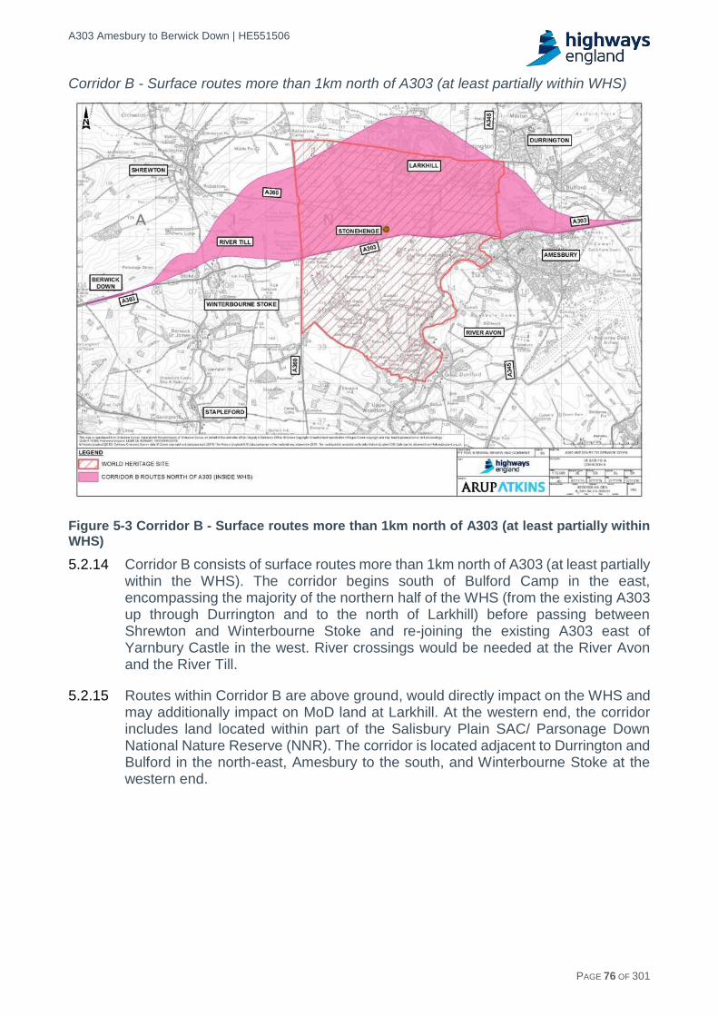
A303 Amesbury to Berwick Down | HE551506
HE551506-AA-GEN-SWI-RP-CX-000020 | P13, S0 21/12/2016 PAGE 76 OF 301
Corridor B - Surface routes more than 1km north of A303 (at least partially within WHS)
Figure 5-3 Corridor B - Surface routes more than 1km north of A303 (at least partially within WHS)
5.2.14 Corridor B consists of surface routes more than 1km north of A303 (at least partially within the WHS). The corridor begins south of Bulford Camp in the east, encompassing the majority of the northern half of the WHS (from the existing A303 up through Durrington and to the north of Larkhill) before passing between Shrewton and Winterbourne Stoke and re-joining the existing A303 east of Yarnbury Castle in the west. River crossings would be needed at the River Avon and the River Till.
5.2.15 Routes within Corridor B are above ground, would directly impact on the WHS and may additionally impact on MoD land at Larkhill. At the western end, the corridor includes land located within part of the Salisbury Plain SAC/ Parsonage Down National Nature Reserve (NNR). The corridor is located adjacent to Durrington and Bulford in the north-east, Amesbury to the south, and Winterbourne Stoke at the western end.

A303 Amesbury to Berwick Down | HE551506
HE551506-AA-GEN-SWI-RP-CX-000020 | P13, S0 21/12/2016 PAGE 77 OF 301
Corridor C - Surface routes within 1.0 km of the existing A303 (at least partially within WHS)
Figure 5-4 Corridor C - Surface routes within 1.0 km of the existing A303 (at least partially within WHS)
5.2.16 Corridor C consists of surface route options within 1.0 km of A303 (inside WHS). The corridor begins west of Solstice Park junction moving westwards to encompass the central section of the WHS, north of Great Durnford and south of Larkhill, before passing close to the north of Winterbourne Stoke and re-joining the existing A303 in the west, east of Yarnbury Castle. A river crossing would be required at the River Till.
5.2.17 Routes within Corridor C are located above ground, would directly impact on the WHS and The Avenue, and would be within close proximity to Stonehenge and numerous other Scheduled Monuments including Vespasian’s Camp (located to the west of Amesbury). The corridor is located adjacent to part of the Salisbury Plain SAC/ Parsonage Down NNR in the west, and Amesbury in the East. A large area of the Normanton Down Royal Society for the Protection of Birds (RSPB) reserve is located in the southern part of the corridor.

A303 Amesbury to Berwick Down | HE551506
HE551506-AA-GEN-SWI-RP-CX-000020 | P13, S0 21/12/2016 PAGE 78 OF 301
Corridor D - Partially tunnelled route options within 1.0km (on plan) of the existing A303 (partially within WHS)
Figure 5-5 Corridor D - Partially tunnelled route options within 1.0km (on plan) of the existing A303 (partially within WHS)
5.2.18 Corridor D consists of tunnel route options within the WHS. The Corridor begins at Solstice Park in the east, following the existing dualled section of the A303 until west of Countess Roundabout, where it expands out when passing through the central section of the WHS (north of Great Durnford and south of Larkhill), before passing around Winterbourne Stoke, crossing the River Till and re-joining the existing A303 east of Yarnbury Castle in the west.
5.2.19 All route options within Corridor D run through the WHS and would have part of their route through the WHS in tunnel, however the lengths of these tunnels differ. There are no tunnel options which tunnel under the full extent of the WHS.

A303 Amesbury to Berwick Down | HE551506
HE551506-AA-GEN-SWI-RP-CX-000020 | P13, S0 21/12/2016 PAGE 79 OF 301
Corridor E - Surface routes and more than 1km south of A303 (at least partially within WHS)
Figure 5-6 Corridor E - Surface routes and more than 1km south of A303 (at least partially within WHS)
5.2.20 Corridor E consists of routes south of A303 (surface routes and inside WHS) The corridor runs from Solstice Park in the east, moving westwards through Amesbury to the south of the existing A303, encompassing the majority of the southern half of the WHS (south of Normanton Down and north of Great Durnford), and an area to the west of the WHS that includes the villages of Winterbourne Stoke, Stapleford and Berwick St James, before re-joining the existing A303 in the west near the junction with the A36. Two river crossings would be required at the River Till and the River Avon.
5.2.21 Routes within Corridor E would directly impact on the WHS. The corridor includes land within Amesbury and the South Western part of the corridor is located within the Cranborne Chase & West Wiltshire Downs Area of Outstanding Natural Beauty (AONB), as well as a Site of Special Scientific Interest (SSSI) and wildlife area north of Steeple Langford. The corridor is also located adjacent to an area of the Salisbury Plain SAC/ Parsonage Down NNR to the north-west.
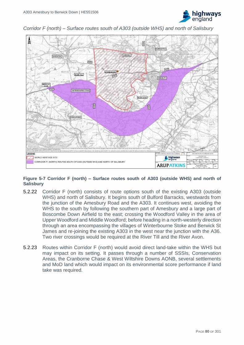
A303 Amesbury to Berwick Down | HE551506
HE551506-AA-GEN-SWI-RP-CX-000020 | P13, S0 21/12/2016 PAGE 80 OF 301
Corridor F (north) – Surface routes south of A303 (outside WHS) and north of Salisbury
Figure 5-7 Corridor F (north) – Surface routes south of A303 (outside WHS) and north of Salisbury
5.2.22 Corridor F (north) consists of route options south of the existing A303 (outside WHS) and north of Salisbury. It begins south of Bulford Barracks, westwards from the junction of the Amesbury Road and the A303. It continues west, avoiding the WHS to the south by following the southern part of Amesbury and a large part of Boscombe Down Airfield to the east; crossing the Woodford Valley in the area of Upper Woodford and Middle Woodford; before heading in a north-westerly direction through an area encompassing the villages of Winterbourne Stoke and Berwick St James and re-joining the existing A303 in the west near the junction with the A36. Two river crossings would be required at the River Till and the River Avon.
5.2.23 Routes within Corridor F (north) would avoid direct land-take within the WHS but may impact on its setting. It passes through a number of SSSIs, Conservation Areas, the Cranborne Chase & West Wiltshire Downs AONB, several settlements and MoD land which would impact on its environmental score performance if land take was required.

A303 Amesbury to Berwick Down | HE551506
HE551506-AA-GEN-SWI-RP-CX-000020 | P13, S0 21/12/2016 PAGE 81 OF 301
Corridor F (south) - Surface routes further south of A303 (outside WHS) and north of Salisbury
Figure 5-8 Corridor F (south) - Routes south of A303 (outside WHS) and north of Salisbury
5.2.24 Corridor F (south) consists of route options south of the existing A303 (outside WHS) and north of Salisbury. It begins on the existing A303 south of Bulford Barracks, westwards from the junction of the Amesbury Road and the A303, before running South West between Amesbury and Allington, through the southern part Boscombe Down Airfield. It then crosses the Woodford Valley in the area of Lower Woodford and Little Durnford, before heading in a north-westerly direction through an area that encompasses the village of Stapleford, running adjacent to the Wylye Valley and re-joining the existing A303 in the west near the junction with the A36. Two river crossings will be required at the River Till and the River Avon.
5.2.25 Corridor F (south) is located a considerable distance to the south of the WHS. The corridor includes land within the Cranborne Chase & West Wiltshire Downs AONB at its western end, as well as a number of SSSIs and Conservation Areas. Routes within this corridor may impact on Boscombe Down Airfield, although a narrow strip exists between the airfield boundary and the Corridor Boundary in which an alignment can be located.

A303 Amesbury to Berwick Down | HE551506
HE551506-AA-GEN-SWI-RP-CX-000020 | P13, S0 21/12/2016 PAGE 82 OF 301
Corridor G - Surface route south of A303 (outside WHS) and South of Salisbury
Figure 5-9 Corridor G - Surface route south of A303 (outside WHS) and South of Salisbury
5.2.26 Corridor G consists of a single route option south of the existing A303 (outside WHS) and south of Salisbury. This was proposed by an interested party and is geographically segregated from the groupings of route options that informed the extent of the other route corridors. It may be considered that, given the very narrow spatial extent of Corridor G, the assessment is skewed against it as in other corridors the breadth of the corridor may support a more favourable assessment on the basis that there is scope to avoid designations / receptors.
5.2.27 However, it is difficult to avoid the receptors or to expand the corridor without resulting in further direct impacts or worsening impacts on receptors. It is therefore concluded that increasing the width of the corridor would not provide any additional feasible route options for consideration.
5.2.28 Corridor G begins at Andover in the East, runs South West to south of Grateley, before turning south until west of Nether Wallop. It then runs South West around Salisbury before turning north-west, keeping south of Wilton and Dinton before tying back into the existing A303 south of Stockton Wood in the west.
Initial Corridor appraisal methodologies
Overview of assessment criteria
5.2.29 The objective of initial Corridor appraisal (Design Fix A) was to undertake a multi-criteria assessment of the eight corridors to enable a sifting to be undertaken and culminate in a recommendation of better performing corridor(s) to be taken forward for further consideration.

A303 Amesbury to Berwick Down | HE551506
HE551506-AA-GEN-SWI-RP-CX-000020 | P13, S0 21/12/2016 PAGE 83 OF 301
5.2.30 An assessment was undertaken that gave due weight to the CSRs, relevant environmental impacts outlined in the National Policy Statement for National Networks (NPSNN) as well as traffic and economics aspects. To achieve this each corridor was assessed against the following criteria:
Client Scheme Requirements (CSRs).
Early Assessment and Sifting Tool (EAST).
Environmental criteria (Having regard to EAST and the National Policy Statement for National Networks (NPSNN)).
5.2.31 The primary tool for initial high level sifting is EAST which is recommended for the purpose in Web-based Transport Analysis Guidance (WebTAG) guidance. EAST considers a broad range of criteria but does not give great weight to client objectives and environmental effects.
5.2.32 For this project client objectives and environmental effects are considered to be very important considerations, given the proximity and importance of the WHS.
5.2.33 To address these concerns, assessments were additionally undertaken against both the CSRs and the environmental decision-making criteria contained within the NPSNN.
5.2.34 With this approach a balanced and robust assessment was undertaken giving due and transparent weight to key client requirements, Government policy and WebTAG methodology.
Assessment methodology - Client Scheme Requirements
5.2.35 The CSRs set out the Department for Transport's requirements on behalf of the Government, as detailed in the Planning Brief section of this report.
5.2.36 A qualitative assessment of the degree of fit of each of the defined corridors was undertaken against each of the sub-requirements of the CSRs. This assessment draws on the findings of the EAST assessment and of the environmental, traffic and economic assessments available at the Design Fix A stage. From these assessments, an overall qualitative assessment was concluded for each of the four CSRs.
Assessment Scoring Criteria
5.2.37 For each corridor option, each CSR and its sub-requirements were scored against the 5-point scale set out in EAST, and shown in Table 5-1 below:

A303 Amesbury to Berwick Down | HE551506
HE551506-AA-GEN-SWI-RP-CX-000020 | P13, S0 21/12/2016 PAGE 84 OF 301
Table 5-1 Five point scoring scale
Numerical Scoring
Colour Code Assessment
1 Poor fit against criteria
2 Low fit against criteria
3 Reasonable fit against criteria
4 Good fit against criteria
5 Excellent fit against criteria
Assessment methodology - EAST
5.2.38 Web-based Transport Analysis Guidance (WebTAG) is the Department for Transport's transport appraisal guidance and toolkit. It provides guidance on transport modelling and appraisal methods that are applicable for highways and public transport interventions in order to facilitate the appraisal and development of transport interventions.
5.2.39 Application of WebTAG guidance is a requirement for all interventions that require Government approval. As such it is a primary source of guidance for the options selection process.
5.2.40 The Transport Analysis Guidance (TAG) unit outlining WebTAG Stage 1 (Option Development) in the appraisal process advocates the use of the EAST as a decision support tool. EAST provides a framework for summarising options which is consistent with the "Transport Business Case Five Case Model". This model requires assessment against:
Strategic Case.
Value for Money (Economic) Case.
Managerial Case.
Financial Case.
Commercial Case.
5.2.41 EAST is flexible to consider highly divergent options (e.g. comparing public transport, policy and physical highway changes), and is not concerned with providing a recommendation or overall scoring, but with providing a consistent framework for assessing a number of options.
5.2.42 EAST challenges environmental matters within the Economic Case assessment, however, given the significant environmental status of this project, it was decided that a more comprehensive assessment of relevant environmental impacts outlined in the NPSNN should be undertaken having regard to EAST. This meant that environmental assessment would not be duplicated within the EAST assessment, but would simply be cross-referred to and presented separately.
Strategic Case
5.2.43 This aspect is provided to assess whether the proposed options meet with pre-identified scheme objectives and is broken down into the following areas:
Scale of Impact

A303 Amesbury to Berwick Down | HE551506
HE551506-AA-GEN-SWI-RP-CX-000020 | P13, S0 21/12/2016 PAGE 85 OF 301
Fit with wider transport and government objectives
Fit with other objectives
Key Uncertainties
Degree of consensus over outcomes
5.2.44 If a proposed option is not a good fit when measured against the strategic objectives discussed below, the option will be discarded and will not be assessed against any other criteria.
Scale of Impact
5.2.45 Under Scale of Impact it must be determined to what extent the proposed corridors impact upon the local area.
Fit with wider government and transport objectives
5.2.46 It is intended that in this section, wider government and transport objectives are identified. It is intended to use the NPSNN as this reflects government and transport objectives
5.2.47 The scoring for this criterion will be the overall scores for the NPSNN assessment undertaken.
Fit with other objectives
5.2.48 This variable refers to how well the proposed options are aligned with other objectives. The CSRs were used as they were considered to represent scheme specific objectives.
5.2.49 The scoring for this criterion will be the overall scores for the CSR assessment undertaken.
Key uncertainties
5.2.50 In this section a text box is available to input any key uncertainties that are associated with the proposed options. An assessment of this aspect will be made manually and any key uncertainties will be assessed in the field that represents the issue most accurately to ensure that it is captured in the final result. No score is provided for this section.
Degree of consensus over outcomes
5.2.51 This field should seek to assess the level of consensus that has been achieved for each of the proposed corridors, or in the case that no consultation has yet taken place, then the perceived level of consensus will need to be evaluated.
Economic Case
5.2.52 For the Economics field, EAST provides a Red, Red-Amber, Amber, Green-Amber and Green (RAG) responses to answer the relevant fields. This is subjective as there is no direct correlation with how the sub-headings have been scored in the following sections:
Economic growth
Carbon emissions
Socio-distributional impacts
Local Environment
Well Being.

A303 Amesbury to Berwick Down | HE551506
HE551506-AA-GEN-SWI-RP-CX-000020 | P13, S0 21/12/2016 PAGE 86 OF 301
5.2.53 To respond to this section accurately and remove the opportunity to be subjective, it is proposed that they are scored using a 5-point scale as shown in Table 5-2.
Economic Growth
5.2.54 In EAST, Economic Growth is further broken down into five criteria which are:
Connectivity
Reliability
Wider economic impacts
Resilience
Delivery of housing
5.2.55 Under each of these headings, EAST has provided questions allowing the respondent to answer each of the proposed options in a standardised way.
5.2.56 For connectivity, respondents are asked to determine whether the proposed option will provide a journey that is shorter/quicker and/or cheaper compared to the existing A303.
5.2.57 Under the section devoted to Reliability, it will be determined whether each of the proposed options will have any variation in their day-to-day journey times. It will also need to be determined what the impact on the number of incidents compared to the existing A303 will be.
5.2.58 In “Wider Economic Impacts” the respondent has an opportunity to note whether there will be any impacts relating to that option which will need further analysis in the appraisal process.
5.2.59 Resilience provides an opportunity to judge what impact each option will have on the resilience of the network due to terrorism, severe weather conditions or long-term effects due to climate change.
5.2.60 Delivery of housing seeks to determine what impact the individual options will have on their ability to support a specific planned development and/or has the ability to provide additional road capacity that will facilitate future housing without causing deterioration in traffic conditions.
Carbon emissions
5.2.61 Within EAST ‘Carbon emissions’ is split into five different sections these are:
Activity
Embedded Carbon
Carbon content
Efficiency
Overall effect on carbon emissions
5.2.62 At the early stage of assessing corridors it is not practical to consider all of the assessment categories shown in EAST under the carbon heading. A simplified assessment which allows comparison between the corridors was undertaken as follows:
Carbon emissions attributed to a project fall under three categories: Capital carbon (emissions from the construction of the asset); Operational carbon

A303 Amesbury to Berwick Down | HE551506
HE551506-AA-GEN-SWI-RP-CX-000020 | P13, S0 21/12/2016 PAGE 87 OF 301
(emissions from the operation and maintenance of the asset); and User carbon (emissions from the end-users of the asset).
The majority of the whole life carbon of a highway project is in the User carbon, with the capital and operational carbon typically forming a small component of the total. Therefore, User carbon is the primary consideration when determining an overall score for carbon emissions. When comparing different options road length was taken as a proxy for User carbon.
Capital Carbon was determined on the basis of road length together with a high level assessment of the number of structures (tunnel and bridges).
For the purposes of the assessment, length is classified as Short, Medium or Long.
Socio-distributional impacts and the regions
5.2.63 This section seeks to measure what the social impacts will be due to the proposed options. This aspect is further broken down into three sections:
Social and distributional impacts and the regions
Regeneration
Regional imbalance
5.2.64 Social and distributional impacts and the regions is measured against eight Social and Distributional Impacts (SDIs) which are Noise, Air Quality, Severance, Accessibility, Personal Affordability, Accidents, Security and User Benefits, that will all need a full appraisal. As the scheme is at an early stage, it will be difficult to gauge what impact will be made on the eight SDIs and it has therefore been decided to undertake a qualitative assessment of these metrics and to apply a single overall score.
5.2.65 Regeneration seeks to measure what impact the scheme will have on a targeted regeneration area and what the impact will be. All options will be assessed against how well they will facilitate development.
5.2.66 Regional imbalance is intended to identify whether the scheme is in a region which is underperforming compared to the rest of the country. In addition to this, the respondent is required to determine whether the individual options will impact economic growth within the region.
Local environment
5.2.67 This aspect of EAST looks to determine the impact each of the potential options will have on the local environment and has been split into four sections provide below:
Air Quality
Noise
Natural Environment, heritage and landscape
Streetscape and urban environment
5.2.68 The environmental effects of the corridors has been assessed in more details within the NPSNN assessment and it is proposed that a single overall score from that assessment will be input here.
Well being
5.2.69 This section of EAST consists of the following sections:
A303 Amesbury to Berwick Down | HE551506
HE551506-AA-GEN-SWI-RP-CX-000020 | P13, S0 21/12/2016 PAGE 88 OF 301
Severance
Physical Activity
Injury or deaths
Crime
Enabling people to enjoy access to a range of goods, services, people and places
Terrorism
5.2.70 For the Severance criteria it will need to be determined what impact the proposed options will have on existing routes and the impact on all road users including Non-Motorised Users.
5.2.71 For physical activity, it must be determined whether the options will have an impact on physical activity levels.
5.2.72 For Injury or deaths, it will need to be determined whether the proposed options will lead to decreased Killed and Serious Injuries (KSIs) compared to the existing A303, based on evidence of similar standard roads. Consideration should also be given to how the proposals shall be maintained and what risk this poses to maintenance workers.
5.2.73 All options will be need to be assessed to determine their impact on crime and the impact it will have on people’s fear of crime.
5.2.74 In ‘Enabling people to enjoy access to a range of goods, services, people and places’, it must be determined what impact the option will have on journey time, reliability, access to key services, journey time reliability and the number of traffic incidents.
5.2.75 All options will be need to be assessed to determine how the vulnerability to terrorism will be affected. This is considered to be low and all corridors will be scored as neutral.
Expected Value for Monday (VfM) category
5.2.76 EAST provides that one of the five following rates be selected to indicate the expected Value for Money.
Poor
Low
Medium
High
Very High
5.2.77 As the scheme is at an early stage not all options have been costed or had their benefits calculated, therefore comparisons will be made based on options that had a Benefit Cost Ratio (BCR) calculated at Stage 0
Managerial Case
Implementation Timetable
5.2.78 The purpose of this section is to provide an estimate of the timescales for each option from inception to delivery. As the A303 is being undertaken as part of the Road Investment Strategy, construction will be required to start in 2020 for all proposed options.

A303 Amesbury to Berwick Down | HE551506
HE551506-AA-GEN-SWI-RP-CX-000020 | P13, S0 21/12/2016 PAGE 89 OF 301
Public acceptability
5.2.79 This field provides an opportunity to say if there are any perceived issues with the public.
5.2.80 A rating for each corridor will be provided using professional judgement based on knowledge of the historic acceptability of historical options.
Practical feasibility
5.2.81 The practical feasibility section is devoted to determining whether the corridors being analysed have been tested and have produced outcomes that are both practical and effective.
5.2.82 The EAST Guidance document asks the respondent to identify who will operate the scheme and whether the operator will have the legal statutory powers to do so. The delivery agent and approach to acquiring the legal authority to construct the scheme is identified.
Quality of the supporting evidence
5.2.83 This section allows the user to evaluate the quality of the supporting evidence that has been used to sift the proposed options.
5.2.84 The scoring is based on what historical evidence is available that is relevant to each corridor.
Key risks
5.2.85 This section is provided to enable the respondent to note in a text field any key risks that have been identified with that particular option. Any risk provided here should be reflected in other fields to ensure that the risk has been captured. This section is not scored.
Financial Case
5.2.86 This section sets out the financial impacts of all the proposed schemes. Where available, estimates of the costs associated with each option should be provided, as this enables a direct comparison of all the proposed scheme options. Where values are provided, present values should be used, discounted to the Department of Transport’s standard base year as ‘this implies that benefits received far in the future are given less weight than benefits received today’.
5.2.87 Financial aspects are split into five areas of consideration and are given below:
Affordability
Capital costs
Revenue costs
Cost profile
Overall cost risks
Affordability
5.2.88 The purpose of this section is to set out whether the scheme is to be considered affordable in terms of the available budget as well as the budget period.
5.2.89 As the scheme is being undertaken as part of the Road Investment Strategy (RIS), all the potential options must be ready for construction, planned to begin before the end of 2020 i.e. the end of the RIS period.

A303 Amesbury to Berwick Down | HE551506
HE551506-AA-GEN-SWI-RP-CX-000020 | P13, S0 21/12/2016 PAGE 90 OF 301
Capital costs
5.2.90 This field provides the ability to supply the estimated capital costs of all the potential options.
5.2.91 At this early stage of assessment no route options that could be costed have been developed. Typical unit costs for road construction and tunnel construction have been applied proportional to the length of any route option that could be developed within the corridor.
5.2.92 Scores have been allocated based on the relative lengths of potential route options.
Revenue costs
5.2.93 This figure provides an estimate of the maintenance and other costs that will be required for upkeep. At this stage in the scheme it is not possible to say how many new structures will be required, pavement layout or the drainage strategy will be.
5.2.94 Revenue cost will therefore be scored based on the relative lengths of potential route options.
Cost profile
5.2.95 This section is provided to enable the respondent to note in a text field any key issues around the cost profile that have been identified with that particular option. This section is not scored
Overall cost risk
5.2.96 In this section the respondent is required to rate the option’s overall cost risk on a scale of 1-5, where 1 is high risk and 5 is low-risk. Where a cost risk has not been considered in other fields, it may be pertinent to include them here. Any supporting evidence based on the experiences of cost variations where relevant should be provided here.
Commercial Case
Flexibility of option
5.2.97 This field would be used to say what flexibility for changing the features of the proposed options based on the level of funding available. This field will be scored based on professional judgement on the degree of flexibility that would be offered within each corridor.
Where is funding from?
5.2.98 The A303 Amesbury to Berwick Down Scheme is being undertaken as part of the Road Investment Strategy (RIS) Schemes South West. As such, all available funding for the scheme is being provided by Highways England. Although the scheme is still at Stage 1, it is not anticipated that any other funding will be provided by Third Parties.
Any income generated
5.2.99 At this stage there is no intention for any of the options to generate any type of further income.
Assessment scoring criteria
5.2.100 Each criterion within each of the five cases was scored against a 5-point scale in accordance with the scoring systems presented in EAST. Overall scores for each

A303 Amesbury to Berwick Down | HE551506
HE551506-AA-GEN-SWI-RP-CX-000020 | P13, S0 21/12/2016 PAGE 91 OF 301
of the five cases was provided by taking an average of the scores for individual criteria and rounding this to the nearest whole number. The overall score for each of the five cases was presented against the 5-point scale (see Table 5-2).
Table 5-2 EAST: Overall scores for each of the five cases
Numerical Scoring
Colour Coding
Assessment
1 Poor fit against criteria
2 Low fit against criteria
3 Reasonable fit against criteria
4 Good fit against criteria
5 Excellent fit against criteria
Assessment methodology - Environmental criteria (having regard to EAST and the National Policy Statement for National Networks)
5.2.101 EAST promotes an assessment of options to determine primarily whether they result in a negative impact, no change, or a positive impact on a limited number of environmental receptors. This limits the extent to which the assessment can differentiate between the relative environmental impacts of different options.
5.2.102 Furthermore, given the similarities between options in terms of the type of intervention proposed and geographical location, it was considered that the standard application of EAST would not enable adequate differentiation in environmental impacts with which to inform the options selection process. It was therefore decided that the EAST methodology would be supplemented and expanded to include additional environmental receptors and application of a scoring system that would allow a differentiation between options.
5.2.103 The list of environmental topics and receptors was determined with reference to EAST, WebTAG and the NPSNN (being the primary basis for decisions on Development Consent Order (DCO) applications15). The approach was developed with reference to the decision making criteria identified under the relevant environmental headings within the generic impacts section of NPSNN. In particular, it had regard to those criteria that are relevant to highways schemes and which would typically fall under the headings presented in an environmental assessment. The NPSNN decision making criteria for the following topics were therefore not considered within the environmental criteria for the initial Corridor appraisal (Design Fix A) stage of assessment:
Civil and military aviation and defence interests – There is no direct impact on these interests. The issue will be considered at the next stage.
15 The Secretary of State uses the NPSNN as the primary basis for making decisions on development consent applications for national
networks NSIPs in England. Under section 104 of the Planning Act, the Secretary of State must determine an NSIP application in accordance with the NPSNN unless he/she is satisfied that to do so would: a) Lead to the UK being in breach of its international obligations. b) Lead to the Secretary of State being in breach of any duty imposed by or under any legislation. c) Be unlawful. d) result in adverse impacts of the development outweighing its benefits; e) be contrary to legislation about how the decisions are to be taken.

A303 Amesbury to Berwick Down | HE551506
HE551506-AA-GEN-SWI-RP-CX-000020 | P13, S0 21/12/2016 PAGE 92 OF 301
Coastal change - Not relevant to this scheme.
Land use including open space, green infrastructure and Green Belt – This is a land use planning matter. Local planning policy is considered in Chapter 4 of this report although Green Belt and Mineral Safeguarding Areas are not present within the initial Corridor appraisal (Design Fix A) study area. In the context of ‘Land Use’, the environmental receptor Best and Most Versatile Agricultural Land is assessed under the topic Geology, Soils and Materials. Severance affecting PRoW within the WHS, communities and local businesses was assessed under the environmental topic - People and Communities, as well as informing EAST, as part of the Value for Money (Economic) Case.
5.2.104 As such, the assessment considered the following environmental topics, which broadly capture, and provide compatibility with the topic headings set out under EAST, WebTAG and Design Manual for Roads and Bridges (DMRB):
Historic Environment.
Biodiversity.
Air Quality.
Noise.
Landscape.
Water.
Geology, Soils and Materials.
People and Communities.
5.2.105 Environmental receptors were then identified under each topic and sub topic, in order to make an assessment against each topic heading.
5.2.106 In the interests of proportionality, and taking into account the broad nature of the corridor options, receptors were limited to high value receptors such as International, European and National designations, local communities, areas that currently exceed environmental limits (such as Air Quality Management Areas) and important environmental resources (e.g. source protection zones for ground water).
5.2.107 A high level desk-based assessment of potential impacts was undertaken for each environmental receptor by technical specialists, based primarily on the presence or absence of a receptor within, or in proximity to, each corridor. Given the broad nature of the corridors and level of detail available at this stage, the assessment was largely qualitative and limited detail was provided on the nature of impacts or mitigation as part of the Design Fix A assessment.
5.2.108 For each corridor option, an overall score and associated key environmental risks and benefits / opportunities were identified.
Assessment scoring criteria
5.2.109 A Red-Amber-Green (RAG) based approach to scoring, as advocated in EAST, was adopted for the assessment of corridors against each environmental receptor. The scoring system is presented in full in Appendix B3.

A303 Amesbury to Berwick Down | HE551506
HE551506-AA-GEN-SWI-RP-CX-000020 | P13, S0 21/12/2016 PAGE 93 OF 301
5.2.110 The scoring system allowed for consideration of adverse and beneficial effects. In the case of a number of receptors, and where appropriate16, the RAG score allowed for the balancing of both beneficial and adverse effects.
5.2.111 Any benefits associated with the closure of the existing A303 were noted but given limited weight in the assessment, as plans for the treatment of this section were not developed at this stage in the process.
5.2.112 Following the assessment against each individual receptor and to adequately differentiate between corridor options, overall topics were scored against a 5-point scale. The scale provides an indication of the level of risk or benefit associated with an option, based on the likelihood of impacts to high value designations only and the numbers of receptors likely to be affected. The 5-point scale is set out in Table 5-3.
Table 5-3 Five point scoring scale
Scoring Criteria
1
Moderate - high level of risk of an adverse impact to high value / sensitivity designations or receptors; or for adverse impacts on a moderate - large number of sensitive receptors within the route corridor
Very Poor
2
Low-moderate level of risk of an adverse impact to high value / sensitivity designations or receptors; or for adverse impacts on a low- moderate number of sensitive receptors within the route corridor
Poor
3
Neutral or limited effects or a low level of risk of an adverse impact to high value / sensitivity designations or receptors; or a limited adverse impact to a number of sensitive receptors within the route corridor
Neutral
4
Potential for beneficial effects or enhancements to high value / sensitivity designations or receptors; or for beneficial effects to a low - moderate number of sensitive receptors within the route corridor
Good
5
Potential for substantial beneficial effects or enhancements (integral to the scheme) to high value / sensitivity designations or receptors; or for beneficial effects to a moderate - large number of sensitive receptors within the route corridor
Very good
5.2.113 Each overall topic score has therefore been determined on the basis of a qualitative assessment informed by a combination of assessments against individual receptors and professional judgement.
5.2.114 In addition to providing an overall score, each topic score was accompanied by text describing the main environmental risks and benefits associated with each option.
16 WebTAG guidance states that where there is a genuine compensatory effect, adverse assessments on some key environmental resources may be
balanced by beneficial assessments on others. However the precautionary approach should be applied, and in most cases it was not considered appropriate to balance beneficial and adverse effects in a way that would cancel each other out, as it was considered that this could obscure the level of risk associated with a corridor option.
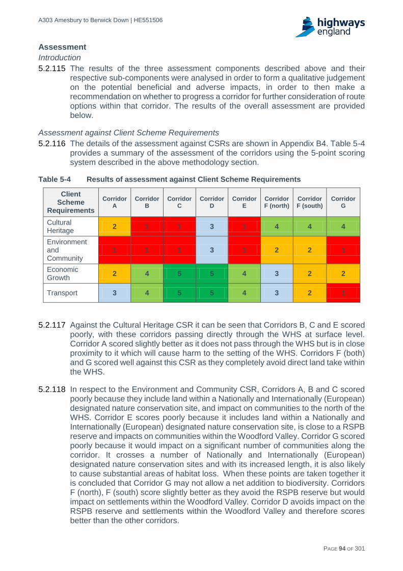
A303 Amesbury to Berwick Down | HE551506
HE551506-AA-GEN-SWI-RP-CX-000020 | P13, S0 21/12/2016 PAGE 94 OF 301
Assessment
Introduction
5.2.115 The results of the three assessment components described above and their respective sub-components were analysed in order to form a qualitative judgement on the potential beneficial and adverse impacts, in order to then make a recommendation on whether to progress a corridor for further consideration of route options within that corridor. The results of the overall assessment are provided below.
Assessment against Client Scheme Requirements
5.2.116 The details of the assessment against CSRs are shown in Appendix B4. Table 5-4 provides a summary of the assessment of the corridors using the 5-point scoring system described in the above methodology section.
Table 5-4 Results of assessment against Client Scheme Requirements
Client Scheme
Requirements
Corridor A
Corridor B
Corridor C
Corridor D
Corridor E
Corridor F (north)
Corridor F (south)
Corridor G
Cultural Heritage
2 1 1 3 1 4 4 4
Environment and Community
1 1 1 3 1 2 2 1
Economic Growth
2 4 5 5 4 3 2 2
Transport 3 4 5 5 4 3 2 1
5.2.117 Against the Cultural Heritage CSR it can be seen that Corridors B, C and E scored poorly, with these corridors passing directly through the WHS at surface level. Corridor A scored slightly better as it does not pass through the WHS but is in close proximity to it which will cause harm to the setting of the WHS. Corridors F (both) and G scored well against this CSR as they completely avoid direct land take within the WHS.
5.2.118 In respect to the Environment and Community CSR, Corridors A, B and C scored poorly because they include land within a Nationally and Internationally (European) designated nature conservation site, and impact on communities to the north of the WHS. Corridor E scores poorly because it includes land within a Nationally and Internationally (European) designated nature conservation site, is close to a RSPB reserve and impacts on communities within the Woodford Valley. Corridor G scored poorly because it would impact on a significant number of communities along the corridor. It crosses a number of Nationally and Internationally (European) designated nature conservation sites and with its increased length, it is also likely to cause substantial areas of habitat loss. When these points are taken together it is concluded that Corridor G may not allow a net addition to biodiversity. Corridors F (north), F (south) score slightly better as they avoid the RSPB reserve but would impact on settlements within the Woodford Valley. Corridor D avoids impact on the RSPB reserve and settlements within the Woodford Valley and therefore scores better than the other corridors.

A303 Amesbury to Berwick Down | HE551506
HE551506-AA-GEN-SWI-RP-CX-000020 | P13, S0 21/12/2016 PAGE 95 OF 301
5.2.119 Corridors C and D performed well against the Economic Growth CSR, principally because route options within these corridors would deliver the shortest overall length of route of all the options being considered. The shortest route lengths would deliver the greatest journey time savings, and consequently the greater journey time benefits. The longer the route, the less journey time benefits would be delivered, therefore Corridors A, F (south) and G all scored poorly against this CSR.
5.2.120 In terms of the Transport CSR, Corridors C and D were assessed to provide the greatest benefits of all the corridors considered, closely followed by Corridors B and E as these provided the most direct link. Corridors A and F (north) would contain longer routes and therefore score lower. Corridor G scored poorly against this CSR because it would mean road users suffering considerable diversion relative to more direct routes.
Assessment against environmental criteria (having regard to EAST and NPSNN)
5.2.121 The details of the assessment against NPSNN are shown in Appendix B5. Table 5-5 below provides a summary of the assessment of the corridors using the 5-point scoring system described in the above methodology section.
Table 5-5 Results of assessment against NPSNN environmental criteria
Environmental Criteria
Co
rrid
or
A
Co
rrid
or
B
Co
rrid
or
C
Co
rrid
or
D
Co
rrid
or
E
Co
rrid
or
F
(no
rth
)
Co
rrid
or
F
(so
uth
)
Co
rrid
or
G
Historic Environment
1 1 1 2 1 4 4 2
Biodiversity 1 1 1 1 1 1 1 1
Landscape (incl streetscape and urban environment)
2 2 2 2 1 2 1 1
Air Quality 2 2 3 3 2 1 2 1
Noise 2 3 3 4 2 3 3 3
Water Quality and Resources
2 3 3 2 3 2 1 1
People and Communities
2 3 2 4 2 2 2 1
Geology, Soils and Materials
2 2 2 2 2 2 2 2
Historic environment
5.2.122 Whilst significantly reducing severance within the WHS, Corridor A would have the potential to harm the setting and key assets of the WHS, including Durrington Walls, and substantial harm to the Outstanding Universal Value (OUV) of the WHS is considered probable. Corridor A would also run through Bulford possibly requiring the demolition and certainly substantially harming the setting of listed buildings, and affecting a Conservation Area.

A303 Amesbury to Berwick Down | HE551506
HE551506-AA-GEN-SWI-RP-CX-000020 | P13, S0 21/12/2016 PAGE 96 OF 301
5.2.123 For Corridors B, C and E, surface routes within the WHS would result in severance, fundamentally altering its character and fabric and resulting in substantial harm to the OUV, which is unlikely to be outweighed by the removal of traffic from the existing A303. In addition these options are likely to require the removal of scheduled assets and would seriously degrade the setting of other scheduled assets.
5.2.124 Tunnel based routes within Corridor D would still include portals and a section of above ground dual carriageway within the WHS, but would bring substantial benefits for the WHS arising from the closure of the A303 to the south of Stonehenge, reducing severance within the WHS and the impact of traffic in the WHS. Overall, it is considered that the potential exists for the benefits to outweigh the harm.
5.2.125 Outside the WHS, all surface routes, including Corridors F (north) and (south) and Corridor G have the potential to adversely impact on the historic environment, including the setting of listed buildings and scheduled assets, registered park and gardens and Conservation Areas.
5.2.126 Adverse impacts were weighed against the benefits of the scheme on the WHS. In this respect Corridors D, F (north), F (south), and G are the better performing with F (north) and F (south) being the best when assessed against the Historic Environment criteria.
Biodiversity
5.2.127 Corridors A, B, C, D and E have the potential to impact the Salisbury Plain SPA/SAC, including Parsonage Down SSSI/NNR, and at new crossings over the River Avon SAC, encompassing the River Avon and River Till. The corridors also cross or are located in close proximity to a number of nationally designated sites and the Normanton Down RSPB Reserve.
5.2.128 Corridors F (north) and (south), and Corridor G would also have the potential to adversely affect the River Avon SAC. Furthermore, given the length of these corridors, they would be expected to result in larger areas of habitat loss and potential severance. Further south there is also the potential for Corridor G to have an adverse impact on Porton Down SPA and Chilmark Quarries Bat SAC.
5.2.129 All corridors scored equally poorly when assessed against the Biodiversity criteria.
Landscape
5.2.130 At grade routes within Corridors A, B, C, and D have the potential to impact on the high quality landscape of the non-statutory, locally designated SLA and a number of visual receptors in local communities e.g. Amesbury, Larkhill, Durrington, Shrewton and Winterbourne Stoke.
5.2.131 Corridor E, Corridor F (north), Corridor F (south) and Corridor G have the potential to impact to a greater or lesser extent on the nationally designated landscape of Cranborne Chase and West Wiltshire Downs AONB and a potentially high number of visual receptors within the more rural communities to the south of the WHS, including Steeple Langford, Stapleford, Wylye, Andover and Salisbury, and villages along the Vale of Wardour.

A303 Amesbury to Berwick Down | HE551506
HE551506-AA-GEN-SWI-RP-CX-000020 | P13, S0 21/12/2016 PAGE 97 OF 301
5.2.132 All corridors scored poorly when assessed against the Landscape criteria, with Corridors E, F (south), and G performing the worst due to the high quality landscape of the AONB and a high number of sensitive visual receptors including residential properties and PRoW.
Air Quality
5.2.133 Corridors A and B are located within 200m of up to four nationally designated ecological sites and have the potential to have an adverse impact on residential receptors at Larkhill, Durrington and Bulford.
5.2.134 In contrast Corridors C and D are unlikely to adversely affect residential receptors and have the smallest increase in emissions based on the traffic modelling undertaken for this Design Fix A stage.
5.2.135 In the south, Corridors E and F (north) and (south) are located within 200m of up to five nationally designated sites and would affect residential receptors within Amesbury, Steeple Langford, Berwick St James, Winterbourne Stoke, Normanton, Stapleford, Lower Woodford, Little Durnford. The closure of the A303 within the WHS and longer routes would result in higher emissions for Corridors F (north) and (south), with the highest emissions predicted for Corridor G. Corridor G would also pass within 200m of up to 10 nationally designated ecological sites and would have potential for adverse effects on residential receptors in communities that include Andover, Grateley, Salisbury, Barford St Martin, and Dinton.
5.2.136 Apart from Corridors C and D, the majority of corridors scored poorly when assessed against the air quality criteria, with Corridors F (north) and G performing the worst due to the greatest increase in emissions.
Noise
5.2.137 Traffic noise for Corridors A, B, C, and E is likely to increase noise levels in the northern and southern parts of the WHS and for communities and sensitive receptors including Larkhill, south of Durrington, Shrewton, west of Bulford, Berwick St James, Stapleford, and West Amesbury, whilst there would be a reduction in Winterbourne Stoke, and noise Important Areas along the A303. There would also be a reduction as the result of tunnel based options in Corridor D.
5.2.138 Traffic noise as the result of Corridor F (north) and (south), and Corridor G would reduce within the WHS as well as within communities in Amesbury and Winterbourne Stoke. However these corridors would introduce new road traffic impacts at a high number of communities and sensitive receptors in more than thirteen communities along the corridor.
5.2.139 Corridor D, which includes tunnel sections within the WHS, scored best when assessed against the noise criteria, with corridors A and E performing the worst due to communities experiencing increases in noise levels.
Water environment
5.2.140 Routes within Corridors A, B, F (north) and F (south) include two new river crossings with the potential to adversely affect the water quality, flood risk and biodiversity of the River Till and Avon and the internationally (European) designated habitats and species within the River Avon SAC. Routes C, D and E include a new crossing of the River Till with the potential for adverse effects on water quality, flood
A303 Amesbury to Berwick Down | HE551506
HE551506-AA-GEN-SWI-RP-CX-000020 | P13, S0 21/12/2016 PAGE 98 OF 301
risk and biodiversity, and an existing river/floodplain crossing of the River Avon that could potentially be redesigned to provide new ecological and other benefits.
5.2.141 Corridor G includes new crossings of extensive floodplain associated with the River Nadder and River Avon downstream of Salisbury, including the historically, culturally and ecologically important Britford Water Meadows.
5.2.142 Small parts of Corridors A, B and the majority of Corridor F (north) cross Source Protection Zone (SPZ) 2, whilst Corridors F (south) and G cross SPZ 1 (The most sensitive area within an SPZ). Corridors C, D and E do not cross the SPZ.
5.2.143 For Corridor D, the tunnel construction would pose the most significant risk to groundwater and, depending on method, could potentially disrupt groundwater flows and the dispersal to the River Avon. However this may be managed by careful planning and design.
5.2.144 Potential adverse impacts associated with the new river crossings and European sites mean that all corridors have a mostly low fit with water environment criteria. However Corridor F (south) and Corridor G score poorly when assessed against the water environment criteria due to the potential for adverse impacts on SPZ 1, the Britford Water Meadow and the River Avon and Nadder floodplains.
People and communities
5.2.145 Corridor A would significantly increase severance within the community of Larkhill. Corridors F (north), F (south) and G would increase severance of access to Amesbury or to Salisbury from several villages located in between these two centres.
5.2.146 Corridors B, C and E would not reduce severance within the WHS nor between Amesbury and residential areas to the north including Larkhill, Durrington and Bulford and Salisbury to the south. Corridors A, D, F (north), F (south) and G would minimise severance and maximise opportunities for connectivity within the WHS.
5.2.147 Corridor D scores best in the assessment against the severance criteria for people and communities, with Corridor G performing the worst due to communities experiencing significant levels of severance.
Geology and soils, and materials
5.2.148 All corridors include sources of potential contamination with varying levels of associated risk. Corridors A and B include potentially contaminant land uses such as MoD Larkhill that includes heavy weapon artillery ranges, Down Barn historical landfill site and non-delineated military waste disposal areas. For Corridors F (north) and F (south) the MoD Boscombe Down airfield and military base spans the majority of the corridor in the east, presenting a potentially significant constraint in respect of land contamination.
5.2.149 All corridors would generate at least a moderate amount of arisings with the tunnel based options in Corridor D and the length of Corridor G considered to generate a significantly higher volume.
5.2.150 All corridors scored poorly when assessed against the Geology and Soils and Materials criteria.

A303 Amesbury to Berwick Down | HE551506
HE551506-AA-GEN-SWI-RP-CX-000020 | P13, S0 21/12/2016 PAGE 99 OF 301
Assessment utilising EAST
5.2.151 The details of the assessment against EAST are shown in Appendix B6. Table 5-6 shows the summary of the assessment of the corridors using the 5-point scoring system.
Table 5-6 Details of the assessment against EAST Cases
Strategic case
5.2.152 Corridor D was the best performing as it delivered Government and local objectives and addressed well the transport issues. Corridors B, C and E failed to deliver environmental objectives and Corridor G delivered neither transport nor environmental objectives.
Economic case
5.2.153 Economic growth: Corridors C and D performed the best on journey time savings and reliability due to their short lengths. Corridors F (south) and G were the worst performing due to the lengths of routes leading to an increased potential for delay and incidents.
5.2.154 Carbon emissions: Emissions from vehicles were the largest component of this assessment. Corridors C and D were the shortest and therefore were the best performers. Corridors F (south) and G, being the longest, performed the worst.
5.2.155 Socio-distributional impacts and the regions: Weighed over a number of criteria all corridors performed similarly.
5.2.156 Local environment: On balance Corridor D performed the best. The other corridors performed well against some criteria but poorly against others. Overall the other corridors performed worse than Corridor D.
5.2.157 Wellbeing: Weighed over a number of criteria all corridors performed similarly
5.2.158 Expected value for money category based on the indicative Benefit Cost Ratios (BCR): Corridors B, C and F (north) performed the best. Corridor D offered lower value for money, primarily due to the high cost of a tunnel. Corridor G performed the worst due to high cost and limited user benefits with the increased length of the route.
EAST Case Corridor
A Corridor
B Corridor
C Corridor
D Corridor
E
Corridor F
(north)
Corridor F
(south)
Corridor G
Strategic Case
2 1 1 4 1 3 3 1
Economic Case
3 3 4 4 3 3 2 1
Managerial Case
2 2 2 4 2 2 2 1
Financial Case
2 2 2 2 2 2 2 1
Commercial Case
3 3 3 3 3 3 3 3

A303 Amesbury to Berwick Down | HE551506
HE551506-AA-GEN-SWI-RP-CX-000020 | P13, S0 21/12/2016 PAGE 100 OF 301
Managerial case
5.2.159 Corridor D performed best as a tunnel scheme had been tested in public previously and there was strong and detailed evidence to support it. Corridor G performed worst as it followed a completely new route which was considered to be more difficult to get through DCO and had no evidence to support it.
Financial case
5.2.160 The financial case considered Capital and Revenue costs and overall cost risk. Corridor G performed worst due to its length which would lead to higher costs.
Commercial case
5.2.161 The commercial case considered funding sources and potential income generated with all corridors scored equally at this stage.
Summary of overall assessment
5.2.162 The results of the three different assessment methodologies (CSRs, EAST and environmental criteria having regard to NPSNN) were drawn together to facilitate a balanced review of the corridors and the recommendation of corridors to be taken forward for further development and appraisal. A summary of the key findings for each corridor is provided in Table 5-7 below.
Table 5-7 Overall Corridor assessment summary
Overall Corridor assessment summary
Corridor A
Corridor A would provide a route to the north of the WHS. This would reduce severance within the WHS, and could also result in some benefit to the WHS. However, the harm it would cause to the setting of the WHS and key assets within it (e.g. Durrington Walls) mean substantial harm to the OUV of the WHS is probable and, on balance potential harm to the OUV of the WHS would outweigh the benefits associated with the removal of the A303.
The corridor may also adversely affect Nationally and Internationally (European) designated nature conservation sites including through the direct loss, in two locations, of parts of Salisbury Plain SPA/SAC. It is likely that this would require significant compensation measures and conflicts with the objective of achieving a net addition in biodiversity.
The corridor has the potential to adversely affect communities and land within the settlements at Larkhill, Durrington and Bulford.
The corridor would reduce transport costs, improve regional connectivity, support the visitor economy and provide journey time savings compared to the existing situation.
Corridor A runs along the northern boundary of the WHS. It is difficult to avoid the receptors or to expand the corridor without resulting in further direct impacts or worsening impacts on receptors such as the Salisbury Plain Special Protection Area (SPA) / Special Area of Conservation (SAC) and communities at Larkhill, Durrington and Bulford. On balance, the overall assessment of the corridor is unlikely to change and it would continue to perform poorly against a number of environmental criteria.
Corridor A delivered a relatively poor fit against the CSRs, and overall performed poorly against the environmental criteria. The performance against the EAST criteria was also poor.
Given the overall poor environmental performance and the poor fit against the CSRs, it was recommended that this corridor was not taken forward for further consideration.
Corridor B
Corridor B would provide a surface dual carriageway route to the north of the existing A303, but would sever the WHS, fundamentally altering its character and fabric and causing substantial harm to the OUV of the WHS. The corridor would adversely affect nationally and internationally (European) designated nature conservation sites which could conflict with the objective of achieving a net addition in biodiversity, but it would reduce road traffic noise and severance in Winterbourne Stoke.

A303 Amesbury to Berwick Down | HE551506
HE551506-AA-GEN-SWI-RP-CX-000020 | P13, S0 21/12/2016 PAGE 101 OF 301
Overall Corridor assessment summary
The corridor would reduce transport costs and improve regional connectivity, although the adverse environmental impacts on the WHS may cause negative economic impacts on the visitor economy. The corridor would provide journey time savings compared to the existing situation.
Corridor B performed poorly against the CSRs, specifically in relation to Cultural Heritage and Environment and Community and overall performed relatively poorly against the environmental criteria. The performance against the EAST criteria was average.
Due to the substantial impact on the WHS, and the consequential poor fit against the CSRs, it was recommended that this corridor was not taken forward for further consideration.
Corridor C
Corridor C would provide a surface dual carriageway route close to the existing A303 corridor. This would cause substantial harm to the OUV of the WHS and the corridor offers limited opportunity to reduce severance within the WHS and there would be limited or no benefit in terms of noise. The corridor would not contribute to the enhancement of the historic landscape within the WHS and has the potential to adversely affect nationally and internationally (European) designated nature conservation sites which could conflict with the objective of achieving a net addition in biodiversity. It would reduce road traffic noise and severance in Winterbourne Stoke.
The corridor would reduce transport costs and improve regional connectivity, although the adverse environmental impacts on the WHS may cause negative economic impacts on the visitor economy. The corridor would provide journey time savings compared to the existing situation.
Corridor C delivered a very poor fit against the CSRs of Cultural Heritage and Environment and Community, but scored well against Economic Growth and Transport. Overall, Corridor C performed poorly against the environmental criteria. The performance against the EAST criteria was average.
Due to substantial impacts on the WHS it was recommended that this corridor was not taken forward for further consideration.
Corridor D
By providing a tunnel within the WHS, Corridor D reduces severance and benefits the character of the WHS and the setting of key assets such as Stonehenge. The above ground elements may cause adverse effects on the character of the WHS but it is considered that substantial harm can be avoided with appropriate design and mitigation. The corridor has the potential to contribute to the enhancement of the historic landscape within the WHS. It would reduce road traffic noise and severance in Winterbourne Stoke.
The corridor would reduce transport costs, improve regional connectivity, support the visitor economy and provide journey time savings compared to the existing situation.
Corridor D had a good fit against the CSRs, particularly Economic Growth and Transport, with the best overall fit of all the corridors. Similarly, the corridor scored the best of all corridors against environmental criteria and EAST.
This corridor offers reduced severance and potential to enhance the WHS and is the best performing corridor of all that were assessed. It was therefore recommended that Corridor D was taken forward for further consideration.
Corridor E
Corridor E would provide a surface level dual carriageway through the WHS to the south of the existing A303. This corridor presents limited potential to reduce severance within the WHS, causing substantial harm to the OUV. The corridor would not contribute to the enhancement of the historic landscape within the WHS. It would reduce road traffic noise and severance in Winterbourne Stoke although this should be weighed against the potential to increase noise in other settlements within the corridor such as at Berwick St James, Stapleford and West Amesbury.
The corridor would reduce transport costs and improve regional connectivity, although the adverse environmental impacts on the WHS would cause negative economic impacts on the visitor economy. The corridor would provide some journey time savings compared to the existing situation.
Corridor E performed poorly against the CSRs, specifically in relation to Cultural Heritage and Environment and Community and overall performed poorly against the environmental criteria, specifically Historic Environment, Biodiversity and Landscape. The performance against the EAST criteria was average.

A303 Amesbury to Berwick Down | HE551506
HE551506-AA-GEN-SWI-RP-CX-000020 | P13, S0 21/12/2016 PAGE 102 OF 301
Overall Corridor assessment summary
Due to the impact on the WHS, and the consequential poor fit against the CSRs, it was recommended that this corridor was not taken forward for further consideration.
Corridor F (north)
Corridor F (north) would provide a surface option that would completely avoid the WHS to the south and it would reduce severance and benefit the character of the WHS and the setting of key assets, bringing substantial benefits. Any route that lies entirely within Corridor F (north) would run through the Boscombe Down airfield. The acceptability of this would be informed by engagement with the MoD during the design development stage.
The corridor has the potential to contribute to the enhancement of the historic landscape within the WHS although it may adversely affect some nationally and internationally (European) designated nature conservation sites, and the length of the corridor would lead to increased habitat loss compared to other corridor options. It would reduce road traffic noise and severance in Winterbourne Stoke although this should be weighed against potential adverse noise, severance and visual effects in other settlements within the corridor.
Economic benefits would be reduced because the length of the route would be longer than the existing road, meaning vehicles have to travel greater distances. However, the corridor would provide journey time savings compared to the existing situation, improve regional connectivity and support the visitor economy.
Corridor F (north) performed relatively well the CSRs, specifically in relation to Cultural Heritage. The overall performance against the environmental criteria was average, but showed detriment in respect of air quality. The performance against the EAST criteria was average.
This corridor has a good fit with the CSR for Cultural Heritage and offers reduced severance and potential enhancement within the WHS by avoiding direct impact upon it. It was recommended that Corridor F (north) was taken forward for further consideration.
Corridor F (south)
Corridor F (south) would provide a surface option that would completely avoid the WHS to the south and it would reduce severance and benefit the character of the WHS and the setting of key assets bringing substantial benefits. The corridor has the potential to contribute to the enhancement of the historic landscape within the WHS although it may adversely affect some nationally and internationally (European) designated nature conservation sites. The length of the corridor would lead to increased habitat loss compared to other corridor options, thus offering limited opportunity to increase biodiversity. The corridor would also result in adverse landscape impacts where it passes through the Cranbourne Chase AONB, and would likely affect a high number of sensitive visual receptors. The majority of the corridor is located within the inner part (Zone 1) of a source protection zone for groundwater. It would reduce road traffic noise and severance in Winterbourne Stoke although this should be weighed against the potential adverse noise, severance and visual effects in other settlements within the corridor.
The corridor would marginally reduce transport costs, improve regional connectivity and support the visitor economy. Hence, economic benefits are likely to be relatively slight.
Corridor F (south) performed relatively well against the CSRs, specifically in relation to Cultural Heritage, but the additional length of the route impacted upon the Transport and Economic criteria. The overall performance against the environmental criteria was poor, with detrimental impacts to Biodiversity, Landscape and Water. The performance against the EAST criteria was average.
This option has a good fit with the CSR for Cultural Heritage, and would offer reduced severance within the WHS by avoiding direct impact upon it. It has the potential to enhance the WHS but it performs less well in a number of environmental areas most noticeably landscape and provides reduced economic and transport benefits compared to Corridor F (north). On this basis it was recommended that Corridor F (south) was not taken forward for further consideration.
Corridor G
Corridor G would provide a surface option that would effectively provide a Salisbury southern bypass. This corridor would reduce severance and benefit the character of the WHS and the setting of key assets such as Stonehenge bringing substantial benefits to the WHS. The corridor would contribute to the enhancement of the historic landscape within the WHS. However, it would adversely affect numerous nationally and internationally (European) designated nature conservation sites and areas of ancient woodland. The length of the corridor would lead to substantially increased habitat loss and

A303 Amesbury to Berwick Down | HE551506
HE551506-AA-GEN-SWI-RP-CX-000020 | P13, S0 21/12/2016 PAGE 103 OF 301
Overall Corridor assessment summary
severance, thus offering limited opportunity to increase biodiversity. The corridor passes to the south of Salisbury and a significant section of the corridor is located within the Cranbourne Chase and West Wiltshire Downs AONB. It would reduce road traffic noise and severance in Winterbourne Stoke although this should be weighed against the potential adverse noise, severance and visual effects in other settlements within the corridor.
The corridor would not reduce transport costs as the benefits from the increase in traffic speed and creation of grade-separated junction are outweighed by the longer route. Hence there would be no improvements in regional connectivity and support for the visitor economy. Hence, there would be no associated economic benefits.
Whilst this option would offer reduced severance and potential to enhance the WHS it is likely to lead to substantial habitat loss. Journey times would increase giving lower economic benefits compared with the more direct routes.
Corridor G performed poorly against the CSRs, specifically in relation to Cultural Heritage and Environment and Community. The overall performance against the environmental criteria was very poor. The performance against the EAST criteria was also the worst performing corridor.
Given the significant increase in journey length for through traffic and the associated disbenefits associated with the longer route, and the consequential poor fit against the CSRs, it was recommended that this corridor was not taken forward for further consideration.
Conclusions and recommendations
5.2.163 Applying the stated assessment methodology of EAST supplemented with NPSNN and the CSRs, it was concluded that Corridors D and F (north) are the better performing corridors and should be taken forward for further consideration.
5.2.164 The initial recommendation was to exclude Corridor F (south) from further assessment on the basis that it performed poorly against a number of environmental areas, most notably the Cranborne Chase AONB. It was also recommended to progress Corridor F (north) for further assessment whilst recognising that the presence of Boscombe Down Airfield in the east of the corridor would present a challenge. Subsequent consideration determined that combining Corridors F (north) and F (south) could provide an opportunity for hybrid route options which could avoid the most significant receptors within each corridor and perform better against a range of criteria.
5.2.165 On this basis it was recommended that Corridor D, Corridor F (north) and Corridor F (south) should be taken forward for further consideration. Corridors F (north) and F (south) will be joined and subsequently known as Corridor F. Design Fix B and C will develop and appraise route options for the improvement, as shown on the plan in Appendix B7.
5.2.166 It was recommended that Corridors A, B, C, E and G were not considered further.

A303 Amesbury to Berwick Down | HE551506
HE551506-AA-GEN-SWI-RP-CX-000020 | P13, S0 21/12/2016 PAGE 104 OF 301
6 Development of route options within corridors
6.1 Introduction
6.1.1 The initial corridor identification and appraisal in Design Fix A recommended Corridors D and F as the better performing corridors to be further assessed as part of developing route options to be taken forward for further assessment to determine route option(s) for public consultation.
6.1.2 Historical routes within the corridors were used to inform the development of route options for these corridors.
6.1.3 This section describes the development of these route options and how they were rationalised based on impacts on the key constraints.
6.2 Basis of geometric design
Expressway
6.2.1 The A303 scheme was identified as a planned Expressway in the Road Investment Strategy (RIS) published in December 2014 and in Highways England’s “Expressway Technical Note”, published in March 2016, which documents high level core requirements for Expressways.
6.2.2 The RIS sets out a vision for Expressways as:
Roads that can be relied upon to be as well-designed as motorways and which are able to offer the same standard of journey to users, meaning:
- Largely or entirely dual carriageway roads that are safe, well-built and resilient to delay.
- Junctions which are largely or entirely grade separated, so traffic on the main road can pass over or under roundabouts without stopping.
- Modern safety measures and construction standards. - Technology to manage traffic and provide better information to drivers.
This means an Expressway would be able to provide a high-quality journey to its users with mile-a-minute journeys throughout the day, particularly outside of urban areas. Safety levels should match the highest standards of the network and be able to provide a motorway-quality journey.
Design standards
6.2.3 Expressways are designated as high standard routes. As such a high standard of road geometry should be achieved by designing the route options to desirable minimum standards as defined in Design Manual for Roads and Bridges (DMRB) Standard TD9/93 Highway Link Design (TD9/93). It is recognised that some departures from standard can be incorporated into schemes to address specific issues without compromising safety and such opportunities would be assessed as the design progresses with selection of a preferred route option.
6.2.4 The geometric alignment design was based on TD 9/93 desirable minimum parameters.

A303 Amesbury to Berwick Down | HE551506
HE551506-AA-GEN-SWI-RP-CX-000020 | P13, S0 21/12/2016 PAGE 105 OF 301
6.2.5 Where options could utilise the existing A303 alignment, it is assumed that any existing geometry even if below desirable minimum standards could be considered for incorporation into the new scheme.
6.2.6 A number of assumptions have been made at this stage about the overall standard and features to be incorporated into the route options and developed for assessment. These assumptions are based on published Expressway documents and good highway design practice:
The adopted design speed is 120kph (70 mph).
The cross section is a rural 2-lane dual carriageway in accordance with Design Manual for Roads and Bridges (DMRB) Standard TD 27/05 Cross Sections and Headroom, Figure 4-3a: Dimensions of Cross-Section Components for Rural All-Purpose Roads Mainline, shown in Figure 6-1 below. For this 2-lane dual carriageway scheme only Lane 1 and Lane 2 would be provided.
Junctions to be provided for all route options with A-Class roads at the A360, serving the Stonehenge Visitor Centre and Winterbourne Stoke, and at the A345, serving Durrington, Amesbury and Larkhill.
Figure 6-1 Rural dual carriageway cross section
6.3 Development of Corridor D route options
Historical routes
6.3.1 The eleven historical routes that lie within Corridor D were used as a starting point for option development and are listed below and shown in Appendix C1:
1991-1993 W5 (Initial route identification study).
1995 4km Tunnel (Planning Conference, referenced in Chapter 17 of 2003 Environmental Statement).
1999 2km Tunnel Cut and Cover (Preferred route announcement).
1999 Winterbourne Stoke Bypass (Preferred route announcement).
2003 2.1km Tunnel (Published scheme)
2003 2.3km Tunnel (Long Tunnels Options Report, 2003).
2003 2.7km Tunnel (Long Tunnels Options Report, 2003).
2003 2.9km Tunnel (Long Tunnels Options Report, 2003).
2003 4.5km Tunnel (Long Tunnels Options Report, 2003)
2015 2.5km Tunnel (A303/A30/A358 Corridor Feasibility Study, 2015).
2015 2.9km Tunnel (A303/A30/A358 Corridor Feasibility Study, 2015).

A303 Amesbury to Berwick Down | HE551506
HE551506-AA-GEN-SWI-RP-CX-000020 | P13, S0 21/12/2016 PAGE 106 OF 301
6.3.2 These routes are only those historical routes that lie in whole or in substantial part within the boundaries of Corridor D and are tunnelled for part of their length through the WHS. The alignments informed the subsequent process of route option development but did not constrain the process. New route options were also developed in localities not previously used if it was considered that they would perform well in the subsequent assessment and against impact on the constraints.
Policy and stakeholder considerations
6.3.3 There have been a number of significant changes in National Planning Policy since the 2004 Public Inquiry for the previous scheme. The most relevant guidance National Policy Statements for National Networks (NPSNN), reflected historic environment policy in the National Planning Policy Framework (2012) and placed far more emphasis on the importance of the setting of heritage assets and the need to conserve internationally important heritage sites, such as the WHS.
6.3.4 Given that all route options within Corridor D would traverse the WHS, the key policy for consideration was therefore identified to be NPSNN. Within this policy the Secretary of State has a responsibility to:
Seek to avoid or minimise conflict between the conservation of designated heritage assets and the proposal.
Refuse consent where the proposed development will lead to substantial harm to or total loss of significance of a designated heritage asset, unless it can be demonstrated that the substantial harm or loss of significance is necessary in order to deliver substantial public benefits that outweigh that loss or harm.
6.3.5 In 2014 the National Trust and English Heritage (now Historic England) published a “Preliminary Outline Assessment of the impact of A303 improvements on the OUV of the Stonehenge Avebury and Associated Sites World Heritage property” report that summarised these issues stating:
“A Statement of Significance, developed with the steering groups for Avebury and Stonehenge, was submitted by the UK Government and agreed by the UNESCO World Heritage Committee in 2008. It was subsumed into an overall Statement of Outstanding Universal Value (now including assessments of integrity and authenticity) agreed by the Committee in 2013. The 2009 WHS Management Plan defined seven attributes of Outstanding Universal Value, based on the Statement of Significance, along with assessments of integrity and authenticity.”
“The Statement and Management Plan make clear that all Neolithic and Early Bronze Age funerary and ceremonial monuments and associated sites, together with their relationships with each other and with the landscape are attributes of Outstanding Universal Value and need to be treated as such. This is a decisive move away from the focus on Stonehenge and the Stonehenge Bowl which underpinned the 1999 EH/ NT Master Plan, the 2000 Management Plan and the Highways Agency Published scheme, to a much wider view of the Outstanding Universal Value of the property which means that all the physical attributes of Outstanding Universal Value have to be given more equal consideration.”
6.3.6 All route options through the WHS and tunnel portal locations within the WHS were therefore carefully considered with the aim of minimising and mitigating negative impacts to the heritage assets where possible.

A303 Amesbury to Berwick Down | HE551506
HE551506-AA-GEN-SWI-RP-CX-000020 | P13, S0 21/12/2016 PAGE 107 OF 301
Considerations of route options within the WHS
6.3.7 Development of route options through the WHS that could be agreed with Historic England, National Trust, Wiltshire Council and English Heritage, was considered key to achieving the following Client Scheme Requirements (CSRs) for the scheme (see Chapter 2):
Improve access within the WHS.
Treat archaeological features with sensitivity and protect the Outstanding Universal Value (OUV) of the WHS.
Minimise any damage to or loss of archaeology.
Seek enhancement of the historic landscape within the WHS.
6.3.8 Additionally, when developing the route options it was important to address the needs articulated in the NPSNN, working closely with key strategic stakeholders in order to contribute as far as is practicable to the delivery of priorities included in the 2015 WHS Management Plan:
Reduce the dominance and negative impact of the A303 as it passes through the WHS.
Contribute towards the interpretation of the site and the enhancement of the visitor experience of the wider landscape.
Ensure that the scheme was consistent with the protection and, where appropriate, the enhancement of the monuments and their settings and the wider WHS landscape and its setting.
Through an improved network, contribute to the spreading of economic benefits related to the WHS to the community and wider county.
In presenting the scheme to the public and seeking their comments, encourage local community engagement with the WHS.
Through an education programme associated with the scheme, encourage sustainable archaeological research and education to improve and communicate the understanding of the WHS.
2003 Scheme 2.1km tunnel
6.3.9 The 2003 published scheme that was examined at Public Inquiry included a 2.1km tunnel and an online western approach route. Historic England, National Trust, Wiltshire Council and English Heritage have indicated in their report that a different approach to the route option assessment is now required due to:
Changes in the understanding of the WHS.
The revised Statement of OUV adopted by UNESCO in 2013 (as presented in the 2015 WHS Management Plan).
Substantive changes in national planning policy and international best practice in relation to WHS.
6.3.10 The 2003 published scheme was therefore based on a different understanding of what attributes provide the WHS with its OUV and reflect a substantially different policy context. The DfT design guidance DMRB was also updated in the intervening period.
6.3.11 The Public Inquiry Inspector’s Report of July 2005 noted that the National Trust presented a case for a tunnel of at least 2.9km in length, an increase to the published tunnel length of 800m. The National Trust concluded ‘numerous
A303 Amesbury to Berwick Down | HE551506
HE551506-AA-GEN-SWI-RP-CX-000020 | P13, S0 21/12/2016 PAGE 108 OF 301
substantial advantages’ would be derived and would improve ‘important elements of the WHS landscape’:
Benefits to the setting of significant features in the Stonehenge landscape including four archaeological sites.
Locating the scheme away from the pinch point of the Normanton Down Barrow Group at the western end of the tunnel.
The reunification of The Avenue in the east.
6.3.12 In this context, the key strategic stakeholders, and international experts at ICOMOS/UNESCO identified in their report on the Joint World Heritage Centre / ICOMOS Advisory Mission to Stonehenge, Avebury and Associated Sites (ICOMOS, 2015) that the 2003 published scheme could be improved upon with a number of changes including:
Adopting a longer tunnel.
Relocating the eastern portal to the east of The Avenue, hence enabling the reconnection of The Avenue.
Relocating the western portal and approach roads further south away from key heritage assets such as the Winterbourne Stoke Barrow Group and further away from edge of the topographic ridges such as King Barrow Ridge that define the immediate landscape around the Stonehenge monument.
6.3.13 English Heritage (now Historic England) and the National Trust set out their initial suggestions for potential tunnel portal locations and approach roads in their 2014 preliminary outline assessment of the three following alternatives:
A 2.1km tunnel as per the 2003 published scheme.
A 2.5km tunnel along the same line as the published scheme but with both portals relocated slightly further east and west.
A 2.9km tunnel with an off-line western portal positioned to the south of the existing road.
6.3.14 These were further refined and developed as described below to reflect tunnel design optimisation, engineering and environmental considerations including, amongst others, potential impacts on heritage Scheduled Monuments and the WHS.
6.3.15 Online approaches for a 2.9km tunnel were not discounted in the 2014 report but were shown to be less preferential than offline route options, particularly given the harm to the Winterbourne Stoke Barrow Group.
6.3.16 The overall conclusion of this Preliminary Outline Assessment Report was that a bored tunnel of between 2.5km and 2.9km, if designed sensitively, would have the potential to maximise the benefits of removing the surface road from the WHS whilst minimising the harmful impacts of any tunnel scheme whose portals lie within the WHS boundary.
6.3.17 The concept of moving the western portal location and approach offline, was further supported through comments received from key stakeholders at an Environment Working Group meeting held to discuss options on 30th June 2016, at which National Trust and Historic England were represented. In the meeting it was stated:

A303 Amesbury to Berwick Down | HE551506
HE551506-AA-GEN-SWI-RP-CX-000020 | P13, S0 21/12/2016 PAGE 109 OF 301
“At the eastern end, the tunnel portal may be more feasibly located to the north of the A303. ICOMOS has identified a desire to place the portal east of The Avenue and this should be considered in design and assessment. At the western end the portal location should be to the south of the A303 within the general area identified as providing the least impact upon Outstanding Universal Value and the inter-relationship between groups of key monuments. Any option with a western portal located to the north of the existing A303 would cause substantial harm to Outstanding Universal Value and to several Scheduled Monuments and other nationally-important archaeology.”
Historical option elimination
6.3.18 In addition to policy changes outlined above that change the emphasis in assessment of route options, a number of engineering considerations conspire against some of the historical options with shorter tunnel lengths.
6.3.19 The 2003 published scheme had its eastern portal to the west of the Avenue. In this position the ground is rising from the east towards King Barrow Ridge which elevates the portal position. With the adoption of a bored tunnel it is necessary to maintain a minimum of 10m cover above the tunnel to ensure stability of the ground and prevent collapse. This would require a gradient within the tunnel in excess of the practical maximum of 4%. Beyond this figure emissions would increase significantly that could lead to the need for higher capacity ventilation systems. There would also be potential operational difficulties with the possible need for a climbing lane and the size of the tunnel increased accordingly.
6.3.20 It is generally accepted by key stakeholders and historic environment specialists that the most desirable position for the eastern tunnel portal would be to the east of The Avenue in order to remove both the physical impact and the impact on the setting of The Avenue. If a tunnel length shorter than 2.9km were to be adopted with the portal to the east of The Avenue, the western portal would be located to the east of Normanton Gorse and in view of the Stonehenge monument.
6.3.21 The 2003 published scheme included a grade separated junction located immediately to the west of Longbarrow Crossroads and within the Winterbourne Stoke Barrow Group. This would continue and increase the level of impact on that Barrow Group which would adversely impact upon its setting. To avoid this impact the junction would need to be moved to the south. By moving the junction southwards the approach to it from the east would also need to be south of the existing A303. Shorter tunnel lengths would then have the western portal located close to the Normanton Down Barrow Group and may impact upon Normanton Gorse.
6.3.22 In the light of these considerations the 1991_1993 W5, 1991-Winterbourne Stoke Bypass, 2003 Published scheme 2.1km Tunnel, 2.3km Tunnel and 1999-2km Tunnel cut and cover options were eliminated from the assessment and route options development.
6.3.23 On this basis, of the original eleven historical routes, six routes were considered further in the development of route options for appraisal as follows:
1995 4.0km Tunnel Route (proposed at Planning Conference, referenced in Chapter 17 of 2003 Environmental Statement).
2003 2.7km Tunnel (Long Tunnels Options Report, 2003).

A303 Amesbury to Berwick Down | HE551506
HE551506-AA-GEN-SWI-RP-CX-000020 | P13, S0 21/12/2016 PAGE 110 OF 301
2003 2.9km Tunnel (Long Tunnels Options Report, 2003).
2003 4.5km Tunnel (Long Tunnels Options Report, 2003).
2015 2.5km Tunnel (A303/A30/A358 Corridor Feasibility Study, 2015).
2015 2.9km Tunnel (A303/A30/A358 Corridor Feasibility Study, 2015).
Design reviews
6.3.24 A series of design reviews were undertaken with the aim of further rationalising and developing the proposed route options based on the remaining historical routes to minimise impact on the identified constraints.
Design review 1
6.3.25 Routes were considered having cognisance of the routes within Corridor F which includes routes passing to the south of Winterbourne Stoke. This area was seen to have merit in terms of the fit of routes within the landform and their effect on landscape and designations.
6.3.26 Routes to the south of Winterbourne Stoke would lie outside the boundaries of Corridor D that were assessed in Design Fix A and a decision was therefore made to adjust the boundary of Corridor D to include tunnel options that could also route to the south of Winterbourne Stoke.
6.3.27 Six route options were developed D001 to D006 and the summary of their key design criteria and the assessment against the constraints is shown in Table 6-1.
Table 6-1 Corridor D design review 1 summary
Route Option Comments
D001 Approximately 2.9km length tunnel with the route option continuing north of Winterbourne Stoke. The route is based on the 2015 2.9km tunnel option but with eastern portal relocated east of The Avenue and western portal located south of Normanton Gorse.
No immediate reasons were identified for excluding this option at this stage, and it was therefore taken forward for further review.
D002 Approximately 4.5km length tunnel with the route option continuing north of Winterbourne Stoke. The route is based on a modified 2006 4.0km alignment north of Stonehenge option but with the tunnel alignment altered to relocate eastern portal east of The Avenue and relocate the western portal outside of the WHS. The route was moved further south which allowed the western portal to be located outside the WHS.
No immediate reasons were identified for excluding this option at this stage, and it was therefore taken forward for further review.
D003 Approximately 2.9km length tunnel with the route option continuing south of Winterbourne Stoke. The route is based on the 2015 2.9km tunnel option but with the eastern portal relocated east of The Avenue.
No immediate reasons were identified for excluding this option at this stage, and it was therefore taken forward for further review.
D004 Approximately 2.5km length tunnel with the route option continuing north of Winterbourne Stoke. The route is based on the alignment of the 2015 2.9km tunnel option moving the route south away from the Winterbourne Stoke Barrow Group and with the eastern portal relocated east of The Avenue.

A303 Amesbury to Berwick Down | HE551506
HE551506-AA-GEN-SWI-RP-CX-000020 | P13, S0 21/12/2016 PAGE 111 OF 301
Route Option Comments
With the eastern portal located to the east of The Avenue, the western tunnel portal would be in view to and from Stonehenge, leading to a significant visual impact and on this basis was not taken forward for further review.
D005 Approximately 2.7km length tunnel with the route option continuing north of Winterbourne Stoke. As with D004, the route is based on the alignment of the 2015 2.9km tunnel option moving the route south away from the Winterbourne Stoke Barrow Group and with the eastern portal relocated east of The Avenue.
With the eastern portal located to the east of The Avenue, as with D004, the western tunnel portal would be in view to and from Stonehenge, leading to a significant visual impact and on this basis was not taken forward for further review.
D006 Approximately 4.5km length tunnel with the route option continuing south of Winterbourne Stoke. The route is based on 2003 published scheme 4.5km tunnel option but realigned along the D003 route option with eastern portal location consistent with other route options and western portal outside of the WHS, and beyond the A360.
No immediate reasons were identified for excluding this option at this stage, and it was therefore taken forward for further review.
6.3.28 Locations of the western portals were considered and the six route options were rationalised to four, as described in Table 6-1. The four route options taken forward for further consideration were Route Options D001, D002, D003 and D006. D004 and D005 were not taken forward as with the eastern tunnel portal located east of The Avenue, the shorter tunnel lengths would result in the western portal being visible to and from Stonehenge.
6.3.29 Indicative vertical alignments were developed to allow consideration of the wider impacts of possible earthworks on each route option.
Design review 2
6.3.30 The purpose of this review was to identify key constraints of the route options brought forward from design review 1, and to refine horizontal alignments to minimise direct impacts on the most sensitive and valued environmental assets.
6.3.31 Environmental and technical reviews resulted in the introduction of Route Option D010 which follows a similar horizontal geometry to Route Option D001 but adopts a 4.5km tunnel to take the western portal outside of the WHS as proposed for Route Option D006.
6.3.32 The review also explored further horizontal and vertical adjustment of Route Options D001, D003 and D006 between the proposed connection to the existing A303 in the west and the western tunnel portal.
Design review 3
6.3.33 An environmental and technical review resulted in the adjustment of Route Options D001 and D010 further south of the existing A360/A303 junction to avoid certain archaeological features and long barrows where feasible.
6.3.34 Route Options D001, D002, D003, D006 and D010 are shown in Appendix C2.

A303 Amesbury to Berwick Down | HE551506
HE551506-AA-GEN-SWI-RP-CX-000020 | P13, S0 21/12/2016 PAGE 112 OF 301
Design review 4
6.3.35 It was concluded that route options with a 2.9km tunnel should be further investigated to incorporate eastern portal locations east and west of The Avenue and a bypass north and south of Winterbourne Stoke. These include two additional route options that follow the same horizontal geometry as Route Options D001 and D003 however shift the tunnel to the west, allowing the western portal to move further south west away from Normanton Gorse with the eastern portal to sit west of The Avenue. These route options were named D021 and D022 with D021 running north of Winterbourne Stoke and D022 running south of Winterbourne Stoke.
6.3.36 The geometry of route options south of Stonehenge was further refined. Horizontal radii were introduced into the tunnel’s geometry to provide better end user driveability, allow more flexibility in the tunnel portal orientation to reduce risk of sun glare on exiting the tunnel.
Conclusion
6.3.37 The seven route options taken forward for initial appraisal of Corridor D options were D001, D002, D003, D006, D010, D021 and D022 as shown in Appendix C3.
6.4 Development of Corridor F route options
Historical routes
6.4.1 The thirteen historical routes that lie within Corridor F were used to inform the route option development and are listed below and shown in Appendix C4:
1991_1993 S2(B). (Initial route identification study).
1991_1993 S2-S2(B). (Initial route identification study)
2004 ACT. (Objector’s Alternative Route at 2004 public inquiry).
2004 Alternative Route 2. (Objector’s Alternative Route at 2004 public inquiry)
2004 Alternative Route 4. (Objector’s Alternative Route at 2004 public inquiry)
2004 Alternative Route 7 Case Route. (Objector’s Alternative Route at 2004 public inquiry)
2004 Jackson Route AR2. (Objector’s Alternative Route at 2004 public inquiry)
2004 Lawrence Alternative AR10. (Objector’s Alternative Route at 2004 public inquiry)
2006 Alternative Route FNR1 (proposed at 2006 Public Consultation)
2006 Alternative Route FSR1 (proposed at 2006 Public Consultation)
2006 Alternative route FSR2 (proposed at 2006 Public Consultation)
2006 Alternative Route FSR3 (proposed at 2006 Public Consultation)
6.4.2 These routes are only those historical routes that lie in whole or in substantial part within the boundaries of Corridor F. The alignments informed the subsequent process of route option development but did not constrain the process. New alignments were developed in localities not previously used if it was considered that they would perform well in the subsequent assessment and against the impacts on key constraints.
Methodology of route rationalisation
6.4.3 The historical routes were initially rationalised to identify routes that cover the north, middle and south of the corridor, allowing the constraints of the whole corridor breadth to be explored further, and to combine options where they followed similar

A303 Amesbury to Berwick Down | HE551506
HE551506-AA-GEN-SWI-RP-CX-000020 | P13, S0 21/12/2016 PAGE 113 OF 301
paths. This resulted in eight route options, F001 to F008, as shown in Appendix C5.
6.4.4 The rationale for maintaining, discarding and merging the respective historical routes into these eight route options is summarised in the table in Appendix C6.
6.4.5 Corridor F was split into three sections; western, central and eastern to aid optioneering and review. These sections were located to allow consideration of key constraints in each section, namely:
Western - Cranborne Chase and Wiltshire Downs Area of Outstanding Natural Beauty (AONB), designated heritage assets, various woodland areas and the settlements of Winterbourne Stoke, Berwick St. James and Stapleford.
Central - Settlements and designations situated along River Avon limit the flexibility of River Avon crossing location.
Eastern - Amesbury and the Ministry of Defence (MoD) Boscombe Down Airfield.
Design reviews
6.4.6 A series of design reviews were undertaken with the aim of further rationalising and developing the remaining proposed options to minimise impact on the identified constraints.
Design review 1
Western section
6.4.7 The initial drivers of the route options were to connect the proposed route to the existing A303 at a suitable location, avoiding the main settlements of Winterbourne Stoke, Berwick St. James and Stapleford. Heritage and environmental impacts including designated heritage assets and woodland areas were considered when refining the specific route options and alignments were designed to anticipate best fit with the natural contours.
6.4.8 The Cranborne Chase and Wiltshire Downs AONB covers a large proportion of the western section as shown in the plan in Appendix C5. For AONB, Chapter 5 of National Policy Statement for National Networks Clauses 5.150 – 5.152 includes that:
5.150 - Great weight should be given to conserving landscape and scenic beauty in nationally designated areas. National Parks, the Broads and Areas of Outstanding Natural Beauty have the highest status of protection in relation to landscape and scenic beauty...
5.151 - The Secretary of State should refuse development consent in these areas except in exceptional circumstances and where it can be demonstrated that it is in the public interest…
5.152 - There is a strong presumption against any significant road widening or the building of new roads and strategic rail freight interchanges in a National Park, the Broads and Areas of Outstanding Natural Beauty, unless it can be shown there are compelling reasons for the new or enhanced capacity and with any benefits outweighing the costs vary significantly…
6.4.9 On this basis, Route Options F003 and F006, which traverse the AONB, were rejected.

A303 Amesbury to Berwick Down | HE551506
HE551506-AA-GEN-SWI-RP-CX-000020 | P13, S0 21/12/2016 PAGE 114 OF 301
Central section
6.4.10 Routes through the central section identified river crossing points which would minimise impact on settlements, and environmental and heritage designations. Three route options were identified for further consideration including:
The northern route that runs north of Upper Woodford.
The middle route that runs between Middle Woodford and Lower Woodford avoiding buildings.
The southern route that runs south of Little Durnford.
Eastern section
6.4.11 Routes to the north of the Boscombe Down Airfield were not investigated further due to the adverse impacts on Amesbury.
6.4.12 Routes through the airfield were considered and developed for further assessment. No meeting had been held with the MoD at this stage to fully understand the future plans for the airfield and it was considered possible that it may be de-commissioned within the overall timescale for implementing the scheme. Three route options were identified to be investigated further and discussed with MoD as follows:
The first passing through the Boscombe Down Airfield primary runway.
The second passing through the secondary runway.
The third completely avoiding the Boscombe Down Airfield to the south.
6.4.13 It was also deemed desirable that a single common eastern tie-in point to the existing A303 should be developed.
6.4.14 Route options were locally moved where possible to avoid local environmental and heritage constraints to produce Route Options F001, F004 and F005 as shown on the plan in Appendix C7.
6.4.15 Route Option F001 formed a northern route and represented the shortest possible alternative option to the existing A303 outside of the WHS to the south. Route Options F004 and F005 formed central and southern route options which covered the whole Corridor Breadth.
6.4.16 A summary of the local route option adjustments is contained in Table 6-2. Vertical alignments of these route options were developed to allow indicative earthworks impact for each route to be analysed at the next stage of the options selection process.
Table 6-2 F001, F004 and F005 route option drivers
Route Option Western section Central section Eastern section
F001
Refined F001 moved slightly
north to avoid an area of
woodland to the north-east of
Berwick St James.
Refined F001 to move
north at A360 crossing to
avoid a heritage site.
Route taken along primary
runway of Boscombe
Down Airfield for review
with MoD
F004
Utilised Route F008 in the west
to avoid direct land-take within
AONB.
Refined F005 to move
north to avoid the Lower
Unchanged

A303 Amesbury to Berwick Down | HE551506
HE551506-AA-GEN-SWI-RP-CX-000020 | P13, S0 21/12/2016 PAGE 115 OF 301
Route Option Western section Central section Eastern section
Woodford Conservation
Area.
F005
Utilised Route F008 in the west
to avoid direct land-take within
AONB.
Refined F005 to move
further south to avoid the
Lower Woodford
Conservation Area. Route
option runs south of Little
Durnford
Re-aligned between Little Durnford and the south-east corner of Boscombe Down airfield.
Route F005 retained east
of Boscombe Down
Airfield.
Design review 2
6.4.17 Although not formally confirmed by the MoD, initial consultation confirmed that route options through Boscombe Down Airfield were unacceptable and on this basis, three additional route options were developed to avoid direct land take within the airfield. Route Options F010, F011 and F012 are shown in Appendix C7, with Route Option F012 also exploring a route option north of Winterbourne Stoke.
6.4.18 Table 6-3 summarises the development of these additional route options.
6.4.19 Further horizontal and vertical adjustments were made to Route Options F001 and F010 to reduce anticipated earthworks extent and reduce the visual impact over the River Avon.
Table 6-3 Development of Route Options F010, F011 and F012
Route Option Western section Central section Eastern section
F010 Same as F001 Same as F001
Similar to F005 (connection between F001 central and F005 east kept north of High Post golf course)
F011 Same as F004 Same as F004
Similar to F005 (connection between F004 central and F005 east kept north of High Post golf course)
F012 Same as D001 (north of Winterbourne Stoke)
Same as F001
Similar to F005 (connection between F001 central and F005 east kept north of High Post golf course)
Design review 3
6.4.20 Design review 3 concluded that there was commonality in the design and environmental issues for western, central and eastern sections and that the following elements should be investigated further:
Western section – Comparison of two potential route options running north or south of Berwick St. James to connect with the existing A303.

A303 Amesbury to Berwick Down | HE551506
HE551506-AA-GEN-SWI-RP-CX-000020 | P13, S0 21/12/2016 PAGE 116 OF 301
Central section – Comparison of three potential crossings of the Avon Valley between existing settlements. One covering the north, one covering the centre and one covering the south of the corridor.
Eastern section – Comparison of three potential route options through or around Boscombe Down Airfield to connect to the existing A303. It is however recognised that only route options around Boscombe Down Airfield to the south were likely to be viable.
6.4.21 As a result, sections of Route Options F001, F011 and F012 were discarded at this stage as they either crossed the Boscombe Down Airfield or were considered similar to Route Options F004, F005 and F010.
6.4.22 The MoD formally confirmed on 29 June 2016 that route options through Boscombe Down Airfield would not be acceptable due to long term operational plans for the airfield.
Conclusion
6.4.23 The three route options taken forward for further investigation in Corridor F were Route Options F004, F005 and F010 as shown in Appendix C8.
6.5 Summary
6.5.1 After assessing the historical routes against the engineering, heritage and environmental constraints across the study area, seven route options were developed for Corridor D and three route options for Corridor F and these are summarised below and shown in Appendix C3 and Appendix C8 respectively. These route options were taken forward for initial appraisal to determine the better performing route options for further development.
Corridor D route options
Route Option D001: Approximately 2.9km length tunnel with route running north of Winterbourne Stoke, eastern tunnel portal located east of The Avenue and the western tunnel portal located west of Normanton Gorse to minimise visual impact to and from Stonehenge.
Route Option D002: Approximately 4.5km length tunnel with route running north of Stonehenge and western tunnel portals located outside of the WHS.
Route Option D003: Approximately 2.9km length tunnel with route running south of Winterbourne Stoke, eastern tunnel portal located east of The Avenue and the western tunnel portal located west of Normanton Gorse to minimise visual impact to and from Stonehenge.
Route Option D006: Approximately 4.5km length tunnel with route running south of Stonehenge and south of Winterbourne Stoke and western tunnel portals located outside of the WHS.
Route Option D010: Approximately 4.5km length tunnel with route running north of Stonehenge and south of Winterbourne Stoke and western tunnel portals located outside of the WHS.
Route Option D021: Approximately 2.9km length tunnel with route running north of Winterbourne Stoke, eastern tunnel portal located west of The Avenue and the western tunnel portal located further west of Normanton Gorse.
Route Option D022: Approximately 2.9km length tunnel with route running south of Winterbourne Stoke, eastern tunnel portal located west of The Avenue and the western tunnel portal located further west of Normanton Gorse.

A303 Amesbury to Berwick Down | HE551506
HE551506-AA-GEN-SWI-RP-CX-000020 | P13, S0 21/12/2016 PAGE 117 OF 301
Corridor F route options
Route Option F004: Surface route running from the A303 in the west between Berwick St. James and Stapleford avoiding the AONB. The route continues between Middle Woodford and Lower Woodford, crossing the River Avon avoiding existing buildings and then passes to the south of Boscombe Down Airfield before connecting back to the existing A303 east of Amesbury. This route forms the middle route through Corridor F.
Route Option F005: Surface route running from the A303 in the west between Berwick St. James and Stapleford avoiding the AONB. The central section runs south of the Little Durnford and then passes to the south of Boscombe Down Airfield, following the same alignment as route F004 before reconnecting with the existing A303 east of Amesbury. The route forms the southern route through Corridor F.
Route Option F010: Surface route running from the A303 in the west between Winterbourne Stoke and Berwick St. James. The route then continues east, keeping to the south of the WHS boundary but north of Upper Woodford before running south of the Boscombe Down Airfield following the same alignment as Route Options F004 and F005 before reconnecting with the existing A303 east of Amesbury. This route forms the northern route in Corridor F.

A303 Amesbury to Berwick Down | HE551506
HE551506-AA-GEN-SWI-RP-CX-000020 | P13, S0 21/12/2016 PAGE 118 OF 301
7 Initial route options appraisal
7.1 Introduction
7.1.1 This section of the report summarises the Design Fix C initial appraisal of the developed route options for Corridor D and Corridor F, to identify the better performing options from the two corridors to take forward for further appraisal. The developed route options for Corridor D and Corridor F are shown in Appendix C3 and Appendix C8 respectively.
7.1.2 Further details on the initial appraisal and assessment and associated methodologies are provided in Appendix D. Further details of the environmental assessment can be found in the “Initial Route Options Development - Design Fix C Environment Report”.
7.2 Route option proposals for assessment
7.2.1 An Interim Advice Note (IAN) for Expressways is scheduled for publication in late 2016. As this has not been published, the geometric alignment design was based on TD 9/93 desirable minimum parameters. Pre-empting the publication of the IAN, all-purpose dual carriageway vertical parameters were adopted.
7.2.2 Where options could utilise parts of the existing A303 alignment, it was assumed that any existing geometry below desirable minimum standards would be retained.
7.2.3 A number of assumptions were made about the overall standard and features to be incorporated into the route options as detailed in section 6.2. The following additional assumptions were included for the assessment:
The existing A303 is closed between Countess Roundabout and Longbarrow Roundabout for general traffic except for local access.
Access between Winterbourne Stoke and the scheme is assumed to be from junctions east of the township to prevent traffic using the township as a thoroughfare, with specific arrangements for each option outlined below.
For Corridor F route options, east facing slip roads have been proposed at the eastern tie-in with the existing A303, east of Solstice Park, providing additional access to local areas including Amesbury, Bulford, Durrington, Larkhill and Solstice Park.
No additional remedial measures are included at this stage to counter the re-routeing of traffic as a result of a particular option. This could be considered in the next stage as a possible sensitivity test.
Alternative tunnel portal locations (at eastern and western ends) are not likely to have significant benefits to traffic.
Street lighting is not proposed on the mainline, at junctions or the immediate approach to junctions, subject to a detailed risk assessment by a Road Safety Engineer in accordance with TA 49/07.
Street lighting is provided within the tunnel for Corridor D route options.
7.3 Appraisal methodology
Overview
7.3.1 The methodology used to appraise the route options, follows on from that used for the Initial corridors Appraisal in Design Fix A, and is again based around the

A303 Amesbury to Berwick Down | HE551506
HE551506-AA-GEN-SWI-RP-CX-000020 | P13, S0 21/12/2016 PAGE 119 OF 301
Transport Business Case Five Case Model criteria using the Option Assessment Framework contained within the Web-based Transport Analysis Guidance (WebTAG) Transport Appraisal Process. The five headline assessment criteria are as follows:
Strategic Fit.
Value for Money.
Financial Case.
Delivery Case.
Commercial Case.
7.3.2 This five case model includes the assessment against the scheme specific Client Scheme Requirements (CSRs) (Strategic Fit) that were produced for the scheme (refer to Chapter 2) and all the environmental aspects (part of Value for Money). A summary of the assessment methodology for each of the five cases is given below with more detail provided in Appendix D.
Strategic fit assessment
7.3.3 The strategic fit assessment updated the Design Fix A CSR assessment for the route options, drawing on the environmental, traffic, economic and social assessments available at Design Fix C. In addition to the CSRs, at this stage the route options were also assessed for their fit with relevant national and local policy objectives.
National, regional and local policies
7.3.4 The seven route options were assessed for their alignment with and contribution to national, regional and local policy objectives as set out in: the National Policy Statement for National Networks (NPSNN); the Road Investment Strategy (RIS) (RIS1 2015-2020); the Wiltshire Core Strategy; the Third Wiltshire Local Transport Plan (LTP); and the Swindon and Wiltshire Local Enterprise Partnership (LEP) Revised Strategic Economic Plan.
7.3.5 Options were assessed for strategic fit with high level goals and strategic objectives, rather than with individual policies. However, the detailed assessment took into account fit with underpinning policies and objectives. For example, assessment against the Wiltshire LTP looks at fit with the national transport goals which provide the overarching priority framework for the plan, and for this considered how well each option performed against the strategic objectives which sit under each goal.
Client Scheme Requirements
7.3.6 Further to the assessment of the different corridors degree of fit with the CSRs as part of Design Fix A (refer to section 5 of this report), the route options developed were re-assessed against the four main CSRs:
Transport: to create a high quality route option that resolves current and predicted traffic problems and contributes towards the creation of an Expressway between London and the South West.
Economic growth: in combination with other schemes on the route option, to enable growth in jobs and housing by providing a free flowing and reliable connection between the East and the South West peninsula.

A303 Amesbury to Berwick Down | HE551506
HE551506-AA-GEN-SWI-RP-CX-000020 | P13, S0 21/12/2016 PAGE 120 OF 301
Cultural heritage: to contribute to the conservation and enhancement of the WHS by improving access both within and to the site.
Environment and community: to contribute to the enhancement of the historic landscape within the WHS, to improve biodiversity along the route option and to provide a positive legacy to communities adjoining the road.
Assessment qualitative scoring
7.3.7 A qualitative assessment of the degree of fit was undertaken based on the three point scale summarised in Table 7-1.
Table 7-1 Qualitative scale for degree of fit with CSRs
Score Alignment
against CSR Comments
3 Strong Option makes a substantial positive contribution towards meeting relevant objective.
2 Moderate Option makes some contribution towards meeting relevant objective.
1 Weak Option makes little or no contribution towards meeting relevant objective.
Value for money assessment (Economic case)
7.3.8 This section summarises the methodology applied in assessing the economic case for the options. The economic case considers the various economic, social and environmental impacts of the scheme and relates these impacts to the costs of investment to provide an indication of the value for money of alternative options. Where possible impacts are quantified and expressed in monetary terms in a common price base and unit of account (2010 prices and values).
Business users and transport providers
7.3.9 Impacts on users with respect to journey time savings and vehicle operating costs were assessed and monetised through application of TUBA, the DfT Transport User Benefit Appraisal (TUBA) software (version 1.9.6). The economic impacts of the scheme were derived by comparing the future year situation following implementation of the scheme (Do Something scenario) to the situation without the scheme (Do Minimum). For details of the interim traffic model used in the assessment and the cost-benefit analysis refer to Chapter 10 of this report.
7.3.10 A key scheme objective is to provide a high quality route that resolves the congestion currently experienced, particularly at weekends and in the summer. Viewed in the context of the wider corridor this section of the A303 creates a significant bottleneck due to the single carriageway, therefore considerably increasing journey times compared with uncongested free flow conditions. The wider route option running between London and the South West is important for businesses operating across the wider area. The scheme will increase capacity, and so reduce congestion and journey times, which will have time benefits for business users, especially in peak hours and summer months.
7.3.11 In accordance with WebTAG guidance, the benefits of journey time savings were determined by the ‘value of time’ ascribed to different types of user. The value of time reflects the opportunity cost of the time that a traveller spends on his/her journey. The assessment used the DfT’s proposed update to changes to the values

A303 Amesbury to Berwick Down | HE551506
HE551506-AA-GEN-SWI-RP-CX-000020 | P13, S0 21/12/2016 PAGE 121 OF 301
of time. These modified values are set out in Annex A of the DfT’s consultation document17 on the values of travel time savings.
7.3.12 To allow a comparison of costs and benefits that accrue at different points in time, all monetised impacts were discounted and converted to a present value. The impact of each option was assessed over a 60 year appraisal period in comparison with a base case or ‘do minimum’ scenario. The results of the assessment are summarised in the present value of costs (PVC) and the present value of benefits (PVB).
7.3.13 To maintain proportionality, at this stage of the options sifting process all Corridor D route options were assessed as being the same as there is little difference between these options in terms of traffic and economic impacts. This approach provided sufficient detail to allow an appraisal between options.
Wider impacts
7.3.14 WebTAG (Unit A2.1) defines Wider Impacts as impacts of transport interventions on welfare at a national level that are not captured by a conventional appraisal of transport user benefits. There are three types of Wider Impact identified in WebTAG. These are agglomeration effects (the productivity benefits experienced by businesses as a result of improved accessibility or ‘access to economic mass’), labour market impacts and the value of increased economic output resulting from lower business transport costs.
7.3.15 For the purposes of this stage of options sifting, a qualitative assessment of Wider Impacts was made. This assessment draws on the outputs of the traffic model and the indicative economic appraisal, as well as a broader understanding of the economic context to the scheme and conditions in which Wider Impacts are typically expected to be more or less significant.
Reliability
7.3.16 According to the guidance, WebTAG Unit A1.3, as long as demand is below capacity, incidents will be the main source of journey time variability. Day-to-day variability is a much less important source of reliability benefits than incidents, except in urban areas.
7.3.17 For this stage of the assessment, a qualitative approach was developed that takes into account a number of factors. These are set out in more detail in Appendix D.
Regeneration
7.3.18 WebTAG guidance states that “Regeneration benefits should only be identified where the intervention has been designed to address regeneration issues”. This scheme is not primarily designed to address regeneration issues. Nevertheless, in line with guidance, a process of identifying regeneration areas within the immediate study area and within the area of potential impact was undertaken. A qualitative estimate of the change in accessibility to jobs as a result of the transport intervention was undertaken for identified regeneration areas and areas with significant levels of deprivation within the vicinity of the scheme.
17 ‘Understanding and Valuing Impacts of Transport Investment – Values of Travel Time Savings’, Department for
Transport, October 2015.

A303 Amesbury to Berwick Down | HE551506
HE551506-AA-GEN-SWI-RP-CX-000020 | P13, S0 21/12/2016 PAGE 122 OF 301
Impact on the environment
7.3.19 Each route option was assessed against the following Option Assessment Framework environmental assessment areas:
Noise.
Air Quality.
Greenhouse gases.
Landscape and Townscape.
Historic environment.
Biodiversity.
Water Environment.
7.3.20 The Historic Environment assessment was informed by an initial Heritage Impact Assessment. In addition, and for consistency with the approach taken in the Initial Corridors Appraisal, the environmental assessment also considered materials, land contamination and agricultural land use.
7.3.21 Environmental discipline specialists have made mostly qualitative assessments against each of these criteria based on available information. The assessment reflects the risk to a receptor of an effect occurring based on the receptor’s presence within or in proximity to a route option.
Impact on society
7.3.22 This was the assessment of the impact of each of the route options on society, which considered the impact of transport on people, both local residents and users of the transport network. The WebTAG assessment areas included non-business users, physical activity, journey quality, accidents and security, accessibility, affordability, severance and option values.
Distributional impacts
7.3.23 Distributional impacts considered the variance of transport intervention impacts across different social groups. Both beneficial and/or adverse distributional impacts of transport interventions were considered, along with the identification of social groups likely to be affected.
Public accounts (scheme costs)
7.3.24 At this stage of options sifting, order of magnitude cost estimates for each of the route options were produced by Highways England. These were used both in the analysis of costs and benefits and to gain an understanding of the impact on public accounts of each of the options. The cost estimate used in the analysis is the ‘most likely cost’ or P50 estimate and include allowances for risk and contingency which are considered appropriate to the early stage of the design development.
7.3.25 A detailed assessment of the impact of the scheme on maintenance and operating costs was not undertaken and modelling of any impacts on traffic during periods of maintenance was also excluded at this stage. In lieu of specific assessment, an indicative allowance for tunnel operation, maintenance and renewal costs was included in the cost analysis. This indicative allowance was based on recently produced cost estimates for the Lower Thames Crossing scheme, a tunnel of a similar type and length to that being proposed within Corridor D. No allowance had been made to account for avoided maintenance costs associated with the existing

A303 Amesbury to Berwick Down | HE551506
HE551506-AA-GEN-SWI-RP-CX-000020 | P13, S0 21/12/2016 PAGE 123 OF 301
overland section of the A303 that would be replaced with the tunnel section, as such cost savings are expected to be relatively modest.
7.3.26 To maintain consistency of approach, indicative costs were also estimated for Route Options F004, F005 and F010 based on unit prices and benchmarking with other similar schemes. Ongoing operational and maintenance costs have not been assessed at this stage but these are not considered to be substantial as compared with the tunnelled options.
7.3.27 To maintain comparability with monetised benefits, scheme costs are expressed in present value terms (2010) and in 2010 prices. Further detail on these cost estimates is provided in Appendix D.
Indicative costs and benefits
7.3.28 To enable a comparison between options a summary of the present value of costs and benefits is presented. The present value of costs is estimated as described above, and the present value of benefits is an estimate of the following monetised benefits:
Journey time benefits (business and commuting)
Vehicle operating costs (business and commuting)
Greenhouse gases
Indirect taxes
Accident benefits
Financial case
7.3.29 The financial case is concerned with the cost and therefore affordability of the alternative options. Under the WebTAG Options Assessment Framework, consideration is given to both capital and operating costs. The latest scheme costs for each route option from Highways England commercial division, were presented and assessed for affordability.
7.3.30 At this stage of the project development, the funding sources were considered to be the same for all route options and therefore it was not a differentiator between options and has not been assessed at this stage.
Delivery case
7.3.31 At this stage of the project, with only the initial consultation with the public and key stakeholders undertaken, the study team have made a qualitative assessment of Stakeholder/Public acceptability, based on the anticipated level of support or challenge from the respective groups in relation to the options. A qualitative assessment of the relative complexity of delivering each route option was also undertaken including the key construction issues.
7.3.32 At the current stage of the project development, the delivery agents and funding sources were considered to be the same for all route options.
Commercial case
7.3.33 The commercial case requires consideration of possible procurement options, level of risk and likely level of market interest. At the current stage of the project development, these were considered to be the same for all route options and as a result this was scoped out of this appraisal.

A303 Amesbury to Berwick Down | HE551506
HE551506-AA-GEN-SWI-RP-CX-000020 | P13, S0 21/12/2016 PAGE 124 OF 301
7.4 Corridor D route options assessment
Introduction
7.4.1 As detailed in Chapter 6, seven Corridor D route options were developed as potential options for the new improvement scheme. However three of these options utilised a 4.5km long tunnel under the WHS. All three options were assessed to generate scheme capital costs in the region of £2 billion which was considered to be unaffordable. On this basis, these options were rejected in favour of the shorter tunnel route options and not taken forward for initial appraisal.
7.4.2 The remaining four Corridor D route options each taken forward for initial appraisal are illustrated on the plans in Appendix C3 and described below.
Route option descriptions
Route Option D001
7.4.3 Route Option D001 includes a 2.9km tunnel with a bypass to the north of Winterbourne Stoke. The route starts approximately 0.5km to the west of Berwick Down and continues east past Berwick Down before swinging to the north-east to pass around the north of Winterbourne Stoke. The route drops down the valley in a maximum 10m deep cutting followed by a maximum 12m high embankment to cross the River Till on a viaduct. The viaduct is approximately 8m above river level.
7.4.4 It then heads south-easterly in a maximum 4m cutting and maximum 6m embankment to cross the existing A303 at ground level approximately 1.1km west of Longbarrow Roundabout. The route swings to the east in a maximum 14m deep cutting and crosses the A360 approximately 0.5km south of Longbarrow Roundabout. An all-movements grade-separated junction with the A360 would be incorporated in this vicinity.
7.4.5 The route continues east within the WHS in a maximum 5m deep cutting and connects to the western tunnel portal, which is approximately 0.1km west of Normanton Gorse. The tunnel then follows a north-east bearing, passing under the existing A303 before emerging at the eastern tunnel portal which is approximately 0.1km east of The Avenue and approximately 100m to the north of the existing A303. Both portals are located within the WHS.
7.4.6 The route then ties back into the existing A303 at ground level before rising onto an approximately 8m high embankment to pass over Countess Roundabout and form an all movements grade separated junction at this location. The alignment drops back to existing level and crosses the River Avon on the existing bridge before tying in to the existing A303 approximately 1.3km east of Countess Roundabout.
Route Option D003
7.4.7 Route Option D003 includes a 2.9km tunnel with a bypass to the south of Winterbourne Stoke. The route starts approximately 0.5km to the west of Berwick Down. It continues east past Berwick Down and swings to the south-east successively on maximum 2m high embankments and in maximum 2m deep cuttings. It then swings eastwards, alternately at ground level or in maximum 5m deep cuttings, passing approximately 0.7km south of Winterbourne Stoke and rising onto an embankment of maximum 10m height. The route then crosses the River Till on a viaduct approximately 13m above river level.

A303 Amesbury to Berwick Down | HE551506
HE551506-AA-GEN-SWI-RP-CX-000020 | P13, S0 21/12/2016 PAGE 125 OF 301
7.4.8 The route then heads north-easterly through a short cutting of maximum depth 7m, passing approximately 0.5km south of Hill Farm Cottages and generally following the line and topography of the valley. Near the top of Oatlands Hill the route drops into a cutting of maximum depth 8m and crosses the A360 approximately 0.8km south of Longbarrow Roundabout. An all-movements grade-separated junction would be incorporated in this vicinity.
7.4.9 The route continues east within the WHS in a maximum 8m deep cutting rising towards ground level as it approaches the western tunnel portal, which is approximately 0.1km west of Normanton Gorse. The tunnel then follows a north-east bearing, passing under the existing A303 before emerging at the eastern tunnel portal which is approximately 100m east of The Avenue and approximately 100m to the north of the existing A303. Both portals are located within the WHS.
7.4.10 The route then ties back into the existing A303 at ground level before rising onto an approximately 8m high embankment to pass over Countess Roundabout and form an all movements grade separated junction at this location. The alignment drops back to existing level and crosses the River Avon on the existing bridge before tying in to the existing A303 approximately 1.3km east of Countess Roundabout.
Route Option D021
7.4.11 Route Option D021 has the same horizontal alignment as Route Option D001 (with the bypass north of Winterbourne Stoke) but the tunnel portals are moved further to the west. The 2.9km tunnel has the eastern portal located approximately 0.3km west of The Avenue and the western portal located approximately 0.5km west of Normanton Gorse.
7.4.12 The move of the tunnel portals leads to a slightly different vertical alignment from Route Option D001. The cutting from Oatlands Hill to the western tunnel portal is deepened to a maximum depth of 16m as the alignment is lowered to suit the portal position.
7.4.13 To the east of the tunnel the route quickly rises to ground level and then onto an embankment of maximum height 19m which continues as far as the all movements grade separated junction at Countess Roundabout before dropping back to existing level and re-joining the Route Option D001 alignment.
Route Option D022
7.4.14 Route Option D022 has the same horizontal alignment as Route Option D003 (with the bypass south of Winterbourne Stoke) but the tunnel portals are moved further to the west. The 2.9km tunnel has the eastern portal located approximately 0.3km west of The Avenue and the western portal located approximately 0.5km west of Normanton Gorse.
7.4.15 The move of the tunnel portals leads to a slightly different vertical alignment from Route Option D003. The cutting from the A360 to the western tunnel portal is deepened to a maximum depth of 16m as the alignment is lowered to suit the portal position.
7.4.16 To the east of the tunnel the route quickly rises to ground level and then onto an embankment of maximum height 19m which continues as far as the all movements

A303 Amesbury to Berwick Down | HE551506
HE551506-AA-GEN-SWI-RP-CX-000020 | P13, S0 21/12/2016 PAGE 126 OF 301
grade separated junction at Countess Roundabout before dropping back to existing level and re-joining the Route Option D001 alignment.
Strategic fit assessment
Client Scheme Requirements
7.4.17 All Corridor D options generally align strongly with the CSRs. There is more moderate fit in terms of cultural heritage and environment and community.
7.4.18 The options where the eastern tunnel portal is located to the east of The Avenue (Route Options D001 and D003) show a stronger synergy with relevant policy objectives and the CSRs, as they would facilitate the reconnection of The Avenue, an ancient ceremonial route that is a fundamental element of the Outstanding Universal Value (OUV) of the WHS. Where the eastern portal is located to the west of The Avenue (Route Options D021 and D022), these options would have reduced alignment with the objectives and CSRs and an overall ‘weak fit’.
National and local policies
7.4.19 The assessment of Corridor D route options against the national and local policies showed that all options demonstrate strong alignment with national policy objectives. All options would increase traffic capacity and improve conditions both for through traffic and local traffic, supporting economic growth and reducing severance in communities to the north of the existing A303 which are currently affected by rat running. There is more moderate alignment with policy objectives relating to delivering better environmental outcomes. Options in Corridor D would all have the potential for beneficial impacts on noise and air pollutant concentrations at human receptors, but overall adverse impacts on cultural heritage and biodiversity, albeit an improvement for cultural heritage in the WHS. All options would also result in an increase in greenhouse gas emissions.
Summary
7.4.20 Based on the information available there is minimal differentiation in strategic fit between the route options around Winterbourne Stoke.
7.4.21 Overall, in terms of the strategic case assessment, Route Options D001 and D003 would be preferred because of the benefit to The Avenue.
Value for money assessment
Impact on the economy
Business users and transport providers
7.4.22 The economic assessment of the Corridor D route options generated no discernible differentiation between the options, with all four options providing a similar level of performance against the topics of business users and transport providers, reliability, regeneration and wider impacts. All Corridor D route options are of similar length, with the length of the proposed A303 route option between the intersections with A36 and A338 increasing by approximately 0.4km from the existing. With all Corridor D options, the average journey times between the intersections with A36 and A338 would be approximately 13 minutes with journey time savings of 4 minutes from the do-minimum (i.e. with no improvements to the existing road network). The four Corridor D options were assessed as one as there is no significant difference between the route options from a traffic and economics perspective.

A303 Amesbury to Berwick Down | HE551506
HE551506-AA-GEN-SWI-RP-CX-000020 | P13, S0 21/12/2016 PAGE 127 OF 301
7.4.23 Traffic modelling shows all the Corridor D options would reduce the level of rat running through the villages of Durrington, Larkhill and Shrewton by up to 50 to 100 vehicles per hour (depending upon time period).
7.4.24 The impact on business users and transport providers for Corridor D route options is summarised below:
Business Users - Travel time benefits, PV 2010 prices: £85million
Business Users - Vehicle operating cost benefits, PV 2010 prices: -£28million
Business Users – Net business impact, PV 2010 prices: £57 million.
Impact on reliability
7.4.25 The creation of an Expressway to dual carriageway standard would provide adequate capacity for predicted traffic levels and would reduce the level of incidents. Attraction of traffic onto the A303 from the local areas to the north and south of the existing road (e.g. Amesbury, Bulford, Durrington, Larkhill and Shrewton) would reduce the impact of incidents in these communities.
7.4.26 Corridor D route options assessed would have a beneficial impact on reliability along the route.
Impact on regeneration
7.4.27 As far as the A303 Amesbury to Berwick Down scheme is concerned, the only regeneration areas that are likely to be impacted by the scheme are in Cornwall, and it is assessed that there would be no discernible difference in the regeneration impact in Cornwall of the different route options in Corridor D and F. Additionally, non-designated regeneration areas were identified in Salisbury, and Wilton, which are unlikely to be significantly impacted by this scheme. Hence, at this stage, the impact was deemed neutral and no further assessment of the impact on regeneration was undertaken.
Wider economic impacts
7.4.28 Corridor D options were assessed to have minor benefits relating to agglomeration and labour market effects. These reflect the improvement in travel costs along the corridor, improving connectivity, with particular benefits accruing from improved linkages between areas such as Salisbury, West Wiltshire and Bath. Positive labour market impacts arise from an improvement in commuting travel costs along the corridor, offset to an extent by increases in journey times on some more local journeys within Wiltshire affected by the local impacts of the route realignment.
7.4.29 Benefits relating to time and vehicle operating cost savings experienced as a result of the scheme by those travelling for business purposes lead to a positive impact on economic output. Overall, there was a slight benefit for wider impacts.
Summary of impact on economy
7.4.30 The Corridor D options are not differentiated by their impacts on the economy. Each of the Corridor D options would deliver benefits to business transport users and improved reliability whilst also having positive impacts on the economy more generally.

A303 Amesbury to Berwick Down | HE551506
HE551506-AA-GEN-SWI-RP-CX-000020 | P13, S0 21/12/2016 PAGE 128 OF 301
Impact on the environment
7.4.31 Key environmental receptors and assets common to all route options in Corridor D and considered in the assessment were:
WHS and complex network of Scheduled Monuments central to the OUV including Stonehenge, King Barrow Ridge, The Avenue, Winterbourne Stoke Barrow Group, and Normanton Down Barrow Group.
Listed Buildings, Amesbury, West Amesbury, Winterbourne Stoke Conservation Areas, and Amesbury Abbey Registered Park and Garden.
River Avon and River Till and associated floodplains.
International and national ecological designated sites including River Avon Special Area of Conservation (SAC) (encompassing the Rivers Till and Avon) and Salisbury Plain SAC, Sites of Special Scientific Interest (SSSI) and Parsonage Down SSSI and NNR, River Till SSSI, River Avon System SSSI, Steeple Langford SSSI and Yarnbury Castle.
Two noise IAs in Winterbourne Stoke.
Cranborne Chase and West Wiltshire Downs Area of Outstanding Natural Beauty (AONB) to South West and higher quality and ‘very strong landscape value’ (Source: ICOMOS) chalk downland landscape.
Public Rights of Ways (PRoW), National Cycle Network (NCN) route, and leisure and tourism destinations.
Human receptors in Winterbourne Stoke, Amesbury, Berwick St James, Larkhill, Shrewton, Durrington and Bulford.
7.4.32 With greenhouse gases and carbon dioxide emissions, although no industry guidance exists to assign levels of significance for greenhouse gases emissions at a project level, the Route Options D001, D003 and D021 are assessed as having the lowest carbon impact of the Corridor D options with Route Option D022 having the worst impact.
7.4.33 The findings of the environmental assessment of the Corridor D route options were summarised below into two sections to reflect the key differentiators between options in Corridor D: sections within the WHS and sections north or south of Winterbourne Stoke.
Section within World Heritage Site
7.4.34 All the tunnel options, Route Options D001, D003, D021 and D022, would result in the closure of the existing A303 between Longbarrow and Countess Roundabouts for general traffic except for local access. This would result in a substantial improvement to the setting and hence significance of many Scheduled Monuments central to the OUV of the WHS, including Stonehenge.
7.4.35 The Avenue to the east of King Barrow Ridge is a fundamental element of the OUV of the WHS and directly connected to Stonehenge itself. The Avenue is currently severed by the existing A303. The location of the eastern portal to the east of The Avenue for Route Options D001 and D003 would enable the reconnection of The Avenue. This is a desirable outcome and is likely to reflect shared objectives with the key stakeholders: Historic England, National Trust, Wiltshire Council, ICOMOS and UNESCO.
7.4.36 For Route Options D021 and D022 the eastern portal would be located to the west of The Avenue resulting in further severance of The Avenue. As such, Route

A303 Amesbury to Berwick Down | HE551506
HE551506-AA-GEN-SWI-RP-CX-000020 | P13, S0 21/12/2016 PAGE 129 OF 301
Options D021 and D022 would likely result in a major adverse impact on this asset, with the additional severance highly likely to directly effect the OUV of the WHS.
7.4.37 The western portal for Route Options D001 and D003 lies closer to the Normanton Down Barrow Group and may cause harm to the setting of this group and other important monuments. This would harm the OUV of the WHS without mitigation during design development. It would also impact on the local landscape character and may be visible in medium and longer distance views from within the WHS, including users of the PRoW (Byway 12).
7.4.38 For Route Options D021 and D022, the western tunnel portal lies further west away from the Normanton Down Barrow Group than options D001 and D003, with the impacts here being lower in scale and number. However, there are still a number of significant adverse effects on the setting of scheduled monuments, including the Normanton Down Barrow Group.
7.4.39 In addition, other environmental benefits with all route options within the WHS would include:
Traffic screened resulting in improved visual amenity and tranquillity for the majority of visitors to the WHS.
Provision of Non-Motorised User (NMU) access within WHS along existing A303 corridor leading to reduced severance along PRoW. This would improve access both within the WHS and from Amesbury, Larkhill and River Avon and Till villages.
Reconnection of habitats within the WHS and potentially reduced disturbance.
7.4.40 The recommended Corridor D route options within the WHS are Route Options D001 and D003. It is considered to be the likely preference for the key stakeholders assuming that impacts associated with the western portal can be adequately mitigated. The reconnection of The Avenue and the removal of the A303 from areas of the WHS deliver significant benefits for assets fundamental to the OUV of the WHS, including Stonehenge and The Avenue; as well as a number of other barrows and other monument types. These are substantial benefits for the OUV of the WHS. They are however offset to a considerable degree by adverse impacts on a considerable number of Scheduled Monuments and non-designated assets that also contribute to the OUV of the WHS. On balance the impacts and resultant effects are considered positive. It should be noted however that adverse impacts on other designated heritage assets and non-designated remains result in an overall slight adverse effect for the Historic Environment overall.
North (Route Options D001, D021) or south (Route Options D003, D022) of Winterbourne Stoke
7.4.41 All Corridor D route options have the potential to impact on the River Avon SAC in the River Till Valley. Significant earthworks and the new River Till crossing for all Corridor D options would have an adverse impact on the high quality landscape character.
7.4.42 Route Options D001 and D021 (north) would potentially have a greater adverse impact on air pollutant sensitive features within designated international/national ecological sites to the north of Winterbourne Stoke.

A303 Amesbury to Berwick Down | HE551506
HE551506-AA-GEN-SWI-RP-CX-000020 | P13, S0 21/12/2016 PAGE 130 OF 301
7.4.43 Route Options D001 and D021 (north) would also seriously degrade the setting of two additional important scheduled barrow complexes to the north of Winterbourne Stoke which, although they lie outside the WHS, contribute to its OUV.
7.4.44 However, Route Options D003 and D022 (south) would potentially detract from views from the south of Winterbourne Stoke and these southern route options may also affect an area of potentially important non-designated archaeology to a greater degree than those to the north.
7.4.45 All Corridor D options have the potential to benefit receptors by moving traffic away from Winterbourne Stoke and other surrounding villages: reducing severance; improving the Conservation Area; substantially benefitting two noise IAs; potentially improving air pollutant concentrations; decreasing noise nuisance; and improving journey time for local residents.
7.4.46 When comparing Corridor D options to the north or south of Winterbourne Stoke, based on the available information, a clear preference cannot be stated in environmental terms.
Summary of impact on environment
7.4.47 The preferred Corridor D route options are D001 and D003, with the eastern tunnel portal located east of The Avenue and the options of north and south of Winterbourne Stoke. However, the location of the western portal would require careful consideration and mitigation during design development.
Impact on society
7.4.48 All Corridor D route options were found to generate social benefits, most notably in terms of accident saving, severance and reliability. Traffic modelling has shown all the Corridor D options would reduce the level of rat running through the villages of Durrington, Larkhill and Shrewton by up to 50 to 100 vehicles per hour (depending upon time period), with associated benefits in accident reduction.
7.4.49 Traffic modelling and TUBA results indicate there would be a positive impact on commuting and other user benefits. There would also be an improvement in the number of accidents avoided, which was an issue for this section of the A303. In terms of accidents and benefits accruing to commuters and other users, there is no difference between route options to the north or south of Winterbourne Stoke based on modelling undertaken at this stage.
7.4.50 The assessment did not provide any differentiation between the route options with regards to tunnel portal locations, but showed a slight increase in severance between the villages of Winterbourne Stoke and Berwick St James, if the A303 were to be aligned to the south of Winterbourne Stoke (Route Options D003 and D022).
7.4.51 All Corridor D route options have the potential to derive beneficial social impacts by moving traffic away from Winterbourne Stoke and other surrounding villages. Benefits would also accrue by providing:
Improved physical activity opportunities with access for NMUs within the WHS and from Amesbury, Larkhill and villages within the River Avon and Till valleys.
Reducing severance for NMUs along PRoW.
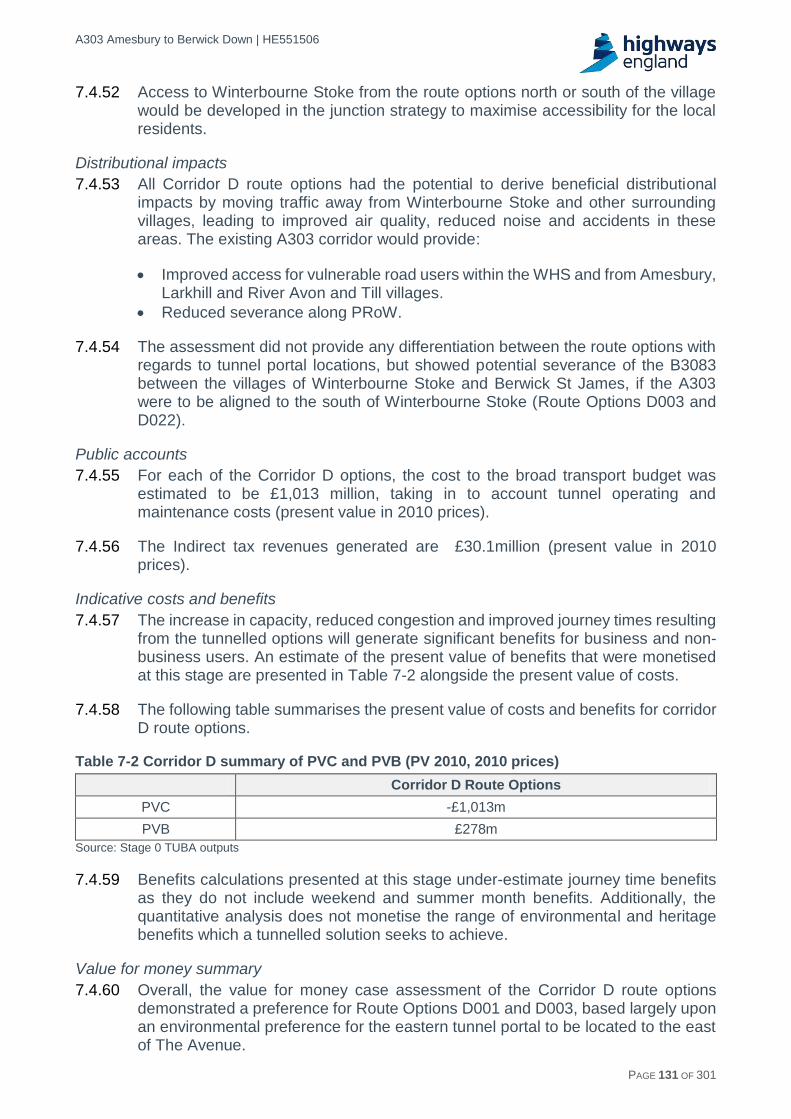
A303 Amesbury to Berwick Down | HE551506
HE551506-AA-GEN-SWI-RP-CX-000020 | P13, S0 21/12/2016 PAGE 131 OF 301
7.4.52 Access to Winterbourne Stoke from the route options north or south of the village would be developed in the junction strategy to maximise accessibility for the local residents.
Distributional impacts
7.4.53 All Corridor D route options had the potential to derive beneficial distributional impacts by moving traffic away from Winterbourne Stoke and other surrounding villages, leading to improved air quality, reduced noise and accidents in these areas. The existing A303 corridor would provide:
Improved access for vulnerable road users within the WHS and from Amesbury, Larkhill and River Avon and Till villages.
Reduced severance along PRoW.
7.4.54 The assessment did not provide any differentiation between the route options with regards to tunnel portal locations, but showed potential severance of the B3083 between the villages of Winterbourne Stoke and Berwick St James, if the A303 were to be aligned to the south of Winterbourne Stoke (Route Options D003 and D022).
Public accounts
7.4.55 For each of the Corridor D options, the cost to the broad transport budget was estimated to be £1,013 million, taking in to account tunnel operating and maintenance costs (present value in 2010 prices).
7.4.56 The Indirect tax revenues generated are £30.1million (present value in 2010 prices).
Indicative costs and benefits
7.4.57 The increase in capacity, reduced congestion and improved journey times resulting from the tunnelled options will generate significant benefits for business and non-business users. An estimate of the present value of benefits that were monetised at this stage are presented in Table 7-2 alongside the present value of costs.
7.4.58 The following table summarises the present value of costs and benefits for corridor D route options.
Table 7-2 Corridor D summary of PVC and PVB (PV 2010, 2010 prices)
Corridor D Route Options
PVC -£1,013m
PVB £278m
Source: Stage 0 TUBA outputs
7.4.59 Benefits calculations presented at this stage under-estimate journey time benefits as they do not include weekend and summer month benefits. Additionally, the quantitative analysis does not monetise the range of environmental and heritage benefits which a tunnelled solution seeks to achieve.
Value for money summary
7.4.60 Overall, the value for money case assessment of the Corridor D route options demonstrated a preference for Route Options D001 and D003, based largely upon an environmental preference for the eastern tunnel portal to be located to the east of The Avenue.

A303 Amesbury to Berwick Down | HE551506
HE551506-AA-GEN-SWI-RP-CX-000020 | P13, S0 21/12/2016 PAGE 132 OF 301
Financial case assessment
7.4.61 Each of the Corridor D options is of a similar length both in terms of the tunnelled and surface sections and on this basis, a single capital cost estimate was generated by the Highways England commercial division for the Corridor D options for this stage of assessment.
7.4.62 The ‘Most Likely’ capital cost estimate is £1,385m with the Lower Bound estimate being £1,130m and the Upper Bound estimate being £1,800m.
7.4.63 The funding sources were considered to be the same for all route options. There was therefore no differentiation between the Corridor D options for the financial case.
Delivery case assessment
7.4.64 The delivery agents and funding sources are considered to be the same for all route options.
7.4.65 It is considered that all Corridor D route options could be delivered to acceptable, desirable minimum highway geometric standards. All Corridor D options assessed propose a tunnel of approximately 2.9km in length and, depending on the construction methodology, could require an associated significant dewatering programme during construction. A new bridge structure over the River Till and a remodelling of the Countess Junction would also be required for all options.
7.4.66 Traffic management would be required to ensure the existing A303 would remain operational during construction, particularly at the eastern portal and the section of road east of the WHS.
7.4.67 Route Options D001 and D021, running to north of the village of Winterbourne Stoke, would cross the existing A303 east of the village and depending on the location of the new junction for the A360, would require an additional road bridge structure to maintain access to Winterbourne Stoke.
7.4.68 It was considered that route options within Corridor D could be processed through the scheme preparation phase such that a start on site date of March 2020 was achievable. It was then estimated that all route options would require a similar construction programme of between 4.5 - 5.5 years.
7.4.69 Although no direct public consultation on the route options was undertaken to date, engagement with stakeholders (parish councillors, land owners and occupiers, farmers, National Trust, Wiltshire Council) demonstrates that there was a general acceptance of a tunnel and associated surface works to the north of Winterbourne Stoke in Corridor D. This general acceptance stems from previous proposals for a tunnel.
7.4.70 There is an increased risk of objection to any route option to the south of Winterbourne Stoke (Route Options D003 and D022) as these move away from the previous proposals.
7.4.71 From the initial key stakeholder engagement meetings, there was a strong preference to locate the eastern tunnel portal to the east of The Avenue, although there were concerns with the resulting location of the western portal which would require careful consideration and mitigation during design development.

A303 Amesbury to Berwick Down | HE551506
HE551506-AA-GEN-SWI-RP-CX-000020 | P13, S0 21/12/2016 PAGE 133 OF 301
7.4.72 The overall assessment against the delivery case has shown no substantial difference between the Corridor D options.
Commercial case assessment
7.4.73 Not assessed.
Corridor D route option assessment summary
7.4.74 The assessment and comparison of the four Corridor D route options demonstrated all options were comparable in terms of the strategic fit, financial, and delivery cases, and user benefits. However, there were notable differences in terms of environmental impact.
7.4.75 In terms of the WHS, all the options would substantially improve the setting and hence significance of many Scheduled Monuments central to the OUV of the WHS, including Stonehenge itself.
7.4.76 The eastern portal location for Route Options D001 and D003 would enable the reconnection of The Avenue, which would be a very substantial benefit. Careful design and mitigation would be required to address any concerns with the location of the western portal. Route Options D001 and D003 are however considered to be overall beneficial for the WHS. Route Options D021 and D022 would have an overall negative impact on the WHS.
7.4.77 When comparing Corridor D options to the north or south of Winterbourne Stoke, a clear preference could not be stated in environmental terms.
7.4.78 It was therefore recommended that the Corridor D route option preferences are:
Route Option D001: Approximately 2.9km length tunnel with route running north of Winterbourne Stoke, eastern tunnel portal located east of The Avenue and the western tunnel portal located west of Normanton Gorse to minimise visual impact to and from Stonehenge.
Route Option D003: Approximately 2.9km length tunnel with route running south of Winterbourne Stoke, eastern tunnel portal located east of The Avenue and the western tunnel portal located west of Normanton Gorse to minimise visual impact to and from Stonehenge.
7.4.79 Careful consideration would need to be given with the design and mitigation development at the western portal to reduce its impact on key assets within the WHS.
7.5 Corridor F route options assessment
7.5.1 Three Corridor F route options were developed as potential options for the scheme.
7.5.2 The three options run south of the WHS connecting to the existing A303 west of Winterbourne Stoke and east of Amesbury, allowing traffic to be completely removed from within the WHS. This would substantially improve the setting of over 100 Scheduled Monuments and would provide significant benefits for the WHS in terms of conservation, access and visitor experience.
7.5.3 These route options are shown in Appendix C8 and are summarised below.

A303 Amesbury to Berwick Down | HE551506
HE551506-AA-GEN-SWI-RP-CX-000020 | P13, S0 21/12/2016 PAGE 134 OF 301
Route option description
Route Option F004
7.5.4 Route Option F004 starts with west-facing slip roads to provide a connection to Winterbourne Stoke at a point approximately 1.8km east of the junction of the A303 with the A36. It then passes through a cutting of maximum depth 20m and swings towards the south from the A303 over a short maximum 12m high embankment and through a short 7m deep cutting. The route then moves onto a maximum 13m high embankment and swings at close to ground level to an easterly bearing, rising onto a maximum 23m high embankment to cross the B3083 and the River Till on viaduct approximately mid-way Berwick St. James and Stapleford. The viaduct would be approximately 27m above river level.
7.5.5 At the east side of the River Till valley the route then rises up Oatlands Hill through a 1.3km long cutting with a maximum depth of 27m and emerging to the east of the hilltop onto a maximum 12m high embankment and turning to a south-easterly bearing and into a long cutting of maximum depth 9m. This cutting continues as the route crosses the A360 to the west of Middle Woodford. An all movements grade-separated junction would be located in this vicinity.
7.5.6 The alignment then swings eastwards and starts to descend towards the River Avon on two short embankments of maximum heights 12m and 9m before entering a cutting with a maximum depth of 21m. The route then emerges onto an embankment across the valley punctuated by a viaduct over the River Avon. This viaduct would be located approximately mid-way between Middle Woodford and Lower Woodford and cross the River Avon at a height of approximately 30m.
7.5.7 Following the crossing of the River Avon the alignment rises up towards the top of the valley entering a cutting of maximum depth 10m before swinging on a left hand curve and a maximum 5m embankment to head north-east towards the A345. Approaching the A345 crossing the alignment enters a cutting of maximum depth 12m and it crosses the A345 in cutting approximately 0.7km to the south of High Post. An all movements grade separated junction with A345 would be included in this vicinity.
7.5.8 At the end of the cutting the route then continues in a north-easterly direction on a succession of low embankments and cuttings towards Boscombe Down Airfield. The alignment swings to the east on a succession of low embankments and cuttings and then onto a left hand curve in a cutting of maximum depth 14m and turns north around the south-east corner of the airfield. The route passes to the south of the secondary runway and close to the A338 on an embankment approximately 10m high followed by a cutting of maximum depth 12m through a localised hilltop.
7.5.9 The route continues on a northerly bearing running near to the airfield secondary runway before turning through a right hand curve and heading north-east. It passes through undulating landscape on embankments (maximum height 12m) and in cuttings (maximum depth 7m) between Amesbury in the west and Boscombe to the east. The route ties back into the existing A303 dual carriageway at chainage 21500m, west of its existing junction with the A338.
Route Option F005
7.5.10 Route Option F005 starts with west-facing slip roads to provide a connection to Winterbourne Stoke at a point approximately 1.8km east of the junction of the A303

A303 Amesbury to Berwick Down | HE551506
HE551506-AA-GEN-SWI-RP-CX-000020 | P13, S0 21/12/2016 PAGE 135 OF 301
with the A36. It then passes through a cutting of maximum depth 20m and swings towards the south from the A303 over a short maximum 12m high embankment and through a short 7m deep cutting. The route then moves onto a maximum 13m high embankment and swings at close to ground level to an easterly bearing, rising onto a maximum 23m high embankment to cross the B3083 and the River Till on viaduct approximately mid-way Berwick St. James and Stapleford. The viaduct would be approximately 27m above river level.
7.5.11 At the east side of the River Till valley the route enters a 2.5km long cutting with a maximum depth of 26m and swings to a more southerly direction to run approximately 1.5km east of Stoford and South Newton crossing a small valley on an embankment of maximum height 15m before passing through a short cutting with maximum depth 13m.
7.5.12 At the end of the cutting the alignment follows ground level before turning towards the south-east and onto an embankment with a maximum height of 20m before crossing the A360 at ground level to the South West of Lower Woodford. An all movements grade-separated junction with A360 would be located to the South West of Lower Woodford.
7.5.13 Beyond the A360 the route continues on a south-east bearing and in a cutting of maximum depth 14m while following a left hand curve around the south of Little Durnford. The alignment crosses then emerges onto a maximum 40m high embankment across the valley punctuated by a viaduct over the River Avon. This viaduct would cross the River Avon on a north-easterly bearing and at a height of approximately 40m.
7.5.14 At the east side of the valley the route continues close to ground level and heading north-east towards Boscombe Down Airfield and crosses the A345 in a cutting of maximum depth 9m at a point approximately 1.5km south of High Post. An all movements grade-separated junction with A345 would be located in this vicinity.
7.5.15 Following a 7.4km length of straight generally following the existing ground profile the alignment drops into a maximum 17m deep cutting and the follows a left hand curve in a cutting of maximum depth 14m and turns north around the south-east corner of the airfield. The route passes to the south of the secondary runway and close to the A338 on an embankment approximately 10m high followed by a cutting of maximum depth 12m through a localised hilltop.
7.5.16 The route continues on a northerly bearing running near to the airfield secondary runway before turning through a right hand curve and heading north-east. It passes through undulating landscape on embankments (maximum height 12m) and in cuttings (maximum depth 7m) between Amesbury in the west and Boscombe to the east. The route ties back into the existing A303 dual carriageway at chainage 21500m, west of its existing junction with the A338.
Route Option F010
7.5.17 Route Option F010 starts at a point approximately 1.0km east of Yarnbury Castle, leaving the existing A303 and swinging to the south-east.
7.5.18 The route alternates between embankments with a maximum height of 8m and cuttings of maximum depth 5m. The alignment then turns through a slight left hand

A303 Amesbury to Berwick Down | HE551506
HE551506-AA-GEN-SWI-RP-CX-000020 | P13, S0 21/12/2016 PAGE 136 OF 301
radius to head east and crosses the line of the B3083 at ground level between Winterbourne Stoke and Berwick St. James.
7.5.19 The route then crosses the River Till valley on a viaduct structure approximately 6m above existing ground level, bridging the River Till and its flood plain. At the eastern side of the valley, the alignment rises through a cutting of maximum depth approximately 10m and crosses the existing A360 on an embankment approximately 5m high, north of Druids Lodge. A grade-separated junction would be located in this vicinity to provide connectivity to the A360.
7.5.20 The alignment continues on a large radius right hand curve to the south-east, largely following existing ground level before changing to a left hand radius curve and passing south of the WHS boundary and to the north of Upper Woodford. The topography is undulating in this area and the route is partly on embankment with a maximum height of 4m and partly in cuttings with a maximum depth of 7m.
7.5.21 To the north of Upper Woodford the alignment moves into the River Avon valley which it would cross at a maximum height of approximately 26m above existing ground level, passing over the river and two minor roads. This crossing would be partly on embankment and partly on a viaduct approximately 24m above the river.
7.5.22 To the east of the River Avon valley, the alignment follows an easterly bearing, climbing and cutting into the valley side to a maximum depth 11m. The route then turns north-east and crosses the existing A345 at ground level. A grade-separated junction would be located in this vicinity to provide connectivity to the A345.
7.5.23 To the east of the A345 the alignment generally follows the existing undulating ground across open farmland, passing to the south of Boscombe Down Airfield. To the north of Porton the route moves to a left hand curve in a cutting of maximum depth 14m and turns north around the south-east corner of the airfield. The route passes to the south of the secondary runway and close to the A338 on an embankment approximately 10m high followed by a cutting of maximum depth 12m through a localised hilltop.
7.5.24 The route continues on a northerly bearing running near to the airfield secondary runway before turning through a right hand curve and heading north-east. It passes through undulating landscape on embankments (maximum height 12m) and in cuttings (maximum depth 7m) between Amesbury in the west and Boscombe to the east. The route ties back into the existing A303 dual carriageway at chainage 21500m, west of its existing junction with the A338.
Strategic fit assessment
Client Scheme Requirements
7.5.25 Corridor F options perform well against the CSR of cultural heritage, as all would remove the A303 from within the WHS. However, Corridor F options align less closely with other CSRs. While alignment with the economic growth and transport CSRs is similar across all three options, options F004 and F005 are considered to align less closely with the environment and community CSR than option F010, as these options would have the potential for larger environment impacts.
National and local policies
7.5.26 Route Option F010 was found to perform slightly better than the other two options against the National policy requirements. Route Options F004 and F005 would

A303 Amesbury to Berwick Down | HE551506
HE551506-AA-GEN-SWI-RP-CX-000020 | P13, S0 21/12/2016 PAGE 137 OF 301
result in an increase in pollutant concentrations for some human receptors due to the redistribution of traffic on to minor roads (increased rat running). Route Option F010 also performed slightly better against local policies as Route Options F004 and F005 had more adverse implications for air quality.
Summary
7.5.27 Overall, in terms of the strategic case assessment, Route Option F010 was found to perform the best of the Corridor F options because of a better alignment with a number of national and regional policies.
Value for money assessment
Impact on the economy
Business users and transport providers
7.5.28 The economic assessment of the three Corridor F route options found that all generated dis-benefits in terms of vehicle operating costs and the net impact on business users. The relative increase in the distance to travel along this option (compared with the existing situation) would increase vehicle operating costs therefore reduce benefits to business users. Route Option F010 and F004 resulted in minor benefits in terms of travel time benefits. However, Route Option F005 resulted in a disbenefit in terms of travel time benefits.
7.5.29 As a result of the longer distance (relative to the existing route) journey time benefits were considerably less. These are outweighed by the increase in operating costs resulting in a net dis-benefit for business users.
7.5.30 To enable comparison between the Corridor F route options, the length of the different options and associated journey time impacts was assessed over the length of the proposed A303 route option between the intersections with A36 and A338 and is shown in Table 7-3.
Table 7-3 Corridor F journey time comparison
Route Options
Increased length of route between A36 and A338 compared with existing
(km)
Average journey time between A36 and A338
(mins)
Average journey time savings from do-minimum
(mins)
F004 4.5 14.75 2.25
F005 6.5 15.85 1.25
F010 4.1 14.25 2.75
7.5.31 It can be seen that there are journey time savings with all Corridor F route options with Route Option F010 performing better than the other two options.
7.5.32 Traffic modelling has shown that with all Corridor F route options, there is a significant risk that vehicles, including Heavy Goods Vehicles (HGV’s), would use the local road network to the north of the A303, increasing rat running through the surrounding villages, rather than making use of the Expressway. This would increase the likelihood of accidents in these areas. Early modelling has suggested the best performing F route option (F010) would result in an approximate doubling of the amount of vehicles rat running through the villages of Durrington, Larkhill and Shrewton with Route Options F004 and F005 resulting in an even greater risk.

A303 Amesbury to Berwick Down | HE551506
HE551506-AA-GEN-SWI-RP-CX-000020 | P13, S0 21/12/2016 PAGE 138 OF 301
7.5.33 The impact on business users and transport providers for Corridor F route options is summarised in Table 7-4 below. The Net business impacts is the sum of travel time benefits and vehicle operating cost benefits.
Table 7-4 Corridor F business users impacts, PV 2010 prices
Route Options
Travel time impacts Vehicle operating cost
impacts Net business impact
F004 +£4.6m -£54.5m -£50.1m
F005 -£24.1m -£40.4m -£64.5m
F010 +£30.3m. -£58m -£27.7m
Impact on reliability 7.5.34 The creation of an Expressway to dual carriageway standard would provide
adequate capacity for predicted traffic levels and would reduce the level of incidents. However, this is offset by the Corridor F options tending to encourage more traffic to divert into the local roads to the north and south of the existing alignment (e.g. Amesbury, Bulford, Durrington, Larkhill and Shrewton) and would thereby increase the incidents in these communities.
7.5.35 Corridor F route options would have only a slightly beneficial impact on reliability along the route.
Impact on regeneration
7.5.36 All Corridor F route options would provide a new dual carriageway south of Winterbourne Stoke and Amesbury and are not considered likely to have a significant impact on accessibility or economic activity in either of the identified regeneration areas in central Salisbury, or on areas of deprivation in Salisbury and Wilton. Therefore the impact of all three Corridor F options were considered neutral and no further assessment was undertaken at this stage.
Wider economic impacts
7.5.37 Corridor F route options were assessed to have minor dis-benefits relating to agglomeration and labour market effects as a result of the impacts of the increase in travel distance more than offsetting the congestion relief achieved. The net result was a slight reduction in connectivity between locations of economic activity. The impacts were limited by the fact that the improvements primarily occur on inter-urban movements, whereas agglomeration levels were typically most affected by improvements in intra-urban movements. Increases in commuting business travel costs due to increased travel distance along the corridor, supplemented by increases in journey times on some more local journeys within Wiltshire result in minor dis-benefits in terms of labour market and economic output.
7.5.38 Dis-benefits relating to time and vehicle operating cost savings experienced as a result of the scheme by those travelling for business purposes led to a net negative impact on economic output. Overall, there was a slight adverse impact.
Impact on economy summary
7.5.39 The economic assessment of the Corridor F route options showed that not all route options would provide benefits against the topics of business users and transport providers, reliability, regeneration and wider impacts. A high level assessment against reliability show a slight beneficial impact. However, this was outweighed by adverse wider economic impacts and a net negative impact on business users.

A303 Amesbury to Berwick Down | HE551506
HE551506-AA-GEN-SWI-RP-CX-000020 | P13, S0 21/12/2016 PAGE 139 OF 301
7.5.40 Route Option F010 being the shorter, more direct route, outperformed the other two route options in terms of shorter journey times, user benefits, and enhanced reliability.
Impact on the environment
7.5.41 Based on the available information for Corridor F, the key environmental receptors and assets common to all route options and considered in the assessment were:
WHS and complex network of Scheduled Monuments central to the OUV including Stonehenge, King Barrow Ridge, The Avenue and Winterbourne Stoke Barrow Group.
Listed Buildings and seven Conservation Areas.
River Avon and River Till and associated floodplains.
Environment Agency Groundwater Source Protection Zones (SPZ) of Very High Importance SPZ 1 and 2.
International and national ecological designated sites including Avon SAC, Salisbury Plain SAC and SPA, River Till SSSI, River Avon System SSSI, Yarnbury castle SSSI, Porton Meadows SSSI, Lower Woodford Meadows SSSI, Steeple Langford Down SSSI.
Seven noise IAs.
Cranborne Chase and West Wiltshire Downs AONB to South West and higher landscape quality of the chalk downland landscape.
Public Rights of Ways (PRoW), National Cycle Network (NCN) routes, and leisure and tourism destinations.
Human receptors in Winterbourne Stoke, Amesbury, Berwick St James, Stapleford, communities within the Woodford Valley and to the south-east of Boscombe Down Airfield, Salisbury, Larkhill, Shrewton, Durrington and Bulford.
7.5.42 With greenhouse gases and carbon dioxide emissions, although no industry guidance exists to assign levels of significance at a project level, the Route Option F010 is assessed as having the lowest carbon impact of the Corridor F options followed by Route Option F004 and Route Option F005 having the worst impact. This is based on the lengths of the route and the new construction and the number of new structures possibly required with the routes.
7.5.43 All Corridor F Options were more than 20km in length and would have a large adverse impact on agricultural land and ecological resources including within designated international/national ecological sites. All options would require two river crossings: the River Avon and River Till Valleys, with potential flood risk and water quality implications, and effects on international important species associated with the River Avon SAC. All options cross an SPZ in the east of Corridor F which is divided into SPZ1 (areas of highest risk) and SPZ2 (areas of medium risk). Option F010 would cross more than 2km of an SPZ2. Option F004 would cross more than 3.3km of an SPZ2. However, F005 crosses 1.7km of SPZ1, as well as 2km of SPZ2. Environment Agency policy (as set out in Groundwater Protection: Policy and Practice - GP3) is to object to potentially polluting developments within SPZ1 and therefore F005 is considered less favoured.
7.5.44 All options would also have significant earthworks and the new river crossings would have an adverse impact on the variable quality landscape character within the middle and upper parts of the Woodford valley and increasing intervisibility and impact on the setting of the Cranborne Chase and Wiltshire Downs AONB. The

A303 Amesbury to Berwick Down | HE551506
HE551506-AA-GEN-SWI-RP-CX-000020 | P13, S0 21/12/2016 PAGE 140 OF 301
options would also detract from views of a substantial number of visual receptors that would be likely to experience adverse effects on their visual amenity, with the greatest proportion being residential receptors and users of PROW and leisure/tourist destinations.
7.5.45 Based on the Affected Road Networks (ARN) for the Corridor F Options the existing Salisbury AQMAs may also be adversely affected by redistributed traffic.
7.5.46 There would be limited visibility of Route Option F010 from the southern fringes of the WHS potentially resulting in limited adverse impacts on the setting of designated assets within the WHS. It would also harm the setting of a small number of other Scheduled Monuments, although overall, it would substantially benefit the WHS.
7.5.47 Route Options F004 and F005 would not be visible from the WHS but would have impacts on the setting of other Scheduled Monuments, including a scheduled castle site and with Route Option F005 also possibly the setting of Old Sarum. The scale of harm was greater on Scheduled Monuments for F004 and F005 options than for F010.
7.5.48 As with Corridor D, there was a risk of encountering unknown archaeology along the route options, however the Corridor F options have not been investigated to the same extent as the WHS and there was a higher degree of uncertainty as to what archaeology might be present. It should be noted that archaeology closer to the WHS was not deemed (at this stage) more significant than archaeology found further from the WHS. No specific higher risk areas were identified where unknown archaeology could lie therefore Route Option F010 is more preferable over Route Options F004 and F005 and as the route is shorter in length with a reduced area to impact.
7.5.49 In addition moving traffic away from Winterbourne Stoke and Amesbury would benefit up to four noise IAs, and reduce the affected area and impact on air pollutant sensitive features in international and national designated ecological sites within 200m of the A303 by up to 12-15ha.
7.5.50 A substantial reduction was identified at the two important areas in Winterbourne Stoke and a further two in Amesbury. The remaining IAs are likely to experience a smaller changes in noise levels with increases to some areas and a decrease at others.
Impact on the environment summary
7.5.51 Generally Route Option F010 was considered to be the best performing Corridor F option. It outperformed Route Options F004 and F005 in terms of air quality, potentially providing a beneficial effect on human health receptors. In addition Route Option F010 would have the least significant adverse impact on SPZ2 slightly reducing the severity consequences of Route Options F004 and F005. Of the Corridor F route options, F004 and F005 would not be visible from the WHS but the scale of harm on Scheduled Monuments would be greater than Route Option F010.
Impact on society
7.5.52 All Corridor F route options have the potential to generate social benefits, most notably in terms of accident savings and journey reliability, relative to the existing

A303 Amesbury to Berwick Down | HE551506
HE551506-AA-GEN-SWI-RP-CX-000020 | P13, S0 21/12/2016 PAGE 141 OF 301
situation and moving traffic away from receptors in Winterbourne Stoke and Amesbury.
7.5.53 However, the increased length of the Corridor F options would increase vehicle operating costs, and the new road alignment would cause issues with severance in nearby communities such as Upper, Middle and Lower Woodford. All options, in providing a new highway through open farmland, would potentially sever up to 27 PRoW and increase severance between the numerous communities between Berwick St. James and Stapleford, the River Avon villages and the service centres of Amesbury and Salisbury, and the communities to the south-east of Boscombe Down Airfield when accessing Amesbury. All options would also very substantially reduce severance within the WHS and for residents of Countess Road, Durrington and Bulford when accessing facilities in Amesbury and provide greatly improved opportunity for physical activity with improved access for vulnerable road users along the length of the redundant A303.
7.5.54 Traffic modelling and TUBA results indicate there would be a modest positive impact on commuting and other user benefits for Route Options F004 (£32m) and F010 (£77m), however Route Option F005 results in a disbenefit of £21m. Option F010 significantly outperformed the other two options.
7.5.55 In terms of monetised accident benefits, F005 (£39.5m) was the best performing option of the three Corridor F route options, however the difference between options was relatively small. The monetised benefit for accidents avoided for option F004 was £38.5m and £36.5 for Route Option F010 (discounted PV, 2010 prices). In terms of accident benefits, there was little difference between the three Corridor F options based on modelling at this stage of the options sifting process.
7.5.56 Overall, there was little differentiation between the Corridor F route options with regards to social benefits, but a slight preference for Route Option F010 as this route option impacted the fewest communities.
Distributional impacts
7.5.57 All Corridor F route options had the potential to have beneficial distributional impacts by moving traffic away from Winterbourne Stoke and Amesbury, with improved air quality, reduced noise and accidents in these areas. The existing A303 corridor would also provide improved access for vulnerable road users within the WHS and from Amesbury, Larkhill and River Avon and Till villages and reduce severance along PRoW.
7.5.58 All route options include a new road alignment in Corridor F and therefore all the route options could lead to severance issues between the villages along the River Avon.
7.5.59 However, significant increases in traffic flows, including HGVs, for Route Options F004 and F005 are forecast along a small number of adjacent road links, namely along the Packway, A3028, B3086 and A360 and A345 to the north of the A303 and on the A36 to the west of Salisbury. This effect would increase severance within Durrington, Larkhill and Shrewton as well as worsening journey times for Shrewton residents when accessing facilities in Amesbury. Increases in traffic flows along the B390 and The Packway would adversely affect travellers’ ability to make good progress along these route options. Early modelling has suggested the best performing F route option (F010) would result in an approximate doubling of the

A303 Amesbury to Berwick Down | HE551506
HE551506-AA-GEN-SWI-RP-CX-000020 | P13, S0 21/12/2016 PAGE 142 OF 301
amount of vehicles rat running through the villages of Durrington, Larkhill and Shrewton (where there are high concentrations of children) with Route Options F004 and F005 resulting in an even greater impact. There are concentrations of children and old people in areas impacted by all route options that would be particularly impacted on by any changes in severance.
7.5.60 The increased rat running across the local road network, through the surrounding villages, rather than making use of the Expressway, would increase the likelihood of accidents. There are concentrations of children and old people in areas impacted by all route options that would be particularly impacted by any changes in accidents.
7.5.61 With regard to noise and air quality all options within Corridor F are classed as Slight Beneficial overall. These alignments would remove through traffic from Winterbourne Stoke, and so reduce noise and air quality impacts, but introduce new road alignments close to other settlements such as Upper, Middle and Lower Woodford, and Berwick St James, increasing noise and air quality impacts in these areas. Concentrations of children who would be particularly impacted by these changes have been identified in impacted areas for all alignments.
7.5.62 Overall, however, there was little differentiation between the Corridor F route options with regards to distributional benefits, but a slight preference for Route Option F010 as this route option impacted the fewest communities.
Public Accounts
7.5.63 Across the three Corridor F options, Route Option F010 performs the best in terms cost to the transport budget, and indirect tax revenues generated are marginally more than Route Option F004. Overall the Route Option F010 is the least costly of the Corridor F options.
7.5.64 Cost to broad transport budget as output from TUBA in Present Value (2010 prices) for each option is:
Route Option F004: £663million.
Route Option F005: £957million.
Route Option F010: £501million.
7.5.65 The increase in indirect tax revenues as output from TUBA in Present Value (2010 prices) for each option is:
Route Option F004: £59million.
Route Option F005: £55million.
Route Option F010: £56million.
Indicative costs and benefits
7.5.66 The surface dual carriageway options result in a longer Route option than the tunnelled options and therefore show reduced user benefits in comparison to the tunnelled options. Additionally, the relatively longer distance increases vehicle operating costs. The net impact is that relatively lower scheme costs of the corridor F options are outweighed by net negative business user benefits. The net impact results in negative benefits overall. Indicative present value scheme costs and benefits are summarised in Table 7-5.
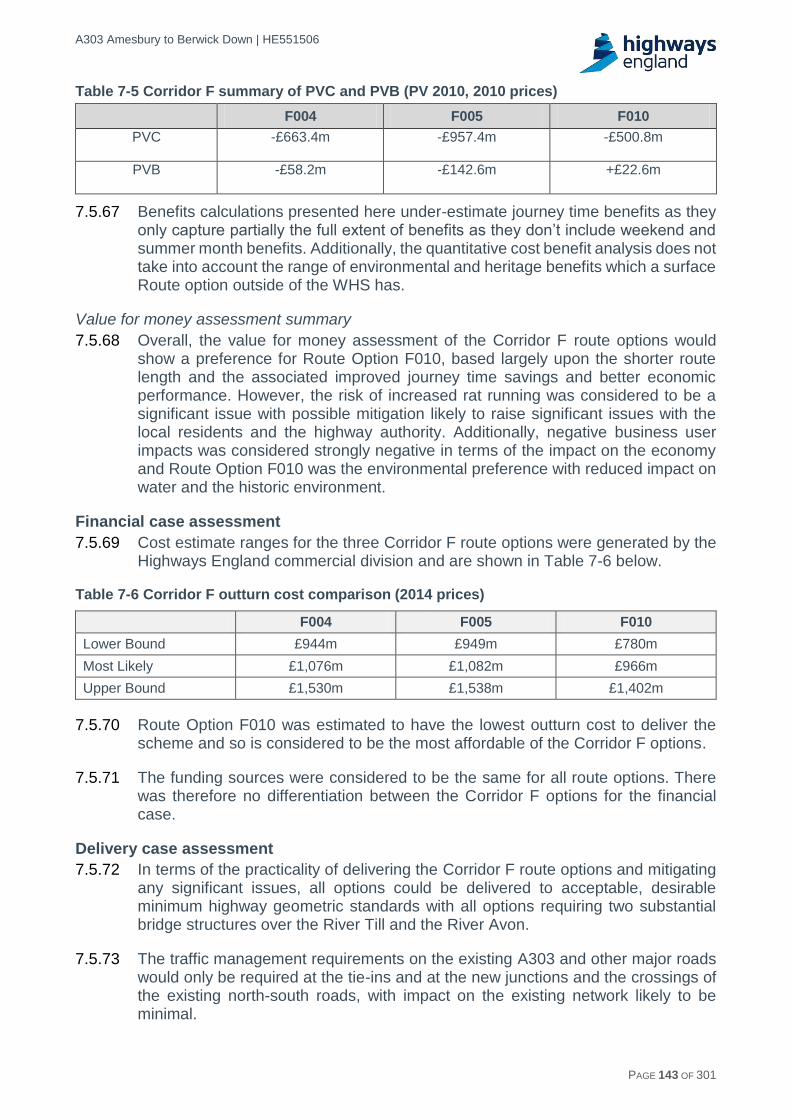
A303 Amesbury to Berwick Down | HE551506
HE551506-AA-GEN-SWI-RP-CX-000020 | P13, S0 21/12/2016 PAGE 143 OF 301
Table 7-5 Corridor F summary of PVC and PVB (PV 2010, 2010 prices)
F004 F005 F010
PVC -£663.4m -£957.4m -£500.8m
PVB -£58.2m -£142.6m +£22.6m
7.5.67 Benefits calculations presented here under-estimate journey time benefits as they only capture partially the full extent of benefits as they don’t include weekend and summer month benefits. Additionally, the quantitative cost benefit analysis does not take into account the range of environmental and heritage benefits which a surface Route option outside of the WHS has.
Value for money assessment summary
7.5.68 Overall, the value for money assessment of the Corridor F route options would show a preference for Route Option F010, based largely upon the shorter route length and the associated improved journey time savings and better economic performance. However, the risk of increased rat running was considered to be a significant issue with possible mitigation likely to raise significant issues with the local residents and the highway authority. Additionally, negative business user impacts was considered strongly negative in terms of the impact on the economy and Route Option F010 was the environmental preference with reduced impact on water and the historic environment.
Financial case assessment
7.5.69 Cost estimate ranges for the three Corridor F route options were generated by the Highways England commercial division and are shown in Table 7-6 below.
Table 7-6 Corridor F outturn cost comparison (2014 prices)
F004 F005 F010
Lower Bound £944m £949m £780m
Most Likely £1,076m £1,082m £966m
Upper Bound £1,530m £1,538m £1,402m
7.5.70 Route Option F010 was estimated to have the lowest outturn cost to deliver the scheme and so is considered to be the most affordable of the Corridor F options.
7.5.71 The funding sources were considered to be the same for all route options. There was therefore no differentiation between the Corridor F options for the financial case.
Delivery case assessment
7.5.72 In terms of the practicality of delivering the Corridor F route options and mitigating any significant issues, all options could be delivered to acceptable, desirable minimum highway geometric standards with all options requiring two substantial bridge structures over the River Till and the River Avon.
7.5.73 The traffic management requirements on the existing A303 and other major roads would only be required at the tie-ins and at the new junctions and the crossings of the existing north-south roads, with impact on the existing network likely to be minimal.

A303 Amesbury to Berwick Down | HE551506
HE551506-AA-GEN-SWI-RP-CX-000020 | P13, S0 21/12/2016 PAGE 144 OF 301
7.5.74 Route options within Corridor F have not had any environmental or geotechnical surveys undertaken to date. Collection of this data is likely to increase the scheme preparation phase by up to one year, meaning a likely start on site date of March 2021, which is beyond the aspiration to start on site by March 2020.
7.5.75 A construction programme for the Corridor F route options was estimated to be approximately 3 years, with Route Option F010 requiring the least time with its shorter length.
7.5.76 No public consultation had been undertaken at this stage. The nature of Corridor F is that, other than in the vicinity of Amesbury, the area was homogenous in terms of settlement pattern, plot sizes and land use. Therefore, it was not clear at this stage that any route option would be more or less likely to be supported or rejected than another, other than to individual landowners and residents.
7.5.77 Given the reduced construction programme, and reduced scale of construction relative to the other two route options, Route Option F010 was considered the best performing route option against the delivery case.
Corridor F route option appraisal summary
7.5.78 The assessment and comparison of the three Corridor F route options clearly demonstrated that Route Option F010 was the best performing option in all the assessed cases.
7.5.79 It was therefore recommended that Route Option F010 be taken forward for further appraisal.
7.5.80 The route option leaves the A303 in the west and runs between Winterbourne Stoke and Berwick St James. The route option then continues east, keeping south of the WHS boundary but north of Upper Woodford. The route option then runs south of the Boscombe Down Airfield following the same alignment as Route Options F004 and F005 before reconnecting with the existing A303 dual carriageway.
7.6 Conclusions
7.6.1 The initial appraisal of the Corridor D route options and the Corridor F route options against the Transport Business Case criteria in WebTAG, recommended the following options as the best performing options to be taken forward for further appraisal as shown in Appendix E1:
Route Option D001: Approximately 2.9km length tunnel with route running north of Winterbourne Stoke, eastern tunnel portal located east of The Avenue and the western tunnel portal located west of Normanton Gorse to minimise visual impact to and from Stonehenge.
Route Option D003: Approximately 2.9km length tunnel with route running south of Winterbourne Stoke, eastern tunnel portal located east of The Avenue and the western tunnel portal located west of Normanton Gorse to minimise visual impact to and from Stonehenge.
Route Option F010: Surface route running from the A303 in the west between Winterbourne Stoke and Berwick St. James. The route then continues east, keeping to the south of the WHS boundary but north of Upper Woodford before running south of the Boscombe Down Airfield following the same alignment as Route Options F004 and F005 before reconnecting with the existing A303 east of Amesbury.

A303 Amesbury to Berwick Down | HE551506
HE551506-AA-GEN-SWI-RP-CX-000020 | P13, S0 21/12/2016 PAGE 145 OF 301
8 Description of route options for further appraisal
8.1 Introduction
8.1.1 The outcome of the Initial Route options Appraisal (Design Fix C), detailed in Chapter 7 of this report, was a recommendation that Route Options D001, D003 and F010 were the best performing options to be taken forward for further full WebTAG appraisal. Route Options D001, D003 and F010 are shown in Appendix E1.
8.1.2 Following further design review and challenge, the location of the eastern tunnel portal for both Route Options D001 and D003 was moved approximately 40m closer to the existing A303 with the updated route options renamed as D031 (previously D001) and D032 (previously D003). Route Options D031, D032 and F010 are shown in Appendix E2.
8.1.3 As part of the further appraisal of the better performing route options, a programme of geophysical surveys was undertaken to investigate the possible presence of further buried archaeological features. The scope, location and extent of the works was agreed with Wiltshire Council and Historic England, with input from National Trust.
8.1.4 The geophysical surveys identified two Neolithic long barrows and a henge-type enclosure to the east of the A360 and within the likely construction footprint of Route Options D031 and D032. The nature of these features was confirmed by subsequent archaeological investigation, for which the scope of the works was again agreed with Wiltshire Council and Historic England, with input from National Trust.
8.1.5 Although displaying no visible features at the current ground surface, the two long barrows and the henge-type enclosure were considered to be important archaeological features that would contribute to the Outstanding Universal Value (OUV) of the WHS. These features would be adversely affected by Route Options D031 and D032 and the decision was taken to adjust both route options to avoid physical impact on these assets.
8.1.6 On this basis, Route Options D031 and D032 were further amended and renamed as D061 and D062 for the purposes of the further assessment. The amendment of the two route options also aimed to accommodate the junction proposals for each option and maintain full standard highway geometry, whilst minimising impact on key environmental constraints and maintaining the balanced earthworks strategy where possible. Route Options D061, D062 and F010 are shown in Appendix E3.
8.1.7 This chapter describes the three Route Options D061, D062 and F010 and the key engineering design criteria and assumptions with each option, implemented for the purposes of the assessment at this stage.
8.1.8 The further assessment and appraisal of the three route options is reported in the following Chapters 9 to 18 of this report, with the appraisal summarised in Chapter 20 and in the Appraisal Summary Tables.

A303 Amesbury to Berwick Down | HE551506
HE551506-AA-GEN-SWI-RP-CX-000020 | P13, S0 21/12/2016 PAGE 146 OF 301
8.2 Route descriptions
8.2.1 Route Options D061, D062 and F010 are described in more detail below and are shown in Appendix F1, F2 and F3, respectively.
Route Option D061
8.2.2 Option D061 is a part surface / part tunnelled route which includes a 2.9km tunnel through part of the WHS and a bypass to the north of Winterbourne Stoke. The route option gives an increased journey distance of approximately 400m compared to the existing A303 route.
8.2.3 From the west, the alignment begins at the end of the existing A303 dual carriageway just east of Yarnbury Castle. It runs eastwards, adding a second carriageway to a section of the existing A303 before breaking away to the north of the existing alignment in order to bypass Winterbourne Stoke. It then heads north-east approximately at ground level, parallel to the boundary with Parsonage Down National Nature Reserve before dropping on a downward gradient into a cutting approximately 5m deep.
8.2.4 The alignment maintains its downward gradient and follows a right hand curve towards the south east before emerging onto an embankment to the north of Scotland Lodge farm. This embankment would have a maximum height of approximately 20m in order to navigate the steep topography. The alignment then remains on embankment and on a right hand curve passing over the B3083 at a height of approximately 7m. It would cross the Till Valley (which contains a Special Area of Conservation, SAC) on a viaduct structure approximately 12m above existing ground level, bridging the River Till and its flood plain.
8.2.5 After crossing the River Till the route climbs at a gradient similar to the surrounding topography on an embankment of varying height (with a maximum of approximately 11m). It then crosses over the existing A303 before dropping on a downward gradient into a shallow cutting and crossing the A360 approximately 3m below existing ground level. The A360 would be raised onto an embankment approximately 4m high offline to the west of the existing road, to pass over the new A303.
8.2.6 An all-movement, grade separated (two level) junction is proposed in the vicinity of the existing A303 crossing. This will provide access to the A360, the WHS and Winterbourne Stoke and allow free flowing traffic on the A303.
8.2.7 On entering the Stonehenge, Avebury and Associated Sites WHS, the route option remains in cutting and swings north-east, avoiding a number of Scheduled Monuments. It then crosses a linear archaeological earthwork feature and passes through Diamond Wood, all in shallow cutting average depth approximately 1.5m. The route then enters the proposed western tunnel portal south west of Normanton Gorse.
8.2.8 The tunnel portal was located to provide a minimum of 6m of cover from the existing ground level to the tunnel crown. The 2.9km tunnel drops to a low point at Stonehenge Bottom at which point the tunnel crown is approximately 10m below ground level. The tunnel alignment then rises again until arriving at the eastern portal located approximately 80m east of The Avenue. The horizontal alignment throughout the tunnel is a gentle “S” curve.

A303 Amesbury to Berwick Down | HE551506
HE551506-AA-GEN-SWI-RP-CX-000020 | P13, S0 21/12/2016 PAGE 147 OF 301
8.2.9 To the east of the tunnel section, the alignment ties back into the existing A303 alignment, with Vespasian's Camp located to the south of the road. It then rises up to a height of approximately 8m to pass through and over the proposed new junction with the A345 at the Countess Roundabout.
8.2.10 It is currently proposed that an all-movement grade separated junction would be provided at this location in order to maintain connectivity to Amesbury and the existing A345. The layout of the junction at Countess Roundabout is constrained by properties to the north and the River Avon and a conservation area to the south.
8.2.11 From Countess Roundabout the alignment turns to the east, dropping down and joining the existing A303, before it crosses the River Avon on the existing bridge structure and ties-in just west of the existing Solstice Park junction.
Route Option D062
8.2.12 Option D062 is a part surface / part tunnelled route option which includes a 2.9km tunnel through part of the WHS and a bypass to the south of Winterbourne Stoke. The route option gives an increased journey distance of approximately 400m compared to the existing A303 route.
8.2.13 From the west, the alignment begins at the end of the existing A303 dual carriageway just east of Yarnbury Castle. It runs eastwards, adding a second carriageway to a section of the existing A303 before breaking away to the south on a right hand curve in order to bypass Winterbourne Stoke. It then heads south-east, on an embankment of varying height up to a maximum of approximately 14m following the line of a natural valley.
8.2.14 The alignment then turns through a left hand radius to head east and crosses the line of the B3083 close to ground level. The side road would be raised onto an embankment approximately 7m high to pass over the expressway. The route option crosses the Till Valley on a viaduct structure approximately 10m above existing ground level, bridging the River Till and its flood plain.
8.2.15 After crossing the River Till the route continues on an upward gradient on an embankment of varying height (with a maximum of approximately 12m). The route option follows a left hand curve, the vertical alignment flattens off and the route enters a cutting as far as the Oatlands Dairy Unit which the route passes to the south. The route traverses an area known as The Park on a left hand curve and a varying height embankment (maximum height approximately 8m) dropping close to to ground level where it crosses the existing line of the A360.
8.2.16 An all-movement, grade separated junction is proposed in the vicinity of the existing A360. This will provide access to the A360, the WHS and Winterbourne Stoke and allow free flowing traffic on the A303.
8.2.17 The route option enters the WHS on a left hand curve at ground level and heads in a north-easterly direction. It then changes to a right hand curve, crossing a dip in the land on an embankment with a maximum height of approximately 7m. The route option crosses a linear archaeological earthwork feature and passes through Diamond Wood before swinging to a more easterly bearing and entering the western tunnel portal south west of Normanton Gorse.
8.2.18 The portal location and the remainder of the route option to the east of this point is the same as that described above for option D061.

A303 Amesbury to Berwick Down | HE551506
HE551506-AA-GEN-SWI-RP-CX-000020 | P13, S0 21/12/2016 PAGE 148 OF 301
Route Option F010
8.2.19 Option F010 is a wholly surface route which runs to the south of and entirely outside the WHS and incorporates a bypass to the south of Winterbourne Stoke. The route option gives an increased journey distance of approximately 4.1km compared to the existing A303 route.
8.2.20 After diverging from the existing dualled A303, just east of Yarnbury Castle, the route heads south-east, following the line of a natural valley, across farmland and undulating topography. Through this section the route alternates between embankments with a maximum height of 8m and cuttings of maximum depth 5m. The alignment then turns through a slight left hand radius to head east and crosses the line of the B3083 close to ground level between Winterbourne Stoke and Berwick St. James. The side road would be raised onto an embankment approximately 7m high to pass over the expressway.
8.2.21 The route then crosses the River Till valley on a viaduct structure approximately 6m above existing ground level, bridging the River Till and its flood plain. At the eastern side of the valley, the alignment rises through a cutting of maximum depth approximately 10m and crosses the existing A360 on an embankment approximately 5m high, north of Druids Lodge. The A360 would be lowered by approximately 4m to pass beneath the expressway. A grade-separated junction would be located in this vicinity to provide connectivity to the A360 and to Winterbourne Stoke.
8.2.22 The alignment continues on a large radius right hand curve to the south-east, largely following existing ground level before changing to a left hand radius curve and passing south of the WHS boundary and to the north of Upper Woodford. The topography is undulating in this area and the route is partly on embankment with a maximum height of 4m and partly in cuttings with a maximum depth of 7m.
8.2.23 To the north of Upper Woodford the alignment moves into the River Avon valley which it would cross at a maximum height of approximately 26m above existing ground level, passing over the river and two minor roads. This crossing would be partly on embankment and partly on a viaduct approximately 24m above the river.
8.2.24 To the east of the River Avon valley, the alignment follows an easterly bearing, climbing and cutting into the valley side to a maximum depth 11m. The route then turns north-east and crosses the existing A345 at close to ground level. A grade-separated junction would be located in this vicinity to provide connectivity to the A345.
8.2.25 To the east of the A345 the alignment generally follows the existing undulating ground across open farmland, passing to the south of Boscombe Down Airfield. To the north of Porton the route moves to a left hand curve in a cutting of maximum depth 14m and turns north around the south-east corner of the airfield. The route passes to the south of the secondary runway and close to the A338 on an embankment approximately 10m high followed by a cutting of maximum depth 12m through a localised hilltop.
8.2.26 The route continues on a northerly bearing running near to the airfield secondary runway before turning through a right hand curve and heading north-east. It passes through undulating landscape on embankments (maximum height 12m) and in cuttings (maximum depth 7m) between Amesbury in the west and Boscombe to the

A303 Amesbury to Berwick Down | HE551506
HE551506-AA-GEN-SWI-RP-CX-000020 | P13, S0 21/12/2016 PAGE 149 OF 301
east. The route ties back into the existing A303 dual carriageway at chainage 21500m, west of its existing junction with the A338.
8.3 Road layout
8.3.1 The Design Manual for Roads and Bridges (DMRB) recommends traffic flow ranges for new rural road links based on the Annual Average Daily Traffic (AADT) flows. Table 8-1 below summarises the indicative range of traffic flows within which different carriageway layouts are likely to be economically justified (not absolute capacity).
Table 8-1 Opening Year AADT flow ranges for different carriageway standards (DMRB 46/97 - Table 2.1)
Carriageway standard Opening year AADT
Minimum Maximum
Single carriageway S2 Up to 13,000
Wide single carriageway WS2 6,000 21,000
Dual 2 lane all purpose D2AP 11,000 39,000
Dual 3 lane all purpose D3AP 23,000 54,000
8.3.2 Forecast opening year traffic flows for the three scheme route options along with the do minimum (without scheme) scenario are summarised in Table 8-2. The forecast traffic flows for Route Options D061, D062 and F010 all fall within the AADT range specified in Table 8-1 for a 2-lane all purpose (D2AP) dual carriageway cross-section and above the maximum flow recommended for a wide single carriageway cross-section. Notably, the do minimum forecast flows would also be greater than the maximum flows for a wide single carriageway cross-section.
Table 8-2 Forecast AADT flows on A303
Scenario Opening year (2024) AADT
Low Core High
Do Minimum 25,465 27,164 28,963
Option D061 27,415 30,256 31,646
Option D062 27,374 29,478 31,511
Option F010 26,426 27,898 30,855
8.3.3 Further traffic analysis and modelling of the existing single carriageway and the proposed dual 2-lane carriageway with the various forecast years are provided in Chapter 10. This confirms from the network stress analysis and the capacity analysis, that the improved 2-lane dualling scheme would decrease the driver stress levels in the future forecast years to well below the 85% threshold in the neutral month (March). With an overall 34% increase in flow in the peak summer period, the forecast flows would still remain below the 100% capacity level for all forecast years, with the 85% threshold level only being breached by the future horizon year 2051.
8.3.4 On this basis, the proposed scheme road layout was confirmed as a 2-lane all purpose dual carriageway.

A303 Amesbury to Berwick Down | HE551506
HE551506-AA-GEN-SWI-RP-CX-000020 | P13, S0 21/12/2016 PAGE 150 OF 301
8.4 Highway design relaxations and departures from standards
8.4.1 The new highway will be a Dual 2-Lane All Purpose Expressway with a design speed of 120kph. The design of the route options for this stage have been based on the DMRB requirements for an all-purpose road of this design speed, in conjunction with design principles outlined in the Expressways Technical Note, ahead of publication of the Expressway Interim Advice Note (IAN). A more detailed assessment of the application of the Expressway IAN to the scheme will take place in the next stage after its publication.
8.4.2 The existing Countess Roundabout geometry was designed for future provision of an overpass on the A303 and in order to maximise retention of the existing road geometry, there could be possible minor visibility and minor horizontal curvature departures on the approaches to any new grade separated junction at this location including with the adjacent tie-in with the existing A303. The departures are common to Route Options D061 and D062 and are subject to design development at the next stage. Departures will either be designed out completely or subject to the formal Highways England departure approvals process.
8.4.3 With the exception of the existing horizontal geometry at Countess Roundabout and the adjacent eastern tie-in to the existing A303, the new A303 scheme design is proposed to adopt at least desirable minimum design standards, and there are no further departures to note for Route Options D061 or D062 at this stage in the scheme development.
8.4.4 There are no anticipated departures to note for Route Option F010 at this stage.
8.4.5 Relaxations from design standards will be assessed during design development of the route options taken forward.
8.5 Junction and side roads strategy
8.5.1 The junction and side roads strategy for the three route options was developed at a high level based on the Highways England Expressway Technical Note, in addition to anticipated requirements in the upcoming Expressway IAN. These documents specify the use of grade separated junctions and the aim to minimise the number of junctions onto the Expressway.
8.5.2 The junction strategy was developed in accordance with the following principles:
All movement grade separated junctions where the new route crosses existing "A" roads, to maintain optimum integration with the wider strategic road network.
Where minor side roads, byways, bridleways, footpaths or private accesses cross the route options, it is proposed that these will be accommodated by either an overpass, underpass or be closed and diverted. The specific treatment at each location will be the subject of further assessment and design development.
8.5.3 An indication of the location of these junctions and crossings can be seen on the plans in Appendices F1, F2 and F3 for the Route Options D061, D062 and F010 respectively. These plans indicate the location of possible major all movement grade separated junctions by means of red circles and indicate the crossing points of side roads, private accesses and Public Right of Ways (PRoWs) by means of blue circles.

A303 Amesbury to Berwick Down | HE551506
HE551506-AA-GEN-SWI-RP-CX-000020 | P13, S0 21/12/2016 PAGE 151 OF 301
Traffic flows and junction form
8.5.4 The two-way AADT design year 2039 mainline traffic flows for the three route options were reviewed at the proposed junction locations with the “A” roads A360 and A345, to allow consideration of the likely junction forms. These are shown in Table 8-3 below.
Table 8-3 2039 AADT flows on the proposed A303
Location D061/D062 AADT two way
AADT flows F010 AADT two way AADT
flows
A303 at A345 39,966 33,498
A303 at A360 42,178 32,970
8.5.5 Table 8-3 shows the AADT flows on the mainline of all route options are greater than 30,000, which is the maximum mainline flow recommended for a compact grade separated junction layout with reduced junction footprint (Highways England Design Standard DMRB TD 40/94). On this basis, at this stage it is considered that full grade separated junctions to DMRB TD 22/06 (Figure 5/4), are likely to be required at the proposed A360 and A345 junctions. These would likely comprise a single grade separated roundabout with two bridges over or under the mailine, or two grade separated roundabouts with one bridge for the connector road over or under the mainline, together with slip roads to and from the mainline. The final junction forms will be confirmed in the design development of the preferred route, ensuring that the impact of the junctions on their surrounding environment is minimised.
Strategy for Route Options D061 and D062
8.5.6 The western tie-in with the existing A303 for both Route Options D061 and D062 was proposed without junction connectivity to Winterbourne Stoke, to prevent traffic using the village as a route for access to and from the WHS and Visitor Centre.
8.5.7 An all movement grade separated junction was proposed east of Winterbourne Stoke to provide connectivity to the A360, Stonehenge WHS Visitor Centre and Winterbourne Stoke. The exact junction location and form will be developed and confirmed in the next stage after selection of a preferred route, however, for the purpose of this assessment, junction locations were proposed based on preliminary junction assessments as outlined below.
8.5.8 For Route Option D061, options for a junction in the vicinity of the A360 were investigated, however, a reduced footprint compact grade separated junction form would likely be required offline to the west of the A360, to avoid/minimise any landtake from within the WHS. As shown in Table 8-3 and detailed above, the mainline flows exceed the maximum recommended flow for a compact grade separated junction layout and, therefore, for the purpose of this assessment the compact junction option was not pursued further at this stage. On this bais, in an attempt to minimise any direct and indirect impacts on the WHS as well as maximise the use of the existing A303 and A360 carriageways, a full grade separated junction was proposed at the existing A303 crossing, which could maintain compliant highway standards for all aspects of the junction. Connectivity from the junction to the A360 would be provided via the existing A303 and the Longbarrow junction.

A303 Amesbury to Berwick Down | HE551506
HE551506-AA-GEN-SWI-RP-CX-000020 | P13, S0 21/12/2016 PAGE 152 OF 301
8.5.9 For Route Option D062, a full grade separated junction east of Winterbourne Stoke was proposed in the vicinity of the A360. The routing of D062 would allow sufficient space for a full grade separated junction to the west of the A360 and outside of the adjacent WHS, with only a minor diversion of the A360 to tie into the new junction.
8.5.10 Access between Winterbourne Stoke and the A303 (west) would be made from the proposed A360 junction to the east of Winterbourne Stoke, for both options. A new alternative high load route is proposed, that would use the new A360 junction east of Winterbourne Stoke and divert high load vehicles north of the existing A303 between the A360 and the A345. The high load route is detailed in Section 15.2 and will be investigated further at a later stage of design development.
8.5.11 The new junction with the A345 would serve Durrington, Amesbury, Bulford and Larkhill and for the purpose of this assessment, a full grade separated junction has been proposed at the existing A345 Countess Roundabout junction. Notably, there is an opportunity to investigate an alternative junction location at the adjacent existing Solstice Park junction to the east. The following factors would need to be considered when further investigating the Solstice Park junction option:
Further traffic modelling to assess the network resilience of concentrating all access facilities for Amesbury, Durrington, Larkhill, Bulford and Solstice Park itself at a single junction location.
Further traffic modelling to assess the additional risk of rat running north of the proposed A303.
Further assessment of the impact of the additional traffic on the residential areas of north and east Amesbury to access both the town centre and the A345 southwards to Amesbury.
Further assessment of archaeological, environmental, landowner and geotechnical constraints associated with the extensive additional construction works north of the A303 through unknown areas, particularly for the link road that would be required across to join the existing A345.
The potential for a new river crossing structure over the River Avon.
8.5.12 The existing A303 within the WHS would be closed between Countess Roundabout and Longbarrow Roundabout for general traffic except for local access from Amesbury.
Strategy for Route Option F010
8.5.13 The western tie-in of Route Option F010 with the existing A303 has been proposed without a junction west of Winterbourne Stoke to prevent traffic using the township as a thoroughfare for access to and from the WHS and Visitor Centre.
8.5.14 All movement grade separated junctions were proposed at both the A360 and A345 to service local destinations including Amesbury, Durrington, Larkhill and Winterbourne Stoke, together with the Stonehenge Visitor Centre. Access between Winterbourne Stoke and the A303 (west) would be made from the proposed junction with the A360 on the eastern side of Winterbourne Stoke.
8.5.15 An eastern tie-in with the existing A303 has been proposed east of Solstice Park with a westbound slip road from the proposed A303 to Amesbury and an eastbound slip road from Amesbury onto the proposed A303. The slip roads are required to provide access between the A303 (east) and the old A303 and local areas of Amesbury, Bulford, Durrington, Larkhill and Solstice Park.

A303 Amesbury to Berwick Down | HE551506
HE551506-AA-GEN-SWI-RP-CX-000020 | P13, S0 21/12/2016 PAGE 153 OF 301
8.5.16 The existing A303 within the WHS would be closed between Countess Roundabout and Longbarrow Roundabout for general traffic except for local access from Amesbury.
8.6 Carriageway lighting
8.6.1 The provision of lighting will be subject to a detailed risk assessment by a Road Safety Engineer, in accordance with TA 49/07, consistent with the industry standard procedure for the introduction of lighting on a scheme. This assessment considers the potential benefits of the introduction of lighting alongside the adverse impacts, with consideration of alternative measures.
8.6.2 At this early stage in the scheme development, and for the purpose of assessment ahead of the TA 49/07 lighting appraisal, lighting assumptions have been adopted that are in accordance with design standards and common dual carriageway lighting practice throughout the UK. They introduce no departures from standard.
8.6.3 It was assumed that the mainline will be unlit for all route options, other than in the tunnel with Route Options D061/D062. Junctions and their approaches on slip roads and side roads are also assumed to be unlit for all route options. It is assumed with Route Options D061/D062, that the inside of the tunnels will be lit with carriageway lighting in accordance with BS 5489-2:2016.
8.6.4 In accordance with BS 5489-2:2016, Highways England is responsible for the decision to provide lighting at the access and parting zones at either end of the tunnel and directly outside of the entry and exit tunnel portals, respectively. Consistent with elsewhere on the scheme, the assumption is that the access and parting zones will not be lit. This is to be confirmed with Highways England at the next stage of scheme development if selected to be take forward.
8.6.5 The outcome of the formal lighting appraisal will be considered alongside the various lighting constraints to inform the final proposed lighting strategy for the scheme. Lighting constraints include environmental and ecological considerations (including bat populations) in addition to the recognised desire to minimise and avoid lighting within the setting of the WHS, where possible. The detailed lighting assessment will be undertaken at the next stage of assessment after selection of a preferred route. The junction layout at each location will be developed with consideration of the operational safety and presence of road user movements in various light conditions, based on the outcome of the lighting appraisal.
8.6.6 At this stage in the assessment it is assumed that that existing lighting on the circulatory carriageway at the Countess Roundabout would be retained.
8.7 Impact on existing utilities
8.7.1 The key known utilities interacting with all route options include:
Oil pipeline (Esso Petroleum Company Ltd). Gas mains (Southern Gas Networks). High voltage electricity cables (Southern Electric Power Distribution). Low voltage electricity cables (Southern Electric Power Distribution). Foul sewers (Wessex Water). Water mains (Wessex Water). Fibre optic cables (Various).

A303 Amesbury to Berwick Down | HE551506
HE551506-AA-GEN-SWI-RP-CX-000020 | P13, S0 21/12/2016 PAGE 154 OF 301
8.7.2 Information relating to services located on adjacent Ministry of Defence (MOD) land has not been included in the assessment. Should such services prove to impact upon the progressed route option, then details will be reviewed when available.
8.7.3 The level of impact of existing utility services and the associated diversion requirements will be assessed and confirmed throughout subsequent design development. At this stage an allowance has been included within the cost estimate for each route option to allow for utility service diversions.
8.8 Proposed structures
8.8.1 Six major locations for proposed structures were identified for route option D061. From west to east, these are as follows:
Underpass on the B3083. Viaduct over River Till Special Area of Conservation (SAC). Grade-separated junction in the vicinity of the existing A303 with side road
above the mainline. Overpass on the A360. 2.9km twin bore tunnel. Grade-separated junction with A345 at the current location of Countess
Roundabout with retaining structures and an overpass on the mainline A303.
8.8.2 Five major locations for proposed structures were identified for Route Option D062. From west to east, these are as follows:
Overpass on the B3083. Viaduct over River Till SAC. Grade-separated junction in the vicinity of the A360 with side road under the
mainline. 2.9km twin bore tunnel. Grade-separated junction with A345 at the current location of Countess
Roundabout with retaining structures and an overpass on the mainline A303.
8.8.3 Six locations for proposed major structures were identified for Route Option F010. From west to east, these are as follows:
Overpass on the B3083. Viaduct over River Till SAC. Grade-separated junction with the A360 with side road under the mainline. Grade-separated junction with the A345 with side road over the mainline. Viaduct over River Avon Special Site of Scientific Interest (SSSI) and SAC. Grade-separation with the existing A303 at the eastern tie-in with side road over
the mainline.
8.8.4 The proposed structure locations are shown in Appendix F1, F2 and F3 for the Route Options D061, D062 and F010 respectively.
8.8.5 In addition to these structures there would be structures required with grade separated crossings for PRoW (see section 8.9 below) and for private accesses as accommodation works. Significantly more structures are likely with the F010 option because of its longer length and additional number of private accesses and PRoW intersected.

A303 Amesbury to Berwick Down | HE551506
HE551506-AA-GEN-SWI-RP-CX-000020 | P13, S0 21/12/2016 PAGE 155 OF 301
8.8.6 The form of all the proposed structures will be developed during design development of the route options taken forward.
8.9 Public Rights of Way (PRoW)
8.9.1 Each of the route options bisects a number of PRoW as shown on the plans in Appendices F1, F2 and F3:
Route Option D061 – bisects five PRoW including two bridleways and three byways.
Route Option D062 - bisects six PRoW including two footpaths, two bridleways and two byways.
Route Option F010 - bisects fifteen PRoW including three footpaths, five bridleways and seven byways. This route also bisects Sustrans National Cycle Route 45 around 200m north of Upper Woodford.
8.9.2 All of the affected PRoW are located outside of the WHS.
8.9.3 The needs and requirements for Non-Motorised Users (NMU) would be considered in a NMU Context Report and subsequent NMU audits through the design development process. NMU crossings of the proposed route options would need to be grade separated either over or under the new A303 mainline. Where possible existing NMU routes would be maintained, and where this is not feasible, they would be diverted along a suitable alternate route. NMU provisions parallel to the scheme would maintain or enhance connectivity for users, particularly within the WHS. Redundant lengths of existing roads would be reclassified for NMUs and local access.
8.10 Tunnel design with Route Options D061 and D062
8.10.1 For Route Options D061 and D062 an accelerated design development of the tunnel was undertaken in order to confirm the viability of the options.
8.10.2 The existing site, environmental and archaeological conditions, current geotechnical information, and highway design requirements were used to set the tunnel alignment and geometry and to assess the impacts and potential mitigation measures.
Tunnel alignment 8.10.3 The horizontal alignment of the tunnel was established based upon the following
considerations:
Allowable highway curvature. Connection with A303 beyond the tunnels portals. Topography. Environment and cultural heritage considerations. Position of portals and tunnel approaches.
8.10.4 In order to establish the vertical alignment of the tunnel the minimum ground cover (distance between the ground level and the tunnel crown) at Stonehenge Bottom was assumed as 6.0 metres. This figure was selected based on the following:
Safe excavation with tunnelling techniques must have sufficient cover. Crown stability dependent on structural arch behaviour in soil or rock mass. Deeper

A303 Amesbury to Berwick Down | HE551506
HE551506-AA-GEN-SWI-RP-CX-000020 | P13, S0 21/12/2016 PAGE 156 OF 301
chalk is also likely to be less fractured, which reduces the risk of crown collapse or face collapse.
Minimising disturbance to the topsoil and subgrade to protect archaeology and ecology.
In the permanent operational phase, highest permeability in the dry valley is in the top ground layer. Therefore maximising cover at Stonehenge Bottom to avoid damming the groundwater in this zone minimises potential environmental impacts.
Due to the presence of groundwater, enough cover is required to prevent buoyancy effects. The ground cover provides a counterweight against the buoyancy forces. Initial calculations suggest 6m as the minimum requirements.
8.10.5 Additionally, in order to allow for safe excavation to commence, a minimum cover of 10m is required at the portals.
Tunnel sizing 8.10.6 The tunnel will be constructed as a twin bore tunnel in order to accommodate a
dual carriageway highway cross section. Each of the tunnel bores will have an internal diameter of between 11 and 12m.
8.10.7 The tunnel cross section may be circular or semi-oval, depending on the method of construction (Tunnel Boring Machine (TBM) or Sprayed Concrete Lining (SCL) tunnelling methods). The lining thickness has been assumed indicatively as 350mm thick for the primary and 375mm thick for the secondary lining, or 450mm thick for the segmental lining. This assessment will be reviewed in subsequent design stages.
8.10.8 Given the tunnel length and predicted traffic volumes Highways England Engineering Standards (BD 78/99) classifies the tunnel as Category AA.
Cross passages 8.10.9 Cross passages are required for evacuation and access for the emergency
services. It is proposed that the cross passages are located at 100 metre intervals and will also house the electrical distribution panels, ventilation panels and emergency points.
Tunnel portals 8.10.10 The potential location of the portals was based upon a combination of the overall
highway geometry, the existing topography and mitigation of the environmental impacts.
8.10.11 Tunnel bore separation at the portal was estimated as one tunnel diameter between the outsides of the tunnel bore construction. A separation is required to prevent the recirculation of polluted exhaust air between the tunnels, otherwise an anti-recirculation wall must be provided. The separation will be optimised after further aerodynamic analysis and collaboration with architects at the next design stage to arrive at an optimised design that is both functional and aesthetically pleasing.
Tunnel construction 8.10.12 A number of viable safe methods of construction were identified as being
appropriate for the construction of the main tunnel bores and cross passages, including:

A303 Amesbury to Berwick Down | HE551506
HE551506-AA-GEN-SWI-RP-CX-000020 | P13, S0 21/12/2016 PAGE 157 OF 301
SCL excavation. Open face shield machine tunnelling. Earth Pressure Balance (EPB) TBM. Slurry TBM.
8.10.13 A final decision on the form of construction will be taken later in the design process once all contributing factors have been developed and assessed.
Tunnel drainage 8.10.14 Highway drainage at the portal should capture surface water before entering the
tunnel. The tunnel itself will be waterproofed for operational and maintenance reasons with only minor seepage envisaged through the lining. Highway drainage within the tunnel is designed to capture tunnel maintenance cleaning liquid runoff, firefighting water and liquid spillages. The tunnel drainage system will connect to a low point sump where it is pumped out of the tunnel into an impounding sump for removal offsite.
Geotechnical issues 8.10.15 Geotechnical issues that may be factors in the selection of tunnel construction
method include:
Phosphatic chalk – The extent and distribution of phosphatic chalk and its engineering characteristics which are currently uncertain.
The local hydrogeology – How variations in permeability and sub-surface groundwater flows will influence requirements for control of groundwater during construction.
8.10.16 These will be evaluated further following additional ground investigation.
8.11 Earthworks
Cuttings 8.11.1 Cuttings will generally be located within the higher ground where there is a thin
mantle of weathered chalk over the chalk bedrock. Factors that will influence the design of cutting slopes include:
Potential presence of unfavourable jointing in the chalk. Control and mitigation of surface degradation/ravelling (maintenance). Impacts on the OUV of the WHS. Landscape and visual impact within the WHS. Extent of physical footprint and potential risk to archaeological resource.
8.11.2 Cutting slopes on the existing A303 in the vicinity of Winterbourne Stoke and Amesbury vary from 1:2 to 1:1 with no evidence of instability.
Embankments 8.11.3 Within dry valleys and areas of higher ground, embankments will generally be
founded on the chalk or Head deposits which are expected to provide stable foundation conditions.
8.11.4 Within the River Till and Avon valleys embankments will be founded on alluvial deposits. These may include some soft or compressible deposits.

A303 Amesbury to Berwick Down | HE551506
HE551506-AA-GEN-SWI-RP-CX-000020 | P13, S0 21/12/2016 PAGE 158 OF 301
8.11.5 Side slopes of 1 in 3 are typically adopted for embankments constructed from chalk fill on competent ground. Shallower slopes may be required on soft ground or for landscaping.
Re-use of excavated materials 8.11.6 The scheme would aim to minimise generation of waste and maximise onsite use
as much as possible in keeping with the Waste Framework Directive through cut and fill balance, and in environmental mitigation measures (such as landscaping for visual or noise mitigation or to enhance biodiversity).
8.11.7 The majority of the excavated arisings will comprise chalk. The feasibility of using arisings from tunnel excavation in the earthworks will be dependent on the tunnel construction method and will be subject to further study.
8.11.8 Chalk arisings from previous highway tunnels constructed using open face methods have generally been considered acceptable for use in landscaping only. However, chalk arisings from the North Downs tunnel on High Speed 1 were successfully used in an embankment for the M2 motorway and a similar approach to re-use will be considered for this scheme.
8.11.9 Arisings from tunnels excavated in chalk using a TBM are in the form of a slurry or paste which generally requires treatment to render it suitable for handling and transport. Arisings from TBM excavations in chalk are not believed to have previously been used in highway earthworks. If the arisings from TBM excavations cannot be suitably treated for re-use it is anticipated that they may need to be transported off-site and deposited in permitted or exempt sites in the vicinity.
8.12 Surface water drainage
8.12.1 The DMRB guidance for Highways Drainage (HD 33/16) encourages a hierarchy of discharge types, with infiltration being the preferred type of discharge. This is because other means of discharge, such as discharge to watercourse, could potentially increase flood risk. The proposed method of surface water disposal across the scheme is infiltration, the preferred method of discharge in the DMRB. Furthermore, the chalk which is prevalent in the area is naturally suited to allow surface water to infiltrate.
8.12.2 Previous Ground Investigation included soakaway testing which indicated that infiltration would be a feasible solution for highway drainage. However, groundwater level was not recorded during the tests, and this could affect the infiltration results.
8.12.3 The groundwater table fluctuates highly in different seasons. In order to be successful, the water table should be a minimum of 1m below the base of the infiltration device. This would be confirmed during further Ground Investigation.
8.12.4 Mitigation measures, in the form of sustainable drainage solutions would have to be in place to ensure that water quality targets are met for discharge to groundwater.
Carriageway drainage 8.12.5 Highway drainage would collect all the highway runoff from the mainline, slip roads
and associated side roads. Drainage could be collected through a variety of

A303 Amesbury to Berwick Down | HE551506
HE551506-AA-GEN-SWI-RP-CX-000020 | P13, S0 21/12/2016 PAGE 159 OF 301
different means including surface water channels, kerb and gullies, kerb drainage units and grassed channels (swales).
8.12.6 Water would be conveyed from the carriageway to Drainage Treatment Areas (DTAs), where the water would be treated as described below and then discharge through infiltration. An overflow from the infiltration basin would be placed where the infiltration is located near a watercourse. This overflow would be restricted to a rate agreed with the Environment Agency.
Drainage treatment areas 8.12.7 DTAs are proposed to treat both the quality and the quantity of the surface water
drainage which will discharge from the carriageway. Systems would be introduced to reduce suspended solids, dilute de-icing salts and mitigate pollution of the water. Health and Safety and maintenance of the DTAs would be considered in the design of all drainage treatment areas.
Cross drainage 8.12.8 With the exception of the Rivers Till and Avon there are no other watercourses
which are crossed by the route options. However, there are several 'dry valleys' where it is assumed that water soaks away into the underlying chalk strata. Route Option F010 also passes close to the River Bourne without crossing it.
8.12.9 Where the highway crosses these dry valleys the earthworks will dam the surface water flow path before it infiltrates. Over a long period this could cause erosion and instability in the embankment. To counteract this, a drainage blanket layer would be placed at these locations, with a series of pipes under the highway to convey flows.
Pre earthworks and cuttings drainage 8.12.10 At the top of cuttings, cut-off ditches would be provided to intercept overland flows
from adjacent land. The anticipated negligible flows would be either diverted to the nearest watercourse, or permitted to infiltrate into the ground.
8.12.11 At cuttings, groundwater flows would be assessed. In areas where groundwater seepage is anticipated into the cuttings, grips consisting of filter stone material would convey this water to the base of the cutting where it could be drained, either using a separate filter drain system where possible, or the wider highway drainage system. The design would ensure that groundwater would not transfer between catchments in order to be compliant with the Water Framework Directive (WFD).
Portal drainage 8.12.12 Carriageway runoff would be intercepted before entering the tunnel bores.
Soakaway pits would be located at the tunnel portals to achieve this. Water would be treated prior to discharge to ensure it had appropriate quality for discharge to groundwater.
8.13 Buildability
Buildability considerations applicable to all route options 8.13.1 Given the traffic volumes, the strategic importance of the route and the
Government’s aim to reduce disruption to roads users, it is vital that the existing network remains operational during the construction of the scheme.

A303 Amesbury to Berwick Down | HE551506
HE551506-AA-GEN-SWI-RP-CX-000020 | P13, S0 21/12/2016 PAGE 160 OF 301
8.13.2 All route options will require traffic management to be put in place at various times and at various locations during construction for a number of purposes including to allow:
Construction works in the vicinity. Plant to cross the highway. Access and egress to site compounds.
8.13.3 Lane width reductions and temporary speed limits would be required at each tie-in location. Temporary speed limits would be imposed along these sections together with reduced lane widths. There may also be the need for short term temporary closures and diversions of both roads and PRoW. Where appropriate and possible these are likely to take place during the night. As part of the construction operation there will also be a need to move materials from one part of the site to another and to import materials and plant to site.
8.13.4 All traffic management proposals and permitted access routes will be incorporated into a Traffic Management Plan which will be agreed with the relevant highway authority. This will minimise the level and duration of impact on users and ensure their safety.
8.13.5 The more detailed design of the highway geometry will take place at a later stage in the scheme development, after selection of a preferred route, and will aim to optimise the cut/fill earthworks balance. For the tunnel options, there are opportunities to investigate a cut/fill eartwhorks deficit in order to receive and make use of tunnel arisings, reducing or removing any surplus of excavated material with the scheme.
Cost effectiveness 8.13.6 The approach to ensuring cost effective construction and maintenance will centre
on maximising standardisation of components such as structures, drainage and road restraint systems, and enabling the use of familiar and conventional construction and maintenance techniques. This approach should also help maximise the health and safety performance of the scheme during construction and operation.
8.13.7 This process is at an early stage, but ultimately liaison will be undertaken with Highways England’s construction and maintenance supply chain partners in order to ensure opportunities to improve cost effectiveness are identified and implemented.
Buildability considerations applicable to Route Options D061 and D062
Tunnel 8.13.8 Both route options contain 2.9km tunnels. Buildability advice was obtained from
experienced tunnelling contractors acting as Highways England’s construction advisors. The type of construction method was left open so as not to limit the options at this stage.
8.13.9 Each construction method has its advantages and disadvantages and will involve different hazards, risks and opportunities. The preferred construction options are to use either an Earth Pressure Balance Tunnel Boring Machine (TBM) or a Sprayed

A303 Amesbury to Berwick Down | HE551506
HE551506-AA-GEN-SWI-RP-CX-000020 | P13, S0 21/12/2016 PAGE 161 OF 301
Concrete Lining (SCL), based on factors including construction programme and complexity of material re-use and/or disposal.
8.13.10 The chalk material to be excavated from the tunnels will produce spoil with different characteristics with the two different construction methods. The opportunities to re-use this material elsewhere within the works is dependent upon these characteristics and their compliance with the Specification for Highway Works. Using a SCL method it may be possible through adoption of an end-product specification in combination with earthworks trials to re-use arisings from the tunnel excavation in embankment construction.
8.13.11 Due to the environmental and historic sensitivity of the locality, working space would only be permitted within the permanent scheme site boundary in the WHS. Thus any materials storage areas, TBM assembly and launch areas, materials processing or storage areas and site offices would need to be located in a very constrained area. This will present logistical challenges which would require careful planning.
8.13.12 The east tunnel portal has been located adjacent to the existing A303 as close as practicable to allow construction while still allowing two-way managed raffic flow on the existing road.
East of the Tunnel to Countess Roundabout 8.13.13 To the east of the tunnel the route options run along a similar line to the existing
road. Within this area temporary speed limits would be imposed together with reduced lane widths and possibly contraflow operation.
8.13.14 On the approach to Countess Roundabout the route options would rise on embankment and viaduct over the roundabout to form an all-movement, grade-separated junction with the A345. The construction work at Countess Roundabout will be assisted by the geometry of the existing roundabout which was designed for future provision of an overpass but traffic management measures will be required during construction of the tie-in points.
Conclusion 8.13.15 All three proposed route options offer good buildability for the predominantly off-
line construction, while construction of on-line tie-ins in close proximity to traffic are achievable through sound traffic management and construction phasing. Minor closures or diversions throughout the construction phase are likely to take place over night, outside of peak traffic conditions.

A303 Amesbury to Berwick Down | HE551506
HE551506-AA-GEN-SWI-RP-CX-000020 | P13, S0 21/12/2016 PAGE 162 OF 301
9 Client Scheme Requirements and policy assessment
9.1 Introduction
9.1.1 Further to the assessments undertaken through the Design Fix B Corridor Appraisal and Design Fix C Initial Route options Appraisal (section 5 and 7), this section presents the assessment of the better performing route options for their alignment with the Client Scheme Requirements (CSRs), and with relevant local and national planning, transport and economic policies objectives.
9.1.2 A summary of the assessment and the resulting conclusions is set out below with the full assessment tables for each route option provided in Appendix G.
9.2 Assessment methodology
9.2.1 The assessment updated the strategic fit assessment undertaken at Design Fix C, drawing on the Web-based Transport Analysis Guidance (WebTAG) environmental, traffic, economic and social assessments in order to assess the three route options against relevant national and local policy and the CSRs for the scheme.
Client Scheme Requirements
9.2.2 The three route options were assessed against the following main CSRs:
Transport: To create a high quality route that resolves current and predicted traffic problems and contributes towards the creation of an Expressway between London and the South West.
Economic growth: In combination with other schemes on the route, to enable growth in jobs and housing by providing a free flowing and reliable connection between the East and the South West peninsula.
Cultural heritage: To contribute to the conservation and enhancement of the WHS by improving access both within and to the site.
Environment and community: To contribute to the enhancement of the historic landscape within the WHS, to improve biodiversity along the route and to provide a positive legacy to communities adjoining the road.
9.2.3 The three route options were assessed against the scheme objectives defined in the four main CSRs, with reference to the detailed requirements which sit underneath these objectives as listed in Chapter 2 of this report.
9.2.4 The assessment tables provided in Appendix G provide detailed assessments against each of the four main CSRs. A summary assessment of each of the options against the detailed requirements is also provided.
Relevant policies
9.2.5 The three route options were also assessed against relevant high level goals and policy objectives set out in the following documents:
National Policy Statement for National Networks (NPSNN).
Road Investment Strategy (RIS1 2015-2020).
Wiltshire Core Strategy.
Third Wiltshire Local Transport Plan (LTP).
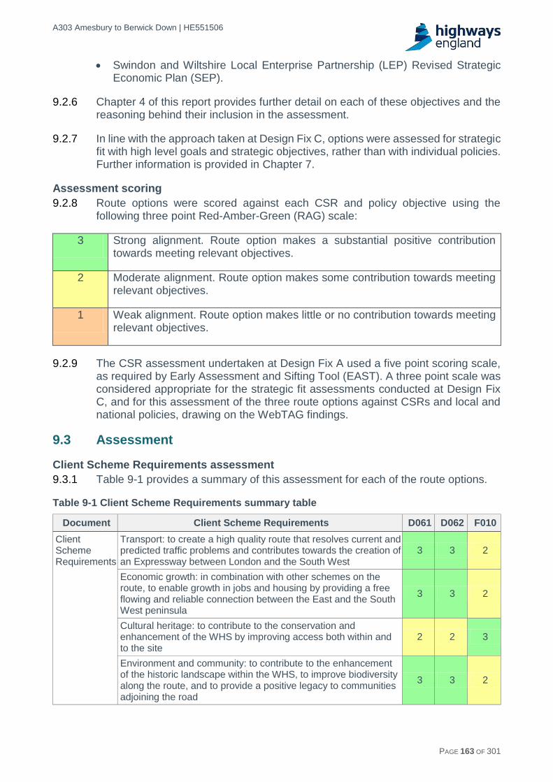
A303 Amesbury to Berwick Down | HE551506
HE551506-AA-GEN-SWI-RP-CX-000020 | P13, S0 21/12/2016 PAGE 163 OF 301
Swindon and Wiltshire Local Enterprise Partnership (LEP) Revised Strategic Economic Plan (SEP).
9.2.6 Chapter 4 of this report provides further detail on each of these objectives and the reasoning behind their inclusion in the assessment.
9.2.7 In line with the approach taken at Design Fix C, options were assessed for strategic fit with high level goals and strategic objectives, rather than with individual policies. Further information is provided in Chapter 7.
Assessment scoring
9.2.8 Route options were scored against each CSR and policy objective using the following three point Red-Amber-Green (RAG) scale:
3 Strong alignment. Route option makes a substantial positive contribution towards meeting relevant objectives.
2 Moderate alignment. Route option makes some contribution towards meeting relevant objectives.
1 Weak alignment. Route option makes little or no contribution towards meeting relevant objectives.
9.2.9 The CSR assessment undertaken at Design Fix A used a five point scoring scale, as required by Early Assessment and Sifting Tool (EAST). A three point scale was considered appropriate for the strategic fit assessments conducted at Design Fix C, and for this assessment of the three route options against CSRs and local and national policies, drawing on the WebTAG findings.
9.3 Assessment
Client Scheme Requirements assessment
9.3.1 Table 9-1 provides a summary of this assessment for each of the route options.
Table 9-1 Client Scheme Requirements summary table
Document Client Scheme Requirements D061 D062 F010
Client Scheme Requirements
Transport: to create a high quality route that resolves current and predicted traffic problems and contributes towards the creation of an Expressway between London and the South West
3 3 2
Economic growth: in combination with other schemes on the route, to enable growth in jobs and housing by providing a free flowing and reliable connection between the East and the South West peninsula
3 3 2
Cultural heritage: to contribute to the conservation and enhancement of the WHS by improving access both within and to the site
2 2 3
Environment and community: to contribute to the enhancement of the historic landscape within the WHS, to improve biodiversity along the route, and to provide a positive legacy to communities adjoining the road
3 3 2

A303 Amesbury to Berwick Down | HE551506
HE551506-AA-GEN-SWI-RP-CX-000020 | P13, S0 21/12/2016 PAGE 164 OF 301
9.3.2 In general, Route Options D061 and D062 align more closely with the CSRs than Route Option F010. However, Route Option F010 aligns most strongly with the cultural heritage CSR as it would remove the road from the WHS in its entirety. This would be a substantial benefit for the WHS and the setting of Stonehenge and other Scheduled Monuments. Route Options D061 and D062 would also remove the road from a key part of the WHS, and all three route options would allow the reconnection of the Avenue, a scheduled monument of high importance that is currently severed by the existing road. All three options would also improve access to the site by improving local traffic conditions. These are very notable benefits.
9.3.3 However, route Options D061 and D062 would introduce major new infrastructure into the WHS, adversely affecting important assets and key attributes of the site’s OUV. On balance, D061 would result in a Slight/Moderate beneficial effect for the WHS, and D062 in a Moderate beneficial effect. Strategic fit with the cultural heritage CSR is therefore considered moderate for both route options.
9.3.4 In other respects, Route Option F010 performs less strongly than Route Options D061 and D062. While Route Option F010 would provide benefits in terms of increased capacity and improved reliability, the longer length of the route restricts potential journey time savings in comparison to Route Options D061 and D062, thereby limiting potential benefits and strategic alignment in terms of improved connectivity and economic growth.
9.3.5 Route Option F010 also has the potential for larger adverse impacts on the environment and community than Route Options D061 and D062. For example, the length and alignment of Route Option F010 could encourage traffic on to local roads to the north of the existing A303, resulting in further adverse severance effects. The route option could also introduce adverse severance effects to communities along the proposed route to the south of the existing A303, such as Berwick St James and Upper Woodford. The length of the route has the potential to result in significant loss of priority habitats and associated biodiversity.
9.3.6 All options would reduce the impact of traffic on Winterbourne Stoke, and have the potential for other beneficial environment and community effects such as a net benefit in terms of reducing noise and a net improvement in local air quality, although there is an increase in NOx emissions across the scheme area. However, route option F010 performs considerably less well in terms of impacts on local communities than route options D061 and D062, and also has the potential for a larger adverse effect on biodiversity. This reduces its strategic fit with the environment and community CSR, relative to route options D061 and D062.
National policy assessment
9.3.7 Table 9-2 provides a summary of national policy alignment for each of the three route options. Route Options D061 and D062 generally align more closely with national policy objectives than F010. Route Option F010, which involves the construction of a longer surface route, offers smaller journey time savings than for D061 and D062 and, as such, contributes less directly to policy objectives relating to connectivity and economic growth.

A303 Amesbury to Berwick Down | HE551506
HE551506-AA-GEN-SWI-RP-CX-000020 | P13, S0 21/12/2016 PAGE 165 OF 301
Table 9-2 National policy summary table
Document Relevant objectives D061 D062 F010
National Policy Statement for National Networks (NPSNN)
Networks with the capacity and connectivity and resilience to support national and local economic activity and facilitate growth and create jobs
3 3 2
Networks which support and improve journey quality, reliability and safety
3 3 2
Networks which support the delivery of environmental goals and the move to a low carbon economy
1 1 1
Networks which join up our communities and link effectively to each other
3 3 1
Road Investment Strategy: for the 2015/16 – 2019/2020 Road Period (RIS1)
Making the network safer 3 3 2
Improving user satisfaction 3 3 2
Supporting the smooth flow of traffic 3 3 2
Encouraging economic growth by working to minimise delay 3 3 2
Delivering better environmental outcomes 2 2 2
Helping cyclists, pedestrians and other vulnerable users 3 3 2
9.3.8 All route options would improve journey quality, reliability and safety for through traffic. However, F010 is expected to encourage more traffic to use local roads adjacent to communities to the north of the existing A303, resulting in adverse severance effects. This route option also has the potential to introduce new adverse severance effects for communities to the south of the existing A303, and therefore performs less well against objectives relating to local traffic issues and communities.
9.3.9 In terms of environmental objectives, all three route options are expected to result in a net overall increase in greenhouse gas emissions20, and an adverse impact on biodiversity, landscape and the water environment. However, F010, due to its greater length, has the potential to result in significant loss of priority habitats and associated biodiversity. Benefits of route options D061 and D062 would include a shorter scheme in terms of its length, landscape reconnection and habitat restoration, leading to a reduction in road fatalities and increase in wildlife movement relative to route option F010.
9.3.10 All three options would result in a net beneficial effect on noise. However F010 has the potential for a larger beneficial noise effect than D061 or D062 due to the reduced noise impact of the existing A303 on Amesbury. All three options have the potential to result in a net improvement in local air quality due to a reduction to exposure of concentrations of particulate matter, although there is an increase in NOx emissions across the scheme area.
20 As part of the Stage 1 assessment, both definitions of Affected Road Network (ARN) were reviewed; due to the limitations of the regional changes in the current local model, the local ARN was used. It is recognised that not all changes in carbon emissions are captured with this approach; this may skew the results of the emissions comparison, particularly during the early years of operation of the Scheme. This limitation will be appropriately addressed once the new regional model becomes available.

A303 Amesbury to Berwick Down | HE551506
HE551506-AA-GEN-SWI-RP-CX-000020 | P13, S0 21/12/2016 PAGE 166 OF 301
Local policy assessment
9.3.11 Table 9-3 provides a summary of local policy alignment for each of the three route options. In general, D061 and D062 perform more strongly than F010 against relevant policy objectives.
Table 9-3 Local policy summary table
Document Relevant objectives D061 D062 F010
Wiltshire Core Strategy
Strategic Objective 1: Delivering a thriving economy 3 3 2
Strategic Objective 4: Helping to build resilient communities
3 3 2
Strategic Objective 5: Protecting and enhancing the natural, historic and built environment
2 2 2
Strategic Objective 6: Ensuring that adequate infrastructure is in place to support our communities
2 2 1
Core Policy 4: Spatial strategy for the Amesbury Community Area
2 2 2
Core Policy 6: Stonehenge 2 2 3
Core Policy 59: The WHS and its setting 2 2 3
Wiltshire Local Transport Plan
Support economic growth 3 3 2
Reduce carbon emissions 1 1 1
Contribute to better safety, security and health 3 3 2
Promote equality of opportunity 2 2 2
Improve quality of life and promote a healthy natural environment
2 2 2
WHS Management Plan
Aim 3: Sustain the OUV of the WHS through the conservation and enhancement of the Site and its attributes of OUV.
2 2 3
Aim 6: Reduce significantly the negative impacts of
roads and traffic on the WHS and its attributes of
OUV and increase sustainable access to the WHS.
2 2 3
Swindon and Wiltshire LEP, Strategic Economic Plan
Transport infrastructure improvements: we need a well-connected, reliable and resilient transport system to support economic and planned development growth at key locations
3 3 2
Place shaping: we need to deliver the infrastructure required to deliver our planned growth and regenerate our City and Town Centres, and improve our visitor and cultural offer
3 3 2
9.3.12 F010 is longer than route options in Corridor D, which limits the potential for journey time savings, and could result in larger areas of habitat loss than D061 and D062. All three route options would result in an increase in carbon dioxide and greenhouse gas emissions, and therefore align weakly with the goal set out in Wiltshire LTP to reduce carbon emissions. Strategic Objective 6 of the Wiltshire Core Strategy includes reductions in greenhouse gas emissions associated with transport as a key outcome, alongside the provision of new or improved infrastructure, reductions in delays and disruption, improved road safety, and better access to jobs and services. Alignment with this strategic objective is considered to be moderate for D061 and D062 – as both would perform reasonably well against other key outcomes associated with this objective – but weak for F010.

A303 Amesbury to Berwick Down | HE551506
HE551506-AA-GEN-SWI-RP-CX-000020 | P13, S0 21/12/2016 PAGE 167 OF 301
9.3.13 The potential benefits for communities along the route option are also limited by the alignment of the F10 route, which could have the potential to encourage traffic to divert into areas to the north of the existing A303, resulting in adverse severance effects. This reduces the extent to which F010 aligns with relevant policy objectives relating to community infrastructure and quality of life. F010 also has the potential to cause severance for communities to the south of the existing A303. All route options would result in a net beneficial impact on noise, but this would be largest for F010 due to the reduced impact of noise from the existing A303 in Amesbury. All route options align to some extent with local policies for the Amesbury Community Area, as they would potentially improve traffic conditions for journeys to and from the town.
9.3.14 Route Option F010 performs strongly in relation to Stonehenge and the historic environment, as it would remove the A303 from the WHS in its entirety, which is a substantial benefit for the WHS and the setting of Stonehenge and other Scheduled Monuments within the site. This would outweigh some adverse effects to other designated assets including Scheduled Monuments, listed buildings, and Conservation Areas elsewhere along the proposed route.
9.3.15 All three options would allow the reconnection of the Avenue, and would have notable benefits for the WHS. However, route Options D061 and D062 would introduce major new infrastructure into the WHS, adversely affecting important assets and key attributes of the site’s OUV, e.g. the location of the western portal relative to Normanton Down Barrow Group. Overall, Route Option D061 would result in a slight/moderate effect on the WHS, and D062 would result in a moderate beneficial effect. Both route options are considered to have a moderate strategic fit with local policies relevant to the WHS.
9.3.16 There are benefits associated with Route Options D061 and DO32 which accord with the aims of the WHS Management Plan, principally in reducing the impact of roads and promoting sustainable access. The tunnel routes would, however, impact negatively upon Aim 3 of the Management Plan due to the presence of the road within the WHS, and so strategic alignment with this aim is considered to be moderate. The removal of the road from the WHS in its entirety, as proposed in Route Option F010, would fulfil the aims of the policy to preserve and enhance the attribute of OUV in the WHS.
9.4 Summary and conclusions
Routes in Corridor D
9.4.1 Route Options D061 and D062 align strongly with all CSRs with the exception of the cultural heritage CSR, where there is a more moderate fit. D061 and D062 would remove the existing A303 and the sight and sound of associated road traffic noise from a key part of the Stonehenge WHS, and would have very notable benefits that, when balanced against the adverse effects resulting from the introduction of major new infrastructure into the WHS and the impacts on important assets and key attributes of the site’s OUV, would result in a Slight/Moderate Beneficial effect on the WHS for Route Option D061 and a Moderate beneficial effect for D062.
9.4.2 Route Options D061 and D062 align strongly with national policy objectives with regards to improving safety, increasing user satisfaction, supporting the flow of traffic, encouraging economic growth, connecting communities and supporting

A303 Amesbury to Berwick Down | HE551506
HE551506-AA-GEN-SWI-RP-CX-000020 | P13, S0 21/12/2016 PAGE 168 OF 301
vulnerable users. These route options would increase capacity and improve conditions both for through traffic and local traffic, supporting economic growth and reducing severance in communities to the north of the existing A303 which are currently affected by rat-running.
9.4.3 There is more moderate alignment with policy objectives relating to delivering better environmental outcomes, where both options would have the potential for a range of adverse and beneficial impacts. D061 and D062 would have beneficial impacts on noise and air quality (in terms of reductions in exposure to particulate matter), but adverse impacts on biodiversity and greenhouse gas emissions, landscape, and the water environment. Benefits of route options D061 and D062 would, however, include a shorter scheme in terms of its length, landscape reconnection and habitat restoration, leading to a reduction in road fatalities and increase in wildlife movement relative to route option F010.
9.4.4 In terms of regional and local policy alignment, D061 and D062 would align strongly with relevant objectives in terms of delivering transport infrastructure, improving traffic conditions for local traffic and strategic road users, encouraging economic growth, and supporting local communities. Alignment with objectives relating to protecting the natural and historic environment is again more moderate, reflecting the broad range of adverse and beneficial impacts associated with these policies. There is weak alignment with the goal set out in the Wiltshire Local Transport Plan to reduce carbon emissions.
9.4.5 The key difference between Route Options D061 and D062 relates to the alignment of the Winterbourne Stoke bypass. However, differences are relatively slight and have not affected the scoring of the route options.
Route Option F010
9.4.6 Route Option F010 generally aligns less strongly with national, regional and local policy objectives and CSRs than route options in Corridor D. The longer length of the route would limit the potential for journey time savings and therefore the potential to support economic growth. This in turn limits the extent to which F010 aligns with objectives relating to delivering transport infrastructure, increasing user satisfaction, improving traffic, and encouraging growth. Route Option F010 also has the potential to result in adverse effects on biodiversity including larger areas of habitat loss than route options in Corridor D, limiting alignment with objectives relating to the environment.
9.4.7 In terms of supporting local communities, the alignment of Route Option F010 and the closure of the existing A303 between Countess and Longbarrow roundabouts is expected to encourage traffic to divert onto local roads, increasing traffic flows through communities to the north of the existing A303. This would have the potential to result in adverse severance effects for communities currently affected by 'rat running'. There is also the potential for severance to affect communities to the south of the existing A303, such as Great Durnford and Upper Woodford. This affects the extent to which this route option aligns with strategic objectives and CSRs in relation to safety, vulnerable road users, quality of life, and resilient communities.
9.4.8 With regards to the historic environment, F010 would remove the road from the entirety of the WHS and allow the reconnection of the Avenue, which aligns strongly with relevant cultural heritage and historic environment objectives and CSRs. It also

A303 Amesbury to Berwick Down | HE551506
HE551506-AA-GEN-SWI-RP-CX-000020 | P13, S0 21/12/2016 PAGE 169 OF 301
increases the extent to which the route option aligns with the environment and community CSR, which includes consideration of the historic landscape within the WHS. There is, however, the potential for this route option to result in adverse effects for designated heritage assets outside the WHS, and there may be some visibility of the route option from the southern fringes of the WHS.
Conclusions
9.4.9 In overall terms, Route Options D061 and D062 align more closely with CSRs and relevant national and local policy objectives than Route Option F010.

A303 Amesbury to Berwick Down | HE551506
HE551506-AA-GEN-SWI-RP-CX-000020 | P13, S0 21/12/2016 PAGE 170 OF 301
10 Traffic analysis and modelling
10.1 Introduction
10.1.1 This chapter provides a summary of the traffic data and modelling approach adopted for the traffic assessment. Full details of the traffic analysis can be found in the following documents:
Local Model Validation Report.
Traffic Forecasting Report.
Traffic Data Collection Report.
10.1.2 The traffic modelling has and will be undertaken in three stages, as follows:
In the pre-feasibility study, the traffic modelling approach used the existing London to the South West and South Wales Multi-Modal Study (SWARMMS) model. The SWARMMS model covers the entire strategic road network from London to Cornwall and the Midlands. This model was used to test the proposed A303 corridor improvements package, which includes the A303 Amesbury to Berwick Down scheme. The network used was strategic in nature using speed/flow curves to reflect the impact of congestion on travel times rather than detailed junction modelling. The trip matrices were based on the 2013 base year updated SWARMMS matrices. This model was used to test the range of options at Design Fix A and B.
For the Project Control Framework (PCF) Stage 1 assessment of the Design Fix C options, a hybrid model was developed combining the network from the South-West Regional Transport Model (SWRTM) including junction modelling in the local area with the SWARMMS network in the outer, buffer area. The trip matrices were based on the 2013 base year updated SWARMMS matrices supplemented with data from roadside interview surveys undertaken in October 2015 and comprehensive count data used in the matrix estimation process.
For the future PCF Stage 2 traffic modelling, a new model will be built from the complete SWRTM being developed by Highways England. The network will include widespread junction modelling both across the local and outer areas. The new trip matrices, constructed in SWRTM from mobile phone data will be supplemented with the Stage 1 roadside interview data and comprehensive count data.
10.1.3 From a traffic point of view, the alignment of the updated tunnel route options D061/D062 were very similar to the D031/D032 options and the design changes introduced to these options were considered to have no material effect on the traffic and economic assessment. On this basis, given the stage of development of the project, no update to the traffic model and traffic forecasting detailed for the D031/D032 in the Traffic Forecasting Report was required.
10.2 Initial corridors appraisal (Design Fix A) traffic modelling
10.2.1 In order to assist the sifting process, a number of routes were tested using the Stage 1 model. As outlined in Chapter 5, a large number of potential options were identified. It was not feasible to model each of option individually and hence the following six routes represented the corridors:
To the north of the A303 – to represent Corridors A, B and C.

A303 Amesbury to Berwick Down | HE551506
HE551506-AA-GEN-SWI-RP-CX-000020 | P13, S0 21/12/2016 PAGE 171 OF 301
Remain online with a tunnel – to represent Corridor D.
South of the A303, but within the WHS – to represent Corridor E.
South of the WHS – to represent Corridor F (north).
North of Salisbury – to represent Corridor F (south).
South of Salisbury – to represent Corridor G.
10.2.2 The modelling process consisted of defining indicative schemes for each corridors identified above.
10.2.3 The six routes tested are described in Table 10-1 and are shown in Figure 10-1. For comparison purposes, the distances quoted in Table 10-1 were measured from the junction of the A303/A342/A343 at Andover to a point approximately five kilometres east of the A303/A350 junction for all route options.
Table 10-1 Routes tested
Route Name Description Indicative distance
(km)
A303 Existing A303 From the junction of the A303/A342/A343 at Andover to a point five km east of the A303/A350 junction
42
1 Northern route From the A345 Countess roundabout and extending west of Winterbourne Stoke with the A303 closed
44
2 Short Tunnel and Winterbourne Stoke Bypass
Tunnel between the A345 Countess roundabout and the A360 Longbarrow roundabout, linking to a bypass around the north of Winterbourne Stoke
43
3 Within WHS
A route passing through the WHS from the A345 (Countess roundabout) to west of the A360 Longbarrow roundabout and then passing north of Winterbourne Stoke
43
4 South of WHS From east of the A345 Countess Roundabout passing south of the WHS to re-join the A303 north of the A36 junction
45
5 North of Salisbury
From east of the A345 Countess Roundabout passing through the Boscombe Down Site connecting to the A345 and A360 north of Salisbury and then connecting to the A36 near the B3083 junction
47
6 South of Salisbury
From the A303 between the A303 and A343 junctions joining the A343 to the west of Lopcombe and then heading south to the A36 and passing south of Salisbury, crossing the A338 and A354 before heading north-west to re-join the A303 west of Deptford
52
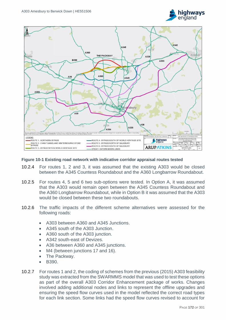
A303 Amesbury to Berwick Down | HE551506
HE551506-AA-GEN-SWI-RP-CX-000020 | P13, S0 21/12/2016 PAGE 172 OF 301
Figure 10-1 Existing road network with indicative corridor appraisal routes tested
10.2.4 For routes 1, 2 and 3, it was assumed that the existing A303 would be closed between the A345 Countess Roundabout and the A360 Longbarrow Roundabout.
10.2.5 For routes 4, 5 and 6 two sub-options were tested. In Option A, it was assumed that the A303 would remain open between the A345 Countess Roundabout and the A360 Longbarrow Roundabout, while in Option B it was assumed that the A303 would be closed between these two roundabouts.
10.2.6 The traffic impacts of the different scheme alternatives were assessed for the following roads:
A303 between A360 and A345 Junctions.
A345 south of the A303 Junction.
A360 south of the A303 junction.
A342 south-east of Devizes.
A36 between A360 and A345 junctions.
M4 (between junctions 17 and 16).
The Packway.
B390.
10.2.7 For routes 1 and 2, the coding of schemes from the previous (2015) A303 feasibility study was extracted from the SWARMMS model that was used to test these options as part of the overall A303 Corridor Enhancement package of works. Changes involved adding additional nodes and links to represent the offline upgrades and ensuring the speed flow curves used in the model reflected the correct road types for each link section. Some links had the speed flow curves revised to account for

A303 Amesbury to Berwick Down | HE551506
HE551506-AA-GEN-SWI-RP-CX-000020 | P13, S0 21/12/2016 PAGE 173 OF 301
upgrading to dual carriageway, while other links had the speed flow curve downgraded to account for a reduction to single carriageway. The speed flow curves of relevance to this modelling are shown in Table 10-2.
Table 10-2 Network speed curves
Description Free flow
speed (kph)
Speed at capacity
(kph)
Link capacity
Power Index
Typical Single (7.3M) Carriageway 1L 50Sp
77 48 1118 2.65 151
Wide Single (10M) Carriageway 1L 60Sp
92 58 1425 2.80 161
Dual 2 Lanes All Purpose Carriageway 2L 70Sp
112 91 3448 3.70 631
Typical Single (7.3M) Carriageway 1L 40Sp
77 48 1218 2.65 841
10.2.8 For the purposes of the option appraisal, the 2021 and 2041 forecast matrices for the SWARMMS model were used. The 2021 and 2041 reference case matrices had been developed from the 2013 base year matrices with growth factors derived from TEMPro 6.2 and National Transport Model (NTM, RTF13). Known approvals for major developments adjacent to the A303 scheme corridor were included in the matrices.
10.2.9 For these forecasts, no variable demand modelling was undertaken. As the matrices are fixed, any changes in traffic flows on the network are purely due to reassignment of traffic as a result of the route being assessed by the model.
Impact of routes
10.2.10 The results of the initial modelling show that for routes 1, 2 and 3 the changes in traffic flows are local and largely restricted to the A303 corridor itself. For all of these routes there are changes in flows on the A36, but these are limited in numbers at approximately less than 30 vehicles. The A303 dual carriageway offers congestion relief between the A345 Countess and A360 Longbarrow roundabouts and this occurs for all modelled time periods and both 2021 and 2041.
10.2.11 Routes 4, 5 and 6 have a much wider impact due to these corridors being further south and thus become alternative routes for those travelling to and from Salisbury and those travelling to or from London to the South West. Each of these routes attracts vehicles from the A303, although when the A303 is open (in Option A) for routes 4, 5 and 6, the impact is limited.
10.2.12 For route 6 the impact of closing the A303 is greater and more widespread than for all other corridors. With route 6 being located south of Salisbury it results in a movement in traffic from the A303 corridor to the A30 corridor. This movement of traffic between the corridors is due to the A30 being closer to the bypass south of Salisbury and so the additional distance travelled is lower than would be the case if a vehicle remained on the A303 corridor.
10.2.13 For routes 4 and 5 the congestion relief on the A303 is limited if the A303 remains open (Option A) as vehicles will remain on the A303 rather than divert onto the

A303 Amesbury to Berwick Down | HE551506
HE551506-AA-GEN-SWI-RP-CX-000020 | P13, S0 21/12/2016 PAGE 174 OF 301
bypass due to the increased distance and time of using this bypass. With the A303 closed (Option B) the congestion relief is greatest for route 5, while for route 4 there is little difference between A303 open (Option A) and closed (Option B).
10.2.14 For route 5 (Option A) the section of bypass between the A36 and the A360 is attractive to vehicles as an alternative route to and from Salisbury. To the east of the A360 the traffic flow is substantially lower. The impact of this option on the A303 is limited as there is no journey time saving in using the bypass over the existing A303 and so vehicles remain on the A303.
10.2.15 For both route 5 and 6 with Option B there is a shift in traffic from the A303 corridor to the A30 Corridor as this becomes a more attractive route.
10.2.16 The results show that for routes 1, 2, 3 and 4 there is a journey time saving for all three time periods for 2021 and 2041, whereas for routes 5 and 6 there is no journey time saving to be made for those travelling on the bypass. This is due to the increased distance that vehicles on routes 5 and 6 have to travel as a result of the bypass route. For both routes 5 and 6 those vehicles that remain on the A303 experience some journey time savings in comparison with the Do Minimum.
10.2.17 For routes 5 and 6 with Option A (A303 open), there is the potential for savings to be made on the A303 itself as a result of traffic diverting onto the alternative bypass.
Impact on local road network
10.2.18 Based on the results of the modelling using the PCF Stage 1 model, those route options within the WHS (routes 1, 2 and 3) have an impact on the local road network, whereas those outside the WHS (routes 4, 5 and 6) have an impact over a much greater area due to these corridors being further to the south and impacting on travel around Salisbury.
10.2.19 Route 6 with the A303 closed affects a much wider area than the other route corridors due to the proximity of this southern route option to the A30. With the A303 being closed (Option B) the A30 would become more attractive as a route from the South West to London.
10.2.20 The results from the journey time analysis show that for those routes within the WHS (routes 1, 2 and 3) there are savings to be made. For route 4 there is a journey time saving to be made in all time periods except 2021 AM peak. Those routes furthest from the A303 (routes 5 and 6) experience journey time savings in certain time periods and these are more likely to occur in 2041.
10.2.21 For those routes where the A303 remains open (routes 4, 5 and 6) there was a potential journey time saving to be made for vehicles staying on the A303, but these did not occur in all time periods.
10.2.22 The network statistics for the vehicle-hours show those route options within the WHS have a decrease in comparison with the Do Minimum, whereas those outside the WHS have an increase in comparison with the Do Minimum.
10.2.23 Route 2 has the lowest total network vehicle-hours for all situations.
10.2.24 The network statistics for the vehicle-kilometres show an increase for all route options in comparison with the Do Minimum scenario, with route option 2 being the scheme option with the lowest vehicle kilometres.

A303 Amesbury to Berwick Down | HE551506
HE551506-AA-GEN-SWI-RP-CX-000020 | P13, S0 21/12/2016 PAGE 175 OF 301
10.2.25 The results from the initial modelling show that those corridors that are within the WHS and thus are close to the A303 have the greatest impact in terms of easing congestion on the A303 and improving journey times. Whereas, those further from the A303 only have an impact when the A303 itself is closed, otherwise the impact of reducing congestion is negligible. On these routes with the A303 is closed, the result is an increase in the total network vehicle-hours and kilometres as a result of the increased distance vehicles travel.
10.2.26 Output from the application of the traffic modelling which informed the Design Fix A assessment is reported in Chapter 5.
10.3 Initial route options appraisal (Design Fix C) traffic modelling
10.3.1 As indicated in the introduction, there are three stages to the transport model development. These reflect the availability of existing traffic models and data and the emergence and timing of the availability of new models and data.
10.3.2 At Design Fix C, from the traffic modelling perspective, the main role was the assessment of the different route options within Corridors D and F.
10.3.3 After a review of the differences between the Winterbourne Stoke north and south bypasses from the perspective of the traffic modelling, considering the lengths of the route options and the locations of junctions, it was concluded that there would be no significant difference between them in the modelling and hence only a single option for Corridor D was modelled in detail.
10.3.4 The three options that were assessed in Corridor F using the model are as follows and are shown in Appendix C8:
Route Option F004 – Central route which shares eastern section with options F010 and F005 and has the same western junction as Route Option F005.
Route Option F005 – Southern option which shares the same eastern and western junctions with Route Option F004.
Route Option F010 – Northern route which skirts the southern boundary of the WHS.
10.3.5 As the Design Fix C model did not include detailed junction simulation, indicative junctions were represented in the link-based modelling with all vehicle movements permitted at each junction. For each option, in both Corridor D and F, the modelling included junctions with A303 (east), A345, A360 and A303 (west).
10.3.6 The results for the single option of Corridor D and the three variations for Corridor F were prepared in terms of the traffic flows on each link and the difference from the Do Minimum situation. A single forecast year of 2041 is reported; the general assessment in 2021 is similar to that for 2041 for each option. The presentation of outputs concentrates on the PM Peak period when the traffic flows are generally at their highest and are shown in Figures 10-2 to 10-9.
10.3.7 Output from the application of the traffic modelling which informed the Design Fix C assessment is reported in Chapter 7.

A303 Amesbury to Berwick Down | HE551506
HE551506-AA-GEN-SWI-RP-CX-000020 | P13, S0 21/12/2016 PAGE 176 OF 301
Figure 10-2 2041 PM peak forecast traffic flows – Corridor D

A303 Amesbury to Berwick Down | HE551506
HE551506-AA-GEN-SWI-RP-CX-000020 | P13, S0 21/12/2016 PAGE 177 OF 301
Figure 10-3 2041 PM peak forecast traffic flows – Difference from Do Minimum – Corridor D
Figure 10-4 2041 PM peak forecast traffic flows – Option F010

A303 Amesbury to Berwick Down | HE551506
HE551506-AA-GEN-SWI-RP-CX-000020 | P13, S0 21/12/2016 PAGE 178 OF 301
Figure 10-5 2041 PM peak forecast traffic flows – Difference from Do Minimum – Option F010
Figure 10-6 2041 PM peak forecast traffic flows – Option F004
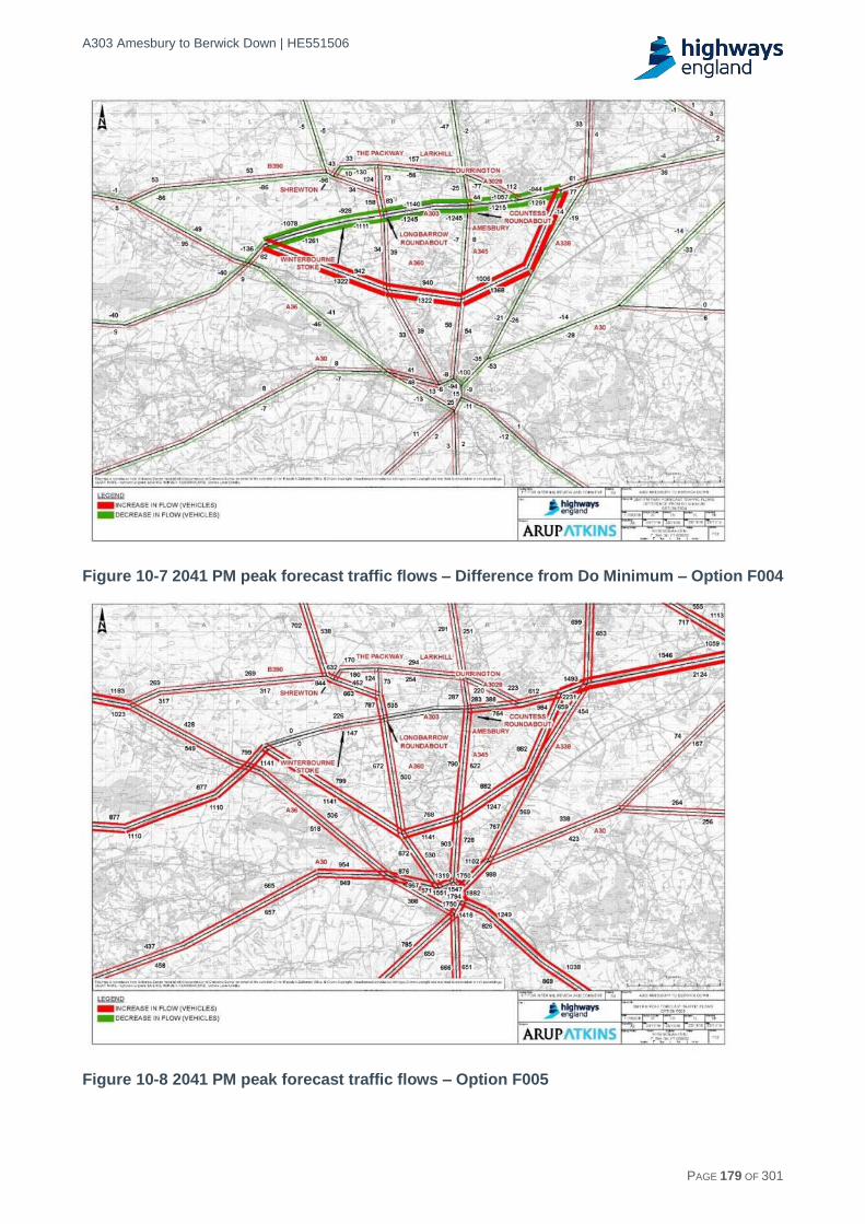
A303 Amesbury to Berwick Down | HE551506
HE551506-AA-GEN-SWI-RP-CX-000020 | P13, S0 21/12/2016 PAGE 179 OF 301
Figure 10-7 2041 PM peak forecast traffic flows – Difference from Do Minimum – Option F004
Figure 10-8 2041 PM peak forecast traffic flows – Option F005

A303 Amesbury to Berwick Down | HE551506
HE551506-AA-GEN-SWI-RP-CX-000020 | P13, S0 21/12/2016 PAGE 180 OF 301
Figure 10-9 2041 PM peak forecast traffic flows – Difference from Do Minimum – Option F005
10.4 Further WebTAG appraisal traffic modelling
10.4.1 The overall approach to the development of the transport models used in the Design Fix A, B and C process was outlined at the start of this chapter. The assessment of the options emerging from Design Fix C were assessed using the PCF Stage 1 model; this contains a number of refinements from the model used in Design Fix A and C.
10.4.2 In addition to the initial specification of the approach for the PCF Stage 1 model outlined in the Appraisal Specification Report (ASR), further supporting evidence on the model is provided in the following:
The Traffic Data Collection Report for the A303 Amesbury to Berwick Down scheme which was issued in June 2016.
The Local Model Validation Report for the scheme issued in September 2016.
The Traffic Forecasting Report for the scheme issued in September 2016.
Model description/outline specification
10.4.3 In PCF Stage 1, covering the model used to assess the Design Fix C schemes, the modelling methodology is based on the updated SWARMMS model supplemented by preliminary data from the under-development SWRTM to create a model designed to assess the local impacts of the scheme. The modelling process was designed to be compliant with Department for Transport (DfT) Web-based Transport Analysis Guidance (WebTAG) guidance. The PCF Stage 2 model will be based on the full SWRTM when it becomes available.

A303 Amesbury to Berwick Down | HE551506
HE551506-AA-GEN-SWI-RP-CX-000020 | P13, S0 21/12/2016 PAGE 181 OF 301
10.4.4 The development of the Stage 1 local traffic model from the Stage 0 model, involved refining the SWARMMS-based model in the local area (see Figure 10-10) with disaggregation of the zone system and increased detail in the network specification.
10.4.5 The local model area was identified by using the SWARMMS model to determine the Area of Detailed Modelling. This comprises those links where the most significant changes in traffic volumes were likely to occur as a result of the scheme, as shown in Figure 10-10.
10.4.6 Within this area, the model network was enhanced to include full junction simulation. Initial coding of the network in this area was informed by details released from the under-development SWRTM.
Figure 10-10 Local model area containing detailed modelling
10.4.7 The zoning systems for the updated SWARMMS model and the SWRTM were the starting point for the development of a zoning system for the detailed local area modelling, taking into account the extent of highway options to be assessed.
10.4.8 Within the local area, the network from the SWRTM was used as the starting point for the specification of the highway network, with additional links as necessary in the immediate vicinity of the scheme to reflect local roads not included in the SWRTM network. Outside the local area, the SWARMMS model formed the basis for the network definition.
10.4.9 The trip matrices in Stage 1 were derived from the SWARMMS model (with disaggregation to align with the amended zone system), supplemented by data from roadside interview surveys undertaken in October 2015 specifically for the scheme development.

A303 Amesbury to Berwick Down | HE551506
HE551506-AA-GEN-SWI-RP-CX-000020 | P13, S0 21/12/2016 PAGE 182 OF 301
10.4.10 As already noted, the 2013 SWARMMS model is a highway-only model, which has no variable demand modelling function. Given the low level of public transport alternatives available for traffic in this area, a highway-only model using fixed demand was considered to be acceptable for the purpose of this assessment.
Highway model specification
10.4.11 The updated Stage 1 model uses SATURN version 11.3.10 software, which is a 'congested assignment' software suite that was developed over a period of more than 30 years by the Institute for Transport Studies at the University of Leeds. It is widely used, both in the UK and overseas, for the evaluation of a wide variety of highway systems and proposals, and is recognised as an "industry standard" traffic assignment model that satisfies the requirements for modelling highway networks as set out in WebTAG.
10.4.12 SATURN provides a combined traffic simulation and assignment model for the analysis of road proposals ranging from traffic management schemes over relatively localised networks to major infrastructure improvements. One of the key features of SATURN is its ability to simulate the operation of junctions in some detail, including the prediction of queues and delays, the effect of queues blocking back on adjacent junctions, and the influence of congestion at specific points in the network on driver route choice.
10.4.13 The highway modelling process is illustrated in Figure 10-11. The basic inputs to the SATURN model are the transport demands, in the form of a matrix of trip movements between zones, and the 'supply' in the form of a detailed description of the road network. Following the network building procedure, the trip matrix is assigned to the network using an iterative series of loops between 'assignment' and 'simulation' until the model has converged.
10.4.14 The 'assignment' process calculates the minimum cost route options for trips in terms of a weighted combination of time and distance. The 'simulation' stage then simulates the operation of each junction in the network. As route costs can depend upon the route options taken by other vehicles, for example through the delays caused by traffic following different route options, the junction simulations can lead to a different set of minimum cost route options. Thus, the process is repeated, until successive assignment-simulation loops produce an acceptably low level of change in vehicle flows between iterations, when the model is deemed to have achieved convergence.
10.4.15 When convergence is achieved, the model is considered to be calibrated. The modelled number of vehicles on the network are compared with the observed counts. The description of the road network (supply) is checked carefully and a matrix estimation procedure is used to adjust the trip patterns in the trip matrices (demand) if required.
10.4.16 The final stage is to validate the model, in which comparisons are made between modelled flows and a separate and independent set of traffic count data that was not used in the calibration process. Modelled journey times are also compared with observed times.
10.4.17 It is expected that, depending on the development of the SWRTM model, the version of the SWRTM that will form the basis of the PCF Stage 2 assessment will incorporate a public transport model and variable demand modelling.

A303 Amesbury to Berwick Down | HE551506
HE551506-AA-GEN-SWI-RP-CX-000020 | P13, S0 21/12/2016 PAGE 183 OF 301
Network Development
SATURN Assignment / Simulation
Base Year
Updated Matrix
Figure 10-11 SATURN highway modelling process
10.4.18 The modelled time periods used in the PCF Stage 1 model are those used in the 2013 SWARMMS model:
AM peak hour (08:00 - 09:00).
Inter-peak hour (average hour between 10:00 and 16:00).
PM peak hour (17:00 - 18:00).
10.4.19 The trip matrices used for modelling are derived from the 2013 SWARMMS model, and so comprise the same user classes, based on travel purpose and type of vehicle. Four user classes are modelled:
Network Inventory
Base Year SATURN Network
Observed Roadside
Interview Data
Matrix Development
Base Year Prior Matrix
SWARMMS Travel Demand
Update Prior Matrix Using Matrix Estimation Traffic Count Data
Calibrated Model
Calibrate
network
Iterate
SATURN Assignment / Simulation
Model Calibration
Count Data
Journey Time Survey Data
Comparison with Observed RSI Data
Validated Base Year Model
Validation Comparison
Model Validation

A303 Amesbury to Berwick Down | HE551506
HE551506-AA-GEN-SWI-RP-CX-000020 | P13, S0 21/12/2016 PAGE 184 OF 301
Cars/light goods vehicles: commuting trips.
Cars/light goods vehicles: business trips.
Cars light goods vehicles: other trips.
Heavy goods vehicles.
10.4.20 This allows the model to take account of differences in users' Value of Time (VoT) and Vehicle Operating Cost (VOC). HGVs have different VOCs in comparison to cars and Light Goods Vehicles (LGVs). The cars and LGVs have been split into three trip purposes as the value of time differs between these types i.e. vehicles on business trips are likely to have a higher value of time than, for example, a vehicle on a journey for leisure purposes.
10.4.21 Demand in the SATURN traffic assignment is expressed in terms of Passenger Car Units (PCUs). The factors used to convert from vehicles to PCUs are also listed in Table 10-3.
Table 10-3 Passenger car unit (PCU) factors
Vehicle type PCU factor
Car / LGV Work 1.00
Car / LGV Business 1.00
Car / LGV Other 1.00
Heavy Goods Vehicle 2.51
10.4.22 As applied in the SWARMMS model, the PCU factor for Heavy Goods Vehicles (HGVs) is a weighted average of the factors given in WebTAG for Rigid Goods Vehicles and Articulated Goods Vehicles. The weighting was applied using goods vehicle type splits on major roads within the study area from the DfT's Annual Average Daily Flow - Data by Direction Major Roads.
10.4.23 The Local Model Validation Report details the validation of the PCF Stage 1 highway model. Four validation sites were identified on the A303, together with two screenlines of sites running parallel to the route option, one to the north and one to the south. All of these count sites were kept separate as independent validation sites.
10.4.24 All of the remaining count sites were used in the matrix estimation process for calibrating the model, which adjusted the trip matrices to better reflect observed count data.
10.4.25 The model validation shows those areas in which greater confidence can be attached to the forecasts from the model. The results show that, in the AM Peak, all the sites on the A303 passed the validation criteria, although three of the four screenline totals failed to meet the appropriate criteria. Of all the individual sites, 87% met both the flow criteria set in the guidelines, marginally lower than the recommended level.
10.4.26 Similar results were achieved in the Inter Peak, again with all of the A303 sites passing the criteria, while all four screenline totals failed to meet the flow validation criteria. The validation of all the independent sites, however, also met the criteria, with 94% of sites passing the flow criteria.

A303 Amesbury to Berwick Down | HE551506
HE551506-AA-GEN-SWI-RP-CX-000020 | P13, S0 21/12/2016 PAGE 185 OF 301
10.4.27 Results in the PM Peak were less good. Two of the four A303 sites failed to meet the criteria in the eastbound direction, and one failed in the westbound direction. In addition, three of the four screenline totals failed to meet the set criteria, while 74% of sites met the flow criteria set in the guidelines.
10.4.28 The results indicate that there is scope for further improvements in the validation of the Stage 1 model, in particular to ensure that the total flow across the screenlines provide a closer match to observed flows. The most important comparison of flows along the A303 itself achieve a good validation in the AM and Inter Peak time periods, but the PM Peak model needs further work in this respect as well.
10.4.29 The results show that the validation of journey times in each of the modelled time periods meets the WebTAG requirements on most of the surveyed routes. In the AM Peak, the total number of routes which met the validation criteria was marginally below the 85% requirement, although it should be noted that the only routes which failed were those on the A30, which included some duplication between the long distance Route 4 and the local Route 12.
10.4.30 In the Inter Peak, the 85% requirement was exceeded, with only three routes not meeting the validation criteria. This included the long distance routes via the M4/M5 in both directions.
10.4.31 As with the flow validation, the journey time comparison in the PM Peak was less good, with 79% of routes achieving the 85% requirement. This again included the local A30 Route 12 along with one of the long distance A30 routes.
10.4.32 The PCF Stage 1 model represents an interim model and the ultimate PCF Stage 2 SWRM-based model is awaiting the release of the base year and future year Do Minimum SWRM models. The development of the PCF Stage 1 model for future years was based on growth factors derived from the recently-released DfT TEMPro 7.0 forecasts. The release of TEMPro 7.0 in July 2016 enabled a revision of the forecast years from those used in the earlier modelling, with the extension of the horizon to 2051. As a result, forecasts were developed for the following future years:
2024 - Year of opening.
2031 - Intermediate year.
2039 - Design year (15 years after opening).
2051 - Horizon year.
10.4.33 TEMPro 7.0 was used to derive the forecasts for light vehicle user classes with the trip end growth, fuel and income adjustment factors being applied via the Furnessing procedure to the base year trip matrices. For HGVs, the growth from the National Transport Model was used to provide the growth up to the NTM horizon year of 2040 beyond which a trend extrapolation was applied to 2051.
10.4.34 For the opening year of 2024, the forecast growth in demand is about 10% above the demand in the 2015 base year. By the design year of 2039, demand is forecast to be 27-30% higher than the base year, and 40-44% higher by 2051.
10.4.35 The Traffic Forecasting Report includes outputs from the modelling of the Do Minimum and options for Corridor D and F, including the journey times in the future for each time period and network plots showing the forecast flows in 2024 (year of

A303 Amesbury to Berwick Down | HE551506
HE551506-AA-GEN-SWI-RP-CX-000020 | P13, S0 21/12/2016 PAGE 186 OF 301
opening) and 2039 (design year) for each time period and the difference in flows between the option and the Do Minimum.
10.4.36 The PCF Stage 1 modelling, which informed the Design Fix C assessment, contained a number of enhancements from the earlier modelling used for the earlier Design Fix A assessments. The main differences are summarised below, covering not just the core modelling but also the subsequent application of the model for scheme appraisals:
Model enhanced to include junction modelling in the local model area.
Model extended to include additional local roads within the vicinity of A303 at Stonehenge.
Model enhanced and revalidated using matrix estimation based on up-to-date counts.
Change in Value of Time used in assignment following updated DfT guidance.
TEMPro 7.0 replacing TEMPro 6.2.
Forecast years 2024, 2031, 2039 and 2051 rather than 2021 and 2041.
Changes to the specification of the schemes.
Changes to the design of junctions with A345 and A360.
New version of Transport User Benefit Appraisal (TUBA) - v1.9.8.
Change in Value of Time for appraisal.
Change in treatment of business user benefits in appraisal including variation by journey length in line with revised DfT guidance.
Changes to scheme costs.
Changes to opening year of schemes (including schemes along the A303/A358 corridor).
10.5 Road layout and standards
Congestion and stress
10.5.1 As described in section 3 paragraphs 3.1.57-58, in relation to the existing situation, an approach to understanding the impact of traffic flow on network performance is to calculate the network "stress" using traffic flow data compared with Congestion Reference Flow (CRF). The CRF is the maximum achievable hourly throughput on a link expressed in terms of AADT. Links which operate with flows in excess of this value (i.e. above 100%) are likely to suffer from operational issues and congestion, including flow breakdown and queuing. Where the stress factor lies between 85% and 100% turbulent traffic conditions will also be experienced during peak periods.
10.5.2 The analysis was extended in Tables 10-4 and 10-5 below to show the forecast road stress ratios without the scheme for neutral and summer month for the same sections for 2015, 2024, 2031, 2039 and 2051, assuming the same limiting congestion flows (CRFs) on each section as previously calculated. The analysis is based on the forecast flows from the traffic model for each future year. The analysis clearly demonstrates the increase in stress levels in the future on the single carriageway sections between Amesbury and Berwick Down if no improvements are made. The stress factors between 85% and 99% are highlighted in yellow while stress factors above 100% are shown in orange.

A303 Amesbury to Berwick Down | HE551506
HE551506-AA-GEN-SWI-RP-CX-000020 | P13, S0 21/12/2016 PAGE 187 OF 301
Table 10-4 Future Corridor CRF and stresses without scheme - Neutral month (March)
No. Section No. of lanes
Eastbound
CRF ADT Stress factor
2015 2024 2031 2039 2051 2015 2024 2031 2039 2051
1 A36 - B3083 1 15,578 10,446 10,413 10,941 11,368 12,576 0.67 0.67 0.70 0.73 0.81
2 B3083 - A345 1 12,421 12,810 14,214 15,199 16,140 17,828 1.03 1.14 1.22 1.30 1.44
3 A345 - A3028 2 51,891 14,155 19,627 21,186 22,792 25,286 0.27 0.38 0.41 0.44 0.49
4 A3028 - A338 2 49,440 11,910 17,063 18,230 19,454 21,303 0.24 0.35 0.37 0.39 0.43
No. Section No. of lanes
Westbound
CRF ADT Stress factor
2015 2024 2031 2039 2051 2015 2024 2031 2039 2051
1 A36 - B3083 1 10,678 10,387 10,422 11,452 11,847 13,348 0.97 0.98 1.07 1.11 1.25
2 B3083 - A345 1 10,290 12,630 14,465 16,004 17,081 19,020 1.23 1.41 1.56 1.66 1.85
3 A345 - A3028 2 38,498 12,032 18,763 20,201 21,414 23,581 0.31 0.49 0.52 0.56 0.61
4 A3028 - A338 2 33,956 15,447 17,461 18,831 19,916 22,066 0.45 0.51 0.55 0.59 0.65
No. Section No. of lanes
Both directions
CRF ADT Stress factor
2015 2024 2031 2039 2051 2015 2024 2031 2039 2051
1 A36 - B3083 1 25,289 20,833 20,835 22,393 23,215 25,924 0.82 0.82 0.89 0.92 1.03
2 B3083 - A345 1 22,466 25,440 28,679 31,203 33,221 36,848 1.13 1.28 1.39 1.48 1.64
3 A345 - A3028 2 88,248 26,187 38,390 41,387 44,206 48,867 0.30 0.44 0.47 0.50 0.55
4 A3028 - A338 2 80,312 27,357 34,524 37,061 39,370 43,369 0.34 0.43 0.46 0.49 0.54
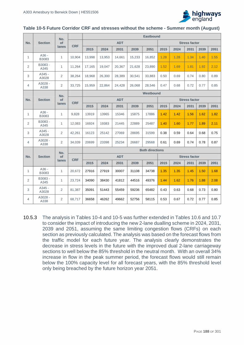
A303 Amesbury to Berwick Down | HE551506
HE551506-AA-GEN-SWI-RP-CX-000020 | P13, S0 21/12/2016 PAGE 188 OF 301
Table 10-5 Future Corridor CRF and stresses without the scheme - Summer month (August)
No. Section No. of
lanes
Eastbound
CRF ADT Stress factor
2015 2024 2031 2039 2051 2015 2024 2031 2039 2051
1 A36 - B3083
1 10,904 13,998 13,953 14,661 15,233 16,852 1.28 1.28 1.34 1.40 1.55
2 B3083 -
A345 1 11,264 17,165 19,047 20,367 21,628 23,890 1.52 1.69 1.81 1.92 2.12
3 A345 - A3028
2 38,264 18,968 26,300 28,389 30,541 33,883 0.50 0.69 0.74 0.80 0.89
4 A3028 -
A338 2 33,725 15,959 22,864 24,428 26,068 28,546 0.47 0.68 0.72 0.77 0.85
No. Section No. of
lanes
Westbound
CRF ADT Stress factor
2015 2024 2031 2039 2051 2015 2024 2031 2039 2051
1 A36 - B3083
1 9,828 13919 13965 15346 15875 17886 1.42 1.42 1.56 1.62 1.82
2 B3083 -
A345 1 12,083 16924 19383 21445 22889 25487 1.40 1.60 1.77 1.89 2.11
3 A345 - A3028
2 42,261 16123 25142 27069 28695 31599 0.38 0.59 0.64 0.68 0.75
4 A3028 -
A338 2 34,039 20699 23398 25234 26687 29568 0.61 0.69 0.74 0.78 0.87
No. Section No. of
lanes
Both directions
CRF ADT Stress factor
2015 2024 2031 2039 2051 2015 2024 2031 2039 2051
1 A36 - B3083
1 20,672 27916 27919 30007 31108 34738 1.35 1.35 1.45 1.50 1.68
2 B3083 -
A345 1 23,724 34090 38430 41812 44516 49376 1.44 1.62 1.76 1.88 2.08
3 A345 - A3028
2 81,387 35091 51443 55459 59236 65482 0.43 0.63 0.68 0.73 0.80
4 A3028 -
A338 2 68,717 36658 46262 49662 52756 58115 0.53 0.67 0.72 0.77 0.85
10.5.3 The analysis in Tables 10-4 and 10-5 was further extended in Tables 10.6 and 10.7 to consider the impact of introducing the new 2-lane dualling scheme in 2024, 2031, 2039 and 2051, assuming the same limiting congestion flows (CRFs) on each section as previously calculated. The analysis was based on the forecast flows from the traffic model for each future year. The analysis clearly demonstrates the decrease in stress levels in the future with the improved dual 2-lane carriageway sections to well below the 85% threshold in the neutral month. With an overall 34% increase in flow in the peak summer period, the forecast flows would still remain below the 100% capacity level for all forecast years, with the 85% threshold level only being breached by the future horizon year 2051.

A303 Amesbury to Berwick Down | HE551506
HE551506-AA-GEN-SWI-RP-CX-000020 | P13, S0 21/12/2016 PAGE 189 OF 301
Table 10-6 Future Corridor CRF and stress factor with the scheme - Neutral month (March)
No. Section No. of lanes
Eastbound
CRF ADT Stress factor
2024 2031 2039 2051 2024 2031 2039 2051
1 A36 - B3083
2 66,087 10,413 10,941 11,368 12,576 0.16 0.17 0.17 0.19
2 B3083 -
A345 2 52,695 14,214 15,199 16,140 17,828 0.27 0.29 0.31 0.34
3 A345 - A3028
2 51,891 19,627 21,186 22,792 25,286 0.38 0.41 0.44 0.49
4 A3028 -
A338 2 49,440 17,063 18,230 19,454 21,303 0.35 0.37 0.39 0.43
No. Section No. of lanes
Westbound
CRF ADT Stress factor
2024 2031 2039 2051 2024 2031 2039 2051
1 A36 - B3083
2 44,484 10,422 11,452 11,847 13,348 0.23 0.26 0.27 0.30
2 B3083 -
A345 2 42,870 14,465 16,004 17,081 19,020 0.34 0.37 0.40 0.44
3 A345 - A3028
2 38,498 18,763 20,201 21,414 23,581 0.49 0.52 0.56 0.61
4 A3028 -
A338 2 33,956 17,461 18,831 19,916 22,066 0.51 0.55 0.59 0.65
No. Section No. of lanes
Both directions
CRF ADT Stress factor
2024 2031 2039 2051 2024 2031 2039 2051
1 A36 - B3083
2 106,295 20,835 22,393 23,215 25,924 0.20 0.21 0.22 0.25
2 B3083 -
A345 2 94,430 28,679 31,203 33,221 36,848 0.30 0.33 0.35 0.39
3 A345 - A3028
2 88,248 38,390 41,387 44,206 48,867 0.44 0.47 0.50 0.55
4 A3028 -
A338 2 80,312 34,524 37,061 39,370 43,369 0.43 0.46 0.49 0.54

A303 Amesbury to Berwick Down | HE551506
HE551506-AA-GEN-SWI-RP-CX-000020 | P13, S0 21/12/2016 PAGE 190 OF 301
Table 10-7 Future Corridor CRF and stresses with scheme - Summer month (August)
No.
Section No. of lanes
Eastbound
CRF ADT Stress factor
2024 2031 2039 2051 2024 2031 2039 2051
1 A36 - B3083
2 46,18
0 13,953 14,661 15,233 16,852 0.30 0.32 0.33 0.36
2 B3083 -
A345 2
47,702
19,047 20,367 21,628 23,890 0.40 0.43 0.45 0.50
3 A345 - A3028
2 38,26
4 26,300 28,389 30,541 33,883 0.69 0.74 0.80 0.89
4 A3028 -
A338 2
33,725
22,864 24,428 26,068 28,546 0.68 0.72 0.77 0.85
No.
Section No. of lanes
Westbound
CRF ADT Stress factor
2024 2031 2039 2051 2024 2031 2039 2051
1 A36 - B3083
2 41,07
7 13,965 15,346 15,875 17,886 0.34 0.37 0.39 0.44
2 B3083 -
A345 2
51,172
19,383 21,445 22,889 25,487 0.38 0.42 0.45 0.50
3 A345 - A3028
2 42,26
1 25,142 27,069 28,695 31,599 0.59 0.64 0.68 0.75
4 A3028 -
A338 2
34,039
23,398 25,234 26,687 29,568 0.69 0.74 0.78 0.87
No.
Section No. of lanes
Both directions
CRF ADT Stress factor
2024 2031 2039 2051 2024 2031 2039 2051
1 A36 - B3083
2 86,96
5 27,919 30,007 31,108 34,738 0.32 0.35 0.36 0.40
2 B3083 -
A345 2
99,804
38,430 41,812 44,516 49376 0.39 0.42 0.45 0.50
3 A345 - A3028
2 81,38
7 51443 55,459 59,236 65482 0.63 0.68 0.73 0.80
4 A3028 -
A338 2
68,717
46,262 49,662 52,756 58,115 0.67 0.72 0.77 0.85
Traffic and capacity
10.5.4 Section 3.1 and Appendix A4 also contains an analysis of the traffic volumes on key sections which currently operate as a single carriageway including a comparison against the theoretical capacity of these single carriageway sections:
West of Winterbourne Stoke.
Between Winterbourne Stoke and A360.
Between A360 and A345.
10.5.5 In addition to the CRF, this analysis was also updated to relate to the forecast flows on the future road network with the new 2-lane dualling scheme. The typical one direction hourly capacity of a dual carriageway road such as represented over the section between Stonehenge Road and Berwick Down, was estimated at 3,650 vehicles. This is based on the DfT WebTAG Unit M3.1 (Highway Assignment Modelling). The corresponding 85% level, at which point flow breakdown occurs, is estimated at 3,100 vehicles per hour per direction.

A303 Amesbury to Berwick Down | HE551506
HE551506-AA-GEN-SWI-RP-CX-000020 | P13, S0 21/12/2016 PAGE 191 OF 301
10.5.6 Tables 10-8, 10-9 and 10-10 below provide the analysis of the relationships between future flows and capacity for the neutral month and confirm that the future flows are well within the 85% capacity level.
10.6 Conclusions
10.6.1 The results from the traffic modelling outlined in this chapter have provided the basis for assessments undertaken through the Design Fix A to C sifting process and the more detailed WebTAG appraisal on the better performing route options. These assessments are reported in other sections of the report as follows:
Design Fix A assessment in Chapter 5.
Design Fix C assessment in Chapter 7.
WebTAG assessments in Chapters 9 to 18.
10.6.2 The network stress analysis presented in Tables 10-4 to 10-7 and the capacity analysis presented in Tables 10-8 to 10-10 clearly demonstrate the single carriageway sections of the existing A303 between Amesbury to Berwick Down are operating with high levels of stress which, if not corrected, will increase significantly in the future. In addition, average traffic volumes exceed the 85% capacity levels for many hours in the average day. The improved 2-lane dualling scheme would decrease the stress levels in the future forecast years to well below the 85% threshold in the neutral month. With an overall 34% increase in flow in the peak summer period, the forecast flows would still remain below the 100% capacity level for all forecast years, with the 85% threshold level only being breached by the future horizon year 2051.

A303 Amesbury to Berwick Down | HE551506
HE551506-AA-GEN-SWI-RP-CX-000020 | P09, S0 21/12/2016 PAGE 192 OF 301
Table 10-8 Traffic flows in time periods for future years – Option D061
Westbound 2024 2031 2039 2051
No. Section AM IP PM AM IP PM AM IP PM AM IP PM
1 A345 - A360 817 1,030 1,576 885 1,121 1,639 1,041 1,261 1,041 1,236 1,335 1,236
2 A360 - Old A303 758 971 1,585 851 1,064 1,691 958 1,181 958 1,125 1,265 1,125
Eastbound 2024 2031 2039 2051
No. Section AM IP PM AM IP PM AM IP PM AM IP PM
1 Old A303 - A360 1,435 1,008 1,098 1,520 1,054 1,174 1,693 1,212 1,693 1,815 1,294 1,815
2 A360 - A345 2,007 1,217 1,538 2,018 1,242 1,619 2,323 1,464 2,323 2,396 1,537 2,396
Table 10-9 Traffic flows in time periods for future years – Option D062
Westbound 2024 2031 2039 2051
No. Section AM IP PM AM IP PM AM IP PM AM IP PM
1 Old A303 - A345 777 1,013 1,490 881 1,122 1,603 988 1,241 1,776 1,173 1,334 1,910
2 A345 - A360 756 965 1,558 856 1,068 1,695 957 1,162 1,831 1,134 1,252 1,993
Eastbound 2024 2031 2039 2051
No. Section AM IP PM AM IP PM AM IP PM AM IP PM
1 Old A303 - A360 1,425 982 1,087 1,520 1,055 1,175 1,679 1,173 1,260 1,830 1,299 1,396
2 A360 - A345 1,900 1,160 1,454 1,863 1,201 1,499 2,237 1,401 1,766 2,265 1,486 1,807

A303 Amesbury to Berwick Down | HE551506
HE551506-AA-GEN-SWI-RP-CX-000020 | P09, S0 21/12/2016 PAGE 193 OF 301
Table 10-10 Traffic flows in time periods for future years – Option F010
Westbound 2024 2031 2039 2051
No. Section AM IP PM AM IP PM AM IP PM AM IP PM
1 Old A303 - A345 716 877 1,173 857 1,019 1,399 900 1,060 1,436 1,066 1,238 1,697
2 A345 - A360 660 795 1,143 823 956 1,490 826 971 1,421 1,099 1,183 1,926
3 A360 - Old A303 635 778 1,160 769 925 1,380 804 954 1,464 985 1,149 1,733
Eastbound 2024 2031 2039 2051
No. Section AM IP PM AM IP PM AM IP PM AM IP PM
1 Old A303 - A360 1,246 895 1,047 1,392 979 1,165 1,536 1,066 1,257 1,767 1,202 1,339
2 A360 - A345 1,549 948 1,215 1,702 1,050 1,361 1,849 1,156 1,465 2,091 1,296 1,585
3 A345 - Old A303 1,552 973 1,296 1,676 1,047 1,386 1,774 1,135 1,467 1,937 1,262 1,586

A303 Amesbury to Berwick Down | HE551506
HE551506-AA-GEN-SWI-RP-CX-000020 | P13, S0 21/12/2016 PAGE 194 OF 301
11 Economic assessment
11.1 Introduction
11.1.1 This section summarises the WebTAG economic assessment of the three route options taken forward from Design Fix C for further appraisal. The economic assessment or ‘cost benefit analysis’ provides a quantified assessment of the value for money. Further detail on the assessment is provided in the Economic Assessment Report and the Appraisal Summary Tables (ASTs) and Supporting Worksheets Report.
11.1.2 From a traffic and economic assessment point of view, the alignment of the updated tunnel route options D061/D062 were very similar to the D031/D032 options and the design changes introduced to these options were considered to have no material effect on the traffic and economic assessment. On this basis, given the stage of development of the project, no update to the economic assessment detailed for the D031/D032 in the Economic Assessment Report was required.
11.2 Overview
11.2.1 The main purpose of the economic assessment is to undertake a cost benefit analysis of the scheme options. The cost benefit analysis assesses the impact of each option over a 60 year appraisal period in comparison with a base case or ‘do minimum’ scenario. To allow comparison of costs and benefits that accrue at different points in time, all monetised impacts are discounted and converted to a present value. The results of the cost benefit analysis are summarised in the Net Present Value (NPV) and Benefit Cost Ratio (BCR) for the each option.
11.2.2 In seeking to quantify the impacts, the A303 Amesbury to Berwick Down scheme poses a number of unique challenges as summarised below.
The benefits of the Expressway programme
11.2.3 The scheme is part of a larger planned programme of 8 schemes which together form an Expressway to the South West which will improve regional connectivity and deliver a range of wider economic benefits. Achieving the Expressway and delivering these benefits depends on overcoming the bottleneck between Amesbury and Berwick Down.
11.2.4 The economic assessment of the A303 Amesbury to Berwick Down needs to be set within the context of the overall Expressway. Undertaking a cost benefit analysis of the Amesbury to Berwick Down scheme in isolation does not take account of the positive interactions and inter-dependencies of all the proposed schemes that make up the Expressway.
11.2.5 To account for this, a ‘programmatic’ approach was taken to the cost-benefit analysis. The programmatic approach compares the benefits of the improvement programme both with and without the Amesbury to Berwick Down scheme. By doing so we are able to estimate the benefits of the scheme assuming that all other schemes in the Corridor are also delivered.
11.2.6 The results of the cost benefit analysis are presented in this economic case both using the programmatic approach and a scheme level approach in which the scheme is considered in isolation from the rest of the corridor.

A303 Amesbury to Berwick Down | HE551506
HE551506-AA-GEN-SWI-RP-CX-000020 | P13, S0 21/12/2016 PAGE 195 OF 301
Wider economic benefits of improved inter-regional connectivity
11.2.7 Enabling economic growth is an objective of the scheme and one of the key rationale for the delivery of the Expressway as a whole. It is expected that the Expressway will deliver wider economic impacts beyond the direct benefits to customers measured by savings in travel times and vehicle operating costs. As discussed, examples of wider economic benefits include: (i) indirect and induced impacts; (ii) the impacts on productivity as a result of improving connectivity to far-away centres of economic density (this is sometimes called “long-distance connectivity” or “between region productivity effects”); and (iii) the impacts on tourism demand.
11.2.8 These effects are real impacts that are not fully captured as part of the ‘Wider Impacts’ methodology for calculating Wider Economic Benefits given in WebTAG guidance. It is important, therefore, to consider how changes in transport costs and accessibility translate into real economy impacts and, furthermore, to consider where such impacts represent additional benefits to those captured in the conventional cost benefit analysis.
11.2.9 An approach is required which takes into account the major economic impacts of the Expressway to the South West. It is anticipated that the scheme will deliver wider economic impacts by reducing transport costs, improving connectivity between the South East and South West regions of the UK, which improves business productivity in the South West.
Impacts on cultural heritage and the environment
11.2.10 Impacts on heritage and environment are a key rationale for the scheme and an important differentiator between options. Diverting the road away from the WHS, either by constructing a tunnel or a bypass, results in higher capital costs than would otherwise be the case.
11.2.11 In view of this, Highways England has commissioned an innovative research study to better understand and quantify the trade-offs between costs and impacts on the WHS. The research employs a Contingent Valuation (‘Willingness to Pay’) approach to elicit a monetary value for removing the road from part of the WHS. Methods such as contingent valuation are recognised by the HM Treasury Green Book. This involved undertaking surveys of Stonehenge visitors and UK residents which asked respondents to consider the monetary amount they would be willing to pay to realise the impacts of the option in question.
11.2.12 The Contingent Valuation study is focussed on the value that UK residents put on the removal of the A303 from its current location within the World Heritage Site (WHS), in relation to noise reduction, increased tranquillity, visual amenity and reduced landscape severance in the vicinity of Stonehenge. However, notwithstanding these benefits, each of the options for the scheme has adverse consequences for landscape more generally. In view of this, Department for Transport (DfT) guidance on the valuation of landscape impacts has also been applied to take account of the impact of the construction of new or widened surface highway in an otherwise rural environment.
11.2.13 Whilst these methodologies are, by their nature relatively imprecise, combining these two elements provides an indication of the value for money of the scheme from a broader perspective, taking into account the heritage and landscape impacts which are a key element of the overall economic case for the scheme.

A303 Amesbury to Berwick Down | HE551506
HE551506-AA-GEN-SWI-RP-CX-000020 | P13, S0 21/12/2016 PAGE 196 OF 301
11.3 Presentation of results
11.3.1 For those impacts which are more difficult to measure, or for which appraisal methodologies are less well developed, there is a lesser degree of certainty over the magnitude of the impacts. In accordance with the DfT guidance on value for money assessment, the results of the economic assessment are presented with and without such impacts. As a result, there are a range of alternative formulations of the NPV and BCR for the scheme options, depending on which quantified impacts are included.
11.3.2 The impacts included in each analysis are set out below:
Typically monetised benefits (‘Initial BCR’) – This appraisal result includes impacts that are typically monetised for transport schemes, comprising:
o Indirect Tax. Journey time savings / vehicle operating costs (under normal operating conditions).
o Accidents. o Greenhouse gas emissions. o Noise. o Air quality. o Indirect Tax.
Other transport and economic benefits (‘Adjusted BCR’) – Less easily quantified transport and economic benefits are added to inform the ‘adjusted BCR’:
o Reliability benefits. o Wider Impacts.
Other Monetised Impacts – Includes monetised assessment of heritage and landscape impacts:
o Cultural heritage impacts (‘Willingness to Pay’ study). o Monetised landscape assessment.
Complementary approach to wider economic benefits assessment – The cost benefit analysis has been presented on the basis of the results of the bespoke wider economic benefits assessment.
11.3.3 As noted, the various BCRs are presented for the scheme when assessed in isolation and when applying a programmatic approach to appraisal.
11.4 Approach
11.4.1 This section details the approach taken to quantifying the primary impacts listed above.
Transport user benefits
11.4.2 The economic appraisal was undertaken using the DfT Transport User Benefit Appraisal (TUBA) software. This software was produced by the DfT to carry out transport scheme economic appraisal using a ‘willingness to pay’ approach with fixed or variable demand. The economic impacts of a scheme are derived by comparing the future year situation with the scheme (Do Something scenario) to the situation without the scheme (Do Minimum).
11.4.3 TUBA uses data forecasts taken from the future years’ traffic model on the number of trips, average journey times and average journey distances to calculate journey

A303 Amesbury to Berwick Down | HE551506
HE551506-AA-GEN-SWI-RP-CX-000020 | P13, S0 21/12/2016 PAGE 197 OF 301
time impacts, vehicle operating costs, indirect tax effects and greenhouse gas emission impacts in accordance with the WebTAG methodology and databook.
11.4.4 For the Stage 1 Economic Assessment TUBA version 1.9.8 (Interim) was used. This version of the software was released in September 2016. When compared with previous versions of TUBA, it incorporates new values of time (VOT) for all car based trip purposes. It also includes a continuous function which relates the VOT for business travellers to the journey length.
11.4.5 The forecast years adopted for the Stage 1 traffic modelling are as follows:
2024 – Year of opening.
2031 – Intermediate year.
2039 – Design year (15 years after opening).
2051 – Horizon year.
11.4.6 Both D061/D062 tunnelled and F010 surface route options would deliver significant travel time savings in comparison with the existing A303. Travel time savings result from the combined effect of increased capacity, higher speed limits and grade separated junctions.
11.4.7 User benefits calculated for the updated tunnel options D061 and D062 were based based on traffic models developed for the previous D031 and D032 options. However, from a traffic point of view, the alignment of the D061/D062 options are very similar to the D031/D032 options and the design changes introduced to these options were considered to have no material effect on the traffic and economic assessment. On this basis, given the stage of development of the project, no update to the traffic model and economic appraisal was required.
Accidents and safety
11.4.8 The accident and safety impacts were assessed quantitatively and monetised to be incorporated into the overall economic assessment. Accident saving benefits were calculated separately using Cost and Benefit to Accidents – Light Touch (COBA-LT), a spreadsheet application developed by the DfT to be used as part of the economic appraisal of road schemes. COBA-LT compares accidents by severity and associated costs across the network in the Do Minimum with those in the Do Something scenario, using details of link and junction characteristics and forecast traffic volumes. Accident rates and costs used in COBA-LT are consistent with those defined in the Design Manual for Roads and Bridges (DMRB). The resulting safety benefits calculated by COBA-LT were then added to the main TUBA assessment.
11.4.9 The assessment demonstrates that all options will reduce accidents due to the replacement of the existing single carriageway with a grade-separated dual carriageway. It is estimated that this would save 6 accidents per year for the Route Options D061 and D062 compared to 2 accidents a year for the surface Route Option F010.
Reliability benefits
11.4.10 The impact of the scheme upon reliability was assessed, where reliability refers to journey time variability. Journey time reliability was measured by calculating the standard deviation of journey times. For single carriageways, there is no single established approach to modelling the effects of increased road capacity on journey

A303 Amesbury to Berwick Down | HE551506
HE551506-AA-GEN-SWI-RP-CX-000020 | P13, S0 21/12/2016 PAGE 198 OF 301
time variability.21 However, in the case of the A303 it was possible to infer the likely change in variability by comparing the level of variability on different sections of the route option.
11.4.11 For the purposes of this analysis, journey time variability was measured for two sections of the A303: the section between Amesbury to Berwick Down, and the dual carriageway section of the route option between Andover and Amesbury. It was assumed that, once dualled, users of the section between Amesbury to Berwick Down would experience the level of variability that users experience between Andover and Amesbury. Variability was measured across a sample of journey time observations taken from the vehicle tracking database, Trafficmaster. No account was made for changes in variability that may occur over time due to demand growth and therefore the analysis builds in a level of conservatism.
11.4.12 To ensure that the analysis captures unpredictable variation only, journey time variability was measured and compared separately across specific times of the day (AM, Interpeak, and PM periods), days of the week (Monday – Thursday, Friday, and Saturday – Sunday) and months of the year (July-August, and all other months).
11.4.13 In assessing journey time reliability, it is important to distinguish between unpredictable variation in journey times and predictable variation in journey times which occurs because traffic levels are typically higher at different times of the day, week or year. To ensure that the analysis captures unpredictable variation only, journey time variability was measured and compared separately across specific times of the day (AM, Interpeak, and PM periods), days of the week (Monday – Thursday, Friday, and Saturday – Sunday) and months of the year (July-August, and all other months).
11.4.14 The monetised benefits of improved reliability are estimated by applying the ‘reliability ratio’ of 0.4. This says that a one minute reduction in the standard deviation of journey times is equivalent to a 24 seconds (i.e. 0.4 x 1 minute) reduction in journey times.
Wider economic impacts
11.4.15 It is expected that the Expressway will deliver wider economic impacts beyond the direct benefits to customers measured by savings in travel times and vehicle operating costs. These effects are real impacts that are not fully captured as part of existing appraisal methods. It is important, therefore, to consider how changes in transport costs and accessibility translate into real economy impacts and, furthermore, to consider where such impacts represent additional benefits to those captured in the conventional cost benefit analysis.
11.4.16 The analysis of Wider Economic Benefits relies on both the standard WebTAG ‘Wider Impacts’ methodology, as well as the complementary modelling referred to above.
21 The DfT’s transport analysis guidance (WebTAG) states that for journeys predominantly on single carriageways outside
urban areas it is not possible to estimate monetised reliability benefits.

A303 Amesbury to Berwick Down | HE551506
HE551506-AA-GEN-SWI-RP-CX-000020 | P13, S0 21/12/2016 PAGE 199 OF 301
Wider impacts approach
11.4.17 A framework for the calculation of impacts was established by the DfT and is formalised in WebTAG. Under the guidance, wider impacts relate to three effects:
Agglomeration effects - The term agglomeration refers to the concentration of economic activity over an area. Transport can act to increase the accessibility of an area to a greater number of firms and workers, thereby impacting on the level of agglomeration. Increased agglomeration is empirically associated with higher productivity. Therefore, improved access can result in higher productivity and Gross Domestic Product (GDP).
Output change in imperfectly competitive markets – Reducing transport costs lowers the costs of production that firms face (under normal market conditions). This allows an increased output of goods that require the use transport. A transport intervention that leads to increased output of goods will deliver a welfare gain, as consumers’ willingness to pay for the increased output will exceed the cost of producing it.
Labour market impacts – where transport improvements reduce the costs of commuting, they effectively act to reduce barriers to employment and improve access to employment opportunities. Encouraging more people into the labour market brings societal benefits in respect of higher tax revenues. Wider impacts can also result where a transport scheme results in a transfer of employment from low to high productive jobs, also resulting in higher tax revenues.
11.4.18 The above impacts were modelled using the WITA (Wider Impacts on Transport Appraisal) software using outputs from the traffic model.
Complementary approach to wider economic benefits
11.4.19 The complementary appraisal method is a bespoke approach, designed to capture the expected benefits of the Expressway. Whilst the results of the complementary appraisal should be treated with care owing to their innovative nature, it is important to recognise that the analysis was undertaken with a very high degree of rigour and is generally consistent with the approach set out in the DfT’s recently published consultation on the approach to Wider Economic Impacts. The analysis has also received extensive academic peer review; and similar approaches were applied in respect of other recent schemes including the Lower Thames Crossing and the A14.
11.4.20 The wider economic impact assessment consider two main impacts:
The productivity effect of connecting peripheral regions – The analysis investigates the productivity benefits of improving ‘long-distance connectivity’ by connecting peripheral regions to regions with higher economic activity.
The ‘total’ (including ‘knock-on’) economic impacts of the A303 – The modelling produces estimates of how the planned improvements to the corridor could affect economic output and employment at a regional and national level. The approach does this in a way that captures not just the “direct” economic impacts, but also the “knock-on” effects of the scheme.
11.4.21 Quantifying the productivity benefits of connecting peripheral regions employs new econometric analysis undertaken for the purposes of this assessment. The analysis demonstrates that there is a statistically significant relationship between regional

A303 Amesbury to Berwick Down | HE551506
HE551506-AA-GEN-SWI-RP-CX-000020 | P13, S0 21/12/2016 PAGE 200 OF 301
connectivity and business productivity. Such effects are in addition to the agglomeration effects included in the Wider Impacts framework.
11.4.22 A Spatial Computable General Equilibrium (S-CGE) model was developed to estimate the knock on impacts of the scheme. This technique can capture the various dynamic clustering and other impacts that can be associated with projects of this nature. Equally importantly, innovative but rigorous statistical analysis was undertaken to assess key relationships, notably the impact on productivity of connectivity over long distances, to supplement the Wider Impacts methodology. These analyses (the S-CGE modelling, Wider Impacts assessment and the statistical research) were combined in a single, internally-consistent framework to allow a full and rigorous understanding of the effects of the scheme.
11.4.23 The complementary appraisal approach (and S-CGE analysis in particular) is especially well suited to identifying the extent to which growth in an area is genuinely additive (in the sense that the economic activity created is genuinely “new”) or whether it is displaced from another location (in the sense that the economic activity is simply “moved” from one location to another). When combined with other analysis, it is possible to quantify the “Total Economic Impact” of a project and assess its potential impact on:
Gross Value Added (GVA) and employment.
The extent to which the scheme could be self-financing by triggering a long-term increase in economic activity and therefore higher tax receipts.
How different regions could be affected.
11.4.24 Some of the above impacts, in particular those for GVA and employment, are likely to be of interest to many stakeholders, and serve as a useful complement to the welfare impacts.
11.4.25 The estimates presented in this report in relation to the complementary approach are based on analysis undertaken in Spring/Summer 2016 for the purposes of the Strategic Outline Business Case (SOBC). This research provides robust evidence on the additional economic benefits that are not captured in the standard cost benefit analysis. This evidence was used to inform the economic appraisal at this stage. It is intended that the complementary wider economic benefits analysis will be fully updated at the end of the next stage.
Cultural Heritage Impacts – The Value of Removing the Road from the World Heritage Site
11.4.26 Current appraisal guidance (WebTAG) does not monetise or seek to quantitatively value impacts on historic environment. It instead relies on qualitative scores. In some respects, the value of cultural heritage assets is intangible and will remain unquantifiable. However, techniques exist which seek to monetise the value that people place on cultural heritage assets.
Willingness to Pay Research
11.4.27 As noted, a Contingent Valuation study has been undertaken to provide a more balanced quantitative assessment of value for money. The aim of this study is to understand the value that visitors to the World Heritage Site, A303 users, and UK residents put on the removal of the A303 from its current location within the Stonehenge World Heritage Site (WHS), in relation to noise reduction, increased

A303 Amesbury to Berwick Down | HE551506
HE551506-AA-GEN-SWI-RP-CX-000020 | P13, S0 21/12/2016 PAGE 201 OF 301
tranquillity, visual amenity and reduced landscape severance in the Stonehenge WHS.
11.4.28 The research elicits a value for the benefits of the scheme as perceived by visitors to the World Heritage Site and UK residents. Respondents to the survey were provided with information on the current route and a description of the impact of the existing A303 on the World Heritage Site. They were also been provided with information on the expected impacts of the scheme. On the basis of this information, respondents were asked to consider what (hypothetically) they would be willing to pay in an increase in annual taxation to realise the benefits of the scheme.
11.4.29 Care has been taken to ensure that responses are focussed on the impact of removing the road from the landscape, rather than factors such as transport benefits and considerations of affordability.
11.4.30 The survey responses have been used to generate estimates of the aggregate willingness to pay of the UK population as a whole or, put another way, the overall value that society attributes to these benefits.
Quantitative versus Qualitative Analysis
11.4.31 The quantitative research is intended to complement but not replace the qualitative appraisal of environmental impacts (including the historic environment assessment) undertaken in accordance with WebTAG guidance. There are a number of important differences between the willingness to pay research and the WebTAG historic environment.
11.4.32 The quantitative assessment places a value on the impact of the scheme as perceived by visitors to the World Heritage Site, users of the A303 and the UK population. Although respondents are provided with high level information about the World Heritage Site and its features, in the vast majority of cases, their valuation will not be based on expert opinion as is the case with the qualitative assessment.
11.4.33 Linked to this, it is likely that responses to the survey will be highly influenced by impacts on Stonehenge itself as the most recognisable monument in the World Heritage Site. In contrast, the historic environment assessment takes a broader approach, recognising the uniqueness of Stonehenge and its international importance, but also weighing up impacts on the many different monuments affected, either positively or negatively, by the scheme. The historic environment assessment has to consider all aspects of the World Heritage Site landscape and the relationships between the monuments within it, not just the changes to the landscape around Stonehenge itself.
11.4.34 It should also be noted that the willingness to pay survey is focussed primarily on impacts on Stonehenge within the World Heritage Site, whilst the WebTAG qualitative assessment takes into account any impacts on the historic environment outside the World Heritage Site. There are a substantial number of important monuments, listed buildings and other assets around the WHS that may be adversely or beneficially affected by the scheme and these need to be taken into account when weighing the overall level of benefit and harm to the historic environment. The historic environment WebTAG assessment also addresses assets within the boundary of the World Heritage Site which are not directly connected with the Outstanding Universal Value of the World Heritage Site and,

A303 Amesbury to Berwick Down | HE551506
HE551506-AA-GEN-SWI-RP-CX-000020 | P13, S0 21/12/2016 PAGE 202 OF 301
importantly, it has to assess impacts on individual monuments in their own right regardless of the World Heritage Site designation.
11.4.35 Finally, it should also recognised that, in practice, the willingness to pay values cover a range of impacts not necessarily limited to historic environment. The values generated by the surveys are likely to capture impacts on noise, air quality landscape and amenity, as well as impacts on historic monuments. In this regard, the willingness to pay research is closely related to a number of environmental topics covered in the qualitative WebTAG assessment.
11.4.36 In overview, the willingness to pay research provides an assessment of the public value attributed to removing the road from the World Heritage Site. It provides a partial assessment of the benefits of the scheme which complements qualitative assessment based on expert opinion. Nonetheless, understanding the value that people place on the benefits of the scheme, the research helps us to better understand the trade-offs between cost and impact.
Applying the Results of the Assessment
11.4.37 At this stage, the research has been undertaken only on the basis of the tunnelled option (nominall, Route Option D061). However, the research is primarily concerned with the impact of removing the road from part or all of the World Heritage Site. Therefore, the research can also be used to infer the likely benefits of the surface route in this respect.
11.4.38 In respect of cultural heritage impacts, all options would deliver transformative benefits for parts of the World Heritage Site by improving the setting of scheduled monuments, including Stonehenge itself, and by removing the physical barrier that currently divides the Site into two parts. Therefore, the results of the assessment may underestimate the benefits of Route Option F010. However, it is likely that the value attributed to the scheme respondents is focussed on the impact of the scheme on Stonehenge (the most recognisable feature of the World Heritage Site), rather than impacts on monuments located to the east or west of Stonehenge that would be affected by the construction of tunnel portals or new sections of highway.
11.4.39 Whilst these differences are highly material to the qualitative assessment of heritage impacts, in respect of the quantifiable impacts of the benefits of removing the road from the World Heritage Site, the tunnelled and surface options are similar.
Results
11.4.40 As noted, the Contingent Valuation study involved undertaking face to face surveys at the Visitor Centre as well as on-line surveys with a stratified sample of UK residents. The research considered three separate populations:
Stonehenge Visitors.
A303 Road Users.
General population.
11.4.41 Each survey was tested through survey pilots and appropriate refinements were made. In general the pilots demonstrated that the surveys were appropriate and clearly understood by respondents.
11.4.42 Respondents were asked whether they would be willing to pay to remove the road from the World Heritage Site. The majority of respondents reported that they would

A303 Amesbury to Berwick Down | HE551506
HE551506-AA-GEN-SWI-RP-CX-000020 | P13, S0 21/12/2016 PAGE 203 OF 301
be willing to pay some amount to remove the road. The proportion of people willing to pay was highest for visitors and road users (both 67.4%). It was 59.2% for the general population.
11.4.43 Respondents who were not willing to pay to remove the road were further asked if they would require compensation in the event that the scheme went ahead. This was an important part of the research given that it ensured that those who perceived the scheme has having negative impacts (for example, because it would result in Stonehenge no longer being visible to road users when travelling on the A303) were also able to place a value on these impacts.
11.4.44 The percentage shares of people requiring compensation were very low for all populations, and was lowest for Stonehenge visitors (0.5%). Across the three groups between 30% and 38% of people neither required any compensation, nor were not willing to pay.
Table 11-1 Respondents ‘Willing to Pay’ for the Proposed Scheme
Visitors Road users General population
Willing to pay to move the road 67.4% 67.4% 59.2%
Requiring compensation for the removal of the road
0.5% 2.1% 2.3%
Neither willing to pay nor requiring compensation
32.2% 30.5% 38.4%
Total 100% 100% 100%
11.4.45 Those willing to pay something for the proposed improvement were asked how much willing to pay an increase in annual taxes over a three-year period to support the scheme, whilst those requiring compensation were asked what they would be willing to accept in compensation should the scheme go ahead.
11.4.46 The average willingness to pay/accept values derived from the survey were then aggregated to the relevant population levels within each of the three groups. Willingness to accept is subtracted from willingness to pay in order to provide a net overall benefit. In accordance with good practice, a range of validity tests have been undertaken which demonstrate that the variation in values across different sub-groups of respondents are logical and internally consistent.
11.4.47 In summary, the aggregate net benefit for visitors to Stonehenge is £24m, for road users it is £51m, and for the general population it is £1.1 billion. Combining these together results in an estimated aggregate net present value of £1.3 billion (2016 prices and values) for the removal of the section of the A303 for a tunnel. For comparability with the overall cost benefit analysis this result has been converted to 2010 prices and values to give a value of £1.0bn.

A303 Amesbury to Berwick Down | HE551506
HE551506-AA-GEN-SWI-RP-CX-000020 | P13, S0 21/12/2016 PAGE 204 OF 301
Table 11-2 Aggregate Willingness to Pay/Accept
Group WTP/WTA variable
% Relevant
Population
Mean (£ Net Present Value)
Aggregation to national level
Visitors Annual tax 67% 363,776 £68 £24m
Compensation (one off)
0.5% 2,517 £188
Road Users Annual tax 67% 854,212 £22 £51m
Compensation (one off)
2% 27,204 £81
General Population
Annual tax 59% 31,653,894 £14 £1,251m
Compensation (one off)
2% 1,229,012 £58
Total net present value (2016 prices and values) £1,326m
Total net present value (2010 prices and values) £992m
11.4.48 Upper and lower bound results have also been derived based on a 95% confidence interval for the Willingness to Pay / Accept values based on the respective sample sizes. The results show a range of £1.2bn to £1.5bn. The interpretation of this analysis is that we are 95% confident that the willingness to pay (net of willingness to accept) is between £1.2bn and £1.5bn.
Table 11-3 Upper and Lower Bound Estimates
Lower Bound (of 95% Confidence Interval)
Central Estimate (Mean)
Upper Bound (of 95% Confidence Interval)
Total net present value (2016 prices and values) (£)
1,190 1,326 1,463
Total net present value (2010 prices and values) (£)
889 992 1,093
11.4.49 It is acknowledged, however, that given the nature of this research there are uncertainties beyond those relating to confidence intervals. Notwithstanding that any assessment of this nature is subject to a significant margin for error, the assessment demonstrates that the benefits of removing the road from the World Heritage Site – as perceived by Stonehenge visitors and the general public – are substantial.
Valuing Impacts on the Landscape beyond Stonehenge
Approach
11.4.50 As noted, for all options, the benefits of removing the road from the World Heritage Site need to be balanced against the negative impacts of the construction of a new or widened surface highway in an otherwise rural environment. As for heritage impacts, quantifying such effects is highly challenging. Where landscape impacts are highly material (i.e. scored as moderate or large), DfT has identified that an illustrative monetisation of landscape impacts can help inform the overall value for money assessment of a scheme.

A303 Amesbury to Berwick Down | HE551506
HE551506-AA-GEN-SWI-RP-CX-000020 | P13, S0 21/12/2016 PAGE 205 OF 301
11.4.51 The DfT landscape valuation method employs monetary values for a range of landscape types, such as agricultural land, forested land and natural or semi-natural land. The landscape values are derived from an extensive literature review of studies which have placed a value on different land types (using techniques such as contingent valuation).
11.4.52 It is acknowledged that the landscape valuation methodology is relatively crude given that it is based on the quantum of different land use types and therefore fails to take account of specific landscape characteristics or features such as river valleys, nor does it take account of the level of human interaction with the landscape. Furthermore, the assessment is not sufficiently precise to allow the particular impacts of elements such as tunnel portals or viaducts to be fully considered. Mitigation of landscape impacts has not been considered although this may be possible at more detailed design stages. Therefore, the overall values provide an indication of the broad magnitude of impacts but, as for heritage impacts, the analysis is intended to complement rather than replace the more detailed qualitative assessment.
11.4.53 A detailed mapping exercise has been undertaken which identifies the presence of each of the different land types identified in the guidance. The mapping exercise considers a 500m corridor either site of the proposed alignment of the A303. In order to provide improved granularity a different weight has been placed on the landscape between 0 and 250 metres of the road alignment and the landscape between 250 and 500 metres of the road. Furthermore, for Route Options D061 and D062 which involve some elements of on-line widening, an adjustment has been made to reflect the fact that the change in landscape quality will (all things being equal) be less for highway widening, than for the construction of a new highway in the landscape.
11.4.54 Each of the options involve the construction of new sections of highway as well as the removal of part of the existing A303 from the World Heritage Site landscape. To avoid double counting with the Contingent Valuation study, the landscape benefits of removing the road have been excluded and only the negative impacts of highway widening or construction have been included. For conservatism, with respect to the tunnelled options, the negative impacts of the new sections of dual carriageway within the World Heritage Site have been included.
Results
11.4.55 The findings of the monetised landscape assessment are given in Table 11-4. Each of the options results in significant landscape disbenefits when excluding the portion of road which is removed. As would be expected, Route Option F010 which involves the construction of a considerably longer section of new dual carriageway has the greatest impact at £348m (PV 2010). Route Options D061 and D062 show disbenefits of £212m and £214m respectively.
11.4.56 The results of the quantitative assessment are broadly in line with the qualitative assessment which scores Route Option F010 as ‘very large adverse’ in landscape terms whereas Route Option D061 and Route Option D062 are assessed as having ‘moderate adverse’ impacts. This highlights the approximate nature of the landscape valuation approach.

A303 Amesbury to Berwick Down | HE551506
HE551506-AA-GEN-SWI-RP-CX-000020 | P13, S0 21/12/2016 PAGE 206 OF 301
Table 11-4 Monetised Landscape Impacts (excluding removal of existing A303) £m 2010 Prices and Values
Option D061 Option D062 Option F010
Rural Forested Land -76 -109 -149
Agricultural Land (Extensive)
-79 -73 -136
Agricultural Land (Intensive)
-10 -10 -23
Natural / Semi-Natural Land
-46 -21 -40
TOTAL -212 -214 -348
Scheme costs
Capital costs
11.4.57 Indicative order of magnitude cost estimates for each of the options were generated by the Highways England commercial team.
11.4.58 The cost estimates include the estimated construction costs as well as an allowance for land costs, design and supervision costs, risk contingency costs and inflation between the base year of the estimate and the years of expenditure. The cost estimates are presented in a range of ‘Most Likely’, ‘Lower Bound’ and ‘Upper Bound’ with the ‘Most Likely’ estimate used for the purposes of the economic assessment at this stage. The estimates will be updated to reflect the emerging design detail throughout the life of the project.
11.4.59 Costs were estimated on the basis of Route Options D031 and D032 which, as detailed in Section 8, were superseded by Route Options D061 and D062. However, the design changes between Route Options D031/D032 and D061/D062 are relatively minor and therefore any changes in cost were not considered to be material to the options selection process. On this basis, the cost estimates for Route Options D061 and D062 were assumed to be the same as Route Options D031 and D032 at this stage.
11.4.60 Cost estimates for the three scheme options are shown in Table 11-5. In accordance with WebTAG guidance, costs and benefits are converted to 2010 Market Prices.
Table 11-5 A303/A30/A358 Route option scheme assumptions
Route Option Outturn costs £m factor cost £m 2010 market prices and values
Lower Bound
Most Likely
Upper Bound
Lower bound
Most likely
Upper bound
Option D061 1,129 1,385 1,802 744 913 1,187
Option D062 1,129 1,385 1,802 744 913 1,187
Option F010 780 966 1,402 519 642 932
Operating, maintenance and renewals costs
11.4.61 Tunnelled roads are associated with higher on-going costs – associated with tunnel operations, maintenance and renewals – than overland roads.

A303 Amesbury to Berwick Down | HE551506
HE551506-AA-GEN-SWI-RP-CX-000020 | P13, S0 21/12/2016 PAGE 207 OF 301
11.4.62 An indicative allowance for tunnel operation, maintenance and renewal costs was included in the cost benefit analysis. This indicative allowance was based on recently produced estimates for a tunnel of a similar type and length, namely the Lower Thames Crossing scheme.
11.4.63 Allowance has also been made for the costs of maintaining the overland element for each route option, although such costs are relatively small in comparison with the anticipated tunnel maintenance costs.
Programmatic assessment (A303/A30/A358 corridor)
11.4.64 Including the A303 Amesbury to Berwick Down there are eight schemes which comprise the Expressway programme. Three of these schemes are being delivered during RIS 1 (Dualling of the A303 between Sparkford and Ilchester, dualling the A358 between Taunton and Southfields; and the A303 Amesbury and Berwick Down). A further five schemes were identified in the A303/A30/A358 Corridor Feasibility Study. These schemes would be delivered in subsequent Road Investment Strategy periods.
11.4.65 Undertaking a cost benefit analysis of the A303 Amesbury to Berwick Down scheme in isolation does not take account of the interactions and inter-dependencies of all proposed schemes. Therefore a programmatic appraisal was undertaken to assess the benefits of the Expressway programme both with and without the Amesbury to Berwick Down scheme. The programmatic appraisal involves the construction of two scenarios: a ‘do minimum scenario’ which assumes that seven of the corridor schemes are delivered (excluding A303 Amesbury to Berwick Down); and, a ‘do something’ scenario which assumes all eight corridor schemes are delivered.
11.4.66 Comparing these two scenarios provides an estimate of the benefits of the scheme including the benefits of the positive interaction between the A303 Amesbury to Berwick Down scheme and all other schemes in the corridor.
11.4.67 A description of each of the schemes and their capital costs is given in Table 11-6.
Table 11-6 A303/A30/A358 corridor scheme assumptions
Section Location Description Capital cost (most likely
estimate)
Assumed opening year
1 A303 Amesbury to Berwick Down
12km of dual carriageway and junction improvements
£966m – £1,385m
2023
2 A303 Wylye to Stockton Wood
3.9km mainly ‘on-line’ dual carriageway
£39m 2028
3 A303 Chicklade Bottom to Mere
12km of part ‘on-line’ and part ‘off-line’ dual
carriageway and associated junction improvements
£236m 2028
4 A303 Sparkford to Ilchester
5.5km of part ‘on-line’ and part ‘off-line’ dual
carriageway and associated junction improvements
£120m 2023
5 A303 Podimore Roundabout
Junction improvement (grade separated)
£34m 2028

A303 Amesbury to Berwick Down | HE551506
HE551506-AA-GEN-SWI-RP-CX-000020 | P13, S0 21/12/2016 PAGE 208 OF 301
Section Location Description Capital cost (most likely
estimate)
Assumed opening year
6 A303 Cartgate Roundabout
Junction improvement (grade separated)
£36m 2028
7 A303 South Petherton to Southfields
10km of ‘on-line’ dual carriageway
£213m 2028
8 A358 Southfields to M5 Motorway (Junction 25)
14km of part ‘on-line’ and part ‘off-line’ dual
carriageway and associated junction improvements
£415m 2023
11.5 Results – Typically monetised impacts (initial BCR)
11.5.1 Table 11-7 summarises the results of the economic assessment of the scheme options when appraised in isolation (assuming that none of the other corridor schemes are delivered). The results are presented using the ‘most likely’ cost estimates. As noted, the initial BCR for the scheme is calculated only on the basis of impacts which are typically monetised in transport appraisal. This includes lower journey costs for users and reduced accidents.
11.5.2 Overall, the benefits of the tunnelled option are between £323m and £403m (PV 2010) higher than the surface route. The costs of the tunnelled route options are £398m (PV 2010) higher than the surface route option.
11.5.3 Comparing the costs and benefits of each option, the initial BCR (the ratio of benefits to costs) for Route Options D061 and D062 are 0.5 and 0.6 respectively. This compares with a BCR for the surface route option of 0.3.
Table 11-7 Scheme level appraisal: initial BCR (‘Most likely’ cost estimates)
£m 2010 prices and values Option D061 Option D062 Option F010
Journey Times 575 645 323
Vehicle Operating Costs -28 -13 -119
Total User Benefits 547 632 204
Greenhouse Gas Benefits -50 -51 -54
Noise 0.2 0.3 3.7
Air Quality -0.3 -0.3 -0.5
Indirect Tax Revenues 17 13 45
Accident Benefits 29 29 22
Present Value of Benefits (PVB)
543 623 220
Capital Costs 913 913 642
Operating, Maintenance and Renewal Costs
138 138 10
Present Value of Costs (PVC) 1,051 1,051 653
Initial Net Present Value (NPV)
-508 -428 -432

A303 Amesbury to Berwick Down | HE551506
HE551506-AA-GEN-SWI-RP-CX-000020 | P13, S0 21/12/2016 PAGE 209 OF 301
£m 2010 prices and values Option D061 Option D062 Option F010
Initial Benefit-to-Cost Ratio (BCR)
0.5 0.6 0.3
11.6 Results – Other transport and economic impacts (adjusted BCR)
11.6.1 Other transport and economic impacts of improved reliability and WebTAG based wider economic benefits (‘Wider Impacts’) are included in the ‘adjusted BCR’ for the scheme options. If these benefits are also considered, the BCRs for the tunnelled options increase to 0.7 (Route Option D061 and Route Option D062) whilst the BCR for the surface route option (Route Option F010) increases to 0.5.
Table 11-8 Scheme level appraisal: adjusted BCR (‘Most likely’ cost estimates)
£m 2010 prices and values Option D061 Option D062 Option F010
Typically Monetised Benefits 543 623 220
Reliability Benefits 61 61 61
Wider Impacts 97 103 66
Adjusted Present Value of Benefits (PVB)
700 786 347
Present Value of Costs (PVC) 1,051 1,051 653
Adjusted Net Present Value (NPV) -350 -264 -306
Adjusted Benefit-to-Cost Ratio (BCR)
0.7 0.7 0.5
11.7 Results – Other Monetised Impacts
11.7.1 The analysis set out in Section 11.4 demonstrate that monetised heritage and landscape impacts are highly material to the overall value for money assessment. Including these impacts suggests that, for all options, the benefits of the scheme is likely to substantially outweigh its costs with BCRs of between 1.7 and 2.0.
11.7.2 When heritage and landscape impacts are included, the BCRs for the alternative options are in a similar range. However, the overall difference between benefits and costs (i.e. the net present value) is likely to be higher for the tunnelled options (£0.3bn to £0.6bn) than for the surface route (£0.2bn to £0.4bn).
Table 11-9 Appraisal Results Including Monetised Heritage and Landscape Impacts
£M 2010 Prices and Values Option D061 Option D062 Option F010
Adjusted PVB 700 786 347
Willingness to Pay for removing the road from the WHS
889 – 1094 889 – 1094 889 – 1094*
Monetised Landscape Impacts (excluding removed section of existing A303)
-212 -214 -348
Total Monetised Benefits 1,378 – 1,582 1,462 – 1,666 888 – 1,092
Net Present Value 327 – 531 411 – 615 236 – 440
Benefit Cost Ratio 1.3 – 1.5 1.4 – 1.6 1.4 – 1.7
*NB – Indicative value based on tunnelled option

A303 Amesbury to Berwick Down | HE551506
HE551506-AA-GEN-SWI-RP-CX-000020 | P13, S0 21/12/2016 PAGE 210 OF 301
11.8 Results – supplementary approach to wider economic benefits
11.8.1 As noted, a bespoke assessment of wider economic benefits has also been undertaken. This complements the WebTAG based Wider Impacts assessment. This approach is intended to provide a more tailored assessment of wider economic benefits, specific context to this scheme.
11.8.2 The analysis suggests that the BCR for the scheme is likely to lie in the range 1.7 to 2.0. As for the WebTAG–based appraisal, the BCRs for the three options of a similar magnitude.
Table 11-10 Scheme Level Appraisal:
£M 2010 Prices and Values Option D061 Option D062 Option F010
Present Value Benefits (Including monetised heritage and landscape impacts
1,378 – 1,582 1,462 – 1,666 888 – 1,092
Long Distance Productivity Benefits 126 135 85
SGCE Effects (‘knock on’ economic impacts)
231 260 113
Present Value of Benefits, PVB 1,736 – 1,940 1,857 – 2,061 1,087 – 1,291
Present Value of Costs, PVC 1,051 1,051 653
Adjusted Net Present Value, NPV 685 – 889 806 – 1,010 434 - 638
Adjusted Benefit-to-Cost Ratio, BCR
1.7 – 1.8 1.8 – 2.0 1.7 – 2.0
11.9 Sensitivity Tests
Capital Costs
11.9.1 Sensitivity tests were undertaken to allow for the range of cost estimates given in Table 11-5. These results of these sensitivity tests are provided for each of the alternative formulations of the BCR set out above.
11.9.2 The low cost test assumes the ‘lower bound’ cost estimates for each option (as given in Table 11-11). The overall impact of test is a slight improvement in the ‘initial BCR’ to 0.6 (Route Option D061), 0.7 (Route Option D062) and 0.4 (Route Option F010).
Table 11-11 Sensitivity Test: Low Capital Cost
£M 2010 Prices and Values Option D061 Option D062 Option F010
Initial BCR 0.6 0.7 0.4
Adjusted BCR 0.8 0.9 0.7
BCR Including Monetised Heritage and Landscape Impacts
1.6 – 1.8 1.7 – 1.9 1.7 – 2.1
Complementary Approach to Wider Economic Benefits
2.1 – 2.2 2.1 – 2.3 2.2 – 2.4
11.9.3 The high cost estimates assumed the ‘upper bound’ cost estimates for each option (Table 11-12). The impact of these changes on the initial BCRs is a reduction to 0.4 (Route Option D061), 0.5 (Route Option D062) and 0.2 (Route Option F010).

A303 Amesbury to Berwick Down | HE551506
HE551506-AA-GEN-SWI-RP-CX-000020 | P13, S0 21/12/2016 PAGE 211 OF 301
However, if monetised heritage and landscape impacts are included, the BCR for Route Option D062 is slightly above that of Route Options D061 and F010.
Table 11-12 Sensitivity Test: High Capital Cost
£M 2010 Prices and Values Option D061 Option D062 Option F010
Initial BCR 0.4 0.5 0.2
Adjusted BCR 0.5 0.6 0.4
BCR Including Monetised Heritage and Landscape Impacts
1.0 – 1.2 1.1 – 1.3 0.9 – 1.2
Complementary Approach to Wider Economic Benefits
1.4 – 1.5 1.5 – 1.6 1.3 – 1.4
Traffic Growth
11.9.4 In accordance with DfT guidance, the impact of variations in future economic and traffic growth were examined. This involved developing Low and High Growth traffic forecasts using the methodology recommended in WebTAG Unit M4 on Forecasting and Uncertainty.
11.9.5 Under the high traffic growth scenario, the initial BCRs for the options increase to 0.7 (Route Option D061), 0.8 (Route Option D062) and 0.5 (Route Option F010).
Table 11-13 Sensitivity Test: High Traffic Growth
£M 2010 Prices and Values Option D061 Option D062 Option F010
Initial BCR 0.7 0.8 0.5
Adjusted BCR 1.0 1.2 0.9
BCR Including Monetised Heritage and Landscape Impacts
1.5 – 1.7 1.6 – 1.8 1.5 – 1.9
Complementary Approach to Wider Economic Benefits
1.7 – 1.9 1.8 – 2.0 1.8 – 2.1
11.9.6 The impact of lower traffic growth assumptions is to reduce the initial BCRs to 0.3 (Route Option D061), 0.4 (Route Option D062) and -0.1 (Route Option F010).
Table 11-14 Sensitivity Test: Low Traffic Growth
£M 2010 Prices and Values Option D061 Option D062 Option F010
Initial BCR 0.3 0.4 -0.1
Adjusted BCR 0.5 0.5 -0.0
BCR Including Monetised Heritage and Landscape Impacts
1.2 – 1.5 1.3 – 1.5 1.0 – 1.4
Complementary Approach to Wider Economic Benefits
1.5 – 1.7 1.5 – 1.7 0.9 – 1.3
11.10 Programmatic Appraisal
11.10.1 The programmatic appraisal assesses the costs and benefits of the Expressway programme both with and without the Amesbury to Berwick Down scheme. Comparing the results of the corridor scenarios allows us to isolate the net effect of adding the scheme to the Expressway programme. The detailed results of this analysis are included in the Economic Appraisal Report.

A303 Amesbury to Berwick Down | HE551506
HE551506-AA-GEN-SWI-RP-CX-000020 | P13, S0 21/12/2016 PAGE 212 OF 301
11.10.2 Viewed from this perspective, the scheme delivers user benefits (journey times and vehicle operating cost savings) 20% and 30% higher than under the ‘scheme-only’ appraisal. This represents the benefit of the A303 Amesbury to Berwick Down including the positive interaction between the corridor schemes.
11.10.3 The programmatic appraisal of the scheme shows an initial BCR of 0.7 for tunnelled Route Options D061 and D062, and an initial BCR for surface Route Option F010 of 0.4.
11.10.4 If monetised heritage and landscape impacts are included, the BCR for Route Option D061 lies in the range 1.5 to 1.7. Route Option D062 has a BCR between 1.6 and 1.8, whilst Route Option F010 has a BCR between 1.5 and 1.8.
Table 11-15 Programmatic Appraisal
£M 2010 Prices and Values Option D061 Option D062 Option F010
Initial BCR 0.7 0.7 0.4
Adjusted BCR 0.9 0.9 0.7
BCR Including Monetised Heritage and Landscape Impacts
1.5 – 1.7 1.6 – 1.8 1.5 – 1.8
Complementary Approach to Wider Economic Benefits
1.9 – 2.1 2.0 – 2.2 1.8 – 2.2
Care should be applied when interpreting these results. It is acknowledged that assessing all schemes in the programme in this manner would overstate the total benefits of investing in the corridor. It is also acknowledged that each scheme needs to be assessed in its own right to avoid double counting of benefits. Notwithstanding this, the analysis demonstrates the positive interaction between corridor schemes and leads to the conclusion that there is a stronger economic case for the A303 Amesbury to Berwick Down scheme if delivered as part of the Expressway programme rather than if considered in isolation.
11.11 Economic assessment conclusions
11.11.1 A conventional approach to appraisal, which focusses on the traffic related benefits delivered to users of the road network, would suggest that the scheme offers poor value for money with the BCRs for all options being less than 1.
11.11.2 Comparing the options when assessed on this basis, the initial BCR for Route Option D061 is 0.5 and for Route Option D062, 0.6. This compares with a BCR for the surface route option (Route Option F010) of 0.3. If the benefits of improved reliability, and wider effects on the economy (‘Wider Impacts’) are taken into account, the BCRs are higher at 0.7 for Route Options D061 and D062 and 0.5 for Route Option F010.
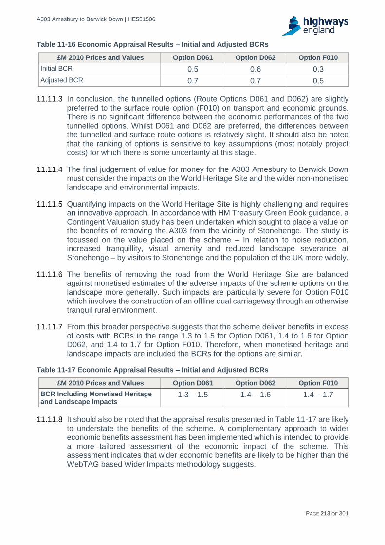
A303 Amesbury to Berwick Down | HE551506
HE551506-AA-GEN-SWI-RP-CX-000020 | P13, S0 21/12/2016 PAGE 213 OF 301
Table 11-16 Economic Appraisal Results – Initial and Adjusted BCRs
£M 2010 Prices and Values Option D061 Option D062 Option F010
Initial BCR 0.5 0.6 0.3
Adjusted BCR 0.7 0.7 0.5
11.11.3 In conclusion, the tunnelled options (Route Options D061 and D062) are slightly preferred to the surface route option (F010) on transport and economic grounds. There is no significant difference between the economic performances of the two tunnelled options. Whilst D061 and D062 are preferred, the differences between the tunnelled and surface route options is relatively slight. It should also be noted that the ranking of options is sensitive to key assumptions (most notably project costs) for which there is some uncertainty at this stage.
11.11.4 The final judgement of value for money for the A303 Amesbury to Berwick Down must consider the impacts on the World Heritage Site and the wider non-monetised landscape and environmental impacts.
11.11.5 Quantifying impacts on the World Heritage Site is highly challenging and requires an innovative approach. In accordance with HM Treasury Green Book guidance, a Contingent Valuation study has been undertaken which sought to place a value on the benefits of removing the A303 from the vicinity of Stonehenge. The study is focussed on the value placed on the scheme – In relation to noise reduction, increased tranquillity, visual amenity and reduced landscape severance at Stonehenge – by visitors to Stonehenge and the population of the UK more widely.
11.11.6 The benefits of removing the road from the World Heritage Site are balanced against monetised estimates of the adverse impacts of the scheme options on the landscape more generally. Such impacts are particularly severe for Option F010 which involves the construction of an offline dual carriageway through an otherwise tranquil rural environment.
11.11.7 From this broader perspective suggests that the scheme deliver benefits in excess of costs with BCRs in the range 1.3 to 1.5 for Option D061, 1.4 to 1.6 for Option D062, and 1.4 to 1.7 for Option F010. Therefore, when monetised heritage and landscape impacts are included the BCRs for the options are similar.
Table 11-17 Economic Appraisal Results – Initial and Adjusted BCRs
£M 2010 Prices and Values Option D061 Option D062 Option F010
BCR Including Monetised Heritage and Landscape Impacts
1.3 – 1.5 1.4 – 1.6 1.4 – 1.7
11.11.8 It should also be noted that the appraisal results presented in Table 11-17 are likely to understate the benefits of the scheme. A complementary approach to wider economic benefits assessment has been implemented which is intended to provide a more tailored assessment of the economic impact of the scheme. This assessment indicates that wider economic benefits are likely to be higher than the WebTAG based Wider Impacts methodology suggests.

A303 Amesbury to Berwick Down | HE551506
HE551506-AA-GEN-SWI-RP-CX-000020 | P13, S0 21/12/2016 PAGE 214 OF 301
11.11.9 Furthermore, a programmatic analysis has been undertaken which demonstrates that the transport and economic benefits of the A303 Amesbury to Berwick Down scheme are greater when considered as part of the overall Expressway programme.
11.11.10 Taking these factors into account, at this stage of the assessment, the A303 Amesbury to Berwick Down is assessed as being a ‘medium’ value for money scheme.

A303 Amesbury to Berwick Down | HE551506
HE551506-AA-GEN-SWI-RP-CX-000020 | P13, S0 21/12/2016 PAGE 215 OF 301
12 Social assessment
12.1 Introduction
12.1.1 Web-based Transport Analysis Guidance (WebTAG) provides guidance for the completion of Social Impact appraisals.
12.1.2 Social Impacts consider the impact of transport on people including both local residents, and users of the transport network. The analysis of Social Impacts is mandatory in the appraisal process and is a constituent of the Appraisal Summary Table (AST). Both beneficial and/or adverse Social Impacts of transport interventions need to be considered.
12.1.3 There are ten indicators for Social Impacts:
Physical activity.
Journey quality.
Accessibility (Access to services).
Security.
Severance.
Affordability.
Option and non-use values.
Commuting and other users.
Reliability.
Accidents.
12.1.4 Further detail on the social assessment is provided in the Appraisal Summary Tables (ASTs) Report. The Commuting and Other users, Reliability and Accidents indicators are detailed in Chapter 11 Economic Assessment.
12.1.5 A range of qualitative and quantitative assessments for the other criteria were undertaken, as detailed below. At this stage, this assessment was undertaken without taking any mitigation into account.
12.2 Assessment methodologies
Physical activity
12.2.1 The assessment of the options against the physical activity indicator has followed the methodology established in WebTAG Unit A4.1 Social Impact Appraisal. However, at this early stage of option identification, the approach taken was qualitative due to the absence of data on the numbers of pedestrian, cyclists and equestrians using Public Rights of Way (PRoW) and Non-Motorised User (NMU) facilities.
12.2.2 The comparative analysis of options was based on the number of PRoW affected, not the number of NMUs affected nor the change in journey times. PRoW are likely to be affected directly (through the downgrading of the existing alignment and provision of the new alignment), and indirectly (as a result of changes in traffic flows on the affected road network). The direct and indirect impacts on PRoW were considered in the assessment of impacts on physical activity.
A303 Amesbury to Berwick Down | HE551506
HE551506-AA-GEN-SWI-RP-CX-000020 | P13, S0 21/12/2016 PAGE 216 OF 301
12.2.3 Given the early stage of option identification, there are a number of limitations in the assessment of physical activity, as detailed below:
At this stage of assessment the comparative analysis of options was based on the number of PRoW affected, not the number of NMUs affected nor the change in journey times.
The list of NMU route options affected may need to be revised once the affected road network for each option, as set out in the relevant traffic model, has been taken into account.
At this stage it is not known what form of mitigation would be adopted at potential points of severance. For example, this could be via an on-line crossing or a diversion. Hence, mitigation has not been factored into the comparative analysis.
Journey quality
12.2.4 The assessment guidelines for journey quality, as set out in WebTAG Unit A4.1, subdivides the topic into three groups:
Traveller care.
Traveller views.
Traveller stress.
12.2.5 Traveller Care combines the assessments of:
Cleanliness.
Quality of transport facilities.
Availability of travel information.
The general transport environment.
12.2.6 Cleanliness of transport facilities and availability of travel information relate to public transportation facilities and are not relevant to a trunk road scheme. As such these were removed from the assessment of the three options. Quality of transport facilities considered the presence of service stations and facilities for motorists. This was therefore a relevant consideration for the three route options. The ‘general transport environment’ is generally only applicable to public transport schemes however there are certain criteria which would be relevant to the two tunnel Route Options D061 and D062. Therefore, for Traveller care, Route Options D061 and D062 were assessed only in terms of quality of transport facilities and the general transport environment, while Route Option F010 was assessed only with regard to quality of transport facilities. The assessment of general transport environment included consideration of temperature, noise and ventilation within the tunnelled section of options D061 and D062. The quality of transport facilities focused solely on the level of facilities available to motorists at Solstice Park and Countess Services.
12.2.7 Traveller views required a qualitative assessment which judged the change in views from the route options compared to the baseline, taking into account how cuttings and artificial barriers might block and restrict views of the surrounding countryside and townscape. The assessment criteria is documented in the Environmental Assessment Report (EAR).
12.2.8 Traveller Stress is formed of three sub-factors:

A303 Amesbury to Berwick Down | HE551506
HE551506-AA-GEN-SWI-RP-CX-000020 | P13, S0 21/12/2016 PAGE 217 OF 301
Frustration.
Fear of potential accidents.
Route uncertainty.
12.2.9 A qualitative approach was taken to each of these sub-factors. For frustration, the focus was on the change in travellers’ ability to make good progress along each option in comparison to the baseline. Assessing fear of potential accidents required consideration of changes in road and junction layouts and conditions among other factors. With regard to route uncertainty, the changes from the baseline in the ease of navigating route options, particularly in terms of junctions and provision of direction information, were factors which determined the assessment score.
12.2.10 An overall score for Traveller Stress was determined based on a balanced score of the three sub-factors. The assessment criteria is documented in the EAR.
12.2.11 Subsequently, scores for traveller care, traveller views and traveller stress were combined to feed into an overall, on-balance assessment score for Journey quality.
12.2.12 The overall assessment score for Journey quality was determined on balance by the assessment scores of the three sub-factors. The score was assessed using a seven point assessment scale as presented in Table 12-1 below.
Table 12-1 Journey quality assessment scale
Large adverse
Moderate adverse
Minor adverse
Neutral Minor
beneficial Moderate beneficial
Major beneficial
Number of travellers affected daily
>10,000
Number of travellers affected daily
500-10,000
Number of travellers affected daily
<500
Balanced or no change
Number of travellers affected daily
<500
Number of travellers affected daily
500-10,000
Number of travellers affected daily
>10,000
WebTAG unit A4.1 social impact appraisal para. 6.2.7
Accessibility (Access to services)
12.2.13 As detailed in WebTAG Unit A4.1, this topic assesses access to services via public transportation. As the A303 Amesbury to Berwick Down is a trunk road scheme and all route options would provide adequate accessibility along the A303 route corridor in equal measure, this topic is considered to provide little differentiation between the options. As such, the options have not been assessed against the accessibility indicator.
Severance
12.2.14 The WebTAG assessment of Severance is defined as the separation of residents from services and facilities within their community. This assessment focuses exclusively on relief from existing and new severance impacts affecting local residents accessing facilities on foot, omitting private vehicle journeys, public transport and bicycle.
12.2.15 The assessment of severance was undertaken in two separate stages. Firstly, the difference in severance between the with-scheme and without-scheme scenarios was identified using the descriptions of levels of severance below:
None – Little or no hindrance to pedestrian movement.

A303 Amesbury to Berwick Down | HE551506
HE551506-AA-GEN-SWI-RP-CX-000020 | P13, S0 21/12/2016 PAGE 218 OF 301
Slight – All people wishing to make pedestrian movements will be able to do so, but there will probably be some hindrance to movement.
Moderate – Pedestrian journeys will be longer or less attractive; some people are likely to be dissuaded from making some journeys on foot.
Severe – People are likely to be deterred from making pedestrian journeys to an extent sufficient to induce a reorganisation of their activities. In some cases, this could lead to a change in the location of centres of activity or to a permanent loss of access to certain facilities for a particular community. Those who do make journeys on foot will experience considerable hindrance. For the benefit of assessing change in severance, ‘Severe’ relates to ‘Large’ in Table 12-2.
12.2.16 Table 12-2 below demonstrates the process taken to determine the level of change.
Table 12-2 Assessment of change in severance
Assessment of change in severance
Without-scheme severance scoring
With-scheme severance scoring
None Slight Moderate Large
None None Slight negative Moderate negative Large negative
Slight Slight positive None Slight negative Moderate negative
Moderate Moderate positive Slight positive None Slight Negative
Large Large positive Moderate positive Slight positive None
WebTAG unit A4.1 social impact appraisal. Table 5.1
12.2.17 Secondly, an overall score for severance was determined based on the number of pedestrians affected daily. This second stage assessment used a seven point assessment scale detailed below in Table 12-3.
Table 12-3 Overall severance assessment scale
Large adverse
Moderate adverse
Minor adverse
Neutral Minor
beneficial Moderate beneficial
Major beneficial
Number of pedestrians affected daily
>1,000
Number of pedestrians affected daily
200-1,000
Number of pedestrians affected daily
<200
Balanced or no change
Number of pedestrians affected daily
<200
Number of pedestrians affected daily
200-1,000
Number of pedestrians affected daily
>1,000
WebTAG Unit A4.1 social impact appraisal
12.2.18 A number of limitations in the appraisal of severance have been identified below:
At this early stage of option identification, the size of the population of communities affected by severance is unknown. An estimate of the relative sizes of the populations affected by severance was made for comparative purposes.
The list of communities affected by severance may need to be altered once the Affected Road Network for each option, as set out in the latest traffic model, has been taken into account.
It has not been considered at this stage what form of mitigation will be applied at the potential points of severance. Therefore, mitigation has not been factored into the comparative analysis.

A303 Amesbury to Berwick Down | HE551506
HE551506-AA-GEN-SWI-RP-CX-000020 | P13, S0 21/12/2016 PAGE 219 OF 301
Security
12.2.19 This indicator considered changes in the perception of security, as well as actual changes to the level of security. A qualitative assessment was undertaken, looking at any changes in the security indicators including public transport waiting facilities / interchange facilities; pedestrian access; provision of lighting and visibility; landscaping; or formal or informal surveillance. Table 12-4 below demonstrates the process taken to determine the level of change for each of the security indicators.
Table 12-4 Assessment of change in security
Assessment of Change in Security
Without-scheme Security Scoring
With-scheme Security Scoring
None Poor Moderate High
None None Slight negative Moderate negative Large negative
Poor Slight positive None Slight negative Moderate negative
Moderate Moderate positive Slight positive None Slight Negative
High Large positive Moderate positive Slight positive None
12.2.20 Secondly, an overall score for security was determined based on the number of residents affected daily. This second stage assessment used a seven point assessment scale detailed below in Table 12-5.
Table 12-5 Overall security assessment scale
Large Adverse
Moderate Adverse
Minor Adverse
Neutral Minor
Beneficial Moderate Beneficial
Major Beneficial
Number of travellers affected daily
>1,000
Number of travellers affected daily
200-1,000
Number of travellers affected daily
<200
Balanced or no change
Number of travellers affected daily
<200
Number of travellers affected daily
200-1,000
Number of travellers affected daily
>1,000
Affordability
12.2.21 This indicator identifies the potential user costs of the scheme, including changes in public transport fares, tolls, and vehicle operating costs. A qualitative assessment of the potential impact on road users was undertaken. The score was assessed using a seven point assessment scale as presented in Table 12-6 below.
Table 12-6 Assessment of change in affordability
Large Adverse
Moderate Adverse
Minor Adverse
Neutral Minor
Beneficial Moderate Beneficial
Major Beneficial
Large change to several types of cost
Large change to one type of cost or moderate change to several types of cost
Moderate change to one type of cost or slight change to several types of cost
Balanced or no change
Moderate change to one type of cost or slight change to several types of cost
Large change to one type of cost or moderate change to several types of cost
Large change to several types of cost

A303 Amesbury to Berwick Down | HE551506
HE551506-AA-GEN-SWI-RP-CX-000020 | P13, S0 21/12/2016 PAGE 220 OF 301
Option values
12.2.22 Option and non-use values considered if the scheme being appraised included measures that would substantially change the availability of transport services. The score was assessed using a seven point assessment scale as presented in Table 12-7 below.
Table 12-7 Overall option values assessment scale
Large Adverse
Moderate Adverse
Minor Adverse
Neutral Minor
Beneficial Moderate Beneficial
Major Beneficial
Number of households affected
>1,000
Number of households affected
250-999
Number of households affected 1-249
Balanced or no change
Number of households affected 1-249
Number of households affected
250-999
Number of households affected
>1,000
WebTAG Unit A4.1 Social Impact Appraisal
Commuting and other users
12.2.23 The Commuting and Other Users assessment is detailed in Chapter 11.
Reliability
12.2.24 The Reliability assessment is detailed in Chapter 11.
Accidents
12.2.25 The Accidents assessment is detailed in Chapter 11.
12.3 Assessment
Physical activity
Route Option D061
12.3.1 Route Option D061, by replacing the existing alignment and through the resulting changes in traffic flows on the affected road network, D061would reduce severance at approximately 18 PRoWs. Therefore, the experience for users of the PRoW network across the area would improve, potentially increasing physical activity. It is assessed that D061 without mitigation, would cause severance at 9 PRoW, however on balance a beneficial effect is determined in terms of physical activity.
Route Option D062
12.3.2 It is anticipated that Route Option D062, by replacing the existing alignment and through the resulting changes in traffic flows on the affected road network, would see a reduction in severance at approximately 18 PRoW. This would constitute an improvement to the condition of the PRoW network across the area. An improved user experience could result in increasing numbers of people engaging in physical activity. Without mitigation in the form of grade-separated crossings, it is assessed that D062 would cause severance at 10 PRoW. Overall a beneficial effect on physical activity is assessed for this alignment option.
Route Option F010
12.3.3 The alignment of Route Option F010 is assessed as affecting 16 PRoW through severance. Indirectly, through increased traffic flows on the affected road network, F010 would increase severance at a further 9 PRoW. While the assessment also identified 8 PRoW which would benefit from reduced severance, it is determined on balance that an adverse effect on physical activity would arise from this option.

A303 Amesbury to Berwick Down | HE551506
HE551506-AA-GEN-SWI-RP-CX-000020 | P13, S0 21/12/2016 PAGE 221 OF 301
Journey quality
Route Option D061
12.3.4 The tunnel with this option would be ventilated to minimise impacts from vehicle emissions. This would result in neutral effects in terms of the quality of the transport environment. Access to Solstice Park and Countess Services would maintain access to services for motorists, resulting in a neutral effect in terms of access and quality of traveller facilities. Overall, neutral effects are anticipated for Traveller Care.
12.3.5 In terms of Traveller Views, the loss of views of and within the Stonehenge and Avebury WHS, and in particular the complete loss of views to the Stonehenge monument, would represent a detrimental impact. While it is the intention, through architectural measures, to remind drivers they are travelling through an historic landscape, the tunnelled section of the alignment would provide travellers with no external views for a length of 2.9km. Overall, a negative change to Travellers Views would be expected to result, with impacts affecting more than 10,000 travellers per day, resulting in a large adverse effect on Traveller Views.
12.3.6 Traveller Stress is assessed in terms of sub-factors, frustration, fear of potential accidents and route uncertainty. Regarding frustration, upgrading the A303 to a dual carriageway would reduce congestion and queuing and the provision of grade-separated junctions would improve travellers’ ability to make good progress along the route. These two factors would reduce traveller frustration. The grade separated junctions will introduce merges and diverges that drivers will have to negotiate however the junctions will also reduce congestion. On balance a change for the better is expected in terms of fear of potential accidents. Similarly, the provision of grade-separated junctions may have a limited adverse effect in terms of route uncertainty. Overall, Option D061 would result in a change for the better in terms of each of the three sub-factors under Traveller Stress and as these changes for the better would affect more than 10,000 travellers per day, a large beneficial effect is expected.
12.3.7 Taking account of the performance of the route option against all of the Journey Quality sub-factors, option D061 is predicted to have a moderate beneficial effect on Journey Quality.
Route Option D062
12.3.8 For the same reasons expressed for Route Option D061, the overall effect for Journey quality with Route Option D062 is determined to have a moderate beneficial effect.
Route Option F010
12.3.9 Route Option F010 would result in the loss of access to modern facilities at Solstice Park services for travellers. The service station includes a filling station, convenience store, a range of restaurants and a hotel. Due to route uncertainty and the stress associated with navigating potential congestion on local roads, travellers are unlikely to venture from the strategic route onto the local road network to access services. The nearest service stations on the A303 are 14 miles east and 28 miles west of Solstice Park. These service stations comprise a petrol station and limited service offering. Therefore the loss of access to Solstice Park services would have an adverse effect which has the potential to affect more than 10,000 travellers per

A303 Amesbury to Berwick Down | HE551506
HE551506-AA-GEN-SWI-RP-CX-000020 | P13, S0 21/12/2016 PAGE 222 OF 301
day. As such, Route Option F010 would have a large adverse effect on Traveller Care.
12.3.10 With regard to Traveller Views, this option would result in the complete loss of views of the Stonehenge and Avebury WHS from the road. This is offset to some extent by the provision of new views across the high quality landscape of the River Avon and River Till valleys, where views are not currently possible. Due to the necessary roadside cuttings and embankments these views would be intermittent. It is considered that this constitutes a change for the worse as the provision of intermittent views within the river valleys would not compensate for the loss of views of the Stonehenge monument and its surrounding context. This is considered a large adverse effect as this change would be experienced by more than 10,000 daily travellers.
12.3.11 Traveller Stress is assessed in terms of sub-factors, frustration, fear of potential accidents and route uncertainty. Upgrading the A303 to dual carriageway standard would reduce congestion and the provision of grade-separated junctions would improve travellers’ ability to make good progress along the route. These route improvements would be considered to reduce traveller frustration.
12.3.12 The fear of potential accidents and route uncertainty for Option F010 could increase to some extent. This is due to the provision of grade-separated junctions which will introduce merges and diverges that drivers will have to negotiate. However, the junctions will also reduce congestion. Overall the provision of grade-separated crossings and an improvement to dual carriageway would result in a change for the better. On the whole, the changes for the better for each of the three sub-factors under Traveller Stress are assessed as large beneficial due to the change being experienced by more than 10,000 travellers per day.
12.3.13 Taking account of the performance of the route option against all the Journey Quality sub-factors, a moderate beneficial effect is predicted for Route Option F010.
Accessibility (Access to services)
12.3.14 Accessibility was scoped out of this assessment. See Section 12.2.13.
Severance
Route Option D061
12.3.15 Route Option D061 would divert the A303 to the north of Winterbourne Stoke, thus removing the road and associated traffic from passing through the middle of the village. This would result in a positive impact upon severance but, given the low numbers of people directly affected, was assessed to be slight beneficial. The provision of the tunnelled section would reduce severance within the WHS which would benefit local residents and visitors gaining access to the site.
12.3.16 A slight positive change in severance is anticipated between Berwick St James and Winterbourne Stoke. Due to the estimated number of people affected a slight beneficial effect is predicted. The tunnelled section of D061 in the WHS is considered to reduce severance for local residents gaining access to the site. Similarly, the provision of pedestrian facilities as part of the grade-separated junction at Countess Roundabout would result in a slight positive change in

A303 Amesbury to Berwick Down | HE551506
HE551506-AA-GEN-SWI-RP-CX-000020 | P13, S0 21/12/2016 PAGE 223 OF 301
severance, therefore, slight beneficial effects are predicted given the estimated low number of people affected.
12.3.17 Moderate beneficial changes were assessed for the villages of Shrewton, Durrington and Larkhill. These beneficial impacts would be associated with a predicted reduction in through traffic diverting from the A303 onto the local road network (rat running) if Option D061 was provided. A neutral score was assessed for the villages within the Avon Valley as Option D061 would not affect residents in terms of severance.
12.3.18 Overall a moderate beneficial effect is predicted for Option D061 in terms of Severance, as between 200 and 1000 daily travellers are expected to experience reduced severance.
Route Option D062
12.3.19 Route Option D062 would divert the A303 to the south of Winterbourne Stoke, thus removing the road and associated traffic from passing through the middle of the village. This would result in a positive impact upon severance but, given the low numbers of people directly affected, was assessed to be slight beneficial.
12.3.20 The tunnelled section of D062 in the WHS is considered to reduce severance for local residents gaining access to the site. A further slight positive change in severance is expected for residents of Countess Road when accessing facilities in Amesbury and based on the estimated number of residents to be affected, slight beneficial effects are anticipated.
12.3.21 Moderate beneficial changes were assessed for the villages of Shrewton, Durrington and Larkhill. These beneficial impacts would be associated with a predicted reduction in through traffic diverting from the A303 onto the local road network (rat running) if Option D062 was provided. A neutral score was assessed for the villages within the Avon Valley as Option D062 would be unlikely to affect residents in terms of severance.
12.3.22 Overall Option D062 is expected to have a moderate beneficial effect in terms of severance, as between 200 and 1000 daily travellers are expected to experience reduced severance.
Route Option F010
12.3.23 Route Option F010 would remove trunk road traffic from Winterbourne Stoke and this would improve access to facilities for residents of the village.
12.3.24 A moderate adverse change in severance would be expected for residents of Durrington and Larkhill given the forecast increase in through traffic passing through the local side roads, increasing traffic flows through these villages; the estimated number of residents to be adversely affected results in a moderate adverse effect. Similarly, the redistribution of traffic flows associated with Option F010 would increase severance for the residents of Shrewton, resulting in a slight negative change; the number of residents estimated to be affected results in a moderate adverse effect.
12.3.25 Due to a new instance of severance between Great Durnford and Upper and Middle Woodford, a moderate negative change in severance is assessed. This is predicted to affect less than 200 residents daily and constitutes a slight negative effect. A

A303 Amesbury to Berwick Down | HE551506
HE551506-AA-GEN-SWI-RP-CX-000020 | P13, S0 21/12/2016 PAGE 224 OF 301
moderate negative change is identified between Berwick St James and Winterbourne Stoke, again less than 200 residents are likely to be affected daily and a slight negative effect is expected.
12.3.26 Overall, a moderate adverse effect is predicted for Route Option F010, as between 200 and 1000 daily travellers are expected to be affected by increases in severance.
Security
12.3.27 There will be no lighting along the mainline for any of the options (except in the tunnel and existing lighting at Countess Roundabout where relevant), but as the existing alignment is unlit except where it passes through Winterbourne Stoke, this will not constitute a change in lighting levels along the route. No significant impacts on personal security were identified at this stage, and so all options were assessed as neutral.
Affordability
12.3.28 The affordability assessment considers the financial implications for users of the scheme with a particular focus on regular local users.
12.3.29 The distance to travel along the length of the route option will increase for all route options. For the tunnelled options, the difference between the existing route and the tunnelled routes is marginal and would have negligible impact on local users. In contrast, the surface route would result in an approximate 4.1km increase in the length of the A303. Travel distances for local travel to/from Amesbury would increase as a result. The result of the surface route would be an overall increase in vehicle operating costs and therefore an adverse impact on affordability. In all options, residents of Winterbourne Stoke will have to travel greater distances to access the A303 westbound, as there will be no junction where the bypass re-joins the existing A303 alignment. For each of the options, a reduction in congestion would have some offsetting effect on vehicle operating costs. On balance, for the tunnelled options improved traffic flows are likely to offset small changes in travel distances such that a neutral score is considered appropriate. For the surface route, a number of local trips would suffer an element of increase in journey length which would not be offset by the improved traffic flows on the new A303. With the increased length and longer diversion, the surface Route Option F10 was assessed as slight adverse.
Option values
12.3.30 It is unlikely this scheme will have any impact on Option Values for any of the options under consideration as there are no new provisions of public transport services or removal of existing services. The scheme was assessed as neutral for all options.
12.4 Conclusions
12.4.1 For option values, all options were assessed as neutral as there is no public transport element to the scheme. For security, all options were assessed as neutral as no significant changes to personal security on the route were identified, but this may change when detailed arrangements on lighting and surveillance are determined during design development. For affordability, both tunnel options (D061 and D062) were assessed as slight adverse as while there will be savings in vehicle operating costs from reduced congestion, this will be outweighed by an increase in

A303 Amesbury to Berwick Down | HE551506
HE551506-AA-GEN-SWI-RP-CX-000020 | P13, S0 21/12/2016 PAGE 225 OF 301
operating costs due to having to travel along a longer route. The surface route (Option F010) was assessed as moderate adverse, as the new road alignment would mean an even longer distance to travel for most users.
12.4.2 For severance, Route Options D061 and D062 were scored as moderate beneficial as severance would be reduced at a number of locations along the alignment and on the affected road network, whereas Option F010 was assessed as moderate adverse.
12.4.3 For journey quality, all options scored moderate beneficial because of reductions in traveller stress. For physical activity Route Options D061 and D062 were scored as beneficial as, on balance, PRoW would experience decreased severance. An adverse effect is assessed for Route Option F010 as, on balance, PRoW would experience an increase in severance.
12.4.4 While the WebTAG guidance for social assessments does not lend itself to assessing an overall score for each of the route options in terms of social impacts, Table 12-8 demonstrates the scores for each topic for the benefit of comparing the three route options.
Table 12-8 Social impacts summary
Assessment Topic D061 D062 F010
Physical Activity Beneficial Beneficial Adverse
Journey Quality Moderate beneficial Moderate beneficial Moderate beneficial
Accessibility Neutral Neutral Neutral
Security Neutral Neutral Neutral
Severance Moderate beneficial Moderate beneficial Moderate adverse
Affordability Neutral Neutral Slight adverse
Options and non-use values
Neutral Neutral Neutral
12.4.5 The assessment identifies no differences between Route Options D061 and D062.
12.4.6 Similarly to Route Options D061 and D062, Route Option F010 is assessed as having neutral impacts in terms of accessibility, security and options and non-use values. Route Option F010 performs worse in terms of physical activity and severance. A slight differentiation between Route Option F010 and D061/62 is identified in terms of affordability.

A303 Amesbury to Berwick Down | HE551506
HE551506-AA-GEN-SWI-RP-CX-000020 | P13, S0 21/12/2016 PAGE 226 OF 301
13 Distributional impact assessment
13.1 Introduction
13.1.1 Web-based Transport Analysis Guidance (WebTAG) provides guidance for the completion of distributional impact appraisals.
13.1.2 Distributional impacts consider the variance of transport intervention impacts across different social groups. The analysis of distributional impacts is mandatory in the appraisal process and is a constituent of the Appraisal Summary Table (AST). Both beneficial and/or adverse distributional impacts of transport interventions need to be considered, along with the identification of social groups likely to be affected.
13.1.3 There are eight indicators for distributional impacts:
User Benefits.
Noise.
Air Quality.
Accidents.
Security.
Severance.
Personal Affordability.
Accessibility.
13.1.4 A screening was undertaken to determine which distributional impact indicators are relevant for the A303. Accessibility was scoped out, as this indicator highlights any impact to public transport services operating along the route option as a result of the scheme, and the scheme has no public transport along the existing A303 and limited public transport nearby (there is an hourly bus service to Winterbourne Stoke that accesses the village via the B3083 but under current assumptions this route will not be disrupted upon completion of the scheme and further assessment would be disproportionate to the negligible impacts). All of the other seven indicators will be subject to a full assessment using the available model data (SATURN, COBA-LT, TUBA, air and noise models) and other scheme information at later stages of the project, but at this stage it was deemed disproportionate, and so qualitative assessments were undertaken for each indicator using available model outputs.
13.1.5 Further detail on the distributional impacts assessment is provided in the Appraisal Summary Tables (ASTs) Report.

A303 Amesbury to Berwick Down | HE551506
HE551506-AA-GEN-SWI-RP-CX-000020 | P13, S0 21/12/2016 PAGE 227 OF 301
13.2 Assessment methodology
13.2.1 All assessments were assessed using the 7 point scale detailed in Table 13-1.
Table 13-1 Distributional impacts scoring
Key to individual assessment of each Income quintile
Beneficial and the population impacted is significantly greater than the proportion of the group in the total population
Large Beneficial
Beneficial and the population impacted is broadly in line with the proportion of the group in the total population
Moderate Beneficial
Beneficial and the population impacted is smaller than the proportion of the group in the total population
Slight Beneficial
There are no significant benefits or disbenefits experienced by the group for the specified impact
Neutral
Adverse and the population impacted is smaller than the proportion of the population of the group in the total population
Slight Adverse
Adverse and the population impacted is broadly in line with the proportion of the population of the group in the total population
Moderate Adverse
Adverse and the population impacted is significantly greater than the proportion of the group in the total population
Large Adverse
WebTAG Unit A4.2 Distributional Impact Appraisal
User benefits
13.2.2 This indicator identifies the potential user benefits, and assesses whether the benefits and/or disbenefits are distributed proportionately across the users. User benefits including benefits to journey times and benefits to vehicle operating costs were identified and compared to the income category of indices of deprivation to identify any disproportionate impacts on low income groups.
Noise
13.2.3 A noise analysis was carried out to identify potential changes as a result of the scheme. This was compared against current census data to assess the impact on nearby vulnerable groups including children and low income groups and to determine if any vulnerable groups were impacted disproportionately.
Air quality
13.2.4 An air quality analysis was carried out to identify potential changes. This was compared to current census data to assess the impact on nearby vulnerable groups including children and low income groups and determine if any vulnerable groups were impacted disproportionately.
Accidents
13.2.5 This aspect examined the likely changes to accident levels (positive or negative), as a result of the proposed scheme and compared this with the proportion of vulnerable groups within the scheme area. STATS19 data was used to identify if the area was an existing hotspot for accidents involving vulnerable users such as pedestrians, cyclists and young male drivers to identify if any changes in accident levels were likely to disproportionately affect them.
Security
13.2.6 This included a qualitative assessment on whether the scheme will improve or deteriorate the perception of personal security on vulnerable groups, including

A303 Amesbury to Berwick Down | HE551506
HE551506-AA-GEN-SWI-RP-CX-000020 | P13, S0 21/12/2016 PAGE 228 OF 301
looking at changes to pedestrian access; changes to provision of lighting and visibility; changes to landscaping; and changes to formal or informal surveillance.
Severance
13.2.7 The ease with which people move around the area impacted by the scheme was examined, and a qualitative assessment undertaken of any changes to footbridges and public rights of way, as well as increases/decreases in traffic flows. This was compared with vulnerable groups in the area including children, older people and those in households without access to a car to determine if there was likely to be any disproportionate impact on them.
Accessibility
13.2.8 This indicator was scoped out of the assessment as the scheme has no public transport along the existing A303 and limited public transport nearby (there is an hourly bus service to Winterbourne Stoke that accesses the village via the B3083 but under current assumptions this route will not be disrupted upon completion of the scheme and further assessment would be disproportionate to the negligible impacts).
Affordability
13.2.9 This indicator identified the potential affordability benefits, and assessed whether the benefits and/or disbenefits are distributed proportionately across the users. Benefits related to the cost of travel (vehicle operating costs were the only relevant category for this scheme) were identified and compared to the income category of indices of deprivation to identify any disproportionate impacts on low income groups.
13.3 Assessment
User benefits
13.3.1 As detailed in Section 3.1, there are currently high levels of congestion and long journey times on this section of the A303, as it is a single carriageway section with limited capacity. All route options would be dual carriageway, which would increase capacity, and so reduce congestion and journey times, which would have time benefits for users of the scheme, especially in peak hours.
13.3.2 The distance to travel along the length of the route option will increase for all route options. For the tunnelled options, the difference between the existing route and the tunnelled routes is marginal and would have negligible impact on local users. In contrast, the surface route would result in an increase in the length of the A303 by around 4.1km. Travel distances for local travel to/from Amesbury would increase as a result of the proposed layout. The result of the surface route would be an overall increase in vehicle operating costs. In all options, residents of Winterbourne Stoke will have to travel greater distances to access the A303 westbound, as there will be no junction where the bypass re-joins the existing A303, and so they will have to reroute to join the A303 further east. For each of the options, a reduction in congestion would have some offsetting effect on vehicle operating costs.
13.3.3 User benefits have a particularly large impact on people with income deprivation – while there were no Lower Super Output Areas identified as income deprived in the immediate area around the scheme, there are still likely to be people suffering from income deprivation in the immediate area who may be particularly impacted by any

A303 Amesbury to Berwick Down | HE551506
HE551506-AA-GEN-SWI-RP-CX-000020 | P13, S0 21/12/2016 PAGE 229 OF 301
changes. It is also likely that that people from further away with high levels of income deprivation will use the route option, as it is one of the main route options connecting south-east England to South West England, and so they may also be particularly impacted by any changes.
13.3.4 The increase in vehicle operating costs for the two tunnelled options is likely to be negligible, and the impact on journey times will be beneficial due to reduced congestion. There was an increase in vehicle operating costs for the surface route, but this was outweighed by the reduction in journey times due to reduced congestion and so the overall impact was beneficial. The exact split of benefits between income quintiles cannot be examined with the qualitative proportionate analysis done at this stage, but no areas with high levels of deprivation were identified in the immediate area around the scheme and so there is unlikely to be any disproportionate impact on income deprived people in the area for any of the route options, and so all were assessed as moderate beneficial.
Noise
13.3.5 There are some small Noise Impact Area (NIA) sections in Winterbourne Stoke. Noise impacts were identified primarily in Amesbury, in Durrington and Bulford, on the A338, on the B3083, and on the road through Great Durnford and Upper Woodford. No areas with high levels of income deprived people were identified in these areas, but there were several areas with high concentrations of children, as well as schools in Amesbury, Durrington and Bulford that may be particularly impacted by any changes to noise levels. For all route options, there was a net beneficial impact on the number of properties impacted by noise, with the majority of properties experiencing a reduction in noise levels. For all options there were a large number of impacted properties in Amesbury in areas where there are high levels of children and several schools, but the surface route has more properties with reduced noise levels in this area than either of the tunnelled route options. Areas of Durrington and Bulford with high levels of children and schools present receive a mix of adverse and beneficial impacts also, with a similar split for all route options, although again the surface route has slightly more properties with reduced noise levels in this area.
13.3.6 As there was a beneficial impact on properties for all scheme options in the Environmental Assessment, all route options will also have a beneficial impact in the Distributional Impact Assessment. For both of the tunnelled routes, the split of properties benefiting from reduced noise levels and those receiving adverse impacts due to increased noise levels was similar to that for the scheme as a whole, and so they have both been assessed as moderate beneficial. For the surface route, there were higher levels of benefits in areas with high concentrations of children and schools, and so the route option was assessed as large beneficial.
Air quality
13.3.7 There are no Air Quality Management Areas (AQMAs) within 200m of the route options. Air quality impacts close to the scheme were identified primarily in Amesbury, in Durrington and Bulford, on the B3083, and in Fisherton de la Mare. No areas with high levels of income deprived people were identified in these areas, but there were several areas with high concentrations of children, as well as schools in Amesbury, Durrington and Bulford that may be particularly impacted by any changes to air quality levels. For all route options, there was a net adverse impact on air quality, but in areas where there are high levels of children and several
A303 Amesbury to Berwick Down | HE551506
HE551506-AA-GEN-SWI-RP-CX-000020 | P13, S0 21/12/2016 PAGE 230 OF 301
schools (Amesbury, Durrington and Bulford), the majority of receptors either experienced no significant change in air quality levels or experienced a benefit. Therefore vulnerable groups are likely to experience less of the disbenefits than the average population for all options. All options have therefore been assesses as slight adverse.
Accidents 13.3.8 The A303 Amesbury to Berwick Down is an accident blackspot with higher rates of
traffic incidents than would normally be expected for a road of its type. Accident rates between Amesbury and Berwick Down are twice those for the Corridor as a whole. The new alignment would be designed to current standards and help improve safety by creating a dual carriageway and managing junction access to maintain the flow of traffic. Accidents in tunnels (D061 and D062), especially with operating with bi-directional flow, can be more severe, but the tunnel will be designed to the latest safety standards.
13.3.9 Higher than average levels of accidents involving pedestrians and older people were found in the study areas, meaning that any reduction in accident rates will potentially be of particular benefit for them. Accidents rates for all other vulnerable groups were below the national average.
13.3.10 As there was a beneficial impact on accidents rates for all scheme options in the Economic Assessment, all route options also have a beneficial impact in the Distributional Impact Assessment. As all route options have study areas with high levels of accidents involving some vulnerable users, but low levels of accidents involving other vulnerable users, the impact of the improvement in accidents rates for vulnerable users was determined to be in line with the impact on the population as a whole, and so all route options were classed as moderate beneficial.
Security 13.3.11 With this section of the A303 closed to general traffic except for local access, it is
possible that the level of informal surveillance could decrease, which could lead to an adverse impact on people's perception of security. This section of the A303 is mostly unlit, although there is some lighting as the route passes through Winterbourne Stoke. The mainline will not be lit for any of the route options (except for in the tunnel and reproviding lighting at Countess Roundabout where relevant), and so any impact from changes to lighting on security along the route is expected to be negligible.
13.3.12 Security is particularly important for children, older people, people with disabilities, and black and minority ethnic people (as identified in WebTAG). There are concentrations of children in Amesbury and to the north of the existing A303 and concentrations of older people along the existing A303 who may be impacted on by any changes to security. There are no areas with a high concentration of people with disabilities or black and minority ethnic people close to the scheme, but there will still be people in these groups who may be impacted on by any changes to security.
13.3.13 No significant impacts on personal security were identified, and so the scheme was assessed as neutral.

A303 Amesbury to Berwick Down | HE551506
HE551506-AA-GEN-SWI-RP-CX-000020 | P13, S0 21/12/2016 PAGE 231 OF 301
Severance
13.3.14 Impacts of any changes in severance in the scheme area will have a particular impact on older people, children, people living in households without access to a car and people with disabilities.
13.3.15 Both of the tunnelled options resulted in reductions in severance in several areas, including Winterbourne Stoke, the WHS, Shrewton, Durrington and Larkhill. In both Durrington and Larkhill there were high concentrations of older people and children who will particularly benefit from this. D061 will also reduce severance between Winterbourne Stoke and Berwick St James and at Countess Roundabout, both of which are located in areas where there are high concentrations of older people, and there was also a small area close to Countess Roundabout identified with high concentrations of households without access to a car. D062 will also reduce severance for Countess Road residents travelling to Amesbury, which includes pockets of areas with high concentrations of both children and older people.
13.3.16 The surface route resulted in a reduction in severance through Winterbourne Stoke, but increased severance in several other areas including Durrington, Larkhill, Shrewton, Great Durnford/Upper Woodford and between Berwick St James and Winterbourne Stoke. In Durrington and Larkhill there were high concentrations of older people and children who will be particularly impacted by this, and there were also concentrations of older people between Berwick St James and Winterbourne Stoke who will be adversely impacted.
13.3.17 As both of the tunnelled routes were assessed as having a net beneficial impact in the Social Impacts Assessment, they were also assessed as beneficial in the Distributional Impacts Assessment. As there were high concentrations of vulnerable groups in several of the areas that benefit from reduced severance, they are likely to benefit disproportionately, and so both route options were assessed as large beneficial.
13.3.18 As the surface route was assessed as having a net adverse impact in the Social Impacts Assessment, it was also assessed as adverse in the Distributional Impacts Assessment. As there were high concentrations of vulnerable groups in several of the areas that were adversely impacted by increased severance, they are likely to experience disbenefits disproportionately, and so both route options were assessed as large adverse.
Accessibility
13.3.19 This indicator was scoped out of the assessment as the scheme has no public transport along the existing A303 and limited public transport nearby (there is an hourly bus service to Winterbourne Stoke that accesses the village via the B3083 but under current assumptions this route will not be disrupted upon completion of the scheme and further assessment would be disproportionate to the negligible impacts).
Affordability
13.3.20 Affordability has a disproportionate impact on people with low incomes. While it is possible that people with high levels of income deprivation will use the route option, there are no Lower Super Output Areas identified as income deprived in the area around the scheme (although there may still be residents on low incomes nearby who will be particularly impacted on by any changes in costs).

A303 Amesbury to Berwick Down | HE551506
HE551506-AA-GEN-SWI-RP-CX-000020 | P13, S0 21/12/2016 PAGE 232 OF 301
13.3.21 The distance to travel along the length of the route option will increase for all route options. For the tunnelled options, the difference between the existing route and the tunnelled routes is marginal and would have negligible impact on local users. In contrast, the surface route would result in an increase in the length of the A303 by around 4.1km. Travel distances for local travel to/from Amesbury would increase and as a result, the surface route would have an overall increase in vehicle operating costs and therefore an adverse impact on affordability. In all options, residents of Winterbourne Stoke will have to travel greater distances to access the A303 westbound, as there will be no junction where the bypass re-joins the existing A303, and so they will have to travel east to join at the A360 junction. For each of the options, a reduction in congestion would have some offsetting effect on vehicle operating costs.
13.3.22 In the Social Impacts Assessment, the overall impact on affordability for both tunnelled options was neutral, and so the Distributional Impacts Assessment for affordability has also been assessed as neutral.
13.3.23 The overall impact for affordability for the surface route was assessed as adverse in the Social Impacts Assessment and so the overall impact for the Distributional Impacts Assessment will also be adverse. The exact split of benefits between income quintiles cannot be examined with the qualitative proportionate analysis done at this stage, but no areas with high levels of deprivation were identified in the immediate area around the scheme and so there is unlikely to be any disproportionate impact on income deprived people in the area, and so the surface route was assessed as moderate adverse.
Conclusions
13.3.24 All options were assessed as moderate beneficial for user benefits, as no disproportionate impact on income deprived groups was identified and there were net benefits. Both tunnel options (D061 and D062) were assessed as moderate beneficial for noise, as benefits from the traffic rerouting will be proportionate to the general population. The Surface Route option was assessed as large beneficial, as the benefits from the traffic rerouting will have particular impact in areas with high levels of vulnerable groups. All options were assessed as slight adverse for air quality, as while the net impact of air quality changes is adverse, the majority of receptors in areas with high levels of vulnerable groups do not experience adverse impacts. All options were assessed as moderate beneficial for accidents, as the improvement in accidents will have a particular impact on pedestrians and older people but lower than expected impact on all other relevant groups. All options were assessed as neutral for security as so significant changes were identified. Both tunnel options (D061 and D062) were assessed as large beneficial for severance as the benefits would disproportionately impact vulnerable groups, and the surface route was assessed as large adverse as the disbenefits would disproportionately impact vulnerable groups. Both tunnel options (D061 and D062) were assessed as neutral for affordability as no significant impacts on vehicle operating costs were identified, and the surface route was assessed as moderate adverse as, while there are net disbenefits, it has not been shown to disproportionately impact on vulnerable groups.
13.3.25 The summary scores are shown in Table 13-2 below.

A303 Amesbury to Berwick Down | HE551506
HE551506-AA-GEN-SWI-RP-CX-000020 | P13, S0 21/12/2016 PAGE 233 OF 301
Table 13-2 Distribution impacts summary
Assessment Topic D061 D062 F010
User benefits Moderate beneficial Moderate beneficial Moderate beneficial
Noise Moderate beneficial Moderate beneficial Large beneficial
Air quality Slight adverse Slight adverse Slight adverse
Accidents Moderate beneficial Moderate beneficial Moderate beneficial
Security Neutral Neutral Neutral
Severance Large beneficial Large beneficial Large adverse
Accessibility Neutral Neutral Neutral
Affordability Neutral Neutral Moderate Adverse
13.3.26 Overall, there is no significant difference in impact between both tunnel options (D061 and D062), and these perform better than the Surface Route option as they were assessed to have less adverse impacts.

A303 Amesbury to Berwick Down | HE551506
HE551506-AA-GEN-SWI-RP-CX-000020 | P13, S0 21/12/2016 PAGE 234 OF 301
14 Safety assessment
14.1 Introduction
14.1.1 This section assesses the three route options against the safety impact on the road user with a review of accident statistics and a road safety review, and also a review of the impact of the options during construction, maintenance, operation and demolition in accordance with the Construction, Design and Management (CDM) Regulations 2015.
14.2 Impact on road user
Assessment methodology
14.2.1 This safety assessment reviews the proposed route options with reference to the road safety targets contained within the Highways England Delivery Plan. It then considers the effective construction traffic management that will be required to deliver the project. The remainder of the section reviews the potential implications for operational safety of the three alignment options D061, D062 and F010.
14.2.2 The road safety element has assessed the following aspects:
Overall alignments.
General highway design features.
Junction strategy.
Tie-in points.
Tunnel options.
Severance and implications for the local highway network.
14.2.3 This assessment reviews the design from a road safety perspective. Observations and recommendations are made about road safety aspects for consideration in future design development.
Delivery plan and national incident and casualty reduction plan
Policy context
14.2.4 The Highways England Delivery Plan 2015-2020 (and, subsequently, the National Incident and Casualty Reduction Plan) sets out a target of reducing the number of people killed or injured on the network as close as possible to zero by the year 2040. More specifically, the target is to reduce the number of collisions involving fatal or serious injuries on the Highways England network to 1,393 per year by 2020. This would represent a reduction of 40% on the baseline of the 2005 to 2009 averages.
Collision history
14.2.5 Over the length of the existing A303 within the scheme extents there were 8 recorded personal injury collisions resulting in fatal injuries and 28 serious injury collisions in the ten-year period 2005 to 2014. 7 of the 8 fatal collisions and 15 of the 28 serious injury collisions occurred on the single carriageway section. In addition, 6 of the 12 serious injury collisions occurred at or near at grade junctions.
14.2.6 It is noted that 1 serious collision occurred at the former A303/A344 junction that has since been removed.

A303 Amesbury to Berwick Down | HE551506
HE551506-AA-GEN-SWI-RP-CX-000020 | P13, S0 21/12/2016 PAGE 235 OF 301
Implications of the proposals
14.2.7 A significant proportion of the existing A303 within the scheme extents consists of single carriageway, part of which passes through the village of Winterbourne Stoke. Existing highway features include:
At grade side road junctions.
Residential and field accesses.
Laybys.
Access to a services area via a slip road immediately east of Countess Roundabout.
14.2.8 The proposed route options using an Expressway would eliminate most or all of these highway features. In addition, the horizontal and vertical alignments and associated forward visibility would be significantly improved relative to the existing situation. This would be expected to lead to a decrease in the number of collisions on the trunk road. Specifically, the fatal and serious injury collision rate highlighted above would be decreased given that the single carriageway and at grade features of the existing alignment would be removed.
14.2.9 Depending on the route option selected, most of the highway features on the existing A303 may remain as part of the local road network upon opening of the Expressway. However, the level of risk and therefore the likely number of collisions associated with these features would be expected to reduce significantly due to lower traffic flows.
Safety review
Overall alignments
14.2.10 The horizontal alignment of D061 includes curves that are greater than desirable minimum for a 120kph design speed. The horizontal alignment of D062 includes two desirable minimum curves (1020m radius). Despite one of these being in combination with a desirable minimum crest curve, the combination is within standard and therefore does not raise any obvious greater concern for one alignment over another. Therefore, the vertical and horizontal geometry is not a differentiator between options.
14.2.11 Route Option F010 includes a combination of desirable minimum horizontal and vertical (crest) curvature for a distance of approximately 700m. Again, this does not raise any specific concerns for road safety.
14.2.12 Gradients along all three route options are acceptable and do not raise concerns for road safety. It is noted that the River Avon crossing on Route Option F010 would take the proposed alignment structure above the river level. There are no road safety concerns subject to the appropriate provision of parapets and vehicle restraint systems.
14.2.13 All other factors being equal, the greater increase in travel distance for Route Option F010 (approximately 4.1km compared to 0.4km for D061 and D062) would be expected to lead to a greater number of collisions simply as a result of the greater distance travelled. However, the difference in the number of collisions can be expected to be small.

A303 Amesbury to Berwick Down | HE551506
HE551506-AA-GEN-SWI-RP-CX-000020 | P13, S0 21/12/2016 PAGE 236 OF 301
General highway design features
14.2.14 Forward visibility and associated widening on bends would be expected to be provided within standards and therefore there are no specific concerns with regards to this element. In addition, highway features such as signs and structural elements would be expected to lie outside the visibility splays and not create road safety problems.
14.2.15 The Expressway cross-section is expected to be formed of two standard 3.65 m-wide lanes in each direction with a central reserve and a 1.0 m hard strip. The cross-section, with the exception of the hard strip, would be similar to the existing A303 dual carriageway sections at the tie-in locations. The hard strip would be expected to accommodate drainage features such as gullies to ensure they are located away from live traffic. In addition, during heavy rainfall events any areas of standing/running water would be accommodated within the hard strip to avoid any impact upon live traffic lanes.
14.2.16 The choice of central reserve vehicle restraint system would be influenced by a number of factors including the Expressway design requirements, WHS implications and the safety performance of the different options. Once the requirements of the forthcoming design standard for Expressways are known, the options for the central reserve vehicle restraint system should be investigated. This should include an assessment of the expected performance of each option.
14.2.17 There are five laybys of varying designs present along the existing A303 within the scheme extents that present the opportunity for road users to stop. The Expressway design is likely to include variable message signs with an Emergency Refuge Area (ERA) for use by road users in emergency situations (including road users who have left their vehicles to become pedestrians). At this stage of design development there are no reasons why these cannot be accommodated. Consideration should be given to the location of these refuge areas such that they do not block forward visibility on the inside of bends. In addition, users should be able to enter and exit the bays with good visibility.
14.2.18 Street lighting is not included in the proposals anywhere along the route (except through the tunnels) or at any junctions, excluding the replacement junction at the site of the existing Longbarrow Roundabout. It is assumed the existing lighting at Countess Roundabout will be retained. Street lighting at junctions along the Expressway would be expected to reduce the likelihood of night-time or poor weather collisions. It is recognised that the proposals are within the vicinity of the WHS and therefore other factors will need to be taken into account when considering the provision of junction lighting.
14.2.19 TA 49/07 Appraisal of New and Replacement Lighting on the Strategic Motorway and All Purpose Trunk Road Network indicates that the road safety benefits of lighting provision is unlikely to be as great as might be expected although it provides little or no indication of expected benefits at junctions. It recommends that a road safety engineer undertakes an assessment to estimate the likely personal injury accident saving through the provision of street lighting.
14.2.20 The choice of junction layout at each location should therefore take account of overall operational safety of each type of junction particularly with respect to clarity of layout and the presence/movements of other users at night. This is particularly relevant at the proposed A360 junction where the existing A303 to the east would

A303 Amesbury to Berwick Down | HE551506
HE551506-AA-GEN-SWI-RP-CX-000020 | P13, S0 21/12/2016 PAGE 237 OF 301
be stopped up. Measures should be included to avoid the appearance of the route continuing on approach to the give way at the junction.
14.2.21 During the development of landscaping proposals their impact upon road users should be taken into account at an early stage in order to incorporate any required mitigation into the design and to ensure that sufficient landtake is identified.
14.2.22 At this stage of design development it is not known whether Variable Message Signage (VMS) will be incorporated into the scheme over the extents of the WHS for Route Options D061 and D062. This is due to the visual impact upon the WHS. In addition, the formal requirements for provision of VMS on an Expressway are not yet known. The omission of VMS over an extended length may raise operational safety concerns that messages about incidents or road conditions cannot be relayed to road users whilst travelling along the scheme. If VMS are not to be included over various sections of the scheme then the road safety implications should be investigated in more detail and mitigation should be identified where appropriate.
14.2.23 Signs (including VMS) and other roadside features should, where possible, be located away from high risk areas where errant vehicles may be more likely to leave the carriageway. The potential for these features to be struck and thus the need to include vehicle restraint systems should be considered as the design is developed.
14.2.24 Vehicle restraint systems will be required on high embankments. Further consideration of these systems will be given as the design is developed.
Junction strategy
14.2.25 Junction locations for the route options are described in Section 8.5 of this report. The exact location and form of the junctions will be determined at the next stage of design development after selection of a preferred route.
14.2.26 For Route Options D061 and D062, a junction at the current location of Countess Roundabout may result in a short weaving length to the adjacent Solstice Park junction. This would be reviewed at the next stage when considering the form and location of each junction if Route Option D061 or D062 is selected to be taken forward.
14.2.27 Initial indications are that these weaving lengths would be close to the desirable minimum figure of 1km. Whilst this may have implications for Departures from Standards, the variation in weaving length by relatively small amounts is unlikely to have a significant impact upon the operational road safety of the road layout. Irrespective of the weaving lengths being marginally over or under the desirable minimum figure specified in TD 22 Layout of Grade Separated Junctions, they would appear to be of an order that would justify the investigation of mitigation measures such as additional traffic signs or reduced speed limits at the next stage of design development if Route Option D061 or D062 is selected to be taken forward.
14.2.28 The spacing of junctions along each route option has potential impacts upon road safety:

A303 Amesbury to Berwick Down | HE551506
HE551506-AA-GEN-SWI-RP-CX-000020 | P13, S0 21/12/2016 PAGE 238 OF 301
Increased spacing may discourage some users from joining the Expressway and thus traffic levels may not decrease as much as expected on the local road network. This could reduce the road safety benefits of the scheme.
Larger distances between junctions provide fewer opportunities for users to leave the network if they experience difficulties with their vehicle or wish to stop for non-emergency purposes. This would result in a greater need for safe places of refuge out of the live traffic lanes.
Emergency services accessing an incident may face greater challenges and therefore slower response times. This could also have a detrimental impact upon the severity of the incident or worsening of congestion and congestion-related safety concerns.
14.2.29 Junction spacings on D061 and D062 will be approximately 6.5 km between the A360 and A345, as existing. However, to the west of the junction, spacing to the Wylye Interchange with the A36 would be approximately 11km without intermediate junction.
14.2.30 Route Option F010 would have a maximum junction spacing of approximately 11km, experienced by westbound users. Due to the presence of long distance traffic on the A303 the needs of these users should be considered as the design is developed. This could include the provision of facilities for stopping or clear signing of facilities away from the trunk road network.
14.2.31 Route Option F010 to the south of the WHS would include two major junctions along the alignment (with the A360 and the A345) but would not include the existing Solstice Park junction that would be included in the tunnelled route options. Therefore, the potential reduction in number of junctions would be expected to represent a reduction in the number of collisions experienced by through-traffic on the A303 given that “the majority of accidents occur in the vicinity of junctions” (TD 9/93 Highway Link Design).
14.2.32 The choice of junction layout at each location should take account of traffic flows and turning movement proportions to minimise the risk of collisions. The junction layouts may also pose problems for vulnerable users wishing to proceed on the local road network who are required to negotiate the junction. The needs of these users would be considered at the next design stage.
Tie-in points
14.2.33 The standard of the route options would be similar to the existing A303 at tie-in points at each end of the scheme.
14.2.34 The western tie-in of all route options has a horizontal alignment that is relatively straight with good forward visibility. Whilst the vertical alignment is undulating, forward visibility does not appear to be compromised and thus there are no obvious road safety concerns regarding the alignment.
14.2.35 The eastern tie-in of Route Options D061 and D062 would be immediately east of Countess Roundabout, prior to the Solstice Park Junction on the A303. This section of dual carriageway currently has a vehicle restraint system in the central reserve and no hard strip. It is noted that an alignment making use of existing horizontal geometry at Countess Roundabout and the eastern tie-in may result in minor Departures from Standards as detailed in Section 8.4. The horizontal and vertical

A303 Amesbury to Berwick Down | HE551506
HE551506-AA-GEN-SWI-RP-CX-000020 | P13, S0 21/12/2016 PAGE 239 OF 301
alignments do not raise any concerns for road safety at this stage given the similarity between existing and proposed alignments and cross-sections.
14.2.36 The eastern tie-in of Route Option F010 would be approximately 1.5km west of the the A303/A338 junction. East-facing slips would be incorporated into the scheme to allow connection to the existing A303 west of the tie-in point giving access to Amesbury and Solstice Park Business Park. These slip roads could be likely to impact on the A338 junction which would need to be assessed during design development.
14.2.37 None of the tie-ins are located close to junctions or other significant highway features except for the eastern F010 tie-in that lies close to two existing laybys. As the design is progressed it is recommended that relocation or removal of these laybys is considered.
Tunnel options
14.2.38 For Route Options D061 and D062 the tunnel would be subject to the particular safety provisions within the Road Tunnel Safety Regulations 2007 (RTSR 2007) and BD 78/99, and would be expected to be similar to other tunnels on the Highways England network. Advantage would be taken of proven design features used elsewhere to minimise road safety risks. A comparison of these features with the requirements of an Expressway should form part of the design development.
14.2.39 Hazards with a much higher potential severity such as major incidents involving multiple vehicles or fire would be expected to have an increased risk as a result of the closed nature of the tunnel. Despite the potential high severities associated with some tunnel hazards, well-tested mitigation measures to reduce the risk levels would be expected to be incorporated into the scheme.
14.2.40 The east west alignment of Route Options D061 and D062 tunnels would need to be checked to mitigate impacts from the rising or setting sun.
Severance
14.2.41 The tunnel in Route Options D061 and D062 would reduce severance and associated road safety concerns for users crossing the A303. Over the whole length of the alignments, D061 would bisect three Public Rights of Way (PRoW) nearly complete (the B3083 and two bridleways) whilst D062 would bisect four PRoW (one bridleways, two footpaths and one byway). The redundant section of A303 created by the implementation of D061 or D062 would become a route option for Non-Motorised Users (NMUs), reducing the severance impacts of the scheme.
14.2.42 Route Option F010 would create a greater degree of severance without suitable mitigation measures, given that it is longer and passes further from the existing alignment of the A303. Route Option F010 would bisect fourteen PRoW including six bridleways, three footpaths and five byways. It would also bisect Sustrans National Cycle Network Route 45 near Upper Woodford. For this route option it is expected that a greater degree of effort will be required to reduce the road safety impacts of severance to an acceptable level. This is likely to involve grade separated crossings and the creation of new diversion route options.
14.2.43 Vulnerable users such as pedestrians, cyclists and equestrians have a lower capacity for diversion than vehicular users. Where existing route options are severed by the route options and vulnerable users are likely to be affected, the

A303 Amesbury to Berwick Down | HE551506
HE551506-AA-GEN-SWI-RP-CX-000020 | P13, S0 21/12/2016 PAGE 240 OF 301
diversion route will have a significant impact upon the safety of those users. If the diversion route is long then users may be persuaded to take an inappropriate route or even cross the Expressway; if the diversion route involves high volumes and speeds of motorised traffic then this may significantly increase risks for vulnerable users.
14.2.44 Equestrians and cyclists would require special consideration for any proposed crossings.
Relaxations and Departures from Standards
14.2.45 Relaxations and Departures from Standards will be identified and mitigated where possible as the design is developed. Highway geometry Departures were identified with Route Options D061 and D062 at the Countess Roundabout and the eastern tie-in (refer to Chapter 8) which will need to be assessed in more detail during the design development, but are not considered to cause a significant safety concern at this stage.
Summary
14.2.46 All three route options would be expected to have a positive impact upon road safety and contribute to the Highways England target of reducing the number of people killed or seriously-injured on the trunk road network. Whilst the three route options present a number of differences in possible road safety implications none of the options raise significant concerns. It is recommended that as the design progresses the potential road safety issues highlighted in this safety assessment are taken into consideration.
14.2.47 This assessment recommends further consideration is given to the road safety implications of the following areas as the design is developed:
Locations of and protection for roadside features.
Need for vehicle restraint systems at locations including roadside features and cuttings/embankments.
Implications of junction spacing on weaving, fatigue, alternative route options and emergency access.
Comparison of best practice tunnel safety features and Expressway requirements.
Implementation of tunnel safety provisions for Route Options D061/D062.
Suitable facilities for non-motorised users.
Relaxations and Departures from Standard.
Extent of lighting, especially at junctions.
Implications of night-time road safety upon choice of junction form.
Provision for non-emergency stopping.
Removal or relocation of laybys at the eastern tie-in for Route Option F010.
Locations and spacing of variable message signs and ERAs.
Weaving lengths for Route Options D061 and D062 between Solstice Park and a grade separated junction at Countess Roundabout, together with any appropriate mitigation measures.
Options for the central reserve vehicle restraint system, particularly within the WHS.
The impact of landscaping proposals.

A303 Amesbury to Berwick Down | HE551506
HE551506-AA-GEN-SWI-RP-CX-000020 | P13, S0 21/12/2016 PAGE 241 OF 301
14.3 Impact during construction, maintenance, operation and demolition (CDM)
14.3.1 Throughout the design process, construction, maintenance, operational and future demolition risks were considered and recorded. The project CDM risk register is the record of hazards identified by designers throughout the early design. This was produced as a single multi-disciplinary register to facilitate early identification of hazards and possible mitigation that can be applied through cross-discipline working.
14.3.2 Historic construction information was gathered from Highways England and further surveys, investigations, searches will be undertaken to identify and gather more information about the existing conditions and hazards. Possible mitigation is also recorded for consideration for future design stages.
14.3.3 Design risk workshops were held to identify hazards and risks that may be applicable to this project.
Hazards identified for all route options
14.3.4 Key hazards identified in all route options are:
Working in live traffic (connections into the existing live network both ends of the route option).
Substantial movement of earthworks material including moving material by road
Working under overhead high voltage electricity cables.
Work over a high pressure oil pipeline.
Hazards for Route Options D061 and D062
14.3.5 Key additional hazards identified in these route options are:
Tunnel (working underground and removal and handling of spoil).
Uncertainty in groundwater regime and groundwater control during tunnel excavation
Uncertainty in ground conditions (particularly the phosphatic chalk) and associated stability during excavation of the tunnel (dependent on tunnel construction method)
Tunnelling method impacts on extent of earthworks movements
One river crossing (working at height above water, River Till).
Hazards for Route Option F010
14.3.6 Key additional hazards identified in this route option are:
Almost twice the length of highway construction as Corridor D.
Two river crossings (working at height above water, River Avon and River Till).
Closer proximity to a World War I airfield – further research in later design stages required to establish how it was decommissioned and/or structures were demolished for any residual hazards.
Hazards mitigation
14.3.7 Design mitigation that has already been incorporated includes:

A303 Amesbury to Berwick Down | HE551506
HE551506-AA-GEN-SWI-RP-CX-000020 | P13, S0 21/12/2016 PAGE 242 OF 301
Re-aligning the eastern tunnel portal for Corridor D so that is it north (off-line) of the existing A303, reducing impact of working alongside live traffic.
Bypassing Winterbourne Stoke (to north or south) to avoid operational risks running heavy traffic through a local community with local traffic and NMUs.
The majority of both corridor route options are off-line, allowing for construction away from live traffic.
The approach to the gradient of earthwork slopes is similar in both corridors. Further assessment and potential mitigation can be applied following the Ground Investigation.
14.3.8 Further design work will be undertaken at preliminary design stage. This will allow a more thorough understanding of the specific hazard and the opportunity to mitigate these.

A303 Amesbury to Berwick Down | HE551506
HE551506-AA-GEN-SWI-RP-CX-000020 | P13, S0 21/12/2016 PAGE 243 OF 301
15 Operational assessment
15.1 Introduction
15.1.1 The proposed route options would significantly improve the operation of the road network by reducing accidents, minimising delays and maintaining traffic flows, providing better current information to road users and providing community enhancements.
15.1.2 The key operational design criteria expected to be specified in the upcoming Expressway standards and applicable to the A303 scheme are as follows:
Dual 2 lane all-purpose road operating at the national speed limit.
1m hard strips.
Clearway.
Grade separated junctions.
Emergency Refuge Areas (ERAs).
No central reserve gaps.
No right turning movements.
No direct public access other than at junctions, ERAs service/ rest areas or laybys.
15.1.3 The upcoming Expressways standards are not expected to be explicit in their application to road tunnels. The tunnels in proposed Route Options D061 and D062 are subject to the operational and design principles set out in DMRB BD78/99, as well as applying good practice by meeting the design requirements of Road Tunnel Safety Regulations (RTSR) 2007 and most importantly an ALARP approach to tunnel safety.
15.1.4 Non-Motorised Users (NMUs) would not be permitted on the scheme regardless of the route option selection. The needs and requirements for all classes of NMU would be considered in the design of NMU facilities provided and this will be detailed in the NMU context report in the next stage after selection of a preferred route.
15.1.5 As detailed in section 16 of the report, Variable Message Sign (VMS) positioning relative to the WHS requires more detailed landscape and visual impact assessment. The opportunity to locate VMS signs within the WHS and immediately outside of the tunnel portals with Route Options D061 and D062 may be dependent in part on junction location and slip road arrangements.
15.2 Schemes operating regime
Operating regimes
15.2.1 The following operating regimes are expected during normal periods:
All lanes available for traffic use.
VMS (where provided) would remain blank (if not required for campaign messages) unless required for incident or congestion management.
National speed limit would apply without signalling.
Inclusion of Variable Mandatory Speed Limits (VMSL) to be assessed at a later stage in the scheme.

A303 Amesbury to Berwick Down | HE551506
HE551506-AA-GEN-SWI-RP-CX-000020 | P13, S0 21/12/2016 PAGE 244 OF 301
15.2.2 The adopted design speed for the A303 scheme is 120 kph.
15.2.3 Movements would not be subjected to the existing waiting periods at Longbarrow roundabout or traffic signals at Countess Roundabout or the signalised pedestrian crossing in Winterbourne Stoke.
15.2.4 Operation of the A303 would be overseen by the Traffic Officer Service (TOS) through a new or existing control centre and mobile patrols.
15.2.5 Technology systems would be beneficial to the TOS during operation of the scheme including, for example:
Environmental sensors to identify weather conditions.
Vehicle detection to identify traffic status.
CCTV to support incident assessment.
Variable signs and signals for traffic control and information provision.
2.9km tunnel with Route Options D061 and D062
15.2.6 The operation of the tunnel has a significant influence on the requirements for the tunnel geometry. The current geometrical proposal is for twin-bore tunnels each comprising 2 lanes.
15.2.7 ERAs and emergency stopping lanes are not assumed to be present within the 2.9km tunnel at this stage. Laybys/ERAs, which have the potential to be used as maintenance facilities, could be provided on the tunnel approaches.
15.2.8 A 1.5m wide raised verge would be provided between the tunnel wall and roadway to form emergency walkways. This meets the requirements set out in Design Manual for Roads and Bridges (DMRB) BD 78/99 with improved provision for impaired mobility access. Consultation with mobility user groups would be undertaken to agree emergency access and egress needs.
15.2.9 The 2.9km tunnel in Route Options D061 and D062 would require traffic control systems to assist in closing the tunnel during an incident or for maintenance. The location of traffic control equipment would need to be considered in relation to the portals, emergency services access points and preceding junctions.
15.2.10 Lane control signals would be installed to control the traffic in the tunnel. Variable mandatory speed limit signals may also be necessary. The distance between the signs and the combination of signs would be determined to meet safety and operational requirements.
15.2.11 Breakdowns, traffic collisions and other incidents may cause lane or single bore closure. In more extreme events such as vehicle fires, full tunnel closure of both bores would be necessary.
High and abnormal loads
15.2.12 The A303 within the scheme study area is identified as a high load route option for vehicles with a maximum height of 6.1m and the tunnel would be suitable for normal height vehicles only. A maintained headroom clearance of 5.03m would be provided in the tunnel. This includes typical buses, coaches and normal height HGVs. Requirements for heavy load route option requirements are unknown at this stage.

A303 Amesbury to Berwick Down | HE551506
HE551506-AA-GEN-SWI-RP-CX-000020 | P13, S0 21/12/2016 PAGE 245 OF 301
15.2.13 It is proposed a variation of the existing high load route option would divert high load vehicles north of the existing A303 and through the existing road network, as shown in Figure 15-1. The figure is indicative only and does not show the path through the proposed grade-separated junction to the west of the A360. There are no overbridges, underpasses, gantries or other forms of fixed overhead structures on the identified route option. The alternative provision is subject to approval by Highways England, the local authority and haulage industry review.
Figure 15-1 Potential northern diversion of high load route option
15.3 Driver compliance
15.3.1 The layout of Route Options D061, D062 and F010 is expected to have a net positive impact on driver compliance compared with the existing arrangement due primarily to the simplification of the carriageway design from a road user perspective. The use of traffic signs would assist drivers to understand what to expect and what is expected of them once the new carriageway is commissioned.
15.3.2 A holistic approach was considered with regards to the tie-ins of all route options to the existing A303. It is expected that the carriageway design, in accordance with the upcoming Expressway standards, would ensure the operation phase behaviour would be as intuitive as possible for road users, to limit potential for driver non-compliance. Installation of VMSL will be considered at the next design stage.
15.4 Conclusion
15.4.1 Route Options D061, D062 and F010 can all be developed to provide safe and economic operation and maintenance. Route Options D061 and D062 perform marginally worse from an operational perspective based on the assumption that limited VMS will be possible within the WHS, due to impact on the visual setting.
15.4.2 As detailed in Section 8.4, there are minor geometric departures from standard applicable to Route Options D061 and D062 and no geometric departures from standard applicable to Route Option F010. A detailed assessment of the application of the Expressway standard to the scheme will take place after publication.
15.4.3 Design of the preferred route option will develop in close consultation with the Overseeing Organisation, TOS and the Asset Management Team to optimise the operational characteristics of the scheme. A more detailed ‘Combined Operations' report will be prepared for the selected preferred route option at a later stage in the design development.
Longbarrow Roundabout
Solstice Park Junction

A303 Amesbury to Berwick Down | HE551506
HE551506-AA-GEN-SWI-RP-CX-000020 | P13, S0 21/12/2016 PAGE 246 OF 301
16 Technology assessment
16.1 Introduction
16.1.1 The A303 scheme is expected to adopt technology to support operational regimes which manage traffic and provide current information to drivers. Various technology equipment is expected to be required in accordance with the upcoming Expressway standard which was considered in the development of the proposed route options.
16.1.2 There are no known departures relating to the technology equipment on any of the proposed route options. A detailed assessment of the Expressway standard will take place after its publication. The tunnel component of Route Options D061 and D062 would be designed in accordance with the technology requirements of Road Tunnel Safety Regulations (RTSR) 2007 and Design Manual for Roads and Bridges (DMRB) BD 78/99. As with all route options, input from parties including the Highways England Tunnel Operations team would also be used to develop the design for operations and maintenance.
16.2 Option design implications of ITS systems
16.2.1 A review of the technology assets to be installed will be undertaken at a later stage, with consideration of methods to enable simpler and faster repair or replacement of faulty equipment to reduce the time spent performing maintenance actions.
Route Option F010 and surface sections of Route Options D061 and D062
16.2.2 Emergency Refuge Areas (ERAs) would be located at defined at centres along the route, co-located with technology devices to facilitate construction and maintenance access. Technology devices would be clustered at each ERA wherever practicable. The detailed layout and locations of ERAs and associated technologies are expected to follow a similar layout to Smart Motorway technology which include Variable Message Signing (VMS), CCTV, traffic detection and associated electrical and telecommunication networks. Where required, roadside support structures to mount technology equipment would be developed in consultation with the Overseeing Organisation and the Asset Management Team.
16.2.3 Speed enforcement is expected to support the operation of Variable Mandatory Speed Limits (VMSL). Guidance will be sought from the Overseeing Organisation at a later design stage regarding the deployment and operational arrangements for speed enforcement equipment and other compliance measures for offences such as contravention of lane closure signals.
2.9km tunnel within Route Options D061 and D062
16.2.4 The technology necessary to meet the requirements of RTSR 2007 and DMRB BD 78/99, and to interface to the upcoming Expressway standards would comprise a range of traffic control and surveillance systems, and systems to support the safe operation of the tunnel.
16.2.5 It is noted that technology device positioning relative to the tunnel in the WHS is likely to require more detailed landscape and visual impact assessment. It is anticipated that the pending Expressway Standard will call for a typical VMS separation along the route. At 2.9km length, and with limited opportunity to provide Expressway Standard VMS within the tunnel bores, particular measures may be required to conceal VMS and CCTV infrastructure within the tunnel approach
A303 Amesbury to Berwick Down | HE551506
HE551506-AA-GEN-SWI-RP-CX-000020 | P13, S0 21/12/2016 PAGE 247 OF 301
cuttings or to use equipment with a smaller profile and, in the case of VMS, greater control of light spill. However, the opportunity to locate VMS’s immediately outside of the tunnel portals may be dependent in part on junction location and slip road arrangements.
16.2.6 At this stage in the scheme, it is assumed that a technology solution can be developed for the WHS that minimises landscape and visual impact. Compliance with design standards will be more accurately assessed at the next stage after selection of a preferred route, further development of a detailed highway geometric design and publication of the Expressway standard.
16.2.7 Plant rooms would be required at both portals with proposed Route Options D061 and D062 to house power supply, control and communications equipment. Options for concealing or moving plant rooms to appropriate locations to alleviate landscape and visual impact will need to be considered.
16.2.8 Lighting would be provided inside the tunnel to minimise the risk of collisions and to manage the transition for road users between lighting conditions inside and outside of the tunnel. Mechanical ventilation, supported by air quality sensors and anemometers, would also be provided in order to maintain air quality for road users and road workers.
16.2.9 Tunnel fire safety provision would include fire detection, water supplies and, possibly, automatic suppression systems. Emergency points, equipped with ERTs and fire extinguishers, would be positioned in the tunnel as specified in RTSR 2007 and DMRB BD 78/99. Emergency exits within the tunnel will also be equipped with means of communication.
16.2.10 To control the traffic in the tunnel, lane control signals would be installed. Variable mandatory speed limit signals may also be necessary. The distance between the signs and the combination of signs would be determined to meet safety and operational requirements.
16.2.11 Automatic Incident Detection (AID) facilities would be installed to detect incidents on the road, such as stopped vehicles or debris. Traffic control systems (VMS and traffic signals) would assist in closing the tunnel during an incident.
16.2.12 Radio rebroadcast would be located throughout the tunnel to provide broadcast and mobile telephone capabilities for both the public and emergency services.
16.2.13 The tunnel lighting system would be connected to a controller system to adjust the lighting levels to suit the ambient outside light levels. The emergency lighting system would be connected to an Uninterruptible Power Supply (UPS) system to provide sufficient standby lighting in case of a power loss.
16.3 Regional Control Centre systems and sub systems
16.3.1 Technology equipment installed as part of the scheme would be integrated into the Highways England traffic management system, which is expected to utilise the Common Highways Agency Rijkswaterstaat Model (CHARM), and operated from a new or existing control centre such as the South West Regional Control Centre (SWRCC).

A303 Amesbury to Berwick Down | HE551506
HE551506-AA-GEN-SWI-RP-CX-000020 | P13, S0 21/12/2016 PAGE 248 OF 301
2.9km tunnel within Route Options D061 and D062
16.3.2 Control of tunnel plant and equipment would take place through a Plant Monitoring and Control System (PMCS) based on Supervisory Control And Data Acquisition (SCADA) principles. The system would monitor environmental conditions within the tunnel and the health of the equipment to determine automated responses under both normal and emergency conditions.
16.3.3 The combination of sensors would provide tunnel operators with a complete picture of conditions within the tunnel.
16.3.4 All plant within the tunnel would be capable of full remote monitoring and control from outside the tunnel, including resetting and restarting. This would avoid unplanned tunnel closures for minor issues. The control system would be configured so that it is resilient to faults. This would be achieved through providing dual control connections and power supplies.
16.4 Conclusion
16.4.1 Route Options D061, D062 and F010 can all be progressed on the basis of integration of technology equipment, roadside support structures and communication network requirements. A greater amount of technology is required for Route Options D061 and D062 due to requirements for safety, ventilation and lighting associated with the tunnel. The provision of technology devices on the approaches to the tunnel with the WHS is also subject to greater scrutiny for landscape and visual impact.
16.4.2 Detailed assessment of the technology integration into the Highways England traffic management system and Regional Control Centre (RCC) will be required with design development after the selection of a preferred route option.
16.4.3 Design of the preferred route option selection will develop in close consultation with the Overseeing Organisation and the Operations Directorate (OD) Senior User to optimise the adoption of technology. A more detailed ‘RCC Technology and Capacity Implications Report’ will be prepared for the selected preferred route option in later stages of the design development.

A303 Amesbury to Berwick Down | HE551506
HE551506-AA-GEN-SWI-RP-CX-000020 | P13, S0 21/12/2016 PAGE 249 OF 301
17 Maintenance assessment
17.1 Introduction
17.1.1 Route Options D061, D062 and F010 would all introduce new maintainable assets requiring limited maintenance and repair in the short to medium term due to the design life of those assets.
17.1.2 These route options will be designed in accordance with the latest Design Manual for Roads and Bridges (DMRB) maintenance design standard, Interim Advice Note (IAN) 69/14, and the anticipated Expressway standard. There are no known departures relating to the maintenance and repair strategy for civil or technology assets on any of the proposed route options.
17.1.3 Additionally the tunnel component of Route Options D061 and D062 would be designed in accordance with the maintenance requirements of Road Tunnel Safety Regulations (RTSR) 2007 and DMRB BD 78/99. As with all route options, input from parties including the Highways England Tunnel Operations team will be used to develop the maintenance design.
17.1.4 Surface Route Option F010 would introduce maintenance over a longer length of road while Route Options D061 and D062 would introduce additional maintenance associated with the tunnel. All route options propose the existing A303, where not forming part of the new scheme, to be downgraded from a trunk road, to either a Non-Motorised User (NMU) corridor with access only for the statutory authorities, or to a local authority road from Amesbury for access to associated residential properties.
17.2 Maintenance and repair strategy for civils
17.2.1 The design of all route options will be undertaken with consideration of eliminating the need for future maintenance activities that would impose risks upon those that work on the highway.
17.2.2 Where the asset is deemed to be required and in accordance with IAN 69/14, civil engineering design principles will be considered where practicable to:
Reduce the effort when maintaining i.e. avoid using hard to reach locations such as the underside of bridges for mounting point for maintainable assets such as lighting.
Reduce the proximity of maintainers to hazards i.e. drainage to be designed to avoid locating manholes on running lanes or hard shoulders.
Improve access i.e. walkways and ladders provided at structures.
Improve management systems i.e. improve asset management standards to reduce site visits where possible by storing records of bolt types, fitting, lengths, etc.
Provide safe and convenient diversion route options, where possible, such as the proposed northern diversion for high loads.
Provide identifiers i.e. reduce time exposure to risk during maintenance by improved labelling of maintainable assets for rapid identification.
Traffic management sub-group proposals i.e. Emergency Refuge Areas (ERAs) have been proposed which would double as safe pull-off areas for maintenance vehicles.

A303 Amesbury to Berwick Down | HE551506
HE551506-AA-GEN-SWI-RP-CX-000020 | P13, S0 21/12/2016 PAGE 250 OF 301
Anti-theft/vandalism i.e. minimise triggers for maintenance by considering anti-graffiti coatings.
Route Option F010 and the surface sections of Route Options D061 & D062
17.2.3 ERAs would be located at defined at centres along the route, co-located with technology devices to facilitate construction and maintenance access. This would allow the maintaining organisation to set out nearside Temporary Traffic Management (TTM) signs from these ERA’s to reduce risk of injury to maintenance personnel. The exact location and spacing of ERA’s will be determined in the design development at a later design stage.
2.9km tunnel section of Route Options D061 & D062
17.2.4 Tunnel maintenance would be subject to the provisions in RTSR 2007.
17.2.5 It is assumed that tunnel maintenance would be undertaken during the closure of one tunnel bore with contraflow in operation in the other bore. Tunnel closure for maintenance would take place on a cyclical basis only during night-time, quiet periods and excluding periods when more traffic than normal is expected.
17.2.6 The route diversion option in lieu of contraflow operations would operate along the identified high load route north of the A303 through the existing road network. Traffic management needs during tunnel maintenance is subject to further assessment.
17.3 Maintenance and repair strategy for technology
17.3.1 As detailed in the Technology Assessment, technology assets within the scheme will be integrated into the Highways England traffic management system to be controlled from the Regional Control Centre (RCC). This will enable the appointed maintenance organisation to remotely access technology equipment, in coordination with the RCC, to minimise physical maintenance required on the Expressway.
Route Option F010 and surface segments of Route Options D061 and D062
17.3.2 Any technology equipment introduced with the scheme would be clustered at standardised ERAs, where possible. This is expected to promote significant improvements in the maintenance of technology equipment on the surface route option segments of both corridors.
17.3.3 Maintenance Hardstand Areas (MHS) accessed via the ERA sites would facilitate maintenance vehicles to reverse to the back of the facility, parking on the hard standing with protection from an associated vehicle restraint system. Maintenance of the equipment would take place within the partially protected area without the need for TTM.
17.4 Conclusion
17.4.1 Route Options D061, D062 and F010 could all implement the maintenance requirements for an Expressway based on DMRB IAN 69/14, and the anticipated Expressway standards. The three route options can all be developed to provide safe and suitable access to all maintainable assets on the new network, resulting in reduced health, safety and welfare risks.

A303 Amesbury to Berwick Down | HE551506
HE551506-AA-GEN-SWI-RP-CX-000020 | P13, S0 21/12/2016 PAGE 251 OF 301
17.4.2 There is no significant differentiation of maintenance between the various options other than the greater overall length of Route Option F010 and the greater extent of mechanical and electrical plant required with Route Options D061 and D062 due to the safety, ventilation and tunnel lighting requirements.
17.4.3 The tunnel maintenance associated with Route Options D061 and D062 would require bore closure outside of peak times using contraflow in the alternate bore or diversion via an alternative route through the existing road network. This tunnel maintenance procedure is considered routine.
17.4.4 The network occupancy periods for maintenance and quantity of maintenance procedures is expected to be minimised, reducing the exposure of workers to the hazards associated with working adjacent to live traffic.
17.4.5 A more detailed maintenance and repair strategy statement will be prepared in accordance with IAN 69/14 for the selected route option in the next stage of design development.

A303 Amesbury to Berwick Down | HE551506
HE551506-AA-GEN-SWI-RP-CX-000020 | P13, S0 21/12/2016 PAGE 252 OF 301
18 Environmental assessment
18.1 Introduction
18.1.1 The appraisal methodology for environmental factors is described in TAG Unit A3, Environmental Impact Appraisal (Department for Transport, 2015) and is supported by Web-based Transport Analysis Guidance (WebTAG) Environmental Worksheets. The findings of this appraisal process are summarised under the Environmental Objective of the Appraisal Summary Tables (AST) which are then used to present the results of a transport scheme appraisal as part of the Value for Money business case and based on quantitative and qualitative assessment as required by TAG Unit A3. As the main output from WebTAG appraisal, the relevant AST output is presented in section 20 of this report. The accompanying worksheets are compiled together with the economic impacts worksheets and social and distributional impacts worksheets within the Appraisal Summary Tables report.
18.1.2 The appraisal, using methods as set out in the TAG Unit A3 guidance, can be carried out at any stage in the development of proposals. However, it should be noted that the guidance calls for a proportionate approach to be adopted with excessive detail avoided. At Project Control Framework (PCF) Stage 1 the level of detail will not be as much as when a preferred route option has been selected and a full statutory Environmental Impact Assessment is being undertaken. At this stage, the limitations of the available data was identified as part of the assessment process and described under each topic assessment below.
18.1.3 Topics covered within the WebTAG Environmental Impact Appraisal include noise, air quality, greenhouse gases, landscape, townscape, historic environment, biodiversity and water environment. Each of these is covered within this section which includes a summary overview of the appraisal methodology and appraisal results. Worksheets are presented for each of the route options appraised with an overall assessment score for each environmental topic with reference to the guidelines included in paragraph 5.3.19 in TAG Unit A3.
18.2 Assessment methodology
Noise
18.2.1 Noise impacts were appraised following the guidance presented in Department for Transport TAG Unit A3, Chapter 2. A methodology for calculating noise impacts from road traffic is set out in the Calculation of Road Traffic Noise (DoT, 1998). Guidance on quantifying these is also provided in Design Manual for Roads and Bridges (DMRB) 11.3.7.
18.2.2 The noise study area was defined in accordance with DMRB Volume 11.3.7 as follows:
600m either side of the centreline of the proposed Scheme (new and altered roads);
600m either side of routes within 1 km of the Scheme with predicted changes in noise of at least 1dB in the Scheme opening year; and
50m either side of existing roads with predicted changes in noise of at least 1dB in the Scheme opening year and 3dB in the long term.

A303 Amesbury to Berwick Down | HE551506
HE551506-AA-GEN-SWI-RP-CX-000020 | P13, S0 21/12/2016 PAGE 253 OF 301
18.2.3 These road links, and those of the proposed Scheme itself, are defined as the 'affected road network' (ARN).
18.2.4 As per the WebTAG guidance, the quantitative input shows the estimated numbers of households facing increases and decreases in noise levels as a result of the scheme in the last forecast year (i.e. 2039, which is the Design year, 15 years after opening). In addition, a value was given to the change in noise (either benefit or disbenefit) which was calculated based on valuation of impacts on sleep disturbance, amenity, stroke, dementia, AMI (acute myocardial infarctions).
18.2.5 The monetised value has been calculated using the Department for Transport WebTAG assessment methodology (2016) to calculate the Net Present Value (NPV). WebTAG assigns a monetary value to the likely health effects and loss of amenity, based on the number of households affected and the change in noise level at these properties.
Air Quality
18.2.6 Local air quality impacts were assessed for each option following the guidance presented in TAG Unit A Chapter 3. The air quality study area for the assessment was determined using the local air quality assessment criteria for affected roads given in DMRB Volume 11, Section 3, Part 1, HA 207/07. Pollutant concentrations at receptors sensitive to changes in local air quality were calculated within 200m of road links included in the study area for both the with and without scheme scenarios for an opening year (2024) and forecast year (2039).
18.2.7 Pollutant concentrations at prescribed distances from affected roads were calculated using the Draft DMRB screening method (2015 DMRB v4.2). This method uses emission factors published in Highway England’s Interim Advice Note 185/15. Vehicle emission factors are available within the DMRB screening method up to 2030 only and therefore were held at 2030 levels for the forecast year (2039). This limitation is considered conservative, given that vehicle emissions are expected to improve further with time.
18.2.8 Traffic data used in this assessment were taken from an updated version of the local traffic model (SWARMMS).
18.2.9 Road sources included in the traffic model were explicitly modelled using the DMRB air quality screening method. The tool required input of traffic flow, composition and speed data as well as the road width and road to receptor distances.
18.2.10 Traffic data can be input in to the DMRB air quality screening tool in a number of formats. Taking a proportionate approach for PCF Stage 1 Option Identification, traffic data was input as AADT:
Composition was input as a percentage of HDV for the AADT period.
Speeds are input as a speed category. This category was determined in accordance with Interim Advice Note (IAN) 185/15 on speed banding, based on daily average speeds (see note below).
Corresponding NOx and PM10 rates based on the speed category were used.
Road widths were assumed as a standard 3.65 metres per lane, with the number of lanes determined from aerial photography/project Geographic Information System (GIS) and scheme drawings.
Road to receptor distances were determined from the project GIS data.

A303 Amesbury to Berwick Down | HE551506
HE551506-AA-GEN-SWI-RP-CX-000020 | P13, S0 21/12/2016 PAGE 254 OF 301
18.2.11 The approach to speed banding was based on the approach typically used in PCF Stage 1 studies; i.e. as a proportionate approach was taken, there has been no requirement to undertake a full speed banding approach. The approach used therefore excluded: comparison of observed and modelled vehicle speeds; speed pivoting (the method for correcting modelled speeds to more closely match observed speeds); and ‘infilling’ (applying the speed pivoting where observed vehicle speeds are not available). Instead, speed banding: considered only annual average daily traffic (AADT); used daily average speeds for each individual link directly from the traffic model; used the tables in Annex A of IAN 185/15 to identify the speed range the traffic model link speed would fall into; determined the appropriate speed-band category; and used this category in the 2015 DMRB air quality screening method.
18.2.12 The total number of properties across the study area modelled to experience an improvement or deterioration in particulate matter (PM10) or nitrogen dioxide concentrations (NO2) were calculated, based on the number of properties within defined distance bands up to 200m from affected roads. These are presented in the Appraisal Summary Tables and local air quality worksheets. The change in emissions of oxides of nitrogen (NOx) as a result of each option has also been calculated for the opening (2024) and forecast (2039) year.
18.2.13 The change in NOx emissions and the assessment score for PM10 concentrations were used to determine a Net Present Value (£)22 for local air quality for each option assessed.
Greenhouse gases
18.2.14 Changes in greenhouse gas emissions were assessed for each option following the guidance presented in TAG Unit A Chapter 4. The study area for the assessment was determined using the local air quality assessment criteria for affected roads given in DMRB Volume 11, Section 3, Part 1, HA 207/07, in line with TAG guidance (section 3.3.3) which states that the criteria for regional assessment set out in DMRB 11.3.1 may be used, but it may be more efficient to use the criteria used for the local air quality analysis. As part of the PCF Stage 1 assessment, both definitions of Affected Road Network (ARN) were reviewed; due to the limitations of the regional changes in the current local model, the local ARN was used. It is recognised that not all changes in carbon emissions are captured with this approach; this may skew the results of the emissions comparison, particularly during the early years of operation of the scheme. This limitation will be appropriately addressed once the new regional model becomes available.
18.2.15 Total CO2 emissions for all road links included in the study area were calculated for the ‘with’ and ‘without’ scheme scenarios for all options for an opening (2024), forecast (2039) and future (2051) year. Emissions were calculated using the Draft DMRB screening method (2015 DMRB v4.2) which includes emission rates published in Highways England Interim Advise Note 185/15. As discussed above, emission rates are provided up to 2030 only, therefore emission rates were held at 2030 levels for the forecast (2039) and future (2051) years assessed.
18.2.16 The change in CO2 emissions as a result of the scheme options was calculated for every year over the 60 year appraisal period. A linear interpolation was applied to
22 Values for each year are calculated and discounted at standard HM treasury rates to give a present value (PV). This is then summed
over the appraisal period, to give the net present value of the change in air quality for the scheme in question.

A303 Amesbury to Berwick Down | HE551506
HE551506-AA-GEN-SWI-RP-CX-000020 | P13, S0 21/12/2016 PAGE 255 OF 301
the change between the opening and forecast year and forecast and future year to provide the yearly change in emissions in both with and without scheme scenarios. CO2 emissions were held constant for 2051 onwards due to uncertainties regarding future traffic growth beyond this point.
Landscape
18.2.17 Impacts on landscape were appraised following the methodology guidance presented in TAG Unit A3, Chapters 5 and 6.
18.2.18 The study area covered the general extent of the anticipated 'Zone of Theoretical Visibility' (ZTV) of the route options within a 2km wide corridor comprising largely open agricultural land and woodland blocks and small settlements as well as the town of Amesbury. Beyond this study area it was considered that any views towards the proposal would be unlikely to result in significant impacts.
18.2.19 The assessment considers each route option based on its engineering design and alignment and considers the impacts as at year one of opening. This approach was undertaken due to the absence of a formal mitigation strategy at this stage of scheme development and to enable the comparison of the impacts of each route as a result of their physical presence in the landscape. In addition, due to the open grassland nature of some of the character areas within the study area, a traditional vegetation screening approach may not be the approach favoured by local stakeholders.
18.2.20 The visual analysis was informed by a preliminary site survey and desk study using the ZTV plans in combination with the study of landform, aerial and “street view” images. These allowed judgements to be made regarding the likely impacts that each route option would have on visual amenity of the various receptor groups when considered as a whole.
Townscape
18.2.21 Impacts on townscape were appraised following the methodology guidance presented in TAG Unit A3, Chapters 5 and 7.
18.2.22 The study area covered the general extent of the anticipated ZTV of the route options within a 4km wide corridor comprising largely open agricultural land and woodland blocks and small settlements as well as larger settlements: Durrington, Bulford and the town of Amesbury. Beyond this study area it was considered that any views towards the proposal would be unlikely to result in significant impacts.
18.2.23 The assessment considered each route option based on its engineering design and alignment and the impacts at year one of opening. This approach was undertaken due to the absence of a formal mitigation strategy and considered the comparison of the impacts of each route as a result of their physical presence.
Historic Environment
18.2.24 Impacts on the historic environment were appraised following the methodology guidance presented in TAG Unit A3, Chapter 8. The appraisal also followed guidance in DMRB Volume 11, Section 1, Part 1 (HA 200/08), in DMRB Volume 11, Section 2, Chapter 4 (HA 204/08) and in Interim Advice Note 125/1.
18.2.25 The assessment was also informed by an assessment of the impact of the route options on the Outstanding Universal Value of the WHS, undertaken using the
A303 Amesbury to Berwick Down | HE551506
HE551506-AA-GEN-SWI-RP-CX-000020 | P13, S0 21/12/2016 PAGE 256 OF 301
“Guidance on Heritage Impact Assessments for Cultural World Heritage Properties” published by ICOMOS in January 2011, and consideration of the NPSNN (2015).
18.2.26 This assessment considered both the physical and setting impacts on the known historic environment resource within the study areas.
18.2.27 The assessment of setting and impacts on setting reflected the guidance set out in The Setting of Heritage Assets, Historic Environment Good Practice Advice in Planning: 3 (Historic England 2015).
18.2.28 The study area was split into two for the purpose of the appraisal:
1.5km either side of the proposed route centre line for all designated heritage assets; and
250m either side of the proposed route centre line for all non-designated assets.
Biodiversity
18.2.29 Impacts on biodiversity were appraised following the methodology guidance presented in TAG Unit A3, Chapter 9. It followed guidance in DMRB Volume 11, Section 3, Part 4 (Ecology and Nature Conservation) and IAN 103/10. These guidelines set out a process of identifying the value of ecological resources and then characterising the impacts that are predicted.
18.2.30 The working assumptions included a working area that extended to 75m either side of the centre line of Route Options D061, D062 and F010 (i.e. a 150m total width for each route option). The study area varied depending on the receptors considered, e.g. 2km for internationally designated sites, 1km for national and 500m for local sites and priority habitats. This distance was extended where hydrological links were present or where other potential impact pathways occur.
Water Environment
18.2.31 Impacts on the water environment were appraised following the methodology guidance presented in TAG Unit A3, Chapter 10. The WebTAG methodology provided a qualitative assessment that used professional judgment in the absence of specific quantitative data which was not available at this stage of route selection.
18.2.32 The data was also set against both EU and UK legislative and regulatory policies that govern the water environment.
18.2.33 The spatial scope of the assessment included as a minimum, features of the water environment within 1km of each of the route options. A 3.5 km study area was applied around potential dewatering locations.
18.3 Assessment
18.3.1 The three route options were assessed against all WebTAG environment criteria, with the assessments summarised below and reported within the Appraisal Summary Tables (AST) in Chapter 20 of this report. The supporting WebTAG worksheets for each of the criteria are presented within the Appraisal Summary Tables and Supporting Worksheets report.
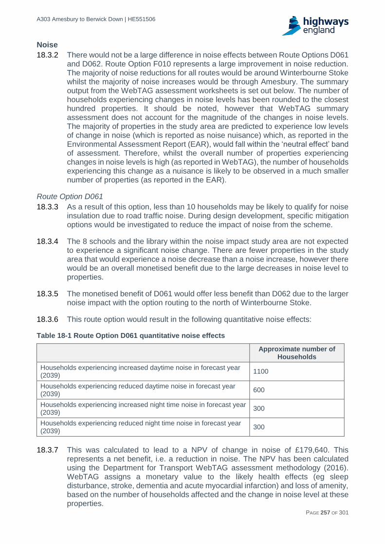
A303 Amesbury to Berwick Down | HE551506
HE551506-AA-GEN-SWI-RP-CX-000020 | P13, S0 21/12/2016 PAGE 257 OF 301
Noise
18.3.2 There would not be a large difference in noise effects between Route Options D061 and D062. Route Option F010 represents a large improvement in noise reduction. The majority of noise reductions for all routes would be around Winterbourne Stoke whilst the majority of noise increases would be through Amesbury. The summary output from the WebTAG assessment worksheets is set out below. The number of households experiencing changes in noise levels has been rounded to the closest hundred properties. It should be noted, however that WebTAG summary assessment does not account for the magnitude of the changes in noise levels. The majority of properties in the study area are predicted to experience low levels of change in noise (which is reported as noise nuisance) which, as reported in the Environmental Assessment Report (EAR), would fall within the ‘neutral effect’ band of assessment. Therefore, whilst the overall number of properties experiencing changes in noise levels is high (as reported in WebTAG), the number of households experiencing this change as a nuisance is likely to be observed in a much smaller number of properties (as reported in the EAR).
Route Option D061
18.3.3 As a result of this option, less than 10 households may be likely to qualify for noise insulation due to road traffic noise. During design development, specific mitigation options would be investigated to reduce the impact of noise from the scheme.
18.3.4 The 8 schools and the library within the noise impact study area are not expected to experience a significant noise change. There are fewer properties in the study area that would experience a noise decrease than a noise increase, however there would be an overall monetised benefit due to the large decreases in noise level to properties.
18.3.5 The monetised benefit of D061 would offer less benefit than D062 due to the larger noise impact with the option routing to the north of Winterbourne Stoke.
18.3.6 This route option would result in the following quantitative noise effects:
Table 18-1 Route Option D061 quantitative noise effects
Approximate number of
Households
Households experiencing increased daytime noise in forecast year (2039)
1100
Households experiencing reduced daytime noise in forecast year (2039)
600
Households experiencing increased night time noise in forecast year (2039)
300
Households experiencing reduced night time noise in forecast year (2039)
300
18.3.7 This was calculated to lead to a NPV of change in noise of £179,640. This
represents a net benefit, i.e. a reduction in noise. The NPV has been calculated using the Department for Transport WebTAG assessment methodology (2016). WebTAG assigns a monetary value to the likely health effects (eg sleep disturbance, stroke, dementia and acute myocardial infarction) and loss of amenity, based on the number of households affected and the change in noise level at these properties.

A303 Amesbury to Berwick Down | HE551506
HE551506-AA-GEN-SWI-RP-CX-000020 | P13, S0 21/12/2016 PAGE 258 OF 301
Route Option D062
18.3.8 As a result of this option less than 15 households are likely to qualify for noise insulation due to road traffic noise. During design development, specific mitigation options would be investigated to reduce the impact of noise from the scheme to all receptors.
18.3.9 The 8 schools and the library within the noise impact study area are not expected to experience a significant noise change. There are fewer properties in the study area that would experience a noise decrease than a noise increase. Based on the values calculated by DfT’s WebTAG however, there would be an overall monetised benefit (NPV) due to small increases in noise level and large decreases in noise level to these properties.
18.3.10 The monetised benefit of D062 would offer more benefit due to the lower noise impact from the road realignment to the south of Winterbourne Stoke, but would not reduce the noise impact of the existing A303 on Amesbury.
18.3.11 This route option is predicted to result in the following quantitative noise effects:
Table 18-2 Route Option D062 quantitative noise effects
Approximate number of
Households
Households experiencing increased daytime noise in forecast year (2039)
1100
Households experiencing reduced daytime noise in forecast year (2039)
600
Households experiencing increased night time noise in forecast year (2039)
300
Households experiencing reduced night time noise in forecast year (2039)
300
18.3.12 This was calculated to lead to a net present value of change in noise of £225,124.
This represents a net benefit, i.e. a reduction in noise. The NPV has been calculated using the Department for Transport WebTAG assessment methodology (2016). WebTAG assigns a monetary value to the likely health effects (eg sleep disturbance, stroke, dementia and acute myocardial infarction) and loss of amenity, based on the number of households affected and the change in noise level at these properties.
Route Option F010
18.3.13 As a result of this option less than 10 Households are likely to qualify for noise insulation due to road traffic noise. During design development, specific mitigation options would be investigated to reduce the impact of noise from the scheme to all receptors.
18.3.14 The 10 schools and the library within the noise impact study area are not expected to experience a significant noise change. There would be more properties in the study area that would experience a noise decrease than a noise increase.

A303 Amesbury to Berwick Down | HE551506
HE551506-AA-GEN-SWI-RP-CX-000020 | P13, S0 21/12/2016 PAGE 259 OF 301
18.3.15 This route option is predicted to result in the following quantitative noise effects:
Table 18-3 Route Option F010 quantitative noise effects
Approximate number of Households
Households experiencing increased daytime noise in forecast year (2039)
800
Households experiencing reduced daytime noise in forecast year (2039)
2800
Households experiencing increased night time noise in forecast year (2039)
300
Households experiencing reduced night time noise in forecast year (2039)
500
18.3.16 This was calculated to lead to a net present value of change in noise of £3,656,638. This represents a net benefit, i.e. a reduction in noise. The monetised benefit of F010 would be significant due to the reduced noise impact of the existing A303 on Amesbury. The NPV has been calculated using the Department for Transport WebTAG assessment methodology (2016). WebTAG assigns a monetary value to the likely health effects (eg sleep disturbance, stroke, dementia and acute myocardial infarction) and loss of amenity, based on the number of households affected and the change in noise level at these properties.
Air Quality
18.3.17 Table 18-4 shows that all modelled options would result in an increase in NOx emissions, due to increases in vehicle flows and the distance travelled. Route Option F010 would have the highest increase in NOx emissions over the 60 year period, whilst there would be little difference between Route Options D061 and D062.
18.3.18 The ‘net total route assessment score’ is determined by estimating pollutant concentrations for all receptors within 200m of a road section, and calculating the resultant change in concentration between a without development scenario and each of the route options. Summing across all affected road sections then gives an overall score for the scheme. A negative value will indicate that there is an overall decrease in concentrations and therefore a general improvement in air quality, due to a scheme. So as the table below shows, the small negative net total route assessment score for each option suggests a reduction in overall exposure to PM10 and NO2 as a result of each option due to the realignment of each option away from sensitive receptors.
18.3.19 Overall, F010 would have the worst local air quality NPV (largest disbenefit) over the 60 year period, whilst there would be little difference between Route Options D061 and D062.

A303 Amesbury to Berwick Down | HE551506
HE551506-AA-GEN-SWI-RP-CX-000020 | P13, S0 21/12/2016 PAGE 260 OF 301
Table 18-4 TAG local air quality assessment results summary
Parameter Option D061 Option D062 Option F010
Net total route assessment score (opening year) for PM10 :
-43 -40 -49
Net total route assessment score (opening year) for NO2 :
-221 -217 -201
Change in NOX emissions over 60 year appraisal period:
1,481 1,448 1,560
Present value of change in NOX emissions (£): -£791,544 -£772,426 -£831,223
Present value of change in PM10 concentrations (£):
£480,561 £455,492 £343,054
Total value of change in air quality (£): -£310,983 -£316,934 -£488,169
Greenhouse gases
18.3.20 The TAG greenhouse gas assessment workbooks were completed to calculate the final Net Present Value of each route option over the 60 year appraisal period.
18.3.21 The results in Table 18-5 shows that Route Option F010 would have the highest increase in non-traded carbon and the worst NPV (largest disbenefit) over the 60 year period, with little difference between the Route Options D061 and D062. However, the model would suggest that in the opening year (2024) Route Option F010 would result in a smaller increase in CO2 emissions than either Route Option D061 or D062, reflecting the model boundaries considered. The larger increase in CO2 emissions over the 60 year appraisal period as a result of Route Option F010 would result primarily from higher emissions between 2039 (the design year) and 2051 (the future year) compared to Route Options D061 and D062. This increase in emissions is primarily due to an increase in Vehicle Km (VKM) travelled during the interpeak period. The inconsistent results due to the model limitations will be specifically addressed when the regional model becomes available in PCF Stage 2.
Table 18-5 TAG greenhouse gas assessment results summary
Parameter Option D061 Option D062 Option F010
Change in non-traded carbon dioxide emissions in tCO2e in 2024
14,655 13,963 10,738
Change in non-traded carbon over 60y (tCO2e) 1,098,266 1,108,558 1,175,655
Value of Change: NPV in £millions -£50,106,484 -£50,615,971 -£53,875,360
Landscape
18.3.22 The landscape assessment concludes the following for each of the route options:
Route Option D061
18.3.23 An overall assessment of Moderate Adverse was assigned to this 13.2km route as a result of those impacts identified for the Tilshead Chalk Downland, Till Narrow Chalk River Valley and Larkhill Chalk Downland character areas.
18.3.24 This route option would result in a range of Slight to Moderate Adverse effects on landscape character along its length, the key impacts are described briefly below.
A303 Amesbury to Berwick Down | HE551506
HE551506-AA-GEN-SWI-RP-CX-000020 | P13, S0 21/12/2016 PAGE 261 OF 301
Within the Larkhill Chalk Downland area there would be Moderate Adverse impacts on the landscape pattern as a result of the landform being altered by earthworks around portal locations and associated with the grade separated junction with the A360 and by the introduction of a new road in the landscape, frequently in cutting and on substantial embankments.
18.3.25 West of the A360 Route Option D061 would create a decrease in tranquillity, reducing the quality of visual amenity and adversely affecting the scale and pattern of the landscape. This is due to the grade separated junction with the A360, the offline section to the north of Winterbourne Stoke through the Till Narrow Chalk River Valley (Moderate Adverse) and Tilshead Chalk Downland (Moderate Adverse), and the height of the proposed route above the valley floor to the north of Winterbourne Stoke. There would be Slight Beneficial impacts on tranquillity and cultural aspects for parts of the Larkhill Chalk Downland to the east of the A360 due to the removal of traffic from the landscape.
Route Option D062
18.3.26 An overall assessment of Moderate Adverse was assigned to this 13.3km route as a result of those impacts identified for the Tilshead Chalk Downland, Till Narrow Chalk River Valley and Larkhill Chalk Downland character areas.
18.3.27 This route option would result in a range of Slight to Moderate Adverse effects on landscape character along its length, the key impacts are described briefly below. Within the Larkhill Chalk Downland area there would be Moderate Adverse impacts on the landscape pattern. This is due to the landform being altered by earthworks around portal locations and the introduction of a new road in the landscape, frequently in cutting and on substantial embankments.
18.3.28 West of the A360 Route Option D062 would create a decrease in tranquillity, reducing the quality of visual amenity and adversely affecting the scale and pattern of the landscape. The adverse effects of D062 as it crosses the Till Valley to the south east of Winterbourne Stoke would result from the route cutting into a side spur of the valley side and by the height of the proposed route above the valley floor as it crosses the river between Berwick St. James and Winterbourne Stoke. There would be Slight Beneficial impacts on tranquillity and cultural aspects for parts of the Larkhill Chalk Downland to the east of the A360 due to the removal of traffic from the landscape.
Route Options D061 and D062
18.3.29 Route Options D061 and D062 were assigned the same overall assessment score of Moderate Adverse due to very similar impacts occurring across a similar length route and the same range of landscape character areas. Without further design development and mitigation, Route Option D061 has marginally less adverse impact than Route Option D062. This is due to difference in the level of impact on the tranquillity of the Tilshead Downland character area (Moderate Adverse for D062 compared to Slight Adverse for D061) and on the cultural aspects of the Till Narrow Chalk River Valley (Slight Adverse for D062 compared to Neutral for D061).
Route Option F010
18.3.30 An overall assessment of Very Large Adverse was assigned to Route Option F010 as a result of those impacts identified on the Upper Avon Narrow Chalk River Valley character area.

A303 Amesbury to Berwick Down | HE551506
HE551506-AA-GEN-SWI-RP-CX-000020 | P13, S0 21/12/2016 PAGE 262 OF 301
18.3.31 This route option would result in a range of Slight to Very Large Adverse changes to the landscape character along its length. As the route passes through the Upper Avon Narrow Chalk River Valley, it would be elevated and aligned against the grain of the existing landscape. This would be a highly visual and intrusive feature and the potential effects would extend north and south some way along the valley due to the substantial height of the route over the valley floor, being at complete variance with the landform, scale and pattern of the landscape. This results in a Very Large Adverse effect due to impacts on visual receptors, pattern, landform and the setting of Ogbury Hill Scheduled Monument.
18.3.32 Within the Larkhill Chalk Downland area there would be adverse impacts on the landscape pattern as a result of the route cutting across the landscape along new embankments and cuttings resulting in a Large Adverse effect. Within the Till Narrow Chalk River Valley and Tilshead Chalk Downland areas beyond this, Large and Slight Adverse effects respectively result from the introduction of a new major highway within a largely rural landscape.
Townscape
18.3.33 For all route options, it is not anticipated that there would be any notable impacts on Amesbury, Durrington and Bulford Landscape Character Assessment (LCA), therefore the effect is judged to be Neutral.
Historic environment
Route Options D061 and D062
18.3.34 Route Options D061 and D062 would have very similar impacts on the historic environment. Both options would have a complex mixture of beneficial and adverse impacts on designated and non-designated assets:
a. The beneficial impacts would arise from the removal of the existing A303 from the eastern tunnel portal to Longbarrow Roundabout.
b. The adverse impacts would arise from the physical impact of construction on assets and the impact of the new dual carriageway and its operational traffic on the setting of assets and the Outstanding Universal Value (OUV) of the WHS.
18.3.35 In terms of the WHS, both options would remove the A303 from a key part of the WHS providing a significant improvement for the setting of Stonehenge and other related monuments. It would also reconnect The Avenue. These are very notable benefits. However, the route options would introduce major new infrastructure into the WHS adversely affecting important assets and key attributes of the site’s OUV, e.g. the location of the western portal relative to Normanton Down Barrow Group.
18.3.36 On balance and in terms of the WHS, the impacts are considered positive, resulting in a Slight/ Moderate Beneficial effect for D061 and a Moderate Beneficial effect for D062. This difference is due to the greater benefits for the WHS that D062 provides with the routing west of the western portal, where it avoids important archaeological remains and uses local topography to better fit into the landscape of the WHS.
18.3.37 In terms of the historic environment as a whole (i.e. both within and outside the WHS), the route options would have an impact on the settings of many scheduled monuments within and around the WHS which would benefit from the removal of the existing A303. The construction of the new route would have adverse impacts on the setting of many other scheduled monuments and the fabric of one monument

A303 Amesbury to Berwick Down | HE551506
HE551506-AA-GEN-SWI-RP-CX-000020 | P13, S0 21/12/2016 PAGE 263 OF 301
and numerous areas of non-designated archaeology, this would result in a greater number of adverse effects than beneficial effects. Additionally, there would be adverse impacts on a number of listed buildings, a conservation area and a registered park and garden; resulting in adverse effects on these environmental resources.
18.3.38 On the basis of WebTAG, the assessment would indicate that, in purely numerical terms, the adverse effects resulting from both D061 and D062 route options would outweigh the beneficial effects, with D062 overall having a slightly less adverse effect on heritage assets, particularly outside and to the west of the WHS. However, as set out in the NPSNN (2015), great weight must be given to the beneficial effect resulting from the changes to the WHS and also the beneficial impact on Stonehenge and The Avenue.
18.3.39 In this context, a Neutral score has been recorded for the historic environment, representing a balanced outcome between important beneficial impacts and a large number of adverse impacts on designated and non designated assets. Route Options D061 and D062 would result in a range of slight to very large adverse impacts on more than 60 scheduled monuments. These adverse impacts are a result of changes to the setting of the monuments and the relationships between monuments and the landscape. Both options would cross a scheduled linear boundary monument resulting in a very large adverse impact and D061 would have a large adverse impact on two scheduled barrow complexes north of Winterbourne Stoke. Both options would also adversely affect listed buildings, a conservation area and a registered park and garden at the eastern end of scheme around Amesbury. The partial removal of the A303 would deliver benefits for over 50 scheduled monuments, including Stonehenge and other high and very high value scheduled monuments within the WHS, resulting in a range of slight to very large beneficial impacts for both D061 and D062.
18.3.40 This Neutral score must be understood in the context of there being a number of substantial adverse impacts and effects that require further mitigation and consideration. Although both route options would result in the same overall Neutral score for the historic environment, there is a preference for D062 given that it would provide slightly greater benefits for the WHS. These differences are due to the alignment of D062 west of the western portal where it would avoid important archaeological remains and would use local topography to structure its alignment and fit into the landscape of the WHS.
Route Option F010
18.3.41 Option F010 would result in a mixture of beneficial and adverse impacts on designated and non-designated assets. The beneficial impacts would arise from the removal of the existing A303 from Countess East to the Longbarrow Roundabout. The adverse impacts arise from the physical impact of construction on assets outside of the WHS and the impact of the new dual carriageway and its operational traffic on the setting of designated and non-designated assets.
18.3.42 The removal of the A303 would also deliver benefits for over 100 scheduled monuments, and a number of listed buildings. Overall, within and outside the WHS, F010 would result in 132 beneficial impacts (22 very large, 49 large, 29 moderate, 32 slight) and 161 adverse impacts (4 large, 36 moderate, 121 slight). Outside of the WHS, this includes harm to other designated assets: scheduled monuments,

A303 Amesbury to Berwick Down | HE551506
HE551506-AA-GEN-SWI-RP-CX-000020 | P13, S0 21/12/2016 PAGE 264 OF 301
listed buildings, conservation areas; and the loss of non-designated, known and potential archaeology along its length.
18.3.43 Overall whilst the harm to the other assets does weight slightly against the benefits of F010, the scheme is still considered to deliver a Large Beneficial Effect.
Biodiversity
Route Options D061 and D062
18.3.44 A precautionary approach to assessment was taken of potential significant adverse impacts on designated international and national ecological sites, including the River Avon SAC and the River Till and River Avon System SSSIs. This is due to the construction of a tunnel, the uncertainty over construction methodology, and size / footprint of one new crossing over the River Till. The overall assessment score of Large Adverse effect was assigned to these route options. Mitigation through design should lead to a reduction of the scale of impact for the latter receptor.
18.3.45 The route corridor would also result in impacts to two County Wildlife Sites (CWS), and several hedgerows and woodlands. The likely direct impacts that would occur are habitat change/loss; habitat severance and/or obstructions; hydrological connectivity change/loss; wildlife road fatalities; wildlife displacement; lighting; noise and vibration and pollution.
18.3.46 Indirect impacts differ for these two options. Route Option D061 would result in indirect impacts to Steeple Langford Down SSSI; Yarnbury Castle SSSI, Salisbury Plain SAC & Special Protective Area (SPA), two CWS and one Protected Road Verge (PRV). For Route Option D062 indirect impacts would occur to Salisbury Plain SAC & SPA; Steeple Langford Down SSSI; Yarnbury Castle SSSI; Parsonage Down SSSI / National Nature Reserve (NNR), and two PRV.
18.3.47 Benefits brought by tunnel Route Options D061 and D062 would include a shorter scheme in terms of its length, landscape reconnection and habitat restoration leading to a reduction of road fatalities and increase in wildlife movement, relative to surface Route Option F010.
Route Option F010
18.3.48 Route Option F010, a proposal nearly twice as long as Route Options D061 and D062, and completely above ground, was assigned an overall assessment score of Very Large Adverse effect was assigned to Route Option F010. This is due to the direct impacts to the River Avon SAC (encompassing the River Avon and River Till) and the River Till and River Avon System SSSIs (which overlap with the River Avon SAC).
18.3.49 Route Option F010 would also result in impacts to two CWS, and numerous hedgerows and woodlands. The likely direct impacts that would occur are habitat change/loss; habitat severance and/or obstructions; hydrological connectivity change/loss; wildlife road fatalities; wildlife displacement; lighting; noise and vibration and pollution. Indirect impacts, such as from lighting and reduced air quality would occur to Salisbury Plain SAC & SPA; Parsonage Down SSSI & NNR; Yarnbury Castle SSSI; Salisbury Plain SSSI; Porton Meadows SSSI; five CWS and one PRV.

A303 Amesbury to Berwick Down | HE551506
HE551506-AA-GEN-SWI-RP-CX-000020 | P13, S0 21/12/2016 PAGE 265 OF 301
18.3.50 There will be a major loss of habitat and biodiversity and these cannot be compensated within the scheme.
Water environment
Route Options D061 and D062
18.3.51 An overall assessment score of Large Adverse was assigned to Route Options D061 and D062. This is due to the number of potentially significant effects on water environment features associated with these route options.
18.3.52 One of the construction methodologies may require dewatering of the chalk aquifer. Current assessment shows that a number of water environment features are within the potential area of influence of the scheme including local groundwater abstractions, surface and groundwater dependent biodiversity in the River Till and River Avon, flood risk and cultural assets such as Blickmead Spring. De-risking work is being undertaken to fully evaluate the extent and magnitude of these construction effects, and this may influence the assessment score.
18.3.53 Overall, operational risks are considered to be significantly lower than those associated with construction.
Route Option F010
18.3.54 An overall assessment score of Moderate Adverse was assigned to this route option.
18.3.55 Most of the effects associated with Route Option F010 (shading by bridges, increased flood risk and changes in flow volume and water quality in both groundwater and surface water) would be eliminated by mitigation and design. Route Option F010 crosses 2.4km of Source Project Zone (SPZ) 2 and this would require a project specific mitigation approach which is reflected in the score provided.
Summary
18.3.56 In terms of environmental effects, in order to facilitate ease of comparison across the three route options, Table 18-6 summarises the assessment outcomes together.
18.3.57 WebTAG does not prescribe the separate reporting of impacts on individual receptors, and instead seeks to provide an overall score for each topic. However, given the emphasis that is placed on the protection and enhancement of the WHS within the Client Scheme Requirements (CSRs), it is considered appropriate to note the findings of the WebTAG assessment in terms of the overall impact on the WHS site for each option and this is also presented as a sub-component of the Historic Environment.

A303 Amesbury to Berwick Down | HE551506
HE551506-AA-GEN-SWI-RP-CX-000020 | P13, S0 21/12/2016 PAGE 266 OF 301
Table 18-6 Summary of environmental assessment outcomes
Parameter Option D061 Option D062 Option F010
Noise (NPV of change in Noise)* £180,000 £225,000 £3,660,000
Air quality: Total value of change in air quality*
-£310,000 -£320,000 -£490,000
Greenhouse Gases (NPV of change in Greenhouse gases)*
-£50,106,484 -£50,615,971 -£53,875,360
Landscape Moderate Adverse Moderate Adverse Very Large Adverse
Townscape Neutral Neutral Neutral
Historic Environment (overall) Neutral Neutral Large Beneficial
Historic Environment (WHS)** Slight / Moderate Beneficial
Moderate Beneficial Large Beneficial
Biodiversity Large Adverse Large Adverse Very Large Adverse
Water environment Large Adverse Large Adverse Moderate Adverse
* a positive value represents a benefit whilst a negative value a disbenefit
** Scores are as per WebTAG guidance (TAG Unit A3), these differ from DMRB derived impact and effect scores.
18.3.58 In WebTAG terms, in comparing environmental effects across the route options, Route Options D061 and D062 have very little to distinguish between them. For both D061 and D062 the number of properties experiencing noise nuisance is small whilst noise benefits are slightly better for D062 based on the level of noise reduction around Winterbourne Stoke. This is represented by the monetised values in Table 18-6 that relate to the positive effects on health. In terms of greenhouse gases, both D061 and D062 would result in an increase in user carbon, due to increases in vehicle flows and the slightly longer distance travelled compared to the existing. For air quality, this would also result in higher NOx emissions. Whilst air quality receptors within 200m would experience a reduction in exposure to PM10 emissions, leading to improved local air quality, this improvement is offset by the overall increase in exposure to NOx leading to an overall reduction in air quality. This is represented by the negative NPV values in Table 18-6.
18.3.59 Biodiversity and the water environment have both been assigned the same level of Large Adverse effect, with potential effects on water environment predicted to substantially reduce post construction. For biodiversity, mitigation through design development is predicted to result in a reduction in the scale of impact. In terms of landscape both Route Options D061 and D062 would have a Moderate Adverse effect with scope for further mitigation during design development. For the historic environment, both D061 and D062 would result in an overall Neutral score but with slight to moderate beneficial benefits for the WHS. There is a preference for D062 over D061 given that it provides greater benefits for the WHS with the routing west of the western portal, where it avoids important archaeological remains and uses local topography to better fit into the landscape of the WHS.
18.3.60 Route Option F010 would provide benefits for noise receptors based on the level of noise reduction around Winterbourne Stoke and Amesbury. This is represented by the monetised values in Table 18-6. In terms of greenhouse gases, in comparison with Route Options D061 and D062, F010 would result in the highest increase in user carbon due to increases in vehicle flows and the much longer distance travelled. For air quality, this would also result in higher NOx emissions.
A303 Amesbury to Berwick Down | HE551506
HE551506-AA-GEN-SWI-RP-CX-000020 | P13, S0 21/12/2016 PAGE 267 OF 301
As with D061 and D062, receptors within 200m of F010 would also experience a reduction in exposure to PM10 emissions, leading to improved local air quality. However, this improvement is also offset by the overall increase in exposure to NOx leading to an overall reduction in air quality and this is again represented by the negative NPV values in Table 18-6.
18.3.61 The magnitude of change and the sensitivity of the high quality rural landscape along the approximate 21.5 km length of Route Option F010 and the visual impacts of the highly intrusive crossing of the Upper Avon Narrow Chalk River Valley landscape character area would result in a Very Large Adverse effect on Landscape with limited scope for mitigation. F010 is nearly twice the length of D061 and D062 and at surface level that would result in a Very Large Adverse effect on biodiversity. This is due to the direct impacts to the River Avon SAC (encompassing the River Avon and River Till) and the River Till and River Avon System SSSIs (which overlap with the River Avon SAC). For the water environment Route Option F010 crosses 2.4km a Special Protection Zone 2 (SPZ) which is reflected in the Moderate Adverse assessment.
18.3.62 For the historic environment overall, F010 would result in a Large Beneficial effect compared with a Neutral effect for Route Options D061 and D062. In terms of the WHS, F010 would also result in a Large Beneficial effect, whilst D061 would result in a Slight/Moderate Beneficial effect and D062 a Moderate Beneficial effect.
A303 Amesbury to Berwick Down | HE551506
HE551506-AA-GEN-SWI-RP-CX-000020 | P13, S0 21/12/2016 PAGE 268 OF 301
19 Stakeholder engagement
Introduction
19.1.1 The Stakeholder Engagement and Communications Strategy was implemented to govern the approach to managing stakeholders. Underneath this the Stakeholder and Communications Plan set out the approach to stakeholders in the run up to consultation in early 2017. The Public Consultation Plan details the proposals for undertaking full public consultation in early 2017. These documents provide the basis on which the views of the public and of key stakeholders will be taken into account in the optioneering and planning stages of the scheme's development.
19.1.2 Figure 19-1 below shows the interrelationships of these documents.
Figure 19-1 Stakeholder engagement and communications strategy documents
Stakeholder engagement objectives
19.1.3 Highways England needs to make sure it finds the right solution before spending public money, and has and will continue to seek views from the local community and stakeholders on the proposals.
19.1.4 This means the objectives of stakeholder engagement are to:
Involve stakeholders in the scheme and secure feedback.
Provide opportunities for communities and all stakeholders to get involved in the scheme and express views.
Ensure the scheme's needs, potential benefits, impacts and mitigation to all stakeholders are explained.
Gain feedback from all stakeholders which is properly considered, responded to and, where practicable, addressed.
Approach to stakeholder engagement and key issues
19.1.5 A key approach to deliver this engagement is through Working Groups. These meetings will help us to identify stakeholder objectives, and address issues early. Details of the Working Groups and the stakeholders involved are
Working Groups “A group of stakeholders who work with Highways England/Arup Atkins Joint Venture to achieve set objectives concerning a specific topic or subject matter.”

A303 Amesbury to Berwick Down | HE551506
HE551506-AA-GEN-SWI-RP-CX-000020 | P13, S0 21/12/2016 PAGE 269 OF 301
set out in Table 19-1. The objectives of each Working Group and any key issues raised are included in the table.
19.1.6 The project has also set up Engagement Forums. These Forums will help to ensure that all the views and opinions from specialist groups with a specific focus are captured and inputted into the decision making process. Details of Forums and their membership are set out in Table 19-1. As the project programme progresses, further Forums will be established to focus on particular aspects of the scheme.
Table 19-1 Details of stakeholder working groups and forums
Name Members Key issues and objectives
Peninsula working group
(A303/A358/A30 steering group)
Somerset County Council
Wiltshire Council
Devon County Council
Dorset County Council
Heart of the South West LEP
Other local and regional bodies to be identified where relevant.
Objectives:
- To agree any joint working to support the scheme and other A303 projects.
- To obtain evidence about the regional economy.
- To promote the public consultation and encourage co-ordinated responses from the group’s constituent members.
Utilities working group
Environment Agency
ESP Utilities Group
ESSO Petroleum Company Ltd
GTC
Highways England
Instalcom
Openreach (BT)
SKY Telecommunications Services
Southern Electric Power (SSE)
Virgin Media
Wessex Water
Wiltshire Council
Objectives:
- Describe the general approach that would be adopted for affected utilities within the Development Consent Order (DCO) namely the acquisition process, powers likely to be sought and the protective provisions that would be put in place.
Transport and access working group
Canal and River Trust
Civil Aviation Authority
The Disabled Persons Transport Advisory Committee
The Office of Road and Rail Regulation
Wiltshire Police
Wiltshire Fire and Rescue
Local Fire Station
South Central Ambulance Service NHS Foundation Trust
South-Western Ambulance Service NHS Foundation Trust
Road Haulage Association
The Automobile Association
Green Flag Rapid Breakdown Cover
Objectives:
- Obtain survey data
- Seek agreement on methodology for optioneering and assessment
- Seek views on shortlisted options.
Working Groups “A group of stakeholders who work with Highways England/Arup Atkins Joint Venture to achieve set objectives concerning a specific topic or subject matter.”

A303 Amesbury to Berwick Down | HE551506
HE551506-AA-GEN-SWI-RP-CX-000020 | P13, S0 21/12/2016 PAGE 270 OF 301
Name Members Key issues and objectives
RAC
Go South Coast
Salisbury Reds
Cross Country
Network Rail
National Express
South-West Trains
First Great Western
Connect2Wiltshire
The Transport Association
Director General of Roads, Devolution and Motoring (DfT)
Freight Transport Association
Railfuture
Transport Focus
Confederation of Passenger Transport (CPT)
South West Public Transport Users Forum (SWPTUF)
Stagecoach
Trail Riders Fellowship Somerset
Trail Riders Fellowship Wiltshire
White Horse Trekking Centre
COGS (Cycling Group)
British Horse Society
Campaign For Better Transport
Stonehenge Traffic Action Group
Travel Watch South West CIC
Somerset and Wiltshire Landrover Club
4x4 Response organisation
The British Horse Society
Open Spaces Society
Sustrans
Ramblers Association
Wiltshire Bridleways Association
Stonehenge Alliance
Joint environment and heritage working group
National Trust
Historic England
English Heritage
Wiltshire Council
Natural England
Objectives:
- To protect and enhance the natural and historic environment, minimise impact to the soil and water environment and promote the reduction and re-use of wastes that will be generated.
- Develop Statements of Common Ground.
Key issues:
- The process of option selection was presented to stakeholders.
- Members of the working group have requested to see the detail of assessments prior to agreeing to the outcomes of the selection process.

A303 Amesbury to Berwick Down | HE551506
HE551506-AA-GEN-SWI-RP-CX-000020 | P13, S0 21/12/2016 PAGE 271 OF 301
Name Members Key issues and objectives
- Measures to optimise the scheme layout and design were shared, and workshops held to capture the views of the group in order to further contribute to design development.
WHS forum WHS Partnership Panel
WHS Committee
Objectives:
- To share information about the project
- To ensure participation in the consultation.
Consultation working group
Wiltshire Council Ministry of Defence (MoD)
Objectives:
- To share and discuss consultation methods
- To agree the definition of “hard to reach” groups
- Set expectations as to what the consultation will look like and how the options will be presented
- To maximise the social value of the consultation.
- Agree consultation approach and content at the appropriate times.
Key issues:
- Approach to consultation was discussed
- Information to identify venues for consultation events was shared
- The Council has provided information on consulting with hard to reach groups.
Education working group
Wiltshire Council
English Heritage
Local Schools (to be identified later in the project)
Objectives:
- Ensuring benefits of the project are felt through the promotion of Science, Technology, Engineering and Mathematics (STEM) subjects and making links between industry and career opportunities in local schools and colleges.
Key issues:
- Ensuring that measures have a legacy
Working with the Ministry of Defence (MoD), English Heritage and other bodies for benefit of education stakeholders.
Communication working group
National Trust
English Heritage
Historic England
Wiltshire Council
Highways England
Objectives:
- To maintain the co-ordination of messages relating to the scheme.
Key Issues:
- Communications around surveys
Maximising opportunities around the ICOMOS visit.
Air quality working group
Wiltshire Council
Test Valley Borough Council
South Somerset District Council
Objectives:
- Agree air quality assessment baseline, scope and methodology with all parties.

A303 Amesbury to Berwick Down | HE551506
HE551506-AA-GEN-SWI-RP-CX-000020 | P13, S0 21/12/2016 PAGE 272 OF 301
Name Members Key issues and objectives
North Dorset District Council
Environment Agency
Natural England
- Develop Statement of Common Ground.
UNESCO and ICOMOS working group
Department for Culture, Media & Sport
Wiltshire Council
Historic England
National Trust
Highways England
English Heritage
Objectives:
Key issues:
- The response to the ICOMOS recommendations
- Sharing archaeological information to support ICOMOS advice on the scheme.
South West business working group
Business representatives and organisations to be identified as the scheme is progressed.
Objectives:
- To better understand the priorities of the local and regional business community.
- To obtain evidence on the regional economic benefits of the project.
Heritage specialist forum
The Amesbury Society
Salisbury Museum
Avebury and Stonehenge Archaeological and Historical Research Group
Society of Antiquaries
World Heritage UK
Chartered Institute for Archaeologists
Alexander Keiller Museum
Wiltshire Archaeological and Natural History Society
The South-West Heritage Trust
The Prehistoric Society
The Megalithic Society
Somerset Archaeological and Natural History Society
Rescue (British Archaeological Trust)
Council for British Archaeology
The Amesbury History Centre
The Amesbury Museum and Heritage Trust
The Avebury Society
ICOMOS UK
This forum will be used to disseminate information about the heritage aspects of the scheme.
Natural environment forum
Environment Agency
Link2Nature
RSPB
Cranborne Chase and West Wiltshire Downs Area of Outstanding Natural Beauty (AONB)
This forum will be used to disseminate information about the scheme and its impacts on the natural environment.

A303 Amesbury to Berwick Down | HE551506
HE551506-AA-GEN-SWI-RP-CX-000020 | P13, S0 21/12/2016 PAGE 273 OF 301
Name Members Key issues and objectives
Land agents forum
Attendees to comprise the land agents of the landowners likely to be directly affected by the route option to be taken to consultation.
This forum was set up to ensure the representatives of land owners are provided with relevant and up to date information.
Key issues raised by statutory consultees
19.1.7 Engagement with statutory consultees has been ongoing through Spring and Summer 2016 through the Working Groups identified above. This has considered the development and appraisal of corridors and route options within the better performing corridors, as detailed in sections 5, 6 and 7 of this report. The summary in Table 19-2 reflects the stakeholder’s views in response to information which was released iteratively through this process.
Table 19-2 Key findings from stakeholder responses
Principal information events
Key findings
Working group meetings
Three joint workshops with key statutory consultees: Design Fix A; Design Fix B; Design Fix C
Opportunities workshop
Collaborative site visit
Meetings have also been held with Historic England, English Heritage, National Trust, the Environment Agency, Natural England and Wiltshire Council. Wiltshire Council has established an Officer Steering Panel which meets regularly for consideration of technical (including environmental) matters, attended by Highways England and AAJV.
Engagement has also, inter alia, been initiated with key non-statutory environmental organisations,
Stakeholders have welcomed the opportunity for early and extensive engagement which has enabled them sufficiently to inform and endorse the approach to environmental appraisal and development of the route options.
The staged approach and selection method adopted was found to be acceptable to stakeholders subject to a do-nothing/do-minimum option being included in the process and demonstration that a hybrid, spanning corridors, would not be overlooked.
Key stakeholders considered that landscape, biodiversity and access benefits collectively are best delivered through the tunnel route option (Corridor D) within the WHS rather than the surface options in Corridor F which increases severance outside the WHS. This view, however, is subject to route optimisation (minimising adverse impacts on heritage and environment), tunnel location and emphasis on mitigation for potential impacts and the securing of significant benefits to the historic environment and communities.
Drawings of the route options emerging from Design Fix B and assessed in Design Fix C were circulated to stakeholders for comment.
Regarding Corridor D: no preference was expressed for a northern or southern Winterbourne Stoke bypass, although Historic England and National Trust noted benefits to existing heritage assets from the southern bypass (but some dis-benefits in the Till Valley). A tunnel portal to the east of The Avenue was welcomed but not so the location of the western portal due to the impact on the Normanton Down Barrow Group, Normanton Gorse and its relationship to the Midwinter Sunset alignment; greater separation was requested – ideally extension of the tunnel. The main concern within the WHS in terms of archaeology is the potential impact of the considerable length of new Expressway on the western side

A303 Amesbury to Berwick Down | HE551506
HE551506-AA-GEN-SWI-RP-CX-000020 | P13, S0 21/12/2016 PAGE 274 OF 301
Principal information events
Key findings
including the Cranborne Chase and West Wiltshire Downs AONB and the RSPB.
of the tunnel. From an ecological point of view, the preferred route option for stakeholders remains the tunnel.
Regarding Corridor F: it is considered to have benefits for the historic environment in terms of removing the A303 from with the WHS, which would minimise impacts on attributes of Outstanding Universal Value (OUV). Nevertheless all route options were considered rich in designated and undesignated heritage assets, with the northernmost option potentially less harmful to historic environment than the southern ones. The southern surface route options would be detrimental to a number of key priority habitats and species and would have extremely high landscape and noise impacts on the Woodford Valley and surrounding downland.
Historic England, National Trust, English Heritage and Wiltshire Council have made it clear that considerably more than normal design and assessment information will be required to support their decision making/position at this stage in the process and this must be resolved and evaluated before the DCO is submitted.
Natural England has aspirations from the project regarding Parsonage Down National Nature Reserve (NNR). They and other key stakeholders have sought an “opportunities” session in which the wider benefits facilitated by the scheme may be articulated. This would fit with the enhancement and legacy objectives of the scheme and the wider spatial planning recommendation of the UNESCO / ICOMOS Mission Report.
Consultation
19.1.8 The scheme is unique with the diverse nature and geographical spread of stakeholder interest.
19.1.9 A multifaceted approach to consultation promotion that reaches beyond the traditional bounds of an infrastructure project is therefore essential to ensure all interested stakeholders have the opportunity to provide feedback.
19.1.10 The consultation also needs to consider the fine balance between the differing objectives of the scheme, such as: alleviating congestion, promoting growth, protecting and enhancing the WHS, reconnecting communities and enhancing biodiversity.
19.1.11 In addition, consultation is being planned for the A358 Taunton to Southfields and A303 Sparkford to Ilchester schemes in early 2017. A co-ordinated approach to promoting the A303 Corridor and the relevant consultations is therefore being developed across the schemes. This will run alongside the specific promotion for the scheme consultation.

A303 Amesbury to Berwick Down | HE551506
HE551506-AA-GEN-SWI-RP-CX-000020 | P13, S0 21/12/2016 PAGE 275 OF 301
19.1.12 Based on this the aims of the Options Consultation are to:
Demonstrate robustness by undertaking consultation in the spirit of the Planning Act 2008, specifically sections 37, 42-49 as they relate to pre-application consultation.
Be meaningful, purposeful and informative to the widest range of stakeholders potentially interested in the scheme in all the cohorts identified in the Stakeholder Engagement and Consultation Strategy.
Ensure inclusivity by making the consultation accessible, clearly defined, transparent, and respectful of community identities.
Recognise the reach and complexity the scheme has, and the range of stakeholders who are likely to have an interest.
Raise awareness of the consultation at all geographical scales - local, regional, national and international.
19.1.13 To meet these aims the objectives of the Options Consultation will be to:
Exceed the guidance identified in the Department of Communities and Local Government's Guidance on the pre-application process by using best practice and lessons learned from other infrastructure projects.
Make information available through a number of methods and levels of detail to enable consultees to engage at the level they find appropriate.
Offer appropriate and convenient methods, both traditional and digital, of providing feedback to help make it easy for consultees to respond to the consultation.
Take reasonable steps to identify, engage and consult with hard to reach groups potentially affected or interested in the scheme.
Implement innovative tactics to promote the consultation in a way that reflects the unique and multifaceted nature of the stakeholders thereby reaching the widest, most diverse audience, not necessarily the largest in number, but across the greatest range of cohorts, channels and geographical location.
Utilise existing stakeholder relations to raise awareness and promote the consultation.
Recognise the positive contribution consultees can make towards the scheme, including the identification of ways the scheme could contribute to the strategic objectives of host communities and authorities.
Respect and make maximum use of local expertise, knowledge and experience that may challenge various technical and environmental studies.
Who are we consulting?
19.1.14 The local community, residents and businesses located in the immediate area of the options and the general public will be the focus of the Options Consultation. This includes those living or working within an identified 'Consultation Zone' which extends from the indicative site boundary of the proposed options, with small extensions to ensure villages or groups of houses are wholly included.
19.1.15 At the same time as consulting with the community, we will be consulting with landowners, businesses, cultural interest groups, tourism representatives and statutory consultees, as well as road users.

A303 Amesbury to Berwick Down | HE551506
HE551506-AA-GEN-SWI-RP-CX-000020 | P13, S0 21/12/2016 PAGE 276 OF 301
What are we consulting on?
19.1.16 Feedback is being sought on the proposed route options being taken forward for further development and assessment to determine the preferred route. Consideration will be given to all comments received in connection with any aspect of the scheme during the consultation.
The methodology
19.1.17 The consultation shows the methodology used to work out which option should be taken forward for consultation. In brief this includes:
Setting out at a high level the full range of options considered for the scheme, including over 60 historical options and any new options that were identified as part of the feasibility and options process.
Explaining the methodology used to assess the options and sift out options, clearly setting out those that were considered non-viable at an early stage and those that were taken forward for further detailed assessment.
Presenting more detailed analysis of each of the remaining options setting out key issues and their comparative assessment against each other and against the CSRs. This more detailed assessment will show some further options that were considered non-viable prior to consultation.
Consultation feedback
19.1.18 The project team will review and consider all the feedback it receives during Options Consultation. The findings of the consultation, along with details of how the information received will be used in the evolution of the scheme design, will be published in a Summary Consultation Report.
Preferred route option announcement and consultation
19.1.19 Having taken into account the feedback from the Options Consultation, Highways England will make a recommendation on its Preferred Route Option to the Secretary of State for Transport. The Preferred Route will then be the subject of statutory consultation in late 2017. A further detailed plan will be produced to support this second consultation.
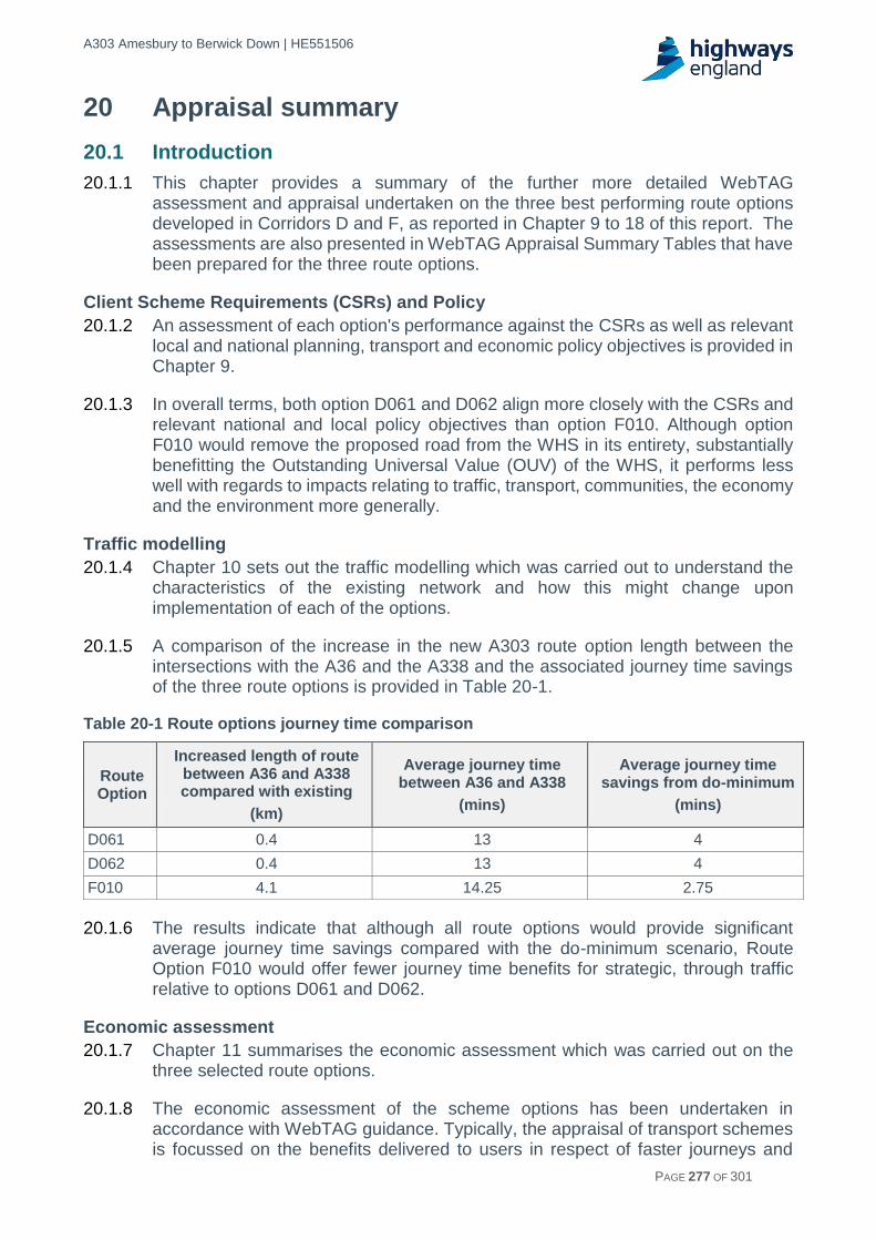
A303 Amesbury to Berwick Down | HE551506
HE551506-AA-GEN-SWI-RP-CX-000020 | P13, S0 21/12/2016 PAGE 277 OF 301
20 Appraisal summary
20.1 Introduction
20.1.1 This chapter provides a summary of the further more detailed WebTAG assessment and appraisal undertaken on the three best performing route options developed in Corridors D and F, as reported in Chapter 9 to 18 of this report. The assessments are also presented in WebTAG Appraisal Summary Tables that have been prepared for the three route options.
Client Scheme Requirements (CSRs) and Policy
20.1.2 An assessment of each option's performance against the CSRs as well as relevant local and national planning, transport and economic policy objectives is provided in Chapter 9.
20.1.3 In overall terms, both option D061 and D062 align more closely with the CSRs and relevant national and local policy objectives than option F010. Although option F010 would remove the proposed road from the WHS in its entirety, substantially benefitting the Outstanding Universal Value (OUV) of the WHS, it performs less well with regards to impacts relating to traffic, transport, communities, the economy and the environment more generally.
Traffic modelling
20.1.4 Chapter 10 sets out the traffic modelling which was carried out to understand the characteristics of the existing network and how this might change upon implementation of each of the options.
20.1.5 A comparison of the increase in the new A303 route option length between the intersections with the A36 and the A338 and the associated journey time savings of the three route options is provided in Table 20-1.
Table 20-1 Route options journey time comparison
Route Option
Increased length of route between A36 and A338 compared with existing
(km)
Average journey time between A36 and A338
(mins)
Average journey time savings from do-minimum
(mins)
D061 0.4 13 4
D062 0.4 13 4
F010 4.1 14.25 2.75
20.1.6 The results indicate that although all route options would provide significant average journey time savings compared with the do-minimum scenario, Route Option F010 would offer fewer journey time benefits for strategic, through traffic relative to options D061 and D062.
Economic assessment
20.1.7 Chapter 11 summarises the economic assessment which was carried out on the three selected route options.
20.1.8 The economic assessment of the scheme options has been undertaken in accordance with WebTAG guidance. Typically, the appraisal of transport schemes is focussed on the benefits delivered to users in respect of faster journeys and

A303 Amesbury to Berwick Down | HE551506
HE551506-AA-GEN-SWI-RP-CX-000020 | P13, S0 21/12/2016 PAGE 278 OF 301
reduced vehicle operating costs. However, in view of the objectives of the scheme, an innovative approach to the economic assessment has been taken which considers impacts on the WHS, so far as they can be monetised.
20.1.9 If assessed only on the basis of those impacts which are typically monetised in transport appraisal, the BCRs for the three options are as follows:
Route Option D061 - 0.5
Route Option D062 - 0.6
Route Option F010 - 0.3
20.1.10 On this basis, the tunnelled options (Route Options D061 and D062) are slightly preferred to the surface option (Route Option F010) on transport and economic grounds. There is no significant difference between the economic performance of the two tunnelled options. Whilst Route Options D061 and D062 are preferred, the differences between the tunnelled and surface route options is relatively slight. It should also be noted that the ranking of options is sensitive to key assumptions (most notably project costs) for which there is some uncertainty at this stage.
20.1.11 However, the final judgement of value for money for the A303 Amesbury to Berwick Down must consider the impacts on the World Heritage Site and the wider non-monetised landscape and environmental impacts.
20.1.12 Quantifying impacts on Stonehenge and the World Heritage Site is highly challenging and requires a bespoke assessment. In accordance with HM Treasury Green Book guidance, a Contingent Valuation study has been undertaken which sought to place a value on the benefits of removing the A303 from the vicinity of Stonehenge. The study is focussed on the value placed on the scheme – in relation to noise reduction, increased tranquillity, visual amenity and reduced landscape severance at Stonehenge – by visitors to Stonehenge and the population of the UK more widely.
20.1.13 The benefits of removing the road from the World Heritage Site are balanced against monetised estimates of the adverse impacts of the scheme options on the landscape more generally. Such impacts are particularly severe for Route Option F010 which involves the construction of an offline dual carriageway through an otherwise tranquil rural environment.
20.1.14 The ranged BCRs for the scheme options when such impacts are included are as follows:
Route Option D061 - 1.3 – 1.5
Route Option D062 - 1.4 – 1.6
Route Option F010 - 1.4 – 1.7
20.1.15 From this broader perspective, the economic analysis suggests that the scheme deliver benefits in excess of costs. The BCRs for the options are of a similar magnitude.
20.1.16 It should also be noted that the appraisal results set out here are likely to understate the benefits of the scheme. A complementary approach to wider economic benefits assessment has been implemented which is intended to provide a more tailored assessment of the economic impact of the scheme. This assessment indicates that

A303 Amesbury to Berwick Down | HE551506
HE551506-AA-GEN-SWI-RP-CX-000020 | P13, S0 21/12/2016 PAGE 279 OF 301
wider economic benefits are likely to be higher than the WebTAG based Wider Impacts methodology suggests.
20.1.17 Furthermore, analysis has been undertaken which demonstrates that the transport and economic benefits of the A303 Amesbury to Berwick Down scheme are greater when considered as part of the overall Expressway programme.
20.1.18 Taking these factors into account, at this stage of the assessment, the A303 Amesbury to Berwick Down is assessed as being a ‘medium’ value for money scheme.
Social assessment
20.1.19 The assessment of Social Impacts are set out in Chapter 12. The Social Impacts assessment considered the impact of the scheme on both local residents and users of the transport network.
20.1.20 Table 20-2 summarises the scores for each topic for the benefit of comparing Route Options D061, D062 and F010. The assessment identifies no differences between Route Options D061 and D062.
20.1.21 The key differentiators between Route Options F010 and Route Options D061/D062 were Physical Activity and Severance, with the increased number of communities and numbers of pedestrians considered to be affected by the options, while there is slight differentiation in terms of affordability with the increased length and vehicle operating costs.
Table 20-2 Social impacts summary
Assessment Topic
D061 D062 F010
Physical Activity Beneficial Beneficial Adverse
Journey Quality Moderate beneficial Moderate beneficial Moderate beneficial
Accessibility Neutral Neutral Neutral
Security Neutral Neutral Neutral
Severance Moderate beneficial Moderate beneficial Moderate adverse
Affordability Neutral Neutral Slight adverse
Options and non-use values
Neutral Neutral Neutral
Distributional impact assessment
20.1.22 The assessment of distributional impacts is set out in Chapter 13. Distributional impacts consider the variance of transport intervention impacts across different social groups.
20.1.23 A summary of the assessment carried out for the three options against the eight indicators, as defined by WebTAG, is included in Table 20-3 below.

A303 Amesbury to Berwick Down | HE551506
HE551506-AA-GEN-SWI-RP-CX-000020 | P13, S0 21/12/2016 PAGE 280 OF 301
Table 20-3 Distribution impacts summary
Assessment Topic
D061 D062 F010
User benefits Moderate beneficial Moderate beneficial Moderate beneficial
Noise Moderate beneficial Moderate beneficial Large beneficial
Air quality Slight adverse Slight adverse Slight adverse
Accidents Moderate beneficial Moderate beneficial Moderate beneficial
Security Neutral Neutral Neutral
Severance Large beneficial Large beneficial Large adverse
Accessibility Neutral Neutral Neutral
Affordability Neutral Neutral Moderate Adverse
20.1.24 Overall, it was assessed that there is no significant difference in impact between option D061 and D062, and that both of these perform better than option F010 with the less adverse impacts.
Safety assessment
20.1.25 The safety assessment of the three options is reported in Chapter 14 and encompasses both impacts on the road user, via an accident and road safety review, as well as an assessment of the impact during construction and subsequent operation.
20.1.26 The outcome of the review was that, although individual differences were identified between the route options, none of the options raised significant concerns and the expectation was that all three route options would have a positive impact upon road safety.
20.1.27 In terms of safety during construction, differing hazards were identified for the three route option. For D061 and D062 the key risks are associated with the tunnelling works which will include underground working and the handling and removal of significant quantities of spoil.
20.1.28 The works for F010 would extend to almost twice the length of the tunnelled options and involve an additional new crossing of the River Avon which has the inherent hazards associated with the construction of a major structure such as the size of construction plant required and the inevitable working at height.
20.1.29 On balance it was assessed that the inclusion of a tunnel is less commonplace in the industry today and is likely to have slightly more significant risk associated with its construction. The risks are not unknown, however, and would be suitably mitigated by an experienced Contractor.
Operational assessment
20.1.30 Chapter 15 of the report sets out an assessment as to how the three options compare in terms of their effect on the operation of the road network in the locality of the scheme.
20.1.31 The assessment concluded that all three options could be developed to provide safe and economic operation and maintenance.

A303 Amesbury to Berwick Down | HE551506
HE551506-AA-GEN-SWI-RP-CX-000020 | P13, S0 21/12/2016 PAGE 281 OF 301
Technology assessment
20.1.32 The technology assessment is set out in Chapter 16. Technology will be adopted to support operational regimes and manage traffic through this section of the network. At this stage it has been assessed that all three options can be designed in accordance with the appropriate industry guidance, albeit with slightly more technology being required in order to service the tunnel element of options D061 and D062.
Maintenance assessment
20.1.33 Chapter 17 discusses and records the outcome of the maintenance assessment of the three options.
20.1.34 All three options would introduce new maintenance liabilities onto the network but all are deemed capable of being maintained in accordance with current industry guidance and requirements.
20.1.35 Specific maintenance activities would be required for the tunnel with options D061 and D062 but these are considered to be routine tunnel maintenance operations.
Environmental assessment
20.1.36 Chapter 18 discusses and records the outcome of the WebTAG environmental assessment undertaken on each of the three route options and provides a summary comparison of the three options against each of the assessment topics.
20.2 Appraisal Summary Tables (ASTs)
20.2.1 ASTs were produced for each of the three route options to collate the assessments summarised above and detailed in Chapters 11 to 18 of this report. Further details of the ASTs and supporting worksheets can be found in the Appraisal Summary Table and Supporting Worksheets Report. The ASTs present a summary of the appraisals under the main headings of:
Economy.
Environmental.
Social.
Public Accounts.
20.2.2 The ASTs for each option are provided in Appendix H.
20.2.3 To assist the comparison of the three route options, a summary of the quantitative and qualitative assessments from the ASTs is presented below in Table 20-4.

A303 Amesbury to Berwick Down | HE551506
HE551506-AA-GEN-SWI-RP-CX-000020 | P13, S0 21/12/2016 PAGE 282 OF 301
Table 20-4 AST assessment comparison
Impacts D061 D062 F010
Econ
om
y
Business users & transport providers
£199,155,000 £195,969,000 £78,476,000
Reliability impact on business users
£14,600,000 £14,600,000 £14,600,000
Regeneration Neutral Neutral Neutral
Wider Impacts £97,000,000 £103,000,000 £66,000,000
En
vir
on
me
nta
l
Noise £180,000 £225,000 £3,660,000
Air Quality -£310,000 -£320,000 -£490,000
Greenhouse Gases -£ 50,106,484 -£ 50,615,971 -£53,875,360
Landscape Moderate Adverse Moderate Adverse Very Large Adverse
Townscape Neutral Neutral Neutral
Historic Environment (overall)
Neutral Neutral Large Beneficial
Historic Environment (WHS)
Slight/Moderate Beneficial
Moderate Beneficial
Large Beneficial
Biodiversity Large Adverse Large Adverse Very Large Adverse
Water Environment Large Adverse Large Adverse Moderate Adverse
So
cia
l
Commuting and other users
£347,955,000 £435,611,000 £125,528,000
Reliability impact on commuting and other users
£46,000,000 £46,000,000 £46,000,000
Physical activity Beneficial Beneficial Adverse
Journey quality Moderate Beneficial Moderate Beneficial
Moderate Beneficial
Accidents £29,233,300 £29,382,700 £13,727,100
Security Neutral Neutral Neutral
Accessibility Neutral Neutral Neutral
Affordability Neutral Neutral Slight Adverse
Severance Moderate Beneficial Moderate Beneficial
Moderate Adverse
Option and non-use values
Neutral Neutral Neutral
Pu
blic
a
cco
un
ts Cost to broad
transport budget £1,050,879,000 £1,050,847,000 £652,504,000
Indirect Tax Revenues
£16,577,000 £12,737,000 £44,820,000
* a positive value represents a benefit whilst a negative value a disbenefit
20.2.4 For the purposes of comparison, each of the options were given a ranking from 1 to 3 based upon how they were assessed as performing against each of the criteria, a rank of “1” representing the best performing option and this is presented in Table 20-5 below.
20.2.5 No weighting was applied to the rankings, with each impact being given equal importance. A total of the rankings for each option gives a comparison between

A303 Amesbury to Berwick Down | HE551506
HE551506-AA-GEN-SWI-RP-CX-000020 | P13, S0 21/12/2016 PAGE 283 OF 301
options with a lower total indicating a better performing option against the set of criteria.
Table 20-5 Summary of assessment within the ASTs
Impacts D061 D062 F010
Econ
om
y
Business users & transport providers 1 2 3
Reliability impact on business users 1 1 1
Regeneration 1 1 1
Wider Impacts 2 1 3
En
vir
on
me
nta
l
Noise 3 2 1
Air Quality 1 1 2
Greenhouse Gases 1 1 2
Landscape 1 1 3
Townscape 1 1 1
Historic Environment 2 2 1
Biodiversity 1 1 2
Water Environment 2 2 1
So
cia
l
Commuting and other users 2 1 3
Reliability impact on commuting and other users
1 1 1
Physical activity 1 1 2
Journey quality 1 1 1
Accidents 1 1 2
Security 1 1 1
Accessibility 1 1 1
Affordability 1 1 2
Severance 1 1 2
Option and non-use values 1 1 1
Public accounts
Cost to broad transport budget 2 2 1
Indirect Tax Revenues 2 3 1
Totals (lowest optimal) 32 31 39
20.2.6 This approach to comparing the ASTs of each of the options corresponds well with
the other assessments carried out, particularly the performance of the options against the CSRs, which indicates that the part tunnelled options, Route Options D061 and D062, both perform better than the southern surface Route Option F010.

A303 Amesbury to Berwick Down | HE551506
HE551506-AA-GEN-SWI-RP-CX-000020 | P13, S0 21/12/2016 PAGE 284 OF 301
21 Programme
21.1 Introduction
21.1.1 This chapter describes the timescales for the continuing development and delivery of the scheme route options through the subsequent Project Control Framework (PCF) stages.
21.2 Key milestones
21.2.1 The programme responds to the Government commitment (Road Investment Strategy) to commence construction by end March 2020. It is considered that this timescale is achievable for either of the proposed tunnelled options, Route Option D061 or D062.
21.2.2 Should the surface Route Option F010 be progressed, new environmental and geotechnical surveys would be required. These would extend the development phase by at least 12-months, enabling an earliest start date of March 2021.
21.2.3 The construction of a tunnel (Option D061 and D062) would entail a complex construction phase that is estimated to last for around 4.5 to 5.5 years.
21.2.4 The construction programme for a surface route (Route Option F010) is estimated to require a construction programme of between around 3 years.
21.2.5 Key milestones defining the project programme through to start of Construction Works include:
Commence Option Identification - Jan 2016.
Route to be assessed in Option Selection approved - Nov 2016.
Start of Options Consultation - Jan 2017.
Preferred Route Announcement - Jul 2017.
Start of Preliminary Design - Jul 2017.
Start of Pre-application Consultation - Nov 2017.
Submit Development Consent Order (DCO) application - mid 2018.
DCO – end of examination - mid 2019.
Secretary of State’s decision on DCO - Dec 2019.
Start of Works - Mar 2020.

A303 Amesbury to Berwick Down | HE551506
HE551506-AA-GEN-SWI-RP-CX-000020 | P13, S0 21/12/2016 PAGE 285 OF 301
22 Overall Summary
22.1.1 The identification of the existing problems and constraints for the scheme and the options development, sifting and appraisal process, to ultimately determine the route options to be taken forward for public consultation, was split into three stages: Design Fix A; Design Fix B; and Design Fix C.
22.1.2 In Design Fix A, some 60 historical routes that have been proposed by Government, stakeholders and the public in the past, were reviewed and grouped into eight corridors which contained routes with similar characteristics. The corridors were assessed against the Client Scheme Requirements (CSRs), WebTAG and EAST criteria, and the National Policy Statement for National Networks (NPSNN)) environmental aspects. The outcome of this initial corridor appraisal was that Corridor D (part tunnel part surface route options within the WHS to the south of the existing A303) and Corridor F (wholly surface route options to the south of the WHS) were the best performing corridors and should be taken forward for further consideration and development of route options.
22.1.3 A number of route options were then developed in Design Fix B, within the two best performing corridors, and sifted against the key engineering and environmental constraints to confirm 7 route options in Corridor D and 3 route options in Corridor F to be taken through initial route options appraisal. The methodology used to appraise the options (Design Fix C) followed that used for the Initial corridors appraisal, and was based on the guidance in the WebTAG Option Assessment Framework. The outcome of this initial options appraisal was that three of the best performing Corridor D and F route options were taken forward for further more detailed WebTAG appraisal to determine the route options for consultation.
22.1.4 The three better performing route options D061, D062 and F010, were taken through a WebTAG appraisal with the outcomes of the assessments reported in Appraisal Summary Tables (refer to Appendix H).
22.1.5 The further appraisal confirmed that Route Options D061 and D062 would deliver a better fit against the Client Scheme Requirements (CSRs) and the relevant local and national planning, transport and economic policy objectives, than Route Option F010, thus providing better alignment with the scheme objectives.
22.1.6 Route Options D061 and D062 would provide a shorter, more direct route for through traffic along the A303 relative to Route Option F010, reducing the extent of rat-running through local villages and delivering a journey time saving of approximately 4 minutes compared to the existing case. A journey along Route Option F010 would involve travelling an additional 3.7km relative to Route Options D061 and D062 and consequently, the journey time saving (in relation to the existing situation) is reduced and is less at approximately 2.75 minutes. A consequence of the longer Route Option F010 alignment and the proposed junction locations is an increase in rat-running through local villages.
22.1.7 The economic appraisal undertaken provided an assessment of the overall value for money of the investment on the basis of costs and benefits that can be monetised. If assessed on the basis of traditional metrics of transport user benefits, Route Options D061 and D062 performed better than Route Option F010, although costs outweigh benefits for all options. However, if the value of removing the A303 from the vicinity of Stonehenge is included in the assessment, a positive economic

A303 Amesbury to Berwick Down | HE551506
HE551506-AA-GEN-SWI-RP-CX-000020 | P13, S0 21/12/2016 PAGE 286 OF 301
case can be made for each of the options. In overall terms, when viewed from this broader perspective, the options performed similarly. At this stage in the assessment, the scheme was assessed as offering ‘medium’ value for money.
22.1.8 Route Options D061 and D062 performed marginally better than Route Option F010 in terms of limiting the separation of residents from services and facilities within their community. This is due to reduced severance at a number of locations along the route and on the affected road network. In particular, Route Options D061 and D062 remove traffic from Winterbourne Stoke, reduce traffic for other nearby settlements such as Shrewton, Durrington and Larkhill, and also include new pedestrian facilities at Countess Roundabout. With the criteria of physical activity, Route Options D061 and D062 also performed better due to a lower degree of Public Rights of Way (PRoW) severance relative to Route Option F010. All options were comparable in terms of journey quality due to reductions in traveller stress.
22.1.9 The distributional impacts assessment identified no significant differentiators between the impact of Route Options D061 and D062, with these outperforming Route Option F010 overall due to fewer adverse impacts.
22.1.10 WebTAG environmental appraisals were undertaken on each of the three route options. For all options it is predicted that properties affected in the study area would experience low levels of change in noise, with a small number of properties assessed as experiencing noise nuisance. All options would provide noise benefits, with the level of noise reduction around Winterbourne Stoke better for Route Option D062 and Route Option F010 having further noise benefits for properties in Amesbury.
22.1.11 In terms of greenhouse gases all options would result in an increase in user carbon, with F010 resulting in the greatest increase due to vehicle flows and the much longer distance travelled. For air quality, the increase in vehicle flows and the much longer distance travelled for F010 would also result in the highest NOx emissions. For all options air quality receptors within 200m would experience a reduction in exposure to PM10 emissions, leading to improved local air quality. This improvement is offset for all options by the overall increase in exposure to NOx leading to an overall reduction in air quality.
22.1.12 In terms of landscape both D061 and D062 would have a Moderate Adverse effect with scope for further mitigation during design development. For F010 the magnitude of change and the sensitivity of the high quality rural landscape along the approximate 21.5 km length and the visual impacts of the highly intrusive crossing of the Upper Avon Valley would result in a Very Large Adverse effect on the landscape with limited scope for mitigation.
22.1.13 For the historic environment, both Route Options D061 and D062 would result in an overall Neutral score compared with a Large Beneficial effect for F010. In terms of the WHS, F010 would also result in a Large Beneficial effect, whilst D061 would result in a Slight/Moderate Beneficial effect and D062 a slightly greater Moderate Beneficial effect. These differences are due to the routing of D062 west of the western portal where it avoids important archaeological remains and uses local topography to better fit into the landscape of the WHS.
22.1.14 For Route Options D061 and D062 biodiversity and the water environment have both been assigned the same level of Large Adverse effect, with potential effects

A303 Amesbury to Berwick Down | HE551506
HE551506-AA-GEN-SWI-RP-CX-000020 | P13, S0 21/12/2016 PAGE 287 OF 301
on water environment predicted to substantially reduce post construction. For biodiversity, mitigation through design development is predicted to result in a reduction in the scale of impact. Route Option F010 crosses 2.4km a Special Protection Zone 2 (SPZ) which is reflected in the Moderate Adverse assessment for water environment. For biodiversity F010 is nearly twice the length of D061 and D062 and at surface level would result in a Very Large Adverse effect. This is due to the direct adverse impacts to internationally (European) and nationally designated ecological sites.
22.1.15 All options were assessed to have a positive impact upon on road safety as the existing A303 is an accident blackspot, and all new route options will increase capacity and be designed to high safety standards. All proposed route options would significantly reduce the risk of hazards to road users. Additionally, the horizontal and vertical alignments and associated forward visibility would improve significantly relative the existing conditions.
22.1.16 As a result of having shorter travel distances, Route Options D061 and D062 were assessed to have the potential to deliver greater in-service accident benefits over Route Option F010. In relation to Construction, Design and Management (CDM) safety assessment, Route Options D061 and D062 would involve significant tunnel construction, a highly specialised and technically complex activity. This would be considered a significant construction risk activity, but was assessed as manageable by a competent contractor. Route Option F010 would involve the construction of an additional significant viaduct over the River Avon, which would require significant amount of working at height, another significant but manageable construction risk.
22.1.17 In terms of performance against the assessment criteria of operation, technology and maintenance, all options performed to a similar level with Route Options D061 and D062 requiring enhanced operation and maintenance features specific to the tunnel.
22.1.18 In regards to the scheme programme, Route Options D061 and D062 could be delivered to meet the Road Investment Strategy (RIS) programme dates and achieve a start on site by March 2020. Route Option F010 would require additional survey information leading to a 12 month delay relative to Route Options D061 and D062, and thus would achieve a later start on site date of approximately March 2021.
22.1.19 In conclusion, based on the more detailed WebTAG assessment and appraisal of the sifted best performing route options for Corridors D and F, and the fit with the scheme objectives, the following route options are proposed to be taken forward to Stage 2 for public consultation and further appraisal, with no significant characteristics differentiating the two options:
Route Option D061: Approximately 2.9km length tunnel with route running north of Winterbourne Stoke, eastern tunnel portal located east of The Avenue and the western tunnel portal located west of Normanton Gorse to minimise visual impact to and from Stonehenge.
Route Option D062: Approximately 2.9km length tunnel with route running south of Winterbourne Stoke, eastern tunnel portal located east of The Avenue and the western tunnel portal located west of Normanton Gorse to minimise visual impact to and from Stonehenge.

A303 Amesbury to Berwick Down | HE551506
HE551506-AA-GEN-SWI-RP-CX-000020 | P13, S0 21/12/2016 PAGE 288 OF 301
GLOSSARY
AADT Annual Average Daily Traffic
AAJV Arup Atkins Joint Venture
AID Automatic Incident Detection
AMOR Asset Maintenance and Operational Requirements
ANPR Automatic Number Plate Recognition
AONB Area(s) of Outstanding Natural Beauty
AQMA Air Quality Management Areas
AQS Air Quality Strategy
ARN Affected Road Networks
ASC Asset Support Contractor
ASR Appraisal Specification Report
AST Appraisal Summary Table
AVIS Asset Visualisation Information System
BBCJV Balfour Beatty Carillion Joint Venture
BCR Benefit to Cost Ratio
BOAT Byways Open to All Traffic
CABE Commission for Architecture and the Built Environment
CBA Council for British Archaeology
CCTV Closed Circuit Television
CDM Construction, Design, and Management
CEEQUAL Civil Engineering Environmental Quality Assessment and Award scheme
CHARM Common Highways Agency Rijkswaterstaat Model
COBA-LT Cost and Benefit to Accidents – Light Touch
CPO Cosmopolis (luminaire brand)
CPRE Campaign for the Protection of Rural England
CRF Congestion Reference Flow
CSR Client Scheme Requirement
CWS Country Wildlife Site
D2AP All-purpose Dual Carriageway
DCMS Department for Culture, Media and Sport
DCO Development Consent Order
Defra Department for Environment, Food and Rural Affairs
DETR Department of the Environment, Transport and the Regions
DfT Department for Transport
DI Distributional Impact
DMRB Design Manual for Roads and Bridges
DTA Drainage Treatment Area
EAR Environmental Assessment Report
EAST Early Assessment and Sifting Tool
EPB Earth Pressure Balance
ERA Emergency Refuge Area

A303 Amesbury to Berwick Down | HE551506
HE551506-AA-GEN-SWI-RP-CX-000020 | P13, S0 21/12/2016 PAGE 289 OF 301
ERT Emergency Roadside Telephone
GIS Geographical Information Systems
GVA Gross Value Added
HA Highways Agency
HATRIS Highways England Traffic Information System
HGV Heavy Goods Vehicle
HIA Heritage Impact Assessment
IA Important Area
IAN Interim Advice Note
ICOMOS International Council on Monuments and Sites
IROPI Imperative Reasons of Overriding Public Interest
KSI Killed or Seriously Injured
LAC Landscape Advisory Committee
LCA Landscape Character Assessment
LEP Local Enterprise Partnership
LGV Light Goods Vehicle
LTP Local Transport Plan
MCF/U Tubular Fluorescent
MHS Maintenance Hardstand Area
MoD Ministry of Defence
NCA National Character Area
NCN National Cycle Network
NIA Noise Important Area
NMU Non-Motorised User
NNR National Nature Reserve
NOx Nitrous Oxides
NPPF National Planning Policy Framework
NPSNN National Policy Statement for National Networks
NPV Net Present Value
NSIP Nationally Significant Infrastructure Project
NTM National Transport Model
NVRM National Vehicle Recovery Manager
OD Operations Directorate
OUV Outstanding Universal Value
PCF Project Control Framework
PCU Passenger Car Unit
PIA Personal Injury Accident
PLC Programmable Logic Controllers
PM10 Particulate matter less than 10µm aerodynamic diameter
PMCS Plant Monitoring and Control System
PPG Planning Practice Guidance
PRoW Public Rights of Way
PRV Protected Road Verge
RAG Red-Amber-Green

A303 Amesbury to Berwick Down | HE551506
HE551506-AA-GEN-SWI-RP-CX-000020 | P13, S0 21/12/2016 PAGE 290 OF 301
RBD River Basin District
RBMP River Basin Management Plan
RCC Regional Control Centre
RFAC Royal Fine Art Commission
RIS Road Investment Strategy
RIS1 Road Investment Strategy for the 2015/16-2019/20 Road Period
RSPB Royal Society for the Protection of Birds
RTF Road Traffic Forecast
SAC Special Area of Conservation
SCADA Supervisory Control and Data Acquisition
SCGE Spatial Computable General Equilibrium
SCL Sprayed Concrete Lining
SHW Specification for Highway Works
SMIS Safety Management Information System
SOBC Strategic Outline Business Case
SON/T High Pressure Sodium
SOUV Statement of Outstanding Universal Value
SPA Special Protection Area
SPZ Source Protection Zone
SRN Strategic Road Network
SSD Stopping Sight Distance
SSSI Special Site of Scientific Interest
STEM Science, Technology, Engineering and Mathematics
WHS Stonehenge, Avebury and Associated Sites World Heritage Site
SWRCC South West Regional Control Centre
SWARMMS South West and South Wales Multi-Modal Study
SWRTM South West Regional Transport Model
TAG Transport Analysis Guidance
TAME Traffic Appraisal Modelling and Economics
TAR Technical Appraisal Report
TBM Tunnel Boring Machine
TEMPro Trip End Model Presentation Program
TEN-T Trans-European Network-Transport
TERN Trans-European Road Network
TMU Traffic Monitoring Unit
TOS Traffic Officer Service
TPO Tree Preservation Order
TRO Traffic Regulation Order
TTM Temporary Traffic Management
TUBA Transport User Benefit Appraisal
ULEV Ultra Low Emission Vehicles
UNESCO United Nations Educational, Scientific, and Cultural Organization
UPS Uninterruptible Power Supply
VMS Variable-Message Sign

A303 Amesbury to Berwick Down | HE551506
HE551506-AA-GEN-SWI-RP-CX-000020 | P13, S0 21/12/2016 PAGE 291 OF 301
VMSL Variable Mandatory Speed Limits
VOC Vehicle Operating Cost
VoT Value of Time
WANHS Wiltshire Archaeological and Natural History Society
WCS Wiltshire Core Strategy
WebTAG Web-based Transport Analysis Guidance
WITA Wider Impacts on Transport Appraisal
WFD Water Framework Directive

A303 Amesbury to Berwick Down | HE551506
HE551506-AA-GEN-SWI-RP-CX-000020 | P13, S0 21/12/2016 PAGE 292 OF 301
GLOSSARY DESCRIPTIONS
A New Deal for Trunk Roads in England Department for Transport paper published in 1998 setting out the policy direction for the motorway and trunk road network.
Affected Road Network The parts of the road network that would be affected by a change in traffic levels as the result of a transport scheme
Air Quality Management Area An area identified where the National Air Quality Objectives are not likely to be achieved. The Local Authority is required to produce a Local Air Quality Action Plan to plan how air quality in the area is to be improved.
Amesbury to Berwick Down The stretch of the A303 between the Countess Roundabout at Amesbury, and Berwick Down.
Annual Average Daily Traffic The number of vehicles travelling on a particular stretch of road on an average day.
Appraisal Specification Report A Project Control Framework (PCF) document required to outline the approach that will be undertaken during the transport modelling, economic, environmental and operational assessments of a Highways England Major Project and the approach to their inter-relationships.
Appraisal Summary Table A table that appraises the performance of each option against economic, environmental, social and distributional sub-impacts and is used to directly inform the Value for Money assessment for the Economic Case.
Area of Outstanding Natural Beauty An area outside a National Park designated for conservation due to its natural beauty.
Asset Maintenance and Operational Requirements
A Highways England document that sets out the Performance Requirements for the maintenance and operation of the Area Network
Asset Support Contract A contract issued by Highways England for the maintenance, operation and improvement of the Highways England’s network.
Asset Visualisation Information System A web-based database used by Highways England to store and recall data about road network asset information
At grade On the same level, for example, an at grade junction is two or more roads meeting or crossing on the same level.
Benefit (to) Cost Ratio The ratio of Present Value of Benefits (PVB) to Present Value of Costs (PVC).
Best and Most Versatile Defined as Grades 1, 2 and 3a of the Agricultural Land Classification as land which is most flexible, productive and efficient in response to inputs and which can best deliver future crops for food and non-food uses such as biomass, fibres and pharmaceuticals.
Biodiversity Action Plan An internationally recognized program addressing threatened species and habitats and is designed to protect and restore biological systems. The original impetus for these plans derives from the 1992 Convention on Biological Diversity.

A303 Amesbury to Berwick Down | HE551506
HE551506-AA-GEN-SWI-RP-CX-000020 | P13, S0 21/12/2016 PAGE 293 OF 301
Campaign for the Protection of Rural England
Organisation that was the forerunner of the re-named 'Campaign to Protect Rural England’ which is a national charity devoted to protecting and enhancing rural England.
CDM Regulations 2015 The main set of regulations for managing the health, safety and welfare of construction projects.
CEEQUAL An evidence-based sustainability assessment, rating and awards scheme for infrastructure and celebrates the achievement of high environmental and social performance.
Client Scheme Requirements The objectives of the A303 Amesbury to Berwick Down scheme.
Common Highways Agency Rijkswaterstaat Model
Specifies requirements for Advanced Traffic Management Systems that are used to support the operational processes of Traffic Management Centres.
Congestion Reference Flow The maximum achievable hourly throughput of traffic on a particular stretch of road, expressed in terms of AADT.
Conservation Area An area of special environmental or historic interest or importance, of which the character or appearance is protected by law against undesirable changes (Section 69 of the Planning (Listed Buildings and Conservation Areas) Act 1990).
Corridor Refers to a group of route options related by a commonality in their alignment and concept (tunnel or surface options). Note these are specific for the A303 Amesbury to Berwick Down improvement scheme with the A303/A30/A358 corridor referring to the wider road network along the A303, A30 and A358.
Council for British Archaeology Educational charity promoting appreciation and care of the historic environment in the United Kingdom.
County Wildlife Site Areas of land of recognised value for wildlife, which fall outside the legal protection given to Sites of Special Scientific Interest (SSSI).
Defra Defra is the Government department responsible for environmental protection, food production and standards, agriculture, fisheries and rural communities in the United Kingdom of Great Britain and Northern Ireland. Defra is a ministerial department, supported by 33 agencies and public bodies.
Department for Transport Government department responsible for the transport network in England, and for aspects of the transport network in the devolved administrations.
Design Fix A Corridor identification based on historic routes proposed for the A303 scheme and initial sifting of those corridors to recommend a consolidated list or corridors to be taken forward for further consideration.
Design Fix B A rationalisation of the historical routes within the corridors recommended for further consideration at Design Fix A, with a review against the main environmental constraints and input from the key environmental stakeholders.

A303 Amesbury to Berwick Down | HE551506
HE551506-AA-GEN-SWI-RP-CX-000020 | P13, S0 21/12/2016 PAGE 294 OF 301
Design Fix C Sifting of the route options, put forward for further consideration at Design Fix B, based on an appraisal of the Strategic Case, Value for Money Case, Financial Case, Delivery Case and Commercial Case to identify route options to take forward to public consultation.
Design Manual for Roads and Bridges A series of 15 volumes prepared by the Department for Transport and Highways England that provide standards, advice notes and other published documents relating to the design, assessment and operation of trunk roads, including motorways, in the United Kingdom. Full listings are available here: http://www.standardsforhighways.co.uk/ha/standards/dmrb/index.htm
Distributional Impact Assessment Describes the assessment of the scheme's (route options) impacts on different social groups across a range of indicators, namely: user benefits, noise, air quality, accidents, security, severance, accessibility and personal affordability
Do Minimum Scenario The situation without implementation of the scheme.
Do Something Scenario The future year situation with implementation of the scheme
Development Consent Order The means of applying for consent to undertake a Nationally Significant Infrastructure Project (NSIP). NSIPs include, for example, major energy and transport projects.
Drainage Treatment Area Takes surface water runoff from the highway and treats it with a range of processes for water quality before infiltrating to ground.
Early Assessment and Sifting Tool Provides a framework for summarising options which is consistent with the "Transport Business Case Five Case Model".
Economic Assessment Report Summarises the transport modelling process, details the data and justifies the assumptions used in the economic assessment. It combines the monetised costs and benefits for each assessed option in standard economic appraisal tables to produce economic performance indicators.
English Heritage Charity that cares for the National Heritage Collection of state-owned historic sites and monuments across England, under licence from Historic England.
Environmental Assessment Report The non-statutory environmental assessment report that forms part of the Project Control Framework’s (PCF) Stage1: Options Identification (Options Phase). The report follows on from, and is underpinned by, the Stage 1: Environmental Scoping Report (ESR) (August 2015).
Expressway / Expressway Standard A road with high quality performance and safety standards, as described in the July 2013 Action for Roads report.
Gross Value Added A key indicator of economic performance, used in the estimation of GDP. GVA measures the contribution to the economy of each individual producer, industry or sector.
Heavy Goods Vehicle Any vehicle with a gross combination mass (GCM) of over 3,500 kilograms

A303 Amesbury to Berwick Down | HE551506
HE551506-AA-GEN-SWI-RP-CX-000020 | P13, S0 21/12/2016 PAGE 295 OF 301
Historic England Publicly funded body that champions and protects England’s historic places, including Stonehenge and Avebury; also known as the Historic Buildings and Monuments Commission for England.
HM Treasury’s Green Book A guidance on how publicly funded bodies should prepare and analyse proposed policies, programmes and projects to obtain the best public value and manage risks. It covers the evaluation of policies, programmes and projects after implementation to find out how well they have achieved their original objectives and how well they have delivered within their original budgets and planned timescales. The Green Book guidance on assessing public value and risks applies to proposals and decisions about both spending public money and to changes in regulation.
ICOMOS Guidance on Heritage Impact Assessments (2011)
The World Heritage Committee is responsible for implementing the World Heritage Convention that was adopted by UNESCO in 1972 and ratified in the UK in 1984. The International Council on Monuments and Sites (ICOMOS) is one of three UNESCO World Heritage Advisory bodies that is named within the Convention and which advices the World Heritage Committee (which itself is responsible for implemented the World Heritage Convention).The ICOMOS 2011 Guidance on Heritage Impact Assessment provides a guide on the process for carrying out Heritage Impact Assessments for World Heritage properties in order to evaluate effectively the impact of potential development on the Outstanding Universal Value of properties.
Imperative Reasons of Overriding Public Interest
A test for derogation through the Habitats Regulations which is applied to plans and projects which are likely to have a significant adverse effect on a European designated site.
Index of Deprivation, 2015 The official measure of relative deprivation for small areas (or neighbourhoods) in England.
The Infrastructure Planning (Environmental Impact Assessment) Regulations 2009
The regulations governing the process of environmental impact assessment for nationally significant infrastructure projects considered under the Planning Act 2008.
International Committee on Monuments and Sites
Professional association that works for the conservation and protection of cultural heritage places around the world, and provides advice on World Heritage Sites to the United Nations Educational, Scientific and Cultural Organisation.
Interim Advice Note Documents issued by Highways England containing specific guidance relating to works on motorways and trunk roads, subject to any specific implementation instructions.
Investing in Britain's Future Government plan to build, repair and renew key infrastructure in Britain.
Landscape Advisory Committee Organisation that no longer exists, but used to provide independent advice on the design of roads within their landscape setting.

A303 Amesbury to Berwick Down | HE551506
HE551506-AA-GEN-SWI-RP-CX-000020 | P13, S0 21/12/2016 PAGE 296 OF 301
Landscape Character Area An area of the landscape that is based on a distinct and recognisable pattern of elements, or characteristics, in the landscape that make one area of the landscape distinct from another.
Local Enterprise Partnership A voluntary partnership set up between local authorities and businesses to drive local economic growth and job creation activities. There are 39 LEPs across England.
Local Model Validation Report A PCF product which summarises the development and calibration of the base year traffic model and reports on the validation of the model against observed data.
Lower Super Output Area A geography for the collection and publication of small area statistics (including Census data). They have an average of roughly 1,500 residents and 650 households.
Lower Thames Crossing scheme A proposed new crossing of the Thames estuary linking the county of Kent with the county of Essex through Thurrock, at or east of the existing Dartford Crossing.
Ministry of Defence Government department responsible for the defence of the UK and its overseas territories, including the maintenance of the armed forces.
National Character Area The subdivision of England into 159 distinct natural areas. Each area is defined by a unique combination of landscape, biodiversity, geodiversity, history, and cultural and economic activity. Their boundaries follow natural lines in the landscape rather than administrative boundaries.
National Infrastructure Plan Document published by the UK Government, setting out its strategy for meeting the infrastructure needs of the UK economy.
National Nature Reserve Reserves established to protect some of the most important habitats, species and geology in the United Kingdom, and to provide ‘outdoor laboratories’ for research.
National Planning Policy Framework The primary national policy document guiding the designation of local plans and consideration of applications for planning permission by local authorities.
National Policy Statement for National Networks (2015)
Sets out the national roads policy framework, as presented to Parliament in December 2014.
National Transport Model Developed by the Department for Transport to provide a systematic means of comparing the national consequences of alternative national transport policies or widely applied local transport policies.
National Trust Charity that cares for historic houses, gardens, ancient monuments, countryside and other sites across England, Wales and Northern Ireland, including the Stonehenge landscape.
National Vehicle Recovery Manager Acts as the Highways England's liaison with vehicle recovery operators, who are appointed to recover stranded vehicles.
Nationally Significant Infrastructure Project A project which requires development consent to be granted by the relevant Secretary of State, as defined by the Planning Act 2008.

A303 Amesbury to Berwick Down | HE551506
HE551506-AA-GEN-SWI-RP-CX-000020 | P13, S0 21/12/2016 PAGE 297 OF 301
Natural England An executive non-departmental public body responsible for the natural environment
Net Present Value A measure of profitability calculated by subtracting the present value of cash outflows (costs) from the present value of cash inflows
Noise Important Area Areas where the 1% of the population that are affected by the highest noise levels from major roads are located according to the results of Defra's strategic noise maps.
Non-Motorised User Cyclists, pedestrians (including wheelchair users), and equestrians using the public highway.
On Time Reliability Measure The percentage of journeys on the Strategic Road Network that are on time.
Outstanding Universal Value To be included on the UNESCO World Heritage List, sites must be deemed to be of ‘outstanding universal value’.
P50 Estimate The middle estimate in a range of cost estimates for which a level of certainty is defined. 50% of estimates exceed the P50 estimate (and by definition, 50% of estimates are less than the P50 estimate).
Passenger Car Units A method used in transport modelling to allow for the different vehicle types within a traffic flow group to be assessed in a consistent manner; typical values are 1 for a car or light goods vehicle and 2 for a bus or heavy goods vehicle. Related to vehicle length.
Personal Injury Accident An accident that involves personal injury occurring on the public highway (including footways) in which at least one road vehicle or a vehicle in collision with a pedestrian in involved and which becomes known to the police within 30 days of its occurrence.
Planning Practice Guidance A suite of documents setting out how specific matters should be considered and assessed in the planning process.
Preliminary Outline Assessment of the impact of A303 improvements on the Outstanding Universal Value of the Stonehenge Avebury and Associated Sites World Heritage property
Report prepared by English Heritage and National Trust assessing the impacts of different options for tunnelling the A303 past Stonehenge.
Project Control Framework A joint Department for Transport and Highways England approach to managing major projects. The Framework comprises a standard project lifecycle; standard project deliverables; project control processes and governance arrangements.
Protected Road Verge Verges that were deemed valuable miniature nature reserves, providing a refuge for a range of birds, small mammals and insects and acting as important wildlife corridors. As such these road verges were selected to receive special management so these rich habitats are not lost.
Public Right of Way A way over which the public have a right to pass and repass. The route option may be used on foot, on (or leading) a horse, on a pedal cycle or with a motor vehicle, depending on its status. Although the land may be owned by a private individual, the public may still

A303 Amesbury to Berwick Down | HE551506
HE551506-AA-GEN-SWI-RP-CX-000020 | P13, S0 21/12/2016 PAGE 298 OF 301
gain access across that land along a specific route option. Public rights of way are all highways in law.
Relaxations and Departures from Standards Relaxations are written into design standards to introduce limited flexibility in certain circumstances allowing designers to design to less stringent requirements than those specified in a standard. These need to be agreed with but not approved by the Project Sponsor. A departure from standard is any other variation or waiving from a requirement contained within the design standards and requires formal approval from the Project Sponsor.
River Basin Management Plan River basin management plans (RBMPs) set out how organisations, stakeholders and communities will work together to improve the water environment. The Water Environment has been divided nationally into River Basin Districts. There are 11 river basin districts in England and Wales. The Environment Agency manage the 7 RBDs in England.
Road Traffic Forecast 2013 A series of traffic forecasts issued by the Department for Transport using the National Transport Model to generate measures of traffic demand, congestion and emissions in England up to 2041.
Road Investment Strategy The long-term strategy to improve England’s motorways and major A roads. The first RIS (known as RIS1) was published in 2014 and covers the period 2015-2020. A second RIS (RIS2) was published in 2015, and covers the post-2020 period.
Safety Management Information System A Highways England system for inventory and defect management of structures on the road network.
Scheduled Monument A 'nationally important' archaeological site or historic building, given protection against unauthorised change and included in the Schedule of Monuments kept by the Secretary of State for Culture, Media and Sport. The protection given to Scheduled Monuments is given under the Ancient Monuments and Archaeological Areas Act 1979.
The scheme The A303 Amesbury to Berwick Down scheme (where not implicit).
Severe Weather Desk Exercise An exercise to simulate the implementation of a severe weather desk/control room which would have the ability to communicate directly with motoring organisations and local authorities and to listen to/watch local news/traffic media in severe weather, in accordance with the Highways England Network Management Manual.
Site of Special Scientific Interest A conservation designation denoting to a protected area in the United Kingdom. The Sites are protected by law to conserve their wildlife or geology.
A303 Amesbury to Berwick Down | HE551506
HE551506-AA-GEN-SWI-RP-CX-000020 | P13, S0 21/12/2016 PAGE 299 OF 301
Source Protection Zone Areas of land around over 2000 groundwater sources such as wells, boreholes and springs used for public drinking water supply. The zones show the risk of contamination from any activities that might cause pollution in the area. The closer the activity, the greater the risk. There are three main zones (inner, outer and total catchment) and a fourth zone of special interest, which is occasionally applied to a groundwater source. The zones are used in conjunction with the Groundwater Protection Policy to set up pollution prevention measures in areas which are at a higher risk, and to monitor the activities of potential polluters nearby.
South West and South Wales Multi-modal Study model
Transport model developed in 2002 for the London to the South West and South Wales Multi-modal Study encompassing the transport network between London and Cornwall to enable the assessment of transport measures identified by the study.
South West Regional Transport Model A Highways England regional transport model of the South West of England, currently under development. The model simulates traffic movements within the strategic road network of the South West.
Spatial Computable General Equilibrium A methodology that can be used in the appraisal of the wider economic impacts of a transport intervention.
Special Area of Conservation A site designated under the Habitats Directive. These sites, together with Special Protection Areas (or SPAs), are called Natura sites and they are internationally important for threatened habitats and species.
Special Parliamentary Procedure A procedure that has to be followed by Parliament which gives especially affected bodies the right to petition Parliament if they oppose legislation that is needed to secure powers that allows planned developments to proceed.
Special Protection Area Areas of strictly protected sites classified in accordance with Article 4 of the EC Birds Directive (2009/147/EC) on the conservation of wild birds. They are classified for rare and vulnerable birds (as listed on Annex I of the Directive), and for regularly occurring migratory species.
Site of Special Scientific Interest (SSSI) A conservation designation denoting a protected area in the United Kingdom. In England, the designating body for SSSIs, Natural England, selects SSSIs that have a particular landscape, geological or ecological characteristic.
Specification for Highway Works Published as Volume 1 of the Manual of Contract Documents for Highway Works and in addition to the Introduction contains 27 Series and 8 Lettered Appendices
Statement of Outstanding Universal Value Statements written for World Heritage Sites that are key references for their effective treatment and management.
Stonehenge Master Plan Plan produced by English Heritage and National Trust in 1999 containing proposals for a new Stonehenge Visitor Centre adjacent to the roundabout junction of the A345 with the A303 that were later changed.

A303 Amesbury to Berwick Down | HE551506
HE551506-AA-GEN-SWI-RP-CX-000020 | P13, S0 21/12/2016 PAGE 300 OF 301
Strategic Economic Plan A document produced by a Local Enterprise Partnership setting out its plans for the future and the funding that will be required to deliver these plans.
Strategic Outline Business Case A business case produced for a project at an early stage in its development.
Strategic Road Network The network of approximately 4,300 miles of motorways and major ‘trunk’ A roads across England, managed by Highways England.
Summary Consultation Report A report summarising the results of the consultation and the responses received.
Trafficmaster A system for the presentation of data collected from the Global Positioning Systems of from vehicles to plot the time spent to traverse sections of the road network at different times.
Traffic Data Collection Report A PCF product which summarises the collection new traffic data (roadside interviews and automatic number plat recognition survey) or assembly of data (traffic counts) held by other sources.
Traffic Forecasting Report A PCF product which summarises the development of the base year traffic model to generate traffic forecasts for future years 2024, 2031, 2039 and 2051. Summary of the key outputs from the future year traffic models.
Traffic Officer Service An operational unit within the Highways England that undertakes certain general traffic and road management tasks, previously undertaken by the police force. The traffic officer service does not have enforcement powers and their vehicles are not classed as emergency vehicles.
Traffic Regulation Orders A legal document required to support a range of measures, which govern or restrict the use of public roads, including double yellow lines, one-way streets, banned turning movements, bus lanes.
Transport Business Five Case Model Transport business cases are developed in line with Treasury’s advice on evidence-based decision making set out in the Green Book, and use its best practice five case model approach.
Transport Analysis Guidance Guidance produced by DfT on the process of appraisal of transport interventions.
Trans-European Network Transport A series of road, rail, air and water networks in the European Union, the programme for the improvement of which is designed to remove bottlenecks, improve infrastructure, and streamline cross-border transport operations for passengers and businesses across the EU.
Trans-European Road Network A project to improve the internal road infrastructure of the European Union (EU). The TERN project is one of several Trans-European Transport Networks.
Transport User Benefit Appraisal A computer programme developed by DfT and widely used to undertake economic appraisal for multi modal transport studies, in line with TAG guidance.
Trip End Model Presentation Program A program used to analyse data about trip ends (destinations), journey mileage, car ownership and the population and workforce based on development information provided by local authorities. TEMPro is

A303 Amesbury to Berwick Down | HE551506
HE551506-AA-GEN-SWI-RP-CX-000020 | P13, S0 21/12/2016 PAGE 301 OF 301
also often used to estimate traffic growth over a particular time and area.
Tunnel Design Authority report Document providing an overview of the current tunnel design, standardising the information provided to the TDA across ongoing tunnel projects including retrofits. Used by the TDA to provide feedback and recommendations for the Stage Gate Assessment Reviews.
Ultra Low Emission Vehicles Ultra low emission vehicles are those with emissions of CO2 below 75 g/km, or fully electrically powered.
United Nations Educational, Scientific and Cultural Organisation (UNESCO)
The United Nations agency which promotes international collaboration through education, science and culture.
Water Framework Directive An EU directive which aims to achieve good status of all water bodies (surface water, groundwater and the sites that depend on them, estuaries and near-shore coastal waters) and prevent any deterioration. It has introduced a comprehensive river basin management planning system to protect and improve the ecological quality of the water environment. It is underpinned by the use of environmental standards.
WebTAG Transport Appraisal Process The Department for Transport’s transport appraisal guide and toolkit consisting of software tools and guidance on transport modelling and appraisal methods that are applicable for highways and public transport interventions. The appraisal of transport interventions is a three step process including Option Development, Further Appraisal and Implementation, Monitoring and Evaluation.
Wider Impacts Framework A framework to capture Wider Impacts (WIs), positive and negative, that include productivity and welfare changes associated with the impact of transport on agglomeration and labour supply.
Wiltshire Archaeological and Natural History Society
County-based organisation which runs the Wiltshire Museum in Devizes.
Wiltshire Core Strategy The Local Development Plan for Wiltshire Council
World Heritage Site A site listed by UNESCO because of its special natural or cultural value.
WHS Management Plan A management plan that covers the management requirements of a WHS over a specified period of time. The WHS Management Plan 2015 covers the management requirements for this WHS in the period 2015-2021.
Wiltshire Local Transport Plan Sets out the council’s objectives, plans and indicators for transport in Wiltshire. Furthermore, as a document developed through partnership working and extensive consultation, the LTP also provides the framework for all other organisations with a direct or in-direct involvement in transport in Wiltshire.

If you need help accessing this or any other Highways England information,please call 0300 123 5000 and we will help you.
© Crown copyright 2017.You may re-use this information (not including logos) free of charge in any format or medium, under the terms of the Open Government Licence. To view this licence: visit www.nationalarchives.gov.uk/doc/open-government-licence/write to the Information Policy Team, The National Archives, Kew, London TW9 4DU, or email [email protected].
This document is also available on our website at www.gov.uk/highways
If you have any enquiries about this publication email [email protected] or call 0300 123 5000*. Please quote the Highways England publications code PR178/16
Highways England creative job number S160569
Report No HA540039-HHJ-ZZZ-REP-ZZZ-010
*Calls to 03 numbers cost no more than a national rate call to an 01 or 02 number and must count towards any inclusive minutes in the same way as 01 and 02 calls.These rules apply to calls from any type of line including mobile, BT, other fixed line or payphone. Calls may be recorded or monitored.
Registered office Bridge House, 1 Walnut Tree Close, Guildford GU1 4LZHighways England Company Limited registered in England and Wales number 09346363
The Technical Assessment Report details the assessment of options leadingup to consultation.