publish your own network analysis services with arcgis
TRANSCRIPT

Publish Your Own Network Analysis
Services with ArcGIS EnterpriseDeelesh Mandloi

http://esriurl.com/uc19nas
Slides for this demo theater on Publishing Your Own Network Analysis
Services with ArcGIS Enterprise

• Network Analyst concepts
• ArcGIS Enterprise publishing workflow
- Geoprocessing services
- Network Analysis services
• Using network analysis services
Agenda

Network Analyst Concepts

ArcGIS Network AnalystSolve Transportation Problems
Service Area
Location-AllocationVehicle Routing
Problem
Route Closest Facility
Origin-Destination
Cost Matrix

Analysis is performed on a network dataset
Transportation
Network
Network Dataset
Data Model
Geodatabase

Where do I get a network dataset?
• Purchase StreetMap Premium for ArcGIS
- High quality ready-to-use network dataset
- Can add your own street data as well
OR
• Build your own network dataset from:
- Your organization’s data
- TIGER
- OpenStreetMap (try ArcGIS Editor for OpenStreetMap)

ArcGIS Enterprise

• Enables “Web GIS” in your infrastructure
- On-premises or in your own cloud
• Formerly known as ArcGIS for Server
What is ArcGIS Enterprise?
Portal
GIS Server with
Routing Services
Network Dataset
Apps

• GIS service → GIS resource running on a server
- vs. GIS application on your local computer
• Share GIS resources to the web as following service types
What are GIS services?
services
…
Map LocatorGeodata Geoprocessing ImageNetwork
AnalysisFeature Schematics

Publishing Services
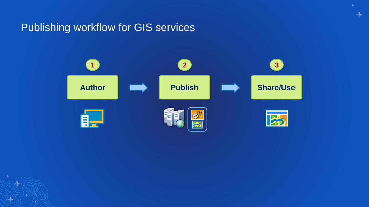
Publishing workflow for GIS services
1
Author Share/Use
3
Publish
2

Publishing network analysis servicesCan be published as two different service types
Network Analysis Service
1. Author using a map document with
network analysis layers
2. Publish the map document as a service
3. Use from Map Viewer and ArcMap (Route
solver only)
Geoprocessing Service
1. Author using geoprocessing tools from the Server toolset
2. Run the tools and publish the result as a service
3. Use from Map Viewer, ArcGIS Pro and ArcMap
1
2
3
1
2
3

Publishing network analysis services should be easy …
I have a network dataset and
want to publish all network
analysis services. Is there a
single tool that can perform the
authoring and publishing of
these services?

Publish Routing Services tool
• ArcGIS Server command line utility
included with ArcGIS Enterprise
10.6 or later
• If publishing to a federated GIS
Server, the tool registers the
network analysis services as portal
utility services
• Requires Network Analyst
extension for ArcGIS Server
• For previous versions of ArcGIS
Enterprise, download a similar tool
from GitHub

Asynchronous geoprocessing service
Network analysis service
Synchronous geoprocessing service
Service to get travel modes
Services
created by
Publish
Routing
Services tool

Registering services with your portal
• Configure as Directions and
Routing utility services in your
portal
• Allows all apps to discover the
network analysis services
• Required by many apps in
order to use the services
• Configured by Publish Routing
Services tool if publishing
services to a federated GIS
Server

Presenter(s)
Demo: Publish
Routing Services
tool

• Do not try to publish network analysis services using standard publishing
workflows
- It is difficult to get all the services published correctly
- Some apps might not work if some services are missing or not configured
correctly
• Manually delete existing network analysis services then recreate new ones
using the publish routing services tool when
- Upgrading to newer versions of ArcGIS Enterprise
- Upgrading street data (for example, using newer version of StreetMap Premium
Publishing tips and tricks

Using Services

Using services in Map Viewer
• Directions button
• Analysis tools
- Most tools in the Use
Proximity toolset
- Choose Best Facilities tool in
Find Locations toolset
- Summarize Nearby tool in
Summarize Data toolset

Using services in ArcGIS Desktop
• Use from Network Analysis gallery in the
Analysis tab within ArcGIS Pro
• Use from a ArcGIS Server connection in
ArcMap

Demo: Using
Network Analysis
Services

Please Share Your Feedback in the App
Download the Esri
Events app and find
your event
Select the session
you attended
Scroll down to
“Survey”
Log in to access the
survey
Complete the survey
and select “Submit”

http://esriurl.com/uc19nas
Slides for this demo theater on Publishing Your Own Network
Analysis Services
Questions?