purpose and scope of project -
TRANSCRIPT
PURPOSE AND SCOPE OF PROJECT
Much of Slippery Rock Creek is underlain by coal, gas, and oil deposits which constitute important economic mineral resources. Commercial mining of coal began in the late 1800's. Initially, the coal was mined with little or no concern for the protection of the land surface and water supplies. These natural resources are necessary for a livable and pleasant environment. Mine drainage flan numerous mines has contaminated and polluted many miles of streams in the watershed, principally in the headwaters. Acidity, iron, manganese, and aluminum contained in this mine drainage have destroyed aquatic life and rendered the streams unfit for domestic, industrial or recreational use.
Commercial extraction of gas and oil developed along a similar path. The
geo-hydrologic conditions of the reservoir rocks in the Slippery Rock Creek project area are such that the potential for developing flowing artesian wells is great. Until the advent of practical and relatively permanent well sealing schemes, many of these walls ware simply abandoned or sealing was achieved (temporarily) by methods such as driving tree stumps into the drill hole and backfilling. Drainage from these walls contributes high levels of dissolved solids, chlorides, sodium, and iron; all causing considerable potential to affect aquatic species and reduce or eliminate the streams potential for use.
Hydrologic and geologic conditions in the 12 square mile study area,
which makes up the headwaters of Slippery Rock Creek, were evaluated to understand their effect and interaction in regard to the production and discharge of acid mine drainage and contaminated gas and oil well discharge. Detailed information on the nature, distribution and structure of applicable coal, oil, and gas members and associated strata; surface and subsurface water occurrences and supplies; were obtained through a monitoring and analysis program. The work was done as part of an engineering program and hydrogeologic investigation to determine the origin, sources and causes of the acid mine drainage which contaminated the discharge from the abandoned oil and gas well known as Big Bertha and to determine the suitability of remedial abatement actions.
During the period between February, 1983 and September, 1983, dis-
charge characteristics, physical and chemical characteristics of water quality, and other hydrologic parameters were obtained from eight (3) surface water sampling and gauging stations in the study area of the watershed.
During the study period, aquifer recharge characteristics, physical and
chemical characteristics of water quality, geophysical characteristics and other hydrologic parameters were obtained for eight sampling zones in the flowing artesian well at the site.
During the study period, each of four piezometers constructed for
groundwater monitoring purposes was sampled to determine the aquifer char-acteristics, physical and chemical characteristics of water quality, geophysical characteristics, and other hydrologic parameters associated with the aquifers.
A constant-recording rain gauge was installed during the study period for purposes of recording and correlating precipitation with increases in discharge if such conditions occurred.
As a result of the engineering study, specific recommendations have been
made for abating the surface mine drainage from the abandoned strip pit at the site and abating the pollutional aspects of the gas and/or oil well discharge at the flowing artesian well.
If and when the proposed remedial work is accomplished, the water quality
in the headwaters of the Slippery Rock Creek watershed will be improved. The study contained herein was established to allow the monitoring and assessment of the effectiveness of future reclamation projects to be easily and cost effectively implemented.

LOCATION AND DESCRIPTION
The Slippery Rock Creek Watershed drains an area of about 410 square miles, or 262,168 acres in west central Pennsylvania. It is an irregular pie-shaped drainage basin, which generally trends in a northeast southwest direction for approximately 30 miles. The watershed has a maximum width of about 20 miles in the northeast portion, and narrows to approximately 3 miles at the southwest boundary and confluence with Connoquenessing Creek.
Included in the Watershed is the northwestern part of Butler County, the
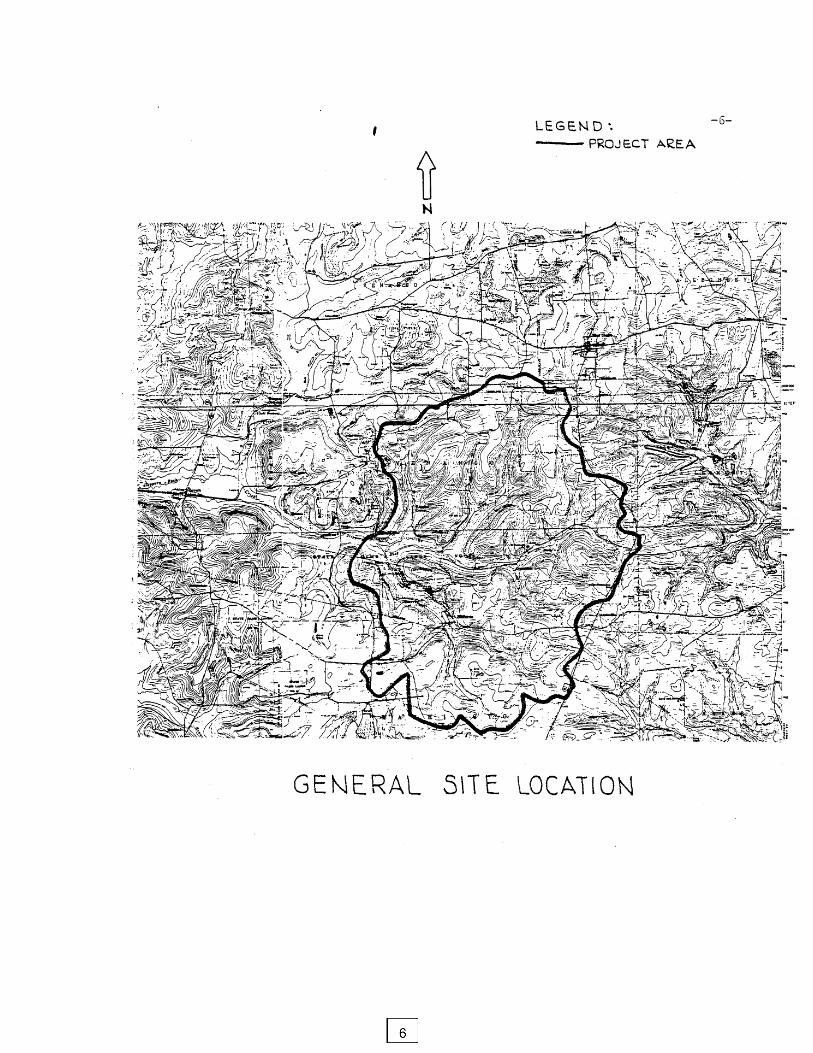
extreme southwestern part of Venango County, the southeastern part of Mercer County, the eastern part of Lawrence County and a small area along the county line in northeastern Beaver County. It is situated approximately 9 miles northwest of Butler and 35 miles north of Pittsburgh. The study area is located at the headwaters of Slippery Rock Creek containing approximately 12 square miles of drainage area.
The site is generally situated in northwestern Pennsylvania in Butler
County. The site is in the Slippery Rock Creek watershed making up the headwaters of the Main Branch of Slippery Rock Creek. The specific site location is Washington and Venango Townships in northeast Butler County near Hilliards and Whiskerville. The site is depicted on the Hilliards and Eau Claire 7.5-minute USGS quadrangles.
The site location is shown on the map on the following page and is also
depicted on Sheet 2 - General Location Map. The topography, physiographic features, and important mine and construction related features are shown on Sheet 3.
Slippery Rock Creek is characteristic of the larger underfit streams
(choked with alluvium) which have wide flood plains, swamps, and steep sided valleys cut by intermittent streams whose sources are near the coal measures. Situated in the Pittsburgh Plateaus Section in the western part of the Appalachian Plateaus physiographic province, the Slippery Rock Creek Watershed is a broad, moderately dissected upland.
Surface features of the watershed are in the early stage of maturity. The
topography consists of gently rolling hills, which are often flat topped, and broad moderate to steep sided valleys with incised streams.
Swamps are common in the lowland areas, where the drainage system
was deranged by Illinoian and Wisconsin glaciation and the land surface is relatively flat. Slopes of 0 to 16 percent are prevalent throughout the watershed. The "duck pond" situated adjacent to the flowing artesian well was formerly a swamp; recently being dammed along the western edge to form a pod for wildlife management purposes.
Slippery Rock Creek headwaters have a confluence with Seaton Creek just
downstream (west) of the project area. Therefore, for all practical purposes, the monitoring of the outflow from the project area is representative of the gross character of discharges emanating from the headwaters of Slippery Rock Creek.
PREVIOUS INVESTIGATIONS Three sources of reference were examined for background information which presents data of same use in determining conditions which existed prior to construction. They are:
1. Report of Project SL-110, Slippery Rock Creek Mine Drainage Pollution Abatement Project, Operation Scarlift, Gwin Engineers, Inc., Altoona, PA 1970.
2. Complex Groundwater and Mine Drainage Problems from a Bituminous
Coal Mine in Western Pennsylvania - D.R. Thompson, Bull. of the Assoc. of Eng. Geologists, Vol. IX, No. 4, 1972.
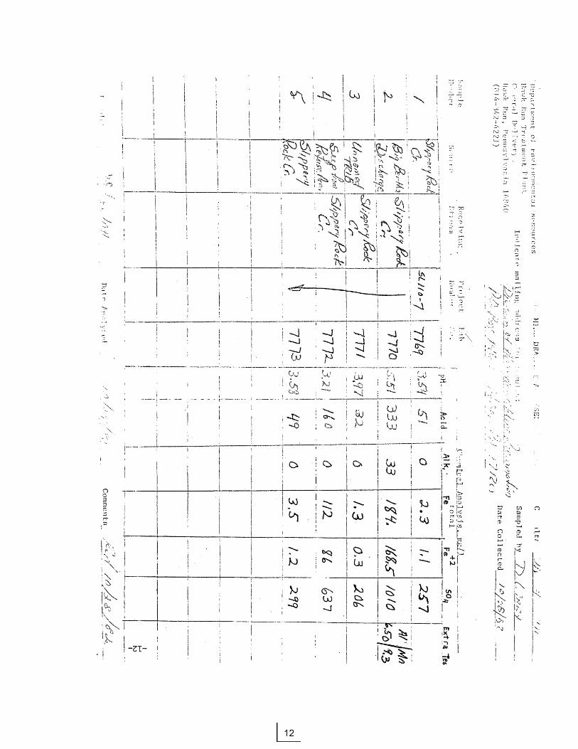
3. PA DER Quality Analyses (collected 10/28/82) The first reference source examined the majority of the Slippery Rock Creek watershed cataloging surface and underground mines detailing their extent and locations of associated discharges. Chemical analysis was performed on most of the mine discharges and at several locations along the length of Slippery Rock Creek. The first major findings for water quality in the headwaters area of Slippery Rock Creek are reproduced below:
1. The most severe condition of coal mine drainage is found in the Slippery Rock Creek Headwaters - Seaton Creek Area. Indeed, very little drainage from this region is produced exclusive of contact with, or issuance from mine workings.
2. The main stream was found to be acid for a length of 12 miles from the headwaters to Bovard. Neutralization and a substantial gain in alkalinity, i.e. greater than 40 mg/l, was determined to occur only after the confluence with Wolf Creek.
The same reference further categorized Slippery Rock Creek as having three distinct chemical reaches. The project area of this report falls into Area A, which was summarized as follows: A - Slippery Rock Creek Headwaters to Bovard including the area streams, tributaries and the mainstem which make up the drainage system to the Bovard Station..... Area A - Slippery Rock Creek above Bovard drains 68.6 square miles by way of four tributary watersheds, the headwaters and twelve miles of mainstream. Of the four tributary streams, one - McMurray Run, was found to be consistently alkaline. North Branch and Blacks Creek were identified as having chemically neutral waters near their points of confluence with the main stream, thereby reducing their beneficial effect to one of dilution, with little in the way of neutralization capacity. Seaton Creek is the lone acid tributary, joining with the main stem at a point 4.39 miles downstream at Argentine. The chemical quality of Seaton Creek and the Slippery Rock Creek - main stem above Seaton shows nearly identical analysis with average acidities of 50 mg/l. The stream bottoms of both branches are covered with deep deposits of iron sludges in visual
evidence of water originating from heavily mined areas. The beginnings of Slippery Rock Creek together with Seaton comprises a drainage area of 26.78 square miles, or about 38.6% of Area A. The resulting water quality for the entire drainage system as measured at Bovard is in the variable range from slightly acid to acid.
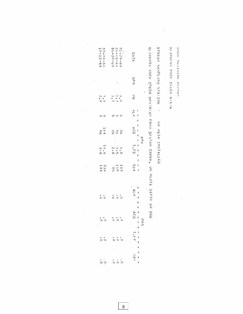
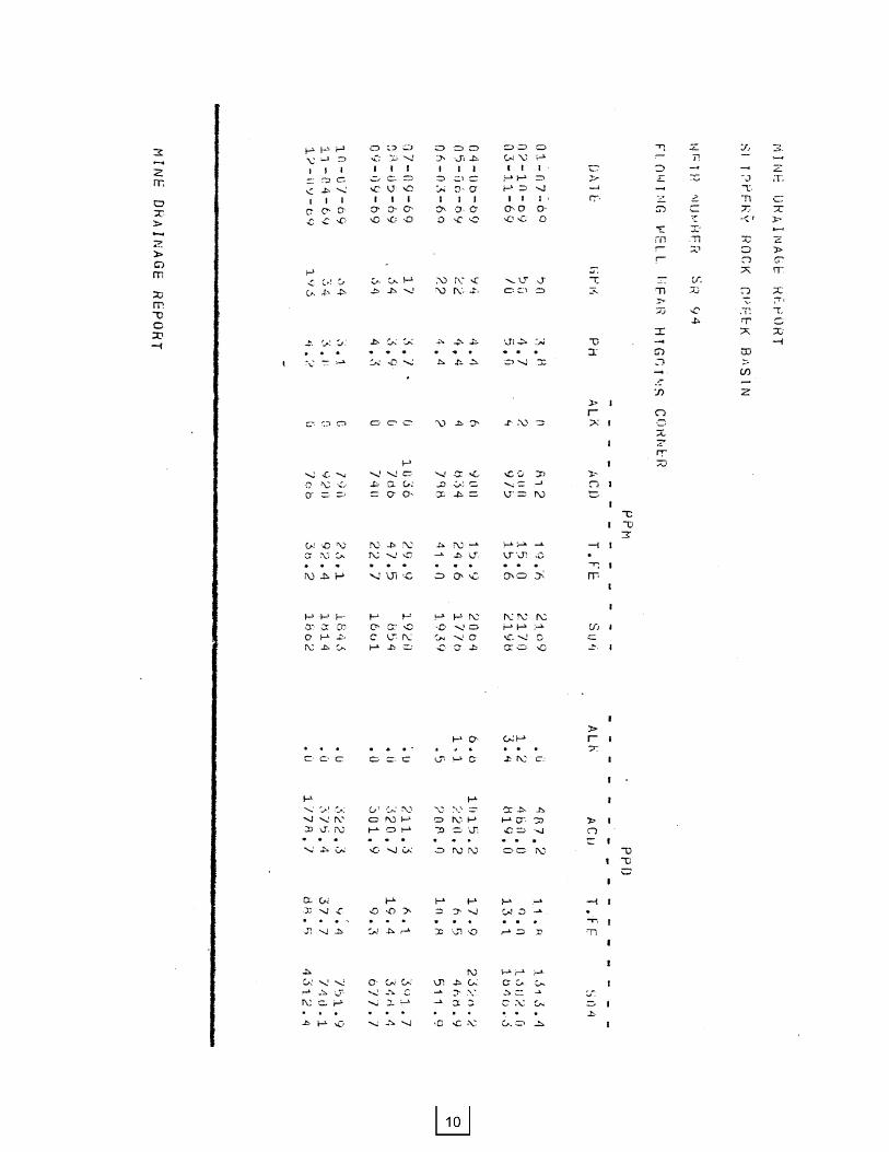
However, the most important part of the first reference is the water quality
data. Two sample locations monitored are virtually identical with that observed for this project. Those points are:
Source Reference One This Report
Big Bertha flowing well SR 94 Sample No. 4
Slippery Rock Creek SSST 1 Sample No. 1 (upstream from Seaton Creek)
Copies of the analyses for the two locations are given on the next two
pages.
The second reference source represents a general examination of the project area proper. The author reached the following conclusions:
The water discharged from the abandoned oil and gas well in the duck
pond comes from the abandoned deep coal mine. This well is recharged from the lagoon and surface infiltration rather than from the deeper artesian oil and gas reservoir.
I base my conclusions on the following:
1. Discharge from the abandoned oil and gas well is low in chlorides and
high in iron and acidity. The chemical quality of this water is typical of coal-mine drainage rather than oil-well brines.
2. During heavy rains it was observed that the abandoned oil and gas well
has a large discharge. Twenty-four hours later, the flow decreases to a mere trickle.
3. An avenue of passage for the wastewater in the lagoon to the old deep
mine was created by the fracturing of the high wall left by strip mining. During this operation, ruptures extended from the bottom of the strip pit to the underlying deep mine.
Based on these statements, I contend that surface runoff from rain and
wastewater in the lagoon flowed into the old mine. This flow moved through the fractured bedrock to the lower areas of the deep mine. One of the low areas in the deep mine is the roan that undoubtedly breached the abandoned oil and gas well. The head generated by the flow to the low areas forces the groundwater to the surface through the abandoned oil and gas well.

Additionally, the author reported the following chemical parameters from a sample of the flowing well:
pH - 2.8 Acidity - 1340 mg/l Total Iron 250 mg/l Sulphates - 1825 mg/l
The third reference source is a sampling of several of the proposed
surface monitoring points after the completion of the well construction and prior to the monitoring program. Discharge was measured at the flowing well (Big Bertha) as 48 gpm during the sampling. The results of this sampling are presented on the following page.
Summarizing the findings of the previous investigation with regard to the
study area, the following conclusions can be made:
1. The most severe degradation of surface water quality in the Slippery Rock Creek originates from the Slippery Rock Creek headwaters (the study area of this report) and the adjacent Seaton Creek watershed (not examined in this report).
2. The average acidity during previous studies for the headwaters of
Slippery Rock Creek was approximately 50 mg/l.
3. The flowing artesian well (Big Bertha) was observed to have acidities varying from 330-1400 mg/l; typically around 800 mg/l. The well was also shown to have a high iron and high sulphate concentration discharge, with values typically being 30 mg/l (iron) and 1600 mg/l (sulphate).
4. The flowing artesian well (Big Bertha) showed readily measured or
observed changes in discharge which were intuitively correlated to precipitation.
CONSTRUCTION PROJECT AT SITE
A construction project was conducted at the site during the period of
October, 1982 through November, 1982. The phases of the construction project were:
1. Rotary drilling and monitor well piezometer installation at R-1. This provides stratigraphic information for strata above the mine, allows for access for geophysical investigations, provides a method of physically and chemically sampling and monitoring the underground mine pool of the Hamilton-Standard mine, and provides a dye injection point for the aquifer interconnection study. The work involved in the installation of the mine piezometer is described below: Installation of Deep Mine Monitoring Well This work involved exploratory drilling to determine the location of the old mine workings such that a monitoring well could be installed in the lowest (structurally downgradient) portion of the mine. Three holes (R1, R.1-A, and R1-B) were rotary drilled before the old workings were successfully located. Sheet 3 shows the location of the three exploratory holes. R1-B was then developed into a true piezometer with full casing and the annular void space between the casing and the edge of the hole was grouted to the surface. R1 and R1-A were grouted full to prevent any migration of aquifer waters to the lower zone of the mine. 2. Cable-tool reaming of Big Bertha flowing artesian well. This provides a clean, open, and unrestricted well to facilitate geophysical logging and subsequent sampling. The work involved in the reaming of Big Bertha is described below: Reaming/Reconstruction drilling at Big Bertha flowing artesian well. This work involved the reaming of the artesian well for the purpose of removing old casing, cleaning out and preparing the hole such that new casing could be installed. Temporary casing was set to 55' depth to maintain an open hole and facilitate geophysical logging operations conducted by U.S. Geological Surveys. 3. Geophysical Logging at Big Bertha flowing artesian well. The geophysical logging is more fully described in the geologic section of this report. Logging at this well was done prior to final casing installation, between 10/11/83-10/13/83. 4. Installation of Groundwater Monitoring Wells
This work involved the development of three true piezometers to observe the groundwater levels. These piezometers were constructed similar to R1-B; such that only the flow zone being monitored is open to the atmosphere, and the rest of the hole is
cased and grouted between the casing and the edge of the hole. Each piezometer (R2, R3, C1) monitors a different flow system. The location of the three holes is shown on Sheet 3. The reviewer will note that the holes are situated on a line between the artesian well and piezometer R1-B. Hole C1 was cored and geophysically legged (10/26/83-10/27/83) PRIOR to construction and grouting of the piezometer. The geophysical logging results are described fully in the geology section of this report. Drill holes R2 and R3 were air-rotary drilled, the piezometers were constructed and grouted with no geophysical logging. This was due to the close proximity of these wells to C1, as shown on sheet 3 of the plans. 5. Final Installation of Casing and Grouting at Big Bertha Flowing Artesian Well. Following geophysical logging of the flowing well, new casing was installed and grouted. This new casing ties installed and grouted to facilitate the installation and operation of a gate valve and pressure gauge assembly. Sheet 3 shows the location of the artesian well. The final depth of the new casing was 72' from ground surface. During the grouting operations, a packer was partially destroyed and lost in the lower reaches of the well. Subsequent investigation reveals the packer is wedged at 210'.