quarterly report to 31 december 2016 asx code: nwf ... · 1/30/2017 · announcement 28th...
TRANSCRIPT

Highlights
Sierra Leone Diamond Project:
Maiden JORC-compliant alluvial Diamond Resource declared for the
Gboyeiya fluvial deposit in EL 15/2012, comprising 7,286 carats
(cts), at an average value of US$ 290 per carat.
Kimberlite drilling program initiated on the recovery of positive
Kimberlite Indicator Minerals (KIMs) and ground magnetometry
(GM) results from the Lake Popei area, EL 11/2014.
Two new suction-dredging units deployed on the Sewa River in EL
15/2012.
Mine-closure report for the Golu small-scale mining licence (SML
01/2015) in EL 15/2012, submitted to the National Minerals Agency
in Freetown.
New 10 ton per hour DMS processing plant successfully
commissioned at Sumbuya, EL 11/2014.
ASX Release: 30 January, 2017
ACN 153 219 848
DIRECTORS
Mr Anthony Ho
(Executive Director)
Mr Michael Lynn
(Executive Director)
Mr Suryandy Jahja
(Non-Executive Director)
CAPITAL STRUCTURE
Shares on Issue: 225.58M
Options on Issue: 16M
Quarterly Report to 31 December 2016 ASX Code: NWF
Photograph of diamonds recovered from the
Gboyeiya Diamond Resource, EL 15/2012.
Newfield Resources Limited
15 McCabe Street
North Fremantle WA 6159
Telephone: +61 8 9389 8880
Facsimile: +61 8 9389 8890
Email: [email protected]
Website: www.newfieldresources.com.au
For
per
sona
l use
onl
y

2
Newfield Quarterly Report to 31 December, 2016
1. ALLOTROPES DIAMOND PROJECT – SIERRA LEONE (NEWFIELD 100%)
Exploration Activities and Results
Newfield Resources Limited (“Newfield” or the
“Company”) is currently active in all five of its
exploration licences covering 1002 km2 of tenement
holdings within the Bo, Bonthe, Moyamba, Pujehun
and Kenema Districts in the Southern Province of
Sierra Leone (Figure 1).
The principal exploration focus in this quarter has
been the acquisition and collation of data for the
Gboyeiya Alluvial Project, culminating in a Maiden
JORC-compliant Diamond Resource statement, and
the initiation of a kimberlite drilling program in EL
11/2014.
The announcement of a Maiden JORC-compliant
alluvial resource on the Gboyeiya Alluvial Project,
was concluded in December 2016. The Gboyeiya
Alluvial Project lies within Allotrope’s exploration
licence EL 15/2012, on the south bank of the Sewa
River and adjacent to the village of Gboyeiya, some
1.6 km downstream and on the opposite bank to the
Golu Small-scale Mining licence (ASX
announcement 1 July, 2015). The average diamond
size is significantly larger (0.66 carats per stone), than that recovered from trial-mining at the Golu Small-scale mining
licence (0.33 carats per stone).
Several geophysical anomalies generated from the 2016 airborne magnetometry (AM) survey have been followed up with
soil-sampling and the completion of a large calibrating ground magnetometry (GM) mega-survey incorporating some 85
line-kilometres of survey completed to date. Soil samples submitted to the MSA laboratories in South Africa returned
positive KIMs in three licences; EL 11/2104, EL 12/2014 and EL 20/2014. EL 11/2014 is host to the Lake Popei
kimberlite dyke (ASX announcements of 16 September and 25 September, 2014) and these results underpin the premise
that the Lake Popei kimberlite dyke lies within a kimberlite field within the regional emplacement trend (N55-600 E).
The wet-commissioning of the Company’s new 10 ton per hour (tph) DMS processing plant which arrived from South
Africa in November 2016, was also completed in the period.
Figure 1. Status of Exploration Licence (EL) holdings, Sierra Leone.
For
per
sona
l use
onl
y

3
Newfield Quarterly Report to 31 December, 2016
The receding water level of the Sewa River has allowed the deployment of two (2) purpose-built suction dredges in EL
15/2012. The construction of a third dredging unit is nearing completion.
An outline of the exploration activities and results, follows.
1. Exploration Licence - EL 15/2012
1.1 Gboyeiya Alluvial Project (Sewa River South-bank): Maiden JORC-compliant Resource
An Inferred Diamond Resource estimation was completed for the Gboyeiya Alluvial Deposit (Figure 2, ASX
announcement 28th December, 2016). The resource estimate relied on:
Trial-mining information acquired from the Golu deposit, being similar in age and depositional environment,
which demonstrated the natural attributes of the deposit (including an average diamond value of US$ 290 per
carat);
Three (3) quasi-equidistant bulk-sample trenches up to 200m x7m in dimension;
A statistically-representative set of samples totalling approximately 500 tons of gravel, contributed to the
resource grade estimation;
Close-spaced (25m centres) in-fill auger drill-holes, which provided knowledge of geological continuity;
A strong understanding of the geological and mineralisation model;
Strong sampling and processing integrity and chain of custody.
Figure 2. Showing combined Inferred Diamond Resource blocking for the Gboyeiya Alluvial Project, comprising intact, un-mined
gravel (blocks 1-5) and remnant gravel occurrences (Artisanal workings: Central zone and Artisanal Workings: Eastern Zone).
For
per
sona
l use
onl
y

4
Newfield Quarterly Report to 31 December, 2016
Table 1 (below) summarises both the in situ and remnant gravel resource. The Diamond Resource has been classified in
the Inferred category, as outlined in the 2012 Edition of the “Australasian Code for Reporting of Exploration Results,
Mineral Resources and Ore Reserves”. The reader is referred to additional details of the estimation methodology in the
JORC Table 1, of the 28 December ASX announcement.
Table 1. Summary table of Inferred resource estimation attributes for both intact (in situ) and remnant gravels within the Gboyeiya
Alluvial Deposit, EL 15/2012, Bo District, Sierra Leone.
1.2 Komende-Buma Alluvial Project
Reconnaissance mapping of the Komende-Buma alluvial terrace and Sewa River flats, just east of the Golu small-scale
mining licence (Figure 3), was completed. Geological features, as well as the location of artisanal workings, were mapped
in preparation auger-drilling. An auger-drilling exercise was recently completed over the Kpakru-south deposit (Figure
4). These exploration programs, will assist in the location of any follow-up bulk-sample sites, should the results warrant
it.
Figure 3. Geological mapping
of the Komende-Buma Alluvial
Project, EL 15/2012. At right,
showing location of the
Komende area, relative to the
Golu Small-scale Mining
Licence (red outline).
For
per
sona
l use
onl
y

5
Newfield Quarterly Report to 31 December, 2016
Figure 4. Geological mapping and results of the auger drilling exercise conducted at the Kpakru locality in EL 15/2012, in H2, 2016.
1.3 Dredging Activities-EL 15/2012
The September 2016 quarterly report, announced that the Sewa River rose as much as five (5) meters above normal (dry
season) elevation, resulting in the suspension of seasonal dredging operations. With the on-set of the dry season, the
receding water-level has allowed the recommencement of dredging operations, and two (2) new dredging units have been
deployed within the EL (Figure 5).
Figure 5. Photo showing one newly-built dredge unit (above), recently deployed on the Kombra pit, Sewa River locality, EL 15/2012
(at right).
For
per
sona
l use
onl
y
6
Newfield Quarterly Report to 31 December, 2016
1.4 Golu Mine Closure Report-SML 01/2015
A comprehensive mine-closure report was submitted to the NMA in October, 2016.
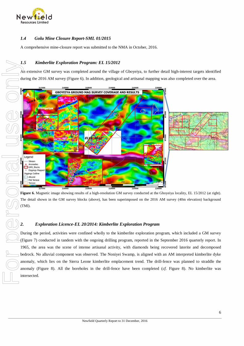
1.5 Kimberlite Exploration Program: EL 15/2012
An extensive GM survey was completed around the village of Gboyeiya, to further detail high-interest targets identified
during the 2016 AM survey (Figure 6). In addition, geological and artisanal mapping was also completed over the area.
Figure 6. Magnetic image showing results of a high-resolution GM survey conducted at the Gboyeiya locality, EL 15/2012 (at right).
The detail shown in the GM survey blocks (above), has been superimposed on the 2016 AM survey (40m elevation) background
(TMI).
2. Exploration Licence-EL 20/2014: Kimberlite Exploration Program
During the period, activities were confined wholly to the kimberlite exploration program, which included a GM survey
(Figure 7) conducted in tandem with the ongoing drilling program, reported in the September 2016 quarterly report. In
1965, the area was the scene of intense artisanal activity, with diamonds being recovered laterite and decomposed
bedrock. No alluvial component was observed. The Noniyei Swamp, is aligned with an AM interpreted kimberlite dyke
anomaly, which lies on the Sierra Leone kimberlite emplacement trend. The drill-fence was planned to straddle the
anomaly (Figure 8). All the boreholes in the drill-fence have been completed (cf. Figure 8). No kimberlite was
intersected.
For
per
sona
l use
onl
y

7
Newfield Quarterly Report to 31 December, 2016
Figure 7. A GM survey was completed near the village of Kponima (at right), on high-interest AM targets. Image shows detail of the
survey, with superimposed geology and artisanal workings.
Figure 8. A drilling program (cross-section, shown above and plan-view, at right) has been completed over an interpreted kimberlite
dyke anomaly (purple line, at right) near the village of Kponima. The drill line, shown as a dotted black line (at right), straddles the
anomaly. Red lines (at right), are Early-Jurassic dolerite dykes.
3. Exploration Licence - EL 19/2014: Hima-Mano Alluvial Project
No active exploration has taken place in this EL during the period. A review of a proposed ground-penetrating radar
(GPR) has been completed in the interim and the survey is expected to commence in Q1,2017 with a Namibian-based
consultant, Earth Maps Consulting. The reconnaissance survey will be conducted over the dolerite dyke boundaries, to
assess the applicability of the GPR in locating scour-features. A bulk-sampling program in 2016, highlighted the
importance of the dolerite riffle-and-scour depositional model for the Hima-Mano deposits (cf. Quarterly Report 30
September, 2016).
For
per
sona
l use
onl
y

8
Newfield Quarterly Report to 31 December, 2016
4. Exploration Licence - EL 12/2014: Sumbuya Project
4.1 Mokombo-Pongolo Alluvial Program-Sumbuya Project
Due to the 2016 wet season, much of the work associated with the low-lying fluvial terraces was limited, or put on hold.
However, the fluvial high-level Pongolo Terrace remained accessible, and delineation-mapping (terrace edge, artisanal
excavations and outcrop) of this down-wasted fluvial deposit was completed (Figure 9). The flank of the swamp
dissecting the terrace (cf. Figure 9), comprises a thick colluvium, containing re-worked, texturally-mature fluvial clasts.
This site has been subjected to intermittent artisanal working over the years. Nonetheless, this terrace has been identified
as a prospective target, given the significant extent of the in situ remnants. Bulk sampling sites are currently being
planned, and these excavations should commence toward the end of H1, 2017.
Figure 9. The Pongolo Terrace Alluvial Project, Sumbuya locality, EL 12/2014. The yellow hatching denotes the extent and
distribution of the terrace colluvium, which has been intermittently worked by artisanal miners. The colluvium contains an inherited
texturally-mature clast assemblage, denoting the probable down-wasting of an older fluvial deposit.
In addition, reconnaissance mapping has been conducted on the lower terrace/alluvial flat (Figure 10) of the Makombo-
Pongolo point-bar. This terrace is significant, due to architectural similarities and spatial correlation with the Golu lower
terrace fluvial deposits.
For
per
sona
l use
onl
y

9
Newfield Quarterly Report to 31 December, 2016
Figure 10. The lower terrace occurrence of the Makomba-Pongolo Terrace deposits, Sumbuya locality, EL 12/2014. The red polygon
denotes the extent and distribution of the fluvial terrace, with respect to the higher-elevation colluvium, which has been intermittently
worked by artisanal miners.
4.2 Kamasu Alluvial Project
The Kamasu Alluvial Project is located North of Sumbuya Town and on the west-bank of the Sewa River. Vehicular
access to this locality is challenging, however a tertiary road from Tissana, through Mofwe and Nyandehun, connects
Kamasu. An initial mapping exercise identified two fluvial terraces, comprising four (4) gravel sequences (Figure 11):
River flat gravel (fluvial gravel).
In situ colluvium gravel (true terrace gravel).
Remobilised colluvium gravel (Reworked).
Colluvium bedrock
Mapping of the terrace edges coincided with the 50m and 100m contour intervals, and artisanal activities show that the
gravel sequences are diamond-bearing. In addition, the tributary streams of the Sewa River also support intense artisanal
activity, with the Yanoi River being the most productive.
For
per
sona
l use
onl
y

10
Newfield Quarterly Report to 31 December, 2016
Figure 11. Kamasu Terrace locality-EL 12/2014 (at right), showing geology of mapped area and fluvial terrace outlines. The western
boundary of the EL is shown as a red line (black, at right).
4.3 Tima Island-Kamasu Alluvial Project
Lying within the Sewa River, the adjacent Tima Island was also mapped in the period (Figure 12). This island is the site
of extensive artisanal activity and may host substantial remnant gravel accumulations.
Figure 12. Tima Island locality, adjacent to the
Kamasu Terrace locality, showing mapped area
(at left) and current artisanal activity (at right).
For
per
sona
l use
onl
y

11
Newfield Quarterly Report to 31 December, 2016
4.4 Mofwe Orientation Visit
This area, just north-west of Sumbuya township, on the right-hand bank of the Sewa River, was considered to have both
high-alluvial and kimberlite potential for former operator, Sierra Leone Diamond Company (SLDC). They conducted
intensive exploration in the form of pitting and test-mining was conducted, with a five (5) ton/per hour DMS plant
commissioned to treat the gravels. Close-spaced reverse-circulation (RC) drilling, delineated some 330,000 cubic metres
of gravels, with only 1500m3 of recovered gravels subsequently being treated, with poor results. SLDC reported average
basal gravel thicknesses of up to 1m, below 4-7m of overburden. SLDC’s inability to reach the basal gravels due to water
ingress, combined with the erratic distribution of gravels, led to the abandonment of the project. A reconnaissance
mapping exercise was completed by Allotropes to determine the location of their old workings and the extent of remnant
gravel distribution (Figure 13).
Figure 13. ALDC reconnaissance visit, Mofwe locality, showing old-workings and geological mapping. SLDC mapped buried
channels (at right), the result of a ground-penetrating radar (GPR) survey conducted in c.2005.
4.5 Jene-Tissana Alluvial Project
The project covers the Modern and palaeo-gravels pertaining to a well-developed accretionary point-bar of the Sewa
River (Figure 14). Three predominant and compositionally distinct, gravel elevations were mapped, comprising youngest
to oldest; river flats, Terrace 1 (lower terrace), Terrace 2 (upper terrace). The riffle-and-scour model developed for the
Hima-Mano deposits in EL 19/2014, seems to be corroborated by the development of deep alluvial workings adjacent to a
large NW-trending dolerite cutting the area (cf. Figure 14). The initial results of the reconnaissance mapping are
encouraging, and warrant further follow-up work.
For
per
sona
l use
onl
y

12
Newfield Quarterly Report to 31 December, 2016
Figure 14. Showing locality and geological mapping of the Jene-Tissana Alluvial Project.
4.6 Kimberlite Exploration Program
Reconnaissance mapping of artisanal workings and reconnaissance soil-sampling for KIMs, was conducted within the EL
during Q4 2016. In addition, several high-priority magnetic anomalies were investigated, adjacent to the village of
Tawamaehun, just south of Sumbuya. Kimberlitic ilmenite was confirmed in this area from samples submitted to MSA in
South Africa, and this supports results reported by previous operator SLDC, who also reported probe-positive kimberlitic
ilmenites from this locality. It is pertinent to note that historic alluvial diamond diggings occur some 150m away from
this anomaly. Thus, several ground-magnetometry (GM) blocks have been designed for follow up geophysical surveying
within the EL.
5. Exploration Licence - EL 11/2014: Alluvial and Kimberlite Exploration Program
5.1 Lake Popei Alluvial Exploration Program
Limited alluvial work was conducted in the EL in the six-month period, as exploration activities to date have centred on
the kimberlite exploration program. However, the fluvial high-level terrace near the Lake Popei kimberlite dyke was
mapped to ascertain any similarities in sedimentary architecture and elevation (erosion level), to the fluvial gravels
delineated at the Momajo Terrace in EL 12/2104. It is uncertain at this stage, whether the diamond content of these Lake
Popei gravels bears any relationship to the nearby kimberlite dyke.
For
per
sona
l use
onl
y

13
Newfield Quarterly Report to 31 December, 2016
5.2. Kimberlite Exploration Program
5.2.1 Follow-up Ground-magnetometry (GM) Surveys and Soil Sampling Activities-Lake Popei
A heavy minerals consignment sent to the MSA laboratories in South Africa returned probe-positive kimberlitic
ilmenites from soil samples recovered from AM anomalies adjacent to the known Lake Popei kimberlite. In addition,
KIMs were recovered from soil samples collected from directly over the surface trace of the Lake Popei kimberlite.
These samples were included in the consignment, to act as an orientation exercise, and to test the efficacy of the other
field sampling and laboratory results for comparative purposes.
An orientation mega-ground magnetometry (GM) survey, overseen by an experienced geophysical consultant, was
completed in the latter part of FY2016, and the results from these data are currently being processed. The ‘Lake Popei
Block’ mega-GM survey was designed to cover all known high interest AM anomalies in the Lake Popei area. A first-
pass plot (1VD) is shown in Figure 15.
Figure 15. First-pass image (1VD) of GM results overlain on AM TMI background in the ‘Lake Popei Block’, EL 11/2014.
Kimberlite dyke-like features are apparent within the magnetically quieter background with the red outlines of the GM survey blocks.
POD 001 (image centre), refers to the original Lake Popei kimberlite dyke discovery.
A single observation trench of c.20m x 6m x 3m dimensions (Figure 16), was excavated over probe-positive KIMs
recovered from a soil sample taken from the AM anomaly POD 011. The trench exposed a thin dolerite/diabase dyke,
which was assumed to be a causative body of the GM anomaly. Whilst the GM anomaly has been resolved, the source
of the indicators is yet to be resolved.
For
per
sona
l use
onl
y

14
Newfield Quarterly Report to 31 December, 2016
Figure 16. Excavation of trench (at left), over
probe-positive KIM soil-sampling results obtained
for the AM Geophysical anomaly, POD 011, EL
11/2014. The causative magnetic body proved to be
a diabase dyke (at right). The source of the KIM
ilmenites is unresolved.
A drilling program has begun on selected high-interest targets near the site of the Lake Popei kimberlite dyke (Figure
17). The first diamond-drill hole targeted the AM and GM anomaly POD 011. No kimberlite has been intersected to date
and the program continues.
Figure 17. The first drill-hole of a series, planned over selected GM targets, Lake Popei area, EL 11/2014.
For
per
sona
l use
onl
y

15
Newfield Quarterly Report to 31 December, 2016
6. Sumbuya DMS Processing Plant, EL 11/2014.
The Company is pleased to report the successful commissioning of a new 10 ton per hour (tph) DMS plant (Figure 18),
during the quarter. The plant, complete with twin flowsort X-Ray recovery units, is fully mobile and will service the
exploration and trial-mining bulk-sample material obtained from the southern-most Els.
Figure 18. The 10 tph plant is the second to be successfully commissioned by the Company. It will process bulk-samples recovered
from the southern licences, and was acquired to circumvent the high-costs and prohibitive distances involved in processing material
through the Golu DMS plant.
7. Community Initiatives and Public Relations
In anticipation of the 2017 dry-season exploration activities, the Company has renewed/re-negotiated royalty contracts
with those communities adjacent to its operations.
The Baoma Chiefdom recently honoured ADCL CEO, Mike Lynn, with the title of Honourary Chief, after receiving a
certificate of appreciation from Paramount Chief on behalf of the Company’s investment initiatives in the community
(ASX announcement, 30 September, 2016).
REFERENCES
Hall, P.K., (1972). The diamond fields of Sierra Leone. Geol. Surv. Sierra Leone Bull. 5 (1); 133 pp.
Ikona, C. K. (2006). Technical Report on Alluvial Diamond Properties –EPL 1/94 & EPL 5/94, Sierra Leone, for Cream Minerals Ltd.,
77pp.
For
per
sona
l use
onl
y

16
Newfield Quarterly Report to 31 December, 2016
COMPETENT PERSON’S STATEMENT- DIAMONDS
The information in this report that relates to Exploration Results, Mineral Resources or Ore Reserves on the Allotropes Diamond’s
Sierra Leone Diamond Project, is based on information compiled by Mr Richard Hall (M.Sc. Geology, Cum Laude) who is a Fellow of
the Australasian Institute of Mining and Metallurgy and a member of the Australian Geological Society, and who is an employee of
Newfield Resources Limited. Mr Hall has sufficient experience which is relevant to the style of mineralisation and type of deposit
under consideration and to the activity which he is undertaking, to qualify as a Competent Person as defined in the 2012 Edition of the
“Australasian Code for Reporting of Exploration Results, Mineral Resources and Ore Reserves”. Mr Hall consents to the inclusion in
this ASX release of this information in the form and context in which it appears.
For
per
sona
l use
onl
y

17
Newfield Quarterly Report to 31 December, 2016
2. NEWFIELD GOLD PROJECT (NEWFIELD 100%)
The Newfield Project comprises two granted mining leases and one granted
prospecting licence. The project is centred approximately 60km NNW of
Bullfinch, in the Yilgarn Mineral Field (Figure 19).
The project covers the historical Newfield (also known as Carterton) Mining
Centre, which is located at the northern end of the highly endowed Southern
Cross greenstone belt. Historical, pre-1940, gold production for the Carterton
group was 8,552 oz. from 8,700t of ore at an average grade of 30.5 g/t Au, with
production mainly coming from the Newfield Central workings.
More recent production at the Newfield Central Mine during the period from
2001 – 2005 resulted in 33,200 tonnes of ore extracted for a total of 24,200
ounces at a recovered grade of 22.68g/t Au.
During the quarter exploration activities comprised inspection of historical
diamond drill core from the Newfield Central Prospect and ongoing
prioritisation of gold targets within the project area.
A review of the existing datasets has identified several high priority gold
targets, which include near surface targets within the strike extensions of the
Newfield Central Fault Zone.
3. CREST YARD GOLD PROJECT (NEWFIELD 70%)
The Crest Yard Gold Project, covers 987 ha, centred between the historical gold mining centres of Kintore and
Dunnsville, located approximately 60km northwest of Kalgoorlie, Western Australia.
Exploration undertaken by the Company on the project to date has included an aeromagnetic survey, a detailed auger
geochemical program and aircore drilling programs. This work has defined several areas of bedrock gold mineralisation
associated with zones quartz veining, Fe-staining, sericite alteration and haematite alteration within the previously
untested Doyle Dam Granodiorite.
The phase two aircore drilling program returned several areas of anomalous bedrock gold mineralisation (greater 100ppb
Au) at or near bottom of drill holes within the southern target area. (NWF ASX Release 30 January, 2015*)
Newfield Resources Ltd continues to review and interpret the results of the previously completed aircore drilling
programs with a view to refining targets for deeper drill testing in the coming quarters.
*In accordance with Listing Rule 5.23.2, the Company confirms in the subsequent public report that it is not aware of any new information or data that
materially affects the information included in the relevant market announcement and, in the case of estimates of mineral resources or ore reserves, that
all material assumptions and technical parameters underpinning the estimates in the relevant announcement continue to apply and have not materially
changed.
Figure 19
For
per
sona
l use
onl
y

18
Newfield Quarterly Report to 31 December, 2016
COMPETENT PERSON’S STATEMENT- GOLD
The information in this report that relates to Exploration Results, Mineral Resources or Ore Reserves on the Newfield and Crest Yard
Gold Projects is based on information compiled by Mr Bryan Alexander who is a member of the Australasian Institute of Mining and
Metallurgy.
Mr Alexander has sufficient experience which is relevant to the style of the mineralisation and type of deposit under consideration and
to the activity which he is undertaking, to qualify as a Competent Person as defined in the 2012 Edition of the “Australasian Code for
Reporting of Exploration Results, Mineral Resources and Ore Reserves”. Mr Alexander consents to the inclusion in this ASX Release
of this information in the form and context in which it appears.
For
per
sona
l use
onl
y

Schedule of Tenements as at 31 December 2016
Project Tenement
Number
Tenement
Name Registered Holder(s)
Newfield’s
Interest
Western Australia
Newfield M77/0422
Newfield Newfield Resources Limited 100%
M77/0846
Woongaring Hills Newfield Resources Limited 100%
Crest Yard P16/2722
Doyle Dam Newfield Resources Limited
Crest Metals Pty Ltd
70%
P16/2726 Doyle Dam Newfield Resources Limited
Crest Metals Pty Ltd
70%
P16/2728 Doyle Dam Newfield Resources Limited
Crest Metals Pty Ltd
70%
P16/2729 Doyle Dam Newfield Resources Limited
Crest Metals Pty Ltd
70%
P16/2730 Doyle Dam Newfield Resources Limited
Crest Metals Pty Ltd
70%
P16/2731 Doyle Dam Newfield Resources Limited
Crest Metals Pty Ltd
70%
Sierra Leone
Baoma EL15/2012 Baoma Allotropes Diamond Company Ltd 100%
Lake Popei EL11/2014 Lake Popei Allotropes Diamond Company Ltd 100%
Sumboya EL12/2014 Sumboya Allotropes Diamond Company Ltd 100%
Hima EL19/2014 Hima Allotropes Diamond Company Ltd 100%
Jomu EL20/2014 Jomu Allotropes Diamond Company Ltd 100%
Golu SML 01/2015 Golu Allotropes Mining Company Ltd 100%
For
per
sona
l use
onl
y

Appendix 5B Mining exploration entity and oil and gas exploration entity quarterly report
+ See chapter 19 for defined terms 1 September 2016 Page 1
+Rule 5.5
Appendix 5B
Mining exploration entity and oil and gas exploration entity quarterly report
Introduced 01/07/96 Origin Appendix 8 Amended 01/07/97, 01/07/98, 30/09/01, 01/06/10, 17/12/10, 01/05/13, 01/09/16
Name of entity
Newfield Resources Limited
ABN Quarter ended (“current quarter”)
98 153 219 848 31 December 2016
Consolidated statement of cash flows Current quarter $A’000
Year to date (6 months)
$A’000
1. Cash flows from operating activities
- - 1.1 Receipts from customers
1.2 Payments for
(710) (2,252) (a) exploration & evaluation
(b) development - -
(c) production - -
(d) staff costs (804) (1,659)
(e) administration and corporate costs (219) (300)
1.3 Dividends received (see note 3) - -
1.4 Interest received 21 73
1.5 Interest and other costs of finance paid - (1)
1.6 Income taxes paid - -
1.7 Research and development refunds - -
1.8 Other (provide details if material) - -
1.9 Net cash from / (used in) operating activities (1,712) (4,139)
2. Cash flows from investing activities
(409) (1,052)
2.1 Payments to acquire:
(a) property, plant and equipment
(b) tenements (see item 10) - -
(c) investments - -
(d) other non-current assets - -
For
per
sona
l use
onl
y

Appendix 5B Mining exploration entity and oil and gas exploration entity quarterly report
+ See chapter 19 for defined terms 1 September 2016 Page 2
Consolidated statement of cash flows Current quarter $A’000
Year to date (6 months)
$A’000
2.2 Proceeds from the disposal of:
- 3 (a) property, plant and equipment
(b) tenements (see item 10) - -
(c) investments - -
(d) other non-current assets - -
2.3 Cash flows from loans to other entities - -
2.4 Dividends received (see note 3) - -
2.5 Other (provide details if material) - -
2.6 Net cash from / (used in) investing activities (409) (1,049)
3. Cash flows from financing activities
- - 3.1 Proceeds from issues of shares
3.2 Proceeds from issue of convertible notes - -
3.3 Proceeds from exercise of share options - -
3.4 Transaction costs related to issues of shares, convertible notes or options
- (24)
3.5 Proceeds from borrowings - -
3.6 Repayment of borrowings (13) (32)
3.7 Transaction costs related to loans and borrowings
- -
3.8 Dividends paid - -
3.9 Other (provide details if material) - -
3.10 Net cash from / (used in) financing activities (13) (56)
4. Net increase / (decrease) in cash and cash equivalents for the period
5,501 8,637 4.1 Cash and cash equivalents at beginning of
period
4.2 Net cash from / (used in) operating activities (item 1.9 above)
(1,712) (4,139)
4.3 Net cash from / (used in) investing activities (item 2.6 above)
(409) (1,049)
4.4 Net cash from / (used in) financing activities (item 3.10 above)
(13) (56)
4.5 Effect of movement in exchange rates on cash held
11 (15)
4.6 Cash and cash equivalents at end of period 3,378 3,378
For
per
sona
l use
onl
y

Appendix 5B Mining exploration entity and oil and gas exploration entity quarterly report
+ See chapter 19 for defined terms 1 September 2016 Page 3
5. Reconciliation of cash and cash equivalents
at the end of the quarter (as shown in the consolidated statement of cash flows) to the related items in the accounts
Current quarter $A’000
Previous quarter $A’000
5.1 Bank balances 1,378 1,479
5.2 Call deposits 2,000 4,022
5.3 Bank overdrafts - -
5.4 Other (provide details) - -
5.5 Cash and cash equivalents at end of quarter (should equal item 4.6 above)
3,378 5,501
6. Payments to directors of the entity and their associates Current quarter $A'000
6.1 Aggregate amount of payments to these parties included in item 1.2 (103)
6.2 Aggregate amount of cash flow from loans to these parties included in item 2.3
-
6.3 Include below any explanation necessary to understand the transactions included in items 6.1 and 6.2
Directors’ remuneration (88)
Professional services (15)
7. Payments to related entities of the entity and their associates
Current quarter $A'000
7.1 Aggregate amount of payments to these parties included in item 1.2 -
7.2 Aggregate amount of cash flow from loans to these parties included in item 2.3
-
7.3 Include below any explanation necessary to understand the transactions included in items 7.1 and 7.2
N/A
For
per
sona
l use
onl
y

Appendix 5B Mining exploration entity and oil and gas exploration entity quarterly report
+ See chapter 19 for defined terms 1 September 2016 Page 4
8. Financing facilities available Add notes as necessary for an understanding of the position
Total facility amount at quarter end
$A’000
Amount drawn at quarter end
$A’000
8.1 Loan facilities - -
8.2 Credit standby arrangements - -
8.3 Other (please specify) - -
8.4 Include below a description of each facility above, including the lender, interest rate and whether it is secured or unsecured. If any additional facilities have been entered into or are proposed to be entered into after quarter end, include details of those facilities as well.
N/A
9. Estimated cash outflows for next quarter $A’000
9.1 Exploration and evaluation (1,000)
9.2 Development -
9.3 Production -
9.4 Staff costs (800)
9.5 Administration and corporate costs (130)
9.6 Other (provide details if material) -
9.7 Total estimated cash outflows (1,930)
10. Changes in tenements (items 2.1(b) and 2.2(b) above)
Tenement reference and location
Nature of interest
Interest at beginning of quarter
Interest at end of quarter
10.1 Interests in mining tenements and petroleum tenements lapsed, relinquished or reduced
N/A
10.2 Interests in mining tenements and petroleum tenements acquired or increased
N/A
For
per
sona
l use
onl
y

Appendix 5B Mining exploration entity and oil and gas exploration entity quarterly report
+ See chapter 19 for defined terms 1 September 2016 Page 5
Compliance statement
1 This statement has been prepared in accordance with accounting standards and policies which
comply with Listing Rule 19.11A.
2 This statement gives a true and fair view of the matters disclosed.
Sign here: ............................................................ Date: 30 January 2017
(Company secretary)
Print name: Kim Hogg
Notes
1. The quarterly report provides a basis for informing the market how the entity’s activities have been financed for the past quarter and the effect on its cash position. An entity that wishes to disclose additional information is encouraged to do so, in a note or notes included in or attached to this report.
2. If this quarterly report has been prepared in accordance with Australian Accounting Standards, the definitions in, and provisions of, AASB 6: Exploration for and Evaluation of Mineral Resources and AASB 107: Statement of Cash Flows apply to this report. If this quarterly report has been prepared in accordance with other accounting standards agreed by ASX pursuant to Listing Rule 19.11A, the corresponding equivalent standards apply to this report.
3. Dividends received may be classified either as cash flows from operating activities or cash flows from investing activities, depending on the accounting policy of the entity.
For
per
sona
l use
onl
y