raaf base tindal pfas management area plan
TRANSCRIPT

RAAF Base Tindal
PFAS MANAGEMENT AREA PLAN
July 2019

PMAP – RAAF Base Tindal
2 July 2019
Contents
1 GLOSSARY..................................................................................................................................... 5
1 INTRODUCTION ............................................................................................................................. 7
1.1 Purpose ................................................................................................................................... 7
1.2 Application ............................................................................................................................... 7
1.3 Background ............................................................................................................................. 7
1.3.1 PFAS and its use............................................................................................................. 7
1.3.2 The nature of PFAS ........................................................................................................ 8
1.4 Policy context .......................................................................................................................... 9
1.4.1 PFAS National Environmental Management Plan .......................................................... 9
1.4.2 Defence estate and environmental management ........................................................... 9
1.4.3 PFAS Response Management Strategy ......................................................................... 9
1.5 Scope .................................................................................................................................... 10
1.6 Guiding principles .................................................................................................................. 11
1.7 Implementation process ........................................................................................................ 12
1.7.1 Approvals ...................................................................................................................... 13
1.7.2 Procurement phase ....................................................................................................... 13
1.7.3 Implementation timelines .............................................................................................. 13
1.7.4 A living document .......................................................................................................... 14
1.8 Roles and responsibilities ..................................................................................................... 14
1.9 Constraints and assumptions ................................................................................................ 15
2 PROFILE OF THE MANAGEMENT AREA ................................................................................... 18
2.1 Management Area description .............................................................................................. 18
2.2 Management Area setting ..................................................................................................... 18
2.3 Management Area scale ....................................................................................................... 20
2.4 Extent of contamination ......................................................................................................... 20
2.4.1 Primary sources ............................................................................................................ 20
2.4.2 Contaminant mass and migration ................................................................................. 21
2.4.3 Indicative transport times .............................................................................................. 22
2.5 Groundwater use ................................................................................................................... 22
2.6 Relevant legislation and government policy .......................................................................... 23
2.7 Interim response management actions ................................................................................. 23
2.8 Stakeholders ......................................................................................................................... 24
3 PMAP METHODOLOGY AND APPROACH ................................................................................. 26
3.1 Overview of approach ........................................................................................................... 26
3.2 Identify risks and consequences (Chapter 4) ........................................................................ 26

PFAS MANAGEMENT AREA PLAN – RAAF BASE TINDAL
3 July 2019
3.3 Prepare Ongoing Monitoring Plan (Chapter 5) ..................................................................... 26
3.4 Develop risk management options (Section 6.1) .................................................................. 26
3.5 Detailed options analysis (Section 6.2) ................................................................................. 27
3.6 Integrated options analysis (Section 6.3) .............................................................................. 27
3.7 Recommendations Analysis .................................................................................................. 27
4 IDENTIFIED RISKS AND CONSEQUENCES .............................................................................. 29
4.1 Source / pathway / receptor analysis .................................................................................... 29
4.2 Risk listing and consequences .............................................................................................. 30
5 ONGOING MONITORING PLAN .................................................................................................. 34
5.1 Overview ............................................................................................................................... 34
5.1.1 Objective and purpose .................................................................................................. 34
5.1.2 Impacted decisions........................................................................................................ 34
5.1.3 Related documentation ................................................................................................. 34
5.2 OMP communications ........................................................................................................... 35
5.3 OMP summary ...................................................................................................................... 35
5.4 OMP review ........................................................................................................................... 36
OPTIONS IDENTIFICATION AND ANALYSIS ..................................................................................... 37
6.1 Options identification and analysis ........................................................................................ 37
6.1.1 Outcomes of comparative analysis – summary ............................................................ 43
6.1.2 Outcomes of comparative analysis – key findings ........................................................ 44
6.2 Integrated options analysis outcomes ................................................................................... 46
7 RECOMMENDED PMAP RESPONSE ACTIONS ........................................................................ 49
7.1 List of recommended PMAP response actions ..................................................................... 49
7.2 Management Measures ........................................................................................................ 50
Response actions for implementation ............................................................................................... 50
Response actions for investigation ................................................................................................... 53
7.3 Comparative PMAP implementation timeframes .................................................................. 56
7.4 Sequential implementation timeframes ................................................................................. 57
8 REVIEW AND UPDATE ................................................................................................................ 58
APPENDIX A: Regulatory and policy analysis
A2 State/Territory Legislation and Policy
APPENDIX B: Interim response management analysis
APPENDIX C Source – pathway – receptor analysis
APPENDIX D Options analysis criteria
APPENDIX E Options listing and analysis
APPENDIX F Ongoing monitoring plan
APPENDIX G Recommendations analysis
APPENDIX H Figures

PFAS MANAGEMENT AREA PLAN – RAAF BASE TINDAL
4 July 2019

PFAS MANAGEMENT AREA PLAN – RAAF BASE TINDAL
5 July 2019
1 GLOSSARY
AEC Area of Environmental Concern
AFFF Aqueous Film Forming Foam
Base A defined physical locality or geographical area from which Defence-
related activities, operations, training or force preparations are
managed, conducted, commanded or controlled.
CFI Capital Facilities Infrastructure
CSM Conceptual Site Model
DSI Detailed site investigation as identified in section 1.1.1
ERA Ecological Risk Assessment
Extended implementation
period
Period when PMAP response actions are required beyond the primary
implementation period. These actions include ongoing:
• monitoring, leachate management, and maintenance of
stockpiles
• monitoring of Management Area for PFAS
• assessment of developments and technologies for application
to stockpiled PFAS impacted soils and materials
FTA Fire Training Area
GAC Granular Activated Carbon
HEPA The Heads of EPAs Australia and New Zealand
HHERA Human Health and Ecological Risk Assessment
HHRA Human Health Risk Assessment
Management Area The geographical area subject to Defence response actions as
described in section 1.1.3
MEOMS Mechanical equipment operations and maintenance section
Off-site Off-Base
On-site On-Base
PFAS Per- and poly-fluoroalkyl substances
PFHxS Perfluorohexane Sulfonate
PFOS Perfluorooctane Sulfonate
PFAS NEMP PFAS National Environmental Management Framework 2018
developed cooperatively between Australian jurisdictions
PM/CA Project Manager/Contract Administrator
Primary implementation
period
The period for completion of PMAP response actions characterised as
primary implementation response actions.
Project site A defined site for construction and maintenance works within a Base
PWC Public works committee

PFAS MANAGEMENT AREA PLAN – RAAF BASE TINDAL
6 July 2019
Remediation Action Plan
(RAP)
Defines the purpose and objectives of the remediation, evaluates and
determines the remediation options, and sets out performance
measures.
Response actions Actions identified as recommended or potential options to address
potential risks
Response Management
Strategy (RMS)
The Defence PFAS Response Management Strategy
Risk assessment(s) The HHERA, HHRA and/or ERA described in section 1.1.1
Source area An area within the Management Area that is, or has the potential to be,
a source of contamination
SSB Site Selection Board

PFAS MANAGEMENT AREA PLAN – RAAF BASE TINDAL
7 July 2019
1 INTRODUCTION
1.1 Purpose
This PFAS Management Area Plan (PMAP) provides a roadmap for response management by
Defence of potential risks arising from Per- and poly-fluoroalkyl substances (PFAS) contamination
associated with RAAF Base Tindal and surrounding areas, consistent with the PFAS National
Environmental Management Plan (NEMP). The location of RAAF Base Tindal is shown in Figure 1,
Appendix H.
Defence’s management of the risks under the PMAP aims to avoid or minimise exposure to PFAS
contamination from Defence property to human health and ecological receptors. In doing so, Defence
prioritises the following combination of measures:
1. Implementing practicable solutions to prevent or minimise the migration of PFAS beyond the
Defence property boundary through:
• reducing the mass of the PFAS contamination source, and/or
• blocking or diverting the migration pathway of the contamination from the source to a
receptor
2. Working to protect the community from exposure while management actions addressing source
areas and/or migration pathways are underway.
1.2 Application
This document will be used by Defence (including contractors) managing or carrying out the response
actions set out in this PMAP.
This document may also be relevant for reference or aligning actions:
• By Defence environmental staff responsible for approving Environmental Clearance
Certificates (ECCs) and any other similar approvals required for implementation of this
PMAP.
• By Defence (including contractors) carrying out construction and maintenance works on
the Defence estate.
• During the development and delivery phases of response actions, including by Site
Selection Boards.
1.3 Background
1.3.1 PFAS and its use
PFAS are a group of synthetic (i.e. ‘man-made’) compounds which include perfluorooctane sulfonate
(PFOS), perfluorohexane sulfonate (PFHxS), and perfluorooctanoic acid (PFOA). PFAS have been
widely used around the world since the 1950s to make products that resist heat, stains, grease and
water. These include hydraulic fluid, stain resistant applications for furniture and carpets, packaged
food containers, waterproof clothing, personal care products and cleaning products.
Due to its effectiveness in extinguishing liquid fuel fires, PFAS was also an ingredient in legacy
aqueous film forming foam (AFFF) used extensively worldwide by both civilian and military authorities

PFAS MANAGEMENT AREA PLAN – RAAF BASE TINDAL
8 July 2019
from about the 1970s. Older formulations of AFFF contained a number of PFAS now known to be
persistent in the environment and in humans.
Most people living in developed nations will have some level of PFAS in their body due to their
widespread use. In June 2016, the Environmental Health Standing Committee (enHealth)1, published
guidance statements advising that there is currently no consistent evidence that exposure to PFOS
and PFOA causes adverse human health effects.2 However, since these chemicals remain in humans
and the environment for many years, it is recommended that as a precaution, human exposure to
PFAS be minimised.
PFAS contamination on and in the vicinity of the Defence estate arises primarily because of the
historic use of AFFF for training purposes or incident control.
The fully fluorinated compounds (per) do not degrade and are expected to remain in the environment
for many decades. The compounds are water soluble and mobile and will tend to migrate with water.
The strength of adsorption to organic carbon in the soil of different compounds in the group varies
depending on the number of carbon atoms in the compound. Long chain compounds (six or more
carbons) also bioaccumulate in animals. Due to the mobility, PFAS compounds can be present in
very large plumes associated with groundwater migration and surface waters. Organic rich sediments
may act as ongoing or seasonal sources of PFAS contamination to surface waters through
resuspension and desorption.
1.3.2 The nature of PFAS
PFAS has many qualities that combine to present particular challenges in locating, containing and
remediating PFAS contamination:
• Water is the prime method of PFAS contamination transferring from a source to a
receptor - a person, animal, plant, eco-system, property or a waterbody.
• PFAS is highly soluble and mobile and can rapidly leach through soils or disperse in
waterways, travelling long distances. This may sometimes reduce the level of
contamination of the original source material.
• PFAS can permeate some solid surfaces. This includes concrete and other building
materials, particularly used in storage tanks, fire training grounds and other large surface
areas.
• PFAS is very chemically and biologically stable and has a low vapour pressure, so it is
resistant to breakdown and evaporation.
• Some PFAS (including PFOS and PFOA) are environmentally persistent and
bioaccumulate. This means that some plants may be susceptible to PFAS, uptaking it
through soil and water. It then bio-accumulates and becomes a part of the food chain.
The same process applies to some animals and fish.
1 EnHealth is a subcommittee of the Australian Health Protection Principal Committee, and is responsible for providing agreed environmental health policy advice. Its membership includes representatives from the Health portfolios of Australian and New Zealand governments.
2 http://www.health.gov.au/internet/main/publishing.nsf/content/health-pubhlth-publicat-environ.htm

PFAS MANAGEMENT AREA PLAN – RAAF BASE TINDAL
9 July 2019
1.4 Policy context
The policy context for the PMAP consists of national guidance in the form of the PFAS National
Environmental Management Plan, Defence estate and environmental strategies, and Defence PFAS-
specific strategies and guidance.
1.4.1 PFAS National Environmental Management Plan
The NEMP aims to provide governments with a consistent, practical, risk-based framework for the
environmental regulation of PFAS-contaminated materials and sites. The NEMP has been developed
collaboratively by the Heads of EPAs Australia and New Zealand and the Commonwealth Department
of Environment and Energy (DoEE) and has been endorsed by the Commonwealth Government.
The PFAS Response Management Strategy and the requirements of the PMAP template and
guidance conform to the NEMP.
1.4.2 Defence estate and environmental management
The Defence Estate Strategy 2016-2036 and the Defence Environmental Strategy 2016-2036 each
provide strategic direction for the management of risks associated with PFAS contamination.
Under the Defence Estate Strategy 2016-2036, sustainability is one of five strategic aims for the
management of the Defence estate.3 Under this strategy, the environment and its ongoing sustainable
management is viewed as a critical enabler to Defence capability. For legacy contamination, including
emerging contaminants such as PFAS, Defence is committed to minimising the impacts of the use of
the estate on surrounding communities, proactively investigating and responding to contamination,
and working with affected communities and State/Territory authorities.
The Defence Environmental Strategy 2016-2036 provides further strategic focus. Relevant strategic
aims are:
Strategic Aim 1: Defence will deliver a sustainable estate.
Strategic Aim 2: Defence will understand and manage its environmental impacts.
Strategic Aim 3: Defence will minimise future pollution risks and manage existing contamination
risks.
1.4.3 PFAS Response Management Strategy
The PFAS Response Management Strategy (RMS) is a high-level strategy document that sets out the
approach and principles to be applied to PFAS response management. Under the RMS sit three
integrated components:
PFAS Management
Area Plan (PMAP)
template and
guidance
The template on which this PMAP is based, with embedded guidance for
the comprehensive PFAS response plan for a Defence Base and its
vicinity, based on the outcomes of the Detailed Site Investigations and the
risk assessments.
PFAS Interim
Response
Management (IRM
Guidelines)
Guidance to manage a specific risk rather than the set of risks associated
with a property. These risks will generally emerge during the investigation
phase. Where it is important that the risk be managed before the PMAP is
in place to avoid or mitigate a significant risk to human health or the
3 Defence Estate Strategy 2016-2036, Strategic Aim 4: http://www.defence.gov.au/EstateManagement/Governance/EstateStrategy.asp
PFAS MANAGEMENT AREA PLAN – RAAF BASE TINDAL
10 July 2019
environment, the IRM guidelines provide a process for developing,
assessing and recommending options, scalable from community-level
actions through to PWC referral actions.
PFAS Construction
and Maintenance
Framework
Guidance on the management of PFAS risks when carrying out
constructions and maintenance projects on the Defence estate for a site
that is, or is likely to be, contaminated by PFAS.
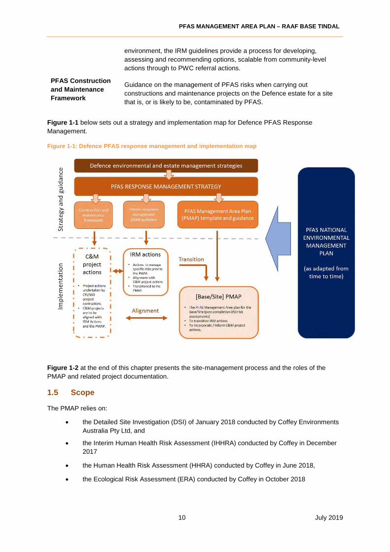
Figure 1-1 below sets out a strategy and implementation map for Defence PFAS Response
Management.
Figure 1-1: Defence PFAS response management and implementation map
Figure 1-2 at the end of this chapter presents the site-management process and the roles of the
PMAP and related project documentation.
1.5 Scope
The PMAP relies on:
• the Detailed Site Investigation (DSI) of January 2018 conducted by Coffey Environments
Australia Pty Ltd, and
• the Interim Human Health Risk Assessment (IHHRA) conducted by Coffey in December
2017
• the Human Health Risk Assessment (HHRA) conducted by Coffey in June 2018,
• the Ecological Risk Assessment (ERA) conducted by Coffey in October 2018

PFAS MANAGEMENT AREA PLAN – RAAF BASE TINDAL
11 July 2019
• the Supplementary Detailed Site Investigation (SDSI) conducted by Coffey in September
2018
to inform risk identification and weighting for the Management Area.
The key parameters for the PMAP are set out below.
Management Area On-Base areas, shown in Figure 2, Appendix H, related to:
• Fire Section and associated surface drains
• Fire Training Area
• Mechanical equipment and operations maintenance section
and associated drainage infrastructure
• Fuel Farms 1 and Fuel Farm 2
• Tindal Creek
Off-Base areas
• Properties using groundwater in the areas designated as
Zone 1 and Zone 2 (Figure 3, Appendix H)
• Tindal Creek
• Katherine River downstream of Knott’s Crossing to Daly
River, including properties drawing water from the river
Issue/risk identification The DSI, HHRA and ERA identified the following risks related to
PFAS impact from the Base:
• Risks of elevated human exposure through drinking
contaminated water
• Risks of elevated human exposure through consumption of
contaminated foods
• Risks of elevated human exposure through direct contact
with contaminated soils, sediments or waters
• Risks to aquatic ecology
• Risks to terrestrial ecology
• Potential future non-compliance with waste transport
regulations.
Issue/risk range Unrestricted: includes health, environmental and community issues
Management timeframe Short, medium and long-term response actions (ref Section 7.2):
comprehensive response document extending beyond primary
implementation period to an extended implementation period, where
appropriate
Remediation technology
status
The response options in this PMAP consider only proven
technologies at the appropriate scale, unless otherwise agreed by
Defence.
Beyond specific active remediation technologies, the impact of
construction earthworks, remedial or incidental capping and
changes in water flow regimes is also considered to have the
potential to affect the control of PFAS migration.
1.6 Guiding principles
When developing and recommending appropriate response actions, the principles considered (in
accordance with the Defence PFAS Response Management Strategy and the NEMP) include:
PFAS MANAGEMENT AREA PLAN – RAAF BASE TINDAL
12 July 2019
• whether an option is proportional to risks
• the sustainability and longevity of an option
(environmental, economic and social) in
achieving an appropriate balance between
benefits and effects
• views of the affected community and the
jurisdictional regulator
• availability of best-practice management
systems, treatments and technologies
• site specific issues (including transference,
cross-contamination, and remobilisation)
• effectiveness and validation status of
technology
• success measures for the treatment or
remediation outcomes
• the need for ongoing operations,
management, maintenance or monitoring
• the net environmental benefit, after taking
into account the environmental costs of the
solution
Defence prioritises source management as
preferable to pathway management and pathway
management as preferable to receptor management,
but these components may be progressed
concurrently.
1.7 Implementation process
Defence will undertake project management of the overall PMAP, including monitoring of
implementation and progressive evaluation (six-monthly intervals in the first year, then annually) of
the implementation.
This will inform any changes to, and re-alignment of, the PMAP.
Some interim response actions will be in progress or in the mid-point of approval processes at the
commencement of this PMAP, having been transitioned from IRM actions (see Section 2.7).
Other actions under the PMAP will be subject to Defence approval and procurement processes,
including where relevant, the processes of the Parliamentary Standing Committee on Public Works
Committee (PWC) processes.
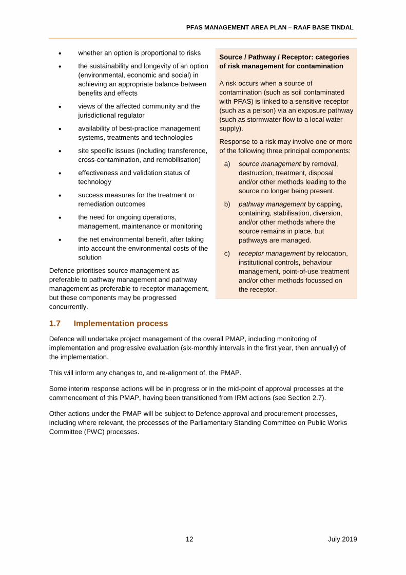
Source / Pathway / Receptor: categories
of risk management for contamination
A risk occurs when a source of
contamination (such as soil contaminated
with PFAS) is linked to a sensitive receptor
(such as a person) via an exposure pathway
(such as stormwater flow to a local water
supply).
Response to a risk may involve one or more
of the following three principal components:
a) source management by removal,
destruction, treatment, disposal
and/or other methods leading to the
source no longer being present.
b) pathway management by capping,
containing, stabilisation, diversion,
and/or other methods where the
source remains in place, but
pathways are managed.
c) receptor management by relocation,
institutional controls, behaviour
management, point-of-use treatment
and/or other methods focussed on
the receptor.
PFAS MANAGEMENT AREA PLAN – RAAF BASE TINDAL
13 July 2019
1.7.1 Approvals
a) Higher value public works
Larger public works (exceeding $15 million in expenditure) require a referral to the PWC. Under very
limited circumstances, exemptions from the PWC process are available:4
• urgency
• for defence purposes where that scrutiny could be contrary to the public interest, or
• for projects of a repetitive nature.
Medium works (exceeding $2 million but less than $15 million in expenditure) require a notification to
the PWC. PWC assessment of a notification may result in:
• approval to proceed
• approval to proceed, subject to specific conditions or requirements
• Committee deliberation postponed, pending further information, or
• Committee resolution to seek a referral.
For higher value public works, a timeframe of up to 12-24 months may apply commencement of the
development phase of the project to approval to commence the delivery phase. The processes may
include all necessary Government and Parliamentary approvals, including PWC. This may require
interim measures to be implemented to manage the risks until the response action has received
approval to commence.
b) Site Selection Board
Where relevant, the Defence Site Selection Board (SSB) is required to determine the location of
response actions and any supporting infrastructure (for example, containment areas or water
treatment plants).
The question as to whether a regional or full review is required will be determined in accordance with
Defence Estate Quality Management System (DEQMS) guidance5
1.7.2 Procurement phase
Once the PMAP is approved by Defence (and subject to the approvals in Section 1.7.1), Defence will
undertake procurement actions (in order of priority) for relevant specific response actions in
accordance with the Commonwealth Procurement Rules and standard Defence procurement
processes. These specific response actions will be implemented and evaluated in accordance with
the terms (including timeframes) of the relevant procurement agreement.
1.7.3 Implementation timelines
The outcomes of the procurement processes will inform the detailed project implementation timelines.
The PMAP is divided into two implementation periods:
1. The primary implementation period applies to actions that can generally be addressed in the
short to medium term (up to three years. Ref Section 7.2).
4 Public Works Committee Act 1969, sections 18(8) and 18(8A) 5 http://www.defence.gov.au/EstateManagement/lifecycle/SiteSelection/Task4.asp

PFAS MANAGEMENT AREA PLAN – RAAF BASE TINDAL
14 July 2019
2. The extended implementation period commences once the primary implementation period has
completed. It applies to response actions required beyond the primary implementation period on
an ongoing or long-term basis. These actions include ongoing:
• monitoring, leachate management, and maintenance of stockpiles
• monitoring of the Management Area for PFAS
• ongoing operation of remediation technologies (e.g. a water treatment plant), as required
• assessment of developments and technologies for application to stockpiled PFAS
impacted soils and materials.
Response actions under this PMAP are designated as forming part of:
a) the primary implementation period
b) the extended implementation period, or
c) both the primary and extended implementation periods (e.g., monitoring of the Management
Area for PFAS).
1.7.4 A living document
The science of understanding PFAS impacts and ways of managing PFAS contamination are
constantly evolving. There is still a lot that is not established about the impacts of PFAS
contamination on human health and the environment. Similarly, remediation technologies, and of the
required scale, are at various stages of research and development.
This PMAP has been prepared based on information available at the time of writing and relies on the
findings of the DSI and the Risk Assessments. Defence recognises that there may still be gaps in
information that will be progressively addressed while impacted sites are being managed.
This document will be reviewed and updated every six months for the first year, then annually (or
earlier if required). As implementation of the PMAP progresses, detailed plans supplementary to this
PMAP will be prepared (as required) to address the individual management actions that have been
identified in this PMAP.
1.8 Roles and responsibilities
Roles PFAS Management Responsibilities
Capital Facilities Infrastructure
(CFI)
• Deliver Defence construction projects. PFAS management of
construction projects under the Construction and
Maintenance Framework is to be aligned with the PMAP.
Defence Environmental and
Sustainability Officers including
ADES, RESO, REO
• Oversight of environmental and heritage issues for a
specified base/s.
• Review relevant Construction Environmental Management
Plans.
• Approve Environmental Clearance Certificates &
Remediation Action Plans.
Environment and Engineering
Branch
• Defence SME and policy owner for environment,
engineering, heritage, contamination management, pollution
prevention, energy, water and waste management within
Defence.
• Approve construction and maintenance project specific
documentation.

PFAS MANAGEMENT AREA PLAN – RAAF BASE TINDAL
15 July 2019
Roles PFAS Management Responsibilities
Environmental Consultant • Contracted by Defence or on behalf of Defence to undertake
environmental testing, provide technical advice (including
site auditing) or develop proposals/plans/certificates.
Lead Consultant • Contracted to Defence to prepare the PMAP
PFAS Investigations
Management Branch (PFASIM)
• Project manages detailed PFAS environmental investigation
and response programs at a specified base.
• Provision of Defence and whole of government PFAS related
policies.
• Coordinate resolution of enquires within PFASIM Branch.
Develop & promote PFAS guidance and management
resources within Defence, including CFI & SDD
stakeholders.
Project Manager/Contract
Administrator (PMCA)
• Contracted to Defence to provide project/contract
management oversight of specific response actions.
• Holds pertinent project and contract documentation.
Public Works Committee (PWC) • Required to approve higher value public works (exceeding
$15 million) and assess public works with a value of between
$2 million and $15 million).
Site Selection Board • Approve the siting of semi-permanent and permanent
structures, including the location of response actions and
any supporting infrastructure.
Service Delivery Division and its
contactors (SDD)
• Maintenance projects delivered by base service EMOS
contractors.
• PFAS management of maintenance projects under the
Construction and Maintenance Framework is to be aligned
with the PMAP.
• Deliver some medium works projects
State/Territory environmental
regulator
• Approve licences for transportation of waste and
storage/disposal of waste at licenced waste disposal
facilities.
• Sets limits or guidance values for soil and liquid waste
disposal or discharge.
• Consultation or inform on remediation activities within
state/territory jurisdictions.
1.9 Constraints and assumptions
This document has been developed based on the following assumptions:
• Information collected, the key assumptions and limitations made, as part of the investigation
works to date are valid, as documented within:
o Detailed Site Investigation (DSI) – PFAS, Coffey, February 2018.
o PFAS Human Health Risk Assessment (HHRA), Coffey, June 2018.
o Ecological Risk Assessment (ERA), Coffey, October 2018.

PFAS MANAGEMENT AREA PLAN – RAAF BASE TINDAL
16 July 2019
o Supplementary Detailed Site Investigation, Coffey, September 2018.
Key assumptions/limitations used in evaluating risks are summarised in the reports noted above.
Assumptions made in this document include:
• Availability of proven technologies for the successful remediation of PFAS in the
environment
o Management and remedial technologies summarised in the NEMP (2018).
o Additional technologies based on successful trials within and outside of Australia
(based on publicly available information).
o Technologies that are not considered economically viable or feasible for use at
RAAF Base Tindal have been excluded (as recommended in NEMP 2018).
• Offsite facilities to accept PFAS contaminated waste are not present in the Northern Territory.
• Existing operating areas of the Base will continue to operate in similar layout and purpose.

PFAS MANAGEMENT AREA PLAN – RAAF BASE TINDAL
17 July 2019
Figure 1-2: Defence PFAS management process

PFAS MANAGEMENT AREA PLAN – RAAF BASE TINDAL
18 July 2019
2 PROFILE OF THE MANAGEMENT AREA
2.1 Management Area description
The management area relates to on-Base and off-Base areas where management of land, waters or
infrastructure is recommended in order to reduce control of people or environmental receptors to
PFAS. RAAF Base Tindal management areas are described in three parts: land and infrastructure
management; groundwater management; and surface water management. A layout of the Base is
presented in Figure 1 and management areas are presented in Figure 2, Appendix H.
Land and Infrastructure: Specific areas on Base contain elevated concentrations in soil or
infrastructure that warrant targeted management or further investigation. These areas are:
• Fire Section (specifically the area to the south west of the Fire Station, and beneath the
main hardstand as shown in Figure 4, Appendix H).
• Fire Training Area (an area of up to 350 m x 250 m as shown in Figure 5, Appendix H).
• Mechanical equipment operations and maintenance section (MEOMS) (specifically at Motor
Transport, Tanker Maintenance, Mechanical Equipment and Ground Equipment
Maintenance, and General Engineering as shown in Figure 6, Appendix H).
• Fuel Farm 1 and Fuel Farm 2 (as shown in Figure 2, Appendix H).
• Wastes from the Sewage Treatment Plant (as shown in Figure 2, Appendix H).
Groundwater: The area requiring management of groundwater use and includes RAAF Base Tindal
and areas of Uralla, Katherine East, Katherine and Lansdowne, where groundwater contains PFAS in
concentrations above the Health Based Guidance Value for Drinking Water. The extent of the area is
shown in Figure 3, Appendix H.
Surface Water: The area requiring management of surface water use includes surface water runoff of
PFAS to base drains, depressions, open pits, Tindal Creek and Katherine River. The extents are:
Katherine River downstream of Knott’s Crossing to the junction with Daly River; and Tindal Creek on-
Base and between the Base boundary and the discharge point to Katherine River.
2.2 Management Area setting
Table 0-1 Management Area Setting
Aspect Description
Regional meteorology
The Base and surrounding area fall within the Australian tropical savanna region which covers a substantial portion of northern Australia. The savanna is characterised by a Wet season that begins in October and lasts through March (with the heaviest rainfall from December through March) and a Dry season from about April through September. The mean monthly rainfall (from 1969 to 2017) ranges between 0.7mm in June and 266mm in January. Mean daily evaporation ranges from 4.9mm in June to 7.9mm in October.
Topography The Base is relatively flat, sloping gently toward Tindal Creek (south-west orientation) with some small hills and limestone outcropping. Base elevations range from approximately 130 m AHD to 140 m AHD. The Mechanical

PFAS MANAGEMENT AREA PLAN – RAAF BASE TINDAL
19 July 2019
Aspect Description
equipment and operations maintenance section (MEOMS) area has an elevation approximately 10 metres higher than the Fire Training Area.
Geology and hydrogeology
Hydrogeological units in the Groundwater Management Area comprise the:
• Antrim Plateau Volcanics (basalts forming the base of the Tindall Limestone aquifer).
• Tindall Limestone aquifer. • Jinduckin Formation (southern edge of the management area). • Cretaceous sediments (overlying the Tindall Limestone).
Localised on-base geology generally comprised of residual cretaceous sediments and overlying Tindall Limestone. The thickness of the weathered cretaceous sediments and weathered section of the Tindall Limestone varied across the site and appeared to be thickest in the southern area near Tindal Creek, where it extended below the depth of investigation (greater than 20 m).
In the Katherine area, groundwater flow in the unconfined Tindall Limestone aquifer flows toward the Katherine River. Most groundwater levels from registered bores do not show long‐term rising or falling trends, indicative of hydraulic response in a very transmissive aquifer. The major springs on the river are the discharge points for these systems.
Soil landscape The Base and off-Base Management Area in general is characterised by lateritic clays (red brown, high to medium plasticity) over weathered karstic limestone. Outcrops of limestone and sandstone are present in some areas, and many sinkholes have been mapped over the karst limestone. Southern portions of the Base have variable thickness of weathered siltstone and limestone (Cretaceous rock and Jinduckin formation) overlying the weathered karstic limestone of the Tindall Limestone.
Vegetation The terrestrial environment at Tindal consists of large areas of bushland and open forest, with the majority characterized by Darwin box and/or bloodwoods woodland with sorghum, white grass, and tussock grasses. Many of the savanna grasses are shallow rooted annuals that grow in response to rainfall. Fruiting and flowering trees and plants are present in the riparian areas. Patches of irrigated grass lawns are found in the landscaped areas at RAAF Base Tindal. To the west of the Base are small scale mango farms, rural residential properties and a quarry.
Management Area
drainage
Surface water run-off is collected via a series of concrete and earthen drains and is directed to two formalised channels. The bulk of the surface run-off from the base is discharged to Tindal Creek at a location upstream of the sewage irrigation paddock, and a location downstream of the northwest end of the airstrip.
Tindal Creek is an ephemeral tributary of Katherine River, and is fed by surface water from bushland and scrubland in the upper portions, but becomes groundwater fed in the Wet season, from Uralla through to the southern edge of Katherine.
Current and
projected land
uses (off-Base)
The Katherine township is the fourth largest urban area in the Northern
Territory with a population of 11,000. The town is set on the banks of the
Katherine River with residential areas spread up and down river of the Stuart
Highway bridge, mostly on the eastern side of the river. Residential,
educational, commercial and recreational areas dominate the Katherine

PFAS MANAGEMENT AREA PLAN – RAAF BASE TINDAL
20 July 2019
Aspect Description
township. The area between Katherine and RAAF Base Tindal comprises
rural properties, an industrial park, a quarry, the Government Research Farm
and pastoral reserves.
2.3 Management Area scale
The scale of the Management Area is rated as Very Large in accordance with the Table 2-2 below.
Table 0-2 Management Area Scale
Characteristics Consequences
Very
Large
• High number of identified risks
• Multiple areas of contamination, both on-
Base and off-Base
• hydrogeological profile facilitates rapid
migration of contamination
• large impacted community
− PMAP complex
− Development / implementation
timeframe: highly extended
Large • Medium number of identified risks
• Multiple areas of contamination, both on-
Base and off-Base
• Medium-sized impacted community
− PMAP moderately complex
− Development / implementation
timeframe: extended
Medium • Small-medium number of identified risks
• Localised areas of contamination both on-
Base and off-Base
− PMAP simplified
− Development / implementation
timeframe: medium
Small • Small number of identified risks
• Contamination currently confined to
isolated locations on-Base
• Potential risk of contamination to a small
number of sensitive receptors
− Basic PMAP
− Development / implementation
timeframe: medium
2.4 Extent of contamination
The extent of PFAS at the Base (and in off-Base areas) has been defined in detail within the DSI
(Coffey 2018a) and HHRA (Coffey 2018b) reports. Soil analytical results for relevant Area of
Environmental Concern (AEC) are illustrated in Figures 4 and 5, Appendix H. A summary of the
CSM is provided below.
2.4.1 Primary sources
Source areas at the site relate to PFAS storage, distribution or use at the Base. Direct measurement
of media such as soil, sediment and water as part of the DSI identified the primary source areas on-
Base as being the following:
• Fire Training Area (affecting an area up to 350m x 200m in soil)
• Fire Station (affecting an area of up to 300m x 300m in soil)
• Mechanical Equipment Operations Maintenance Sections (affecting infrastructure
and small areas of soil)
• Fuel Farm 1 and Fuel Farm 2 (minor)
• Sludge in the on-Base Sewage Treatment Plant (minor)
PFAS MANAGEMENT AREA PLAN – RAAF BASE TINDAL
21 July 2019
PFAS contamination emitted from the primary source areas on the Base is migrating from the site via:
• Leaching to groundwater (Tindall Aquifer) and subsequent flow with groundwater west
toward the Katherine River, discharging to the river within the Management Area. This
pathway has resulted in contamination of groundwater above the drinking water guideline
value between the Base and Katherine River in a plume between 6 and 8 km wide.
• Surface water flow in Katherine River from the discharge zone (starting at Knott’s Crossing)
to the intersection with Daly River. Contamination is present above drinking water
guideline values in the Dry season, but dilution from runoff across the catchment leads to
concentrations below the trigger values in the Wet season.
• Leaching and surface water run-off via site drains and Tindal Creek, which flows through
Uralla and discharges to the Katherine River in Katherine South during the Wet season.
Concentrations vary through the Wet season but are typically above drinking water
guideline values and above recreational guidance values in drains associated with source
areas or in Tindal creek downstream from the Base runway.
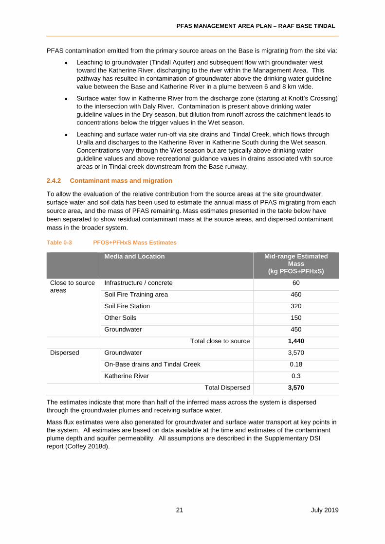
2.4.2 Contaminant mass and migration
To allow the evaluation of the relative contribution from the source areas at the site groundwater,
surface water and soil data has been used to estimate the annual mass of PFAS migrating from each
source area, and the mass of PFAS remaining. Mass estimates presented in the table below have
been separated to show residual contaminant mass at the source areas, and dispersed contaminant
mass in the broader system.
Table 0-3 PFOS+PFHxS Mass Estimates
Media and Location Mid-range Estimated Mass
(kg PFOS+PFHxS)
Close to source areas
Infrastructure / concrete 60
Soil Fire Training area 460
Soil Fire Station 320
Other Soils 150
Groundwater 450
Total close to source 1,440
Dispersed Groundwater 3,570
On-Base drains and Tindal Creek 0.18
Katherine River 0.3
Total Dispersed 3,570
The estimates indicate that more than half of the inferred mass across the system is dispersed
through the groundwater plumes and receiving surface water.
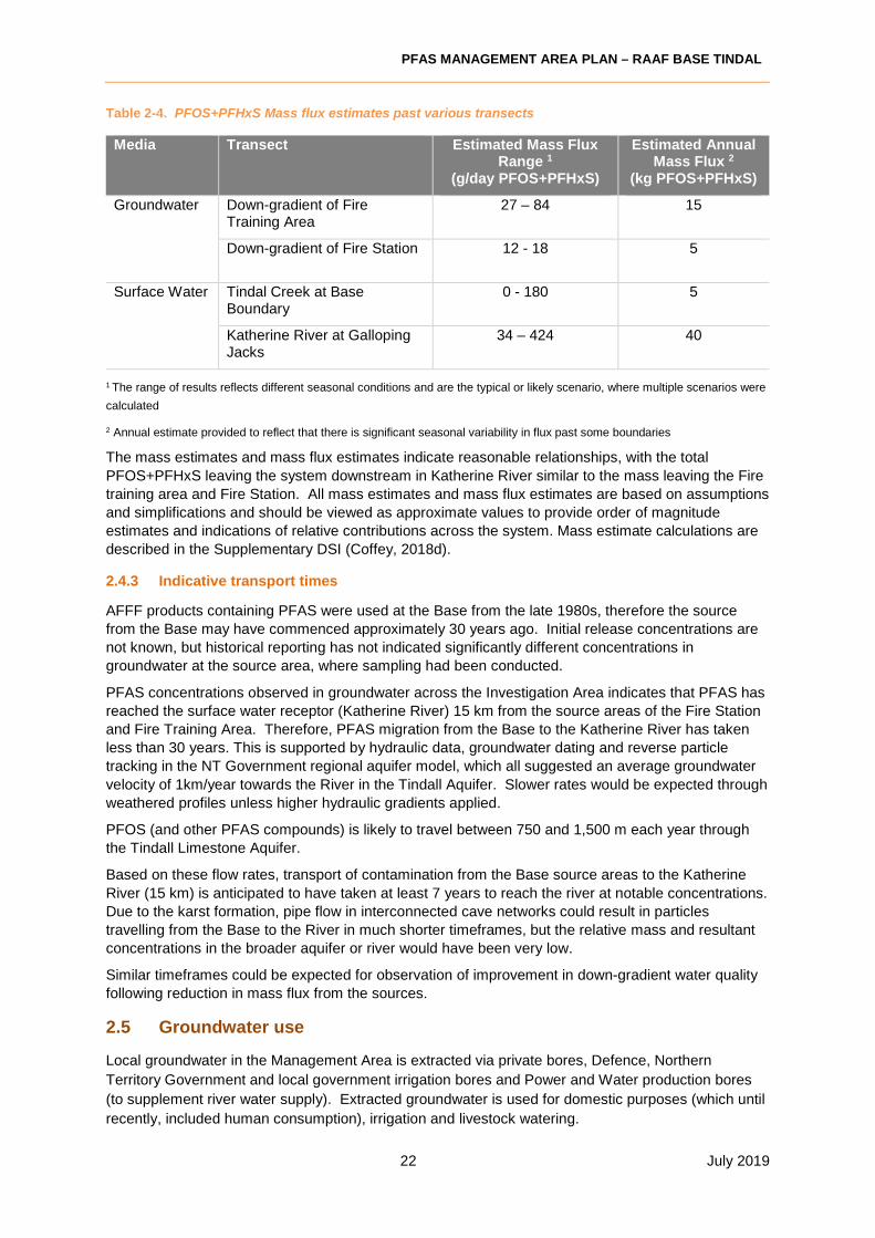
Mass flux estimates were also generated for groundwater and surface water transport at key points in
the system. All estimates are based on data available at the time and estimates of the contaminant
plume depth and aquifer permeability. All assumptions are described in the Supplementary DSI
report (Coffey 2018d).
PFAS MANAGEMENT AREA PLAN – RAAF BASE TINDAL
22 July 2019
Table 2-4. PFOS+PFHxS Mass flux estimates past various transects
Media Transect Estimated Mass Flux Range 1
(g/day PFOS+PFHxS)
Estimated Annual Mass Flux 2
(kg PFOS+PFHxS)
Groundwater Down-gradient of Fire Training Area
27 – 84 15
Down-gradient of Fire Station 12 - 18 5
Surface Water Tindal Creek at Base Boundary
0 - 180 5
Katherine River at Galloping Jacks
34 – 424 40
1 The range of results reflects different seasonal conditions and are the typical or likely scenario, where multiple scenarios were
calculated
2 Annual estimate provided to reflect that there is significant seasonal variability in flux past some boundaries
The mass estimates and mass flux estimates indicate reasonable relationships, with the total
PFOS+PFHxS leaving the system downstream in Katherine River similar to the mass leaving the Fire
training area and Fire Station. All mass estimates and mass flux estimates are based on assumptions
and simplifications and should be viewed as approximate values to provide order of magnitude
estimates and indications of relative contributions across the system. Mass estimate calculations are
described in the Supplementary DSI (Coffey, 2018d).
2.4.3 Indicative transport times
AFFF products containing PFAS were used at the Base from the late 1980s, therefore the source
from the Base may have commenced approximately 30 years ago. Initial release concentrations are
not known, but historical reporting has not indicated significantly different concentrations in
groundwater at the source area, where sampling had been conducted.
PFAS concentrations observed in groundwater across the Investigation Area indicates that PFAS has
reached the surface water receptor (Katherine River) 15 km from the source areas of the Fire Station
and Fire Training Area. Therefore, PFAS migration from the Base to the Katherine River has taken
less than 30 years. This is supported by hydraulic data, groundwater dating and reverse particle
tracking in the NT Government regional aquifer model, which all suggested an average groundwater
velocity of 1km/year towards the River in the Tindall Aquifer. Slower rates would be expected through
weathered profiles unless higher hydraulic gradients applied.
PFOS (and other PFAS compounds) is likely to travel between 750 and 1,500 m each year through
the Tindall Limestone Aquifer.
Based on these flow rates, transport of contamination from the Base source areas to the Katherine
River (15 km) is anticipated to have taken at least 7 years to reach the river at notable concentrations.
Due to the karst formation, pipe flow in interconnected cave networks could result in particles
travelling from the Base to the River in much shorter timeframes, but the relative mass and resultant
concentrations in the broader aquifer or river would have been very low.
Similar timeframes could be expected for observation of improvement in down-gradient water quality
following reduction in mass flux from the sources.
2.5 Groundwater use
Local groundwater in the Management Area is extracted via private bores, Defence, Northern
Territory Government and local government irrigation bores and Power and Water production bores
(to supplement river water supply). Extracted groundwater is used for domestic purposes (which until
recently, included human consumption), irrigation and livestock watering.
PFAS MANAGEMENT AREA PLAN – RAAF BASE TINDAL
23 July 2019
2.6 Relevant legislation and government policy
The PFAS National Environmental Management Plan (NEMP) aims to provide governments in
Australia with a consistent, practical, risk-based framework for the environmental regulation of PFAS-
contaminated materials and sites. It is framed as an adaptive plan, able to respond to emerging
research and knowledge.
The PFAS NEMP provides the guiding framework for the management of PFAS. For further
information, see: http://www.epa.vic.gov.au/PFAS_NMP.
Legislation and policy instruments relevant to the development of options for PFAS management in
the Management Area is set out and discussed in Appendix A.
The Northern Territory (NT) Environmental Protection Authority (EPA) requires contaminated sites
that pose or threaten to pose serious or material environmental harm as defined in the Waste
Management and Pollution Control Act (“the Act”) to be assessed in accordance with the
requirements for environmental audits in the Act. The NT EPA requires assessment of site
contamination to be conducted in accordance with the NEPM.
The Water Act is the primary piece of legislation that governs water resource regulation and
management in the NT. The objective of the Water Act is “to provide for the investigation, allocation,
use, control, protection, management, and administration of water resources”. Under the Water Act,
beneficial uses can be declared for specific water bodies and water quality objectives are established
to describe the water quality targeted to protect the relevant beneficial uses.
Relevant legislation in NT
• Environmental Assessment Administrative Procedures.
• Environmental Protection (National Pollutant Inventory) Objective.
• Environmental Assessment Act.
• Environmental Offences and Penalties Act.
• Northern Territory Environment Protection Authority Act.
• Waste Management and Pollution Control Act.
• Waste Management and Pollution Control (Administration) Regulations.
• Water Act.
• Water Supply and Sewerage Services Act.
• Work Health and Safety (National Uniform Legislation) Act.
2.7 Interim response management actions
Interim response management (IRM) actions are actions in accordance with the Interim Response
Management (IRM) Guideline, or preceding that guideline, to provide for necessary avoidance or
mitigation of risks prior to the completion of the DSI and/or risk assessments. While some actions
have concluded, others are current and have been assessed for continued implementation and
transition to this PMAP.
Appendix B sets out the IRM actions relevant to the Management Area and assesses their impact.
The following IRM actions have been assessed for continued implementation and a recommendation
has been made to continue or terminate those actions:

PFAS MANAGEMENT AREA PLAN – RAAF BASE TINDAL
24 July 2019
Table 2-5. Interim response actions
IRM ACTION RECOMMENDATION
Continue / TerminateREASON
1. Provision of bottled water Continue as required Provision of bottled water is a short-term measure.
2. Provision of rainwater tanks Continue (as required) Provide a long-term alternative water supply
3. Installation of interim ECT2 water treatment plant at the Power & Water Corporation water treatment plant
Continue (until long-term plant commissioned)
Operation required to remove PFAS from groundwater used in the town water supply
4. Installation of on-Base source area ECT2 water treatment plants (x2) at the FTA and Fire Station, to reduce contaminant migration from these source areas.
Continue Operation required to reduce PFAS mass leaving the Base in groundwater
Recommendations for a continuation of interim response actions will form part of the PMAP.
2.8 Stakeholders
Information about the PFAS investigation at RAAF Base Tindal has been provided through community
shopfronts and community walk-in sessions. Information has also been shared through the use of
factsheets letterbox drops, emails from the hotline. An indigenous community engagement program is
also being conducted to raise awareness of impacted aquatic foods with local indigenous
communities.
Local Community
• Residents and occupiers in the Management Area
• Katherine Community Consultative Group
• General public
• Operators of tourism and real estate businesses in the Region
• Representatives from the Rockhole, Myalli, Binjari, and Geyulkgan communities.
Local Media
• Katherine Times
• NT News
• ABC Radio
Government Stakeholders
• Local Government:
o Katherine Town Council
• NT Government
o NT Department of the Chief Minister
o NT Health
o NT EPA
o NT Department of Environment and Natural Resources
o NT Department of Primary Industries & Resources
o Power & Water Corporation

PFAS MANAGEMENT AREA PLAN – RAAF BASE TINDAL
25 July 2019
• Federal Government:
o Department of Health
Elected Officials:
• Katherine Town Council:
o Mayor of Katherine
• NT Government:
o Chief Minister of the NT,
o Territory Member for Katherine.
• Federal Government:
o Senator for the NT,
o Senator for the NT and the Minister for Indigenous Affairs,
o Federal Member for Lingiari,
Commonwealth and State/Territory members of Parliament

PFAS MANAGEMENT AREA PLAN – RAAF BASE TINDAL
26 July 2019
3 PMAP METHODOLOGY AND APPROACH
3.1 Overview of approach
This PMAP conforms to the PFAS National Environmental Management Plan. The Northern Territory
Environment Protection Authority and Department of Health have been consulted in the development
of the PMAP.
Stakeholder engagement associated with specific response actions recommended through the
development of the PMAP will be addressed as relevant in the detailed implementation documents for
those actions.
The PMAP methodology steps through the following stages set out in this section.
3.2 Identify risks and consequences (Chapter 4)
The list of risks to be managed in this PMAP are identified as ‘elevated’ in either the DSI and/or the
risk assessments. A source / pathways / receptor analysis based on the CSM in the DSI was used to
identify the relevant source (primary and secondary), pathways and receptors for the risk. For each
risk, the range of potential consequences if the risk is realised have been identified.
3.3 Prepare Ongoing Monitoring Plan (Chapter 5)
An ongoing monitoring plan (OMP) forms a mandatory part of the PMAP and is therefore provided
separately and has not been subject to the options analysis.
3.4 Develop risk management options (Section 6.1)
Management option/s were identified to address each of the risks identified in Chapter 4. The list of
options has been informed by a range of information and research, both general and specific to the
Management Area. Management Area-specific information including:
• Risk assessments, CSM and DSI;
• Relevant Commonwealth and State/Territory legislation
• Feedback from stakeholder consultation (impacted community and jurisdictional regulator)
• IRM actions undertaken or continuing in the Management Area
• IRM or PMAP actions undertaken or considered by Defence on other properties
The management options include
• the ‘do-nothing’ option. It provides the ‘base case’ against which other options are
assessed and may at times be the best available option when assessed against the criteria
of ‘net environmental benefit’. It does not get assessed through this process, but the
potential impacts are described in the Chapter 4 analysis.
• IRM actions recommended under Section 2.7 for continued implementation are included as
options for further assessment.
• Additional investigations required to address uncertainties and data gaps as identified
through completion of the DSI.
• Community-level options for further assessment.
Identifying information for each option includes the objective and a description of how the objective
contributes to managing the identified risk.

PFAS MANAGEMENT AREA PLAN – RAAF BASE TINDAL
27 July 2019
3.5 Detailed options analysis (Section 6.2)
For each risk, the following analysis was undertaken for the selected management options:
A. Cost / effectiveness / impact analysis
1 Cost range estimate
2 Effectiveness rating
3 Implementation period / timeframe
4 Potential impacts
5 Estimated net environmental benefit
B. Risk-based analysis
6 Proportion of action to risk
7 Best-practice status
8 Verification status
9 Technology assessment
10 Risks and mitigation
11 Key dependencies
C. Defence implications
12 Defence capability
13 Project fit
14 Scalability
D. Stakeholder impacts, views and consents
15 Jurisdictional regulator/s
16 Owner / occupier consents and views
17 Community
E. Comparative analysis
Comparative analysis comparing the available options to manage an identified risk.
Details of the analysis for each of these factors are set out in Appendix D.
3.6 Integrated options analysis (Section 6.3)
Cost savings and efficiencies may be found by looking for synergies that optimise outcomes, in
particular:
• analysing the outcomes of the comparative analysis for each identified risk for synergies in
the Management Area, and
• assessing extended implementation actions for suitability in a Base’s existing maintenance
framework (consultations with Defence).
Where these synergies have been found, they are presented as an integrated package addressing
the relevant sets of risks.
3.7 Recommendations Analysis
The recommended PMAP response actions for each identified risk are based on the comparative
analysis and the integrated analysis from Parts C and D of the methodology. They are supported by a
comparison of PMAP response action implementation timeframes.

PFAS MANAGEMENT AREA PLAN – RAAF BASE TINDAL
28 July 2019
A recommended sequential implementation schedule was then developed, taking into account:
• the nature, immediacy, severity, and extent of the consequences identified in the Part A of
the methodology
• the comparative options analysis; and
• the integrated options analysis.

PFAS MANAGEMENT AREA PLAN – RAAF BASE TINDAL
29 July 2019
4 IDENTIFIED RISKS AND CONSEQUENCES
4.1 Source / pathway / receptor analysis
The identification of sources of impact at RAAF Base Tindal and the associated pathways to
receptors are described in the DSI report (Coffey 2018a) and the supplementary DSI report (Coffey
2018d). Quantification and evaluation of risks related to specific pathways are presented for human
receptors in the Human Health Risk Assessment (Coffey 2018b) and for ecological receptors in the
Ecological Risk Assessment (Coffey 2018c). The source areas, migration pathways and receptor
groups are described below.
Table 4-1. Key sources, pathways and receptors
Sources Pathways Receptors
Primary source areas:
• Fire Training Area • Fire Station
• Vertical migration of PFAS in shallow soils around source areas into groundwater.
• Migration of PFAS in groundwater through the Tindall Limestone aquifer, flowing to the west-north-west, towards Katherine River.
• Transfer of PFAS between groundwater and surface water via sinkholes and seepage from shallow groundwater (during the Wet season).
• Discharge of PFAS in groundwater into Katherine River through springs
• Migration of PFAS down-stream in Katherine River.
• Extraction of groundwater from the Tindall Limestone aquifer via groundwater bores for potable (drinking water) and non-potable (irrigation and recreational) uses.
• Pumping of water from Katherine River for potable (drinking water) and non-potable (irrigation and recreational) uses.
• Consumption of terrestrial plants and animals that have accumulated PFAS by frequent contact with contaminated soils or waters.
Human Health 1:
• Consumers of heavily impacted bore water as a primary drinking water source.
• Consumers of high volumes of moderately impacted bore water or river water as a primary drinking water source.
• Consumers of home-grown produce (eggs and meat) irrigated using PFAS impacted bore water.
• Consumers of aquatic biota from Tindal Creek or Katherine River (downstream of Knott’s Crossing).
• Base construction or maintenance workers in direct contact with impacted soils and effluent in source areas.
Ecological 2:
• Aquatic invertebrates, amphibians and fish in impacted waters in source areas.
• Plants in direct contact with soils in source areas.
• Birds and mammals that eat fish from Tindal Creek.
• Birds and mammals that eat plants, invertebrates
Additional minor
source areas:
• Fuel Farm 1 and Fuel Farm 2
• Mechanical Equipment Operations Maintenance Section
Secondary source
areas:
• Sediments in open Base drains and Tindal Creek
• Sediments and waters in Base closed drainage infrastructure (pits, drains and sewers)
• PFAS impacts in sediments or residual salts mobilised by surface water runoff in the Wet season. PFAS migration through the on-Base drainage network into Tindal Creek and infiltration to groundwater.
• Migration of PFAS in surface water along Tindal Creek, ultimately discharging to Katherine River or infiltrating to groundwater.
• Movement of contaminated biosolids or sediments to more sensitive locations.

PFAS MANAGEMENT AREA PLAN – RAAF BASE TINDAL
30 July 2019
Sources Pathways Receptors
• Biosolids from the on-Base sewerage treatment plant
and reptiles from source areas.
1 Further detail in Human Health Risk Assessment (Coffey 2018b). Other receptors and pathways did not indicate elevated
intake. 2 Further detail in Ecological Risk Assessment (Coffey, 2018c). Other receptors and pathways did not indicate elevated intake
by direct or indirect routes.
A summary of the source-pathway-receptor pollutant linkages is presented in Appendix C.
4.2 Risk listing and consequences
Elevated risks have been identified related to compliance, human health and ecological exposure.
The risks were identified based on conditions described in the DSI and Supplementary DSI reports
and risks quantified in the HHRA and ERAs.
“Elevated” is defined as events that would lead to human exposure over the tolerable daily intake
(TDI), ecological exposure over the screening benchmarks or NOAEL, breaches of legislation or
regulatory notices.
The risks listed in Table 4-3 below have been considered based on individual areas of environmental
concern (as identified within the DSI, HHRA, ERA and Supplementary DSI) so as to align with
proposed management actions more clearly. The immediacy and consequence rations have been
based on the Department of Defence Contamination Risk Assessment Tool guidance definitions, with
compliance risks assessed against “Financial” and “Legislative” criteria, and human health and
ecological risks assessed against “Environment – Stage 3 Risk Assessment” criteria.
To provide an indication of what each consequence category is based on, the following summary is
provided in Table 4-2. Health, ecological or compliance risks are interpreted in isolation and the
highest ranked risk is presented in Table 4-3.
Table 4-2. Health, Ecological and Compliance risks categories
Consequence Health and/or Ecological ComplianceSevere Major HI greater than 10 Financial costs between $2M and $4M, breach of
legislation that has potential for prosecution Moderate HI between 1 and 10 Financial costs between $100k and $2M, breach
of legislation that has potential for sanction Minor HI between 0.1 and 1 Financial costs between $25k and $100k,
technical breach of legislation Insignificant
Notes: HI = Hazard Index
Subsequently, in the column ‘Immediacy’, an assessment is made of the probability of the risk
occurring for the outcome. This assessment is ranked based on site-specific conditions as follows:
• Rare (may occur only in exceptional circumstances)
• Unlikely (may occur in the future)
• Possible (might occur within the next 10 years)
• Likely (will probably occur within the next year)
• Current (either occurring or almost certainly will occur)

PFAS MANAGEMENT AREA PLAN – RAAF BASE TINDAL
31 July 2019
The elevated risks are described in the table below for each AEC and if the identified risk is a
Compliance risk (C), Human Health (HH) risk or an Ecological Exposure (Ec) risk as denoted by a .

PFAS MANAGEMENT AREA PLAN – RAAF BASE TINDAL
32 July 2019
Table 4-3. Identified risks
AEC ID Identified Risks C HH Ec Immediacy ConsequenceFire Station
A1 Movement of soil to more sensitive areas may present an exposure risk to water ways or human health
Possible Moderate
A2 Movement of soil off-site requires approval and transport to a licenced facility Unlikely Moderate
A3 Surface water run off represents a source of impact to Tindal Creek, resulting in human health exposure through consumption of fish
Possible Major
A4 Surface water run off represents a source of impact to Tindal Creek, resulting in ecological exposure to terrestrial and aquatic ecosystems
Current Moderate
A5 Contact with soil during construction excavation works may represent significant human exposure
Possible Moderate
A6 Migration of PFAS in groundwater represents source of impact to Katherine River, resulting in human health exposure through consumption of fish
Current Moderate
A7 Migration of PFAS in groundwater represents a source of impact to Katherine River, resulting in ecological exposure to terrestrial and aquatic ecosystems
Current Minor
A8 Migration of PFAS in groundwater represents a human health exposure through extraction and domestic use of bore water.
Current Major
A9 Migration of PFAS in groundwater represents a human health exposure through extraction and use of bore water in town water supply
Current Major
A10 Contact with soil and surface water, uptake by plants and bioaccumulation through the ecological food web may represent a significant exposure.
Current Moderate
A11 Concentrations exceed anticipated Stockholm Convention reporting limit (50 mg/kg) Current Minor
Fire Training Area
B1 Movement of soil to more sensitive areas may present an exposure risk to water ways or human health
Possible Moderate
B2 Movement of soil off-site requires approval and transport to a licenced facility Unlikely Moderate
B3 Migration of PFAS in groundwater represents a source of impact to Katherine River, resulting in human health exposure through consumption of fish
Current Moderate
B4 Migration of PFAS in groundwater represents a source of impact to Katherine River, resulting in ecological exposure to terrestrial and aquatic ecosystems
Current Minor
B5 Migration of PFAS in groundwater represents a human health exposure through extraction and domestic use of bore water.
Current Major
B6 Migration of PFAS in groundwater represents a human health exposure through extraction and use of bore water in town water supply
Current Major
B7 Soil contact, uptake by plants and bioaccumulation through the ecological food web may represent a significant exposure.
Current Moderate

PFAS MANAGEMENT AREA PLAN – RAAF BASE TINDAL
33 July 2019
AEC ID Identified Risks C HH Ec Immediacy ConsequenceB8 Extended contact with groundwater during construction excavation works may
represent significant human exposure Possible Moderate
B9 Regular contact with effluent in ponds may represent significant human exposure Current Major
B10 Concentrations exceed anticipated Stockholm Convention reporting limit (50 mg/kg) Current Minor
Fuel Farm 1
C1 Movement of soil to more sensitive areas may present an exposure risk to water ways or human health
Possible Minor
C2 Movement of soil off-site requires approval and transport to a licenced facility Unlikely Minor
Fuel Farm 2
D1 Movement of soil to more sensitive areas may present an exposure risk to water ways or human health
Possible Minor
D2 Movement of soil off-site requires approval and transport to a licenced facility Unlikely Minor
Sewage Treatment Plant
E1 Movement of sludge / biosolids to more sensitive areas may present an exposure risk to water ways or human health
Possible Minor
MEOMS F1 Movement of soil to more sensitive areas may present an exposure risk to water ways or human health
Possible Moderate
F2 Movement of soil off-site requires approval and transport to a licenced facility Unlikely Minor
F3 Regular contact with effluent in tanks may represent significant human exposure Likely Moderate
Immediacy and Consequence ratings have been based on Department of Defence Combined Risk Assessment Tool (CRAT) guidance definitions, with
Compliance risks assessed against “Financial” and “Legislative” criteria, and Human Health and Ecological Risks assessed against “Environment – Stage 3
Risk Assessment” criteria. “Reputation” criteria have also been considered for all risks and in the case of impact to town water supply and domestic water
supplies was used to upgrade the consequence from “Minor” and “Moderate” as indicated by HI alone, to “Major”.
Likelihood ConsequenceCurrent (Almost Certain) Severe Likely Major (HI >10, $2M<financial cost< $4M, breach of legislation that has potential for prosecution) Possible Moderate (1<HI<10, $100K<cost<$2M, breach of legislation that has potential for sanction) Unlikely Minor (0.1<HI<1, $25K<cost<$100K, technical breach of legislation) Rare Insignificant

PFAS MANAGEMENT AREA PLAN – RAAF BASE TINDAL
34 July 2019
5 ONGOING MONITORING PLAN
5.1 Overview
The Management Area ongoing monitoring plan (OMP) monitors changes to the contamination plume
and surface water contamination characteristics.
Changes may result from the specific or cumulative impact of remediation or containment actions,
existing transportation trends, changes to hydrogeology, or weather events. Future construction and
development works also have the potential to change contaminant movement by changing access to
contaminated soils or altering surface water and groundwater flow.
The ongoing monitoring plan (OMP) for the Management Area is set out in Appendix F. An OMP
forms a standard component of all PMAPs.
5.1.1 Objective and purpose
The objective of the OMP is to provide information on changes in PFAS contamination originating
from a Defence Base to inform risk management decisions by Defence and State/Territory
agencies to protect human health and the environment.
Data on changes in the distribution, concentration, transport (pathways and flow rates) and
transformation of the contaminants and assessment against appropriate guideline values provides:
• an evidence base for targeted and effective risk management of PFAS contamination to
protect human health and environmental receptors currently impacted by PFAS.
• an early warning that additional management of PFAS contamination may be warranted in
areas not currently affected by PFAS.
5.1.2 Impacted decisions
Changes detected through the implementation of the OMP may inform a number of risk-management
decisions including:
• additional investigations
• re-assessment of one or more remediation or containment actions
• additional remediation or containment actions
• modification of capital works design or construction
• changing risk management actions at receptor level (e.g. provision or cessation of
alternate drinking water supplies)
• changes to State/Territory advice on types of exposure-minimisation behaviours (e.g.,
consumption of home produce or seafood)
• changes to State/Territory advice on boundaries of a designated management area and the
management zones within
• changes or refinements to the monitoring network, frequency and parameters
5.1.3 Related documentation
Current IRMs related to water treatment at the Fire Training Area and town water treatment plant
have their own monitoring plans to verify performance of those actions.
One or more specific remediation action plans (RAPs) are likely to be developed for the Management
Area for specific remedial options. The RAPs will contain specific monitoring actions to assess and
validate the impact of that remediation plan.

PFAS MANAGEMENT AREA PLAN – RAAF BASE TINDAL
35 July 2019
5.2 OMP communications
The following will be shared with relevant Territory authorities and made publicly available:
• OMP
• monitoring data collected during the implementation of the OMP
• decisions made in response to the data collected during implementation of the OMP
• changes to the OMP in response to incoming data over the implementation period
5.3 OMP summary
Table 5-1. OMP Summary
Aspect Description PurposeTimeframe The OMP in Appendix F is
recommended to be implemented for an initial period of three years prior to review and revision.
An initial period of three years has been selected during implementation of any management options.
Review and revision of the OMP will allow for changes in the nature and extent of PFAS contamination in the Management Area to be reflected in the monitoring network and frequency.
Inspections Undertake inspections of any management actions implemented and review associated documentation (such as cap inspections, checking condition of fencing erected around source areas and review of permit to dig records)
Monitoring of implemented management actions in order to assess their success and ensure they are being undertaken, followed and/or maintained.
Groundwater monitoring
A total of 36 bores (including investigation bores and private/extractive bores) sampled on an annual basis. Selected wells may be sampled more frequently, where variability is more likely.
Monitor the extent of PFAS impact in groundwater within the Management Area over time.
Surface water monitoring
Monitoring of on-Base drains (1 location) Tindal Creek (3 locations), Katherine River (5 locations) and public recreation (2 locations) sampled on a biannual or quarterly basis (depending on presence/absence of surface water at some locations).
Monitor the extent of PFAS impact in surface water within the Management Area over time.
Biota Monitoring
Off-base monitoring (Katherine River) sampled twice a year at the end of the Wet and Dry seasons.
Monitor changes in PFAS concentrations in biota over time and confirm ongoing relevance of data used to inform NT Health.
Point of use monitoring
Monitoring of private bores used for extractive purposes in key areas.
Monitor the extent of PFAS impact in groundwater within the Management Area over time. Allow identification of potential human health risks associated with extracted groundwater use.
Triggers Several trigger points have been incorporated into the OMP. Triggers include changes in conditions in the Management Area such as significant increases in PFAS concentrations, or locations reporting detectable PFAS
Triggers have been included in order to measurably track any changes in the conceptual site model (CSM) and/or risk profile.

PFAS MANAGEMENT AREA PLAN – RAAF BASE TINDAL
36 July 2019
Aspect Description Purposewhich had previously been reported below the limit of reporting.
Contingency Corrective actions included in the OMP in the event that a trigger point is realised. Actions may include changes in the monitoring network/frequency, or implementation of additional management actions/response measures.
Actions required for implementation in order to suitably address the changes to the CSM and/or risk profile.
A detailed summary of OMP works is provided in Appendix F.
5.4 OMP review
The OMP will be reviewed regularly by Defence. The review frequency will be based on site specific
characteristics and the existing trend data available. The review frequency may be revised during the
implementation period as more data becomes available.

PFAS MANAGEMENT AREA PLAN – RAAF BASE TINDAL
37 July 2019
6. OPTIONS IDENTIFICATION AND ANALYSIS
6.1 Options identification and analysis
Management Area-specific information that has been considered in developing options includes:
• Risk assessments, CSM and DSI;
• Relevant Commonwealth and State/Territory legislation
• Feedback from stakeholder consultation (impacted community and jurisdictional regulator)
• IRM actions undertaken or continuing in the Management Area
• IRM or PMAP actions undertaken or considered by Defence on other properties
The management options include
• the ‘do-nothing’ option. It provides the ‘base case’ against which other options are
assessed in Part C and may at times be the best available option when assessed against
the criteria of ‘net environmental benefit’. It does not get assessed through this process, but
the potential impacts are described in Section 4.
• IRM actions recommended under Section 2.7 for continued implementation are included
as options for further assessment.
• Additional investigations required to address uncertainties and data gaps as identified
through completion of the DSI.
• Community-level options for further assessment.
The range of potential remedial options considered have been based on plausible and proven
technologies described in NEMP (HEPA 2018) and ITRC (2018). A summary of the techniques
identified and analysed herein is provided below.
Table 6-1. Summary of recognised remedial techniques
Approach Category
Process Definition
Base Case Do nothing No remediation undertaken. Continue to monitor plume extent and bioaccumulation in aquatic biota.
Administrative Control
Community restrictions on fishing.
Community consultation program to increase awareness of health concerns regarding the consumption of fish and crustaceans from Tindal Creek and Katherine River.
On-base Management Controls
Vegetation removal and habitat restriction in contaminated areas for ecological receptors. Implementation of access restriction and controls for access managed by management plans.
Restriction on groundwater abstraction
Implementation of groundwater source management zones to restrict community consuming water from bores.
Source Management
Stabilisation/ immobilisation Addition of a binding agent to soil to reduce the mobility of PFAS
Ex-situ water treatment via separation foam fractionation /Flocculation /Coagulation
Removal of PFAS from water using flocculation and coagulation
Thermal Desorption Separation of PFAS from solid materials using high temperatures to increase the volatility of the PFAS
Pyrolysis and oxidative thermal destruction
Alteration of chemical composition using high temperature in the absence or presence of oxygen
Excavation and off-site disposal
Excavation and disposal to a containment cell in an off-site Defence owned facility.
Excavation and long-term containment
Excavation and long-term storage in engineered facility to prevent leaching, contact and migration.

PFAS MANAGEMENT AREA PLAN – RAAF BASE TINDAL
38 July 2019
Approach Category
Process Definition
Pathway Interception
Capping Placing a durable and relatively impermeable cover over contaminated soils to prevent physical access, infiltration and leaching to surface runoff.
Ex-situ water treatment via adsorption/ reverse osmosis / nanofiltration
Recovery of PFAS from water via adsorption/semi permeable membrane.
Supply alternative water sources
Supply alternative water sources for residents within contaminated zone.
Passive treatment (water) Use of Passive treatment (adsorbent) in surface water drains.
Ex-situ treatment of groundwater (Pump and Treat)
Ex-situ treatment of Creek water by pump and treat and discharge downgradient following treatment.
Point of Use treatment Inline treatment for all users of groundwater to ensure quality suitable for non-potable domestic and irrigation uses.
Ex-situ treatment Divert drainage from contaminated areas to reduce volume of contaminated water entering creek, store and treat.
Initial screening was undertaken for plausible options related to each type of risk, to identify options
for detailed assessment. The screening level options assessment is provided in Appendix G. Table
6-2 provides a high-level screening assessment of remedial options considered for management of
identified risk from each AEC.

PFAS MANAGEMENT AREA PLAN – RAAF BASE TINDAL
39 July 2019
Table 6-1 - Summary of management options to be considered
RiskOpt. ID Option Type Remedial Option Method Description
Co
sts
($
)
Lik
eli
ho
od
of
Su
cc
es
s
Ca
pa
bil
ity I
mp
ac
t
Co
mm
un
ity
Im
pac
t
Migration of PFAS in groundwater results in human exposure through extracted groundwater and discharge to Katherine River
(Predominantly relate to Fire Station and Fire Training Area)
- Base Case - Do Nothing No remediation undertaken. Continue monitor plume extent and bioaccumulation in aquatic biota A E A E
R1.1 Pathway Interception
Hydraulic containment to intercept PFAS impacted groundwater in source area.
Extraction wells positioned down-gradient of source area to intercept PFAS plume to reduce offsite migration. Extracted water treated ex-situ on-site. Spent adsorbent media or PFAS 'concentrate' would require further management (on-site storage) or treatment to destroy PFAS.
D D B C
R1.2 Pathway Interception
Pump and treat surface water in Katherine River
Extract water from locations along the impacted stretch of Katherine River in the Wet season, treat ex-situ and discharge further downstream. Spent adsorbent media of PFAS 'concentrate' would require further management (on-site storage) or treatment to destroy PFAS.
E D A B
R1.3 Source Management
Ex-situ treatment of PFAS impacted groundwater
Extraction of contaminated groundwater via a network of extraction wells to reduce source mass discharging to River. Spent adsorbent media or PFAS 'concentrate' would require further management (on-site storage) or treatment to destroy PFAS.
C B C B
R1.4 Source Management
Containment of PFAS in soil via stabilisation/immobilisation techniques
Addition of a binding agent to soil to immobilise PFAS. Applications can be made either in-situ or ex-situ, using conventional plant and equipment. Treatability trials required to demonstrate effectiveness and durability of the immobilisation process.
B C B C
R1.5 Source Management
Excavation and containment of PFAS impacted soil within purpose-built containment cell
PFAS impacted soils/sediments from source area are excavated and placed within a containment cell with appropriate basal liner and cover system to prevent PFAS leaching to underlying aquifer. Containment cell is subject to long term management. B B C B
R1.6 Source Management
Thermal desorption of soil/sediment in source areas
Thermal energy is used to desorb and oxidise PFAS from the source material. Vapours generated from the desorption process are collected and subjected to further treatment to oxidise PFAS and manage acidic gases resulting from the treatment. Treated soil may be retained on site where these materials meet remediation criteria. Certain thermal desorption plants may be used to destroy wastes from other treatment processes.
C A C A
R1.7 Source Management
Excavation and off-Base disposal of impacted soils
PFAS impacted soils are identified and excavated from source areas and then transported in accordance with Territory and State waste transport regulations to a licenced facility for long-term containment or destruction.
C A B B

PFAS MANAGEMENT AREA PLAN – RAAF BASE TINDAL
40 July 2019
RiskOpt. ID Option Type Remedial Option Method Description
Co
sts
($
)
Lik
eli
ho
od
of
Su
cc
es
s
Ca
pa
bil
ity I
mp
ac
t
Co
mm
un
ity
Im
pac
t
Impacts in Katherine River result in human health exposure through consumption of fish
R1.8 Administrative Control
Restrict community consuming fish caught from the Katherine River
Community consultation programme to increase awareness of health concerns regarding the consumption of fish and crustaceans from the Katherine River. Erection of warning signs at boat ramps and popular fishing areas.
A D A D
Off-Base PFAS in groundwater represents a significant human health exposure through extraction and domestic use of bore water.
R1.9 - Base Case - Do Nothing As per Option R1.1 A E A E
R1.10 Administrative Control
Implement groundwater abstraction restrictions.
Implement groundwater source management zone to restrict community consuming water from bores within Zones 1 to 3, or consuming produce irrigated by groundwater abstracted from bores in Zone 1. Consultation programme to inform community of groundwater abstraction restrictions. Supply alternate water
B B A B
R1.11 Pathway Interception
Point of Use treatment Provide inline treatment for all users of groundwater to treat to a quality suitable for non-potable domestic and irrigation uses. Install, validate and maintain. Spent adsorbent media or PFAS 'concentrate' would require further management (on-site storage) or treatment to destroy PFAS.
D C A C
R1.12 Pathway Interception
Supply alternative water sources for Residents within Zones 1, 2 and 3
Upgrade Katherine Water Treatment Plan to treat PFAS from higher volume. Expand the supply of reticulated water within Katherine. D B A C
Migration of PFAS in surface water into Tindal Creek represents human health exposure through consumption of fish and impact to aquatic ecology.
(Relates to groundwater spring discharge
- Base Case - Do Nothing As per Option R1.1 A E A E
R2.1 Administrative Control
Restrict community consuming fish and crustaceans caught from Tindal Creek
Community consultation programme to increase awareness of exposure concerns regarding the consumption of fish from Tindal Creek. Erect warning signs at popular fishing areas.
A D A D
R2.2 Pathway Interception
Divert drainage from contaminated areas to reduce volume of contaminated water entering creek, store and treat
Undertake earthworks to isolate impacted surface water and create lined retention basin. Implement treatment of retained surface water to remove PFAS to acceptable levels prior to discharge.
C C C B
R2.3 Pathway Interception
Treat waters in Tindal Creek leaving base
Undertake earthworks to create a suitable intake and discharge zone. Implement treatment of surface water to remove PFAS to reduce concentrations in surface waters.
C D B B

PFAS MANAGEMENT AREA PLAN – RAAF BASE TINDAL
41 July 2019
RiskOpt. ID Option Type Remedial Option Method Description
Co
sts
($
)
Lik
eli
ho
od
of
Su
cc
es
s
Ca
pa
bil
ity I
mp
ac
t
Co
mm
un
ity
Im
pac
t
originating from Fire Station and Fire Training Area, and surface water run-off from Fire Station)
R2.4 Pathway Interception
Seal contaminated surfaces
Cap contaminated soils with clean soil or hardstand, and seal contaminated drains and hardstand that are contributing to surface water concentrations B B C B
R2.5 Source Management
Excavate and treat contaminated soils that are contributing to surface water impact
Excavate contaminated (Potential target: Nominally, ASLP >0.7ug/L PFOS) from top 1 m and contain, treat or dispose off-Base.
B B C B
Soil contact, uptake by plants and bioaccumulation through the ecological food web may represent a significant exposure. (Relates to low-lying area southwest of Fire Station and area surrounding Fire Training Ground)
- Base Case - Do Nothing As per Option R1.1 A E A E R3.1 Administrative
Control Remove vegetation and restrict habitat in contaminated areas for ecological receptors.
Undertake site clearance to remove vegetation from existing FTA source area and maintain low value habitat within 200m of source area.
B C C C
R3.2 Pathway Interception
Seal contaminated surfaces
Cap contaminated soils with clean soil or hardstand, and seal contaminated drains and hardstand that are contributing to surface water concentrations A C B B
R3.3 Source Management
Containment of PFAS in soil via stabilisation/immobilisation techniques
As per Option R1.4
B C B C
R3.4 Source Management
Containment of PFAS impacted soil within purpose-built containment cell
As per Option R1.5
B B C B
R3.5 Source Management
Thermal desorption of soil/sediment in source areas
As per Option R1.6 C A C A
R3.6 Source Management
Excavation and off-Base disposal of impacted soils
As per Option R1.7 C A B B
Regular contact with residues in infrastructure may represent significant human exposure
- Base Case - Do Nothing Leave effluent in pond. A E A E
R4.1 Administrative Control
Restrict access to ponds and pits and develop local management plan for personnel accessing infrastructure
Erect boundary fence surrounding the FTA ponds to restrict access. Develop management procedures, including PPE and decontamination protocol to minimise exposure for personnel accessing the MEOMS pits and FTA ponds. A C C D

PFAS MANAGEMENT AREA PLAN – RAAF BASE TINDAL
42 July 2019
RiskOpt. ID Option Type Remedial Option Method Description
Co
sts
($
)
Lik
eli
ho
od
of
Su
cc
es
s
Ca
pa
bil
ity I
mp
ac
t
Co
mm
un
ity
Im
pac
t
(Relates to MEOMS interceptor drains and evaporation ponds at the Fire Training Ground)
R4.2 Source Management
Remove sediments and effluent for treatment.
Abstract effluent from pond for treatment ex-situ.
C A B B
Concentrations exceed anticipated Stockholm Convention reporting limit (50mg/kg)
(Relates to sediments in evaporation ponds at the Fire Training Area and small volume of soil near the Fire Station)
- Base Case - Do Nothing As per Option R1.1 A E A E R5.2 Source
Management Thermal desorption of soil/sediment in source areas
Excavate target soils and handle securely. Thermal energy is used to desorb and oxidise PFAS from the source material. Vapours generated from the desorption process are collected and subjected to further treatment to oxidise PFAS and manage acidic gases resulting from the treatment. Treated soil may be retained on site where these materials meet remediation criteria.
C B C A
Key:
Rating
E D C B A
Cost Prohibitive cost to achieve required clean-up target Low cost to achieve method specific target.
Likelihood of success Method not verified or uncertain outcome. Potential to generate harmful secondary risks
Well established technique with a high likelihood of achieving objective
Capability Impact Prevention of critical Base operations Minor or no disruption of important Base activities Community Impacts Anticipate widespread community rejection or
inconsistent with regulatory requirements Anticipate widespread acceptance by community and approval by regulator

PFAS MANAGEMENT AREA PLAN – RAAF BASE TINDAL
43 July 2019
The following options were excluded for further assessment based on this simplified screening
assessment:
• Do Nothing: Option of doing nothing other than ongoing routine assessment of plume
extent and bioaccumulation was excluded from further assessment based on ongoing risks
to human health and environment posed by contaminated media. Do nothing approach
may be applicable to certain sites where environmental assessment indicates human and
ecological exposure risk is unlikely and effort in implementing remedial measures do not
change the existing risk profile. As such, this option is not applicable for the site and has
been excluded from further consideration.
• Direct treatment of Katherine River water by pump and treat to reduce human exposure
risks from consumption of aquatic biota and ecological exposure risks to aquatic ecology.
This option was excluded based on the extreme costs, long application time and low
likelihood of success.
• Extending the Katherine town water supply to all properties within the affected area to
reduce human exposure risk from consumption of contaminated water. This option was
excluded based on the limited capacity of the existing system, high cost and long lead time
for upgrade and extension, and ongoing cost of water supply to existing self-sufficient
residents.
• Clearing and habitat exclusion to reduce ecological exposure to soils. This option was
excluded as a high level of maintenance would be required indefinitely for success and it
would not contribute to reducing any other risks.
The detailed identification and analysis of an option or set of options for each risk is set out in
Appendix E, using the criteria set out in Appendix D.
Management options to control risks related to uncontrolled movement of contaminated soils to more
sensitive areas or off-Base have not been assessed through a comparative review. The risks would
be appropriately managed through the existing: Environmental Clearance Certificate; Contaminated
Sites Register; PFAS Framework for Construction and Maintenance projects; and Base excavation
permit systems implemented on the Base. This management option has been taken through to
recommendations for soils and sediments from the MEOMS, Fuel Farm 1, Fuel Farm 2, Sewerage
Treatment Plant sludge, Fire Training Area and Fire Station.
Net benefits through control of PFAS movement could be gained through appropriate design and
siting decisions for future Base capital works. Construction of hardstand, drainage design and
dewatering activities have the potential to alter PFAS migration from source areas, and could have a
significant benefit for individual areas, with limited impact to works costs or timeframes. These
potential actions and benefits have not been assessed in the options review, as the specifics will
depend on the future developments.
The detailed identification and analysis of an option or set of options for each risk is set out in
Appendix E, the relevant options for each risk from each group of AECs is then presented side-by-
side in Appendix G.
The following section provides an overall summary by AEC and a description of the relative benefits
of particular options related to groups of risks.
6.1.1 Outcomes of comparative analysis – summary
A rolled-up summary of the outcomes of the comparative analysis is presented in the following table
with the key considerations outlined below. Details of the analysis and assessment of each specific
remedial option and assessment category, as outlined in Section 6.1 and 3.5 respectively, are
detailed in Appendix G. Whilst source control provides complete removal of impacted media
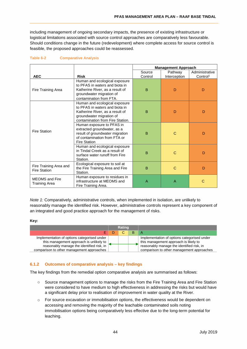
PFAS MANAGEMENT AREA PLAN – RAAF BASE TINDAL
44 July 2019
including management of ongoing secondary impacts, the presence of existing infrastructure or
logistical limitations associated with source control approaches are comparatively less favourable.
Should conditions change in the future (redevelopment) where complete access for source control is
feasible, the proposed approaches could be reassessed.
Table 6-2 Comparative Analysis
AEC Risk
Management ApproachSource Control
Pathway Interception
Administrative Control1
Fire Training Area
Human and ecological exposure to PFAS in waters and biota in Katherine River, as a result of groundwater migration of
contamination from FTA.
B D D
Fire Station
Human and ecological exposure to PFAS in waters and biota in Katherine River, as a result of groundwater migration of contamination from Fire Station.
B D D
Human exposure to PFAS in extracted groundwater, as a result of groundwater migration of contamination from FTA or Fire Station
B C D
Human and ecological exposure in Tindal Creek as a result of surface water runoff from Fire Station.
B C D
Fire Training Area and Fire Station
Ecological exposure to soil at the Fire Training Area and Fire Station.
B C D
MEOMS and Fire Training Area
Human exposure to residues in infrastructure at MEOMS and Fire Training Area.
A A C
Note 1: Comparatively, administrative controls, when implemented in isolation, are unlikely to
reasonably manage the identified risk. However, administrative controls represent a key component of
an integrated and good practice approach for the management of risks.
Key:
Rating
E D C B A
Implementation of options categorised under this management approach is unlikely to reasonably manage the identified risk, in
comparison to other management approaches
Implementation of options categorised under this management approach is likely to reasonably manage the identified risk, in comparison to other management approaches
6.1.2 Outcomes of comparative analysis – key findings
The key findings from the remedial option comparative analysis are summarised as follows:
o Source management options to manage the risks from the Fire Training Area and Fire Station
were considered to have medium to high effectiveness in addressing the risks but would have
a significant delay prior to realisation of improvement in water quality at the River.
o For source excavation or immobilisation options, the effectiveness would be dependent on
accessing and removing the majority of the leachable contaminated soils noting
immobilisation options being comparatively less effective due to the long-term potential for
leaching.

PFAS MANAGEMENT AREA PLAN – RAAF BASE TINDAL
45 July 2019
o Whilst ex-situ treatment of groundwater does not have the same limitations as source
excavation or immobilisation, it is affected by complex hydrogeology and does not
concurrently address other risks, such as ecological contact with soils and effectiveness
would potentially be affected by high yield aquifer.
o Of the source management options, most were in the same cost, proportionality and net
environmental benefit, although noting thermal treatment option provides complete removal of
contaminant mass and limits on-going monitoring and liability.
o Design and construction of a purpose-built cell would have a longer preparation time than
capping or immobilisation but would have better long-term management.
o Both source management and pathway interception options (for example: excavation,
capping and drainage diversion) may potentially require planning and coordination with Base
Operations to minimise disruption to Defence and ensure potential adverse impacts, such as
increased flooding risks, are appropriately managed.
o Contaminant migration in surface water due to run-off from contaminated areas was not
indicated to represent a significant proportion of the mass leaving the Base (Section 2.4) and
would not warrant actions that would involve significant cost or energy inputs, compared to
actions that address more significant pathways.
o Whilst administrative controls, such as dietary advisories, generally represent comparatively
lower effectiveness, many administrative controls complement other management measures
and therefore require further consideration (as presented within the integrated assessment).
Administrative controls reduce the risks within the short-term, compared to longer
implementation times for pathway interception or source management options.
o Community views were considered likely to be generally positive for any source removal,
particularly compared to do nothing or administrative controls alone, and views are likely to be
mixed in relation to thermal treatment, and long-term retention on-Base.
o Regulatory approvals and engagement would be required for any action off-Base and would
be advisable for on-Base groundwater extraction, long-term containment or thermal treatment
options to manage reputational risks.
Table 6-3 Key Findings
AEC Risk Key Findings
Fire Station Human and ecological exposure to PFAS in waters and biota in Katherine River, as a result of groundwater migration of contamination from Fire Station
For source excavation or immobilisation option, the effectiveness would be hampered by the presence of the Fire Station, which would prevent removal of all leachable contaminated soils.
Human and ecological exposure in Tindal Creek as a result of surface water runoff from Fire Station
Although the mass of PFAS entering Tindal Creek and ultimately Katherine River by this pathway is low, a high reputational risk was indicated if the pathway was not managed.
Opportunities were identified to co-manage surface water run-off in December - February with an ex-situ groundwater treatment system but will require modifications to existing drainage network to facilitate diversion and capture. Run-off from soils would also effectively be managed by removal of the sources of impact to groundwater, and potentially sealing remnant infrastructure surfaces (hardstand).
Fire Training Area and Fire Station
Human exposure to PFAS in extracted groundwater, as a result of groundwater migration of contamination from FTA or Fire Station
Point of use treatment was identified as having moderate effectiveness, based on the need for maintenance and potential down time. Multiple treatment systems on private land also presents safety and amenity risks. Point of use treatment also had a lower net environmental benefit and was not considered best practice, compared to

PFAS MANAGEMENT AREA PLAN – RAAF BASE TINDAL
46 July 2019
AEC Risk Key Findings
source treatment options, as it did not improve the broader condition. A positive impact of point of use treatment compared to source removal options is the short time to reduction of this specific risk. Therefore, it should be retained as a contingency option in the event that alternative water supplies or existing groundwater extraction is not viable.
Ecological exposure to soil at the Fire Training Area and Fire Station
All options could be applied in the short to medium term.
Whilst capping would be considered proportionate and a good project fit, to manage risks associated with ecological exposure from surface soils in isolation, it comparatively does not address the other potential risks at the Fire Training Area or Fire Station (as discussed in the integrated options analysis).
Human and ecological exposure to PFAS in waters and biota in Katherine River, as a result of groundwater migration.
No additional specific findings to address this risk. Any action taken at the source to address groundwater extraction risks, would ultimately also improve Katherine River condition.
MEOMS and Fire Training Area
Human exposure to residues in infrastructure at MEOMS and Fire Training Area.
Restriction of access to infrastructure and cleaning of infrastructure would both adequately manage the risk, but restrictions would need to be implemented long term. Cleaning of infrastructure (including evaporation ponds) had a higher net environmental benefit and better community view due to reduction of PFAS entering the environment from infrastructure. Costs of cleaning infrastructure were higher, but were considered proportionate to the risk, compared to managing access alone.
6.2 Integrated options analysis outcomes
The comparative analysis assessed each
management option against 17 screening criteria
(as presented in Section 3.5) to determine which
option would be comparatively the most
practicable to address that risk. The comparative
analysis, however, did not consider which option,
or combination of options, would be most
practicable when looking at a number of risks and
areas.
An integrated analysis was conducted to identify
potential synergies, dependencies and
complementary actions across the management
options, and the considerations and findings are
presented in the following table.
Integrated
Approach
Source
Management
Administrative
Controls
Pathway
Interception

PFAS MANAGEMENT AREA PLAN – RAAF BASE TINDAL
47 July 2019
Table 6-4 Integrated Options Analysis
Key Findings Integrated Approach
Whilst source management approaches may reduce
the mass of PFAS migrating from source areas, it
would unlikely have an impact on concentrations
within the off-Base groundwater or Katherine River in
the short or medium term (at least 5 years).
Where source management approaches were
identified as comparatively practicable and potentially
appropriate option to manage risks, pathway
interception and administrative controls warrant
further investigation to address the short or medium-
term impacts.
The presence of operating infrastructure may
preclude the ability to implement or the ability to
effectively remove impacts from all on-Base source
areas.
Where source removal is precluded, pathway
interception options such as capping are likely to be
effective interim measures until effective source
removal can be achieved. As per above, other
pathway interception such as point of use treatment
and administrative controls will warrant further
investigation to address short to medium term risks.
Source management approaches will likely represent
significant capital investment.
The capital costs are not directly proportionate with
the volume of source to be managed (i.e. the cost to
manage twice the volume of impacts will be
significantly less than double). On this basis, it would
likely be most cost effective to manage the greatest
practicable volume of impacts within a single
mobilisation.
Contaminant migration in surface water due to run-off
from contaminated areas was not indicated to
represent a significant proportion of mass leaving the
Base (Section 2.4) and would not warrant actions that
would involve significant cost or energy inputs,
compared to actions that address more significant
pathways.
The capture and treatment of surface waters from the
Fire Station could be readily integrated into any
groundwater treatment option and implemented as
part of source management. Whilst integration is
unlikely to represent a meaningful change to the
current risk profile, further consideration is warranted,
given the ease of implementation. Integration may
also provide additional contingency protection against
future potential changes to the risk profile.
Point of use treatment (pathway interception) was
identified as having moderate effectiveness in
addressing the risks to human health, however, it will
not address the broader risks.
Although point of use treatment is unlikely to be a
practicable long-term solution across the plume area,
its implementation is appropriate for town water
supply based on the number of associated users, and
could be considered for a short-term contingency to
address immediate or perceived immediate risks in
other areas.
Administrative controls, such as dietary advisories,
generally represent comparatively lower
effectiveness.
Administrative controls complement other
management measures and therefore the
implementation of administrative controls may deliver
on some reduction in ongoing risks whilst engineering
controls are investigated, developed and
implemented.
Onsite administrative controls, such as training and
PPE to manage the risk to human exposure from
residues in infrastructure including evaporation ponds
and pits have the potential to result in greater risk
management due to the possibility of controls being
integrated into standard site operating procedures.
Based on the outcomes of the comparative analysis and review of the options in an integrated
manner, the following management approaches are indicated for each AEC.

PFAS MANAGEMENT AREA PLAN – RAAF BASE TINDAL
48 July 2019
Table 6-5 Management Approaches
AEC Next Steps
General / all areas Immediate implementation timeframe:
• Support advisory on consumption (Administrative Control).
• Implement controls on ground disturbance activities and management of works via access controls in all source areas (Administrative Control).
• Review practicable timeframes for the implementation of source management options. Where source management options cannot be practicably implemented within short to medium term timeframes, investigate implementation of practicable pathway interception options (i.e. capping or alternative water supply).
• Continue interim response measure of town water supply treatment plant operation until a long-term plant is commissioned.
Medium implementation timeframe:
• Support planning and operation of a long-term PFAS water treatment plan to extent the capacity of town water supply through Power and Water Corporation.
Fire Training Area Short implementation timeframe:
• Develop and implement remedial action plan to limit contact with contaminated soils (Pathway Interception) in accessible areas.
• Removal of sediments from evaporation ponds and ongoing management (Source Management).
• Continue interim response measure of localised groundwater extraction and treatment to reduce PFAS migration from source area.
Medium implementation timeframe:
• Investigate immobilisation or source removal (soil and remaining infrastructure) managed by thermal treatment or on-Base containment cell (Source Management) removal options.
• Implement groundwater source zone management until ongoing source of groundwater contamination is verified as removed.
Fire Station Short implementation timeframe:
• Develop and implement remedial action plan to limit contact with contaminated soils (Pathway Interception) in accessible areas.
• Investigate and implement concrete sealing of hardstand and AFFF tank bund (Source Management).
• Continue interim response measure of localised groundwater extraction and treatment to reduce PFAS migration from source area.
Medium implementation timeframe:
• Investigate immobilisation or source removal (soil) managed by thermal treatment or on-Base containment cell (Source Management)
• Implement groundwater source zone management until ongoing source of groundwater contamination is verified as removed.
MEOMS Short implementation timeframe:
• Investigate sealing of remaining hardstand (Pathway Interception).
• Remove effluents and sediments from infrastructure and implement cleaning measures (Source Management).

PFAS MANAGEMENT AREA PLAN – RAAF BASE TINDAL
49 July 2019
7 RECOMMENDED PMAP RESPONSE ACTIONS
7.1 List of recommended PMAP response actions
Based on the comparative analysis and the integrated analysis, the recommended actions for each
identified risk are set out below. Recommended PMAP response action as summarised in tables
below and presented in Figures 8 and 9 (Appendix H). Approaches to implementation of measures
as noted in tables below are summarised in Section 7.2. Table 7-1: Measures for Implementation
Action # Action Risk Timeframe1 Advisory on consumption:
Support EPA and Health advisories
Human exposure from consumption of fish in Katherine River and Tindal Creek, and consumption of home-grown fruit and vegetables watered with contaminated bore water (Zone 1).
Ongoing, Continue
2 Controls on soil movement: Controls on ground disturbance and soil movement from source areas and off-Base transport (applies to all areas of the site).
Movement of contaminated soils to more sensitive areas creating additional surface water or groundwater contamination
Immediate
3 Access Restrictions to sediments within Fire Training Area and MEOMS Interceptor Pits
Human exposure to effluents and sediments by Base maintenance workers
Immediate
4 Routine cleaning of infrastructure and management of effluent and sediments in accordance with the facility management plan
Human exposure to Fire Training Area and MEOMS effluent by Base maintenance workers Leaching to groundwater/surface water
Short
5 Removal of sediments, effluent and infrastructure from FTA
Human exposure from consumption of fish in Katherine River and Tindal Creek. Human exposure through extracted groundwater use. Leaching to groundwater/surface water
Short
6 Support Power and Water Corporation in implementation of PFAS water treatment system for town water supply.
Human exposure through use of extracted groundwater in town water supply
Medium
7a Continue Interim Response groundwater treatment at FTA and FS
Human exposure from consumption of fish in Katherine River and Tindal Creek Human exposure through extracted groundwater use
Medium - Long
7b Long-term groundwater treatment to remove residuals from Source Areas: GW treatment of source areas to initially reduce migration and then further removal residuals once soil and infrastructure source removal has occurred.
8 Source removal (soil around FS and FTA) managed by thermal treatment or on-Base containment cell (treatment option pending assessment of feasibility)
Human exposure from consumption of fish in Katherine River and Tindal Creek. Human exposure through extracted groundwater use. Leaching to groundwater/surface water
Medium
Table 7-2: Measures for further investigation
Action # Action Risk Timeframe9 Assess feasibility (pilot trial) on
sealing of contaminated infrastructure (FS hardstand, drains in MEOMS)
Leaching to groundwater/surface water Short
10 Develop and implement RAP to limit contact with soils in FTA and
Ecological and human exposure in Tindal Creek (via run-off), Ecological exposure to surface soils
Short

PFAS MANAGEMENT AREA PLAN – RAAF BASE TINDAL
50 July 2019
FS. (as a short-term alternative to source removal)
11 Review plans for the existing infrastructure within the FS and MEOMS areas and determine timeframes for source management implementation
Human exposure from consumption of fish in Katherine River and Tindal Creek. Human exposure through extracted groundwater use. Leaching to groundwater/surface water
Immediate
12 Review practicability of implementation of contingency actions (supply of alternative water)
Human exposure through extracted groundwater use
Immediate
13 Integrate PFAS migration control evaluation into future capital works project siting and design evaluation
Human exposure from consumption of fish in Katherine River and Tindal Creek. Human exposure through extracted groundwater use. Leaching to groundwater/surface water
Medium - Long
7.2 Management Measures
Response actions for implementation
1 Advisory on Consumption:
• Support ongoing community engagement strategy with NT Government and increasing
awareness via community sessions on the potential health risks of frequently consuming
fish/crustaceans and or recreational use of the creeks.
• Will require engagement with NT Health, NT Department of Environmental and Natural
Resources and NT EPA to confirm content and approach for implementation of response.
• Assisting Territory Agencies manage health advice regarding consumption of fish within the
Katherine River and Tindal Creek and restriction on groundwater abstraction for watering of
home grown fruits and vegetables.
2 Controls on Soil Movement
Soils in the vicinity of the Fire Training Area, the Fire Station, the Fuel Farms are known to contain
elevated concentrations of PFAS, which may present a compliance or exposure risk if transported or
handled inappropriately. Other areas of the Base with lower concentrations, such as around MEOMS
or waste water treatment sludge, may also represent a compliance risk or present a risk to waterways
if placed nearby. Controls on excavation, testing and movement of soils would mitigate these risks
and would involve:
• Administrative controls via mandatory excavation permit for all source areas.
• Implementation of Defence PFAS Construction and Maintenance Framework to define
principles of soil management.
• All ECCs to describe controls on cross contamination and soil movements from source
areas, including classification prior to off-Base transport.
3 Access Restrictions to sediments within Fire Training Area and MEOMS Interceptor
Pits
The sediments in the FTA evaporation ponds and in MEOMS interceptor pits contain high
concentrations of PFAS and may present an elevated exposure risk to maintenance workers in
contact with the sediments.
• Limit contact with effluent tanks to trained and inducted personnel.
• Apply mandatory PPE requirements for accessing evaporation ponds and any
infrastructure (including pits) that may be in contact with impacts including disposable
coveralls, gloves and hygiene – to be managed using permit to work system.

PFAS MANAGEMENT AREA PLAN – RAAF BASE TINDAL
51 July 2019
4 Routine Cleaning of infrastructure and management of effluent and sediments in
accordance with ongoing management plan.
This will require liaison with the EMOS contractor to define how Base infrastructure such as pits and
drains are managed and maintained.
5 Removal of sediments, effluent and infrastructure from FTA
The fire training pad and associated evaporation pond at the fire training area have PFAS retained in
the concrete of the structure and the accumulated sediments and effluent contain high levels of
PFAS. The water level and concentrations of PFAS in the underlying groundwater indicate that the
evaporation ponds may be leaking. Removal of the pad and ponds would remove an on-going source
of PFAS impact to groundwater and surface water in the area and would be expected to improve the
effectiveness of groundwater treatment actions and reduce concentration in down-gradient
groundwater and Tindal Creek.
The anticipated implementation steps are:
• Prepare brief describing the sediments, waters and potentially concrete to be removed and
preferred treatment method.
• Procure contract and implement in consultation with water treatment project team to ensure
treatment equipment is not damaged.
• Validate removal.
• Lining and backfill requirements will be dependent on the relative timing of soil removal and
treatment at the surrounding source area and should be defined in the brief.
• Develop and deliver a RAP including draft works/design/s.
6 Support planning and operation of PFAS water treatment plant on town water supply
The pathway by which the most people could be exposed to PFAS contamination is through
reoccurrence of PFAS contamination of the town water supply provided by Power and Water
Corporation (PWC). The interim PFAS treatment plant has limited capacity and must be operated in
combination with water use restrictions to maintain the water supply at non-detectable PFAS levels
through the year. A larger capacity treatment plant would allow future expansion of the town supply
network.
The anticipated implementation steps are:
• Support PWC in planning, sourcing and commissioning of the plant, as defined by an
agreement.
• Confirm commissioning, based on information provided by PWC.
• Observe performance of the system, based on monitoring data supplied by PWC.
7a Continue Interim Response groundwater treatment at FTA and FS
The dominant sources of impact to off-Base groundwater contamination are the Fire Training Area
and Fire Station. Pump and treat from these areas has been commenced as an interim response
action to reduce the mass of PFAS leaving these zones, until longer term source removal can be
implemented.
The implementation steps are:
• Identify feasible groundwater extraction and re-infiltration locations to intercept source
migration from FTA and FS.

PFAS MANAGEMENT AREA PLAN – RAAF BASE TINDAL
52 July 2019
• Install and commission treatment system. Monitor pumping response and system
performance to guide system improvement or design of long-term systems.
• Develop and implement tailored monitoring of effect of management measure.
7b Long-term groundwater treatment to remove residuals from Source Areas
Following soil and infrastructure source removal from the FTA and FS, residual impact in groundwater
will remain surrounding the former source area. Treatment of groundwater in the area until
concentrations are lowered will help to remove more source contaminant mass and reduce the time
for improvement in off-Base concentrations.
The anticipated implementation steps are:
• Develop Remedial Action Plan
o Review performance and learnings from interim treatment program.
o Set groundwater remedial targets in source area and down-gradient monitoring wells
for completion of treatment.
o Collate options for groundwater pump and treat.
o Assess suitable locations for groundwater extraction or injection (existing or revised
to optimise).
o Complete pump and treat feasibility study (extraction rates, treatment and discharge
rate).
o Preliminary design of long-term ex-situ groundwater treatment system.
• Install and operate ex-situ groundwater treatment system.
• Develop and implement tailored long-term monitoring of effect of management measure.
8 Source (soil) managed by thermal treatment or on-Base containment
Contaminated soil surrounding the fire training area, adjacent to the fire station and to a lesser extent
in localised areas of the Base (WWTP sludge, beneath fuel farms and in contaminated stockpiles)
present ongoing (or potential future) sources of PFAS impact to groundwater and surface waters.
Removal of these sources from contact with surface water and groundwater will reduce the impact
migrating from the source areas and improve the effectiveness of groundwater treatment.
The anticipated implementation steps are:
• Liaise with Base and project groups to identify potential conflicts in development or access
to target areas.
• Confirm extent of contamination above remediation targets. Remediation targets should be
agreed with Defence based on PFAS policy, but could be guided by the existing or
proposed NEMP soil investigation levels of 1 mg/kg (PFOS+PFHxS) for direct contact, or
10 µg/kg (PFOS+PFHxS) for indirect contact, and also considering the potential for soils to
leach and lead to concentrations in groundwater or run-off over the water quality guidelines
of 0.13 µg/L for ecosystem protection or 0.07 µg/L for potable use.
• Document Remedial Action Plan for source removal and treatment or long-term
management. The RAP should include:
o Objective of remediation;
o Anticipated extent of excavation;
o Procedure and targets for validation;
o Contingency measures for weather, perched water, unexpected finds and other
potential complications during excavation;
o Excavation sequencing and material segregation requirements;
o Temporary stockpiling and material handing requirements;
o Containment cell location and design (if relevant);

PFAS MANAGEMENT AREA PLAN – RAAF BASE TINDAL
53 July 2019
o Capping and water diversion design (if relevant);
o Treatment process targets, facility location, risk assessment and mitigation, facility
design (if relevant); and
o Environmental monitoring during treatment or during long-term containment (as
relevant).
• Engage contractor based on documentation provided in the RAP.
• Source removal soil volumes will be dependent on ability to access contaminated soils
under or adjacent to critical infrastructure and ability to excavate due to presence of rock.
• Source management via containment will require identification of a suitable location for
construction of a containment cell and associated approvals. Containment cell will require
sufficient space to accommodate soil volumes anticipated from this and co-excavated
areas. No pilot trials are required for this approach.
• Thermal treatment option will require preliminary pilot trials and feasibility studies and
associated regulatory and Defence approvals prior to implementation.
Response actions for investigation
9 Assess Feasibility of sealing contaminated infrastructure
Elevated levels of PFAS were identified in some concrete surfaces around the Base where AFFF
foam or concentrate would have come into contact with concrete repeatedly. The concrete may be
acting as an ongoing source of impact to surface water during rainfall or washdown events. Where
replacement of the concrete surfaces and infrastructure is not scheduled or warranted, sealing of the
surface to reduce leaching to run-off may be beneficial.
The anticipated implementation steps are:
• Collate options for infrastructure decontamination or sealing.
• Conduct treatability trials to decontaminate or prevent ongoing leaching of PFAS
compounds from drains, hardstand and other infrastructure areas.
• If successful options are identified, develop Remedial Action Plan to describe
implementation of full scale treatment. The RAP should include:
o Remediation targets;
o Identification of affected infrastructure and the extent of areas requiring treatment,
based on testing to supplement concrete testing conducted in the DSI;
o Method for application of treatment product.
o Propose monitoring to assess effectiveness of proposed treatment.
• The RAP will be evaluated for implementation and will be documented in a revision of the
PMAP.
10 Reduction of risk from soils in Fire Training Area and Fire Station
The Fire Training Area and Fire Station were identified in the DSI to contain the highest
concentrations of PFAS in surface soils exposed on-Base. The Fire Training Area represents the
highest direct exposure risk to terrestrial flora and fauna, based on concentration and proximity to
bush habitat. The Fire Station was also identified in the supplementary DSI as resulting in the highest
PFAS concentrations in surface water run-off. Groundwater is impacted via leaching from soils in
both areas, and low permeability capping may potentially reduce infiltration and leaching from the
most contaminated areas, however, towards the end of the wet season shallow groundwater comes
into contact with contaminated soil and would not be influenced by capping.
Improvement from the Fire Station run-off would be expected at OMP monitoring location SW188
(noting that this is the closest surface water sampling location to the Fire Station in the OMP).

PFAS MANAGEMENT AREA PLAN – RAAF BASE TINDAL
54 July 2019
Capping would only be warranted if source removal (Item 8) is anticipated to be delayed by several
years or is limited to highly contaminated soils.
The specific technique applied to control direct exposure, leaching and run-off in each area should be
tailored to the site constraints and anticipated cost benefits. Potential options include:
- temporary cover as a performance trial, or until long-term treatment is implemented;
- capping with low permeability clay or membrane;
- combination of removal of shallow high concentration soils and placement of capping layer.
Remediation targets should be agreed with Defence based on PFAS policy, but could be guided by
the existing or proposed NEMP soil investigation levels of 1 mg/kg (PFOS+PFHxS) for direct contact,
or 10 µg/kg (PFOS+PFHxS) for indirect contact, and also considering the potential for soils to leach
and result in concentrations in groundwater or run-off above the water quality guidelines of 0.13 µg/L
for ecosystem protection or 0.07 µg/L for potable use.
The implementation steps are anticipated as follows:
Evaluation and design:
• Liaise with Base and project groups to identify planned future development in the areas and
specific operating access requirements.
• Engage consultant to undertake targeted soil investigation of each area to fill data gaps and define
lateral extent of shallow soil contamination above target total and leachable concentrations.
Assessment should include detailed survey of infrastructure and other physical constraints within
the target areas.
• Evaluate options for reduction in direct exposure and migration risks to meeting remedial
objectives.
• Engage a consultant to assess surface levels and impact of capping options to potential flooding.
This assessment could be completed in parallel with the contamination assessment.
• Management to be applicable in unsealed areas. The areas noted below are approximate and
apply to unsealed areas only. Areas will need to be confirmed via site survey to map out extent of
management. Current estimates of areas are:
o Fire Training Area up to 50,000 m2
o Fire Station Area up to 80,000 m2
• Based on the outcomes of the contamination and surface levels assessments, a management
action design should be completed (RAP). Where capping is recommended, selection of capping
materials (eg clay, geomembrane, asphalt, compacted hardstand) and relevant thickness should
be included in the capping design based on suitability of capping material for each area.
• The RAP should also nominate post construction performance monitoring criteria, locations and
frequency.
• The outcomes of the investigation as defined in the RAP will be evaluated for implementation and
will be documented in a revision of the PMAP.
11 Review plans for the existing infrastructure within the FS and MEOMS areas and
determine timeframes for source management implementation
• Liaise with Base to identify scheduled timeframe for renewal of infrastructure, or milestone
opportunities for replacement of key drains and pits coordinated with other capital or
maintenance works.
12 Review practicability of implementation of contingency actions (supply of alternative
water)

PFAS MANAGEMENT AREA PLAN – RAAF BASE TINDAL
55 July 2019
• Develop contingency options based on readily available products or technology, that could be
implemented in the event immediate risks increase or applied mitigation measures fail.
• Confirm procurement approach that would be applied, if required.
• Review options every three years with review of PMAP.
13 Integrate PFAS migration control into future capital works project siting and design
evaluation
• Investigate options to include evaluation of the potential benefits that the siting and design of
Base projects may have on PFAS migration into the SSB process.
• Incentivise siting and design that will result in incremental reduction in PFAS migration from
source areas or into drainage channels.

PFAS MANAGEMENT AREA PLAN – RAAF BASE TINDAL
56 July 2019
7.3 Comparative PMAP implementation timeframes

PFAS MANAGEMENT AREA PLAN – RAAF BASE TINDAL
57 July 2019
7.4 Sequential implementation timeframes
The graphic representation of a proposed sequential timeframe for PMAP response actions provided
in Section Error! Reference source not found. considers:
• the nature, immediacy, severity, and extent of the consequences identified in Section 4
• the comparative options analysis
• the integrated options analysis.
Note that estimated timeframes are indicative only at this stage and that priority of these actions
needs to be revisited in later versions of this PMAP. Priority of management actions may change
based on a range of variables including:
• the outcomes of earlier PMAP response actions
• the development of relevant legislation, policy and guidelines
• changes in land use surrounding the site
• feedback received from the local community and stakeholders
• the availability of new relevant science and technology
• timeframes for approvals (e.g. PWC) and procurement processes.

PFAS MANAGEMENT AREA PLAN – RAAF BASE TINDAL
58 July 2019
8 REVIEW AND UPDATE
This PMAP has been developed on the basis of existing knowledge, current government policy
settings, and available scientific methodologies and technology. PFAS management is a field that is
rapidly evolving.
Over the primary implementation period, Defence will review and update (where necessary) the
PMAP at intervals of 12 months to ensure that the document is current and its recommendations are
valid.
Performance measures for individual response actions under this PMAP will be contained in the
relevant approval or procurement documentation.
Over the extended implementation period, the Defence branch responsible for the remaining
response management actions, will review/update the PMAP (or its successor document) at intervals
of 12 months to ensure that the document is current and its recommendations are valid.
An earlier review/update may be triggered where circumstances demand it. Examples of
circumstances that may trigger a review/update include:
• a performance evaluation of specific PMAP response actions that recommends changes or
advises that its objectives are not being met.
• updated information obtained from PMAP response actions involving further investigations
or monitoring outcomes.
• feedback and information received as a result of the on-going community and/or
stakeholder consultation.
• any significant changes of land use which may occur in the area within the Management
Area or adjoining land.
• changes in legislation, policy and guidelines/standards that could have a direct bearing on
the project.
• changes to Defence’s strategic approach to managing PFAS contamination.
• on-going research and development of management/remediation technologies to address
PFAS impacted soil and groundwater.
• changes to water supply options available to land owners and residents in the area
surrounding the site.
• progress in risk management and remediation activities that may require realignment or
further calibration.
• new scientific findings that update the knowledge or assumptions underlying the PMAP or
specific PMAP response actions.
• any other new information that has the potential to positively or negatively impact the
objectives of the PMAP.
Any proposed changes to this PMAP will be communicated and discussed with the community and
key stakeholders including Federal and State/Territory government agencies and the local Council.
.

PFAS MANAGEMENT AREA PLAN – RAAF BASE TINDAL
59 July 2019
APPENDIX A: Regulatory and policy analysis
This Appendix identifies relevant legislation, policy and standards applicable to the development and
prioritisation of management options for the Management Area. It further identifies key drivers and
constraints affecting that development and/or prioritisation.
A1 Commonwealth legislation, policy and standards
A1.1 Outline
The following Commonwealth legislation and policy is relevant to the risk management of the Management Area:
Commonwealth legislation
• Environment Protection and Biodiversity Conservation Act 1999 – Relevant to the Management Area as relates to consideration of Commonwealth environment and biodiversity conservation. This Act must be considered, including the requirement for referrals in the development of any management measures involving ground disturbance.
• Work Health and Safety Act 2011 – relevant to general health and safety compliance relating to all works associated with the risk management of the Management Area.
• Water Act 2007 (As Amended in 2016 and 2018) – makes provision for the management of the water resources of the Daly Basin and for other matters of national interest in relation to water and water information.
• National Environment Protection (Assessment of Site Contamination) Measure 1999, as amended in 2013. (NEPM 2013) – provides guidance on the investigation and risk assessment process for contaminated site assessments.
Commonwealth policy, standards and guidance
Defence policy, standards and guidance
• Defence Environmental Policy
• Defence Estate Strategy 2016-2036
• Defence Environmental Strategy 2016-2036
• Defence Construction and Maintenance Framework 2018
• Defence PFAS Response Management Strategy 2018
• Defence Interim Response Management Guidelines 2018
• Defence PMAP Template and Guidance 2018
Commonwealth whole-of-government policy, standards and guidance
• Intergovernmental Agreement on a National Framework for Responding to PFAS
Contamination 20 February 2018
• PFAS National Environmental Management Plan 2018 (NEMP)
• The Australian and New Zealand Guidelines for Fresh and Marine Water Quality
• Final Health Based Guidance Values (HBGV) for PFAS for use in site investigations in Australia, FSANZ February 2017
PFAS MANAGEMENT AREA PLAN – RAAF BASE TINDAL
60 July 2019
A1.2 Key drivers and constraints impacting on development/prioritisation of options
At the time of preparation of this PMAP there is limited Commonwealth legislation on the designation
of criteria for waste disposal. The PFAS NEMP (2018) indicates potential criteria to be adopted at the
State/Territory level for a State/Territory based receiving site, however there are currently no
approved landfill disposal sites in NT that are licensed to receive PFAS impacted waste.
The PFAS NEMP (2018) outlines the preferred framework for PFAS management including treatment,
remediation, containment and disposal of PFAS-contaminated media. The PFAS NEMP highlights
that any management response implemented must consider site-specific conditions in determining the
best approach to the management of PFAS. The PFAS NEMP (2018) presents the hierarchy of
treatment and remediation options (consistent with NT waste management requirements (refer
below)), being any clean-up of land will reflect the order of preference set out in the waste hierarchy
(i.e. treatment and reuse on–site is preferred to treatment and reuse off-site, while long-term
containment off-site is the least preferred option).
A2 State/Territory Legislation and Policy
A2.1 Outline
The following Commonwealth legislation and policy is relevant to the risk management of the
Management Area:
• Northern Territory Waste Management and Pollution Control Act (2016) – This Act provides
protection of the environment through encouragement of effective pollution prevention and
waste management practices and for related purposes.
• Northern Territory Waste Management and Pollution Control (Administration) Regulations
(2014) – Supports the Waste Management Pollution Control Act.
• Northern Territory Water Act (2017) – This Act relates to water resource regulation and
management in NT. The objective of the Act is to provide for the investigation, allocation,
use, control, protection, management and administration of water resources, and for related
purposes.
• Northern Territory Environment Protection Authority (2013) Guidelines for the Siting,
Design and Management of Solid Waste Disposal Sites in the Northern Territory - provides
a consistent and environmentally responsible approach to managing landfills in the
Northern Territory. This guide should be used for the planning of environmental approvals
and licensing for new landfill sites and expansion of existing landfill sites and in some cases
also applies to existing landfill sites.
• National Environment Protection Council (Northern Territory) Act (2004) – An Act to provide
for the establishment of a National Environment Protection Council, and for related
purposes.
• Northern Territory Environment Protection Authority (2017) Northern Territory
Contaminated Land Guideline – A guideline to detail the responsibilities and roles of parties
involved in the assessment and remediation of contaminated land, assist in the
identification of contaminated sites and ensure that investigation and remediation is
undertaken to a level expected by the NT EPA.
A.2.2 Key institutional drivers and constraints impacting on development/prioritisation of
options
There are currently no licenced waste facilities in NT which accept PFAS contaminated waste
(including soil or water). This will need to be taken into consideration when selecting management
options or when works are undertaken at the Base which may generate PFAS-contaminated waste.
Off-Base disposal options to manage PFAS impacted solids and liquids is limited to inter-state
PFAS MANAGEMENT AREA PLAN – RAAF BASE TINDAL
61 July 2019
transport to a licence facility following appropriate application and approval by regulatory authorities in
each affected state or territory.
A3 Planning Instruments or environmental permitting/licence controls
A3.1 Outline
NT EPA is required to maintain a contaminated land register, which includes a register of
contaminated sites and would likely include identified source zones on Base and future containment
facilities.
Operation of a high temperature facility incinerator would most likely require licensing under the
Waste Management Pollution Control Act, and suitable control of emissions and other environmental
and public health risks would need to be demonstrated.
Any management actions that may be deemed to have a significant adverse environmental impact in
relation to aspects covered by Northern Territory legislation described above beyond the
Commonwealth land boundary, may require formal assessment under the Environmental Assessment
Act.
Any management actions that may be deemed to require a sacred sites clearance would require
assessment by the Aboriginal Areas Protection Authority under the Northern Territory Aboriginal
Sacred Sites Act.
A3.2 Key drivers and constraints impacting on development/prioritisation of options
No evident constraints or drivers identified.
.

PFAS MANAGEMENT AREA PLAN – RAAF BASE TINDAL
62 July 2019
APPENDIX B: Interim response management analysis
This Appendix sets out Interim Response Management (IRM) actions relevant to the Management
Area, determines whether the actions address an identified risk (in whole or part), and applies the
assessment of the relevant project director on whether the action has been effective in meeting its
objective. As a result of that assessment, IRM actions may be recommended for continued
implementation and progressed for inclusion in the PMAP options analysis.
Provision of packaged water
Description Provision of packaged water to a total of 74 properties within
the Investigation Area.
Objective Provide an alternative source of drinking water to properties
whose primary source of water is bore water impacted by
PFAS.
Describe the risk that is being
managed
Several properties located in the Investigation Area do not
have a town water connection and their primary source of
water came from bore water. Many properties, particularly
those in Uralla, reported concentrations of PFAS in
groundwater above the adopted health-based guidance
value for drinking water. This option provides an alternative
safe drinking supply to the impacted community
Exposure to PFAS from consumption of impacted
groundwater in these areas was identified as an elevated
risk in the HHRA undertaken by Coffey (Coffey 2018).
The extent to which this option
met the objective
Provides the impacted community with 100% of average
drinking water requirements.
Supplementary /
complementary options
This IRM has been taking place prior to implementation of
rainwater tank and alternative water installations, which are
anticipated to be a longer-term solution for providing an
alternate water supply to affected properties.
Effectiveness / sustainability
assessment
Provision of packaged water has met the objective of
providing an alternative water supply to affected properties,
however it has been treated as a short-term solution, whilst
a more suitable longer-term solution has been identified and
implemented (rainwater tank or alternative water
installations).
Continued implementation
recommendation
At the time of writing, one property is receiving bottled
water.
Upon completion of all rainwater tank or alternative water
installations, it is expected that bottled water provision will
no longer be required.

PFAS MANAGEMENT AREA PLAN – RAAF BASE TINDAL
63 July 2019
Provision of rainwater tanks and alternative water installations
Description Provision of rainwater tanks or alternative water installations
to 65 properties within the Investigation Area.
Objective Provide an alternative source of drinking water to properties
whose primary source of water is bore water impacted by
PFAS.
Describe the risk that is being
managed
Several properties located in the Investigation Area do not
have a town water connection and their primary source of
water came from bore water. Many properties, particularly
those in Uralla, reported concentrations of PFAS in
groundwater above the adopted health-based guidance
value for drinking water. This option provides an alternative
safe drinking supply to the impacted community
Exposure to PFAS from consumption of impacted
groundwater in these areas was identified as an elevated
risk in the HHRA undertaken by Coffey (Coffey 2018).
The extent to which this option
met the objective
Rainwater tanks or alternative water installations have been
installed at 65 properties in the Investigation Area to date. It
has been assessed that these tanks will provide the
impacted community with 100% of average drinking water
requirements.
Supplementary /
complementary options
This IRM has been taking place in conjunction with the
provision of packaged water as an alternative drinking water
supply. Implementation of rainwater tank or alternative water
installations, are anticipated to be a longer-term solution for
providing an alternative water supply to affected properties.
It is noted that several tanks were installed after the Wet
season started and therefore, would not fill enough with
rainwater to meet the requirements for the following Dry
season. In these instances, Defence have paid to have the
tanks part-filled with town water.
Effectiveness / sustainability
assessment
Rainwater tanks provide a long term alternative drinking
water supply.
Continued implementation
recommendation
Once all scheduled rainwater tanks or alternative water
installations have been installed, it is anticipated that the
impacted community will have access to a long term
alternative water supply.
In the event that additional properties are identified where a
rainwater tank is required, this will continue to be
implemented.

PFAS MANAGEMENT AREA PLAN – RAAF BASE TINDAL
64 July 2019
Installation of interim town water treatment plant
Description Provision of an interim ECT2 water treatment plant to treat
PFAS-impacted groundwater used by Power and Water
Corporation to produce the Katherine town water supply.
Objective Power and Water Corporation’s objective is to ensure safe
tap water is provided for Katherine residents and
businesses.
Describe the risk that is being
managed
Town water supply is partly sourced from groundwater that
is PFAS-impacted. This option provides a supply of town
water to the community which is free of detectable levels of
PFAS.
The concentration of PFAS in the town production bore
were identified as a risk as part of the HHRA, however, once
mixed with river water, the town water was not identified as
a significant risk.
The extent to which this option
met the objective
It is noted that the Power and Water Corporation production
bores alone do not provide enough water to meet to the
demands of the town and production bore water still needs
to be mixed with river water. However, PFAS concentrations
in the town water supply are now reported below the
laboratory limit of reporting, where previously PFAS was
reported in detectable concentrations.
Supplementary /
complementary options
Prior to the interim water treatment plant installation, Power
and Water Corporation had implemented water restrictions
in Katherine and were not using bore water to augment the
town water supply (which was provided from water from the
Katherine River only).
Effectiveness / sustainability
assessment
The interim Water Treatment Plant treats approximately
12.5 L/s of water, or approximately 1ML/day. This results in
the Power and Water Corporation reporting shows PFAS
concentrations in the town water supply below the limit of
reporting.
Continued implementation
recommendation
Ongoing operation of this treatment plant is recommended
until a time when PFAS concentrations in the current
production bores are consistently reported below the
drinking water health-based guidance value, or until an
alternative source of suitable water is identified.
Installation of on-Base treatment plants
Description Provision of two ECT2 water treatment plants to treat PFAS-
impacted groundwater in the vicinity of the Fire Training
Area and the Fire Station.
Objective Reduce the mass of PFAS leaving the Base in groundwater

PFAS MANAGEMENT AREA PLAN – RAAF BASE TINDAL
65 July 2019
Describe the risk that is being
managed
Primarily, risks to off-Base human and ecological receptors
exposed to PFAS in groundwater (via extraction) and/or
surface water (where groundwater discharges into Katherine
River).
The extent to which this option
met the objective
At the time of writing, works are in early stages and the
water treatment plant have not been installed. It is
anticipated that the treatment plants will reduce the mass of
PFAS leaving the Base in groundwater.
Supplementary /
complementary options
It is expected that in addition to treatment of groundwater at
the two main source areas, soil treatment will also take
place in these areas in order to limit the amount of PFAS
migrating into groundwater.
Effectiveness / sustainability
assessment
Ongoing monitoring of groundwater in the vicinity of the
source areas and in downgradient areas will be undertaken
in order to monitor and assess the effectiveness of the water
treatment plants.
Continued implementation
recommendation
Ongoing operation of the treatment plants is recommended
until a time when PFAS is not detected in groundwater
leaving the Base or until additional management options are
implemented which limit or remove the need for the water
treatment plants.

PFAS MANAGEMENT AREA PLAN – RAAF BASE TINDAL
66 July 2019
APPENDIX C Source – pathway – receptor analysis
PFAS source
area
(CSR ID)
Location Summary of DSI findings
Fire Training
Area
South of RAAF Base
Tindal security fence
approximately 280 m
north-east of the
Sewage Treatment
Plant (NT0061) and
800 m north of Tindal
Creek.
Confirmed PFAS presence in soil, groundwater and
surface water.
This Fire Training Area is utilised for fire suppression
training exercises. The Fire Training Area incorporates a
central lined fire pit, three evaporation ponds, cleared
area, practice equipment and combustion areas outside
the lined fire pit.
AFFF has historically been used at the Fire Training
Area. 3M LightwaterTM was used potentially twice a week
between 1993 and approximately 2004, when it was
replaced with Ansulite 3%.
Fire Station Airside, in the vicinity
of the air traffic
control tower and the
Search and Rescue
(SAR) helicopter
hangar
Confirmed PFAS presence in soil, groundwater and
surface water
The Base’s firefighting operations are centralised within
this location. The Fire Station has been in its current
location for more than 20 years and is primarily used for
vehicle storage (including fire trucks), equipment testing
and equipment cleaning (including line tests).
3M Lightwater was historically stored at the fire station and
used to fill, test and clean fire trucks.
A soil stockpile located next to the Fire Station
(approximately 56 m3) was previously reported to contain
PFAS. The maximum reported concentration in the
stockpile was 3.4 mg/kg PFOS (GHD 2012).
Mechanical
Equipment
Operations
Maintenance
Section,
comprising
Vehicle and
Equipment
maintenance
areas
Within the security
fence in the north-
eastern portion of the
Base.
Confirmed minor PFAS presence in soil and groundwater.
Elevated concentrations in concrete and some pits.
Vehicle and equipment maintenance activities occur in this
area, which would have historically included some vehicles
and equipment that contained or had been in contact with
PFAS materials (i.e. fire trucks and AFFF pumps).
Fuel Farm 1 Near 75 Squadron. Confirmed minor PFAS presence in groundwater and
retention pond.
Bunded above ground and underground fuel facility. Fuel
Farm 1 has a fire suppression system that is inbuilt as part
of the facility. The original facility manual for the fuel farm
was reviewed and indicated that the farm included AFFF
drum stores when built, which likely contained PFAS
based on the facility age (1987). Inspection of the current

PFAS MANAGEMENT AREA PLAN – RAAF BASE TINDAL
67 July 2019
PFAS source
area
(CSR ID)
Location Summary of DSI findings
infrastructure did not identify foam tanks connected to the
suppression systems, and the current system requires
attendance by Fire Section vehicles to connect to a
manifold and deliver foam.
Fuel Farm 2 Within the security
fence in the northern
portion of the Base.
Confirmed minor PFAS presence in groundwater and in
retention pond.
Bunded above ground and underground fuel facility. Fuel
Farm 2 has a fire suppression system that is inbuilt as part
of the facility. The original facility manual for the fuel farm
was reviewed and indicated that the farm included an
AFFF foam tank when built, which likely contained PFAS,
based on the facility age (mid-1990s). Inspection of the
current infrastructure did not identify foam tanks connected
to the suppression systems, and the current system
requires attendance by Fire Section to connect to a
manifold and deliver foam.
Other diffuse or unidentified sources may also be present, such as incident response or testing along
the runway, application of AFFF to fuel spills, use of foam for recreational purposes or equipment
washing, discharge of handheld foam extinguishers. These areas have not been specifically
identified for targeted assessment. The cumulative effect of these potential sources has been
captured through investigation of the main Base drains (surface water and sediment) and site-wide
groundwater investigation.
Secondary sources of PFAS include, but are not limited to:
• PFAS adhered/adsorbed to soils in the vadose zone (unsaturated soils above the groundwater table), migrating to groundwater or surface water with seasonal fluctuations in groundwater levels;
• PFAS in sediments along Tindal Creek, drainage lines and surface soils across the Base mobilising during the Wet Season; and
• Movement of contaminated soils during historic construction activities and potential generation of dust containing PFAS.
Available reports and interviews have not indicated any potential disposal or activities that indicate
landfills would be a potentially significant source of PFAS contamination (i.e. sewerage sludge was
not disposed on-Base and waste was not burned (and extinguished)). One previous environmental
assessment report (GHD, 2008) indicated that sludge from the evaporation ponds at the Fire Training
Area was removed by an external contractor and disposed of off-site. It has not been possible to
confirm this as there is no available documentation describing if, or when this occurred, however the
comment, which likely came from interviews conducted by GHD at the time, suggests that the
sediment/sludge was not routinely disposed on-Base.
Potential pathways for the migration of PFAS associated with application and use at the Base include:
• Vertical migration of PFAS through soil to the groundwater system.

PFAS MANAGEMENT AREA PLAN – RAAF BASE TINDAL
68 July 2019
• Lateral migration of PFAS in groundwater towards Uralla and Katherine, discharging to the Katherine River.
• Leaching of PFAS from Base soils or sediments into surface water and migration along Base drains and Tindal Creek.
• Infiltration of PFAS in surface water to groundwater.
• Extraction of groundwater for domestic, irrigation and stock watering use.
• Accumulation of PFAS from wastewater in sludge at the Base sewage system.
Potential receptors where plausible pathways are present include:
• Users of extracted impacted groundwater (i.e. bore water used for drinking water, swimming, irrigation, stock watering, and consumption of home-grown produce).
• Users of Tindal Creek and Katherine River (i.e. drinking water, swimming, consumption of aquatic biota).
• Base personnel in impacted areas across the Base, specifically construction or maintenance workers in contact with impacted soils and waters in source areas.
• Aquatic ecological receptors including flora and fauna in and around Tindal Creek and Katherine River.
• Terrestrial ecological receptors including flora and fauna within the Investigation Area
A summary of the source-pathway-receptor pollutant linkages is presented in Figure C1.

PFAS MANAGEMENT AREA PLAN – RAAF BASE TINDAL
69 July 2019

PFAS MANAGEMENT AREA PLAN – RAAF BASE TINDAL
70 July 2019
APPENDIX D Options analysis criteria
This Appendix sets out the criteria for the detailed options analysis.
Cost / effectiveness / impact analysis
1 Cost range
estimate
Estimate a cost range for implementation of the option, accompanied by
an explanation of the basis of that estimate.
The cost ranges below have overlapping values: this is to avoid a scenario where a borderline cost may distort the analysis. Where a cost
estimate falls into an overlapping range, but effectiveness of the option in 1.2 is assessed as ‘high’, use the lower cost range to adjust the margin of
error in favour of the ‘effectiveness’ criterion.
Category 1 PWC approval required
above $15 million.6> $13,000,000
Category 2 Medium works notification
to PWC required above $2 million
> $1,500,000 < $15,000,000
Category 3 Project actions > $450,000 < $2,000,000
Category 4 Community level actions7 < $500,000
Cost ranges should include direct, indirect, recurrent costs and the costs of mitigating any secondary risks identified in 2.5 below.
Where there will be a need for ongoing operations, management, maintenance and monitoring beyond the Primary Implementation Period, a separate risk should be identified and a separate options analysis
applied.
2 Effectiveness
rating
Assign an effectiveness rating in accordance with the following criteria:
High The option is projected to meet all its objectives or meet a ‘best available’ standard
High with supplementary
option
The option, together with a supplementary option, is projected to meet all its objectives or meet a
‘best available’ standard
Medium The option is projected to make significant
progress towards meeting its objectives.
Medium with
supplementary option
The option, together with a supplementary option,
is projected to make significant progress towards meeting its objectives
Low The option cannot reliably be projected to make significant progress towards meeting its
objectives or may only do so in a timeframe that is
6 http://www.defence.gov.au/estatemanagement/governance/Committees/pwc/Default.asp
7 Accommodates a range of community level response actions such as arranging alternative grazing for impacted agricultural businesses or providing fencing. The value of community-level actions may also exceed $500,000.

PFAS MANAGEMENT AREA PLAN – RAAF BASE TINDAL
71 July 2019
not aligned with effective management of the
identified risk.
3 Implementation
period / timeframe
Designate an indicative timeframe for implementation:
Primary implementation period
− Short term: 1-12 months from the date of the PMAP
− Medium term: 1-3 years
Extended implementation period
− Long term: beyond 3 years.
Where an action extends across both the primary and extended
implementation period, both should be designated. Different procurement actions may apply.
4 Potential impacts
List any potential environmental and socio-economic impacts (positive and negative).
Negative impacts should be further analysed and addressed in section
10 below.
5 Estimated net
environmental benefit
Whether the impacted environment as a whole would experience a net
benefit. Rate as negative / marginal / moderate / significant
Risk-based analysis
6 Proportion of
action to risk
Assess the scale (timing/implementation logistics/impact on Defence
capability) and cost of the action in comparison to the likelihood and scale
of the risk.
7 Best-practice
status
Consider whether there is a recognised ‘best-practice’ standard available
for the category of the proposed solution and whether the solution meets a relevant standard.
8 Verification status
Where an action involves a remediation technology, provide information on the verification status.
9 Technology assessment
Where an option involves a remediation technology:
− infrastructure and energy requirements
− ability to construct and operating technology
− reliability of technology
− ability to monitor effectiveness
− ability to obtain any necessary approvals
− availability of services and materials
10 Risks and
mitigation
List primary, secondary8 and residual9 risks of implementation and
associated mitigation options, such as:
− potential environmental impacts, including PFAS transference, cross-contamination, and remobilisation; and presence of
contaminants other than PFAS
8 Secondary risks are risks that emerge from implementation of a risk management response
9 Residual risks comprise that component of the identified risk that is not addressed by the option.

PFAS MANAGEMENT AREA PLAN – RAAF BASE TINDAL
72 July 2019
− the availability of treatment/storage management options to manage waste streams
− impact on existing infrastructure (including bores)
− potential social and economic impacts (e.g. land use or employment.)
Specify whether mitigation options form a part the same option or whether they are developed separately (provide option identification number).
11 Key Dependencies
List any key dependencies, including the implementation of any other options, and any external factors.
Defence implications
12 Defence capability
The extent to which an aspect of Defence capability will be impacted by the process or outcome of implementation of the option and the availability
and cost of alternatives (consultations with Defence)
13 Project fit Whether the project outcomes complement the outcomes of response
management actions for the same or other sites (consultations with
Defence)
14 Scalability Whether the outcomes of the project can be scaled up or down to address
similar needs in the same or other Bases.
Stakeholder impacts, views and consents
15 Jurisdictional
regulator/s
List jurisdictional authorisations required to implement the option. Note the
views of any relevant jurisdictional regulator
16 Owner /
occupier consents and views
List any owner / occupier consents required to implement the option.
Note the views of any relevant landowner or occupier.
17 Community Defence’s understanding of the views of the impacted community.

PFAS MANAGEMENT AREA PLAN – RAAF BASE TINDAL
73 July 2019
APPENDIX E Options listing and analysis
This Appendix provides the analysis of the management options identified as available to address the
range of risks identified in the DSI and risk assessments.
Options listing
1 Ex-situ Treatment of PFAS Impacted Groundwater using adsorptive media
(Granulated/Powdered Activated Carbon or Resin)
No # R1.1, R1.3
Title (functional) Ex-situ Treatment of PFAS Impacted Groundwater, surface water or waste water.
Description Extraction of PFAS impacted groundwater from primary source zones and treatment ex-situ using adsorption techniques.
Objective Reduce mass of PFAS in groundwater in primary source areas, resulting in subsequent reduction in mass flux and down-gradient concentrations.
How this objective contributes to managing the identified risk
Fire Training Area (FTA) and Fire Station (FS) represent large portion of mass entering groundwater and the potential removal of 50% to 90% of source concentrations over the short term would be expected to have material impact to down-gradient groundwater and Katherine River concentrations in the medium to long term.
The extent to which this option is expected to meet the objective
Reduction of source concentrations in the order of 50% to 90% in 3 years is considered plausible.
Whether the option addresses
− source,
− pathway
− receptor, and/or
− extended implementation
period requirements
Option will reduce source mass, reducing mass migrating off base over time.
Supplementary / complementary options
Option does not address point of exposure risks in the short to medium term. Option to be combined with administrative controls to mitigate point of exposure risks (i.e. domestic consumption of groundwater, consumption of fish caught from Katherine River), or treatment of water at the point of exposure.
Cost / effectiveness / impact analysis
1 Cost range
estimate
The cost range estimate for the Option is Category 2 (>$1.5M & <$15M)
assuming:
- Treatment aims to reduce source mass within primary source areas within
the FTA and FS. - Mobilisation of two separate treatment plants to treat source mass in FTA
and FS separately to avoid running plumbing beneath active runway - Treatment operated over a 3-year period to reduce source mass by 90% in
FTA and FS.
- Post-remediation monitoring to demonstrate effectiveness (2 years)
Spent treatment media would require management; namely storage on site or
thermal treatment to destroy PFAS.

PFAS MANAGEMENT AREA PLAN – RAAF BASE TINDAL
74 July 2019
2 Effectiveness
rating Medium with supplementary option
This option will reduce migration of PFAS down gradient of the source areas identified in the FTA and FS. A complex hydrogeological setting limits the effectiveness of this option.
Supplementary options to enhance remediation outcome may comprise treatment/management of PFAS impacted soil and administration controls to
restrict exposure.
3 Implementation
period / timeframe
Primary implementation period
− Medium term: 3 years
Post Implementation Monitoring Period
− This Option anticipates a period of post-remediation monitoring to
assess the effectiveness of groundwater treatment. This is likely to
comprise a period of 2years.
4 Potential impacts
Environmental and socio-economic impacts:
• Positive: - Reduction of PFAS mass in groundwater in primary source areas.
- Some acceptance by regulatory and community stakeholders.
• Negative
- Spent treatment media requires further treatment, or long-term storage. - Unlikely to result in lifting of restrictions on groundwater use off site or
consumption of fish/crustaceans caught in river in short to medium
term.
5 Estimated net
environmental benefit
Marginal within Primary Source Areas over the medium term.
Improvement in groundwater quality off-base will occur quicker relative to the ‘do nothing’ approach but results are expected to be demonstrated over the
long term.
Risk-based analysis
6 Proportion of action to risk
Proportionate
Further hydrogeological characterisation is required to design the groundwater
abstraction array within the FTA and FS.
The treatment plant and extraction wells could be installed in a manner which
would minimise impacts on Defence operations. Two separate treatment plants
would be required to mitigate impacts on runway operations, although
commercial/technical economies of scale exist when plant operated by the
same contractor.
7 Best-practice status
Partial best practice.
This option aims to reduce PFAS in groundwater in the FTA and FS only and does not aim to address PFAS impacts off base. As such, not considered a
‘best practice’ solution in isolation.

PFAS MANAGEMENT AREA PLAN – RAAF BASE TINDAL
75 July 2019
8 Verification
status
Proven
Proven technique to remove PFAS from groundwater. Successful implementation on other Defence sites. Technology readily available.
Some uncertainty exists regarding the ability to implement successfully within
the hydrogeological setting.
Some uncertainty exists regarding the management of spent treatment media in
a cost-effective manner.
9 Technology
assessment • Infrastructure and energy requirements
- Designated treatment plants and groundwater abstraction wells.
- Moderate electricity demand to abstract water and treat. - Modular design possible to expand/reduce treatment needs
• ability to construct and operating technology
- Reasonable expertise in market to construct and operate plant
• reliability of technology - proven technology to remove PFAS from water. - Commissioning stage to be anticipated to refine O&M requirements.
• ability to monitor effectiveness - standardised sampling procedures to measure treatment effectiveness
(PFAS removal)
- sampling of groundwater bores to assess mass reduction and compliance with objectives
• ability to obtain any necessary approvals - groundwater abstraction permit required?
- Permitting required to either store spent treatment media (base permitting system) or transport media to offsite treatment facility.
• availability of services and materials - plant and consumables readily available in market.
10 Risks and
mitigation
Low risk and manageable
Secondary risks
- management of spent treatment media requires consideration
- co-contaminants dissolved within groundwater may reduce the effectiveness of treatment
Residual risks
- treatment aims to reduce PFAS mass in source areas. It will not address PFAS impacted groundwater beyond the extent of the extraction well array.
11 Key Dependencies
Additional controls required to address risks at point of exposure over the
medium to long term. These may include administrative controls to restrict groundwater use, or fish consumption, or implementation of other remedial
measures in off-site areas.
Utilities serving the area is also a dependency.
Defence implications
12 Defence
capability
Above ground infrastructure required to store and treat pumped groundwater.
Site selection to consider ongoing Defence operational requirements although plant could be configured to minimise impacts on critical infrastructure.
13 Project fit Technology is currently in use at other Defence bases to manage PFAS
impacted groundwater.

PFAS MANAGEMENT AREA PLAN – RAAF BASE TINDAL
76 July 2019
14 Scalability The treatment technology is modular and capacity can be adjusted to meet
treatment requirements.
Stakeholder impacts, views and consents
15 Jurisdictional
regulator/s
NT Government
Active removal of PFAS from source areas is likely to be viewed positively. Waste management, including management of treated water, will require negotiation and approvals.
16 Owner / occupier consents and
views
RAAF Base Tindal
Occupier views will depend on location and associated disruption from
equipment. Perceived and demonstrated value of the action will also influence
acceptance.
17 Community No community impacts identified.
Source treatment is anticipated to be received positively by the community,
although the timescales to which it would result in measurable improvements to
groundwater quality in offsite areas is uncertain, which may erode positive
sentiment over the medium to longer term
PFAS MANAGEMENT AREA PLAN – RAAF BASE TINDAL
77 July 2019
2 Ex-situ Treatment of PFAS Impacted Groundwater using adsorptive media
(Granulated/Powdered Activated Carbon or Resin) at the Point of Exposure
No # R1.11
Title (functional) Ex-situ Treatment of PFAS Impacted Groundwater for residential use, and other high water users
Description Establishing treatment plants within the community to treat PFAS impacted groundwater in off base areas to a standard that allows use in a residential setting, and in other high water uses (e.g. swimming pools, commercial uses such as the abattoir etc.)
Objective Provide treatment at the point of exposure to reduce community exposure to PFAS impacted groundwater.
How this objective contributes to managing the identified risk
Treatment reduces human exposure to PFAS impacted groundwater.
The extent to which this option is expected to meet the objective
Treatment to reduce PFAS concentrations below drinking water standards or recreational standards would reduce risks at the point of exposure to acceptable standards.
Whether the option addresses
− source,
− pathway
− receptor, and/or
− extended implementation
period requirements
Option reduces the source of PFAS in groundwater abstracted for beneficial uses.
Supplementary / complementary options
Option does aim to address the source areas on base.
Option to be combined with administrative controls to mitigate point of exposure risks associated with the consumption of fish caught from Katherine River.
Cost / effectiveness / impact analysis
1 Cost range estimate
The cost range estimate is likely to fall into Category 1 (>$15M) given the extent of the PFAS plume within off site areas that use groundwater for
domestic and/or commercial uses.
Spent treatment media would require management; namely storage on site or thermal treatment to destroy PFAS.
2 Effectiveness rating
Moderate with supplementary option (subject to maintenance and continuous operation)
This option will reduce exposure to PFAS in groundwater abstracted for
beneficial uses.
Supplementary options would be required to manage other point of exposure risks (e.g. administrative controls to restrict consumption of fish).
3 Implementation period /
timeframe
Primary implementation period
− Medium to long term: >3 years (depending on source
treatment/pathway intervention measures)

PFAS MANAGEMENT AREA PLAN – RAAF BASE TINDAL
78 July 2019
4 Potential
impacts
Environmental and socio-economic impacts:
• Positive: - Reduction of PFAS in groundwater abstracted for beneficial uses. - Reduction in PFAS source mass in groundwater in in off-site areas. - Low impact on lifestyle of community stakeholders.
• Negative - Spent treatment media requires further treatment, or long-term storage.
- Relies on efficiency of treatment plant, and regular change of adsorption media.
5 Estimated net environmental
benefit
Negative – extensive treatment and energy required without addressing source areas
Risk-based analysis
6 Proportion of action to risk
Disproportionate
Installation of treatment plants throughout Katherine seems disproportionate to
reduction in overall risk. Option could be deployed in the event that community
needs to rely on groundwater.
7 Best-practice status
Not considered to be best practice due to limited environmental improvement.
8 Verification status
Proven
Proven technique to remove PFAS from groundwater. Successful
implementation on other Defence sites. Technology readily available.
Some uncertainty exists regarding the management of the treatment plants and spent treatment media in a cost-effective manner.
9 Technology assessment
• Infrastructure and energy requirements - Designated treatment plants and groundwater abstraction wells. - High electricity demand to abstract water and treat.
- Modular design possible to expand/reduce treatment needs
• ability to construct and operating technology - Reasonable expertise in market to construct and operate plant
• reliability of technology - proven technology to remove PFAS from water. - Commissioning stage to be anticipated to refine O&M requirements.
• ability to monitor effectiveness - standardised sampling procedures to measure treatment effectiveness
(PFAS removal) - sampling of groundwater bores to assess mass reduction and
compliance with objectives
• ability to obtain any necessary approvals - groundwater abstraction permit required?
- Permitting required to either store spent treatment media or transport media to offsite treatment facility.
• availability of services and materials - plant and consumables readily available in market.
10 Risks and
mitigation
Low – Moderate risk and manageable
Secondary risks

PFAS MANAGEMENT AREA PLAN – RAAF BASE TINDAL
79 July 2019
- operation of treatment plants and management of spent treatment media
requires consideration - co-contaminants dissolved within groundwater may reduce the effectiveness
of treatment.
Residual risks
- treatment will not address PFAS impacted groundwater within primary
source areas.
11 Key Dependencies
Additional controls required to reduce fish consumption, or implementation of
other remedial measures in off site areas.
Water storage and utilities serving the area is also a dependency.
Defence implications
12 Defence
capability
Minimal impact on Defence operations.
13 Project fit Poor project fit.
14 Scalability The treatment technology is modular and capacity can be adjusted to meet
treatment requirements.
Stakeholder impacts, views and consents
15 Jurisdictional regulator/s
NT Government
16 Owner /
occupier consents and views
Landowners
17 Community Treatment is anticipated to be received positively by the community, although
unlikely to result in measurable improvements to groundwater quality over long
term without source management.

PFAS MANAGEMENT AREA PLAN – RAAF BASE TINDAL
80 July 2019
3 Ex-situ Treatment of PFAS Impacted surface water or wastewater using adsorptive media
(Granulated/Powdered Activated Carbon or Resin)
No # part R2.2, part R2.3, part 4.2
Title (functional) Ex-situ Treatment of PFAS Impacted surface water or waste water.
Description Extraction of PFAS impacted surface water from drains or creeks and treatment ex-situ using adsorption techniques.
Objective Reduce mass of PFAS in surface water or infrastructure, resulting from run-off, groundwater seepage or residual impact in infrastructure.
How this objective contributes to managing the identified risk
Reduction of PFAS mass in exposure points and reduction of mass transfer by surface water flow will lower the exposure concentrations in some areas on-Base and in Tindal Creek.
The extent to which this option is expected to meet the objective
Would reduce concentrations in some sections, but not likely to have notable or lasting impact along the full waterway, due to groundwater seepage.
Whether the option addresses
− source,
− pathway
− receptor, and/or
− extended implementation
period requirements
Option will intercept pathway and reducing mass migrating off base in specific waterways while in operation.
Option applied to infrastructure is a source removal approach.
Supplementary / complementary options
Option does not address point of exposure risks in all surface water. Option would need to be combined with administrative controls to mitigate other point of exposure risks (i.e. other sections of drains or creek) and in combination with source removal for long-term improvement.
Complementary options for infrastructure treatment may include solvent washing to reduce residual mass and monitoring for recontamination.
Cost / effectiveness / impact analysis
1 Cost range estimate
The cost range estimate for the Option is Category 2 (>$1.5M & <$15M)assuming:
- Treatment aims to reduce concentrations in drains or Tindal creek sections to below recreational guidance values in the Wet season when surface
water is running - Treatment operated seasonally over a 10 year period to reduce source
mass by 90% in surface water. - Monitoring conducted during operation - Earthworks required to divert drains and create holding basin for treatment
Spent treatment media would require management; namely storage on site or thermal treatment to destroy PFAS.
2 Effectiveness rating
Low to Moderate due to limited area of influence
This option will reduce concentrations of PFAS in surface water immediately
downstream of the treatment point, but is unlikely to have a significant impact on the total mass leaving the site, or concentrations in Tindal Creek due to

PFAS MANAGEMENT AREA PLAN – RAAF BASE TINDAL
81 July 2019
groundwater seepage. A complex hydrogeological setting limits the
effectiveness of this option.
3 Implementation
period / timeframe
Primary implementation period
− Long term: 10 years
− Potentially short term, if implemented as an interim measure prior to
source removal.
Post Implementation Monitoring Period
− This Option does not warrant post-implementation monitoring as
surface water concentration will not be permanently changed by
implementation.
4 Potential impacts
Environmental and socio-economic impacts:
Positive:
- Short term reduction of PFAS concentrations in some exposure points. - Captures potential future contaminant releases
Negative
- Spent treatment media requires further treatment, or long-term storage. - Will not improve site condition long-term.
- Will not materially reduce concentrations in Katherine River
5 Estimated net
environmental benefit
Marginal
Improvement in surface water quality in target zones will occur quicker relative to the ‘do nothing’ approach but relies on continual operation of system through the Wet season. Overall improvement of mass flux and site condition is low.
Risk-based analysis
6 Proportion of action to risk
Disproportionate - high
The treatment plant would only operate for 4 months of the year and would only
improve a section of drains or Tindal Creek.
7 Best-practice
status
Partial best practice.
This option aims to reduce PFAS in exposure points within drains and Tindal Creek, but does not address residual sources. As such, not considered a ‘best
practice’ solution in isolation.
8 Verification
status
Proven
Proven technique to remove PFAS from water. Successful implementation on other Defence sites. Technology readily available.
Some uncertainty exists regarding the ability to implement successfully within the drains and creek, due to sediments or variable surface water flow.
Some uncertainty exists regarding the management of spent treatment media in
a cost-effective manner.
9 Technology
assessment • Infrastructure and energy requirements
- Designated treatment plant and surface water capture system.
- Moderate electricity demand to pump water and treat. - Modular design possible to expand/reduce treatment needs
• ability to construct and operate technology - Reasonable expertise in market to construct and operate plant
• reliability of technology - proven technology to remove PFAS from water.
- Commissioning stage to be anticipated to refine O&M requirements.

PFAS MANAGEMENT AREA PLAN – RAAF BASE TINDAL
82 July 2019
• ability to monitor effectiveness - standardised sampling procedures to measure treatment effectiveness
(PFAS removal) - sampling of surface water before and after treatment plant to assess
mass reduction and compliance with objectives
• ability to obtain any necessary approvals - Approvals likely required prior to diversion of surface water to
demonstrate impact to flooding potential
- Permitting required to either store spent treatment media (base permitting system) or transport media to offsite treatment facility.
• availability of services and materials - plant and consumables readily available in market.
10 Risks and
mitigation
Low risk and manageable
Secondary risks
- management of spent treatment media requires consideration - co-contaminants in surface water may reduce the effectiveness of treatment
- diversion of surface water drains and modification of flow may impact flooding potential in high flow events
Residual risks
- option aims to reduce PFAS concentrations in surface water during treatment.
It will not improve conditions long-term, or in areas where groundwater seepage to surface water occurs down stream.
11 Key Dependencies
Ability to effectively divert high impact drains and create a holding basin without impacting on flood potential
Utilities serving the area is also a dependency.
Defence implications
12 Defence capability
Diversion of drains and creating a holding basin may create some disruption to access to some areas of Base during earthworks. Above ground infrastructure required to store and treat pumped water.
Site selection to consider ongoing Defence operational requirements, plant and drains could be configured to minimise impacts on critical infrastructure.
13 Project fit Technology is currently in use at other Defence bases to manage PFAS
impacted water.
14 Scalability The treatment technology is modular and capacity can be adjusted to meet
treatment requirements.
Stakeholder impacts, views and consents
15 Jurisdictional
regulator/s
NT Government
Likely to be viewed positively as removing mass from waterways, but only in combination with source removal for long-term improvement. Waste
management likely to involve NT EPA approval.
16 Owner / occupier
consents and views
RAAF Base Tindal
Occupier views will be strongly influenced by specific location of systems and
drains and impact on Base operations.

PFAS MANAGEMENT AREA PLAN – RAAF BASE TINDAL
83 July 2019
17 Community No community impacts identified.
Surface water treatment is anticipated to be received positively by the
community, as surface water is a visible indicator of off-Base migration of impact.
Measurable improvements to surface water quality further off-Base is uncertain,
which may erode positive sentiment over the medium to longer term

PFAS MANAGEMENT AREA PLAN – RAAF BASE TINDAL
84 July 2019
4 - Ex-situ Treatment of PFAS Impacted Groundwater using a Concentrator (i.e. High Recovery
Nanofiltration and Reverse Osmosis)
No # R1.1, R1.3, R1.11
Title (functional) Ex-situ Treatment of PFAS Impacted Groundwater in primary source zones
Description Extraction of PFAS impacted groundwater from primary source zones and treatment ex-situ using Reverse Osmosis or Nanofiltration to concentrate impacted water.
Objective Reduce mass of PFAS in groundwater in primary source areas.
How this objective contributes to managing the identified risk
Reduction of PFAS mass in primary source areas – FTA and FS, ultimately leading to lower mass flux and lower concentrations in groundwater and Katherine River.
The extent to which this option is expected to meet the objective
Removal of source mass and reduction in localised concentrations may be 50% to 90% in the short term,
Whether the option addresses
− source,
− pathway
− receptor, and/or
− extended implementation
period requirements
Option will reduce source mass, reducing mass migrating off base over time.
Supplementary / complementary options
Option does not address point of exposure risks in the short to medium term. Option to be combined with administrative controls to mitigate point of exposure risks (i.e. domestic consumption of groundwater, consumption of fish caught from Katherine River).
Cost / effectiveness / impact analysis
1 Cost range estimate
The cost range estimate for the Option is Category 2 (>$1.5M & <$15M)assuming:
- Treatment aims to reduce source mass within primary source areas within the FTA and FS.
- Mobilisation of two separate treatment plants to treat source mass in FTA
and FS separately to avoid running plumbing beneath active runway - Treatment operated over a 3 year period to reduce source mass by 90% in
FTA and FS. - Post-remediation monitoring to demonstrate effectiveness (2 years)
Concentrate rejected by the membrane would require management; namely
storage on site or thermal treatment to destroy PFAS.
2 Effectiveness
rating Medium with supplementary option
This option will reduce migration of PFAS down gradient of the source areas identified in the FTA and FS. A complex hydrogeological setting limits the
effectiveness of this option.
Supplementary options to enhance remediation outcome may comprise treatment/management of PFAS impacted soil and administration controls to
restrict exposure.

PFAS MANAGEMENT AREA PLAN – RAAF BASE TINDAL
85 July 2019
3 Implementation
period / timeframe
Primary implementation period
− Medium term: 3 years
Post Implementation Monitoring Period
− This Option anticipates a period of post-remediation monitoring to
assess the effectiveness of groundwater treatment. This is likely to
comprise a period of 2years.
4 Potential impacts
Environmental and socio-economic impacts:
• Positive: - Reduction of PFAS mass in groundwater in primary source areas.
- Some acceptance by regulatory and community stakeholders.
• Negative - Concentrate requires further treatment, or long term storage. The
process recovery rates for groundwater sources can be in the range of 80-90% (i.e. 1-2 litres of water for every 10 litres of incoming water).
- Unlikely to result in lifting of restrictions on groundwater use off site or consumption of fish/crustaceans caught in river in short to medium
term.
5 Estimated net
environmental benefit
Moderate within Primary Source Areas over the medium term.
Improvement in groundwater quality off-base will occur quicker relative to the ‘do nothing’ approach but results are expected to be demonstrated over the long term.
Risk-based analysis
6 Proportion of action to risk
Further hydrogeological characterisation is required to design the groundwater
abstraction array within the FTA and FS.
The treatment plant and extraction wells could be installed in a manner which
would minimise Defence operations. Two separate treatment plants would be
required to mitigate impacts on runway operations, although
commercial/technical economies of scale exist when plant operated by the same
contractor.
7 Best-practice
status
This option aims to reduce PFAS in groundwater in the FTA and FS only and
does not aim to address PFAS impacts off base. As such, not considered a ‘best practice’ solution in isolation.
8 Verification status
Proven technique to remove a wide range of PFAS from groundwater. Successful implementation on other sites impacted by PFAS. Technology readily available.
Some uncertainty exists regarding the ability to implement successfully within the
hydrogeological setting.
Some uncertainty exists regarding the management of treatment concentrate in a
cost effective manner.
9 Technology
assessment • Infrastructure and energy requirements
- Designated treatment plants and groundwater abstraction wells.
- Relatively high electricity demand to abstract water and treat. Estimates of energy use ranges from 0.5-0.75 kW-hr/m3.
- Modular design possible to expand/reduce treatment needs.
• ability to construct and operating technology - Reasonable expertise in market to construct and operate plant
• reliability of technology
PFAS MANAGEMENT AREA PLAN – RAAF BASE TINDAL
86 July 2019
- proven technology to remove PFAS from water.
- Commissioning stage to be anticipated to refine O&M requirements. - Scale and pH correction necessary
• ability to monitor effectiveness - standardised sampling procedures to measure treatment effectiveness
(PFAS removal). - Constituent removal and system performance can be monitored through
continuous on-line instrumentation of surrogate parameters such as conductivity, which is correlated to contaminant removal using grab samples that are analysed in a laboratory.
- sampling of groundwater bores to assess mass reduction and compliance with objectives
• ability to obtain any necessary approvals - groundwater abstraction permit required? - Permitting required to either store concentrate (base permitting system)
or transport waste concentrate to an offsite treatment facility.
• availability of services and materials - plant and consumables readily available in market.
10 Risks and mitigation
Secondary risks
- management of concentrate requires consideration
- co-contaminants dissolved within groundwater may reduce the effectiveness of treatment, although pre-treatment could reduce these risks
Residual risks
- treatment aims to reduce PFAS mass in source areas. It will not address PFAS impacted groundwater beyond the extent of the extraction well array. It
will not reduce risks at point of exposure.
11 Key Dependencies
Additional controls required to address risks at point of exposure over the
medium to long term. These may include administrative controls to restrict groundwater use, or fish consumption, or implementation of other remedial measures in off site areas.
Defence implications
12 Defence capability
Above ground infrastructure required to store and treat pumped groundwater. Site selection to consider ongoing Defence operational requirements although
plant could be configured to minimise impacts on critical infrastructure.
13 Project fit Technology is currently in use at other sites internationally to treat PFAS
impacted groundwater.
14 Scalability The treatment technology is modular and capacity can be adjusted to meet
treatment requirements.
Stakeholder impacts, views and consents
15 Jurisdictional regulator/s
NT Government Active removal of PFAS from source areas is likely to be viewed positively.
Waste management, including management of brine and treated water, will require negotiation and approvals.
16 Owner / occupier
consents and views
RAAF Base Tindal
Occupier views will depend on location and associated disruption from
equipment. Perceived and demonstrated value of the action will also influence
acceptance.

PFAS MANAGEMENT AREA PLAN – RAAF BASE TINDAL
87 July 2019
17 Community No community impacts identified.
Source treatment is anticipated to be received positively by the community,
although the timescales to which it would result in measurable improvements to
groundwater quality in offsite areas is uncertain, which may erode positive
sentiment over the medium to longer term

PFAS MANAGEMENT AREA PLAN – RAAF BASE TINDAL
88 July 2019
5 – Containment via Immobilisation/Stabilisation
No # R1.4, R2.5, R3.3
Title (functional) Containment of soil via immobilisation or stabilisation techniques.
Description Addition of a binding agent to the soil profile to immobilise PFAS within the soil matrix restricting leaching to groundwater.
Objective To immobilise the contaminant within the soil profile. Use of commercially available binding agents has been demonstrated to retard contaminant migration.
How this objective contributes to managing the identified risk
This option breaks the linkage between PFAS sources in soil and the migration pathway (groundwater and surface water).
The extent to which this option is expected to meet the objective
The option involves in-situ mixing of soils with a binding agent (example: MatCARE or Rembind) to reduce or prevent leaching of PFAS from soils, or reducing pore volume to retard contaminant flow within the aquifer.
With the ex-situ option, this will involve excavation and mixing of soils with the binding agent prior to replacement. To further enhance the effectiveness of this option, placement of a low permeable capping layer over treated soils to reduce infiltration.
Whether the option addresses
− source,
− pathway
− receptor, and/or
− extended
implementation period
requirements
This option modifies the source materials to restrict PFAS entering groundwater and/or surface water.
The PFAS source will remain in-situ within the soil. While lab trials have indicated the effectiveness of this option to reduce leachable concentrations with various proprietary agents available within Australia, the long term viability of this option is still uncertain. Treatability trails would be necessary to demonstrate option is viable in a site specific context.
Supplementary / complementary options
Capping to reduce infiltration of precipitation or surface water completed in conjunction with this option would improve the remedial action. Immobilisation could also be applied in combination with excavation and on-Base containment, or off-Base disposal to reduce hazard rating.
Cost / effectiveness / impact analysis
1 Cost range estimate
The cost range estimate for the Option is Category 3 where <2000m3 require treatment. Option would fall into Category 2 where a larger volume requires treatment.
Depending on logistical constraints, the option can be completed ex-situ and in-situ within the same area.
- Will require pilot trials to assess suitability of the binding agent and lab trials to assess effectiveness in reducing leachable concentrations.
- Long term stability of this option is unknown and will need to be understood. - Depending on soil type, amendment dosage may be high (e.g. 10% -15% by
volume to be added to the soil).
2 Effectiveness rating
Medium with supplementary option
Stabilisation or sorption options will reduce leaching of PFAS with soil mixing technologies available in Australia. Trials have indicated reduction in leachability. Option would only target primary source areas, and may not be practical in areas where sources extend under existing infrastructure (e.g. Fire Station).

PFAS MANAGEMENT AREA PLAN – RAAF BASE TINDAL
89 July 2019
Capping of soils would enhance the outcome of this option. Limited information available regarding success of this option at a commercial scale.
3 Implementation period / timeframe
Primary implementation period
− Treatability trials completed in short term (3-6mths).
− Implementation completed over 6-12mths months.
Post Implementation Monitoring Period
− This Option anticipates a period of post-remediation monitoring to assess
the effectiveness. This is likely to comprise a period approx. 2 years.
4 Potential impacts
Environmental and socio-economic impacts:
Positive
• Primary source area immobilised/stabilised reducing mass flux.
• Stabilised source materials in a not readily bioavailable to flora/fauna.
• Can be completed ex-situ and in-situ.
• No operation and maintenance costs, other than monitoring
• Minimal/negligible waste volumes.
Negative
• PFAS mass remains within the soil.
• Long term performance of immobilised soil unknown.
• Potential constraint to future development. Additional treatment or disposal may be required if area is to be subject to future development
5 Estimated net environmental benefit
Moderate within Primary Source Areas over the medium term.
Improvement in surface water and groundwater quality off-base will occur quicker relative to the ‘do nothing’ approach but results are expected to be demonstrated over the long term.
Significant as this option will control the main source area of PFAS on site, reducing downstream exposures and impacts to human health and the environment.
Risk-based analysis
6 Proportion of action to risk
Proportionate
7 Best-practice status
Good Practice This option aims to reduce/eliminate PFAS migration from soil to groundwater. Combined with low permeability capping layer, this option is considered a viable option to mitigate ongoing groundwater contamination risks, although unlikely to be considered ‘best practice’ solution compared to an engineered cell or contaminant destruction.
8 Verification status
Successful trials have indicated reduction in leachable PFAS concentrations. Long term effectiveness of the binding agent is still unclear. Release pattern of PFOS from treated soils depending on soil clay and organic matter content and pH.
Limited information existing regarding the success of this option at a commercial scale.
9 Technology assessment
Infrastructure and energy requirements
- Remediation contractors available to supply and use specialised plant to apply treatment to soil
- No energy or maintenance requirement following application of remedial treatment.

PFAS MANAGEMENT AREA PLAN – RAAF BASE TINDAL
90 July 2019
Reliability of technology
− test shown to reduce the detectable concentration of leachable PFAS by approximately 99%.
− Long term stability unknown.
− Ongoing monitoring of groundwater and surface water in the medium to long term to provide indication on likely success of implementation.
ability to monitor effectiveness
- Soil leachate analysis will confirm effectiveness of applying treatment. - Long term monitoring requirements still uncertain.
ability to obtain any necessary approvals
- Regulatory approval will be required including limitations on soil reuse or restrictions on further developments (infrastructure) in the area.
10 Risks and mitigation
- Organic content in soil will affect the delivery and distribution of binding agent. Lab trials (bench scale studies) will be required (3 to 6 months) to assess dosing requirement and delivery method specific to each area of the site.
- Durability of treatment option uncertain over the longer term. Long term management required to check treatment remains effective.
- Impacts to future use of base areas/future development unknown. Identification of immobilised soil recorded to prevent unintentional disturbance and/or spread of immobilised soil.
11 Key Dependencies
Additional controls required to address risks at point of exposure over the medium to long term. These may include administrative controls to restrict fish consumption, or implementation of other remedial measures in off site areas.
Commitment from Defence in enforcing restrictions on development or other subsurface activities in the area.
Defence implications
12 Defence capability
Potential impacts to Defence operations – e.g. temporary restrictions to use of land adjacent Fire Station, FTA. Potential constraints to future development of Defence land.
13 Project fit Limited experience to immobilise PFAS at field scale.
14 Scalability Remedial option is scalable.
Stakeholder impacts, views and consents
15 Jurisdictional regulator/s
Commonwealth, given on-Base application only. Likely to be viewed as a positive action, but would require demonstration of long-term behaviour, or implementation of secondary control.
16 Owner / occupier consents and views
RAAF Base Tindal
Occupier would potentially see retention of mass in-situ at the Fire Station as
a negative, given potential for future impact on soil management or
development.
17 Community No community impacts identified.
Source management is anticipated to be received positively by the
community, although the timescales to which it would result in measurable
improvements to surface/groundwater water in offsite areas is uncertain,
which may erode positive sentiment over the medium to longer term
PFAS MANAGEMENT AREA PLAN – RAAF BASE TINDAL
91 July 2019
6 – Containment of Soils in a Designated Cell
No # R1.5, R2.5, R3.4, R5.2, potentially also related to solid waste management for R1.1, R1.3, R1.11, R2.2, R2.3, R4.2 (water treatment)
Title (functional) Excavation of soil impacts and relocation to a designated purpose-built cell at the site. Cell is lined and capped with impervious liner and managed in perpetuity.
Description Excavation and long-term storage of PFAS impacted soils in a purpose built cell at the site.
The cell will need to be constructed with basal lining system, surface capping system and leachate control included as part of the construction. The location of the cell would need to be selected to ensure it is protected from damage from fires, or erosion in the Wet season.
Long-term storage to a purpose-built cell will remove source impacts from the site, however noting the long-term monitoring of the cell will be required to ensure integrity is maintained.
Objective To isolate source impacts from multiple areas across the site in to a containment cell that prevents the release of PFAS.
How this objective contributes to managing the identified risk
Excavation of PFAS from source areas will remove direct contact risks, prevent leaching of PFAS impacts to groundwater and surface water (impacted) run off.
This option breaks the linkage between source of PFAS in soil and the migration pathway removing source impacts
The extent to which this option is expected to meet the objective
Option will encapsulate the source mass, thereby reducing mass migrating off base over time. This option does not address point of exposure risks in the short to medium.
Whether the option addresses
− source,
− pathway
− receptor,
and/or
− extended
implementation
period
requirements
This option removes the PFAS mass in the primary source areas for storage in perpetuity preventing release of PFAS to surrounding environment.
Supplementary / complementary options
This option should be carried out in conjunction with controls to mitigate point of exposure risks (e.g. administrative controls).
Cost / effectiveness / impact analysis
1 Cost range estimate
Category 2
- Complete removal of source impacts from each affected area. - Containment cell area/volume depends on soil volume. Area within the base
away from sensitive receptors required. - Will require works approval and regulatory approval to build containment cell
similar to existing landfill arrangement. - Monitoring and maintenance requirement in perpetuity, and potentially
beyond the life of base operations.

PFAS MANAGEMENT AREA PLAN – RAAF BASE TINDAL
92 July 2019
2 Effectiveness
rating
High: The option is projected to meet all its objectives or meet a ‘best available’
standard with source impacts removed. Long term monitoring and future
developments in the proposed containment area will need to be considered prior
to implementation.
It is noted that the contaminant mass within the soil matrix is not destroyed rather
encapsulated in a designated lined cell.
3 Implementation period / timeframe
Primary implementation period
Medium term: 3 years
This will require identification of potential locations within the base for building the
purpose built cell, cell design, obtaining necessary regulatory permits to construct
and store material.
Post Implementation Monitoring Period
Long Term – in perpetuity.
The containment cell will need to be maintained and monitored with controls on
future development. The extent of monitoring and management of containment
area will extend beyond the operational period of the base.
4 Potential impacts
Environmental and socio-economic impacts
Positive
• Primary source encapsulated in containment cell.
• Reduction of PFAS mass migrating from site.
Negative
• PFAS isn’t destroyed and remains on base.
• Long term monitoring and maintenance required.
• Potential constraint to future development.
• Regulatory approvals and stakeholder acceptance of proposed approach.
5 Estimated net environmental
benefit
Moderate - this option will reduce mass flux from primary source areas reducing impacts to groundwater on base, and off site over the longer term.
Risk-based analysis
6 Proportion of action to risk
Proportionate
Site selection for proposed containment cell would require further investigation, and
design to ensure option meets objective. Option relies on traditional engineering
principles, with regulatory approvals process in place to containment cells is
designed and constructed in accordance with a construction quality assurance plan
approved by the regulator. This will provide a means of demonstrating to the EPA
and the community that the construction meets the design requirements.
Once constructed and filled, will require capping and rehabilitation, and management
over the long term.
7 Best-practice status
Containment cell can be designed to achieve best practice. Combined with other controls to mitigate point of exposure risks will mitigate identified risks over the longer term.
8 Verification status
Proven over the medium to long term.
Some uncertainty associated with the durability of the containment system to perform over the long term to contain PFAS waste.

PFAS MANAGEMENT AREA PLAN – RAAF BASE TINDAL
93 July 2019
9 Technology assessment
Infrastructure and energy requirements
− Will require land area sufficient for the construction of the containment cell.
− No energy requirement following construction.
Reliability of technology
− Excavation and storage of contaminants in a designed designated storage facility is a proven methodology to isolate contaminants, by removing pathways to receptors
Ability to monitor effectiveness
− Validation of excavation at the source will confirm excavation effectiveness
− Surface water and groundwater monitoring surrounding the containment cell area would be used to validate cell design.
− Regulatory approval will be required.
10 Risks and mitigation
Effective design and construction requires high confidence in volume to be managed prior to design.
Durability of liner over the longer term.
Long term management, potentially beyond the occupation of the site by Defence.
Leachate collected within containment cell will require management (treatment or disposal), although leachate volumes would reduce over time where liner remains intact.
11 Key Dependencies
Additional controls required to address risks at point of exposure over the medium to long term. These may include administrative controls to restrict groundwater use, or fish consumption, or implementation of other remedial measures in off site areas.
Defence implications
12 Defence capability
Availability of suitable land area for building containment cell may result in some disruption to on-site operation, although this could be minimised depending on location selection within the site. Containment cell could pose constraint to future development on base.
13 Project fit Established technology.
Cell could be designed to take waste from other Defence sites impacted by PFAS.
14 Scalability Remedial option scalable
Stakeholder impacts, views and consents
15 Jurisdictional regulator/s
Commonwealth and potentially NT Government Although Territory regulator would not have jurisdiction over an on-Base containment cell, communication and in principle agreement from NT EPA would
assist with community acceptance.
16 Owner /
occupier consents and
views
RAAF Base Tindal
Occupier views would be driven by the proposed location of the containment cell
and other waste streams that may also be accommodated.
17 Community Limited community impacts identified.
On-Base containment may initially be considered negatively as retention of
hazardous material within the region, and strict controls on the construction,
placement and monitoring would need to be demonstrated to communicate the
positive aspects.

PFAS MANAGEMENT AREA PLAN – RAAF BASE TINDAL
94 July 2019
7 – Thermal Desorption of PFAS impacted Soil/Sediment & Groundwater from Primary Source
Zones
No # R1.6, R2.6, R3.5, R5.3
Title (functional) Thermal Desorption of PFAS Impacted Soil/Sediment & Groundwater from Primary Source Zones
Description Vapour Energy Generator (VEG) Thermal Desorption
Ex-situ thermal treatment of PFAS impacted media in source zones using high temperature steam to desorb PFAS. Vapour stream generated from the desorption process is collected and treated to oxidise PFAS and manage acidic gases.
Chemical mass desorbed from soils is transformed into a synthetic gas (syngas), which offsets fuel (gas) consumption.
PFAS impacted groundwater can be used as water source in place of potable source to generate steam.
Objective Reduction of PFAS mass in primary source areas – FTA and FS
How this objective contributes to managing the identified risk
Removal and destruction of PFAS in soil, sediment and groundwater.
The extent to which this option is expected to meet the objective
Option will reduce source mass, reducing mass migrating off base over time.
Option does not address point of exposure risks in the short to medium term.
Whether the option addresses
− source,
− pathway
− receptor, and/or
− extended
implementation period
requirements
This option aims to reduce the PFAS mass in primary source areas.
Supplementary / complementary options
This option should be carried out in conjunction with controls to mitigate point of exposure risks (e.g. administrative controls)
Cost / effectiveness / impact analysis
1 Cost range estimate
The cost range estimate for the Option is Category 2 (>$1.5M & <$15M)assuming:
- Treatment aims to destroy ~90% PFAS mass from primary source areas within the FTA and FS.
- Requires excavation and ex-situ treatment of soils with ASLP > 0.7ug/L
PFOS + PFHxS. - Abstraction and treatment of heavily impacted groundwater from source
areas. - Mobilisation of single desorption treatment plant to treat source mass in
FTA and FS. - Treated soils reused to backfill excavation (subject to geotechnical
suitability).
- Post-remediation monitoring to demonstrate effectiveness (2 years)
2 Effectiveness
rating
High with supplementary option

PFAS MANAGEMENT AREA PLAN – RAAF BASE TINDAL
95 July 2019
Thermal treatment of impacted soil/sediment will reduce PFAS mass migrating
beyond source areas. Highly impacted groundwater from source area could also be abstracted and treated using the same treatment plant.
Supplementary options to enhance remediation outcome may administration
controls to restrict exposure.
3 Implementation
period / timeframe
Primary implementation period
− Medium term: 3 years to delineate source mass, conduct treatment
trials (Proof of Performance (POP)), obtain permit to operate, mobilise
and commission treatment plant, excavate and treat, and demobilise.
Treatment rates estimated to be 100m3 to 500m3 per day depending on
moisture content and particle size of soils being treated.
Post Implementation Monitoring Period
− This Option anticipates a period of post-remediation monitoring to
assess the effectiveness of groundwater treatment. This is likely to
comprise a period of 2years.
4 Potential impacts
Environmental and socio-economic impacts:
• Positive: - Reduction of PFAS mass in soil and groundwater in primary source
areas. - Destruction of PFAS, removing the need for subsequent management
of PFAS wastes.
- Treatment process could be used to treat PFAS impacted materials from secondary source areas.
- General acceptance by regulatory and community stakeholders.
• Negative - Emissions from treatment require management, although this would be
controlled as part of permitting process. - Energy consumption relatively high
- Unlikely to result in lifting of restrictions on groundwater use off site or consumption of fish/crustaceans caught in river in short to medium
term.
5 Estimated net
environmental benefit
Moderate within Primary Source Areas over the short to medium term.
Destruction of PFAS negates the need to manage treatment PFAS wastes.
Improvement in groundwater quality off-base will occur quicker relative to the ‘do nothing’ approach but results are expected to be demonstrated over the
long term.
Risk-based analysis
6 Proportion of
action to risk
Proportionate when ongoing monitoring and controls management is taken into
consideration. Disproportionate high, if initial benefits and considered in
isolation.
7 Best-practice status
Considered to represent best practice standard for treatment of source mass. Improved project outcome when combined with other controls to mitigate risks at
point of exposure.
8 Verification
status
Treatability trials required to demonstrate POP and optimise treatment
rates/process. Demonstrated to be effective at destroying PFAS in soil, sediment and water at several US sites.

PFAS MANAGEMENT AREA PLAN – RAAF BASE TINDAL
96 July 2019
9 Technology
assessment • Infrastructure and energy requirements
- Vapour Energy Generator (VEG) is manufactured in US. Other
equipment readily available through local/national suppliers. - Relatively high energy consumption - Modular design possible to expand/reduce treatment needs.
• ability to construct and operating technology - Supplier based in US, who holds expertise to construct and operate
plant. Local operators would supply labour for earthworks, groundwater
and waste management.
• reliability of technology - proven technology to remove PFAS in a number of sites in US. POP trial
required to demonstrate effectiveness/optimise treatment. - Commissioning stage to be anticipated to refine O&M requirements.
• ability to monitor effectiveness - standardised sampling procedures to measure treatment effectiveness
(PFAS removal). - PFAS removal and system performance can be monitored through
thermocouple instrumentation to assess treatment temperatures which are correlated to contaminant removal using grab samples of treatment material that are analysed in a laboratory.
- sampling of groundwater bores to assess mass reduction and compliance with objectives
• ability to obtain any necessary approval - Permitting required to operate thermal desorption plant. This is likely to
comprise emission compliance standards, and operating periods
• availability of services and materials - VEG manufactured/supplied out of US. Lead time unknown.
- Other plant and consumables readily available in market.
10 Risks and
mitigation
Secondary risks
- Liquid waste from vapour treatment requires management. This waste comprises a dilute liquid solution of sodium nitrate (from the nitrous oxides),
sodium bisulfate (sulphur oxides), sodium chloride (from hydrochloric acid), and sodium fluoride (hydrofluoric acids), together with water and lime. Waste
likely to be accepted at local water treatment facility, although confirmation required.
- High temperature unit and fuel (gas) delivery will require hazard assessment
and specific on-Base operating procedures.
Residual risks
- treatment aims to reduce PFAS mass in source areas. It will not address PFAS impacted groundwater
11 Key Dependencies
Further source characterisation required to delineate source mass requiring
treatment could be completed in ~6mths. Treatability trials (POP) undertaken in
~2-4mth period. Appointment of contractor, permitting and mobilisation ~6mths.
Operating thermal treatment plant uses a significant quantity of natural gas,
which will require delivery via tanker. Operating thermal treatment plant on base may pose risks to Defence operations (e.g. storage of natural gas, venting emission etc.) although these could be minimised through site selection and
setup design. Additional controls required to address risks at point of exposure over the medium to long term. These may include administrative controls to
restrict groundwater use, or fish consumption, or implementation of other remedial measures in off site areas.

PFAS MANAGEMENT AREA PLAN – RAAF BASE TINDAL
97 July 2019
Defence implications
12 Defence
capability
Operating thermal treatment plant on base may pose risks to Defence
operations (e.g. storage of natural gas, venting emission etc.) although these could be minimised through site selection and setup design.
13 Project fit Technology is currently in use at other sites internationally to treat PFAS
impacted soil and groundwater.
14 Scalability The treatment technology is mobile and modular. Capacity can be adjusted to
meet treatment requirements.
Stakeholder impacts, views and consents
15 Jurisdictional regulator/s
Commonwealth and NT Government Although Territory regulator would not have jurisdiction over on-Base actions,
liaison and in principle agreement from NT EPA would be advisable for operation of a high temperature thermal unit, in order to provide community
comfort regarding safety and emissions.
16 Owner /
occupier consents and views
RAAF Base Tindal
Occupier views will depend on location of unit operation and disruption caused
by soil and fuel movements. Some concerns may also be expressed regarding
safety of a high temperature unit on Base.
17 Community Visible steam plume may represent aesthetic impact although source
destruction is anticipated to be received positively by the community.
The timescales for source treatment to result in measurable improvements to
groundwater quality in offsite areas is uncertain, which may erode positive
sentiment over the medium to longer term
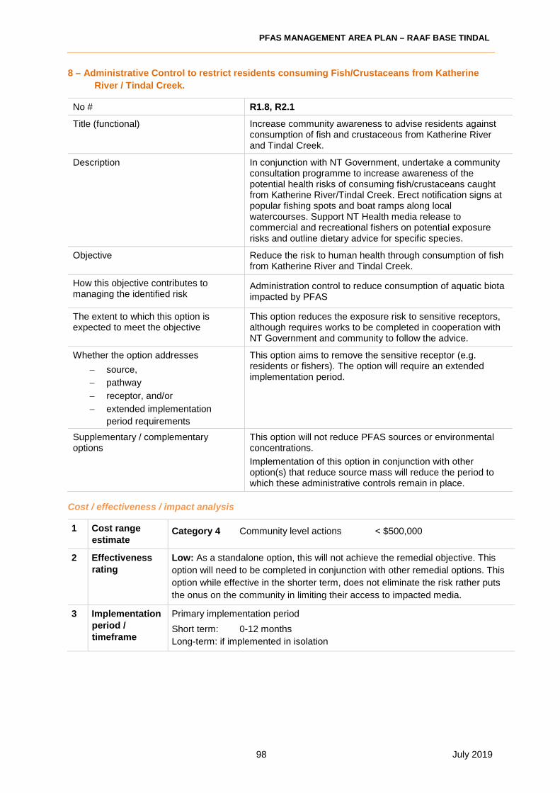
PFAS MANAGEMENT AREA PLAN – RAAF BASE TINDAL
98 July 2019
8 – Administrative Control to restrict residents consuming Fish/Crustaceans from Katherine
River / Tindal Creek.
No # R1.8, R2.1
Title (functional) Increase community awareness to advise residents against consumption of fish and crustaceous from Katherine River and Tindal Creek.
Description In conjunction with NT Government, undertake a community consultation programme to increase awareness of the potential health risks of consuming fish/crustaceans caught from Katherine River/Tindal Creek. Erect notification signs at popular fishing spots and boat ramps along local watercourses. Support NT Health media release to commercial and recreational fishers on potential exposure risks and outline dietary advice for specific species.
Objective Reduce the risk to human health through consumption of fish from Katherine River and Tindal Creek.
How this objective contributes to managing the identified risk
Administration control to reduce consumption of aquatic biota impacted by PFAS
The extent to which this option is expected to meet the objective
This option reduces the exposure risk to sensitive receptors, although requires works to be completed in cooperation with NT Government and community to follow the advice.
Whether the option addresses
− source,
− pathway
− receptor, and/or
− extended implementation
period requirements
This option aims to remove the sensitive receptor (e.g. residents or fishers). The option will require an extended implementation period.
Supplementary / complementary options
This option will not reduce PFAS sources or environmental concentrations.
Implementation of this option in conjunction with other option(s) that reduce source mass will reduce the period to which these administrative controls remain in place.
Cost / effectiveness / impact analysis
1 Cost range estimate
Category 4 Community level actions < $500,000
2 Effectiveness rating
Low: As a standalone option, this will not achieve the remedial objective. This
option will need to be completed in conjunction with other remedial options. This
option while effective in the shorter term, does not eliminate the risk rather puts
the onus on the community in limiting their access to impacted media.
3 Implementation period / timeframe
Primary implementation period
Short term: 0-12 months
Long-term: if implemented in isolation

PFAS MANAGEMENT AREA PLAN – RAAF BASE TINDAL
99 July 2019
4 Potential
impacts
Environmental and socio-economic impacts
• Positive - Reduction of consumption of PFAS impacted biota - Increased community awareness.
• Negative - Negative perception from community if Administrative Control is selected
as a primary or only remedial option. - Does not reduce the source or remove the migration pathway with
watercourse to continue to be impacted. - Negative socio-economic impact on local community through loss of
resource. - Ongoing monitoring of media (soil, water and biota) will be required to
assess the PFAS levels on residential properties. - Ongoing community and stakeholder engagement requirements. - While seen as a control, it relies on participation by the community to
remain effective.
5 Estimated net environmental
benefit
Negative, when considered as a stand-alone option.
Marginal net benefits when combined with other options.
Risk-based analysis
6 Proportion of action to risk
Development of community engagement strategy to communicate dietary advice
associated with the consumption of fish/crustaceans from Katherine River/Tindal
Creek (1-2months).
Implementation of community strategy involving community meetings, media
releases and the erection of signage at popular fishing spots and boat ramps (3-
6months initially roll out then periodically thereafter).
No impacts on Defence capability/operations anticipated.
7 Best-practice status
This option is not considered best practice, when implemented in isolation. Considered to be part of a best practice solution if implemented with source removal
8 Verification status
In progress as part of an interim response.
Requires the community to follow the recommendations of the NT Government. This represents a challenge to verify the effectiveness of this option.
9 Technology assessment
Not applicable
10 Risks and mitigation
Social and reputational risks for Defence, which would increase in severity if option used in isolation. Mitigation measures include ongoing community engagement, communication and works being implemented in conjunction with other source or pathway management options.
11 Key Dependencies
Stakeholder driven process.
The timeframes required to lift restrictions on fish/crustacean consumption are dependant of PFAS levels within the watercourses. Treatment of source mass in conjunction of this Option is expected to reduce the time restrictions would be in place.
Defence implications
12 Defence capability
No Defence capabilities affected by implementation of the option

PFAS MANAGEMENT AREA PLAN – RAAF BASE TINDAL
100 July 2019
13 Project fit Similar administrative controls are in place in relation to other contaminated sites
within Australia, including those operated by Defence.
14 Scalability Achieved through expanding awareness programs and consultation.
Administrative control can be scaled depending on success of other management
options.
Stakeholder impacts, views and consents
15 Jurisdictional
regulator/s
NT Government
Significant liaison with NT Health, NT Department of Environmental and Natural Resources and NT EPA required to determine content and approach to dietary
advisories and notifications.
16 Owner /
occupier consents and views
Katherine Town Council, Indigenous communities and tourism authorities.
17 Community Negative if implemented in isolation – Reputational risk and concerns raised by
community about impact to recreational fishing and consumption. Timely and
transparent information is expected in relation to exposure potential, but there is an
expectation that source removal or concentration reduction actions will also be
implemented.

PFAS MANAGEMENT AREA PLAN – RAAF BASE TINDAL
101 July 2019
9 - Excavate and Dispose Off Site
No # R1.7, R2.5, R3.6
Title (functional) Excavate and dispose off site to a licensed landfill.
Description Source reduction through the excavation of PFAS impacted soil materials in primary source areas and disposal to a licensed landfill off site.
Objective Reduce the impact to groundwater quality
How this objective contributes to managing the identified risk
Reduces the PFAS mass in primary source areas.
The extent to which this option is expected to meet the objective
Source removal will reduce groundwater impacts, which will in turn reduce PFAS discharged to surface water bodies and uptake mechanisms within the wider food chain.
Whether the option addresses
− source,
− pathway
− receptor, and/or
− extended implementation
period requirements
Source
Supplementary / complementary options
Implementation of this option in conjunction with other option(s) that reduce source mass will reduce the period to which these administrative controls remain in place.
Cost / effectiveness / impact analysis
1 Cost range estimate
Category 1 >$15m based on volume of impacted soil in primary source areas.
There is currently no landfill licensed to receive this waste in the NT. PFAS
impacted soil material would need to be transported interstate.
2 Effectiveness
rating High with supplementary option
Administrative controls would also be required to manage point of exposure risks. Monitoring of effectiveness would also be required
3 Implementation period / timeframe
Primary implementation period
− Medium term: 3 years
4 Potential impacts
Environmental and socio-economic impacts:
• Positive: - Reduction of PFAS mass in soil in primary source areas.
- Higher confidence on mass reduction, and implementation programme
• Negative - Disposal of PFAS waste cross border in different jurisdiction. - Uncertain on regulatory acceptance of option.
- Unlikely to result in lifting of restrictions on groundwater use off site or consumption of fish/crustaceans caught in river in short to medium term.
5 Estimated net environmental benefit
Marginal
Option transfers waste from one location to another, requiring large investment to transport waste.

PFAS MANAGEMENT AREA PLAN – RAAF BASE TINDAL
102 July 2019
Risk-based analysis
6 Proportion of
action to risk
Action is disproportionate to net environmental benefit.
7 Best-practice
status
Option is not considered best practice.
8 Verification
status
Not applicable
9 Technology
assessment
Not applicable
10 Risks and
mitigation
Secondary risks
- Waste requires transport over potentially long distances - Cross contamination
Residual risks
- treatment aims to reduce PFAS mass in source areas. It will not address PFAS impacted groundwater beyond the extent of the excavation. It will not
reduce risks at point of exposure.
11 Key Dependencies
Requires regulatory approval to transport wastes to an appropriately licensed
landfill, potentially across jurisdictions. Also requires additional controls to mitigate risks at point of exposure.
Defence implications
12 Defence
capability
Minimal impact on defence associated with excavation, reinstatement and
haulage of PFAS waste
13 Project fit Poor fit given location of Tindal to known landfill facilities licensed to receive
waste.
14 Scalability Scalable
Stakeholder impacts, views and consents
15 Jurisdictional
regulator/s
NT Government and other State Government (depending on fate of waste)
Defence
16 Owner /
occupier consents and views
Defence
Receiving landfill operator, and government regulatory authority.
17 Community Positive view from local community although negative impacts from community
near receiving facility.

PFAS MANAGEMENT AREA PLAN – RAAF BASE TINDAL
103 July 2019
10 – Cap or seal contaminated soils and surfaces
No # R2.4, R3.2
Title (functional) Cap contaminated soils or seal contaminated surfaces
Description Place physical cover or seal surfaces to reduce contaminated run-off, leaching to groundwater and direct contact.
Objective Reduce concentrations in surface waters of Base drains and Tindal Creek Control direct exposure of ecology to contaminated soils
How this objective contributes to managing the identified risk
Reduces the PFAS run-off from contaminated soils and infrastructure to drains Prevents direct contact with soils in primary source areas
The extent to which this option is expected to meet the objective
Low permeability cover would significantly reduce concentrations in run-off in early Wet season, but would not be as effective late in the Wet season when groundwater levels are shallow and intercept surface drains. Physical cover would prevent exposure for as long as it is maintained.
Sealing infrastructure would be expected to significantly reduce concentrations in run-off resulting from back diffusion from surfaces. The percentage contribution from this pathway is not known.
Whether the option addresses
− source,
− pathway,
− receptor, and/or
− extended implementation
period requirements
Pathway interception close to the source.
Supplementary / complementary options
Capping and sealing may be applied as a short term measure while planning and procurement of source removal are conducted.
Cost / effectiveness / impact analysis
1 Cost range
estimate The cost range estimate for the Option is Category 3 ($500K - $1.5M)
2 Effectiveness
rating
Low: As a standalone option, this will not achieve the remedial objective to
address multiple risks from source areas. This option will need to be completed in conjunction with other remedial options. This option while effective for run-off
reduction and reducing direct contact exposure for ecology, does not reduce risks from groundwater migration and does not reduce the source.
3 Implementation period / timeframe
Primary implementation period
− Short term: 0-12 months
4 Potential impacts
Environmental and socio-economic impacts:
• Positive: - Reduction of PFAS run-off from primary source areas
- Low energy needs
• Negative - Requires soil movement
- Requires maintenance in perpetuity

PFAS MANAGEMENT AREA PLAN – RAAF BASE TINDAL
104 July 2019
5 Estimated net
environmental benefit
Marginal
Low carbon and energy inputs, but also limited improvement of site condition.
Risk-based analysis
6 Proportion of
action to risk
Action is disproportionate to net environmental benefit, and only addresses
limited number of risks.
7 Best-practice status
Option is considered best practice, until source removal is contacted, or where other measures manager groundwater migration.
8 Verification status
Well established process for non-volatile contaminants where leaching to groundwater is not a driver.
9 Technology assessment
Plant and consumables readily available in market. If clay capping is proposed then a suitable source would need to be identified. Geomembrane liner material
available within Australia.
10 Risks and
mitigation
Secondary risks
- May change surface drainage and lead to flooding - Would result in contamination of some capping material and increase ultimate
source volume for subsequent removal
Residual risks
- treatment aims to reduce direct contact and PFAS surface run-off in source
areas. It will not address PFAS impacted groundwater and will not materially reduce risks at off-Base points of exposure.
11 Key Dependencies
Requires surface profiling to maintain site use or suitable drainage, while accommodating a thickness of added cover or liner.
Defence implications
12 Defence
capability
Short term impact on Defence associated with excavation/profiling and cover
placement
13 Project fit Good fit as a short term measure if source removal is delayed.
14 Scalability Scalable
Stakeholder impacts, views and consents
15 Jurisdictional regulator/s
Commonwealth
16 Owner / occupier
consents and views
Defence
Design would need to consider site profiling to ensure usable surface and
adequate drainage. Earthworks disruption may be considered low value if
contamination remains.
17 Community Positive view from local community if implemented as a rapid action prior to
source removal.

PFAS MANAGEMENT AREA PLAN – RAAF BASE TINDAL
105 July 2019
APPENDIX F Ongoing monitoring plan
RAAF Base Tindal
PFAS ONGOING MONITORING PLAN
July 2019

2 July 2019
CONTENTS
CONTENTS............................................................................................................................................. 2
GLOSSARY ............................................................................................................................................ 4
1 INTRODUCTION .................................................................................................................................. 5
1.1 Background ................................................................................................................................... 5
The nature of PFAS ........................................................................................................................ 6
1.2 Objective ....................................................................................................................................... 7
1.3 Purpose of this OMP ..................................................................................................................... 7
1.4 Responsible parties ....................................................................................................................... 8
2 Monitoring program .............................................................................................................................. 9
2.1 Sampling and analysis quality plan ............................................................................................... 9
2.1.1 Monitoring frequency .............................................................................................................. 9
2.2 Monitoring network ........................................................................................................................ 9
2.1.1 Groundwater monitoring network ........................................................................................... 9
2.1.2 Surface water monitoring network ....................................................................................... 10
2.3 Biota monitoring program ............................................................................................................ 10
2.4 Analytical plan ............................................................................................................................. 11
2.5 Inspect Administrative Controls .................................................................................................. 12
3 Quality procedures ............................................................................................................................. 13
3.1 Data Quality Objectives............................................................................................................... 13
4 Trigger values or performance standards .......................................................................................... 17
4.1 Screening values ......................................................................................................................... 17
4.2 Trigger points .............................................................................................................................. 17
4.3 Administrative control trigger points ............................................................................................ 19
5 Reporting requirements ...................................................................................................................... 20
5.1 Guidance documents .................................................................................................................. 20
4.1.1 PFAS National Environmental Management Plan ........................................................ 20
5.2 Reporting ..................................................................................................................................... 20
5.2 Stakeholder engagement ............................................................................................................ 22
5.3 Triggers for OMP review ............................................................................................................. 22
5.4 Monitoring potential future risks .................................................................................................. 23
5.4 Document review frequency ....................................................................................................... 23
Existing Knowledge ....................................................................................................................... 23
6 References ......................................................................................................................................... 24
Appendix A OMP Figures ................................................................................................................. 25
Appendix B Sampling Location Coordinates .................................................................................... 26

PFAS MANAGEMENT AREA PLAN – RAAF Base Tindal
3 July 2019
Appendix C SAQP Guidance ............................................................................................................ 34
Appendix D Monitoring Well Construction Details ............................................................................ 38
Appendix E Historic Sampling Data .................................................................................................. 39

PFAS MANAGEMENT AREA PLAN – RAAF Base Tindal
4 July 2019
GLOSSARY
Base A defined physical locality or geographical area from which Defence-
related activities, operations, training or force preparations are
managed, conducted, commanded or controlled.
DSI Detailed site investigation as identified in References
ERA Ecological Risk Assessment
HHRA Human Health Risk Assessment
Management Area The geographical area subject to Defence response actions as
described in section 1
PFAS NEMP PFAS National Environmental Management Framework (2018)
developed cooperatively between Australian jurisdictions
Response actions Actions identified as recommended or potential options to address
potential risks
Risk assessment(s) The HHRA and ERA described in References
Source area An area within the Management Area that is, or has the potential to be,
a source of contamination

PFAS MANAGEMENT AREA PLAN – RAAF Base Tindal
5 July 2019
1 INTRODUCTION
1.1 Background
PFAS are a group of synthetic (i.e. ‘man-made’) compounds which include perfluorooctane sulfonate
(PFOS), perfluorohexane sulfonate (PFHxS), and perfluorooctanoic acid (PFOA). PFAS have been
widely used around the world since the 1950s to make products that resist heat, stains, grease and
water. These include hydraulic fluid, stain resistant applications for furniture and carpets, packaged
food containers, waterproof clothing, personal care products and cleaning products.
Due to its effectiveness in extinguishing liquid fuel fires, PFAS was also an ingredient in legacy
aqueous film forming foam (AFFF) used extensively worldwide by both civilian and military authorities
from about the 1970s. Older formulations of AFFF contained a number of PFAS now known to be
persistent in the environment and in humans.
Most people living in developed nations will have some level of PFAS in their body due to their
widespread use. In June 2016, the Environmental Health Standing Committee (enHealth)1, published
guidance statements advising that there is currently no consistent evidence that exposure to PFOS
and PFOA causes adverse human health effects.2 However, since these chemicals remain in humans
and the environment for many years, it is recommended that as a precaution, human exposure to
PFAS be minimised.
PFAS contamination on and in the vicinity of the Defence estate arises primarily because of the
historic use of AFFF for training purposes or incident control.
Department of Defence has engaged Coffey Environments Australia Pty Ltd (Coffey) to develop this
Ongoing Monitoring Plan (OMP) for per- and polyfluoroalkyl substance (PFAS) as a part of the PFAS
Management Area Plan (PMAP) for RAAF Base Tindal (the Base).
The Management Area ongoing monitoring plan (OMP) monitors changes to the contamination plume
and surface water contamination characteristics. Changes may result from the specific or cumulative
impact of remediation or containment actions, existing transportation trends, changes to
hydrogeology, or weather events.
The Management Area relevant to this OMP is presented in Figure 1.
1 EnHealth is a subcommittee of the Australian Health Protection Principal Committee and is responsible for providing agreed environmental health policy advice. Its membership includes representatives from the Health portfolios of Australian and New Zealand governments.
2 http://www.health.gov.au/internet/main/publishing.nsf/content/health-pubhlth-publicat-environ.htm

PFAS MANAGEMENT AREA PLAN – RAAF Base Tindal
6 July 2019
Figure 1. PFAS Management Area
The nature of PFAS
PFAS has many qualities that combine to present particular challenges in locating, containing and
remediating PFAS contamination:
• Water is the prime method of PFAS contamination transferring from a source to a
receptor - a person, animal, plant, eco-system, property or a waterbody.
• PFAS is highly soluble and mobile and can rapidly leach through soils or disperse in
waterways, travelling long distances. This may sometimes reduce the level of
contamination of the original source material.
• PFAS can permeate some solid surfaces. This includes concrete and other building
materials, particularly used in storage tanks, fire training grounds and other large surface
areas.
• PFAS is very chemically and biologically stable and has a low vapour pressure, so it is
resistant to breakdown and evaporation. However, some longer chain PFAS do break
down in the environment, and are precursors to forming PFOS, PFHxS or PFOA.
• Some PFAS (including PFOS and PFOA) are environmentally persistent and
bioaccumulate. This means that some plants may be susceptible to PFAS, uptaking it
through soil and water. It then bio-accumulates and becomes a part of the food chain.
The same process applies to some animals and fish.

PFAS MANAGEMENT AREA PLAN – RAAF Base Tindal
7 July 2019
1.2 Objective
The objective of the OMP is to set out a program of monitoring to continue to assess the changes in
the nature and extent of PFAS within the environment, where Defence’s historical use of legacy AFFF
has led to an identified potentially elevated risk to a receptor, or potential future risk to a receptor.
Data on changes in the distribution, concentration, transport (pathways and flow rates) and
transformation of the contaminants and assessment against appropriate guideline values provides:
• an evidence base for targeted and effective risk management of PFAS contamination to
protect human health and environmental receptors.
• an early warning that additional management of PFAS contamination may be warranted
in areas not currently affected by PFAS.
1.3 Purpose of this OMP
The historic release of PFAS containing chemicals into the environment at RAAF Base Tindal has led
to the contamination of soils, groundwater and surface water, resulting in concentrations of PFAS
within water bodies and biota off-base that has the potential to pose an unacceptable risk to the health
of human receptors or the environment. Consequently, it is important that ongoing monitoring of the
nature and extent of PFAS within the environment at and surrounding RAAF Base Tindal is
undertaken to assess potential changes in risk levels. As a consequence of currently identified
potentially unacceptable risks to receptors, the Northern Territory Department of Health has issued
dietary advisories relating to consumption of fish from the Katherine River, and Department of
Defence issued a Human Health Risk Assessment that described potential PFAS intake from various
activities that people may undertake. In order to ensure that the advice remains relevant, it is
important to monitor the concentrations of PFAS within the environment on-Base and off-Base.
The overall aim of the OMP is to provide information on changes in PFAS contamination originating
from RAAF Base Tindal to inform risk management decisions by Defence Territory agencies to protect
human health and the environment.
Data on changes in the distribution, concentration, transport (pathways and flow rates) and
transformation of the contaminants and assessment against appropriate guideline values provides:
• an evidence base for targeted and effective risk management of PFAS contamination to protect
human health and environmental receptors currently impacted by PFAS.
• an early warning that additional management of PFAS contamination may be warranted in areas
not currently affected by PFAS.
The specific objectives of this OMP are:
• Monitor PFAS concentrations in groundwater and surface water and assess the data for any
changes over time.
• Provide data to monitor the success of any remediation and management undertaken as set out in
the PMAP.
• To monitor PFAS concentrations within target aquatic species to inform risk management
measures and provide updates of any recommendations to Territory Agencies regarding
consumption of biota.
This OMP has been prepared in general accordance with the following documents, which should be
read in conjunction with this OMP:
• NEPC (2013) National Environmental Protection (Assessment of Site Contamination) Measure
1999, as amended in 2013, National Environment Protection Council.

PFAS MANAGEMENT AREA PLAN – RAAF Base Tindal
8 July 2019
• HEPA (2018) PFAS National Environmental Management Plan (NEMP), the Heads of EPAs
Australia and New Zealand.
• Department of Defence (2018) Defence PFAS Framework – Construction and Maintenance
Projects.
• Department of Defence (2012) Defence Contamination Directive #7: Naming convention – surface
water, groundwater bore, soil and sediment sampling identification.
• VIC EPA, Publication 669 - Groundwater Sampling Guidelines (April 2000).
• WA DER, Interim Guideline on the Assessment and Management of Perfluoroalkyl and
Polyfluoroalkyl Substances (PFAS) (January 2017).
1.4 Responsible parties
The roles and responsibilities associated with the implementation of this OMP are provided in the
table below.
Table 1. Responsible parties
Role Responsibilities
Department
of Defence
PFAS Investigation
Management
Branch
Ensure the OMP is implemented by an appropriate independent
consultant.
Ensure the OMP is reviewed as and when required and changes are
reported are implemented.
RAAF Base Tindal
BSM/SADFO
Ensure that on-Base sampling locations are safely accessible and
maintained.
Environmental and
Sustainability
Officer
Ensure works associated with this OMP are carried out in accordance
with Defence environmental policy.
Environmental consultant Carry out all works described in this OMP, including:
• Obtain relevant Base permits etc. to complete the works
• Sample collection
• Data management
• Reporting to Defence
• Review of the OMP
NATA accredited laboratory Carry out laboratory analysis of samples and report results to the
environmental consultant and/or Defence.
Provide electronic format of data for uploading into the Defence
database.

PFAS MANAGEMENT AREA PLAN – RAAF Base Tindal
9 July 2019
2 Monitoring program
2.1 Sampling and analysis quality plan
A sampling and analysis quality plan (SAQP) should be prepared for any sampling works associated
with this OMP. The SAQP should be prepared by an appropriate environmental consultant and should
be consistent and compliant with guidance provided in the PFAS NEMP (2018) and the NEPM (2013).
The SAQP will be reviewed by Defence prior to commencement of works to ensure consistency with
the program in line with any changes in documentation, including ongoing review of the OMP and
PMAP.
2.1.1 Monitoring frequency
Ongoing monitoring frequency of groundwater and surface water monitoring is summarised in the
following table.
Table 2. Monitoring frequency
Matrix Monitoring
frequency
Approximate monitoring period
Groundwater – private bores
selected along Zimin Drive and
Shadforth Road on western
side of Katherine River
Quarterly
Early-mid Dry season (May-June), late Dry season
(September-October), early-mid Wet season (December),
late Wet season (February-March)
Groundwater - other Annual Late Dry season or early Wet season (October-
December)
Surface water – Katherine
River, Hot Springs and YMCA
pool
Quarterly
Early-mid Dry season (May-June), late Dry season
(September-October), early-mid Wet season (December),
late Wet season (February-March)
Surface Water - other Twice-per-year
Early-mid Wet season and mid-late Wet season.
Depending on when water is observed in on-Base drains
and Tindal Creek
Groundwater and surface water sampling methodologies are described in Appendix C.
2.2 Monitoring network
2.1.1 Groundwater monitoring network
Groundwater monitoring wells identified for ongoing monitoring are presented in Figures 1 to 3,
Appendix A and in Table 1, Appendix B. It is noted that several groundwater bores selected for
ongoing monitoring are private/residential bores. These have been selected to monitor exposure
points in key areas. In order to obtain samples from private bores, a signed access agreement is
required prior to sample collection. Groundwater monitoring locations have been selected to monitor
source area concentration changes and changes that may occur at the Base boundary or offsite
locations, which could indicate a change in contaminant transport off-Base or change in risk profile.
Where a groundwater bore has been nominated for monitoring, an alternative has been provided in
the event that the original bore cannot be sampled for some reason. In the event that a nominated
bore is destroyed, it may be a requirement to reinstall the well (where the alternative bore column of
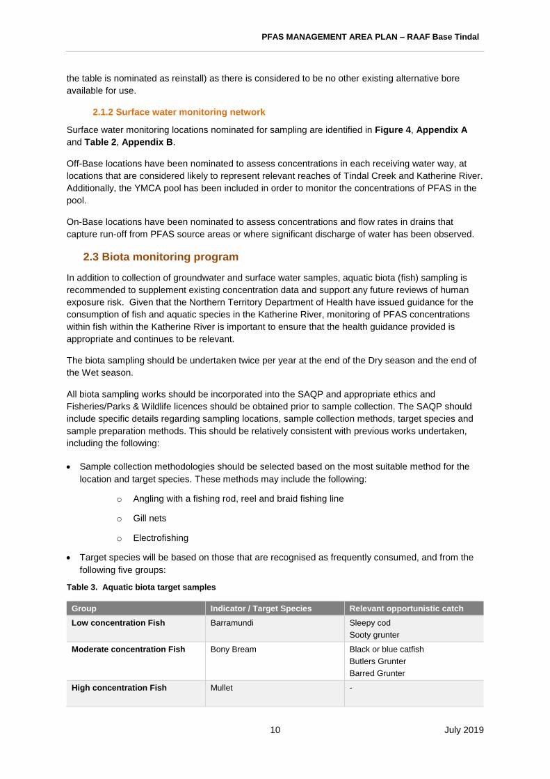
PFAS MANAGEMENT AREA PLAN – RAAF Base Tindal
10 July 2019
the table is nominated as reinstall) as there is considered to be no other existing alternative bore
available for use.
2.1.2 Surface water monitoring network
Surface water monitoring locations nominated for sampling are identified in Figure 4, Appendix A
and Table 2, Appendix B.
Off-Base locations have been nominated to assess concentrations in each receiving water way, at
locations that are considered likely to represent relevant reaches of Tindal Creek and Katherine River.
Additionally, the YMCA pool has been included in order to monitor the concentrations of PFAS in the
pool.
On-Base locations have been nominated to assess concentrations and flow rates in drains that
capture run-off from PFAS source areas or where significant discharge of water has been observed.
2.3 Biota monitoring program
In addition to collection of groundwater and surface water samples, aquatic biota (fish) sampling is
recommended to supplement existing concentration data and support any future reviews of human
exposure risk. Given that the Northern Territory Department of Health have issued guidance for the
consumption of fish and aquatic species in the Katherine River, monitoring of PFAS concentrations
within fish within the Katherine River is important to ensure that the health guidance provided is
appropriate and continues to be relevant.
The biota sampling should be undertaken twice per year at the end of the Dry season and the end of
the Wet season.
All biota sampling works should be incorporated into the SAQP and appropriate ethics and
Fisheries/Parks & Wildlife licences should be obtained prior to sample collection. The SAQP should
include specific details regarding sampling locations, sample collection methods, target species and
sample preparation methods. This should be relatively consistent with previous works undertaken,
including the following:
• Sample collection methodologies should be selected based on the most suitable method for the
location and target species. These methods may include the following:
o Angling with a fishing rod, reel and braid fishing line
o Gill nets
o Electrofishing
• Target species will be based on those that are recognised as frequently consumed, and from the
following five groups:
Table 3. Aquatic biota target samples
Group Indicator / Target Species Relevant opportunistic catch
Low concentration Fish Barramundi
Sleepy cod
Sooty grunter
Moderate concentration Fish Bony Bream
Black or blue catfish
Butlers Grunter
Barred Grunter
High concentration Fish Mullet
-

PFAS MANAGEMENT AREA PLAN – RAAF Base Tindal
11 July 2019
Group Indicator / Target Species Relevant opportunistic catch
Crustaceans Cherabin -
Reptiles Turtle -
• The number of samples collected will vary based on what is caught, however a target of at least
three of each indicator species should be aimed for from each location.
• The two primary suitable locations identified for sample collection are in the vicinity of:
o Stuart Highway boat ramp: Location code BIO088 (shown as SW108 on Figure 4,
Appendix A)
o Galloping Jacks boat ramp: Location code BIO078 (approximately 19 km downstream
from Stuart Highway) (shown as SW151 on Figure 4, Appendix A)
• Captured target fish should be euthanised in line with ethics approval, which may involve ice
slurry, Aqui-S solution anaesthesia, clubbing, pithing and/or cervical dislocation.
• For larger fish, complete tissue samples of edible flesh should be collected. Whole gutted fish
samples should be taken for smaller fish.
• A clean polypropylene cover should be used over a chopping board, and new sterilised scalpel
blades or washed stainless steel blades used for sample preparation.
2.4 Analytical plan
Samples should be analysed for the standard required PFAS suite, as specified in Defence PFAS
Framework – Construction and Maintenance Projects. This suite is presented in the following table.
Table 4. Standard laboratory PFAS suite
Group Acronym Chemical Compound CAS No
Perfluoroalkane Sulfonic Acids
PFBS Perfluorobutane sulfonic acid 375-73-5
PFPeS Perfluoropentane sulfonic acid 2706-91-4
PFHxS Perfluorohexane sulfonic acid 355-46-4
PFHpS Perfluoroheptane sulfonic acid 375-92-8
PFOS Perfluorooctane sulfonic acid 1763-23-1
PFDS Perfluorodecane sulfonic acid 335-77-3
Perfluoroalkane Carboxylic Acids
PFBA Perfluorobutanoic acid 375-22-4
PFPeA Perfluoropentanoic acid 2706-90-3
PFHxA Perfluorohexanoic acid 307-24-4
(PFHpA) Perfluoroheptanoic acid 375-85-9
PFOA Perfluorooctanoic acid 335-67-1
PFNA Perfluorononanoic acid 375-95-1
PFDA Perfluorodecanoic acid 335-76-2
PFUnDA Perfluoroundecanoic acid 2058-94-8
PFDoDA Perfluorododecanoic acid 307-55-1
PFTrDA Perfluorotridecanoic acid 72629-94-8
PFTeDA Perfluorotetradecanoic acid 376-06-7
Perfluoroalkyl Sulfonamides
FOSA Perfluorooctane sulfonamide 754-91-6
MeFOSA N-Methyl perfluorooctane sulfonamide 31506-32-8
EtFOSA N-Ethyl perfluorooctane sulfonamide 4151-50-2
MeFOSE N-methyl perfluorooctane sulfonamidoethanol 24448-09-7

PFAS MANAGEMENT AREA PLAN – RAAF Base Tindal
12 July 2019
Group Acronym Chemical Compound CAS No
EtFOSE N-Ethyl perfluorooctane sulfonamidoethanol 1691-99-2
MeFOSAA N-methyl perfluorooctane sulfonamidoacetic acid 2355-31-9
EtFOSAA N-ethyl perfluorooctane sulfonamidoacetic acid 2991-50-6
(n:2) Fluorotelomer Sulfonic Acids
4:2 FTS 4:2 Fluorotelomer sulfonic acid 757124-72-4
6:2 FTS 6:2 Fluorotelomer sulfonic acid 27619-97-2
8:2 FTS 8:2 Fluorotelomer sulfonic acid 39108-34-4
10:2 FTS 10:2 Fluorotelomer sulfonic acid 120226-60-0
2.5 Inspect Administrative Controls
Various administrative controls are recommended to be implemented as a part of the management of
risks to human health arising from PFAS at the Base. The administrative controls required to be
implemented include:
• Implementing PPE and Hazard control requirements for maintaining and cleaning Fire Training
Area equipment, tanks and sumps
• Ensuring construction and maintenance activities that are undertaken within PFAS source areas
are undertaken safely and using the required PPE and Hazard/ Waste control requirements.
• Ensuring construction and maintenance activities that are undertaking at depths that may
encounter groundwater are undertaken safely and using the required PPE and Hazard/ Waste
control requirements.
• An area of PFAS impacted soil stockpiles is located within an area of the base. These are to be
inspected to ensure that coverings are in place and not degrading.
Inspection actions should be undertaken annually in consultation with the REO and the outcomes of
the review documented in the annual report. Where opportunities for improvement are identified in
the management measures or procedures, these should also be documented in the annual report.

PFAS MANAGEMENT AREA PLAN – RAAF Base Tindal
13 July 2019
3 Quality procedures
The recommendations of this procedure are based on the guidelines presented in:
• NEPM [the National Environment Protection (Assessment of Site Contamination) Measure 1999]
as amended in 2013.
• AS4482.1 Guide to the sampling and investigation of potentially contaminated soil, Part 1: Non-
Volatile and Semi-Volatile Substances.
• AS4482.2 Guide to the sampling and investigation of potentially contaminated soil, Part 2: Volatile
Substances.
• AS/NZ 5667.1 Water Quality Sampling – Guidance on the design of sampling programs, sampling
techniques and the preservation and handling of samples.
• ANZECC&ARMCANZ (2000). Australian guidelines for water quality monitoring and reporting.
• ANZECC&ARMCANZ (2000). Australian and New Zealand guidelines for fresh and marine water
quality.
• WA DER (2016). Interim Guideline on the Assessment and Management of Perfluoroalkyl and
Polyfluoroalkyl Substances (PFAS).
3.1 Data Quality Objectives
Data Quality Objectives (DQOs) are qualitative and quantitative statements derived from the outputs
of the first six steps of the seven step DQO process that:
• Clarifies the study objective.
• Defines the most appropriate collection of data as relevant to the study objective.
• Determines the conditions from which to collect data;
• Specifies tolerable limits on decision errors, which will be used as the basis for establishing
the quantity and quality of data, needed to support the decision.
The DQOs for this investigation have been prepared in line with the DQO process outlined in US
Environmental Protection Agency (EPA) (2006) and NEPM 2013 (Schedule B2) and are presented in
the seven-step DQO approach summarised in Table 5.
Table 5. Data Quality Objectives
Data Quality Objectives
1. State the Problem
Confirmed PFAS contamination sources have been identified at RAAF Base Tindal that have led to
the contamination of soil, groundwater and surface water, with PFAS measured within biota from
Tindal Creek and the Katherine River. Based on the data collected between April 2017 and May
2018, assessments of risk to human health and ecology were completed. It is important to that the
concentrations of PFAS within the environment are monitored to review if the advice developed
based on previous data and risk assessments remains relevant, appropriate and protective.
2. Identify the goal of the study
The purpose of the OMP is to ensure that the concentrations of PFAS within groundwater, surface
water and biota are monitored and compared against baseline conditions and to assess potential
changes in risks to sensitive receptors (human and ecological receptors). This will then allow NT

PFAS MANAGEMENT AREA PLAN – RAAF Base Tindal
14 July 2019
Data Quality Objectives
government agencies to be provided with advice regarding managing and/or controlling exposure
to contamination.
3. Identify information inputs
• Existing data relevant to PFAS in soil, waters and biota
• Surface water and groundwater flow regimes
• Location and types of human and environmental receptors
4. Define the boundary of the study
Based on the understood extent of contaminated surface water or shallow groundwater at the
Base the study area includes land and waterways on RAAF Base Tindal and in each direction
towards, and including, the receiving water bodies. The Management Area is shown in Figure 1.
5. Develop a decision rule
Primary environmental samples are to be collected and analysed for the 28 PFAS compounds
described in Defence Technical Memorandum on Laboratory Analysis Suite (reference number
1652034-060-M-Rev2 dated 30 March 2017).
PFOS, PFHxS and PFOA concentrations will be compared against screening levels relevant to the
potential beneficial uses of water to identify changes to risk profile.
The relative concentrations of all (analysed) PFAS compounds over time in groundwater, surface
water and aquatic biota samples will be used to assess changes in the extent or magnitude of
contamination.
6. Specify performance of acceptance criteria
The ongoing monitoring program as a whole must reliably characterise the changes in PFAS
contamination within surface water, groundwater and biota compared with the baseline conditions
and describe the risk that the contamination poses to human or ecological receptors. Analytical
data quality indicators are described below in Quality control procedures section.
7. Develop a plan for obtaining the data
The methodology and rationale for obtaining relevant data for the OMP is described in this
document.
Table 6. Field quality control samples
Sample Type Comments
Intra-laboratory
duplicates
Intra-laboratory field duplicates will be collected at a frequency of one sample per ten
samples collected (10%). The analytical results of the two duplicate samples will be
compared to assess the precision of the sampling protocol and to provide an indication of
variation in the sample source.
Repeatability will be assessed by calculating the relative percentage difference (RPD)
between the primary and duplicate results. Where the RPD is greater than 30%, the potential
causes of variability will be reviewed.

PFAS MANAGEMENT AREA PLAN – RAAF Base Tindal
15 July 2019
Sample Type Comments
Inter-laboratory
duplicates Inter-laboratory field duplicates will be collected of surface water and sediment samples at a
frequency of one sample per ten samples collected (10%). The analytical results of the two
duplicate samples will be compared to assess the precision of the sampling protocol, provide
an indication of variation in the sample source and to assess the accuracy of analysis.
Reproducibility will be assessed by calculating the relative percentage difference (RPD)
between the primary and duplicate sample results. Where the RPD is greater than 30%, the
potential causes of variability will be reviewed.
Rinsate blanks
Rinsate samples will be prepared in the field using laboratory prepared bottles and PFAS free
deionised water used for the cleaning of reusable sampling equipment (if used). These
samples will be a check of field decontamination procedures. A rinsate sample will be
collected and analysed for each day of field work carried out or for each 10 primary samples
where more than ten samples are collected in a day, where reusable sampling equipment
has been used.
Detectable concentrations of PFAS in a rinsate blank sample will trigger review of
decontamination procedures, equipment materials, sample container types and UHP water
quality. The concentration and compound detected will be considered in reviewing the
potential impact of transport related cross-contamination of the assessment data quality.
Trip blanks Trip blanks are a check on sample contamination originating from containers, sample
transport, shipping and site conditions. The blank will be prepared in a clean environment
(office or warehouse) and remain with the sample containers during sampling and during the
return trip to the lab. At no time during these procedures will the blanks be opened. Upon
return to the lab the blank will be analysed, if needed, as any other field sample. As PFAS is
not volatile, a reduced blank frequency is considered appropriate and a single trip blank will
be transported and analysed for each day.
Detectable concentrations of PFAS in a trip blank sample will trigger review of sample
container types, transport procedures and UHP water quality. The concentration and
compound detected will be considered in reviewing the potential impact of transport related
cross-contamination of the assessment data quality.

PFAS MANAGEMENT AREA PLAN – RAAF Base Tindal
16 July 2019
Table 7. Laboratory quality control procedures
Sample Type Comments
Sample
Analysis
All sample analyses to be conducted using NATA certified laboratories which will implement
a quality control plan in accordance with NEPM (1999).
Holding times Groundwater/surface water: 14 days prior to extraction or 28 days following extraction for
PFAS (NMI 2017)
Soil: 60 days prior to extraction for PFAS (NMI 2017)
Biota: 180 days prior to extraction for PFAS
Laboratory
detection limits
All laboratory detection limits to be less than the site investigation criteria.
Laboratory
Blanks
Laboratory blanks to be analysed at a rate of 1 in 20, with a minimum of one analysed per
batch.
Concentration of analytes to be less than the laboratory detection limits.
Laboratory
Duplicates
Laboratory duplicates to be analysed at a rate of 1 in 20, with a minimum of one analysed per
batch. RPDs to be less than 30%.
Laboratory
Control
Samples (LCS)
LCSs to be analysed at a rate of 1 in 20, with a minimum of one analysed per analytical
batch.
Control limits: 50 to 150 % Acceptable Recovery
Surrogate Labelled surrogates of target analytes are added in known amounts to each sample during
analysis and recovery of the surrogate is quantified to assess equipment and process
response. The recovery is then used to adjust the calculation of the target analyte in that
sample.
Surrogate
control limits:
50–150 % Acceptable recovery.
Matrix spike
duplicate
Matrix spike duplicate prepared by dividing a field sample into two aliquots, then spiking each
with identical concentrations of the analytes at a rate of 1 in 20.
Matrix spike
duplicates:
RPDs <50%
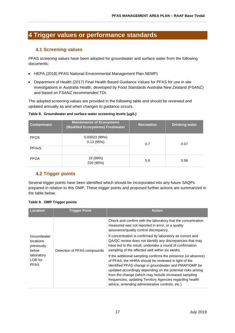
PFAS MANAGEMENT AREA PLAN – RAAF Base Tindal
17 July 2019
4 Trigger values or performance standards
4.1 Screening values
PFAS screening values have been adopted for groundwater and surface water from the following
documents:
• HEPA (2018) PFAS National Environmental Management Plan NEMP).
• Department of Health (2017) Final Health Based Guidance Values for PFAS for use in site
investigations in Australia Health, developed by Food Standards Australia New Zealand (FSANZ)
and based on FSANZ recommended TDI.
The adopted screening values are provided in the following table and should be reviewed and
updated annually as and when changes to guidance occurs.
Table 8. Groundwater and surface water screening levels (µg/L)
Contaminant Maintenance of Ecosystems
(Modified Ecosystems) Freshwater Recreation Drinking water
PFOS 0.00023 (99%)
0.13 (95%) 0.7 0.07
PFHxS -
PFOA 19 (99%)
220 (95%) 5.6 0.56
4.2 Trigger points
Several trigger points have been identified which should be incorporated into any future SAQPs
prepared in relation to this OMP. These trigger points and proposed further actions are summarized in
the table below.
Table 9. OMP Trigger points
Location Trigger Point Action
Groundwater
locations
previously
below
laboratory
LOR for
PFAS
Detection of PFAS compounds
Check and confirm with the laboratory that the concentration
measured was not reported in error, or a quality
assurance/quality control discrepancy.
If concentration is confirmed by laboratory as correct and
QA/QC review does not identify any discrepancies that may
have led to the result, undertake a round of confirmation
sampling of the affected well within six weeks.
If the additional sampling confirms the presence (or absence)
of PFAS, the HHRA should be reviewed in light of the
identified PFAS change in groundwater and PMAP/OMP be
updated accordingly depending on the potential risks arising
from the change (which may include increased sampling
frequencies, updating Territory Agencies regarding health
advice, amending administrative controls, etc.)

PFAS MANAGEMENT AREA PLAN – RAAF Base Tindal
18 July 2019
Location Trigger Point Action
All monitoring
locations
(groundwater,
surface water
or biota)
PFOS+PFHxS and/or sum of
PFAS concentrations show an
increasing trend (using
statistical analysis) over two
years of monitoring or increase
by >30% in one year.
Undertake QA/QC checks with laboratory/data to confirm
concentrations.
Review the change in the context of the overall CSM and
whether the change is material or not. Instances where a
change may be considered immaterial is where the
interpretation against screening values does not change.
Review the OMP and/or HHRA and consider additional
monitoring rounds and/or locations.
Consider additional investigation of known or potential source
areas.
Consider updating health advice to Territory Agencies or
amending administrative controls.
All monitoring
locations
(groundwater,
surface water
or biota)
PFOS+PFHxS and/or sum of
PFAS concentrations show a
decreasing trend (using
statistical analysis) over two
years of monitoring or decrease
by >30% in one year.
Undertake QA/QC checks with laboratory/data to confirm
concentrations.
Review the change in the context of the overall CSM and
whether the change is material or not.
Review the OMP and/or HHRA and consider reducing the
monitoring network or frequency as appropriate.
Consider adding additional trigger points relating to cessation
of monitoring.
Consider updating health advice to Territory Agencies or
amending administrative controls.
All
groundwater
monitoring
locations
Groundwater monitoring well is
not able to be sampled as it is
dry, blocked, damaged,
decommissioned, inaccessible,
lost etc.
Attempts should be made to locate/repair/unblock the
monitoring well.
If this is not successful, a contingency location should be
sampled instead.
If no suitable contingency location can be identified, the
monitoring well should be reinstalled in a similar location,
depth and screen interval.
Private bores
along Zimin
Drive
PFOS+PFHxS and/or sum of
PFAS concentrations in a bore
show an increasing trend
(using statistical analysis) over
two years of monitoring or
increase by >30% in one year.
Or, concentrations in a bore are
reported above the adopted
drinking water health-based
screening level.
Undertake QA/QC checks and review the change in the
context of the overall concentrations of PFAS within the bore
and surrounding bore network (as per the above).
Consider provision of alternative water supply (such as
bottled water or rainwater tanks).
Update the monitoring network to include additional
properties along Zimin Drive and Shadforth Road in this
area. In the event of additional properties reporting
detectable concentrations of PFAS, expand the monitoring
network as required in order to delineate the PFAS plume in
this area.

PFAS MANAGEMENT AREA PLAN – RAAF Base Tindal
19 July 2019
Location Trigger Point Action
Private bore
on Uralla
Road
(MW498)
Concentrations of PFAS are
reported in MW498 which
indicate an increase in plume
size or concentrations above
drinking water guidelines.
Arrange retesting of the bore as soon as practicable to
confirm the result. Conduct a second retest of the bore
approximately one month after the first retest.
If one or both of the retests report concentrations of PFAS
above drinking water guidelines, consider provision of
alternative water supply (such as bottled water or rainwater
tanks) and conduct testing of nearby private bores to the
south, as well as any other nearby properties which had
previously reported PFAS <LOR and have not received a
rainwater tank.
For sampling of additional properties, follow the steps above
in the event of detectable PFAS.
Consider accessing or installing an additional bore in order
to delineate the southern extent of the PFAS plume in Uralla.
Private bore
on Gorge
Road
(MW445)
Detectable concentrations of
PFAS are reported in MW445.
Arrange retesting of the bore as soon as practicable to
confirm the detection. Conduct a second retest of the bore
approximately one month after the first retest.
If one or both of the retests report detectable concentrations
of PFAS, consider provision of alternative water supply (such
as bottled water or rainwater tanks) and conduct testing of
nearby private bores along Gorge Road (at properties
without a town water connection).
For sampling of additional properties, follow the steps above
in the event of detectable PFAS.
Consider accessing or installing an additional bore in order
to delineate the northern extent of the PFAS plume in
Lansdowne.
MW133
PFOS+PFHxS and/or sum of
PFAS concentrations show an
increasing trend (using
statistical analysis) over two
years of monitoring or increase
by >30% in one year.
Consider requirements for additional investigation bores to
delineate the northern extent of the PFAS plume in this area
and testing of residential properties to the north of the Base.
4.3 Administrative control trigger points
The administrative controls are to be reviewed twice yearly to confirm that the appropriate controls
and management measures are being implemented in accordance with the PMAP.
Various administrative controls are recommended to be implemented to reduce risks of human exposure or
environmental release arising from PFAS at the Base. The administrative controls required to be implemented
include:
• PPE and Hazard control requirements for maintaining and cleaning Fire Training Area ponds and
sumps.
• Ensuring construction and maintenance activities that are undertaken within PFAS source areas are
undertaken safely and using the required PPE and Hazard/ Waste control requirements.
• Ensuring construction and maintenance activities that are undertaking at depths that may encounter
groundwater are undertaken safely and using the required PPE and Hazard/ Waste control
requirements.
• A PFAS impacted soil stockpile is located within the Base. This is to be inspected to ensure that
coverings are in place and not degrading.

PFAS MANAGEMENT AREA PLAN – RAAF Base Tindal
20 July 2019
Inspection actions should be undertaken annually in consultation with the REO and the outcomes of the review
documented in the annual report. Where opportunities for improvement are identified in the management
measures or procedures, these should also be documented in the annual report.
Where damage to controls (such as stockpile coverings or signage, locks etc) is identified, the
damage is to be notified to the REO within 2 weeks and any corrective actions documented.
Any construction or maintenance activities that may result in exposure of workers to PFAS
contaminated soils, groundwater or wastes which are to be conducted in the key PFAS source areas
within the management area (as shown on Figure 2 of the PMAP), or within 100m of any of the key
source areas are to be reviewed by the REO. This is to ensure that any ECC prepared for the works
takes into consideration limiting exposure to PFAS contaminated media, and that appropriate waste
management controls are to be implemented prior to issuing the ECC.
Where remedial actions are undertaken and risks to receptors are lowered, or risks are noted to
increase (through on-going monitoring and review of results against ERA and HHRA outcomes), a
review of the administrative controls should be undertaken (in accordance with the following section)
to adjust the relevant controls accordingly.
5 Reporting requirements
5.1 Guidance documents
Adopted screening criteria references national guidance in the form of the PFAS National
Environmental Management Plan, Defence estate and environmental strategies, and Defence PFAS-
specific strategies and guidance.
5.1.1 PFAS National Environmental Management Plan
The PFAS NEMP provides the guiding framework for the management of PFAS. For further
information, see: http://www.epa.vic.gov.au/PFAS_NMP.
The NEMP aims to provide governments with a consistent, practical, risk-based framework for the
environmental regulation of PFAS-contaminated materials and sites. The NEMP has been developed
collaboratively by the Heads of EPAs Australia and New Zealand and the Commonwealth Department
of Environment and Energy (DoEE) and has been endorsed by the Commonwealth Government.
The PFAS Response Management Strategy and the requirements of the OMP template and guidance
conform to the NEMP.
5.2 Reporting
Upon completion of each sampling event, data collected by the environmental consultant should be
documented in a report to Defence, which should contain the following, as a minimum.
• A summary of the scope of works undertaken.
• A summary of the field methodologies used to complete the scope of works.
• A summary of field observations and field measured data, such as water quality parameters and
gauging data.
• Presentation of inferred groundwater elevation contours.
• Estimation of rate of surface water flow at each monitoring point.
• Presentation of analytical laboratory results and comparison with adopted screening levels.

PFAS MANAGEMENT AREA PLAN – RAAF Base Tindal
21 July 2019
• Review of data quality.
• Comparison of analytical results to historical data (including trend analysis and/or graphing).
• Discussion of trends in PFAS concentrations.
• Provision of attachments including laboratory reports and chain of custody documentation, results
tables, figures, field notes and calibration records (where applicable).
The anticipated reporting schedule and purpose is described in Table 10.
Table 10. Anticipated reports Report type Frequency and
recipient Report purpose
Monitoring report
Quarterly to Defence
Presentation of factual data
Review against Triggers
Confirmation of appropriate implementation of administrative controls
Flagging of changes in risk profile
Annual PFAS monitoring and management report
Annually for Defence to provide to NT Government and the Public
Presentation of full year’s monitoring data
Collation of related information from other sources (i.e. DENR or NT Health data, relevant Incident reports, publicly available verified data)
Review of trends in concentrations
Verification that HHRA and ERA outcomes remain relevant
Assessment of adequacy of existing exposure management controls
Assessment of adequacy of monitoring locations, types and frequency to meet OMP objectives
OMP review End of 3 years for Defence to discuss with NT Government
Identification of improvements to the OMP procedures in light of observed variability or concentration changes
Review of data gaps and nomination of measures to address significant gaps
Review of changes in Australian or International practice and guidance in PFAS investigation
Incident reports As required to Defence
Reporting of changed conditions that require mitigation or warrant review of risk assessments
Results of biota sampling should be tabulated and average concentrations for each season and
species sampled should be calculated. Results are to be passed on to Defence and any triggers and
outcomes (such as dietary advice) should come from NT Department of Health.
Any other data collected during the monitoring period (whether by the lead consultant or other
consultants undertaking relevant sampling or observations within the Management Area) are to be
included within an annual report of all monitoring. The annual report is to consider the results of all
the monitoring for a 12-month period and is to include an update of the CSM and comparison with
HHRA and ERA conclusions to ensure that any health advice being issued is appropriate and up to
date.
At the end of three years of monitoring, a report of the entire monitoring data set is to be completed
with a review and comparison of results to confirm that the OMP being implemented is appropriate
and that the advice provided to Northern Territory Agencies regarding potential risks to receptors is
appropriate and up to date.
PFAS MANAGEMENT AREA PLAN – RAAF Base Tindal
22 July 2019
5.2 Stakeholder engagement
Analytical results from each monitoring round will be provided to the relevant State or Territory
regulator, including the annual interpretative report.
Where off-site residential sampling is proposed, a separate letter will be produced to provide to the
resident with the analytical results of the monitoring event and assessment against relevant guideline
values.
5.3 Triggers for OMP review
This OMP will be reviewed regularly. The review frequency will be based on site specific
characteristics and the existing trend data available. The review frequency may be revised during the
implementation period as more data becomes available.
Updates to the OMP may be required for several reasons, including the following:
• Regulatory or policy changes require review of or updates to the OMP.
• Changes in on-Base infrastructure or other works impact the existing monitoring networks.
• Additional groundwater monitoring wells are installed which may assist in achieving the objectives
of the OMP.
• Other changes to the groundwater or surface water monitoring networks are required (e.g. lost,
damaged or dry monitoring wells need to be replaced).
• Significant changes to the CSM are made.
• Updated screening values for PFAS are published.
• Significant changes to best practice sampling procedures are published.
• Updated laboratory analytical methods become available, including if the standard PFAS suite
changes.
• Updated human health and/or ecological risk assessments are published for RAAF Base Tindal
which may impact the objectives of the OMP.
• Changes to the site risk profile as a result of any remediation actions.
Changes in our understanding of these risks, triggered by this data assessment may inform:
• an early warning that additional management of PFAS contamination may be warranted in areas
not currently affected by PFAS.
• changes detected through the implementation of the OMP may inform a number of risk-
management decisions including:
• additional investigations
• re-assessment of one or more remediation or containment actions
• additional remediation or containment actions
• changing risk management actions at receptor level (e.g. provision or cessation of alternate
drinking water supplies)
PFAS MANAGEMENT AREA PLAN – RAAF Base Tindal
23 July 2019
5.4 Monitoring potential future risks
Findings from the ongoing monitoring will be used to evaluate whether changes have occurred to the
risk posed by PFAS contaminated groundwater and surface water across the Management Area. This
may be achieved through:
• Comparison of our current understanding of the nature and extent of the plume as presented
in the DSI.
• This may trigger evaluation of the monitoring program and an updated scope of works.
• Include relevant site-specific considerations, such as potential changes in known
concentrations within receiving environments or ecological receptors.
5.4 Document review frequency
The OMP will be reviewed regularly. The review frequency will be based on site specific
characteristics and the existing data trend available. The review frequency may be revised during the
implementation period as more data becomes available.
Based on the current understanding and existing data, this OMP should be implemented for an initial
three-year period, and subsequently revised if the monitoring reports trigger this change.
Existing Knowledge
The document has been developed on the basis of existing knowledge, current government policy
settings, and available scientific methodologies and technology at the time of publication. PFAS
management is a field that is rapidly evolving.
Over the primary implementation period of the PFAS Management Area Plan, Defence will review and
update (where necessary) the PMAP at intervals of 12 months to ensure that the document is current,
and its recommendations are valid.
The OMP should be subsequently updated in light of the considerations outlined in Section 5 as well
as reviews and updates to the PMAP to ensure the document is current and its recommendations
valid.

PFAS MANAGEMENT AREA PLAN – RAAF Base Tindal
24 July 2019
6 References
Australian and New Zealand Environment Conservation Council (ANZECC), 2000.Australian and New
Zealand Guidelines for Fresh and Marine Water Quality.
Australian Standard (AS 4482.1), 2005, Guide to the investigation and sampling of sites with
potentially contaminated soil, Part 1: Non-volatile and semi-volatile compounds.
Australian Standard (AS 4482.2), 1999, Guide to the Sampling and Investigation of Potentially
Contaminated Soil, Part 2: Volatile Substances.
Department of Defence, 2017, PFAS Investigation and Management Guidance Document D Non
PFAS Analysis of Other Chemicals of Potential Concern.
Department of Defence, 2018, Defence Contamination Directive (DCD) #8 (Version 2) – Screening
Guidelines, 13 March 2018.
Department of Health, 2017, Final Health Based Guidance Values for PFAS for use in site
investigations in Australia, developed by Food Standards Australia New Zealand (FSANZ).
FSANZ, 2017. Perfluorinated Chemicals in Food.
Heads of Environment Protection Agencies Australia and New Zealand (HEPA), 2018, PFAS National
Environmental Management Plan, January 2018.
National Health and Medical Research Council (NHMRC), 2011, Australian Drinking Water Guidelines
(ADWG), National Health and Medical Research Council (NHMRC).
National Environmental Protection Council (NEPC), 2013. National Environment Protection
(Assessment of Site Contamination) Amendment Measure 2013 (No. 1) (NEPM), 2013.
Northern Territory of Australia, 2004, National Environment Protection Council (Northern Territory) Act
(2004).
Northern Territory of Australia, 2011, Water Act (2011).
Northern Territory of Australia, 2016, Waste Management and Pollution Control Act (2016).
US EPA, 2000. Guidance on Systematic Planning Using the Data Quality Objectives Process. United
States Environmental Protection Agency. EPA QA/G-4 2000.
US EPA, 2002. Guidance on Environmental Data Verification and Data Validation, Washington D.C:
United States Environmental Protection Agency. EPA QA/G-8 2002.
VIC EPA, 2000. Groundwater Sampling Guidelines, Publication 669, Environment Protection Authority
Victoria, April 2000.
Western Australian Department of Environment Regulation (DER), 2017. Interim Guideline on the
Assessment and Management of Perfluoroalkyl and Polyfluoroalkyl Substances (PFAS). Government
of Western Australia.

PFAS MANAGEMENT AREA PLAN – RAAF Base Tindal
25 July 2019
Appendix A OMP Figures

D ate :
Fi le N a m e :
Pro je c t:
!z|A
!z|A
!z|A!z|A
!z|A!z|A
!z|A!z|A!z|A!z|A!z|A!z|A!z|A!z|A
!z|A!z|A!z|A
!z|A!z|A!z|A!z|A!z|A!z|A!z|A!z|A!z|A
!z|A
!z|A
!z|A!z|A
!z|A!z|A
!z|A!z|A !z|A
!z|A!z|A
!z|A
!z|A
!z|A
!z|A
!z|A
!z|A
!z|A
!z|A!z|A!z|A
!z|A!z|A!z|A
!z|A!z|A
!z|A
!z|A
!z|A
!z|A!z|A!z|A
!z|A!z|A
!z|A!z|A
!z|A
!z|A
!z|A
!z|A!z|A
!z|A
!z|A
!z|A
!z|A!z|A
!z|A
!z|A
!z|A!z|A
!z|A
!z|A!z|A
!z|A
!z|A!z|A
!z|A
!z|A
!z|A
!z|A
!z|A
!z|A
!z|A
!z|A
!z|A
!z|A
!z|A
!z|A
!z|A
!z|A
!z|A
!z|A
!z|A!z|A
!z|A
!z|A
!z|A
!z|A!z|A
!z|A
!z|A
!z|A
!z|A
!z|A!z|A
!z|A!z|A
!z|A
!z|A
!z|A
!z|A
!z|A
!z|A !z|A
!z|A!z|A
!z|A
!z|A
!z|A
!z|A
!z|A
!z|A
!z|A
!z|A
!z|A!z|A
!z|A
!z|A
!z|A
!z|A
!z|A!z|A
!z|A
!z|A
!z|A
!z|A
!z|A
!z|A
Se e F igu re 2
Se e F igu re 4
F lorin a R o ad
V ic to r ia H ig h w a y
S tu a r t H ig h w ay
E m u ngalan
R o ad
Z im m in D riv e
G o rg e R o a d
S tu a r t H ig h w ay
L e ig h t C re e k
T ind a l C r eek
K a th e rin e
20 0 ,0 0 0
20 0 ,0 0 0
20 2 ,5 0 0
20 2 ,5 0 0
20 5 ,0 0 0
20 5 ,0 0 0
20 7 ,5 0 0
20 7 ,5 0 0
21 0 ,0 0 0
21 0 ,0 0 0
21 2 ,5 0 0
21 2 ,5 0 0
21 5 ,0 0 0
21 5 ,0 0 0
21 7 ,5 0 0
21 7 ,5 0 0
22 0 ,0 0 0
22 0 ,0 0 0
22 2 ,5 0 0
22 2 ,5 0 0
22 5 ,0 0 0
22 5 ,0 0 0
8,387
,500
8,387
,500
8,390
,000
8,390
,000
8,392
,500
8,392
,500
8,395
,000
8,395
,000
8,397
,500
8,397
,500
8,400
,000
8,400
,000
8,402
,500
8,402
,500
MXD R
eferen
ce: 19
9420_P
MAP_O
MP_G
IS001_
v0_5
D ep artm en t o f D e fe n c e 10 1 . 0 7 . 2 0 1 97 5 4 -M E L E N 1 9 9 4 2 0
F ig u re N o :
L E G E N D!z|A O M P m o n ito r in g lo c a tio n!z|A C o n tin g e n c y m o n i to r in g lo c a t io n!z|A O th e r m o n i to rin g lo c a t io n
R o a dTra c kR a i lW a te rc o u rs eT in d a l C re e kK a th e rin e R iv e rG ro u n d w a te r m a n a g e m e n t a re aS u rfa c e w a te r m a n a g e m e n t a re aR A A F B a s e T in d a l s ite b o u n d a ry
P M A P1 9 9 4 2 0 _ P M A P _ O M P _ F 0 0 1 _ G ISO n g o in g M o n ito r in g P la n - G r o u n d w a te r
So ur ce :M on itor in g lo cat io n s a nd m a n ag e m en t a rea s f ro m C o ffey .R oa d s , t ra cks , ra ilw a y, w a te rco ur ses a n d s ite b o u nd a ry fr om D o D .Im a ge ry f ro m Ar cG IS O nl in e (ca p tu re d ate un kno w n ).
N
Page s ize : A3
0 2kmScale 1:75,00 0
Pro je ctio n: G D A 1 994 M G A Z one 53

D ate :
Fi le N a m e :
Pro je c t:
!z|A
!z|A
!z|A!z|A
!z|A!z|A
!z|A!z|A!z|A!z|A!z|A!z|A!z|A!z|A
!z|A!z|A!z|A
!z|A!z|A!z|A!z|A!z|A!z|A!z|A!z|A!z|A
!z|A
!z|A
!z|A!z|A
!z|A
!z|A
!z|A!z|A !z|A
!z|A
!z|A
!z|A
!z|A
!z|A
!z|A
!z|A
!z|A
!z|A
!z|A!z|A!z|A
!z|A
!z|A!z|A
!z|A
!z|A
!z|A
!z|A
!z|A
!z|A!z|A!z|A
!z|A!z|A
!z|A
!z|A
!z|A!z|A
!z|A
!z|A
!z|A
!z|A!z|A
!z|A
!z|A
!z|A
!z|A
!z|A
!z|A
!z|A
!z|A
!z|A
!z|A
!z|A
!z|A
!z|A
!z|A!z|A
!z|A
!z|A
!z|A
!z|A!z|A
!z|A
!z|A
!z|A
!z|A
!z|A
!z|A
!z|A
!z|A !z|A
!z|A!z|A
!z|A
!z|A
!z|A
!z|A
M W 2 8 5
M W 1 0 7
M W 11 0
M W 11 7
M W 1 3 3
M W 4 0 0
M W 5 2 0
R N 0 25 6 5 0
M W 4 0 3
M W 2 8 6
M W 1 0 6
M W 111
M W 11 8
M W 1 3 2
R N 0 22 3 9 2
M W 2 9 6
M W 2 9 7
M W 4 0 1
M W 3 0 2M W 3 0 3
M W 2 9 1
M W 2 9 2M W 2 8 8
M W 2 8 3
M W 2 5 2
M W 4 1 9
M W 4 2 2M W 4 2 3
M W 4 2 6
M W 1 0 0
M W 1 0 8
M W 1 0 9M W 1 0 9 D
M W 11 2
M W 11 3
M W 11 9
M W 1 3 0
M W 1 3 1
M W 2 9 8
M W 2 8 4
T P 0 3 7
M W 2 6 1 T P 0 3 8
R N 0 25 4 5 0
R N 0 26 7 0 5
R N 0 29 4 2 9
R N 0 29 4 3 0
S e e F ig u re 3 b
S e e F ig u re 3 a
S e e F ig u re 3 d
S e e F ig u re 3 c
T in d a l C re e k
S tu a rt H ig h w a y
211 ,0 0 0
211 ,0 0 0
21 2 ,0 0 0
21 2 ,0 0 0
21 3 ,0 0 0
21 3 ,0 0 0
21 4 ,0 0 0
21 4 ,0 0 0
21 5 ,0 0 0
21 5 ,0 0 0
21 6 ,0 0 0
21 6 ,0 0 0
21 7 ,0 0 0
21 7 ,0 0 0
21 8 ,0 0 0
21 8 ,0 0 0
21 9 ,0 0 0
21 9 ,0 0 0
22 0 ,0 0 0
22 0 ,0 0 0
22 1 ,0 0 0
22 1 ,0 0 0
22 2 ,0 0 0
22 2 ,0 0 0
22 3 ,0 0 0
22 3 ,0 0 0
22 4 ,0 0 0
22 4 ,0 0 0
22 5 ,0 0 0
22 5 ,0 0 0
8,389
,000
8,389
,000
8,390
,000
8,390
,000
8,391
,000
8,391
,000
8,392
,000
8,392
,000
8,393
,000
8,393
,000
8,394
,000
8,394
,000
8,395
,000
8,395
,000
8,396
,000
8,396
,000
8,397
,000
8,397
,000
8,398
,000
8,398
,000
MXD R
eferen
ce: 19
9420_P
MAP_O
MP_G
IS002_
v0_4
D ep artm ent o f D e fence 20 1 . 0 7 . 2 0 1 97 5 4 -M E L E N 1 9 9 4 2 0
F ig u re N o :
LEG E N D!z|A O M P m o n ito r in g lo c a tio n!z|A C o n tin g e n c y m o n i to r in g lo c a t io n!z|A O th e r m o n i to rin g lo c a t io n
R o a dTra c kW a te rc o u rs eT in d a l C re e kG ro u n d w a te r m a n a g e m e n t a re aR A A F B a s e T in d a l s ite b o u n d a ry
PM A P1 9 9 4 2 0 _ P M A P _ O M P _ F 0 0 2 _ G ISO n g oin g M o n ito r in g P la n - G ro un d w a te r - O n -B a s e
N
Page s ize : A3
0 1k mScale 1:40,00 0
Pro je ctio n: G D A 1 994 M G A Z one 53
So ur ce :M on itor in g lo cat io n s a nd m a n ag e m en t a rea f ro m C o ffey .R oa d s , t ra cks , w a te rcou rse s a nd s i te b o un d ary fro m D oD .Im a ge ry f ro m Ar cG IS O nl in e (ca p tu re d ate un kno w n ).

D ate :
Fi le N a m e :
Pro je c t:
!z|A
!z|A
!z|A
!z|A
!z|A
!z|A!z|A
!z|A
!z|A
!z|A
!z|A
!z|A
!z|A
!z|A
!z|A
!z|A
!z|A
!z|A
!z|A
!z|A
!z|A
M W 2 3 0
M W 2 3 1
M W 1 0 4
M W 1 2 1
M W 2 3 4
M W 2 3 7
M W 2 3 6
M W 2 2 3
M W 2 6 2
M W 4 0 4M W 2 3 2
M W 2 3 5
M W 2 3 3
M W 4 2 1
M W 1 0 2
M W 1 0 3
M W 1 0 5
M W 11 6
M W 1 2 0
M W 1 2 2
M W 1 2 3
21 6 ,7 5 0
21 6 ,7 5 0
21 6 ,8 0 0
21 6 ,8 0 0
21 6 ,8 5 0
21 6 ,8 5 0
21 6 ,9 0 0
21 6 ,9 0 0
21 6 ,9 5 0
21 6 ,9 5 0
21 7 ,0 0 0
21 7 ,0 0 0
21 7 ,0 5 0
21 7 ,0 5 0
21 7 ,1 0 0
21 7 ,1 0 0
21 7 ,1 5 0
21 7 ,1 5 0
21 7 ,2 0 0
21 7 ,2 0 0
21 7 ,2 5 0
21 7 ,2 5 0
21 7 ,3 0 0
21 7 ,3 0 0
21 7 ,3 5 0
21 7 ,3 5 0
21 7 ,4 0 0
21 7 ,4 0 0
21 7 ,4 5 0
21 7 ,4 5 0
21 7 ,5 0 0
21 7 ,5 0 0
21 7 ,5 5 0
21 7 ,5 5 0
21 7 ,6 0 0
21 7 ,6 0 0
21 7 ,6 5 0
21 7 ,6 5 0
8,391
,600
8,391
,600
8,391
,650
8,391
,650
8,391
,700
8,391
,700
8,391
,750
8,391
,750
8,391
,800
8,391
,800
8,391
,850
8,391
,850
8,391
,900
8,391
,900
8,391
,950
8,391
,950
8,392
,000
8,392
,000
8,392
,050
8,392
,050
8,392
,100
8,392
,100
8,392
,150
8,392
,150
MXD R
eferen
ce: 19
9420_P
MAP_O
MP_G
IS003a
_v0_4
D ep artm ent o f D e fence 3a0 1 . 0 7 . 2 0 1 97 5 4 -M E L E N 1 9 9 4 2 0
F ig u re N o :
LEG E N D!z|A O M P m o n ito r in g lo c a tio n!z|A C o n tin g e n c y m o n i to r in g lo c a t io n!z|A O th e r m o n i to rin g lo c a t io n
R o a dTra c k
PM A P1 9 9 4 2 0 _ P M A P _ O M P _ F 0 0 3 a _ G I SO n g oin g M o n ito r in g P la n - G ro un d w a te r - F ire T ra in in g A re a
N
Page s ize : A3
0 5 0mScale 1:2 ,500
Pro je ctio n: G D A 1 994 M G A Z one 53
So ur ce :M on itor in g lo cat io n s fro m C of fe y .R oa d s a nd t ra cks f ro m D o D .Im a ge ry f ro m Ar cG IS O nl in e (ca p tu re d ate un kno w n ).

D ate :
Fi le N a m e :
Pro je c t:
!z|A
!z|A
!z|A
!z|A
!z|A!z|A
!z|A
!z|A
!z|A
!z|A !z|A
!z|A
!z|A
M W 4 0 5
M W 1 2 7
M W 1 2 9
M W 4 0 6
M W 1 2 6
M W 1 2 8
M W 2 9 3
M W 2 2 7
M W 2 2 8
M W 2 2 9
M W 4 2 4
M W 1 2 4
M W 1 2 5
21 7 ,2 0 0
21 7 ,2 0 0
21 7 ,2 5 0
21 7 ,2 5 0
21 7 ,3 0 0
21 7 ,3 0 0
21 7 ,3 5 0
21 7 ,3 5 0
21 7 ,4 0 0
21 7 ,4 0 0
21 7 ,4 5 0
21 7 ,4 5 0
21 7 ,5 0 0
21 7 ,5 0 0
21 7 ,5 5 0
21 7 ,5 5 0
21 7 ,6 0 0
21 7 ,6 0 0
21 7 ,6 5 0
21 7 ,6 5 0
21 7 ,7 0 0
21 7 ,7 0 0
21 7 ,7 5 0
21 7 ,7 5 0
21 7 ,8 0 0
21 7 ,8 0 0
21 7 ,8 5 0
21 7 ,8 5 0
21 7 ,9 0 0
21 7 ,9 0 0
21 7 ,9 5 0
21 7 ,9 5 0
21 8 ,0 0 0
21 8 ,0 0 0
21 8 ,0 5 0
21 8 ,0 5 0
21 8 ,1 0 0
21 8 ,1 0 0
8,393
,050
8,393
,050
8,393
,100
8,393
,100
8,393
,150
8,393
,150
8,393
,200
8,393
,200
8,393
,250
8,393
,250
8,393
,300
8,393
,300
8,393
,350
8,393
,350
8,393
,400
8,393
,400
8,393
,450
8,393
,450
8,393
,500
8,393
,500
8,393
,550
8,393
,550
8,393
,600
8,393
,600
8,393
,650
8,393
,650
MXD R
eferen
ce: 19
9420_P
MAP_O
MP_G
IS003b
_v0_4
D ep artm ent o f D e fence 3b0 1 . 0 7 . 2 0 1 97 5 4 -M E L E N 1 9 9 4 2 0
F ig u re N o :
LEG E N D!z|A O M P m o n ito r in g lo c a tio n!z|A C o n tin g e n c y m o n i to r in g lo c a t io n!z|A O th e r m o n i to rin g lo c a t io n
R o a dTra c kW a te rc o u rs e
PM A P1 9 9 4 2 0 _ P M A P _ O M P _ F 0 0 3 b _ G I SO n g oin g M o n ito r in g P la n - G ro un d w a te r - F ire S ta t io n
N
Page s ize : A3
0 5 0mScale 1:2 ,500
Pro je ctio n: G D A 1 994 M G A Z one 53
So ur ce :M on itor in g lo cat io n s fro m C of fe y .R oa d s , t ra cks a n d w a te rco urse s fr om D o D .Im a ge ry f ro m Ar cG IS O nl in e (ca p tu re d ate un kno w n ).

D ate :
Fi le N a m e :
Pro je c t:
!z|A
!z|A
!z|A
!z|A
!z|A !z|A!z|A
!z|A
!z|A
!z|A
!z|A
!z|A
!z|A
!z|AM W 2 4 4
M W 3 0 6
M W 2 4 7
M W 2 4 3
M W 3 0 8
M W 4 0 2
M W 2 4 2M W 2 4 6
M W 2 4 5M W 3 1 0
M W 3 0 9
M W 3 11
M W 2 5 3
M W 4 3 1
21 8 ,7 5 0
21 8 ,7 5 0
21 8 ,8 0 0
21 8 ,8 0 0
21 8 ,8 5 0
21 8 ,8 5 0
21 8 ,9 0 0
21 8 ,9 0 0
21 8 ,9 5 0
21 8 ,9 5 0
21 9 ,0 0 0
21 9 ,0 0 0
21 9 ,0 5 0
21 9 ,0 5 0
21 9 ,1 0 0
21 9 ,1 0 0
21 9 ,1 5 0
21 9 ,1 5 0
21 9 ,2 0 0
21 9 ,2 0 0
21 9 ,2 5 0
21 9 ,2 5 0
21 9 ,3 0 0
21 9 ,3 0 0
21 9 ,3 5 0
21 9 ,3 5 0
21 9 ,4 0 0
21 9 ,4 0 0
21 9 ,4 5 0
21 9 ,4 5 0
21 9 ,5 0 0
21 9 ,5 0 0
21 9 ,5 5 0
21 9 ,5 5 0
21 9 ,6 0 0
21 9 ,6 0 0
21 9 ,6 5 0
21 9 ,6 5 08,394
,250
8,394
,250
8,394
,300
8,394
,300
8,394
,350
8,394
,350
8,394
,400
8,394
,400
8,394
,450
8,394
,450
8,394
,500
8,394
,500
8,394
,550
8,394
,550
8,394
,600
8,394
,600
8,394
,650
8,394
,650
8,394
,700
8,394
,700
8,394
,750
8,394
,750
8,394
,800
8,394
,800
8,394
,850
8,394
,850
MXD R
eferen
ce: 19
9420_P
MAP_O
MP_G
IS003c
_v0_4
D ep artm ent o f D e fence 3c0 1 . 0 7 . 2 0 1 97 5 4 -M E L E N 1 9 9 4 2 0
F ig u re N o :
LEG E N D!z|A O M P m o n ito r in g lo c a tio n!z|A C o n tin g e n c y m o n i to r in g lo c a t io n!z|A O th e r m o n i to rin g lo c a t io n
R o a dTra c kW a te rc o u rs e
PM A P1 9 9 4 2 0 _ P M A P _ O M P _ F 0 0 3 c_ G I SO n g oin g M o n ito r in g P la n - G ro un d w a te r - M e c ha n ic al E q u ip m e n t O p era tio n s M a in te n an c e S ec tio n
N
Page s ize : A3
0 5 0mScale 1:2 ,500
Pro je ctio n: G D A 1 994 M G A Z one 53
So ur ce :M on itor in g lo cat io n s fro m C of fe y .R oa d s , t ra cks a n d w a te rco urse s fr om D o D .Im a ge ry f ro m Ar cG IS O nl in e (ca p tu re d ate un kno w n ).

D ate :
Fi le N a m e :
Pro je c t:
!z|A
!z|A
!z|A
!z|A
!z|A
!z|A
!z|A
!z|A
M W 2 7 8
M W 11 5
M W 2 8 1
M W 2 7 9
M W 4 2 0
M W 11 4
M W 2 4 1
M W 2 8 0
21 9 ,1 0 0
21 9 ,1 0 0
21 9 ,1 5 0
21 9 ,1 5 0
21 9 ,2 0 0
21 9 ,2 0 0
21 9 ,2 5 0
21 9 ,2 5 0
21 9 ,3 0 0
21 9 ,3 0 0
21 9 ,3 5 0
21 9 ,3 5 0
21 9 ,4 0 0
21 9 ,4 0 0
21 9 ,4 5 0
21 9 ,4 5 0
21 9 ,5 0 0
21 9 ,5 0 0
21 9 ,5 5 0
21 9 ,5 5 0
21 9 ,6 0 0
21 9 ,6 0 0
21 9 ,6 5 0
21 9 ,6 5 0
21 9 ,7 0 0
21 9 ,7 0 0
21 9 ,7 5 0
21 9 ,7 5 0
21 9 ,8 0 0
21 9 ,8 0 0
21 9 ,8 5 0
21 9 ,8 5 0
21 9 ,9 0 0
21 9 ,9 0 0
21 9 ,9 5 0
21 9 ,9 5 0
22 0 ,0 0 0
22 0 ,0 0 0
22 0 ,0 5 0
22 0 ,0 5 08,392
,300
8,392
,350
8,392
,350
8,392
,400
8,392
,400
8,392
,450
8,392
,450
8,392
,500
8,392
,500
8,392
,550
8,392
,550
8,392
,600
8,392
,600
8,392
,650
8,392
,650
8,392
,700
8,392
,700
8,392
,750
8,392
,750
8,392
,800
8,392
,800
8,392
,850
8,392
,850
8,392
,900
8,392
,900
MXD R
eferen
ce: 19
9420_P
MAP_O
MP_G
IS003d
_v0_4
D ep artm ent o f D e fence 3d0 1 . 0 7 . 2 0 1 97 5 4 -M E L E N 1 9 9 4 2 0
F ig u re N o :
LEG E N D!z|A O M P m o n ito r in g lo c a tio n!z|A C o n tin g e n c y m o n i to r in g lo c a t io n!z|A O th e r m o n i to rin g lo c a t io n
R o a dTra c kW a te rc o u rs e
PM A P1 9 9 4 2 0 _ P M A P _ O M P _ F 0 0 3 d _ G I SO n g oin g M o n ito r in g P la n - G ro un d w a te r - Fu e l F a rm 1 / T e s t A re a 1
N
Page s ize : A3
0 5 0mScale 1:2 ,500
Pro je ctio n: G D A 1 994 M G A Z one 53
So ur ce :M on itor in g lo cat io n s fro m C of fe y .R oa d s , t ra cks a n d w a te rco urse s fr om D o D .Im a ge ry f ro m Ar cG IS O nl in e (ca p tu re d ate un kno w n ).

D ate :
Fi le N a m e :
Pro je c t:
!z|A
!z|A
!z|A
!z|A
!z|A
!z|A
!z|A
!z|A
!z|A
!z|A!z|A
!z|A
!z|A!z|A
!z|A!z|A
!z|A
!z|A
!z|A
!z|A
!z|A
!z|A!z|A
!z|A
!z|A!z|A
!z|A
!z|A
!z|A
!z|A
!z|A
!z|A
!z|A
!z|A
!z|A
!z|A!z|A
!z|A
!z|A
!z|A
!z|A
!z|A
!z|A
!z|A
!z|A
!z|A
F lo rin a R o ad Victori
a High
way
S tu a r t H ig h w ay
E m un ga la n R o ad
Z im m in D r iv e
G o rge R oad
S tu a r t H ig h w ay
M W 11 7
M W 1 3 4
M W 1 3 8
M W 1 4 0
M W 1 4 2
M W 1 4 4
M W 4 0 0
M W 4 4 5
M W 4 9 8
M W 5 1 2
M W 5 2 8
M W 5 5 5 M W 5 9 9
M W 6 0 5
M W 6 1 4
M W 6 4 2
M W 1 3 7
R N 0 21 0 9 9
R N 0 33 0 1 9
R N 0 39 0 5 9
M W 1 3 5
M W 11 8
M W 1 4 1
M W 5 1 0
R N 0 02 5 2 2
R N 0 07 4 3 7
R N 0 22 4 7 5
R N 0 29 2 4 3
M W 11 9
M W 1 3 0
M W 1 3 6
M W 1 3 9
M W 1 4 3
R N 0 02 8 9 0
R N 0 04 8 8 1
R N 0 20 11 8
R N 0 22 0 2 5
R N 0 22 0 2 7R N 0 22 1 3 0
R N 0 22 4 8 6
R N 0 22 8 3 6 R N 0 24 0 5 0
R N 0 25 7 6 8R N 0 30 6 6 2
R N 0 311 3 1
R N 0 33 7 5 7
T in d a l C re ek
K a th e rin e
19 9 ,0 0 0
19 9 ,0 0 0
20 0 ,0 0 0
20 0 ,0 0 0
20 1 ,0 0 0
20 1 ,0 0 0
20 2 ,0 0 0
20 2 ,0 0 0
20 3 ,0 0 0
20 3 ,0 0 0
20 4 ,0 0 0
20 4 ,0 0 0
20 5 ,0 0 0
20 5 ,0 0 0
20 6 ,0 0 0
20 6 ,0 0 0
20 7 ,0 0 0
20 7 ,0 0 0
20 8 ,0 0 0
20 8 ,0 0 0
20 9 ,0 0 0
20 9 ,0 0 0
21 0 ,0 0 0
21 0 ,0 0 0
211 ,0 0 0
211 ,0 0 0
21 2 ,0 0 0
21 2 ,0 0 0
21 3 ,0 0 0
21 3 ,0 0 0
8,394
,000
8,394
,000
8,395
,000
8,395
,000
8,396
,000
8,396
,000
8,397
,000
8,397
,000
8,398
,000
8,398
,000
8,399
,000
8,399
,000
8,400
,000
8,400
,000
8,401
,000
8,401
,000
8,402
,000
8,402
,000
8,403
,000
8,403
,000
MXD R
eferen
ce: 19
9420_P
MAP_O
MP_G
IS004_
v0_3
D ep artm en t o f D e fe n c e 40 1 . 0 7 . 2 0 1 97 5 4 -M E L E N 1 9 9 4 2 0
F ig u re N o :
L E G E N D!z|A O M P m o n ito r in g lo c a tio n!z|A C o n tin g e n c y m o n i to r in g lo c a t io n!z|A O th e r m o n i to rin g lo c a t io n
R o a dTra c kR a i lW a te rc o u rs eT in d a l C re e kK a th e rin e R iv e rG ro u n d w a te r m a n a g e m e n t a re aS u rfa c e w a te r m a n a g e m e n t a re aR A A F B a s e T in d a l s ite b o u n d a ry
P M A P1 9 9 4 2 0 _ P M A P _ O M P _ F 0 0 4 _ G ISO n g o in g M o n ito r in g P la n - G r o u n d w a te r - O ff -B a s e
N
Page s ize : A3
0 1k mScale 1:40,00 0
Pro je ctio n: G D A 1 994 M G A Z one 53
So ur ce :M on itor in g lo cat io n s a nd m a n ag e m en t a rea s f ro m C o ffey .R oa d s , t ra cks , ra ilw a y, w a te rco ur ses a n d s ite b o u nd a ry fr om D o D .Im a ge ry f ro m Ar cG IS O nl in e (ca p tu re d ate un kno w n ).

D ate :
Fi le N a m e :
Pro je c t:
[¡
[¡
!H
!H
!H
!H
!H
!H
!H
!H
!H
!H
!H
F lo r in a R oa d
V ic to r ia H ig h w a y
B ic e n te nn ia l R oad
S tu a r t H ig h w ay
E m u n galan
R oad
Z im m in D r iv e
G o rg e R o a dS tu a r t H ig h w ay
S tu a rt H w y R a m p
G JK R
S W 1 6 1
S W 0 1 6
S W 0 2 1
S W 1 0 0
S W 1 0 8
S W 11 0
S W 1 5 1
S W 1 8 8
T D LW AT 5
S W 1 5 3
O T H 0 0 8
Le ig h t C re e k
Ti n d a l C re e k
K a th e rin e
19 0 ,0 0 0
19 0 ,0 0 0
19 2 ,5 0 0
19 2 ,5 0 0
19 5 ,0 0 0
19 5 ,0 0 0
19 7 ,5 0 0
19 7 ,5 0 0
20 0 ,0 0 0
20 0 ,0 0 0
20 2 ,5 0 0
20 2 ,5 0 0
20 5 ,0 0 0
20 5 ,0 0 0
20 7 ,5 0 0
20 7 ,5 0 0
21 0 ,0 0 0
21 0 ,0 0 0
21 2 ,5 0 0
21 2 ,5 0 0
21 5 ,0 0 0
21 5 ,0 0 0
21 7 ,5 0 0
21 7 ,5 0 0
8,387
,500
8,387
,500
8,390
,000
8,390
,000
8,392
,500
8,392
,500
8,395
,000
8,395
,000
8,397
,500
8,397
,500
8,400
,000
8,400
,000
8,402
,500
8,402
,500
MXD R
eferen
ce: 19
9420_P
MAP_O
MP_G
IS005_
v0_5
D ep artm en t o f D e fe n c e 50 1 . 0 7 . 2 0 1 97 5 4 -M E L E N 1 9 9 4 2 0
F ig u re N o :
L E G E N D!H O M P m o n ito r in g lo c a tio n[¡ A q u a tic b io ta s a m p lin g lo c a t io n
R o a dTra c kR a i lW a te rc o u rs eT in d a l C re e kK a th e rin e R iv e rG ro u n d w a te r m a n a g e m e n t a re aS u rfa c e w a te r m a n a g e m e n t a re aR A A F B a s e T in d a l s ite b o u n d a ry
P M A P1 9 9 4 2 0 _ P M A P _ O M P _ F 0 0 5 _ G ISO n g o in g M o n ito r in g P la n - S u rfa c e W a te r
N
Page s ize : A3
0 2kmScale 1:75,00 0
Pro je ctio n: G D A 1 994 M G A Z one 53
So ur ce :M on itor in g lo cat io n s a nd m a n ag e m en t a rea s f ro m C o ffey .R oa d s , t ra cks , ra ilw a y, w a te rco ur ses a n d s ite b o u nd a ry fr om D o D .Im a ge ry f ro m Ar cG IS O nl in e (ca p tu re d ate un kno w n ).

PFAS MANAGEMENT AREA PLAN – RAAF Base Tindal
26 July 2019
Appendix B Sampling Location Coordinates
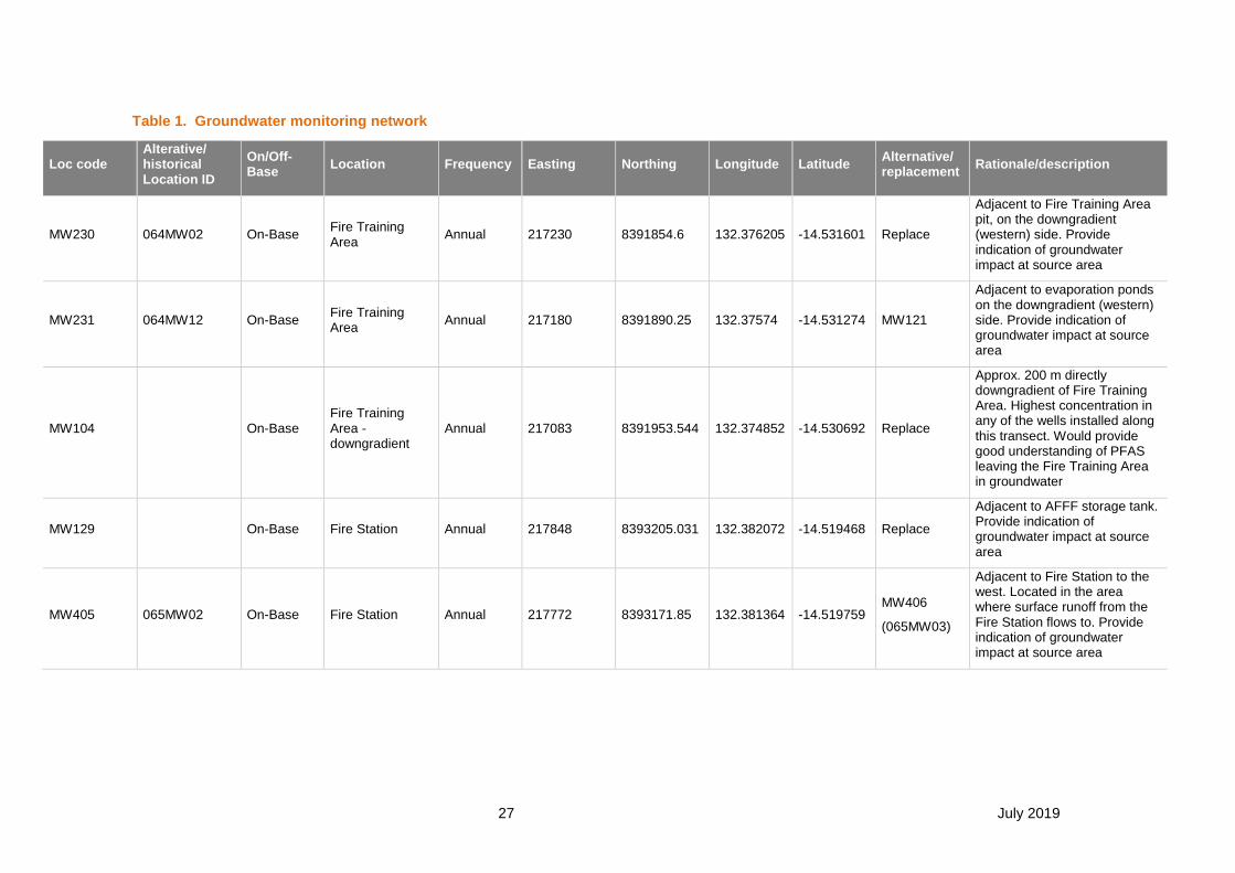
27 July 2019
Table 1. Groundwater monitoring network
Loc code Alterative/ historical Location ID
On/Off-Base
Location Frequency Easting Northing Longitude Latitude Alternative/ replacement
Rationale/description
MW230 064MW02 On-Base Fire Training Area
Annual 217230 8391854.6 132.376205 -14.531601 Replace
Adjacent to Fire Training Area pit, on the downgradient (western) side. Provide indication of groundwater impact at source area
MW231 064MW12 On-Base Fire Training Area
Annual 217180 8391890.25 132.37574 -14.531274 MW121
Adjacent to evaporation ponds on the downgradient (western) side. Provide indication of groundwater impact at source area
MW104 On-Base Fire Training Area - downgradient
Annual 217083 8391953.544 132.374852 -14.530692 Replace
Approx. 200 m directly downgradient of Fire Training Area. Highest concentration in any of the wells installed along this transect. Would provide good understanding of PFAS leaving the Fire Training Area in groundwater
MW129 On-Base Fire Station Annual 217848 8393205.031 132.382072 -14.519468 Replace
Adjacent to AFFF storage tank. Provide indication of groundwater impact at source area
MW405 065MW02 On-Base Fire Station Annual 217772 8393171.85 132.381364 -14.519759 MW406
(065MW03)
Adjacent to Fire Station to the west. Located in the area where surface runoff from the Fire Station flows to. Provide indication of groundwater impact at source area

PFAS MANAGEMENT AREA PLAN – RAAF Base Tindal
28 July 2019
Loc code Alterative/ historical Location ID
On/Off-Base
Location Frequency Easting Northing Longitude Latitude Alternative/ replacement
Rationale/description
MW127 On-Base Fire Station - downgradient
Annual 217476 8393240.406 132.378635 -14.51911 MW126 or MW128
Approx. 300m downgradient of Fire Station. Highest concentration in this transect of wells. Would provide good understanding of PFAS leaving the Fire Station in groundwater
MW278 076MW02 On-Base Fuel Farm 1 Annual 219505 8392814 132.397393 -14.523171 MW115
Adjacent to fuel farm - highest concentration reported at FF1. Provide indication of groundwater impact at source area
MW285 077MW01 On-Base Fuel Farm 2 Annual 217432 8394245 132.378325 -14.510031 MW286
(077MW03)
Adjacent to fuel farm - highest concentration reported at FF2. Provide indication of groundwater impact at source area
MW244 053MW02 On-Base
Mechanical Equipment Operations Maintenance Section
Annual 219423 8394622.122 132.39683 -14.506831 MW306 (053MW04)
Consistently highest reported concentrations in MEOMS area. Provide indication of groundwater impact at source area
RN028782 On-Base Married Quarters Annual 219732 8395225.993 132.399752 -14.501408 - Bore is (or has previously been) used for on-Base irrigation
RN025650 On-Base 75 Squadron Annual 220069 8391621.993 132.402504 -14.533995 - Bore is (or has previously been) used for on-Base construction works
MW110 On-Base source area downgradient transect
Annual 215361 8393873.912 132.359088 -14.513168 MW111 Provides data point approx. 2 km downgradient of source areas
MW107 On-Base source area downgradient transect
Annual 215550 8392690.817 132.360718 -14.523873 MW106 Provides data point ~2km downgradient of Fire Training Area

PFAS MANAGEMENT AREA PLAN – RAAF Base Tindal
29 July 2019
Loc code Alterative/ historical Location ID
On/Off-Base
Location Frequency Easting Northing Longitude Latitude Alternative/ replacement
Rationale/description
MW403 064MW08 On-Base source area downgradient transect
Annual 213008 8390513.033 132.336915 -14.543276 RN029430 Southern edge of on-Base PFAS plume
MW117 On-Base Western Base boundary
Annual 213333 8395638.664 132.340479 -14.497016 MW118 Monitor PFAS concentrations in groundwater at the Base boundary
MW133 On-Base Northern Base boundary
Annual 215897 8397831.396 132.364482 -14.47748 RN022392 or MW132
Non-detect to minor detect well. This location can act as a point to monitor between source areas and receptors to the north of the base (Lansdowne) and monitor the northern extent of the plume.
MW134
Off-Base
Private property
Katherine Research Station
Annual 209913 8397936.468 132.309021 -14.475902 RN002522 Impacted well through the centre of the plume off-base
MW135
Off-Base
Private property
Katherine Research Station
Annual 210572 8399887.852 132.315343 -14.458348 RN033342 Northern edge of the off-Base PFAS plume
MW137 Off-Base
Public land Katherine East Annual 207620 8399558.695 132.28795 -14.461007 RN030662
Impacted well through the centre of the plume off-base
MW400 MW145 Off-Base
Public land Collins Road Annual 210418 8397006.119 132.313605 -14.484358 Replace
Impacted well through the centre of the plume off-base
MW138 Off-Base
Public land
Katherine East, centre of plume
Annual 206814 8398814.436 132.280395 -14.467642 RN007437 Impacted well through the centre of the plume off-base
RN039059
Off-Base
Private property
Morris Road Annual 207398 8401482 132.286106 -14.443613 RN038490 Power & Water bore originally installed as a town water production bore

PFAS MANAGEMENT AREA PLAN – RAAF Base Tindal
30 July 2019
Loc code Alterative/ historical Location ID
On/Off-Base
Location Frequency Easting Northing Longitude Latitude Alternative/ replacement
Rationale/description
MW445 PB016
Off-Base
Private property
Adjacent to Katherine River - upstream
Annual 207066 8402466.893 132.283137 -14.434682 MW510 (PB090)
Concentrations historically reported <LOR. Ongoing monitoring to assess northern extent of plume
RN021099 Off-Base
Public land
Adjacent to Katherine River - upstream
Annual 205836 8401651.993 132.27164 -14.44191 RN022025
provide data to estimate mass of PFAS entering Katherine river in the future and monitor any changes
MW140 Off-Base
Public land
Katherine East, centre of plume
Annual 206039 8398035.457 132.273126 -14.474594 RN002475
provide data to estimate mass of PFAS entering Katherine river in the future and monitor any changes
MW142 Off-Base
Public land
Adjacent to Katherine River
Annual 204773 8396702.963 132.26125 -14.486492 MW141
provide data to estimate mass of PFAS entering Katherine river in the future and monitor any changes
MW144 Off-Base
Public land
Adjacent to Katherine River - downstream
Annual 203314 8394753.937 132.247501 -14.503936 Replace
Concentrations historically reported <LOR or low detect. Ongoing monitoring to assess southern extent of plume
MW498 PB077
Off-Base
Private property
Uralla Road Annual 208597.487 8394865.241 132.29649 -14.5035 MW478 (PB050)
Closest non-detect private bore to the southern extent of the plume in Uralla. This and 3 other properties to the south are <LOR and have not received a rainwater tank. Need to monitor this bore and reconsider tanks if a detect is reported.

PFAS MANAGEMENT AREA PLAN – RAAF Base Tindal
31 July 2019
Loc code Alterative/ historical Location ID
On/Off-Base
Location Frequency Easting Northing Longitude Latitude Alternative/ replacement
Rationale/description
RN033019 RN033019
Off-Base
Private property
Stuart Highway, approx. 200 m west of Katherine River
Quarterly 204289 8399747.9 132.257101 -14.45894 -
This bore has previously reported detectable concentrations of PFAS. Ongoing monitoring to assess PFAS impacts on the western side of Katherine River.
MW642 PB232
Off-Base
Private property
Shadforth Road Quarterly 202747 8396345 132.24243 -14.489505 None Detect west of Katherine River. No town water supply or rainwater tank
MW512 PB092
Off-Base
Private property
Zimin Drive Quarterly 203433 8396612.015 132.248817 -14.487168 None Detect west of Katherine River. No town water supply or rainwater tank
MW599 PB187
Off-Base
Private property
Zimin Drive Quarterly 203620 8396667.993 132.250549 -14.486683 None Detect west of Katherine River. No town water supply or rainwater tank
MW555 PB141
Off-Base
Private property
Zimin Drive Quarterly 203347 8396875 132.24805 -14.484784 None Detect west of Katherine River. No town water supply or rainwater tank
MW605 PB193
Off-Base
Private property
Zimin Drive Quarterly 203327 8396934.993 132.247872 -14.48424 None Detect west of Katherine River. No town water supply or rainwater tank
MW614 PB202
Off-Base
Private property
Arndt Road Quarterly 203892 8398884.993 132.253325 -14.46669 None Detect west of Katherine River. No town water supply or rainwater tank
MW528 RN037412, PB113
Off-Base
Public land Emungalan Road Quarterly 206617 8402551.993 132.278986 -14.433866 None Detect west of Katherine River
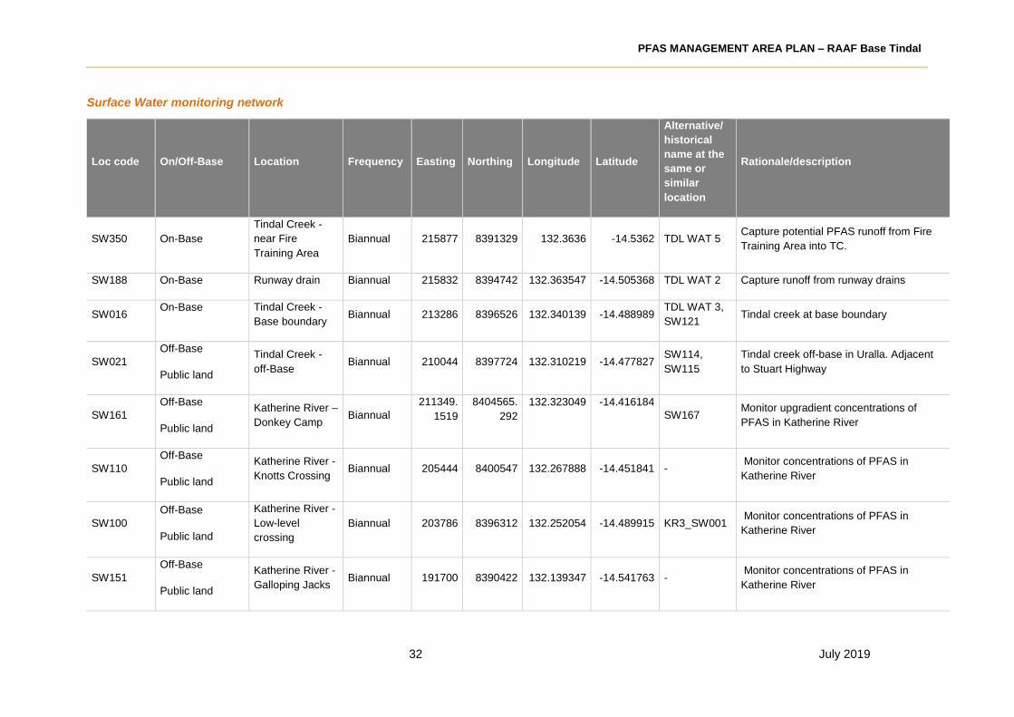
PFAS MANAGEMENT AREA PLAN – RAAF Base Tindal
32 July 2019
Surface Water monitoring network
Loc code On/Off-Base Location Frequency Easting Northing Longitude Latitude
Alternative/
historical
name at the
same or
similar
location
Rationale/description
SW350 On-Base
Tindal Creek -
near Fire
Training Area
Biannual 215877 8391329 132.3636 -14.5362 TDL WAT 5 Capture potential PFAS runoff from Fire
Training Area into TC.
SW188 On-Base Runway drain Biannual 215832 8394742 132.363547 -14.505368 TDL WAT 2 Capture runoff from runway drains
SW016 On-Base Tindal Creek -
Base boundary Biannual 213286 8396526 132.340139 -14.488989
TDL WAT 3,
SW121 Tindal creek at base boundary
SW021
Off-Base
Public land
Tindal Creek -
off-Base Biannual 210044 8397724 132.310219 -14.477827
SW114,
SW115
Tindal creek off-base in Uralla. Adjacent
to Stuart Highway
SW161
Off-Base
Public land
Katherine River –
Donkey Camp Biannual
211349.
1519
8404565.
292
132.323049 -14.416184
SW167 Monitor upgradient concentrations of
PFAS in Katherine River
SW110
Off-Base
Public land
Katherine River -
Knotts Crossing Biannual 205444 8400547 132.267888 -14.451841 -
Monitor concentrations of PFAS in
Katherine River
SW100
Off-Base
Public land
Katherine River -
Low-level
crossing
Biannual 203786 8396312 132.252054 -14.489915 KR3_SW001 Monitor concentrations of PFAS in
Katherine River
SW151
Off-Base
Public land
Katherine River -
Galloping Jacks Biannual 191700 8390422 132.139347 -14.541763 -
Monitor concentrations of PFAS in
Katherine River

PFAS MANAGEMENT AREA PLAN – RAAF Base Tindal
33 July 2019
Loc code On/Off-Base Location Frequency Easting Northing Longitude Latitude
Alternative/
historical
name at the
same or
similar
location
Rationale/description
SW108
Off-Base
Public land
Katherine River -
Stuart Hwy Quarterly 204453 8399446 132.258584 -14.461678
SW109,
KR1_SW001,
SW077,
SW173,
SW172
Monitor concentrations of PFAS in
Katherine River
SW153
Off-Base
Public land
Katherine Hot
Springs Quarterly 204069 8397100 132.254768 -14.482826
Monitor concentrations of PFAS in
Katherine Hot Springs
OTH008
Off-Base
Private property
YMCA Pool Quarterly 205856 8398730 132.271504 -14.468295 PB043 Monitor concentrations of PFAS in the
Katherine YMCA pool.

PFAS MANAGEMENT AREA PLAN – RAAF Base Tindal
34 July 2019
Appendix C SAQP Guidance
The objective of the SAQP is to outline the monitoring locations, data quality assurance procedures
and justify sampling methods and procedures to be used during the monitoring events based on the
technologies available at the time of monitoring.
Some text below has been provided for consideration to allow for consistency across the Defence
program when drafting site specific SAQPs.
Other standard information may be included within the development stage of the SAQP rather than
within this OMP, such as decontamination procedures, sample identification, preservation, and
appropriate record keeping.
The SAQP will be a stand-alone document that details, at a minimum, the following:
• Introduction including background and summary of previous investigations;
• Site setting and conceptual site model;
• Data Quality Objectives as detailed within the Ongoing Monitoring Plan, and a description of
any inclusions or deviations from the objective or scope;
• Field work sampling methodology, equipment and laboratory analysis;
• Waste management;
• Quality Assurance/Quality Control procedures; and
• Fieldwork Documentation.
All sampling works should be conducted in accordance with guidance set out in the PFAS NEMP
(2018) and the NEPM (2013). In addition to these documents, the following section provides
additional information regarding sampling methodologies.
Laboratory analysis
Within the SAQP, the primary contaminants of concern are defined as PFAS and referenced in
Guidance Document E – Standard PFAS Analytical Suite for Detailed Site Investigations (Department
of Defence, 2018a).
Other contaminants of potential concern are defined as those listed as non-PFAS compounds and are
not considered as part of this investigation, unless determined necessary to supplement new and
existing data.
Laboratory sampling analysis is to be conducted using NATA certified laboratories which will
implement a quality control plan in accordance with NEPM (1999).
Groundwater sampling methodology
Groundwater samples should be collected via an appropriate sampling technique, in accordance with
the PFAS NEMP (2018) and industry best practice guidelines. The general groundwater sampling
methodology is described below.
• Gauge and record the depth to groundwater:
o Use an interface probe to measure depth to water. In the event that LNAPL is detected,
measure the thickness and confirm using a disposable bailer.
o Measure the total well depth. In the event that DNAPL is detected, measure the thickness and
confirm using a disposable bailer.

PFAS MANAGEMENT AREA PLAN – RAAF Base Tindal
35 July 2019
o Measure depth to water to the nearest mm, measured from the survey mark or highest point of
the well casing.
o Record the date, time, well condition and any odours noted.
• Collect a groundwater sample using either low/high-flow pump purging or via a Hydrasleeve grab
sampler. These samples should be collected in accordance with industry and/or manufacturer
guidelines.
• If conducting low/high-flow sampling, purging of groundwater should take place until field
parameters have stabilised prior to collecting a sample, two equipment volumes or one well
volume has been purged. Field parameters should be recorded at regular intervals.
• If collecting samples using Hydrasleeves (to be left within each well for a minimum of 12 hours
prior to sampling), in-situ groundwater field quality parameters should be recorded after sample
collection using a down-hole water quality meter.
• Groundwater samples should be collected from approximately 3 m below the standing water level
(SWL) or 1m below the top of the screened section (whichever is deeper).
• All sampling equipment used should be made from appropriate materials, as described in the
PFAS NEMP (2018).
• All reusable sampling equipment should be decontaminated in accordance with the methodology
described in this OMP.
• Single use sampling equipment and any waste generated during works associated with this OMP
(including generation of waste water or soil) should be managed and/or disposed of appropriately.
Surface water sampling methodology
Surface water samples should be collected in accordance with PFAS NEMP (2018) guidelines.
Surface water samples should be collected from either mid-way through the water column or
approximately 0.5 m below the surface (if possible), without disturbing the bottom of the surface water
body. Samples should be collected without capturing any surface film. Observations of weather
conditions, an estimate of flow velocity and water column observations should be collected.
Decontamination procedures
In addition to guidance described in the PFAS NEMP (2018), the following procedures should be
applied for decontamination of sampling equipment, where applicable.
• Re-useable equipment (e.g. level probe, water quality probes, sampling poles etc.) shall be
decontaminated prior to first use each day at each site, and between each sampling location or at
an increased frequency to provide a satisfactory level of decontamination suitable to meet the
project requirements/site conditions.
• Disposable (single use) equipment, such as nitrile gloves, tubing, Hydrasleeves etc., will be
disposed of appropriately following each use. This equipment is not to be re-used and therefore
does not require decontamination.
• Care will be taken at all times to handle the cleaned equipment and samples only with clean
disposable nitrile gloves. Equipment will be stored after decontamination and prior to use, in clean
polypropylene bags, to ensure the cleaned equipment does not come into contact with anything
that may introduce contamination to the equipment.

PFAS MANAGEMENT AREA PLAN – RAAF Base Tindal
36 July 2019
• Care will be taken to ensure that the decontamination process does not contribute to the spread of
contamination of the site, stormwater or off-Base locations.
The procedure noted below will be followed as a minimum when decontaminating reusable equipment
used to sample soil and groundwater at the site.
• For equipment used to sample solids, all adhered materials (such as soil, vegetation) will be
removed from the sampling equipment by gloved hand, paper towel or scrubbing brush.
• Wash the equipment in a bucket of potable water. Use of detergents is only recommended if
appropriate testing has confirmed that the detergent is suitable for use in a PFAS investigation.
• Rinse the equipment thoroughly in a second bucket containing distilled water.
• Spray rinse the equipment with pure water (preferably UHP or deionised/distilled water meeting
Grade 3 as defined in ISO 3696).
• Dry the decontaminated equipment with disposable towels or air dry on a surface that will not
result in the re-contamination of the equipment.
• Where equipment is being temporarily stored between sample locations (i.e. where another round
of decontamination washing is not being undertaken) the equipment is to be stored in clean
polypropylene bags, to prevent re-contamination prior to its next use.
Sample preservation and documentation
Samples will be placed in laboratory prepared containers suitable for PFAS analysis. The sample
containers will then be placed directly into an insulated ice chest containing ice, for transportation to a
NATA accredited analytical laboratory with the Chain of Custody form recording the following
information:
• project reference;
• date of sampling;
• sample identifications;
• matrix and container details;
• preservation methods;
• name of sampler;
• required analysis;
• turnaround times required; and
• signatures of sender and receiving laboratory.
The following sample naming protocols will be adopted for all samples, in accordance with Defence
Contamination Directive #7.
• Property ID (0990_)
• Sample location incorporating sample type (i.e. 234MW102, SW108)
• Date sample collected (_YYMMDD)
Additional details for sample nomenclature should be sourced from Defence Contamination Directive
#7.

PFAS MANAGEMENT AREA PLAN – RAAF Base Tindal
37 July 2019
Quality control and quality assurance processes
Both field and laboratory QA/QC processes should be undertaken in accordance with the most recent
state or national guidance.

PFAS MANAGEMENT AREA PLAN – RAAF Base Tindal
38 July 2019
Appendix D Monitoring Well Construction Details

OMP
Appendix D
Monitoring Well Construction Details
DoD, RAAF Base Tindal
Bore ID Easting Northing
Well Depth
(m) Screen Interval Sand Interval
Bentonite
Interval Grout Interval Geology Drill method Drill Date Driller Name Sample Access
MW230 217230.00 8391854.00 20 2.0-20.0 1.0-20.0 0.5-1.0 0.0-0.5 Sandy, gravelly clay AH 23/05/2006 Parrot, NT Bores Open well
MW244 219423.00 8394622.00 21 1.0-21.0 1.0-21.0 0.5-1.0 0.0-0.5 Sandy clay, limestone MR 24/04/2006 Parrot, NT Bores Open well
MW403 213008.92 8390513.03 10.5 6.5-10.5 NK NK NK Limestone NK NK NK Open well
MW231 217180.00 8391890.00 24 3.0-24.0 0.5-24.0 0.0-0.5 NA Clayey sand, sandstone AH 24/02/2012 Bores NT Open well
MW405 217772.00 8393171.00 NK NK NK NK NK NK NK NK NK Open well
MW278 219505.00 8392814.00 24 3.0-24.0 1.0-24.0 0.5-1.0 0.0-0.5 Sandy clay, sandstone, limestone SS 21/04/2006 Shaun, NT Bores Open well
MW285 217432.00 8394245.00 18 3.0-18.0 3.8-18.0 0.5-3.8 0.0-0.5 Open well
MW104 217083.00 8391953.00 20.2 2.5-20.2 2.0-20.2 1.0-2.0 0.0-1.0 Clay, limestone AH 10/08/2017Scott Barnes, Star
DrillingOpen well
MW107 215555 8392684 15 1.0-15.0 0.5-15.0 0.0-0.5 - Clay, limestone HA, AH 19/07/2017 Hagstrom Open well
MW110 215364 8393873 13.15 1.15-13.15 1-15.15 0-1 - Clay, limestone HA, AH 25/07/2017 Hagstrom Open well
MW117 213334 8395637 14.5 0.5-14.5 0.5-14.5 0.1-0.5 0.0-0.1 Limestone and loose gravel HA, AH 2/08/2017Arren McNamara,
HagstromOpen well
MW127 217476 8393240 20 1.5-20.0 1.0-20.0 0.0-1.0 - Clay, limestone HA, AH 7/08/2017Arren McNamara,
Hagstrom Open well
MW129 217848 8393205 20 2.0-20.0 1.5-20.0 1.0-1.5 0.0-1.0 Clay, limestone HA, AH 18/08/2017Arren McNamara,
Hagstrom Open well
MW133 215904 8397827 19.7 1.7-19.7 1.0-19.7 0.5-1.0 0.0-0.5 Sandy clay, siltstone HA, AH 8/08/2017Arren McNamara,
Hagstrom Open well
MW134 209913 8397936 20.5 2.5-20.5 2.0-20.5 1.0-2.0 0.0-1.0 Sandy clay, limestone HA, SS, MR 16/08/2017Scott Barnes, Star
DrillingOpen well
MW135 210572 8399888 19.1 2.5-19.1 2.0-19.1 1.0-2.0 0.0-1.0 Clayey Sand, limestone HA, SS, MR 16/08/2017Scott Barnes, Star
DrillingOpen well
MW137 207617 8399561 20 2.0-20.0 1.5-20 0.5-1.5 0.0-0.5 Silty Clay, limestone HA, SS, AH, MR 23/08/2017Scott Barnes, Star
DrillingOpen well
MW138 206816 8398830 19.5 5.5-19.5 5.0-19.5 4.0-5.0 0.0-4.0 Clayey Sand, limestone HA, SS, AH, MR 24/08/2017Scott Barnes, Star
DrillingOpen well
MW140 206060 8397998 18.7 2.7-18.7 2.5-18.7 1.0-2.5 0.0-1.0 Sandy clay, Limestone HA, AH, MR 19/08/2017Scott Barnes, Star
DrillingOpen well
MW142 204774 8396700 18.1 3.0-18.1 2.5-18.1 1.5-2.5 0.0-1.5 Gravelly sand, carbonate HA, AH 30/08/2017 Marcus, Proactive Open well
MW144 203308 8394751 20 3.0-20.0 2.5-20.0 1.5-2.5 0.2-1.5 Mudstone, silty clay HA, AH 1/09/2017 Marcus, Proactive Open well
MW145 210419 8397006 84.6
30.6-36.6
51.6-57.6
78.6-84.6
- - - Limestone HA, AH 16/04/2018 Bores NT Open well
RN025650 220069 8391621 64 NK NK NK NK Limestone NK 14/02/1987Fred Leonard,
White Constructions
Closed system with
pump and tap
RN021099 205833 8401664 30 18-30 NK NK NK clay, limestone NK 25/07/1981F.J. Leonhardt,
Leondrill
Closed system with
pump and tap
RN039059 207398 8401482 54 40-45, 47-52 NK NK 0.0-6.0 Clay, limestone RA 1/09/2016Paul Juett, Diverse
Resources GroupOpen well
MW445 207066 8402467 NK NK NK NK NK NK NK NK NKClosed system with
pump and tap
RN033019 204289 8399748 98 NK NK NK NK Limestone AH 29/07/2001 T. HughesClosed system with
pump and tap
RN028782 219732 8395225 67 45.0-60.0 NK NK NK Clay, limestone, siltstone AH 17/05/1993
Trevor Hughes,
Trevor Hughes
Drilling Contractors
Closed system with
pump and tap
MW642 202747 8396345 50 NK NK NK NK Clay, limestone AH 17/04/1993 T. HughesClosed system with
pump and tap
MW512 203433 8396612 56 NK NK NK NK Mudstone, limestone NK 27/11/1985 F. J. LeonhardtClosed system with
pump and tap
MW599 203620 8396668 57 NK NK NK NK Siltstone AH 22/01/1985 T. HughesClosed system with
pump and tap
MW555 203347 8396875 39 33-39 NK NK NK Limestone NK 2/06/1981 F. J. LeonhardtClosed system with
pump and tap
MW605 203327 8396935 42 35-42 NK NK NK Siltstone, Limestone NK 5/09/1983 C. OldfieldClosed system with
pump and tap
MW614 203892 8398885 29 NK NK NK NK Limestone NK 29/04/1982 F. J. LeonhardtClosed system with
pump and tap
MW528 206617 8402552 84.8 42.8-48.8 NK NK 0-5.8Limestone, clay, siltstone, limestone,
sandstone, basaltAH 17/09/2011
J. Billich, Water
ResourcesOpen well
NK: Not known
HA: Hand auger
SS: Solid stem flight auger
AH: Air hammer
MR: Mud rotary
RA: Rotary Air
DC: Diamond core

PFAS MANAGEMENT AREA PLAN – RAAF Base Tindal
39 July 2019
Appendix E Historic Sampling Data

Table E1
RAAF Base Tindal
Ongoing Monitoring Plan
Historical Groundwater Analytical Results
DoD, RAAF Base Tindal
Pe
rflu
oro
-n-o
cta
no
ic a
cid
(P
FOA
)
Pe
rflu
oro
-n-h
exan
e su
lfo
nic
aci
d (
PFH
xS)
Pe
rflu
oro
-n-o
cta
ne
sulf
on
ic a
cid
(P
FOS)
PFH
xS a
nd
PFO
S (S
um
of
To
tal)
Pe
rflu
oro
bu
tan
e s
ulf
on
ic a
cid
(P
FBS)
Pe
rflu
oro
bu
tan
oic
aci
d (
PFB
A)
Pe
rflu
oro
-n-d
ecan
e s
ulf
on
ic a
cid
(P
FDS)
Pe
rflu
oro
-n-d
ecan
oic
aci
d (
PFD
A)
Pe
rflu
oro
-n-d
od
ecan
oic
aci
d (
PFD
oD
A)
Pe
rflu
oro
pen
tan
e su
lfo
nic
aci
d (
PFP
eS)
Pe
rflu
oro
-n-h
epta
ne
sulf
on
ic a
cid
(P
FHp
S)
Pe
rflu
oro
-n-h
epta
no
ic a
cid
(P
FHp
A)
Pe
rflu
oro
-n-h
exan
oic
aci
d (
PFH
xA)
Pe
rflu
oro
-n-n
on
ano
ic a
cid
(P
FNA
)
Pe
rflu
oro
oct
an e
sulf
on
am
ide
(PFO
SA)
Pe
rflu
oro
pe
nta
no
ic a
cid
(P
FPe
A)
Pe
rflu
oro
-n-t
etr
ad
ecan
oic
aci
d (
PFT
eDA
)
Pe
rflu
oro
-n-t
rid
ecan
oic
aci
d (
PFT
riD
A)
Pe
rflu
oro
-n-u
nd
ecan
oic
aci
d (
PFU
nD
A)
2-(N
-eth
ylp
erfl
uo
ro-1
-oct
ane
sulf
on
am
ide)
-eth
an
ol
2-(N
-me
thyl
per
flu
oro
-1-o
cta
ne
su
lfo
nam
ide
)-e
than
ol
N-E
thyl
per
flu
oro
oct
an
e s
ulf
on
amid
oa
ceti
c ac
id
N-M
eth
yl p
erfl
uo
roo
ctan
e s
ulf
on
am
ido
acet
ic a
cid
1H.1
H.2
H.2
H-p
erfl
uo
roh
exan
esu
lfo
nic
aci
d (
4:2
FTS)
1H.1
H.2
H.2
H-p
erfl
uo
roo
ctan
esu
lfo
nic
aci
d (
6:2
FT
S)
1H.1
H.2
H.2
H-p
erfl
uo
rod
ecan
esu
lfo
nic
aci
d (
8:2
FTS
)
1H.1
H.2
H.2
H-p
erfl
uo
rod
od
eca
ne
sulf
on
ic a
cid
N-E
thyl
per
flu
oro
-1-o
ctan
e s
ulf
on
am
ide
(N
-EtF
OSA
)
N-m
eth
ylp
erfl
uo
ro-1
-oct
an
e s
ulf
on
amid
e (N
-MeF
OSA
)
Pe
rflu
oro
no
na
nes
ulf
on
ic a
cid
(P
FNS)
Pe
rflu
oro
pro
pa
nes
ulf
on
ic a
cid
(P
FPrS
)
µg/L µg/L µg/L µg/L µg/L µg/L µg/L µg/L µg/L µg/L µg/L µg/L µg/L µg/L µg/L µg/L µg/L µg/L µg/L µg/L µg/L µg/L µg/L µg/L µg/L µg/L µg/L µg/L µg/L µg/L µg/L
EQL 0.001 0.001 0.0001 0.001 0.001 0.005 0.001 0.001 0.001 0.001 0.001 0.001 0.001 0.001 0.005 0.001 0.001 0.001 0.001 0.005 0.005 0.005 0.005 0.001 0.005 0.001 0.001 0.005 0.005 0.01 0.05
Maintenance of Ecosystems - Freshwater 95%1 220 0.13
Maintenance of Ecosystems - Freshwater 99%1 19 0.00023
Potable Domestic 2 0.56 0.07
Recreation / Irrigation2 5.6 0.7
Field_ID LocCode Sample Date Type Zone Lab_Report
0990_053MW02_170720 MW244 20/07/2017 On-Base Investigation Zone 1 555721 0.42 3.6 11 14.6 0.52 0.27 <0.01 <0.01 <0.01 0.68 0.24 0.45 0.92 0.01 <0.05 0.61 <0.01 <0.01 <0.01 <0.05 <0.05 <0.05 <0.05 <0.01 2.3 0.02 <0.01 <0.05 <0.05 - -
0990_053MW02_171127 MW244 27/11/2017 On-Base Investigation Zone 1 574954 0.11 0.82 3.3 4.12 0.08 0.06 <0.01 <0.01 <0.01 0.11 0.06 0.12 0.19 <0.01 <0.05 0.15 <0.01 <0.01 <0.01 <0.05 <0.05 <0.05 <0.05 <0.01 0.55 <0.01 <0.01 <0.05 <0.05 - -
0990_053MW02_180127 MW244 27/01/2018 On-Base Investigation Zone 1 582882 0.27 2.9 4.7 7.6 0.35 0.19 <0.01 <0.01 <0.01 0.42 0.21 0.28 0.66 <0.01 <0.05 0.48 <0.01 <0.01 <0.01 <0.05 <0.05 <0.05 <0.05 <0.01 0.38 <0.01 <0.01 <0.05 <0.05 - -
0990_053MW02_180327 MW244 27/03/2018 On-Base Investigation Zone 1 592012 0.39 6.6 14 20.6 0.9 0.24 <0.01 <0.01 <0.01 1.1 0.3 0.25 1.1 0.01 <0.05 0.53 <0.01 <0.01 <0.01 <0.05 <0.05 <0.05 <0.05 <0.01 0.67 <0.01 <0.01 <0.05 <0.05 - -
0990_053MW02_181219 MW244 19/12/2018 On-Base Investigation Zone 1 634367 0.34 3.6 8.3 11.9 0.66 0.86 <0.01 <0.01 <0.01 0.86 0.43 0.99 4.4 <0.01 <0.05 2.4 <0.01 <0.01 <0.01 <0.05 <0.05 <0.05 <0.05 0.1 1.8 <0.01 <0.01 <0.05 <0.05 - -
064MW02_060511 MW230 11/05/2006 On-Base Investigation Zone 1 ERM2007 - - 5200 - - - - - - - - - - - - - - - - - - - - - - - - - - - -
064MW02_070411 MW230 11/04/2007 On-Base Investigation Zone 1 GHD2007 8.4 - <0.05 - - - - - - - - - - - - - - - - - - - - - - - - - - - -
064MW02_071120 MW230 20/11/2007 On-Base Investigation Zone 1 GHD2008 63 - 85 - - - - - - - - - - - - - - - - - - - - - - - - - - - -
064MW02_081111 MW230 11/11/2008 On-Base Investigation Zone 1 AECOM2009 2.1 - 2700 - - - - - - - - - - - - - - - - - - - - - - - - - - - -
064MW02_090428 MW230 28/04/2009 On-Base Investigation Zone 1 AECOM2009 33 - 120 - - - - - - - - - - - - - - - - - - - - - - - - - - - -
064MW02_100422 MW230 22/04/2010 On-Base Investigation Zone 1 GHD2016 200 - 1700 - - - - - - - - - - - - - - - - - - - - - - - - - - - -
064MW02_110509 MW230 9/05/2011 On-Base Investigation Zone 1 GHD2016 38 - 7800 - - - - - - - - - - - - - - - - - - - - - - - - - - - -
064MW02_120417 MW230 17/04/2012 On-Base Investigation Zone 1 GHD2016 190 - 1000 - - - - - - - - - - - - - - - - - - - - - - - - - - - -
064MW02 MW230 10/03/2012 On-Base Investigation Zone 1 GHD2012 160 - 1700 - - - - - - - - - - - - - - - - - - - - - - - - - - - -
064MW02_130502 MW230 2/05/2013 On-Base Investigation Zone 1 GHD2016 36.7 - 7140 - - - - - - - - - - - - - - - - - - - - - - - - - - - -
064MW02_140402 MW230 2/04/2014 On-Base Investigation Zone 1 GHD2016 270 - 2.5 - - - - - - - - - - - - - - - - - - - - - - - - - - - -
064MW02_160607 MW230 7/06/2016 On-Base Investigation Zone 1 GHD2016 260 - 4010 - - - - - - - - - - - - - - - - - - - - - - - - - - - -
0990_064MW02_170429 MW230 29/04/2017 On-Base Investigation Zone 1 544592 160 650 3600 4250 130 48 <0.3 <0.3 <0.3 100 38 63 370 5.4 <0.3 120 <0.3 <0.3 <0.3 <0.3 <0.3 <0.3 <0.3 <0.3 3.9 0.74 <0.3 <0.3 <0.3 - -
0990_064MW02_170723 MW230 23/07/2017 On-Base Investigation Zone 1 555721 310 2000 5000 7000 390 120 <0.01 <0.01 1.3 320 220 150 920 8.1 <0.05 210 <0.01 <0.01 <0.01 <0.05 <0.05 <0.05 <0.05 <0.01 27 3.9 <0.01 <0.05 <0.05 - -
0990_064MW02_170925 MW230 25/09/2017 On-Base Investigation Zone 1 565353 390 2500 2800 5300 450 140 <0.2 <0.2 <0.2 460 280 180 980 11 <0.2 150 <0.2 <0.2 <0.2 <0.2 <0.2 <0.2 <0.2 <0.2 9.1 1.5 <0.2 <0.2 <0.2 - -
0990_064MW02_171127 MW230 27/11/2017 On-Base Investigation Zone 1 574954 470 2900 5900 8800 710 200 <0.01 <0.01 <0.01 590 360 230 1500 7.2 <0.05 360 <0.01 <0.01 <0.01 <0.05 <0.05 <0.05 <0.05 <0.01 10 <0.01 <0.01 <0.05 <0.05 - -
0990_064MW02_180202 MW230 2/02/2018 On-Base Investigation Zone 1 583407 110 380 3900 4280 100 43 <0.2 <0.2 <0.2 92 110 47 190 6.6 <0.2 90 <0.2 <0.2 <0.2 <0.2 <0.2 <0.2 <0.2 <0.2 2 0.9 <0.2 <0.2 <0.2 - -
0990_064MW02_180328 MW230 28/03/2018 On-Base Investigation Zone 1 592008 140 850 4600 5450 180 56 <0.2 <0.2 <0.2 160 89 64 360 5 <0.2 100 <0.2 <0.2 <0.2 <0.2 <0.2 <0.2 <0.2 <0.2 2.7 0.93 <0.2 <0.2 <0.2 - -
0990_064MW02_181219 MW230 19/12/2018 On-Base Investigation Zone 1 634367 140 1100 1900 3000 200 69 <2 <2 <2 130 84 68 790 2.5 <2 110 <2 <2 <2 <2 <2 <2 <2 <2 5.2 <2 <2 <2 <2 - -
064MW08_071120 MW403 20/11/2007 On-Base Investigation Zone 5 ND GHD2008 <0.8 - <2 - - - - - - - - - - - - - - - - - - - - - - - - - - - -
064MW08_080514 MW403 14/05/2008 On-Base Investigation Zone 5 ND GHD2008 <0.05 - <0.05 - - - - - - - - - - - - - - - - - - - - - - - - - - - -
0990_064MW08_170923 MW403 22/09/2017 On-Base Investigation Zone 5 ND 570292 <0.01 <0.01 <0.01 <0.01 <0.01 <0.05 <0.01 <0.01 <0.01 <0.01 <0.01 <0.01 <0.01 <0.01 <0.05 <0.01 <0.01 <0.01 <0.01 <0.05 <0.05 <0.05 <0.05 <0.01 <0.05 <0.01 <0.01 <0.05 <0.05 - -
0990_064MW08_171102 MW403 2/11/2017 On-Base Investigation Zone 5 ND 571200 <0.01 <0.01 <0.01 <0.01 <0.01 <0.05 <0.01 <0.01 <0.01 <0.01 <0.01 <0.01 <0.01 <0.01 <0.05 <0.01 <0.01 <0.01 <0.01 <0.05 <0.05 <0.05 <0.05 <0.01 <0.05 <0.01 <0.01 <0.05 <0.05 - -
0990_064MW08_171126 MW403 26/11/2017 On-Base Investigation Zone 5 ND 574650 <0.01 <0.01 <0.01 <0.01 <0.01 <0.05 <0.01 <0.01 <0.01 <0.01 <0.01 <0.01 <0.01 <0.01 <0.05 <0.01 <0.01 <0.01 <0.01 <0.05 <0.05 <0.05 <0.05 <0.01 <0.05 <0.01 <0.01 <0.05 <0.05 - -
0990_064MW08_181218 MW403 18/12/2018 On-Base Investigation Zone 5 634367 <0.01 <0.01 0.02 0.02 <0.01 <0.05 <0.01 <0.01 <0.01 <0.01 <0.01 <0.01 <0.01 <0.01 <0.05 <0.01 <0.01 <0.01 <0.01 <0.05 <0.05 <0.05 <0.05 <0.01 <0.05 <0.01 <0.01 <0.05 <0.05 - -
0990_064MW08_190304 MW403 4/03/2019 On-Base Investigation Zone 5 644424 <0.01 <0.01 <0.01 <0.01 <0.01 <0.05 <0.01 <0.01 <0.01 <0.01 <0.01 <0.01 <0.01 <0.01 <0.05 <0.01 <0.01 <0.01 <0.01 <0.05 <0.05 <0.05 <0.05 <0.01 <0.05 <0.01 <0.01 <0.05 <0.05 <0.01 <0.01
064MW12 MW231 19/03/2012 On-Base Investigation Zone 1 GHD2012 180 - 360 - - - - - - - - - - - - - - - - - - - - - - - - - - - -
0990_NT0064MW12_170429 MW231 29/04/2017 On-Base Investigation Zone 1 544592 87 240 270 510 61 30 <0.3 <0.3 <0.3 57 24 47 280 1.1 <1.5 65 <0.3 <0.3 <0.3 <1.5 <1.5 <1.5 <1.5 <1.5 7.8 <1.5 <1.5 <1.5 <1.5 - -
0990_064MW12_170723 MW231 20/07/2017 On-Base Investigation Zone 1 555721 230 730 400 1130 220 87 <0.01 <0.01 0.15 170 93 140 730 2.6 <0.05 160 <0.01 <0.01 <0.01 <0.05 <0.05 <0.05 <0.05 <0.01 30 0.69 <0.01 <0.05 <0.05 - -
0990_NT0064MW12A_20170901 MW231 1/09/2017 On-Base Investigation Zone 1 561847 200 810 290 1100 180 80 <0.2 <0.2 <0.2 150 110 130 560 2.4 <0.2 150 <0.2 <0.2 <0.2 <0.2 <0.2 <0.2 <0.2 <0.2 28 0.21 <0.2 <0.2 <0.2 - -
0990_NT0064MW12B_20170901 MW231 1/09/2017 On-Base Investigation Zone 1 561847 200 740 270 1010 160 75 <0.2 <0.2 <0.2 130 90 110 500 2 <0.2 120 <0.2 <0.2 <0.2 <0.2 <0.2 <0.2 <0.2 <0.2 24 <0.2 <0.2 <0.2 <0.2 - -
0990_NT0064MW12C_20170901 MW231 1/09/2017 On-Base Investigation Zone 1 561847 310 960 370 1330 260 120 <0.2 <0.2 <0.2 280 230 170 720 3.5 <0.2 200 <0.2 <0.2 <0.2 <0.2 <0.2 <0.2 <0.2 <0.2 40 0.23 <0.2 <0.2 <0.2 - -
0990_064MW12_170924 MW231 24/09/2017 On-Base Investigation Zone 1 565191 150 260 110 370 140 71 <0.01 <0.01 <0.01 63 190 140 250 4 <0.05 90 <0.01 <0.01 <0.01 <0.05 <0.05 <0.05 <0.05 <0.01 5.6 0.04 <0.01 <0.05 <0.05 - -
0990_NT0064MW12_180202 MW231 2/02/2018 On-Base Investigation Zone 1 583407 130 480 650 1130 140 51 <0.2 <0.2 <0.2 140 110 75 340 2 <0.2 97 <0.2 <0.2 <0.2 <0.2 <0.2 <0.2 <0.2 <0.2 9.7 0.78 <0.2 <0.2 <0.2 - -
0990_064MW12_180328 MW231 28/03/2018 On-Base Investigation Zone 1 592008 190 940 790 1730 250 87 <0.2 <0.2 <0.2 170 120 140 690 4.2 <0.2 160 <0.2 <0.2 <0.2 <0.2 <0.2 <0.2 <0.2 <0.2 17 0.91 <0.2 <0.2 <0.2 - -
0990_064MW12_181219 MW231 19/12/2018 On-Base Investigation Zone 1 634367 100 410 480 890 80 42 <2 <2 <2 55 49 57 440 3.6 <2 70 <2 <2 <2 <2 <2 <2 <2 <2 15 <2 <2 <2 <2 - -
EXB01 MW405 9/08/2016 On-Base Investigation Zone 1 EES2016 8.67 - 36.5 - - - - - - - - - - - - - - - - - - - - - - - - - - - -
EXB01 MW405 16/09/2016 On-Base Investigation Zone 1 EES2016 9.54 - 61.2 - - - - - - - - - - - - - - - - - - - - - - - - - - - -
0990_NT0065MW02_170428 MW405 28/04/2017 On-Base Investigation Zone 1 544592 8.2 50 170 220 6.6 2.7 <0.3 <0.3 <0.3 6.7 3.6 3.5 19 0.41 <1.5 6.3 <0.3 <0.3 <0.3 <1.5 <1.5 <1.5 <1.5 <1.5 <1.5 <1.5 <1.5 <1.5 <1.5 - -
0990_65MW02A_170906 MW405 6/09/2017 On-Base Investigation Zone 1 562785 9 32 71 103 4.1 5.6 <0.2 <0.2 <0.2 3.4 3.9 8.9 15 2.9 0.44 9.6 <0.2 <0.2 <0.2 <0.2 <0.2 <0.2 <0.2 <0.2 5 8.4 <0.2 <0.2 <0.2 - -
0990_65MW02B_170906 MW405 6/09/2017 On-Base Investigation Zone 1 562785 6.4 30 60 90 3.8 3.7 <0.2 <0.2 <0.2 3.2 3.1 5.9 12 1.6 0.27 6.4 <0.2 <0.2 <0.2 <0.2 <0.2 <0.2 <0.2 <0.2 2.6 4.3 <0.2 <0.2 <0.2 - -
0990_065MW02_170926 MW405 26/09/2017 On-Base Investigation Zone 1 565864 9 30 120 150 5.3 4.2 <0.01 0.08 <0.01 5 3.4 8.9 15 2.7 <0.05 7.9 <0.01 <0.01 <0.01 <0.05 <0.05 <0.05 <0.05 <0.01 3.9 3.6 <0.01 <0.05 <0.05 - -
0990_065MW02_171126 MW405 26/11/2017 On-Base Investigation Zone 1 574650 8.5 17 56 73 2.9 5.2 0.08 0.08 <0.01 2.8 1.7 13 13 2.3 <0.05 12 <0.01 <0.01 <0.01 <0.05 <0.05 <0.05 <0.05 <0.01 4.3 5.1 <0.01 <0.05 <0.05 - -
0990_NT0065MW02_180126 MW405 26/01/2018 On-Base Investigation Zone 1 582882 5.6 24 110 134 2.4 3.1 1 0.09 0.02 1.4 2.3 3.7 8.6 1.1 0.44 5.8 <0.01 <0.01 0.02 <0.05 <0.05 <0.05 <0.05 <0.01 1.1 5.1 <0.01 <0.05 <0.05 - -
0990_065MW02_180316 MW405 16/03/2018 On-Base Investigation Zone 1 590120 6.9 54 140 194 5.5 2.7 <0.2 <0.2 <0.2 5.7 5.2 3.9 15 0.73 <0.2 6.5 <0.2 <0.2 <0.2 <0.2 <0.2 <0.2 <0.2 <0.2 0.83 3.3 <0.2 <0.2 <0.2 - -
0990_065MW02_181218 MW405 18/12/2018 On-Base Investigation Zone 1 634367 12 42 160 202 7.2 7.4 <0.01 0.24 <0.01 5.8 11 13 26 2.4 0.08 15 <0.01 <0.01 0.02 <0.05 <0.05 <0.05 <0.05 <0.01 3.2 12 <0.01 <0.05 <0.05 - -
076MW02_160607 MW278 7/06/2016 On-Base Investigation Zone 1 GHD2016 0.12 - 8.51 - - - - - - - - - - - - - - - - - - - - - - - - - - - -
0990_076MW02_170502 MW278 2/05/2017 On-Base Investigation Zone 1 544814 0.35 11.1 15 26.1 2 0.21 <0.01 <0.01 <0.01 1.4 0.84 0.21 1.7 <0.01 <0.05 0.39 <0.01 <0.01 <0.01 <0.05 <0.05 <0.05 <0.05 <0.01 <1 0.02 <0.01 <0.05 <0.05 - -
0990_076MW02_170720 MW278 20/07/2017 On-Base Investigation Zone 1 555721 0.17 4.2 9.3 13.5 0.58 0.13 0.02 <0.01 <0.01 0.54 0.32 0.1 0.79 <0.01 <0.05 0.22 <0.01 <0.01 <0.01 <0.05 <0.05 <0.05 <0.05 <0.01 0.06 0.01 <0.01 <0.05 <0.05 - -
0990_076MW02_170928 MW278 28/09/2017 On-Base Investigation Zone 1 565952 0.2 5.7 5.9 11.6 0.27 0.08 0.01 <0.01 <0.01 0.34 0.14 0.1 0.54 <0.01 <0.05 0.21 <0.01 <0.01 <0.01 <0.05 <0.05 <0.05 <0.05 <0.01 0.07 <0.01 <0.01 <0.05 <0.05 - -
0990_076MW02_171128 MW278 28/11/2017 On-Base Investigation Zone 1 575259 0.19 4.9 6.3 11.2 0.17 0.09 0.02 <0.01 <0.01 0.23 0.17 0.08 0.42 <0.01 <0.05 0.19 <0.01 <0.01 <0.01 <0.05 <0.05 <0.05 <0.05 <0.01 <0.05 <0.01 <0.01 <0.05 <0.05 - -
0990_076MW02_180129 MW278 29/01/2018 On-Base Investigation Zone 1 582824 0.11 2.9 9 11.9 0.21 0.07 <0.01 <0.01 <0.01 0.21 0.2 0.07 0.35 <0.01 <0.05 0.12 <0.01 <0.01 <0.01 <0.05 <0.05 <0.05 <0.05 <0.01 <0.05 0.04 <0.01 <0.05 <0.05 - -
0990_076MW02_180327 MW278 27/03/2018 On-Base Investigation Zone 1 592012 0.19 5.1 8.9 14 0.49 0.1 <0.01 <0.01 <0.01 0.47 0.28 0.08 0.66 <0.01 <0.05 0.18 <0.01 <0.01 <0.01 <0.05 <0.05 <0.05 <0.05 <0.01 <0.05 0.03 <0.01 <0.05 <0.05 - -
0990_076MW02_190118 MW278 18/01/2019 On-Base Investigation Zone 1 637116 0.14 4.2 8 12.2 0.19 0.09 <0.01 <0.01 <0.01 0.3 0.16 0.08 0.45 <0.01 <0.05 0.16 <0.01 <0.01 <0.01 <0.05 <0.05 <0.05 <0.05 <0.01 <0.05 0.04 <0.01 <0.05 <0.05 - -
0990_077MW01_170428 MW285 28/04/2017 On-Base Investigation Zone 2 544592 0.01 0.37 0.22 0.59 0.04 <0.05 <0.01 <0.01 <0.01 0.03 0.01 <0.01 0.05 <0.01 <0.05 0.02 <0.01 <0.01 <0.01 <0.05 <0.05 <0.05 <0.05 <0.01 <0.05 <0.01 <0.01 <0.05 <0.05 - -
0990_077MW01_170928 MW285 28/09/2017 On-Base Investigation Zone 2 565952 0.01 0.32 0.22 0.54 0.02 <0.05 <0.01 <0.01 <0.01 0.03 0.01 <0.01 0.02 <0.01 <0.05 0.01 <0.01 <0.01 <0.01 <0.05 <0.05 <0.05 <0.05 <0.01 <0.05 <0.01 0.02 <0.05 <0.05 - -
0990_077MW01_171128 MW285 28/11/2017 On-Base Investigation Zone 2 575259 <0.02 0.28 0.26 0.54 0.03 <0.05 <0.01 <0.01 <0.01 0.03 0.02 <0.01 0.02 <0.01 <0.05 <0.01 <0.01 <0.01 <0.01 <0.05 <0.05 <0.05 <0.05 <0.01 <0.05 <0.01 <0.01 <0.05 <0.05 - -
0990_077MW01_180129 MW285 29/01/2018 On-Base Investigation Zone 2 582824 <0.01 0.26 0.27 0.53 0.03 <0.05 <0.01 <0.01 <0.01 0.03 0.01 <0.01 0.02 <0.01 <0.05 <0.01 <0.01 <0.01 <0.01 <0.05 <0.05 <0.05 <0.05 <0.01 <0.05 <0.01 <0.01 <0.05 <0.05 - -
0990_NT0077MW01_180129 MW285 29/01/2018 On-Base Investigation Zone 2 582824 <0.01 0.08 0.08 0.16 0.02 <0.05 <0.01 <0.01 <0.01 0.02 <0.01 <0.01 0.03 <0.01 <0.05 <0.01 <0.01 <0.01 <0.01 <0.05 <0.05 <0.05 <0.05 <0.01 <0.05 <0.01 <0.01 <0.05 <0.05 - -
0990_077MW01_180327 MW285 27/03/2018 On-Base Investigation Zone 2 592012 <0.01 0.42 0.27 0.69 0.04 <0.05 <0.01 <0.01 <0.01 0.04 0.01 <0.01 0.02 <0.01 <0.05 <0.01 <0.01 <0.01 <0.01 <0.05 <0.05 <0.05 <0.05 <0.01 <0.05 <0.01 <0.01 <0.05 <0.05 - -
0990_077MW01_181219 MW285 19/12/2018 On-Base Investigation Zone 2 634367 0.02 0.36 0.74 1.1 0.04 <0.05 <0.01 <0.01 <0.01 0.03 0.03 <0.01 0.07 <0.01 <0.05 <0.01 <0.01 <0.01 <0.01 <0.05 <0.05 <0.05 <0.05 <0.01 <0.05 <0.01 <0.01 <0.05 <0.05 - -
0990_MW104_170925 MW104 25/09/2017 On-Base Investigation Zone 1 565353 47 300 540 840 59 23 <0.2 <0.2 <0.2 52 23 19 150 0.6 <0.2 33 <0.2 <0.2 <0.2 <0.2 <0.2 <0.2 <0.2 <0.2 1.5 <0.2 <0.2 <0.2 <0.2 - -
0990_MW104_171127 MW104 27/11/2017 On-Base Investigation Zone 1 574954 31 210 580 790 44 16 <0.01 <0.01 <0.01 38 25 15 110 0.44 <0.05 26 <0.01 <0.01 <0.01 <0.05 <0.05 <0.05 <0.05 <0.01 1.2 <0.01 <0.01 <0.05 <0.05 - -
0990_MW104_180316 MW104 16/03/2018 On-Base Investigation Zone 1 590120 62 480 1600 2080 73 31 <0.2 <0.2 <0.2 78 58 24 200 0.72 <0.2 53 <0.2 <0.2 <0.2 <0.2 <0.2 <0.2 <0.2 <0.2 1.8 <0.2 <0.2 <0.2 <0.2 - -
0990_MW104_181219 MW104 19/12/2018 On-Base Investigation Zone 1 634367 9.5 66 220 286 11 4.9 <2 <2 <2 8.3 7.4 4.3 47 <2 <2 7.3 <2 <2 <2 <2 <2 <2 <2 <2 2 <2 <2 <2 <2 - -
0990_MW107_170924 MW107 24/09/2017 On-Base Investigation Zone 1 565191 0.04 0.36 1.2 1.56 0.05 <0.05 <0.01 <0.01 <0.01 0.08 0.05 0.02 0.1 <0.01 <0.05 0.03 <0.01 <0.01 <0.01 <0.05 <0.05 <0.05 <0.05 <0.01 <0.05 <0.01 <0.01 <0.05 <0.05 - -
0990_MW107_171124 MW107 26/11/2017 On-Base Investigation Zone 1 576521 0.04 0.36 1.2 1.56 0.05 0.05 <0.01 <0.01 <0.01 0.04 0.03 0.02 0.08 <0.01 <0.05 0.04 <0.01 <0.01 <0.01 <0.05 <0.05 <0.05 <0.05 <0.01 <0.05 <0.01 <0.01 <0.05 <0.05 - -
0990_MW107_180319 MW107 19/03/2018 On-Base Investigation Zone 1 590387 0.04 0.41 1.6 2.01 0.06 <0.05 <0.01 <0.01 <0.01 0.08 0.05 0.02 0.09 <0.01 <0.05 0.03 <0.01 <0.01 <0.01 <0.05 <0.05 <0.05 <0.05 <0.01 <0.05 <0.01 <0.01 <0.05 <0.05 - -
0990_MW107_190118 MW107 18/01/2019 On-Base Investigation Zone 1 637116 0.02 0.15 0.36 0.51 0.02 <0.05 <0.01 <0.01 <0.01 0.02 0.01 <0.01 0.03 <0.01 <0.05 0.01 <0.01 <0.01 <0.01 <0.05 <0.05 <0.05 <0.05 <0.01 <0.05 <0.01 <0.01 <0.05 <0.05 - -
0990_MW110A_170912 MW110 11/09/2017 On-Base Investigation Zone 1 563453 0.16 2 6.3 8.3 0.31 0.07 <0.01 <0.01 <0.01 0.26 0.17 0.06 0.46 <0.01 <0.05 0.1 <0.01 <0.01 <0.01 <0.05 <0.05 <0.05 <0.05 <0.01 <0.05 <0.01 <0.01 <0.05 <0.05 - -
0990_MW110B_170912 MW110 11/09/2017 On-Base Investigation Zone 1 563453 0.15 2 5.2 7.2 0.31 0.07 <0.01 <0.01 <0.01 0.25 0.15 0.06 0.47 <0.01 <0.05 0.1 <0.01 <0.01 <0.01 <0.05 <0.05 <0.05 <0.05 <0.01 <0.05 <0.01 <0.01 <0.05 <0.05 - -
0990_MW110C_170912 MW110 11/09/2017 On-Base Investigation Zone 1 563453 0.13 1.9 4.3 6.2 0.32 0.07 <0.01 <0.01 <0.01 0.27 0.13 0.06 0.46 <0.01 <0.05 0.1 <0.01 <0.01 <0.01 <0.05 <0.05 <0.05 <0.05 <0.01 <0.05 <0.01 <0.01 <0.05 <0.05 - -
0990_MW110_170924 MW110 24/09/2017 On-Base Investigation Zone 1 565191 0.2 2.1 6.9 9 0.28 0.07 <0.01 <0.01 <0.01 0.38 0.24 0.07 0.56 <0.01 <0.05 0.09 <0.01 <0.01 <0.01 <0.05 <0.05 <0.05 <0.05 <0.01 <0.05 <0.01 <0.01 <0.05 <0.05 - -
0990_MW110_171126 MW110 26/11/2017 On-Base Investigation Zone 1 574650 0.14 1.8 4.6 6.4 0.26 0.1 <0.01 <0.01 <0.01 0.23 0.14 0.06 0.42 <0.01 <0.05 0.09 <0.01 <0.01 <0.01 <0.05 <0.05 <0.05 <0.05 <0.01 <0.05 <0.01 <0.01 <0.05 <0.05 - -
0990_MW110_180319 MW110 19/03/2018 On-Base Investigation Zone 1 590387 0.1 1.2 3.9 5.1 0.19 <0.05 <0.01 <0.01 <0.01 0.24 0.13 0.04 0.27 <0.01 <0.05 0.06 <0.01 <0.01 <0.01 <0.05 <0.05 <0.05 <0.05 <0.01 <0.05 <0.01 <0.01 <0.05 <0.05 - -
0990_MW109D_190118^ MW109D 18/01/2019 On-Base Investigation Zone 1 637116 0.02 0.17 0.24 0.41 0.03 <0.05 <0.01 <0.01 <0.01 0.02 <0.01 <0.01 0.05 <0.01 <0.05 <0.01 <0.01 <0.01 <0.01 <0.05 <0.05 <0.05 <0.05 <0.01 <0.05 <0.01 <0.01 <0.05 <0.05 - -
0990_MW110_190304 MW110 4/03/2019 On-Base Investigation Zone 1 644424 0.1 1.5 3.5 5 0.2 <0.05 <0.01 <0.01 <0.01 0.26 0.16 0.04 0.33 <0.01 <0.05 0.06 <0.01 <0.01 <0.01 <0.05 <0.05 <0.05 <0.05 <0.01 <0.05 <0.01 <0.01 <0.05 <0.05 <0.01 0.08
0990_MW117A_170909 MW117 9/09/2017 On-Base Investigation Zone 1 562845 0.04 0.79 1.3 2.09 0.11 <0.05 <0.01 <0.01 <0.01 0.12 0.04 0.02 0.12 <0.01 <0.05 0.04 <0.01 <0.01 <0.01 <0.05 <0.05 <0.05 <0.05 <0.01 <0.05 <0.01 <0.01 <0.05 <0.05 - -
0990_MW117B_170909 MW117 9/09/2017 On-Base Investigation Zone 1 562845 0.05 0.82 1.4 2.22 0.11 <0.05 <0.01 <0.01 <0.01 0.13 0.04 0.02 0.13 <0.01 <0.05 0.04 <0.01 <0.01 <0.01 <0.05 <0.05 <0.05 <0.05 <0.01 <0.05 <0.01 <0.01 <0.05 <0.05 - -
0990_MW117C_170909 MW117 9/09/2017 On-Base Investigation Zone 1 562845 0.05 0.78 1.2 1.98 0.11 <0.05 <0.01 <0.01 <0.01 0.13 0.04 0.02 0.12 <0.01 <0.05 0.04 <0.01 <0.01 <0.01 <0.05 <0.05 <0.05 <0.05 <0.01 <0.05 <0.01 <0.01 <0.05 <0.05 - -
0990_MW117_170923 MW117 23/09/2017 On-Base Investigation Zone 1 565020 0.03 0.58 1.3 1.88 0.15 <0.05 <0.01 <0.01 <0.01 0.12 0.04 0.02 0.16 <0.01 <0.05 0.04 <0.01 <0.01 <0.01 <0.05 <0.05 <0.05 <0.05 <0.01 <0.05 <0.01 <0.01 <0.05 <0.05 - -
0990_MW117_171102 MW117 2/11/2017 On-Base Investigation Zone 1 571200 0.06 0.81 1.6 2.41 0.1 <0.05 <0.01 <0.01 <0.01 0.12 0.06 0.02 0.13 <0.01 <0.05 0.03 <0.01 <0.01 <0.01 <0.05 <0.05 <0.05 <0.05 <0.01 <0.05 <0.01 <0.01 <0.05 <0.05 - -
0990_MW117_171126 MW117 26/11/2017 On-Base Investigation Zone 1 574650 0.04 0.75 1.4 2.15 0.11 <0.05 <0.01 <0.01 <0.01 0.11 0.04 0.02 0.14 <0.01 <0.05 0.03 <0.01 <0.01 <0.01 <0.05 <0.05 <0.05 <0.05 <0.01 <0.05 <0.01 <0.01 <0.05 <0.05 - -
- MW117 Dec-18 On-Base Investigation Zone 1 - Not sampled - blocked at 8.252 m - -
PFAS

Table E1
RAAF Base Tindal
Ongoing Monitoring Plan
Historical Groundwater Analytical Results
DoD, RAAF Base Tindal
Per
flu
oro
-n-o
ctan
oic
aci
d (
PFO
A)
Per
flu
oro
-n-h
exa
ne
sulf
on
ic a
cid
(P
FHxS
)
Per
flu
oro
-n-o
ctan
e s
ulf
on
ic a
cid
(P
FOS)
PFH
xS a
nd
PFO
S (S
um
of
Tota
l)
Per
flu
oro
bu
tan
e su
lfo
nic
aci
d (
PFB
S)
Per
flu
oro
bu
tan
oic
aci
d (
PFB
A)
Per
flu
oro
-n-d
eca
ne
sulf
on
ic a
cid
(P
FDS)
Per
flu
oro
-n-d
eca
no
ic a
cid
(P
FDA
)
Per
flu
oro
-n-d
od
eca
no
ic a
cid
(P
FDo
DA
)
Per
flu
oro
pen
tan
e s
ulf
on
ic a
cid
(P
FPeS
)
Per
flu
oro
-n-h
ep
tan
e su
lfo
nic
aci
d (
PFH
pS)
Per
flu
oro
-n-h
ep
tan
oic
aci
d (
PFH
pA
)
Per
flu
oro
-n-h
exa
no
ic a
cid
(P
FHxA
)
Per
flu
oro
-n-n
on
an
oic
aci
d (
PFN
A)
Per
flu
oro
oct
an
esu
lfo
nam
ide
(PFO
SA)
Per
flu
oro
pen
tan
oic
aci
d (
PFP
eA)
Per
flu
oro
-n-t
etra
dec
an
oic
aci
d (
PFT
eD
A)
Per
flu
oro
-n-t
rid
ecan
oic
aci
d (
PFT
riD
A)
Per
flu
oro
-n-u
nd
eca
no
ic a
cid
(P
FUn
DA
)
2-(
N-e
thyl
per
flu
oro
-1-o
cta
ne
sulf
on
amid
e)-
eth
ano
l
2-(
N-m
eth
ylp
erf
luo
ro-1
-oct
ane
sulf
on
am
ide)
-eth
ano
l
N-E
thyl
pe
rflu
oro
oct
ane
su
lfo
nam
ido
acet
ic a
cid
N-M
eth
yl p
erfl
uo
roo
cta
ne
sulf
on
am
ido
ace
tic
acid
1H
.1H
.2H
.2H
-per
flu
oro
hex
an
esu
lfo
nic
aci
d (
4:2
FT
S)
1H
.1H
.2H
.2H
-per
flu
oro
oct
ane
sulf
on
ic a
cid
(6
:2 F
TS)
1H
.1H
.2H
.2H
-per
flu
oro
dec
an
esu
lfo
nic
aci
d (
8:2
FTS)
1H
.1H
.2H
.2H
-per
flu
oro
do
dec
anes
ulf
on
ic a
cid
N-E
thyl
pe
rflu
oro
-1-o
cta
ne
sulf
on
am
ide
(N-E
tFO
SA)
N-m
eth
ylp
erf
luo
ro-1
-oct
ane
su
lfo
nam
ide
(N
-Me
FOSA
)
Per
flu
oro
no
nan
esu
lfo
nic
aci
d (
PFN
S)
Per
flu
oro
pro
pan
esu
lfo
nic
aci
d (
PFP
rS)
µg/L µg/L µg/L µg/L µg/L µg/L µg/L µg/L µg/L µg/L µg/L µg/L µg/L µg/L µg/L µg/L µg/L µg/L µg/L µg/L µg/L µg/L µg/L µg/L µg/L µg/L µg/L µg/L µg/L µg/L µg/L
EQL 0.001 0.001 0.0001 0.001 0.001 0.005 0.001 0.001 0.001 0.001 0.001 0.001 0.001 0.001 0.005 0.001 0.001 0.001 0.001 0.005 0.005 0.005 0.005 0.001 0.005 0.001 0.001 0.005 0.005 0.01 0.05
Maintenance of Ecosystems - Freshwater 95%1 220 0.13
Maintenance of Ecosystems - Freshwater 99%1 19 0.00023
Potable Domestic 2 0.56 0.07
Recreation / Irrigation2 5.6 0.7
Field_ID LocCode Sample Date Type Zone Lab_Report
PFAS
0990_MW127_170907 MW127 7/09/2017 On-Base Investigation Zone 1 562775 0.11 1 5.6 6.6 0.12 0.05 <0.01 <0.01 <0.01 0.11 0.09 0.05 0.27 <0.01 <0.05 0.07 <0.01 <0.01 <0.01 <0.05 <0.05 <0.05 <0.05 <0.01 <0.05 <0.01 <0.01 <0.05 <0.05 - -
0990_MW127_170926 MW127 26/09/2017 On-Base Investigation Zone 1 565864 0.1 0.84 4.7 5.54 0.1 <0.05 <0.01 <0.01 <0.01 0.1 0.08 0.04 0.25 <0.01 <0.05 0.09 <0.01 <0.01 <0.01 <0.05 <0.05 <0.05 <0.05 <0.01 <0.05 <0.01 <0.01 <0.05 <0.05 - -
0990_MW127_171126 MW127 26/11/2017 On-Base Investigation Zone 1 574650 0.06 0.8 2.7 3.5 0.09 0.07 <0.01 <0.01 <0.01 0.09 0.05 0.03 0.14 <0.01 <0.05 0.05 <0.01 <0.01 <0.01 <0.05 <0.05 <0.05 <0.05 <0.01 <0.05 <0.01 <0.01 <0.05 <0.05 - -
0990_MW127_180127 MW127 27/01/2018 On-Base Investigation Zone 1 582882 0.06 2.1 1.7 3.8 0.22 0.07 <0.01 <0.01 <0.01 0.21 0.09 0.03 0.23 <0.01 <0.05 0.06 <0.01 <0.01 <0.01 <0.05 <0.05 <0.05 <0.05 <0.01 <0.05 <0.01 <0.01 <0.05 <0.05 - -
0990_MW127_180517 MW127 17/05/2018 On-Base Investigation Zone 1 599599 0.1 0.93 5.1 6.03 0.12 0.06 <0.01 <0.01 <0.01 0.12 0.06 0.05 0.27 <0.01 <0.05 0.08 <0.01 <0.01 <0.01 <0.05 <0.05 <0.05 <0.01 <0.05 <0.01 <0.01 <0.05 <0.05 <0.05 - -
0990_MW127_181218 MW127 18/12/2018 On-Base Investigation Zone 1 634367 0.3 3 5.8 8.8 0.41 0.32 <0.01 <0.01 <0.01 0.42 0.34 0.16 1.4 0.01 <0.05 0.31 <0.01 <0.01 <0.01 <0.05 <0.05 <0.05 <0.05 <0.01 <0.05 <0.01 <0.01 <0.05 <0.05 - -
0990_MW129_170926 MW129 26/09/2017 On-Base Investigation Zone 1 565864 23 110 140 250 23 11 <0.2 <0.2 <0.2 22 13 15 71 <0.2 <0.2 18 <0.2 <0.2 <0.2 <0.2 <0.2 <0.2 <0.2 <0.2 <0.2 <0.2 <0.2 <0.2 <0.2 - -
0990_MW129_171126 MW129 26/11/2017 On-Base Investigation Zone 1 574650 18 100 220 320 26 11 <0.01 <0.01 <0.01 20 12 14 69 <0.01 <0.05 17 <0.01 <0.01 <0.01 <0.05 <0.05 <0.05 <0.05 <0.01 0.42 <0.01 <0.01 <0.05 <0.05 - -
0990_MW129_180126 MW129 26/01/2018 On-Base Investigation Zone 1 582882 9.7 60 110 170 11 5.7 <0.2 <0.2 <0.2 9.8 6.7 6.2 32 <0.2 <0.2 8.5 <0.2 <0.2 <0.2 <0.2 <0.2 <0.2 <0.2 <0.2 0.27 0.37 <0.2 <0.2 <0.2 - -
0990_MW129_180316 MW129 16/03/2018 On-Base Investigation Zone 1 590120 17 120 200 320 20 9.1 <0.2 <0.2 <0.2 20 14 11 58 <0.2 <0.2 20 <0.2 <0.2 <0.2 <0.2 <0.2 <0.2 <0.2 <0.2 0.48 <0.2 <0.2 <0.2 <0.2 - -
0990_MW129_181218 MW129 18/12/2018 On-Base Investigation Zone 1 634367 30 150 230 380 38 18 <0.01 0.03 <0.01 34 45 23 110 0.28 0.07 31 <0.01 <0.01 <0.01 <0.05 <0.05 <0.05 <0.05 0.02 0.99 0.12 <0.01 <0.05 <0.05 - -
0990_MW133_170923 MW133 22/09/2017 On-Base Investigation Zone 5 ND 570292 <0.01 <0.01 <0.01 <0.01 <0.01 <0.05 <0.01 <0.01 <0.01 <0.01 <0.01 <0.01 <0.01 <0.01 <0.05 <0.01 <0.01 <0.01 <0.01 <0.05 <0.05 <0.05 <0.05 <0.01 <0.05 <0.01 <0.01 0.18 <0.05 - -
0990_MW133_171102 MW133 2/11/2017 On-Base Investigation Zone 5 571200 <0.01 0.01 <0.01 0.01 <0.01 <0.05 <0.01 <0.01 <0.01 <0.01 <0.01 <0.01 <0.01 <0.01 <0.05 <0.01 <0.01 <0.01 <0.01 <0.05 <0.05 <0.05 <0.05 <0.01 <0.05 <0.01 <0.01 <0.05 <0.05 - -
0990_MW133_171127 MW133 27/11/2017 On-Base Investigation Zone 5 ND 574954 <0.05 <0.01 <0.01 <0.01 <0.01 <0.05 <0.01 <0.01 <0.01 <0.01 <0.01 <0.01 <0.01 <0.01 <0.05 <0.01 <0.01 <0.01 <0.01 <0.05 <0.05 <0.05 <0.05 <0.01 <0.05 <0.01 <0.01 <0.05 <0.05 - -
0990_MW133_180120 MW133 20/01/2018 On-Base Investigation Zone 5 581555 <0.01 0.01 0.01 0.02 <0.01 <0.05 <0.01 <0.01 <0.01 <0.01 <0.01 <0.01 <0.01 <0.01 <0.05 <0.01 <0.01 <0.01 <0.01 <0.05 <0.05 <0.05 <0.05 <0.01 <0.05 <0.01 <0.01 <0.05 <0.05 - -
0990_MW133_180321 MW133 21/03/2018 On-Base Investigation Zone 5 ND 590880 <0.01 <0.01 <0.01 <0.01 <0.01 <0.05 <0.01 <0.01 <0.01 <0.01 <0.01 <0.01 <0.01 <0.01 <0.05 <0.01 <0.01 <0.01 <0.01 <0.05 <0.05 <0.05 <0.05 <0.01 <0.05 <0.01 <0.01 <0.05 <0.05 - -
0990_MW133_181219 MW133 19/12/2018 On-Base Investigation Zone 5 ND 634367 <0.01 0.05 0.2 0.25 <0.01 <0.05 <0.01 <0.01 <0.01 <0.01 <0.01 <0.01 0.02 <0.01 <0.05 <0.01 <0.01 <0.01 <0.01 <0.05 <0.05 <0.05 <0.05 <0.01 0.09 <0.01 <0.01 <0.05 <0.05 - -
0990_MW133_190214 MW133 14/02/2019 On-Base Investigation Zone 5 ND 641173 <0.01 <0.01 <0.01 <0.01 <0.01 <0.05 <0.01 <0.01 <0.01 <0.01 <0.01 <0.01 <0.01 <0.01 <0.05 <0.01 <0.01 <0.01 <0.01 <0.05 <0.05 <0.05 <0.05 <0.01 <0.05 <0.01 <0.01 <0.05 <0.05 <0.01 <0.01
0990_RN028782_180327 RN028782 27/03/2018 On-Base Private Bore Zone 5 ND 592012 <0.01 <0.01 <0.01 <0.01 <0.01 <0.05 <0.01 <0.01 <0.01 <0.01 <0.01 <0.01 <0.01 <0.01 <0.05 <0.01 <0.01 <0.01 <0.01 <0.05 <0.05 <0.05 <0.05 <0.01 <0.05 <0.01 <0.01 <0.05 <0.05 - -
0990_RN028782_181219 RN028782 19/12/2018 On-Base Private Bore Zone 5 ND 634367 <0.01 <0.01 <0.01 <0.01 <0.01 <0.05 <0.01 <0.01 <0.01 <0.01 <0.01 <0.01 <0.01 <0.01 <0.05 <0.01 <0.01 <0.01 <0.01 <0.05 <0.05 <0.05 <0.05 <0.01 <0.05 <0.01 <0.01 <0.05 <0.05 - -
0990_MW134_170920 MW134 20/09/2017 Off-Base Investigation Zone 1 564886 0.027 0.87 1 1.87 0.076 0.022 0.007 <0.001 <0.001 0.1 0.045 0.018 0.12 <0.001 <0.005 0.033 <0.001 <0.001 <0.001 <0.005 <0.005 <0.005 <0.005 <0.001 0.007 <0.001 <0.001 <0.005 <0.005 - -
0990_MW134_171124 MW134 24/11/2017 Off-Base Investigation Zone 1 574650 0.03 0.7 1.3 2 0.1 <0.05 <0.01 <0.01 <0.01 0.14 0.04 0.01 0.11 <0.01 <0.05 0.02 <0.01 <0.01 <0.01 <0.05 <0.05 <0.05 <0.05 <0.01 <0.05 <0.01 <0.01 <0.05 <0.05 - -
0990_MW134_180202 MW134 2/02/2018 Off-Base Investigation Zone 1 583429 0.03 0.67 0.71 1.38 0.07 <0.05 <0.01 <0.01 <0.01 0.1 0.05 0.02 0.11 <0.01 <0.05 0.02 <0.01 <0.01 <0.01 <0.05 <0.05 <0.05 <0.05 <0.01 <0.05 <0.01 <0.01 <0.05 <0.05 - -
0990_MW134_180328 MW134 28/03/2018 Off-Base Investigation Zone 1 592008 0.02 0.41 0.79 1.2 0.05 <0.05 <0.01 <0.01 <0.01 0.09 0.02 <0.01 0.05 <0.01 <0.05 0.01 <0.01 <0.01 <0.01 <0.05 <0.05 <0.05 <0.05 <0.01 <0.05 <0.01 <0.01 <0.05 <0.05 - -
0990_MW134_190117 MW134 17/01/2019 Off-Base Investigation Zone 1 637116 0.04 0.74 1.2 1.94 0.1 <0.05 <0.01 <0.01 <0.01 0.14 0.04 0.02 0.11 <0.01 <0.05 0.03 <0.01 <0.01 <0.01 <0.05 <0.05 <0.05 <0.05 <0.01 <0.05 <0.01 <0.01 <0.05 <0.05 - -
0990_MW135_170922 MW135 22/09/2017 Off-Base Investigation Zone 5 570292 <0.01 0.01 0.02 0.03 <0.01 <0.05 <0.01 <0.01 <0.01 <0.01 <0.01 <0.01 <0.01 <0.01 <0.05 <0.01 <0.01 <0.01 <0.01 <0.05 <0.05 <0.05 <0.05 <0.01 <0.05 <0.01 <0.01 <0.05 <0.05 - -
0990_MW135_171102 MW135 2/11/2017 Off-Base Investigation Zone 5 571265 <0.01 0.01 <0.01 0.01 <0.01 <0.05 <0.01 <0.01 <0.01 <0.01 <0.01 <0.01 <0.01 <0.01 <0.05 <0.01 <0.01 <0.01 <0.01 <0.05 <0.05 <0.05 <0.05 <0.01 <0.05 <0.01 <0.01 <0.05 <0.05 - -
0990_MW135_171124 MW135 24/11/2017 Off-Base Investigation Zone 5 ND 574650 <0.01 <0.01 <0.01 <0.01 <0.01 <0.05 <0.01 <0.01 <0.01 <0.01 <0.01 <0.01 <0.01 <0.01 <0.05 <0.01 <0.01 <0.01 <0.01 <0.05 <0.05 <0.05 <0.05 <0.01 <0.05 <0.01 <0.01 <0.05 <0.05 - -
0990_MW135_180202 MW135 2/02/2018 Off-Base Investigation Zone 5 ND 583429 <0.01 <0.01 <0.01 <0.01 <0.01 <0.05 <0.01 <0.01 <0.01 <0.01 <0.01 <0.01 <0.01 <0.01 <0.05 <0.01 <0.01 <0.01 <0.01 <0.05 <0.05 <0.05 <0.05 <0.01 <0.05 <0.01 0.01 <0.05 <0.05 - -
0990_MW135_180326 MW135 26/03/2018 Off-Base Investigation Zone 5 591521 <0.01 0.02 0.03 0.05 <0.01 <0.05 <0.01 <0.01 <0.01 <0.01 <0.01 <0.01 <0.01 <0.01 <0.05 <0.01 <0.01 <0.01 <0.01 <0.05 <0.05 <0.05 <0.05 <0.01 <0.05 <0.01 <0.01 <0.05 <0.05 - -
0990_MW135_190117 MW135 17/01/2019 Off-Base Investigation Zone 5 637116 <0.01 <0.01 0.02 0.02 <0.01 <0.05 <0.01 <0.01 <0.01 <0.01 <0.01 <0.01 <0.01 <0.01 <0.05 <0.01 <0.01 <0.01 <0.01 <0.05 <0.05 <0.05 <0.05 <0.01 <0.05 <0.01 <0.01 <0.05 <0.05 - -
0990_MW137A_170915 MW137 15/09/2017 Off-Base Investigation Zone 2 563889 <0.01 0.13 0.19 0.32 0.02 <0.05 <0.01 <0.01 <0.01 0.02 <0.01 <0.01 0.02 <0.01 <0.05 <0.01 <0.01 <0.01 <0.01 <0.05 <0.05 <0.05 <0.05 <0.01 <0.05 <0.01 <0.01 <0.05 <0.05 - -
0990_MW137B_170915 MW137 15/09/2017 Off-Base Investigation Zone 2 563889 <0.01 0.13 0.19 0.32 0.02 <0.05 <0.01 <0.01 <0.01 0.03 <0.01 <0.01 0.02 <0.01 <0.05 <0.01 <0.01 <0.01 <0.01 <0.05 <0.05 <0.05 <0.05 <0.01 <0.05 <0.01 <0.01 <0.05 <0.05 - -
0990_MW137C_170915 MW137 15/09/2017 Off-Base Investigation Zone 2 563889 <0.01 0.13 0.22 0.35 0.02 <0.05 <0.01 <0.01 <0.01 0.03 <0.01 <0.01 0.02 <0.01 <0.05 <0.01 <0.01 <0.01 <0.01 <0.05 <0.05 <0.05 <0.05 <0.01 <0.05 <0.01 <0.01 <0.05 <0.05 - -
0990_MW137_170922 MW137 22/09/2017 Off-Base Investigation Zone 2 565020 0.01 0.1 0.17 0.27 0.03 <0.05 <0.01 <0.01 <0.01 0.02 <0.01 <0.01 0.05 <0.01 <0.05 0.02 <0.01 <0.01 <0.01 <0.05 <0.05 <0.05 <0.05 <0.01 <0.05 <0.01 <0.01 <0.05 <0.05 - -
0990_MW137_171102 MW137 2/11/2017 Off-Base Investigation Zone 2 571200 <0.01 0.12 0.23 0.35 0.02 <0.05 <0.01 <0.01 <0.01 0.03 <0.01 <0.01 0.02 <0.01 <0.05 <0.01 <0.01 <0.01 <0.01 <0.05 <0.05 <0.05 <0.05 <0.01 <0.05 <0.01 <0.01 <0.05 <0.05 - -
0990_MW137_171124 MW137 24/11/2017 Off-Base Investigation Zone 2 574650 <0.01 0.11 0.2 0.31 0.02 <0.05 <0.01 <0.01 <0.01 0.03 <0.01 <0.01 0.01 <0.01 <0.05 <0.01 <0.01 <0.01 <0.01 <0.05 <0.05 <0.05 <0.05 <0.01 <0.05 <0.01 <0.01 <0.05 <0.05 - -
0990_MW137_180119 MW137 19/01/2018 Off-Base Investigation Zone 2 581555 <0.01 0.13 0.16 0.29 0.02 <0.05 <0.01 <0.01 <0.01 0.02 <0.01 <0.01 0.02 <0.01 <0.05 <0.01 <0.01 <0.01 <0.01 <0.05 <0.05 <0.05 <0.05 <0.01 <0.05 <0.01 <0.01 <0.05 <0.05 - -
0990_MW137_180326 MW137 26/03/2018 Off-Base Investigation Zone 2 591521 <0.01 0.12 0.2 0.32 0.02 <0.05 <0.01 <0.01 <0.01 0.03 <0.01 <0.01 0.02 <0.01 <0.05 <0.01 <0.01 <0.01 <0.01 <0.05 <0.05 <0.05 <0.05 <0.01 <0.05 <0.01 <0.01 <0.05 <0.05 - -
0990_MW137_190118 MW137 18/01/2019 Off-Base Investigation Zone 2 637116 <0.01 0.09 0.1 0.19 0.02 <0.05 <0.01 <0.01 <0.01 0.01 <0.01 <0.01 0.01 <0.01 <0.05 <0.01 <0.01 <0.01 <0.01 <0.05 <0.05 <0.05 <0.05 <0.01 <0.05 <0.01 <0.01 <0.05 <0.05 - -
0990_MW138_170922 MW138 22/09/2017 Off-Base Investigation Zone 1 570292 0.02 0.39 1.4 1.79 0.04 <0.05 <0.01 <0.01 <0.01 0.05 0.02 <0.01 0.05 <0.01 <0.05 0.01 <0.01 <0.01 <0.01 <0.05 <0.05 <0.05 <0.05 <0.01 <0.05 <0.01 <0.01 <0.05 <0.05 - -
0990_MW138_171102 MW138 2/11/2017 Off-Base Investigation Zone 1 571200 0.02 0.37 1.5 1.87 0.05 <0.05 <0.01 <0.01 <0.01 0.06 0.02 <0.01 0.04 <0.01 <0.05 <0.01 <0.01 <0.01 <0.01 <0.05 <0.05 <0.05 <0.05 <0.01 <0.05 <0.01 <0.01 <0.05 <0.05 - -
0990_MW138_171124 MW138 24/11/2017 Off-Base Investigation Zone 1 574650 0.02 0.36 1.4 1.76 0.05 <0.05 <0.01 <0.01 <0.01 0.06 0.02 <0.01 0.04 <0.01 <0.05 <0.01 <0.01 <0.01 <0.01 <0.05 <0.05 <0.05 <0.05 <0.01 <0.05 <0.01 <0.01 <0.05 <0.05 - -
0990_MW138_180119 MW138 19/01/2018 Off-Base Investigation Zone 1 581555 0.02 0.39 1.4 1.79 0.04 <0.05 <0.01 <0.01 <0.01 0.05 0.02 0.01 0.05 <0.01 <0.05 0.02 <0.01 <0.01 <0.01 <0.05 <0.05 <0.05 <0.05 <0.01 <0.05 <0.01 <0.01 <0.05 <0.05 - -
0990_MW138_180326 MW138 26/03/2018 Off-Base Investigation Zone 1 591521 0.02 0.49 0.95 1.44 0.08 <0.05 <0.01 <0.01 <0.01 0.1 0.02 <0.01 0.06 <0.01 <0.05 0.01 <0.01 <0.01 <0.01 <0.05 <0.05 <0.05 <0.05 <0.01 <0.05 <0.01 <0.01 <0.05 <0.05 - -
0990_MW138_190118 MW138 18/01/2019 Off-Base Investigation Zone 1 637116 0.02 0.43 1 1.43 0.06 <0.05 <0.01 <0.01 <0.01 0.07 0.02 <0.01 0.05 <0.01 <0.05 0.01 <0.01 <0.01 <0.01 <0.05 <0.05 <0.05 <0.05 <0.01 <0.05 <0.01 <0.01 <0.05 <0.05 - -
0990_MW140_170929 MW140 29/09/2017 Off-Base Investigation Zone 2 566028 <0.01 0.03 0.04 0.07 <0.01 <0.05 <0.01 <0.01 <0.01 <0.01 <0.01 <0.01 <0.01 <0.01 <0.05 <0.01 <0.01 <0.01 <0.01 <0.05 <0.05 <0.05 <0.05 <0.01 <0.05 <0.01 <0.01 <0.05 <0.05 - -
0990_MW140_171124 MW140 24/11/2017 Off-Base Investigation Zone 5 574650 <0.01 0.01 0.01 0.02 <0.01 <0.05 <0.01 <0.01 <0.01 <0.01 <0.01 <0.01 <0.01 <0.01 <0.05 <0.01 <0.01 <0.01 <0.01 <0.05 <0.05 <0.05 <0.05 <0.01 <0.05 <0.01 <0.01 <0.05 <0.05 - -
0990_MW140_180119 MW140 19/01/2018 Off-Base Investigation Zone 2 581555 <0.01 0.08 0.07 0.15 0.01 <0.05 <0.01 <0.01 <0.01 0.01 <0.01 <0.01 0.01 <0.01 <0.05 <0.01 <0.01 <0.01 <0.01 <0.05 <0.05 <0.05 <0.05 <0.01 <0.05 <0.01 <0.01 <0.05 <0.05 - -
0990_MW140_180326 MW140 26/03/2018 Off-Base Investigation Zone 5 591521 <0.01 <0.01 0.02 0.02 <0.01 <0.05 <0.01 <0.01 <0.01 <0.01 <0.01 <0.01 <0.01 <0.01 <0.05 <0.01 <0.01 <0.01 <0.01 <0.05 <0.05 <0.05 <0.05 <0.01 <0.05 <0.01 <0.01 <0.05 <0.05 - -
0990_MW140_181219 MW140 19/12/2018 Off-Base Investigation Zone 2 634367 <0.01 0.06 0.12 0.18 0.01 <0.05 <0.01 <0.01 <0.01 <0.01 <0.01 <0.01 0.02 <0.01 <0.05 <0.01 <0.01 <0.01 <0.01 <0.05 <0.05 <0.05 <0.05 <0.01 <0.05 <0.01 <0.01 <0.05 <0.05 - -
0990_MW142A_170914 MW142 14/09/2017 Off-Base Investigation Zone 2 563665 <0.01 0.04 0.03 0.07 <0.01 <0.05 <0.01 <0.01 <0.01 <0.01 <0.01 <0.01 <0.01 <0.01 <0.05 <0.01 <0.01 <0.01 <0.01 <0.05 <0.05 <0.05 <0.05 <0.01 <0.05 <0.01 <0.01 <0.05 <0.05 - -
0990_MW142B_170914 MW142 14/09/2017 Off-Base Investigation Zone 2 563665 <0.01 0.04 0.03 0.07 <0.01 <0.05 <0.01 <0.01 <0.01 <0.01 <0.01 <0.01 <0.01 <0.01 <0.05 <0.01 <0.01 <0.01 <0.01 <0.05 <0.05 <0.05 <0.05 <0.01 <0.05 <0.01 <0.01 <0.05 <0.05 - -
0990_MW142C_170914 MW142 14/09/2017 Off-Base Investigation Zone 2 563665 <0.01 0.04 0.04 0.08 <0.01 <0.05 <0.01 <0.01 <0.01 <0.01 <0.01 <0.01 <0.01 <0.01 <0.05 <0.01 <0.01 <0.01 <0.01 <0.05 <0.05 <0.05 <0.05 <0.01 <0.05 <0.01 <0.01 <0.05 <0.05 - -
0990_MW142D_170915 MW142 15/09/2017 Off-Base Investigation Zone 2 563889 <0.01 0.03 0.04 0.07 <0.01 <0.05 <0.01 <0.01 <0.01 <0.01 <0.01 <0.01 <0.01 <0.01 <0.05 <0.01 <0.01 <0.01 <0.01 <0.05 <0.05 <0.05 <0.05 <0.01 <0.05 <0.01 <0.01 <0.05 <0.05 - -
0990_MW142_170921 MW142 21/09/2017 Off-Base Investigation Zone 2 564886 <0.001 0.065 0.051 0.116 0.006 <0.005 0.004 <0.001 <0.001 <0.001 <0.001 <0.001 0.002 <0.001 <0.005 <0.001 <0.001 <0.001 <0.001 <0.005 <0.005 <0.005 <0.005 0.001 <0.005 <0.001 <0.001 <0.005 <0.005 - -
0990_MW142_171122 MW142 22/11/2017 Off-Base Investigation Zone 5 574347 <0.01 0.02 0.04 0.06 <0.01 <0.05 <0.01 <0.01 <0.01 <0.01 <0.01 <0.01 <0.01 <0.01 <0.05 <0.01 <0.01 <0.01 <0.01 <0.05 <0.05 <0.05 <0.05 <0.01 <0.05 <0.01 <0.01 <0.05 <0.05 - -
0990_MW142_180119 MW142 19/01/2018 Off-Base Investigation Zone 5 581555 <0.01 0.02 0.02 0.04 <0.01 <0.05 <0.01 <0.01 <0.01 <0.01 <0.01 <0.01 <0.01 <0.01 <0.05 <0.01 <0.01 <0.01 <0.01 <0.05 <0.05 <0.05 <0.05 <0.01 <0.05 <0.01 <0.01 <0.05 <0.05 - -
0990_MW142_180326 MW142 26/03/2018 Off-Base Investigation Zone 5 591521 <0.01 0.02 0.03 0.05 <0.01 <0.05 <0.01 <0.01 <0.01 <0.01 <0.01 <0.01 <0.01 <0.01 <0.05 <0.01 <0.01 <0.01 <0.01 <0.05 <0.05 <0.05 <0.05 <0.01 <0.05 <0.01 <0.01 <0.05 <0.05 - -
0990_MW142_181219 MW142 19/12/2018 Off-Base Investigation Zone 2 634367 <0.01 0.03 0.06 0.09 <0.01 <0.05 <0.01 <0.01 <0.01 <0.01 <0.01 <0.01 <0.01 <0.01 <0.05 <0.01 <0.01 <0.01 <0.01 <0.05 <0.05 <0.05 <0.05 <0.01 <0.05 <0.01 <0.01 <0.05 <0.05 - -
0990_MW144A_170916 MW144 16/09/2017 Off-Base Investigation Zone 5 ND 563889 <0.01 <0.01 <0.01 <0.01 <0.01 <0.05 <0.01 <0.01 <0.01 <0.01 <0.01 <0.01 <0.01 <0.01 <0.05 <0.01 <0.01 <0.01 <0.01 <0.05 <0.05 <0.05 <0.05 <0.01 <0.05 <0.01 <0.01 <0.05 <0.05 - -
0990_MW144B_170916 MW144 16/09/2017 Off-Base Investigation Zone 5 ND 563889 <0.01 <0.01 <0.01 <0.01 <0.01 <0.05 <0.01 <0.01 <0.01 <0.01 <0.01 <0.01 <0.01 <0.01 <0.05 <0.01 <0.01 <0.01 <0.01 <0.05 <0.05 <0.05 <0.05 <0.01 <0.05 <0.01 <0.01 <0.05 <0.05 - -
0990_MW144C_170916 MW144 16/09/2017 Off-Base Investigation Zone 5 ND 563889 <0.01 <0.01 <0.01 <0.01 <0.01 <0.05 <0.01 <0.01 <0.01 <0.01 <0.01 <0.01 <0.01 <0.01 <0.05 <0.01 <0.01 <0.01 <0.01 <0.05 <0.05 <0.05 <0.05 <0.01 <0.05 <0.01 <0.01 <0.05 <0.05 - -
0990_MW144D_170916 MW144 16/09/2017 Off-Base Investigation Zone 5 563889 <0.01 <0.01 0.02 0.02 <0.01 <0.05 <0.01 <0.01 <0.01 <0.01 <0.01 <0.01 <0.01 <0.01 <0.05 <0.01 <0.01 <0.01 <0.01 <0.05 <0.05 <0.05 <0.05 <0.01 <0.05 <0.01 <0.01 <0.05 <0.05 - -
0990_MW144_170921 MW144 21/09/2017 Off-Base Investigation Zone 5 564886 <0.001 <0.001 0.004 0.004 <0.001 <0.005 0.005 <0.001 <0.001 <0.001 <0.001 0.003 0.002 <0.001 <0.005 <0.001 <0.001 <0.001 <0.001 <0.005 <0.005 <0.005 <0.005 0.001 <0.005 <0.001 <0.001 <0.005 <0.005 - -
0990_MW144_171124 MW144 24/11/2017 Off-Base Investigation Zone 5 ND 574650 <0.01 <0.01 <0.01 <0.01 <0.01 <0.05 <0.01 <0.01 <0.01 <0.01 <0.01 <0.01 <0.01 <0.01 <0.05 <0.01 <0.01 <0.01 <0.01 <0.05 <0.05 <0.05 <0.05 <0.01 <0.05 <0.01 <0.01 <0.05 <0.05 - -
0990_MW144_180119 MW144 19/01/2018 Off-Base Investigation Zone 5 ND 581555 <0.01 <0.01 <0.01 <0.01 <0.01 <0.05 <0.01 <0.01 <0.01 <0.01 <0.01 <0.01 <0.01 <0.01 <0.05 <0.01 <0.01 <0.01 <0.01 <0.05 <0.05 <0.05 <0.05 <0.01 <0.05 <0.01 <0.01 <0.05 <0.05 - -
0990_MW144_180326 MW144 26/03/2018 Off-Base Investigation Zone 5 ND 591521 <0.01 <0.01 <0.01 <0.01 <0.01 <0.05 <0.01 <0.01 <0.01 <0.01 <0.01 <0.01 <0.01 <0.01 <0.05 <0.01 <0.01 <0.01 <0.01 <0.05 <0.05 <0.05 <0.05 <0.01 <0.05 <0.01 <0.01 <0.05 <0.05 - -
0990_MW144_181219 MW144 19/12/2018 Off-Base Investigation Zone 5 634367 <0.01 <0.01 0.03 0.03 <0.01 <0.05 <0.01 <0.01 <0.01 <0.01 <0.01 <0.01 <0.01 <0.01 <0.05 <0.01 <0.01 <0.01 <0.01 <0.05 <0.05 <0.05 <0.05 <0.01 <0.05 <0.01 <0.01 <0.05 <0.05 - -
0990_MW144_190214 MW144 14/02/2019 Off-Base Investigation Zone 5 641173 <0.01 <0.01 <0.01 <0.01 <0.01 <0.05 <0.01 <0.01 <0.01 <0.01 <0.01 <0.01 <0.01 <0.01 <0.05 <0.01 <0.01 <0.01 <0.01 <0.05 <0.05 <0.05 <0.05 <0.01 <0.05 <0.01 <0.01 <0.05 <0.05 <0.01 <0.01
0990_MW145A_180514 MW145 14/05/2018 Off-Base Investigation Zone 1 589660 0.05 0.71 1.4 2.11 0.11 <0.05 <0.01 <0.01 <0.01 0.16 0.04 0.02 0.13 <0.01 <0.05 0.04 <0.01 <0.01 <0.01 <0.05 <0.05 <0.05 <0.05 <0.01 0.34 <0.01 <0.01 <0.05 <0.05 - -
0990_MW145B_180514 MW145 14/05/2018 Off-Base Investigation Zone 1 589660 0.04 0.75 1.4 2.15 0.11 <0.05 <0.01 <0.01 <0.01 0.16 0.04 0.02 0.13 <0.01 <0.05 0.03 <0.01 <0.01 <0.01 <0.05 <0.05 <0.05 <0.05 <0.01 <0.05 <0.01 <0.01 <0.05 <0.05 - -
0990_MW145C_180514 MW145 14/05/2018 Off-Base Investigation Zone 1 589660 0.04 0.7 1.4 2.1 0.1 <0.05 <0.01 <0.01 <0.01 0.13 0.04 0.02 0.12 <0.01 <0.05 0.03 <0.01 <0.01 <0.01 <0.05 <0.05 <0.05 <0.05 <0.01 0.84 <0.01 <0.01 <0.05 <0.05 - -
0990_MW145_181219 MW145 19/12/2018 Off-Base Investigation Zone 1 634367 0.04 0.84 1.5 2.34 0.11 <0.05 <0.01 <0.01 <0.01 0.03 0.04 0.02 0.25 <0.01 <0.05 0.02 <0.01 <0.01 <0.01 <0.05 <0.05 <0.05 <0.05 <0.01 2.6 <0.01 <0.01 <0.05 <0.05 - -
0990_PB016_170811 MW445 11/08/2017 Off-Base Private Bore Zone 5 ND 560582 <0.01 <0.01 <0.01 <0.01 <0.01 <0.05 <0.01 <0.01 <0.01 <0.01 <0.01 <0.01 <0.01 <0.01 <0.01 <0.05 <0.01 <0.01 <0.01 <0.05 <0.05 <0.05 <0.05 <0.01 <0.05 <0.01 <0.01 <0.05 <0.05 - -
0990_PB016_190123 MW445 23/01/2019 Off-Base Private Bore Zone 5 ND 637722 <0.01 <0.01 <0.01 <0.01 <0.01 <0.05 <0.01 <0.01 <0.01 <0.01 <0.01 <0.01 <0.01 <0.01 <0.05 <0.01 <0.01 <0.01 <0.01 <0.05 <0.05 <0.05 <0.05 <0.01 <0.05 <0.01 <0.01 <0.05 <0.05 - -
0990_PB092_171026 MW512 26/10/2017 Off-Base Private Bore Zone 5 - <0.01 0.02 0.03 0.05 <0.01 <0.05 <0.01 <0.01 <0.01 <0.01 <0.01 <0.01 <0.01 <0.01 <0.05 <0.01 <0.01 <0.01 <0.01 <0.05 <0.05 <0.05 <0.05 <0.01 <0.05 <0.01 <0.01 <0.05 <0.05 - -
0990_PB092_190121 MW512 21/01/2019 Off-Base Private Bore Zone 5 637723 <0.01 <0.01 0.02 0.02 <0.01 <0.05 <0.01 <0.01 <0.01 <0.01 <0.01 <0.01 <0.01 <0.01 <0.05 <0.01 <0.01 <0.01 <0.01 <0.05 <0.05 <0.05 <0.05 <0.01 <0.05 <0.01 <0.01 <0.05 <0.05 - -
0990_PB092_190327 MW512 27/03/2019 Off-Base Private Bore Zone 5 648349 <0.01 0.01 0.02 0.03 <0.01 <0.05 <0.01 <0.01 <0.01 <0.01 <0.01 <0.01 <0.01 <0.01 <0.05 <0.01 <0.01 <0.01 <0.01 <0.05 <0.05 <0.05 <0.05 <0.01 <0.05 <0.01 <0.01 <0.05 <0.05 <0.01 <0.01
- MW498 Dec-18 Off-Base Private Bore Zone 5 ND - Not sampled - No access agreement currently in place - -
- MW498 Mar-19 Off-Base Private Bore Zone 5 ND - Not sampled - No access agreement currently in place - -
0990_PB141_171127 MW555 27/11/2017 Off-Base Private Bore Zone 5 574965 <0.05 0.02 0.03 0.05 <0.01 <0.05 <0.01 <0.01 <0.01 <0.01 <0.01 <0.01 <0.01 <0.01 <0.05 <0.01 <0.01 <0.01 <0.01 <0.05 <0.05 <0.05 <0.05 <0.01 <0.05 <0.01 <0.01 <0.05 <0.05 - -
0990_PB141_190121 MW555 21/01/2019 Off-Base Private Bore Zone 5 637719 <0.01 <0.01 0.02 0.02 <0.01 <0.05 <0.01 <0.01 <0.01 <0.01 <0.01 <0.01 <0.01 <0.01 <0.05 <0.01 <0.01 <0.01 <0.01 <0.05 <0.05 <0.05 <0.05 <0.01 <0.05 <0.01 <0.01 <0.05 <0.05 - -
0990_PB141_190327 MW555 27/03/2019 Off-Base Private Bore Zone 5 648349 <0.01 0.02 0.02 0.04 <0.01 <0.05 <0.01 <0.01 <0.01 <0.01 <0.01 <0.01 <0.01 <0.01 <0.05 <0.01 <0.01 <0.01 <0.01 <0.05 <0.05 <0.05 <0.05 <0.01 <0.05 <0.01 <0.01 <0.05 <0.05 <0.01 <0.01
0990_PB187_171221 MW599 21/12/2017 Off-Base Private Bore Zone 5 579708 <0.01 0.01 0.02 0.03 <0.01 <0.05 <0.01 <0.01 <0.01 <0.01 <0.01 <0.01 <0.01 <0.01 <0.05 <0.01 <0.01 <0.01 <0.01 <0.05 <0.05 <0.05 <0.05 <0.01 <0.05 <0.01 <0.01 <0.05 <0.05 - -
0990_PB187_190121 MW599 21/01/2019 Off-Base Private Bore Zone 5 637718 <0.01 <0.01 0.01 0.01 <0.01 <0.05 <0.01 <0.01 <0.01 <0.01 <0.01 <0.01 <0.01 <0.01 <0.05 <0.01 <0.01 <0.01 <0.01 <0.05 <0.05 <0.05 <0.05 <0.01 <0.05 <0.01 <0.01 <0.05 <0.05 - -
0990_PB187_190327 MW599 27/03/2019 Off-Base Private Bore Zone 5 648349 <0.01 0.01 0.01 0.02 <0.01 <0.05 <0.01 <0.01 <0.01 <0.01 <0.01 <0.01 <0.01 <0.01 <0.05 <0.01 <0.01 <0.01 <0.01 <0.05 <0.05 <0.05 <0.05 <0.01 <0.05 <0.01 <0.01 <0.05 <0.05 <0.01 <0.01
0990_PB193_171222 MW605 22/12/2017 Off-Base Private Bore Zone 5 579716 <0.01 0.01 0.03 0.04 <0.01 <0.05 <0.01 <0.01 <0.01 <0.01 <0.01 <0.01 <0.01 <0.01 <0.05 <0.01 <0.01 <0.01 <0.01 <0.05 <0.05 <0.05 <0.05 <0.01 <0.05 <0.01 <0.01 <0.05 <0.05 - -
0990_PB193_190121 MW605 21/01/2019 Off-Base Private Bore Zone 5 637720 <0.01 0.02 0.04 0.06 <0.01 <0.05 <0.01 <0.01 <0.01 <0.01 <0.01 <0.01 0.01 <0.01 <0.05 <0.01 <0.01 <0.01 <0.01 <0.05 <0.05 <0.05 <0.05 <0.01 <0.05 <0.01 <0.01 <0.05 <0.05 - -
0990_PB193_190402 MW605 2/04/2019 Off-Base Private Bore Zone 5 649215 0.02 0.22 0.21 0.43 0.05 <0.05 <0.01 <0.01 <0.01 0.05 <0.01 <0.01 0.1 <0.01 <0.05 0.03 <0.01 <0.01 <0.01 <0.05 <0.05 <0.05 <0.05 <0.01 <0.05 <0.01 <0.01 <0.05 <0.05 <0.01 <0.01

Table E1
RAAF Base Tindal
Ongoing Monitoring Plan
Historical Groundwater Analytical Results
DoD, RAAF Base Tindal
Per
flu
oro
-n-o
ctan
oic
aci
d (
PFO
A)
Per
flu
oro
-n-h
exa
ne
sulf
on
ic a
cid
(P
FHxS
)
Per
flu
oro
-n-o
ctan
e s
ulf
on
ic a
cid
(P
FOS)
PFH
xS a
nd
PFO
S (S
um
of
Tota
l)
Per
flu
oro
bu
tan
e su
lfo
nic
aci
d (
PFB
S)
Per
flu
oro
bu
tan
oic
aci
d (
PFB
A)
Per
flu
oro
-n-d
eca
ne
sulf
on
ic a
cid
(P
FDS)
Per
flu
oro
-n-d
eca
no
ic a
cid
(P
FDA
)
Per
flu
oro
-n-d
od
eca
no
ic a
cid
(P
FDo
DA
)
Per
flu
oro
pen
tan
e s
ulf
on
ic a
cid
(P
FPeS
)
Per
flu
oro
-n-h
ep
tan
e su
lfo
nic
aci
d (
PFH
pS)
Per
flu
oro
-n-h
ep
tan
oic
aci
d (
PFH
pA
)
Per
flu
oro
-n-h
exa
no
ic a
cid
(P
FHxA
)
Per
flu
oro
-n-n
on
an
oic
aci
d (
PFN
A)
Per
flu
oro
oct
an
esu
lfo
nam
ide
(PFO
SA)
Per
flu
oro
pen
tan
oic
aci
d (
PFP
eA)
Per
flu
oro
-n-t
etra
dec
an
oic
aci
d (
PFT
eD
A)
Per
flu
oro
-n-t
rid
ecan
oic
aci
d (
PFT
riD
A)
Per
flu
oro
-n-u
nd
eca
no
ic a
cid
(P
FUn
DA
)
2-(
N-e
thyl
per
flu
oro
-1-o
cta
ne
sulf
on
amid
e)-
eth
ano
l
2-(
N-m
eth
ylp
erf
luo
ro-1
-oct
ane
sulf
on
am
ide)
-eth
ano
l
N-E
thyl
pe
rflu
oro
oct
ane
su
lfo
nam
ido
acet
ic a
cid
N-M
eth
yl p
erfl
uo
roo
cta
ne
sulf
on
am
ido
ace
tic
acid
1H
.1H
.2H
.2H
-per
flu
oro
hex
an
esu
lfo
nic
aci
d (
4:2
FT
S)
1H
.1H
.2H
.2H
-per
flu
oro
oct
ane
sulf
on
ic a
cid
(6
:2 F
TS)
1H
.1H
.2H
.2H
-per
flu
oro
dec
an
esu
lfo
nic
aci
d (
8:2
FTS)
1H
.1H
.2H
.2H
-per
flu
oro
do
dec
anes
ulf
on
ic a
cid
N-E
thyl
pe
rflu
oro
-1-o
cta
ne
sulf
on
am
ide
(N-E
tFO
SA)
N-m
eth
ylp
erf
luo
ro-1
-oct
ane
su
lfo
nam
ide
(N
-Me
FOSA
)
Per
flu
oro
no
nan
esu
lfo
nic
aci
d (
PFN
S)
Per
flu
oro
pro
pan
esu
lfo
nic
aci
d (
PFP
rS)
µg/L µg/L µg/L µg/L µg/L µg/L µg/L µg/L µg/L µg/L µg/L µg/L µg/L µg/L µg/L µg/L µg/L µg/L µg/L µg/L µg/L µg/L µg/L µg/L µg/L µg/L µg/L µg/L µg/L µg/L µg/L
EQL 0.001 0.001 0.0001 0.001 0.001 0.005 0.001 0.001 0.001 0.001 0.001 0.001 0.001 0.001 0.005 0.001 0.001 0.001 0.001 0.005 0.005 0.005 0.005 0.001 0.005 0.001 0.001 0.005 0.005 0.01 0.05
Maintenance of Ecosystems - Freshwater 95%1 220 0.13
Maintenance of Ecosystems - Freshwater 99%1 19 0.00023
Potable Domestic 2 0.56 0.07
Recreation / Irrigation2 5.6 0.7
Field_ID LocCode Sample Date Type Zone Lab_Report
PFAS
0990_PB193_190424 MW605 24/04/2019 Off-Base Private Bore Zone 5 652659 <0.01 0.03 0.03 0.06 <0.01 <0.05 <0.01 <0.01 <0.01 <0.01 <0.01 <0.01 <0.01 <0.01 <0.05 <0.01 <0.01 <0.01 <0.01 <0.05 <0.05 <0.05 <0.05 <0.01 <0.05 <0.01 <0.01 <0.05 <0.05 <0.01 <0.01
0990_PB202_180201 MW614 1/02/2018 Off-Base Private Bore Zone 2 583422 <0.01 0.04 0.05 0.09 <0.01 <0.05 <0.01 <0.01 <0.01 <0.01 <0.01 <0.01 0.02 <0.01 <0.05 <0.01 <0.01 <0.01 <0.01 <0.05 <0.05 <0.05 <0.05 <0.01 <0.05 <0.01 <0.01 <0.05 <0.05 - -
- MW614 Dec-18 Off-Base Private Bore Zone 2 - Not sampled - No access agreement currently in place - -
0990_PB202_190410 MW614 43565 Off-Base Private Bore Zone 2 650885 <0.01 0.04 0.03 0.07 <0.01 <0.05 <0.01 <0.01 <0.01 <0.01 <0.01 <0.01 <0.01 <0.01 <0.05 <0.01 <0.01 <0.01 <0.01 <0.05 <0.05 <0.05 <0.05 <0.01 <0.05 <0.01 <0.01 <0.05 <0.05 <0.01 <0.01
0990_PB232_180322 MW642 22/03/2018 Off-Base Private Bore Zone 2 591534 <0.01 0.03 0.06 0.09 <0.01 <0.05 <0.01 <0.01 <0.01 <0.01 <0.01 <0.01 <0.01 <0.01 <0.05 <0.01 <0.01 <0.01 <0.01 <0.05 <0.05 <0.05 <0.05 <0.01 <0.05 <0.01 <0.01 <0.05 <0.05 - -
- MW642 Dec-18 Off-Base Private Bore Zone 2 - Not sampled - No access agreement currently in place - -
0990_PB232_190327 MW642 43551 Off-Base Private Bore Zone 2 648349 <0.01 <0.01 <0.01 <0.01 <0.01 <0.05 <0.01 <0.01 <0.01 <0.01 <0.01 <0.01 <0.01 <0.01 <0.05 <0.01 <0.01 <0.01 <0.01 <0.05 <0.05 <0.05 <0.05 <0.01 <0.05 <0.01 <0.01 <0.05 <0.05 <0.01 <0.01
0990_RN021099_170824 RN021099 24/08/2017 Off-Base Private Bore Zone 2 560551 <0.01 0.08 0.07 0.15 0.02 <0.05 <0.01 <0.01 <0.01 <0.01 <0.01 <0.01 <0.01 <0.01 <0.05 <0.01 <0.01 <0.01 <0.01 <0.05 <0.05 <0.05 <0.05 <0.01 <0.05 <0.01 <0.01 <0.05 <0.05 - -
0990_RN021099_171017 RN021099 17/10/2017 Off-Base Private Bore Zone 2 568584 <0.01 0.08 0.11 0.19 0.02 <0.05 <0.01 <0.01 <0.01 0.02 <0.01 <0.01 0.01 <0.01 <0.05 <0.01 <0.01 <0.01 <0.01 <0.05 <0.05 <0.05 <0.05 <0.01 <0.05 <0.01 <0.01 <0.05 <0.05 - -
0990_RN021099_180405 RN021099 5/04/2018 Off-Base Private Bore Zone 2 592954 <0.01 0.07 0.11 0.18 0.02 <0.05 <0.01 <0.01 <0.01 0.01 <0.01 <0.01 <0.01 <0.01 <0.05 <0.01 <0.01 <0.01 <0.01 <0.05 <0.05 <0.05 <0.05 <0.01 <0.05 <0.01 <0.01 <0.05 <0.05 - -
0990_RN021099_190121 RN021099 21/01/2019 Off-Base Private Bore Zone 2 637717 <0.01 0.05 0.07 0.12 0.02 <0.05 <0.01 <0.01 <0.01 0.01 <0.01 <0.01 <0.01 <0.01 <0.05 <0.01 <0.01 <0.01 <0.01 <0.05 <0.05 <0.05 <0.05 <0.01 <0.05 <0.01 <0.01 <0.05 <0.05 - -
RN025650_071111 RN025650 11/11/2007 On-Base Investigation Zone 5 GHD2011 <0.05 - <0.05 - - - - - - - - - - - - - - - - - - - - - - - - - - - -
RN025650_080512 RN025650 12/05/2008 On-Base Investigation Zone 5 GHD2008 <0.05 - <0.05 - - - - - - - - - - - - - - - - - - - - - - - - - - - -
RN025650 RN025650 8/08/2016 On-Base Investigation Zone 5 EES2016 <0.01 - <0.01 - - - - - - - - - - - - - - - - - - - - - - - - - - - -
0990_RN025650_190117 RN025650 17/01/2019 On-Base Investigation Zone 5 637116 <0.01 <0.01 0.01 0.01 <0.01 <0.05 <0.01 <0.01 <0.01 <0.01 <0.01 <0.01 <0.01 <0.01 <0.05 <0.01 <0.01 <0.01 <0.01 <0.05 <0.05 <0.05 <0.05 <0.01 <0.05 <0.01 <0.01 <0.05 <0.05 - -
0990_PB113_171110 MW528 10/11/2017 Off-Base DENR Bore Zone 2 577262 <0.01 0.07 0.1 0.17 0.01 <0.05 <0.01 <0.01 <0.01 0.01 <0.01 <0.01 <0.01 <0.01 <0.05 <0.01 <0.01 <0.01 <0.01 <0.05 <0.05 <0.05 <0.05 <0.01 <0.05 <0.01 <0.01 <0.05 <0.05 - -
- MW528 Dec-18 Off-Base Private Bore Zone 2 - Not sampled - no access as bore locked. Sample collected in Feb-19 - -
0990_RN037412_190214 MW528 14/02/2019 Off-Base Private Bore Zone 2 641173 <0.01 0.09 0.08 0.17 0.02 <0.05 <0.01 <0.01 <0.01 0.02 <0.01 <0.01 0.01 <0.01 <0.05 <0.01 <0.01 <0.01 <0.01 <0.05 <0.05 <0.05 <0.05 <0.01 <0.05 <0.01 <0.01 <0.05 <0.05 <0.01 <0.01
0990_RN037412_190410 MW528 10/04/2019 Off-Base Private Bore Zone 2 650885 <0.01 0.04 0.07 0.11 <0.01 <0.05 <0.01 <0.01 <0.01 <0.01 <0.01 <0.01 0.01 <0.01 <0.05 <0.01 <0.01 <0.01 <0.01 <0.05 <0.05 <0.05 <0.05 <0.01 <0.05 <0.01 <0.01 <0.05 <0.05 <0.01 0.03
0990_RN033019_171011 RN033019 11/10/2017 Off-Base Private Bore Zone 2 567472 <0.01 0.1 0.14 0.24 0.01 <0.05 <0.01 <0.01 <0.01 0.01 <0.01 <0.01 0.01 <0.01 <0.05 <0.01 <0.01 <0.01 <0.01 <0.05 <0.05 <0.05 <0.05 <0.01 <0.05 <0.01 <0.01 <0.05 <0.05 - -
0990_RN033019_171102 RN033019 2/11/2017 Off-Base Private Bore Zone 2 571200 <0.01 0.1 0.16 0.26 0.01 <0.05 <0.01 <0.01 <0.01 0.02 <0.01 <0.01 0.01 <0.01 <0.05 <0.01 <0.01 <0.01 <0.01 <0.05 <0.05 <0.05 <0.05 <0.01 <0.05 <0.01 <0.01 <0.05 <0.05 - -
0990_RN033019_190121 RN033019 21/01/2019 Off-Base Private Bore Zone 2 637717 <0.01 0.03 0.07 0.1 <0.01 <0.05 <0.01 <0.01 <0.01 <0.01 <0.01 <0.01 0.01 <0.01 <0.05 <0.01 <0.01 <0.01 <0.01 <0.05 <0.05 <0.05 <0.05 <0.01 <0.05 <0.01 <0.01 <0.05 <0.05 - -
0990_RN033019_190402 RN033019 2/04/2019 Off-Base Private Bore Zone 2 649215 <0.01 <0.01 0.02 0.02 <0.01 <0.05 <0.01 <0.01 <0.01 <0.01 <0.01 <0.01 <0.01 <0.01 <0.05 <0.01 <0.01 <0.01 <0.01 <0.05 <0.05 <0.05 <0.05 <0.01 <0.05 <0.01 <0.01 <0.05 <0.05 <0.01 <0.01
0990_RN039059_190121 RN039059 21/01/2019 Off-Base Private Bore Zone 2 637721 <0.01 0.04 0.09 0.13 0.02 <0.05 <0.01 <0.01 <0.01 0.01 <0.01 <0.01 0.01 <0.01 <0.05 <0.01 <0.01 <0.01 <0.01 <0.05 <0.05 <0.05 <0.05 <0.01 <0.05 <0.01 <0.01 <0.05 <0.05 - -
1. DoEE (2016), Draft Australian Water Quality Guidelines for Fresh and Marine Waters (as presented in Draft Commonwealth environmental management guidance on Perfluorooctane sulfonic acid (PFOS) and Perfluorooctanoic acid (PFOA)).
2. HEPA (2018) PFAS National Environmental Management Plan (NEMP) / DoH (2017) Health Based Guidance Values for PFAS, Department of Health
^MW110 blocked at 4.78 mBTOC. MW109D sampled as replacement well

Table E2
RAAF Base Tindal
Ongoing Monitoring Plan
Historical Surface Water Analytical Results
DoD, RAAF Base Tindal
Pe
rflu
oro
-n-o
ctan
oat
e a
cid
(P
FOA
)
Pe
rflu
oro
-n-h
exa
ne
su
lfo
nic
aci
d (
PFH
xS)
Pe
rflu
oro
-n-o
ctan
e s
ulf
on
ic a
cid
(P
FOS)
PFH
xS +
PFO
S
Pe
rflu
oro
bu
tan
e s
ulf
on
ic a
cid
(P
FBS)
Pe
rflu
oro
bu
tan
oic
aci
d (
PFB
A)
Pe
rflu
oro
-n-d
eca
ne
su
lfo
nic
aci
d (
PFD
S)
Pe
rflu
oro
-n-d
eca
no
ic a
cid
(P
FDA
)
Pe
rflu
oro
-n-d
od
eca
no
ic a
cid
(P
FDo
DA
)
Pe
rflu
oro
-n-p
en
tan
e s
ulf
on
ic a
cid
(P
FPe
S)
Pe
rflu
oro
-n-h
ep
tan
e s
ulf
on
ic a
cid
(P
FHp
S)
Pe
rflu
oro
-n-h
ep
tan
oic
aci
d (
PFH
pA
)
Pe
rflu
oro
-n-h
exa
no
ic a
cid
(P
FHxA
)
Pe
rflu
oro
-n-n
on
ano
ic a
cid
(P
FNA
)
Pe
rflu
oro
oct
ane
su
lfo
nam
ide
(P
FOSA
)
Pe
rflu
oro
pe
nta
no
ic a
cid
(P
FPA
or
PFP
eA
)
Pe
rflu
oro
-n-t
etr
ade
can
oic
aci
d (
PFT
eD
A)
Pe
rflu
oro
-n-t
rid
eca
no
ic a
cid
(P
FTri
DA
)
Pe
rflu
oro
-n-u
nd
eca
no
ic a
cid
(P
FUn
DA
)
2-(
N-m
eth
ylp
erf
luo
ro-1
-oct
ane
su
lfo
nam
ide
)-e
than
ol
2-(
N-e
thyl
pe
rflu
oro
-1-o
ctan
e s
ulf
on
amid
e)-
eth
ano
l
N-E
thyl
pe
rflu
oro
oct
ane
su
lfo
nam
ido
ace
tic
acid
N-M
eth
yl p
erf
luo
roo
ctan
e s
ulf
on
amid
oac
eti
c ac
id
1H
.1H
.2H
.2H
-pe
rflu
oro
he
xan
esu
lfo
nic
aci
d (
4:2
FTS
)
1H
.1H
.2H
.2H
-pe
rflu
oro
oct
ane
sulf
on
ic a
cid
(6
:2 F
TS)
1H
.1H
.2H
.2H
-pe
rflu
oro
de
can
esu
lfo
nic
aci
d (
8:2
FTS
)
1H
.1H
.2H
.2H
-do
de
can
esu
lfo
nic
aci
d (
10
:2 F
TS)
N-e
thyl
pe
rflu
oro
-1-o
ctan
e s
ulf
on
amid
e (
N-E
tFO
SA)
N-m
eth
ylp
erf
luo
ro-1
-oct
ane
su
lfo
nam
ide
(N
-Me
FOSA
)
Pe
rflu
oro
no
nan
esu
lfo
nic
aci
d (
PFN
S)
Pe
rflu
oro
pro
pan
esu
lfo
nic
aci
d (
PFP
rS)
µg/L µg/L µg/L µg/L µg/L µg/L µg/L µg/L µg/L µg/L µg/L µg/L µg/L µg/L µg/L µg/L µg/L µg/L µg/L µg/L µg/L µg/L µg/L µg/L µg/L µg/L µg/L µg/L µg/L µg/L µg/L
EQL 0.001 0.001 0.0001 0.001 0.001 0.005 0.001 0.001 0.001 0.001 0.001 0.001 0.001 0.001 0.005 0.001 0.001 0.001 0.001 0.005 0.005 0.005 0.005 0.001 0.005 0.001 0.001 0.005 0.005 0.01 0.05
Maintenance of Ecosystems - Freshwater 95%1 220 0.13
Maintenance of Ecosystems - Freshwater 99%1 19 0.00023
Potable Domestic 2 0.56 0.07
Recreation / Irrigation2 5.6 0.7
Field ID LocCode Sample Date Sample Area Location*
0990_SW188_180216 SW188 16/02/2018 On-Base Drain West of runway 0.08 0.81 2.6 3.41 0.12 0.06 <0.01 <0.01 <0.01 0.11 0.04 0.27 <0.01 <0.05 0.09 0.06 <0.01 <0.01 <0.01 <0.05 <0.05 <0.05 <0.05 <0.01 <0.05 0.02 <0.01 <0.05 <0.05 - -
0990_SW188_180223 SW188 23/02/2018 On-Base Drain West of runway 0.05 0.55 1.2 1.75 0.07 <0.05 <0.01 <0.01 <0.01 0.07 0.03 0.14 <0.01 <0.05 0.04 0.04 <0.01 <0.01 <0.01 <0.05 <0.05 <0.05 <0.05 <0.01 <0.05 <0.01 <0.01 <0.05 <0.05 - -
0990_SW188_180302 SW188 2/03/2018 On-Base Drain West of runway 0.06 0.65 1.4 2.05 0.07 <0.05 <0.01 <0.01 <0.01 0.07 0.03 0.16 <0.01 <0.05 0.06 0.04 <0.01 <0.01 <0.01 <0.05 <0.05 <0.05 <0.05 <0.01 <0.05 <0.01 <0.01 <0.05 <0.05 - -
0990_SW188_180309 SW188 9/03/2018 On-Base Drain West of runway 0.03 0.43 1.1 1.53 0.05 <0.05 <0.01 <0.01 <0.01 0.06 0.02 0.1 <0.01 <0.05 0.04 0.03 <0.01 <0.01 <0.01 <0.05 <0.05 <0.05 <0.05 <0.01 <0.05 <0.01 <0.01 <0.05 <0.05 - -
0990_SW188_180404 SW188 4/04/2018 On-Base Drain West of runway 0.04 0.52 1.2 1.72 0.07 <0.05 <0.01 <0.01 <0.01 0.12 0.02 0.13 <0.01 <0.05 0.05 0.05 <0.01 <0.01 <0.01 <0.05 <0.05 <0.05 <0.05 <0.01 <0.05 <0.01 <0.01 <0.05 <0.05 - -
- SW188 Dec-18 On-Base Drain West of runway Dry - Unable to collect sample
0990_SW188_190327 SW188 27/03/2019 On-Base Drain West of runway 0.06 0.32 2.7 3.02 0.07 0.05 0.02 <0.01 <0.01 0.05 0.03 0.02 0.17 <0.01 <0.05 0.06 <0.01 <0.01 <0.01 <0.05 <0.05 <0.05 <0.05 <0.01 <0.05 0.02 <0.01 <0.05 <0.05 0.03 0.02
TDL_WAT_5_120418 SW350 18/04/2012 TC-1 -7.5 0.0082 - - - - - - - - - - - - - - - - - - - - - - - - - - - - - -
TDL_WAT_5_130502 SW350 2/05/2013 TC-1 -7.5 <0.005 - 0.009 - - - - - - - - - - - - - - - - - - - - - - - - - - - -
TDL_WAT_5_140403 SW350 3/04/2014 TC-1 -7.5 <0.01 - <0.01 - - - - - - - - - - - - - - - - - - - - - - - - - - - -
0990_SW06_17/04/30 SW350 30/04/2017 TC-1 -8.4 <0.01 0.02 0.03 0.05 <0.01 <0.05 <0.01 <0.01 <0.01 <0.01 <0.01 <0.01 <0.01 <0.01 <0.05 <0.01 <0.01 <0.01 <0.01 <0.05 <0.05 <0.05 <0.05 <0.01 <0.05 <0.01 <0.01 <0.05 <0.05 - -
0990_TDLWAT5_181212 SW350 12/12/2018 TC-1 -7.5 <0.01 0.02 0.07 0.09 <0.01 <0.05 <0.01 <0.01 <0.01 <0.01 <0.01 <0.01 <0.01 <0.01 <0.05 <0.01 <0.01 <0.01 <0.01 <0.05 <0.05 <0.05 <0.05 <0.01 <0.05 <0.01 <0.01 <0.05 <0.05 - -
0990_TDLWAT5_190402 SW350 2/04/2019 TC-1 -7.5 <0.01 <0.01 0.02 0.02 <0.01 <0.05 <0.01 <0.01 <0.01 <0.01 <0.01 <0.01 <0.01 <0.01 <0.05 <0.01 <0.01 <0.01 <0.01 <0.05 <0.05 <0.05 <0.05 <0.01 <0.05 <0.01 <0.01 <0.05 <0.05 <0.01 <0.01
0990_SW16_17/05/01 SW016 1/05/2017 TC-1 -0.4 0.03 0.44 0.92 1.36 0.07 <0.05 <0.01 <0.01 <0.01 0.06 0.04 0.02 0.11 <0.01 <0.05 0.03 <0.01 <0.01 <0.01 <0.05 <0.05 <0.05 <0.05 <0.01 <0.05 <0.01 <0.01 <0.05 <0.05 - -
0990_SW016_180216 SW016 16/02/2018 TC-1 -0.4 0.02 0.22 0.61 0.83 0.04 <0.05 <0.01 <0.01 <0.01 0.03 0.01 0.07 <0.01 <0.05 0.03 0.02 <0.01 <0.01 <0.01 <0.05 <0.05 <0.05 <0.05 <0.01 <0.05 <0.01 <0.01 <0.05 <0.05 - -
0990_SW016_180223 SW016 23/02/2018 TC-1 -0.4 0.04 0.53 1.2 1.73 0.08 <0.05 <0.01 <0.01 <0.01 0.08 0.02 0.12 <0.01 <0.05 0.03 0.04 <0.01 <0.01 <0.01 <0.05 <0.05 <0.05 <0.05 <0.01 <0.05 <0.01 <0.01 <0.05 <0.05 - -
0990_SW016_180302 SW016 2/03/2018 TC-1 -0.4 0.05 0.67 1 1.67 0.08 <0.05 <0.01 <0.01 <0.01 0.09 0.02 0.14 <0.01 <0.05 0.04 0.05 <0.01 <0.01 <0.01 <0.05 <0.05 <0.05 <0.05 <0.01 <0.05 <0.01 <0.01 <0.05 <0.05 - -
0990_SW016_180309 SW016 9/03/2018 TC-1 -0.4 0.03 0.51 1.3 1.81 0.07 <0.05 <0.01 <0.01 <0.01 0.08 0.02 0.12 <0.01 <0.05 0.03 0.04 <0.01 <0.01 <0.01 <0.05 <0.05 <0.05 <0.05 <0.01 <0.05 <0.01 <0.01 <0.05 <0.05 - -
0990_SW016_180404 SW016 4/04/2018 TC-1 -0.4 0.03 0.44 1.2 1.64 0.06 <0.05 <0.01 <0.01 <0.01 0.09 0.02 0.11 <0.01 <0.05 0.03 0.03 <0.01 <0.01 <0.01 <0.05 <0.05 <0.05 <0.05 <0.01 <0.05 <0.01 <0.01 <0.05 <0.05 - -
0990_SW016_181212 SW016 12/12/2018 TC-1 -0.4 0.02 0.2 0.78 0.98 0.02 <0.05 <0.01 <0.01 <0.01 0.02 0.01 0.01 0.05 <0.01 <0.05 0.04 <0.01 <0.01 <0.01 <0.05 <0.05 <0.05 <0.05 <0.01 <0.05 <0.01 <0.01 <0.05 <0.05 - -
0990_SW016_190327 SW016 27/03/2019 TC-1 -0.4 <0.01 0.07 0.33 0.4 0.01 <0.05 <0.01 <0.01 <0.01 0.01 <0.01 <0.01 0.02 <0.01 <0.05 <0.01 <0.01 <0.01 <0.01 <0.05 <0.05 <0.05 <0.05 <0.01 <0.05 <0.01 <0.01 <0.05 <0.05 <0.01 <0.01
0990_SW21_17/05/01 SW021 1/05/2017 TC-2 3.9 0.03 0.4 0.91 1.31 0.06 <0.05 <0.01 <0.01 <0.01 0.05 0.03 0.02 0.1 <0.01 <0.05 0.03 <0.01 <0.01 <0.01 <0.05 <0.05 <0.05 <0.05 <0.01 <0.05 <0.01 <0.01 <0.05 <0.05 - -
0990_SW021_180216 SW021 16/02/2018 TC-2 3.9 0.02 0.19 0.5 0.69 0.03 <0.05 <0.01 <0.01 <0.01 0.03 <0.01 0.06 <0.01 <0.05 0.02 0.01 <0.01 <0.01 <0.01 <0.05 <0.05 <0.05 <0.05 <0.01 <0.05 <0.01 <0.01 <0.05 <0.05 - -
0990_SW021_180223 SW021 23/02/2018 TC-2 3.9 0.02 0.35 1.1 1.45 0.05 <0.05 <0.01 <0.01 <0.01 0.05 0.01 0.08 <0.01 <0.05 0.02 0.02 <0.01 <0.01 <0.01 <0.05 <0.05 <0.05 <0.05 <0.01 <0.05 <0.01 <0.01 <0.05 <0.05 - -
0990_SW021_180302 SW021 2/03/2018 TC-2 3.9 0.04 0.44 0.93 1.37 0.06 <0.05 <0.01 <0.01 <0.01 0.06 0.02 0.11 <0.01 <0.05 0.03 0.03 <0.01 <0.01 <0.01 <0.05 <0.05 <0.05 <0.05 <0.01 <0.05 <0.01 <0.01 <0.05 <0.05 - -
0990_SW021_180309 SW021 9/03/2018 TC-2 3.9 0.02 0.34 0.81 1.15 0.05 <0.05 <0.01 <0.01 <0.01 0.05 0.01 0.08 <0.01 <0.05 0.02 0.03 <0.01 <0.01 <0.01 <0.05 <0.05 <0.05 <0.05 <0.01 <0.05 <0.01 <0.01 <0.05 <0.05 - -
0990_SW021_180404 SW021 4/04/2018 TC-2 3.9 0.02 0.29 0.74 1.03 0.04 <0.05 <0.01 <0.01 <0.01 0.06 0.01 0.07 <0.01 <0.05 0.02 0.02 <0.01 <0.01 <0.01 <0.05 <0.05 <0.05 <0.05 <0.01 <0.05 <0.01 <0.01 <0.05 <0.05 - -
- SW021 Dec-18 TC-2 3.9 Dry - Unable to collect sample
0990_SW021_190228 SW021 28/02/2019 TC-2 3.9 <0.01 0.05 0.15 0.2 <0.01 <0.05 <0.01 <0.01 <0.01 <0.01 <0.01 0.01 <0.01 <0.05 <0.01 <0.01 <0.01 <0.01 <0.01 <0.05 <0.05 <0.05 <0.05 <0.01 <0.05 <0.01 <0.01 <0.05 <0.05 <0.01 <0.01
0990_SW021_190327 SW021 27/03/2019 TC-2 3.9 <0.01 0.05 0.3 0.35 <0.01 <0.05 <0.01 <0.01 <0.01 <0.01 <0.01 <0.01 0.02 <0.01 <0.05 <0.01 <0.01 <0.01 <0.01 <0.05 <0.05 <0.05 <0.05 <0.01 <0.05 <0.01 <0.01 <0.05 <0.05 <0.01 <0.01
0990_SW167_171215 SW167 15/12/2017 KR-1 -10.4 <0.01 <0.01 <0.01 <0.01 <0.01 <0.05 <0.01 <0.01 <0.01 <0.01 <0.01 <0.01 <0.01 <0.01 <0.05 <0.01 <0.01 <0.01 <0.01 <0.05 <0.05 <0.05 <0.05 <0.01 <0.05 <0.01 <0.01 <0.05 <0.05 - -
0990_SW167_180206 SW167 6/02/2018 KR-1 -10.4 <0.01 <0.01 <0.01 <0.01 <0.01 <0.05 <0.01 <0.01 <0.01 <0.01 <0.01 <0.01 <0.01 <0.01 <0.05 <0.01 <0.01 <0.01 <0.01 <0.05 <0.05 <0.05 <0.05 <0.01 <0.05 <0.01 <0.01 <0.05 <0.05 - -
0990_SW167_180320 SW167 20/03/2018 KR-1 -10.4 <0.01 <0.01 <0.01 <0.01 <0.01 <0.05 <0.01 <0.01 <0.01 <0.01 <0.01 <0.01 <0.01 <0.01 <0.05 <0.01 <0.01 <0.01 <0.01 <0.05 <0.05 <0.05 <0.05 <0.01 <0.05 <0.01 <0.01 <0.05 <0.05 - -
0990_SW167_180501 SW167 1/05/2018 KR-1 -10.4 <0.01 <0.01 <0.01 <0.01 <0.01 <0.05 <0.01 <0.01 <0.01 <0.01 <0.01 <0.01 <0.01 <0.01 <0.05 <0.01 <0.01 <0.01 <0.01 <0.05 <0.05 <0.05 <0.05 <0.01 <0.05 <0.01 <0.01 <0.05 <0.05 - -
0990_SW167_190118 SW167 18/01/2019 KR-1 -10.4 <0.01 <0.01 <0.01 <0.01 <0.01 <0.05 <0.01 <0.01 <0.01 <0.01 <0.01 <0.01 <0.01 <0.01 <0.05 <0.01 <0.01 <0.01 <0.01 <0.05 <0.05 <0.05 <0.05 <0.01 <0.05 <0.01 <0.01 <0.05 <0.05 - -
0990_SW100_170707 SW100 7/07/2017 KR-2 3.4 <0.01 0.05 0.11 0.16 <0.01 <0.05 <0.01 <0.01 <0.01 <0.01 <0.01 <0.01 <0.01 <0.01 <0.05 <0.01 <0.01 <0.01 <0.01 <0.05 <0.05 <0.05 <0.05 <0.01 <0.05 <0.01 <0.01 <0.05 <0.05 - -
0990_SW100_170809 SW100 9/08/2017 KR-2 3.4 <0.01 0.06 0.1 0.16 <0.01 <0.05 <0.01 <0.01 <0.01 <0.01 <0.01 <0.01 <0.01 <0.01 <0.05 <0.01 <0.01 <0.01 <0.01 <0.05 <0.05 <0.05 <0.05 <0.01 <0.05 <0.01 <0.01 <0.05 <0.05 - -
0990_SW100_171012 SW100 12/10/2017 KR-2 3.4 <0.01 0.08 0.15 0.23 0.02 <0.05 <0.01 <0.01 <0.01 0.02 <0.01 <0.01 0.01 <0.01 <0.05 <0.01 <0.01 <0.01 <0.01 <0.05 <0.05 <0.05 <0.05 <0.01 <0.05 <0.01 <0.01 <0.05 <0.05 - -
0990_SW100_171215 SW100 15/12/2017 KR-2 3.4 <0.01 <0.01 0.01 0.01 <0.01 <0.05 <0.01 <0.01 <0.01 <0.01 <0.01 <0.01 <0.01 <0.01 <0.05 <0.01 <0.01 <0.01 <0.01 <0.05 <0.05 <0.05 <0.05 <0.01 <0.05 <0.01 <0.01 <0.05 <0.05 - -
0990_SW100_180207 SW100 7/02/2018 KR-2 3.4 <0.01 <0.01 <0.01 <0.01 <0.01 <0.05 <0.01 <0.01 <0.01 <0.01 <0.01 <0.01 <0.01 <0.01 <0.05 <0.01 <0.01 <0.01 <0.01 <0.05 <0.05 <0.05 <0.05 <0.01 <0.05 <0.01 <0.01 <0.05 <0.05 - -
0990_SW100_180320 SW100 20/03/2018 KR-2 3.4 <0.01 <0.01 <0.01 <0.01 <0.01 <0.05 <0.01 <0.01 <0.01 <0.01 <0.01 <0.01 <0.01 <0.01 <0.05 <0.01 <0.01 <0.01 <0.01 <0.05 <0.05 <0.05 <0.05 <0.01 <0.05 <0.01 <0.01 <0.05 <0.05 - -
0990_SW100_180501 SW100 1/05/2018 KR-2 3.4 <0.01 0.03 0.06 0.09 <0.01 <0.05 <0.01 <0.01 <0.01 <0.01 <0.01 <0.01 <0.01 <0.01 <0.05 <0.01 <0.01 <0.01 <0.01 <0.05 <0.05 <0.05 <0.05 <0.01 <0.05 <0.01 <0.01 <0.05 <0.05 - -
0990_SW100_181212 SW100 12/12/2018 KR-2 3.4 <0.01 0.03 0.05 0.08 <0.01 <0.05 <0.01 <0.01 <0.01 <0.01 <0.01 <0.01 <0.01 <0.01 <0.05 <0.01 <0.01 <0.01 <0.01 <0.05 <0.05 <0.05 <0.05 <0.01 <0.05 <0.01 <0.01 <0.05 <0.05 - -
0990_SW100_190327 SW100 27/03/2019 KR-2 3.4 <0.01 <0.01 <0.01 <0.01 <0.01 <0.05 <0.01 <0.01 <0.01 <0.01 <0.01 <0.01 <0.01 <0.01 <0.05 <0.01 <0.01 <0.01 <0.01 <0.05 <0.05 <0.05 <0.05 <0.01 <0.05 <0.01 <0.01 <0.05 <0.05 <0.01 <0.01
0990_SW108_170707 SW108 7/07/2017 KR-2 0 <0.01 0.03 0.05 0.08 <0.01 <0.05 <0.01 <0.01 <0.01 <0.01 <0.01 <0.01 <0.01 <0.01 <0.05 <0.01 <0.01 <0.01 <0.01 <0.05 <0.05 <0.05 <0.05 <0.01 <0.05 <0.01 <0.01 <0.05 <0.05 - -
0990_SW108_170809 SW108 9/08/2017 KR-2 0 <0.01 0.04 0.07 0.11 <0.01 <0.05 <0.01 <0.01 <0.01 <0.01 <0.01 <0.01 <0.01 <0.01 <0.05 <0.01 <0.01 <0.01 <0.01 <0.05 <0.05 <0.05 <0.05 <0.01 <0.05 <0.01 <0.01 <0.05 <0.05 - -
0990_SW108_170830 SW108 30/08/2017 KR-2 0 <0.01 0.07 0.09 0.16 <0.01 <0.05 <0.01 <0.01 <0.01 <0.01 <0.01 <0.01 <0.01 <0.01 <0.05 <0.01 <0.01 <0.01 <0.01 <0.05 <0.05 <0.05 <0.05 <0.01 <0.05 <0.01 <0.01 <0.05 <0.05 - -
0990_SW108_171012 SW108 12/10/2017 KR-2 0 <0.01 0.07 0.13 0.2 0.01 <0.05 <0.01 <0.01 <0.01 0.01 <0.01 <0.01 <0.01 <0.01 <0.05 <0.01 <0.01 <0.01 <0.01 <0.05 <0.05 <0.05 <0.05 <0.01 <0.05 <0.01 <0.01 <0.05 <0.05 - -
0990_SW108_171215 SW108 15/12/2017 KR-2 0 <0.01 <0.01 <0.01 <0.01 <0.01 <0.05 <0.01 <0.01 <0.01 <0.01 <0.01 <0.01 <0.01 <0.01 <0.05 <0.01 <0.01 <0.01 <0.01 <0.05 <0.05 <0.05 <0.05 <0.01 <0.05 <0.01 <0.01 <0.05 <0.05 - -
0990_SW108_180206 SW108 6/02/2018 KR-2 0 <0.01 0.02 0.02 0.04 <0.01 <0.05 <0.01 <0.01 <0.01 <0.01 <0.01 <0.01 <0.01 <0.01 <0.05 <0.01 <0.01 <0.01 <0.01 <0.05 <0.05 <0.05 <0.05 <0.01 <0.05 <0.01 <0.01 <0.05 <0.05 - -
0990_SW108_180320 SW108 20/03/2018 KR-2 0 <0.01 <0.01 <0.01 <0.01 <0.01 <0.05 <0.01 <0.01 <0.01 <0.01 <0.01 <0.01 <0.01 <0.01 <0.05 <0.01 <0.01 <0.01 <0.01 <0.05 <0.05 <0.05 <0.05 <0.01 <0.05 <0.01 <0.01 <0.05 <0.05 - -
0990_SW108_180501 SW108 1/05/2018 KR-2 0 <0.01 0.02 0.03 0.05 <0.01 <0.05 <0.01 <0.01 <0.01 <0.01 <0.01 <0.01 <0.01 <0.01 <0.05 <0.01 <0.01 <0.01 <0.01 <0.05 <0.05 <0.05 <0.05 <0.01 <0.05 <0.01 <0.01 <0.05 <0.05 - -
0990_SW108_181212 SW108 12/12/2018 KR-2 0 <0.01 0.02 0.03 0.05 <0.01 <0.05 <0.01 <0.01 <0.01 <0.01 <0.01 <0.01 <0.01 <0.01 <0.05 <0.01 <0.01 <0.01 <0.01 <0.05 <0.05 <0.05 <0.05 <0.01 <0.05 <0.01 <0.01 <0.05 <0.05 - -
0990_SW108_190131 SW108 31/01/2019 KR-2 0 <0.01 0.02 <0.01 0.02 <0.01 <0.05 <0.01 <0.01 <0.01 <0.01 <0.01 <0.01 <0.01 <0.01 <0.05 <0.01 <0.01 <0.01 <0.01 <0.05 <0.05 <0.05 <0.05 <0.01 <0.05 <0.01 <0.01 <0.05 <0.05 - -
0990_SW108_190228 SW108 28/02/2019 KR-2 0 <0.01 <0.01 <0.01 <0.01 <0.01 <0.05 <0.01 <0.01 <0.01 <0.01 <0.01 <0.01 <0.01 <0.01 <0.05 <0.01 <0.01 <0.01 <0.01 <0.05 <0.05 <0.05 <0.05 <0.01 <0.05 <0.01 <0.01 <0.05 <0.05 <0.01 <0.01
0990_SW108_190327 SW108 27/03/2019 KR-2 0 <0.01 <0.01 <0.01 <0.01 <0.01 <0.05 <0.01 <0.01 <0.01 <0.01 <0.01 <0.01 <0.01 <0.01 <0.05 <0.01 <0.01 <0.01 <0.01 <0.05 <0.05 <0.05 <0.05 <0.01 <0.05 <0.01 <0.01 <0.05 <0.05 <0.01 <0.01
0990_SW110_170707 SW110 7/07/2017 KR-2 -1.6 <0.01 <0.01 <0.01 <0.01 <0.01 <0.05 <0.01 <0.01 <0.01 <0.01 <0.01 <0.01 <0.01 <0.01 <0.05 <0.01 <0.01 <0.01 <0.01 <0.05 <0.05 <0.05 <0.05 <0.01 <0.05 <0.01 <0.01 <0.05 <0.05 - -
0990_SW110_171012 SW110 12/10/2017 KR-2 -1.6 <0.01 0.02 0.03 0.05 <0.01 <0.05 <0.01 <0.01 <0.01 <0.01 <0.01 <0.01 <0.01 <0.01 <0.05 <0.01 <0.01 <0.01 <0.01 <0.05 <0.05 <0.05 <0.05 <0.01 <0.05 <0.01 <0.01 <0.05 <0.05 - -
0990_SW110_171215 SW110 15/12/2017 KR-2 -1.6 <0.01 <0.01 <0.01 <0.01 <0.01 <0.05 <0.01 <0.01 <0.01 <0.01 <0.01 <0.01 <0.01 <0.01 <0.05 <0.01 <0.01 <0.01 <0.01 <0.05 <0.05 <0.05 <0.05 <0.01 <0.05 <0.01 <0.01 <0.05 <0.05 - -
0990_SW110_180206 SW110 6/02/2018 KR-2 -1.6 <0.01 <0.01 <0.01 <0.01 <0.01 <0.05 <0.01 <0.01 <0.01 <0.01 <0.01 <0.01 <0.01 <0.01 <0.05 <0.01 <0.01 <0.01 <0.01 <0.05 <0.05 <0.05 <0.05 <0.01 <0.05 <0.01 <0.01 <0.05 <0.05 - -
0990_SW110_180321 SW110 21/03/2018 KR-2 -1.6 <0.01 <0.01 <0.01 <0.01 <0.01 <0.05 <0.01 <0.01 <0.01 <0.01 <0.01 <0.01 <0.01 <0.01 <0.05 <0.01 <0.01 <0.01 <0.01 <0.05 <0.05 <0.05 <0.05 <0.01 <0.05 <0.01 <0.01 <0.05 <0.05 - -
0990_SW110_180501 SW110 1/05/2018 KR-2 -1.6 <0.01 <0.01 <0.01 <0.01 <0.01 <0.05 <0.01 <0.01 <0.01 <0.01 <0.01 <0.01 <0.01 <0.01 <0.05 <0.01 <0.01 <0.01 <0.01 <0.05 <0.05 <0.05 <0.05 <0.01 <0.05 <0.01 <0.01 <0.05 <0.05 - -
0990_SW110_181212 SW110 12/12/2018 KR-2 -1.6 <0.01 <0.01 <0.01 <0.01 <0.01 <0.05 <0.01 <0.01 <0.01 <0.01 <0.01 <0.01 <0.01 <0.01 <0.05 <0.01 <0.01 <0.01 <0.01 <0.05 <0.05 <0.05 <0.05 <0.01 <0.05 <0.01 <0.01 <0.05 <0.05 - -
0990_SW110_190327 SW110 27/03/2019 KR-2 -1.6 <0.01 <0.01 <0.01 <0.01 <0.01 <0.05 <0.01 <0.01 <0.01 <0.01 <0.01 <0.01 <0.01 <0.01 <0.05 <0.01 <0.01 <0.01 <0.01 <0.05 <0.05 <0.05 <0.05 <0.01 <0.05 <0.01 <0.01 <0.05 <0.05 <0.01 <0.01
0990_SW153_170802 SW153 2/08/2017 KR-2 (Hot Springs) -2.6 <0.01 0.01 0.04 0.05 <0.01 <0.05 <0.01 <0.01 <0.01 <0.01 <0.01 <0.01 <0.01 <0.01 <0.05 <0.01 <0.01 <0.01 <0.01 <0.05 <0.05 <0.05 <0.05 <0.01 <0.05 <0.01 <0.01 <0.05 <0.05 - -
0990_SW153_170928 SW153 28/09/2017 KR-2 (Hot Springs) -2.6 <0.01 0.01 0.03 0.04 <0.01 <0.05 <0.01 <0.01 <0.01 <0.01 <0.01 <0.01 <0.01 <0.01 <0.05 <0.01 <0.01 <0.01 <0.01 <0.05 <0.05 <0.05 <0.05 <0.01 <0.05 <0.01 <0.01 <0.05 <0.05 - -
0990_SW152_171108 SW153 8/11/2017 KR-2 (Hot Springs) -2.6 <0.01 0.01 0.02 0.03 <0.01 <0.05 <0.01 <0.01 <0.01 <0.01 <0.01 <0.01 <0.01 <0.01 <0.05 <0.01 <0.01 <0.01 <0.01 <0.05 <0.05 <0.05 <0.05 <0.01 <0.05 <0.01 <0.01 <0.05 <0.05 - -
0990_SW153_171216 SW153 16/12/2017 KR-2 (Hot Springs) -2.6 <0.01 0.01 0.02 0.03 <0.01 <0.05 <0.01 <0.01 <0.01 <0.01 <0.01 <0.01 <0.01 <0.01 <0.05 <0.01 <0.01 <0.01 <0.01 <0.05 <0.05 <0.05 <0.05 <0.01 <0.05 <0.01 <0.01 <0.05 <0.05 - -
0990_SW153_180207 SW153 7/02/2018 KR-2 (Hot Springs) -2.6 <0.01 <0.01 <0.01 <0.01 <0.01 <0.05 <0.01 <0.01 <0.01 <0.01 <0.01 <0.01 <0.01 <0.01 <0.05 <0.01 <0.01 <0.01 <0.01 <0.05 <0.05 <0.05 <0.05 <0.01 <0.05 <0.01 <0.01 <0.05 <0.05 - -
0990_SW153_180312 SW153 12/03/2018 KR-2 (Hot Springs) -2.6 <0.01 0.01 0.02 0.03 <0.01 <0.05 <0.01 <0.01 <0.01 <0.01 <0.01 <0.01 <0.01 <0.01 <0.05 <0.01 <0.01 <0.01 <0.01 <0.05 <0.05 <0.05 <0.05 <0.01 <0.05 <0.01 <0.01 <0.05 <0.05 - -
0990_SW153_180501 SW153 1/05/2018 KR-2 (Hot Springs) -2.6 <0.01 0.01 0.03 0.04 <0.01 <0.05 <0.01 <0.01 <0.01 <0.01 <0.01 <0.01 <0.01 <0.01 <0.05 <0.01 <0.01 <0.01 <0.01 <0.05 <0.05 <0.05 <0.05 <0.01 <0.05 <0.01 <0.01 <0.05 <0.05 - -
0990_SW153_180622 SW153 22/06/2018 KR-2 (Hot Springs) -2.6 <0.01 0.01 0.02 0.03 <0.01 <0.05 <0.01 <0.01 <0.01 <0.01 <0.01 <0.01 <0.01 <0.01 <0.05 <0.01 <0.01 <0.01 <0.01 <0.05 <0.05 <0.05 <0.05 <0.01 <0.05 <0.01 <0.01 <0.05 <0.05 - -
0990_SW153_180717 SW153 17/07/2018 KR-2 (Hot Springs) -2.6 <0.01 0.01 0.02 0.03 <0.01 <0.05 <0.01 <0.01 <0.01 <0.01 <0.01 <0.01 <0.01 <0.01 <0.05 <0.01 <0.01 <0.01 <0.01 <0.05 <0.05 <0.05 <0.05 <0.01 <0.05 <0.01 <0.01 <0.05 <0.05 - -
0990_SW153_180807 SW153 7/08/2018 KR-2 (Hot Springs) -2.6 <0.01 0.01 0.02 0.03 <0.01 <0.05 <0.01 <0.01 <0.01 <0.01 <0.01 <0.01 <0.01 <0.01 <0.05 <0.01 <0.01 <0.01 <0.01 <0.05 <0.05 <0.05 <0.05 <0.01 <0.05 <0.01 <0.01 <0.05 <0.05 - -
0990_SW153_180816 SW153 16/08/2018 KR-2 (Hot Springs) -2.6 <0.01 0.01 0.02 0.03 <0.01 <0.05 <0.01 <0.01 <0.01 <0.01 <0.01 <0.01 <0.01 <0.01 <0.05 <0.01 <0.01 <0.01 <0.01 <0.05 <0.05 <0.05 <0.05 <0.01 <0.05 <0.01 <0.01 <0.05 <0.05 - -
0990_SW153_180914 SW153 14/09/2018 KR-2 (Hot Springs) -2.6 <0.01 0.01 0.02 0.02 <0.01 <0.05 <0.01 <0.01 <0.01 <0.01 <0.01 <0.01 <0.01 <0.01 <0.05 <0.01 <0.01 <0.01 <0.01 <0.05 <0.05 <0.05 <0.05 <0.01 <0.05 <0.01 <0.01 <0.05 <0.05 - -
0990_SW153_180925 SW153 25/09/2018 KR-2 (Hot Springs) -2.6 <0.01 0.02 0.02 0.04 <0.01 <0.05 <0.01 <0.01 <0.01 <0.01 <0.01 <0.01 <0.01 <0.01 <0.05 <0.01 <0.01 <0.01 <0.01 <0.05 <0.05 <0.05 <0.05 <0.01 <0.05 <0.01 <0.01 <0.05 <0.05 - -
0990_SW153_181011 SW153 11/10/2018 KR-2 (Hot Springs) -2.6 <0.01 0.01 0.02 0.03 <0.01 <0.05 <0.01 <0.01 <0.01 <0.01 <0.01 <0.01 <0.01 <0.01 <0.05 <0.01 <0.01 <0.01 <0.01 <0.05 <0.05 <0.05 <0.05 <0.01 <0.05 <0.01 <0.01 <0.05 <0.05 - -
0990_SW153_181025 SW153 25/10/2018 KR-2 (Hot Springs) -2.6 <0.01 0.01 0.02 0.03 <0.01 <0.05 <0.01 <0.01 <0.01 <0.01 <0.01 <0.01 <0.01 <0.01 <0.05 <0.01 <0.01 <0.01 <0.01 <0.05 <0.05 <0.05 <0.05 <0.01 <0.05 <0.01 <0.01 <0.05 <0.05 - -
0990_SW153_181101 SW153 1/11/2018 KR-2 (Hot Springs) -2.6 <0.01 <0.01 0.02 0.02 <0.01 <0.05 <0.01 <0.01 <0.01 <0.01 <0.01 <0.01 <0.01 <0.01 <0.05 <0.01 <0.01 <0.01 <0.01 <0.05 <0.05 <0.05 <0.05 <0.01 <0.05 <0.01 <0.01 <0.05 <0.05 - -
0990_SW153_181108 SW153 8/11/2018 KR-2 (Hot Springs) -2.6 <0.01 <0.01 0.02 0.02 <0.01 <0.05 <0.01 <0.01 <0.01 <0.01 <0.01 <0.01 <0.01 <0.01 <0.05 <0.01 <0.01 <0.01 <0.01 <0.05 <0.05 <0.05 <0.05 <0.01 <0.05 <0.01 <0.01 <0.05 <0.05 - -
0990_SW153_181121 SW153 21/11/2018 KR-2 (Hot Springs) -2.6 <0.01 <0.01 0.02 0.02 <0.01 <0.05 <0.01 <0.01 <0.01 <0.01 <0.01 <0.01 <0.01 <0.01 <0.05 <0.01 <0.01 <0.01 <0.01 <0.05 <0.05 <0.05 <0.05 <0.01 <0.05 <0.01 <0.01 <0.05 <0.05 - -
0990_SW153_181206 SW153 6/12/2018 KR-2 (Hot Springs) -2.6 <0.01 <0.01 0.02 0.02 <0.01 <0.05 <0.01 <0.01 <0.01 <0.01 <0.01 <0.01 <0.01 <0.01 <0.05 <0.01 <0.01 <0.01 <0.01 <0.05 <0.05 <0.05 <0.05 <0.01 <0.05 <0.01 <0.01 <0.05 <0.05 - -
0990_SW153_181212 SW153 12/12/2018 KR-2 (Hot Springs) -2.6 <0.01 0.01 0.02 0.03 <0.01 <0.05 <0.01 <0.01 <0.01 <0.01 <0.01 <0.01 <0.01 <0.01 <0.05 <0.01 <0.01 <0.01 <0.01 <0.05 <0.05 <0.05 <0.05 <0.01 <0.05 <0.01 <0.01 <0.05 <0.05 - -
0990_SW153_181212 SW153 31/01/2019 KR-2 (Hot Springs) -2.6 <0.01 0.01 0.01 0.03 <0.01 <0.05 <0.01 <0.01 <0.01 <0.01 <0.01 <0.01 <0.01 <0.01 <0.05 <0.01 <0.01 <0.01 <0.01 <0.05 <0.05 <0.05 <0.05 <0.01 <0.05 <0.01 <0.01 <0.05 <0.05 - -
0990_SW153_190228 SW153 28/02/2019 KR-2 (Hot Springs) -2.6 <0.01 <0.01 <0.01 <0.01 <0.01 <0.05 <0.01 <0.01 <0.01 <0.01 <0.01 <0.01 <0.01 <0.01 <0.05 <0.01 <0.01 <0.01 <0.01 <0.05 <0.05 <0.05 <0.05 <0.01 <0.05 <0.01 <0.01 <0.05 <0.05 <0.01 <0.01
PFAS
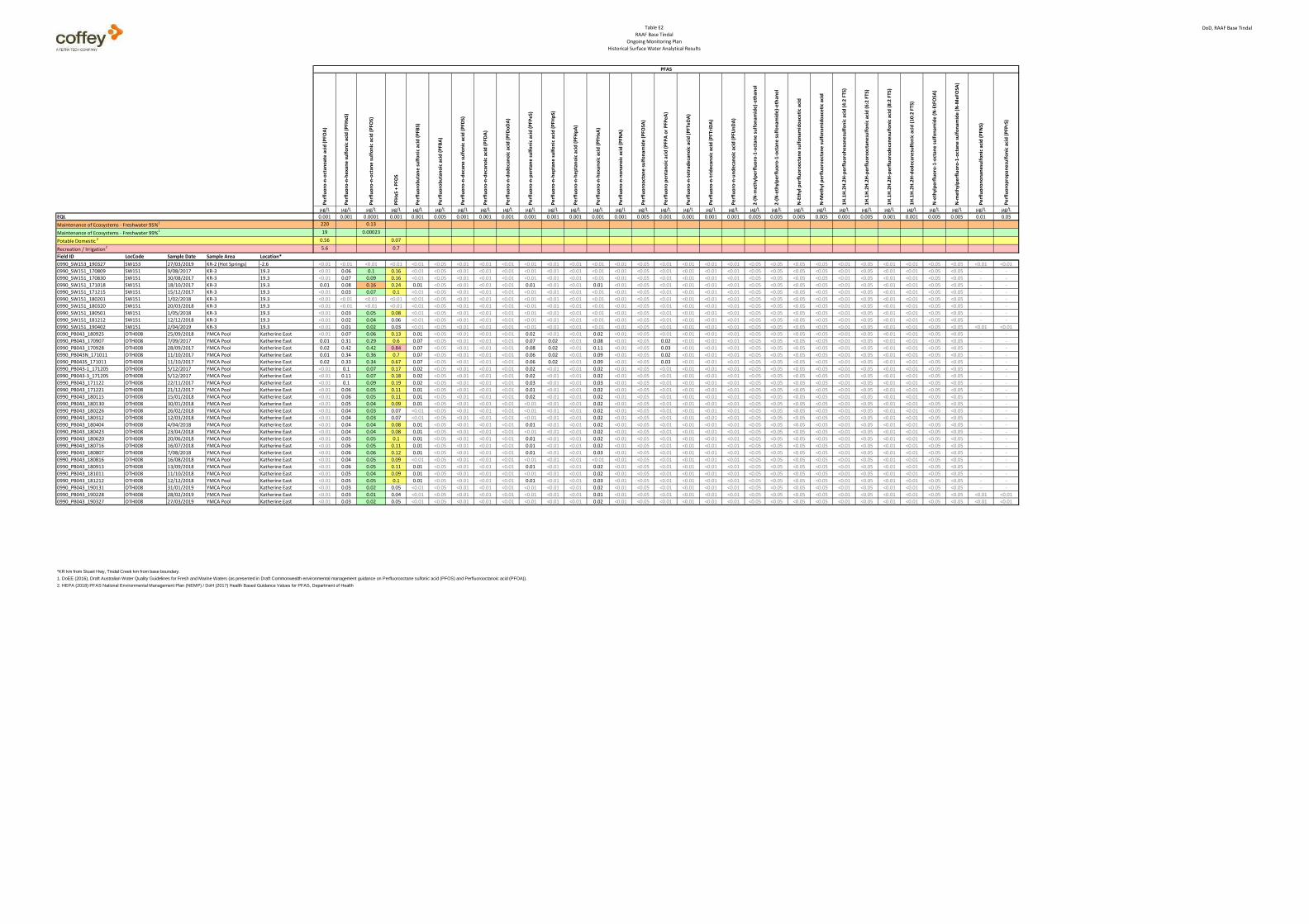
Table E2
RAAF Base Tindal
Ongoing Monitoring Plan
Historical Surface Water Analytical Results
DoD, RAAF Base Tindal
Pe
rflu
oro
-n-o
ctan
oat
e a
cid
(P
FOA
)
Pe
rflu
oro
-n-h
exa
ne
su
lfo
nic
aci
d (
PFH
xS)
Pe
rflu
oro
-n-o
ctan
e s
ulf
on
ic a
cid
(P
FOS)
PFH
xS +
PFO
S
Pe
rflu
oro
bu
tan
e s
ulf
on
ic a
cid
(P
FBS)
Pe
rflu
oro
bu
tan
oic
aci
d (
PFB
A)
Pe
rflu
oro
-n-d
eca
ne
su
lfo
nic
aci
d (
PFD
S)
Pe
rflu
oro
-n-d
eca
no
ic a
cid
(P
FDA
)
Pe
rflu
oro
-n-d
od
eca
no
ic a
cid
(P
FDo
DA
)
Pe
rflu
oro
-n-p
en
tan
e s
ulf
on
ic a
cid
(P
FPe
S)
Pe
rflu
oro
-n-h
ep
tan
e s
ulf
on
ic a
cid
(P
FHp
S)
Pe
rflu
oro
-n-h
ep
tan
oic
aci
d (
PFH
pA
)
Pe
rflu
oro
-n-h
exa
no
ic a
cid
(P
FHxA
)
Pe
rflu
oro
-n-n
on
ano
ic a
cid
(P
FNA
)
Pe
rflu
oro
oct
ane
su
lfo
nam
ide
(P
FOSA
)
Pe
rflu
oro
pe
nta
no
ic a
cid
(P
FPA
or
PFP
eA
)
Pe
rflu
oro
-n-t
etr
ade
can
oic
aci
d (
PFT
eD
A)
Pe
rflu
oro
-n-t
rid
eca
no
ic a
cid
(P
FTri
DA
)
Pe
rflu
oro
-n-u
nd
eca
no
ic a
cid
(P
FUn
DA
)
2-(
N-m
eth
ylp
erf
luo
ro-1
-oct
ane
su
lfo
nam
ide
)-e
than
ol
2-(
N-e
thyl
pe
rflu
oro
-1-o
ctan
e s
ulf
on
amid
e)-
eth
ano
l
N-E
thyl
pe
rflu
oro
oct
ane
su
lfo
nam
ido
ace
tic
acid
N-M
eth
yl p
erf
luo
roo
ctan
e s
ulf
on
amid
oac
eti
c ac
id
1H
.1H
.2H
.2H
-pe
rflu
oro
he
xan
esu
lfo
nic
aci
d (
4:2
FTS
)
1H
.1H
.2H
.2H
-pe
rflu
oro
oct
ane
sulf
on
ic a
cid
(6
:2 F
TS)
1H
.1H
.2H
.2H
-pe
rflu
oro
de
can
esu
lfo
nic
aci
d (
8:2
FTS
)
1H
.1H
.2H
.2H
-do
de
can
esu
lfo
nic
aci
d (
10
:2 F
TS)
N-e
thyl
pe
rflu
oro
-1-o
ctan
e s
ulf
on
amid
e (
N-E
tFO
SA)
N-m
eth
ylp
erf
luo
ro-1
-oct
ane
su
lfo
nam
ide
(N
-Me
FOSA
)
Pe
rflu
oro
no
nan
esu
lfo
nic
aci
d (
PFN
S)
Pe
rflu
oro
pro
pan
esu
lfo
nic
aci
d (
PFP
rS)
µg/L µg/L µg/L µg/L µg/L µg/L µg/L µg/L µg/L µg/L µg/L µg/L µg/L µg/L µg/L µg/L µg/L µg/L µg/L µg/L µg/L µg/L µg/L µg/L µg/L µg/L µg/L µg/L µg/L µg/L µg/L
EQL 0.001 0.001 0.0001 0.001 0.001 0.005 0.001 0.001 0.001 0.001 0.001 0.001 0.001 0.001 0.005 0.001 0.001 0.001 0.001 0.005 0.005 0.005 0.005 0.001 0.005 0.001 0.001 0.005 0.005 0.01 0.05
Maintenance of Ecosystems - Freshwater 95%1 220 0.13
Maintenance of Ecosystems - Freshwater 99%1 19 0.00023
Potable Domestic 2 0.56 0.07
Recreation / Irrigation2 5.6 0.7
Field ID LocCode Sample Date Sample Area Location*
PFAS
0990_SW153_190327 SW153 27/03/2019 KR-2 (Hot Springs) -2.6 <0.01 <0.01 <0.01 <0.01 <0.01 <0.05 <0.01 <0.01 <0.01 <0.01 <0.01 <0.01 <0.01 <0.01 <0.05 <0.01 <0.01 <0.01 <0.01 <0.05 <0.05 <0.05 <0.05 <0.01 <0.05 <0.01 <0.01 <0.05 <0.05 <0.01 <0.01
0990_SW151_170809 SW151 9/08/2017 KR-3 19.3 <0.01 0.06 0.1 0.16 <0.01 <0.05 <0.01 <0.01 <0.01 <0.01 <0.01 <0.01 <0.01 <0.01 <0.05 <0.01 <0.01 <0.01 <0.01 <0.05 <0.05 <0.05 <0.05 <0.01 <0.05 <0.01 <0.01 <0.05 <0.05 - -
0990_SW151_170830 SW151 30/08/2017 KR-3 19.3 <0.01 0.07 0.09 0.16 <0.01 <0.05 <0.01 <0.01 <0.01 <0.01 <0.01 <0.01 <0.01 <0.01 <0.05 <0.01 <0.01 <0.01 <0.01 <0.05 <0.05 <0.05 <0.05 <0.01 <0.05 <0.01 <0.01 <0.05 <0.05 - -
0990_SW151_171018 SW151 18/10/2017 KR-3 19.3 0.01 0.08 0.16 0.24 0.01 <0.05 <0.01 <0.01 <0.01 0.01 <0.01 <0.01 0.01 <0.01 <0.05 <0.01 <0.01 <0.01 <0.01 <0.05 <0.05 <0.05 <0.05 <0.01 <0.05 <0.01 <0.01 <0.05 <0.05 - -
0990_SW151_171215 SW151 15/12/2017 KR-3 19.3 <0.01 0.03 0.07 0.1 <0.01 <0.05 <0.01 <0.01 <0.01 <0.01 <0.01 <0.01 <0.01 <0.01 <0.05 <0.01 <0.01 <0.01 <0.01 <0.05 <0.05 <0.05 <0.05 <0.01 <0.05 <0.01 <0.01 <0.05 <0.05 - -
0990_SW151_180201 SW151 1/02/2018 KR-3 19.3 <0.01 <0.01 <0.01 <0.01 <0.01 <0.05 <0.01 <0.01 <0.01 <0.01 <0.01 <0.01 <0.01 <0.01 <0.05 <0.01 <0.01 <0.01 <0.01 <0.05 <0.05 <0.05 <0.05 <0.01 <0.05 <0.01 <0.01 <0.05 <0.05 - -
0990_SW151_180320 SW151 20/03/2018 KR-3 19.3 <0.01 <0.01 <0.01 <0.01 <0.01 <0.05 <0.01 <0.01 <0.01 <0.01 <0.01 <0.01 <0.01 <0.01 <0.05 <0.01 <0.01 <0.01 <0.01 <0.05 <0.05 <0.05 <0.05 <0.01 <0.05 <0.01 <0.01 <0.05 <0.05 - -
0990_SW151_180501 SW151 1/05/2018 KR-3 19.3 <0.01 0.03 0.05 0.08 <0.01 <0.05 <0.01 <0.01 <0.01 <0.01 <0.01 <0.01 <0.01 <0.01 <0.05 <0.01 <0.01 <0.01 <0.01 <0.05 <0.05 <0.05 <0.05 <0.01 <0.05 <0.01 <0.01 <0.05 <0.05 - -
0990_SW151_181212 SW151 12/12/2018 KR-3 19.3 <0.01 0.02 0.04 0.06 <0.01 <0.05 <0.01 <0.01 <0.01 <0.01 <0.01 <0.01 <0.01 <0.01 <0.05 <0.01 <0.01 <0.01 <0.01 <0.05 <0.05 <0.05 <0.05 <0.01 <0.05 <0.01 <0.01 <0.05 <0.05 - -
0990_SW151_190402 SW151 2/04/2019 KR-3 19.3 <0.01 0.01 0.02 0.03 <0.01 <0.05 <0.01 <0.01 <0.01 <0.01 <0.01 <0.01 <0.01 <0.01 <0.05 <0.01 <0.01 <0.01 <0.01 <0.05 <0.05 <0.05 <0.05 <0.01 <0.05 <0.01 <0.01 <0.05 <0.05 <0.01 <0.01
0090_PB043_180925 OTH008 25/09/2018 YMCA Pool Katherine East <0.01 0.07 0.06 0.13 0.01 <0.05 <0.01 <0.01 <0.01 0.02 <0.01 <0.01 0.02 <0.01 <0.05 <0.01 <0.01 <0.01 <0.01 <0.05 <0.05 <0.05 <0.05 <0.01 <0.05 <0.01 <0.01 <0.05 <0.05 - -
0990_PB043_170907 OTH008 7/09/2017 YMCA Pool Katherine East 0.01 0.31 0.29 0.6 0.07 <0.05 <0.01 <0.01 <0.01 0.07 0.02 <0.01 0.08 <0.01 <0.05 0.02 <0.01 <0.01 <0.01 <0.05 <0.05 <0.05 <0.05 <0.01 <0.05 <0.01 <0.01 <0.05 <0.05 - -
0990_PB043_170928 OTH008 28/09/2017 YMCA Pool Katherine East 0.02 0.42 0.42 0.84 0.07 <0.05 <0.01 <0.01 <0.01 0.08 0.02 <0.01 0.11 <0.01 <0.05 0.03 <0.01 <0.01 <0.01 <0.05 <0.05 <0.05 <0.05 <0.01 <0.05 <0.01 <0.01 <0.05 <0.05 - -
0990_PB043N_171011 OTH008 11/10/2017 YMCA Pool Katherine East 0.01 0.34 0.36 0.7 0.07 <0.05 <0.01 <0.01 <0.01 0.06 0.02 <0.01 0.09 <0.01 <0.05 0.02 <0.01 <0.01 <0.01 <0.05 <0.05 <0.05 <0.05 <0.01 <0.05 <0.01 <0.01 <0.05 <0.05 - -
0990_PB043S_171011 OTH008 11/10/2017 YMCA Pool Katherine East 0.02 0.33 0.34 0.67 0.07 <0.05 <0.01 <0.01 <0.01 0.06 0.02 <0.01 0.09 <0.01 <0.05 0.03 <0.01 <0.01 <0.01 <0.05 <0.05 <0.05 <0.05 <0.01 <0.05 <0.01 <0.01 <0.05 <0.05 - -
0990_PB043-1_171205 OTH008 5/12/2017 YMCA Pool Katherine East <0.01 0.1 0.07 0.17 0.02 <0.05 <0.01 <0.01 <0.01 0.02 <0.01 <0.01 0.02 <0.01 <0.05 <0.01 <0.01 <0.01 <0.01 <0.05 <0.05 <0.05 <0.05 <0.01 <0.05 <0.01 <0.01 <0.05 <0.05 - -
0990_PB043-3_171205 OTH008 5/12/2017 YMCA Pool Katherine East <0.01 0.11 0.07 0.18 0.02 <0.05 <0.01 <0.01 <0.01 0.02 <0.01 <0.01 0.02 <0.01 <0.05 <0.01 <0.01 <0.01 <0.01 <0.05 <0.05 <0.05 <0.05 <0.01 <0.05 <0.01 <0.01 <0.05 <0.05 - -
0990_PB043_171122 OTH008 22/11/2017 YMCA Pool Katherine East <0.01 0.1 0.09 0.19 0.02 <0.05 <0.01 <0.01 <0.01 0.03 <0.01 <0.01 0.03 <0.01 <0.05 <0.01 <0.01 <0.01 <0.01 <0.05 <0.05 <0.05 <0.05 <0.01 <0.05 <0.01 <0.01 <0.05 <0.05 - -
0990_PB043_171221 OTH008 21/12/2017 YMCA Pool Katherine East <0.01 0.06 0.05 0.11 0.01 <0.05 <0.01 <0.01 <0.01 0.01 <0.01 <0.01 0.02 <0.01 <0.05 <0.01 <0.01 <0.01 <0.01 <0.05 <0.05 <0.05 <0.05 <0.01 <0.05 <0.01 <0.01 <0.05 <0.05 - -
0990_PB043_180115 OTH008 15/01/2018 YMCA Pool Katherine East <0.01 0.06 0.05 0.11 0.01 <0.05 <0.01 <0.01 <0.01 0.02 <0.01 <0.01 0.02 <0.01 <0.05 <0.01 <0.01 <0.01 <0.01 <0.05 <0.05 <0.05 <0.05 <0.01 <0.05 <0.01 <0.01 <0.05 <0.05 - -
0990_PB043_180130 OTH008 30/01/2018 YMCA Pool Katherine East <0.01 0.05 0.04 0.09 0.01 <0.05 <0.01 <0.01 <0.01 <0.01 <0.01 <0.01 0.02 <0.01 <0.05 <0.01 <0.01 <0.01 <0.01 <0.05 <0.05 <0.05 <0.05 <0.01 <0.05 <0.01 <0.01 <0.05 <0.05 - -
0990_PB043_180226 OTH008 26/02/2018 YMCA Pool Katherine East <0.01 0.04 0.03 0.07 <0.01 <0.05 <0.01 <0.01 <0.01 <0.01 <0.01 <0.01 0.02 <0.01 <0.05 <0.01 <0.01 <0.01 <0.01 <0.05 <0.05 <0.05 <0.05 <0.01 <0.05 <0.01 <0.01 <0.05 <0.05 - -
0990_PB043_180312 OTH008 12/03/2018 YMCA Pool Katherine East <0.01 0.04 0.03 0.07 <0.01 <0.05 <0.01 <0.01 <0.01 <0.01 <0.01 <0.01 0.02 <0.01 <0.05 <0.01 <0.01 <0.01 <0.01 <0.05 <0.05 <0.05 <0.05 <0.01 <0.05 <0.01 <0.01 <0.05 <0.05 - -
0990_PB043_180404 OTH008 4/04/2018 YMCA Pool Katherine East <0.01 0.04 0.04 0.08 0.01 <0.05 <0.01 <0.01 <0.01 0.01 <0.01 <0.01 0.02 <0.01 <0.05 <0.01 <0.01 <0.01 <0.01 <0.05 <0.05 <0.05 <0.05 <0.01 <0.05 <0.01 <0.01 <0.05 <0.05 - -
0990_PB043_180423 OTH008 23/04/2018 YMCA Pool Katherine East <0.01 0.04 0.04 0.08 0.01 <0.05 <0.01 <0.01 <0.01 <0.01 <0.01 <0.01 0.02 <0.01 <0.05 <0.01 <0.01 <0.01 <0.01 <0.05 <0.05 <0.05 <0.05 <0.01 <0.05 <0.01 <0.01 <0.05 <0.05 - -
0990_PB043_180620 OTH008 20/06/2018 YMCA Pool Katherine East <0.01 0.05 0.05 0.1 0.01 <0.05 <0.01 <0.01 <0.01 0.01 <0.01 <0.01 0.02 <0.01 <0.05 <0.01 <0.01 <0.01 <0.01 <0.05 <0.05 <0.05 <0.05 <0.01 <0.05 <0.01 <0.01 <0.05 <0.05 - -
0990_PB043_180716 OTH008 16/07/2018 YMCA Pool Katherine East <0.01 0.06 0.05 0.11 0.01 <0.05 <0.01 <0.01 <0.01 0.01 <0.01 <0.01 0.02 <0.01 <0.05 <0.01 <0.01 <0.01 <0.01 <0.05 <0.05 <0.05 <0.05 <0.01 <0.05 <0.01 <0.01 <0.05 <0.05 - -
0990_PB043_180807 OTH008 7/08/2018 YMCA Pool Katherine East <0.01 0.06 0.06 0.12 0.01 <0.05 <0.01 <0.01 <0.01 0.01 <0.01 <0.01 0.03 <0.01 <0.05 <0.01 <0.01 <0.01 <0.01 <0.05 <0.05 <0.05 <0.05 <0.01 <0.05 <0.01 <0.01 <0.05 <0.05 - -
0990_PB043_180816 OTH008 16/08/2018 YMCA Pool Katherine East <0.01 0.04 0.05 0.09 <0.01 <0.05 <0.01 <0.01 <0.01 <0.01 <0.01 <0.01 <0.01 <0.01 <0.05 <0.01 <0.01 <0.01 <0.01 <0.05 <0.05 <0.05 <0.05 <0.01 <0.05 <0.01 <0.01 <0.05 <0.05 - -
0990_PB043_180913 OTH008 13/09/2018 YMCA Pool Katherine East <0.01 0.06 0.05 0.11 0.01 <0.05 <0.01 <0.01 <0.01 0.01 <0.01 <0.01 0.02 <0.01 <0.05 <0.01 <0.01 <0.01 <0.01 <0.05 <0.05 <0.05 <0.05 <0.01 <0.05 <0.01 <0.01 <0.05 <0.05 - -
0990_PB043_181011 OTH008 11/10/2018 YMCA Pool Katherine East <0.01 0.05 0.04 0.09 0.01 <0.05 <0.01 <0.01 <0.01 <0.01 <0.01 <0.01 0.02 <0.01 <0.05 <0.01 <0.01 <0.01 <0.01 <0.05 <0.05 <0.05 <0.05 <0.01 <0.05 <0.01 <0.01 <0.05 <0.05 - -
0990_PB043_181212 OTH008 12/12/2018 YMCA Pool Katherine East <0.01 0.05 0.05 0.1 0.01 <0.05 <0.01 <0.01 <0.01 0.01 <0.01 <0.01 0.03 <0.01 <0.05 <0.01 <0.01 <0.01 <0.01 <0.05 <0.05 <0.05 <0.05 <0.01 <0.05 <0.01 <0.01 <0.05 <0.05 - -
0990_PB043_190131 OTH008 31/01/2019 YMCA Pool Katherine East <0.01 0.03 0.02 0.05 <0.01 <0.05 <0.01 <0.01 <0.01 <0.01 <0.01 <0.01 0.02 <0.01 <0.05 <0.01 <0.01 <0.01 <0.01 <0.05 <0.05 <0.05 <0.05 <0.01 <0.05 <0.01 <0.01 <0.05 <0.05 - -
0990_PB043_190228 OTH008 28/02/2019 YMCA Pool Katherine East <0.01 0.03 0.01 0.04 <0.01 <0.05 <0.01 <0.01 <0.01 <0.01 <0.01 <0.01 0.01 <0.01 <0.05 <0.01 <0.01 <0.01 <0.01 <0.05 <0.05 <0.05 <0.05 <0.01 <0.05 <0.01 <0.01 <0.05 <0.05 <0.01 <0.01
0990_PB043_190327 OTH008 27/03/2019 YMCA Pool Katherine East <0.01 0.03 0.02 0.05 <0.01 <0.05 <0.01 <0.01 <0.01 <0.01 <0.01 <0.01 0.02 <0.01 <0.05 <0.01 <0.01 <0.01 <0.01 <0.05 <0.05 <0.05 <0.05 <0.01 <0.05 <0.01 <0.01 <0.05 <0.05 <0.01 <0.01
*KR km from Stuart Hwy, Tindal Creek km from base boundary.
1. DoEE (2016), Draft Australian Water Quality Guidelines for Fresh and Marine Waters (as presented in Draft Commonwealth environmental management guidance on Perfluorooctane sulfonic acid (PFOS) and Perfluorooctanoic acid (PFOA)).
2. HEPA (2018) PFAS National Environmental Management Plan (NEMP) / DoH (2017) Health Based Guidance Values for PFAS, Department of Health

PFAS MANAGEMENT AREA PLAN – RAAF BASE TINDAL
106 July 2019
APPENDIX G Recommendations analysis
Human and ecological exposure to PFAS in waters and biota in Katherine River, as a result of groundwater migration of contamination from FTA
Source Management Pathway Interception Administrative Controls
Ex-situ treatment of groundwater
Immobilisation of PFAS in soil by adsorbent mixing
Excavation and onsite containment of soil in purpose built cell
Excavation and thermal treatment of soil
Excavation and off-site disposal to licenced facility
Hydraulic interception and ex-situ treatment of groundwater at site boundary
Dietary advisories to restrict fish consumption
ID R1.3 R1.4 R1.5 R1.6 R1.7 R1.1 R1.8
1 Cost range estimate Cat 2 Cat 2 Cat 2 Cat 2 Cat 1 Cat 2 Cat 4
2 Effectiveness rating Medium Medium High High High Low Low
3 Implementation period / timeframe Medium to Long Short Medium Medium Medium Medium to Long Long
4 Potential impacts + Mass removal, - Waste
+ Reduces mobility - Long-term management
+ Reduces mobility - Long-term monitoring
+ Destroys contaminant- High energy input
+ Reduces mobility - High road transport impact
+ Mass removal, - Waste
+ Reduced intake - No environmental improvement
5 Estimated net environmental benefit Marginal Moderate Moderate Moderate Marginal Negative Negative
6 Proportion of action to risk Proportionate Proportionate Proportionate Proportionate Disproportionate High Disproportionate High Disproportionate Low
7 Best-practice status Partial Best Practice Good Practice Best Practice Good Practice Not best practice Not best practice Partial Best Practice
8 Verification status Proven Proven short term Proven med-long term Trialled Proven In progress
9 Technology assessment Moderate Effort Moderate Effort Moderate Effort High effort Moderate Effort
10 Risks and mitigation Manageable Requiring monitoring Requiring monitoring Manageable Manageable Unlikely to succeed High reputational risk
11 Key Dependencies Limited Limited Limited Moderate Limited Limited Stakeholder driven
12 Defence capability Minimal Minimal Manageable Manageable Minimal Minimal Negligible
13 Project fit Good Moderate Good Good Poor Poor Good in combination
14 Scalability Scalable Scalable Scalable Scalable Scalable Scalable Scalable
15 Jurisdictional regulator/s NT DENR Commonwealth Commonwealth Commonwealth States and Territories NT DENR NT Government
16 Owner / occupier consents and views Defence Generally negative Manageable Requires coordination Manageable Defence Requires coordination
17 Community Generally positive Neutral Mixed Generally positive Mixed Neutral Negative in isolation
Comments 2: Also requires receptor controls 7: Not "best practice" in isolation, but part of an integrated approach 9: Need for Approvals, Equipment purpose built, moderate energy use. 11: Access to power, application of receptor controls
10: Long term performance uncertain
9: Planning and design critical and ongoing maintenance 10: Very long term performance (>100yrs) uncertain 11: Exposure point controls required in short-medium term 13: Established technology, large site 16: Siting negotiations
6: Proportionate when long term management considered 9: High energy, equipment custom built, regulator approvals 10: High temperature unit, waste salts 11: Availability of fuel, hazard assessment, treatment optimisation trial
11: Interstate transport requires multiple jurisdiction approval 13: Long distance to licenced facility
2: Unlikely to intercept and treat sufficient volume. Also requires receptor controls 7: Not "best practice" due to high volumes for interception 9: Need for Approvals, Equipment purpose built, moderate energy use. 11: Access to power, application of receptor controls
7: Part of a best practice solution if implemented with source removal 8: In progress as an interim response

PFAS MANAGEMENT AREA PLAN – RAAF BASE TINDAL
107 July 2019
Human and ecological exposure to PFAS in waters and biota in Katherine River, as a result of groundwater migration of contamination from Fire Station
Source Management Pathway Interception Administrative Controls
Ex-situ treatment of groundwater
Immobilisation of PFAS in soil by adsorbent mixing
Excavation and onsite containment of soil in purpose built cell
Excavation and thermal treatment of soil
Excavation and off-site disposal to licenced facility
Hydraulic interception and ex-situ treatment of groundwater at site boundary
Dietary advisories to restrict fish consumption
ID R1.3 R1.4 R1.5 R1.6 R1.7 R1.1 R1.8
1 Cost range estimate Cat 2 Cat 2 Cat 2 Cat 2 Cat 1 Cat 2 Cat 4
2 Effectiveness rating Medium Medium High High High Low Low
3 Implementation period / timeframe Medium to Long Short Medium Medium Medium Medium to Long Long
4 Potential impacts + Mass removal, - Waste
+ Reduces mobility - Long-term management
+ Reduces mobility - Long-term monitoring
+ Destroys contaminant- High energy input
+ Reduces mobility - High road transport impact
+ Mass removal, - Waste
+ Reduced intake - No environmental improvement
5 Estimated net environmental benefit Marginal Moderate Moderate Moderate Marginal Negative Negative
6 Proportion of action to risk Proportionate Proportionate Proportionate Proportionate Disproportionate High Disproportionate High Disproportionate Low
7 Best-practice status Partial Best Practice Good Practice Best Practice Good Practice Not best practice Not best practice Partial Best Practice
8 Verification status Proven Proven short term Proven med-long term Trialled Proven In progress
9 Technology assessment Moderate Effort Moderate Effort Moderate Effort High effort Moderate Effort
10 Risks and mitigation Manageable Requiring monitoring Requiring monitoring Manageable Manageable Unlikely to succeed High reputational risk
11 Key Dependencies Limited Limited Limited Moderate Limited Limited Stakeholder driven
12 Defence capability Minimal Minimal Manageable Manageable Minimal Minimal Negligible
13 Project fit Good Moderate Good Good Poor Poor Good in combination
14 Scalability Scalable Scalable Scalable Scalable Scalable Scalable Scalable
15 Jurisdictional regulator/s NT DENR Commonwealth Commonwealth Commonwealth States and Territories NT DENR NT Government
16 Owner / occupier consents and views Defence Generally negative Manageable Requires coordination Manageable Defence Requires coordination
17 Community Generally positive Neutral Mixed Generally positive Mixed Neutral Negative in isolation
Comments 2: Also requires receptor controls 7: Not "best practice" in isolation, but part of an integrated approach 9: Need for Approvals, Equipment purpose built, moderate energy use. 11: Access to power, application of receptor controls
10: Long term performance uncertain
9: Planning and design critical and ongoing maintenance 10: Very long term performance (>100yrs) uncertain 11: Exposure point controls required in short-medium term 13: Established technology, large site 16: Siting negotiations
6: Proportionate when long term management considered 9: High energy, equipment custom built, regulator approvals 10: High temperature unit, waste salts 11: Availability of fuel, hazard assessment, treatment optimisation trial
11: Interstate transport requires multiple jurisdiction approval 13: Long distance to licenced facility
2: Unlikely to intercept and treat sufficient volume. Also requires receptor controls 7: Not "best practice" due to high volumes for interception 9: Need for Approvals, Equipment purpose built, moderate energy use. 11: Access to power, application of receptor controls
7: Part of a best practice solution if implemented with source removal 8: In progress as an interim response

PFAS MANAGEMENT AREA PLAN – RAAF BASE TINDAL
108 July 2019
Human and ecological exposure to PFAS in extracted groundwater, as a result of groundwater migration of contamination from FTA
Source Management Pathway Interception Administrative Controls
Ex-situ treatment of groundwater
Immobilisation of PFAS in soil by adsorbent mixing
Excavation and onsite containment of soil in purpose built cell
Excavation and thermal treatment of soil
Excavation and off-site disposal to licenced facility
Point of Use treatment
Implement extraction restrictions
ID R1.3 R1.4 R1.5 R1.6 R1.7 R1.11 R1.10
1 Cost range estimate Cat 2 Cat 2 Cat 2 Cat 2 Cat 1 Cat 1 Cat 4
2 Effectiveness rating Medium Medium High High High Moderate Low
3 Implementation period / timeframe Medium to Long Short Medium Medium Medium Medium to Long Long
4 Potential impacts + Mass removal, - Waste
+ Reduces mobility - Long-term management
+ Reduces mobility - Long-term monitoring
+ Destroys contaminant - High energy input
+ Reduces mobility - High road transport impact
+ Mass removal, low impact on lifestyle - Waste, ongoing maintenance
+ Reduced intake - No environmental improvement
5 Estimated net environmental benefit Marginal Moderate Moderate Moderate Marginal Negative Negative
6 Proportion of action to risk Proportionate Proportionate Proportionate Proportionate Disproportionate High Disproportionate High Disproportionate Low
7 Best-practice status Partial Best Practice Good Practice Best Practice Good Practice Not best practice Not best practice Partial Best Practice
8 Verification status Proven Proven short term Proven med-long term Trialled Proven In progress
9 Technology assessment Moderate Effort Moderate Effort Moderate Effort High effort Moderate Effort
10 Risks and mitigation Manageable Requiring monitoring Requiring monitoring Manageable Manageable Manageable High reputational risk
11 Key Dependencies Limited Limited Limited Moderate Limited Stakeholder driven Stakeholder driven
12 Defence capability Minimal Minimal Manageable Manageable Minimal Minimal Negligible
13 Project fit Good Moderate Good Good Poor Poor Good in combination
14 Scalability Scalable Scalable Scalable Scalable Scalable Scalable Scalable
15 Jurisdictional regulator/s NT DENR Commonwealth Commonwealth Commonwealth States and Territories NT DENR NT DENR
16 Owner / occupier consents and views Defence Generally negative Manageable Requires coordination Manageable Landowners Requires coordination
17 Community Generally positive Neutral Mixed Generally positive Mixed Mixed Mixed
Comments 2: Also requires receptor controls 7: Not "best practice" in isolation, but part of an integrated approach 9: Need for Approvals, Equipment purpose built, moderate energy use. 11: Access to power, application of receptor controls
10: Long term performance uncertain
9: Planning and design critical and ongoing maintenance 10: Very long term performance (>100yrs) uncertain 11: Exposure point controls required in short-medium term 13: Established technology, large site 16: Siting negotiations
6: Proportionate when long term management considered 9: High energy, equipment custom built, regulator approvals 10: High temperature unit, waste salts 11: Availability of fuel, hazard assessment, treatment optimisation trial
11: Interstate transport requires multiple jurisdiction approval 13: Long distance to licenced facility
2: Subject to maintenance and continuous operation 7: Not "best practice" due to limited environmental improvement 9: Equipment purpose built, moderate energy use. 11: Access to power, landowner agreement
7: Part of a best practice solution if implemented with source removal 8: In progress as an interim response

PFAS MANAGEMENT AREA PLAN – RAAF BASE TINDAL
109 July 2019
Human and ecological exposure to PFAS in extracted groundwater, as a result of groundwater migration of contamination from Fire Station
Source Management Pathway Interception Administrative Controls
Ex-situ treatment of groundwater
Immobilisation of PFAS in soil by adsorbent mixing
Excavation and onsite containment of soil in purpose built cell
Excavation and thermal treatment of soil
Excavation and off-site disposal to licenced facility
Point of Use treatment
Implement extraction restrictions
ID R1.3 R1.4 R1.5 R1.6 R1.7 R1.11 R1.10
1 Cost range estimate Cat 2 Cat 2 Cat 2 Cat 2 Cat 1 Cat 2 Cat 4
2 Effectiveness rating Medium Medium High High High Moderate Low
3 Implementation period / timeframe Medium to Long Short Medium Medium Medium Medium to Long Long
4 Potential impacts + Mass removal, - Waste
+ Reduces mobility - Long-term management
+ Reduces mobility - Long-term monitoring
+ Destroys contaminant - High energy input
+ Reduces mobility - High road transport impact
+ Mass removal, low impact on lifestyle - Waste
+ Reduced intake - No environmental improvement
5 Estimated net environmental benefit Marginal Moderate Moderate Moderate Marginal Negative Negative
6 Proportion of action to risk Proportionate Proportionate Proportionate Proportionate Disproportionate High Disproportionate High Disproportionate Low
7 Best-practice status Partial Best Practice Good Practice Best Practice Good Practice Not best practice Not best practice Partial Best Practice
8 Verification status Proven Proven short term Proven med-long term Trialled Proven In progress
9 Technology assessment Moderate Effort Moderate Effort Moderate Effort High effort Moderate Effort
10 Risks and mitigation Manageable Requiring monitoring Requiring monitoring Manageable Manageable Manageable High reputational risk
11 Key Dependencies Limited Limited Limited Moderate Limited Stakeholder driven Stakeholder driven
12 Defence capability Minimal Minimal Manageable Manageable Minimal Minimal Negligible
13 Project fit Good Moderate Good Good Poor Poor Good in combination
14 Scalability Scalable Scalable Scalable Scalable Scalable Scalable Scalable
15 Jurisdictional regulator/s NT DENR Commonwealth Commonwealth Commonwealth States and Territories NT DENR NT DENR
16 Owner / occupier consents and views Defence Generally negative Manageable Requires coordination Manageable Landowners Requires coordination
17 Community Generally positive Neutral Mixed Generally positive Mixed Mixed Mixed
Comments 2: Also requires receptor controls 7: Not "best practice" in isolation, but part of an integrated approach 9: Need for Approvals, Equipment purpose built, moderate energy use. 11: Access to power, application of receptor controls
10: Long term performance uncertain
9: Planning and design critical and ongoing maintenance 10: Very long term performance (>100yrs) uncertain 11: Exposure point controls required in short-medium term 13: Established technology, large site 16: Siting negotiations
6: Proportionate when long term management considered 9: High energy, equipment custom built, regulator approvals 10: High temperature unit, waste salts 11: Availability of fuel, hazard assessment, treatment optimisation trial
11: Interstate transport requires multiple jurisdiction approval 13: Long distance to licenced facility
2: Subject to maintenance and continuous operation 7: Not "best practice" due to limited environmental improvement 9: Equipment purpose built, moderate energy use. 11: Access to power, landowner agreement
7: Part of a best practice solution if implemented with source removal 8: In progress as an interim response

PFAS MANAGEMENT AREA PLAN – RAAF BASE TINDAL
110 July 2019
Human and ecological exposure in Tindal Creek as a result of surface water runoff from Fire Station
Source Management Pathway Interception Administrative Controls
Immobilisation of PFAS in soil by adsorbent mixing
Excavation and onsite containment of soil in purpose built cell
Excavation and thermal treatment of soil
Cap soils Treat water in Tindal Creek
Divert drains and treat water
Dietary advisories to restrict fish consumption
ID R2.5 / 1.4 R2.5/ 1.5 R2.5 /1.6 R3.2 R2.3 R2.2 R1.8
1 Cost range estimate Cat 2 Cat 2 Cat 2 Cat 2 Cat 2 Cat 2 Cat 4
2 Effectiveness rating Medium High High Low Low to Moderate Low Low
3 Implementation period / timeframe Short Medium Medium Short Long Long Long
4 Potential impacts + Reduces mobility - Long-term management
+ Reduces mobility - Long-term monitoring
+ Destroys contaminant- High energy input
+ reduce runoff concentrations - long term management
+ local reduction - no material improvement
+ local reduction - no material improvement
+ Reduced intake - No environmental improvement
5 Estimated net environmental benefit Moderate Moderate Moderate Marginal Marginal Low Negative
6 Proportion of action to risk Proportionate Proportionate Proportionate Disproportionate High Disproportionate - High Disproportionate - High Disproportionate Low
7 Best-practice status Good Practice Best Practice Good Practice Partial Best Practice Partial Best Practice Partial Best Practice Partial Best Practice
8 Verification status Proven short term Proven med-long term Trialled Proven Proven Proven In progress
9 Technology assessment Moderate Effort Moderate Effort High effort Low effort Moderate Effort Moderate Effort
10 Risks and mitigation Requiring monitoring Requiring monitoring Manageable Manageable Low Manageable High reputational risk
11 Key Dependencies Limited Limited Moderate Limited Limited Limited Stakeholder driven
12 Defence capability Minimal Manageable Manageable Requires coordination Minimal Requires coordination Negligible
13 Project fit Moderate Good Good Moderate Poor Good in combination Good in combination
14 Scalability Scalable Scalable Scalable Scalable Scalable Scalable Scalable
15 Jurisdictional regulator/s Commonwealth Commonwealth Commonwealth Commonwealth NTG Commonwealth NT Government
16 Owner / occupier consents and views Generally negative Manageable Requires coordination Requires coordination Manageable Requires coordination Requires coordination
17 Community Neutral Mixed Generally positive Generally positive Generally positive Generally positive Negative in isolation
Comments 10: Long term performance uncertain
9: Planning and design critical and ongoing maintenance 10: Very long term performance (>100yrs) uncertain 11: Exposure point controls required in short-medium term 13: Established technology, large site 16: Siting negotiations
6: Proportionate when long term management considered 9: High energy, equipment custom built, regulator approvals 10: High temperature unit, waste salts 11: Availability of fuel, hazard assessment, treatment optimisation trial
6: high effort for minor mass contribution 13: Good fit, but requires duplicated effort once source removal implemented.
10: Drainage design required to avoid flooding risk
6: Would be proportionate if integrated with FTA groundwater treatment 9: Limited addition effort if part of groundwater treatment system. 10: Drainage design required to avoid flooding risk
7: Part of a best practice solution if implemented with source removal 8: In progress as an interim response

PFAS MANAGEMENT AREA PLAN – RAAF BASE TINDAL
111 July 2019
Ecological exposure to soil at the Fire Training Area
Source Management Pathway Interception
Immobilisation of PFAS in soil by adsorbent mixing
Excavation and onsite containment of soil in purpose built cell
Excavation and thermal treatment of soil
Excavation and off-site disposal to licenced facility
Cap soils
ID R3.3 R3.4 R3.5 R3.6 R3.2
1 Cost range estimate Cat 2 Cat 2 Cat 2 Cat 1 Cat 3
2 Effectiveness rating Medium High High High High
3 Implementation period / timeframe Short Medium Medium Medium Short
4 Potential impacts + Reduces mobility - Long-term management
+ Reduces mobility - Long-term monitoring
+ Destroys contaminant - High energy input
+ Reduces source mass - High road transport impact
+ reduce exposure - long term management
5 Estimated net environmental benefit Moderate Moderate Moderate Marginal Marginal
6 Proportion of action to risk Proportionate Proportionate Proportionate Disproportionate High Marginal
7 Best-practice status Good Practice Best Practice Good Practice Not best practice Partial Best Practice
8 Verification status Proven short term Proven med-long term Trialled Proven
9 Technology assessment Moderate Effort Moderate Effort High effort Low effort Low effort
10 Risks and mitigation Requiring monitoring Requiring monitoring Manageable Manageable Manageable
11 Key Dependencies Limited Limited Moderate Limited Limited
12 Defence capability Minimal Minimal Manageable Minimal Minimal
13 Project fit Moderate Good Good Poor Moderate
14 Scalability Scalable Scalable Scalable Scalable Scalable
15 Jurisdictional regulator/s Commonwealth Commonwealth Commonwealth States and Territories Commonwealth
16 Owner / occupier consents and views Generally negative Manageable Requires coordination Manageable Requires coordination
17 Community Neutral Mixed Generally positive Mixed generally positive
Comments 10: Long term performance uncertain 13: High cost for partial solution
9: Planning and design critical and ongoing maintenance 10: Very long term performance (>100yrs) uncertain 11: Exposure point controls required in short-medium term 13: Established technology, large site 16: Siting negotiations
6: Proportionate when long term management considered 9: High energy, equipment custom built, regulator approvals 10: High temperature unit, waste salts 11: Availability of fuel, hazard assessment, treatment optimisation trial
11: Interstate transport requires multiple jurisdiction approval 13: Long distance to licenced facility
6: Disproportionate overall based on limited habitat value, and no improvement for other risks 13: Good fit for specific risk but requires duplicated effort once source removal implemented.

PFAS MANAGEMENT AREA PLAN – RAAF BASE TINDAL
112 July 2019
Ecological exposure to soil at the Fire Station
Source Management Pathway Interception
Immobilisation of PFAS in soil by adsorbent mixing
Excavation and onsite containment of soil in purpose built cell
Excavation and thermal treatment of soil
Excavation and off-site disposal to licenced facility
Cap soils
ID R3.3 R3.4 R3.5 R3.6 R3.2
1 Cost range estimate Cat 2 Cat 2 Cat 2 Cat 1 Cat 3
2 Effectiveness rating Medium High High High High
3 Implementation period / timeframe Short Medium Medium Medium Short
4 Potential impacts + Reduces mobility - Long-term management
+ Reduces mobility - Long-term monitoring
+ Destroys contaminant - High energy input
+ Reduces mobility - High road transport impact
+ reduce exposure - long term management
5 Estimated net environmental benefit Moderate Moderate Moderate Low Marginal
6 Proportion of action to risk Disproportionate High Disproportionate High Disproportionate High Disproportionate High Marginal
7 Best-practice status Good Practice Best Practice Good Practice Not best practice Partial Best Practice
8 Verification status Proven short term Proven med-long term Trialled Proven
9 Technology assessment Moderate Effort Moderate Effort High effort Low effort
10 Risks and mitigation Requiring monitoring Requiring monitoring Manageable Manageable Manageable
11 Key Dependencies Limited Limited Moderate Limited Limited
12 Defence capability Manageable Manageable Manageable Minimal Requires coordination
13 Project fit Moderate Good Moderate Poor Poor
14 Scalability Scalable Scalable Scalable Scalable Scalable
15 Jurisdictional regulator/s Commonwealth Commonwealth Commonwealth States and Territories Commonwealth
16 Owner / occupier consents and views Generally negative Manageable Requires coordination Manageable Requires coordination
17 Community Neutral Mixed Generally positive Mixed generally positive
Comments 6: Disproportionate based on limited habitat value 10: Long term performance uncertain
6: Disproportionate based on limited habitat value 9: Planning and design critical and ongoing maintenance 10: Very long term performance (>100yrs) uncertain 11: Exposure point controls required in short-medium term 13: Established technology, large site 16: Siting negotiations
6: Disproportionate based on limited habitat value 9: High energy, equipment custom built, regulator approvals10: High temperature unit, waste salts 11: Availability of fuel, hazard assessment, treatment optimisation trial 13. Project fit would improve if applied across multiple sources
6: Disproportionate based on cost and net environmental. benefit 11: Interstate transport requires multiple jurisdiction approval 13: Long distance to licenced facility
6: Disproportionate overall based on limited habitat value, and no improvement for other risks 13: Good fit for specific risk, but requires duplicated effort once source removal implemented.

PFAS MANAGEMENT AREA PLAN – RAAF BASE TINDAL
113 July 2019
Human exposure to residues in infrastructure at MEOMS and Fire Station
Source Management Administrative Controls
Remove sediments and flush effluents Restrict access and implement PPE protocols
ID R4.2 R4.1
1 Cost range estimate Cat 3 Cat 4
2 Effectiveness rating High Moderate
3 Implementation period / timeframe Short Long
4 Potential impacts + removal of source in infrastructure - low material improvement to other risks
+ Reduced intake - No environmental improvement
5 Estimated net environmental benefit Positive Low
6 Proportion of action to risk Proportionate Disproportionate Low
7 Best-practice status Partial Best Practice Partial Best Practice
8 Verification status Proven In progress
9 Technology assessment Low Effort
10 Risks and mitigation Manageable Reputational risk
11 Key Dependencies Limited Stakeholder driven
12 Defence capability Requires coordination Minimal
13 Project fit Good Good
14 Scalability Scalable Scalable
15 Jurisdictional regulator/s Commonwealth Commonwealth
16 Owner / occupier consents and views Requires coordination Requires coordination
17 Community Generally positive Neutral
Comments 6: Proportionate if integrated with onsite water treatment system to deal with flush water 10: Mobilisation risk requires management 12: Requires coordination to get suitable access to hardstand, pits and tanks
7: Part of a best practice solution if implemented as an interim measure 16: Will require coordination to ensure controls are understood and applicable

PFAS MANAGEMENT AREA PLAN – RAAF BASE TINDAL
114 July 2019
APPENDIX H Figures

D a te :
F i le N a m e :
P ro jec t :
S tu a r t H ighw a yFl o
rin aR oa
d
Vic to ria
H ighwa
y
B ic e n te nnia l Ro ad
E mu ng
a lan Road
Z im m in D riv e
G org e R o a d
S tu a r t H igh w a y
T inda l Creek
Leight C re ek
Two MileC re e k
K a th e rin e E a s t
Tin d a l
U ra l la
La n sd o w n e
K a th e rin e
2 0 0 ,0 0 0
2 0 0 ,0 0 0
2 0 2 ,5 0 0
2 0 2 ,5 0 0
2 0 5 ,0 0 0
2 0 5 ,0 0 0
2 0 7 ,5 0 0
2 0 7 ,5 0 0
2 1 0 ,0 0 0
2 1 0 ,0 0 0
2 1 2 ,5 0 0
2 1 2 ,5 0 0
2 1 5 ,0 0 0
2 1 5 ,0 0 0
2 1 7 ,5 0 0
2 1 7 ,5 0 0
2 2 0 ,0 0 0
2 2 0 ,0 0 0
2 2 2 ,5 0 0
2 2 2 ,5 0 0
2 2 5 ,0 0 0
2 2 5 ,0 0 0
8,387
,500
8,387
,500
8,390
,000
8,390
,000
8,392
,500
8,392
,500
8,395
,000
8,395
,000
8,397
,500
8,397
,500
8,400
,000
8,400
,000
8,402
,500
8,402
,500
MXD R
eferen
ce: 19
9420_P
MAP_G
IS009_
v0_1
D e p a rtm e n t o f D e fe n ce 10 9 .0 8 .2 0 1 87 5 4 -M E L E N 1 9 9 4 2 0
F ig u r e N o :
L E G E N DR o a dTra ckR a ilW a te rc ou rseK a th e rin e R ive rR A A F B a se Tin d a l s i te b o u n da ry
N
P a g e s iz e : A 3
0 2kmS c a le 1 :7 5 ,0 0 0
P ro je c tio n : G D A 1 9 9 4 M G A Z o n e 5 3
D a rw in
K a th e r in e
N TW A Q L D
Stu art H ig h wa y
0 2 0 0km
PM A P1 9 9 4 2 0 _ P M A P _ F 0 0 1 a _ G ISB a s e L o c a t io n S o u rc e :
R o a ds , tr ac k s , ra i l, w a te r co u rs e s a n d s i te b o u nd a ry f ro m D o D .Im a g er y fr om A rc G IS O n line (c a pt u re d a te u n k no w n) .

D ate :
Fi le N a m e :
Pro je c t:
M e c h a nica l E qu ip m e nt O p e ra tio n sM a in te na n c e S e c tio n
F ireS ta tion
F ire Tra in ingA re a
S e w a g e T re a tm en tP o n d s
F u e lF a rm 1
F u e lF a rm 2
21 6 ,0 0 0
21 6 ,0 0 0
21 6 ,5 0 0
21 6 ,5 0 0
21 7 ,0 0 0
21 7 ,0 0 0
21 7 ,5 0 0
21 7 ,5 0 0
21 8 ,0 0 0
21 8 ,0 0 0
21 8 ,5 0 0
21 8 ,5 0 0
21 9 ,0 0 0
21 9 ,0 0 0
21 9 ,5 0 0
21 9 ,5 0 0
22 0 ,0 0 0
22 0 ,0 0 0
22 0 ,5 0 0
22 0 ,5 0 0
22 1 ,0 0 0
22 1 ,0 0 0
8,391
,500
8,391
,500
8,392
,000
8,392
,000
8,392
,500
8,392
,500
8,393
,000
8,393
,000
8,393
,500
8,393
,500
8,394
,000
8,394
,000
8,394
,500
8,394
,500
MXD R
eferen
ce: 19
9420_P
MAP_G
IS015_
v0_3
21 9 9 4 2 0 _ P M A P _ F 0 0 2 _ G IS
1 2 . 1 0 . 2 0 1 87 5 4 -M E L E N 1 9 9 4 2 0
F ig u re N o :
L E G E N DR o a dTra c kW a te rc o u rs eO n -B a s e L a n d a n d In fra s tru c tu re M a n a g e m e n t A re aN o te : A c t io n ite m s a s d e ta i le d in S e c t io n 7 .1
N
Page s ize : A3
0 4 0 0mScale 1:15,00 0
Pro je ctio n: G D A 1 994 M G A Z one 53
So ur ce :M an a ge m e nt a re as fro m C o ffey .R oa d s , t ra cks a n d w a te rco urse s fr om D o D .Im a ge ry f ro m Ar cG IS O nl in e (ca p tu re d ate un kno w n ).
D ep artm en t o f D e fe n c eP M A P
O n -B a s e L a n d a n d In fr a s t r u c tu re M a n a g e m e n t A r e a s
K a th e rin e
V ic to ria H igh w a y
S t u a rt H ig h w a y
0 5km

D a te :
F i le N a m e :
P ro jec t :
F lo rin a R o a d
V ic to r ia H ig hw a y
B ic e n te nnia l Ro ad
S tu a r t H ighw a y
Em u ng
a la n R oadZ im m in D riv e
G org e R o a dS tu a r t H igh w a y
L eig ht C reek
Two MileCre e k
Tindal Cree k
K a th e rin e
2 0 0 ,0 0 0
2 0 0 ,0 0 0
2 0 2 ,5 0 0
2 0 2 ,5 0 0
2 0 5 ,0 0 0
2 0 5 ,0 0 0
2 0 7 ,5 0 0
2 0 7 ,5 0 0
2 1 0 ,0 0 0
2 1 0 ,0 0 0
2 1 2 ,5 0 0
2 1 2 ,5 0 0
2 1 5 ,0 0 0
2 1 5 ,0 0 0
2 1 7 ,5 0 0
2 1 7 ,5 0 0
2 2 0 ,0 0 0
2 2 0 ,0 0 0
2 2 2 ,5 0 0
2 2 2 ,5 0 0
2 2 5 ,0 0 0
2 2 5 ,0 0 0
8,387
,500
8,387
,500
8,390
,000
8,390
,000
8,392
,500
8,392
,500
8,395
,000
8,395
,000
8,397
,500
8,397
,500
8,400
,000
8,400
,000
8,402
,500
8,402
,500
MXD R
eferen
ce: 19
9420_P
MAP_G
IS011_
v0_3
D e p a rtm e n t o f D e fe n ce 31 2 .1 0 .2 0 1 87 5 4 -M E L E N 1 9 9 4 2 0
F ig u r e N o :
L E G E N DR o a dTra ckR a ilW a te rc ou rseTin d a l C re e kK a th e rin e R ive rG ro u n dw a te r m a na g e m en t a re aS u r fa ce w a te r m a na g e m en t a re aR A A F B a se Tin d a l s i te b o u n da ry
W a te r s o u rc esZ o n e 1 G ro un d w ate r ab o ve re c re a tio n a l w a te rZ o n e 2 G ro un d w ate r ab o ve d rink in g w a te rZ o n e 5 G ro un d w ate r be low c r ite ria
PM A P1 9 9 4 2 0 _ P M A P _ F 0 0 3 _ G I SW a te r M a n a g e m e n t A re a s
N
P a g e s iz e : A 3
0 2kmS c a le 1 :7 5 ,0 0 0
P ro je c tio n : G D A 1 9 9 4 M G A Z o n e 5 3
S o u rc e :M an a g e m e nt a re a s f ro m C of fe y .W a t er s o u rc e z o ne bo u n d ar y a p pr ox im a tio ns fro m C o ff ey - in d ic a tiv e o n ly .R o a ds , tr ac k s , ra i l, w a te r co u rs e s a n d s i te b o u nd a ry f ro m D o D .Im a g er y fr om A rc G IS O n line (c a pt u re d a te u n k no w n) .

D a te :
F i le N a m e :
P ro jec t :
0 9 9 0 _ P IT _ 1
0 9 9 0 _ P IT _ 2
0 9 9 0 _ S S 2 6 20 9 9 0 _ S S 2 6 30 9 9 0 _ S S 2 6 4
0 9 9 0 _ S S 2 6 5
0 9 9 0 _ S S 2 6 6
0 9 9 0 _ S S 2 6 7
0 9 9 0 _ S S 2 6 80 9 9 0 _ S S 2 6 9
0 9 9 0 _ S S 2 7 0
0 9 9 0 _ S S 2 7 1
0 9 9 0 _ S S 2 7 2
0 9 9 0 _ S S 2 7 3
0 9 9 0 _ S S 2 7 4
0 9 9 0 _ S S 2 7 5
N T 0 0 6 5 B H 0 1
N T 0 0 6 5 B H 0 2
N T 0 0 6 5 B H 0 3
N T 0 0 6 5 B H 0 4N T 0 0 6 5 B H 0 5
N T 0 0 6 5 B H 0 6
0 9 9 0 _ B H 1 4 6
0 9 9 0 _ B H 1 4 7
0 9 9 0 _ B H 1 4 8 0 9 9 0 _ B H 1 4 90 9 9 0 _ B H 1 5 0
0 9 9 0 _ B H 1 5 3
0 9 9 0 _ B H 1 5 4
0 9 9 0 _ B H 1 5 50 9 9 0 _ B H 1 5 6
0 9 9 0 _ B H 1 5 7
0 9 9 0 _ B H 1 5 8
0 9 9 0 _ B H 1 5 9
0 9 9 0 _ B H 1 6 00 9 9 0 _ B H 1 6 1
0 9 9 0 _ B H 1 6 2
0 9 9 0 _ B H 1 6 3
0 9 9 0 _ B H 1 6 4
0 9 9 0 _ B H 1 6 6
0 9 9 0 _ B H 1 6 7
0 9 9 0 _ B H 1 6 8
0 9 9 0 _ B H 1 6 9
0 9 9 0 _ B H 1 7 0
0 9 9 0 _ B H 1 7 1
0 9 9 0 _ B H 1 7 2
0 9 9 0 _ B H 1 7 30 9 9 0 _ B H 1 7 4
0 9 9 0 _ B H 1 7 5
0 9 9 0 _ B H 1 9 2
0 9 9 0 _ B H 1 9 3
0 9 9 0 _ M W 1 2 8
0 9 9 0 _ M W 1 2 4
0 9 9 0 _ M W 1 2 5
0 9 9 0 _ M W 1 2 6
0 9 9 0 _ M W 1 2 7
0 9 9 0 _ B H 1 5 1
0 9 9 0 _ B H 1 5 2
0 9 9 0 _ B H 1 6 5
0 9 9 0 _ M W 1 2 9
0 9 9 0 _ S S 1 5 5
0 9 9 0 _ S S 1 5 7
0 9 9 0 _ S S 1 5 8
0 9 9 0 _ S S 1 5 9
0 9 9 0 _ S S 1 6 0
0 9 9 0 _ S S 1 6 1 0 9 9 0 _ S S 1 6 2 0 9 9 0 _ S S 1 6 3
0 9 9 0 _ S S 1 6 4
N T 0 0 6 5 _ S S 0 1
N T 0 0 6 5 _ S S 0 2
N T 0 0 6 5 _ S S 0 3N T 0 0 6 5 _ S S 0 4
N T 0 0 6 5 _ S S 0 5
N T 0 0 6 5 _ S S 0 6
T D L _ D R A IN 1
T D L _ D R A IN 2
2 1 6 ,8 0 0
2 1 6 ,8 0 0
2 1 6 ,9 0 0
2 1 6 ,9 0 0
2 1 7 ,0 0 0
2 1 7 ,0 0 0
2 1 7 ,1 0 0
2 1 7 ,1 0 0
2 1 7 ,2 0 0
2 1 7 ,2 0 0
2 1 7 ,3 0 0
2 1 7 ,3 0 0
2 1 7 ,4 0 0
2 1 7 ,4 0 0
2 1 7 ,5 0 0
2 1 7 ,5 0 0
2 1 7 ,6 0 0
2 1 7 ,6 0 0
2 1 7 ,7 0 0
2 1 7 ,7 0 0
2 1 7 ,8 0 0
2 1 7 ,8 0 0
2 1 7 ,9 0 0
2 1 7 ,9 0 0
2 1 8 ,0 0 0
2 1 8 ,0 0 0
2 1 8 ,1 0 0
2 1 8 ,1 0 0
2 1 8 ,2 0 0
2 1 8 ,2 0 0
2 1 8 ,3 0 0
2 1 8 ,3 0 0
8,393
,000
8,393
,000
8,393
,100
8,393
,100
8,393
,200
8,393
,200
8,393
,300
8,393
,300
8,393
,400
8,393
,400
8,393
,500
8,393
,500
8,393
,600
8,393
,600
8,393
,700
8,393
,700
8,393
,800
8,393
,800
8,393
,900
8,393
,900
MXD R
eferen
ce: 19
9420_P
MAP_G
IS012_
v0_1
D e p a rtm e n t o f D e fe n ce 40 9 .0 8 .2 0 1 87 5 4 -M E L E N 1 9 9 4 2 0
F ig u r e N o :
L E G E N DR o a dTra ckW a te rc ou rseM a n a g em e n t a re a
PM A P1 9 9 4 2 0 _ P M A P _ F 0 0 4 a _ G ISF ire S e c t io n L a n d a n d In fra s tru c tu re M a n a g e m e n t A re a - S o il A n a ly t ic a l R e s u lts (0 -0 .4 m B G L )
N
P a g e s iz e : A 3
0 1 0 0mS c a le 1 :4 ,0 0 0
P ro je c tio n : G D A 1 9 9 4 M G A Z o n e 5 3
PF O S s o il s a m p le (µ g /k g )>6 ,6 0 0 µ g /k g>6 0 0 to 6 ,6 0 0 µ g /k g>1 0 0 to 6 0 0 µ g /kg>1 0 to 1 0 0 µ g /kgLO R to 10 µ g/k gB e low L O RC irc le sy m b o l d en o tes C o ffe y 2 01 7 /2 0 18so il s a m p le r es u ltD ia m o n d s y m b o l d e n o te s h is to ric a l s o ilsa m p le res u ltTria n g le sy m b o l d en o tes C o ffe y 2 01 7 /2 0 18su rfa c e s ed im e n t sa m p le re su ltPe n ta g o n s y m b o l d e n o te s h is to ric alsu rfa c e s ed im e n t sa m p le re su lt
S o u rc e :S a m p lin g re s u lt s a nd m a na g e m e n t a re a f ro m C o ffe y .R o a ds , tr ac k s an d w a te rc o u rs e s fro m D o D .Im a g er y fr om A rc G IS O n line (c a pt u re d a te u n k no w n) .

D a te :
F i le N a m e :
P ro jec t :
0 9 9 0 _ B H 11 5
0 9 9 0 _ B H 11 6
0 9 9 0 _ B H 11 7
0 9 9 0 _ B H 11 8
0 9 9 0 _ B H 11 9 0 9 9 0 _ B H 1 2 0
0 9 9 0 _ B H 1 2 1
0 9 9 0 _ B H 1 2 2
0 9 9 0 _ B H 1 2 3
0 9 9 0 _ M W 11 6
0 9 9 0 _ M W 1 0 2
0 9 9 0 _ M W 1 0 3
0 9 9 0 _ M W 1 0 4
0 9 9 0 _ M W 1 0 5
0 9 9 0 _ M W 1 2 0
0 9 9 0 _ M W 1 2 2
0 9 9 0 _ M W 1 2 3
0 9 9 0 _ S S 11 5* s e d im e n t fr o m p it
0 9 9 0 _ C O N C 0 1* c o n c re te s a m p le
0 9 9 0 _ C O N C 0 2* c o n c re te s a m p le
0 9 9 0 _ C O N C 0 3* c o n c re te s a m p le
0 9 9 0 _ S S 11 3* s e d im e n t fr o m p o n d
0 9 9 0 _ S S 11 4* s e d im e n t fr o m p o n d
0 9 9 0 _ S S 11 6* s e d im e n t fr o m p o n d
0 9 9 0 _ S S 1 2 6
0 9 9 0 _ S S 1 2 7
0 9 9 0 _ S S 1 2 8
0 9 9 0 _ S S 1 2 9
0 9 9 0 _ S S 1 3 0
0 9 9 0 _ S S 1 3 1
0 9 9 0 _ S S 1 3 2
0 9 9 0 _ S S 1 3 3
0 9 9 0 _ S S 1 3 4
0 9 9 0 _ S S 1 3 5
0 9 9 0 _ S S 1 3 6
N T 0 0 6 4 B H 0 5
N T 0 0 6 4 B H 0 6
N T 0 0 6 4 B H 0 7
N T 0 0 6 4 B H 0 9
N T 0 0 6 4 B H 1 0
N T 0 0 6 4 B H 11
N T 0 0 6 4 B H 1 2
N T 0 0 6 4 M W 11
N T 0 0 6 4 M W 1 2 N T 0 0 6 4 M W 1 3
N T 0 0 6 4 M W 1 4
0 9 9 0 _ T IN _ 0 3
2 1 6 ,9 5 0
2 1 6 ,9 5 0
2 1 7 ,0 0 0
2 1 7 ,0 0 0
2 1 7 ,0 5 0
2 1 7 ,0 5 0
2 1 7 ,1 0 0
2 1 7 ,1 0 0
2 1 7 ,1 5 0
2 1 7 ,1 5 0
2 1 7 ,2 0 0
2 1 7 ,2 0 0
2 1 7 ,2 5 0
2 1 7 ,2 5 0
2 1 7 ,3 0 0
2 1 7 ,3 0 0
2 1 7 ,3 5 0
2 1 7 ,3 5 0
2 1 7 ,4 0 0
2 1 7 ,4 0 0
2 1 7 ,4 5 0
2 1 7 ,4 5 08,391
,750
8,391
,750
8,391
,800
8,391
,800
8,391
,850
8,391
,850
8,391
,900
8,391
,900
8,391
,950
8,391
,950
8,392
,000
8,392
,000
8,392
,050
8,392
,050
8,392
,100
8,392
,100
MXD R
eferen
ce: 19
9420_P
MAP_G
IS013_
v0_1
D e p a rtm e n t o f D e fe n ce 50 9 .0 8 .2 0 1 87 5 4 -M E L E N 1 9 9 4 2 0
F ig u r e N o :
L E G E N DR o a dTra ckM a n a g em e n t a re a
PM A P1 9 9 4 2 0 _ P M A P _ F 0 0 5 _ G I SF ire T ra in in g A re a - S o il A n a ly tic a l R e s u lts (0 -0 .4 m B G L )
N
P a g e s iz e : A 3
0 4 0mS c a le 1 :1 ,5 0 0
P ro je c tio n : G D A 1 9 9 4 M G A Z o n e 5 3
PF O S s o il s a m p le (µ g /k g )>6 ,6 0 0 µ g /k g>6 0 0 to 6 ,6 0 0 µ g /k g>1 0 0 to 6 0 0 µ g /kg>1 0 to 1 0 0 µ g /kgLO R to 10 µ g/k gB e low L O RC irc le sy m b o l d en o tes C o ffe y 2 01 7 /2 0 18so il s a m p le r es u ltD ia m o n d s y m b o l d e n o te s h is to ric a l s o ilsa m p le res u ltTria n g le sy m b o l d en o tes C o ffe y 2 01 7su rfa c e s ed im e n t sa m p le re su lt
S o u rc e :S a m p lin g re s u lt s a nd m a na g e m e n t a re a f ro m C o ffe y .R o a ds an d t ra c k s fr om D o D .Im a g er y fr om A rc G IS O n line (c a pt u re d a te u n k no w n) .

D a te :
F i le N a m e :
P ro jec t :
M e d ic a l a n de n v iro n m e n ta l
h e a lth
S e c u rity M o to rtra n s p o r t
S h e lte r
A d m inD is p o s a l
p it
B a tte r yw o rk s h o p
M e c h a n ic a l e q u ip m e n ta n d g ro u n d e q u ip m e n t
m a in te n a n c e
D a n g e ro u s g o o d ss to re , w a s h d o w n s la ba n d v e h ic le h o is t
G e n e ra le n g in e e r in g
P o lic ed o g s
B a s e ra d iow o rk s h o p
Ta n k e rm a in te n a n c e
D e fe n c e e s ta te(a d m in , n u rs e ry
a n d c in e m a )
C e n tra ls to re
D ru m s to refla m m a b le
g o o d s s to re150
145
143142
141
1 4 7
1 4 2
141
140
1 4 9
147
146145
144
149148147
1 41
140
148
147
146145
1 4 2
1 4 1
1 3 9
1 3 81 4 6
1 4 2
139
140
140
144
142
1 42
141
141 140
2 1 9 ,0 5 0
2 1 9 ,0 5 0
2 1 9 ,1 0 0
2 1 9 ,1 0 0
2 1 9 ,1 5 0
2 1 9 ,1 5 0
2 1 9 ,2 0 0
2 1 9 ,2 0 0
2 1 9 ,2 5 0
2 1 9 ,2 5 0
2 1 9 ,3 0 0
2 1 9 ,3 0 0
2 1 9 ,3 5 0
2 1 9 ,3 5 0
2 1 9 ,4 0 0
2 1 9 ,4 0 0
2 1 9 ,4 5 0
2 1 9 ,4 5 0
2 1 9 ,5 0 0
2 1 9 ,5 0 0
2 1 9 ,5 5 0
2 1 9 ,5 5 0
2 1 9 ,6 0 0
2 1 9 ,6 0 0
2 1 9 ,6 5 0
2 1 9 ,6 5 0
2 1 9 ,7 0 0
2 1 9 ,7 0 0
2 1 9 ,7 5 0
2 1 9 ,7 5 0
2 1 9 ,8 0 0
2 1 9 ,8 0 0
2 1 9 ,8 5 0
2 1 9 ,8 5 0
2 1 9 ,9 0 0
2 1 9 ,9 0 0
2 1 9 ,9 5 0
2 1 9 ,9 5 08,394
,350
8,394
,350
8,394
,400
8,394
,400
8,394
,450
8,394
,450
8,394
,500
8,394
,500
8,394
,550
8,394
,550
8,394
,600
8,394
,600
8,394
,650
8,394
,650
8,394
,700
8,394
,700
8,394
,750
8,394
,750
8,394
,800
8,394
,800
8,394
,850
8,394
,850
8,394
,900
8,394
,900
8,394
,950
8,394
,950
MXD R
eferen
ce: 19
9420_P
MAP_G
IS014_
v0_1
D e p a rtm e n t o f D e fe n ceT o p o g ra p h y a n d s u rfa c e d ra in a g e - M e c h a n ic a l E q u ip m e n t O p e ra tio n s M a in te n a n c e S e c tio n 61 9 9 4 2 0 _ P M A P _ F 0 0 6 _ G I S
0 9 .0 8 .2 0 1 87 5 4 -M E L E N 1 9 9 4 2 0
F ig u r e N o :
L E G E N DR o a dTra ckD ra inIn fe rre d su rfa ce w a te r f low d irec tio nE le va tio n co nto u r (m A H D )B u i ld in g p re c in c tM a n a g em e n t a re a
N
P a g e s iz e : A 3
0 5 0mS c a le 1 :2 ,5 0 0
P ro je c tio n : G D A 1 9 9 4 M G A Z o n e 5 3
PM A PS o u rc e :In fe rre d s u rf a ce w a te r flow d i re c tio n , e le v a tion co n to u rs , a n d m a n ag e m e n t a r ea s f ro m C o ffe y .R o a ds , tr ac k s , d ra in s a n d b u ild in g p re c in c t fr om D o D .Im a g er y fr om A rc G IS O n line (c a pt u re d a te u n k no w n) .
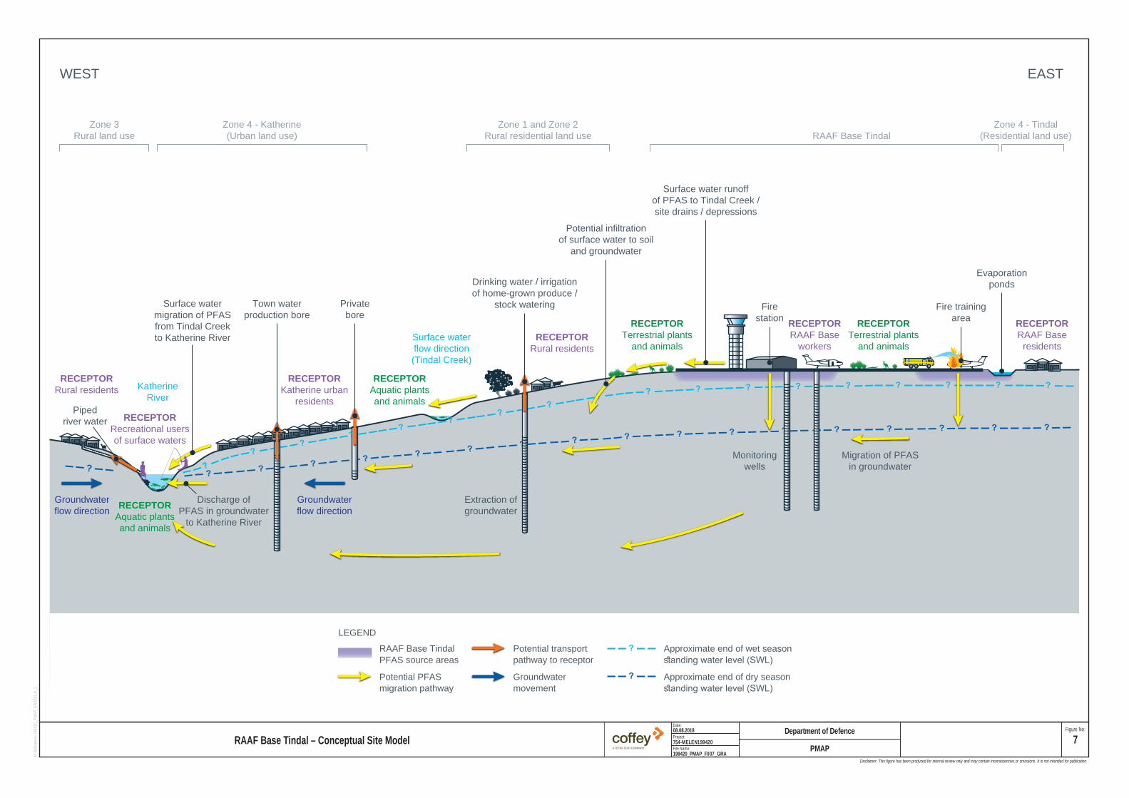
Groundwaterflow direction
KatherineRiver
Groundwaterflow direction
Privatebore
Potential infiltrationof surface water to soil
and groundwater
Surface watermigration of PFASfrom Tindal Creekto Katherine River
Surface water runoffof PFAS to Tindal Creek /site drains / depressions
Drinking water / irrigationof home-grown produce /
stock wateringTown waterproduction bore
Extraction ofgroundwater
Discharge ofPFAS in groundwater
to Katherine River
RAAF Base Tindal
WEST EAST
Zone 4 - Katherine(Urban land use)
Zone 4 - Tindal(Residential land use)
Zone 1 and Zone 2Rural residential land use
Zone 3Rural land use
Firestation
Migration of PFASin groundwater
Monitoringwells
Fire trainingarea
Evaporationponds
Pipedriver water
Surface waterflow direction(Tindal Creek)
RECEPTORRecreational usersof surface waters
RECEPTORAquatic plantsand animals
RECEPTORAquatic plantsand animals
RECEPTORTerrestrial plants
and animalsRECEPTOR
Terrestrial plantsand animals
RECEPTORRural residents
RECEPTORKatherine urban
residents
RECEPTORRural residents
RECEPTORRAAF Base
residentsRECEPTORRAAF Base
workers
LEGENDApproximate end of wet seasonstanding water level (SWL)
Approximate end of dry seasonstanding water level (SWL)
RAAF Base TindalPFAS source areasPotential PFASmigration pathway
Groundwatermovement
Potential transportpathway to receptor
File Name:
Project:
Date: Figure No:
199420_PMAP_F007_GRA
08.08.2018
754-MELEN199420
AI Refe
rence:
19942
0_PMA
P_GRA
001.ai_
1
RAAF Base Tindal – Conceptual Site ModelDepartment of Defence
PMAP7
Disclaimer: This figure has been produced for internal review only and may contain inconsistencies or omissions. It is not intended for publication.

D a te :
Fi le N a m e :
Pro je c t:
F lo r in a R oa d
V ic to ria H igh w ay
B ic e n ten n ia l R o ad
S tu a rt H igh w a y
Em u nga lan R oadZ im m in D r ive
G o rg e R o a dS tu a rt H igh w a y
L e ig h t C reek
Tw o M i leCre e k
T ind a lC re e k
K a th e r in e
20 0 ,0 0 0
20 0 ,0 0 0
20 2 ,5 0 0
20 2 ,5 0 0
20 5 ,0 0 0
20 5 ,0 0 0
20 7 ,5 0 0
20 7 ,5 0 0
21 0 ,0 0 0
21 0 ,0 0 0
21 2 ,5 0 0
21 2 ,5 0 0
21 5 ,0 0 0
21 5 ,0 0 0
21 7 ,5 0 0
21 7 ,5 0 0
22 0 ,0 0 0
22 0 ,0 0 0
22 2 ,5 0 0
22 2 ,5 0 0
22 5 ,0 0 0
22 5 ,0 0 0
8,387
,500
8,387
,500
8,390
,000
8,390
,000
8,392
,500
8,392
,500
8,395
,000
8,395
,000
8,397
,500
8,397
,500
8,400
,000
8,400
,000
8,402
,500
8,402
,500
MXD R
eferen
ce: 19
9420_P
MAP_G
IS017_
v0_3
D epartm ent o f D e fence 81 8 . 0 7 .2 0 1 97 5 4 -M E L E N 1 9 9 4 2 0
F ig u re N o :
LE GE N DR o a dTra c kR a ilW a te rc o u rs eT in d a l C re e kK a th e r in e R iv e rG ro u n d w a te r m a n a g e m e n t a re aS u rfa c e w a te r m a n a g e m e n t a re aR A A F B a s e T in d a l s ite b o u n d a ry
W ater sourcesZ o n e 1 G ro u n d w a te r a b o v e re c re a t io n a l w a te rZ o n e 2 G ro u n d w a te r a b o v e d rin k in g w a te rZ o n e 5 G ro u n d w a te r b e lo w c ri te ria
PM A P1 9 9 4 2 0 _ P M A P _ F 0 0 8 _ G ISW a te r M a n a g e m e n t A re a s - R e c o m m e n d e d P M A P R e s p o n s e A c tio n s
N
Pag e s ize: A 3
0 2kmScale 1:75,0 00
Pro jection: G D A 199 4 M G A Zo ne 53
So ur ce :M an a ge m e n t a re a s fr om C o ffe y .W a te r sou rce zo ne b o u nd a ry a p pr ox im at io n s fro m C o ffe y - in d ica tive on ly .R o ad s , tra cks, ra il , w a te rco ur se s a n d s ite bo u nd a ry f ro m D o D .Im a ge ry f ro m A rcG IS O n lin e (ca ptur e da te u n kno w n).
W ith in sur face w ater m anagem ent areas, s upport the E PA and N T H ealth to iss ue, notify and routine ly m onitor hea l th advisor ies a nd gu idanc e.Continue to provid e a lternativ e dom estic/potab le wate r to proper ties that re ly on w ater contam inated w ith P FAS abov e drinking w ater H BG V
C o ntinu e su pp ort o f in te r im P FA S trea tm e nt p la n on tow n w ate r su pp ly un til lon g-te rm trea tm en t p la n t is com m iss ion ed.Su pp ort P W C in p la nn ing , com m iss ion in g a nd o pera tion o f lo ng -te rm P FA S trea tm e nt p la n t fo r to w n w a te r sup p ly, co ns iste n t w ith ag re em e nt.
C o n d u c t O M P to m o n ito r fo r c h a n g e s in c o n c e n tra t io n s o rris k le v e l
C o ntinu e to p ro v ide a lte rn a tive dom es tic /po ta b le w ate r to p ro pe rties th a t re ly on w a te r con ta m ina te d w ith P FA S a bo ve drin kin g w ater H B G V
C o ndu c t O M P to m on ito r fo r ch an ges in conce ntra tio ns o rrisk leve l
W ith in sur face w ater m a na ge m en t a rea s, su pp ort the E PA a nd N T H e a lth to issue , no tify a nd rou tin e ly m on ito r he a lth ad visor ies an d gu idan ce.

D ate :
Fi le N a m e :
Pro je c t:
M e c h a nica l E qu ip m e nt O p e ra tio n sM a in te na n c e S e c tio n
F ireS ta tion
F ire Tra in ingA re a
S e w a g e T re a tm en tP o n d s
F u e lF a rm 1
F u e lF a rm 2
21 6 ,0 0 0
21 6 ,0 0 0
21 6 ,5 0 0
21 6 ,5 0 0
21 7 ,0 0 0
21 7 ,0 0 0
21 7 ,5 0 0
21 7 ,5 0 0
21 8 ,0 0 0
21 8 ,0 0 0
21 8 ,5 0 0
21 8 ,5 0 0
21 9 ,0 0 0
21 9 ,0 0 0
21 9 ,5 0 0
21 9 ,5 0 0
22 0 ,0 0 0
22 0 ,0 0 0
22 0 ,5 0 0
22 0 ,5 0 0
22 1 ,0 0 0
22 1 ,0 0 0
8,391
,500
8,391
,500
8,392
,000
8,392
,000
8,392
,500
8,392
,500
8,393
,000
8,393
,000
8,393
,500
8,393
,500
8,394
,000
8,394
,000
8,394
,500
8,394
,500
MXD R
eferen
ce: 19
9420_P
MAP_G
IS016_
v0_2
91 9 9 4 2 0 _ P M A P _ F 0 0 9 _ G IS
11 .0 7 .2 0 1 97 5 4 -M E L E N 1 9 9 4 2 0
F ig u re N o :
L E G E N DR o a dTra c kW a te rc o u rs eO n -B a s e L a n d a n d In fra s tru c tu re M a n a g e m e n t A re aN o te : A c t io n ite m s a s d e ta i le d in S e c t io n 7 .1
N
Page s ize : A3
0 4 0 0mScale 1:15,00 0
Pro je ctio n: G D A 1 994 M G A Z one 53
So ur ce :M an a ge m e nt a re as fro m C o ffey .R oa d s , t ra cks a n d w a te rco urse s fr om D o D .Im a ge ry f ro m Ar cG IS O nl in e (ca p tu re d ate un kno w n ).
D ep artm en t o f D e fe n c eP M A P
O n -B a s e L a n d a n d In fr a s t r u c tu re M a n a g e m e n t A r e a s - R e c o m m e n d e d P M A P R e s p o n s e A c tio n s
K a th e rin e
V ic to ria H igh w a y
S t u a rt H ig h w a y
0 5km
C on tro l the m o ve m ent o f s lud gefrom th is source a re a .
C on tro l g rou nd d is tu rb an ce a ctiv it ies , con tro l them ovem en t o f so ils fro m th is so urce a rea a nd tores tric t an y o ff-Ba se transpo rt o f so ils .
C on tro l g rou nd d is tu rb an ce a ctiv it ies , con tro l the m o ve m ent o f so ilsfrom th is source a re a an d to res tr ict an y o ff-Ba se transpo rt o f so ils .F urthe r en fo rce P P E contro ls a nd re str ic tion s on a ccess a ssoc ia tedw ith th e F TA se d im en ts .U nd erta ke rou tin e cle an in g o f th e F TA a nd S ew ag e Trea tm en tPo nd in fras truc tu re a nd assoc ia ted m a nag em e nt o f e fflu en t an dse d im en ts w ith in the a re a .R em ove im pac ted sed im ents a nd e fflu en t from w ith in F TAin fras truc tu re .U nd erta ke trea tm en t o f g roun dw ater w ith in the F TA , in a n a tte m pt to in itia lly re duce P FA S m igra tio n po te n tia l and in th e long er te rm (on ce so il an d in fra stru ctu re so urce rem o va l h as o ccurre d), fu rthe r red uce re sidu a l P FA S con ce ntra tio ns . D eve lo p an d im p lem e nt a R A P to lim it lea ch ing a nd con ta ct w ithco ntam ina te d so ils. T h is m ay inc lude sou rce re m ova l, cap p in gor con ta in m en t.
C on tro l g rou nd d is tu rb an ce a ctiv it ies , con tro l the m o ve m ent o f so ils from th is source a re a an d to res tr ict an y o ff-Ba se transpo rt o f so ils .In ve stiga te sea ling o f ha rds tand and b un ded sur fa ces to re du ce PFA S m o b ilisa tio n .U nd erta ke trea tm en t o f g roun dw ater w ith in the F ire S ta tio n , in a n a tte m pt to in it ia lly red uce P FA S m igra tio n po te n tia l and in th e long er te rm (on ce so il a nd in fra struc tu re source rem o va l h as occu rre d), fu rther red uce re sid ua l P FA S con centra tio ns . D eve lo p an d im p lem e nt a R A P to lim it lea ch ing a nd con ta ct w ithco ntam ina te d so ils. T h is m ay inc lude sou rce re m ova l, cap p in g orco n ta inm e nt.
C on tro l g rou nd d is tu rb an ce a ctiv it ies , con tro l the m o ve m ent o f so ils from th is source a re a an d to res tr ict an y o ff-Ba se transpo rt o f so ils .F urthe r en fo rce P P E contro ls a nd re str ic tion s on a ccess a ssoc ia ted w ith th e M E O M S in te rce p tor p its .U nd erta ke rou tin e cle an in g o f th e M E O M S in fras truc tu re and asso cia te d m ana ge m ent o f e ffluen t a nd sed im e nts w ith in the a rea .In ve stiga te sea ling o f in fra stru ctu re to red uce m ob ilisa tio n o f P FA S.
C on tro l g rou nd d is tu rb an ce a ctiv it ies , con tro l them ovem en t o f so ils fro m th is so urce a rea a nd tores tric t an y o ff-Ba se transpo rt o f so ils .