radial and lateral distribution of cs-137 in soils in the
TRANSCRIPT
Radial and lateral distribution of Cs-137 in soils in the Bryansk Region 31 year after the Chernobyl disaster
Linnik V.G. (1), Sokolov A.V. (1,2), Ivanitsky O.M. (1), Borisov A.P. (1) Mironenko I.V. (3), Fedin A.V. (4)
(1) Vernadsky Institute of Geochemistry and Analytical Chemistry of Russian Academy of Sciences, Kosygin Street 19, 117975 Moscow, Russia, [email protected](2) Institute for Information Transmission Problems (Kharkevich Institute) of Russian Academy of Science, 127051, Moscow, Russia, Bol'shoi Karetnyi per., 19(3) Moscow State University, Geographical Department, GSP-1, 119991, Moscow, Russia(4) Institute of Geography, Russian Academy of Sciences, 119017, Staromonetny per., 29, Moscow, Russia
The aim of the investigations: after the 1986 accident at the Chernobyl nuclear power plant, prediction of the vertical migration of anthropogenic radionuclides is a top-priority avenue of radioecology studies. The spatiotemporal estimation of depths reached by radionuclides in the soils is of crucial importance for predicting how radionuclides are taken up from the soil to plants; how radiation dozes from external sources vary with time; how the groundwaters can be potentially contaminated and how the soils are eroded.
References1. V. G. Linnik, A. P. Borisov, O. M. Ivanitsky, I. V. Mironenko, A. V. Sokolov Vertical Distribution of Cs-137 in the Catena Soils of Agricultural Landscapes in the Bryansk Region Geochemistry International, 2020, Vol. 58, No. 12, pp. 1369–1381. DOI: 10.1134/s00167029201000922. V. Linnik, A. Sokolov, O. Ivanitsky, A. Saveliev Modelling the extent of Cs-137 soil contamination patterns at the Kostica River basin (Bryansk Region, Russia) -EGU General Assembly Conference Abstracts, May, 2020. DOI: 10.5194/egusphere-egu2020-10173
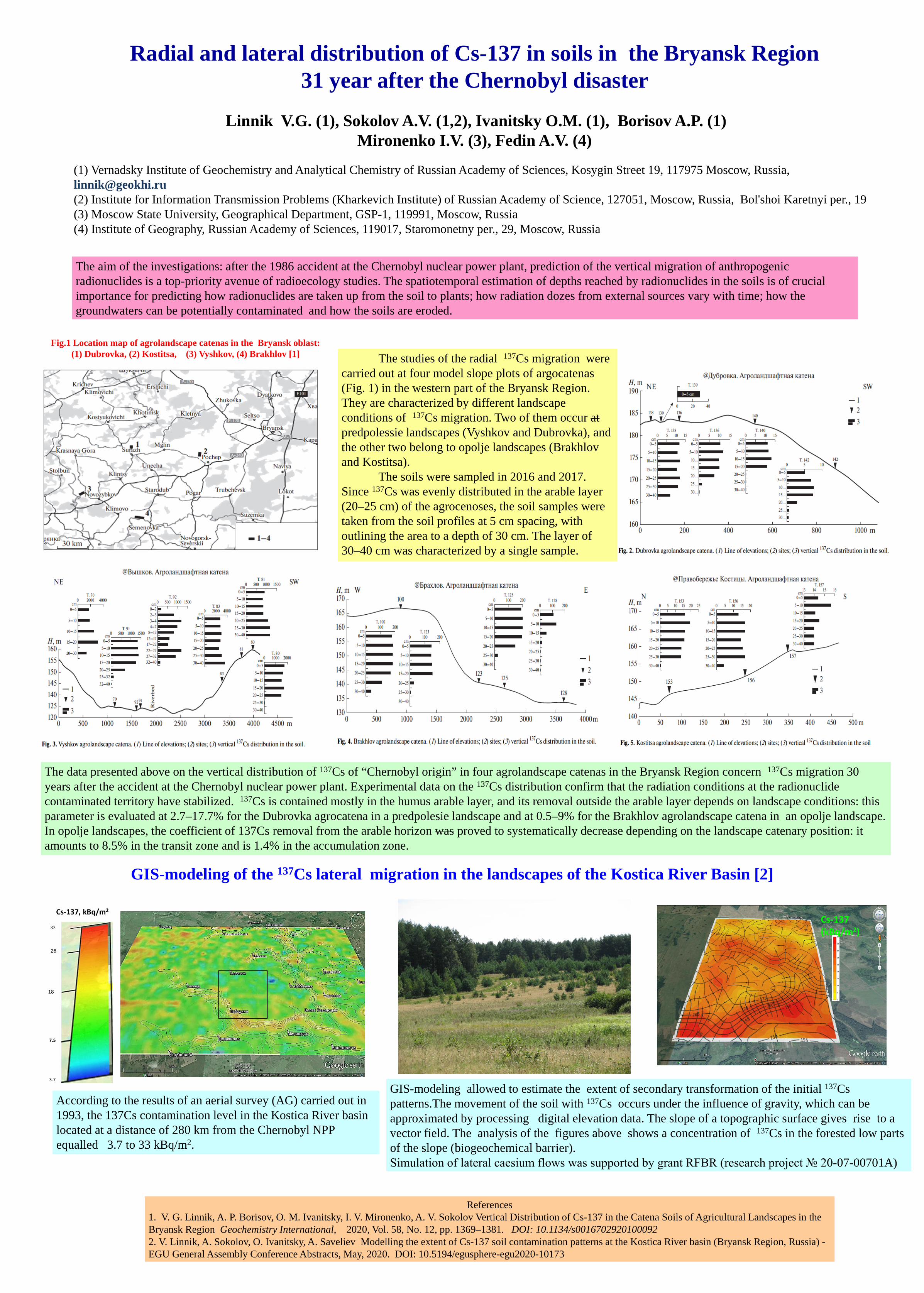
Fig.1 Location map of agrolandscape catenas in the Bryansk oblast: (1) Dubrovka, (2) Kostitsa, (3) Vyshkov, (4) Brakhlov [1] The studies of the radial 137Cs migration were
carried out at four model slope plots of argocatenas(Fig. 1) in the western part of the Bryansk Region. They are characterized by different landscape conditions of 137Cs migration. Two of them occur atpredpolessie landscapes (Vyshkov and Dubrovka), and the other two belong to opolje landscapes (Brakhlovand Kostitsa).
The soils were sampled in 2016 and 2017. Since 137Cs was evenly distributed in the arable layer (20–25 cm) of the agrocenoses, the soil samples were taken from the soil profiles at 5 cm spacing, with outlining the area to a depth of 30 cm. The layer of 30–40 cm was characterized by a single sample.
The data presented above on the vertical distribution of 137Cs of “Chernobyl origin” in four agrolandscape catenas in the Bryansk Region concern 137Cs migration 30 years after the accident at the Chernobyl nuclear power plant. Experimental data on the 137Cs distribution confirm that the radiation conditions at the radionuclide contaminated territory have stabilized. 137Cs is contained mostly in the humus arable layer, and its removal outside the arable layer depends on landscape conditions: thisparameter is evaluated at 2.7–17.7% for the Dubrovka agrocatena in a predpolesie landscape and at 0.5–9% for the Brakhlov agrolandscape catena in an opolje landscape. In opolje landscapes, the coefficient of 137Cs removal from the arable horizon was proved to systematically decrease depending on the landscape catenary position: it amounts to 8.5% in the transit zone and is 1.4% in the accumulation zone.
GIS-modeling of the 137Cs lateral migration in the landscapes of the Kostica River Basin [2]
Cs-137 (kBq/m2)
GIS-modeling allowed to estimate the extent of secondary transformation of the initial 137Cs patterns.The movement of the soil with 137Cs occurs under the influence of gravity, which can be approximated by processing digital elevation data. The slope of a topographic surface gives rise to a vector field. The analysis of the figures above shows a concentration of 137Cs in the forested low parts of the slope (biogeochemical barrier). Simulation of lateral caesium flows was supported by grant RFBR (research project № 20-07-00701A)
33
26
18
7.5
3.7
Cs-137, kBq/m2
According to the results of an aerial survey (AG) carried out in 1993, the 137Cs contamination level in the Kostica River basin located at a distance of 280 km from the Chernobyl NPP equalled 3.7 to 33 kBq/m2.