rainy season of the asian–pacific summer monsoonrainy season or on the linkage between the onsets...
TRANSCRIPT
386 VOLUME 15J O U R N A L O F C L I M A T E
q 2002 American Meteorological Society
Rainy Season of the Asian–Pacific Summer Monsoon*
BIN WANG
Department of Meteorology and IPRC, University of Hawaii at Manoa, Honolulu, Hawaii
LINHO
Department of Atmospheric Sciences, National Taiwan University, Taipei, Taiwan
(Manuscript received 19 December 2000, in final form 13 July 2001)
ABSTRACT
To date, the monsoon-research community has not yet reached a consensus on a unified definition of monsoonrainy season or on the linkage between the onsets over the Asian continent and the adjacent oceans. A singlerainfall parameter is proposed, and a suite of universal criteria for defining the domain, onset, peak, and withdrawalof the rainy season are developed. These results reveal a cohesive spatial–temporal structure of the Asian–Pacificmonsoon rainy season characteristics, which will facilitate validation of monsoon hydrological cycles simulatedby climate system models and improve our understanding of monsoon dynamics.
The large-scale onset of the Asian monsoon rainy season consists of two phases. The first phase begins withthe rainfall surges over the South China Sea (SCS) in mid-May, which establishes a planetary-scale monsoonrainband extending from the south Asian marginal seas (the Arabian Sea, the Bay of Bengal, and the SCS) tothe subtropical western North Pacific (WNP). The rainband then advances northwestward, initiating the conti-nental Indian rainy season, the Chinese mei-yu, and the Japanese baiu in early to mid-June (the second phase).The heights of the rainy seasons occur primarily in three stepwise phases: in late June over the mei-yu/baiuregions, the northern Bay of Bengal, and the vicinity of the Philippines, in late July over India and northernChina; and in mid-August over the tropical WNP. The rainy season retreats northward over east Asia, yet itmoves southward over India and the WNP.
Clear distinctions in the characteristics of the rainy season exist among the Indian, east Asian, and WNPsummer monsoon regions. Nevertheless, the rainy seasons of the three subsystems also show close linkage. Thecauses of the regional distinctions and linkages are discussed. Also discussed are the atypical monsoon rainyseasons, such as the skewed and bimodal seasonal distributions found in various places of Asian monsoondomain.
1. Introduction
Rainfall is an essential meteorological parameter de-scribing the monsoon climate. Rainfall distribution in-dicates the location of the atmospheric heat source thatdrives tropical circulation; thus, rainfall variation re-flects the variability of the entire monsoon circulationsystem. Rainfall is also a key component of the hydro-logical cycle of the earth’s climate system, playing acentral role in connecting terrestrial, atmospheric, andoceanic processes. The study of rainfall characteristicsis of central importance for understanding monsoon cir-culation and its relationship with other components ofthe hydrological cycle.
* School of Ocean and Earth Science and Technology Publication5887 and International Pacific Research Center Publication 122.
Corresponding author address: Dr. Bin Wang, Department of Me-teorology, University of Hawaii at Manoa, Honolulu, HI 96825.E-mail: [email protected]
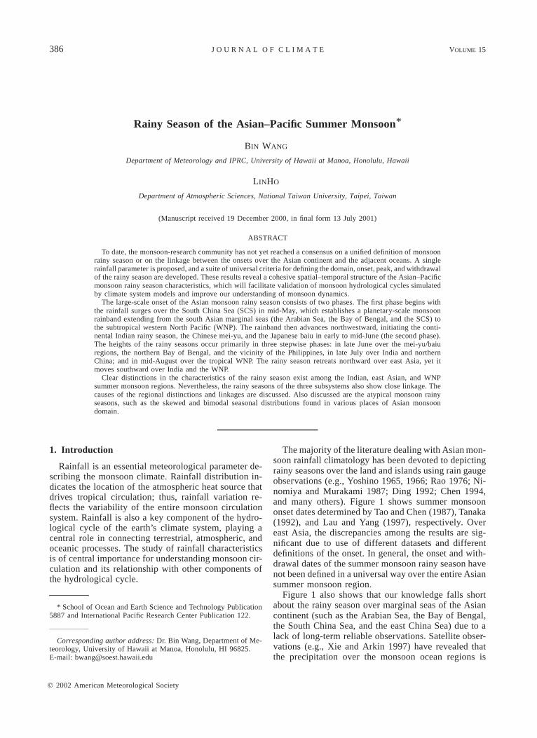
The majority of the literature dealing with Asian mon-soon rainfall climatology has been devoted to depictingrainy seasons over the land and islands using rain gaugeobservations (e.g., Yoshino 1965, 1966; Rao 1976; Ni-nomiya and Murakami 1987; Ding 1992; Chen 1994,and many others). Figure 1 shows summer monsoononset dates determined by Tao and Chen (1987), Tanaka(1992), and Lau and Yang (1997), respectively. Overeast Asia, the discrepancies among the results are sig-nificant due to use of different datasets and differentdefinitions of the onset. In general, the onset and with-drawal dates of the summer monsoon rainy season havenot been defined in a universal way over the entire Asiansummer monsoon region.
Figure 1 also shows that our knowledge falls shortabout the rainy season over marginal seas of the Asiancontinent (such as the Arabian Sea, the Bay of Bengal,the South China Sea, and the east China Sea) due to alack of long-term reliable observations. Satellite obser-vations (e.g., Xie and Arkin 1997) have revealed thatthe precipitation over the monsoon ocean regions is
15 FEBRUARY 2002 387W A N G A N D L I N H O
FIG. 1. The onset dates of the summer monsoon as defined by Taoand Chen (1987, upper panel), Tanaka (1992, middle panel), and Lauand Yang (1997, lower panel).
more intense than over the adjacent land areas. Fromthe dynamical and hydrological points of view, it isimportant to know how the oceanic and continentalmonsoon rainy seasons are interlinked.
Often overlooked is the tropical western North Pacific(WNP) region (108–228N, 1208–1708E), which shows atypical monsoon character (Murakami and Matsumoto1994). Although the oceanic monsoon over the WNPdiffers from the continental monsoon in certain aspects,such as the rain-bearing system, both the continentaland oceanic monsoons are driven by the annual variationof solar radiation and controlled by the land–ocean ther-mal contrast. Thus they share common fundamental fea-tures, namely, annual reversal of the prevailing windsand the sharp contrast between rainy summer and drywinter. The WNP region has been recognized as a partof the Asian–Pacific monsoon domain both from surfacewind criteria (Ramage 1972) and from rainy seasoncharacteristics (Wang 1994), yet how the WNP rainyseason is related to the other parts of the Asian summermonsoon is not known.
The immense Asian monsoon system, affected by thehighest topography on earth, shows regional diversities.Meteorologists in east Asian countries have emphasizedthe differences between the south Asian and east Asiansummer monsoons (e.g., Tao and Chen 1987). In orderto identify the differences as well as the linkages be-tween regional monsoon subsystems, we urgently needa universal definition of a monsoon and criteria for thequantitative description of rainfall climatology in theentire Asian–Pacific monsoon domain.
Thus far, the monsoon community has not yet reacheda consensus concerning the domain and onset of theAsian–Pacific monsoon. The linkage between the rainyseasons over the Asian continent and those over theadjoining oceans is not well understood. One of theobjectives of the present study is to investigate the fea-sibility of using a concise yet pertinent rainfall param-eter and a set of universal criteria to quantify rainyseason characteristics for the entire Asian–Pacific mon-soon domain. Another purpose is to use the precipitationdata derived from satellite observations over the oceansalong with rain gauge observations over the continentto build up a unified picture of the spatial and temporalstructures of the mean monsoon rainy seasons. Particularattention is given to the contrast and linkage amongvarious regional monsoon subsystems. The results willprovide an observational basis for validating and iden-tifying the weaknesses of the existing atmospheric gen-eral circulation models and climate system models sim-ulating the Asian–Pacific summer monsoon.
In section 2, we first describe the dataset and theprocessing procedure. In section 3, an innovative andsuccinct rainfall parameter is proposed to objectivelydefine the domain and the onset of the rainy season.Section 4 presents the resultant onset, peak, and with-drawal patterns of the Asian–Pacific monsoon rainy sea-son. In section 5, we elaborate on the differences andlinkages among the regional components in terms ofrainfall climatology. Section 6 discusses issues associ-ated with the analysis and related to understanding the
388 VOLUME 15J O U R N A L O F C L I M A T E
annual cycle of the Asian–Pacific summer monsoon.The last section summarizes our conclusions.
2. Data
The primary datasets analyzed in this study includethe Climate Prediction Center (CPC) Merged Analysisof Precipitation (CMAP; Xie and Arkin 1997) and theNational Centers for Environmental Prediction–Nation-al Center for Atmospheric Research reanalysis (Kalnayet al. 1996). The CMAP was derived by merging raingauge observations, five different satellite estimates, andnumerical-model outputs. The climatological pentad (5-day) mean (CPM) rainfall dataset was constructed forthe 20-yr period from 1979 to 1998 with global coverageon 2.58 3 2.58 grids. The CPM wind data were derivedfrom daily mean data on 2.58 3 2.58 grids during thesame period. Over the ocean, the accuracy and reliabilityof the pentad mean CMAP on small spatial scales hasnot been fully determined because of the lack of groundtruth observations. Since the CMAP dataset mergesmultisource estimates, the uncertainties contained ineach individual estimate are significantly reduced. Acomparative study of CMAP and land-based rain gaugedata shows that the two datasets yield similar large-scalepictures over land areas. Thus, it is meaningful to de-scribe large-scale rainfall characteristics using CPMCMAP estimates.
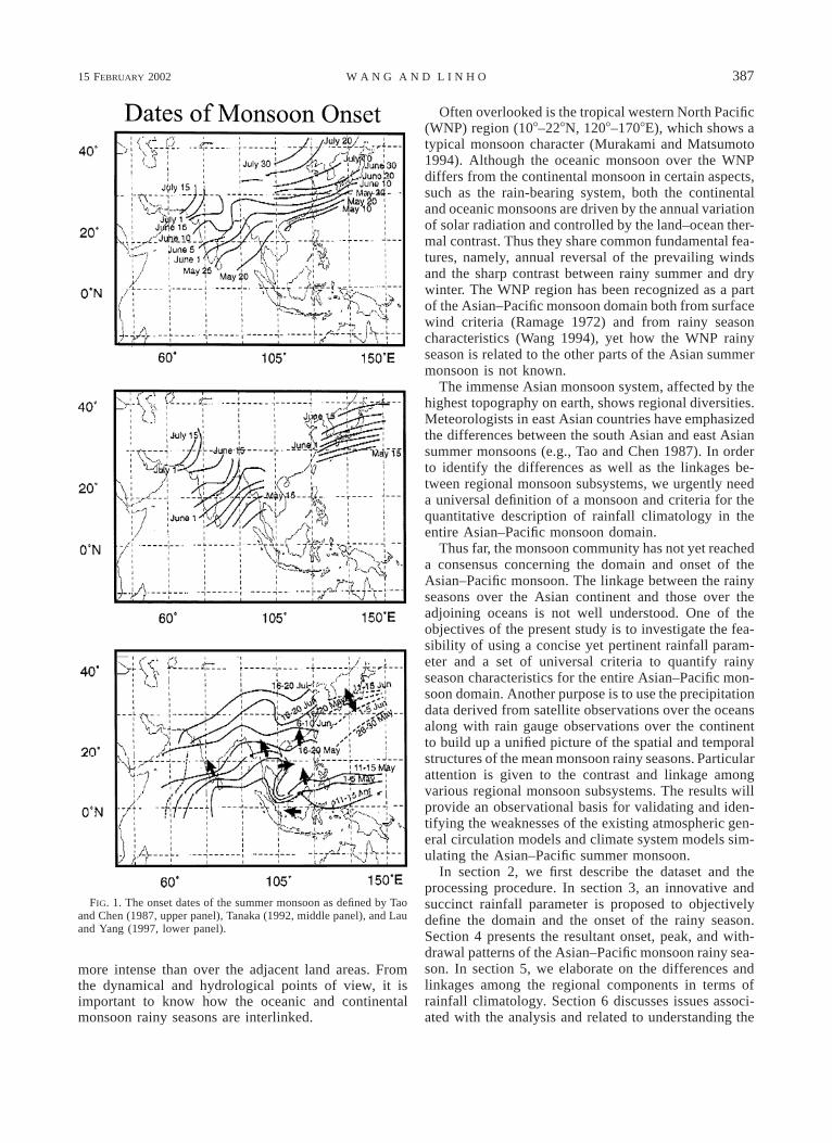
Most previous studies have used a smoothed annualcycle that is defined by the annual mean plus the firstfour Fourier harmonics of the CPM time series to definethe onset of monsoon rainy seasons (e.g., Murakami andMatsumoto 1994; Wang 1994). However, Fig. 2 showsthat the onset pentad defined by the smoothed annualcycle often differs considerably from that defined by theCPM series. The discrepancy is particularly large in theregions where the onset is sudden (e.g., Fig. 2a) or therainy season is short (Fig. 3b). The smoothed annualcycle cannot resolve properly the subseasonal variationssuch as the well-known double peaks of the rainy seasonshown in Figs. 3d,e, and 3f. On the other hand, theoriginal CPM time series contains high-frequency fluc-tuations due to the limited sampling size from whichthe climate data were derived. A decision has to be madeas to how many harmonics should be used to retain boththe seasonal and subseasonal signals. Sensitivity testsof the results to Fourier truncation indicate that the sumof the first 12 harmonics (period longer than 1 month)is best suited for our purpose. A parallel analysis wascarried out using the time series retaining the first 18harmonics (period longer than 4 pentads); the resultantdifferences are insignificant as far as the large-scale fea-tures are concerned. As shown in Figs. 2 and 3, the timeseries including the first 12 harmonics captures both theseasonal and subseasonal signals and depicts very wellthe time at which the local rainfall rate reaches peak orexceeds (drops below) 6 mm day21. In the followinganalysis of rainfall, we will use the reconstructed pentad
series, which consists of the long-term mean and thefirst 12 harmonics, to define the onset, peak, and with-drawal of the monsoon rainy season.
The reconstructed time series consists of a smoothedannual cycle and a climatological intraseasonal oscil-lation (CISO). The CISO component is included becauseit represents subseasonal variation, an intrinsic com-ponent of the monsoon climate (LinHo and Wang 2002,manuscript submitted to J. Climate, hereafter LW),Wang and Xu (1997) have shown the statistical signif-icance of the CISO in the boreal summer monsoon do-main by using a sign test, an extreme test (Monte Carlosimulations), and an amplitude test (the t test).
3. Definition of the monsoon rainy season
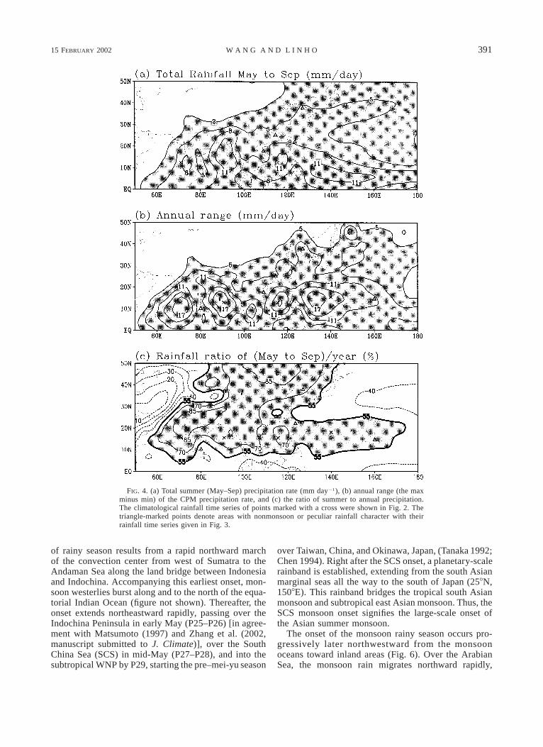
It has been generally recognized that a typical mon-soon rainy season implies significant annual variation,an intense rainfall rate, and concentration of yearly rain-fall in the local summer. Quantitative description ofthese characteristics requires perhaps three parameters:1) the total amount of summer rainfall that measuresthe intensity of the rainy season (Fig. 4a), 2) the annualrange of rainfall rate that measures the amplitude ofannual variation (Fig. 4b), and 3) the seasonal distri-bution of rainfall that measures the ratio of summer toyearly rainfall (Fig. 4c).
Figure 4a shows total summer (May–September) pre-cipitation. The summer precipitation in semiarid andarid continental Asia is below 300 mm (equivalent to asummer mean rainfall rate of 2 mm day21), and a rainyseason cannot be clearly defined because of the absenceof an intense rainy period. Figure 4b shows the annualrange. The largest annual range exceeding 17 mm day21
is found over the sea in the following areas: the centralBay of Bengal, the southeastern Arabian Sea, the Phil-ippine Sea, and the South China Sea (SCS). These re-gions of largest annual range tend to coincide with theregions of maximum summer rainfall (Figs. 4a and 4b).Figure 4c shows the ratio of summer to annual rainfallthat reflects the seasonal distribution of precipitation. Alarge ratio implies a heavy summer rainy season versusa dry winter. Over the Indian monsoon region and north-east continental Asia, the ratio exceeds 85%. Over thePhilippine Sea, the ratio is also relatively high (over60%). The level of 55% provides a reasonable demar-cation for the equatorial perennial and monsoon rainyseasons.
Note that the areas where the annual range falls below5 mm day21 coincide well with the arid and semiaridcontinental regions (Figs. 4a and 4b). Thus, the annualrange can not only measure the amplitude of annualvariation, but also effectively distinguishes the semiaridcontinental regime from the monsoon regime. We notealso that both the equatorial perennial rain regime andthe North Pacific oceanic regime have a moderate con-trast between summer and winter. Thus, to further dis-tinguish the monsoon regime from the perennial and
15 FEBRUARY 2002 389W A N G A N D L I N H O
FIG. 2. CPM precipitation rate (mm day21) (thin solid with cross mark) observed at (a) 12.58N,708E, (b) 12.58N, 908E, (c) 12.58N, 1158E, and (d) 158N, 1408E. The locations of these fourrepresentative points are marked by crosses in Fig. 4. The dotted line denotes the slow annualcycle, obtained by the summation of the mean and the first four Fourier harmonics. The thick linerepresents the summation of the mean and the first 12 Fourier harmonics. The CPM climatologyis derived from CMAP data (Xie and Arkin 1997) for the period 1979–97.
oceanic regimes, we design a compound rainfall variablethat is able to synthesize the aforementioned three char-acteristics. This variable is defined by the differencebetween the pentad mean (Ri) and the January mean(RJAN) precipitation rates:
RR 5 R 2 R , i 5 1, 2, . . . , 73.i i JAN (1)
The quantity, RRi, is referred to as the relative pentadmean rainfall rate. In the Northern Hemisphere, Januarymean rainfall represents the winter mean precipitationrate. Thus the RRi essentially measures the contrast of
the rainfall rates between a specific pentad and the cor-responding winter.
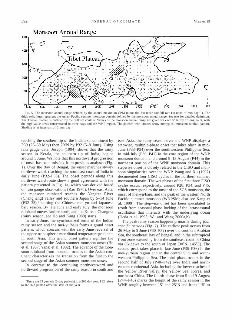
For a typical Northern Hemisphere summer monsoonrainy season, one expects that the maximum value ofRRi, that is, Max (RRi; hereafter the monsoon range),must be sufficiently large and occur in summer (May–September). To quantify ‘‘sufficiently large,’’ we pre-sent in Fig. 5 the geographic distribution of the monsoonrange. The cutoff value of 5 mm day21 appears to rep-resent a sufficient strength for the rainy season. Hencethis criterion effectively separates the dry continental
390 VOLUME 15J O U R N A L O F C L I M A T E
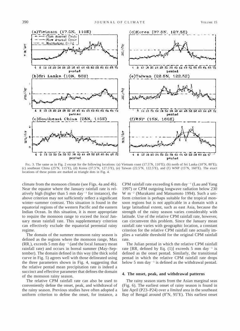
FIG. 3. The same as in Fig. 2 except for the following locations: (a) Vietnam coast (17.58N, 1108E); (b) north of Sri Lanka (108N, 808E);(c) southeast China (258N, 1158E), (d) Korea (37.58N, 127.58E), (e) Taiwan (22.58N, 122.58E), and (f ) WNP (158N, 1608E). The exactlocations of these points are marked as triangle dots in Fig. 4.
climate from the monsoon climate (see Figs. 4a and 4b).Near the equator where the January rainfall rate is rel-atively high (higher than 5 mm day21 for instance), theabove criterion may not sufficiently reflect a significantwinter–summer contrast. This situation is found in theequatorial regions of the western Pacific and the easternIndian Ocean. In this situation, it is more appropriateto require the monsoon range to exceed the local Jan-uary mean rainfall rate. This supplementary criterioncan effectively exclude the equatorial perennial rainyregime.
The domain of the summer monsoon rainy season isdefined as the regions where the monsoon range, Max(RRi), exceeds 5 mm day21 (and the local January meanrainfall rate) and occurs in boreal summer (May–Sep-tember). The domain defined in this way (the thick solidcurve in Fig. 5) agrees well with those delineated usingthe three parameters shown in Fig. 4, suggesting thatthe relative pentad mean precipitation rate is indeed asuccinct and effective parameter that defines the domainof the monsoon rainy season.
The relative CPM rainfall rate can also be used toconveniently define the onset, peak, and withdrawal ofthe rainy season. Previous studies have often adopted auniform criterion to define the onset, for instance, a
CPM rainfall rate exceeding 6 mm day21 (Lau and Yang1997) or CPM outgoing longwave radiation below 230W m22 (Murakami and Matsumoto 1994). Such a uni-form criterion is perhaps suitable for the tropical mon-soon regions but is not applicable in a domain with alarge latitudinal extent, such as east Asia, because thestrength of the rainy season varies considerably withlatitude. Use of the relative CPM rainfall rate, however,can circumvent this problem. Since the January meanrainfall rate varies with geographic location, a constantcriterion for the relative CPM rainfall rate actually im-plies a variable threshold for the original CPM rainfallrate.
The Julian pentad in which the relative CPM rainfallrate [RRi defined by Eq. (1)] exceeds 5 mm day21 isdefined as the onset pentad. Similarly, the transitionalpentad in which the relative CPM rainfall rate dropsbelow 5 mm day21 is defined as the withdrawal pentad.
4. The onset, peak, and withdrawal patterns
The rainy season starts from the Asian marginal seas(Fig. 6). The earliest onset of rainy season is found inlate April (P23–P24) over a limited area in the southeastBay of Bengal around (88N, 958E). This earliest onset
15 FEBRUARY 2002 391W A N G A N D L I N H O
FIG. 4. (a) Total summer (May–Sep) precipitation rate (mm day21), (b) annual range (the maxminus min) of the CPM precipitation rate, and (c) the ratio of summer to annual precipitation.The climatological rainfall time series of points marked with a cross were shown in Fig. 2. Thetriangle-marked points denote areas with nonmonsoon or peculiar rainfall character with theirrainfall time series given in Fig. 3.
of rainy season results from a rapid northward marchof the convection center from west of Sumatra to theAndaman Sea along the land bridge between Indonesiaand Indochina. Accompanying this earliest onset, mon-soon westerlies burst along and to the north of the equa-torial Indian Ocean (figure not shown). Thereafter, theonset extends northeastward rapidly, passing over theIndochina Peninsula in early May (P25–P26) [in agree-ment with Matsumoto (1997) and Zhang et al. (2002,manuscript submitted to J. Climate)], over the SouthChina Sea (SCS) in mid-May (P27–P28), and into thesubtropical WNP by P29, starting the pre–mei-yu season
over Taiwan, China, and Okinawa, Japan, (Tanaka 1992;Chen 1994). Right after the SCS onset, a planetary-scalerainband is established, extending from the south Asianmarginal seas all the way to the south of Japan (258N,1508E). This rainband bridges the tropical south Asianmonsoon and subtropical east Asian monsoon. Thus, theSCS monsoon onset signifies the large-scale onset ofthe Asian summer monsoon.
The onset of the monsoon rainy season occurs pro-gressively later northwestward from the monsoonoceans toward inland areas (Fig. 6). Over the ArabianSea, the monsoon rain migrates northward rapidly,
392 VOLUME 15J O U R N A L O F C L I M A T E
FIG. 5. The monsoon annual range defined by the annual maximum CPM minus the Jan mean rainfall rate (in units of mm day 21). Thethick solid lines represent the Asian–Pacific summer monsoon domain defined by the monsoon annual range. See text for detailed definition.The Tibetan Plateau is outlined by the 3000-m contour. Values of the monsoon annual range are given for each 58 lat by 58 long point, withthe high-value areas concentrated in three bays and the WNP region. The patches with crosses show nontypical monsoon rainfall pattern.Shading is at intervals of 5 mm day21.
reaching the southern tip of the Indian subcontinent byP30 (26–30 May) then 208N by P32 (5–9 June). Usingrain gauge data, Joseph (1994) shows that the rainyseason in Kerala, the southern tip of India, beginsaround 1 June. We note that this northward progressionof onset has been missing from previous analyses (Fig.1). Over the Bay of Bengal, the onset marches slowlynorthwestward, reaching the northeast coast of India inearly June (P32–P33). The onset pentads along thisnorthwestward route show a good agreement with thepattern presented in Fig. 1a, which was derived basedon rain gauge observations (Rao 1976). Over east Asia,the monsoon rainband reaches the Yangtze River(Changjiang) valley and southern Japan by 5–14 June(P32–33),1 starting the Chinese mei-yu and Japanesebaiu season. By late June and early July, the monsoonrainband moves farther north, and the Korean Changma(rainy season, see Ho and Kang 1988) starts.
In early June, the synchronized onset of the Indianrainy season and the mei-yu/baiu forms a grand onsetpattern, which concurs with the early June reversal ofthe upper-tropospheric meridional temperature gradientsin south Asia. This grand onset pattern signifies thesecond stage of the Asian summer monsoon onset (Heet al. 1987; Yanai et al. 1992). The advance of the mon-soon rainband from monsoon oceans to the Asian con-tinent characterizes the transition from the first to thesecond stage of the Asian summer monsoon onset.
In contrast to the continuing northwestward andnorthward progression of the rainy season in south and
1 There are 73 pentads (5-day periods) in a 365 day year. P32 refersto the 32d pentad after the start of the year.
east Asia, the rainy season over the WNP displays astepwise, multiple-phase onset that takes place in mid-June (P33–P34) over the southwestern Philippine Sea,in mid-July (P39–P41) in the core region of the WNPmonsoon domain, and around 8–13 August (P44) in thenortheast portion of the WNP monsoon domain. Thisstepwise onset is closely related to the CISO and mon-soon singularities over the WNP. Wang and Xu (1997)documented four CISO cycles in the northern summermonsoon domain. The wet phases of the first three CISOcycles occur, respectively, around P28, P34, and P45,which correspond to the onset of the SCS monsoon, theonset of mei-yu/baiu, and the peak of the western NorthPacific summer monsoon (WNPSM; also see Kang etal. 1999). The stepwise onset has been speculated toresult from seasonal phase locking of the intraseasonaloscillation that interacts with the underlying ocean(Ueda et al. 1995; Wu and Wang 2000a,b).
The peak rainy season happens primarily during fourspecific periods (Fig. 7). The earliest peak occurs from26 May to 9 June (P30–P32) over the southern ArabianSea, the southeast Bay of Bengal, and in the subtropicalfront zone extending from the southeast coast of Chinavia Okinawa to the south of Japan (308N, 1458E). Thesecond peak takes place in late June (P35–P36) in themei-yu/baiu region and in the central SCS and south-western Philippine Sea. The third phase occurs in thesecond half of July (P40–P42) over India and north-eastern continental Asia, including the lower reaches ofthe Yellow River valley, the Yellow Sea, Korea, andnortheast China. The fourth phase from 5 to 19 August(P44–P46) marks the height of the rainy season in theWNP, roughly between 158 and 258N and from 1158 to
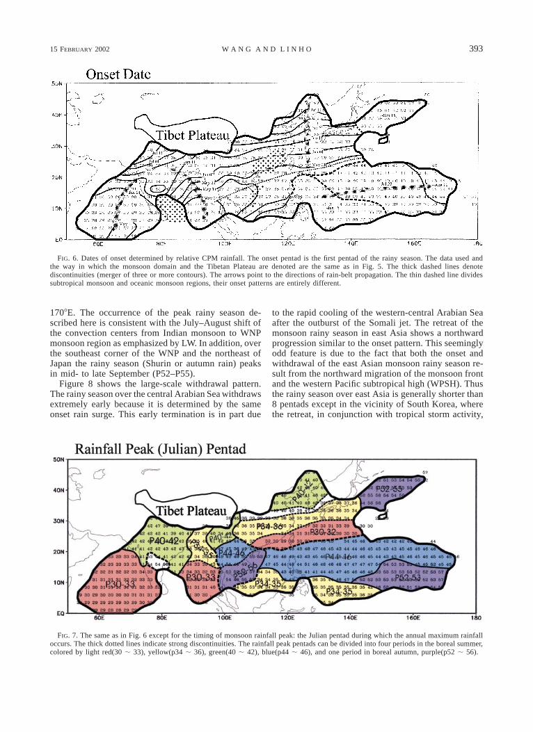
15 FEBRUARY 2002 393W A N G A N D L I N H O
FIG. 6. Dates of onset determined by relative CPM rainfall. The onset pentad is the first pentad of the rainy season. The data used andthe way in which the monsoon domain and the Tibetan Plateau are denoted are the same as in Fig. 5. The thick dashed lines denotediscontinuities (merger of three or more contours). The arrows point to the directions of rain-belt propagation. The thin dashed line dividessubtropical monsoon and oceanic monsoon regions, their onset patterns are entirely different.
FIG. 7. The same as in Fig. 6 except for the timing of monsoon rainfall peak: the Julian pentad during which the annual maximum rainfalloccurs. The thick dotted lines indicate strong discontinuities. The rainfall peak pentads can be divided into four periods in the boreal summer,colored by light red(30 ; 33), yellow(p34 ; 36), green(40 ; 42), blue(p44 ; 46), and one period in boreal autumn, purple(p52 ; 56).
1708E. The occurrence of the peak rainy season de-scribed here is consistent with the July–August shift ofthe convection centers from Indian monsoon to WNPmonsoon region as emphasized by LW. In addition, overthe southeast corner of the WNP and the northeast ofJapan the rainy season (Shurin or autumn rain) peaksin mid- to late September (P52–P55).
Figure 8 shows the large-scale withdrawal pattern.The rainy season over the central Arabian Sea withdrawsextremely early because it is determined by the sameonset rain surge. This early termination is in part due
to the rapid cooling of the western-central Arabian Seaafter the outburst of the Somali jet. The retreat of themonsoon rainy season in east Asia shows a northwardprogression similar to the onset pattern. This seeminglyodd feature is due to the fact that both the onset andwithdrawal of the east Asian monsoon rainy season re-sult from the northward migration of the monsoon frontand the western Pacific subtropical high (WPSH). Thusthe rainy season over east Asia is generally shorter than8 pentads except in the vicinity of South Korea, wherethe retreat, in conjunction with tropical storm activity,

394 VOLUME 15J O U R N A L O F C L I M A T E
FIG. 8. The same as in Fig. 6 except for the withdrawal date of the rainy season. The withdrawal pentad is the last pentad of the rainyseason. The arrows also indicate where the rain belts migrate. Note that in the east Asian summer monsoon (EASM) the rain belt, similarto the onset pattern, also retreats from south to north whereas in the Indian summer monsoon (ISM) the withdrawal route just takes oppositedirection.
FIG. 9. This map divides the Asian–Pacific monsoon into three subregions. The ISM and western WNPSM are tropical monsoon regions.A broad corridor in the Indochina Peninsula separate them. The subtropical monsoon region is identified as the EASM. It shares a narrowborderline with the WNPSM.
produces a second rainy peak in August (Fig. 3d). Thiscauses the rainy season to last longer (about 15 pentads).In sharp contrast, over the tropical monsoon regions,the rainy season retreats progressively southward. Thusthe length of the rainy season generally increases towardthe equator. The longest rainy season is found in thesoutheast Bay of Bengal; it lasts about 7 months.
5. The regionality and linkage of the Asian–Pacificmonsoon system
The rainy season characteristics described in the pre-vious section suggest demarcation of the Asian–Pacific
monsoon into three components: the Indian summermonsoon (ISM), the WNPSM, and the east Asian sum-mer monsoon (EASM) (Fig. 9). The ISM and WNPSMare tropical monsoons in which the low-level winds re-verse from winter easterlies to summer westerlies (Fig.10). The EASM is a subtropical monsoon in which thelow-level winds reverse primarily from winter north-erlies to summer southerlies. The EASM domain definedhere agrees with the conventional notion, which in-cludes the region of 208–458N and 1108–1408E, cov-ering eastern China, Korea, Japan, and the adjacent mar-ginal seas.
15 FEBRUARY 2002 395W A N G A N D L I N H O
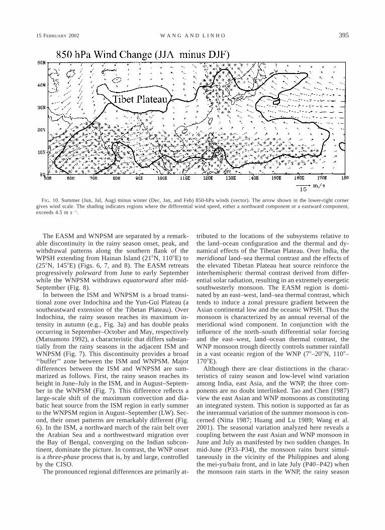
FIG. 10. Summer (Jun, Jul, Aug) minus winter (Dec, Jan, and Feb) 850-hPa winds (vector). The arrow shown in the lower-right cornergives wind scale. The shading indicates regions where the differential wind speed, either a northward component or a eastward component,exceeds 4.5 m s21.
The EASM and WNPSM are separated by a remark-able discontinuity in the rainy season onset, peak, andwithdrawal patterns along the southern flank of theWPSH extending from Hainan Island (218N, 1108E) to(258N, 1458E) (Figs. 6, 7, and 8). The EASM retreatsprogressively poleward from June to early Septemberwhile the WNPSM withdraws equatorward after mid-September (Fig. 8).
In between the ISM and WNPSM is a broad transi-tional zone over Indochina and the Yun-Gui Plateau (asoutheastward extension of the Tibetan Plateau). OverIndochina, the rainy season reaches its maximum in-tensity in autumn (e.g., Fig. 3a) and has double peaksoccurring in September–October and May, respectively(Matsumoto 1992), a characteristic that differs substan-tially from the rainy seasons in the adjacent ISM andWNPSM (Fig. 7). This discontinuity provides a broad‘‘buffer’’ zone between the ISM and WNPSM. Majordifferences between the ISM and WNPSM are sum-marized as follows. First, the rainy season reaches itsheight in June–July in the ISM, and in August–Septem-ber in the WNPSM (Fig. 7). This difference reflects alarge-scale shift of the maximum convection and dia-batic heat source from the ISM region in early summerto the WNPSM region in August–September (LW). Sec-ond, their onset patterns are remarkably different (Fig.6). In the ISM, a northward march of the rain belt overthe Arabian Sea and a northwestward migration overthe Bay of Bengal, converging on the Indian subcon-tinent, dominate the picture. In contrast, the WNP onsetis a three-phase process that is, by and large, controlledby the CISO.
The pronounced regional differences are primarily at-
tributed to the locations of the subsystems relative tothe land–ocean configuration and the thermal and dy-namical effects of the Tibetan Plateau. Over India, themeridional land–sea thermal contrast and the effects ofthe elevated Tibetan Plateau heat source reinforce theinterhemispheric thermal contrast derived from differ-ential solar radiation, resulting in an extremely energeticsouthwesterly monsoon. The EASM region is domi-nated by an east–west, land–sea thermal contrast, whichtends to induce a zonal pressure gradient between theAsian continental low and the oceanic WPSH. Thus themonsoon is characterized by an annual reversal of themeridional wind component. In conjunction with theinfluence of the north–south differential solar forcingand the east–west, land–ocean thermal contrast, theWNP monsoon trough directly controls summer rainfallin a vast oceanic region of the WNP (78–208N, 1108–1708E).
Although there are clear distinctions in the charac-teristics of rainy season and low-level wind variationamong India, east Asia, and the WNP, the three com-ponents are no doubt interlinked. Tao and Chen (1987)view the east Asian and WNP monsoons as constitutingan integrated system. This notion is supported as far asthe interannual variation of the summer monsoon is con-cerned (Nitta 1987; Huang and Lu 1989; Wang et al.2001). The seasonal variation analyzed here reveals acoupling between the east Asian and WNP monsoon inJune and July as manifested by two sudden changes. Inmid-June (P33–P34), the monsoon rains burst simul-taneously in the vicinity of the Philippines and alongthe mei-yu/baiu front, and in late July (P40–P42) whenthe monsoon rain starts in the WNP, the rainy season
396 VOLUME 15J O U R N A L O F C L I M A T E
in northern China reaches its height. The aforemen-tioned linkage is established through the movement ofthe WPSH. Note, however, the coupling through theWPSH tends to collapse after the WNP monsoon gyreforms in late July and early August. In August andSeptember, the east Asian monsoon is linked to the ac-tive-break cycle of the WNP monsoon primarily throughtropical cyclone activity, especially that of the north-ward recurving tropical cyclones affecting coastal re-gions of east Asia. The peaks of the second rainy season,occurring in Korea and Taiwan (Figs. 3d and 3e), areexamples of influence from tropical storms. In the sameperiod, the intraseasonal convective anomalies propa-gate westward from 1708E into the Bay of Bengal, pro-viding a linkage between the Indian and WNP monsoons(Wang and Xu 1997). The onset patterns in the ISM andEASM exhibit an evident similarity (Fig. 6). Althoughbeing separated by the Yun-Gui Plateau, the Indian mon-soon rain surges enhance the rainfall of the east Asianmonsoon via strengthening northeastward transport ofmoisture above the terrain. The interaction between thethree regional components deserves further investiga-tion.
6. Discussion
a. Definition of a monsoon
The original definition of a monsoon was solely basedon the annual reversal of surface winds (Ramage 1972).However, the meteorological significance and practicalimportance of rainfall makes it desirable to define mon-soons in terms of rainfall characteristics. In this paperwe have explored the possibility of defining a monsoondomain using rainy season characteristics. The domainof the monsoon rainy season defined by rainfall char-acteristics (Fig. 5) is dynamically consistent, in termsof large-scale features, with the region where the 850-hPa winds exhibit significant seasonal reversal fromwinter easterlies (northerlies) to summer westerlies(southerlies) (Fig. 10). From winter to summer, a giantcircumcontinental cyclonic circulation forms as a resultof the increase in the thermal contrast between the landand ocean. A belt of prominent westerlies is found be-tween 58 and 208N and from the Arabian Sea (408E) tothe eastern Philippine Sea (1608E; the southwest sum-mer monsoon). These westerlies tend to be located tothe southwest of the monsoon rainy region and can beunderstood as a result of the interaction between theconvective heat source and the corresponding Rossbywave response (Gill 1980). Significant southerlies arefound between 1108 and 1408E in east Asia north of228N (the southeast summer monsoon). As seen fromFigs. 6 to 8, the rainfall characteristics also change re-markably around 228N.
Our definition of the rainy season does not considerthe types of rain-bearing systems. One might argue thatthe rains produced by tropical cyclones are not monsoon
rains. However, the tropical cyclone, like other synopticsystems embedded in the planetary-scale monsoon cir-culation (such as monsoon depressions and the meso-scale cyclones in the mei-yu front) is just one of therain-bearing systems. Over the Bay of Bengal, tropicalcyclones furnish a significant portion of the monsoonrainfall. In east Asia, the second peak of the rainy seasonoccurring on the Indochina peninsula, Taiwan, andSouth Korea (Figs. 3a, 3d, and 3e) is primarily attributedto tropical cyclone–related rainfall. Therefore, in ourdefinition, we focus only on rainfall intensity, conti-nuity, annual range, and seasonal distribution, but noton the nature of rain-bearing systems.
b. Atypical monsoon rainy seasons
A skewed seasonal distribution is found over the Ara-bian Sea and Bay of Bengal, where rainfall shows asharp increase in late May, a peak in early June, and aslow decrease thereafter (Fig. 2a,b). Over the ArabianSea, both the peak and onset of the rainy season occurprogressively northward (Figs. 6 and 7). The phasespeed of the northward propagation is about 18 of lat-itude per day, which approximately equals that of thetransient intraseasonal oscillation (ISO) in that region.This suggests that the mean monsoon onset/peak overthe Arabian Sea results from a ‘‘punctuated’’ occurrenceof the northward-propagating intraseasonal oscillations.This tight phase lock of ISO to the annual cycle isattributed to the modulation of ISO by the large-scalecirculation that is driven by the punctuated annualwarming of the Indian subcontinent and northern IndianOcean.
A bimodal seasonal distribution with maximum rain-fall occurring in October–November and a secondarymaximum occurring in June is found over Sri Lankaand Indochina (Figs. 3a,b). In southeast India, Sri Lan-ka, and the southwestern Bay of Bengal is a regioncalled the rain-shadow area of the Indian monsoon. Thesummer rainfall there is substantially lower than otherregions of the Indian peninsula (Annamalai et al. 1999).
The ‘‘spring rain’’ over southeast China signifies thebeginning of the local rainy season (Fig. 3c). Tradi-tionally, the spring rain has not been considered to bea part of the summer monsoon rainy season, becausethe large-scale circulation and rain-bearing systems dif-fer from those associated with the mei-yu. In these re-gions, however, mid-summer (July–August) dryness isa climatological feature (Fig. 3c; Ding 1992); thus, thespring rain represents a major rainy season during thecourse of the year.
c. Simulation of the rainy season’s characteristics
The annual migration of the convection centers hasbeen considered as resulting from the differential re-sponse of land and ocean to the annual cycle of solarforcing (Webster 1987). The annual march of sea surface
15 FEBRUARY 2002 397W A N G A N D L I N H O
temperature (SST) may also play an important role(Shukla and Fennessy 1994; Wang 1994; Murakami andMatsumoto 1994; Ueda et al. 1995; Wu and Wang2000a,b). On the other hand, the monsoons have strongfeedback to the annual cycles of warm pool SST andland surface conditions. Thus, the complex behavior ofthe monsoon rainy seasons has to be understood throughcoupled atmosphere–ocean–land models.
Current climate models have notable deficiencies insimulating the south Asian summer monsoon (Sperberand Palmer 1996; Sperber et al. 2001). The performanceof climate models in simulating the east Asian and WNPmonsoons is even poorer than the simulation of the ISM(Kang et al. 2001). Many general circulation models(GCMs) severely underestimate the rainfall intensityand seasonal variability of the WNP summer monsoon.Most of the models also fail to reproduce the east Asianmei-yu/baiu front. Present model intercomparison hasbeen focused on south Asian monsoon simulation withless attention paid to the WNPSM, a region perhapscrucial for the global climate system. The results derivedfrom the present analysis suggest that the continentaland oceanic monsoons consist of integrated monsoonhydrological cycles. The simple yet objective definitionsof monsoon domain, onset, peak, and withdrawal pro-vide a useful validation tool for diagnosis of the GCMs.
7. Conclusions
An adequate description of the spatial–temporal struc-ture of the mean Asian–Pacific monsoon rainy seasonshould take the intrinsic subseasonal components intoaccount. This study shows that the domain, onset, peak,and withdrawal of the rainy season can be quantitativelydescribed by using a single rainfall variable with a suiteof universal objective criteria. This variable is calledrelative pentad mean (the pentad mean minus the Jan-uary mean) precipitation rate. The monsoon domain andrainy season delineated by the relative pentad mean rain-fall rate exceeding 5 mm day21 reflect the essential fea-tures of monsoon climate: a significant summer–winterrainfall contrast and an intense concentration of rainfallin the summer.
The large-scale onset of the Asian summer monsoonbegins with the rainfall surges over the South China Sea(SCS) in mid-May, which establishes a planetary-scalemonsoon rainband extending from the south Asian mar-ginal seas (the Arabian Sea, the Bay of Bengal, and theSCS) to subtropical western North Pacific (WNP). Theonset then gradually progresses northward and north-westward from the Asian marginal seas and the sub-tropical WNP toward inland areas. The synchronizedonset of the Indian rainy season and the mei-yu/Baui inearly June forms the second phase of the Asian monsoononset. The peak rainy seasons tend to occur in stepwisephases, respectively, in early June over the central Ara-bian Sea, southeast of Bay of Bengal, and the subtropicalWNP; in late June over the mei-yu/baiu region and the
vicinity of the southern Philippines; in late July overIndia and northern China; and in mid-August over thetropical WNP (108–228N, 1208–1608E). The rainy sea-son retreats progressively northward in east Asia duringJuly and August, while southward in the ISM and theWNPSM after mid-September. The geographic distri-butions of the onset, retreat, and peak of the rainfallannual cycle exhibit remarkable regionality among thethree monsoon subsystems—the ISM, WNPSM, andEASM. However, they are also closely interlinked asdiscuused in section 5.
The span of CMAP data is only 20 yr, which fallsshort for a reliable description of climatological fea-tures. Given the weaknesses of all the available rainfalldatasets, information about oceanic regions derivedfrom the current analysis should be viewed as prelim-inary and should be updated whenever longer-term andmore accurate data become available.
Acknowledgments. The authors thank Ms. Zhen Fanfor making numerous draft plots; Dr. R. Wu, Prof. S.Businger, and Mr. Chi-Bao Fu for their assistance inmaking the final figures; and Drs. Kemball-Cook andAnnamalai for their comments. This work is supportedby grants from the NOAA Office of Global Change andthe ONR Marine Meteorology Program (N00014-96-1-0796). Prof. LinHo is supported by NSC 89-2111-M-002-006-AP7. The International Pacific Research Centeris sponsored in part by the Frontier Research Systemfor Global Change.
REFERENCES
Annamalai, H., J. M. Slingo, K. R. Sperber, and K. Hodges, 1999:The mean evolution and variability of the Asian summer mon-soon: Comparison of ECMWF and NCEP–NCAR reanalyses.Mon. Wea. Rev., 127, 1157–1186.
Chen, G. T.-J., 1994: Large-scale circulations associated with the EastAsian summer monsoon and the Mei-Yu over south China andTaiwan. J. Meteor. Soc. Japan, 72, 959–983.
Ding, Y.-H., 1992: Summer monsoon rainfalls in China. J. Meteor.Soc. Japan, 70, 397–421.
Gill, A. E., 1980: Some simple solutions for heat-induced tropicalcirculation. Quart. J. Roy. Meteor. Soc., 106, 447–462.
He, H., J. W. McGinnis, Z. Song, and M. Yanai, 1987: Onset of theAsian summer monsoon in 1979 and the effect of the TibetanPlateau. Mon. Wea. Rev., 115, 1966–1995.
Ho, C.-H., and I.-S. Kang, 1988: The variability of precipitation inKorea. J. Korean Meteor. Soc., 24, 1–15.
Huang, R.-H., and L. Lu, 1989: Numerical simulation of the rela-tionship between the anomaly of the subtropical high over EastAsia and the convective activities in the western tropical Pacific.Adv. Atmos. Sci., 6, 202–214.
Joseph, P. V., J. K. Eischeid, and R. J. Pyle, 1994: Interannual var-iability of the onset of the Indian summer monsoon and its as-sociation with atmospheric features, El Nino, and sea surfacetemperature anomalies. J. Climate, 7, 81–105.
Kalnay, E., and Coauthors, 1996: The NCEP/NCAR 40-Year Re-analysis Project. Bull. Amer. Meteor. Soc., 77, 437–471.
Kang, I.-S., C.-H. Ho, Y.-K. Lim, and K.-M. Lau, 1999: Principalmodes of climatological, seasonal, and intraseasonal variationsof the Asian summer monsoon. Mon. Wea. Rev., 127, 322–340.
——, and Coauthors, 2001: Intercomparison of GCM simulated
398 VOLUME 15J O U R N A L O F C L I M A T E
anomalies associated with the 1997–98 El Nino event. ClimateDyn., in press.
Lau, K.-M., and S. Yang, 1997: Climatology and interannual vari-ability of the southeast Asian summer monsoon. Adv. Atmos.Sci., 14, 141–162.
LinHo, and B. Wang, 2002: The time–space structure of Asian sum-mer monsoon–A fast annual cycle view. J. Climate, submitted.
Matsumoto, J., 1992: The seasonal changes in Asian and Australianmonsoon regions. J. Meteor. Soc. Japan, 70, 257–273.
——, 1997: Seasonal transition of summer rainy season over Indo-china and adjacent monsoon region. Adv. Atmos. Sci., 14, 231–245.
Murakami, T., and J. Matsumoto, 1994: Summer monsoon over theAsian continent and western north Pacific. J. Meteor. Soc. Japan,72, 719–745.
Ninomiya, K., and T. Murakami, 1987: The early summer rainy season(baiu) over Japan. Monsoon Meteorology, Oxford UniversityPress, C.-P. Chang and T. N. Krishnamurti, Eds., 93–121.
Nitta, T., 1987: Convective activities in the tropical western Pacificand their impacts on the Northern Hemisphere summer circu-lation. J. Meteor. Soc. Japan, 65, 373–390.
Ramage, C. S., 1972: Monsoon Meteorology. Academic Press, 296pp.
Rao, Y. P., 1976: Southwest monsoon. Synoptic Meteorology, Meteor.Monogr., No. 1, Indian Meteorology Department, 367 pp.
Shukla, J., and M. J. Fennessy, 1994: Simulation and predictabilityof monsoons. Proc. Int. Conf. on Monsoon Variability and Pre-diction, Tech. Rep. WCRP-84, Geneva, Switzerland, WCRP,567–575.
Sperber, K. R., and T. N. Palmer, 1996: Interannual tropical rainfallvariability in general circulation model simulations associatedwith the Atmospheric Model Intercomparison Project. J. Cli-mate, 9, 2727–2750.
——, and Coauthors, 2001: Dynamical seasonal predictability of theAsian summer monsoon. Mon. Wea. Rev., 129, 2226–2248.
Tanaka, M., 1992: Intraseasonal oscillation and the onset and retreat
dates of the summer monsoon over the east, southeast and west-ern north Pacific region using GMS high cloud amount data. J.Meteor. Soc. Japan, 70, 613–629.
Tao, S., and L. Chen, 1987: A review of recent research on the EastAsian summer monsoon in China. Monsoon Meteorology, C.-P.Chang and T. N. Krishnamurti, Eds., Oxford University Press,60–92.
Ueda, H., T. Yasunari, and R. Kawamura, 1995: Abrupt seasonalchange of large-scale convective activity over the western Pacificin the northern summer. J. Meteor. Soc. Japan, 73, 795–809.
Wang, B., 1994: Climatic regimes of tropical convection and rainfall.J. Climate, 7, 1109–1118.
——, and X. Xu, 1997: Northern Hemispheric summer monsoonsingularities and climatological intraseasonal oscillation. J. Cli-mate, 10, 1071–1085.
——, R. Wu, and K.-M. Lau, 2001: Interannual variability of theAsian summer monsoon: Contrasts between the Indian and thewestern North Pacific–East Asian monsoons. J. Climate, 14,4073–4090.
Webster, P. J., 1987: The elementary monsoon. Monsoons, J. S. Feinand P. L. Stephens, Eds., Wiley Interscience, 3–32.
Wu, R., and B. Wang, 2000a: Interannual variability of summer mon-soon onset over the western North Pacific and the underlyingprocesses. J. Climate, 13, 2483–2501.
——, and ——, 2000b: Multi-stage onset of the summer monsoonover the western North Pacific. Climate Dyn., in press.
Xie, P., and P. A. Arkin, 1997: Global precipitation: A 17-year month-ly analysis based on gauge observations, satellite estimates andnumerical model outputs. Bull. Amer. Meteor. Soc., 78, 2539–2558.
Yanai, M., C. Li, and Z. Song, 1992: Seasonal heating of the TibetanPlateau and its effects on the evolution of the Asian summermonsoon. J. Meteor. Soc. Japan, 70, 319–351.
Yoshino, M. M., 1965: Four stages of the rainy season in early sum-mer over East Asia (Part I). J. Meteor. Soc. Japan, 43, 231–245.
——, 1966: Four stages of the rainy season in early summer overEast Asia (Part II). J. Meteor. Soc. Japan, 44, 209–217.