randwick city council randwick residential ... city council randwick residential discussion paper...
TRANSCRIPT

RANDWICK CITY COUNCIL
Randwick ResidentialDiscussion PaperAPPENDICESAugust 2011

Note: This document has been prepared for the Council Business Papers for the meeting of 9 August 2011. Minor amendments not affecting the content or recommendations may be made to the paper prior to public consultation, to improve formatting and/or communications.

Contents Appendix A - Community Profile
Appendix B – Comparison of Existing and Proposed Zones and Land Use Tables
Appendix C – Comparison of Definitions
Appendix D – FSR Analysis
Appendix E – Zoning Mismatch Datasheets and rezoning submissions
Appendix F – Clause Comparison
Appendix G – Dwelling Numbers and Capacity Analysis
References

1
Appendix A – Community Profile
1. Overview This community profile contains a detailed analysis of the population and housing characteristics of Randwick City and supplements information summarised in Chapter 4 of the Residential Discussion Paper. It is based on information derived from the ABS Census, including time series data which provides comparisons over time. In this document Randwick City refers to the Local Government Area (LGA) of Randwick and comparisons to Sydney refer to the Sydney Statistical Division (SD) as defined by the ABS. Statistics have also been derived from the NSW Metropolitan Development Program (MDP)① 2009/2010 which is based on Council records on dwelling completions and Sydney Water connections. It also includes potential dwelling production for local areas in NSW. Housing data has been obtained from Housing NSW.
2. Population Size and Growth The population of Randwick City has experienced a period of decline from the 1970s to the 1980s and is only now again approaching levels similar to the early 1970s (see Figure 1). In 2006 the residential population of Randwick City was 122,173, reflecting an increase of 2.7% (3,268 additional residents) over the 10 years since 1996 (2006 Census). This growth rate is relatively low when compared to Sydney which had a population growth of about 10.9% over the same period.
108000
110000
112000
114000
116000
118000
120000
122000
124000
126000
1971 1976 1981 1986 1991 1996 2001 2006
Census Year
No.
per
sons
Figure 1: Population change in Randwick City 1971 – 2006. Source: 2006 Census.
① MDP is the State government’s key program for managing land and housing supply and assisting infrastructure coordination. Annual reports are prepared by the Department of Planning on potential land supply.

2
Across Randwick City the population density averages 33.63 persons per hectare②. Although high compared to Sydney with an overall density of 3.42 people per hectare, it is lower than most surrounding areas with the exception of Botany (see table below). Table 1: Population Density Comparison with adjoining LGAs
Population density (persons per hectare)
Average Household size
Botany 16.65 2.57
Waverley 64.73 2.19
Woollahra 40.37 2.17
Sydney CBD 62.49 1.95
Randwick 33.63 2.35
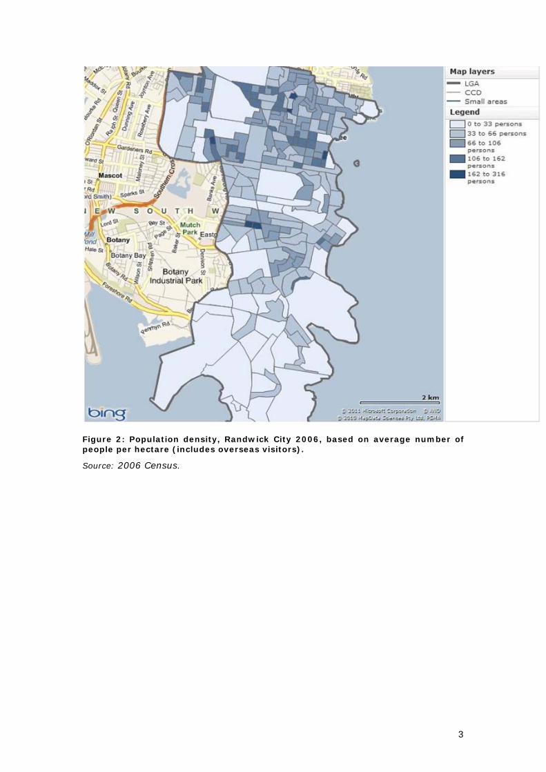
Source: 2006 Census. Population densities across Randwick City are variable with higher densities occurring in the older northern suburbs (eg Coogee and Clovelly) and around town centres (eg Kingsford, Kensington and Maroubra Junction). Figure 2 shows the higher density suburbs around the University of NSW, Randwick and Coogee and lower density areas south in the City. The population for Randwick City is expected to increase by 10,000 – 15,000 between 2006 and 2031③ with average annual growth rate of approximately 0.3%-0.5%. This projection, of some additional 400-600 people per year, is based on fertility rates, migration, and current major redevelopment sites.
② Population density calculated based on total population/total land area (2006 census data). ③ Population projection provided in Randwick City Plan and NSW SLA Population Projections, 2001 – 2031 by Department of Planning & Infrastructure.
3
Figure 2: Population density, Randwick City 2006, based on average number of people per hectare (includes overseas visitors).
Source: 2006 Census.

4
3. Age Structure The median age of the population in Randwick City is 35 years (2006 Census) which is comparable to the Sydney median age. However this varies across the City with Little Bay having a higher median age of 42 years and Kingsford and Kensington having a lower median age of 33 and 32 years respectively. In the 10 years between 1996 and 2006, the largest increases occurred in the age groups of 35-49 and 50–59 (2006 Census) and the lowest increases were in the 0-4 and all age groups over 60. The largest decrease occurred in the age group of 18-24 which lost approximately 1,300 people during this period. However, this group remains proportionally larger in Randwick City (13.1%) than that of Sydney (9.9%).
Figure 3: Age structure of Randwick City and Sydney statistical division 2006. Source: 2006 Census. The population of Randwick City is ageing and this is expected to continue, consistent with Sydney metropolitan wide trends. One indicator of the aging population is the increasing median age which has steadily increased from 33 to 35 years at each Census year from 1996 to 2006. By 2031 older people (50 years+) are expected to represent about 31% of the City’s population (currently about 28% of the population). As indicated in Table 2, this age group is also expected to experience the highest proportional growth. Furthermore, the oldest age group of 70+ is expected to increase by nearly 40% over this period or an additional 4,600 people. Despite these trends, the City is expected to continue to maintain a significant proportion of young people in the 20-24 age groups (9.7%) and 25-34 years (18.1%), given the proximity to educational establishments such as UNSW and

5
Randwick TAFE, access to a range of facilities and services, employment opportunities and lifestyle factors. An aging population and high proportion of young adults will have implications on the type of housing needed in the future. More dwellings will be required to be of adaptable and/or universal design to meet changing mobility needs and to facilitate social inclusion and aging in place. The high presence of young adults, particularly students, is likely to continue the ongoing demand for more affordable housing in proximity to the educational establishments. The need for housing for students and key workers was also highlighted in Council’s Randwick Education and Health Specialised Centre Discussion Paper (October 2010). Table 2: Population in 2006 and 2031 by Age Groups
Source: Department of Planning & Infrastructure Population Projections 2006-2031.
2006 2031
0-4 6,644 5.2% 6,534 4.8%
5-9 5,791 4.6% 5,806 4.2%
10-19 12,509 9.9% 12,288 9.0%
20-24 13,987 11.0% 13,318 9.7%
25-34 24,386 19.3% 24,764 18.1%
35-49 27,979 22.1% 30,188 22.1%
50-59 13,752 10.9% 15,150 11.1%
60-69 9,428 7.4% 11,813 8.6%
70 over 12,112 9.6% 16,756 12.3% Total
126,588
100%
136,617 100.0%

6
4. Households
4.1 Household Type
Family households are the most dominant household type in Randwick City representing 57.5% of the total households while lone person households comprise approximately a quarter of the total. There is also a large proportion of group households in Randwick City compared to Sydney as a whole. Table 3: Household Types Household Type Randwick Sydney SD
Family households 57.5% 68.6% Lone person households 26.2% 21.8% Group households 8.9% 3.9% Others 7.3% 5.7%
Source: 2006 Census Of the family households:
42.6% comprise couples with children 15.5% consist of one parent families 37.6% are made up of couples without children, and 4.3% for other family types.
Over the period 1996 to 2006, the main shifts in household type were:
One parent families (8.1% decrease) Couples without children (7.2% increase) Lone person households (3.4% increase)
4.2 Household Size
In 2006 the average household size in Randwick City was 2.35 persons per household, representing a decline in size of 2.9% since 1996 when it was 2.42 persons per household (2006 Census). The fall in household size is consistent with Sydney Metropolitan trends although the overall average is higher for Sydney (at 2.65 in 2006). As shown in Figure 4, the average household size tends to increase away from the coast and towards the southern suburbs, due to larger dwelling sizes and higher proportion of family households in these areas.

7
Figure 4: Household size, Randwick City 2006 – based on the average number of persons per occupied private dwelling.
Source: 2006 Census. The figure below clearly illustrates the increase in the number of lone person and two person households between 1996 and 2006 (+3.4% and +4.8% respectively).

8
Figure 5: Change in household size, Randwick City 1996 - 2006
Source: ABS 1996 & 2006 Household size in Randwick City is predicted to decrease to 2.28 persons per dwelling by 2031. Average household size in 2031 is calculated based on projected population in 2031, which is 136,617 (Department of Planning & Infrastructure projection) and approximate dwelling numbers in 2031, which is 60,000 (estimated based on the 8,400 dwelling target and existing dwelling numbers). Average household size (number of persons per dwelling) is 136,617/60,000=2.28 people/dwelling. The decline in household size is consistent with Sydney where the average household size is expected to fall from 2.65 to 2.36 people per dwelling. Despite the relatively low population growth projected for the LGA, the projected decrease in household size indicates the need to provide more dwellings to accommodate smaller household formats.

9
5. Workforce and Employment
5.1 Workforce
The total employed residents of Randwick City is 59,236. Of this labour force, 25.4% work within the City. Not surprisingly, the largest centre of employment for Randwick’s workforce is the CBD where 33.2% of the employed residents work. There are a total of 35,643 people working in Randwick City. 42.2% of these (about 15,000 people) are local residents while about 58% live outside the City. Of those workers living outside Randwick City, close to 17% resided in LGAs adjoining Randwick City (Botany Bay, Sydney and Waverley). Over 27% of workers living in Randwick City commute further distances to their workplaces (North Sydney, Ryde, Marrickville, Rockdale, Willoughby and beyond). This suggests a need for strong transport connections to/from the key employment centres of Randwick City (i.e Randwick Education and Health Specialised Centre and Port Botany) within Randwick City and to the CBD and adjacent suburbs, as well as a range of housing options to support the local workforce residing in Randwick City so as to minimise travel times.
5.2 Employment Characteristics
The three most popular industry sectors in Randwick City are:
Health Care and Social Assistance (6,948 persons or 11.8%) Professional, Scientific and Technical Services (6,296 persons or 10.7%) Education and Training (5,511 persons or 9.3%)
UNSW, the Randwick Hospitals Campus and surrounding areas account for the high proportion of people employed in these sectors including a significant number of key workers such as nurses, administration personnel, cleaners and other allied health workers. The three most popular occupations are professionals, clerical and administration and managers. When compared to Sydney, Randwick City has a higher percentage of persons employed as professionals and a smaller percentage of persons employed as machinery operators, drivers, technicians and trades workers. Over the period 1996-2006 the largest increases were in traditional white collar occupations: Property & Business Services; Health & Community Services; and Finance & Insurance sectors (+3248). Conversely, the largest decreases were in traditionally blue collar occupations namely Manufacturing; Transport & Storage; and Wholesale Trade (-1675 people). Further evidence of the changes can be seen from the occupation data which shows the largest changes between 1991 and 2006 were Professionals; Managers & Administrators (+5657). These occupations were also proportionally higher in Randwick City than Sydney. Declining occupations over the same 10 year period were: Administration, Clerical and Services workers; Intermediate Production & Transport Workers; and Labourers & Related workers (-2345). These changes over time reflect the gentrification process and long term trend in rising socio-economic status of the population, economic and employment

10
opportunities available in the City and high level of educational qualifications of residents. It also points to the need to address the supply of affordable housing as a way of maintaining a diverse population profile.
5.3 Income
There are two distinct income groups within Randwick City and these variations show geographic concentrations. A significant proportion of households in Randwick City (32%) are classified as high income households (those earning $1,700 per week or more) compared with 29.5% in Sydney. Conversely about 17.5% of households are classified as low income (those earning less than $500 per week) which is higher than Sydney (16.8%), which is likely a result of the higher proportion of 18-24 year olds, particularly students earning little or no incomes, together with public housing residents.

11
6. Transport
6.1 Journey to Work
Approximately 25.7% of the City’s residents use public transport and 44.6% drive private vehicles (cars) to work, compared to 18% and 53.7% respectively for Sydney. Of the residents who use public transport to work, bus commuters make up the largest proportion (22.2% compared to 5.4% in Sydney). The reliance on buses as the main public transport option is reflective of the lack of mass (rail) transit in the LGA. A large number of residents (6.3%) walk to work, compared to 4.2% in Sydney.
6.2 Car Ownership Patterns
Overall, car ownership in Randwick City is slightly lower than that of Sydney, with 70.1% owning at least one car compared to 78.1% of households in Sydney. Conversely within Randwick City almost 1 in 5 households do not own a car, while the ratio for Sydney is 1 in 8 households. Most of the households without a car are located at the major institutions and in areas of good transport provision (Randwick, Kingsford, Coogee and along the Anzac Pde spine) as shown in Figure 6. Trends indicate that car ownership rates in Randwick City are facing exponential growth with the largest changes in the 1996 to 2006 period occurring to those who own:
3 vehicles or more (27.9% increase), and No vehicles (13% decrease).

12
Figure 6: Households with a car in Randwick City Council (2006) – as a percentage of total households.
Source: 2006 Census.

13
7. Housing Statistics and Trends
7.1 Number of Dwellings
Randwick City has a total of 54,571 dwellings (as at July 2010), reflecting an increase of 4.6% (6,501 additional dwellings) since 1999 (2010 MDP④). Most of the increase in residential development over the last 10 years has resulted mainly from developments in town centres, small scale infill developments and large scale redevelopments on surplus government sites, now redundant to their initial purpose. The average dwelling density in 2010 was 14.58 dwellings per hectare over the entire LGA and 40.57 dwellings per hectare for land zoned residential. Housing density is highest in the north of the City at Randwick, Coogee and Kingsford and declines towards the south of the City (see Figure 7).
Figure 7 Dwelling density, Randwick City 2006 based on average number of dwelling per hectare.
Source: 2006 Census.
④ 2010 Metropolitan Development Program data. This is slightly higher than the Census estimate of 53,034 dwellings (which is a count of occupied private dwellings)

14
7.2 Housing Type/Mix
Randwick City’s urban landscape contains a greater diversity in housing types compared to Sydney. Randwick City has a much higher proportion of multi-unit residential development including residential flat buildings (36.6% for Randwick City compared to 17.3% in Sydney) and much lower proportion of single dwelling houses (29.8% in Randwick City compared to 57.1% in Sydney SD). There is also a greater proportion of medium density residential development such as townhouses and villas (25.1%) compared to 17.4% in Sydney. Single dwelling housing is located throughout the LGA with greater concentrations in the central and southern suburbs including Malabar, Chifley and Matraville. Medium density and multi-unit development such as townhouses and residential flat buildings is generally located around the town centres and transport routes in areas such as Kingsford, Kensington and Maroubra, and the coastal suburbs.
Figure 8: Dwelling structure in Randwick City and Sydney statistical division 2006.
Source: 2006 Census. The existing trends in household formation including decreasing household size, an increase in one person and couples only households, and an ageing population have implications in terms of dwelling numbers and composition of dwellings in residential developments. There will be a need to provide more dwellings to house the same number of people. It is anticipated that smaller households will have a preference for multi-unit housing over single dwelling houses.
7.3 Dwelling Production
Dwelling production is highly cyclical and dependent on a variety of economic and demographic changes both locally and regionally. Randwick City has experienced a substantial fluctuation in dwelling completion and building approvals during the past 10 years.

15
Dwelling completions reached a peak of 722 in 2008 and declined significantly to 192 in 2010, which appears largely affected by the declining numbers of building approvals since 2007 generally as a result of the changing economic circumstances and global financial crisis.
0
200
400
600
800
1,000
1,20000
/01
01/0
2
02/0
3
03/0
4
04/0
5
05/0
6
06/0
7
07/0
8
08/0
9
09/1
0
Dw elling Completion Building Approval
Figure 9: Dwelling Approvals and Completions 2010
Source: MDP 2010 A summary of development approvals for residential development between 2001 and 2010 is shown in the chart below.
0
200
400
600
800
1000
1200 Separate house
Medium density
High density
Total
Separate house 50 63 77 127 80 66 108 76 81 97
Medium density 67 99 79 96 129 86 91 29 76 61
High density 175 383 149 770 437 524 305 177 176 332
Total 292 545 305 993 646 676 504 282 333 490
00/01 01/02 02/03 03/04 04/05 05/06 06/07 07/08 08/09 09/10
Figure 10: Building approvals by dwelling types over reporting years (number of dwellings).
Source: MDP 2010.
16
7.4 Dwelling Tenure
There are a large proportion of residents renting properties in Randwick (42.2%), which is considerably higher than Sydney (29.7%). Overall 27.2% of the population own their own dwelling and 20.2% are purchasing a dwelling compared with 30.1% and 31.1% respectively for Sydney (2006 Census).
7.5 Dwelling Costs
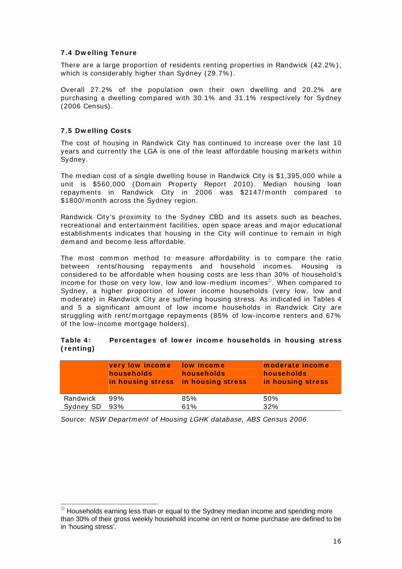
The cost of housing in Randwick City has continued to increase over the last 10 years and currently the LGA is one of the least affordable housing markets within Sydney. The median cost of a single dwelling house in Randwick City is $1,395,000 while a unit is $560,000 (Domain Property Report 2010). Median housing loan repayments in Randwick City in 2006 was $2147/month compared to $1800/month across the Sydney region. Randwick City’s proximity to the Sydney CBD and its assets such as beaches, recreational and entertainment facilities, open space areas and major educational establishments indicates that housing in the City will continue to remain in high demand and become less affordable. The most common method to measure affordability is to compare the ratio between rents/housing repayments and household incomes. Housing is considered to be affordable when housing costs are less than 30% of household’s income for those on very low, low and low-medium incomes⑤. When compared to Sydney, a higher proportion of lower income households (very low, low and moderate) in Randwick City are suffering housing stress. As indicated in Tables 4 and 5 a significant amount of low income households in Randwick City are struggling with rent/mortgage repayments (85% of low-income renters and 67% of the low-income mortgage holders). Table 4: Percentages of lower income households in housing stress (renting) very low income
households in housing stress
low income households in housing stress
moderate income households in housing stress
Randwick 99% 85% 50% Sydney SD 93% 61% 32%
Source: NSW Department of Housing LGHK database, ABS Census 2006.
⑤ Households earning less than or equal to the Sydney median income and spending more than 30% of their gross weekly household income on rent or home purchase are defined to be in ‘housing stress’.

17
Table 5: Percentages of lower income households in housing stress (purchasing) very low income
households in housing stress
low income households in housing stress
moderate income households in housing stress
Randwick 88% 67% 50% Sydney SD 83% 60% 42%
Source: NSW Department of Housing LGHK database, ABS Census 2006. Over 51.0% of households in Randwick City pay high mortgage repayments ($2,000 per month or more) compared with 40.2% in Sydney. Only 11.6% of households have low repayments, compared with 15.1% in Sydney (2006 Census). Analysis of the weekly housing rental payments of households in Randwick City compared to Sydney shows that there is a larger proportion of households paying high rental payments ($450 per week or more) but a similar proportion of households with low rental payments (less than $140 per week). Overall, 15.5% of households were paying high rents, and 15.7% were paying low rents, compared with 10.0% and 16.9% respectively in Sydney. Housing NSW⑥ has advised that their analysis of Centrelink data and ABS data shows that Randwick City has a significant number of low and moderate income earners in housing stress (for households renting and purchasing their home). The LGA also has one of NSW’s highest proportions of recipients of Commonwealth Rent Assistance (CRA) of which 28% of recipients are below 25 years of age. Housing NSW identifies that this trend is consistent with other LGA’s, which contain universities, indicating that a significant proportion of CRA recipients are students.
⑥ Housing NSW data 2010.

18
Local Government Areas by Housing Need
High Moderate High Moderate Low Moderate Low
Auburn Ashfield Albury Blayney Balranald
Bankstown Ballina Armidale Dumaresq Bogan Bland
Blacktown Baulkham Hills Bathurst Regional Cabonne Bombala
Canterbury Blue Mountains Bega Valley Camden Boorowa
Fairfield Botany Bay Bellingen Cobar Bourke
Gosford Burwood Berrigan Cooma-Monaro Brewarrina
Hornsby Byron Broken Hill Corowa Shire Carrathool
Lake Macquarie Campbelltown Cessnock Cowra Central Darling
Liverpool Canada Bay Cootamundra Deniliquin Conargo
Marrickville Clarence Valley Dubbo Dungog Coolamon
Newcastle Coffs Harbour Glen Innes Severn Forbes Coonamble
North Sydney Eurobodalla Gloucester Greater Hume Shire Gilgandra
Parramatta Hastings Goulburn Mulwaree Griffith Guyra
Penrith Hawkesbury Great Lakes Gundagai Gwydir
Randwick Holroyd Greater Taree Harden Jerilderie
Rockdale Hunters Hill Gunnedah Hay Junee
Ryde Hurstville Inverell Kyogle Lachlan
Sutherland Kogarah Kempsey Leeton Lockhart
Sydney Ku-Ring-Gai Kiama Lithgow Murrumbidgee
Tweed Lane Cove Liverpool Plains Moree Plains Snowy River
Warringah Leichhardt Mid-Western Regional Murray Tumbarumba
Waverley Lismore Nambucca Muswellbrook Tumut Shire
Willoughby Maitland Orange Narrabri Unincorporated NSW
Wollongong Manly Parkes Narrandera Urana
Wyong Mosman Tamworth Regional Narromine Wakool
Pittwater Tenterfield Oberon Walcha
Port Stephens Upper Hunter Shire Palerang Warren
Queanbeyan Uralla Singleton Weddin
Richmond Valley Walgett Temora Wentworth
Shellharbour Yass Valley Upper Lachlan
Shoalhaven Warrumbungle Shire
Strathfield Wellington
Wagga Wagga Young
Wingecarribee
Wollondilly
Woollahra
Source Department of Housing Centre For Affordable Housing
(http://www.housing.nsw.gov.au/Centre+For+Affordable+Housing/Affordable+Housing+in+NSW/Where+Do+We+Need+Affordable+Housing/)

19
Appendix B - Comparison of Existing and Proposed Residential Zones and Land Use Tables

20
Cl
Randwick LEP 1998 (CONSOLIDATION)
Cl Comprehensive RLEP 2011
(based on Standard Instrument LEP) 10
Zone No 2A (Residential A Zone) (1) The objectives of Zone No 2A are:
(a) to provide a low density residential environment, and (b) to maintain the desirable attributes of established residential areas, and (c) to protect the amenity of existing residents, and (d) to allow for a range of community uses to be provided to serve the needs of residents, workers and visitors, and (e) to encourage housing affordability, and (f) to allow people to carry out a range of activities from their homes, where such activities are not likely to adversely affect the environment of the locality.
(2) Development for the purpose of the following does not require development consent: Bushfire hazard reduction; Public utility undertakings; Recreation (3) Development for the purpose of the following requires development consent: Attached dual occupancy; Bed and breakfast accommodation; Boarding houses; Child care centres; Communication facilities; Community facilities; Dwelling houses; Earthworks; Educational establishments; Health consulting rooms; Home activities; Outdoor advertising; Places of worship; Public transport; Recreation facilities; Roads (4) Any development not included in subclause (2) or (3) is prohibited.
Zone R2 Low Density Residential Direction. The following must be included as either “Permitted without consent” or “Permitted with consent” for this zone: Roads 1 Objectives of zone:
To provide for the housing needs of the community within a low density residential environment.
To enable other land uses that provide facilities or services to meet the day to day needs of residents.
To maintain the desirable attributes of established residential areas;
To protect the amenity of residents; and To encourage housing affordability
2 Permitted without consent Home occupations; Home based child care; Recreation area. 3 Permitted with consent Bed and breakfast accommodation; Boarding houses; Child care centres; Community facilities; Dual occupancy (attached); Dwelling houses; Group homes; Health consulting rooms; Home business; Home industry; Places of public worship; Passenger transport facilities; Respite day care centres; Semi-detached dwelling; Recreation facility(indoor); Recreation facility(outdoor); Respite day care centre; Roads; Semi detached dwellings

21
Cl
Randwick LEP 1998 (CONSOLIDATION)
Cl Comprehensive RLEP 2011
(based on Standard Instrument LEP)
4 Prohibited Any development not specified in item 2 or 3
* Black text in the column for Comprehensive RLEP 2011 indicates compulsory provisions while red text indicates the Council’s recommended inclusions. The land use table does not provide an exhaustive list of all uses that may be permissible in a particular zone. Other uses may be provided for in other planning instruments (i.e. ISEPP).

22
Cl
Randwick LEP 1998 (CONSOLIDATION)
Cl Comprehensive RLEP 2011
(based on Standard Instrument LEP) 11
Zone No 2B (Residential B Zone) (1) The objectives of Zone No 2B are:
(a) to provide for a low to medium density residential environment, and (b) to maintain the desirable attributes of established residential areas, and (c) to protect the amenity of existing residents, and (d) to allow for a range of community uses to be provided to serve the needs of residents, workers and visitors, and (e) to encourage housing affordability, and (f) to allow people to carry out a range of activities from their homes, where such activities are not likely to adversely affect the environment of the locality.
(2) Development for the purpose of the following does not require development consent: Bushfire hazard reduction; Public utility undertakings; Recreation (3) Development for the purpose of the following requires development consent: Bed and breakfast accommodation; Boarding houses; Child care centres; Communication facilities; Community facilities; Dwelling houses; Earthworks; Educational establishments; Health consulting rooms; Home activities; Multi-unit housing; Outdoor advertising; Places of worship; Public transport; Recreation facilities; Roads; Serviced apartments (4) Any development not included in subclause (2) or (3) is
Zone R3 Medium Density Residential Direction. The following must be included as either “Permitted without consent” or “Permitted with consent” for this zone: Roads 1 Objectives of zone
To provide for the housing needs of the community within a medium density residential environment.
To provide a variety of housing types within a medium density residential environment.
To enable other land uses that provide facilities or services to meet the day to day needs of residents.
To maintain the desirable attributes of established residential areas;
To protect the amenity of residents; and To encourage housing affordability
2 Permitted without consent Home occupation; Recreation area 3 Permitted with consent Attached dwellings; Bed and breakfast accommodation; Boarding houses; Car parks; Child care centres; Community facilities; Dwelling houses; Dual occupancies; Group homes; Home businesses, Hostels; Hotel and motel accommodation; Multi dwelling housing; Residential flat buildings; Neighbourhood shops; Places of public worship; Passenger transport facilities; Recreation facility(indoor); Recreation facility(outdoor); Respite day care centres; Roads; Semi-detached dwellings; Seniors housing;

23
Cl
Randwick LEP 1998 (CONSOLIDATION)
Cl Comprehensive RLEP 2011
(based on Standard Instrument LEP) prohibited. Serviced apartments
4 Prohibited Any development not specified in 2 & 3
* Black text in the column for Comprehensive RLEP 2011 indicates compulsory provisions while red text indicates the Council’s recommended inclusions. The land use table does not provide an exhaustive list of all uses that may be permissible in a particular zone. Other uses may be provided for in other planning instruments (i.e. ISEPP).

24
Cl Randwick LEP 1998 (CONSOLIDATION)
Cl
Comprehensive RLEP 2011 (based on Standard Instrument LEP)
12
Zone No 2C (Residential C Zone)
(1) The objectives of Zone No 2C are: (a) to provide for a medium density residential environment, and (b) to maintain the desirable attributes of established residential areas, and (c) to protect the amenity of existing residents, and (d) to allow for a range of community uses to be provided to serve the needs of residents, workers and visitors, and (e) to encourage housing affordability, and (f) to allow people to carry out a range of activities from their homes, where such activities are not likely to adversely affect the environment of the locality.
(2) Development for the purpose of the following does not require development consent: Bushfire hazard reduction; Public utility undertakings; Recreation (3) Development for the purpose of the following requires development consent: Bed and breakfast accommodation; Boarding houses; Car parks; Child care centres; Communication facilities; Community facilities; Dwelling houses; Earthworks; Educational establishments; Health consulting rooms; Home activities; Hospitals; Motels; Multi-unit housing; Outdoor advertising; Places of worship; Public transport; Recreation facilities; Roads; Serviced apartments
As per the LUT for R3 above.

25
Cl
Randwick LEP 1998 (CONSOLIDATION)
Cl Comprehensive RLEP 2011
(based on Standard Instrument LEP) (4) Any development not included in subclause (2) or (3) is prohibited.
* Black text in the column for Comprehensive RLEP 2011 indicates compulsory provisions while red text indicates the Council’s recommended inclusions. The land use table does not provide an exhaustive list of all uses that may be permissible in a particular zone. Other uses may be provided for in other planning instruments (i.e. ISEPP).

26
Cl
Randwick LEP 1998 (CONSOLIDATION)
Cl Comprehensive RLEP 2011
(based on Standard Instrument LEP) 12A
Zone No 2D (Residential D—Comprehensive Development Zone) (1) The objectives of Zone No 2D are: (a) to allow the comprehensive redevelopment of land for primarily residential and open space purposes, and (b) to enable development that is consistent with a development control plan prepared in accordance with clause 40A and approved by the Council, and (c) to enable residential development in a variety of density and housing forms, where such development does not adversely affect the amenity and function of surrounding areas, and (d) to allow people to carry out a range of activities from their homes, where such activities are not likely to adversely affect the environment of the locality, and (e) to allow a limited range and scale of non-residential uses, that are compatible with residential amenity on land identified for those uses within a development control plan prepared in accordance with clause 40A and approved by the Council, and (f) to encourage housing affordability, and (g) to allow a range of community uses to be provided to serve the needs of residents, workers and visitors. (2) Development for the purpose of the following does not require development consent:
Zone R1 General Residential Direction. The following must be included as either “Permitted without consent” or “Permitted with consent” for this zone: Roads 1 Objectives of zone
• To provide for the housing needs of the community. • To provide for a variety of housing types and densities. • To enable other land uses that provide facilities or services to meet the day to day needs of residents. To allow the comprehensive redevelopment of
land for primarily residential and open space purposes; and
To encourage housing affordability
2 Permitted without consent Home occupations; Home based child care; Recreation area 3 Permitted with consent Attached dwellings; Bed and breakfast accommodation; Boarding houses; Car parks; Child care centres; Community facilities; Dwelling houses; Group homes; Home businesses; Home industries; Hostels; Multi dwelling housing; Neighbourhood shops; Places of public worship; Passenger transport facilities; Recreation facility(indoor); Recreation facility(outdoor); Residential flat buildings; Respite day care centres; Restaurant or

27
Cl
Randwick LEP 1998 (CONSOLIDATION)
Cl Comprehensive RLEP 2011
(based on Standard Instrument LEP) Bushfire hazard reduction; Public utility undertakings; Recreation (3) Development for the purpose of the following requires development consent: Bed and breakfast accommodation; Boarding houses; Car parks (ancillary to primary land use); Child care facilities; Communication facilities; Community facilities; Dwelling houses; Earthworks; Educational establishments; Health consulting rooms; Home activities; Multi-unit housing; Outdoor advertising; Places of worship; Public transport; Recreation facilities; Residential care facilities; Restaurants; Roads; Serviced apartments (4) Any development not included in subclause (2) or (3) is prohibited.
café; Roads; Serviced apartments; Semi-detached dwellings; Seniors housing; Shop top housing 4 Prohibited Any development not specified in 2 & 3
* Black text in the column for Comprehensive RLEP 2011 indicates compulsory provisions while red text indicates the Council’s recommended inclusions. The land use table does not provide an exhaustive list of all uses that may be permissible in a particular zone. Other uses may be provided for in other planning instruments (i.e. ISEPP).

28
Appendix C: Comparison of Land Use Definitions

29
Randwick LEP Definitions (uses permissible in residential zones)
Standard Instrument LEP Residential Related Definitions
outdoor advertising means the use of a building or place for the display of symbols, messages or other devices for promotional purposes or for conveying information, instructions, directions or the like, whether or not the display involves the erection of a structure.
advertisement has the same meaning as in the Act.
Note. The term is defined as a sign, notice, device or representation in the nature of an advertisement visible from any public place or public reserve or from any navigable water.
advertising structure has the same meaning as in the Act.
Note. The term is defined as a structure used or to be used principally for the display of an advertisement.
Advertising structures are a type of signage—see the definition of that term in this Dictionary.
affordable housing has the same meaning as in the Act.
Note. The term is defined as housing for very low income households, low income households or moderate income households, being such households as are prescribed by the regulations or as are provided for in an environmental planning instrument.
aboriginal object means any deposit, object or other material evidence (not being a handicraft made for sale) relating to the Aboriginal habitation of an area of New South Wales, being habitation before or concurrent with (or both) the occupation of that area by persons of non-Aboriginal extraction, and includes Aboriginal remains
aboriginal object means any deposit, object or other material evidence (not being a handicraft made for sale) relating to the Aboriginal habitation of an area of New South Wales, being habitation before or concurrent with (or both) the occupation of that area by persons of non-Aboriginal extraction, and includes Aboriginal remains.
aboriginal place of heritage significance means an area of land, the general location of which is identified in an Aboriginal heritage study adopted by the Council after public exhibition and that may be

30
Randwick LEP Definitions (uses permissible in residential zones)
Standard Instrument LEP Residential Related Definitions
shown on the Heritage Map, that is:
(a) the site of one or more Aboriginal objects or a place that has the physical remains of pre-European occupation by, or is of contemporary significance to, the Aboriginal people. It may (but need not) include items and remnants of the occupation of the land by Aboriginal people, such as burial places, engraving sites, rock art, midden deposits, scarred and sacred trees and sharpening grooves, or
(b) a natural Aboriginal sacred site or other sacred feature. It includes natural features such as creeks or mountains of long-standing cultural significance, as well as initiation, ceremonial or story places or areas of more contemporary cultural significance.
Note. The term may include (but is not limited to) places that are declared under section 84 of the National Parks and Wildlife Act 1974 to be Aboriginal places for the purposes of that Act.
attached dual occupancy means a building containing two (but not more than two) dwellings.
dual occupancy (attached) means 2 dwellings on one lot of land that are attached to each other, but does not include a secondary dwelling.
Note. Dual occupancies (attached) are a type of dual occupancy—see the definition of that term in this Dictionary.
attached dwelling means a building containing 3 or more dwellings, where:
(a) each dwelling is attached to another dwelling by a common wall, and
(b) each of the dwellings is on its own lot of land, and (c) none of the dwellings is located above any part of another
dwelling.

31
Randwick LEP Definitions (uses permissible in residential zones)
Standard Instrument LEP Residential Related Definitions
Note.
Attached dwellings are a type of residential accommodation—see the definition of that term in this Dictionary.
building identification sign means a sign that identifies or names a building and that may include the name of a building, the street name and number of a building, and a logo or other symbol, but that does not include general advertising of products, goods or services.
Note. Building identification signs are a type of signage—see the definition of that term in this Dictionary.
business identification sign means a sign: (a) that indicates: (i) the name of the person or business, and (ii) the nature of the business carried on by the person at the premises or place at which the sign is displayed, and (b) that may include the address of the premises or place and a logo or other symbol that identifies the business, but that does not include any advertising relating to a person who does not carry on business at the premises or place.
Note. Business identification signs are a type of signage—see the definition of that term in this Dictionary
bed and breakfast accommodation means a building which provides temporary accommodation for not more than 5 persons and where the owner of the building is a permanent resident.
bed and breakfast accommodation means an existing dwelling in which temporary or short-term accommodation is provided on a commercial basis by the permanent residents of the dwelling and where:
(a) meals are provided for guests only, and

32
Randwick LEP Definitions (uses permissible in residential zones)
Standard Instrument LEP Residential Related Definitions
(b) cooking facilities for the preparation of meals are not provided within guests’ rooms, and
(c) dormitory-style accommodation is not provided. Note. See clause 5.4 for controls relating to the number of bedrooms for bed and breakfast accommodation.
Bed and breakfast accommodation is a type of tourist and visitor accommodation—see the definition of that term in this Dictionary.
boarding house means a building or place:
(a) where permanent accommodation facilities are provided to the residents of the building or place, and (b) where meal and laundry facilities may be provided, and (c) which is not licensed to sell liquor within the meaning of the Liquor Act 1982,
but (in Part 2) does not include a building or place elsewhere defined in this clause.
boarding house means a building that:
(a) is wholly or partly let in lodgings, and (b) provides lodgers with a principal place of residence for 3 months
or more, and (c) may have shared facilities, such as a communal living room,
bathroom, kitchen or laundry, and (d) has rooms, some or all of which may have private kitchen and
bathroom facilities, that accommodate one or more lodgers, but does not include backpackers’ accommodation, a group home, hotel or motel accommodation, seniors housing or a serviced apartment. Note. Boarding houses are a type of residential accommodation—see the definition of that term in this Dictionary.
bushfire hazard reduction means a reduction or modification (by controlled burning or mechanical or manual means) of material that constitutes a bushfire hazard.
bush fire hazard reduction work has the same meaning as in the Rural Fires Act 1997.
Note. The term is defined as follows:
bush fire hazard reduction work means:
(a) the establishment or maintenance of fire breaks on land, and

33
Randwick LEP Definitions (uses permissible in residential zones)
Standard Instrument LEP Residential Related Definitions
(b) the controlled application of appropriate fire regimes or other means for the reduction or modification of available fuels within a predetermined area to mitigate against the spread of a bush fire, but does not include construction of a track, trail or road.
car park means a building or place (other than a building or place used in conjunction with a dwelling) used for parking vehicles, whether operated for gain or not, and includes any manoeuvring space and access to that building or place.
car park means a building or place primarily used for the purpose of parking motor vehicles, including any manoeuvring space and access thereto, whether operated for gain or not.
child care centre means a building or place used for the purpose of supervising or caring for children which:
(a) caters for more than 5 children who have not reached the compulsory school-age (as defined in the Education Act 1990), whether or not those children are related to the owner or operator of the building or place, and (b) may be used for education, and (c) may operate for the purpose of gain,
but does not include a building or place providing residential care for those children.
child care centre means a building or place used for the supervision and care of children that:
(a) provides long day care, pre-school care, occasional child care or out-of-school-hours care, and (b) does not provide overnight accommodation for children other than those related to the owner or operator of the centre, but does not include: (c) a building or place used for home-based child care, or (d) an out-of-home care service provided by an agency or organisation accredited by the NSW Office of the Children’s Guardian, or (e) a baby-sitting, playgroup or child-minding service that is organised informally by the parents of the children concerned, or (f) a service provided for fewer than 5 children (disregarding any children who are related to the person providing the service) at the premises at which at least one of the children resides, being a service that is not advertised, or (g) a regular child-minding service that is provided in connection with a recreational or commercial facility (such as a gymnasium), by or on behalf of the person conducting the facility, to care for children while

34
Randwick LEP Definitions (uses permissible in residential zones)
Standard Instrument LEP Residential Related Definitions
the children’s parents are using the facility, or (h) a service that is concerned primarily with the provision of: (i) lessons or coaching in, or providing for participation in, a cultural, recreational, religious or sporting activity, or (ii) private tutoring, or (i) a school, or (j) a service provided at exempt premises (within the meaning of Chapter 12 of the Children and Young Persons (Care and Protection) Act 1998), such as hospitals, but only if the service is established, registered or licensed as part of the institution operating on those premises.
communications facility means a building, structure, work or place used primarily for transmitting or receiving signals for the purpose of communication, and includes radio masts, towers, satellite dishes, cables and the like, but does not include any reception device attached to a dwelling for domestic purposes.
See ‘telecommunications facility’
community facility means a building or place owned or controlled by a public authority or a charitable or voluntary organisation which may provide for the physical, social, cultural or intellectual development or welfare of the local community, but (in Part 2) does not include a building or place elsewhere defined in this clause.
community facility means a building or place:
(a) owned or controlled by a public authority or non-profit community organisation, and (b) used for the physical, social, cultural or intellectual development or welfare of the community,
but does not include an educational establishment, hospital, retail premises, place of public worship or residential accommodation.
curtilage, in relation to a heritage item or conservation area, means the area of land (including land covered by water) surrounding a heritage item, a heritage conservation area, or building, work or place within a heritage conservation area, that contributes to its heritage

35
Randwick LEP Definitions (uses permissible in residential zones)
Standard Instrument LEP Residential Related Definitions
significance
See ‘attached dual occupancy’ dual occupancy means a dual occupancy (attached) or a dual occupancy (detached).
Note. Dual occupancies are a type of residential accommodation—see the definition of that term in this Dictionary.
dwelling means a room or number of rooms occupied or used, or so constructed or adapted as to be capable of being occupied or used, as a separate residence.
dwelling means a room or suite of rooms occupied or used or so constructed or adapted as to be capable of being occupied or used as a separate domicile.
dwelling house means a building containing one (but not more than one) dwelling.
dwelling house means a building containing only one dwelling.
Note. Dwelling houses are a type of residential accommodation—see the definition of that term in this Dictionary.
educational establishment means a building or place used for education (including teaching) and includes:
(a) a school, and (b) a tertiary institution, being a university, TAFE establishment, teachers’ college or other tertiary college providing formal education which is constituted by or under an Act, and (c) an art gallery, library or museum, not being an art gallery, library or museum in which any items on display are for sale,
whether or not accommodation for staff and students is provided and whether or not used for the purpose of gain.
educational establishment means a building or place used for education (including teaching), being:
(a) a school, or (b) a tertiary institution, including a university or a TAFE establishment, that provides formal education and is constituted by or under an Act.

36
Randwick LEP Definitions (uses permissible in residential zones)
Standard Instrument LEP Residential Related Definitions
group home (permanent) or permanent group home means a dwelling:
(a) that is occupied by persons as a single household with or without paid supervision or care and whether or not those persons are related or payment for board and lodging is required, and (b) that is used to provide permanent household accommodation for people with a disability or people who are socially disadvantaged, but does not include development to which State Environmental Planning Policy (Housing for Seniors or People with a Disability) 2004 applies. Note. Permanent group homes are a type of group home—see the definition of that term in this Dictionary.
group home (transitional) or transitional group home means a dwelling:
(a) that is occupied by persons as a single household with or without paid supervision or care and whether or not those persons are related or payment for board and lodging is required, and (b) that is used to provide temporary accommodation for the relief or rehabilitation of people with a disability or for drug or alcohol rehabilitation purposes, or that is used to provide half-way accommodation for persons formerly living in institutions or temporary accommodation comprising refuges for men, women or young people, but does not include development to which State Environmental Planning Policy (Housing for Seniors or People with a Disability) 2004 applies. Note. Transitional group homes are a type of group home—see the definition of that term in this Dictionary.
37
Randwick LEP Definitions (uses permissible in residential zones)
Standard Instrument LEP Residential Related Definitions
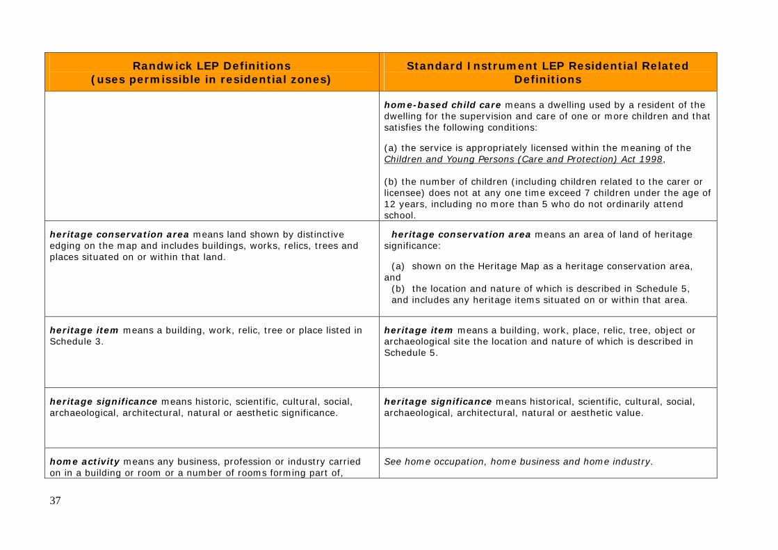
home-based child care means a dwelling used by a resident of the dwelling for the supervision and care of one or more children and that satisfies the following conditions:
(a) the service is appropriately licensed within the meaning of the Children and Young Persons (Care and Protection) Act 1998, (b) the number of children (including children related to the carer or licensee) does not at any one time exceed 7 children under the age of 12 years, including no more than 5 who do not ordinarily attend school.
heritage conservation area means land shown by distinctive edging on the map and includes buildings, works, relics, trees and places situated on or within that land.
heritage conservation area means an area of land of heritage significance:
(a) shown on the Heritage Map as a heritage conservation area, and
(b) the location and nature of which is described in Schedule 5, and includes any heritage items situated on or within that area.
heritage item means a building, work, relic, tree or place listed in Schedule 3.
heritage item means a building, work, place, relic, tree, object or archaeological site the location and nature of which is described in Schedule 5.
heritage significance means historic, scientific, cultural, social, archaeological, architectural, natural or aesthetic significance.
heritage significance means historical, scientific, cultural, social, archaeological, architectural, natural or aesthetic value.
home activity means any business, profession or industry carried on in a building or room or a number of rooms forming part of,
See home occupation, home business and home industry.

38
Randwick LEP Definitions (uses permissible in residential zones)
Standard Instrument LEP Residential Related Definitions
attached to, or within the curtilage of, a dwelling, where:
(a) only goods made or produced, or services offered, as a result of the activity or pursuit are displayed, sold or provided, and (b) the primary use of the dwelling is for residential purposes, and (c) the activity or pursuit does not: (i) interfere with the amenity of the locality by reason of the emission of excessive noise, vibration, smell, fumes, smoke, vapour, steam, soot, ash, dust, waste water, waste products, grit or oil or otherwise, or (ii) involve exposure to view from any public place of any matter, or (iii) require the provision of any essential service main of a greater capacity than that available in the locality, or (iv) generate traffic out of keeping with the surrounding area, and (d) the activity is carried out by the permanent residents of the dwelling,
but (in Part 2) does not include any land use elsewhere defined in this clause.
home business means a business that is carried on in a dwelling, or in a building ancillary to a dwelling, by one or more permanent residents of the dwelling and that does not involve:
(a) the employment of more than 2 persons other than those residents, or
(b) interference with the amenity of the neighbourhood by reason of the emission of noise, vibration, smell, fumes, smoke, vapour, steam, soot, ash, dust, waste water, waste products, grit or oil, traffic generation or otherwise, or
(c) the exposure to view, from any adjacent premises or from any public place, of any unsightly matter, or
(d) the exhibition of any signage (other than a business identification sign), or

39
Randwick LEP Definitions (uses permissible in residential zones)
Standard Instrument LEP Residential Related Definitions
(e) the sale of items (whether goods or materials), or the exposure or offer for sale of items, by retail, except for goods produced at the dwelling or building, but does not include bed and breakfast accommodation, home occupation (sex services) or sex services premises.
Note. See clause 5.4 for controls relating to the floor area used for a home business.
home industry means a dwelling (or a building ancillary to a dwelling) used by one or more permanent residents of the dwelling to carry out an industrial activity that does not involve any of the following:
(a) the employment of more than 2 persons other than those residents,
(b) interference with the amenity of the neighbourhood by reason of the emission of noise, vibration, smell, fumes, smoke, vapour, steam, soot, ash, dust, waste water, waste products, grit or oil, traffic generation or otherwise,
(c) the exposure to view, from any adjacent premises or from any public place, of any unsightly matter,
(d) the exhibition of any signage (other than a business identification sign),
(e) the sale of items (whether goods or materials), or the exposure or offer for sale of items, by retail, except for goods produced at the dwelling or building, but does not include bed and breakfast accommodation or sex services premises.
Note. See clause 5.4 for controls relating to the floor area used for a home industry.
Home industries are a type of light industry—see the definition of that term in this Dictionary.

40
Randwick LEP Definitions (uses permissible in residential zones)
Standard Instrument LEP Residential Related Definitions
See ‘home activity’ home occupation means an occupation that is carried on in a dwelling, or in a building ancillary to a dwelling, by one or more permanent residents of the dwelling and that does not involve:
(a) the employment of persons other than those residents, or (b) interference with the amenity of the neighbourhood by reason of
the emission of noise, vibration, smell, fumes, smoke, vapour, steam, soot, ash, dust, waste water, waste products, grit or oil, traffic generation or otherwise, or
(c) the display of goods, whether in a window or otherwise, or (d) the exhibition of any signage (other than a business identification
sign), or (e) the sale of items (whether goods or materials), or the exposure
or offer for sale of items, by retail,
but does not include bed and breakfast accommodation, home occupation (sex services) or sex services premises.
home occupation (sex services) means the provision of sex services in a dwelling that is a brothel, or in a building that is a brothel and is ancillary to such a dwelling, by no more than 2 permanent residents of the dwelling and that does not involve:
(a) the employment of persons other than those residents, or (b) interference with the amenity of the neighbourhood by reason of the emission of noise, traffic generation or otherwise, or (c) the exhibition of any signage, or (d) the sale of items (whether goods or materials), or the exposure or offer for sale of items, by retail, but does not include a home business or sex services premises.
hospital means a building or place used for providing professional health services (including preventative care, diagnosis, medical or
hospital means a building or place used for the purpose of providing professional health care services (such as preventative or convalescent care, diagnosis, medical or surgical treatment,

41
Randwick LEP Definitions (uses permissible in residential zones)
Standard Instrument LEP Residential Related Definitions
surgical treatment or counselling) to people and includes:
(a) ancillary facilities for the accommodation of nurses or other health care workers, ancillary shops or refreshment rooms and ancillary accommodation for persons receiving health care or for their visitors, and (b) facilities situated in the building or at the place and used for educational or research purposes, whether or not they are used only by hospital staff or health care workers, and whether or not any such use is a commercial use,
but (in Part 2) does not include a building or place elsewhere defined in this clause.
psychiatric care or care for people with disabilities, or counselling services provided by health care professionals) to people admitted as in-patients (whether or not out-patients are also cared for or treated there), and includes ancillary facilities for (or that consist of) any of the following:
(a) day surgery, day procedures or health consulting rooms, (b) accommodation for nurses or other health care workers, (c) accommodation for persons receiving health care or for their
visitors, (d) shops, kiosks, restaurants or cafes or take-away food and drink
premises, (e) patient transport facilities, including helipads, ambulance facilities
and car parking, (f) educational purposes or any other health-related use, (g) research purposes (whether or not carried out by hospital staff or
health care workers or for commercial purposes), (h) chapels, (i) hospices, (j) mortuaries. Note. Hospitals are a type of health services facility—see the definition of that term in this Dictionary.
See ‘Motel’ hotel or motel accommodation means a building or place (whether or not licensed premises under the Liquor Act 2007) that provides temporary or short-term accommodation on a commercial basis and that:
(a) comprises rooms or self-contained suites, and (b) may provide meals to guests or the general public and facilities
for the parking of guests’ vehicles, but does not include backpackers’ accommodation, a boarding house, bed and breakfast accommodation or farm stay accommodation.

42
Randwick LEP Definitions (uses permissible in residential zones)
Standard Instrument LEP Residential Related Definitions
Note. Hotel or motel accommodation is a type of tourist and visitor accommodation—see the definition of that term in this Dictionary.
medical centre means premises that are used for the purpose of providing health services (including preventative care, diagnosis, medical or surgical treatment, counselling or alternative therapies) to out-patients only, where such services are principally provided by health care professionals. It may include the ancillary provision of other health services.
Note. Medical centres are a type of health services facility—see the definition of that term in this Dictionary.
motel means a building providing short-term accommodation for travellers or tourists, but (in Part 2) does not include a building elsewhere defined in this clause.
See ‘Hotel or Motel’ accommodation
multi-unit housing means two or more dwellings, whether or not attached.
multi dwelling housing means 3 or more dwellings (whether attached or detached) on one lot of land, each with access at ground level, but does not include a residential flat building.
Note. Multi dwelling housing is a type of residential accommodation—see the definition of that term in this Dictionary.
outdoor advertising means the use of a building or place for the display of symbols, messages or other devices for promotional purposes or for conveying information, instructions, directions or the like, whether or not the display involves the erection of a structure.
See ‘signage’

43
Randwick LEP Definitions (uses permissible in residential zones)
Standard Instrument LEP Residential Related Definitions
Check ‘Public Transport’ passenger transport facility means a building or place used for the assembly or dispersal of passengers by any form of transport, including facilities required for parking, manoeuvring, storage or routine servicing of any vehicle that uses the building or place.
place of worship means a building or place used for religious worship, whether or not the building or place is also used for counselling, social events, instruction or religious training by a congregation or religious group.
place of public worship means a building or place used for the purpose of religious worship by a congregation or religious group, whether or not the building or place is also used for counselling, social events, instruction or religious training.
public utility undertaking means any undertaking carried on by, or by authority of, any public authority, or in pursuance of any Commonwealth or State Act, for the purpose of:
(a) railway, road or air transport, or (b) the provision of sewerage or drainage services, or (c) the supply of water, hydraulic power, electricity or gas, or (d) low-impact telecommunication facilities.
public utility undertaking means any of the following undertakings carried on or permitted to be carried on by or by authority of any Government Department or under the authority of or in pursuance of any Commonwealth or State Act:
(a) railway, road transport, water transport, air transport, wharf or river undertakings, (b) undertakings for the supply of water, hydraulic power, electricity or gas or the provision of sewerage or drainage services,
and a reference to a person carrying on a public utility undertaking includes a reference to a council, electricity supply authority, Government Department, corporation, firm or authority carrying on the undertaking.
public transport means the use of a building or place for providing passenger transport facilities to the general public, whether or not those facilities are provided by a public authority.
Check ‘Passenger Transport Facility’
recreation means the use of an area or place for: (a) a children’s playground, or
recreation area means a place used for outdoor recreation that is

44
Randwick LEP Definitions (uses permissible in residential zones)
Standard Instrument LEP Residential Related Definitions
(b) recreational or leisure activities which promote the physical, cultural or intellectual welfare of persons within the community, but (in Part 2) does not include any land use elsewhere defined in this clause.
normally open to the public, and includes:
(a) a children’s playground, or (b) an area used for community sporting activities, or (c) a public park, reserve or garden or the like,
and any ancillary buildings, but does not include a recreation facility (indoor), recreation facility (major) or recreation facility (outdoor).
recreation facility means a building or a work used for a sporting, exercise or leisure activity, and includes golf courses, racecourses, showgrounds, bowling greens, tennis courts and the like, including any ancillary club building, but (in Part 2) does not include a building or work elsewhere defined in this clause.
See recreation facility (indoor), recreation facility (major), recreation facility (outdoor).
recreation facility (indoor) means a building or place used predominantly for indoor recreation, whether or not operated for the purposes of gain, including a squash court, indoor swimming pool, gymnasium, table tennis centre, health studio, bowling alley, ice rink or any other building or place of a like character used for indoor recreation, but does not include an entertainment facility, a recreation facility (major) or a registered club.
recreation facility (major) means a building or place used for large-scale sporting or recreation activities that are attended by large numbers of people whether regularly or periodically, and includes theme parks, sports stadiums, showgrounds, racecourses and motor racing tracks.
recreation facility (outdoor) means a building or place (other than a recreation area) used predominantly for outdoor recreation, whether or not operated for the purposes of gain, including a golf course, golf driving range, mini-golf centre, tennis court, paint-ball

45
Randwick LEP Definitions (uses permissible in residential zones)
Standard Instrument LEP Residential Related Definitions
centre, lawn bowling green, outdoor swimming pool, equestrian centre, skate board ramp, go-kart track, rifle range, water-ski centre or any other building or place of a like character used for outdoor recreation (including any ancillary buildings), but does not include an entertainment facility or a recreation facility (major).
residential care facilities means accommodation for older people, including hostels and nursing homes, that includes:
(a) meals and cleaning services, and (b) personal care or nursing care, or both, and (c) appropriate staffing, furniture, furnishings and equipment for the provision of that accommodation and care,
not being a dwelling, hospital or psychiatric facility.
residential care facility means accommodation for seniors or people with a disability that includes:
(a) meals and cleaning services, and (b) personal care or nursing care, or both, and (c) appropriate staffing, furniture, furnishings and equipment for the
provision of that accommodation and care, but does not include a dwelling, hostel, hospital or psychiatric facility. Note. Residential care facilities are a type of seniors housing—see the definition of that term in this Dictionary.
restaurant means a building or place used for the provision of food or drink (or both), whether or not for consumption on the premises or for takeaway.
restaurant or cafe means a building or place the principal purpose of which is the preparation and serving, on a retail basis, of food and drink to people for consumption on the premises, whether or not liquor, takeaway meals and drinks or entertainment are also provided.
Note. Restaurants or cafes are a type of food and drink premises—see the definition of that term in this Dictionary.
Roads (not defined) road means a public road or a private road within the meaning of the Roads Act 1993, and includes a classified road.
residential flat building means a building containing 3 or more dwellings, but does not include an attached dwelling or multi dwelling housing.

46
Randwick LEP Definitions (uses permissible in residential zones)
Standard Instrument LEP Residential Related Definitions
Note. Residential flat buildings are a type of residential accommodation— see the definition of that term in this Dictionary.
secondary dwelling means a self-contained dwelling that:
(a) is established in conjunction with another dwelling (the principal dwelling), and
(b) is on the same lot of land as the principal dwelling, and (c) is located within, or is attached to, or is separate from, the
principal dwelling. Note. See clause 5.4 for controls relating to the total floor area of secondary dwellings.
Secondary dwellings are a type of residential accommodation—see the definition of that term in this Dictionary.
semi-detached dwelling means a dwelling that is on its own lot of land and is attached to only one other dwelling.
Note. Semi-detached dwellings are a type of residential accommodation—see the definition of that term in this Dictionary.
serviced apartment means a dwelling which is cleaned and otherwise serviced or maintained by the owner or manager of the building or the owner’s or manager’s agent, and which provides temporary accommodation for people whose principal place of residence is elsewhere.
serviced apartment means a building (or part of a building) providing self-contained accommodation to tourists or visitors on a commercial basis and that is regularly serviced or cleaned by the owner or manager of the building or part of the building or the owner’s or manager’s agents.
Note. Serviced apartments are a type of tourist and visitor accommodation—see the definition of that term in this Dictionary.
Check ‘outdoor advertising’ signage means any sign, notice, device, representation or advertisement that advertises or promotes any goods, services or events and any structure or vessel that is principally designed for, or

47
Randwick LEP Definitions (uses permissible in residential zones)
Standard Instrument LEP Residential Related Definitions
that is used for, the display of signage, and includes any of the following:
(a) an advertising structure, (b) a building identification sign, (c) a business identification sign,
but does not include a traffic sign or traffic control facilities.

48
Randwick LEP Definitions (other residential related definitions)
Standard Instrument LEP Residential Related Definitions
attic means any habitable space, but not a separate dwelling, contained wholly within a roof above the ceiling line of the storey immediately below, except for minor elements such as dormer windows and the like.
basement means the space of a building where the floor level of that space is predominantly below ground level (existing) and where the floor level of the storey immediately above is less than 1 metre above ground level (existing).
building height means the vertical distance from the highest point on the building to the ground level and includes ancillary services, installations and works (including works to conceal and integrate services) unless the Council is satisfied that they will not adversely affect the amenity of adjoining or nearby land.
building height (or height of building) means the vertical distance between ground level (existing) and the highest point of the building, including plant and lift overruns, but excluding communication devices, antennae, satellite dishes, masts, flagpoles, chimneys, flues and the like.
building line or setback means the horizontal distance between the property boundary or other stated boundary (measured at 90 degrees from the boundary) and:
(a) a building wall, or (b) the outside face of any balcony, deck or the like, or (c) the supporting posts of a carport or verandah roof,
whichever distance is the shortest.
floor space ratio means the ratio of the total gross floor area of all buildings (existing and any proposed) to the site area.
floor space ratio—see clause 4.5.

49
Randwick LEP Definitions (other residential related definitions)
Standard Instrument LEP Residential Related Definitions
Floor Space Ratio Map means the [Name of local government area or other relevant name] Local Environmental Plan [Year] Floor Space Ratio Map.
gross floor area means the sum of the areas of each level of a building where the area of each level is taken to be the area within the inner face of the external enclosing walls and the area of any attic measured at 2.1 metres above the floor level of the attic excluding:
(a) columns, fin walls, shading devices, awnings, balconies and any other elements, projections or works outside the general lines of the outer face of the external wall, and (b) lift towers, cooling towers, machinery and plant rooms, and air-conditioning ducts, and (c) associated car parking and any internal vehicular or pedestrian access to that parking (to ground level), and (d) space for the loading and unloading of goods.
gross floor area means the sum of the floor area of each floor of a building measured from the internal face of external walls, or from the internal face of walls separating the building from any other building, measured at a height of 1.4 metres above the floor, and includes:
(a) the area of a mezzanine, and (b) habitable rooms in a basement or an attic, and (c) any shop, auditorium, cinema, and the like, in a basement or attic, but excludes: (d) any area for common vertical circulation, such as lifts and stairs, and (e) any basement: (i) storage, and (ii) vehicular access, loading areas, garbage and services, and (f) plant rooms, lift towers and other areas used exclusively for mechanical services or ducting, and (g) car parking to meet any requirements of the consent authority (including access to that car parking), and (h) any space used for the loading or unloading of goods (including access to it), and (i) terraces and balconies with outer walls less than 1.4 metres high, and (j) voids above a floor at the level of a storey or storey above.
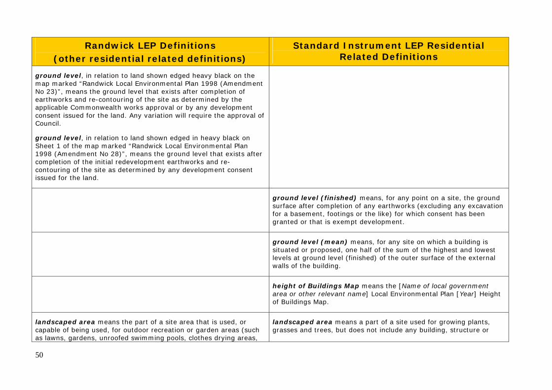
ground level means the level of a site that existed at the appointed day.
ground level (existing) means the existing level of a site at any point.
50
Randwick LEP Definitions (other residential related definitions)
Standard Instrument LEP Residential Related Definitions
ground level, in relation to land shown edged heavy black on the map marked “Randwick Local Environmental Plan 1998 (Amendment No 23)”, means the ground level that exists after completion of earthworks and re-contouring of the site as determined by the applicable Commonwealth works approval or by any development consent issued for the land. Any variation will require the approval of Council.
ground level, in relation to land shown edged in heavy black on Sheet 1 of the map marked “Randwick Local Environmental Plan 1998 (Amendment No 28)”, means the ground level that exists after completion of the initial redevelopment earthworks and re-contouring of the site as determined by any development consent issued for the land.
ground level (finished) means, for any point on a site, the ground surface after completion of any earthworks (excluding any excavation for a basement, footings or the like) for which consent has been granted or that is exempt development.
ground level (mean) means, for any site on which a building is situated or proposed, one half of the sum of the highest and lowest levels at ground level (finished) of the outer surface of the external walls of the building.
height of Buildings Map means the [Name of local government area or other relevant name] Local Environmental Plan [Year] Height of Buildings Map.
landscaped area means the part of a site area that is used, or capable of being used, for outdoor recreation or garden areas (such as lawns, gardens, unroofed swimming pools, clothes drying areas,
landscaped area means a part of a site used for growing plants, grasses and trees, but does not include any building, structure or

51
Randwick LEP Definitions (other residential related definitions)
Standard Instrument LEP Residential Related Definitions
barbecue areas, footpaths and the like) and includes landscaped podium areas and water tanks located at ground level. It does not include areas used for parking, driveways, balconies, rooftop gardens or areas used for garbage or recycling material storage or sorting.
hard paved area.
lot Size Map means the [Name of local government area or other relevant name] Local Environmental Plan [Year] Lot Size Map.
private open space means an area external to a building (including an area of land, terrace, balcony or deck) that is used for private outdoor purposes ancillary to the use of the building.
site area, in relation to development, means the area of land to which an application for consent to carry out development relates, but does not include any part of that land on which the development is not permitted by or under this plan or any other environmental planning instrument.
site area means the area of any land on which development is or is to be carried out. The land may include the whole or part of one lot, or more than one lot if they are contiguous to each other, but does not include the area of any land on which development is not permitted to be carried out under this Plan.
Note. The effect of this definition is varied by clause 4.5 for the purpose of the determination of permitted floor space area for proposed development.
site coverage means the proportion of a site area covered by buildings. However, the following are not included for the purpose of calculating site coverage:
(a) any basement, (b) any part of an awning that is outside the outer walls of a building and that adjoins the street frontage or other site boundary, (c) any eaves, (d) unenclosed balconies, decks, pergolas and the like.
storey means a space within a building that is situated between one

52
Randwick LEP Definitions (other residential related definitions)
Standard Instrument LEP Residential Related Definitions
floor level and the floor level next above, or if there is no floor above, the ceiling or roof above, but does not include:
(a) a space that contains only a lift shaft, stairway or meter room, or (b) a mezzanine, or (c) an attic.
wall height means the vertical distance from the highest point on an external wall to the ground level of the site. Each external wall height measurement must include gable ends and attic walls with an area over 6 metres2 and dormer windows that protrude horizontally from the roof more than 2.5 metres.

53
Appendix D: FSR Analysis
1.0 FSR Comparison: NSW Housing Code, Dwelling House and Attached Dual Occupancy DCP, Previous Planning Controls and Best Practice
Floor space ratio comparisons
Floor space ratio is the ratio of the total amount of floor space (or gross floor area) of a development divided by the site area. It is a common tool used to guide the density of development, and usually works together with other planning controls such as building height, setbacks and landscaped area to guide overall bulk and scale.
Dwelling Houses
Randwick City controls In Randwick City, floor space ratios are provided for single dwellings in the Dwelling Houses and Dual Occupancy DCP (the DCP), which has been in place since 2000. A previous DCP - Randwick DCP 4 (DCP 4) operated between 1985 and 2000, and contained higher floor space ratios than the current controls. NSW Housing Code In 2008 the NSW government introduced the NSW Housing Code (the Code) which applies across the state, and is commonly also known as the Codes SEPP. It is intended to apply to low impact situations, and development proposals are assessed by a building certifier under numerical criteria contained in the Code. The Code allows for new houses and alterations and additions to houses to be approved through a complying development process rather than a development application. There is currently a reasonable degree of variation in the floor space controls for houses between the Randwick Dwelling House and Dual Occupancy DCP and the Housing Code. Existing Development Sample testing of existing dwellings on a range of lot sizes in Randwick City shows that in many cases the existing building already exceeds the nominated FSR. Industry best practice examples As a government statutory authority responsible for developing residential areas on surplus sites, Landcom has prepared a series of design guidelines for new dwellings. These are not statutory documents, but have been tested and applied in a range of developments, and are regarded as industry best practice. Landcom’s Reference Chart: Residential Density and Planning Controls (Typical FSR and lot areas for house types) provides FSR guidelines for dwellings across a range of lot sizes. Section 4.0 illustrates these FSRs and some examples.
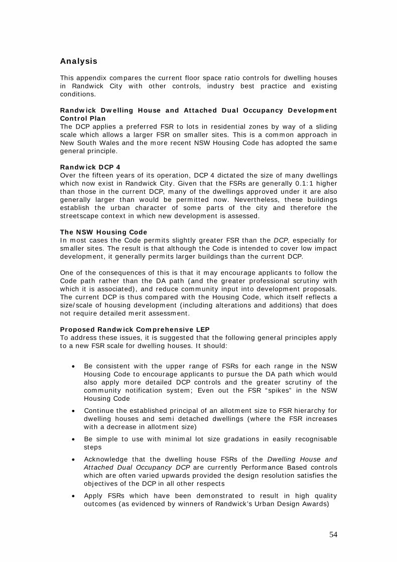
54
Analysis
This appendix compares the current floor space ratio controls for dwelling houses in Randwick City with other controls, industry best practice and existing conditions. Randwick Dwelling House and Attached Dual Occupancy Development Control Plan The DCP applies a preferred FSR to lots in residential zones by way of a sliding scale which allows a larger FSR on smaller sites. This is a common approach in New South Wales and the more recent NSW Housing Code has adopted the same general principle. Randwick DCP 4 Over the fifteen years of its operation, DCP 4 dictated the size of many dwellings which now exist in Randwick City. Given that the FSRs are generally 0.1:1 higher than those in the current DCP, many of the dwellings approved under it are also generally larger than would be permitted now. Nevertheless, these buildings establish the urban character of some parts of the city and therefore the streetscape context in which new development is assessed. The NSW Housing Code In most cases the Code permits slightly greater FSR than the DCP, especially for smaller sites. The result is that although the Code is intended to cover low impact development, it generally permits larger buildings than the current DCP. One of the consequences of this is that it may encourage applicants to follow the Code path rather than the DA path (and the greater professional scrutiny with which it is associated), and reduce community input into development proposals. The current DCP is thus compared with the Housing Code, which itself reflects a size/scale of housing development (including alterations and additions) that does not require detailed merit assessment. Proposed Randwick Comprehensive LEP To address these issues, it is suggested that the following general principles apply to a new FSR scale for dwelling houses. It should:
Be consistent with the upper range of FSRs for each range in the NSW Housing Code to encourage applicants to pursue the DA path which would also apply more detailed DCP controls and the greater scrutiny of the community notification system; Even out the FSR “spikes” in the NSW Housing Code
Continue the established principal of an allotment size to FSR hierarchy for dwelling houses and semi detached dwellings (where the FSR increases with a decrease in allotment size)
Be simple to use with minimal lot size gradations in easily recognisable steps
Acknowledge that the dwelling house FSRs of the Dwelling House and Attached Dual Occupancy DCP are currently Performance Based controls which are often varied upwards provided the design resolution satisfies the objectives of the DCP in all other respects
Apply FSRs which have been demonstrated to result in high quality outcomes (as evidenced by winners of Randwick’s Urban Design Awards)

55
Apply FSRs which reflect best practice (see Landcom’s Reference Chart: Residential Density and Planning Controls (Typical FSR and lot areas for house types)
Recognise the realistic development expectations for lots of various sizes
Recognise that larger lots (>800m2) could potentially be subdivided to the minimum lot size to accommodate the greater floor space permitted on a smaller lot; and
Recognise that the FSR will be an absolute maximum which may not always be achievable given the constraints of the full suite of planning controls applying to a site.
Some of the key characteristics of the proposed new FSR range are as follows:
Maintains generally the same simple lot size/FSR gradations as the current Dwelling House and Attached Dual Occupancy DCP but without the complexity of the formula:
o 0 - <300m2 o 300m2 – 450 m2 o 451m2 - <600m2 o 600m2 +
Allotments under 300m2 (typical of terrace houses and the like): merit assessment (with no FSR) in recognition of the higher density and widely variable site circumstances which are historically characteristic of this type of development
Allotments 300m2 - <450m2: an FSR of 0.75:1
Allotments 450m2 - < 600m2: an FSR of 0.65:1
Allotments 600m2 +: an FSR of 0.6:1
The table below illustrates the FSRs for a variety of lot sizes under a variety of planning instruments. In particular, it compares the current Dwelling House and Attached Dual Occupancy DCP to the NSW Housing Code and also the now superseded Randwick DCP 4. It also summarises the range of FSRs which Landcom In the final column, it proposes an FSR which attempts to resolve the implications of all three controls. The grey and white banding distinguishes each FSR gradation from another.

56
Lot Size Range m2
Lot Size m2
Randwick Dwelling House DCP (2000-)
NSW Housing Code (2011-)
Randwick DCP 4 (1985-2000)
Landcom
Comprehensive LEP Option
200 0.65:1 0.72:1 0.75:1 250 0.65:1 0.70:1 0.75:1
<300
299 0.65:1 0.73:1 0.75:1
0.35:1 - 1.1:1
Merit
301 0.60:1 0.78:1 0.75:1 0.75:1 310 0.60:1 0.75:1 0.75:1 0.75:1 349 0.60:1 0.67:1 0.75:1 0.75:1 350 0.60:1 0.66:1 0.75:1 0.75:1 351 0.60:1 0.67:1 0.725:1 0.75:1 400 0.60:1 0.59:1 0.725:1 0.75:1 401 0.60:1 0.58:1 0.70:1 0.75:1 449 0.60:1 0.52:1 0.70:1 0.75:1
301-450
450 0.60:1 0.65:1 0.70:1
0.35:1 – 0.75:1
0.75:1 451 0.60:1 0.65:1 0.675:1 0.65:1 500 0.57:1 0.59:1 0.675:1 0.65:1 501 0.57:1 0.59:1 0.65:1 0.65:1 550 0.53:1 0.53:1 0.65:1 0.65:1 551 0.53:1 0.53:1 0.625:1 0.65:1 599 0.50:1 0.49:1 0.625:1 0.65:1
451-600
600 0.50:1 0.57:1 0.625:1
0.45:1 – 0.65:1
0.65:1 601 0.50:1 0.57:1 0.60:1 0.60:1 650 0.50:1 0.53:1 0.60:1 0.60:1 700 0.50:1 0.49:1 0.60:1 0.60:1 750 0.50:1 0.46:1 0.60:1 0.60:1
>600
800 0.50:1 0.43:1 0.60:1
0.4:1 – 0.525:1
0.60:1 NB: the NSW Housing Code does not use FSR but a maximum floor area for certain lot sizes. As the floor area definition of the Code includes the area of a garage and the gross floor area definition used in the Standard Instrument does not, the above FSRs in column 3 have been calculated by deducting the size of a double garage (36m2) from the floor space allowances of the NSW Housing Code to achieve a general equivalent FSR.

57
Built Examples of Various FSRs The following photographs of recently built dwellings in Randwick City (many winners or finalists in the Randwick City Urban Design Awards) demonstrate the streetscape impacts of a variety of these FSRs (to nearest 0.05:1).
0.8:1 0.75:1
14 St Pauls Lane, Randwick (Joint Winner, Single Dwelling House Alterations & Additions Category, Randwick City Urban Design Awards 1010) (Nb re-use of historical dwelling)
29 Queen Street, Randwick (Joint Winner, Single Dwelling House Alterations & Additions Category, Randwick City Urban Design Awards 1010)
0.7:1 0.6:1
15 Clifton Road, Clovelly (Entrant, New Single Dwelling Housing Category, Randwick City Urban Design Awards 1010)
66 Melody Street, Coogee (Highly Commended, New Single Dwelling Housing Category, Randwick City Urban Design Awards 1010)
0.5:1
6 Murra Murra Place, Little Bay (Winner, New Single Dwelling Housing Category, Randwick City Urban Design Awards 1010)

58
2.0 Historical FSR Controls for Dwelling Houses The following table shows the historical FSRs for dwelling houses contained in the Randwick Development Control Plan No. 4 Dwelling House Controls 1985.

59
3.0 Residential Zone – Allotment Sizes The following tables summarise the different lot sizes for each residential zone in Randwick City which were used to aid the FSR analysis for the 2B and 2C zones (as discussed in Chapter 6). 2.1 2A Zone Allotment size m2 Number Proportion <100 15 0.08% 100-200 222 0.26% 201-300 2777 15.80% 301-400 3737 21.26% 401-500 3756 21.37% 501-600 3659 20.82% 601-700 2240 12.74% 701-800 661 3.74% 801-900 224 1.27% 901-1000 79 0.44% >1000 204 1.16% Total allotments: 17,574 2.2 2B Zone Allotment size m2 Number Proportion <100 57 1.5%
100-200 131 3.47%
201-300 849 22.49%
301-400 915 24.23% 401-500 704 18.65% 501-600 455 12.06% >600 664 17.59%
Total Allotments: 3,775 2.3 2C Zone Allotment Size m2 Number Proportion <100 15 0.5% >100 and <200 149 4.5%
>200 and <300 684 20.6% >300 and <400 637 19.2% >400 and <500 451 13.6% >500 and <600 337 10.1% >600 and <700 323 9.7% >700 and <800 149 4.5% >800 and <900 101 3% >900 and <1000 76 2.3% >1000 392 11.8%
Total Allotments: 3314

60
4.0 Landcom Residential Density and Planning Controls

61
5.0 NSW Department of Planning and Infrastructure Draft Good Design for Medium Density Living
The following extracts are from the Department of Planning and Infrastructure publication: Draft Good Design for Medium Density Living. The publication showcases examples of well designed, low rise infill residential projects that are suitable for a variety of locations and contexts.
Canada Bay Council Cabarita Courtyard house development Site Area: 5,330m2 Building Height: 2 - 3 storey
FSR: 1:1
Site Coverage: 60%
City of Sydney Beaconsfield Town house development Site Area: 386m2
Building Height: 9m
FSR: 1.14:1
Site Coverage: 71%

62
North Sydney Council
Waverton
Apartments
Site Area: 614.3m2
Building Height: 10m
FSR: 1:1
Site Coverage: 46%
City of Sydney Redfern Mix of apartments and town houses Site Area: 9,709m2
Building Height: 15metres (3-4 storey apartment building and 1-3 storey town houses) FSR: 0.96:1 Site coverage: 44%
Source: www.planning.nsw.gov.au

63
Appendix E: Zoning Mismatches and Rezoning Submissions

64
1. Todman Ave Precinct: 1-29 Todman Avenue, 2A Milroy Avenue, 1-11 Samuel Terry Avenue, Kensington
Existing zoning map
Zoning mismatch map
Current Planning Controls
Current Zone: 2A Residential (Low Density)
Permitted FSR: 0.5:1 (applicable to attached dual occupancies only)
Permitted Height: 9.5m
Description
No. lots + total site area Lots: 16, Total site area: 13,6682 (approx)
No. Buildings 16
Type of Buildings 15 residential flat buildings (multi-unit housing) and 1 townhouse complex
Building Height Generally 2 storeys
Key justification for planning change
The residential flat buildings (multi-unit housing) are a non-conforming use in the 2A low density residential zone. The proposed change is to reflect the existing land use, built form, scale and low-medium density character of these sites.

65
Recommendation: Proposed Zone: R3 (Medium Density)
Proposed FSR: 0.75:1
Proposed Height: 9.5m

66
2. Oberon St Precinct: 166-202 Oberon Street, 346 Arden Street, 270A Rainbow Street, 174-186 Brook Street, Coogee
Existing zoning
Zoning mismatch map
Current Planning Controls
Current Zone: 2A Residential (Low Density)
Permitted FSR: 0.5:1 (applicable to attached dual occupancies)
Permitted Height: 9.5m
Description
No. lots + total site area Lots: 15, Total site area: 11,849 m2 (approx)
No. Buildings 15
Building Types: 9 residential flat buildings ( multi-unit housing)
2 Semi detached dwellings
2 detached dwellings
2 dual occupancy
Building Height 2 - 4 storeys
Key justification for planning change
The residential flat buildings are non conforming uses in the 2A low density zone. The proposed change is to reflect the predominant land use, built form, scale and medium density character of these sites.
Recommendation: Proposed Zone: R3 Proposed FSR: 0.9:1
Proposed Height: 12m

67
3. Denning St Precinct: 58 Denning Street, 2-10 Carlie Place, 147-167 Malabar Road, South Coogee
Existing zoning map Zoning mismatch map
Current Planning Controls
Current Zone: 2A Residential (Low Density)
Permitted FSR: 0.5:1 (applicable to attached dual occupancies)
Permitted Height: 9.5m
Description
No. lots + total site area Lots: 12, Total site area: 7,580m2 (approx)
No. Buildings 12
Building Types: 9 residential flat buildings.
1 semi
1 dual occupancy
1 town house complex
Building Height 2 - 4 storeys

68
Key justification for planning change
The residential flat buildings are non conforming uses in the 2A low density residential zone. The proposed change is to reflect the predominant land use, built form, scale and medium density character of these sites.
Recommendation: Proposed Zone: R3 Proposed FSR: 0.9:1
Proposed Height: 12m

69
4. Mirrabooka Cr Precinct: 1409A Anzac Parade, Little Bay
Existing zoning map Zoning mismatch map
Current Planning Controls
Current Zone: 2A Residential (Low Density)
Permitted FSR: 0.5:1 (applicable to attached dual occupancies)
Permitted Height: 9.5m
Description
No. lots + total site area Lots: 1, Total site area: 6,643 m2 (approx)
No. Buildings 11
Building Types: Low scale residential flat buildings (multi-unit housing)
Building Height Generally 2 storeys
Key justification for planning change
The low scale residential flat buildings are a non conforming use in the existing 2A low density zone. The proposed change is to reflect the existing land use, built form, scale and low-medium density character of these sites. Adjacent sites are zoned 2B Residential with similar scale of development.
Recommendation: Proposed Zone: R3 Proposed FSR: 0.75:1
Proposed Height: 9.5m

70
5. Beauchamp Rd Precinct: 1-23 and 2-14 Bowen Place, 1-37 and 2-34 Manwaring Avenue, 1-17 and 2-40 Hughes Ave, , 2-12 Farthing Place, 1-19 and 2-26 Bennett Place, 116-132 Broome Street, 2-52 and 1-39 White Ave, 449-483 Beauchamp Road, Maroubra
Existing zoning map Zoning mismatch map
Current Planning Controls
Current Zone: 2A Residential (Low Density)
Permitted FSR: 0.5:1 (applicable to attached dual occupancies)
Permitted Height: 9.5m
Description
No. lots + total site area Lots: 193, Total site area: 59,500 m2 (approx)
No. Buildings 191
Building Types: Generally Semi detached dwellings, villas, town houses (multi-unit housing)
Building Height 2 storeys
Key justification for planning change
The low scale villas and town houses are non-conforming uses in the 2A low density zone. They mirror development zoned 2B l-w medium density adjacent to the north and appears to be a zoning error in RLEP 1998.The proposed change is to reflect the existing predominant land use, built form, scale and low-medium density

71
character of these sites.
Recommendation: Proposed Zone: R3 Proposed FSR: 0.75:1
Proposed Height:9.5m

72
6. Broome St Precinct: 81-91 Broome Street, Maroubra
Existing zoning map
Zoning mismatch map
Current Planning Controls
Current Zone: 2A Residential (Low Density)
Permitted FSR: 0.5:1 (applicable to attached dual occupancies)
Permitted Height: 9.5m
Description
No. lots + total site area Lots: 6, Total site area: 7,860m2 (approx)
No. Buildings 6
Building Types: Residential flat buildings
Building Height Height: 4 storeys
Key justification for planning change
The residential flat buildings are non conforming uses in the 2A low density zone. They mirror development to the north (zoned Residential 2C) and appear to be a zoning error in RLEP 1998.The

73
proposed change is to reflect the existing land use, built form, scale and medium density character of these sites.
Recommendation: Proposed Zone: R3
Proposed FSR: 0.9:1
Proposed Height: 12m
74
7. Courland St Precinct: 23 Courland St, 216-218 and 230-230A Carrington Rd, 39-41 Dolphin St, Randwick, 44-54 Coogee St
Existing zoning map
Zoning mismatch map
Current Planning Controls
Current Zone: 2B Residential (Low - medium density)
Permitted FSR: 0.65:1
Permitted Height: 9.5m
Description
No. lots + total site area Lots: 11, Total site area: 6,430 m2 (approx)
No. Buildings 11
Building Types: 7 Residential flat buildings 1 dual occupancy
2 Semi detached dwelling 1 dwelling house
Building Height Up to 4 storeys
Key justification for planning change
The majority of the residential flat buildings have a built form that is of a higher scale than provided for under the 2B (low-medium density) zone. The proposed change is to reflect the existing built
75
form and medium density character of these lots. The commercial uses contained within this block are discussed in the Business Centres Discussion Paper.
Recommendation: Proposed Zone: R3
Proposed FSR: 0.9:1
Proposed Height: 12m

76
8. Carrington Rd Precinct: 89-141 Carrington Road, Coogee
Existing zoning map
Zoning mismatch map
Current Planning Controls
Current Zone: 2B Residential (Low- medium density)
Permitted FSR: 0.65:1
Permitted Height: 9.5m
Description
No. lots + total site area Lots: 22, Total site area: 15,500 m2 (approx)
No. Buildings 22
Building Types: 18 residential flat buildings 2 dual occupancy
2 dwelling houses
Building height Height: 1 - 3 storeys
Heritage LEP Heritage Items 142 (117 Carrington Rd), 144 (127 Carrington Rd)
Key justification for planning change
The built form of the residential flat buildings is of a higher scale than provided for under 2B low-medium density zone. The proposed change is to reflect the existing built form and medium density character of these sites.

77
Recommendation: Proposed zone: R3
Proposed FSR: 0.9:1
Proposed Height: 12m

78
9. Alison Rd Precinct: 233-243 Alison Road, 70-78 St Marks Rd and 1-5 Pitt St, Randwick
Existing zoning map
Zoning mismatch map
Current Planning Controls
Current Zone: 2B Residential (Low- Medium Density)
Permitted FSR: 0.65:1
Permitted Height: 9.5m
Description
No. lots + total site area Lots: 14, Total site area: 10,100 m2 (approx)
No. Buildings 14
Building Types: 10 residential flat buildings 1 boarding house
1 dual occupancy
2 dwelling houses
Built Form Height: 2 - 4 storeys
Key justification for planning change
The built form of the majority of residential flat buildings is of a higher scale than provided for under the 2B low-medium density zone. The proposed change is to reflect the medium density built form and character of the sites, as per sites adjacent along Alison Rd.

79
Recommendation: Proposed Zone: R3
Proposed FSR: 0.9:1
Proposed Height: 12m
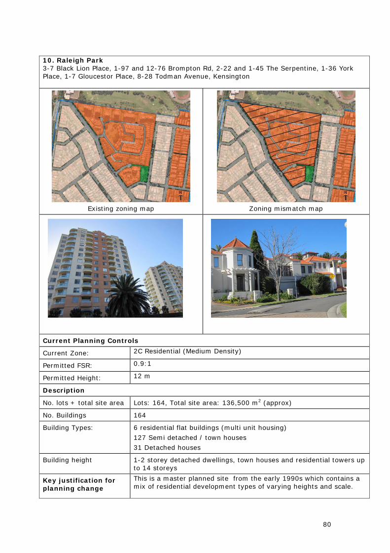
80
10. Raleigh Park 3-7 Black Lion Place, 1-97 and 12-76 Brompton Rd, 2-22 and 1-45 The Serpentine, 1-36 York Place, 1-7 Gloucestor Place, 8-28 Todman Avenue, Kensington
Existing zoning map
Zoning mismatch map
Current Planning Controls
Current Zone: 2C Residential (Medium Density)
Permitted FSR: 0.9:1
Permitted Height: 12 m
Description
No. lots + total site area Lots: 164, Total site area: 136,500 m2 (approx)
No. Buildings 164
Building Types: 6 residential flat buildings (multi unit housing)
127 Semi detached / town houses
31 Detached houses
Building height 1-2 storey detached dwellings, town houses and residential towers up to 14 storeys
Key justification for planning change
This is a master planned site from the early 1990s which contains a mix of residential development types of varying heights and scale.

81
Option 1: Proposed Zone: R3 Proposed FSR: (either 0.75:1 or 0.9:1 depending on lot size)
Proposed Height: 9.5m or 12m
Option 2:
Proposed Zone: R1: (General)
Proposed FSR: Can be graded to reflect existing FSR
Proposed Height: Can be graded to reflect existing height.
Recommendation: The preferred option is no 2. The R1 General residential zone provides for a variety of housing types and densities and therefore best reflects the character and built form of the sites. The different heights and FSR can be graded on the Comprehensive LEP height and FSR maps.

82
11. Coogee Bay Rd Precinct: 36-112 Coogee Bay Road, 26-28 St Luke St, 1 Nathan St, 262A and 251 Carrington Rd, Randwick
Existing zoning map
Zoning mismatch map
Current Planning Controls
Current Zone: 2B Residential (Low to medium density)
Permitted FSR: 0.65:1
Permitted Height: 9.5m
Description
No. lots + total site area Lots: 36, Total site area: 16,500m2 (approx)
No. Buildings 30
Building Types: 22 residential flat buildings 1 boarding house
6 Semi detached 1 dual occupancy
Built Form Height: 1 - 4 storeys
Key justification for planning change
The built form of the majority of residential flat buildings is of a higher scale than provided for under the 2B low-medium density zone. The proposed change is to reflect the medium density built form and character of the sites.
Recommendation: Proposed Zone: R3
Proposed FSR: 0.9:1

83
Proposed Height: 12m

84
Table 1 lists submissions and requests relevant to residential or business lands in Randwick City that have been received from the community and property owners as part of the overall Comprehensive LEP/DCP project to date. These submissions are a combination of detailed site-specific spot rezoning proposals, and more general correspondence. The majority are not discussed in detail at this stage, although preliminary considerations are included, where relevant, based on a review in the context of the discussion paper recommendations. These and other submissions that will be received during the public exhibition of the discussion papers will be reviewed in detail following completion of the exhibition of all discussion papers, and final recommendations will be included in the draft LEP. The draft LEP will involve a further public exhibition process before finalisation of any zones and controls. Business Centres Submissions have been received on ten sites in or around business centres that are within existing business zones, or are seeking a business zoning. Preliminary recommendations are made for these locations, in the context of the review in the Business Centres Discussion Paper. These will be further reviewed following public exhibition of the Paper, and recommendations incorporated into the draft LEP. Residential Areas Submissions in residential areas received to date have been cross-checked against locations of zoning mismatches identified in the Residential Discussion Paper. A preliminary recommendation is made if these locations overlap, while other submissions are listed for information only and will be considered in detail in the draft LEP. Table 1: Submissions relating to residential or business zones Location Submission/request Preliminary consideration Requests for sites in or around business centres 86 Clovelly road Randwick
Request to change from medium density residential to business zone (borders Frenchman’s Road centre)
Refer data sheets in Business Centres Discussion Paper
950 Anzac Parade Maroubra
Spot rezoning proposal - low to medium density residential zone (borders Maroubra junction town centre, and adjacent to RSL)
Refer data sheets in Business Centres Discussion Paper
391-417 Anzac Parade Kingsford
Spot rezoning proposal – medium density residential to business zone (borders Kingsford town centre)
Refer data sheets in Business Centres Discussion Paper
772-784 Anzac Parade Maroubra
Spot rezoning proposal – low density residential to business zone (borders Maroubra Junction town centre)
Refer data sheets in Business Centres Discussion Paper
Schedule of submissions

85
Location Submission/request Preliminary consideration 131 Alison Road Randwick
Randwick Labor Club spot rezoning – seeking additional permissible use of “clubs” to the site in existing 2C zone
Refer data sheets in Business Centres Discussion Paper
131 Malabar road South Coogee
Request for increased height/density controls for existing neighbourhood business centre
Refer data sheets in Business Centres Discussion Paper
1401-1409 Anzac Pde Little Bay
Extend existing business zone, and review development standards (opposite Prince Henry site)
Refer data sheets in Business Centres Discussion Paper
58-60 Carr Street Coogee
Change from medium density residential to business zoning (borders Coogee village centre)
Refer data sheets in Business Centres Discussion Paper
31-33 McKeon St Maroubra Beach
Change from medium density residential to business zoning (borders Maroubra Beach centre)
Refer data sheets in Business Centres Discussion Paper
1-11 Rainbow St Kingsford
STA/Council land: change from open space to business zoning (borders Kingsford town centre)
Refer data sheets in Business Centres Discussion Paper
Requests in residential areas 80-90 Barker Street Kingsford
Spot rezoning proposal – low to medium/high density residential
To be considered in draft LEP
48-60 Pauling Ave Coogee
Spot rezoning proposal - low to medium density residential
To be considered in draft LEP
88 and 90 Botany St Kingsford
Request to upzone from residential 2B to 2C
To be considered in draft LEP
94 St Pauls St Randwick
Request to upzone land from residential 2A
To be considered in draft LEP
34 Glebe St, Randwick Request to upzone from residential 2A to 2C
To be considered in draft LEP
149-155 Belmore Rd, Randwick
Request to increase density controls from current 2B to facilitate redevelopment
To be considered in draft LEP
Struggletown precinct, Randwick
Request to upzone from 2A to 2B, and reduce minimum lot size for subdivision
To be considered in draft LEP
26 Oberon St, Randwick Request to upzone land from 2A to 2B/C
To be considered in draft LEP
19 Howard St, Randwick
Request to upzone from low to medium density residential zone
To be considered in draft LEP
11-29 Middle street Request to upzone from residential 2B to 2C
To be considered in draft LEP
978 Anzac Parade Maroubra
Change from low to medium density residential zone
To be considered in draft LEP
555-563 Bunnerong Rd Matraville
Change from low density to medium density residential zone
To be considered in draft LEP
2-4 Howard Place Randwick
Change from low density to medium density residential zone
To be considered in draft LEP

86
Appendix F: Comparison of Existing and Proposed LEP Clauses

87
Randwick LEP 1998 Comprehensive RLEP 2011
20A Exempt and complying development
(1) Development of minimal environmental impact listed as exempt development in Table A of Development Control Plan—Exempt and Complying Development, as adopted by the Council on 25 September 2007 is exempt development, despite any other provision of this plan.
(2) Development listed as complying development in Tables B, C and D of Development Control Plan—Exempt and Complying Development, as adopted by the Council on 25 September 2007 is complying development if: (a) it is local development of a kind that can be carried out with consent on the land on which it is proposed, and (b) it is not an existing use as defined in section 106 of the Act. (3) Development is exempt or complying development only if it complies with the development standards and other requirements applied to the development by Development Control Plan—Exempt and Complying Development, as adopted by the Council on 25 September 2007. (4) A complying development certificate issued for any complying development is to be subject to the conditions for the development specified in Development Control Plan—Exempt and Complying Development, adopted by the
3.1 Exempt development [compulsory]
Note. Under section 76 of the Act, exempt development may be carried out without the need for development consent under Part 4 of the Act or for assessment under Part 5 of the Act.
The section states that exempt development:
(a) must be of minimal environmental impact, and (b) cannot be carried out in critical habitat of an endangered species, population or ecological community (identified under the Threatened Species Conservation Act 1995 or the Fisheries Management Act 1994), and (c) cannot be carried out in a wilderness area (identified under the Wilderness Act 1987). (1) The objective of this clause is to identify development of minimal environmental impact as exempt development. (2) Development specified in Schedule 2 that meets the standards for the development contained in that Schedule and that complies with the requirements of this Part is exempt development. (3) To be exempt development, the development: (a) must meet the relevant deemed-to-satisfy provisions of the Building Code of Australia or, if there are no such relevant provisions, must be structurally adequate, and (b) must not, if it relates to an existing building, cause the building to contravene the Building Code of Australia, and (c) must not be designated development, and

88
Randwick LEP 1998 Comprehensive RLEP 2011
Council, as in force when the certificate is issued. Note. State Environmental Planning Policy (Exempt and Complying Development Codes) 2008 specifies exempt and complying development under the Policy. The Policy has State-wide application and commenced on 27 February 2009. If any development specified by the Policy is the same as the development specified by Development Control Plan for Exempt and Complying Development approved by the Council on 25 September 2007, the Development Control Plan will no longer apply to that development.
(d) must not be carried out on land that comprises, or on which there is, an item that is listed on the State Heritage Register under the Heritage Act 1977 or that is subject to an interim heritage order under the Heritage Act 1977. (e) (Repealed) (4) Development that relates to an existing building that is classified under the Building Code of Australia as class 1b or class 2–9 is exempt development only if: (a) the building has a current fire safety certificate or fire safety statement, or (b) no fire safety measures are currently implemented, required or proposed for the building. (5) To be exempt development, the development must: (a) be installed in accordance with the manufacturer’s specifications, if applicable, and (b) not involve the removal or pruning of a tree or other vegetation that requires a permit or development consent for removal or pruning, unless that removal or pruning is undertaken in accordance with a permit or development consent. Note. A permit for the removal or pruning of a tree or other vegetation may be granted under this Plan. A development consent for the removal of native vegetation may be granted where relevant under the Native Vegetation Act 2003. (6) A heading to an item in Schedule 2 is part of that Schedule.

89
Randwick LEP 1998 Comprehensive RLEP 2011
3.2 Complying development [compulsory]
Note. Under section 76A of the Act, development consent for the carrying out of complying development may be obtained by the issue of a complying development certificate.
The section states that development cannot be complying development if:
(a) it is on land that is critical habitat of an endangered species, population or ecological community (identified under the Threatened Species Conservation Act 1995 or the Fisheries Management Act 1994), or (b) it is on land within a wilderness area (identified under the Wilderness Act 1987), or (c) the development is designated development, or (d) the development is on land that comprises, or on which there is, an item of environmental heritage (that is listed on the State Heritage Register or in Schedule 5 to this Plan or that is subject to an interim heritage order under the Heritage Act 1977), or (e) the development requires concurrence (except a concurrence of the Director-General of the Department of Environment, Climate Change and Water in respect of development that is likely to significantly affect a threatened species, population, or ecological community, or its habitat (identified under the Threatened Species Conservation Act 1995)), or (f) the development is on land identified as an environmentally sensitive area. (1) The objective of this clause is to identify development as complying development.

90
Randwick LEP 1998 Comprehensive RLEP 2011
(2) Development specified in Part 1 of Schedule 3 that is carried out in compliance with: (a) the development standards specified in relation to that development, and (b) the requirements of this Part, is complying development. Note. See also clause 5.8 (3) which provides that the conversion of fire alarms is complying development in certain circumstances. (3) To be complying development, the development must: (a) be permissible, with development consent, in the zone in which it is carried out, and (b) meet the relevant deemed-to-satisfy provisions of the Building Code of Australia, and (c) have an approval, if required by the Local Government Act 1993, from the Council for an on-site effluent disposal system if the development is undertaken on unsewered land. (4) A complying development certificate for development specified in Part 1 of Schedule 3 is subject to the conditions (if any) set out or referred to in Part 2 of that Schedule. (5) A heading to an item in Schedule 3 is part of that Schedule.

91
Randwick LEP 1998 Comprehensive RLEP 2011
20B MINIMUM ALLOTMENT SIZE (1) The minimum allotment size for allotments resulting from the subdivision of land, other than for the purpose of public utility undertakings or roads, within Zone No 2A is 400 square metres and each allotment must have a frontage of at least 12 metres. (2) The minimum allotment size for allotments resulting from the subdivision of land, other than for the purpose of public utility undertakings or roads, within Zone No 2B or 2C is 325 square metres and each allotment must have a frontage of at least 9 metres. This requirement does not apply to development for the purposes of multi-unit housing. (3) The minimum allotment size for the erection of a dwelling house within Zone No 2A is 400 square metres and the allotment must have a frontage of at least 12 metres. (4) The minimum allotment size for an attached dual occupancy within Zone No 2A is 450 square metres and the allotment must have a frontage of at least 15 metres. (5) This clause does not prohibit the erection of a dwelling house within Zone No 2A, 2B or 2C on an allotment of land that existed as a separate allotment on the appointed day.
Purpose: To establish minimum requirements for the subdivision of land within residential zones in order to protect and improve local amenity.
4.1 MINIMUM SUBDIVISION LOT SIZE [OPTIONAL]
(1) The objectives of this clause are as follows: (a) [set out objectives of the clause] (2) This clause applies to a subdivision of any land shown on the Lot Size Map that requires development consent and that is carried out after the commencement of this Plan. (3) The size of any lot resulting from a subdivision of land to which this clause applies is not to be less than the minimum size shown on the Lot Size Map in relation to that land. Direction. An exception to the minimum size shown on the Lot Size Map may be provided in certain circumstances, for example, in the case of land that is to be used for attached dwellings. (4) This clause does not apply in relation to the subdivision of individual lots in a strata plan or community title scheme.
92
Randwick LEP 1998 Comprehensive RLEP 2011
20C SITE SPECIFIC DEVELOPMENT CONTROLS
(1) This clause applies to land the subject of a built form control map inset. (2) The maximum floor space ratios for development of land to which this clause applies are shown on the built form control map inset for that land. (3) The minimum landscaped areas for development of land to which this clause applies are shown on the built form control map inset for that land. (4) The maximum building and wall heights for development of land to which this clause applies are shown on the built form control map inset for that land. (5) In this clause:
built form control map inset means an inset shown on the map and marked “Inset 1—Pindari Built Form Controls”, “Inset 2—Bundock Street Built Form Controls” or “Inset 3—Prince Henry Built Form Controls”.
Purpose: To provide for controls in relation to the size, scale and site coverage of development on land the subject of a built form control map inset.
No equivalent clause.

93
Randwick LEP 1998 Comprehensive RLEP 2011
20D TRAFFIC AND TRANSPORT MEASURES FOR
ZONE NO 2D
(1) This clause applies to land within Zone No 2D (Residential D—Comprehensive Development Zone). (2) Despite any other provision of this plan, the Council must not grant consent to development of land within Zone No 2D unless it is satisfied that any relevant traffic or transport measures that may apply will be met.
No equivalent clause.
20E LANDSCAPED AREA
(1) Development, otherwise than for the purpose of a dwelling house, within Zone No 2A must provide a minimum of 40% of the total site area as landscaped area. (2) Development, otherwise than for the purpose of a dwelling house, within Zone No 2B or 2C must provide a minimum of 50% of the total site area as landscaped area. (3) Landscaped areas over podiums or excavated basement areas must not exceed 50% of the landscaped area requirements specified in subclauses (1) and (2).
Purpose: To operate together with controls for floor space ratio and building height to limit the size, scale and site coverage of a building having regard to the environmental amenity and aesthetic character of the area.
No equivalent clause

94
Randwick LEP 1998 Comprehensive RLEP 2011
20F FLOOR SPACE RATIOS
(1) The maximum floor space ratios for buildings, other than buildings erected for the purpose of a dwelling house, within Zones Nos 2A, 2B and 2C is 0.5:1, 0.65:1 and 0.9:1, respectively. (2) Despite subclause (1), the maximum floor space ratio for buildings, other than buildings erected for the purpose of a dwelling house, within Zone No 2C is 0.65:1 where the site area is less than 700 square metres. (3) The maximum floor space ratios for buildings within Zones Nos 3A and 3B are shown by distinctive shading on the map. (4) The maximum floor space ratio for buildings within Zone No 4A or 4B is 1:1. (5) The maximum floor space ratio for buildings within Zone No 5 to be used for the purpose of boarding houses, dwellings or multi-unit housing (or any two or more of them) is 0.5:1. (6) The area of the access corridor for a battleaxe allotment is not to be included in the calculation of the floor space ratio of any building on the allotment.
Purpose: To operate together with controls for building height and landscaped area to limit the size, scale and site coverage of a building having regard to the environmental amenity and aesthetic character of the area.
5.2 4.4 FLOOR SPACE RATIO [OPTIONAL]
(1) The objectives of this clause are as follows: (a) [set out objectives of the clause] (2) The maximum floor space ratio for a building on any land is not to exceed the floor space ratio shown for the land on the Floor Space Ratio Map. Direction. Different floor space ratios may be shown on the FSR map for different zones, for different land in the same zone or for different land uses within a building. This Plan may provide that, despite subclause (2), the maximum floor space ratio for a building is to be determined partly by the FSR map and partly by other means, or wholly by other means.

95
Randwick LEP 1998 Comprehensive RLEP 2011
20G BUILDING HEIGHTS
(1) The maximum height for a building, other than a dwelling house, within Zone No 2A or 2B is 9.5 metres measured vertically from any point on ground level. (2) The maximum height for a building, other than a dwelling house, within Zone No 2C is 12 metres measured vertically from any point on ground level. (3) The maximum height for any external wall of a building, other than a dwelling house, within Zone No 2A or 2B is 7 metres measured vertically from any point on ground level. (4) The maximum height for any external wall of a building, other than a dwelling house, within Zone No 2C is 10 metres measured vertically from any point on ground level. (5) The maximum height for buildings within Zone No 3A or 3B are shown by distinctive shading on the map. (6) For the purposes of this clause, chimneys, vents and other service installations may exceed the specified height limits, but only where the Council is satisfied that they will not adversely affect the amenity of adjoining or nearby land.
Purpose: To operate together with controls for floor space ratio and landscaped area to limit the size, scale and site coverage of a building having regard to the environmental amenity and aesthetic character of the area.
4.3 HEIGHT OF BUILDINGS [OPTIONAL]
(1) The objectives of this clause are as follows: (a) [set out objectives of the clause] (2) The height of a building on any land is not to exceed the maximum height shown for the land on the Height of Buildings Map. Direction. Different heights may be shown on the map for different zones or for different land in the same zone. This Plan may also provide for specified height restrictions to be varied or modified in certain circumstances, for example, to prevent overshadowing of public open space, for air safety reasons or for the purposes of promoting design excellence.

96
Randwick LEP 1998 Comprehensive RLEP 2011
No equivalent clause
4.5 CALCULATION OF FLOOR SPACE RATIO AND SITE
AREA [OPTIONAL]
(1) Objectives The objectives of this clause are as follows: (a) to define floor space ratio, (b) to set out rules for the calculation of the site area of development for the purpose of applying permitted floor space ratios, including rules to: (i) prevent the inclusion in the site area of an area that has no significant development being carried out on it, and (ii) prevent the inclusion in the site area of an area that has already been included as part of a site area to maximise floor space area in another building, and (iii) require community land and public places to be dealt with separately. (2) Definition of “floor space ratio” The floor space ratio of buildings on a site is the ratio of the gross floor area of all buildings within the site to the site area. (3) Site area In determining the site area of proposed development for the purpose of applying a floor space ratio, the site area is taken to be: (a) if the proposed development is to be carried out on only one lot, the area of that lot, or (b) if the proposed development is to be carried out on 2 or

97
Randwick LEP 1998 Comprehensive RLEP 2011
more lots, the area of any lot on which the development is proposed to be carried out that has at least one common boundary with another lot on which the development is being carried out.
In addition, subclauses (4)–(7) apply to the calculation of site area for the purposes of applying a floor space ratio to proposed development.
(4) Exclusions from site area The following land must be excluded from the site area: (a) land on which the proposed development is prohibited, whether under this Plan or any other law, (b) community land or a public place (except as provided by subclause (7)). (5) Strata subdivisions The area of a lot that is wholly or partly on top of another or others in a strata subdivision is to be included in the calculation of the site area only to the extent that it does not overlap with another lot already included in the site area calculation. (6) Only significant development to be included The site area for proposed development must not include a lot additional to a lot or lots on which the development is being carried out unless the proposed development includes significant development on that additional lot.
7) Certain public land to be separately considered For the purpose of applying a floor space ratio to any proposed
98
Randwick LEP 1998 Comprehensive RLEP 2011
development on, above or below community land or a public place, the site area must only include an area that is on, above or below that community land or public place, and is occupied or physically affected by the proposed development, and may not include any other area on which the proposed development is to be carried out.
(8) Existing buildings The gross floor area of any existing or proposed buildings within the vertical projection (above or below ground) of the boundaries of a site is to be included in the calculation of the total floor space for the purposes of applying a floor space ratio, whether or not the proposed development relates to all of the buildings.
9) Covenants to prevent “double dipping” When development consent is granted to development on a site comprised of 2 or more lots, a condition of the consent may require a covenant to be registered that prevents the creation of floor area on a lot (the restricted lot) if the consent authority is satisfied that an equivalent quantity of floor area will be created on another lot only because the site included the restricted lot.
10) Covenants affect consolidated sites If:
(a) a covenant of the kind referred to in subclause (9) applies to any land (affected land), and
(b) proposed development relates to the affected land and other land that together comprise the site of the proposed development,

99
Randwick LEP 1998 Comprehensive RLEP 2011
the maximum amount of floor area allowed on the other land by the floor space ratio fixed for the site by this Plan is reduced by the quantity of floor space area the covenant prevents being created on the affected land. (11) Definition In this clause, public place has the same meaning as it has in the Local Government Act 1993.
21 SUBDIVISION—CONSENT REQUIREMENTS
(1) Land to which this plan applies may be subdivided, but only with consent. (2) However, consent is not required for a subdivision within Zone No 8, or a subdivision for the purpose only of any one or more of the following: (a) widening a public road, (b) a minor realignment of boundaries that does not create: (i) additional lots or the opportunity for additional dwellings, or (ii) lots that are smaller than the minimum size provided for by or under this plan in relation to the land concerned, (c) a consolidation of lots that does not create additional lots or the opportunity for additional dwellings, (d) rectifying an encroachment on a lot, (e) creating a public reserve, (f) excising from a lot land that is, or is intended to be, used for public purposes, including drainage purposes,
2.6 SUBDIVISION—CONSENT REQUIREMENTS
[COMPULSORY]
(1) Land to which this Plan applies may be subdivided, but only with development consent. Note. If a subdivision is identified as exempt development in an applicable environmental planning instrument, such as this Plan or State Environmental Planning Policy (Exempt and Complying Development Codes) 2008, the Act enables it to be carried out without development consent. (2) Development consent must not be granted for the
subdivision of land on which a secondary dwelling is situated if the subdivision would result in the principal dwelling and the secondary dwelling being situated on separate lots, unless the resulting lots are not less than the minimum size shown on the Lot Size Map in relation to that land.

100
Randwick LEP 1998 Comprehensive RLEP 2011
rural fire brigade or other emergency service purposes or public toilets.
Note. The definition of secondary dwelling in the Dictionary requires the dwelling to be on the same lot of land as the principal dwelling.
27 AIRCRAFT NOISE
(1) This clause applies to land where the ANEF contour exceeds 20. (2) Development consent must not be granted to development on land to which this clause applies unless the consent authority is satisfied that the proposed development meets the requirements of AS 2021 regarding interior noise levels relevant to the particular type of development. (3) In this clause:
ANEF means a relevant Australian Noise Exposure Forecast contour map showing the forecast of aircraft noise levels that is expected to exist in the future produced in accordance with the Guidelines for the Production of Noise Contours for Australian Airports published by Airservices Australia.
AS 2021 means AS 2021—2000, Acoustics—Aircraft noise intrusion—Building siting and construction.
Purpose: To ensure that development for the purposes of residential accommodation, places of worship, hospitals, educational establishments or other noise sensitive
7.6 DEVELOPMENT IN AREAS SUBJECT TO AIRCRAFT
NOISE
(1) The objectives of this clause are to: (a) prevent certain noise sensitive developments from being located near the [Name] Airport and its flight paths, (b) assist in minimising the impact of aircraft noise from that airport and its flight paths by requiring appropriate noise attenuation measures in noise sensitive buildings, (c) to ensure that land use and development in the vicinity of that airport do not hinder or have any other adverse impacts on the ongoing, safe and efficient operation of that airport. (2) This clause applies to development that: (a) is on land that: (i) is near the [Name] Airport, and (ii) is in an ANEF contour of 20 or greater, and (b) the consent authority considers is likely to be adversely affected by aircraft noise. (3) Before determining a development application for development to which this clause applies, the consent authority: (a) must consider whether the development will result in an increase in the number of dwellings or people affected by aircraft noise, and (b) must consider the location of the development in relation to

101
Randwick LEP 1998 Comprehensive RLEP 2011
buildings are not adversely affected by aircraft noise.
the criteria set out in Table 2.1 (Building Site Acceptability Based on ANEF Zones) in AS 2021-2000, Acoustics-Aircraft noise intrusion- Building siting and construction, and (c) must be satisfied that the development will meet AS 2021—2000, Acoustics- Aircraft noise intrusion- Building siting and construction with respect to interior noise levels for the purposes of: (i) if the development will be in an ANEF contour of 20 or greater - child care centres, educational establishments, entertainment facilities, hospitals, places of public worship, public administration buildings or residential accommodation, and (ii) if the development will be in an ANEF contour of 25 or greater – business premises, hostels, hotel or motel accommodation, office premises or retail premises. (3) In this clause: airport means civil, military or joint civil and military airport. ANEF contour means a noise exposure contour shown as an ANEF contour on the Australian Noise Exposure Forecast Contour Map for that airport endorsed by the Department of the Commonwealth responsible for airports.
29 FORESHORE SCENIC PROTECTION AREA
(1) The foreshore scenic protection area is shown on the map. (2) The consent authority may only grant consent to a
No equivalent clause.

102
Randwick LEP 1998 Comprehensive RLEP 2011
building within the foreshore scenic protection area after it has considered the probable aesthetic appearance of the proposed building in relation to the foreshore.
Purpose: To protect and improve the visual qualities of visually prominent areas along the coast.
30 CONVERSION OF FIRE ALARMS
(1) This clause applies to a fire alarm system that can be monitored by New South Wales Fire Brigades or by a private service provider. (2) The following development may be carried out, but only with consent: (a) converting a fire alarm system from connection with the alarm monitoring system of New South Wales Fire Brigades to connection with the alarm monitoring system of a private service provider, (b) converting a fire alarm system from connection with the alarm monitoring system of a private service provider to connection with the alarm monitoring system of another private service provider, (c) converting a fire alarm system from connection with the alarm monitoring system of a private service provider to connection with a different alarm monitoring system of the same private service provider. (3) Development to which subclause (2) applies is complying development if it consists only of: (a) internal alterations to a building, or
5.8 CONVERSION OF FIRE ALARMS [COMPULSORY]
(1) This clause applies to a fire alarm system that can be monitored by Fire and Rescue NSW or by a private service provider. (2) The following development may be carried out, but only with development consent: (a) converting a fire alarm system from connection with the alarm monitoring system of Fire and Rescue NSW to connection with the alarm monitoring system of a private service provider, (b) converting a fire alarm system from connection with the alarm monitoring system of a private service provider to connection with the alarm monitoring system of another private service provider, (c) converting a fire alarm system from connection with the alarm monitoring system of a private service provider to connection with a different alarm monitoring system of the same private service provider. (3) Development to which subclause (2) applies is complying development if it consists only of: (a) internal alterations to a building, or (b) internal alterations to a building together with the

103
Randwick LEP 1998 Comprehensive RLEP 2011
(b) internal alterations to a building together with the mounting of an antenna, and any support structure, on an external wall or roof of a building so as to occupy a space of not more than 450mm × 100mm × 100mm. (4) A complying development certificate for any such complying development is subject to a condition that any building work may only be carried out between 7.00 am and 6.00 pm on Monday to Friday and between 7.00 am and 5.00 pm on Saturday, and must not be carried out on a Sunday or a public holiday. (5) In this clause:
private service provider means a person or body that has entered into an agreement that is in force with New South Wales Fire Brigades to monitor fire alarm systems.
mounting of an antenna, and any support structure, on an external wall or roof of a building so as to occupy a space of not more than 450mm × 100mm × 100mm. (4) A complying development certificate for any such complying development is subject to a condition that any building work may only be carried out between 7.00 am and 6.00 pm on Monday to Friday and between 7.00 am and 5.00 pm on Saturday, and must not be carried out on a Sunday or a public holiday. (5) In this clause:
private service provider means a person or body that has entered into an agreement that is in force with Fire and Rescue NSW to monitor fire alarm systems.
34 BOARDING HOUSES
(1) This clause applies to a building or place that is used for the purpose of a boarding house and includes any vacant building or part of a building that, when last used or occupied, was used or occupied as a boarding house. (2) The consent of the Council is required in respect of a building or place to which this clause applies: (a) to a different use of the building or place resulting from a change of the use of the building or place to another use not being a boarding house, or (b) to demolish the building or place, or (c) to make any alterations or additions to the building or place.
No equivalent clause.
Nb: Similar provisions covered in the Affordable Rental Housing SEPP.

104
Randwick LEP 1998 Comprehensive RLEP 2011
(3) When determining an application required by this clause, the Council may grant its consent only where it has made an assessment of and considered the implications of: (a) the need to retain the particular type of housing in relation to any identified needs of the local area, and (b) the accumulated impact that the loss of the building or place for use as a boarding house will have on the supply of that type of housing in the local area, and (c) any building and fire safety requirements, and (d) the financial viability of the continued use of the building or place as a boarding house, and (e) whether arrangements have been made or will be made to assist residents who may be displaced by the development, and (f) the availability of other buildings suitable for use as affordable housing, having regard to their location, type, size, rent levels and available services, and (g) any adverse social and economic effects caused by the development on affordable housing stocks and on households in the local community on very low, low or moderate incomes who are spending 30% or greater of gross incomes on rent or home purchase expenses.
Purpose: To make provision for the assessment of the cumulative loss of boarding house accommodation.
35 BUSINESS PREMISES IN RESIDENTIAL ZONES
Despite clauses 10, 11 and 12, the Council may grant consent to the development of land within Zone No 2A, 2B or 2C for the purpose of business premises, but only if the
No equivalent clause.

105
Randwick LEP 1998 Comprehensive RLEP 2011
Council is satisfied that the proposed use: (a) is to be situated in a building, or part of a building, that was originally designed or constructed (or both) for use as business premises, and (b) does not occupy more than 100 square metres of floor space.
Purpose: To provide for the establishment and continued operation of small scale business development in residential zones
35A CERTAIN NON-RESIDENTIAL USES IN ZONE NO 2D
Despite clause 12A, the consent authority may grant consent to development for the purpose of business premises, neighbourhood shops or medical centres on land within Zone No 2D, but only if it is satisfied that the development: (a) is located on land identified as an activity strip in a development control plan for the land, approved by the Council, and (b) is limited to: (i) in the case of land to which Prince Henry Site Development Control Plan approved by the Council on 27 July 2004 applies, ground floor non-residential uses and first floor non-residential uses, and (ii) in any other case, to ground floor non-residential uses, and
No equivalent clause.

106
Randwick LEP 1998 Comprehensive RLEP 2011
(c) is consistent with residential amenity, and (d) primarily serves the local community.
Purpose: To provide for the establishment of small scale businesses and services with active street frontages in locations identified in a development control plan.
40A SITE SPECIFIC DEVELOPMENT CONTROL PLANS
(1) The consent authority must not grant consent to a development application made in respect of a site area consisting of more than 10,000 square metres of land unless a site specific development control plan for the development of that land has been prepared in accordance with this clause. (2) A site specific development control plan is to be prepared following consultation with the Council and is to address, illustrate and explain, where appropriate, proposals in relation to the land covering the following range of matters (but is not limited to them): (a) design principles drawn from an analysis of the site and its context, (b) phasing of development, (c) distribution of land uses, including public open space and environmental protection areas, (d) subdivision pattern, (e) building envelopes and built form controls, (f) heritage conservation, including both Aboriginal and European heritage,
No equivalent clause.

107
Randwick LEP 1998 Comprehensive RLEP 2011
(g) infrastructure provision, (h) remediation of the site, (i) pedestrian, cycle and road access and circulation network, with particular regard to public transport servicing, (j) parking provision, (k) provision of public facilities, (l) impact on, and improvements to, the public domain, (m) provision of open space, its function and landscaping, (n) identification and conservation of native flora and fauna habitat on the site, including any threatened species, populations or ecological communities, (o) the principles of ecologically sustainable development, (p) identification, extent and management of buffer areas, (q) identification, extent and management of water courses, wetlands and riparian lands, whether identified on the map or not, (r) identification, extent and management of habitat corridor, (s) identification, extent and constraints of acid sulfate soils, (t) opportunities to apply integrated natural water cycle design, (u) opportunities to apply integrated renewable energy design, (v) provision of housing mix and tenure choice, including affordable housing. (3) A proposal referred to in subclause (2) must conform to the requirements for development of the site made by this plan and any other environmental planning instrument. (4) The consent authority may waive the requirement for

108
Randwick LEP 1998 Comprehensive RLEP 2011
a development control plan, but only if it is satisfied: (a) that the proposed development is of a minor nature only or is ancillary to the current use of the land, or (b) that adequate guidelines and controls applying to the land are already in place.
Purpose: To require the development of large sites to be in the context of a site specific development control plan.
42 DEVELOPMENT OF LAND FOR CERTAIN ADDITIONAL PURPOSES
Despite the provisions of this plan, a person may, with the consent of the Council, carry out development on land described in Column 1 of Schedule 2 that is specified in Column 2 of that Schedule, subject to any conditions that may be specified in Column 3 of that Schedule.
Purpose: To make provision for additional uses of land in certain specified circumstances, where those uses are not permissible under the existing zoning of the land.
2.5 ADDITIONAL PERMITTED USES FOR PARTICULAR LAND [COMPULSORY]
(1) Development on particular land that is described or referred to in Schedule 1 may be carried out: (a) with development consent, or (b) if the Schedule so provides—without development consent, in accordance with the conditions (if any) specified in that Schedule in relation to that development. (2) This clause has effect despite anything to the contrary in the Land Use Table or other provision of this Plan.
Direction. While this clause and Schedule 1 are compulsory, it is not compulsory to include any items in the Schedule when the Plan is first made.

109
Randwick LEP 1998 Comprehensive RLEP 2011
43 HERITAGE CONSERVATION
(1) Objectives The objectives of this clause are: (a) to conserve the environmental heritage of Randwick City, and (b) to conserve the heritage significance of heritage items and heritage conservation areas including associated fabric, settings and views, and (c) to conserve known or potential archaeological sites, and (d) to conserve places of Aboriginal heritage significance. (2) Requirement for consent Development consent is required for any of the following: (a) demolishing or moving a heritage item or a building, work, relic or tree within a heritage conservation area, (b) altering a heritage item or a building, work, relic, tree or place within a heritage conservation area, including (in the case of a building) making changes to the detail, fabric, finish or appearance of its exterior, (c) altering a heritage item that is a building, by making structural changes to its interior, (d) disturbing or excavating a known or potential archaeological site while knowing, or having reasonable cause to suspect, that the disturbance or excavation will or is likely to result in a relic being discovered, exposed, moved, damaged or destroyed, (e) disturbing or excavating a heritage conservation area that is a place of Aboriginal heritage significance, (f) erecting a building on land on which a heritage item is
5.10 HERITAGE CONSERVATION [COMPULSORY]
Note. Heritage items (if any) are listed and described in Schedule 5. The Heritage Map may also show the location of a heritage item. Heritage conservation areas (if any) must be shown on the Heritage Map as well as being described in Schedule 5.
The location and nature of Aboriginal objects and Aboriginal places of heritage significance may be described in Schedule 5 and shown on the sheet of the Heritage Map marked “Aboriginal Heritage Map”.
(1) Objectives The objectives of this clause are as follows: (a) to conserve the environmental heritage of [Name of local government area or other relevant name], (b) to conserve the heritage significance of heritage items and heritage conservation areas, including associated fabric, settings and views, (c) to conserve archaeological sites, (d) to conserve Aboriginal objects and Aboriginal places of heritage significance. (2) Requirement for consent Development consent is required for any of the following: (a) demolishing or moving any of the following or altering the exterior of any of the following (including, in the case of a building, making changes to its detail, fabric, finish or appearance): (i) a heritage item,

110
Randwick LEP 1998 Comprehensive RLEP 2011
located or that is within a heritage conservation area, (g) subdividing land on which a heritage item is located or that is within a heritage conservation area. (3) When consent not required However, consent under this clause is not required if: (a) the applicant has notified the consent authority of the proposed development and the consent authority has advised the applicant in writing before any work is carried out that it is satisfied that the proposed development: (i) is of a minor nature, or is for the maintenance of the heritage item, known or potential archaeological site, or a building, work, relic, tree or place within a heritage conservation area, or (ii) would not adversely affect the significance of the heritage item, known or potential archaeological site or heritage conservation area, or (b) the development is in a cemetery or burial ground and the proposed development: (i) is the creation of a new grave or monument, or excavation or disturbance of land for the purpose of conserving or repairing monuments or grave markers, and (ii) would not cause disturbance to human remains, relics, Aboriginal objects in the form of grave goods, or to a place of Aboriginal heritage significance, or (c) the development is limited to the removal of a tree or other vegetation that the Council is satisfied is a risk to human life or property, or (d) the development is exempt development. (4) Effect on heritage significance
(ii) an Aboriginal object, (iii) a building, work, relic or tree within a heritage conservation area, (b) altering a heritage item that is a building by making structural changes to its interior or by making changes to anything inside the item that is specified in Schedule 5 in relation to the item, (c) disturbing or excavating an archaeological site while knowing, or having reasonable cause to suspect, that the disturbance or excavation will or is likely to result in a relic being discovered, exposed, moved, damaged or destroyed, (d) disturbing or excavating an Aboriginal place of heritage significance, (e) erecting a building on land: (i) on which a heritage item is located or that is within a heritage conservation area, or (ii) on which an Aboriginal object is located or that is within an Aboriginal place of heritage significance, (f) subdividing land: (i) on which a heritage item is located or that is within a heritage conservation area, or (ii) on which an Aboriginal object is located or that is within an Aboriginal place of heritage significance. (3) When consent not required However, development consent under this clause is not required if: (a) the applicant has notified the consent authority of the proposed development and the consent authority has advised the applicant in writing before any work is carried out that it is

111
Randwick LEP 1998 Comprehensive RLEP 2011
The consent authority must, before granting consent under this clause, consider the effect of the proposed development on the heritage significance of the heritage item or heritage conservation area concerned, including (where the proposed development involves a building) consideration of: (a) the pitch and form of the roof, if any, and (b) the style, size, proportion and position of the openings for windows or doors, if any, and (c) the colour, texture, style, size and type of finish of the materials to be used on the exterior of the building.
This subclause applies regardless of whether a heritage impact statement is prepared under subclause (5) or a heritage conservation management plan is submitted under subclause (6).
(5) Heritage impact assessment The consent authority may, before granting consent to any development on land: (a) on which a heritage item is situated, or (b) within a heritage conservation area, or (c) within the vicinity of land referred to in paragraph (a) or (b), require a heritage impact statement to be prepared that assesses the extent to which the carrying out of the proposed development would affect the heritage significance of the heritage item or heritage conservation area concerned. (6) Heritage conservation management plans The consent authority may require, after considering the
satisfied that the proposed development: (i) is of a minor nature or is for the maintenance of the heritage item, Aboriginal object, Aboriginal place of heritage significance or archaeological site or a building, work, relic, tree or place within the heritage conservation area, and (ii) would not adversely affect the heritage significance of the heritage item, Aboriginal object, Aboriginal place, archaeological site or heritage conservation area, or (b) the development is in a cemetery or burial ground and the proposed development: (i) is the creation of a new grave or monument, or excavation or disturbance of land for the purpose of conserving or repairing monuments or grave markers, and (ii) would not cause disturbance to human remains, relics, Aboriginal objects in the form of grave goods, or to an Aboriginal place of heritage significance, or (c) the development is limited to the removal of a tree or other vegetation that the Council is satisfied is a risk to human life or property, or (d) the development is exempt development. (4) Effect of proposed development on heritage significance The consent authority must, before granting consent under this clause in respect of a heritage item or heritage conservation area, consider the effect of the proposed development on the heritage significance of the item or area concerned. This subclause applies regardless of whether a heritage management document is prepared under subclause (5) or a heritage conservation management plan is submitted under subclause (6).

112
Randwick LEP 1998 Comprehensive RLEP 2011
significance of the heritage item or heritage conservation area and the extent of change proposed to it, the submission of a heritage conservation management plan before granting consent under this clause. (7) Archaeological sites The consent authority must, before granting consent under this clause to the carrying out of development on a known or potential archaeological site (other than land listed on the State Heritage Register or to which an interim heritage order applies): (a) notify the Heritage Office of its intentions to grant consent, and (b) take into consideration any response received from the Heritage Council within 28 days after the notice is sent. (8) Places of Aboriginal heritage significance The consent authority must, before granting consent under this clause to the carrying out of development in a place of Aboriginal heritage significance: (a) consider the effect of the proposed development on the heritage significance of the place and any Aboriginal object known or reasonably likely to be located at the place, and (b) notify the local Aboriginal communities (in such a way as it thinks appropriate) about the application and take into consideration any response received within 28 days after the notice is sent. (9) Demolition of item of State significance The consent authority must, before granting consent for
(5) Heritage assessment The consent authority may, before granting consent to any development: (a) on land on which a heritage item is located, or (b) on land that is within a heritage conservation area, or (c) on land that is within the vicinity of land referred to in paragraph (a) or (b),require a heritage management document to be prepared that assesses the extent to which the carrying out of the proposed development would affect the heritage significance of the heritage item or heritage conservation area concerned. (6) Heritage conservation management plans The consent authority may require, after considering the heritage significance of a heritage item and the extent of change proposed to it, the submission of a heritage conservation management plan before granting consent under this clause. (7) Archaeological sites The consent authority must, before granting consent under this clause to the carrying out of development on an archaeological site (other than land listed on the State Heritage Register or to which an interim heritage order under the Heritage Act 1977 applies): (a) notify the Heritage Council of its intention to grant consent, and (b) take into consideration any response received from the Heritage Council within 28 days after the notice is sent.

113
Randwick LEP 1998 Comprehensive RLEP 2011
the demolition of a heritage item identified in Schedule 3 as being of State heritage significance (other than an item listed on the State Heritage Register or to which an interim heritage order under the Heritage Act 1977 applies): (a) notify the Heritage Council about the application, and (b) take into consideration any response received within 28 days after the notice is sent. (10) Conservation incentives The consent authority may grant consent to the development for any purpose of a building that is a heritage item, or of the land on which such a building is erected, even though development for that purpose would otherwise not be allowed by this plan if the consent authority is satisfied that: (a) the conservation of the heritage item is facilitated by the granting of consent, and (b) the proposed development is in accordance with a heritage conservation management plan that has been approved by the consent authority, and (c) the consent to the proposed development would require that all necessary conservation work identified in the heritage conservation management plan is carried out, and (d) the proposed development would not adversely affect the heritage significance of the heritage item, including its setting, and (e) the proposed development would not have any significant adverse impact on the amenity of the surrounding area.
(8) Aboriginal places of heritage significance The consent authority must, before granting consent under this clause to the carrying out of development in an Aboriginal place of heritage significance: (a) consider the effect of the proposed development on the heritage significance of the place and any Aboriginal object known or reasonably likely to be located at the place by means of an adequate investigation and assessment (which may involve consideration of a heritage impact statement), and (b) notify the local Aboriginal communities, in writing or in such other manner as may be appropriate, about the application and take into consideration any response received within 28 days after the notice is sent. (9) Demolition of nominated State heritage items The consent authority must, before granting consent under this clause for the demolition of a nominated State heritage item: (a) notify the Heritage Council about the application, and (b) take into consideration any response received from the Heritage Council within 28 days after the notice is sent. (10) Conservation incentives The consent authority may grant consent to development for any purpose of a building that is a heritage item or of the land on which such a building is erected, or for any purpose on an Aboriginal place of heritage significance, even though development for that purpose would otherwise not be allowed by this Plan, if the consent authority is satisfied that: (a) the conservation of the heritage item or Aboriginal place of heritage significance is facilitated by the granting of consent, and

114
Randwick LEP 1998 Comprehensive RLEP 2011
(b) the proposed development is in accordance with a heritage management document that has been approved by the consent authority, and (c) the consent to the proposed development would require that all necessary conservation work identified in the heritage management document is carried out, and (d) the proposed development would not adversely affect the heritage significance of the heritage item, including its setting, or the heritage significance of the Aboriginal place of heritage significance, and (e) the proposed development would not have any significant adverse effect on the amenity of the surrounding area.
No equivalent clause
4.6 EXCEPTIONS TO DEVELOPMENT STANDARDS
[COMPULSORY]
(1) The objectives of this clause are as follows: (a) to provide an appropriate degree of flexibility in applying certain development standards to particular development, (b) to achieve better outcomes for and from development by allowing flexibility in particular circumstances. (2) Development consent may, subject to this clause, be granted for development even though the development would contravene a development standard imposed by this or any other environmental planning instrument. However, this clause does not apply to a development standard that is expressly excluded from the operation of this clause. (3) Development consent must not be granted for development that contravenes a development standard unless

115
Randwick LEP 1998 Comprehensive RLEP 2011
the consent authority has considered a written request from the applicant that seeks to justify the contravention of the development standard by demonstrating: (a) that compliance with the development standard is unreasonable or unnecessary in the circumstances of the case, and (b) that there are sufficient environmental planning grounds to justify contravening the development standard. (4) Development consent must not be granted for development that contravenes a development standard unless: (a) the consent authority is satisfied that: (i) the applicant’s written request has adequately addressed the matters required to be demonstrated by subclause (3), and (ii) the proposed development will be in the public interest because it is consistent with the objectives of the particular standard and the objectives for development within the zone in which the development is proposed to be carried out, and (b) the concurrence of the Director-General has been obtained. (5) In deciding whether to grant concurrence, the Director-General must consider: (a) whether contravention of the development standard raises any matter of significance for State or regional environmental planning, and (b) the public benefit of maintaining the development standard, and (c) any other matters required to be taken into consideration by the Director-General before granting concurrence. (6) Development consent must not be granted under this clause for a subdivision of land in Zone RU1 Primary Production, Zone RU2 Rural Landscape, Zone RU3 Forestry, Zone RU4

116
Randwick LEP 1998 Comprehensive RLEP 2011
Primary Production Small Lots, Zone RU6 Transition, Zone R5 Large Lot Residential, Zone E2 Environmental Conservation, Zone E3 Environmental Management or Zone E4 Environmental Living if: (a) the subdivision will result in 2 or more lots of less than the minimum area specified for such lots by a development standard, or (b) the subdivision will result in at least one lot that is less than 90% of the minimum area specified for such a lot by a development standard. (7) After determining a development application made pursuant to this clause, the consent authority must keep a record of its assessment of the factors required to be addressed in the applicant’s written request referred to in subclause (3). (8) This clause does not allow development consent to be granted for development that would contravene any of the following: (a) a development standard for complying development, (b) a development standard that arises, under the regulations under the Act, in connection with a commitment set out in a BASIX certificate for a building to which State Environmental Planning Policy (Building Sustainability Index: BASIX) 2004 applies or for the land on which such a building is situated, (c) clause 5.4. Direction. Additional exclusions may be added.
No equivalent clause
5.5
DEVELOPMENT WITHIN THE COASTAL ZONE (CLAUSE 5.5) [compulsory if land to which Plan applies includes land in the coastal zone]
117
Randwick LEP 1998 Comprehensive RLEP 2011
(1) The objectives of this clause are as follows:
(a) to provide for the protection of the coastal environment of the State for the benefit of both present and future generations through promoting the principles of ecologically sustainable development, (b) to implement the principles in the NSW Coastal Policy, and in particular to:
(i) protect, enhance, maintain and restore the coastal environment, its associated ecosystems, ecological processes and biological diversity and its water quality, and (ii) protect and preserve the natural, cultural, recreational and economic attributes of the NSW coast, and (iii) provide opportunities for pedestrian public access to and along the coastal foreshore, and (iv) recognise and accommodate coastal processes and climate change, and (v) protect amenity and scenic quality, and (vi) protect and preserve rock platforms, beach environments and beach amenity, and (vii) protect and preserve native coastal vegetation, and (viii) protect and preserve the marine environment, and (ix) ensure that the type, bulk, scale and size of development is appropriate for the location and protects and improves the natural scenic quality of the surrounding area, and (x) ensure that decisions in relation to new development consider the broader and cumulative impacts on the catchment, and (xi) protect Aboriginal cultural places, values and customs, and

118
Randwick LEP 1998 Comprehensive RLEP 2011
(xii) protect and preserve items of heritage, archaeological or historical significance.
(2) Consent must not be granted to development on land that is wholly or partly within the coastal zone unless the consent authority has considered: (a) existing public access to and along the coastal foreshore for pedestrians (including persons with a disability) with a view to:
(i) maintaining existing public access and, where possible, improving that access, and (ii) identifying opportunities for new public access, and
(b) the suitability of the proposed development, its relationship with the surrounding area and its impact on the natural scenic quality, taking into account:
(i) the type of the proposed development and any associated land uses or activities (including compatibility of any land-based and water-based coastal activities), and (ii) the location, and (iii) the bulk, scale, size and overall built form design of any building or work involved, and
(c) the impact of the proposed development on the amenity of the coastal foreshore including:
(i) any significant overshadowing of the coastal foreshore, and (ii) any loss of views from a public place to the coastal foreshore, and
(d) how the visual amenity and scenic qualities of the coast,

119
Randwick LEP 1998 Comprehensive RLEP 2011
including coastal headlands, can be protected, and (e) how biodiversity and ecosystems, including:
(i) native coastal vegetation and existing wildlife corridors, and (ii) rock platforms, and (iii) water quality of coastal waterbodies, and (iv) native fauna and native flora, and their habitats, can be conserved, and
(f) the cumulative impacts of the proposed development and other development on the coastal catchment. (3) Consent must not be granted to development on land that is wholly or partly within the coastal zone unless the consent authority is satisfied that: (a) the proposed development will not impede or diminish, where practicable, the physical, land-based right of access of the public to or along the coastal foreshore, and (b) if effluent from the development is disposed of by a non-reticulated system, it will not have a negative effect on the water quality of the sea, or any beach, estuary, coastal lake, coastal creek or other similar body of water, or a rock platform, and (c) the proposed development will not discharge untreated stormwater into the sea, or any beach, estuary, coastal lake, coastal creek or other similar body of water, or a rock platform.
120
Randwick LEP 1998 Comprehensive RLEP 2011
5.4 CONTROLS RELATING TO MISCELLANEOUS PERMISSIBLE USES [COMPULSORY]
(1) Bed and breakfast accommodation If development for the purposes of bed and breakfast accommodation is permitted under this Plan, the accommodation that is provided to guests must consist of no more than [insert number not less than 3] bedrooms. Note. Any such development that provides for a certain number of guests or rooms may involve a change in the class of building under the Building Code of Australia. (2) Home businesses If development for the purposes of a home business is permitted under this Plan, the carrying on of the business must not involve the use of more than [insert number not less than 30] square metres of floor area. (3) Home industries If development for the purposes of a home industry is permitted under this Plan, the carrying on of the home industry must not involve the use of more than [insert number not less than 30] square metres of floor area. (4) Industrial retail outlets If development for the purposes of an industrial retail outlet is permitted under this Plan, the retail floor area must not exceed: (a) [insert number not more than 67]% of the gross floor area of the industry or rural industry located on the same land as the retail outlet, or (b) [insert number not more than 400] square metres, whichever is the lesser. (5) Farm stay accommodation If development for the purposes of farm stay accommodation is

121
Randwick LEP 1998 Comprehensive RLEP 2011
permitted under this Plan, the accommodation that is provided to guests must consist of no more than [insert number not less than 3] bedrooms. (6) Kiosks If development for the purposes of a kiosk is permitted under this Plan, the gross floor area must not exceed [insert number not less than 10] square metres. (7) Neighbourhood shops If development for the purposes of a neighbourhood shop is permitted under this Plan, the retail floor area must not exceed [insert number not less than 80] square metres. (8) Roadside stalls If development for the purposes of a roadside stall is permitted under this Plan, the gross floor area must not exceed [insert number not less than 8] square metres. (9) Secondary dwellings If development for the purposes of a secondary dwelling is permitted under this Plan, the total floor area of the dwelling (excluding any area used for parking) must not exceed whichever of the following is the greater: (a) 60 square metres, (b) [insert number]% of the total floor area of the principal dwelling.
CONTAMINATED LAND (CLAUSE 42B) Despite any other provisions of this plan, the Council must not grant consent to the development of contaminated land within any zone unless the Council is satisfied: (a) that the contaminated land will, after being remediated, be suitable for the purpose for which
SEPP 55 – REMEDIATION OF LAND contains this provision.

122
Randwick LEP 1998 Comprehensive RLEP 2011
development is proposed to be carried out, and (b) that the contaminated land will be remediated before the land is used for that purpose, and (c) that the use of the land for that purpose is permissible in the zone. Purpose: To ensure land will be suitable after remediation for the purpose for which the development is proposed and that the land will be remediated to that suitable standard before it is used.
No equivalent clause
DRAFT MODEL LOCAL PROVISION – COASTAL RISK PLANNING (1) The objectives of this clause are: (a) to maintain existing coastal processes and to avoid significant adverse impacts from those coastal processes; and (b) to enable safe evacuation of coastal risk areas in an emergency; and (c) to avoid significant adverse effects on the environment, and (d) to ensure uses are compatible with coastal risks, including projected sea level rise. (2) This clause applies to land shown as “coastal risk area” on the XXX Council Local Environmental Plan Coastal Risk Planning Map. (3) Consent must not be granted to development on land to which this clause applies unless the consent authority is satisfied that the development:

123
Randwick LEP 1998 Comprehensive RLEP 2011
(a) will not adversely affect coastal processes resulting in detrimental increases in coastal risk exposure of other development or properties; and (b) will not significantly alter coastal processes to the detriment of the environment; and (c) will make provision for safe evacuation of the land; (d) if located seaward of the immediate hazard line, will avoid or minimise exposure to coastal processes; and (e) makes provision for relocation, modification or removal of the development if required to adapt to coastal processes and projected sea level rise. (4) In this clause: coastal risks include coastal erosion and tidal inundation. immediate hazard line is the line identified on the Coastal Risk Planning Map which represents the estimated extent of beach erosion from a design storm event (as outlined in the draft Coastal Risk Management Guide 2009). projected sea level rise means the 2050 and 2100 sea level rise planning benchmarks as specified in the NSW Government’s Sea Level Rise Policy Statement 2009.

124
Randwick LEP 1998 Comprehensive RLEP 2011
No equivalent clause
DRAFT MODEL LOCAL PROVISION – STORMWATER (1) The objective of this clause is to minimise the impacts of urban stormwater on the land to which the development applies, adjoining properties, native bushland and receiving waters. (2) This clause applies to all land zoned Residential, Business and Industrial land uses. (3) Before granting consent to development to which this clause applies the consent authority must be satisfied that the development: (a) is designed to maximise the use of water permeable surfaces on the site having regard to the soil characteristics affecting on-site infiltration of water, (b) include, where practical, on-site stormwater retention for use as an alternative supply to mains water, groundwater or river water; and (c) avoids, or where an impact cannot be avoided, minimises and mitigates, the disturbance and impacts of stormwater runoff on adjoining properties, native bushland and receiving waters.
No equivalent clause
MODEL LOCAL PROVISION – ACID SULFATE SOILS (1) The objective of this clause is to ensure that development does not disturb, expose or drain acid sulfate soils and cause environmental damage.

125
Randwick LEP 1998 Comprehensive RLEP 2011
(2) Development consent is required for the carrying out of works described in the Table to this subclause on land shown on the Acid Sulfate Soils Map as being of the class specified for those works. Class of land Works 1) Any works. 2) Works below the natural ground surface. Works by which the watertable is likely to be lowered. 3) Works more than 1 metre below the natural ground surface. Works by which the watertable is likely to be lowered more than 1 metre below the natural ground surface. 4) Works more than 2 metres below the natural ground surface. Works by which the watertable is likely to be lowered more than 2 metres below the natural ground surface. 5) Works within 500 metres of adjacent Class 1, 2, 3 or 4 land that is below 5 metres Australian Height Datum by which the watertable is likely to be lowered below 1 metre Australian Height Datum on adjacent Class 1, 2, 3 or 4 land. (3) Development consent must not be granted under this clause for the carrying out of works unless an acid sulfate soils management plan has been prepared for the proposed works in accordance with the Acid Sulfate Soils Manual and has been provided to the consent authority. (4) Despite subclause (2), development consent is not required under this clause for the carrying out of works if:
126
Randwick LEP 1998 Comprehensive RLEP 2011
(a) a preliminary assessment of the proposed works prepared in accordance with the Acid Sulfate Soils Manual indicates that an acid sulfate soils management plan need not be carried out for the works, and (b) the preliminary assessment has been provided to the consent authority and the consent authority has confirmed the assessment by notice in writing to the person proposing to carry out the works. (5) Despite subclause (2), development consent is not required under this clause for the carrying out of any of the following works by a public authority (including ancillary work such as excavation, construction of access ways or the supply of power): (a) emergency work, being the repair or replacement of the works of the public authority required to be carried out urgently because the works have been damaged, have ceased to function or pose a risk to the environment or to public health and safety, (b) routine maintenance work, being the periodic inspection, cleaning, repair or replacement of the works of the public authority (other than work that involves the disturbance of more than 1 tonne of soil), (c) minor work, being work that costs less than $20,000 (other than drainage work). (6) Despite subclause (2), development consent is not required under this clause to carry out any works if: (a) the works involve the disturbance of less than 1 tonne of soil, such as occurs in carrying out agriculture, the construction or maintenance of drains, extractive industries, dredging, the

127
Randwick LEP 1998 Comprehensive RLEP 2011
construction of artificial water bodies (including canals, dams and detention basins) or foundations or flood mitigation works, or (b) the works are not likely to lower the watertable. (7) Clause 10 of State Environmental Planning Policy No 4—Development Without Consent and Miscellaneous Exempt and Complying Development does not apply to development that requires development consent under this clause.
No equivalent clause
MODEL LOCAL PROVISION – FLOOD PLANNING (1) The objectives of this clause are as follows: (a) to minimise the flood risk to life and property associated with the use of land, (b) to allow development on land that is compatible with the land’s flood hazard, taking into account projected changes as a result of climate change, (c) to avoid significant adverse impacts on flood behaviour and the environment. (2) This clause applies to: (a) land that is shown as “Flood planning area” on the Flood Planning Map, and (b) other land at or below the flood planning level. Drafting direction Councils know of some areas that flood and those areas are mapped as "flood planning area", but there are other areas where accurate mapping is not possible. Consequently, the wording of this subclause captures the land that can be

128
Randwick LEP 1998 Comprehensive RLEP 2011
accurately mapped and the land that cannot. Such unmapped land includes the “flood planning area” (as defined in the Floodplain Development Manual) up to the “flood planning level”. (3) Development consent must not be granted to development on land to which this clause applies unless the consent authority is satisfied that the development: (a) is compatible with the flood hazard of the land; and (b) will not significantly adversely affect flood behaviour resulting in detrimental increases in the potential flood affectation of other development or properties, and (c) incorporates appropriate measures to manage risk to life from flood, and (d) will not significantly adversely affect the environment or cause avoidable erosion, siltation, destruction of riparian vegetation or a reduction in the stability of river banks or watercourses, and (e) is not likely to result in unsustainable social and economic costs to the community as a consequence of flooding. (4) A word or expression used in this clause has the same meaning as it has in the NSW Government’s Floodplain Development Manual published in 2005, unless it is otherwise defined in this clause. (5) In this clause: flood planning level means the level of a 1:100 ARI (average recurrent interval) flood event plus [insert number 0.xx] metre freeboard. Flood Planning Map means the [Name] Local Environmental Plan 2010 Flood Planning Map.

129
Appendix G: Dwelling numbers
Dwelling Targets
The Sydney Metropolitan Strategy (2005) and associated draft Sydney East Subregional Strategy (2007) set 25 year dwelling targets for the overall Sydney Metropolitan region, each subregion and each local government area. Although meeting these targets is not mandatory, they must be considered in local planning processes. For Randwick City, a target of an additional 8400 dwellings between 2005 and 2031 is identified in the draft Sydney East Subregional Strategy. Approach Randwick City’s planning and policy approach in terms of meeting current and future housing needs, is to focus the majority of new dwellings in and around town centres (within walking distance of shops, jobs, public transport, facilities and services) as well as within carefully planned master planned developments on large surplus sites. Analysis The following analysis of dwellings completed since 2004-05, and likely growth to 2031 shows that the dwelling target for Randwick City will be able to be met without significant changes to current planning controls.
Dwellings completed 2004 – 2010 Since 2004-05, approximately 3300 additional dwellings have been constructed in Randwick City. The data in the table below from the Department of Planning and Infrastructure’s Metropolitan Urban Development Program (MUDP) calculates additional dwellings recorded from new Sydney Water connections. This method is used by the MUDP across the Sydney Metropolitan area to record and track new dwelling completions. Some categories of dwellings may not be captured through this method (eg: where individual water connections are not installed), such as some student housing. Information provided by the MUDP on the overall number of additional dwellings completed between 2004 and 2010 indicates around 3300 have been completed in total. To date a breakdown of this data by location is available up to the year 2008-09. Table 1 shows a total of 2474 new dwellings completed since 2004-05, and the distribution is illustrated on Map 1.

130
Table 1: Dwellings completed between 2004/5 and 2008/9 based on new Sydney Water connections (Source: MUDP – NSW Department of Planning and Infrastructure)
Infill Areas Year 1 2-10 11-50 51-
100 101+
Business Centres
Specialised Centre
Major Sites
2004-05 13 47 30 183 29 34 2005-06 49 71 88 93 286 18 11 2006-07 33 42 77 110 367 34 13 2007-08 60 58 41 184 40 170 2008-09 32 45 117 34 65 TOTAL 18
7 263 236 93 110 1137 154 293
Commentary Dwellings in infill locations Infill locations cover all areas in Randwick City excluding town centres, large master-planned sites or the Randwick Education and Health Specialised Centre. From Table 1, an average of 178 additional infill dwellings per year have been completed over a 5 year period, but shows a high degree of variation from year to year, ranging from a low figure of 77 dwellings per year to a high figure of 301 9in 2008/09 and 2005/06 respectivley). Infill development shown in Table 1 is broken down by development type and size:
Additional single dwellings capture dual occupancy developments and new single houses (eg: on vacant lots or new subdivisions). These primarily occur in the southern part of the LGA.
2-10 dwellings captures townhouse or smaller scale flat buildings (eg: replacing older single houses on large blocks)
11-50 dwellings commonly includes 3 to 4 storey walk-up flat buildings that can be accommodated on larger single sites, or amalgamated lots
Larger developments of over 50 dwellings in infill locations are infrequent, but some examples are included in the snapshot of recently completed developments below.
Examples of completed developments
The table below provides a snapshot of a range of residential developments completed since 2004/05 in a range of locations across Randwick City, including larger developments in business centres and surplus sites, student accommodation and medium density walk-up apartment developments.

131
Table 2: Examples of completed residential developments between 2004/5 and 2010 Location/Address Dwelling
number Notes
Major Development sites Bundock Street Randwick 51 Prince Henry site, Little Bay 317 Business Centres 737 Anzac Parade Maroubra 263 Pacific square phase 2 892-906 Anzac Pde Maroubra 104 Cnr Maroubra road 438 Anzac Pde Kingsford 74 Castellorizian site 305 Anzac Parade Kingsford 47 Boarding house 159-171 Anzac Pde Kensington 55 Unilodge site 268-270 Anzac Pde Kensington 164 Capella site 14-18 Darling St Kensington 68 Corner Anzac Parade 36 McKeon St Maroubra Beach 30 178-180 Marine Pde Maroubra Bch 47 Specialised Centre UNSW Village, High Street 303 303 units, 1013 beds.
Completed 2010 New college, UNSW 260 319 beds Barker lodge 65 Completed 2010 Infill/other 30-36 Dangar St Randwick 115 Montefiore (276 aged care beds) 88-96 King Street Randwick 93 Former brickworks site 68-76 Wentworth Ave Randwick 22 Pindari (stage 1)

132
Map 1: Distribution of dwellings completed between 2004/5 and 2008/09 (source: MUDP)

133
Future Dwelling Estimates Overview Table 3 below shows a breakdown of where new dwellings are estimated to occur over the next 20 years, from 2011 to 2031. These figures are estimates only, and are based on an analysis of the likely dwelling capacity under existing planning controls. When combined with the 3300 dwellings completed between 2004/05 and 2010, it shows that the dwelling target for Randwick City of 8400 is able to be met without requiring significant planning changes. Table 3: Estimate of new dwellings between 2011 and 2031 (rounded)
Locations Estimated Dwellings 2011 - 2031
Low High
Business Centres 1500 1800
Randwick Education & Health Specialised Centre
1500 1500
Major Development (ie: master-plan) sites
Prince Henry site, Little Bay (500 - 600)
Bundock Street, Randwick (50 – 450)
Charter Hall site, Little Bay (450)
Endeavour House site, Randwick (140)
1100 1700
Infill areas 1000 2500
TOTAL 5100 7500 Dwelling demand
Factors affecting demand While the population growth rate in Randwick City itself is projected to remain generally low, the continued fall in average household size coupled with demographic changes (such as an ageing population) and decline in housing affordability indicates that the demand for dwellings is set to continue in the years to come. Dwelling demand will be also be driven by other factors such as the City’s positive attributes including:
The aesthetic, natural and cultural characteristics of the LGA such as foreshore areas and parks
Proximity to employment centres including the Sydney CBD and the Randwick Education and Health Specialised Centre
Access to educational and health facilities including the University of New South Wales, Randwick TAFE and Randwick Health (Hospitals) Campus
The extent and accessibility to public transport infrastructure (particularly near the town centres)

134
The table above shows a range of figures to account for the unpredictable nature of development activity. Factors that can affect the rate of development include:
General economic conditions and market variables affecting development feasibility (e.g. value of some properties may be higher as a single dwelling compared to town houses)
Site constraints and availability of suitable land (eg: location, lot size and ownership)
Local demand factors and demographic trends Willingness of owners to redevelop.
Business Centres
Dwellings in business centres relate to the areas currently zoned for business uses. All Randwick City’s business centres permit residential uses, which helps to provide for dwellings close to transport connections, jobs and local services. Approximately 1200 additional dwellings were completed between 2004/05 and 2010 in our business centres (over 1/3 of total new dwellings). A large majority of these were located in Maroubra Junction. An analysis of the remaining capacity for additional dwellings in our centres between 2011 and 2031 shows that between 1500 and 1800 could be likely. This analysis considered actual residential growth in each centre over the last 5 years, and reviewed the remaining capacity for additional dwellings on a block-by-block basis under the existing planning controls. Estimated growth rates were based on historical trends, with reduced growth rates applied to sites requiring amalgamation, or with fragmented ownership patterns. Properties with strata, institutional or government ownership (e.g. schools) were excluded from calculations. The majority of additional dwellings over the next 20 years will continue to be in larger centres and/or centres that have undergone detailed planning reviews such as Maroubra Junction, Kensington, Kingsford and Matraville. These centres are estimated to have a total likely capacity of around 1200 to 1500 additional dwellings over the next 20 years, with around 300 distributed in other town and neighbourhood centres.
Randwick Education and Heath Specialised Centre
The Randwick Education and Health Specialised Centre is identified in the draft Sydney East Subregional Strategy as a strategic centre of excellence in tertiary education, research and health. It is Randwick City’s largest employment centre, and provides services and economic benefits to the local community and surrounding town centres. This Centre is considered in detail in a separate Discussion Paper, which identifies the importance of providing housing for students and key workers close to their place of study or work. It is estimated that the Centre could accommodate an additional 1500 dwellings over the next 20 years.

135
Major Development Sites
These sites are commonly large government or institutional lands that have been identified by their owners as surplus to their needs. The sites below have undergone a detailed planning review and have approved master-plans or staged development applications (DAs), which identify the maximum number of dwellings possible. Each site is at a different stage of the development process: partially complete, under construction, or at the detailed development approval phase. Prince Henry Redevelopment, Little Bay: This site comprises a major
urban renewal of the former Prince Henry Hospital at Little Bay into a mix of single dwellings, townhouses, multi-unit dwellings and seniors housing. The gross potential for the site is about 989 dwellings (including seniors housing). A total of 317 dwellings have been completed and occupied since 2006.
Bundock Street, Randwick: Former Defence Site bounded by Avoca Street
and Bundock Streets. Approved master plan and DCP allows up to 600 single and multi-unit dwellings at completion. Part of Stage 1 is complete and occupied equating to a total of 51 dwellings.
Former University of New South Wales land, Little Bay (Charter Hall
site): this site is located adjacent to the Prince Henry site. An approved Stage 1 development application has capacity for 450 dwellings.
Endeavour House Redevelopment, South Coogee: This former
Defence land is located on Moverley Road. The site is under construction for around 140 single dwellings.
An analysis of the dwellings likely to be completed for these sites over the next 20 years indicates a range, recognising that some sites may not be fully developed. In particular, the Bundock Street site has developed relatively slowly to date. The Department of Defence is currently reviewing its future needs in this location, and dwelling estimates consider that only a small number of additional dwellings may be provided here. Infill
The large range of additional dwellings estimated for infill locations is consistent with the variation seen in the last 5 years. Estimates for the next 20 years are based on a low average rate of 50 additional dwellings per year, and a high average rate of 125 additional dwellings per year (2.5 times higher). This range recognises the highly unpredictable nature of development in this category. The average growth rate estimates indicated are lower than historical trends, recognising that many of the larger sites suitable for redevelopment have already been developed. Remaining sites are often constrained by high land values limiting feasibility of redevelopment, strata ownership, smaller lot sizes, or difficulties in site amalgamation. Other Dwellings
Future major redevelopment sites Specific estimates are not identified for additional dwellings that may be provided through future major redevelopment (master-planned) sites. This includes the Inglis Newmarket site, which is subject to a current planning proposal. It also

136
includes land owned by the Aboriginal Land Council in La Perouse, which will be the subject of a future detailed study. Inglis Newmarket site: Located on Barker Street, Randwick. The site is
subject to a current rezoning proposal to allow mixed density residential and neighbourhood uses on the 5ha site. Technical studies prepared by the applicant will assist in determining the suitable density for the site and will be reported to Council prior to formal public exhibition of the proposal. No dwelling numbers have been formally considered at this time.
La Perouse Aboriginal Lands Council Land: Located at Anzac Parade, La
Perouse (Karoo Ave); Jennifer Street; and Elaroo Street. Council has successfully obtained a grant through the NSW Planning Reform Fund to clarify the suitable land uses and density for 14ha of La Perouse Aboriginal Lands Council owned lands. This grant will enable a partnership approach with the land owners and consultation with the La Perouse community to investigate environmental constraints.
The capacity for any additional dwellings on these two sites will be confirmed following completion of these activities. Affordable Housing It is difficult to predict how many new dwellings will be taken up under the Affordable Rental Housing SEPP, which operates outside of local planning controls and permits new dwellings such as granny flats and floor space bonuses for affordable rental housing.
Current dwelling approvals
The table below provides a snapshot of existing approved residential developments, either with development consent or under construction, but not completed at this time. This is not a comprehensive list, and does not include smaller scale approvals such as small groups of townhouses, single dwellings or dual occupancy developments, but provides an indication of known larger developments likely to occur over the coming years. Table 4: Snapshot of approved dwellings (source: MUDP, Department of Planning 2011) Location/Address Dwelling
number Notes
Specialised Centre 13-17 Botany Street Randwick 53 Former vet site 201-207 Barker Street Randwick 117 Former car showroom Business Centres 495-503 Bunnerong Rd, Matraville 111 Theos site 390 Anzac Parade Kingsford 36 57-75 Anzac Pde Kensington 14 Peters of Kensington; townhouses 112-124 Anzac Pde Kensington 62 165 Maroubra Rd, Maroubra 22 Corner of Anzac Parade Major Development sites Bundock Street 514 Total approval 600. 35 completed prior to 2005.
51 completed between 2005 and 2010 Charter Hall 450 Prince Henry 672 Total approval 989. 317 completed since 2006
(includes seniors housing) Endeavour House 140

137
Location/Address Dwelling number
Notes
Infill/other 66A Doncaster Ave 82 Former STA land at Randwick Racecourse. 1-81 Little Bay Road, little bay 47 New subdivision; single dwellings 645-651 Anzac Parade Maroubra 15

138
References NSW State Government County of Cumberland Scheme (1951) Sydney Metropolitan Strategy (2005) Sydney Metropolitan Plan (2010) Draft East Subregional Strategy (2007) Department of Planning : Standard Instrument (Local Environmental Plans) Order 2006 Housing for Seniors of People with a Disability State Environmental Planning Policy (2007) Affordable Rental Housing State Environmental Planning Policy (2008) Major Development State Environmental Planning Policy (2005) Infrastructure State Environmental Planning Policy (2007) State Environmental Planning Policy 65 – Design Quality of Residential Flat Development State Environmental Planning Policy (Building Sustainability Index: BASIX) State Environmental Planning Policy No 1 – Development Standards State Environmental Planning Policy (Exempt and Complying Codes) 2008 117 Ministerial Directions Housing NSW Data LGHK database, ABS Census www.housing.nsw.gov.au Metropolitan Development Program 2010 (1998/1999) – 2009/2010)
Randwick City Council (Strategies, data, Plans and Commissioned Studies) Randwick Planning Scheme Ordinance (1978) Randwick City Plan (2006), Update (2010) Randwick Community Profile (sourced from ABS) Recreation Needs Study (2008) SGS Economics and Planning: Randwick City Economic Activity Study (2008) Randwick Local Environmental Plan (LEP) 1998 (Consolidation) Dwelling House and Attached Dual Occupancy DCP (2002) Multi-Unit Housing DCP (2003) Parking DCP (1998) Defence Site Bundock and Avoca Streets, Randwick DCP (2003) Prince Henry Site DCP (2004) University of NSW, Kensington Campus DCP (2007) Design Ideas for Rejuvenating Residential Flat Buildings Randwick Heritage Study (1989) Randwick Affordable Housing Strategy (2007) Conservation Areas Review (2000) Randwick Heritage and Visual Character Study Stage 1 (2001) and Stage 2 (2003) Books and Other Publications Landcom Reference Chart: Residential Density and Planning Controls Newman and Kenworthy (1999) Sustainability and Cities, Island Press