recent encounters of aircraft with volcanic ash clouds · in order to get a general overview of...
TRANSCRIPT

RECENT ENCOUNTERS OF AIRCRAFT WITH VOLCANIC ASH CLOUDS
C. Christmann, R. R. Nunes DLR (German Aerospace Center), Institute of Flight Systems,
Lilienthalplatz 7, 38108 Braunschweig, Germany
A. R. Schmitt DLR (German Aerospace Center), Institute of Flight Guidance,
Lilienthalplatz 7, 38108 Braunschweig, Germany
Abstract
Within the DLR internal project VolcATS – Volcanic Ash Impact on the Air Transport System, the DLR Institute of Flight Systems investigates the impact of volcanic ash on aircraft systems, especially on navigation and communication systems. In order to get a general overview of recent encounters of aircraft with volcanic ash clouds and possible damages to the aircraft, a compilation of known incidents from 2010 through 2014 was created in collaboration with the U.S. Geological Survey (USGS). Together with the DLR Institute of Flight Guidance, a more detailed analysis was performed by combining both flight trajectories and modeled volcanic ash concentration data. This paper gives an overview of the performed activities and future work.
1. INTRODUCTION The disruptions to air transport during the volcanic eruptions in Iceland in 2010 and 2011 are still widely remembered. Eruptions since then – such as Cordon Caulle, Merapi and Kelut – have reminded the world that the risk of volcanic ash clouds is still present and may at any time become a threat for flight safety and also for air traffic. Although much has been done since 2010, e.g. in the area of air traffic management as well as detection and dispersion modeling of volcanic ash clouds, the maximum allowable volcanic ash concentration and dosage levels for the various aircraft systems remain unknown.
In order to better understand risks to aircraft from volcanic ash, data on worldwide encounters with volcanic ash clouds have been collected. The encounters that happened before 2010 have been compiled and published by USGS [1]. In collaboration between DLR and USGS, that dataset has been updated mainly with cases related to the Eyjafjallajökull eruption in 2010 and since then through 2014. The main source of data was a compilation from EUROCONTROL Voluntary ATM Incident Reporting (EVAIR) [2], amended by news reports, internet databases or oral and written communication within the volcanic ash community. Furthermore, the dataset was also consolidated: missing information on the encounter cases was searched and could be found in many cases; in other cases indications that the incident might have been linked to volcanic ash were judged too inconclusive and these cases were sorted out. The consolidation process and criteria will be detailed in this paper. Over one hundred new volcanic ash encounters have been found.
Every encounter was also assigned a severity class according to a severity index which was endorsed by International Civil Aviation Organization (ICAO) in the last decade. It turned out that some reported system failures
caused by volcanic ash are not represented by the currently used severity index. Therefore it was decided to revisit and amend the severity index based on the opinion of pilots and other experts about the system failures which are currently not considered by the severity index with regard to potential hazard to the aircraft. Considerations for an updated severity index based on pilot’s opinions and discussions with experts will be presented in this paper.
An overview of the compilation of incidents since 2010 will be provided showing for example the distribution over the severity index classes, involved aircraft type, and typical reported system failures or other effects having an impact on flight safety. Selected incidents will be discussed in more detail.
The updated database will be published soon as a U.S. Geological Survey digital data series like the original [1].
2. UPDATE OF COMPILATION OF KNOWN INCIDENTS
The update of the compilation of known incidents builds on the existing publication of Guffanti et al. [1]. In order to avoid repeating explanations, only the most important and new aspects will be discussed hereinafter to provide a brief overview. For more detailed background information, please refer to [1].
First of all it must be pointed out that volcanic activity is the only source of large amounts of sulfur gases (primarily sulfur dioxide) at cruise altitudes of jet aircraft [3], and the smell of sulfur gases in the cockpit may indicate an encounter with a volcanic ash cloud. However, the smell of sulfur gases by itself is not necessarily an indicator of the presence of hazardous amounts of volcanic ash particles [1]. Many incidents in the updated compilation are based
Deutscher Luft- und Raumfahrtkongress 2015DocumentID: 370124
1
only on the smell of sulfur and therefore should be correctly described as suspected aircraft encounters with volcanic ash or gas clouds. It is not possible for every report to confirm that there was indeed an encounter.
The main source of data for the update is a compilation from EVAIR with 186 reports during the Eyjafjallajökull crisis in 2010. Furthermore, the Montreal Volcanic Ash Advisory Centre (VAAC) provided a list of 23 pilot reports during the Grímsvötn crisis in 2011. Four additional reports of incidents with suspected volcanic ash or gas clouds were found on different websites. Finally, (partially confidential) written and oral communication contributed three additional incidents to the database. The NASA Aviation Safety Reporting System (ASRS) [4] has given no new incidents.
However, independently of the source, the above mentioned reports had to be handled as raw data. Plausibility checks were made on the descriptions of observations to determine whether it could actually have been a volcanic ash or gas encounter. The following cited exemplary reports were not taken into account:
• “flying north of flight path due to the eruption”
• “helicopter entered closed airspace”
• “sighting of haze distant from the aircraft”
• “suspected layer”
These and other relating descriptions indicate no real volcanic ash or gas encounter and the corresponding reports were therefore left aside.
The remaining reports were classified according to an existing severity index which is described in detail in [1] and which will be discussed later in section 3. Not all reports have described damages to the aircraft. Especially the reports from Montreal VAAC contain only volcanic ash or gas encounters without any damage to the aircraft.
For every report an attempt was made to fill as many gaps as possible. This includes the aircraft type with its designator and description according to ICAO [5] (e.g. L2J – a landplane with two jet engines). If there is an unambiguous engine assignment for the type of aircraft, this was also included in the database.
The aircraft identification was often done by using the EUROCONTROL Demand Data Repository (DDR) service [6]. A traffic sample from DDR for a specific day contains the flights departing on that day. The 4D flight trajectory consists of all waypoints necessary to characterize the flight path reliably.
Another very import parameter in the database is the encounter location, which was reported with varying specificity. Where it was possible, exact coordinates and the encounter country are included in the corresponding database entry.
In addition, the volcano was identified that produced the volcanic ash or gas clouds encountered by the aircraft. Since the volcanoes in question typically had mainly
multiple or continuous eruptions rather than a single eruption, it was not possible to provide delta time, i.e. the time elapsed between the start of volcanic ash production at the source volcano and the subsequent encounter.
Some general and more detailed analyses of the compiled incidents will be presented in section 4.
3. SEVERITY INDEX A severity index was formulated in 1994 by Tom Casadevall and Karin Budding in consultation with engine and airframe manufactures and the Air Line Pilots Association (ALPA) and endorsed by ICAO. TAB 1 is a slightly modified version [1] of the severity index originally published by ICAO [7].
During the compilation of the reported encounters it turned out that not every disturbance on or in an aircraft could be classified according to the severity index. The reason was that the relevant criterion is not yet listed in the severity index. Therefore, some pilots, aerospace engineers and other persons associated with the volcanic ash topic were asked to review and propose amendments to the severity index.
The participating persons have returned some general comments. For example, it was not clear whether the severity classification should be based on potential hazard to the aircraft, mission fulfillment, repair costs or economic impact. It was then clarified by the authors of the paper that the potential hazard to the aircraft is the driving criterion for the severity index which is to be reviewed. As the entire aircraft is within the volcanic ash contaminated air, several aircraft systems are exposed to volcanic ash and therefore simultaneous occurrence of system failures are likely, but not considered in the severity index. This raises the question whether a matrix should be used rather than a table.
Some comments with respect to the wording were received from aviation experts. The expression “Leading to crash” should be changed to “Loss of aircraft” or “Loss of control” which are both commonly used in the field of aircraft accident investigation.
The term “air handling system” is not a common expression either; it was thus recommended to delete these words and use only “air conditioning system”. This wording is then in line with ATA (Air Transport Association of America) chapter 21 according to [8].
Some experts came up with the idea of a two-scale index to consider both safety of aircraft and damage to aircraft, i.e. repair costs.
The general thoughts of an engine expert on this topic were that there are two elements to any encounter, namely:
• Level of impact on the airframe
• Degree of evidence of volcanic ash
Deutscher Luft- und Raumfahrtkongress 2015
2
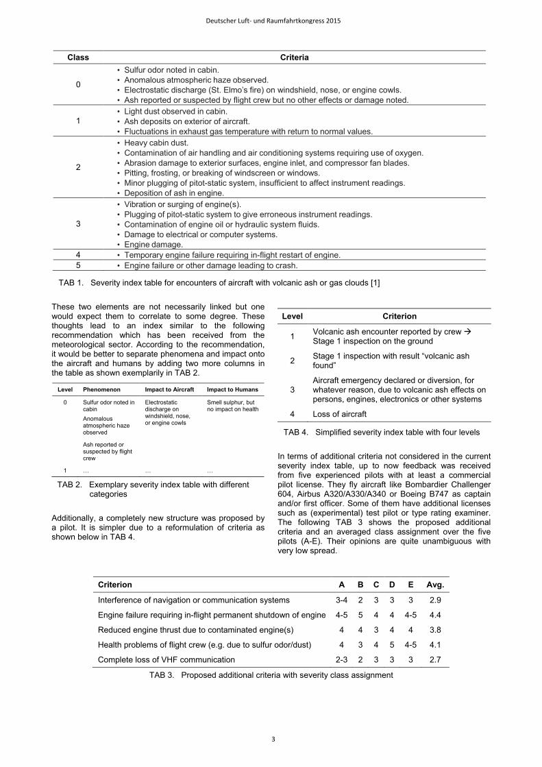
These two elements are not necessarily linked but one would expect them to correlate to some degree. These thoughts lead to an index similar to the following recommendation which has been received from the meteorological sector. According to the recommendation, it would be better to separate phenomena and impact onto the aircraft and humans by adding two more columns in the table as shown exemplarily in TAB 2.
Additionally, a completely new structure was proposed by a pilot. It is simpler due to a reformulation of criteria as shown below in TAB 4.
In terms of additional criteria not considered in the current severity index table, up to now feedback was received from five experienced pilots with at least a commercial pilot license. They fly aircraft like Bombardier Challenger 604, Airbus A320/A330/A340 or Boeing B747 as captain and/or first officer. Some of them have additional licenses such as (experimental) test pilot or type rating examiner. The following TAB 3 shows the proposed additional criteria and an averaged class assignment over the five pilots (A-E). Their opinions are quite unambiguous with very low spread.
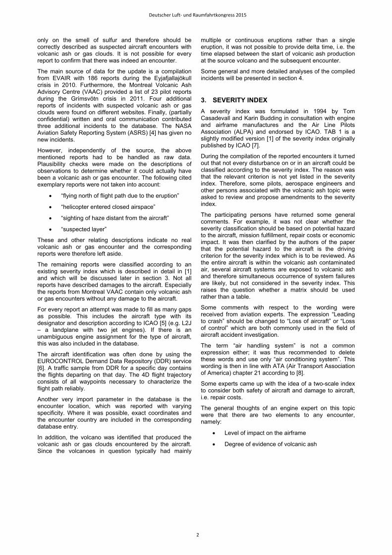
Class Criteria
0
• Sulfur odor noted in cabin. • Anomalous atmospheric haze observed. • Electrostatic discharge (St. Elmo’s fire) on windshield, nose, or engine cowls. • Ash reported or suspected by flight crew but no other effects or damage noted.
1 • Light dust observed in cabin. • Ash deposits on exterior of aircraft. • Fluctuations in exhaust gas temperature with return to normal values.
2
• Heavy cabin dust. • Contamination of air handling and air conditioning systems requiring use of oxygen. • Abrasion damage to exterior surfaces, engine inlet, and compressor fan blades. • Pitting, frosting, or breaking of windscreen or windows. • Minor plugging of pitot-static system, insufficient to affect instrument readings. • Deposition of ash in engine.
3
• Vibration or surging of engine(s). • Plugging of pitot-static system to give erroneous instrument readings. • Contamination of engine oil or hydraulic system fluids. • Damage to electrical or computer systems. • Engine damage.
4 • Temporary engine failure requiring in-flight restart of engine. 5 • Engine failure or other damage leading to crash.
TAB 1. Severity index table for encounters of aircraft with volcanic ash or gas clouds [1]
Level Phenomenon Impact to Aircraft Impact to Humans
0 Sulfur odor noted in cabin Anomalous atmospheric haze observed
Ash reported or suspected by flight crew
Electrostatic discharge on windshield, nose, or engine cowls
Smell sulphur, but no impact on health
1 … … …
TAB 2. Exemplary severity index table with different categories
Criterion A B C D E Avg.
Interference of navigation or communication systems 3-4 2 3 3 3 2.9
Engine failure requiring in-flight permanent shutdown of engine 4-5 5 4 4 4-5 4.4
Reduced engine thrust due to contaminated engine(s) 4 4 3 4 4 3.8
Health problems of flight crew (e.g. due to sulfur odor/dust) 4 3 4 5 4-5 4.1
Complete loss of VHF communication 2-3 2 3 3 3 2.7
TAB 3. Proposed additional criteria with severity class assignment
Level Criterion
1 Volcanic ash encounter reported by crew Stage 1 inspection on the ground
2 Stage 1 inspection with result “volcanic ash found”
3 Aircraft emergency declared or diversion, for whatever reason, due to volcanic ash effects on persons, engines, electronics or other systems
4 Loss of aircraft
TAB 4. Simplified severity index table with four levels
Deutscher Luft- und Raumfahrtkongress 2015
3

Health problems of flight crew include for example sickness, restrictions on breathing and speech, dryness of throat.
One pilot recommends shifting some of the existing criteria into a more critical severity class, in order to take into account the potential hazard to the aircraft. That means for example, if a criterion is currently severity class 3, it should be shifted to severity class 4 in some cases. Other experts have also expressed the view that the current severity class is too low for some criteria.
The ICAO Safety Management Manual [9] provides a template for a severity index which can be customized according to the nature of the product. TAB 5 shows a customized version; the columns potential revenue loss, damage to the environment and damage to the corporate reputation were removed. They are not relevant in the context of impact of volcanic ash on the aircraft and in addition difficult to determine.
An existing template is a good starting point for developing a multi-scale severity index table which seems to be favored by the volcanic ash community. It could be amended by a level 0 which can be “presence of volcanic ash coincident with the aircraft suspected” or similar. However, additional discussion is necessary before a draft version of an updated severity index can be created. This will be addressed in the forthcoming time.
4. ANALYSIS OF INCIDENTS, 2010-2014
4.1. General Analysis After the plausibility analysis described in section 2, a total of 113 encounters with volcanic ash or gas clouds between 2010 and 2014 were identified. The reports are spread over the volcanoes and years as follows:
As described in section 2, the remaining incidents after the plausibility check were classified according to the severity index table presented in TAB 1, because the discussions about a revised version are not yet completed. For example, some encounters have been ranked lower than proposed by the pilots (cf. section 3). These include the reports about health problems of flight crew due to smell which is now severity class 0 (sulfur odor noted in cabin). Pilots recommend a severity class 4 which is significantly higher. The following TAB 7 presents the number of aircraft encounters with volcanic ash or gas clouds according to the severity class.
Fortunately, no volcanic ash encounters of severity class 5 have occurred to date and no severity class 4 is known of in the considered period.
Most of the analyzed reports were severity class 0, i.e. there was no damage to the aircraft, mainly smell noted in the cockpit. The next large group is severity class 1 with 36 incident reports, which mostly reported ash deposits on exterior of aircraft without further damage.
Abrasion damage to exterior surfaces, engine inlet or compressor fan blades are the primary reasons for a severity 2 classification. The reported damages were mainly detected after the flight during post-flight or regular inspections, i.e. they did not have an impact on the mission of the aircraft.
Engine bleed failure or engine fluctuations, ingested volcanic ash or melted volcanic ash on the interior of the engines were some of the reasons for a severity class 3 encounter. TAB 8 shows an overview of severity class per aircraft type designator according to [5].
Level Descriptor
Severity description
Safety of aircraft Physical
injury Damage to
aircraft
1 Insignificant No significance to aircraft-related operational safety No injury No damage
2 Minor
Degrades or affects normal aircraft operational procedures or performance
Minor injury
Minor damage
3 Moderate
Partial loss of significant/major aircraft systems or results in emergency application of flight operations procedures
Serious injury
Substantial damage
4 Major
Complete failure of significant/major aircraft systems or results in emergency application of flight operations procedures.
Singe fatality
Major damage
5 Catastrophic Aircraft/hull loss Multiple fatality
Catastrophic damage
TAB 5. Customized severity index table from ICAO template [9]
Volcano Country 2010 2011 2014
Eyjafjallajökull Iceland 92
Merapi Indonesia 1
Grímsvötn Iceland 17
Tungurahua Ecuador 1
Kelut Indonesia 1
Fogo Cape Verde 1
Total of incidents 93 18 2
TAB 6. List of source volcanoes and associated encounters per year
Severity class Number
Class 5 -
Class 4 -
Class 3 6
Class 2 12
Class 1 36
Class 0 59
Total incidents reported 113
TAB 7. Number of encounters (2010-2014) according to the severity class
Deutscher Luft- und Raumfahrtkongress 2015
4
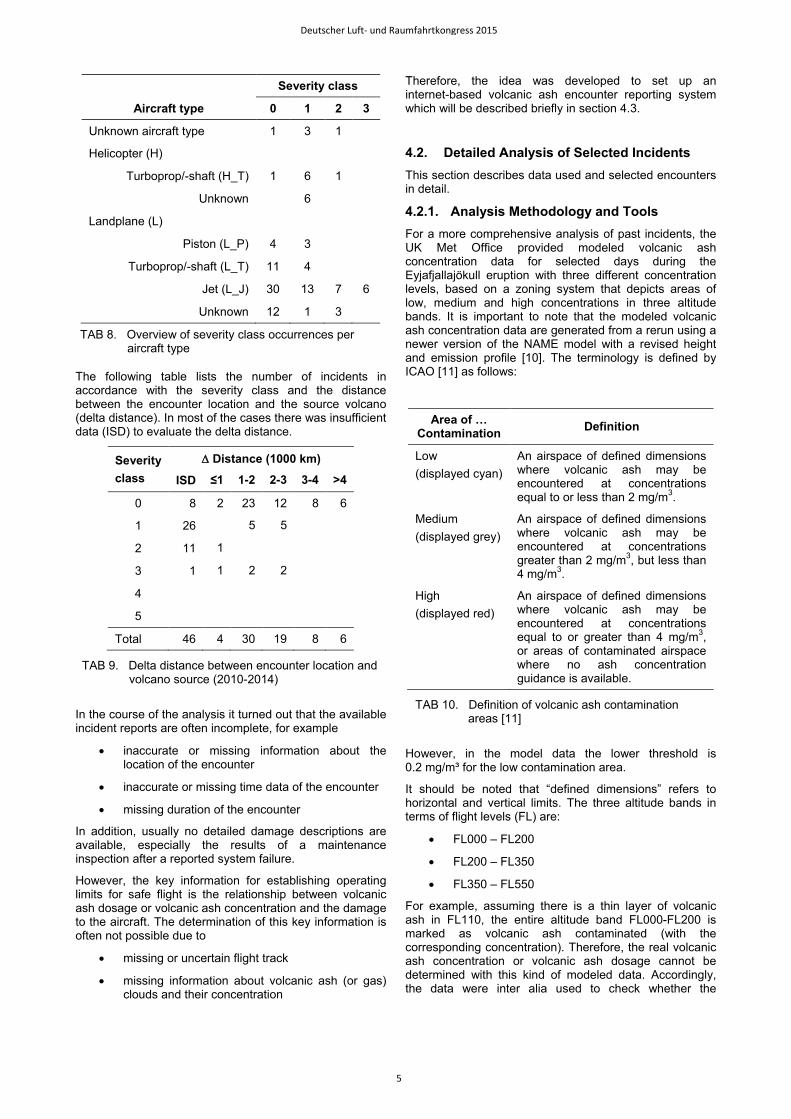
The following table lists the number of incidents in accordance with the severity class and the distance between the encounter location and the source volcano (delta distance). In most of the cases there was insufficient data (ISD) to evaluate the delta distance.
In the course of the analysis it turned out that the available incident reports are often incomplete, for example
• inaccurate or missing information about the location of the encounter
• inaccurate or missing time data of the encounter
• missing duration of the encounter
In addition, usually no detailed damage descriptions are available, especially the results of a maintenance inspection after a reported system failure.
However, the key information for establishing operating limits for safe flight is the relationship between volcanic ash dosage or volcanic ash concentration and the damage to the aircraft. The determination of this key information is often not possible due to
• missing or uncertain flight track
• missing information about volcanic ash (or gas) clouds and their concentration
Therefore, the idea was developed to set up an internet-based volcanic ash encounter reporting system which will be described briefly in section 4.3.
4.2. Detailed Analysis of Selected Incidents This section describes data used and selected encounters in detail.
4.2.1. Analysis Methodology and Tools For a more comprehensive analysis of past incidents, the UK Met Office provided modeled volcanic ash concentration data for selected days during the Eyjafjallajökull eruption with three different concentration levels, based on a zoning system that depicts areas of low, medium and high concentrations in three altitude bands. It is important to note that the modeled volcanic ash concentration data are generated from a rerun using a newer version of the NAME model with a revised height and emission profile [10]. The terminology is defined by ICAO [11] as follows:
However, in the model data the lower threshold is 0.2 mg/m³ for the low contamination area.
It should be noted that “defined dimensions” refers to horizontal and vertical limits. The three altitude bands in terms of flight levels (FL) are:
• FL000 – FL200
• FL200 – FL350
• FL350 – FL550
For example, assuming there is a thin layer of volcanic ash in FL110, the entire altitude band FL000-FL200 is marked as volcanic ash contaminated (with the corresponding concentration). Therefore, the real volcanic ash concentration or volcanic ash dosage cannot be determined with this kind of modeled data. Accordingly, the data were inter alia used to check whether the
Severity class
Aircraft type 0 1 2 3
Unknown aircraft type 1 3 1
Helicopter (H)
Turboprop/-shaft (H_T) 1 6 1
Unknown 6
Landplane (L)
Piston (L_P) 4 3
Turboprop/-shaft (L_T) 11 4
Jet (L_J) 30 13 7 6
Unknown 12 1 3
TAB 8. Overview of severity class occurrences per aircraft type
Severity class
∆ Distance (1000 km)
ISD ≤1 1-2 2-3 3-4 >4
0 8 2 23 12 8 6
1 26 5 5
2 11 1
3 1 1 2 2
4
5
Total 46 4 30 19 8 6
TAB 9. Delta distance between encounter location and volcano source (2010-2014)
Area of … Contamination Definition
Low (displayed cyan)
An airspace of defined dimensions where volcanic ash may be encountered at concentrations equal to or less than 2 mg/m3.
Medium (displayed grey)
An airspace of defined dimensions where volcanic ash may be encountered at concentrations greater than 2 mg/m3, but less than 4 mg/m3.
High (displayed red)
An airspace of defined dimensions where volcanic ash may be encountered at concentrations equal to or greater than 4 mg/m3, or areas of contaminated airspace where no ash concentration guidance is available.
TAB 10. Definition of volcanic ash contamination areas [11]
Deutscher Luft- und Raumfahrtkongress 2015
5
reporting aircraft was in or in the vicinity of modeled volcanic ash areas. As future work, encounter cases of high interest (e.g. severe damage) could be investigated more profoundly, e.g. with model data at a higher vertical resolution which need to be generated specifically.
For the more detailed analysis, FATS (Future Air Traffic Simulator) of the DLR Institute of Flight Guidance was used. The software tool can handle data from the DDR service as well as the volcanic ash concentration comma separated values (CSV) files issued by UK Met Office for aviation purposes without adaptation of the software. FATS detects conflicts of flight trajectories with defined airspaces like volcanic ash areas, calculates start and end time of conflicts and has a three dimensional representation for visualization purposes (cf. section 5). A more detailed description of the conflict detection can be found in [12].
Different cases have been considered during the analysis. In case the affected flight was not already identified, the flight trajectories of the potential flights (flights with similar characteristics as informed in the report, e.g. time, region, aircraft model) were loaded together with the associated modeled volcanic ash data. It was then checked whether one (or more) of the potential flights were routed through modeled volcanic ash contaminated airspace.
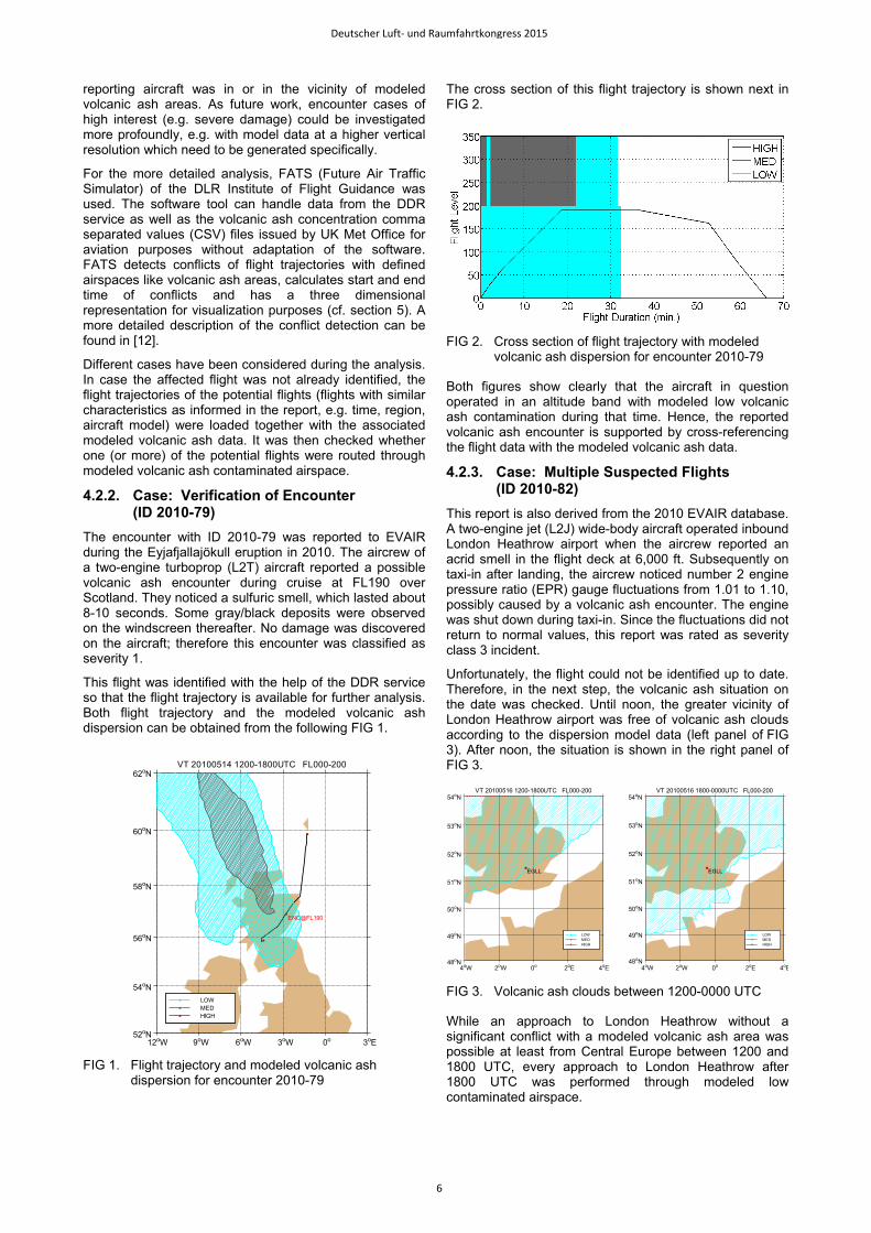
4.2.2. Case: Verification of Encounter (ID 2010-79)
The encounter with ID 2010-79 was reported to EVAIR during the Eyjafjallajökull eruption in 2010. The aircrew of a two-engine turboprop (L2T) aircraft reported a possible volcanic ash encounter during cruise at FL190 over Scotland. They noticed a sulfuric smell, which lasted about 8-10 seconds. Some gray/black deposits were observed on the windscreen thereafter. No damage was discovered on the aircraft; therefore this encounter was classified as severity 1.
This flight was identified with the help of the DDR service so that the flight trajectory is available for further analysis. Both flight trajectory and the modeled volcanic ash dispersion can be obtained from the following FIG 1.
The cross section of this flight trajectory is shown next in FIG 2.
Both figures show clearly that the aircraft in question operated in an altitude band with modeled low volcanic ash contamination during that time. Hence, the reported volcanic ash encounter is supported by cross-referencing the flight data with the modeled volcanic ash data.
4.2.3. Case: Multiple Suspected Flights (ID 2010-82)
This report is also derived from the 2010 EVAIR database. A two-engine jet (L2J) wide-body aircraft operated inbound London Heathrow airport when the aircrew reported an acrid smell in the flight deck at 6,000 ft. Subsequently on taxi-in after landing, the aircrew noticed number 2 engine pressure ratio (EPR) gauge fluctuations from 1.01 to 1.10, possibly caused by a volcanic ash encounter. The engine was shut down during taxi-in. Since the fluctuations did not return to normal values, this report was rated as severity class 3 incident.
Unfortunately, the flight could not be identified up to date. Therefore, in the next step, the volcanic ash situation on the date was checked. Until noon, the greater vicinity of London Heathrow airport was free of volcanic ash clouds according to the dispersion model data (left panel of FIG 3). After noon, the situation is shown in the right panel of FIG 3.
While an approach to London Heathrow without a significant conflict with a modeled volcanic ash area was possible at least from Central Europe between 1200 and 1800 UTC, every approach to London Heathrow after 1800 UTC was performed through modeled low contaminated airspace.
FIG 1. Flight trajectory and modeled volcanic ash
dispersion for encounter 2010-79
FIG 2. Cross section of flight trajectory with modeled
volcanic ash dispersion for encounter 2010-79
FIG 3. Volcanic ash clouds between 1200-0000 UTC
12oW 9oW 6oW 3oW 0o 3oE 52oN
54oN
56oN
58oN
60oN
62oN
ENC@FL190
VT 20100514 1200-1800UTC FL000-200
HIGHMEDLOW
EGLL
VT 20100516 1200-1800UTC FL000-200
4oW 2oW 0o 2oE 4oE 48oN
49oN
50oN
51oN
52oN
53oN
54oN
48oN
49oN
50oN
51oN
52oN
53oN
EGLL
VT 20100516 1800-0000UTC FL000-200
4oW 2oW 0o 2oE 4oE
54oN
HIGHMEDLOW
HIGHMEDLOW
Deutscher Luft- und Raumfahrtkongress 2015
6
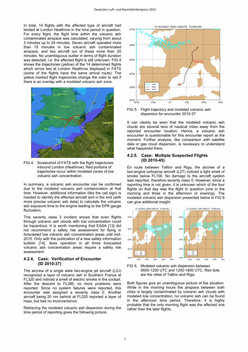
In total, 14 flights with the affected type of aircraft had landed at London Heathrow in the time period in question. For every flight, the flight time within the volcanic ash contaminated airspace was calculated, varying from about 3 minutes up to 24 minutes. Seven aircraft operated more than 15 minutes in low volcanic ash contaminated airspace, and two aircraft out of these more than 20 minutes. No unambiguous outlier in terms of flight duration was detected, i.e. the affected flight is still unknown. FIG 4 shows the trajectories (yellow) of the 14 determined flights which arrive last at London Heathrow displayed in FATS (some of the flights have the same arrival route). The yellow marked flight trajectories change the color to red if there is an overlap with a modeled volcanic ash zone.
In summary, a volcanic ash encounter can be confirmed due to the modeled volcanic ash contamination at that time. However, additional information (like the call sign) is needed to identify the affected aircraft and in the end (with more precise volcanic ash data) to calculate the volcanic ash exposure time to the engine leading to the EPR gauge fluctuation.
This severity class 3 incident shows that even flights through volcanic ash clouds with low concentration could be hazardous. It is worth mentioning that EASA [13] did not recommend a safety risk assessment for flying in forecasted low volcanic ash concentration areas until mid-2015. Only with the publication of a new safety information bulletin [14], does operation in all three forecasted volcanic ash concentration areas require a safety risk assessment.
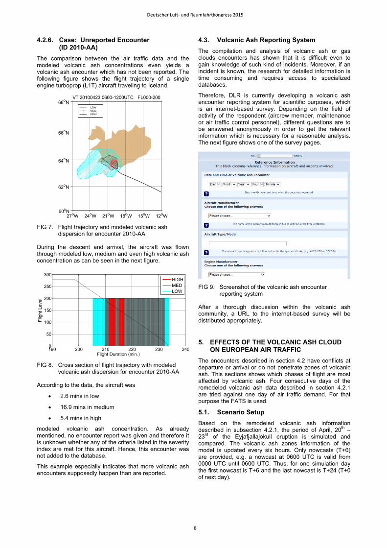
4.2.4. Case: Verification of Encounter (ID 2010-37)
The aircrew of a single aisle two-engine jet aircraft (L2J) recognized a layer of volcanic ash in Southern France at FL320 and noticed a smell of electric smoke in the cockpit. After the descent to FL280, no more problems were reported. Since no system failures were reported, this encounter was assigned a severity class 0. Another aircraft being 20 nm behind at FL320 reported a layer of haze, but had no inconvenience.
Retrieving the modeled volcanic ash dispersion during the time period of reporting gives the following picture.
It can clearly be seen that the modeled volcanic ash clouds are several tens of nautical miles away from the reported encounter location. Hence, a volcanic ash encounter is questionable for this encounter report at the moment. Further analysis, like comparison with satellite data or gas cloud dispersion, is necessary to understand what happened there.
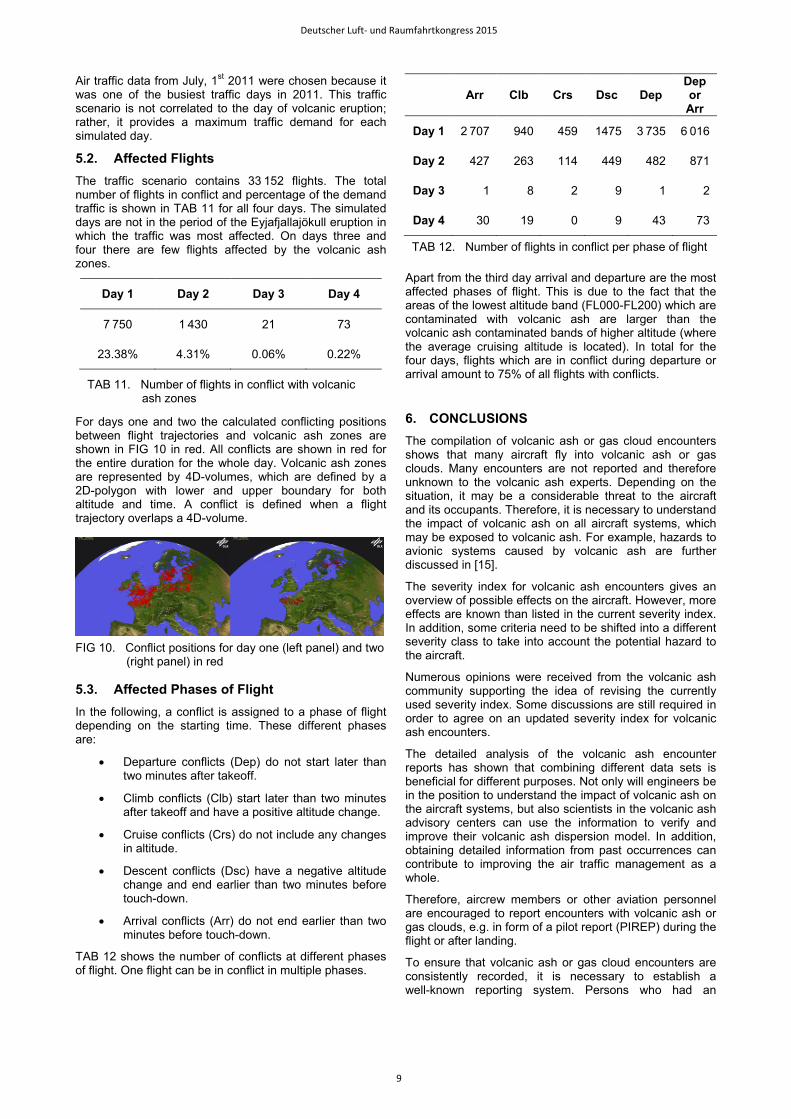
4.2.5. Case: Multiple Suspected Flights (ID 2010-45)
En route between Tallinn and Riga, the aircrew of a two-engine turboprop aircraft (L2T) noticed a light smell of smoke below FL100. No damage to the aircraft system was reported, therefore severity class 0. However, since a reporting time is not given, it is unknown which of the four flights on that day was the flight in question (one in the morning and three in the afternoon or evening). The modeled volcanic ash dispersion presented below in FIG 6 can give additional insight.
Both figures give an unambiguous picture of the situation. While in the morning hours the airspace between both cities is largely contaminated by volcanic ash clouds with modeled low concentration, no volcanic ash can be found in the afternoon time period. Therefore, it is highly probable that the only morning flight was the affected one rather than the later flights.
FIG 4. Screenshot of FATS with the flight trajectories
inbound London (Heathrow). Red portions of trajectories occur within modeled zones of low volcanic ash concentration.
FIG 5. Flight trajectory and modeled volcanic ash
dispersion for encounter 2010-37
FIG 6. Modeled volcanic ash dispersion between
0600-1200 UTC and 1200-1800 UTC. Red dots are the cities of Tallinn and Riga.
10oW 5oW 0o 5oE 10oE 15oE
ENC@FL320
VT 20100421 0600-1200UTC FL000-550
36oN
39oN
42oN
45oN
48oN
51oN
HIGHMEDLOW
12oE 18oE 24oE 30oE 36oE 48oN
52oN
56oN
60oN
64oN
VT 20100421 0600-1200UTC FL000-200
12oE 18oE 24oE 30oE 36oE 48oN
52oN
56oN
60oN
64oN
VT 20100421 1200-1800UTC FL000-200
HIGHMEDLOW
HIGHMEDLOW
Deutscher Luft- und Raumfahrtkongress 2015
7
4.2.6. Case: Unreported Encounter (ID 2010-AA)
The comparison between the air traffic data and the modeled volcanic ash concentrations even yields a volcanic ash encounter which has not been reported. The following figure shows the flight trajectory of a single engine turboprop (L1T) aircraft traveling to Iceland.
During the descent and arrival, the aircraft was flown through modeled low, medium and even high volcanic ash concentration as can be seen in the next figure.
According to the data, the aircraft was
• 2.6 mins in low
• 16.9 mins in medium
• 5.4 mins in high
modeled volcanic ash concentration. As already mentioned, no encounter report was given and therefore it is unknown whether any of the criteria listed in the severity index are met for this aircraft. Hence, this encounter was not added to the database.
This example especially indicates that more volcanic ash encounters supposedly happen than are reported.
4.3. Volcanic Ash Reporting System The compilation and analysis of volcanic ash or gas clouds encounters has shown that it is difficult even to gain knowledge of such kind of incidents. Moreover, if an incident is known, the research for detailed information is time consuming and requires access to specialized databases.
Therefore, DLR is currently developing a volcanic ash encounter reporting system for scientific purposes, which is an internet-based survey. Depending on the field of activity of the respondent (aircrew member, maintenance or air traffic control personnel), different questions are to be answered anonymously in order to get the relevant information which is necessary for a reasonable analysis. The next figure shows one of the survey pages.
After a thorough discussion within the volcanic ash community, a URL to the internet-based survey will be distributed appropriately.
5. EFFECTS OF THE VOLCANIC ASH CLOUD ON EUROPEAN AIR TRAFFIC
The encounters described in section 4.2 have conflicts at departure or arrival or do not penetrate zones of volcanic ash. This sections shows which phases of flight are most affected by volcanic ash. Four consecutive days of the remodeled volcanic ash data described in section 4.2.1 are tried against one day of air traffic demand. For that purpose the FATS is used.
5.1. Scenario Setup Based on the remodeled volcanic ash information described in subsection 4.2.1, the period of April, 20th – 23rd of the Eyjafjallajökull eruption is simulated and compared. The volcanic ash zones information of the model is updated every six hours. Only nowcasts (T+0) are provided, e.g. a nowcast at 0600 UTC is valid from 0000 UTC until 0600 UTC. Thus, for one simulation day the first nowcast is T+6 and the last nowcast is T+24 (T+0 of next day).
FIG 7. Flight trajectory and modeled volcanic ash
dispersion for encounter 2010-AA
FIG 8. Cross section of flight trajectory with modeled
volcanic ash dispersion for encounter 2010-AA
FIG 9. Screenshot of the volcanic ash encounter
reporting system
27oW 24oW 21oW 18oW 15oW 12oW 60oN
VT 20100423 0600-1200UTC FL000-200
62oN
64oN
66oN
68oN
HIGHMEDLOW
Flight Duration (min.)
Flig
ht L
evel
190 200 210 220 230 2400
50
100
150
200
250
300HIGHMEDLOW
Deutscher Luft- und Raumfahrtkongress 2015
8
Air traffic data from July, 1st 2011 were chosen because it was one of the busiest traffic days in 2011. This traffic scenario is not correlated to the day of volcanic eruption; rather, it provides a maximum traffic demand for each simulated day.
5.2. Affected Flights The traffic scenario contains 33 152 flights. The total number of flights in conflict and percentage of the demand traffic is shown in TAB 11 for all four days. The simulated days are not in the period of the Eyjafjallajökull eruption in which the traffic was most affected. On days three and four there are few flights affected by the volcanic ash zones.
For days one and two the calculated conflicting positions between flight trajectories and volcanic ash zones are shown in FIG 10 in red. All conflicts are shown in red for the entire duration for the whole day. Volcanic ash zones are represented by 4D-volumes, which are defined by a 2D-polygon with lower and upper boundary for both altitude and time. A conflict is defined when a flight trajectory overlaps a 4D-volume.
5.3. Affected Phases of Flight In the following, a conflict is assigned to a phase of flight depending on the starting time. These different phases are:
• Departure conflicts (Dep) do not start later than two minutes after takeoff.
• Climb conflicts (Clb) start later than two minutes after takeoff and have a positive altitude change.
• Cruise conflicts (Crs) do not include any changes in altitude.
• Descent conflicts (Dsc) have a negative altitude change and end earlier than two minutes before touch-down.
• Arrival conflicts (Arr) do not end earlier than two minutes before touch-down.
TAB 12 shows the number of conflicts at different phases of flight. One flight can be in conflict in multiple phases.
Apart from the third day arrival and departure are the most affected phases of flight. This is due to the fact that the areas of the lowest altitude band (FL000-FL200) which are contaminated with volcanic ash are larger than the volcanic ash contaminated bands of higher altitude (where the average cruising altitude is located). In total for the four days, flights which are in conflict during departure or arrival amount to 75% of all flights with conflicts.
6. CONCLUSIONS The compilation of volcanic ash or gas cloud encounters shows that many aircraft fly into volcanic ash or gas clouds. Many encounters are not reported and therefore unknown to the volcanic ash experts. Depending on the situation, it may be a considerable threat to the aircraft and its occupants. Therefore, it is necessary to understand the impact of volcanic ash on all aircraft systems, which may be exposed to volcanic ash. For example, hazards to avionic systems caused by volcanic ash are further discussed in [15].
The severity index for volcanic ash encounters gives an overview of possible effects on the aircraft. However, more effects are known than listed in the current severity index. In addition, some criteria need to be shifted into a different severity class to take into account the potential hazard to the aircraft.
Numerous opinions were received from the volcanic ash community supporting the idea of revising the currently used severity index. Some discussions are still required in order to agree on an updated severity index for volcanic ash encounters.
The detailed analysis of the volcanic ash encounter reports has shown that combining different data sets is beneficial for different purposes. Not only will engineers be in the position to understand the impact of volcanic ash on the aircraft systems, but also scientists in the volcanic ash advisory centers can use the information to verify and improve their volcanic ash dispersion model. In addition, obtaining detailed information from past occurrences can contribute to improving the air traffic management as a whole.
Therefore, aircrew members or other aviation personnel are encouraged to report encounters with volcanic ash or gas clouds, e.g. in form of a pilot report (PIREP) during the flight or after landing.
To ensure that volcanic ash or gas cloud encounters are consistently recorded, it is necessary to establish a well-known reporting system. Persons who had an
Day 1 Day 2 Day 3 Day 4
7 750 1 430 21 73
23.38% 4.31% 0.06% 0.22%
TAB 11. Number of flights in conflict with volcanic ash zones
FIG 10. Conflict positions for day one (left panel) and two
(right panel) in red
Arr Clb Crs Dsc Dep Dep or Arr
Day 1 2 707 940 459 1475 3 735 6 016
Day 2 427 263 114 449 482 871
Day 3 1 8 2 9 1 2
Day 4 30 19 0 9 43 73
TAB 12. Number of flights in conflict per phase of flight
Deutscher Luft- und Raumfahrtkongress 2015
9
incident related to volcanic ash activities have to know where to report that incident and what is the required information for a reasonable analysis. Additionally, it should be known who will do the reasonable analysis and what will happen to the (sensitive) data. This task would be preferably performed by an independent and well-known organization. DLR is willing to set up an internet-based survey for volcanic ash encounters.
The analysis of the effect of the Eyjafjallajökull volcanic ash on the European air traffic on selected days has shown that departure and arrival are the most affected phases of flight. A reanalysis of aviation effects is discussed in more detail in [16].
7. ACKNOWLEDGEMENTS The authors would like to thank the volcanic ash community for the open and fruitful discussions regarding this topic. Special thanks go to the experts and pilots who gave their comments on the severity index and proposed additional criteria. It would be too many to list them all by name.
Special thanks to Marianne Guffanti from U.S. Geological Survey for the collaboration in updating the volcanic ash encounter database and to Claire Witham from UK Met Office for providing the modeled volcanic ash concentration which was very useful data for the work.
The authors are looking forward to future interesting discussions and collaborations.
8. REFERENCES [1] Guffanti, M., Casadevall, T.J. and Budding, K.
Encounters of Aircraft with Volcanic Ash Clouds: A Compilation of Known Incidents, 1953-2009. [Online] 2010. http://pubs.usgs.gov/ds/545/. U.S. Geological Survey Data Series 545, ver. 1.
[2] EUROCONTROL. EVAIR (EUROCONTROL Voluntary ATM Incident Reporting). [Online] [Cited: July 23, 2015.] https://www.eurocontrol.int/services/evair-eurocontrol-voluntary-atm-incident-reporting.
[3] Carn, S. A., Krueger, A. J., Krotkov, N. A., Yang, K. and Evans, K. Tracking volcanic sulfur dioxide clouds for aviation hazard mitigation. Natural Hazards. 2009, Vol. 51, No. 2, pp. 325-343. doi: 10.1007/s11069-008-9228-4.
[4] National Aeronautics and Space Administration (NASA). Aviation Safety Reporting System (ASRS). [Online] [Cited: August 25, 2015.] http://asrs.arc.nasa.gov/.
[5] International Civil Aviation Organization (ICAO). DOC 8643 - Aircraft Type Designators. International Civil Aviation Organization (ICAO). [Online] April 14, 2015. http://www.icao.int/publications/DOC8643/Pages/default.aspx.
[6] EUROCONTROL. Demand Data Repository (DDR). [Online] [Cited: July 29, 2015.] https://www.eurocontrol.int/ddr.
[7] International Civil Aviation Organization (ICAO). Manual on Volcanic Ash, Radioactive Material and Toxic Chemical Clouds. Montréal, Quebec : International Civil Aviation Organization (ICAO),
2007. Doc 9691-AN/954. [8] Air Transport Association of America (ATA). ATA
Specification 100 - Specification for Manufacturers' Technical Data. Washington, DC : Air Transport Association of America (ATA), 1999.
[9] International Civil Aviation Organization (ICAO). Safety Management Manual (SMM). Montréal, Quebec : International Civil Aviation Organization (ICAO), 2013. Doc 9859-AN/474.
[10] Webster, H. N., Thomson, D. J., Johnson, B. T., Heard, I. P.C., Turnbull, K., Marenco, F., Kristiansen, N. I., Dorsey, J., Minikin, A., Weinzierl, B., Schumann, U., Sparks, R. S.J., Loughlin, S. C., Hort, M. C., Leadbetter, S. J., Devenish, B. J., Manning, A. J., Witham, C. S., Haywood, J. M. and Golding, B. W. Operational prediction of ash concentrations in the distal volcanic cloud from the 2010 Eyjafjallajökull eruption. Journal of Geophysical Research. 2012, Vol. 117, D00U08. doi:10.1029/2011JD016790.
[11] International Civil Aviation Organization (ICAO). Volcanic Ash Contingency Plan – EUR and NAT Regions. Montréal, Quebec : International Civil Aviation Organization (ICAO), 2010. EUR Doc 019.
[12] Peinecke, N. and Kuenz, A. Tiling the World - Efficient 4D Conflict Detection for Large Scale Scenarios. Proceedings 28th Digital Avionics Systems Conference. Orlando, FL, USA : s.n., October 25-29, 2009.
[13] European Aviation Safety Agency (EASA). Flight in Airspace with Contamination of Volcanic Ash. Cologne : European Aviation Safety Agency (EASA), 21 August 2014. Safety Information Bulletin. 2010-17R6.
[14] European Aviation Safety Agency (EASA). Flight in Airspace with Contamination of Volcanic Ash. Cologne : European Aviation Safety Agency (EASA), 02 July 2015. Safety Information Bulletin. 2010-17R7.
[15] Nunes, R. R., Christmann, C. and Oertel, H. Hazards Caused by Volcanic Ash on Avionic Systems. German Aerospace Congress. Rostock : s.n., September 22-24, 2015.
[16] Schmitt, A. R. and Kuenz, A. A Reanalysis of Aviation Effects from Volcano Eruption of Eyjafjallajökull in 2010. Proceedings of 34th Digital Avionics Systems Conference. Prague : s.n., September 13-17, 2015.
Deutscher Luft- und Raumfahrtkongress 2015
10