regional coastal plan for taranaki · the regional coastal plan for taranaki was approved by the...
TRANSCRIPT

Preface
This is the first regional coastal plan prepared by the Taranaki Regional Council underthe Resource Management Act 1991. The passage of that Act brought about a majorreform of the way in which the coastline and coastal waters of New Zealand aremanaged. The Taranaki Regional Council's responsibilities have been extended from itswater quality management role to include such functions as control of structureplacement, reclamation and foreshore works, noise emission control and air qualitymanagement. The Taranaki Regional Council is required by law to carry out coastalmanagement through this Regional Coastal Plan for Taranaki.
The Regional Coastal Plan for Taranaki has one overriding purpose: to promote thesustainable management of natural and physical resources in relation to the coastalmarine area. This means enabling people to use the coast to provide for their social,cultural and economic needs, and for their health and safety, while at the same timeensuring that the natural coastal environment remains capable of supporting marine life,retains its natural character and is able to meet the needs of future generations.
Many activities take place in the coastal marine area of Taranaki. These range frommajor ventures such as petroleum exploration, and the continuing development of PortTaranaki, to simple activities such as swimming, walking along the foreshore or childrenbuilding sand castles against the incoming tide. The Taranaki coastline ranges from thespectacular White cliffs and river estuaries of north Taranaki, to the harsh, seawall cladforeshore of central New Plymouth, to the wide, unspoilt beaches at Waiinu in the farsouth of the region. The coast and seas of our region fulfil many of our recreational,cultural and economic needs.
The Regional Coastal Plan for Taranaki develops policy for the management of our coastin order to meet our needs, while continuing to be able to enjoy its natural character andunspoilt nature.
On behalf of the Taranaki Regional Council I would like to thank all those who haveparticipated in the preparation of the Regional Coastal Plan for Taranaki. I look forwardto working with you to promote the sustainable management of the coastal marine areaof Taranaki.
Ross AllenCHAIRPERSON

Users' Guide
How the Plan works The plan is divided into seven sections. Section 1 sets the boundaries of the plan's jurisdiction. Section 2 contains definitions of terms that are used in the plan. Sections 3 and 4 are the critical sections of the plan. Section 3 contains: • issues addressed by the plan; • objectives of the plan; • policies to achieve the objectives; and • general methods to implement the policies. The plan's policies are critical. The policies serve a number of purposes: • they contain `criteria' to guide Council's decision making on coastal permit applications by
identifying the environmental effects of particular concern to the Council; and • they state the Council's position on the acceptability or otherwise of those environmental effects;
and • they state general courses of action the Council will adopt to address particular effects or the
effects of particular activities. Section 4 contains regional rules. The regional rules are divided into five sets. There is a set of general rules which apply throughout the coastal marine area. Those rules cover the following activities: • occupation of space; • discharges from ships and offshore installations; • taking and use of water; • introduction of exotic plants; • temporary military training; and • deposits from ships. There are then sets of rules applying to four types of area: • areas of outstanding coastal value; • estuaries (other than those in areas of outstanding coastal value); • the open coast; and • Port Taranaki
1.
These areas can be identified from planning maps in Section 4.2 (note also the extent of "estuaries" in method 1 of Issue one, Section 3.0 of this Plan). Within the four identified areas, rules cover the following activities: • construction, maintenance and removal of structures; • discharges of contaminants (excluding those from ships and offshore installations); • disturbance of, and deposits to, foreshore and seabed; and • reclamations. The rules are intimately linked to the policies, which provide guidance on coastal permit decisions.
1
Note: the area defined as "Port Taranaki" in this plan is larger than the area commonly called Port Taranaki. See planning map 7 for detail.

Section 5 of the plan sets out information that must be supplied with coastal permit applications. Sections 6 and 7 set out administrative procedures required by law, on financial contributions, cross-boundary issues, monitoring and plan reviews.
Guide to consent applicants This section of the users' guide explains, in brief, how to find out whether or not an activity is regulated by the plan, and if so, the steps to be taken in applying for a coastal permit. Step One: Find out where the activity is located. Section 4.2 of the plan contains planning maps
which divide the coastal marine area into four types of management areas. Use the maps to find out which type of area the activity falls in.
Step Two: Break the activity down into parts. Does the activity involve: (a) (i) a discharge from a ship or offshore installation; or (ii) occupation of public space; or (iii) introduction of exotic plants; or (iv) taking, use, damming or diversion of water; or (v) temporary military training; or (v(i) deposition from ships. If so, see the general rules in Section 4.2 of the plan. In addition, does the activity involve: (b) (i) construction, maintenance or removal of a structure; or (ii) discharge of contaminants (other than from a ship or offshore installation); or (iii) disturbance of, or deposit onto, the foreshore or seabed; or (iv) reclamation of foreshore or seabed? If so, go to the appropriate rule table in the coastal management area where the
activity is to be carried out. Note: the explanation in Section 4.2 about using the rule tables will assist you to understand
how the tables may be interpreted. Step Three Are there rules that apply to each part of the activity? (Note: look carefully - most rule
tables have one "catchall" rule to cover activities if there is no specific rule.) If there are no relevant rules, check sections 12, 14 or 15 of the Act. If those sections
do not restrict a part of the activity, then that part may be lawfully carried out without a coastal permit. If those sections restrict that part of the activity, then that part is non-complying and a coastal permit is needed.
Step Four If the activity is covered by rules in the plan, how is each part of the activity
classified? (Note: if the "activity" is made up of several parts, there may be several rules and classifications that apply.)
(a) If it is permitted the activity can be carried out provided the conditions are
met. (b) If it is controlled a coastal permit is needed and the Taranaki Regional
Council must grant the permit if the standards and terms are met.

(c) If it is discretionary a coastal permit is needed, and the Council will decide
whether or not to grant the permit. This will usually depend on how well the proposed activity fits in with the policies in the plan.
(e) If it is non-complying a coastal permit is needed - the Council can only grant
consent if the effects of the activity are minor or are not contrary to the objectives and policies of the plan.
(f) If it is prohibited the activity cannot proceed, and no coastal permit can be
applied for. Figure 1 shows a simplified version of how the activity classifications work. Neither
it nor this discussion can be treated as an exact substitute for the provisions of the Act.
Step Five If any parts of the activity require a coastal permit: (a) check the policies referenced in the rule to find out which effects are of
concern; and (b) check the policies in Section 3.0 Issue Five regarding Maori values; then (c) prepare a document which describes the assessment of effects on the
environment under Section 5.5 of the plan; and (d) make your coastal permit applications to the Taranaki Regional Council, and
include the assessment of effects on the environment and any other information required under Section 5.
You may wish to consult with any people likely to be affected by your activity. Step Six If in doubt, particularly regarding the information requirements of (5) above, or the classification of your activity, telephone the Consents Department of the Taranaki Regional Council on (06) 765 7127.

Figure 1: Activity Classifications
1. Introduction
1.1 Title
This regional coastal plan is known as the Regional Coastal Plan for Taranaki.
1.2 Purpose
The purpose of the regional coastal plan is to promote the sustainable management of
natural and physical resources in relation to the coastal marine area of Taranaki.
1.3 Effect of document
This document is a statutory regional coastal plan prepared by the Taranaki Regional
Council in accordance with the requirements of the Resource Management Act 1991 (`the Act').
The provisions in this plan have legal force under the Act. In particular, the plan contains
regional rules which have the force and effect of a regulation under the Act. Section 84 of the Act states:
`(1) While a policy statement or plan is operative, the regional council or territorial authority
concerned, and every consent authority, shall observe and, to the extent of its authority, enforce the observance of the policy statement or plan.
(2) No purported grant of a resource consent, and no waiver or sufferance or departure from a policy
statement or plan, whether written or otherwise, shall, unless authorised by this Act, have effect in so far as it is contrary to subsection (1).'
1.4 Commencement
The Regional Coastal Plan for Taranaki was approved by the Minister of Conservation on
August 6, 1997, and became operative on 1 October 1997.
1.5 Area of jurisdiction
This regional coastal plan has effect over the coastal marine area of the Taranaki Region. The Taranaki Region is shown on SO Plan No. 13043 deposited with the Chief Surveyor of
the Taranaki Land District. The coastal marine area is that part of the Taranaki Region which is bounded:
• seaward, by the outer limit of the Territorial Sea of New Zealand; and • landward, by the line of Mean High Water Springs, except where that line crosses a
river, in which case the boundary is as described in Section 1.5.1; • in the north, by a line extending from the Mokau River mouth at 273
o true compass
bearing;

• in the south, by a line extending from east of Waiinu Beach at 195o true compass
bearing. 1.5.1 Coastal marine area boundary at rivers The boundary of the coastal marine area at rivers (as agreed pursuant to Section 2 of the
Act) is as described below. (a) In the case of any river not referred to in (b) below, the river mouth is at the
continuation of the line of mean high water springs of the coast across the river. The boundary of the coastal marine area is then a distance upstream equal to the lesser of one kilometre or five times the width of the mouth; or
(b) In the case of any river referred to below, the boundary of the coastal marine area is as
described in Appendix II. The rivers to which this applies are: • Mohakatino River • Te Henui Stream • Tongaporutu River • Huatoki Stream • Mimi River • Oakura River • Urenui River • Kaupokonui Stream • Onaero River • Tangahoe River • Waitara River • Manawapou River • Waiongana River • Patea River • Waiwhakaiho River • Whenuakura River • Waitotara River These rivers are shown in Map 1. These rivers are also shown on the planning maps in
Section 4.0, with the exceptions of Te Henui and Huatoki Streams.
1.6 Statutory restrictions on activities
The Resource Management Act 1991 restricts certain activities under sections 12
(Restrictions on use of coastal marine area), 14 (Restrictions relating to water) and 15 (Discharge of contaminants into environment). Those restrictions are outlined here for the benefit of plan users.
Section 12 Restrictions on use of coastal marine area (1) No person may, in the coastal marine area,- (a) Reclaim or drain any foreshore or seabed; or (b) Erect, reconstruct, place, alter, extend, remove, or demolish any structure or any part of a
structure that is fixed in, on, under, or over any foreshore or seabed; or (c) Disturb any foreshore or seabed (including by excavating, drilling, or tunnelling) in a
manner that has or is likely to have an adverse effect on the foreshore or seabed (other than for the purpose of lawfully harvesting any plant or animal); or
(d) Deposit in, on, or under any foreshore or seabed any substance in a manner that has or is
likely to have an adverse effect on the foreshore or seabed; or

(e) Destroy, damage, or disturb any foreshore or seabed (other than for the purpose of lawfully
harvesting any plant or animal) in a manner that has or is likely to have an adverse effect on plants or animals or their habitat; or
(f) Introduce or plant any exotic or introduced plant in, on, or under the foreshore or seabed - unless expressly allowed by a rule in a regional coastal plan and in any relevant proposed
regional coastal plan or a resource consent. (2) No person may, in relation to land of the Crown in the coastal marine area, or land in the
coastal marine area vested in the regional council,- (a) Occupy the land and any related part of the coastal marine area; or (b) Remove any sand, shingle, shell, or other natural material from the land - unless expressly allowed by a rule in a regional coastal plan and in any relevant proposed
regional coastal plan or by a resource consent. Section 14 Restrictions relating to water (1) No person may, take, use, dam or divert any - (a) Water (other than open coastal water); or (b) Heat or energy from water (other than open coastal water) ... unless the taking, use, damming or diversion is allowed by subsection (3). (3) A person is not prohibited by subsection (1) from taking, using, damming or diverting any
water, heat or energy if - (a) The taking, use, damming or diversion is expressly allowed by a rule in a regional plan and
in any relevant proposed regional plan or a resource consent; or (d) In the case of coastal water (other than open coastal water), the water, heat or energy is
required for an individual's reasonable domestic or recreational needs and the taking, use or diversion does not, or is not likely to, have an adverse effect on the environment; or
(e) The water is required to be taken or used for fire-fighting purposes. Section 15 Discharge of contaminants into environment (1) No person may discharge any - (a) Contaminant or water into water; or (b) Contaminant onto or into land in circumstances which may result in that
contaminant (or any other contaminant emanating as a result of natural processes from that contaminant) entering water; or
(c) Contaminant from any industrial or trade premises into air; or

(d) Contaminant from any industrial or trade premises onto or into land - unless the discharge is expressly allowed by a rule in a regional plan and in any relevant
proposed regional plan, a resource consent, or regulations. These restrictions apply in the absence of a relevant rule in this plan. Certain rules in this
plan make reference to Sections 12(1), 12(2), 14 and 15 above.
1.7 Structure
The structure of this plan is based upon the requirements for a regional plan that are set out
in Section 67(1) of the Resource Management Act. Section 2.0 contains the definitions of terms used in this plan. Section 3.0 states the issues that are addressed by this plan. It further explains the
objectives to be achieved by this plan in order to address those issues, and explains the policies in respect of those issues and objectives. It states the methods to be used to implement the policies, along with the principal reasons for adopting those methods. Finally, it states the anticipated environmental results.
Section 4.0 contains the detail of regional rules which are used to give effect to the policies
in Section 3.0. Section 5.0 sets out the information to be submitted with an application for coastal permits
for land (foreshore and seabed) use, discharges to air or water, and abstractions of water. Section 5.0 also explains the requirements for an assessment of environmental effects and the circumstances in which the Taranaki Regional Council may require further information on a proposed activity in the coastal marine area.
Section 6.0 sets out the circumstances in which a financial contribution may be required, the
method for determining the amount of that contribution and the general purposes for which the contribution may be used.
Section 7.0 of this plan sets out administrative procedures for dealing with cross-boundary
issues, for monitoring the effectiveness of the plan, and for reviewing the plan.
1.8 Agency jurisdiction
The Taranaki Regional Council is the agency responsible for implementing the policies and
methods of this plan at all times.

Map 1 Rivers with mouth by special agreement
195 True0
Onaero R
Waitara R
Waiongana R
Waiwhakaiho R
Oakura R
Te Henui Stm
Huatoki Stm
Tang
ahoe
R
Man
awap
ou R
Patea R
Whenu
akur
a R
Waitota
ra R
Kaupok
onui
Stm
Mimi R
Tongaporutu R
Mohakatino R
Urenui R
12 Nautical miles(22.2km)
0 40 km
Scale
273 True0
KEY
Coastal marine area

2. Definitions This section provides the meanings of words used in this plan and in the Resource Management
Act 1991. Where a word is followed by an asterisk `*', the meaning which follows is the meaning provided in the interpretation section of the Act. Where a term is defined by the Act, the definition for the time being is repeated in this glossary simply for the purpose of assistance. In the case of any inconsistency or amendment of the definition the statutory definition prevails.
Accelerated coastal erosion means intensification of the rate of erosion of the land surface
(including soil, regolith and bedrock), induced by human activity. Accretion means the seaward extension of land as a result of the deposition of sediments. Act* means the Resource Management Act 1991. Air means the mixture of gases enveloping the earth and forming the atmosphere. Amenity values* means those natural or physical qualities and characteristics of an area that
contribute to people's appreciation of its pleasantness, aesthetic coherence, and cultural and recreational attributes.
Area of outstanding coastal value, a synonym for coastal management area A, means any of
the following areas: (a) the area from Pariokariwa Point to Waihi Stream (Map 3), bounded: (i) landward by the landward boundary of the coastal marine area between Pariokariwa
Point and the southern bank of Waihi Stream mouth; and (ii) in the north, by a line extending 1.852 kilometres at a bearing of 270
o true from the
southern bank of the Waihi Stream mouth; (iii) in the south, by a line extending 1.3 kilometres at a bearing of 320
o true from
Pariokariwa Point; (iv) seaward, by the line joining the seaward ends of the lines described in (ii) and (iii)
above while remaining parallel to mean high water springs; or (b) the estuary of the Mimi River (Map 4); or (c) the Protected Area of the Sugar Loaf Islands Marine Protected Area, as defined in the Sugar
Loaf Islands Marine Protected Area Act 1991 (Map 7); or (d) the estuary of the Whenuakura River (Map 11); or (e) that area that falls within the area that is shown on Map 11 and that has the following
dimensions: (i) as to the ends, circles with a radius of 0.5 kilometres each, with the centre of the circle
being the centre of each of the North and South Traps (as shown at positions 174°31'
east, 39°51.8' South and 174°32.6' East, 39°52.5' South on Hydrographic Chart NZ45); and
(ii) as to the middle of the area, such area as is bounded by a rectangle that has a side length equal to a straight line between the centre of the two above mentioned circles and an end length equal to 1 kilometre calculated on a line perpendicular to the line between the centre of the two circles, such that the centre of each circle bisects each end line.
(f) the coastal marine area adjacent to Waverley Beach settlement (Map 12), bounded:
(i) landward, by the landward boundary of the coastal marine area between grid reference Q22: 498-513 (Infomap 260-Q22, Patea) and a point 1.3 kilometres south-east of that grid reference;
(ii) from the north-western point by a line extending 850 metres at a bearing of 184° grid reference Q22: 498-513;
(iii) from the south-eastern point by a line extending 400 metres at a bearing of 180o;
(iv) seaward, by the straight line joining the seaward ends of the lines described in (ii) and (iii) above; or
(g) the estuary of the Waitotara River (Map 13); or (h) the coastal marine area in the vicinity of Waiinu Beach settlement (Map 13), bounded: (i) landward, by the landward boundary of the coastal marine area between a point at
grid reference R22: 593-472 (Infomap 260-R22, Wanganu(i) and a point on the foreshore that is 8.4 kilometres east of that point;
(ii) from the western point, by a line extending 1.0 kilometre at a bearing of 180° true from grid reference R22: 593-472;
(iii) from the eastern point, by a line extending 1.0 kilometre at a bearing of 180° true; (iv) seaward, by a line that joins the seaward ends of the lines in (ii) and (iii) above while
remaining parallel to mean high water springs. As appropriate and as may be appropriate mean that which is or may be appropriate as
determined by the Taranaki Regional Council or its officers acting under delegated authority or, in relation to a decision on a restricted coastal activity, the Minister of Conservation.
Bed* means, in relation to the sea, the submarine areas covered by the internal waters and the
territorial sea. Best practicable option* in relation to a discharge of a contaminant or an emission of noise,
means the best method for preventing or minimising the adverse effects on the environment having regard, among other things, to:
(a) the nature of the discharge or emission and the sensitivity of the receiving environment to
adverse effects; (b) the financial implications, and the effects on the environment, of that option when
compared with other options; and (c) the current state of technical knowledge and the likelihood that the option can be
successfully applied. Biodegradable means capable of being decomposed by bacteria or other biological means. Biodiversity
1 means the variability among living organisms from all sources including inter alia
terrestrial, marine and other aquatic ecosystems and the ecological complexes of which they are a part; this includes diversity within species, between species and of ecosystems.
Clean ballast* means: (a) ballast carried in a tank which, since it was last used to carry a cargo containing a noxious
liquid substance, has been thoroughly cleaned and the residues resulting from the cleaning have been discharged and the tank emptied; and
1
United Nations Convention on Biological Diversity 1992

(b) ballast carried in a tank which, since it was last used to carry oil, has been so cleaned that the effluent from the tank, if it were discharged from a ship which is stationary into clean, calm water on a clear day, would not produce visible traces of oil on the surface of the water or on adjoining shorelines or cause a sludge or emulsion to be deposited beneath the surface of the water or upon adjoining shorelines.
Coastal marine area* means that area of the foreshore and seabed: (a) of which the seaward boundary is the outer limits of the territorial sea; (b) of which the landward boundary is the line of mean high water springs, except that where
that line crosses a river, the landward boundary at that point shall be whichever is the lesser of:
(i) one kilometre upstream from the mouth of the river; or (ii) the point upstream that is calculated by multiplying the width of the river mouth by 5. Coastal water* means seawater within the outer limits of the territorial sea and includes: (a) seawater with a substantial fresh water component; and (b) seawater in estuaries, fiords, inlets, harbours or embayments. Conditions*, in relation to plans and resource consents, includes terms, standards, restrictions
and prohibitions. Consent authority* means the Minister of Conservation, a regional council, a territorial
authority, or a local authority that is both a regional council and a territorial authority, whose permission is required to carry out an activity for which a resource consent is required under the Act.
Construction, maintenance and demolition work (as it relates to noise standards) includes
petroleum exploration, drilling and production. Contaminant* includes any substance (including gases, liquids, solids, and micro-organisms)
or energy (excluding noise) or heat, that either by itself or in combination with the same, similar, or other substances, energy, or heat:
(a) when discharged into water, changes or is likely to change the physical, chemical or
biological condition of water; or (b) when discharged onto or into land or into air, changes or is likely to change the physical,
chemical, or biological condition of the land or air onto or into which it is discharged. Dangerous goods
2 means goods of any of the kinds specified in the Schedule to the Dangerous
Goods Act 1974 and amendments up to 29 June 1994. Deposition means the entrapment and/or settling out of sediment in one location, leading to
accretion. Diadromous means a species that lives in both fresh and salt water. Discharge* includes emit, deposit and allow to escape.
2
The Dangerous Goods Act 1974 will be repealed once the Hazardous Substances and New Organisms Act comes into force. When that Act does come into force the term `Hazardous substance(s)' will be more appropriate than `Dangerous good(s)'.

District plan* means an operative plan approved by a territorial authority under the First Schedule; and includes all operative changes to such a plan (whether arising from a review or otherwise).
District rule* means a rule made as part of a district plan in accordance with Section 76 of the
Act. Disturbance includes excavation, extraction, dredging, drilling and tunnelling. Ecosystem
3 means a dynamic complex of plant, animal and micro-organism communities and
their non-living environment interacting as a functional unit. Effect* includes: (a) any positive or adverse effect; and (b) any temporary or permanent effect; and (c) any past, present or future effect; and (d) any cumulative effect which arises over time or in combination with other effects,
regardless of the scale, intensity, duration or frequency of the effect; and also includes: (e) any potential effect of high probability; and (f) any potential effect of low probability which has a high potential impact. Environment* includes: (a) ecosystems and their constituent parts, including people and communities; and (b) all natural and physical resources; and (c) amenity values; and (d) the social, economic, aesthetic, and cultural conditions which affect the matters stated in (a)
to (c) of this definition or which are affected by those matters. Environmental results anticipated means the expected or foreseen result or outcome on the
environment as a consequence of implementing the policy or policies and methods of implementation. The environmental results anticipated provide a means of assessing the success of the objectives, policies and methods but may not always be measurable or achievable within the operative life of the plan.
Erosion means the natural (geological) processes of the wearing away of the land surface
(including soil, regolith or bedrock) by natural agents and the transport of the derived material. Erosion includes sheet, wind, creep, slump, flow, hill, gully and stream erosion.
Estuary means in relation to a river: (a) for the purpose of regional rules applying to coastal management areas A and B, that part
of the coastal marine area that is bounded: • upstream, by the landward boundary of the coastal marine area; and • downstream, by the line of mean high water springs that could reasonably be expected
to exist if the river was not identified on 1:50,000 topographical maps in the Infomap 260 series.
(b) when used as a synonym for coastal management area B, any area described in (a) above
that is not located in coastal management area A (any area of outstanding coastal value). Exotic means not indigenous to New Zealand.
3
United Nations Convention on Biological Diversity, 1992.

Foreshore* means any land covered and uncovered by the flow and ebb of the tide at mean
spring tides and, in relation to any such land that forms part of the bed of a river, does not include any area that is not part of the coastal marine area.
Form of the foreshore includes the physical nature of the foreshore but does not include those
species that live on the foreshore. Fresh water* means all water except coastal water and geothermal water. Habitat
4 means the place or type of site where an organism or population naturally occurs.
Hapu
5 means sub-tribe, usually a number of whanau with a common ancestor.
Harbour includes any harbour properly so called, whether natural or artificial, and any haven,
dock, pier, jetty and work in or at which ships do or can obtain shelter or ship or unship goods or passengers.
Harbour works includes any structure, reclamation of land from the coastal marine area or any
excavation, deepening or widening of any channel, basin or other works that are a part of a harbour.
Harmful substance includes: (a) any oil or substances containing oil; (b) noxious liquid substances such as specified in the Second Schedule of the marine pollution
regulations, and includes any mixtures including such substances; (c) sewage; and (d) garbage. Hazardous substance means, unless expressly provided otherwise by regulations, any
substance: (a) with one or more of the following intrinsic properties (i) explosiveness; (ii) flammability; (iii) a capacity to oxidise; (iv) corrosiveness; (v) toxicity (including chronic toxicity); (vi) ecotoxicity, with or without bioaccumulation; or (b) which on contact with air or water (other than air water where the temperature or pressure
has been artificially increased or decreased) generates a substance with any one or more of the properties specified in paragraph (a) of this definition.
Heritage values means any cultural, traditional, aesthetic or other value of the past. Integrated management means managing (ie, identifying, prioritising and acting on) the use,
development and protection of natural and physical resources as a whole. Integrated management involves three interrelated parts:
• a recognition by management agencies that natural and physical resources exist as parts of
complex and interconnected social and biophysical systems, where effects on one part of a system may affect other parts of the system and that these effects may occur immediately, may be delayed or may be cumulative; and
4
United National Convention on Biological Diversity, 1992.
5 Ministry for the Environment (1991), Consultation with tangata whenua. Ministry for the Environment, Wellington.

• the integration of management systems between agencies so that the various roles and
responsibilities of those agencies are clearly identified and combined or coordinated to achieve consistency of purpose; and
• the integration of management systems within agencies to ensure that other legislative or
administrative actions are consistent with promoting sustainable management of natural and physical resources.
Intrinsic values* in relation to ecosystems, means those aspects of ecosystems and their
constituent parts which have value in their own right, including: (a) their biological and genetic diversity; and (b) the essential characteristics that determine an ecosystem's integrity, form, functioning, and
resilience. Issue means a matter of concern to the region's community regarding activities affecting some
aspect of natural and physical resources and the environment of the region. Iwi means tribe or grouping of people of Maori descent. Iwi authority* means the authority which represents an iwi and which is recognised by that iwi
as having authority to do so. Iwi o Taranaki or iwi of Taranaki refers to iwi whose rohe (territory or boundary) fall either
wholly or partially within the Taranaki Region. Kaitiakitanga* means the exercise of guardianship; and in relation to a resource, includes the
ethic of guardianship and stewardship based on the nature of the resource itself. Kaimoana means seafood. Kawanatanga
6 means governorship or government.
L
10 means the noise level, in A-weighted decibels, that is equalled or exceeded 10% of the time
when measured in accordance with New Zealand Standard NZS 6801:1991 Measurement of Sound.
Land* includes land covered by water and the air space above land. Local authority* means a regional council or territorial authority. Maintenance of a structure means activities, including reconstruction and alteration of a
structure, which: • are for the purpose of keeping a structure in good repair; and • do not result in any increase in the area of foreshore or seabed allowed to be occupied by
the structure; and • do not change the character, scale and intensity of any effects of the structure on the
environment (except to reduce any adverse effects or increase any positive effects).
6
Parliamentary Commissioner for the Environment (1992) Proposed Guidelines for local authority consultation with tangata whenua. Parliamentary Commissioner for the Environment, Wellington.

Mana Moana means customary authority exercise by iwi, hapu or whanau over the sea area within their rohe or tribal area.
Marine life means life which lives in the sea and includes freshwater species including native
species, which use both marine and freshwater as part of their life cycle. M_taitai* means food resources from the sea and Mahinga m_taitai means the areas from
which these resources are gathered. Mauri/Mouri means essential life force or principle; a metaphysical quality inherent in all
things, both animate and inanimate. Method of implementation means a specific action, procedure, programme or technique
adopted to carry out a policy. Mouth* for the purpose of defining the landward boundary of the coastal marine area, means
the mouth of a river either: (a) as agreed and set between the Minister of Conservation, the regional council, and the
appropriate territorial authority in the period between consultation on, and notification of, the proposed regional coastal plan; or
(b) as declared by the Planning Tribunal under Section 310 upon application made by the
Minister of Conservation, the regional council, or the territorial authority prior to the plan becoming operative.
Natural and physical resources* includes land, water, air, soil, minerals, and energy, all forms
of plants and animals (whether native to New Zealand or introduced), and all structures. Natural hazard* means any atmospheric or earth or water related occurrence (including
earthquake, tsunami, erosion, volcanic and geothermal activity, landslip, subsidence, sedimentation, wind, drought, fire or flooding) the action of which adversely affects or may adversely affect human life, property or other aspects of the environment.
Natural state in relation to receiving water means the state of that water before the discharge
was released. Navigation aid includes: (a) any lightship and any floating or other light exhibited for the guidance of ships; (b) any description of a fog signal not carried on a ship; (c) all marks and signs in aid of marine navigation; and (d) any electronic, radio, or other aid to marine navigation not carried on board any ship. New Zealand coastal policy statement* means a statement issued under Section 57 of the Act. Ngamotu Beach means that area of foreshore that, on 29 June 1994, was bounded: (a) in the east, by the westernmost edge of the area authorised for reclamation under the
Taranaki Harbours Board Reclamation and Empowering Act 1988; and (b) in the west, by the line of the Blyde reclamation. Noise* includes vibration. Objective means a statement of a desired and specific environmental outcome.

Occupy means occupy the land and any related part of the coastal marine area necessary for another activity:
(a) to the exclusion of other persons who do not have a right of occupation to the space by a
resource consent or under a rule in a regional coastal plan; and (b) for a period of time and in a way that, but for the rule in the regional coastal plan or the
holding of a resource consent under this Act, a lease or licence to occupy that part of the coastal marine area would be necessary;
and `occupation' has a corresponding meaning. Offshore installation* includes any artificial structure (including Jack up rigs and any floating
structure other than a ship) used or intended to be used in or on, or anchored or attached to, the seabed for the purpose of the exploration for, or the exploitation or associated processing of, any mineral; but does not include a pipeline or outfall structure.
Original size, for the purpose of a rule authorising maintenance, means: (a) in the case of a structure that is authorised by a coastal permit (including a coastal permit
under Section 384), the maximum dimensions specified in that coastal permit or implied by reference to or incorporation of supporting documentation; or
(b) in the case of any other lawful structure, its size as shown in the Taranaki coastal survey
photographic record held at the Taranaki Regional Council; excluding those additions to the structure since its construction, other than additions made in
accordance with a properly obtained resource consent. Outfall structure, where referred to in a regional rule, means any outfall structure other than a
culvert, unless that culvert is part of an urban stormwater system. Papakainga means settlement and is also a general term for Maori housing complexes on Maori
land and marae. Petroleum means: (a) any naturally occurring hydrocarbon (other than coal) whether in a gaseous, liquid or solid
state; or (b) any naturally occurring mixture of hydrocarbons (other than coal) whether in a gaseous,
liquid or solid state; or (c) any naturally occurring mixture of one or more hydrocarbons (other than coal) and one or
more of the following: hydrogen sulphide, nitrogen, helium or carbon dioxide. Petroleum product means a substance that is produced as a result of refining or physical
treatment of petroleum, or as a result of a chemical process in which petroleum is a reagent. Pipeline means a pipeline constructed or used to convey any matter or substance; and includes
all necessary incidental equipment, including compressor stations. Plan* means a regional plan or district plan. Policy means a specific statement that guides or directs decision making. A policy indicates a
commitment to a general course of action when working towards an objective.

Port Air Zone is a zone within coastal management area D (otherwise referred to as Port Taranak(i), within which discharges to air are regulated
7. The zone is shown in Map 14, and is
that part of the coastal marine area enclosed: (a) landward, by the landward boundary of the coastal marine area from a point 50 metres
north-west of the Main Breakwater, to a point on the south-eastern side of Blyde Wharf and 50 metres seaward (NE) of Ngamotu Beach;
(b) Seaward: (i) by extending a line parallel to and 50 metres north-west of the Main Breakwater until
intersected by the top, most seaward boundary described in (iii); (ii) by a line extending parallel to and 50 metres both south-east from Blyde Wharf and 50
metres seaward (or north-east) from Ngamotu Beach; and (iii) the two boundary lines explained in (i) and (ii) are intersected by this third, most
seaward boundary (ie, enclosing Motunui and Newton King Wharves) by extending a line parallel to the seaward end of Blyde Wharf at a distance of 200 metres perpendicular to the seaward end of Blyde Wharf;
(c) and, a line parallel to and 50 metres seaward to the front edge of the Eastern Reclamation and a line 50 metres and parallel to the eastern side of the Eastern Reclamation to the point where the line meets the coastal marine area landward boundary.
Port Taranaki, when used as a synonym for coastal management area D, means the area shown
in map 7 of this plan and means that part of the coastal marine area enclosed: (a) landward, by the landward boundary of the coastal marine area between a point 200 metres
east of the Lee Breakwater (as at 29 June 1994) and the point of the north-eastern landward boundary of the Protected Area (within the meaning of the Sugar Loaf Islands Marine Protected Area Act 1991); and
(b) seaward: (i) by a line extending parallel to, and 200 metres seaward of, the Lee Breakwater, said line
beginning at the foreshore and ending after a distance equal to the length of the Lee Breakwater;
(ii) by a line connecting lines in (i) above and (iii) below; (iii) by a line commencing at the point on the south-eastern boundary of the protected area
that is 200 metres perpendicular distance from mean high water springs of the North Island, said line extending parallel to mean high water springs to the point where the line is 200 metres distant from (and parallel to) the intersection of land with the Main Breakwater; said line continuing 200 metres parallel to, and seaward of, the Main Breakwater, for a distance equal to the length of the Main Breakwater plus 200 metres;
(iv) by the line of the south-eastern boundary of the Protected Area between the landward
boundary of the protected area and the point on the south-eastern boundary that is 200 metres perpendicular distance from mean high water springs of the North Island.
Public facilities means those facilities that are available for public use free of charge, and that
were constructed predominantly for that purpose. Raft* means any moored floating platform which is not self-propelled; and includes platforms
that provide buoyancy support for the surfaces on which fish or marine vegetation are cultivated or for any cage or other device used to contain or restrain fish or marine vegetation.
Region* means in relation to a regional council, the region of the regional council as determined
in accordance with the Local Government Act 1974.
7
This does not include discharges to air from vessels, which will be controlled by the rules in the general section concerning discharges from ships and offshore installations.

Regional coastal plan* means an operative plan approved by the Minister of Conservation
under the First Schedule of the Act, and includes all operative changes to such a plan (whether arising from a review or otherwise).
Regional council* means a regional council specified in Part I of the First Schedule of the Local
Government Act 1974. Regional plan* means an operative plan (including a regional coastal plan) approved by a
regional council or the Minister of Conservation under the First Schedule of the Act; and includes all operative changes to such a plan (whether arising from a review or otherwise).
Regional rule* means a rule made as part of a regional plan in accordance with Section 68 of
the Act. Remove any sand, shell, shingle or other natural material means to take any of that material in
such quantities or in such circumstances that, but for the rule in the regional coastal plan or the holding of a resource consent, a licence or profit à prendre to do so would be necessary.
Rohe
8 means a territory or boundary which defines the area within which a tangata whenua
group claims traditional association and mana whenua. Sewage means: (a) drainage and other wastes from any form of toilets, urinals and WC scuppers; (b) drainage from medical premises (dispensary, sick bay, etc) via wash basins, tubs, and
scuppers located in such premises; (c) drainage from spaces containing living animals; or (d) other waste waters when mixed with the drainage defined above. Ship* means every description of boat or craft used in navigation, whether or not it has any
means of propulsion; and includes: (a) a barge, lighter, or other like vessel; (b) a hovercraft or other thing deriving full or partial support in the atmosphere from the
reaction of air against the surface of the water over which it operates; (c) a submarine or other submersible. Significant adverse effect means an adverse effect that is of a type or of a magnitude that is
greater than the level of effects that would normally result from the ordinary daily functioning of an activity.
Social and cultural values includes heritage values. Solid waste means primarily solid substances for which disposal by discharge into the
environment is intended, or for which disposal by discharge into the environment would be necessary if other processes such as reduction of resource use, re-use, recycling or recovery cannot be applied.
Standards and Terms means statements of the measurements, times, rates or other information
that are used in a regional rule to determine whether an activity comes within a rule.
8
Parliamentary Commissioner for the Environment, 1991, op.cit

Storage means storage in a structure specifically designed for that purpose; but does not mean storage in a pipeline.
Stormwater means runoff water (excluding water in a river) that is diverted through channels
or pipes for discharge into the coastal marine area or into a water body. Structure means any building, equipment, device or other facility made by people and which is
fixed to land; and includes any raft but does not include any ship or offshore installation. Sufficient means that which is sufficient as determined by the Taranaki Regional Council or
relevant territorial authority or their officers acting under delegated authority. Sustainable management* means managing the use, development, and protection of natural
and physical resources in a way, or at a rate, which enables people and communities to provide for their social, economic and cultural wellbeing and for their health and safety while:
(a) sustaining the potential of natural and physical resources (excluding minerals) to meet the
reasonably foreseeable needs of future generations; (b) safeguarding the life-supporting capacity of air, water, soil, and ecosystems; and (c) avoiding, remedying, or mitigating any adverse effects of activities on the environment. Taiao means the natural world or environment. Tai_pure means a tai_pure-local fishery declared under the Maori Fisheries Act 1989, Part IIIA. Tangata whenua* in relation to a particular area, means the iwi, or hapu, that holds mana
whenua over the area. Taonga
9 means treasure, property: taonga are prized and protected as sacred possessions of the
tribe. The term carries a deep spiritual meaning and taonga may be things that cannot be seen or touched. Included for example are te reo Maori (the Maori language), w_hi tapu, waterways, fishing grounds and mountains.
Tapu means under spiritual protection or restriction. Tauranga waka* means canoe landing or launching sites. Te Putahitanga o Taranaki refers to the standing committee of the Taranaki Regional Council
comprising of representatives from each of the eight iwi in the Taranaki region. Putahitanga means amalgamation or joining together.
Te reo Maori means the Maori language. Territorial authority
10 means a city council or a district council.
Territorial sea* means the territorial sea of New Zealand as defined by Section 3 of the
Territorial Sea and Exclusive Economic Zone Act 1977. Tikanga Maori* means Maori customary values and practices.
9
Parliamentary Commissioner for the Environment, op. cit.
10 Local Government Act 1974, section 2(1).

Tino rangatiratanga11
means chiefly authority, chieftainship, full tribal authority and refers to tribal self-management - to manage and control in accordance with the preferences of the owner.
Toko taunga ika refers to rock marking iwi, hapu or whanau fishing grounds. Treaty of Waitangi (Te Tiriti o Waitangi)* has the same meaning as the word `Treaty' as
defined in Section 2 of the Treaty of Waitangi Act 1975. W_hi tapu means places or things which are sacred or spiritually endowed. Water* (a) means water in all its physical forms whether flowing or not and whether over or
under the ground; (b) includes fresh water, coastal water, and geothermal water; and (c) does not include water in any form while in any pipe, tank, or cistern.
Wetland* includes permanently or intermittently wet areas, shallow water, and land water
margins that support a natural ecosystem of plants and animals that are adapted to wet conditions.
11
Parliamentary Commissioner for the Environment, op. cit.

Coastal processes, natural values and uses
1
ISSUE ONE: RECOGNITION OF DIFFERING COASTAL PROCESSES, NATURAL VALUES AND
USES OF THE COASTAL MARINE AREA
The coastal marine area in Taranaki consists of two basic types of landform: an open coast
exposed to a westerly wave environment and sheltered estuaries formed by the region's largest rivers. Within those two basic types are three subtypes: rocky shore, soft shore and artificial shore. Management of the coastal marine area must recognise the different physical and biological processes that affect, and are affected by, those landforms. The natural values of the coastal marine area include the biological processes, physical processes and natural character of the area. These values are addressed in this Issue and also in Issues two and three of the plan.
Different levels and types of use occur in the coastal marine area. For example, Port Taranaki is
an artificial environment that is accepted as an area of development to contribute to the economic wellbeing of the region. The coastal marine area is also used for defence purposes such as temporary military training, telecommunications and radio communications and other network utilities. The Sugar Loaf Islands Marine Protected Area and some other areas are relatively unmodified areas that it is desirable to retain in their present state due to their conservation values. Management of the coastal marine area must recognise the different levels and types of use that the community applies to the coastal marine area.
Objectives
OBJ 1(a)
To manage the coastal marine area in a way that promotes the sustainable management of natural and physical resources, by recognising and providing for different coastal processes, natural values and uses of the coastal marine area.
OBJ 1(b)
To recognise and provide for the preservation of the natural character of the coastal marine area, to protect that character from inappropriate use and development of the coastal marine area and to restore or rehabilitate the natural character of the coastal marine area where practicable.
Policies
POL 1.1
Management of the coastal marine area will be carried out in a way that recognises that: (a) areas of outstanding coastal value exist in the coastal marine area, and that each of
those areas includes one or more of the following values: (i) it includes, or borders on, outstanding natural features and landscapes in
the coastal environment; or (ii) it is a significant habitat of indigenous marine flora, fauna or birdlife, or
makes a significant contribution to maintaining local and regional ecosystem viability and biodiversity; or
(iii) it is an area with significant natural character or intrinsic value; or (iv) it includes, or borders on, a protected area; or (v) it contains features of historic significance; or (vi) it contains an important estuary, wetland or coastal lagoon. (b) Estuaries within the coastal marine area that are permanently open to tidal
movements (in particular, those estuaries which derive from catchments based in the eastern Taranaki hill country or the uplifted marine terraces of north Taranaki and south Taranak(i):
(i) have significantly different and more complex natural processes than the open coast, because they exist at the interface between river and coastal
Coastal processes, natural values and uses
2
processes; (ii) provide habitats, migrating paths, breeding areas and nursery areas for
marine life and birdlife; (iii) are a pathway for nutrients and sediment to move from land to the coastal
marine area; (iv) provide natural focal points for human activity and, in some cases, are
surrounded by urban or extensively modified environments; (v) will be the subject of pressure for use and development, and for protection,
and that an appropriate balance will need to be found between these pressures to achieve the purpose of the Act;
(vi) in some cases, have outstanding coastal value. (c) Port Taranaki is a highly modified environment: (i) that enables people and communities to provide for their economic wellbeing; (ii) that has a low level of natural character; (iii) that provides some natural habitat and supports some marine species which,
however, are generally less significant than the amount of similar habitat, and populations of such species, found outside Port Taranaki;
(iv) within which port development and port-related activities are, from the Crown perspective as land owner, appropriate uses of the coastal marine area;
(v) that can have significant effects on areas outside of the Port, including contributing to coastal erosion along New Plymouth foreshore;
(vi) that is valued for recreation; (vii) within which occupation rights to the foreshore and seabed are held until the
year 2026; (viii) within which a `Port Air Zone' is defined to regulate discharges to air that
result from port-related activities. (d) The open coastline: (i) is subject to a high energy westerly wave environment and the coastal land
behind the foreshore is generally eroding; (ii) includes areas that are valued for recreation, particularly the beaches
adjacent to urban areas or to which vehicle access exists; (iii) includes reef systems that provide habitat to marine life, and are valued by
Maori for kaimoana gathering; (iv) includes a large proportion of the total foreshore area, which is mostly
unmodified by human activity except in the vicinity of the New Plymouth urban area, and generally is under no significant pressure for use, development or protection;
(v) includes some areas of outstanding coastal value; (vi) contains fisheries that are both recreationally and commercially valuable; (vii) is utilised for defence purposes in accordance with the Defence Act 1991.
POL 1.2
In the management of the coastal marine area, recognition will be given to the restoration or rehabilitation of the natural character of the coastal marine area where appropriate.
POL 1.3
The Taranaki Regional Council will (subject to the provisions of the Act) use the objectives and policies in this plan as criteria to determine the acceptability of effects of activities on the environment, and: (a) where those effects are acceptable, allow the activity; or (b) where those effects are not acceptable, either decline to grant the consent or where
practicable, require those effects to be avoided, remedied or mitigated until they are acceptable.
Coastal processes, natural values and uses
3
POL 1.4
The Taranaki Regional Council will use Policies One and Two of Section 3.5.1 of the Regional Policy Statement for Taranaki (1994) to assist Council decisions regarding the extent of natural character of the coastal environment and how it would be affected by use or development of the coastal marine area.
Explanation
The coastal marine area is not uniform in either the natural processes that exist within it, or in
respect of the levels of use, or types of use, that the community makes of the area. To achieve the purpose of the Act, and to give appropriate effect to the matters in Sections 6 and 7 of the Act, the Taranaki Regional Council considers it necessary to recognise, and manage the coastal marine area in accordance with, those different roles. The Taranaki Regional Council considers that the objective is desirable to achieve the purpose of the Act.
Policy 1.1 provides a statement of the processes and use types and intensities that exist in
different parts of the coastal marine area. In combination with the other policies in this plan, Policy 1.1 provides guidance to the Taranaki Regional Council in its functions of preparing and implementing regional rules, making coastal permit decisions and setting conditions on coastal permits. The policy provides detail on the different uses and processes in areas of the coastal marine area and is a desirable means of achieving the objective.
Policy 1.2 recognises that the natural character of parts of the coastal marine area may be
degraded. The policy provides for the restoration or rehabilitation of degraded natural character where this is appropriate. This will depend on a number of factors including the degree of degradation or loss of natural character, the reasons for such loss and the appropriateness or practicality of restoration or rehabilitation in any particular case. Other policies in this plan will also provide guidance on the implementation of this policy. This policy reflects Policy 1.1.5 of the New Zealand Coastal Policy Statement.
Policy 1.3 states explicitly the way in which the Taranaki Regional Council will use the policies
in this plan to manage the use, development and protection of the natural and physical resources of the coastal marine area. Policy 1.3 is a policy on management processes, describing the Taranaki Regional Council's course of action regarding the use of other policies in this plan.
Policy 1.4 provides guidance on the matters the Taranaki Regional Council will consider when
determining the extent of natural character by identifying criteria, among others, that the Taranaki Regional Council will apply when considering the appropriateness of activities.

Coastal processes, natural values and uses
4
Methods of implementation
The Taranaki Regional Council will use the following methods to implement the policies above: METH 1
Adoption of a coastal management system that divides the coastal marine area into four coastal management areas on the basis of the characteristics identified in Policy 1.1. The areas are: (a) coastal management area A: areas of outstanding coastal value; (b) coastal management area B: estuaries (excluding estuaries that are areas of
outstanding coastal value); (c) coastal management area C: the open coast; and (d) coastal management area D: Port Taranaki (includes the Port Air Zone). The areas are shown on maps 3 to 14 on pages 75 to 85 of this plan. Note also, that coastal management area D (referred to in this plan as "Port Taranaki) is larger than the area commonly called Port Taranaki. See planning map 7 (Section 4.2 of the plan) for detail of coastal management area D, and map 14 for detail of the Port Air Zone.
METH 2
Application of regional rules listed in Section 4.0 of this plan. The rules are organised as follows: (a) five sets of rules exist: one set of rules each for coastal management areas A
to D and one set of general rules that applies to the entire coastal marine area;
(b) each set of rules for coastal management areas A to D regulates the
following activities within each area: activities involving structures; discharges of contaminants (excluding those from ships and offshore installations); disturbances of and deposits to the foreshore and seabed, and reclamation. Port Taranaki (area D) includes specific rules relating to occupation, in recognition of the existing occupation of the Port.
(c) the set of general rules regulates the following activities throughout the coastal marine area:
occupation of space; introduction of exotic plants; discharges of contaminants from ships and offshore installations
1; taking, use, damming and diversion of water, temporary
military training and deposits from ships to the coastal marine area.
1
The general rules controlling discharges from ships and offshore installations may be overridden if they are inconsistent with any marine pollution regulations, as are being developed under section 15B of the Resource Management Amendment Act 1994. For further explanation, see section 4.2.5.
Coastal processes, natural values and uses
5
METH 3
Application of the policies in this plan as the primary assessment criteria (subject to the provisions of the Act) when: (a) considering the conditions to set on coastal permits for controlled,
discretionary or non-complying activities; and (b) considering whether or not to grant a coastal permit for a discretionary or
non-complying activity. METH4
Application of Policies One and Two, Section 3.5.1 of the Regional Policy Statement for Taranaki, to guide decisions on effects on natural character (see Appendix I of the plan), when considering applications for coastal permits.
Reasons
Methods 1, 2 and 3 are closely linked and must be considered together. Policy 1.1 provides for
management that recognises different processes and uses within the coastal marine area. Recognising this, an activity may have greater or lesser effects on the environment depending on where it is located within the coastal marine area. Division of the coastal marine area into four types of sub-area serves two purposes:
(i) it allows clear identification of each type of area referred to in Policy 1.1, which is desirable
to provide certainty for management; and (ii) it allows an individual type of activity to be regulated at a level that is appropriate to the
management area within which it occurs. Method 2 provides for some activities to be managed in accordance with the management area
within which they occur, while other activities receive the same management no matter where they occur. Those latter activities are managed uniformly because they (and their effects) are either very uncommon, or have the same effect wherever they occur, or (in the case of discharges from ships and offshore installations) management by area type is largely impractical.
Method 3 states clearly how Policy 1.3 links the plan policies to the regional rules. This method
has been adopted to make the link explicit, and is desirable to ensure that Policy 1.3 is implemented.
Method 4 gives effect to Policy 1.4. This method has been adopted to make specific the
implementation of Policy 1.4.
Environmental results anticipated
ER 1 Recognition of, and provision made for:
• estuarine and open coastal natural processes; • differing natural values; and • different levels and types of use across the coastal marine area; in a manner that promotes sustainable management of natural and physical resources.

Ecological values
1
ISSUE TWO: PROTECTION OF ECOLOGICAL VALUES
In accordance with the purpose of the Act, sustainable management includes safeguarding the
life-supporting capacity of water and ecosystems. Activities within the coastal marine area may have a wide range of effects on ecosystems, ranging from virtually nil to major functional disruption. The time that an effect lasts for can also vary. The significance of effects of activities also varies with location and activity type.
Objectives
OBJ 2(a)
To maintain biodiversity and protect ecologically viable populations of species of indigenous marine and diadromous aquatic life and birdlife.
OBJ 2(b)
To maintain a representation of each of the existing types of marine habitat found in the Taranaki coastal marine area.
Policies
POL 2.1
Use or development of all estuaries (areas A and B) should: (a) avoid adverse effects on areas or habitats of nationally vulnerable species. (b) avoid or remedy adverse effects on: (i) spawning habitats or aquatic life at spawning times; (ii) passage of diadromous species through estuaries, including the movement of
juveniles and adults up and down river catchments during their life cycles; (iii) waterfowl, particularly wading and migratory birds. (c) avoid, remedy or mitigate adverse effects on: (i) flushing of estuaries by seawater and freshwater inflows; (ii) nutrient flows through estuaries; (iii) vegetation communities; (iv) salt marsh communities.
POL 2.2
Use, development and protection of open coastal areas (area C) should avoid, remedy or mitigate adverse effects on: (a) known fish spawning areas, and in particular the snapper-trevally spawning area
in the North Taranaki Bight; or (b) hard rock habitat in parts of the coastal marine area where the seabed is
predominantly sandy; or (c) marine mammal breeding and haul-out sites; or (d) areas where seabirds congregate to feed or breed.
POL 2.3
Use, development and protection of all parts of the coastal marine area (areas A, B, C and D) should: (a) safeguard the life-supporting capacity of coastal ecosystems by: (i) avoiding the release of contaminants that have significant adverse effects on
marine life; (ii) where it is not practicable to avoid the discharge of contaminants, remedying
or mitigating the effects of that discharge;

Ecological values
2
(iii) avoiding the release of hazardous substances; (iv) avoiding, remedying or mitigating smothering of marine ecosystems, such as
reef systems, that are not adapted to frequent or large-scale sediment disturbance;
(v) avoiding, remedying or mitigating long-term or significant short-term adverse effects on spawning and nursery areas of marine life, feeding and roosting areas of birdlife, and seal haul-out areas;
(vi) ensuring that where an area of any particular habitat type is under pressure from resource use and development, appropriate areas of such habitat remain undisturbed elsewhere in the region;
(vii) maintaining natural biodiversity. (b) not (either on its own or in combination with other uses and developments of the
coastal marine area): (i) risk a significant regional or national decline of an indigenous species by
adversely affecting populations (particularly breeding populations) of that species; nor
(ii) cause a regionally or interregionally significant decline in fish or shellfish population numbers, species diversity or quality for human consumption.
Explanation
The Taranaki Regional Council has stated two objectives to achieve the protection of ecological
values. The reasons for adopting the objectives are that: • the Taranaki Regional Council is required to address ecological values by Sections 5(c), 6(b)
and (c) and 7(d) of the Act, and in particular, the Council carries out those functions in order to safeguard the life-supporting capacity of air, water, soil and ecosystems to achieve the purpose of the Act;
• setting objectives to protect ecological values is the clearest way that the issue will be
addressed, because the other issues and objectives described in the plan do not accommodate ecological values as a primary concern.
The objectives chosen reflect, at a broad level, the outcomes that the Taranaki Regional Council
considers necessary to safeguard the life-supporting capacity of the coastal marine area. Policies 2.1 to 2.3 state performance measures that the Taranaki Regional Council will use when
considering applications that have been made for coastal permits. The life-supporting capacity of the coastal marine area is dependent upon (among other things)
water quality levels and the existence of spawning and nursery areas. Water quality is addressed in another section of this plan; however, policies 2.1 to 2.3 state levels of effect in relation to ecosystems, and in relation to the values of the coastal management areas as defined in Issue One.
Spawning areas in Taranaki are believed to exist in the major estuaries. A snapper and trevally
spawning area also exists in water of less than 25 metres depth between Motunui and the northern regional boundary in the North Taranaki Bight
1. Trawling and seining restrictions are
in place over that area in recognition of its value to fisheries. Spawning and nursery areas should also be protected from effects of hazardous substance disposal and, in estuaries, from reclamation or spoil disposal which could destroy the habitat. The Taranaki Regional Council
1
Horn P., 1986: Distribution and growth of snapper Chrysophrys auratus in the North Taranaki Bight, and management implications of these data: NZ Journal of Marine and Freshwater Research, volume 20: 419-430, 1986.

Ecological values
3
wishes to see a regional, and preferably local, habitat balance maintained when particular types of habitat are targeted for resource use, development or protection.
Safeguarding the life-supporting capacity of ecosystems means maintaining the existence of the
physical and biological components of ecosystems. The Taranaki Regional Council considers that species loss causes irreversible effects on the environment. A significant reduction in a population (particularly a breeding population) of one species may also unbalance marine ecosystems and measures should be taken to ensure that such reduction does not have irreversible effects.
Use or development of the coastal marine area should not cause the loss of species, either from
our region or nationally. The Taranaki Regional Council opposes any activities that, individually or collectively, could cause a significant decline in fish or shellfish species around the region, or cause a region-wide decline in fish or shellfish edibility. Fishing and shellfish gathering are important activities for economic, cultural and social reasons.
Areas of outstanding coastal value have been identified in the coastal marine area (see Issue
Four of this plan). To have outstanding coastal value, an area must have features that the community considers particularly important to maintain. Resource use and development should allow the protection of those conservation values. This may mean that no use or development is allowed in such areas.
The coastal marine area also provides important nesting, feeding and roosting areas for a
variety of birdlife, some of which are uncommon or rare. Estuaries provide sheltered habitat for wading and migratory birds such as godwits, knots and other species. Some, such as the oystercatcher, are uncommon in Taranaki. Reef structures are important feeding areas for herons and gulls while open coastal waters provide habitat for gulls, terns, petrels and shearwaters, many of which come ashore to breed.
The birdlife of the Taranaki coast contributes to the ecological values of the coastal marine area. Policies 2.1 and 2.2 state the matters of particular concern with respect to protecting the
ecological values of estuaries and the open coastline respectively. Policies 2.1 and 2.2 recognise the specific features of estuaries and open coastline that should be protected from long-term or irreversible adverse effects of use or development of the coastal marine area. Such protection may take the form of avoiding, remedying or mitigating adverse effects.
The phrase `avoid, remedy or mitigate' as used in the several of the policies in this section,
indicates that the Taranaki Regional Council will pursue a course of action that focuses on: • avoiding the effects of an activity; • if avoidance is not practically possible, remedying the effects of an activity; and • if neither avoidance or remedial action are practically possible, mitigating the effects
of an activity. This hierarchy of action is consistent with Policy 3.2.2 of the New Zealand Coastal Policy
Statement. Policy 2.1 (a) gives effect to Policy 1.1.2 (a) (ii) of the New Zealand Coastal Policy Statement. It is
intended that this policy will only be triggered for certain areas or at certain times of the year, to avoid adverse effects on nationally vulnerable species. For example, the Australasian bittern is found in particular areas of the Waiwhakaiho Estuary and the banded dotterel inhabits certain areas of the Waiongana Estuary at certain times of the year.
Policy 2.1 (b) gives effect to Policy 1.1.2 (b) of the New Zealand Coastal Policy Statement. Policy
2.1 (b) recognises that even the most modified estuaries of the region, such as the Waiwhakaiho and Waitara estuaries, may provide areas of habitat for regionally rare or threatened species or

Ecological values
4
migratory species in certain areas and at certain times such as breeding or life cycle stages, that need protecting. This policy uses the avoid and remedy limbs of the hierarchy only.
Policy 2.3 provides for the coastal marine area generally. That is, all four coastal management
areas, including the Port.
Methods of implementation
The Taranaki Regional Council will use the following methods to implement the policies above: METH 1
Application of the regional rules in section 4.0 of this plan.
METH 2
Application of Policies 2.1 to 2.3 when considering: (i) conditions to be set on a coastal permit for a controlled activity; (ii) a decision on an application for a coastal permit to carry out a
discretionary or non-complying activity, and conditions on that coastal permit, should it be granted.
Reasons
Methods 1 and 2 have been adopted because: • activities likely to have a significant effect on ecological values will involve use of the
foreshore and seabed or coastal water. Such use is restricted in the absence of rules in a plan. Regional rules will provide more appropriate levels of control over activities than will Sections 12, 14 or 15 of the Act;
• they are likely to be effective instruments to implement policy. The Taranaki Regional
Council has the opportunity to ensure that its policies are given effect through decisions on coastal permits, coastal permit conditions and permitted activity conditions.
Environmental results anticipated
ER 1
Maintenance of biodiversity and of viable populations of existing species of marine and diadromous aquatic life and birdlife.
ER 2 Maintenance of a representation of each of the existing types of marine habitat
found in the Taranaki coastal marine area.

ISSUE THREE: PROTECTION OF SOCIAL AND CULTURAL VALUES
People attach social and cultural values to the coastal environment, including the coastal marine
area. Those values include natural character, amenity values and historical values. The Act provides for these values in its Purpose and Principles.
Objectives
OBJ 3(a)
To maintain and enhance the natural character and amenity values of the coastal environment.
OBJ 3(b)
To recognise the heritage values of sites, buildings, places or areas and to provide protection of those values from adverse effects of use or development of the coastal marine area.
Policies
POL 3.1
Use, development and protection of the coastal marine area should: (a) allow existing established community uses, including utility structures, of the
coastal marine area, and other lawfully established uses of the coastal marine area, that are consistent with the policies of this plan, to continue to be conducted;
(b) not duplicate a function for which existing public facilities are adequate; (c) integrate, as appropriate, with the form and colour of the coastal environment
(which in this case means the sea, foreshore and land backdrop and the way that these interact to provide the individual character of an area);
(d) avoid, remedy or mitigate adverse effects on sites or areas of historical or cultural
significance; (e) maintain or enhance the amenity values of the coastal marine area.
POL 3.2
Regard will be had, in making coastal management decisions, to the regional importance of the amenity values of the following areas: • Mohakatino Estuary • AhuAhu/Weld/Timaru Road Beaches • White Cliffs • Pitone Road Beach • Wai-iti Beach • Leith/Perth Road Beaches • Urenui Estuary and Beach • Stony River Mouth • Onaero Estuary and Beach • Komene Road Beach • Waitara Beach • Opunake Beach • Bell Block Beach • Otakeho Beach • Waiwhakaiho River Mouth • Kaupokonui Beach • Fitzroy Beach • Inaha Beach • East End Beach • Ohawe Beach • Ngamotu Beach • Waverley Beach • Paritutu/Back Beach • Waiinu Beach • Oakura Beach • Puniho Road • Kawaroa Park • Paroa Road • Kina Road Reef • Stent Road • Middleton's Bay • Arawhata Road • Waiongana Estuary • Mangahume • Airedale Reef •Tongaporutu Estuary • Sugar Loaf Islands Marine Protected Area

POL 3.3
Regard will be had, in making coastal management decisions, to areas, places, objects or sites protected by the Historic Places Act 1993 and other areas, places, objects or sites with archaeological, historical, cultural or heritage values of regional or national importance .
Explanation
The Taranaki Regional Council has stated two objectives to address the protection of social and
cultural values. Each of the objectives relates to a statement in the Purpose and Principles of the Act. The reasons for adopting the objectives are that:
• the Taranaki Regional Council is required to promote the management of natural and
physical resources in a way, or at a rate, that enables people and communities to provide for their social and cultural wellbeing;
• without adopting these objectives (and from there, preparing and implementing policies
and methods to give effect to the objectives) it is possible (although not certain) that this issue will not be addressed to a level consistent with achieving the purpose of the Act.
• the Taranaki Regional Council believes that social and cultural wellbeing can be adequately
addressed by objectives relating to amenity value and heritage value, given that other objectives in this plan also address social and cultural issues (for example, objective 5(a)).
Policy 3.1 states outcomes that the Taranaki Regional Council considers desirable to achieve the
objectives, and to which the Council will have regard (subject to the Act) when making decisions on the granting of coastal permits and conditions to be attached to coastal permits.
Established community use is regular or frequent use of the coastal marine area by a
community. `Use' includes use for a general or specific purpose (eg recreation, shellfish gathering). The `community' may be a significant proportion of the regional population or nearby urban area, or the Maori community within an area. While there is no clear-cut definition of `established community use', the Taranaki Regional Council will consider the numbers of people who use an area, the proximity of urban areas or rural communities to that area, and the availability of that type of coastal land form for community use, when determining the extent of, and possible effects on, established community use of an area.
Existing public facilities will most often be an access structure, such as a jetty or boatramp. For
example, in coastal urban areas there are usually facilities provided by the district councils for access to the coastal marine area or facilities open to free public use. If those facilities are adequate (for example, available to the public, not unreasonably congested, and reasonably safe to use) then the Taranaki Regional Council would prefer to promote use of those facilities and avoid further modification to the coastal marine area. However, a new structure may increase both accessibility and amenity values of the coastal marine area and this possibility will be considered when the policy is implemented.
The form and colour of the coastal environment is created by the interaction of elements within
the landscape. The Taranaki Regional Council considers that the sea, islands and stacks, the foreshore and the mainland backdrop are important landscape elements in Taranaki's coastal environment. The Taranaki Regional Council also considers that those elements and their interaction form the basis of the natural character of the coastal environment. To preserve that character and protect it, proposed use or development of the coastal marine area should be integrated with the landscape as far as possible (as described above). In some locations, for example the Tongaporutu coastline or at Waverley Beach, the land/sea interface forms an outstanding natural landscape, and modification is strongly discouraged.

Uses or developments of the coastal marine area should avoid, remedy or mitigate adverse
effects on historic sites or areas. Adverse effects can range from destruction of the site to making the site inaccessible, unsafe or too unpleasant to visit. Some activities (such as reclamation or foreshore and seabed modification) cannot avoid affecting historic sites if they are to be carried out. Developments may avoid, remedy or mitigate adverse effects on historic areas, for example, by providing appropriate memorial and interpretation facilities. The Taranaki Regional Council both encourages and expects this from resource users whose activities may affect or fall near a historic site in the coastal marine area.
Maintaining and enhancing amenity values are matters to which the Taranaki Regional Council
gives particular regard. Use or development of the coastal marine area can produce physical characteristics that make an area more pleasant, aesthetically coherent or increase recreational attributes. Alternatively, a financial contribution can enhance the amenity values of a different area to that affected by the resource use, offsetting the effects of the use or development.
Policies 3.2 and 3.3 complement Policy 3.1, by providing a statement of areas that the Taranaki
Regional Council considers to be regionally important for recreational amenity value and for heritage value. The list in Policy 3.2 is not exhaustive, but identifies a number of areas of significance or importance for their recreational amenity value. The plan is required to identify such areas in accordance with Policy 3.1.2 of the New Zealand Coastal Policy Statement. Policy 3.3 does not list all known areas, places, objects or sites with archaeological, heritage, historical or cultural value. The number of such sites is potentially very large. Policy 3.3 is to ensure that places or sites with the values listed are included within the policy.
Methods of implementation
The Taranaki Regional Council will use the following methods to implement the policies above:

METH 1
Application of the regional rules in section 4.0 of this plan.
METH 2
Application of Policies 3.1 to 3.3 when considering: (i) conditions to be set on a coastal permit for a controlled activity; or (ii) a decision on an application for a coastal permit to carry out a
discretionary or non-complying activity, and conditions on that coastal permit, should it be granted.
METH 3
Having regard to effects of use and development on the following lands and areas administered by the Department of Conservation:
Mohakatino Swamp Conservation Area Kawau Pa Historic Reserve Umukaha Point Recreation Reserve Mimi-Pukearuhe Coastal Marginal Strip Waitoetoe Recreation Reserve Onaero Coast Marginal Strip Waitara West Marginal Strip Crown Land Conservation Area (Waiwhakaiho River Mouth) Sugar Loaf Islands Sanctuary Area Sugar Loaf Islands Marine Protected Area
Tataraimaka Pa Historic Reserve Okato Coast Marginal Strip (Note: two locations) Maitahi Scientific Reserve Cape Egmont Marginal Strip (Note: four locations) Cape Egmont Conservation Area Opunake Coast Marginal Strip Kaupokonui Recreation Reserve Patea Coastal Marginal Strip Waipipi Marginal Strip Foreshore Conservation Area (D.O.C. number 70222) Okotuku Conservation Area Sutton Road Conservation Park

Reasons
Methods 1 and 2 have been adopted because: • activities likely to have a significant effect on social and cultural values will involve use of
the foreshore and seabed or coastal water. Such use is restricted in the absence of rules in a plan. Regional rules will provide more appropriate levels of control over activities than will Sections 12, 14 or 15 of the Act;
• rules are likely to be effective instruments to implement policy. The Taranaki Regional
Council has the opportunity to ensure that its policies are given effect through decisions on coastal permits, coastal permit conditions and permitted activity conditions.
Method 3 has been adopted to give effect to Policy 4.1 of the New Zealand Coastal Policy
Statement.
Environmental results anticipated
ER 1
Amenity values maintained at their existing level or better, for public appreciation.
ER 2 Enhanced awareness of historic areas.

Areas of outstanding coastal value
ISSUE FOUR: EFFECTS ON AREAS OF OUTSTANDING COASTAL VALUE
Areas of outstanding coastal value exist in the coastal marine area. Outstanding coastal value,for the purpose of promoting sustainable management, includes the existence of outstandingnatural features and landscapes, significant habitats of marine life or birdlife, and significant orunmodified natural character.
Objective
OBJ4
To protect those parts of the coastal marine area that have significantconservation values from adverse effects of use or development.
Policies
POL4.1
The following areas are areas of outstanding coastal value and shall be managed in away that gives priority to avoiding adverse effects on the outstanding coastal values ofeach area:
Area Outstanding coastal valuesWaitotara Estuary • Unmodified, representative estuary;
• Adjacent to existing conservation area which is the habitat of threatenedaustralian bittern, NZ shoveller, black swan;
• Stopover for migratory wading birds (royal spoonbill, banded dotterel) andinternational migrant birds (eastern bar-tailed godwit);
• Sub-fossil totara stumps in estuary;• Whitebait spawning area in Waiau Stream.
Waiinu Reef • Limestone rock outcrops extending from mean high water springs to 500 moffshore;
• Hard rock platform contains many well-preserved fossils;• Abundance of marine life forms.
Waverley Beach • Outstanding natural landscape;• Eroding stacks, caverns and tunnels produce unique landforms at land/sea
interface;• Blow holes.
North and SouthTraps
• Large seaweed (Ecklonia) forests, diverse and abundant marine life;• Unusual feature on sandy coast.
WhenuakuraEstuary
• Relatively unmodified estuary;• Habitat of threatened caspian tern and rare variable oyster catcher;• Part of route for migratory birds;• Whitebait spawning on northern bank.
Sugar Loaf IslandsMarine ProtectedArea
• Oldest volcanic formations in Taranaki;• Islands provide important nesting habitat for 27000 seabirds per year;• Moturoa and Motumahanga islands are free of exotic predators;• Vulnerable indigenous plant species (Cook's Scurvy Grass) on islands;• New Zealand fur seal breeding ground;• Diverse range of underwater habitats;• Marine urupa (Motukuku reef) of Ngati-te-whiti hapu;• Diverse and abundant marine life.
Mimi Estuary • Tidal mudflats, saltmarsh and sand dune habitat, uncommon in north Taranaki;• Habitat of migratory and wading birds;• Whitebait spawning area in upper estuary;• Feeding ground for snapper and trevally;• Nursery area for juvenile marine species and flounder;• Blue penguin breeding site (periodic).
Pariokariwa Pointto Waihi Stream
• Fur seal haul-out and seabird roosting area on Opourapa Island;• Offshore reef connected to Opourapa Island contains abundant marine life;• Outstanding natural landscape at White Cliffs;• White Cliffs walkway uses the foreshore between Pukearuhe and Te Horo stock
tunnel;

Areas of outstanding coastal value
• Shipwreck (`Alexandra') in shallow water offshore;• Fluttering shearwaters breed on cliffs and northern blue penguins burrow near
stream mouths;• Outstanding natural features and landscape at Tongaporutu, particularly offshore
stacks, cliffs and caves;• Breeding area for grey-faced petrels on offshore stacks;• Tongaporutu Estuary contains abundant shellfish with high species diversity;• Coastal marine area surrounds Te Kawau Pa Historic Reserve;• Mohakatino Beach Conservation Area adjacent to Mohakatino Estuary;• Australian bittern and caspian tern roost on sandflats and in wetland adjacent to
the estuary;• Mohakatino Estuary supports whitebait, flounder and shellfish.
POL4.2
Buffer areas within the coastal marine area shall be established around areas ofoutstanding coastal value by avoiding the establishment of activities in the coastalmarine area where those activities are likely, either on their own or cumulatively, tohave a significant adverse effect on outstanding coastal values, and will not normallyexceed a distance of 150 metres from the boundary of any area of outstanding coastalvalue.
Explanation
The objective and the policies stated are considered to be necessary to give effect to theprovisions of the New Zealand Coastal Policy Statement and Section 6(a) of the Act regardingthe preservation of the natural character of the coastal environment, and to give effect to theexpressed wishes of the regional community.
While a general conservation ethic applies to the coastal marine area, certain parts of the coastalmarine area are held to be of outstanding coastal value and deserving of a further level ofprotection. Policy 4.1 identifies those areas and their values, and states that the protection ofoutstanding coastal values will be given priority in the management of those areas.
Due to the significant value of the areas identified under Policy 4.1, it is appropriate to avoidany significant adverse effect on the outstanding coastal values of such areas from any activitywithin or outside the area itself. Policy 4.2 provides that activities that have the potential tosignificantly adversely affect an area of outstanding coastal value should not be permitted orconsented to under this plan. This will provide a buffer around areas of outstanding coastalvalue. Buffer areas may be provided for by allocating a specific area, in this instance 150 metres,or by controlling the nature of the activities (and therefore the effects of those activities) that areallowed in areas of outstanding coastal value. The scope of the plan limits the application ofthese buffer areas to the coastal marine area.

Areas of outstanding coastal value
Methods of implementation
The Taranaki Regional Council will use the following methods to implement the policies above:
METH1
Establishment of coastal management area A for areas of outstanding coastalvalue. A specific set of regional rules in Section 4.0 of this plan applies to areasof significant outstanding coastal value.
METH2
Identification of areas of outstanding coastal value on the planning maps inthis plan, clearly showing users of this plan which areas have outstandingcoastal value.
METH3
Signposting of areas of outstanding coastal value over the lifetime of this plan(where this is appropriate, having regard to the possible observers of thesignpost, the physical practicality of signposting the area and any risks ofdamage to valued sites or features).
METH4
Application of policies 4.1 and 4.2 when considering a resource consentapplication.
METH5
Advocacy to district councils regarding the establishment in district plans ofbuffer areas to protect areas of outstanding coastal value.
Reasons
Method 1 has been adopted because significant activities, such as reclamations, structures ordischarges, are amenable to efficient and effective control by regulation. Coastal managementarea A is a restrictive area which provides a stringent level of control over activities.
Method 2 has been adopted because identification on planning maps is essential to the effectiveapplication of the coastal management area system used in this plan. It also providesinformation to the community and resource users as to the acceptability (or otherwise) ofresource uses affecting areas of outstanding coastal value.
Method 3 is an information provision method. It will contribute to public knowledge andappreciation of areas of outstanding coastal value, and will assist in the enforcement of regionalrules set under coastal management area A. Regard will be had to the criteria listed in themethod when signposting such areas. Signs will not be used when there is a risk that damage tovalued sites and features may arise.
Method 4 will automatically be carried out under Section 104 of the Act and is stated here forclarity.
Method 5 recognises that landuse activities may have adverse effects on areas of outstandingcoastal value. The control of many of these effects are the responsibility of district councils andnot the Taranaki Regional Council. Because of the regional importance of areas of outstandingcoastal value, coordinated and integrated management of these areas is required. Method 5 hasbeen adopted to achieve this integration.

Areas of outstanding coastal value
Environmental results anticipated
ER 1 Protection of the features that contribute to the value of areas of outstandingcoastal value.

Tangata whenua
ISSUE FIVE: THE RELATIONSHIP OF TANGATA WHENUA WITH THE COASTALMARINE AREA
The issue to be addressed is that of recognition of, and provision for, the physical, historical andcultural relationship of iwi o Taranaki with the Taranaki coastal marine area, including:
• the exercise of tino rangatiratanga by iwi and hapu in the coastal marine area;
• the role of tangata whenua as kaitiaki of coastal resources;
• the values and perspectives of tangata whenua with respect to the spiritual qualities ofwater (its mauri and wairua);
• the protection of mahinga m_taitai and the customary use of the coastal marine area as asource of kaimoana; and
• the protection of w_hi tapu eg, urupa, coastal battlegrounds, tauranga waka, mauri stones,toko taunga ika, mahinga m_taitai, and landscape features determining iwi or hapuboundaries from the effects of resource use and development.
It should be noted that the Taranaki Regional Council's ability to address these issues may belimited by the scope of its empowering statutes in some instances.
Objective
OBJ5
To recognise and provide for the relationship and values of iwi o Taranaki withthe Taranaki coastal marine area in a manner reflective of their status astangata whenua and in accordance with tikanga Maori.
Policies
POL5.1
Procedures will be adopted which seek to recognise and accommodate the mana moanarights of iwi and hapu over their mahinga m_taitai and other taonga in the coastalmarine area and their role as kaitiaki within coastal management procedures, whereappropriate and consistent with the purposes of the Act.
POL5.2
The aspirations of iwi to develop, use or protect the coastal marine area within theirrohe shall be recognised and provided for, where this is appropriate and consistent withthe purpose of the Act, the Regional Policy Statement for Taranaki and this plan.
POL5.3
Procedures and approaches shall be adopted to enable iwi o Taranaki to participate as apartner in coastal management decisions.
POL5.4
The adverse effects of activities on mahinga m_taitai and kaimoana shall be avoided ormitigated to the fullest extent practicable.
POL5.5
The Taranaki Regional Council shall promote and encourage development of land-based sewage treatment systems as an alternative to assimilation in coastal waters,where appropriate.
POL5.6
W_hi tapu and other sites or features in the coastal marine area of cultural or historicalsignificance to iwi o Taranaki shall be protected from the effects of resource use anddevelopment, as far as practicable.
POL Access to mahinga m_taitai and areas of cultural or historical significance to iwi o

Tangata whenua
5.7 Taranaki within the coastal marine area shall be maintained or enhanced, except whererestrictions are appropriate to achieve the purpose of the Act, the Regional PolicyStatement for Taranaki and this plan.
POL5.8
Opportunities for the incorporation of iwi customary knowledge about coastalresources or for using traditional methods as an alternative means of achievingsustainable management or protecting taonga in the coastal marine area, shall beconsidered and utilised where appropriate.
Explanation
The objective stated is necessary to give effect to Sections 6(e), 7(a) and 8 of the Act and to theprovisions of the New Zealand Coastal Policy Statement. It recognises the special status oftangata whenua relative to other resource users, as established by the Treaty of Waitangi.
Policy 5.1 has been adopted in accordance with the Treaty of Waitangi principle ofrangatiratanga, which recognises the right of individual iwi to define their own culturalperspectives and coastal management preferences within their rohe and their responsibilities tosafeguard tribal coastal resources.
Policy 5.2 is consistent with the Treaty of Waitangi principle of resource development whichrecognises that iwi may choose to pursue resource development in the coastal marine area, inaddition to traditional usage of coastal resources. Recognition and support of iwi developmentand conservation aspirations must, however, concur with the promotion of sustainablemanagement.
Policy 5.3 recognises the partnership relationship between iwi and the Crown as a principle ofthe Treaty of Waitangi and refers to the establishment of procedures to encourage the activeparticipation of iwi in coastal management.
Policy 5.4 recognises the cultural significance of the coastal marine area as a source of kaimoanaand the need to protect traditional fishing reefs and grounds from the adverse effects of coastaldischarges.
Policy 5.5 recognises the cultural and spiritual offensiveness to tangata whenua of the dischargeof human wastes into water.
Policy 5.6 recognises the historical and cultural associations iwi have with the Taranaki coastalmarine area and the contemporary significance of certain areas eg, w_hi tapu, tauranga wakaand mahinga m_taitai.
Policy 5.7 recognises the importance for tangata whenua to be able to maintain physicalcloseness with certain areas of cultural significance. As a result, the plan provides for therestriction of public access in those special circumstances when public access threatens thespiritual integrity of an acknowledged and agreed site.
Policy 5.8 recognises that tangata whenua have their own traditional knowledge and practicesfor conserving and managing coastal resources which could be integrated, at the discretion ofiwi and the Taranaki Regional Council, with the Council's management policies and methods.
Methods of implementation
The Taranaki Regional Council will use the following methods to implement the policies above:

Tangata whenua
METH1
Consideration of policies 5.1 to 5.8, in accordance with Section 104 of the Act,when assessing applications for coastal permits. Section 6.0 of this planspecifies that a financial contribution may be taken as a condition of a coastalpermit, for the purpose of protecting or enhancing tangata whenua values inthe coastal environment, that will be affected by the issuing of a coastal permit.
METH2
Consultation with iwi and hapu with regard to the identification of places ofspecial cultural value in the coastal marine area, as appropriate, with the aim ofprotecting these places from the adverse effects of activities.
METH3
Provision of full opportunity for tangata whenua to participate in the resourceconsents process by;
(a) giving affected iwi and hapu individual notice of all relevant notifiedcoastal permit applications;
(b) requiring, when appropriate and in accordance with the provisions of thisplan, applicants for non-notified coastal permit applications, to obtain theapproval of affected iwi and hapu;
(c) encouraging consent applicants to consult with iwi, hapu or whanaugroups in relation to coastal permit applications for activities within, orthat will affect, the rohe of those groups, where appropriate;
(d) arranging and facilitating pre-hearing meetings between consentapplicants and members of affected iwi and hapu, where a meeting isrequired;
(e) providing adequate information and technical advice to assist with thepreparation of submissions when required;
(f) contracting as may be appropriate, representatives of iwi and hapu tosupply information, provide representative views and undertake specificresearch work in relation to particular coastal permit applications; and
(g) extending time limits when necessary to enable adequate consultation andpossible resolution of issues.
METH4
Provision for tikanga Maori in the hearings process by:
(a) provision of interpretation services for the presentation of evidence in tereo Maori;
(b) holding pre-hearing meetings and hearings on marae at the request of TePutahitanga o Taranaki or affected iwi or hapu and on agreement of theapplicant; and
(c) public exclusion from hearings and restrictions on the publication ofevidence when this is necessary to avoid offence to tikanga Maori and thedisclosure of the location of w_hi tapu.
METH5
Support for iwi initiatives to identify w_hi tapu and other sites or features ofcultural or historical significance in the coastal marine area and thedevelopment of w_hi tapu inventory, `silent files' and iwi planning documentsby providing planning assistance and investigating funding options on a

Tangata whenua
case by case basis.
METH6
Encouragement of iwi participation in environmental monitoring in thecoastal marine area, including input into the design of monitoring programmesand involvement in monitoring activities, where appropriate.
METH7
Discussion and consideration of options with iwi o Taranaki for the transferof resource management powers or functions to iwi authorities, or delegationof powers to Te Putahitanga o Taranaki, with respect to particular coastal areasof special cultural value identified by iwi and hapu.
Reasons
Method 1 states a requirement of the Act, for the avoidance of doubt. Consent authorities arerequired to have regard to the objectives and policies of the plan when considering theirdecisions on resource consents. Protection of a site of importance to tangata whenua is apurpose for which a financial contribution may be used. This may be an appropriate way ofproviding for protection of iwi values in the coastal environment, depending on case-specificcircumstances.
Method 2 gives effect to Policies 2.1.1 and 2.1.2 of the New Zealand Coastal Policy Statement.Iwi may be reluctant to have w_hi tapu and mahinga m_taitai identified as areas of outstandingcoastal value and therefore open to general public knowledge. An alternative to this method isto provide iwi with the opportunity, within the consents process, to identify sites of specialvalue on a case by case basis, when proposed activities which might affect these sites arise.
Method 3 complements method 2 by enabling sites of special cultural value to be protected inthe absence of prior identification. Notification of notified consent applications to affected iwiauthorities is a requirement of Section 93(1)(f) of the Act and is necessary to enable iwi to screenconsent applications to ascertain the need for consultation. The provision of sufficientinformation and time to enable iwi to make informed and consensus decisions about theirresponse to coastal permit applications is considered a basic requirement of genuineconsultation.
Method 4 has been adopted because provision for the use of te reo Maori, for holding meetingsand hearings on marae, and for the protection of sensitive information (eg, the location of w_hitapu) within the hearing process, is considered an important means of recognising tikangaMaori. Recognition of tikanga Maori in the hearings process is provided for in Sections 39(2)(b)and 42(a) of the Act.
Method 5 has been adopted because identification of w_hi tapu and other sites of cultural orhistorical significance (either generally through `silent files' or specifically through inventoryand maps) is crucial to their protection from the adverse effects of activities in the coastalmarine area. Provision of assistance with the identification and recording process, as requestedby iwi, is considered an appropriate and effective means of ensuring these sites are protected.
Method 6 has been adopted because the encouragement of iwi participation in environmentalmonitoring within their rohe is a means of recognising and involving tribal kaitiaki in coastalmanagement processes and of furthering partnership objectives. It may also createopportunities for the integration of traditional knowledge about coastal resources.
Method 7 has been adopted because the transfer of resource management powers, functions orduties to iwi authorities or the delegation of powers to Te Putahitanga o Taranaki (provided forrespectively, by Sections 33 and 34 of the Act) is a complementary method of implementation tomethods 1 to 3 above. Provision for consideration of this method is required by Policy 2.1.3 of

Tangata whenua
the New Zealand Coastal Policy Statement. Opportunities for the transfer of functions to iwiauthorities or delegation of powers to Te Putahitanga o Taranaki could include, for example,environmental monitoring functions in relation to coastal discharges or decisions on consentapplications affecting w_hi tapu or mahinga m_taitai. Provided they meet the requiredconditions of representing community of interest, efficiency and use of expertise, opportunitiesfor the transfer of functions should be considered on the merits of each case.
Environmental results anticipated
ER 1 The use, development and protection of resources in the coastal marine area inaccordance with the cultural and spiritual values of iwi o Taranaki, wherepracticable.
ER 2 Protection of areas and features in the Taranaki coastal marine area ofsignificant cultural value to iwi o Taranaki.

Foreshore, seabed and coastal land
ISSUE SIX: ADVERSE EFFECTS ON THE FORESHORE, SEABED AND COASTAL LAND
Coastal marine area use and development may affect land (both foreshore and seabed in thecoastal marine area and adjacent land outside the coastal marine area) by:
• changing sediment movement and, potentially, rates of coastal erosion or coastal accretion;or
• affecting the quality of sediments on the foreshore and seabed; or
• in the case of reclamation, removing land from the coastal marine area.
Objectives
OBJ6(a)
To reduce the risk of accelerated coastal erosion or accretion along the region's coastlineas a result of human activities in the coastal marine area.
OBJ6(b)
To avoid contamination of sediment that could adversely affect human health ormarine biological communities.
Policies
POL6.1
A new structure or extension of an existing structure should:
(a) not interact with or intercept sediment flow in a way that could materially increase the riskof coastal erosion or accretion;
(b) not cause significant foreshore or seabed erosion by reflecting or refracting wave energy.
POL6.2
Structures should be removed from the coastal marine area or demolished at the expiry of theirauthorisations or on the refusal of grant of a new authorisation or at the end of their useful lives,provided that none of the following apply:
(a) a new authorisation has been granted, or applied for but not yet determined; or
(b) removal of the structure would cause greater adverse effects on the environment thanleaving the structure in place, and in this respect, the matters in policy 6.3 should beconsidered; or
(c) the structure will have no more than minor adverse effects on the environment or on publicaccess or use of the coastal marine area if left in place; or
(d) the structure is an integral part of an historic area or place.
POL6.3
Remedial or mitigation action will be required for existing structures (at thetime of consent renewal or review or if the structure is abandoned) which have a significantadverse effect on the environment (in particular, the foreshore and seabed). A decision on suchaction will follow consideration of:
(a) potential adverse effects (including cost to the community) if no action is taken;
(b) actual cost of proposed remedial action;

Foreshore, seabed and coastal land
(c) practical feasibility of any proposed action;
(d) the degree to which existing adverse effects will be remedied or mitigated;
(e) positive effects of proposed action;
(f) adverse effects of the proposed action on the environment.
POL6.4
Reclamation of the foreshore and seabed should:
(a) not interact with or intercept sediment flow in a way that could materially increase the riskof coastal erosion or accretion;
(b) not erode under wave attack nor cause foreshore or seabed erosion by reflecting wave energy;
(c) not be constructed from material that contains any contaminants that could have asignificant adverse effect on the coastal marine area;
(d) have the purpose of providing for activities for which a coastal marine area location is anoperational necessity;
(e) not cover sites of ecological, amenity, social or cultural importance;
and it must be shown that reclamation is the most appropriate way of providing for anactivity and the underlying needs intended to be met by that activity, followingconsideration of alternatives to a reclamation.
POL6.5
Disturbance of the foreshore or seabed should:
(a) not remove such quantities of sediment from the onshore-offshore or longshore drift systemsas to materially increase the risk of coastal erosion; and
(b) not adversely affect the amenity values of the foreshore;
(c) remove material only if that material can be replaced by natural coastal processes, exceptwhere it is consistent with the purpose of the Act to do otherwise.
POL6.6
The deposition of substances to the foreshore and seabed should:
(a) not contaminate receiving sediments in the onshore-offshore or longshore drift systems norlead to circulation or bioaccumulation of contaminants through the food chain;
(b) not adversely affect the form of the foreshore (and in this respect, regard should be had to thedesirability of a deposited substance being of the same size, sorting and parent material asthe receiving sediments);
(c) not occur in estuaries other than in minor quantities or for flood or erosion control purposes;
(d) not cover rock habitat in areas of predominantly sandy seabed or foreshore (excluding areaswhere those rock habitats have been exposed by coastal erosion induced by human activities);
and deposits for the purpose of disposal of solid waste originating from outside the coastalmarine area, other than when the material is clean fill for the purpose of reclamation inaccordance with this plan will not be allowed.

Foreshore, seabed and coastal land
Explanation
Objective 6(a) has been adopted because accelerated coastal erosion is the most significant effecton land that has occurred from coastal marine area use in Taranaki. Coastal erosion is a naturalfeature on the Taranaki coast; however, accelerated coastal erosion is not. The objective hasbeen adopted to reduce the risk of accelerated coastal erosion and thereby safeguard the lifesupporting capacity of terrestrial soil, allow future generations to meet their foreseeable needsfor land, buildings and recreational areas, and avoid adverse effects (coastal erosion) ofactivities on the environment. Coastal developments may also be affected by accretion. TheTaranaki Regional Council's overall objective is to ensure that use and development do notadversely effect the equilibrium of coastal processes that existed prior to that use ordevelopment.
Objective 6(b) has been adopted because sediments are known to bind with heavy metals orbecome anaerobic and so lose quality. Avoiding a sediment quality decline means thatsubsequent bed disturbance or sediment movement will not contaminate water or marine life.
Policy 6.1 has been adopted to address the potential for new structures or extensions to existingstructures to cause coastal erosion or significant foreshore or seabed erosion. The policy statesthat structures should not cause erosion by interfering with sediment flow or wave action.
Policy 6.2 has been included to give effect to Policy 4.1.3 of the New Zealand Coastal PolicyStatement. The policy provides for the inclusion of structure removal conditions on coastalpermits and in rules specifying permitted activities. The policy also recognises that structureremoval is inappropriate in a wide range of circumstances.
Policy 6.3 states that the Taranaki Regional Council will consider some action when an existingstructure adversely affects land. Possible actions include enforcement provisions, variations toconsent conditions or provision of works or services. The Council will consider whether to takeaction, and what type to take, once it has weighed up the matters in Policy 6.3: costs,effectiveness of action, what will happen if nothing is done, etc. The policy is subject to a coastalprocess equilibrium either being maintained in the event of structure removal or achieved bystructure removal; there is little point in removing a structure for aesthetic purposes if theremoval will cause significant coastal erosion. The Council considers that this is the bestpractical policy to adopt to deal with such structures.
Policy 6.4 deals with reclamation. As with structures under Policy 6.1, reclamations should notinterfere with sediment flow in the longshore drift system to an extent as to increase the risk ofcoastal erosion. Because a reclamation becomes land outside the coastal marine area, thereclamation should be constructed so that it will not erode. A reclamation will not be allowed ifits construction material contains contaminants (other than sediment or marine flora and faunawhich incidentally become part of the fill). Reclamation should occur only if it is to allowactivities that must use, or be located immediately beside, the coastal marine area. For example,such activities include ship maintenance or provision of mooring, launching or berthingstructures. Commercial activities, such as reclamation for oil exploration purposes, can alsocome within the scope of this policy. However, such activities may be able to be provided for bythe purchase of existing land (instead of reclaiming the seabed) or building structures. Theseoptions must be shown not to be feasible, and the proposed activity must be shown to bedesirable, before reclamation will be allowed.
Disturbance of the foreshore and seabed (Policy 6.4) includes riverbed realignment, mining anddredging. It may or may not include the removal of sediment from the coastal marine area.Disturbance of the foreshore or seabed can remove sediment from the longshore and onshore-offshore drift systems, potentially resulting in a shortage of sediment to protect the coastlineagainst wave action. Erosion results until the systems return to equilibrium. Disturbance of the
Foreshore, seabed and coastal land
foreshore or seabed should avoid promoting accelerated erosion by avoiding removal ofsediments from those sediment transport systems. Disturbance of the foreshore and seabedshould not adversely affect those natural and physical qualities which contribute to people'sappreciation of an area's pleasantness, aesthetic coherence and cultural and recreationalattributes.
Sediments removed from the coastal marine area, or shifted within the area, should be able tobe replaced by natural coastal processes. Sediment movement processes can replace removedsediments naturally; human activity (such as beach replenishment or sediment bypasses onstructures) can also replace removed sediments artificially. In some cases, such as clearance ofoutfalls and dredging of navigation channels, it is not desirable that sediments return rapidly tothe area from which they were removed.
Policy 6.6 has been adopted because the Taranaki Regional Council wishes to avoid the buildup of contaminated sediments, particularly where those sediments can come into contact withpeople or marine life consumed by people. The Council also wishes to prevent the coastalmarine area being used as a `landfill' or waste disposal site, particularly in inshore waters or onthe foreshore. However, the Council recognises that there may be circumstances where clean fillwould be an appropriate material to reclaim land with. Provided the reclamation is anappropriate activity under this plan, clean fill may be allowed to be deposited in thosecircumstances.
Policy 6.6 states that the controlled placement of substances (eg sand on a beach) should notadversely affect the form of the foreshore. In the case of beach replenishment, this includesconsideration of the physical properties of the placed and receiving sediments, and the likelysurvival time of introduced sediment.
Methods of implementation
The Taranaki Regional Council will use the following methods to implement the policies above:
METH1
Application of regional rules in Section 4.0 of this plan to regulate:
(a) reclamation or draining of the foreshore or seabed;(b) construction, alteration, maintenance and removal of all types of
structures;(c) disturbance of the foreshore or seabed; and(d) deposits of substances on the foreshore or seabed.
Reasons
The activities described are already restricted by Section 12 of the Act. Regional rules arerequired to change that restriction from a blanket `discretionary' before any other method canbe used.
Because effects on land are the concern, levels of control can be devised that are moreappropriate to the effects of an individual activity. Hence, activity classifications are changedfrom a simple `resource consent required' (under Section 12(1)) to a more effective and efficientrange from `permitted' through to `prohibited'.
Most people are already aware that use of the foreshore and seabed is restricted. People, by andlarge, accept that restriction. The Taranaki Regional Council thinks that the community will bebest served by modification of the existing restrictions to more appropriate levels of controlunder the regional rules in this plan.

Foreshore, seabed and coastal land
Environmental results anticipated
ER 1 Avoidance of increased risk of accelerated coastal erosion.
ER 2 Avoidance of adverse effects on people or ecosystems from sedimentcontamination.

Natural hazards
ISSUE SEVEN: NATURAL HAZARDS
Coastal erosion studies show that the entire Taranaki coastline is eroding at long term averagerates between 0.05 m/yr and 1.89 m/yr1. Exceptions exist at Patea River mouth and Stony(Hangatahua) River mouth2. Areas of greatest coastal erosion risk are Oakura, New Plymouthurban area, Bell Block, Waitara River mouth, Onaero and Urenui Beach, because of theproximity of these urban areas to eroding coastlines.
A second natural hazard is flooding or erosion of river banks in estuaries with adjacent urbanor residential areas or network utilities.
Objectives
OBJ7(a)
To reduce the susceptibility of people, property and the coastal environment ofTaranaki to loss or damage by coastal erosion or flooding.
OBJ7(b)
To avoid as far as practicable, the need for natural hazard protection works inthe coastal marine area and to avoid, remedy or mitigate adverse effects on theenvironment that result from implementation of natural hazard protectionworks.
Policies
POL7.1
Coastal hazard protection works will be allowed only in relation to existing use ordevelopment of areas of the coastal environment in situations where the positive effectsof allowing the works are significantly greater than the adverse effects. Determinationof this will include a consideration of:
(a) the probability of the works succeeding;
(b) the public benefit from the use or development to be protected, in enabling theregional community to provide for its economic wellbeing, health and safety;
(c) the regional and national significance of the use or development to be protected;
(d) the effects of the protection works on the environment, including any change in theoccurrence and rate of coastal erosion;
(e) measures previously taken, including decisions as to the location of the use anddevelopment, to avoid the need for coastal hazard protection works;
(f) alternatives to the development of coastal hazard protection works, and the reasonswhy those alternatives have not been proceeded with.
POL7.2
Coastal erosion protection works with a duration of less than five years may be allowedprovided that:
(a) the proposed works are removable;
1 Taranaki Regional Council, 1992: Coastal marine area: resource description and management issues. Taranaki Regional Council, Stratford.
2 Gibb, J, 1978: Rates of coastal erosion and accretion in New Zealand. New Zealand Journal of Marine and Freshwater Research, vol 12, no4, December 1978.

Natural hazards
(b) no permanent adverse effects on the environment (in particular, foreshore loss infront, or at the ends, of seawalls) will result from the placement, use and/orremoval of the works;
(c) the protection is temporary in order to provide time to prepare and implement aplan to remove or reduce coastal erosion risk without the use of further protectionworks;
and subject to this policy and an assessment under policy 7.1, such temporary worksmay be allowed in circumstances where permanent protection works would not beallowed, provided that the protected asset or activity is intended to be relocated orotherwise protected.
POL7.3
Prior to a decision on a coastal permit for erosion control, mouth stabilisation or floodprotection works in estuaries, the Taranaki Regional Council will require informationto be supplied detailing:
(a) the risk from the natural hazard (incorporating the frequency of the hazard event,the number of people potentially affected, the value to the regional community ofthe natural and physical resources to be protected, and the value of the protectionworks);
(b) the existence and significance of spawning or nursery areas of aquatic life withinthe estuary, and of any diadromous fish species within the catchment, and anyeffects of the works on these;
(c) the effects on the outstanding coastal values where the estuary is an area ofoutstanding coastal value;
(d) the effects of works on water flow rates and channel morphology;
(e) alternatives to erosion control, mouth stabilisation or flood protection works, andthe reasons why those alternatives have not been proceeded with.
POL7.4
In the use, development and protection of the coastal marine area, the ability of naturalfeatures and systems to provide a natural defence to erosion, inundation or sea level riseshould be recognised and the integrity of such features or systems protected, whereappropriate.
POL7.5
The Taranaki Regional Council will require any person wishing to undertake a use ordevelopment within the coastal marine area to recognise the possibility of a sea level risein response to global warming. The best estimate of sea level rise, given by theInternational Panel on Climate Change, is of a 0.2 m rise in global mean sea level by2030 and a 0.65 m rise by 2100.
Explanation
Objective 7(a) has been chosen because of the existence of an erosion problem, flood risk andpredicted sea level rise in the coastal marine area. The objective is considered necessary to carryout the function of avoiding or mitigating natural hazards, to achieve the purpose of the Act.
Objective 7(b) recognises that natural hazard protection works can cause adverse effects on theenvironment by their interaction with sediment movement and wave action. Objectives 7(a)and 7(b) therefore have the potential to conflict. The priority of the objectives will bedetermined on a case-by-case basis by use of the policies set out in this section and othermatters in Section 104 of the Act.

Natural hazards
Policy 7.1 states that coastal erosion protection works may be allowed to protect use,development or subdivision of the coastal environment. However, an application to carry outsuch works will be declined unless it is clear that the positive effects on the environment clearlyoutweigh the negative effects. It is anticipated that this will occur only in relation to existingcoastal settlements and developments, as Policy 6.1, policies in the Regional Policy Statementfor Taranaki and policies in district plans should prevent new use, development or subdivisionin areas that may be adversely affected by coastal erosion or flooding.
Policy 7.2 allows the consideration of temporary coastal erosion protection works where thoseworks are for the protection of an asset from coastal erosion while a longer term protection planis implemented. The intent of the policy is that the protected asset is removed, or the activityrelocated, during the life of the protection works. Alternatively, a different form of protection(eg beach renourishment or removal of `up-drift' structures) may be invoked during the life ofthe protection works. If the Taranaki Regional Council is satisfied that the requirements ofPolicy 7.2 are met, the Council will apply Policy 7.1, taking into account the temporary nature ofthe works and the long-term protection plan, and may allow temporary works in circumstanceswhere permanent works would not be allowed.
Policy 7.3 recognises that areas such as Waitara, Patea, Urenui, Tongaporutu and Mohakatinomay be affected by flooding, erosion of the estuary bed or banks, and (in the case of Waitaraand Patea) removal or reconstruction of mouth stabilisation structures. The Taranaki RegionalCouncil will require full information to be provided before deciding whether or not to grant acoastal permit for hazard protection works in estuaries.
Policy 7.4 recognises that natural features and systems such as beaches or reef systems are anatural defence to coastal erosion and flooding. Use and development in the coastal marine areashould recognise and retain the natural protective abilities of these features. This policy giveseffect to Policy 3.4.2 of the New Zealand Coastal Policy Statement.
Policy 7.5 has been included to give effect to Policy 3.4.2 of the New Zealand Coastal PolicyStatement. Government policy is that local authority plans should recognise the possibility of arise in sea level as a result of global warming. The figures given are those of the InternationalPanel on Climate Change, in accordance with advice to local authorities from the Ministry forthe Environment. The Taranaki Regional Council does not consider that it needs to takeregulatory action to give effect to this policy, merely to advise people of the possibility of sealevel rise.
Methods of implementation
The Taranaki Regional Council will use the following methods to implement the policies above:
METH1
Application of Policies 7.1 to 7.4 when considering an application for a coastalpermit.
METH2
Application of regional rules which make the construction of natural hazardprotection structures a discretionary activity.
METH3
Provision of information to coastal permit applicants of the possibility of sealevel rise. The Taranaki Regional Council will not take any regulatory action inrespect of sea level rise. Should sea level rise occur, policies 7.1 to 7.4 will applyto any protection works proposed for any subdivision, use or development.
METH4
Advocacy to district councils regarding the types and levels of land use thatshould be allowed, regulated or prohibited in areas of the coastal environment
Natural hazards
that are prone to natural hazard occurrence, and advocacy and liaisonregarding appropriate responses to coastal erosion hazards.
Cross-reference: Issue Six `Adverse effects on the foreshore, seabed and coastalland'.
Reasons
Methods 1 and 2 have been adopted because activities of such significance as to be affected by,or affect, natural hazard occurrence will require a coastal permit under this plan. Henceprovision for the effects of coastal erosion can be made through the consents process in asimple, effective and efficient manner.
Method 3 gives effect to Policy 7.4. Information provision is all that is required, as the TaranakiRegional Council considers that people aware of the possibility of sea level rise will choose toact in their own perceived best interest. If individuals choose not to provide for sea level rise,and sea level rise occurs, adverse effects on the environment are unlikely (other than on theindividual development). Policies 7.1 to 7.4 will apply if a use or development is adverselyaffected by sea level rise. It is unlikely that the Taranaki Regional Council will allowprotection works for uses or developments that are carried out after the notification of thisplan and subsequently affected by sea level rise.
Method 4 recognises that under the Regional Policy Statement for Taranaki, district councils areresponsible for planning to avoid or mitigate flooding and coastal erosion. The two coastaldistricts are well aware of the natural hazard issue. Advocacy has been chosen to address thecross-boundary issue that arises because the Taranaki Regional Council is responsible forregulating protection works in the coastal marine area, while districts are responsible for otherresponse measures.
The policies and methods in Issue Six "Adverse effects on the foreshore, seabed and coastalland", are relevant to this issue and those methods will be used to implement Policies 7.1 to 7.4.
Environmental results anticipated
ER 1 No increase in the risk of coastal erosion.
ER 2 Adverse effects of flooding and natural hazard protection works are avoided,remedied or mitigated.

Existing structures
1
ISSUE EIGHT: ADVERSE EFFECTS ON EXISTING STRUCTURES
The Act requires the sustainable management of existing structures, as physical resources.
Structures in the coastal marine area in Taranaki serve the following specific purposes: petroleum exploration, mining and transport; network utility operations; aiding navigation; access to or across the coastal marine area (jetties, bridges, wharves and boatramps); discharges or intakes; or natural hazards protection (seawalls, groynes and breakwaters). The location of a structure and the condition of adjacent foreshore and seabed are critical to the efficient use of the structure for its intended purpose.
The coastal marine area includes river estuaries. Many of these estuaries have network utilities
crossing them, notably state highways and gas transmission pipelines. Those structures require protection from exposure or undermining as a result of other activities.
Objective
OBJ 8
To maintain people's ability to efficiently use any lawfully-established structure for that structure's intended purpose, subject to achievement of objectives relating to adverse effects on land, natural hazards, access and navigation and safety.
Policies
POL 8.1
New use, development and protection of the coastal marine area should: (a) allow safe and adequate access to existing structures for their use and
maintenance; (b) not promote erosion or accretion which results in exposure, burial, blockage,
instability or stranding of an existing structure and so impede reasonable use of that structure for its intended purpose;
where this is consistent with the purpose of the Act. POL 8.2
The Taranaki Regional Council will promote redevelopment and use of existing structures ahead of the construction of new structures, where it is consistent with the efficient use of resources and has less impact on the natural character of the coastal marine area than alternative options.
Explanation
Structures are a physical resource. The sustainable management of structures must be
promoted in order for this plan to achieve the purpose of the Act. An issue with any use, development or protection of the coastal marine area is that it may affect existing structures or use of those structures. Objective 8.1 is necessary to achieve the Act's purpose as the potential of structures to meet the reasonably foreseeable needs of future generations must be maintained (Section 5(2)(a)) and adverse effects of activities on the environment (which includes all natural and physical resources, including structures) must be avoided, remedied or mitigated (Section 5(2)(c)). Objective 8.1 makes clear to those proposing new use, development and protection of the coastal marine area that they must take account of the effects of their proposal on use of existing structures.
Policy 8.1 states the circumstances in which the effects of new use, development and protection
of the coastal marine area on structures are acceptable, that is, are not significant adverse effects.

Existing structures
2
The policy has been adopted because structures in the coastal marine area are highly location-specific. Hence, artificially-induced changes in the surrounding environment can easily render use of a structure difficult, unsafe or impossible.
Policy 8.2 has been adopted to promote the efficient use and development of structures in the
coastal marine area and to avoid sporadic development and adverse effects on natural character within the coastal marine area.
Methods of implementation
The Taranaki Regional Council will use the following methods to implement the policies above: METH 1
Application of Policies 8.1 and 8.2 when considering a coastal permit application to carry out a controlled, discretionary or non-complying activity.
METH 2
Attachment of conditions to rules providing for permitted activities and to coastal permits for controlled activities when: (a) an activity could interfere with reasonable use or maintenance of an
existing structure; or (b) an activity could cause changes to the foreshore or seabed and adversely
affect the structure itself.
Reasons
Policy 8.1 provides a performance measure for activities. The Taranaki Regional Council's
decision is that activities that are likely to have an adverse effect on existing structures, or their use, will be activities presently restricted by Sections 12 or 15 of the Act. Those activities may only be authorised by a coastal permit or by a rule in this plan providing for a permitted activity.
Policy 8.1 can therefore be given effect in an efficient and effective manner through a decision
on a coastal permit application or conditions within a regional rule.
Environmental results anticipated
ER 1
Continued reasonable use of existing structures in the coastal marine area.
Water quality
ISSUE NINE: ADVERSE EFFECTS ON WATER QUALITY
The issue to be addressed is the maintenance of water quality in the coastalmarine area, and enhancement of the quality of water that is degraded,including consideration of effects of point-source discharges of contaminantsfrom coastal industries and communities; limitations on natural flushing ofcoastal waters by development in the coastal marine area; effects of diffuse-source discharges of contaminants associated with the operation andmaintenance of facilities and ships and offshore installations in the coastalmarine area; and effects of spills of oil or other contaminants in the coastalmarine area.
Objective
OBJ9
To maintain and enhance the quality of coastal water by avoiding, remedyingor mitigating the adverse effects of contaminants discharged to the coastalmarine area.
Policies
POL9.1
Waste reduction and treatment practices which avoid, remedy or mitigate theenvironmental effects of the direct discharge of contaminants into water will berequired. In assessing proposals to discharge contaminants directly to water (eithernew discharges or renewals of existing discharges), matters to be considered willinclude:
(a) the need to safeguard the life-supporting capacity of water and aquatic ecosystemsof the receiving environment;
(b) the allowance for reasonable mixing zones;
(c) potential for cumulative or synergetic effects;
(d) the effect on areas where shellfish are gathered for human consumption;
(e) the degree to which the needs of other water users are, or may be, compromised;
(f) the actual or potential risks to human and animal health from the discharge;
(g) the actual or potential effects on amenity and heritage values includingrecreational values of the receiving environment;
(h) the effect of the discharge on the natural state of the receiving water;
(i) the cultural and spiritual values of tangata whenua;
(j) measures to avoid, remedy or mitigate the effects of contaminants to be discharged;
(k) the use of the best practicable option for the treatment and disposal ofcontaminants including, in the case of human sewage wastewater, the use of landdisposal or wetland treatment.
This policy will also be given effect when coastal permits for discharges of contaminantsare reviewed in accordance with Section 128 of the Act.

Water quality
POL9.2
Improvements in the biological health and quality of coastal ecosystems will bepromoted in those coastal waters in which the life-supporting capacity of water andmarine ecosystems is under pressure, while taking account of:
(a) the existing status of water quality;
(b) the existing habitat quality including the need to maintain ecologically viablemarine ecosystems and ecologically viable populations of marine species;
(c) the degree to which cultural and spiritual values or customary uses of tangatawhenua are affected by existing water quality;
(d) the scenic, aesthetic and recreational values including fishery values;
(e) the impact on commercial users of the coastal marine area.
POL9.3
Discharges of contaminants or water to water should:
(a) be carried out in a way that avoids or mitigates significant adverse effects onmarine biological community composition;
(b) maintain or enhance, after reasonable mixing, water quality of a standard thatallows existing community use of that water for recreation, fishing or kaimoanagathering to continue;
(c) avoid, remedy or mitigate significant adverse ecological effects on estuaries orintertidal areas;
(d) be of a quality that ensures that the size or location of the zone required forreasonable mixing does not have a significant adverse effect on community use ofthe coastal marine area or the life-supporting capacity of water and aquaticecosystems.
POL9.4
A discharge of human sewage direct into water, without passing through land, mayonly occur where:
(a) it better meets the purpose of the Act than disposal onto land;
(b) there has been consultation with the tangata whenua in accordance with tikangaMaori and due weight has been given to sections 6, 7 and 8 of the Act;
(c) there has been consultation with the community generally.
POL9.5
After reasonable mixing, no discharge (either by itself or in combination with otherdischarges) may give rise to any significant adverse effects on habitats, feeding groundsor ecosystems.
POL9.6
Adverse effects on water quality from the discharge of contaminated stormwater will beavoided, remedied or mitigated and management systems, structures or facilitiesadopted to:
(a) separate drainage of areas which are at no risk of being contaminated from thosewhich may be contaminated;
(b) treat contaminated stormwater at source or before disposal.

Water quality
POL9.7
The potential for unauthorised discharges of contaminants to occur in respect of anyactivity in the coastal marine area will be considered. Spill contingency plans may berequired in relation to any activity in the coastal marine area with the potential forsignificant adverse effects on water quality in the event of an unauthorised discharge.
POL9.8
Adverse effects on water quality and sediment quality that arise from ship or offshoreinstallation discharges and maintenance shall be avoided or mitigated to the fullestpracticable extent.
POL9.9
The introduction of exotic organisms to New Zealand coastal waters shall be avoided asfar as is practicable and, in particular, risk minimisation methods will be used orrequired where there is a reasonable risk that an activity could result in theintroduction of an exotic species which could:
(a) endanger or cause the regional or national extinction of any indigenous species; or
(b) adversely affect human health, fisheries, shellfisheries, aquaculture or marineecosystems.
POL9.10
When considering coastal permit applications for reclamations, activities involvingstructures, disturbances to the foreshore and seabed, or deposits of substances to theforeshore and seabed, the Taranaki Regional Council will consider adverse effects onwater quality with respect to the need to safeguard the life-supporting capacity of waterand aquatic ecosystems.
POL9.11
Bulk storage of hazardous substances in the coastal marine area will be regulated andthe non-essential bulk storage of hazardous substances in the coastal marine areadiscouraged to prevent adverse effects on water quality.
Explanation
The ambient water quality in the Taranaki coastal marine area is influenced bythe high-energy wave environment, and by the discharges of numerous riversinto the sea. The high-energy wave environment means visual clarity is lowand causes suspension of sediments in inshore waters. The discharges of riverscarry with them the cumulative effects of activities in their catchments,including urban stormwater runoff, suspended sediments and agricultural andindustrial wastes. Additionally, eastern hill country rivers drain siltstone andmudstone catchments, and as such discharge a high load of suspended solids.The effects of rivers on water quality in the coastal marine area will beaddressed through a regional freshwater plan and through the TaranakiRegional Council's riparian management strategy.
There are a number of natural oil or hydrocarbon seeps around New Plymouthand within the Sugar Loaf Islands Marine Protected Area. These naturalseepages are not able to be controlled.
The Taranaki Regional Council considers that the objective stated is apragmatic objective which recognises:
• existing community uses of the coastal marine area;
• the relatively low number of artificial discharges to Taranaki coastal water;and

Water quality
• existing ambient water quality in Taranaki as affected by the West Coastenvironment and river discharge.
The intent of the objective is that the coastal water quality is maintained andenhanced by management of effects of direct discharges to the sea.Contaminants should not prevent or restrict fishing, shellfish gathering forconsumption, or contact recreation, in areas already used for those purposes.
Policy 9.1 allows for new discharges of contaminants or water to the coastalmarine area. The policy states matters that will be considered when a proposalto discharge contaminants to the coastal marine area is made. Those mattersinclude some which relate to other policies in this plan. Those policies will alsobe considered.
Policy 9.1 uses the hierarchy of action given in Policy 3.2.2 of the New ZealandCoastal Policy Statement. That hierarchy means to avoid any adverse effects,or, when those adverse effects are unavoidable they should be mitigated andprovision should be made for remedying those effects.
Policy 9.2 states the matters that the Taranaki Regional Council will consider indetermining the life-supporting capacity of coastal water. The policy isimportant both for proposed new discharges and for existing discharges intodegraded receiving waters.
Policy 9.3 provides a statement of the Taranaki Regional Council's desiredoperational outcomes when considering applications to dischargecontaminants to the coastal marine area. In effect, the policy providesassistance to those wishing to commence a new discharge of contaminants, byproviding a guideline as to the effects the Council considers undesirable in thecoastal marine area.
Policies 9.4 and 9.5 have been included to give effect to Policies 5.1.2 and 5.1.3of the New Zealand Coastal Policy Statement.
Policy 9.6 states the Taranaki Regional Council's approach to stormwaterdischarges. Stormwater is often contaminated in the first flush after heavy rain(particularly following a long dry period) but is a "special case" discharge.Stormwater must be discharged in some way. The Council requires spillcontingency plans and pre-treatment (usually settling ponds which arebypassed after a certain time) when stormwater is discharged from catchmentswith a discernible risk of contaminant spills or solids reaching stormwater(usually in industrial areas).
Policy 9.6 also uses the hierarchy of action given in Policy 3.2.2 of the NewZealand Coastal Policy Statement, as explained in relation to policy 9.1 above.
Policy 9.7 formalises an existing practice of the Taranaki Regional Council, thatactivities with the potential for a discharge with significant adverse effects maybe required to provide a spill contingency plan as a requirement to obtain acoastal permit. In some instances, if the risk of a spill, considering itsprobability and likely adverse effects on the receiving environment, is toogreat, consent may be declined instead of a contingency plan being required. Across-boundary issue exists here, as activities outside the coastal marine areamay have the potential for a spill.

Water quality
Policy 9.8 recognises that ships (including every description of boat or craft)and offshore installations may adversely affect water quality either throughsewage or ballast water discharges, or through chemical contamination frompaints during operation or maintenance periods. It is not possible tocompletely prevent the effects of ships and offshore installations on waterquality. Some ships cannot physically change their ballast water in the opensea, nor can some contamination from paints be completely avoided. Hence thewording of the policy refers to mitigating these effects, rather than avoiding orremedying them.
Discharges from ship and offshore installations to the coastal marine area willbe subject to section 15B of the Resource Management Amendment Act 1994once that Act comes into effect. Under this Amendment Act the Government ispreparing marine pollution regulations to address such discharges. Inanticipation of these changes in legislation, the general rules concerningdischarges from ships and offshore installations have been drafted to be asconsistent as possible with the draft regulations. These rules may beoverridden when section 15B and the associated marine pollution regulationscome into force.
Policy 9.9 recognises the potential adverse effects on shellfisheries, fisheriesand marine ecosystems, and on human health, of the introduction of foreignorganisms such as toxic dinoflagellates. The prospects for controlling oreradicating new organisms that have been introduced to New Zealand havebeen historically identified as poor. The Biosecurity Act 1993 will be theprimary means by which such introductions will be avoided. Ballast waterdischarges are likely to be permitted, in accordance with the marine pollutionregulations noted above, subject to any control imposed under the BiosecurityAct by the Ministry of Agriculture.
Policy 9.10 provides guidance to the Taranaki Regional Council andcommunity when considering coastal permit applications to carry out works inthe coastal marine area. Activities other than discharges may affect waterquality, primarily through temporary sediment disturbance. Such disturbancecan have significant effects, even though the disturbance is temporary, if itoccurs at spawning times.
Policy 9.11 has been put in place to provide for continued control of hazardoussubstance storage in the coastal marine area, as previously provided by theTransitional Regional Coastal Plan. Hazardous substance storage has potentialadverse effects of low probability but high potential impact on the coastalmarine area. The Taranaki Regional Council will therefore discourage the bulkstorage of hazardous substances in the coastal marine area unless there is anoperational need for such storage. The policy maintains the status quo and doesnot affect ships in port, or transportation of hazardous substances.
Methods of implementation
The Taranaki Regional Council will use the following methods to implementthe policies above:
METH1
Application of the regional rules listed in Section 4.0 of this plan to providefor the control of discharges of sewage, other contaminants and water to thecoastal marine area, and for the control of the bulk storage of hazardoussubstances in Port Taranaki.

Water quality
METH2
Advocacy (or requirement when new mooring, berthing or launching facilitiesare constructed) for Westgate Transport Ltd and any future operators of otherlaunching, mooring and berthing facilities (for example, at Waitara or Patea) to:
(a) provide facilities for the collection of litter and on-board wastes;
(b) provide areas on dry land for the maintenance and cleaning of ships(including every description of boat or craft), and in particular, facilities tocollect and dispose of maintenance and cleaning wastes so that they do notescape into coastal water;
(c) encourage ship operators to follow Ministry of Agriculture borderprotection guidelines on the exchange of ballast water, to avoid release ofexotic marine organisms into New Zealand waters.
METH3
Preparation, under the Transport Law Reform Act 1994 and the New ZealandMarine Oil Spill Response Strategy, of the Regional Marine Oil SpillResponse Plan to deal with oil spills in the coastal marine area.
METH4
Approval, and subsequent inspection as appropriate, of site marine oil spillresponse plans under the Maritime Transport Act 1994.
METH5
Inspection, as appropriate, of shipboard marine oil spill response plans heldon New Zealand ships under the Maritime Transport Act 1994.
METH6
Application of conditions on coastal permits to require the preparation ofcontaminant spill contingency plans. These plans will be required, whenappropriate, for activities involving the use of contaminants in the coastalmarine area or activities with discharges to the coastal marine area.
METH7
Provision of information to territorial authorities and the Medical Officer ofHealth for Taranaki if regional water quality monitoring shows that coastalwater is unfit for contact recreation or gathering of shellfish for humanconsumption.
Reasons
Method 1 has been adopted because, in respect of fixed point-sourcedischarges of contaminants, regulation is a simple, efficient and effectivemethod of controlling the adverse effects of those discharges. Sewagedischarges (other than those from ships and offshore installations, or those thatpass through soil or wetland first) are required to be regulated by Policy 5.3.1of the New Zealand Coastal Policy Statement. Policies 5.2.1 to 5.2.5 of the NewZealand Coastal Policy Statement require that provision be made to avoid,remedy or mitigate adverse effects of sewage and other waste discharges fromships and offshore installations. However, setting rules that require coastalpermits to be obtained is neither efficient nor effective for mobile sources,hence other methods will be used to give effect to water quality objectives andpolicies in respect of mobile sources. Bulk storage of hazardous substances haspreviously been a discretionary activity on Port Taranaki wharves. Thisprovision is being continued.
Method 2 has been adopted because provision for collection facilities isrequired by the New Zealand Coastal Policy Statement, Policies 5.2.1 and 5.2.2.

Water quality
Provision of facilities is a service delivery function of a type not practised bythe Taranaki Regional Council due to limitations under the Local GovernmentAct 1974. However, encouragement (or requirement) for sewage and wastedisposal facilities to be provided by operators is considered likely to be aneffective method of achieving Policy 9.9, as well as an efficient method ofimplementation.
Method 2 recognises that rules regarding discharges from foreign-flaggedships cannot be enforced under the Act1. Promotion of the VoluntaryAgreement on Ballast Water Discharge is seen as the most efficient andeffective way of achieving Policy 9.10. While such rules can be enforced againstNew Zealand registered ships, the Taranaki Regional Council would prefer tobe able to deal with all ships and offshore installations in the same way, forreasons of equity.
Education and advocacy have been chosen recognising that, in the long term,behavioral change will be the most effective method of achieving water qualityobjectives. Discharges from ships and offshore installations are difficult topolice outside harbour limits, and so other methods of implementation (withthe exception of service provision) are unworkable.
Method 3 involves the preparation of a regional marine oil spill response plan.Such a plan is mandatory under the Maritime Transport Act 1994, and assistsin achieving the purpose of the Resource Management Act. Section 32 of theResource Management Act allows for the use of functions under other Acts toachieve the purpose of the Resource Management Act.
Method 4 has been adopted because the approval of site marine oil spillresponse plans is a mandatory function of a regional council under theMaritime Transport Act 1994. A regional council may also inspect such plans.This will assist in achieving the purpose of the Resource Management Act.
Method 5 has been adopted because New Zealand ships are required by theMaritime Transport Act 1994 to prepare shipboard marine oil spill responseplans. Regional councils do not have an approval role in respect of such plans,but may inspect them under that Act. The Taranaki Regional Council considersthat such inspections, carried out from time to time, will assist in achieving thepurpose of the Resource Management Act.
1 Until such time as the Resource Management Amendment Act 1994 comes into effect.

Water quality
Method 6 will affect activities in, or involving discharges to, the coastal marine area, which havethe potential for unauthorised discharges of contaminants to the coastal marine area. Aworkable contingency plan is an effective method of avoiding adverse effects from anaccidental or negligent spillage of contaminants. To the advantage of consent holders,acceptable contingency plans assist in a defence given the strict liability provisions of the Act.
Method 7 has been adopted to give effect to Policy 5.1.7 of the New Zealand Coastal PolicyStatement.
Environmental results anticipated
ER 1 Adverse effects of point-source discharges on water quality avoided, remediedor mitigated to:
(a) allow widespread contact recreation, shellfish gathering for humanconsumption and fishing;
(b) ensure the maintenance of viable marine ecosystems, particularly inestuarine and intertidal areas.
ER 2 Minimal occurrence of accidental spills of contaminants, and effective clean-upif spills occur.
ER 3 Minimisation of the risk of introduction of exotic organisms.

Use of water
ISSUE TEN: USE OF WATER
The issues to be addressed are the effects of abstraction and use of coastal water on marine floraand fauna and on human safety; and effects of the abstraction, use, damming or diversion ofwater in estuaries on sediment movement, water quality, aquatic life and human safety.
Objective
OBJ10
To allow the use of coastal water in a manner which enables people andcommunities to provide for their social, economic and cultural wellbeingwhile:
(a) ensuring that coastal water of equal or better quality than existing coastalwater is available to meet the reasonably foreseeable needs of futuregenerations;
(b) safeguarding the life-supporting capacity of coastal water and ecosystems;and
(c) avoiding, remedying or mitigating adverse effects of water use on theenvironment.
Policies
POL10.1
Taking and use of open coastal water shall not be restricted, and taking and use ofcoastal water in embayments, harbours and inlets shall be allowed, where there are noadverse effects on spawning or nursery areas of aquatic life, significant areas ofindigenous vegetation, or significant habitats of indigenous fauna.
POL10.2
Taking, use, damming or diversion of water in an estuary shall be undertaken in amanner which avoids, remedies or mitigates adverse effects on estuarine ecosystems.Applicants for coastal permits to abstract, dam or divert water will be required to:
(a) demonstrate a need for the volumes of water sought;
(b) indicate, where appropriate, what alternative water supplies or water collection orstorage methods have been considered to meet this need and the suitability orotherwise of the alternatives;
(c) report on the environmental effects of the proposed abstraction and possibleavoidance, remedial or mitigation measures;
(d) where appropriate, install systems to accurately measure the volumes of waterabstracted;
(e) undertake measures designed to mitigate the effects of water abstraction ifabstraction would otherwise have a significant adverse effect on spawning areas,estuarine biological communities or nutrient movement.

Use of water
Explanation
The objective recognises the benefits of being able to use coastal water. It recognises also thatany adverse effects are likely to arise from the subsequent discharge of that water, rather thanfrom its abstraction. It also gives effect to Policies 4 and 5 of Section 4.5.1 of the Regional PolicyStatement for Taranaki, which relate to estuaries and the use of coastal water.
Policy 10.1 recognises that coastal water is abundant and no conceivable level of abstraction willsignificantly alter coastal water levels. This applies to open coastal water and to the non-opencoastal water in harbours, embayments and inlets. However, coastal water in Taranaki estuariesmay contain juveniles of aquatic wildlife, or be sufficiently shallow that its abstraction,damming or diversion could adversely affect other flora and fauna.
Policy 10.2 recognises that estuaries provide nursery areas, spawning areas and nutrients foraquatic life. The removal or diversion of water from estuaries may have a significant adverseeffect on those features and, as a result, on marine ecosystems. The removal of water from anestuary may also decrease the ability of the flow to carry sediment in suspension, resulting insedimentation and changes to flow and sediment patterns in estuaries.
The phrase `avoid, remedy or mitigate' as used in the policies in this section, indicates that theTaranaki Regional Council will pursue a course of action that focuses on:
•avoiding the effects of an activity;• if avoidance is not practically possible, remedying the effects of an activity; and•if neither avoidance nor remedial action are practically possible, mitigating the effects of
an activity.
This hierarchy of action is consistent with policy 3.2.2 of the New Zealand Coastal PolicyStatement.
It should be noted, however, that it is more likely to be the placement of the abstractionstructure that is of concern than the abstraction itself.
Methods of implementation
The Taranaki Regional Council will use the following methods to implement the policies above:
METH1
Application of the regional rules in Section 4.0 of this plan which permit theuse of coastal water in harbours, embayments or inlets, where that use willnot adversely effect the environment.
METH2
Application of regional rules in Section 4.0 of this plan which make the use ofcoastal water in estuaries or aquifers a discretionary activity.
Reasons
In the absence of a rule, the use of coastal water which is not open coastal water is restricted bythe Act. As stated above, the use of water in embayments, harbours and inlets is not consideredany more likely to have significant adverse effects on the environment than the use of opencoastal water. A regional rule providing for a permitted activity is more efficient than requiringcoastal permits to take coastal water from embayments, inlets or harbours.
The use of open coastal water is permitted also and does not require a coastal permit.

Use of water
Method 2 has been adopted because estuaries are considered to be more sensitive to adverseeffects, as described above. An estuary is the lowest and last part of a catchment and has bothcoastal and river characteristics. A water permit is presently required to use water from a river.To maintain the ecological value of estuarine water, and to promote integrated management ofwater resources, it is considered appropriate to manage estuarine water on the same basis asriver water.
Environmental results anticipated
ER 1 Significant adverse effects on estuarine ecosystems will be avoided, remediedor mitigated.
ER 2 Coastal water available for use in circumstances where the abstracted water isimmediately compensated for by an influx of either saline or freshwater,without significantly altering the water balance.

Unreasonable noise
ISSUE ELEVEN: ADVERSE EFFECTS OF UNREASONABLE NOISE
The issue to be addressed is control of the emission, and mitigation of the adverse effects,of unreasonable noise generated from within the coastal marine area. Unreasonable noisein the coastal marine area may be generated by construction work, industrial operations onport wharves, flaring or noisy recreational ships. It can disturb people and animals, andmay be harmful to people continually exposed to it.
Objective
OBJ11
To ensure that, over the lifetime of this plan, noise levels in the coastal marinearea remain within a level that is compatible in terms of effects oncommunities, individuals and wildlife, having regard to the occupiers bestpracticable option of ensuring that noise levels do not exceed a reasonablelevel.
Policies
POL11.1
Noise levels in the coastal marine area shall be managed to prevent significant adverseeffects on any one or more of the following:
• the health and social wellbeing of people; or• amenity values; or• livestock; or• significant populations of either migratory, breeding or threatened birds; or• significant populations of either migratory, breeding, threatened or residential
marine mammals.
POL11.2
Priority shall be given to managing noise levels in the coastal marine area in such away that the adverse effects of noise are no greater than those allowed in the adjacentdistrict in circumstances in which noise will have effects above mean high watersprings.
POL11.3
Excessive noise shall be determined with regard to the provisions of this plan and therelevant district plan and New Zealand Standards relating to measurement of noiselevels and the assessment of noise in the environment.
Explanation
Excessive noise is out of keeping with the natural character of the coastal environment andwith the maintenance and enhancement of amenity values. This objective is considerednecessary to provide for a matter of national importance and so contribute to achieving thepurpose of the Act.
Policy 11.1 recognises that some types of noise may disturb livestock and wildlife, and mayspoil people's appreciation of the natural character and aesthetics of the coastalenvironment, for example, in popular recreational areas. In addition, excessive noise can beharmful to people who are continually exposed to it. Methods to control noise will bedirected toward avoiding these effects.
Unreasonable noise
Policy 11.2 directs that the acceptable effects of noise in the coastal marine area shall beconsistent with those that are acceptable above mean high water springs. The policy aimsto achieve integrated management of the effects of noise across the mean high watersprings mark, because the effects of noise will be most keenly felt in residential areas in thecoastal environment of the adjacent district.
Policy 11.3 has been adopted to provide guidance and certainty to both the TaranakiRegional Council and resource users regarding acceptable levels of noise. New ZealandStandards are considered to be widely recognised and accepted standards.
Methods of implementation
The Taranaki Regional Council1 will use the following methods to implement the policies
above:
METH1
Application of regional rules that require general standards (set out in Section4.4 of this plan) to be met. Those standards include general noise standardsand noise standards for construction, maintenance and demolition work andtemporary military training.
METH2
Consideration of the general standards in this plan, and of New ZealandStandards NZS6802:1991 Assessment of Environmental Sound andNZS6803P:1984 The Measurement and Assessment of noise from construction,maintenance and demolition work when:
(a) considering applications for coastal permits; or
(b) determining whether noise levels are excessive for the purpose ofenforcement action under Part XII of the Act.
The standard given priority in any particular situation will depend on:
(i) the location of the activity producing noise, in particular its proximity toland, areas of outstanding coastal value and populations of marinemammals or birdlife; and
(ii) the sound environment within which the activity is located, includingweather and climate conditions.
Reasons
Method 1 has been adopted to provide consistency with the provisions of the NewPlymouth District Plan (operative 1 October 1991). The regional rules apply to activitiesinvolving structure construction, maintenance or demolition and minor activities involvingdisturbance of, or deposits onto the foreshore and seabed. The general standards recognisethat, from time to time, climatic conditions will mean that background noise levels exceed
1 Note that, at the date that this Plan became operative, the administration and enforcement of noise controls in the coastal marine area
was being carried out by New Plymouth and South Taranaki District Councils pursuant to a transfer of powers under Section 33 of theAct.

Unreasonable noise
the L10 level. In those circumstances the stated levels will not apply. The Taranaki RegionalCouncil expects people to observe the duty to avoid unreasonable noise in such conditions.
The regional rules also apply to noise associated with temporary military training activities.Noise associated with temporary military training is a short term phenomenon. It issporadic, sometimes reasonably loud, and of a generally brief duration. In most respects itmay be compared with noise originating from demolition or construction activities, andcan therefore be compared alongside the recommended standard for construction noise.However, because military training does not stop on Sundays and Public Holidays, andmay occur any time of the day or night the regional rules reflect this.
Method 2 has been adopted to provide guidance to the Taranaki Regional Council, consentapplicants and people carrying out activities in the coastal marine area as to levels of noisethat are reasonable. The general standards in this plan are consistent with the noise levelsallowed in the New Plymouth District, while the New Zealand Standards are a commonlyaccepted standard.
Environmental result anticipated
ER 1 Noise levels that do not adversely affect people, communities, wildlife or livestock.

Air quality
ISSUE TWELVE: DEGRADATION OF AIR QUALITY ARISING FROM THE DISCHARGEOF CONTAMINANTS
The issue to be addressed is the degradation of air quality resulting from discharge ofcontaminants to air in the coastal marine area. Existing sources of discharge are emissions fromship (including every description of boat or craft) engines, particulate emissions within PortTaranaki and from offshore installations. Potential sources of discharge include hydrocarbonflaring, incineration of hazardous waste and incineration of materials on the foreshore.
Objective
OBJ12
To maintain the existing high quality of the air resource of the Taranaki coastalmarine area.
Policies
POL12.1
Discharges to air should:
(a) not release contaminants in concentrations or at rates that could adversely affecthuman health or ecosystems in receiving environments;
(b) not be noxious, dangerous, offensive or objectionable to the extent that they couldadversely affect community use of the coastal environment or adversely affectwildlife;
(c) not release particulate matter that could become noxious, dangerous, offensive orobjectionable to an extent that it has or is likely to have an adverse effect on theenvironment, including by restricting visibility or visibly settling out on public orprivate properties.
POL12.2
Discharges to air resulting from the incineration of hazardous waste ordomestic or industrial waste shall not be allowed in the coastal marine area.
POL12.3
Consideration shall be given to requiring implementation of the best practicable optionto prevent or minimise adverse effects on the environment for any coastal permit that isto be exercised for the discharge of contaminants to air.
Explanation
The specific issues of concern in the coastal marine area are nuisance effects of particulatedischarge and odour at Port Taranaki and the potential release of toxic substances into theenvironment. The objective stated is considered to be necessary to address these issues in orderto achieve the purpose of the Act. (Emissions from ship propulsion are negligible in quantityand effect and are lawful activities under the Act. This plan does not regulate those emissions.)
Policy 12.1 states the circumstances in which air discharges are considered not to havesignificant adverse effects. Discharges to air in the coastal marine area from ships and offshoreinstallations and other activities do not generally have adverse effects, other than cumulativelyin their contribution to greenhouse gas accumulation in the atmosphere. This latter effect ismore amenable to a national policy than to regional policy.
Policy 12.2 recognises that adverse effects may result from incineration of hazardous wastes orwaste materials. It is a practice for hazardous substances to be incinerated at high temperatures.

Air quality
This may occur in purpose-built land-based facilities or on board incinerator ships. Incineratorships are less expensive to use than are land-based facilities. This is because incinerator shipshave less pollution control technology aboard and rely on coastal water to absorb and dispersethe contaminants discharged from the incinerator. Such activity is considered inappropriate inthe Taranaki coastal marine area. It should be noted, to avoid any doubt, that incineration ofhazardous wastes is not a class of activity that includes flaring which results from petroleumexploration or mining.
Methods of implementation
The Taranaki Regional Council will use the following methods to implement the policies above:
METH1
Application of regional rule G2.10 as stated in Section 4.0 of this plan, whichprovides for flaring of hydrocarbons from petroleum exploration or miningas a permitted activity in the coastal marine area.
METH2
Application of regional rule G2.11, which permits discharges to air and waterfrom ships and offshore installations that result from normal operationalprocedures (as specified in the rule).
Reasons
The plan provides for flaring to be a permitted activity throughout 95% of the coastal marinearea. Flaring of hydrocarbons takes place as part of petroleum exploration and mining. Theeffects of hydrocarbon flaring are known and are able to be mitigated sufficiently so that flaringmay always proceed offshore in the open coastal area. However, effects of noise and light meanthat flaring is not permitted within the Sugar Loaf Islands Marine Protected Area and a 150mbuffer around that area, and not permitted if located under the New Plymouth Airport flightpath protection surfaces shown in Section 4.3 of this plan.
Incineration of hazardous substances or wastes aboard ships and offshore installations isinappropriate in the coastal marine area. The Taranaki Regional Council has made discharges(other than those described above) a discretionary activity, contingent upon (among otherthings) demonstration that appropriate on-board facilities are available.
Environmental results anticipated
ER 1 Maintenance of the existing level of air quality in the Taranaki coastal marinearea.
ER 2 Avoidance of toxic effects on people and marine ecosystems from thedischarge to air of hazardous substances.

Navigation and safety
ISSUE THIRTEEN: EFFECTS ON NAVIGATION AND SAFETY
Activities in the coastal marine area, including surface water activities, placement ofstructures and vehicle movements, have the ability to affect the safety of users of the coastalmarine area.
In particular, activities within the coastal marine area can:
(i) affect the navigability of areas of water either adversely (for example, by reducingroom to manoeuvre or reducing water depth) or positively (for example, placement ofnavigation aids);
(ii) affect the safety of aircraft, particularly in the vicinity of airports adjacent to the coastalmarine area;
(iii) affect the safety of people in the water or on the foreshore.
The Resource Management Act has limited effect in relation to these matters. The Actprovides for safety in a broad sense by controlling the locations and timing of activities.However, in many cases the way in which an activity is undertaken is governed by adifferent statute which specifically provides for the safety aspects of that activity.
Objective
OBJ13.1
To provide for the safety of users of the coastal marine area, to the extent thatthis is consistent with the purpose of the Act.
Policies
POL13.1
Use or development of the coastal marine area should:
(a) allow the free and safe passage of ships (including every description of boat orcraft) to and from recognised launching, mooring or berthing areas;
(b) not adversely affect the functioning of navigational aids;
(c) allow people to have safe access to and along the coastal marine area;
(d) allow people to make safe use of the foreshore and coastal waters for contactrecreation;
(e) avoid light emissions that could affect the safe navigation of ships; and
(f) provide for appropriate notice to be made when the navigability of an area changesas a result of that use or development.
POL13.2
Use or development of the coastal marine area shall not interfere with the safe operationof New Plymouth Airport, and in particular, uses or developments shall not interferewith the flight path protection surfaces surrounding the airport.
POL Conflicting recreational and commercial surface water activities in the coastal marine

Navigation and safety
13.3 area shall be separated, when necessary, to protect human health and safety.
POL13.4
The Maritime Safety Authority and the Hydrographic Office of the Royal New ZealandNavy shall be notified of new structures and harbour works in the coastal marine areaat the time that a coastal permit is granted for the construction of that structure orharbour work and upon completion of that structure or work.
Explanation
The Taranaki Regional Council is required to manage natural and physical resources in away, or at a rate, that enables people and communities to provide for their health andsafety. The coastal marine area is used for transport, recreation and structure placement.Transport potentially conflicts with the other uses. The Council has adopted Objective 13 toenable users of the coastal marine area to provide for their health and safety.
Policy 13.1 states guidelines for safety in the coastal marine area. Safety is the subject ofother, specialised Acts of Parliament: the Harbours Act 1950, the Maritime Transport Act1994, the Building Act 1991 and the Shipping and Seamen Act 1952. The ResourceManagement Act is concerned only with residual safety and navigation issues, throughpart of its purpose "enabling people to provide for ... their health and safety". Policy 13.1states safety guidelines which relate to coastal marine area uses and which are notspecifically covered by other legislation.
Policy 13.2 is necessary to provide for the continued operation of New Plymouth Airport.Civil Aviation Rules require "obstacle limitation surfaces" to be in place before an airport iscertified safe to operate. Airport operators require designations to be included in districtplans to control heights of structures. However, designations cannot be required forregional coastal plans, and so this policy has been included.
Policy 13.3 recognises the potential for recreational activities to conflict to the detriment ofpublic safety. In such situations, methods will be developed to separate such uses and somitigate such conflict.
Policy 13.4 has been included to promote integrated management of navigational safety.The Maritime Safety Authority administers the Harbours Act 1950 and the MaritimeTransport Act 1994, which provide for navigational safety. Under Section 395 of theResource Management Act 1991, the Taranaki Regional Council is required to forward tothe Maritime Safety Authority, copies of applications for reclamations or other works in thecoastal marine area. The Maritime Safety Authority may then report to the Council on anynavigation related matters raised by the application. The Hydrographic Office of the RoyalNew Zealand Navy surveys and charts the waters of New Zealand and has a vital role inensuring that shipping can safely navigate the waters of New Zealand. Both the MaritimeSafety Authority and the Royal New Zealand Navy need to be aware of structures,dredging, reclamations and other works which can change the navigability of an area ofcoastal water.

Navigation and safety
Methods of implementation
The Taranaki Regional Council will use the following methods to implement the policiesabove:
METH 1
Setting of speed and navigation safety controls under the Harbours Act 1950or subsequent navigation safety legislation to promote the safety of all users ofthe coastal marine area within the gazetted harbour limits of Port Taranaki.
METH 2
Application of Policies 13.1 and 13.2 when:
(a) considering an application for a coastal permit;
(b) setting conditions on coastal permits for controlled, discretionary and non-complying activities that could affect the matters in policy 13.1.
METH 3
Application of height restrictions to give effect to New Plymouth Airportflight path protection surfaces in Section 4.3 of this plan. In particular:
(a) controlled activities for placement of structures must not breach the airportflight path protection surfaces described in Section 4.3;
(b) no application to carry out a discretionary activity will be granted if thatactivity involves a structure that would breach the airport flight pathprotection surfaces described in Section 4.3.
METH 4
Advice to the Maritime Safety Authority and the Hydrographic Office of theRoyal New Zealand Navy when a coastal permit is granted for a new structureor other harbour work and when that structure or work is completed.
Reasons
It is necessary for purposes of public safety to separate areas of contact recreation fromareas used for navigation and ship access. Powers to achieve this separation are dividedbetween the Resource Management Act and the Harbours Act. While the ResourceManagement Act allows the Taranaki Regional Council to control activities in relation tothe surface of water, that control is to achieve the purpose of the Act. By comparison, thebylaw-making powers under the Harbours Act allow the Council to carry out its specificfunctions relating to good navigation and safety under Section 127AA of that Act. TheCouncil has chosen to use the provisions of the Harbours Act 1950 because that Actspecifically addresses navigation and safety. Method 13.1 gives effect to Policy 13.3.
Regional rules are used to regulate activities (such as structure placement, reclamation ordredging) that can affect navigation. Methods 2 and 3 are simple and efficient methods forimplementing Policies 13.1 and 13.2.
Method 4 is the most simple, efficient and effective method of giving effect to Policy 13.4.Because a resource consent may not be given effect to immediately and it is important thatthe hydrographer is aware of structures and works when they are erected, it is necessaryfor the holder of the consent to advise the hydrographer when construction is complete.

Navigation and safety
Environmental result anticipated
ER 1 Maintenance of people's health and safety within the coastal marine area.
ER 2 A marine environment conducive to the maintenance of safe navigation of shipping.

ISSUE FOURTEEN: OCCUPATION AND PUBLIC ACCESS
The issue to be addressed is the potential for existing and future uses of the coastal marinearea to restrict or prevent public access along the coastal marine area, and the potential foroccupation rights to exclude the establishment or continuation of alternative activitieswithin the coastal marine area.
Objectives
OBJ14(a)
To maintain and enhance public access within the coastal marine area.
OBJ14(b)
To prevent conflict arising from multiple occupation rights over any single areaof the coastal marine area.
Policies
POL14.1
Public access along land of the Crown or land vested in the Taranaki Regional Councilin the coastal marine area shall be maintained as far as is practicable in response toresource use or development. In this respect, any application for a coastal permitseeking rights of occupation shall include a consideration of alternatives to occupationrights and shall demonstrate how granting rights to occupy is the most appropriatecourse of action to take.
POL14.2
Where existing public access along land of the Crown or land vested in the TaranakiRegional Council is denied or restricted by use or development of the coastal marinearea, acceptable alternative public access may be required to be provided or improved bythat person whose activities are responsible for the denial or restriction of existingaccess.
POL14.3
Restrictions on public access along the coastal marine area should only be imposedwhere such a restriction is necessary for the purposes of:
(a) protecting areas of significant indigenous vegetation or significant habitats ofindigenous fauna, or both;
(b) protecting Maori cultural values;
(c) protecting the health and safety of the public where these may be adversely affectedby an activity in the coastal environment;
(d) ensuring a level of security consistent with the purpose of a resource consent;
(e) providing for defence purposes; or
(f) in other exceptional circumstances sufficient to justify the restriction,notwithstanding the national importance of maintaining that access.
POL14.4
The matters in Policy 14.3 and in Section 229 of the Act shall be considered indetermining the esplanade reserve or esplanade strip requirements in relation to anyreclamation, along with a consideration of any loss of public access that has occurred as

a result of the reclamation taking place.
POL14.5
Provision shall be made, where appropriate and practicable, to improve the ability of thepublic to reach and use parts of the coastal marine area to which access is limited forany reason, provided that this is not inconsistent with Policy 14.3
POL14.6
In circumstances when more than one set of occupation rights is requested for a part ofthe coastal marine area, measures will be adopted to ensure that occupation rights arecompatible or that a priority order of rights is established.
Explanation
Maintenance and enhancement of public access along the coastal marine area is a matter ofnational importance, for which recognition and provision is required in this plan. Objective14(a) is considered necessary to achieve that recognition and provision. It should be notedthat the jurisdiction of this plan extends only as far as mean high water springs. Access tothe coastal marine area is largely a district planning matter, except in relation to accessstructures (eg boatramps or steps on seawalls) that sit within the coastal marine area.
Policy 14.1 recognises that access rights to the coastal marine area are presently near-universal and are only likely to be restricted by resource use or development of a scale suchthat a coastal permit will be required. In such cases, as a priority existing access should bemaintained where possible. In accordance with Policy 4.1.5 of the New Zealand CoastalPolicy Statement, the Taranaki Regional Council requires an assessment to be made ofalternatives to the grant of occupation rights when an application for occupation is made.Of note, Section 122(5) of the Act states: "Except to the extent that the coastal permitexpressly provides otherwise, and that is reasonably necessary to achieve the purpose ofthe coastal permit, no coastal permit shall be regarded as:
• an authority for the holder to occupy a coastal marine area which is land of the Crownor land vested in a regional council to exclusion of all or any class of persons; or
• conferring on the holder the same rights in relation to the use and occupation of thearea against those persons as if he or she were a tenant or licensee of the land.
Policy 14.2 states that alternative access may be required to be provided or improved byany person or group of people who are responsible for restricting or denying public accessalong the coastal marine area. The intention is that the existing access which is lost bereplaced in the same area if possible. If that is not appropriate, another access way shouldbe upgraded to compensate for lost access (either in the same area or in a different area).This policy is necessary in order to achieve the stated objective.
Policy 14.3 states the reasons for which public access along the coastal marine area may berestricted or denied. This policy is consistent with Policy one, Section 4.5.3 of the RegionalPolicy Statement for Taranaki and with Policy 3.5.1 of the New Zealand Coastal PolicyStatement.
Policy 14.4 ensures that the requirements for an esplanade reserve or esplanade strip on areclamation will be consistent with Policy 14.3 and the Regional Policy Statement forTaranaki. Any loss of public access that may have occurred will also be considered whendetermining esplanade reserve or esplanade strip requirements.

Policy 14.5 recognises that public access to parts of the coastal marine area, particularlypublic access for the purpose of launching ships (ie every description of boat or craft), maybe appropriate but restricted by a lack of available structures for access. Provided that suchaccess is not inconsistent with Policy 14.3, the Taranaki Regional Council considers thatsuch access should be enhanced. This is consistent with the objective stated and Section6(d) of the Act.
Policy 14.6 has been adopted because, in law, more than one coastal permit can be grantedto give occupation rights to the same coastal space. The Taranaki Regional Council intendsto avoid potential conflict by ensuring that the occupation rights will not conflict, or that apriority exists among rights.
Methods of implementation
The Taranaki Regional Council will use the following methods to implement the policiesabove:
METH 1
Decisions on coastal permits to provide for the maintenance of existing access.Restrictions may be applied to access in accordance with policy 14.3 andSection 4.0 of this plan.
METH 2
Application of conditions on coastal permits to provide for alternative accessin situations where this is appropriate, by use of financial contributions underSection 6.0 of this plan.
METH 3
Advocacy, in combination with the above methods, when appropriate, toimprove public access to the coastal marine area where such improvementwould give effect to Policies 14.3 and 14.5. In particular, the Taranaki RegionalCouncil will consider acting as a facilitator to assist in agreement being reachedin situations where there is public demand for the use of privately-ownedaccess structures.
METH 4
Advocacy to district councils for improvements in public access to and alongthe coastal marine area through provisions in district plans for esplanadereserves and esplanade strips.
METH 5
Provision of information, on request, on public access within the coastalmarine area and the location of access points (boatramps, wharves and accesslanes) within the coastal marine area.
Reasons
Methods 1 and 2 have been adopted because the use of consent conditions to provide forthe maintenance of existing access is simple, fair and efficient. Activities for which aconsent is not required are unlikely to detrimentally affect public access. Section 122 of theResource Management Act provides that a coastal permit may not be used for the exclusionof any or all classes of people from the coastal marine area except as explicitly provided forin the permit and as is reasonably necessary to exercise the permit.
Method 3 has been adopted in recognition that provision or enhancement of public accessto the coastal marine area may, on occasion, be desirable where existing public access is

inadequate or is restricted by private development. On such occasions, the TaranakiRegional Council will meet with relevant agencies and groups in order to achieve a level ofpublic access that is acceptable to all parties.
Method 4 recognises that provisions in district plans for esplanade reserves and esplanadestrips can help maintain and enhance public access to and along the coastal marine areaand meet the objectives of this plan.
Method 5 has been adopted to give effect to Policy 3.5.2 of the New Zealand Coastal PolicyStatement. Rights of pedestrian access within the coastal marine area are presently near-universal (although physical access is impractical in many areas). Similarly, access withinthe coastal marine area is also near-universal. Restrictions exist on movement within PortTaranaki for safety reasons. Access to the coastal marine area is a different matter. Withinthe coastal marine area, access points consist of boatramps, wharves and access lanes.Locations of these are generally well-known.
Environmental results anticipated
ER 1 Maintenance and enhancement of public access along the coastal marine area, where this ispracticable.
ER 2 The achievement of single sets of occupation rights to any part of the coastal marine area,or compatible or priority-listed rights if more than one set of rights is allowed.

4. Regional rules
4.1 Introduction
Section 3.0 of this plan states that regional rules will be used in a number of instances tomanage the effects of use, development and protection of the coastal marine area. Thissection contains the detail of the regional rules to be used to give effect to the policies in thisplan.
4.1.1 Effect of Rules
The rules in the plan have effect at all times, unless otherwise stated in the rule.
Each rule has effect only in the coastal management area within which it falls, except asfollows:
(i) rules referenced with a `G' apply to the entire coastal marine area except as otherwisestated; and
(ii) rules for activities that fall within more than one coastal management area are dealtwith as described in Section 4.2.4.
4.1.2 Planning Maps
The following maps show the location of all coastal management areas. The location of thecoastal marine area boundary at rivers with non-standard "mouths" is also shown wherethose rivers appear on the maps.

Map 2: Taranaki region: location of coastal management areas

Regional Coastal Plan for Taranaki 74
Map 3 Coastal management areas north of Pariokariwa Point

Reg
ion
al Coastal P
lan fo
r Taran
aki
75
Map 4
Coastal m
anagement areas: M
imi and U
renui Rivers

Reg
ion
al Coastal P
lan fo
r Taran
aki
76
Map 5
Coastal m
anagement area: W
aitara River

Reg
ion
al Coastal P
lan fo
r Taran
aki
77
Map 6
Coastal m
anagement area: W
aiwhakaiho R
iver

Reg
ion
al Coastal P
lan fo
r Taran
aki
78
Map 7
Coastal m
anagement area: Port Taranaki

Regional Coastal Plan for Taranaki 79
Map 8 Coastal management area: Oakura River
Map 9 Coastal management area: Kaupokonui Stream

Reg
ion
al Coastal P
lan fo
r Taran
aki
80
Map 10 C
oastal managem
ent area: Tangahoe and Manaw
apou Rivers

Map 11: Coastal management areas: Patea and Whenuakura Rivers, North and South traps

Reg
ion
al Coastal P
lan fo
r Taran
aki
82
Map 12
Coastal m
anagement area: W
averley Beach

Reg
ion
al Coastal P
lan fo
r Taran
aki
83
Map 13
Coastal m
anagement areas: W
aitotara River and W
aiinu Beach
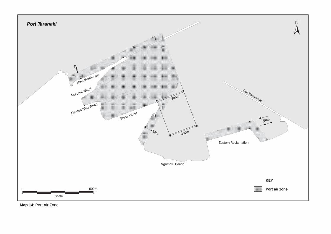
Map 14: Port Air Zone
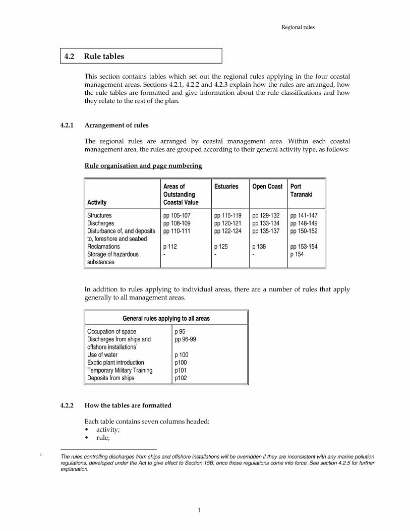
Regional rules
1
4.2 Rule tables
This section contains tables which set out the regional rules applying in the four coastal
management areas. Sections 4.2.1, 4.2.2 and 4.2.3 explain how the rules are arranged, how the rule tables are formatted and give information about the rule classifications and how they relate to the rest of the plan.
4.2.1 Arrangement of rules The regional rules are arranged by coastal management area. Within each coastal
management area, the rules are grouped according to their general activity type, as follows: Rule organisation and page numbering
Activity
Areas of
Outstanding Coastal Value
Estuaries Open Coast Port
Taranaki
Structures Discharges Disturbance of, and deposits to, foreshore and seabed Reclamations Storage of hazardous substances
pp 105-107 pp 108-109 pp 110-111 p 112 -
pp 115-119 pp 120-121 pp 122-124 p 125 -
pp 129-132 pp 133-134 pp 135-137 p 138 -
pp 141-147 pp 148-149 pp 150-152 pp 153-154 p 154
In addition to rules applying to individual areas, there are a number of rules that apply
generally to all management areas.
General rules applying to all areas
Occupation of space Discharges from ships and offshore installations
1
Use of water Exotic plant introduction Temporary Military Training Deposits from ships
p 95 pp 96-99 p 100 p100 p101 p102
4.2.2 How the tables are formatted Each table contains seven columns headed: • activity; • rule;
1
The rules controlling discharges from ships and offshore installations will be overridden if they are inconsistent with any marine pollution regulations, developed under the Act to give effect to Section 15B, once those regulations come into force. See section 4.2.5 for further explanation.
Regional rules
2
• standards/terms/conditions; • classification; • notification; • control/discretion; and • policy reference. Activity The activity column describes the type of activity to be, or being, undertaken. For the
activity to come within and continue to comply with the rule, the activity must come within the description contained in the `activity' column and meet any standards/terms/conditions in the `standards/terms/conditions' column (see below).
Rule The column headed `rule' contains the rule number, for reference purposes. Standards/Terms/Conditions The column contains: • standards and terms for controlled or discretionary activities; • conditions for permitted activities. When multiple standards/terms/conditions are specified, the proposed activity must
comply with all of them in order to remain within the rule class named in the column headed `classification'. In other words, the sentence after each bullet point is to be read as being linked to the following sentence by the word `AND'.
However, if the word `OR' separates the standards, terms or conditions the proposed
activity must comply with one or other of the standards, terms or conditions. The standards, terms or conditions are ongoing requirements that must continue to be met
after consent is granted. Failure to comply with the standards and terms amounts to a breach of the rule and may be subject to enforcement action. In the case of a permitted activity, failure to comply with the conditions will mean that the activity is no longer permitted without consent.
Classification The activity is classified as permitted, controlled, discretionary, non-complying, or
prohibited. Any activity which is not provided for in the specific activity column or which does not
meet the standards, terms, or conditions specified for that activity will be a non-complying activity unless a rule says that another classification applies.
Notification The Taranaki Regional Council has the option to deal with a resource consent application
as a notified application or as a non-notified application. The power to do so is provided by sections 93 and 94 of the Resource Management Act 1991. The options that the Taranaki Regional Council has for processing coastal permit applications (and the corresponding sections of the Act) are as follows:
(a) the Taranaki Regional Council can require a coastal permit application to be notified (s
93); (b) the Taranaki Regional Council need not notify a coastal permit application if:

Regional rules
3
(i) the activity is a controlled activity and the plan expressly permits
consideration of the application without notification or the need to obtain the written approval of affected parties (s 94(1)(b)); or
(ii) the activity is a controlled activity and written approval has been obtained
from every person who, in the Taranaki Regional Council's opinion, may be adversely affected by the granting of the coastal permit unless, in the Taranaki Regional Council's opinion, it is unreasonable in the circumstances to require the obtaining of every such approval (s 94(1)(c)); or
(iii) the activity is a discretionary activity over which the Taranaki Regional
Council has restricted the exercise of its discretion and the plan expressly permits consideration of the application without notification or the need to obtain the written approval of affected parties (s 94(1A)); or
(iv) the activity is a discretionary activity or non-complying activity and: • the Taranaki Regional Council is satisfied that the adverse effect on the
environment of the activity for which consent is sought will be minor; and • written approval has been obtained from every person who, in the Council's
opinion, may be adversely affected by the granting of the coastal permit unless the Council considers it is unreasonable in the circumstances to require the obtaining of every such approval (s 94(2)).
In the table of rules, the notification column will be either blank or contain the words "may
be non-notified without written approval". When the words "may be non-notified without written approval" are used, then the rules
must be taken as stating that an application for a resource consent may be considered without notification and without the need to obtain the written approval of affected persons in accordance with sections 94(1)(b) or 94(1A), ie in the circumstances outlined in (b)(i) and (b)(iii) above. These sections enable an application for a resource consent to be considered without notification or a need to obtain the written approval of affected persons. Note, however, that the Taranaki Regional Council may require an application to be notified, even where a rule states that it may be "non-notified", if the Council considers special circumstances exist in relation to an application. This power is provided by section 94(5).
If the column is blank, the activity may be either notified or non-notified but can only be
non-notified in the circumstances described in (b)(ii) and (iv) above. Control/Discretion This column states the matters over which the Taranaki Regional Council reserves control
(in relation to a controlled activity) or to which it has restricted the exercise of its discretion (in relation to a discretionary activity). The Council is limited to these matters when considering the environmental effects of the activity and when setting conditions on a resource consent.
When the column is blank, one of four situations applies: • the activity is a permitted activity, and by definition no control or discretion can be
reserved;

Regional rules
4
• the activity is a prohibited activity, and by definition no control or discretion can be reserved;
• the activity is a discretionary activity for which the Taranaki Regional Council has
retained full discretion, which will be exercised in accordance with the objectives and policies of the plan and the matters to be considered in Section 104 of the Act;
• the activity is a non-complying activity, and no control or discretion can be reserved. Policy References The `policy references' column cross-references the policies in Section 3.0 of this plan that
are generally relevant to the type of activity governed by that rule. Policy references are included as a guide to all plan users, including the Taranaki Regional
Council, as to the policies that the Council will consider when deciding a coastal permit application.
4.2.3 How the classifications are used A permitted activity can be carried out as of right, provided that all conditions in the
`standards/terms/conditions' column are met. The rule is complete in itself. A controlled activity may only be carried out if a coastal permit is obtained for that
activity. The Taranaki Regional Council must grant the permit and will set conditions in relation to the matters set out in the `control/discretion' column. When the content of these conditions is being considered, the relevant objectives and policies in the plan and other section 104 matters will be considered only so far as they apply to the matters over which the Council has reserved control as set out in the "control/discretion" column.
A discretionary activity may only be carried out if a coastal permit is obtained for that
activity. Effectively, three sub-types of discretionary activity exist. Each is explained below: (a) Discretionary activity for which the Taranaki Regional Council has restricted the
exercise of its discretion The Taranaki Regional Council may decline or grant a coastal permit for this type of
discretionary activity. The Taranaki Regional Council will exercise its discretion in accordance with Section 104 of the Act. However, the Council will only consider effects on the environment (Section 104(1)(a)) that are relevant to the matters to which the Council has restricted the exercise of its discretion. If the coastal permit is granted, the Council may only set conditions that are relevant to the matters to which Council has restricted the exercise of its discretion as set out in the "control/discretion" column.
This type of discretionary activity rule can be identified in the rule tables as a rule
when the classification column contains the word "discretionary" and the control/discretion column is not blank. In that case, the Taranaki Regional Council's discretion is limited to the matters set out in the control/discretion column.

Regional rules
5
(b) Discretionary activity for which the Taranaki Regional Council retains full discretion
The Taranaki Regional Council may decline or grant a coastal permit for this type of
discretionary activity. The Council will exercise its discretion in accordance with the objectives and policies in the plan and other Section 104 matters. The Council may consider any matter allowed under Section 104, including all effects on the environment. If the coastal permit is granted, the Council may set any conditions on the permit that fall within the Council's powers under Section 108 of the Act.
A non-complying activity is an activity (not being a prohibited activity) which is either
defined in the rule as a non-complying activity, or, contravenes a rule in a plan or proposed plan, and is allowed only if a coastal permit is obtained in respect of that activity.
No consent may be granted for a prohibited activity and such activities cannot be carried
out under any circumstances. 4.2.4 Activities falling in more than one coastal management area4.2.4 Activities falling in
more than one coastal management area Any activity that occurs across a boundary of two or more coastal management areas is
considered to fall within the coastal management area (in that group) that has the most stringent provisions that apply to that activity.
4.2.5 Discharges from ships and offshore installations4.2.5 Discharges from ships and
offshore installations Discharges from ships and offshore installations to the coastal marine area will be subject to
section 15B of the Resource Management Amendment Act 1994 once that Act comes into effect. Under this Amendment Act the Government is preparing marine pollution regulations to address discharges of harmful substances or contaminants.
In anticipation of these changes in legislation, the general rules concerning discharges from
ships and offshore installations have been drafted to be as consistent as possible with the draft regulations. These rules may be overridden when section 15B and the associated marine pollution regulations come into force.

General rules applying to all coastal management areas

2
Occupation of space
Activity Rule Standards/Terms/Conditions Classification Notification Control/Discretion Policy References
The occupation of space on the foreshore, seabed or surface of the water for the purpose of conducting a community or recreational or sporting activity
G1.1
• Activity does not affect breeding, roosting or migratory populations of marine life;
• Activity does not present a hazard to navigation and shipping; • Activity does not involve erection of structures, disturbance of
foreshore or seabed or other works that will have an effect that lasts longer than two high tides after the conclusion of the event;
• Date, duration and extent of the event is advertised in The Daily News and all local newspapers at least 14 days prior to the event;
• Activity does not restrict public access or exclude the public for a period of longer than two days;
• All litter and other refuse is removed from the area of the activity before the first high tide following the event;
• Activity does not come within any other rule in this plan.
Permitted
Any activity involving
occupation of large areas of the coastal marine area
G1.2 • Excludes or effectively excludes public access from area of the coastal marine area over 10 hectares (except where such exclusion is required in commercial port areas for reasons of public safety or security);
OR • Excludes or effectively excludes the public from more than 316
metres along the length of the foreshore; OR • Involves occupation or use of areas greater than 50 hectares of the
coastal marine area and such occupation or use would restrict public access to or through such areas.
Discretionary 1.1, 3.1, 3.2, 3.3, 5.7, 13.1(c), 14.1, 14.2, 14.3, 14.6
Other occupation of land of the Crown in the coastal marine area or land vested in the Taranaki Regional Council and occupation of related parts of the coastal marine area
G1.3 • Occupation does not come within and/or comply with any other rule in this plan that authorises occupation.
• Occupation excludes occupation related to structures when there is a rule relating to structure placement that specifically provides for occupation.
Discretionary 1.1, 3.1, 3.2, 3.3, 5.7, 13.1(c), 14.1, 14.2, 14.3, 14.4, 14.5, 14.6

3
Discharges from ships and offshore installations1
Activity Rule Standards/Terms/Conditions Classification Notification Control/Discretion Policy References
Discharge of stormwater from ships and offshore installations to the coastal marine area
G2.1 • Discharge contains less than 15 gm-3 of oil or grease Permitted
Discharge of cooling water from ships and offshore installations to the coastal marine area
G2.2 • Discharge is of water used for cooling purposes as part of the normal operational requirements of a ship or offshore installation;
• Discharge does not contain a harmful substance.
Permitted
Discharge of human
sewage from ships and offshore installations to the coastal marine area
G2.3 • Discharge occurs more than 300 metres (0.15 nautical miles) from mean high water springs and any marine farm;
• Discharge occurs in water depths greater than 5 metres. • The discharge of sewage from ships and offshore installations is
exempt from the conditions of this rule, and therefore a permitted activity, until 31 July 1999.
Permitted
Discharge of treated
sewage from ships and offshore installations to the coastal marine area
G2.4 Discharge meets the following standards when sampled at least 5 times over 24 hours: • geometric mean of faecal coliform count is less than 250 faecal
coliforms per 100 millilitres; • when analysed by gravimetric methods, the geometric mean of total
suspended solids content is less than: (i) 50 gm
-3 when analysed on shore; or
(ii) 100 gm-3 more than suspended solids content of the ambient
water used for flushing when analysed on board a ship;
Permitted
1
These rules controlling discharges from ships and offshore installations may be overridden once marine pollution regulations, as being developed under the Resource Management Act (1994 Amendment) to give effect to section 15B, come into force. See section 4.2.5 for further explanation.

4
3
Activity Rule Standards/Terms/Conditions Classification Notification Control/Discretion Policy References
• a geometric mean of five day biochemical oxygen demand of the samples of sewage is less than 50 gm
-3.
• The discharge of sewage from ships and offshore installations is exempt from the conditions of this rule, and therefore a permitted activity, until 31 July 1999.
Discharge of garbage from ships and offshore installations to the coastal marine area
G2.5 Garbage contains any of: - food waste; - paper products; - rags; - glass; - bottles; - crockery; - metal from a ship. • Discharge has been ground or comminuted so as to be capable of
passing through a 25 mm screen; • Discharge occurs 5500 metres seaward of mean high water
springs
Permitted
Discharge of ballast water from ships to the coastal marine area
G2.6 • Discharge is of ballast water is clean and is from dedicated ballast water holding tanks to the coastal marine area;
• Discharge is subject to any controls imposed under the Biosecurity Act 1993.
Permitted
Discharge of bilge water, on
board sink or dishwater, shower water, laundry water, bath water, wash basin water or deck wash to the coastal marine area
G2.7 • Discharge is not likely to produce any conspicuous oil or grease films, scums or foams, or floatable or suspended materials, after reasonable mixing;
• Discharge is not likely to cause any conspicuous change in colour or visual clarity after reasonable mixing;
• Discharge is not likely to have any significant adverse effects on aquatic life after reasonable mixing.
Permitted
Discharge of drilling muds,
cuttings, and drilling fluids from offshore installations to the coastal marine area
G2.8 • Discharge occurs outside boundary of any part of coastal management area A or coastal management area B.
Permitted

5
3
Discharge of produced
water from an offshore installation
G2.9 • Discharge contains less than 15 gm-3 of oil or grease. Permitted
Discharge of contaminants to air in the coastal marine
area via the flaring of hydrocarbons from
petroleum exploration or mining
G2.10 • Discharge: (a) occurs outside the boundary of the Sugar Loaf Islands Marine
Protected area, inclusive of a 150 m buffer zone; or (b) is not located under the New Plymouth Airport flight path
protection surfaces shown in Section 4.3 of this plan.
Permitted
Discharge of any of the following contaminants or
harmful substances to air and water in the coastal marine area from any ship or offshore installation (a)storage and transfer of cargo materials within the Port Air Zone (see rules D2.7 and D2.8); or (b) ship propulsion; or (c) crew and passengers' utilities, including cooking and laundry facilities; or (d) on-board fish processing operations; or (e) storage or transfer of cargo materials other than as provided for in (a) above
G2.11 • Discharge is not likely to be noxious, dangerous, offensive or objectionable to such an extent that it has, or is likely to have, an adverse effect on the environment.
Permitted

6
3
Seismic surveys of the coastal marine area for the purpose of petroleum prospecting
G2.12 • Survey does not involve placement of explosives or does not otherwise directly involve disturbance of the foreshore or seabed;
• Survey is not conducted in an area that is used by marine wildlife for breeding purposes during the time that those animals are breeding
Permitted
Discharge of contaminants to water or air in the coastal marine area and the discharge does not come within and/or comply with any of rules G2.1 to G2.12
G2.13 Discretionary
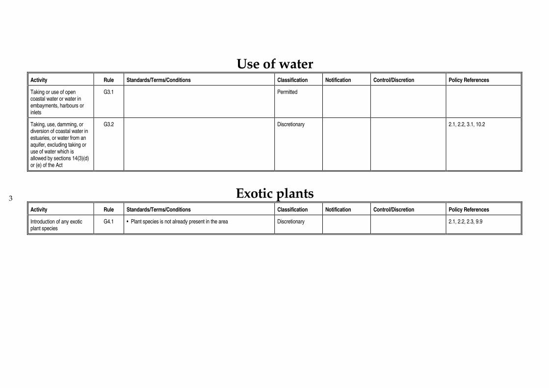
3
Use of water
Activity Rule Standards/Terms/Conditions Classification Notification Control/Discretion Policy References
Taking or use of open coastal water or water in embayments, harbours or inlets
G3.1 Permitted
Taking, use, damming, or diversion of coastal water in estuaries, or water from an aquifer, excluding taking or use of water which is allowed by sections 14(3)(d) or (e) of the Act
G3.2 Discretionary 2.1, 2.2, 3.1, 10.2
Exotic plants
Activity Rule Standards/Terms/Conditions Classification Notification Control/Discretion Policy References
Introduction of any exotic plant species
G4.1 • Plant species is not already present in the area Discretionary 2.1, 2.2, 2.3, 9.9

3
Temporary military training Activity Rule Standards/Terms/Conditions Classification Notification Control/Discretion Policy References
Temporary military training activities with minor effects
G5.1 • All necessary written permission has been obtained from the occupier or person with administrative responsibility for the areas to be used;
• Activities do not involve construction of permanent structures; • Activities do not involve earthworks or excavation, other than
earthworks or excavations which are consented in accordance with this plan;
• Activities comply with the general standards specified in Section 4.4 of this plan;
• Activities do not exclude, or effectively exclude, public access from areas of the coastal marine area over 10 hectares or from more than 316 metres along the length of the foreshore, except where such exclusions are required in commercial port areas for reasons of public safety or security;
• Activities do not involve occupation or use of areas greater than 50 hectares of the coastal marine area.
Permitted
Temporary military training activities that do not comply with rule G5.1
G5.2 • Activities do not exclude, or effectively exclude, public access from areas of the coastal marine area over 10 hectares or from more than 316 metres along the length of the foreshore, except where such exclusions are required in commercial port areas for reasons of public safety of security;
• Activities do not involve occupation or use of areas greater than 50 hectares of the coastal marine area.
Controlled • Disturbance of foreshore and seabed
• Deposition of material on the foreshore and seabed
• Discharge of contaminants • Erection, maintenance and
removal of structures • Effects on ecosystems and
conservation values • Noise emissions

9
3
Deposits from ships
Activity Rule Standards/Terms/Conditions Classification Notification Control/Discretion Policy References
Deposit of a substance from the scraping and/or cleaning of a ship's hull or any other part of the ship that is normally below the water surface, to the coastal marine area
G6.1
• Ship is greater than 25 metres in length; or • Ship has been outside New Zealand's exclusive economic zone
since it was last cleaned or scraped
Prohibited

Coastal Management Area A: Areas of Outstanding Coastal Value


3
Structures
Activity Rule Standards/Terms/Conditions Classification Notification Control/Discretion Policy References
Placement of an outfall structure
A1.1 • Structure has an internal diameter of 400 mm or less and extends 1 metre or less into an estuary, or 2 metres or less into an open coast;
• No erosion, scour or deposition results from placement or use of the structure; • Structure is placed or designed in such a way as to prevent tidal backflow and fish
entrapment; • Structure is not to be built in that part of area A that is the Sugar Loaf Islands
Marine Protected Area or the Waitotara River Estuary; • Structure is to have the minimum external diameter necessary for the safe and
efficient operation of the structure.
Permitted
Reconstruction, alteration or removal and replacement of an existing structure for
maintenance (other than transit bridges)
A1.2 • Activity is for the purpose of maintaining the structure in good repair; • Size of the structure will not increase beyond original size; • Sediment disturbance will not decrease the visual clarity of water by more than
50% outside a 50 metre radius zone of mixing; • No contaminant will be released into coastal water; • Activity complies with general standards in Section 4.4; • At least one working day before maintenance commences, the Taranaki Regional
Council is informed that the activity is to occur.
Permitted
Erection or placement of a navigation aid for marine transport, and related occupation of the coastal marine area (including renewal of occupation), and related disturbance of the foreshore and seabed
A1.3 • Structure does not interfere with the New Plymouth Airport Flight Path Protection Surfaces shown in Section 4.3.
Controlled May be non-notified without written approval
• Disturbance of the foreshore and seabed
• Method of construction or placement • Protection of conservation values • Effects on water quality • Occupation and public access • Noise emissions • Light emissions • Duration of consent and removal of
structure • Timing of works • Monitoring • Review • Administrative charges
1.1(a), 2.1, 2.2, 2.3, 3.1, 6.2, 6.5, 8.1, 9.10, 11.1, 11.2, 13.1, 14.1
Removal or demolition of a structure, and related disturbance of the
A1.4 • Structure is not on the Register of Historic Places, historic areas, w_hi tapu and w_hi tapu areas, or otherwise subject to the Historic Places Act 1993 or any other legislation applying to historic places.
• Structure is not a pipeline authorised before 1 October 1991 to which s107 of the
Discretionary May be non-notified without written approval
• Erosion and channel form effects • Water quality effects • Method of demolition or removal • Disposal of waste
1.1(a), 2.1, 2.2, 2.3, 3.1, 3.2, 3.3, 4.1, 6.2, 6.3, 7.2, 8.1, 8.2, 9.10, 11.1, 11.2

4
3
Activity Rule Standards/Terms/Conditions Classification Notification Control/Discretion Policy References
foreshore and seabed Crown Minerals Act 1991 applies. • Effects on conservation values • Remains of structure in coastal
marine area • Disturbance of the foreshore and
seabed • Restoration of the foreshore and
seabed • Public access • Noise emissions • Light emissions • Duration of consent • Timing of works • Monitoring • Review • Administrative charges
Erection or placement of a large structure and related occupation of the coastal marine area, excluding any structure that comes within rule A1.9
A1.5 • Structure presents a significant barrier to water or sediment movement; • Structure is 300 metres or more in length parallel to the line of mean high water
springs (including separate structures the sum of whose lengths is 300 metres or more).
Non-complying 1.1(a), 2.1, 2.2, 2.3, 3.1, 3.2, 3.3, 4.1, 6.1, 6.2, 7.1, 7.2, 7.3, 7.4, 8.1 8.2, 9.10, 11.1, 11.2, 13.1, 13.2, 14.1, 14.2, 14.3
A1.6 • Structure presents a significant barrier to water or sediment movement; • Structure is oblique or perpendicular to the line of mean high water springs; • Structure is in horizontal projection 100 metres or more in length.
Discretionary 1.1(a), 2.1, 2.2, 2.3, 3.1, 3.2, 3.3, 4.1, 6.1, 6.2, 7.1, 7.2, 7.3, 7.4, 8.1, 8.2, 9.10, 11.1, 11.2, 13.1, 13.2, 14.1, 14.2, 14.3
Erection or placement of
a structure for storage or containment of any petroleum, petroleum products or
contaminants, excluding any pipeline
A1.7 Prohibited

5
3
Erection or placement of a pipeline for the transmission or distribution of petroleum
A1.8 • Pipeline has a volume of more than 50 000 litres in that part of the pipeline that crosses the coastal marine area.
Discretionary 1.1(a), 2.1, 2.2, 2.3, 3.1, 3.2, 3.3, 4.1, 6.2, 6.5, 8.1, 8.2, 9.7, 9.10, 11.1, 11.2, 13.1, 14.1, 14.2, 14.3
Erection or placement of a solid structure that impounds or effectively contains part of the coastal marine area (other than for the purpose of reclamation)
A1.9 Prohibited
Erection or placement of a whitebait stand
A1.10 Prohibited
Erection, placement, reconstruction, alteration, extension, removal or demolition of any structure and any related occupation of the coastal marine area and the activity or structure does not come within and/or comply with any of rules A1.1 to A1.10
A1.11
Discretionary 1.1(a), 2.1, 2.2, 2.3, 3.1, 3.2, 3.3, 4.1, 6.1, 6.2, 6.3, 7.1, 7.2, 7.3, 7.4, 8.1, 8.2, 9.7, 9.10, 11.1, 11.2, 13.1, 13.2, 14.1, 14.2, 14.3

3 3
Discharges
Activity Rule Standards/Terms/Conditions Classification Notification Control/Discretion Policy References
Discharge of water from an
aquifer to coastal water or water in an aquifer in the coastal marine area
A2.1 • No contaminants are added to the discharge; • Saline water is not discharged into freshwater.
Permitted
Discharge of
uncontaminated water or stormwater into water or onto land in the coastal marine area
A2.2 • Stormwater discharge occurs from a road, roof, paved area, grassed area or yard;
• Stormwater discharge contains less than 15 gm-3 of oil and grease
and less than 100 gm-3 suspended solids;
• Stormwater discharge does not originate from any industrial or trade premises;
• Water (other than stormwater) discharge contains no contaminants; • Water or stormwater can be discharged through a 400 mm diameter
pipe.
Permitted
Discharge of uncontaminated water or stormwater into water or onto land in the coastal marine area and the discharge does not come within and/or comply with rule A2.2
A2.3 Discretionary May be non-notified without written approval
• Location of discharge • Effects on conservation values
and ecosystems • Effects on water quality • Erosion effects • Values and ecosystems • Contingency planning to
prevent contaminant discharges
• Quality of discharge and possible treatment before discharge
• Volume and rate of discharge • Duration of consent • Monitoring • Review • Administrative charges
1.1(a), 2.1, 2.2, 2.3, 4.1, 5.4, 9.3, 9.6, 9.7
Discharge of human sewage into water or onto land in the coastal marine area, excluding discharges
A2.4 Prohibited

7
from ships and offshore installations
Other discharge of water or contaminants into water or onto land in the coastal marine area and the discharge does not come within and/or comply with rules A2.1 to A2.4
A2.5 • Discharge gives rise to any or all of the following effects in the receiving waters, after reasonable mixing:
(a) production of conspicuous oil or grease films, scums or foams, or floatable or suspended materials;
(b) conspicuous change in colour or visual clarity; (c) emission of objectionable odour; (d) significant adverse effects on aquatic life; and is not of a temporary nature or associated with necessary maintenance
work.
Discretionary 1.1(a), 2.1, 2.2, 2.3, 3.1, 3.2, 3.3, 5.4, 5.5, 8.1, 9.1, 9.2, 9.3, 9.4, 9.5, 9.6, 13.1, 14.1, 14.2, 14.3
Other discharges of water or contaminants into water or onto land in the coastal marine area, excluding discharges from ships and offshore installations and the discharge does not come within and/or comply with rule A2.5
A2.6 Non-complying 1.1(a), 2.1, 2.2, 2.3, 3.1, 3.2, 3.3, 5.4, 5.5, 8.1, 9.1, 9.2, 9.3, 9.4, 9.5, 9.6, 13.1, 14.1, 14.2, 14.3
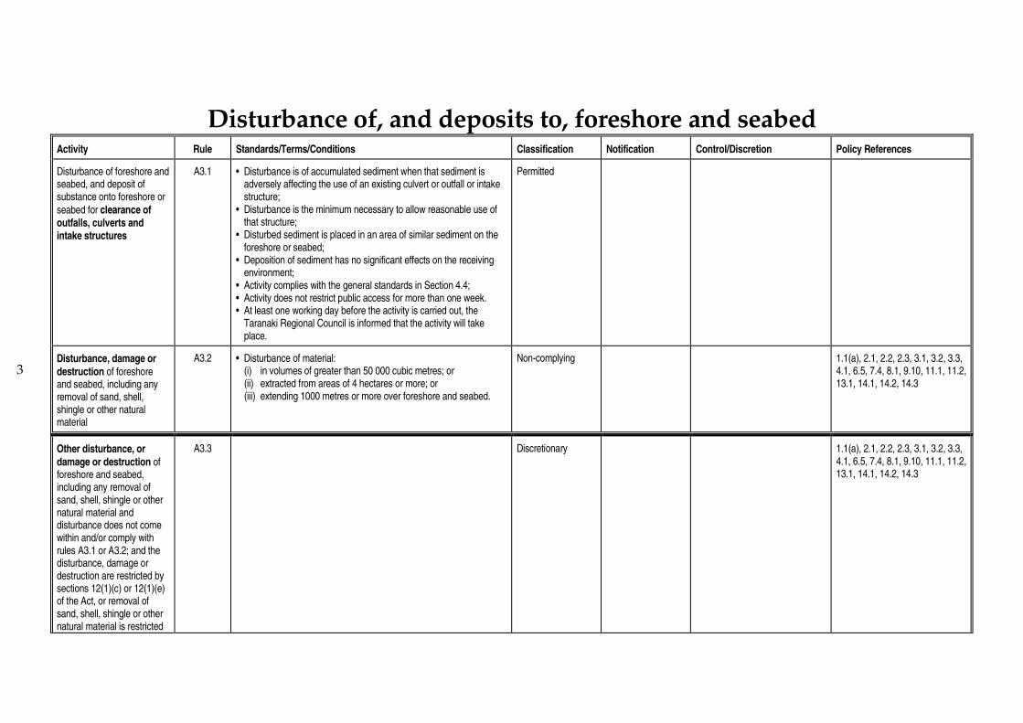
3
Disturbance of, and deposits to, foreshore and seabed
Activity Rule Standards/Terms/Conditions Classification Notification Control/Discretion Policy References
Disturbance of foreshore and seabed, and deposit of substance onto foreshore or
seabed for clearance of outfalls, culverts and intake structures
A3.1 • Disturbance is of accumulated sediment when that sediment is adversely affecting the use of an existing culvert or outfall or intake structure;
• Disturbance is the minimum necessary to allow reasonable use of that structure;
• Disturbed sediment is placed in an area of similar sediment on the foreshore or seabed;
• Deposition of sediment has no significant effects on the receiving environment;
• Activity complies with the general standards in Section 4.4; • Activity does not restrict public access for more than one week. • At least one working day before the activity is carried out, the
Taranaki Regional Council is informed that the activity will take place.
Permitted
Disturbance, damage or
destruction of foreshore and seabed, including any removal of sand, shell, shingle or other natural material
A3.2 • Disturbance of material: (i) in volumes of greater than 50 000 cubic metres; or (ii) extracted from areas of 4 hectares or more; or (iii) extending 1000 metres or more over foreshore and seabed.
Non-complying 1.1(a), 2.1, 2.2, 2.3, 3.1, 3.2, 3.3, 4.1, 6.5, 7.4, 8.1, 9.10, 11.1, 11.2, 13.1, 14.1, 14.2, 14.3
Other disturbance, or
damage or destruction of foreshore and seabed, including any removal of sand, shell, shingle or other natural material and disturbance does not come within and/or comply with rules A3.1 or A3.2; and the disturbance, damage or destruction are restricted by sections 12(1)(c) or 12(1)(e) of the Act, or removal of sand, shell, shingle or other natural material is restricted
A3.3 Discretionary 1.1(a), 2.1, 2.2, 2.3, 3.1, 3.2, 3.3, 4.1, 6.5, 7.4, 8.1, 9.10, 11.1, 11.2, 13.1, 14.1, 14.2, 14.3
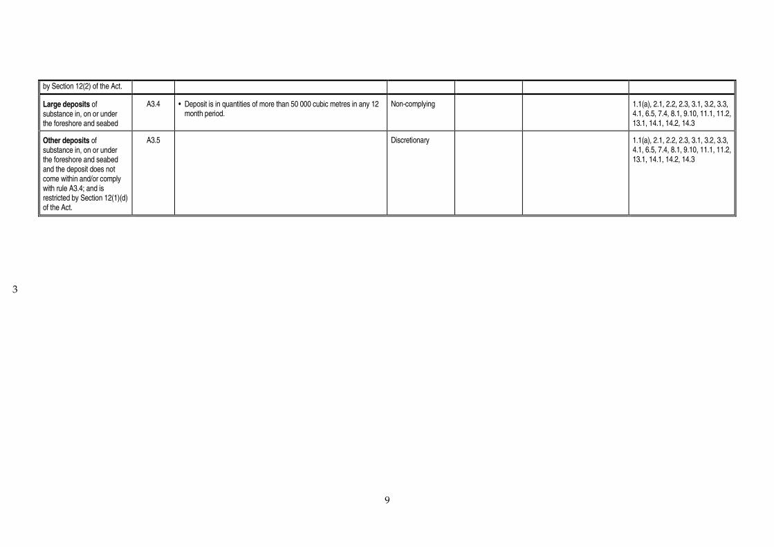
9
3
by Section 12(2) of the Act.
Large deposits of substance in, on or under the foreshore and seabed
A3.4 • Deposit is in quantities of more than 50 000 cubic metres in any 12 month period.
Non-complying 1.1(a), 2.1, 2.2, 2.3, 3.1, 3.2, 3.3, 4.1, 6.5, 7.4, 8.1, 9.10, 11.1, 11.2, 13.1, 14.1, 14.2, 14.3
Other deposits of substance in, on or under the foreshore and seabed and the deposit does not come within and/or comply with rule A3.4; and is restricted by Section 12(1)(d) of the Act.
A3.5 Discretionary 1.1(a), 2.1, 2.2, 2.3, 3.1, 3.2, 3.3, 4.1, 6.5, 7.4, 8.1, 9.10, 11.1, 11.2, 13.1, 14.1, 14.2, 14.3

3
Reclamation
Activity Rule Standards/Terms/Conditions Classification Notification Control/Discretion Policy References
Reclamation or draining of the foreshore and seabed, excluding reclamation for the principal purpose of erosion control or flood control
A4.1 Prohibited
Reclamation or draining of the foreshore and seabed for the principal purpose of
erosion control or flood control
A4.2 • Reclamation is for the principal purpose of erosion control or flood control;
• Reclamation has an area less than 1 hectare and extends less than 10 metres perpendicular to mean high water springs and less than 100 metres parallel to mean high water springs.
Discretionary 1.1(a), 2.1, 2.2, 2.3, 3.1, 3.2, 3.3, 4.1, 6.4, 6.6, 7.1, 7.2, 7.3, 7.4, 7.5, 8.1, 9.10, 11.1, 11.2, 13.1, 14.1, 14.2, 14.3, 14.4
A4.3 • Reclamation is for the principal purpose of erosion control or flood control;
• Reclamation extends less than 100 metres in any direction
Non-complying 1.1(a), 2.1, 2.2, 2.3, 3.1, 3.2, 3.3, 4.1, 6.4, 6.6, 7.1, 7.2, 7.3, 7.4, 7.5, 8.1, 9.10, 11.1, 11.2, 13.1, 14.1, 14.2, 14.3, 14.4
A4.4 • Reclamation has an area of 1 hectare or more; or • Reclamation extends 100 metres or more in any direction; or • Reclamation is an incremental reclamation connected to, or part of,
another reclamation which: (i) was commenced or received a resource consent after 5 May
19941; and
(ii) the sum of the existing and proposed reclamations are equal to or exceed an area of 1 hectare or a distance of 100m in any direction.
Non-complying 1.1(a), 2.1, 2.2, 2.3, 3.1, 3.2, 3.3, 4.1, 6.4, 6.6, 7.1, 7.2, 7.3, 7.4, 7.5, 8.1, 9.10, 11.1, 11.2, 13.1, 14.1, 14.2, 14.3, 14.4
1
the gazettal gate of the New Zealand Coastal Policy Statement.

Coastal Management Area B : Estuaries

2 2 2
Structures
Activity Rule Standards/Terms/Conditions Classification Notification Control/Discretion Policy References
Alteration, reconstruction or removal and re-placement of an existing structure for maintenance
B1.1 • Activity is for the purpose of maintaining the structure in good repair; • Size of the structure will not increase beyond original size; • Sediment disturbance will not decrease the visual clarity of water by
more than 50% outside a 50 metre radius zone of mixing; • No contaminant will be released into coastal water; • Activity complies with general standards in Section 4.4; • At least one working day before maintenance commences, the
Taranaki Regional Council is informed that the activity is to occur.
Permitted
Placement of an outfall structure
B1.2 • Structure has an internal diameter of 600 mm or less and extends 1 metre or less over the bed of the estuary;
• No erosion, scour or deposition results from placement or use of the structure;
• Structure is designed or placed to prevent tidal backflow and fish entrapment;
• Structure is to have the minimum external diameter necessary for the safe and efficient operation of the structure.
Permitted
Erection or placement of a navigation aid for marine transport, and related occupation of the coastal marine area (including renewal of occupation), and related disturbance of the foreshore and seabed
B1.3 • Structure does not interfere with the New Plymouth Airport Flight Path Protection Surfaces shown in Section 4.3.
Controlled May be non-notified without written approval
• Occupation and public access • Noise emissions • Light emissions • Disturbance of foreshore or
seabed • Effects on water quality • Method of construction or
placement • Timing of works • Duration of consent and
removal of structure • Height of structure • Monitoring • Review • Administrative charges
1.1(b), 2.1, 2.2, 3.1, 6.2, 6.5, 8.1, 9.10, 11.1, 11.2, 13.1, 14.1, 14.2, 14.3
Erection, placement, alteration, extension or
B1.4 • Structure is any: - pipeline which is not a restricted coastal activity under rule
Controlled May be non-notified without written
• Disturbance of foreshore and seabed
1.1(b), 2.1, 2.2, 6.2, 6.5, 6.6, 8.1, 8.2, 9.10, 11.1, 11.2, 13.1, 14.1,

3
2
reconstruction of a utility structure, and related occupation of the coastal marine area (including renewal of occupation), and related disturbance of the foreshore and seabed
B1.12; or - outfall structure which does not come within and/or comply with
rule B1.2; or - intake structure; or - communication or electricity cable (excluding overhead cables);
or - marine communications equipment; • Cables or pipelines are either buried within the foreshore and
seabed or are attached to a bridge or access structure; • Outfall or intake structure extends across less than 20% of the width
of the estuary bed at the point of the outfall or intake and no more than 2 metres along the bank;
• Structure does not cause erosion, scour or deposition, or significantly divert water flows;
• Structure is necessary to enable the safe and efficient conduct of the utility operations;
• Structure does not adversely affect access to or use of the area surrounding the structure and does not affect the amenity values present in the area.
approval • Sediment movement and erosion
• Design and external appearance of structure
• Precise location of structure within the general area of the application
• Method of construction or placement of the structure
• Effects on navigation • Effects on ecological values • Occupation and public access • Noise emissions • Light emissions • Duration of consent and
removal of structure • Timing of works • Monitoring • Review • Administrative charges
14.2, 14.3
Erection or placement of a whitebait stand
B1.5 Prohibited
Removal or demolition of a structure, excluding Waitara River control arms or Patea River control arms, and related disturbance of the foreshore and seabed
B1.6 • Structure is not on the Register of Historic Places, historic areas, w_hi tapu and w_hi tapu areas, or otherwise subject to the Historic Places Act 1993 or any other legislation applying to historic places.
• Structure is not a pipeline authorised before 1 October 1991 to which s107 of the Crown Minerals Act 1991 applies.
Discretionary May be non-notified without written approval
• Erosion and channel form effects
• Water quality effects • Method of demolition or
removal • Effects on ecosystems • Disposal of waste • Remains of structure in coastal
marine area • Disturbance of the foreshore
and seabed • Restoration of the foreshore
and seabed • Noise emissions • Light emissions
1.1(b), 2.1, 2.2, 3.1, 6.2, 6.3, 6.5, 8.1, 8.2, 9.10, 11.1, 11.2, 13.1

4
2
• Duration of consents • Timing of works • Monitoring • Review • Administrative charges
Removal or demolition of a structure and the activity or structure does not come within and/or comply with rule B1.6
B1.7 • Structure is not a pipeline authorised before 1 October 1991 to which s107 of the Crown Minerals Act 1991 applies.
Discretionary 1.1(b), 2.1, 2.2, 3.1, 6.2, 6.3, 6.5, 8.1, 8.2, 9.10, 11.1, 11.2, 13.1
Erection or placement of a solid structure that impounds or effectively
contains a naturally-formed area of estuary (other than for reclamation purposes)
B1.8 Prohibited
Erection or placement of a large structure and related occupation of the coastal marine area, excluding any structure that comes within rule B1.6
B1.9 • Structure is solid or presents a significant barrier to water or sediment movement;
• Structure is 300 metres or more in length parallel to the line of mean high water springs (including structures the sum of whose lengths is 300 metres or more).
Discretionary 1.1(b), 2.1, 2.2, 3.1, 3.2, 3.3, 6.1, 6.2, 7.1, 7.2, 7.3, 7.4, 8.1, 8.2, 9.8, 11.1, 11.2, 13.1, 13.2, 14.1, 14.2, 14.3
B1.10 • Structure is solid or presents a significant barrier to water or sediment movement;
• Structure is oblique or perpendicular to the line of mean high water springs;
• Structure is in horizontal projection 100 metres or more in length.
Discretionary 1.1(b), 2.1, 2.2, 3.1, 3.2, 3.3, 6.1, 6.2, 7.1, 7.2, 7.3, 7.4, 8.1, 8.2, 9.10, 11.1, 11.2, 13.1, 13.2, 14.1, 14.2, 14.3
Erection or placement of a structure for the storage or containment of petroleum, petroleum products or contaminants (excluding any pipeline)
B1.11 Prohibited

5
2
Erection or placement of a pipeline for the transmission or distribution of petroleum
B1.12 • Pipeline has a volume of more than 50 000 litres in that part of the pipeline that crosses the coastal marine area.
Discretionary 1.1(b), 2.1, 2.2, 3.1, 3.2, 3.3, 6.2, 8.1, 8.2, 9.7, 9.10, 11.1, 11.2, 13.1, 14.1, 14.2, 14.3
Erection, placement, alteration, extension or reconstruction of any structure, and related occupation of the coastal marine area and the activity or structure does not come within and/or comply with any of rules B1.1 to B1.12
B1.13 • Structure is within any one of the following estuaries: - Waiwhakaiho - Waitara - Patea
Discretionary 1.1(b), 2.1, 2.2, 3.1, 3.2, 3.3, 6.1, 6.2, 6.3, 7.1, 7.2, 7.3, 7.4, 8.1, 8.2, 9.7, 9.10, 11.1, 11.2, 13.1, 13.2, 14.1, 14.2, 14.3
Erection, placement, alteration, extension or reconstruction of any structure, and related occupation of the coastal marine area and the activity or structure does not come within and/or comply with any of rules B1.1 to B1.13
B1.14 Non-complying 1.1(b), 2.1, 2.2, 3.1, 3.2, 3.3, 6.1, 6.2, 6.3, 7.1, 7.2, 7.3, 7.4, 8.1, 8.2, 9.7, 9.10, 11.1, 11.2, 13.1, 13.2, 14.1, 14.2, 14.3

2 2
Discharges
Activity Rule Standards/Terms/Conditions Classification Notification Control/Discretion Policy References
Discharge of water from an
aquifer to coastal water or water in an aquifer in the coastal marine area
B2.1 • No contaminants are added to the discharge; • Saline water is not discharged into fresh water.
Permitted
Discharge of
uncontaminated water or stormwater into water or onto land in the coastal marine area
B2.2 • Stormwater discharge occurs from a road, roof, yard, paved area or grassed area;
• Stormwater discharge contains less than 15 gm-3 of oil and grease
and less than 100 gm-3 suspended sediment;
• Stormwater discharge does not originate from any industrial or trade premises;
• Discharge can be discharged through a 600 mm diameter pipe.
Permitted
Discharge of
uncontaminated water or stormwater into water or onto land in the coastal marine area discharge does not come within and/or comply with rule B2.2
B2.3 Non-complying May be non-notified without written approval
1.1(b), 2.1, 2.2, 5.4, 9.3, 9.5, 9.6, 9.7
Discharge of human sewage into the coastal marine area
B2.4 • Discharge has not first passed through soil or wetland.
Discretionary 1.1(b), 2.1, 2.2, 3.1, 3.2, 3.3, 5.4, 5.5, 8.1, 9.1, 9.2, 9.3, 9.4, 9.5, 9.7, 13.1, 14.1, 14.2, 14.3
Discharge of water or
contaminant into water or onto land in the coastal marine area and the discharge does not come within and/or comply with rules B2.1 to B2.4
B2.5 • Discharge gives rise to any or all of the following effects in the receiving waters, after reasonable mixing:
(a) production of conspicuous oil or grease films, scums or foams, or floatable or suspended materials;
(b) conspicuous change in colour or visual clarity; (c) emission of objectionable odour; (d) significant adverse effects on aquatic life; and such effects are not of a temporary nature or associated with
necessary maintenance work.
Discretionary 1.1(b), 2.1, 2.2, 3.1, 3.2, 3.3, 5.4, 5.5, 8.1, 9.1, 9.2, 9.3, 9.4, 9.5, 9.7, 13.1, 14.1, 14.2, 14.3
Discharge of water or
contaminant into water or
B2.6 Discretionary 1.1(b), 2.1, 2.2, 3.1, 3.2, 3.3, 5.4, 5.5, 8.1, 9.1, 9.2, 9.3, 9.4, 9.5,

7
onto land in the coastal marine area and the discharge does not come within and/or comply with Rule B2.5
9.7, 13.1, 14.1, 14.2, 14.3

2 2
Disturbance of, and deposits to, foreshore and seabed
Activity Rule Standards/Terms/Conditions Classification Notification Control/Discretion Policy References
Disturbance of foreshore and seabed, and deposit of substance onto foreshore or
seabed for clearance of culverts, outfall and intake structures
B3.1 • Disturbance is of accumulated sediment when that sediment is adversely affecting the use of an existing culvert or outfall or intake structure;
• Disturbance is the minimum necessary to allow reasonable use of that structure;
• Disturbed sediment is placed in an area of similar sediment on the foreshore or seabed;
• Sediments that contain contaminants are to be deposited outside of the coastal marine area;
• Activity complies with the general standards in Section 4.4; • Activity does not restrict public access for more than one week; • At least one working day before the activity is carried out, the
Taranaki Regional Council is informed that the activity will take place.
Permitted
Disturbance, damage or
destruction of foreshore and seabed, including any removal of sand, shell, shingle or other natural material
B3.2
• Structure is within any one of the following estuaries: - Waiwhakaiho - Waitara - Patea • Disturbance of material: (i) in volumes of greater than 50 000 cubic metres; or (ii) extracted from areas of 4 hectares or more; or (iii) extending 1000 metres or more over foreshore and seabed.
Discretionary 1.1(b), 2.1, 2.2, 3.1, 3.2, 3.3, 6.5, 7.4, 8.1, 9.10, 11.1, 11.2, 13.1, 14.1, 14.2, 14.3
Disturbance, damage or
destruction of the foreshore and seabed, including any removal of sand, shell, shingle or other natural material, and does not come within or comply with rule B3.2
B3.3 • Disturbance of material: (i) in volumes of greater than 50 000 cubic metres; or (ii) extracted from areas of 4 hectares or more; or (iii) extending 1000 metres or more over foreshore and seabed.
Non-complying 1.1(b), 2.1, 2.2, 3.1, 3.2, 3.3, 6.5, 7.4, 8.1, 9.10, 11.1, 11.2, 13.1, 14.1, 14.2, 14.3
Other disturbance or damage or destruction of foreshore and seabed, including any removal of
B3.4 • Disturbance, damage or destruction is within any one of the following estuaries:
- Waiwhakaiho - Waitara
Discretionary
1.1(b), 2.1, 2.2, 3.1, 3.2, 3.3, 6.5, 7.4, 8.1, 9.10, 11.1, 11.2, 13.1, 14.1, 14.2, 14.3

9
sand, shell, shingle, or other natural material and the disturbance does not come within and/or comply with rules B3.1, B3.2 and B3.3 and the disturbance, damage or destruction are restricted by sections 12(1)(c) or 12(1)(e) of the Act, or removal is restricted by section 12(2) of the Act
- Patea
Other disturbance or
damage or destruction of foreshore and seabed, including any removal of sand, shell, shingle or other natural material and the disturbance does not come within and/or comply with either of rules B3.1 B3.2, B3.3 and B3.4 and the disturbance, damage or destruction are restricted by sections 12(1)(c) or 12(1)(e) of the Act, or removal is restricted by Section 12(2) of the Act.
B3.5 Non-complying 1.1(b), 2.1, 2.2, 3.1, 3.2, 3.3, 6.6, 7.4, 8.1, 9.10, 11.1, 11.2, 13.1, 14.1, 14.2, 14.3
Large deposits of substance in, on or under the foreshore and seabed
B3.6 • Deposit is within any one of the following estuaries: - Waiwhakaiho - Waitara - Patea • Deposit is in quantities of more than 50 000 cubic metres in any 12
month period.
Discretionary 1.1(b), 2.1, 2.2, 3.1, 3.2, 3.3, 6.6, 7.4, 8.1, 9.10, 11.1, 11.2, 13.1, 14.1, 14.2, 14.3

2 2
Large deposits of substance in, on or under the foreshore and seabed and does not come within or comply with rule B 3.6.
B3.7 • Deposit is in quantities of more than 50 000 cubic metres in any 12 month period.
Non-complying 1.1(b), 2.1, 2.2, 3.1, 3.2, 3.3, 6.6, 7.4, 8.1, 9.10, 11.1, 11.2, 13.1, 14.1, 14.2, 14.3
Other deposits of substance in, on or under the foreshore and seabed and the deposit does not come within and/or comply with rules B3.6 or B3.7 and is restricted by Section 12(1)(d) of the Act.
B3.8 • Deposit is within any one of the following estuaries: - Waiwhakaiho - Waitara - Patea
Discretionary 1.1(b), 2.1, 2.2, 3.1, 3.2, 3.3, 6.6, 7.4, 8.1, 9.10, 11.1, 11.2, 13.1, 14.1, 14.2, 14.3
Other deposits of substance in, on or under the foreshore and seabed and the deposit does not come within and/or comply with rules B3.6, B3.7 or B3.8 and is restricted by Section 12(1)(d) of the Act.
B3.9 Non-complying 1.1(b), 2.1, 2.2, 3.1, 3.2, 3.3, 6.6, 7.4, 8.1, 9.10, 11.1, 11.2, 13.1, 14.1, 14.2, 14.3
Reclamations
Activity Rule Standards/Terms/Conditions Classification Notification Control/Discretion Policy References
Reclamation or draining of foreshore and seabed, excluding reclamation for the purpose of erosion control or flood control
B4.1 Prohibited
Reclamation for the purpose of erosion control or flood control
B4.2 • Reclamation has an area less than 1 hectare and has a maximum side length of 100 metres or a maximum diameter of 112 metres.
Discretionary 1.1(b), 2.1, 2.2, 3.1, 3.2, 3.3, 6.4, 6.6, 7.1, 7.2, 7.3, 7.4, 7.5, 8.1, 9.10, 11.1, 11.2, 13.1, 14.1, 14.2, 14.3, 14.4

11
Activity Rule Standards/Terms/Conditions Classification Notification Control/Discretion Policy References
B4.3 • Reclamation has an area of 1 hectare or more; or • Reclamation extends 100 metres or more in any direction; or • Reclamation is an incremental reclamation connected to, or part of,
another reclamation which: (i) was commenced or received a resource consent after 5 May
19941; and
(ii) the sum of the existing and proposed reclamations are equal to or exceed an area of 1 hectare or a distance of 100m in any direction.
Discretionary 1.1(b), 2.1, 2.2, 3.1, 3.2, 3.3, 6.4, 6.6, 7.1, 7.2, 7.3, 7.4, 7.5, 8.1, 9.10, 11.1, 11.2, 13.1, 14.1, 14.2, 14.3, 14.4
1
The gazettal gate of the New Zealand Coastal Policy Statement.
1
Coastal Management Area C: Open Coast


3 3
Structures
Activity Rule Standards/Terms/Conditions Classification Notification Control/Discretion Policy References
Reconstruction, alteration or removal and replacement of an existing structure for maintenance
C1.1 • Activity is for the purpose of maintaining the structure in good repair;
• Size of the structure will not increase beyond original size; • Sediment disturbance will not decrease the visual clarity of water
by more than 50% outside a 50 metre radius zone of mixing; • No contaminant will be released into coastal water; • Activity complies with the general standards in Section 4.4; • At least one working day before the maintenance commences,
the Taranaki Regional Council is informed that the maintenance activity is to occur.
Permitted
Reconstruction, alteration or removal and replacement of an existing structure for
maintenance, and related occupation of the coastal marine area, and related disturbance of the foreshore and seabed, and the activity does not come within and/or comply with rule C1.1
C1.2 • Activity is for the purpose of maintaining structure in good repair.
Discretionary May be non-notified without written approval
• Effects on water quality • Noise emissions • Light emissions • Effects on ecosystems • Disturbance of the foreshore
and seabed; • Method of works • Public access • Duration of consent • Timing of works • Monitoring • Review • Administrative charges
1.1(d), 2.1, 2.3, 3.1, 3.2, 8.1, 9.10. 11.1, 11.1, 14.1, 14.2, 14.3
Placement of an outfall structure
C1.3 • Structure has internal diameter 600 mm or less and extends 2 metres or less into the coastal marine area;
• No erosion, scour or deposition results from placement or use of the structure;
• Structure is designed or placed to prevent tidal backflow and fish entrapment;
• Structure is to have the minimum external diameter necessary for the safe and efficient operation of the structure.
Permitted
Erection or placement of a
navigation aid for marine transport, and related
C1.4 • Structure does not interfere with New Plymouth Airport Flight Path Protection Surfaces shown in Section 4.3.
Controlled May be non-notified without written approval
• Occupation and public access • Noise emissions • Light emissions
1.1(d), 2.1, 2.3, 6.2, 6.5, 8.1, 9.10, 11.1, 11.2, 13.1, 14.1, 14.2, 14.3

4
3
occupation of the coastal marine area (including renewal of occupation), and related disturbance of the foreshore and seabed
• Disturbance of foreshore or seabed during placement
• Effects on water quality • Method of construction or
placement • Timing of works • Duration of consent and
removal of structure • Height of structure • Monitoring • Review • Administrative charges
Removal or demolition of a structure, excluding the Waitara River control arms or Patea River control arms
C1.5 • No waste will be placed, or any contaminant released, into the coastal marine area;
• Structure will be removed completely from the coastal marine area;
• Sediment disturbance will not decrease the visual clarity of water by more than 50% outside a 50 metre zone of mixing.
• Removal or demolition of structure will not significantly affect sediment movement or lead to increased erosion or scour;
• Activity complies with the general standards in Section 4.4; • Structure is not on the Register of Historic Places, historic areas,
w_hi tapu areas or otherwise subject to the Historic Places Act 1993 or any other legislation applying to historic places;
• At least one working day before removal or demolition commences, the Taranaki Regional Council is informed that the activity is to occur.
Permitted
Removal or demolition of a structure and the activity does not come within and/or comply with rule C1.5, and related disturbance of the foreshore and seabed
C1.6
Discretionary May be non-notified without written approval
• Coastal erosion effects • Water quality effects • Disposal of waste • Remains of structure in
coastal marine area • Disturbance of foreshore or
seabed during removal • Method of demolition or
removal • Effects on ecosystems
1.1(d), 2.1, 2.3, 3.1, 3.2, 3.3, 6.2, 6.3, 6.5, 8.1, 9.10, 11.1, 11.2, 13.1, 14.1, 14.2, 14.3

5
3
• Restoration of foreshore and seabed
• Public access during removal • Noise emissions • Light emissions • Timing of works • Duration of consent • Monitoring • Review • Administrative charges
Erection or placement of a large structure or structures, and related occupation of the coastal marine area
C1.7 • Structure impounds or effectively contains 4 hectares or more of the coastal marine area.
Discretionary 1.1(d), 2.1, 2.3, 3.1, 3.2, 3.3, 6.1, 6.2, 7.1, 7.2, 7.3, 7.4, 8.1, 8.2, 9.10, 11.1, 11.2, 13.1, 13.2, 14.1, 14.2, 14.3
Erection or placement of a
large structure or structures, and related occupation of the coastal marine area
C1.8 • Structure presents a significant barrier to water or sediment movement;
• Structure is 300 metres or more in length parallel to the line of mean high water springs (including separate structures the sum of whose individual length would be 300 metres or more).
Discretionary 1.1(d), 2.1, 2.3, 3.1, 3.2, 3.3, 6.1, 6.2, 7.1, 7.2, 7.3, 7.4, 8.1, 8.2, 9.10, 11.1, 11.2, 13.1, 13.2, 14.1, 14.2, 14.32
Erection or placement of a large structure or structures, and related occupation of the coastal marine area
C1.9 • Structure presents a significant barrier to water or sediment movement;
• Structure is sited obliquely or perpendicular to the line of mean high water springs;
• Structure is 100 metres or more in horizontal projection.
Discretionary 1.1(d), 2.1, 2.3, 3.1, 3.2, 3.3, 6.1, 6.2, 7.1, 7.2, 7.3, 7.4, 8.1, 8.2, 9.10, 11.1, 11.2, 13.1, 13.2, 14.1, 14.2, 14.3
Erection or placement of a large structure or structures, and related occupation of the coastal marine area
C1.10 • Structure is for the storage or containment of any petroleum, petroleum products or chemicals in quantities of 50,000 litres or more.
Discretionary 1.1(d), 2.1, 2.3, 3.1, 3.2, 3.3, 6.1, 6.2, 7.1, 7.2, 7.3, 7.4, 8.1, 8.2, 9.7, 9.10, 11.1, 11.2, 13.1, 13.2, 14.1, 14.2, 14.3
Erection, placement, reconstruction, alteration or extension of a structure and the activity or structure does
C1.11 Discretionary 1.1(d), 2.1, 2.3, 3.1, 3.2, 3.3, 6.1, 6.2, 7.1, 7.2, 7.3, 7.4, 8.1, 8.2, 9.7, 9.10, 11.1, 11.2, 13.1, 13.2, 14.1, 14.2, 14.3

6
not come within and/or comply with any of rules C1.1 to C1.10

3 3
Discharges
Activity Rule Standards/Terms/Conditions Classification Notification Control/Discretion Policy References
Discharge of water from an
aquifer into coastal water or water in an aquifer in the coastal marine area
C2.1 • No contaminants are added to the discharge water; • Saline water is not discharged into fresh water.
Permitted
Discharge of
uncontaminated water or stormwater into water or onto land in the coastal marine area
C2.2 • This rule excludes any stormwater discharge from a stormwater catchment which contains any industrial or trade premises;
• The following contaminants, if present in the stormwater discharge, shall not exceed the following limits:
(i) oil and grease 15 gm-3;
(ii) suspended solids 100 gm-3;
• Stormwater discharge occurs from a road, roof, yard, paved area or grassed area;
• Discharge is able to be discharged through a 600 mm (internal diameter) pipe.
Permitted
C2.3 • Discharge occurs from a stormwater catchment which contains one or more industrial or trade premises.
Discretionary May be non-notified without written approval
• Location of discharge • Effects on ecosystems • Effects on water quality • Erosion effects on foreshore or
seabed • Quality of discharge and
possible treatment before discharge
• Contingency planning to prevent contaminant discharges
• Duration of consent • Monitoring • Review • Administrative charges
1.1(d), 2.1, 2.3, 5.4, 9.3, 9.5, 9.6, 9.7
Discharge of petroleum
dispersants into water or onto land in the coastal marine area
C2.4 • Dispersant is used in the event of a marine oil spill; • Discharge is of a dispersant of petroleum approved for use in
marine oil spills by the Maritime Safety Authority; • Dispersant is applied at the rates and by the methods
recommended by the manufacturer;
Permitted

8
• Dispersant is not applied in area where the water depth is less than 10 metres.
Discharge of human
sewage into water or onto land in the coastal marine area
C2.5 • Discharge does not pass through soil or wetland. Discretionary 1.1(d), 2.1, 2.3, 3.1, 3.2, 3.3, 5.4, 5.5, 8.1, 9.1, 9.2, 9.3, 9.4, 9.5, 9.7, 13.1, 14.1, 14.2, 14.3
Discharge of contaminants or water into water or onto land in the coastal marine area and the discharge does not come within and/or comply with any of rules C2.1 to C2.5
C2.6 • Discharge gives rise to any or all of the following effects in the receiving waters, after reasonable mixing:
(a) production of conspicuous oil or grease films, scums, or foams, or floatable or suspended materials;
(b) conspicuous change in colour or visual clarity; (c) emission of objectionable odour; (d) significant adverse effects on aquatic life; and such effects are not of a temporary nature or associated with
necessary maintenance work.
Discretionary 1.1(d), 2.1, 2.3, 3.1, 3.2, 3.3, 5.4, 5.5, 8.1, 9.1, 9.2, 9.3, 9.5, 9.7, 13.1, 14.1, 14.2, 14.3
Discharge of contaminants
or water into water or onto land in the coastal marine area and discharge does not come within and/or comply with rule C2.6
C2.7
Discretionary 1.1(d), 2.1, 2.3, 3.1, 3.2, 3.3, 5.4, 5.5, 8.1, 9.1, 9.2, 9.3, 9.5, 9.7, 13.1, 14.1, 14.2, 14.3
Discharges of contaminants to air in the coastal marine area which are restricted by Section 15(1) of the Act
C2.8 Discretionary 1.1(d), 2.1, 2.3, 3.1, 3.2, 3.3, 8.1, 11.1, 11.2, 12.1, 12.3, 13.1, 13.2
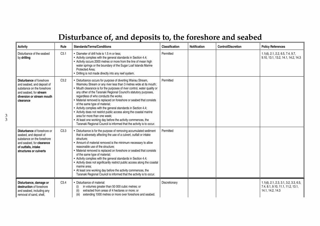
3 3
Disturbance of, and deposits to, the foreshore and seabed
Activity Rule Standards/Terms/Conditions Classification Notification Control/Discretion Policy References
Disturbance of the seabed by drilling
C3.1 • Diameter of drill hole is 1.5 m or less; • Activity complies with the general standards in Section 4.4; • Activity occurs 2000 metres or more from the line of mean high
water springs or the boundary of the Sugar Loaf Islands Marine Protected Area;
• Drilling is not made directly into any reef system.
Permitted 1.1(d), 2.1, 2.2, 6.5, 7.4, 9.7, 9.10, 13.1, 13.2, 14.1, 14.2, 14.3
Disturbance of foreshore and seabed, and deposit of substance on the foreshore
and seabed, for stream diversion or stream mouth clearance
C3.2 • Disturbance occurs for purpose of diverting Wairau Stream, Waimoku Stream or any river less than 3 metres wide at its mouth;
• Mouth clearance is for the purposes of river control, water quality or any other of the Taranaki Regional Council's statutory purposes, regardless of who conducts the works.
• Material removed is replaced on foreshore or seabed that consists of the same type of material;
• Activity complies with the general standards in Section 4.4; • Activity does not restrict public access along the coastal marine
area for more than one week; • At least one working day before the activity commences, the
Taranaki Regional Council is informed that the activity is to occur.
Permitted
Disturbance of foreshore or seabed, and deposit of substance on the foreshore and seabed, for clearance
of outfalls, intake structures or culverts
C3.3 • Disturbance is for the purpose of removing accumulated sediment that is adversely affecting the use of a culvert, outfall or intake structure;
• Amount of material removed is the minimum necessary to allow reasonable use of the structure;
• Material removed is replaced on foreshore or seabed that consists of the same type of material;
• Activity complies with the general standards in Section 4.4; • Activity does not significantly restrict public access along the coastal
marine area; • At least one working day before the activity commences, the
Taranaki Regional Council is informed that the activity is to occur.
Permitted
Disturbance, damage or destruction of foreshore and seabed, including any removal of sand, shell,
C3.4 • Disturbance of material: (i) in volumes greater than 50 000 cubic metres; or (ii) extracted from areas of 4 hectares or more; or (iii) extending 1000 metres or more over foreshore and seabed.
Discretionary 1.1(d), 2.1, 2.3, 3.1, 3.2, 3.3, 6.5, 7.4, 8.1, 9.10, 11.1, 11.2, 13.1, 14.1, 14.2, 14.3

10
shingle or other natural material
Disturbance, damage or
destruction of foreshore and seabed, including any removal of sand, shell, shingle or other natural material and the activity does not come within and/or comply with any of rules C3.1 to C3.4; and is restricted by section 12(1)(c), 12(1)(e) or 12(2) of the Act
C3.5 Discretionary 1.1(d), 2.1, 2.3, 3.1, 3.2, 3.3, 6.5, 7.4, 8.1, 9.10, 11.1, 11.2, 13.1, 14.1, 14.2, 14.3
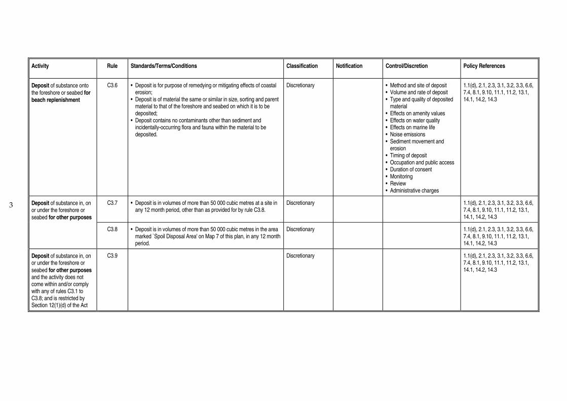
3
Activity Rule Standards/Terms/Conditions Classification
Notification
Control/Discretion Policy References
Deposit of substance onto the foreshore or seabed for beach replenishment
C3.6 • Deposit is for purpose of remedying or mitigating effects of coastal erosion;
• Deposit is of material the same or similar in size, sorting and parent material to that of the foreshore and seabed on which it is to be deposited;
• Deposit contains no contaminants other than sediment and incidentally-occurring flora and fauna within the material to be deposited.
Discretionary • Method and site of deposit • Volume and rate of deposit • Type and quality of deposited
material • Effects on amenity values • Effects on water quality • Effects on marine life • Noise emissions • Sediment movement and
erosion • Timing of deposit • Occupation and public access • Duration of consent • Monitoring • Review • Administrative charges
1.1(d), 2.1, 2.3, 3.1, 3.2, 3.3, 6.6, 7.4, 8.1, 9.10, 11.1, 11.2, 13.1, 14.1, 14.2, 14.3
Deposit of substance in, on or under the foreshore or seabed for other purposes
C3.7 • Deposit is in volumes of more than 50 000 cubic metres at a site in any 12 month period, other than as provided for by rule C3.8.
Discretionary 1.1(d), 2.1, 2.3, 3.1, 3.2, 3.3, 6.6, 7.4, 8.1, 9.10, 11.1, 11.2, 13.1, 14.1, 14.2, 14.3
C3.8 • Deposit is in volumes of more than 50 000 cubic metres in the area marked `Spoil Disposal Area' on Map 7 of this plan, in any 12 month period.
Discretionary 1.1(d), 2.1, 2.3, 3.1, 3.2, 3.3, 6.6, 7.4, 8.1, 9.10, 11.1, 11.2, 13.1, 14.1, 14.2, 14.3
Deposit of substance in, on or under the foreshore or
seabed for other purposes and the activity does not come within and/or comply with any of rules C3.1 to C3.8; and is restricted by Section 12(1)(d) of the Act
C3.9 Discretionary 1.1(d), 2.1, 2.3, 3.1, 3.2, 3.3, 6.6, 7.4, 8.1, 9.10, 11.1, 11.2, 13.1, 14.1, 14.2, 14.3

3
Reclamation
Activity Rule Standards/Terms/Conditions Classification Notification Control/Discretion Policy References
Reclamation or draining of any foreshore or seabed
C4.1 • Reclamation or draining: (i) exceeds 1 hectare in area; or (ii) extends 100 metre or more in any direction; or (iii) is itself of lesser dimensions than those specified in (i) and (ii)
above, but which is connected to or part of another reclamation or reclamations which in combination exceed the dimensions specified in (i) and (ii) above.
Discretionary 1.1(d), 2.1, 2.3, 3.1, 3.2, 3.3, 6.4, 6.6, 7.1, 7.2, 7.3, 7.4, 8.1, 9.10, 11.1, 11.2, 13.1, 14.1, 14.2, 14.3, 14.4
Reclamation or draining of any foreshore or seabed and the reclamation or draining does not come within and/or comply with rule C4.1
C4.2 Discretionary 1.1(d), 2.1, 2.3, 3.1, 3.2, 3.3, 6.4, 6.6, 7.1, 7.2, 7.3, 7.4, 8.1, 9.10, 11.1, 11.2, 13.1, 14.1, 14.2, 14.3, 14.4

Coastal Management Area D : Port Taranaki

2 2
Structures
Activity Rule Standards/Terms/Conditions Classification Notification Control/Discretion Policy References
Alteration, reconstruction or removal and replacement of an existing structure for
maintenance or alteration to the upper surfaces of
existing wharves and breakwaters for purposes directly relating to port company operations
D1.1 • Activity is for the purpose of maintaining the structure in good repair or altering facilities on wharf or breakwater surfaces;
• Size of the structure will not increase beyond original size (other than vertically);
• Sediment disturbance will not decrease the visual clarity of water by more than 50% outside a 50 metre radius zone of mixing;
• No contaminant will be released into coastal water; • Activity complies with the general standards of Section 4.4; • At least one working day before the activity is commenced, the
Taranaki Regional Council is notified that the maintenance is to occur.
Permitted
Alteration, reconstruction or removal and replacement of an existing structure for
maintenance or alteration to the upper surfaces of
existing wharves and breakwaters, and related disturbance of the foreshore and seabed, and activity does not come within and/or comply with rule D1.1
D1.2 • Activity is for the purpose of maintaining structure in good repair; • Size of the structure will not increase beyond original size.
Controlled May be non-notified without written approval
• Effects on water quality • Effects on ecosystems • Disturbance of foreshore and
seabed • Noise emissions • Light emissions • Method of works • Public access • Duration of consent • Timing of works • Monitoring • Review • Administrative charges
1.1(c), 2.1, 3.1, 3.2, 8.1, 9.10, 11.1, 11.2, 14.1, 14.2, 14.3
Placement of an outfall structure
D1.3 • Structure has internal diameter of 600 mm or less and extends 2 metres or less into the coastal marine area;
• Structure is not placed on Ngamotu Beach except within 20 metres of Blyde Reclamation or Eastern Reclamation;
• No erosion, scour or deposition results from placement or use of the structure;
• No tidal backflow or fish movement into the structure will occur. • Structure is to have the minimum external diameter necessary for
the safe and efficient operation of the structure.
Permitted
Placement of mooring D1.4 • Mooring block is placed, secured and maintained in accordance Permitted

3
3
anchor blocks within the seabed
with the instructions of the Harbourmaster; • Excavated sediment is placed in an area of similar sediment and
groomed to match existing contours; • If the mooring block is placed within the breakwaters, it is placed to
secure a ship that is moored to a wharf or that is moored within an area that extends 400 metres from the leeward side of the Lee Breakwater;
• At least one working day before placement, the Harbourmaster is notified that placement is to occur.
Erection or placement of a
navigation aid for marine transport or marine instrumentation purposes, and related disturbance of the foreshore and seabed
D1.5 • Structure does not interfere with New Plymouth Airport Flight Path Protection Surfaces shown in Section 4.3.
Controlled May be non-notified without written approval
• Public access • Noise emissions • Light emissions • Timing of works • Effects on water quality • Disturbance of foreshore or
seabed during placement • Duration of consent and
removal of structure • Monitoring • Review • Administrative charges
1.1(c), 2.1 6.2, 6.5, 8.1, 9.10, 11.1, 11.2, 13.1, 14.1, 14.2, 14.3
Erection, placement, extension, alteration or reconstruction of a launching, mooring or
berthing structure, and related disturbance of the foreshore and seabed, excluding structures under rule D1.5
D1.6 • Structure is a launching, berthing or mooring structure for ships; • Activity excludes: - any seaward extension of the Main Breakwater or Lee
Breakwater; - placement, erection or extension of any structure seaward of
the Main Breakwater or Lee Breakwater; or within 200 metres perpendicular from mean high water springs of Ngamotu Beach;
- any activity or structure that comes within rules D1.10 to D1.16; - any structure that interferes with the New Plymouth Airport
Flight Path Protection Surfaces shown in Section 4.3; • Structure, when completed, does not prevent reasonable navigation
between any existing launching, mooring or berthing facility and the Port entrance.
Controlled May be non-notified without written approval
• Disturbance of foreshore and seabed
• Sediment movement and erosion
• Effects on ecosystems • Effects on navigation • Design of structure (including
height) • Method of construction or
placement of structure • Provision of waste disposal
facilities • Contingency planning to
prevent spills of contaminants • Public access • Noise emissions
1.1(c), 2.1, 3.1, 6.2, 6.5, 8.1, 9.8, 9.10, 11.1, 11.2, 13.1, 13.2, 14.1, 14.2, 14.3

4
3
• Light emissions • Duration of consent and
removal of structure • Timing of works • Monitoring • Review • Administrative charges
Erection, placement, extension, alteration or
reconstruction of a utility structure in, on, or under the foreshore or seabed, and related occupation of the coastal marine area, and related disturbance of the foreshore and seabed
D1.7 • Structure is any: - pipeline which is not a restricted coastal activity under rule
D1.16; or - outfall structure that does not come within and/or comply with
rule D1.3 ; or - intake structure; or - communication or electricity cable (excluding overhead cables); • Excludes erection, placement or extension of any structure seaward
of the Main Breakwater or Lee Breakwater; • Structure is not located within 200 metres of mean high water
springs of Ngamotu Beach; • Structure, when completed, does not adversely affect navigation
between any existing launching, mooring or berthing facility and the port entrance;
• Pipeline or cable is buried in the foreshore or seabed or attached to another structure.
Controlled May be non-notified without written approval
• Disturbance of foreshore and seabed
• Sediment movement and erosion
• Effects on ecosystems • Design and external
appearance of structure • Method of construction or
placement of structure • Effects on navigation • Public access • Noise emissions • Light emissions • Duration of consent and
removal of structure • Timing of works • Monitoring • Review • Administrative charges
1.1(c), 2.1, 3.1, 6.2, 6.5, 6.6, 8.1, 8.2, 9.10, 11.1, 11.2, 13.1, 14.1, 14.2, 14.3
Removal or demolition of a structure
D1.8 • No waste is placed, or any contaminant released, into the coastal marine area;
• Structure is removed completely from the coastal marine area; • Sediment disturbance does not decrease visual clarity of water by
more than 50% outside a 50 metre radius zone of mixing; • Activity does not significantly affect sediment movement or lead to
increased erosion or scour; • At least one day before activity occurs, the Harbourmaster is
notified; • Activity complies with the general standards in Section 4.4; • Excludes removal or demolition of the Main Breakwater or Lee
Permitted

5
3 3
Breakwater.
Removal or demolition of a structure and the activity does not come within and/or comply with rule D1.8, and related disturbance of the foreshore and seabed
D1.9 • Excludes removal or demolition of the Main Breakwater or Lee Breakwater.
Discretionary May be non-notified without written approval
• Erosion and navigation channel effects
• Water quality effects • Disposal of waste • Remains of structure in the
coastal marine area • Disturbance of foreshore and
seabed during removal • Public access during removal • Restoration of foreshore and
seabed • Noise emissions • Light emissions • Timing of works • Duration of consent • Monitoring • Review • Administrative charges
1.1(c), 2.1, 3.1, 6.2, 6.3, 6.5, 8.1, 8.2, 9.10, 11.1, 11.2, 13.1, 14.1, 14.2, 14.3
Erection or placement of a
large structure, and related occupation of the coastal marine area
D1.10 • Structure impounds or effectively contains 4 hectares or more, but less than 8 hectares of the coastal marine area;
• Structure is a floating or open pile structure that can be demonstrated to not impede water flows;
• Structure is constructed from reinforced concrete, quarried rock, timber or other construction materials;
• Structure is to provide launching, mooring or berthing facilities, or other facilities for port activities.
Discretionary 1.1(c), 2.1, 3.1, 3.2, 6.2, 6.5, 7.1, 7.2, 7.3, 8.1, 8.2, 9.10, 11.1, 11.2, 13.1, 14.1, 14.2, 14.3, 14.5
Erection or placement of a large structure, and related occupation of the coastal marine area
D1.11 • Structure impounds or effectively contains 8 hectares or more of the coastal marine area.
Discretionary 1.1(c), 2.1, 3.1, 3.2, 6.2, 6.5, 7.1, 7.2, 7.3, 8.1, 8.2, 9.10, 11.1, 11.2, 13.1, 14.1, 14.2, 14.3, 14.5
Erection or placement of a large structure, and related occupation of the coastal marine area
D1.12 • Structure presents a significant barrier to water or sediment movement;
• Excludes any submarine or sub-aqueous cable, or any open pile structure which can be demonstrated not to have adverse effects;
Discretionary 1.1(c), 2.1, 3.1, 3.2, 6.2, 6.5, 7.1, 7.2, 7.3, 8.1, 8.2, 9.10, 11.1, 11.2, 13.1, 14.1, 14.2, 14.3, 14.5

6
3
• Extends 300 metres or more, but 1000 metres or less, parallel to the line of mean high water springs (includes separate structures that, when their lengths are summed, comply with the dimensions above);
• Constructed of reinforced concrete, quarried rock, timber or other construction materials;
• Provides protection from natural hazards, or is to provide launching, mooring or berthing facilities, or other facilities for port activities.
D1.13 • Structure presents a significant barrier to water or sediment movement;
• Structure extends more than 1000 metres in length parallel to the line of mean high water springs.
Discretionary 1.1(c), 2.1, 3.1, 3.2, 6.2, 6.5, 7.1, 7.2, 7.3, 8.1, 8.2, 9.10, 11.1, 11.2, 13.1, 14.1, 14.2, 14.3, 14.5
D1.14 • Structure presents a significant barrier to water or sediment movement;
• Excludes any submarine or sub-aqueous cable; • Sited obliquely or perpendicular to the line of mean high water
springs; • In horizontal projection is 100 metres or more, but 1000 metres or
less, in length; • Constructed from concrete, quarried rock, timber or other
construction materials; • Provides protection from natural hazards, or is to provide launching,
mooring or berthing facilities, or other facilities for port activities.
Discretionary 1.1(c), 2.1, 3.1, 3.2, 6.2, 6.5, 7.1, 7.2, 7.3, 8.1, 8.2, 9.10, 11.1, 11.2, 13.1, 14.1, 14.2, 14.3, 14.5
Erection or placement of a large structure, and related occupation of the coastal marine area
D1.15 • Structure presents a significant barrier to water or sediment movement;
• Structure is situated obliquely or perpendicular to the line of mean high water springs an in horizontal projection exceeds 1000 metres in length.
Discretionary 1.1(c), 2.1, 3.1, 3.2, 6.2, 6.5, 7.1, 7.2, 7.3, 8.1, 8.2, 9.10, 11.1, 11.2, 13.1, 14.1, 14.2, 14.3, 14.5
Erection or placement of a large structure, and related occupation of the coastal marine area
D1.16 • Structure is for storage or containment of petroleum, petroleum products or chemicals in quantities of 100 000 litres or more.
Discretionary 1.1(c), 2.1, 3.1, 3.2, 6.2, 6.5, 7.1, 7.2, 7.3, 8.1, 8.2, 9.7, 9.10, 11.1, 11.2, 13.1, 14.1, 14.2, 14.3, 14.5
Erection, placement, alteration, extension or reconstruction, removal or
D1.17 Discretionary 1.1(c), 2.1, 3.1, 3.2, 6.2, 6.5, 7.1, 7.2, 7.3, 8.1, 8.2, 9.7, 9.10, 11.1,

7
demolition of a structure, and related occupation of the coastal marine area and the activity or structure does not come within and/or comply with any of rules D1.1 to D1.16
11.2, 13.1, 14.1, 14.2, 14.3, 14.5
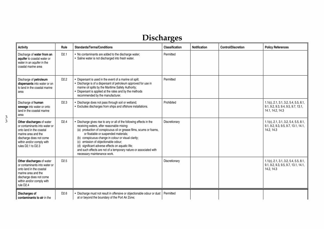
3 3
Discharges
Activity Rule Standards/Terms/Conditions Classification Notification Control/Discretion Policy References
Discharge of water from an
aquifer to coastal water or water in an aquifer in the coastal marine area
D2.1 • No contaminants are added to the discharge water; • Saline water is not discharged into fresh water.
Permitted
Discharge of petroleum dispersants into water or on to land in the coastal marine area
D2.2 • Dispersant is used in the event of a marine oil spill; • Discharge is of a dispersant of petroleum approved for use in
marine oil spills by the Maritime Safety Authority; • Dispersant is applied at the rates and by the methods
recommended by the manufacturer.
Permitted
Discharge of human
sewage into water or onto land in the coastal marine area
D2.3 • Discharge does not pass through soil or wetland; • Excludes discharges from ships and offshore installations.
Prohibited 1.1(c), 2.1, 3.1, 3.2, 5.4, 5.5, 8.1, 9.1, 9.2, 9.3, 9.4, 9.5, 9.7, 13.1, 14.1, 14.2, 14.3
Other discharges of water or contaminants into water or onto land in the coastal marine area and the discharge does not come within and/or comply with rules D2.1 to D2.3
D2.4 • Discharge gives rise to any or all of the following effects in the receiving waters, after reasonable mixing:
(a) production of conspicuous oil or grease films, scums or foams, or floatable or suspended materials;
(b) conspicuous change in colour or visual clarity; (c) emission of objectionable odour; (d) significant adverse effects on aquatic life; and such effects are not of a temporary nature or associated with
necessary maintenance work.
Discretionary 1.1(c), 2.1, 3.1, 3.2, 5.4, 5.5, 8.1, 9.1, 9.2, 9.3, 9.5, 9.7, 13.1, 14.1, 14.2, 14.3
Other discharges of water or contaminants into water or onto land in the coastal marine area and the discharge does not come within and/or comply with rule D2.4
D2.5 Discretionary 1.1(c), 2.1, 3.1, 3.2, 5.4, 5.5, 8.1, 9.1, 9.2, 9.3, 9.5, 9.7, 13.1, 14.1, 14.2, 14.3
Discharges of
contaminants to air in the
D2.6 • Discharge must not result in offensive or objectionable odour or dust at or beyond the boundary of the Port Air Zone;
Permitted

9
coastal marine area within the Port Air Zone from the storage or transfer of cargo materials
• Discharge must not result in noxious or toxic levels of airborne contaminants at or beyond the boundary of the Port Air Zone;
• Discharge must not result in dangerous levels of airborne contaminants at or beyond the boundary of the Port Air Zone, including but not limited to any risk of fire or explosion.
Discharge of contaminants to air in the coastal marine area within the Port Air Zone from the storage or transfer of cargo materials and which does not come within and/or comply with rule D2.6
D2.7 Discretionary 1.1(c), 2.1, 3.1, 8.1, 11.1, 11.2, 12.1, 12.3, 13.1, 13.2
Discharges of contaminants to air in the coastal marine area and which does not come within and/or comply with rules D2.6 or D2.7
D2.8 • The discharge excludes discharges to air from ships and offshore installations;
• Discharge originates from any industrial or trade premises.
Discretionary 1.1(c), 2.1, 3.1, 8.1, 11.1, 11.2, 12.1, 12.3, 13.1, 13.2

3 3
Disturbance of, and deposits to, foreshore and seabed
Activity Rule Standards/Terms/Conditions Classification Notification Control/Discretion Policy References
Disturbance of the foreshore and seabed, and redeposit of disturbed sediment, for
clearance of outfall and intake structures
D3.1 • Disturbance is the removal of accumulated sediment from intake and outfall structures;
• Disturbance is the minimum necessary to allow reasonable use of the structure;
• Activity does not restrict public access for more than one week; • Sediments removed are deposited on the nearest area of similar
sediment in the longshore or onshore-offshore drift zone; • Activity complies with the general standards in Section 4.4.
Permitted
Disturbance of the foreshore and seabed by drilling
D3.2 • Diameter of drill hole is 1.5 m or less; • Activity complies with the general standards in Section 4.4.
Controlled May be non-notified without written approval
• Effects on water quality, including contingency planning to prevent release of contaminants
• Depth of drilling • Noise • Effects on ecosystems • Navigational safety • Occupation and public access • Restoration of foreshore and
seabed • Timing of works • Duration of consent • Monitoring • Review • Administrative charges
1.1(c), 2.1, 3.1, 3.2, 6.5, 7.4, 9.7, 9.10, 13.1, 13.2, 14.1,14.2, 14.3
Disturbance of the seabed by dredging
D3.3 • Disturbance of accumulated sediment for purpose of maintaining a safe navigational depth within Port Taranaki breakwaters;
• Disturbance of 50 000 cubic metres or less from a site in any 12 month period;
• Does not adversely affect the physical form of any foreshore between the Lee Breakwater and the Blyde reclamation;
• Sediment is not removed from the coastal marine area.
Controlled May be non-notified without written approval
• Effects on water quality • Sediment movement and
erosion • Method of dredging • Rate and volume of removal • Navigational safety • Public access • Depth of dredging • Noise emissions • Timing of works • Duration of consent
1.1(c), 2.1, 3.2, 3.2, 6.5, 7.4, 8.1, 9.10, 11.1, 11.2, 13.1, 14.1, 14.2, 14.3

11
3
• Monitoring • Review • Administrative charges
D3.4 • Disturbance of accumulated sediment for purpose of maintaining a safe navigational depth within Port Taranaki breakwaters;
• Disturbance of more than 50 000 cubic metres but less than 300 000 cubic metres per year, or extracted from an area of 4 hectares or more but less than 10 hectares, or along a distance of more than 1000 metres but less than 10 000 metres across the seabed.
Discretionary 1.1(c), 2.1, 3.2, 3.2, 6.5, 7.4, 8.1, 9.10, 11.1, 11.2, 13.1, 14.1, 14.2, 14.3
Large disturbance of the foreshore and seabed
D3.5 • Disturbance of the foreshore and seabed, including any removal of sand, shell, shingle or other natural material:
- in quantities of 300 000 cubic metres or more; or - extracted from an area of 10 hectares or more; or - extending more than 10 000 metres over foreshore and
seabed.
Discretionary 1.1(c), 2.1, 3.2, 3.2, 6.5, 7.4, 8.1, 9.10, 11.1, 11.2, 13.1, 14.1, 14.2, 14.3
Other disturbance or damage or destruction of foreshore and seabed, including any removal of sand, shell, shingle or other natural material and the activity does not come within and/or comply with any of rules D3.1 to D3.5; and is restricted by sections 12(1)(c), 12(1)(e) or 12(2) of the Act
D3.6
Discretionary 1.1(c), 2.1, 3.2, 3.2, 6.5, 7.4, 8.1, 9.10, 11.1, 11.2, 13.1, 14.1, 14.2, 14.3
Deposit of substance onto the foreshore and seabed for beach replenishment
D3.7 • Deposit is for the purpose of combatting coastal erosion or enhancing amenity value;
• Deposit is of material the same or similar in size, sorting and parent material to that of the receiving foreshore and seabed;
• Deposit is in quantities of 50 000 cubic metres or less in any 12 month period;
• Deposit contains no contaminants other than sediment and any incidentally-occurring marine flora and fauna in the deposit;
Discretionary • Effects on water quality • Method and site of deposit • Timing of deposit • Occupation and public access • Type and quality of deposited
material • Rate and volume of deposit • Protection of adjacent land
1.1(c), 2.1, 3.1, 3.2, 6.6, 7.4, 8.1, 9.10, 11.1, 11.2, 13.1, 14.1, 14.2, 14.3
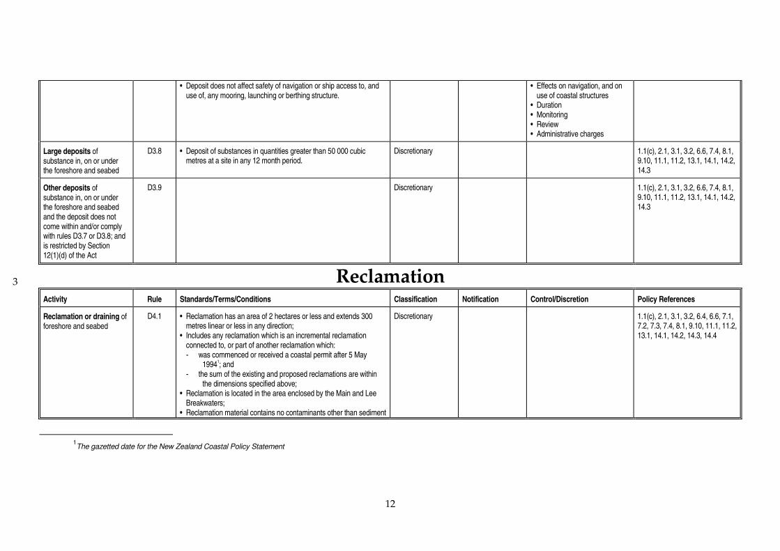
12
3
• Deposit does not affect safety of navigation or ship access to, and use of, any mooring, launching or berthing structure.
• Effects on navigation, and on use of coastal structures
• Duration • Monitoring • Review • Administrative charges
Large deposits of substance in, on or under the foreshore and seabed
D3.8 • Deposit of substances in quantities greater than 50 000 cubic metres at a site in any 12 month period.
Discretionary 1.1(c), 2.1, 3.1, 3.2, 6.6, 7.4, 8.1, 9.10, 11.1, 11.2, 13.1, 14.1, 14.2, 14.3
Other deposits of substance in, on or under the foreshore and seabed and the deposit does not come within and/or comply with rules D3.7 or D3.8; and is restricted by Section 12(1)(d) of the Act
D3.9 Discretionary 1.1(c), 2.1, 3.1, 3.2, 6.6, 7.4, 8.1, 9.10, 11.1, 11.2, 13.1, 14.1, 14.2, 14.3
Reclamation
Activity Rule Standards/Terms/Conditions Classification Notification Control/Discretion Policy References
Reclamation or draining of foreshore and seabed
D4.1 • Reclamation has an area of 2 hectares or less and extends 300 metres linear or less in any direction;
• Includes any reclamation which is an incremental reclamation connected to, or part of another reclamation which:
- was commenced or received a coastal permit after 5 May 1994
1; and
- the sum of the existing and proposed reclamations are within the dimensions specified above;
• Reclamation is located in the area enclosed by the Main and Lee Breakwaters;
• Reclamation material contains no contaminants other than sediment
Discretionary
1.1(c), 2.1, 3.1, 3.2, 6.4, 6.6, 7.1, 7.2, 7.3, 7.4, 8.1, 9.10, 11.1, 11.2, 13.1, 14.1, 14.2, 14.3, 14.4
1
The gazetted date for the New Zealand Coastal Policy Statement

13
3
Activity Rule Standards/Terms/Conditions Classification Notification Control/Discretion Policy References
and incidentally-occurring plant or animal matter within that material;
OR • Reclamation has an area of less than 1 hectare or extends less
than 100 metres in each dimension; • Includes any reclamation connected to or part of another
reclamation which: - was commenced or received a coastal permit after 5 May 1994;
and - the sum of sizes of the existing and proposed reclamations are
within the dimensions specified above.
Reclamation or draining of foreshore or seabed
D4.2 • Reclamation has an area of more than 2 hectares or extends more than 300 metres in any direction;
OR • Reclamation is an incremental reclamation which is part of or
connected to another reclamation which: - was commenced or received a coastal permit after 5 May 1994;
and - the sum of the existing and proposed reclamations is equal to
or exceed 2 hectares or 300 metres linear in any direction; OR • Reclamation has an area of 1 hectare or more but less than 2
hectares, or extends 100 metres or more but less than 300 metres
in any direction, but does not comply with rule 4.1; OR • Reclamation is an incremental reclamation which is part of or
connected to another reclamation which: - was commenced or received a coastal permit after 5 May 1994;
and - the sum of the existing and proposed reclamations is 1 hectare
or more but less than 2 hectares, or is 100 metres or more but less than 300 metres in any direction;
but does not come within and/or comply with rule D4.1.
Discretionary 1.1(c), 2.1, 3.1, 3.2, 6.4, 6.6, 7.1, 7.2, 7.3, 7.4, 8.1, 9.10, 11.1, 11.2, 13.1, 14.1, 14.2, 14.3, 14.4

14
Storage of hazardous substances
Activity Rule Standards/Terms/Conditions Classification Notification Control/Discretion Policy References
Storage of hazardous substances
D5.1 • Storage is of dangerous goods2 in quantities of:
(a) 150 000 litres or more of petrol or diesel; or (b) 4 000 litres or more of any other dangerous goods in a single
storage structure.
Discretionary 1.1(c), 2.1, 2.3, 3.1, 9.11
2
The Dangerous Goods Act 1974 will be repealed once the Hazardous Substances and New Organisms Act comes into force. When that Act does come into force the term `Hazardous Substance(s)' will be more appropriate than `Dangerous Good(s)'.

4.3 New Plymouth Airport flight pathprotection surfaces
New Plymouth Airport is located near the mouth of the Waiongana Stream in NewPlymouth District. In order for the airport operator to remain certified to operate theairport, the airport operator must provide "obstacle limitation surfaces" under the CivilAviation Rules (Civil Aviation Act 1990). The mechanisms to prevent flight path obstaclesare regional and district plans.
New Plymouth Airport requires flight path protection surfaces to cover the coastal marinearea in the vicinity of the airport. The extent of the flight path protection surfaces is shownin figures 2, 3 and 4. The flight path protection surfaces are a group of inclined andhorizontal planes. The protection surfaces are intended to prevent obstacles being placedwithin the airport's flight paths. Five types of surface, described below, cover the coastalmarine area.
4.3.1 Description of protection surfaces
Approach surfacesThree approach surfaces are located over the coastal marine area:
(i) South-western approach surface over Port Taranaki: this is an inclined surface,rising from the south-western end of the main runway strip (23 m above mean sealevel) at a gradient of 1.6 per cent (1 in 62.5), its sides splaying 15 per cent from theedges of the main runway strip.
(ii) North-eastern approach surface over Waitara River estuary: this is an inclinedsurface, rising from the north-eastern end of the main runway strip (23 m abovemean sea level) at a gradient of 1.6 per cent (1 in 62.5), its sides splaying 15 per centfrom the edges of the main runway strip.
(iii) North-western approach surface over the open coast area: this is an inclinedsurface, rising from the north-western end of the subsidiary runway strip (20 mabove mean sea level) at a gradient of 1.6 per cent (1 in 62.5), its sides splaying 15per cent from the edges of the subsidiary runway strip.
Transitional surfacesTwo transitional surfaces rise off the edges of the approach surfaces at a gradient of 1 in 7to intercept the horizontal surface.
Horizontal surfaceThe horizontal surface is a level surface overlying the airport and its surrounding areas at aheight of 74 m above mean sea level. The extent of the horizontal surface is a radius of 4000metres from the ends of the runway strips.
Conical surfaceThe conical surface is an inclined surface that rises from the edge of the horizontal surfaceat a rate of 2.5 per cent (1 in 40).
Rural airport protection zoneA flat surface under which a structure should not exceed 3 metres in height.

4.3.2 Effect of this plan
The flight path protection surfaces are given effect through Policy 11.2 in Issue eleven,Section 3.0 of this plan. In particular, controlled activities must comply with the heightrestrictions established above, while any application to carry out a discretionary activitywill be declined if it does not comply with the height restrictions. Under no circumstanceswill any structure be allowed to breach the flight path protection surfaces.

Figure 2: A generalised description of CAA’s requirements for protection surfaces surrounding New Zealand airports

Figure 3: Base measurement used to calculate New Plymouth Airport flight path protection surfaces

Figure 4: New Plymouth Airport flight path protection surfaces

4.4 General standards
These general standards apply where a rule explicitly states that these standards must becomplied with.
4.4.1 Height (New Plymouth Airport)
No structure or part of any structure shall interfere with the New Plymouth Airport Flight PathProtection Surfaces described in Section 4.3 of the plan.
4.4.2 Light
Light sources shall be shielded so that the light source is not directly visible from any residence,vehicle on a public road or ship under navigation, provided that this shall not apply in the caseof:
(i) navigation aids; or(ii) lighting required under the Acts of Parliament for the safety of ships or offshore
installations and aircraft.
4.4.3 Noise
(a) Activities (excluding construction, maintenance and demolition work and temporarymilitary training) in the coastal marine area should not create noise that exceeds thefollowing limits when measured at the boundary of the nearest affected property:
Monday to Friday 7am to 10pm 55 dBA L10
Saturday 7am to 12pm 55 dBA L10
All other times 45 dBA L10
Provided that when the background sound level exceeds these limits (due to noise ofthe sea, wind noise, traffic noise or other uncontrollable types of noise) the limits shallnot apply but every person shall remain under the duty to avoid unreasonable noise inSection 16 of the Act.
Noise measurement and assessment will be in accordance with New Zealand Standard6801: 1991 Measurement of Sound and New Zealand Standard 6802: Assessment ofEnvironmental Sound.
(b) Construction, maintenance or demolition activities shall comply with the relevantstandards set out in New Zealand Standard NZS6803P:1984 The measurement andassessment of noise from construction, maintenance and demolition work.
Provided that when the background sound level exceeds these limits (due to noise ofthe sea, wind noise, traffic noise or other uncontrollable types of noise) the limits shallnot apply but every person shall remain under the duty to avoid unreasonable noise inSection 16 of the Act.
(c) Temporary military training activities in the coastal marine area should not create noisethat exceeds the following limits when measured from a line 20 metres from andparallel to the facade of any dwelling used for accommodation or the legal boundarywhere this is closest to the dwelling or building:
Time Limits(dba)

(any day) L10 L95 Lmax
0630-0730 60 45 700730-1800 75 60 901800-2000 70 55 85
The following maximum noise levels shall apply in respect of the interface withresidential zones from 2000 hours - 0630 hours any day:
L10
0000-0630 402000-2400 40
Noise resulting from the use of explosives shall not exceed 122 dba.
Provided that when the background sound level exceeds these limits (due to noise ofthe sea, wind noise, traffic noise or other uncontrollable types of noise) the limits shall not apply butevery person shall remain under the duty to avoid unreasonable noise in section 16 of the Act.
5. Information to be submitted with an application for a coastal permit
Section 88 of the Act requires each application for a coastal permit to be in a prescribedform. Section 88 requires that an application includes:
(i) a description of the activity for which consent is sought, and its location;
(ii) an assessment of any actual or potential effects that the activity may have on theenvironment, and the ways in which any adverse effects may be mitigated;
(iii) any information required to be included in the application by this plan or byregulations; and
(iv) a statement specifying all other resource consents that the applicant may require fromany consent authority for the activity to which the application relates, and whether ornot the applicant has applied for such consents.
The Taranaki Regional Council requires the information below to be included with anapplication for a coastal permit. General information in Section 5.1 must be supplied for allapplications, along with the assessment of effects in Section 5.5.
Applicants should note that approvals may need to be obtained under other Acts ofParliament. For example, structure placement requires a building consent under theBuilding Act 1991, aquaculture requires consents under the Fisheries Act 1983 etc. Thoseconsents cannot be obtained under this plan.
5.1 General (all activities)
1. Full name, postal address, home and business telephone numbers of the person ororganisation to whom the permit is to be issued.
2. Name and telephone number of the contact person who is fully conversant with allaspects of the application.
3. Name, address and telephone number of consultant (if applicable).
4. Name and address for service of documents (if different from above).
5. Name and telephone number of occupier or lessee of affected site.
6. Location and address of affected site (as near as possible).
7. Nearest territorial authority (New Plymouth District Council or South Taranaki DistrictCouncil).
8. A list of all other consents needed, and reference numbers of any previous consents, forthis application from all consent authorities.
9. A list of names and addresses of property owners or occupiers likely to be directlyaffected by this application.
10. An assessment of effects on the environment in accordance with Section 5.5 below.(Section 5.5 is important; please read it carefully.)
5.2 Use of the foreshore and seabed
1. Reason for which the foreshore or seabed is to be used (reclamation, structure, drilling,dredging, other (please specify)).
2. An indication of the state of completion of the project (existing, partly developed,proposed).
3. Description of the works proposed, including design specifications.
4. Map reference of site (use Infomap 260 1:50 000)
5. An accurate location and site plan including scale, showing position of works, localnamed roads, north point, boundaries and other relevant features.
6. Legal description of land at site (where applicable).
5.3 Discharges of contaminants
1. Content of discharge (name contaminants, if any).
2. Type of operation or industry causing discharge.
3. Purpose for discharge.
4. Maximum volume daily (cubic metres per day) and maximum discharge rate (litres persecond).
5. Number of hours per day that discharge will occur.
6. Full description of any seasonal or time-related variation in discharge strengths andvolumes expected (if applicable).
7. Accurate site plan and address of discharge source, for inspection purposes.
8. Legal description of land (shown on rate demand) at discharge source, for inspectionpurposes.
9. Map reference of discharge point (use Infomap 260 1:50 000).
10. If discharge point is different from place of treatment/usage, details with supportingplans of each site.
11. Full description of works to be constructed, including process or department fromwhich discharge originates, type of treatment facility and the quality of the proposeddischarge (include design specifications).

5.4 Use of water
1. Reason for which water is to be taken or used or both (industry, other (specify)).
2. An indication of the state of completion of the project (existing, partly developed,proposed).
3. Quantities of water applied for:(i) maximum daily quantity (cubic metres per day);(ii) total annual quantity (cubic metres per year); and(iii) maximum abstraction rate (litres per second).
5.5 Assessment of effects on theenvironment
An assessment of effects on the environment is to be included with every coastal permitapplication in accordance with this section. The detail in the assessment of effects shall bein such detail as corresponds with the scale and significance of the actual or potentialeffects that the activity may have on the environment. This is important: too much detailin relation to the likely effects of the activity will waste applicants' time and money; toolittle detail will result in the Taranaki Regional Council requiring further information,which will lead to further expense and lost time by applicants.
The assessment for a controlled activity, or for a discretionary activity over which theTaranaki Regional Council has restricted the exercise of its discretion, need only addressthose matters over which the Council has retained control or the right to exercise itsdiscretion (as the case may be). Those matters are specified in the relevant rules of this plan.
The extent to which these matters need to be addressed will depend on the nature and scaleof the proposed activity. It is the responsibility of the applicant to provide sufficientinformation to enable the consent authority to assess the application. If the applicant isuncertain as to the amount of information required or where such information may beobtained, the Taranaki Regional Council's Consents Department Staff can assist (telephone06 765 7127).
5.5.1 Matters for inclusion in an assessment of effects on the environment
An assessment of effects on the environment should include -
(a) A description of the proposal;
(b) Where it is likely that an activity will result in any significant adverse effect on theenvironment, a description of any possible alternative locations or methods forundertaking the activity;
(c) An assessment of the actual or potential effect on the environment of the proposedactivity;
(d) Where the activity includes the use of hazardous substances and installations anassessment of any risks to the environment which are likely to arise from such use;

(e) Where the activity includes the discharge of any contaminant, a description of:(i) The nature of the discharge and the sensitivity of the proposed receiving
environment to adverse effects; and(ii) Any possible alternative methods of discharge, including discharge into any other
receiving environment;
(f) A description of the mitigation measures (safeguards and contingency plans whererelevant) to be undertaken and any response to the views of those consulted;
(g) An identification of those persons interested in or affected by the proposal, theconsultation undertaken and any response to the views of those consulted;
(h) Where the scale or significance of the activity's effect are such that monitoring isrequired, a description of how, once the proposal is approved, effects will bemonitored and by whom.
Specific information that is required to give effect to policies
The following information must be supplied in order to allow the Taranaki RegionalCouncil to give effect to information requirements contained in policies in this plan.
(a) When the proposed activity is a reclamation, the applicant must show that thereclamation is the most appropriate way of providing for an activity that requires acoastal marine area location, and alternatives to a reclamation (including purchase ofland or construction of structures) must be explicitly considered.
(b) When the proposed activity is a damming, diversion, taking or use of water from anestuary, applicants for coastal permits must:(i) demonstrate a need for volumes of water sought; and(ii) indicate what alternative water supplies or water collection or storage methods
have been considered to meet this need and the suitability or otherwise of thealternatives.
(c) When the proposed activity is a natural hazard protection work, the applicant mustsupply sufficient information to enable the assessment required by:(i) Policy 7.1; and(ii) Policy 7.3 (if the work is proposed for an estuary);to be carried out.
(d) Any application for a coastal permit seeking rights of occupation (over and above thoserequired for physical occupation by a structure) must include a consideration ofalternatives to occupation rights and must demonstrate how granting rights to occupyis the most appropriate course of action to take.
Matters that should be considered when preparing an assessment of effects on theenvironment
Any person preparing an assessment of the effects on the environment should consider thefollowing matters:
(a) Any effect on those in the neighbourhood and, where relevant, the wider communityincluding any socio-economic and cultural effects;
(b) Any physical effect on the locality, including any landscape and visual effects;

(c) Any effect on ecosystems, including effects on plants or animals and any physicaldisturbance of habitats in the vicinity;
(d) Any effect on natural and physical resources having aesthetic, recreational, scientific,historical, spiritual or cultural or other special value for present or future generations;
(e) Any discharge of contaminants into the environment, including any unreasonableemission of noise and options for the treatment and disposal of contaminants;
(f) Any risk to the neighbourhood, the wider community or the environment throughnatural hazards or the use of hazardous substances or hazardous installations.
5.6 Requirement for further information
Notwithstanding the above, the Taranaki Regional Council may at any reasonable time,require the applicant to provide further information in respect of the activity which theapplication for a coastal permit is made.
The following relate to the circumstances in which the powers under Section 92 (ie. wherefurther information may be required) may be used:
(a) the standard application forms have not been properly completed; or
(b) the application does not adequately describe the nature or location of the proposal; or
(c) the application does not specify, or inaccurately specifies, other consents that may beneeded to undertake the activity; or
(d) in the case of any discretionary or non-complying activity, the application providesinsufficient information:(i) to enable the actual or potential adverse effects of the activity to be identified; or(ii) to explain the ways in which any adverse effects are to be mitigated; or(iii) to identify other parties who may be affected; or(iv) to identify other parties who have been consulted and/or their views; or
(e) there is uncertainty regarding the need or purpose of the consent; or
(f) there are reasonable grounds to suggest that alternative locations or methods ofundertaking the activity may be both feasible and would have less adverse effect onthe environment than the proposed option; or
(g) a report is required to be commissioned to fully assess the effects of the activity or toaudit any information provided by the applicant.

6. Financial contributions
Where the Regional Council grants a coastal permit, it may impose a condition requiringthat a financial contribution be made for the purposes specified in the coastal plan.
The term `financial contribution' is defined in Section 108(9) of the Act to mean:... a contribution of:a) money; orb) land, including an esplanade reserve or esplanade strip (other than in relation to a
subdivision consent), but excluding Maori land within the meaning of the Maori LandAct 1993 unless that Act provides otherwise; or
c) works, including (but without limitation) the protection, planting, or replanting of anytree or other vegetation or the protection, restoration, or enhancement of any natural orphysical resource; or
d) services—or any combination thereof, made for the purposes specified in the plan (including thepurpose of ensuring positive effects on the environment to offset any adverse effect) andwhich does not exceed in value the maximum amount specified in, or determined inaccordance with, the plan.
Financial contributions may be for various purposes specified in the plan including thepurposes of ensuring positive effects on the environment to offset any adverse effects(environmental compensation).
All monies collected under the financial contributions regime of the plan are collected bythe Taranaki Regional Council for use in such a manner as the Council deems fit in order toavoid, remedy or mitigate the adverse effects on the coastal environment of the activity thatthe financial contribution is levied on. When deciding how those contributions should belevied or allocated, consideration should be given to matters contained in publicsubmissions on a coastal permit application.
Clause 5 of Part 1 of the Second Schedule to the Act further requires the Taranaki RegionalCouncil to specify in the plan the circumstances when a financial contribution may beimposed, the maximum amount of the contribution that may be imposed or the formula bywhich the contribution may be calculated and the general purposes for which thecontribution may be used.
The provisions which follow reflect the requirements of the Act and set out:
• The circumstances when such contributions may be imposed.
• The purposes for which such contributions may be required and used.
• The manner in which the amount of the contribution will be determined.
• Matters which the Taranaki Regional Council will have regard to when decidingwhether to impose financial contribution, the type or types of contribution, and theamount of any contribution.

6.1 Circumstances, purpose and amount
Financial contributions may be imposed on any coastal permit in the circumstances and forthe purposes set out below. Contributions may be in the form of land, works, services ormoney or any combination of the two. Contributions of money to the Taranaki RegionalCouncil must be used for the general purpose for which such contributions were taken.
The following provisions set out circumstances and purposes for which financialcontributions may be imposed and used, and the manner in which the amount ofcontribution will be determined is also set out.
(a) Maintenance or improvement of public access to and along the coast
Circumstances: Where public access to or along the coast will be limited or preventedby the activity for which consent is granted.
(i) Purposes: To avoid or mitigate such effects by providing for public access to oralong the coast through or around the area to which the consent applies.
Determination of amount: The amount of contribution will be determined byreference to the matters set out in section 6.2, but will be an amount that will besufficient to avoid, remedy or mitigate adverse effects on public access.
(ii) Purposes: To offset or compensate for reduction or loss of access by contributing tonew or enhanced access to or along another part of the coastal marine area withinthe same general locality or serving the same general community.
Determination of amount: The amount of contribution will be determined byreference to the matters set out in section 6.2, but will be an amount that willcontribute to alternative public access to a reasonably equivalent standard andextent to that which will be lost or reduced.
Note: The operation of this section is limited to restriction of access within thecoastal marine area. The limitation of access to and along the coastal marine areafrom activities that are conducted solely above mean high water springs is not ableto be compensated for under this section.
(b) Enhancement of recreational amenities in the coastal marine area
Circumstances: Where the activity for which consent is granted is likely to cause orcontribute to adverse effects on recreational amenities in the coastal marine area.
Purposes: To mitigate or offset such effects by creating or improving recreationalopportunities or facilities or other public amenities on or in the vicinity of the site,and/or at an alternative location in the coastal environment in the same generallocality or serving the same general community (including contribution to themaintenance or enhancement of public reserves).

Determination of amount: The amount of contribution will be determined by referenceto the matters set out in section 6.2, but will reflect the cost of maintaining recreationalamenity values at a reasonably equivalent level as if consent had not been granted,and/or to provide alternative recreational amenities to a reasonably equivalentstandard or extent to those which will be lost.
(c) Planting or maintenance of coastal vegetation
Circumstances: Where the activity for which consent is granted is likely to cause orcontribute to destruction or damage of coastal vegetation on habitats or contribute toerosion of foreshore or dunes or adversely affect visual amenities.
Purposes: To mitigate or offset such effects by way of planting or maintainingvegetation (including native vegetation) within the coastal environment for thepurpose of protecting, restoring or enhancing the coastal environment (either at the siteconcerned or elsewhere in the same general locality).
Determination of amount: The amount of contribution will be determined by referenceto the matters set out in section 6.2, but will provide for protecting, restoring orenhancing the site in question so as to fully avoid, remedy or mitigate any adverseeffects; or the full cost of providing protection, restoration or enhancement toreasonably compensate for the adverse effects of the activity.
(d) Landscaping or planting
Circumstances: Where the activity for which consent is granted is likely to cause orcontribute to adverse effects on visual amenities and/or involves land clearance ordisturbance.
Purposes: To reduce the adverse effects of land clearance, land disturbance andstructures in the coastal marine area by landscaping or replanting on or adjacent to thesite in question.
Determination of amount: The amount of contribution will be determined by referenceto the matters set out in section 6.2, but will provide for carrying out such works toavoid, remedy or mitigate the adverse effects of the activity.
(e) Fencing or screening
Circumstances: Where the activity for which consent is granted is likely to contribute toadverse effects on visual amenities, heritage features or conservation areas.
Purposes: To reduce adverse visual effects by fencing or screening to protect and/orseparate heritage features or conservation areas.
Determination of amount: The amount of contribution will be determined by referenceto the matters set out in section 6.2, but will provide for such works to avoid, remedyor mitigate the adverse effects of the activity.

(f) Protection, maintenance or restoration of sites of historic or cultural importance
Circumstances: Where the activity for which consent is granted will adversely affect ahistoric site, or one of cultural or spiritual significance to the Tangata Whenua.
Purposes: To mitigate or offset such effects by providing for works which protect orrestore that site and/or to offset such effects by contributing to protection, maintenanceor restoration of some alternative historic or cultural site within the coastalenvironment in the same general locality.
Determination of amount: The amount of contribution will be determined by referenceto the matters set out in section 6.2, but will provide for such works reasonablyrequired to avoid, remedy or mitigate such effects, and/or reasonably compensate forsuch effects.
(g) Protection, restoration or enhancement of seabed and foreshore
Circumstances: Where the activity for which consent is granted is likely to cause orcontribute to adverse effects on the seabed or foreshore.
Purposes: To mitigate or offset the adverse effects of the activity by protecting,restoring or enhancing the seabed or foreshore, including (without limitation)maintenance and planting of vegetation, sediment replenishment, erosion protectionworks, fencing, and foreshore protection and including contribution to such measureselsewhere in the same general locality.
Determination of amount: The amount of contribution will be determined by referenceto the matters set out in section 6.2, and the amount will be sufficient to avoid, remedyor mitigate such effects.
(h) Reduction of litter
Circumstances: Where the activity for which consent is granted is likely to contributedirectly or indirectly to littering of the coastal marine area.
Purposes: To mitigate or offset such effects by contributing to litter collection facilities,services and/or signage in the general area of the activity.
Determination of amount: The amount of contribution will be determined by referenceto the matters set out in section 6.2, and will be an amount reasonably required toavoid, remedy or mitigate the effects referred to above.
(i) Esplanade reserves or esplanade strips on reclamation
Circumstances: Where consent is granted for reclamation or draining of the foreshoreand/or seabed. (Without limitation on (a) or (b) above).
Purposes: Establishment of an esplanade reserve or esplanade strip for the purpose ofcontributing to conservation values, or enabling public access to or along the sea, orenabling public recreational use of the esplanade reserve or strip and adjacent coastalmarine area.

Determination of amount: The amount of contribution will be determined by referenceto the matters set out in section 6.2, and will provide for establishing an esplanadereserve 20 metres wide along that part of the proposed reclamation that is adjacent tothe sea.
(j) General - mitigation works
Circumstances: Where the activity for which consent is granted will cause or contributeto adverse effects on the environment which will not be adequately mitigated by any ofthe types of contribution described elsewhere in this section.
Purposes: Works on or adjacent to the site for the purpose of avoiding, remedying ormitigating the adverse effects of the activity, including protection, and/or restorationof natural or physical resources.
Determination of amount: The amount of contribution will be determined by referenceto the matters set out in section 6.2, and will provide for such works reasonablynecessary to fully avoid, remedy or mitigate the adverse effects of the activity.
(k) General - environmental compensation
Circumstances: Where the activity for which consent is granted will have adverseeffects which will not be adequately avoided, remedied or mitigated and those effectscan be offset by practicably positive effects elsewhere in the coastal marine area.
Purposes: To provide positive effects by way of environmental compensation byprotecting, restoring and/or enhancing natural and physical resources and/or amenityvalues elsewhere in the coastal environment in the same general locality.
Determination of amount: The amount of contribution will be determined by referenceto the matters set out in section 6.2, and will provide for offsetting positive effectsreasonably equivalent in standard, amenity value or environmental value to thoseamenities or resources which will be lost, compromised or adversely affected.
6.2 Matters to be considered
In deciding whether or not to impose financial contributions, the types of contribution andtheir value, the Taranaki Regional Council will have particular regard to the followingmatters:
(a) The extent to which any adverse effects deriving from the activity can and should bemitigated by way of works carried out on or near the site.
(b) The extent to which a financial contribution may offset or provide compensation to thecommunity or environment for adverse effects caused or contributed to by the activityand not otherwise mitigated by the consent holder.
(c) The extent to which a contribution is required to achieve the objectives and policies ofthis plan.

(d) In deciding the actual value of the financial contribution required, the TaranakiRegional Council shall have particular regard to:
(i) the significance of the effects attributable to the activity;
(ii) where such effects are contributed to by other activities, the extent to which thoseeffects can be reasonably attributed to the activity for which consent is granted;
(iii) the extent to which any positive effects of the activity offset any adverse effects.
(e) Financial contributions should relate to the effects of the activity for which consent isgranted and be reasonably proportionate to the significance of any adverse effects.
(f) Financial contributions may not be appropriate in every case even where there areadverse effects.
(g) The actual amount of particular contributions will vary depending upon thecircumstances and the application of the criteria outlined above.
(h) The Taranaki Regional Council does not intend that environmental effects should be"fully mitigated" or fully compensated in every case.

Integrated management
7. Administrative procedures
7.1 Introduction
This section explains procedures to deal with cross-boundary issues, topromote integrated management and to monitor and review the effectivenessof this plan as a means of achieving its objectives and policies.
7.2 Integrated management and cross-boundary issues
Integrated management involves a consideration of:
• the effects of the use of one natural resource on other natural and physicalresources or on other parts of the environment recognising that sucheffects may occur across space and time;
• the functions of other agencies in respect of the coastal marine area orinvolved in resource management which could affect the coastal marinearea;
• the social and economic objectives and interests of the community,recognising that natural and physical resources cannot be managedwithout having regard to social, economic and cultural factors.
Cross-boundary issues may occur when environmental effects of one resourceuse are felt in another part of the environment (eg. water quality effects in thecoastal marine area as a result of discharges into rivers). Integratedmanagement aims to minimise the effects of cross-boundary issues andpromote complementary management of the coastal marine area, coastalresources and the adjacent land.
Cross-boundary issues may exist in relation to:
• water quality (land management and river quality affects coastal waterquality);
• air quality (air is free to move between land and the coastal marine area);
• natural hazards (coastal erosion may affect activities or developments nearthe sea, and uses of the coastal marine area may influence coastal erosion);
• noise (like air, noise is free to move between land and the coastal marinearea).
Cross-boundary issues may also arise when tangata whenua are expected toexpress their interests in the coastal environment to a number of differentagencies having coastal management functions, ie, Ministry of Fisheries,Department of Conservation, regional councils and district councils. This canresult in consultation duplication and inefficiencies, and place unnecessarydemands on tangata whenua.

Integrated management
Integrated management will assist the Taranaki Regional Council to co-ordinate management of activities and natural and physical resources with:
• the Department of Conservation (responsible for marine conservation andaspects of coastal resource management);
• the Ministry of Fisheries (responsible for fisheries management, includingaspects of marine farming, and enhancement and harvesting);
• New Plymouth District Council and South Taranaki District Council(responsible for managing and controlling noise and the effects of land use,down to the mean high water spring line);
• The Maritime Safety Authority (responsible for safety of navigation andfor an overview of oil spill contingency planning);
• The Medical Officer of Health at Taranaki Healthcare (responsible for thepublic health effects of water quality issues).
Procedures
The Taranaki Regional Council will use the following procedures in relation tointegrated management and cross-boundary issues:
1. Having regard, under Section 66 of the Act, to the policy statements andplans (including resource management plans, strategic plans and annualplans) of territorial authorities and neighbouring regional councils and theextent to which this plan needs to be consistent with those documents.
2. Liaising, as appropriate, with the New Plymouth District Council andSouth Taranaki District Council on cross-boundary issues affecting thecoastal marine area (particularly in relation to noise, landuse issues andactivities on the beach or foreshore).
3. Transferring functions which would be more efficiently, effectively andappropriately carried out by other agencies.
4. Preparing regional plans relating to air quality and inland water qualitywhich will be appropriately complemented by the regional coastal plan.
5. Liaising, as appropriate, with Environment Waikato (the WaikatoRegional Council) and the Manawatu-Wanganui Regional Council onmatters of coastal management that are relevant to more than one region.
6. Liaising with the Maritime Safety Authority in order to jointly maintainthe safety of navigation and other surface water activities.
7. Liaising, as appropriate, with the Department of Conservation in relationto the implementation and review of coastal policy, and in relation tomatters of marine conservation and conservation across the land/seainterface.
8. Liaising, as appropriate, with the Ministry of Fisheries in relation tomarine farming and in relation to fisheries management issues relevant tothe Regional Coastal Plan.

Monitoring
9. Liaising, as appropriate, with the Medical Officer of Health at Taranaki Healthcare inrelation to public health matters arising from issues of water quality and discharge ofcontaminants.
10. Exercising the following functions and powers under the Act:
(a) Distribution of coastal permit applications to the Minister of Conservation underSection 90;
(b) Notification of coastal permit applications or requiring approval for non-notification from other affected management agencies under Sections 93 and 94;
(c) Making submissions on resource consent applications made to other consentauthorities;
(d) Involving other management agencies in pre-hearing meetings under Section 99;
(e) Holding joint hearings with New Plymouth District Council or South TaranakiDistrict Council when appropriate under Section 102.
(f) Co-ordinating consultation between the tangata whenua and the Department ofConservation, the New Plymouth District Council and the South Taranaki DistrictCouncil to minimise consultation demands on tangata whenua.
11. Making submissions in respect of documents prepared by other authorities.
7.3 Monitoring
The Taranaki Regional Council is required by Section 35 of the Act to undertakemonitoring and keep records. The Council must monitor:
• the state of the regional environment (to the extent necessary to carry out the TaranakiRegional Council's functions under the Act);
• the suitability and effectiveness of this plan;• the exercise of any transferred functions, powers or duties; and• the exercise of coastal permits;
and take any action that is appropriate in the circumstances.
Procedures
The monitoring of the effectiveness of this plan will be carried out in conjunction withmonitoring of the Regional Policy Statement for Taranaki and other regional plans. Thefollowing methods will be used to monitor the coastal marine area and the effectiveness ofthis plan.
1. Consideration of results of monitoring undertaken as part of the Regional MonitoringStrategy for Taranaki. The strategy contains methods to monitor the overall state of theenvironment of the Taranaki region. Monitoring programmes will be extended oradjusted over time as appropriate.

Monitoring
2. Consideration of the results of methods used in conjunction with territorial authorities,to monitor coastal erosion.
3. Continuation of water quality monitoring at bathing beaches.
4. Continuation of marine ecological monitoring at hard and soft substrata sites aroundthe coast.
5. Compliance monitoring carried out in relation to individual coastal permits. Whereappropriate to the nature and scale of effect of an activity, individual consentmonitoring programmes will be designed and implemented in conjunction with theconsent holder.
6. Continuation of recording and evaluating unauthorised discharges to land, water andair in the coastal marine area, along with other unauthorised activities in the coastalmarine area.
7. Use of monitoring and research programmes carried out by other agencies whereappropriate.
8. Use of information (including requests and complaints) from iwi, territorialauthorities, other agencies and the public, where appropriate.
9. Keeping records of the numbers of notified and non-notified consents applied for andthe number granted and declined in each category.
10. Keeping records of the numbers of consent applications made for each type of activityregulated by the plan.
7.4 Review
The Act requires that this Plan be fully reviewed no later than 10 years from the date uponwhich it becomes operative. That review will include a review of the Plan and all changesto the Plan.
Procedures
The following procedures will be used to review this plan.
1. A review will be carried out in response to any changes in the New Zealand CoastalPolicy Statement and the Regional Policy Statement for Taranaki. This review will beto the extent appropriate to determine and make changes to the plan so that it is notinconsistent with those policy statements.
2. A review will be carried out if a new issue arises, or if regional monitoring shows asignificant change in an existing issue or shows that a review would otherwise beappropriate.
Monitoring
3. A full review (within the meaning of Section 79 of the Act) will be carried out no laterthan 10 years after the date upon which this plan becomes operative.
The procedures to be used to review the plan will be determined at that time, and willinclude (as part of a review programme):
(i) an assessment of the state of those matters that will be the subject of monitoring inthe Regional Monitoring Strategy, and comparison with the relevant objectives ofthe plan;
(ii) internal assessment by officers of the Taranaki Regional Council regarding theefficiency and effectiveness of policies and methods of implementation inachieving the objectives of the plan;
(iii) internal assessment by officers of the Taranaki Regional Council regarding theusefulness of the matters required to be included in an application for a coastalpermit and of administrative procedures;
(iv) formal and informal liaison with public authorities and key interest groupsregarding the effectiveness of the plan;
(v) analysis and appropriate incorporation of public submissions regarding proposedchanges to the plan, or re-notification of the plan, as required by Section 79 of theAct.