regional reflection seismic exploration of the strait of
TRANSCRIPT

Summary
REGIONAL REFLECTION SEISMIC EXPLORATION OF THE STRAIT OF SICILY
by
I. Finetti and C. Morelli Osservatorio Geofisico Sperimentale
Trieste, Italy
A regional seismic reflection survey was performed by OGS in 1970 on the Sicily Channel, using multichannel digital techniques and flexotir source. Reflections up to about 5 s (two-way time) have been obtained.
The analysis of the velocity functions and the correlations with the available geological data allowed to indicate the geological attribution of the most continuous and characteristic reflectors from Miocene to Trias, and to recognize a thick sedimentary platform sequence which dominates all the Strait without solution of continuity from Northern Africa to Southern Sicily.
The distension phase followed to tertiary orogenesis (upper Miocene to Pliocene) has produced an extended fault system mainly constituted by direct, subvertical faults with prevalent NW-SE orientation on the Strait area, with small to consistent displacements (up to 1 s _ 1000 m). Some of these faults remained active until present. As a consequence, a structure and morphology with horsts and grabens is rather predominant, accompanied with gentle ondulation and tabular zones. These last ones are developed N to Tripolitania area.
The Tertiary sequence (Miocene to Eocene) is mostly composed by sediments having interval velocities from 2000 to 3000 mis, interbedded by some higher velocity horizoni (3500 to 4000 m/s)
208

th at give t he best continuous reflect ion s . Th e Me s ozoic se quence is ch a r act erize d by h igh- velocity s edi me nts ( 5500- 6200 m/ s) with some, g e neral ly t h i n , intercalations of lower velocity . In t he most deve lope d grabens and/ or basins (Sout h Sicily basin , Malta Graben) i s present also a consistent Plio-quat e rnary s h aly sequence (ma x . thickness about l . ~ s), t h Jt on the remain i ng p art of t h e platfo r'fTl is very thin to a b sent .
The , mo s t i n t ensiv e l y fau lte d are a, wh ich occup ies the central and NW p a r t of the Channel, is affe cted by y oung magm atic intrusions and eruptions (uppe r Miocene t o recent), responsible for the most pronounced mag netic anomal i es and probably for the most intense natur a l s ei s mi city o f the examine d area.
1. Introduction
The Strait of Sicily, widely considered between Sicily to North, and E Tunisia and NW Libya towards South, is an important area for oceanographic investigations and for comprehension of the geological and geophysical relationships between the Northern African platform and the Southern Europe.
Various geophysical and geological studies were carried out and published by different authors on the specific area here considered,
,~
or as a part of a wider investigation " .
All the published seismic data were generally obtained by employment of low-energy sources (Sparker) and analogue single channel recording. The presence of a th i ck consolidated sedimentary sequence and the obtained results indicates that for a sufficient penetration and for a useful si N r atio, on this area mus~ be employed only seismic professional techniques with strong seismic sources, multichannel digital recording, multifold subsurface coverage (at least l 2-fold, but 24 is bette r ), and digi tal processing. The Deep Seismic Soundi ng is recommended for the study of the Earth's Crust resulting relatively thick on this area.
*For Geology see: Burollet P.F., 1 959 and 1 967; Rocco T., 1959; For Gravity and Magnetic surveys s ee: Agocs W.B., 1 9 59 ; Gantar C. et al., 1961; Allan & Morelli, 1970; Morelli C., 1972. For seismic exploration ' see: Gaskell T.F. et al., 1958; Payo S.G., 1967; Zarudzki E.F.K., 1968.
209

In this paper, for the area under investigation, the preliminary results of a wider regional geophysical study consisting of a digital seismic reflection survey [Fig. lJ, are presented.
The work was carried out with the support of the Oceanographic Commission of C.N.R. of Italy.
2. Geophysical Investigations
The results of this paper are essentially based on the seismic reflection, but also the gravity and magnetic surveys (Morelli, 1972), as well as other available data were very useful to correlate the large interpolations of the regional seismic coverage, and to recognize the volcanic areas.
The seismic exploration was carried out on the Strait of Sicily in 1970 with the following system and techniques:
Recording
- oceanographic vessel~ MARSILI (C.N.R.); - instrument~ T.I. "Digital Field System DFS/lOOOO; - number of channels: 24; - streamer: neutrally buoyant oil-filled; length 2400 m; - seismic sources: FLEXOTIR (3 Guns); - positioning: Loran-C; - record length: 5 to 9 s; - sample rate: 4 ms; - recording filters: 10 - 72 Hz; - coverage~ l2-fold; - source depth: 16 m, - streamer depth: 15 m.
210

Processing
- Gain Removal; - Spherical Divergence Correction; - Trace Edit ; - Veloc ity Analysis; - Wide Band Moveout Correction;
- 12-Fo1d Gather an d Stack; ~ Predictive Deconvolution, - Time-variant Filtering; - Digital AGC; - Variable Area Film Display,
The seismic response of the explored source is very different from place to place. In any case l the techniques employed have allowed to obtain very useful results with generally strong penetrations into the very thick sedimentary sequence here present.
3. Interpretation of the Line MS-19
In this preliminary paper is presented only one of the shortest lines recorded (MS-19). This line, nevertheless, "is important for its location. As it is easy to remark [Fig. 2J the horizons "A" and "B" have a very good SiN ratio. The other horizons interpreted (IICII, "D", liE", "F"), are not so good and not continuous, especially the two deeper ones, But the interpretation carried out not reliable in details, is to be considered regionally acceptable. The main features ou-t -lined from N to S are ":
- South Sicily Basin, (between S.P. 1 and 500), filled by thick Quaternary Tertiary sediments overlying a consistent carbonate sequence.
- Malta Horst, (S.P. 370- 690), NW to the Malta Islands.
- Malta Graben, (S.P. 700 - 990).
211
,"

- A strongly faulted area between S.P . 1 0 00 - 1670 that resq.lts ve ry different with respect the other part of the explored area . In fact on the other lines is not present such an intense faulting J and the gravity picture confirms this situation.
- SE continuation of the Lampedusa High (S. P. 1890 - 2060).
The seismic horizons followed correspond to the sedimentary sequence interval from Neogene to top of Triassic [Fig. 3J.
4 · Interval Velocity Correlation and Geolog.ical Position Identification
On the basis of the many , Automatic Velocity Analysis obtained from processing of the seismic records, selecting the most significant and reliable ones, we have reconstructed the interval velocity functions of three different zones of the Line MS-19 [Fig. 3J:
- Zone 1
- Zone 2
- Zone 3
S.P. 10 - 30
S.P. 600 - 620
s.p.2040 -2060
South Sicily
Malta Horst
Central area of the Straitl.
These functions are correlated for the more evident discontinuities.· Moreover J we have temptatively assigned the geological age to the major seismic discontinuities on the basis of the available geological data and the reflection character of the seismic lines.
Accepting this interpretation the geological position of the correlated horizons ·is the following:
Horizons "A li
" liB Ii
Ii "CII
" "D"
" "E" Ii "FYi
Top_ of consolidated Miocene Layer.
Lower Miocene (top_ of a limestone layer).
Lower Eocene.
Top of h igh-velocity carbonate sequence (near top of Cretaceous).
Near top of Jurassic.
Near top of Triassic.
212

Horizons ~ and ~ correspond to very strong and clear reflections having a very high Si N ratio. on their correlation.
Therefore high reliability eXlst
Frequently, as well known, the intense diffraction effect at the top of the Upper Miocene layers, mask the underlaying reflections.
Horizon C does not present the same characters on the whole
interpreted area: in some zones it corresponds to good reflections, in some others to poor ones; but in general it is possible to identify and follow it.
Horizon D is generally fair, but in some cases it results difficult to follow it across the faults.
Horizon!!. is the poorer one and we have only temptatively followed it in order to give an indication of the Cretaceous thickness. We are not obviously sure that the interpretation is fully reliable, but we are of the opinion that on a regional basis it is an acceptable indication.
Horizon F is discontinuous and of varying characters, but in general rather poor, due to its depth.
A better SiN ratio of the last two horizons could be obtained from a coverage (24-fold) and a sophisticate processing.
5. Regional Geological and Geophysical Setting
After the interpretation of the consistent geophysical data carried out, and considering also the geological interpretations made, very important observations can be formulated on the regional setting of the present area.
The first impressive result is constituted on the whole area by the presence of a very thick sedimentary sequence that, in contrast
213
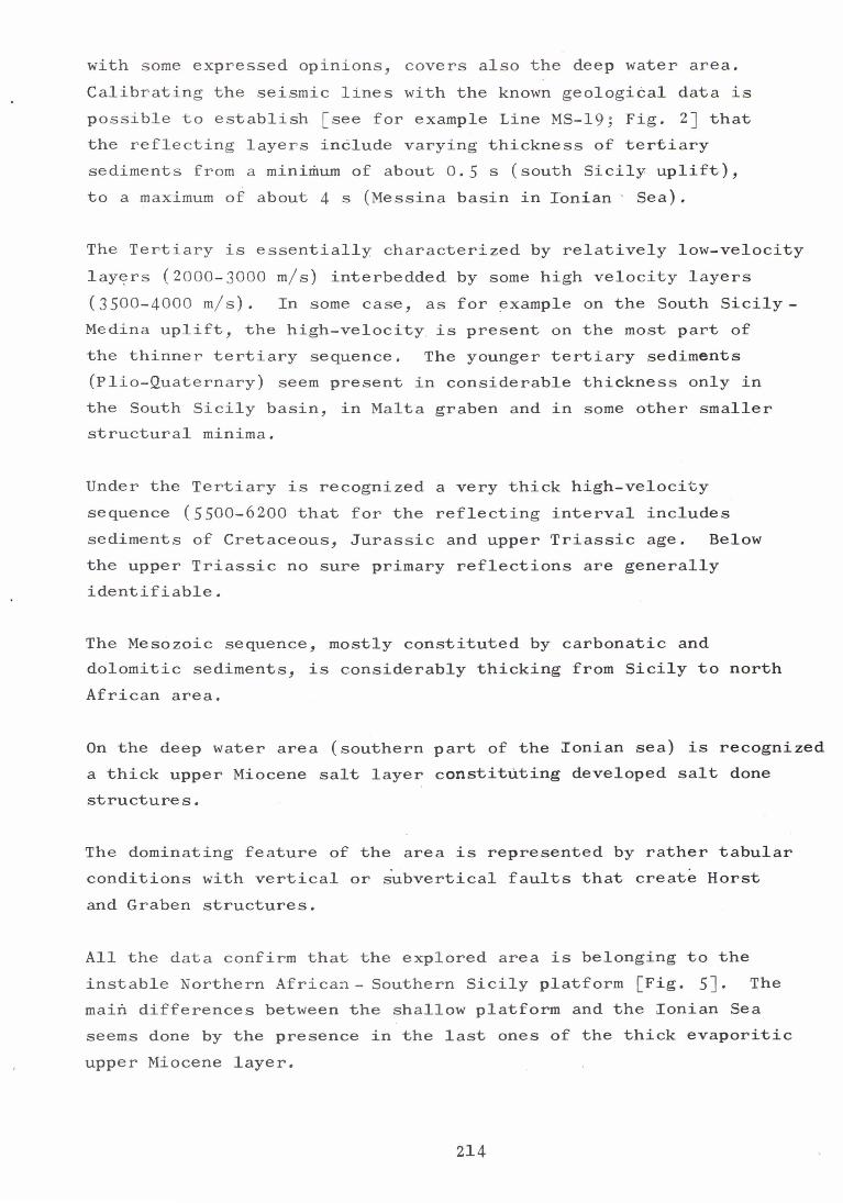
with some expressed opinions, covers also the deep water area. Calibrating the seismic lines with the known geological data is possible to establish [see for example Line MS-19; Fig. 2J that the reflecting layers include varying thickness of tertiary sediments from a minimum of about 0.5 s (south Sicily uplift), to a maximum of about 4 s (Messina basin in I6nian ' Sea).
The Tertiary is essentially characterized by relatively low-velocity layers (2000-3000 m/s) interbedded by some high velocity layers (3500-4000 m/ s). In some case, as for example on the South Sicily-Medina uplift, the high-velocity is present on the most part of the thinner tertiary sequence. The younger tertiary sediments (Plio-Quaternary) seem present in considerable thickness only in the South Sicily basin, in Malta graben and in some other smaller structural minima.
Under the Tertiary is recognized a very thick high-velocity sequence (5500-6200 that for the reflecting interval includes sediments of Cretaceous, Jurassic and upper Triassic age. Below the upper Triassic no sure primary reflections are generally identifiable.
The Mesozoic sequence, mostly constituted by carbonatic and dolomitic sediments, is considerably thicking from Sicily to north African area.
On the deep water area (southern part of the Ionian sea) is recognized a thick upper Miocene salt layer constituting developed salt done structures.
The dominating feature of the area is represented by rather tabular conditions with vertical or subvertical faults that create Horst and Graben structures.
All the data confirm that the explored area is belonging to the instable Northern Africa~- Southern Sicily platform [Fig. 5J. The main differences between the shallow platform and the Ionian Sea seems done by the presence in the last ones of the thick evaporitic upper Miocene layer.
214

This situation suggests the conclusion that the Ionian Se a is a
foundered block of the same instable platform. Faulting systems indicate that the tectonic displacements affect also the younger sediments and many faults seem to have short life (upper Miocene to Quaternary) . This means that, after the alpine tectogenesis, the examined area of the platform wa s affected by a distension with consequent collapse, responsible for the most part of the present structures and general setting.
It seems also probable that the foundered thick continental crust of the Ionian sea, at least on the North continuation of the land known big Sirte basin, was sinking also before the Miocene, beginning probably on the early Tertiary. On the upper Miocene, while on the foundered eastern block of the Ionian sea were sedimenting the evaporitic layers, on the shallow area, between Sicily and Tripolitania, continued the regular platform sedimentation.
When the top of the evaporitic layer is strongly broken even by many small faults, the seismic diffraction noise masks considerably the underlying reflecting layers.
The magmatic intrusion phenomena are clearly identified by the magnetic picture and confirmed by the seismic section where control exist. The area on which intrusions and eruptions are more frequent correspond also to the area of the most intense tectonization on the NW part of the Channel [Fig. 5J. These area is also affected by the most intense natural seismicity. Magmatic activity seems for the most cases rather young, but mesozoic, and early tertiary basalt intercalations are found by drilling exploration.
Bibliography
WaB o Agocs, !!Profondit~ e Struttura delllOrizzonte Igneo fra Catania e Tunisi dedotte da un P rofilo Aeromagnetico!!, Bbll. Serv. Geol. It., Vol. 80, No.1, 1959, pp. 51-61, Roma.
215

T. D. Allan and C. Horelli, "A Geophysical Study of the t-lediterranean
Sea", Boll.. (-;'eo. Teor. Appl., Vol. XIII, No. 50, 1 0 71.
P.F. Burollet~ HGeneral Geology of Tunisia in Guidebook to the Geology and History of Tunisia" ~ Petrol. Expl. Soc. of Libya, 9th Annual Field Conf., pp. 51-58, 1067.
P. F. Burollet, "Petroleum Geology of the \I1estern ~{editerranean Basin", Adlard and Son Ltd., Dorking, Surrey, Great Britain, lQ69.
C. Gantar, C. Borelli, A.G. Segre, L. Zampieri, "Studio Gravimetrico e Considerazioni Geologiche sull'Isola di Pantelleria", Boll. Geof. Teor. Appl., Vol. III, No. l~, 1961.
T.F. Gaskell, N.H. Hill, J.C. Swallow, "Seismic Heasurements made by H.H.S. "CHALLENGER" in the Mediterranean Sea, 1950-1953", Philos. Trans. Roy. Soc. Lond. A ~5l, No. 988, 1958.-
C. Horelli, "Bathymetry, Gravity and Hagnetism in the Sicily Channel", 1972, Osservatorio Geofisico Sperimentale, Trieste} Italy.
S.G. P ayo, "Crustal Structure of the ~lediterranean Sea by Surf ace Waves", Pt. 1 - Group Velocity. Vol. 57, No. ~, 1967.
Seismol. Soc. Amer. Bull.,
T. Rocco, "Gela in Italy, an Unusual Oilfield", Sect. I, paper 11 of the 5th World Petroleum Congress, 1959.
E.F.K. Zarudzki, "The Strait of Sicily, a Geophysical Study", Woods Hole Oceanographic Institution, 1968.
216

10' 11' 11' 11'
3S · l!-------'lr---+-------+-----f--------"'<:/-+---'-'k-------+-----+--+----~
31 '
10'
--- LINE LOCATION ,", 5·19 (
~
CORRELATED V(LOCiTY FUNCTIONS (fIg. 3) I.
r-----_+_------~~f___~------_+_--~------f-----------_M 31'
G{IlD6UL UfT(RPRETATIOII
so
II '
2 .0
.}-,-+-{f':r- ·3.0
11 '
1 -- -~ 11:0· 1,-
___ ---.JI 1'5
13 '
FIG. 1
FIG. 2
217
14' IS '
"/'.
2 .5
3.0
IS '
1l0000liitAl rlT~PRE'ATIOfI
0 .5
---" ''--..1-'--'- to
1.5 !
2 .5 i
3.0
11'

M
ci u..
, ~ ~
;5 ~ ~
, ~ -
i = -
%
~
0 1i: ~
.: r
! <X
~
5 ~
~
u
~ ~
I ~
;::
~ "" I ~ I
• = '" ~ ~ lS ~ '"
218

~- ~
~---c
0 ~- u ~- M
l? §-
LL
-
~-
§-
~-
§-
~-
~-
~-
~~
~ -
~-
~-
2-
~-
~-
~-
~-
~-
§-
~-
~-
~-
219

N
N o
MA
L
T A
G
RA
BE
N
, T
7 T
TY
-T
T 1
9j i
i 8i
at i
7j i
7i 7i
7i liO
1°
FIG
. 3
(Con
t'd)
MA
L
T A
68
0 67
0 I
I
H
0 R
S
T
----
----
-~40
~~
~lO
50
4!1
O ~8:J
I '
I I
I I
I I
I I
I I
I I
I

N
N f-'
SO
U
T H
5
4j4
i4j4
ii4
j 4'1
4j
j 'j
'T i
i 3jO
3jO
i
i c
L Y
B
AS
"'" ,.,
"" ""
"0
1
1 I
I I
FIG
.3
(Con
t'd)
N
'I Iii
140
130
I I
'" I ., I
" I '" I
'" I '°1

w 12' 13' 14"
38' i1I------+------k---+---f------===t---~_=A:=::,==--_+-___,L-+_--'----+_tL--,L_-__!.I 38'
32'
10'
z ::> I-
TIME CONTOUR - MAP
TWO WAY TRAVELTIME CATUM SEA LEVEL
CONTOUR INTERVAL 500 muc
~ MAIN fAULTS DO WN
M5-19 \ ---- U NE LOCATION
M5-20
w
I.
12' 13' 14' 15' 16' 11"
FIG. 4
222

10· ll" lZ· 13· 14·
3s. irl--------r---- 4,,--<>--f--~---"'_='4====:::-=---+__-_f____t-----"'______t+-_f--__1.I 3S·
SI C I L Y
37 ·irl---\------+n------t--- --:--t-t=l.li.JL'il-~+-f-7'<:____:__-__t-7"II__f_-__t"<i~__:+-____hl 37·
36 · ,.., '0 36·
4( ¢ ~ ... .,:l 1/1 ~~ z ,.., '0
t<I ;:) ~(""l I- ... 0
35·
33· 33·
--.L MAIN POSITIVE AXIS -r---L MAIN NEGATIVE AXIS ---r - MOST EVIDENT VOLCANIC I.
AREAS AND/ OR INTRUSIVE n· 3Z · ~\,.""~ STRONGLY FAULTED AREA
0 50 100 Km - --= SCALE
10· ll" lZ· 13· l(" 15· I&" 17"
FIG. 5
223