remotely piloted aircraft systems - fpinnovations
TRANSCRIPT

Unrestricted
[email protected] fpinnovations.ca
August 2020
Steven Hvenegaard, Researcher, Wilfire Operations
REMOTELY PILOTED AIRCRAFT SYSTEMS: EVALUATION OF PLATFORMS FOR HOTSPOT DETECTION ON WILDFIRES

ii
301013106: REMOTELY PILOTED AIRCRAFT SYSTEMS
AND INFRARED IMAGING OPERATIONS
TECHNICAL REPORT NO. 29 (2020)
ACKNOWLEDGEMENTS This project was financially supported by Alberta
Agriculture and Forestry.
APPROVER CONTACT INFORMATION Michael Benson
Manager , Wildfire Operations
REVIEWERS Jacques Lirette, Resource Management, FPInnovations
Rex Hsieh, Wildfire Operations, FPInnovations
Razim Refai, Wildfire Operations, FPInnovations
AUTHOR CONTACT INFORMATION Steven Hvenegaard
Researcher, Wildfire Operations
(780) 740-3310
Disclaimer to any person or entity as to the accuracy, correctness, or completeness of the
information, data, or of any analysis thereof contained in this report, or any other
recommendation, representation, or warranty whatsoever concerning this report.
Follow us:
ABSTRACT:
The ongoing evolution of remotely piloted aircraft systems (RPASs) with recent advances in micro-
sensors and imaging software has the potential to enhance the delivery of infrared imaging services
for wildfire operations. Understanding the capabilities and limitations of these aircraft will aid
wildfire managers in selecting appropriate RPAS platforms as another "tool in the toolbox" for
hotspot detection missions on wildfires.

iii
Table of Contents BACKGROUND ............................................................................................................................................... 1
ISSUE ............................................................................................................................................................. 1
OBJECTIVE ..................................................................................................................................................... 2
METHODS ...................................................................................................................................................... 2
FINDINGS ....................................................................................................................................................... 2
Terminology and classifications.............................................................................................................................. 2
Thermal imaging in wildfire management operations ........................................................................................... 4
Operational considerations for RPAS in thermal imaging operations.................................................................... 6
Working environment ........................................................................................................................................ 6
Night operations and visual line of sight ............................................................................................................ 6
Infrared imaging missions – objectives and mission parameters ...................................................................... 7
RPA platform selection ........................................................................................................................................... 8
RPA platform types ............................................................................................................................................. 9
Rotorcraft ....................................................................................................................................................... 9
Fixed-wing.....................................................................................................................................................10
Hybrid-electric propulsion systems (HEPS) in RPA ...........................................................................................10
Solar electric propulsion system.......................................................................................................................11
Essential RPA attributes and operator capacity ...................................................................................................11
Size and payload capacity .................................................................................................................................11
Vertical take-off and landing (VTOL) ................................................................................................................11
Beyond visual line of sight (BVLOS) ..................................................................................................................12
Operating altitude ............................................................................................................................................12
Battery endurance ............................................................................................................................................12
Navigational range ............................................................................................................................................13
Inertial navigation system ................................................................................................................................13
Other sensors ...................................................................................................................................................14
SUMMARY ................................................................................................................................................... 14
REFERENCES................................................................................................................................................. 15
APPENDIX 1. CATEGORIZATION OF UAS PLATFORMS (USDA FOREST SERVICE, 2016) ...................................... 18

iv
List of tables Table 1. UAV classifications defined by the National Wildfire Coordinating Groupa ................................................. 4

1
BACKGROUND Infrared imaging technology has been used for over four decades in support of wildfire management operations
in Alberta and across North America. This technology has been utilized in several different combinations of sensors
and operational platforms to achieve a broad range of strategic and tactical fire intelligence objectives.
One of the more frequently conducted localized tactical infrared imaging operations is hotspot detection during
the patrol and mop-up stages of wildfire suppression. An underlying goal of hotspot detection is to expedite mop-
up operations by locating smouldering sections of fireline that would otherwise be difficult, inefficient, or unsafe
to locate and access by ground crews. Hotspot detection operations provide a reference (GPS location or visual
marker) to ground crews who can be directed to the location to extinguish these hotspots before they flare up
with escalations in weather conditions. Infrared imaging is also used to provide a measure of confidence that a
section of fireline or the entire fire is under control or extiguished. Until recently, these operations have been
conducted mostly from a manned helicopter platform.
In contrast to these low altitude/short duration imaging operations, remote sensing operations (satellites or high-
altitude fixed-wing platforms) provide a more global picture of wildfire activity with coarser resolution of fire
activity across the landscape over a longer duration of time. This broader capture of wildfire activity provides
intelligence used in developing wildfire management strategies. While remote sensing from a high-altitude
platform is expensive with limited access to single end users on wildfire incidents, helicopters and small RPASs can
provide more flexible and affordable solutions to data collection in forestry operations including wildfire mapping
and hotspot detection.
Several research projects and the commercial delivery of infrared imaging have demonstrated the potential for
RPASs with infrared sensors to support wildfire management operations. As infrared imaging technology has
evolved, compact and affordable sensors have enabled widespread application of these tools with more accurate
and expedient imaging and higher-quality map delivery. The ongoing evolution of RPASs with recent advances in
micro-sensors and imaging software has the potential to enhance the delivery of infrared imaging products with
another operational platform, which can provide another "tool in the toolbox" to inform wildfire management at
both strategic and tactical operational levels.
ISSUE Infrared imaging product manufacturers and vendors are developing and marketing infrared imaging systems that
incorporate evolved remotely piloted aircraft (RPA) platforms, compact sensors, and advanced software systems
to deliver mapping products as decision support aids for wildfire managers. With an abundance of commercial
off-the-shelf RPAS and infrared imaging products available, remote sensing contractors have recognized the
commercial opportunity for utilizing this technology for wildfire applications. Wildfire management agencies are
lobbied by contractors or service providers to apply their infrared imaging technology and services on wildfires. A
wide range of performance capabilities and limitations in commercial off-the-shelf products, coupled with varying
degrees of experience and expertise in the wildfire remote sensing community, makes contractor selection
difficult. Field evaluation of infrared imaging systems is time-consuming and an RPAS product screening

2
mechanism utilized prior to field evaluations can reduce the resource commitments and logistical challenges
required for field evaluations.
OBJECTIVE An infrared imaging RPAS comprises a remotely piloted aircraft (RPA), sensors to capture thermal images, a
navigational system (manual guidance or autonomous), and software to interpret data with links to geographical
locations. In order to evaluate the suitability of an RPA platform for a given mission, it will be necessary to
understand the demands and challenges of the working environment and infrared imaging missions.
This synthesis of knowledge and practice will focus on RPA as an operational platform for hotspot detection and
outline platform attributes and performance standards essential to efficient data collection during these missions.
METHODS As an initial exploration into the literature, we conducted a search through Google Scholar which yielded material
that was categorized as:
• journal publications
• media reports
• vendor publications
References cited in the journal publications identified through this initial exploration were reviewed to determine
their applicability in this literature review. In addition to these sources of literature, technical reports published
by FPInnovations’ Remote Sensing group provided technical information relating to RPAS components (platforms,
sensors, and software) and applications in specific forestry operations.
Very little literature is available that documents RPAS operations at a tactical scale in wildfire operations. The
documentation that was found was followed up by telephone calls or emails to gather more information and
clarify details about the operations on wildfires. Personal communications were a valuable source of information
in developing this review.
FINDINGS
Terminology and classifications Consistent terminology has not been universally adopted for this new and quickly evolving technology. Regulatory
agencies and practitioners around the world apply synonymous sets of terms for system components with a
mutual acceptance and understanding of each. Inconsistent adoption of a set of terminology is apparent within
some regulatory agencies’ websites or documents, where as many as three different sets of terminology are used
to refer to the same system or vehicle.
3
Unmanned aerial vehicle (UAV) and unmanned aircraft (aerial) system (UAS) are universally recognized and
commonly applied terms. A subtle yet important distinction should be noted in the evolution of these terms; in a
literal context, "unmanned" in UAV can be interpreted as "the total absence of a human who directs and actively
pilots the aircraft." To remove any such misconceptions, UAS was adopted by several agencies to clarify that UAS
comprise an aircraft with demonstrated airworthiness and system capabilities of being remotely controlled
through ground stations (Valavanis and Vachtsevanos, 2015). Unmanned aircraft are defined as any aircraft
intended to be flown without a pilot on board. An unmanned aircraft can be remotely and fully controlled from
another place (ground, another aircraft, and space) or pre-programmed to conduct its flight without intervention.
Prior to recent amendments (Government of Canada, 2018) made to the Canadian Aviation Regulations, Transport
Canada applied and defined UAV as "a power-driven aircraft, other than a model aircraft, that is designed to fly
without a human operator on board." UAS is commonly applied to system components that include the UAV, the
ground control station, the communication system, and on-board sensors.
The terminology of UAS and UAV are used by many industry operators and regulatory agencies, including the
Federal Aviation Administration and other government agencies such as the United States Forest Service.
The most recent amendments adopted by the Canadian Aviation Regulations incorporate terminology used by the
International Civil Aviation Organization (2011) and several national aviation regulatory agencies. An RPAS is
defined as "a set of configurable elements consisting of an RPA, its control station, the command and control links,
and any other system elements required during flight operation." Remotely piloted aircraft means a navigable
aircraft, other than a balloon, rocket, or kite, that is operated by a pilot who is not on board. A small RPA is defined
as one with a maximum takeoff weight of at least 250 g (0.55 lb.) but not more than 25 kg (55 lb.).
This literature review has used the most recent terms adopted by the Canadian Aviation Regulations and has
applied RPA and RPAS when referring to the aircraft or the overall system in a general sense. In the case that an
agency or organization has specifically used other terminology to refer to their systems or aircraft, those specific
terms have been used.
Numerous applications of RPAS, in a broad range of industries, have fuelled the development of new RPA
platforms of varying configuration and size with a broad range of capabilities. Classifying an RPA is an important
initial step in selecting an appropriate platform that can fulfil the objectives of a wildfire infrared imaging mission.
With the development and application of drones in military operations, much of the classification and
nomenclature developed for drones has carried over to civilian and research communities. These classifications
provide a general framework for distinguishing the general arena of operations and the RPA capabilities (duration
and payload). UAS platforms are often categorized by mission type (strategic vs. tactical) and the associated
altitude and endurance range for these mission types (Appendix 1). Strategic infrared imaging missions that can
operate over a broad geographic area and capture imagery on several incidents would typically be conducted by
a medium-altitude long-endurance (MALE) or high-altitude long-endurance (HALE) UAS platform. The cost of
deploying these aircraft on wildfire missions can be two to three times the cost of manned aircraft (Ambrosia and
Zajkowski, 2015).
Low-altitude long-endurance (LALE) aircraft are used for capturing data on a large wildfire or a complex of fires,
while a low-altitude short-endurance (LASE) UAS would be the preferred platform for tactical operations over a
4
single fire or a small portion of a larger fire. The LASE UAS (often referred to as small UAS) is the most commonly
utilized UAS for fireline supervisors or other forestry monitoring personnel to obtain real-time photo/video and
infrared imagery.
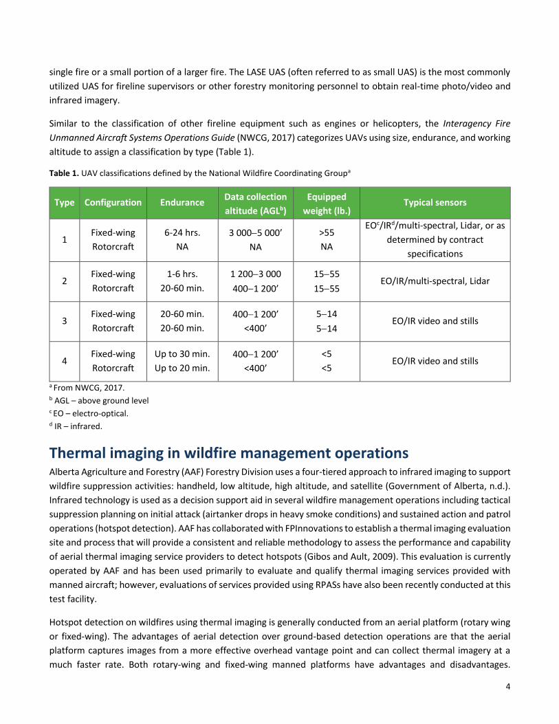
Similar to the classification of other fireline equipment such as engines or helicopters, the Interagency Fire
Unmanned Aircraft Systems Operations Guide (NWCG, 2017) categorizes UAVs using size, endurance, and working
altitude to assign a classification by type (Table 1).
Table 1. UAV classifications defined by the National Wildfire Coordinating Groupa
Type Configuration Endurance Data collection
altitude (AGLb)
Equipped
weight (lb.) Typical sensors
1 Fixed-wing
Rotorcraft
6-24 hrs.
NA
3 000−5 000’
NA
>55
NA
EOc/IRd/multi-spectral, Lidar, or as
determined by contract
specifications
2 Fixed-wing
Rotorcraft
1-6 hrs.
20-60 min.
1 200−3 000
400−1 200’
15−55
15−55 EO/IR/multi-spectral, Lidar
3 Fixed-wing
Rotorcraft
20-60 min.
20-60 min.
400−1 200’
<400’
5−14
5−14 EO/IR video and stills
4 Fixed-wing
Rotorcraft
Up to 30 min.
Up to 20 min.
400−1 200’
<400’
<5
<5 EO/IR video and stills
a From NWCG, 2017. b AGL – above ground level c EO – electro-optical. d IR – infrared.
Thermal imaging in wildfire management operations Alberta Agriculture and Forestry (AAF) Forestry Division uses a four-tiered approach to infrared imaging to support
wildfire suppression activities: handheld, low altitude, high altitude, and satellite (Government of Alberta, n.d.).
Infrared technology is used as a decision support aid in several wildfire management operations including tactical
suppression planning on initial attack (airtanker drops in heavy smoke conditions) and sustained action and patrol
operations (hotspot detection). AAF has collaborated with FPInnovations to establish a thermal imaging evaluation
site and process that will provide a consistent and reliable methodology to assess the performance and capability
of aerial thermal imaging service providers to detect hotspots (Gibos and Ault, 2009). This evaluation is currently
operated by AAF and has been used primarily to evaluate and qualify thermal imaging services provided with
manned aircraft; however, evaluations of services provided using RPASs have also been recently conducted at this
test facility.
Hotspot detection on wildfires using thermal imaging is generally conducted from an aerial platform (rotary wing
or fixed-wing). The advantages of aerial detection over ground-based detection operations are that the aerial
platform captures images from a more effective overhead vantage point and can collect thermal imagery at a
much faster rate. Both rotary-wing and fixed-wing manned platforms have advantages and disadvantages.

5
Helicopters have become the preferred platform for localized tactical operations because of their greater flight
manoeuvrability at slower speeds, hovering capability, and ability to operate at lower height above ground.
Infrared imaging at a localized scale on smaller wildfires or sections of fireline can be conducted by agency
personnel or contractors using handheld or gimbal-mounted infrared cameras while flying above areas of concern.
Prior to the use of aircraft mounted and handheld GPS devices, the location of an identified hotspot was marked
by dropping flagging tape or other material that would be visible to ground crews.
With the widespread implementation of GPS devices and evolution of aircraft mounted infrared sensors, hotspot
detection operations have evolved to allow aircraft to fly targeted sections or an entire wildfire area in a pre-
determined flight pattern, collect thermal imaging data, and, within hours, produce a list of GPS coordinates
and/or a map indicating the location of hotspots in the scanned area. In recent years, hotspot detection operations
in Alberta have also been conducted by RPAS service providers.
Scion Rural Fire Research group based in New Zealand started working with research partners in 2013 to develop
cheaper and safer alternatives to conventional hotspot detection methods conducted by ground-based
firefighters. Initial steps in this process involved developing a prototype using readily available components
including a quadcopter equipped with a stabilized, gimbal-mounted thermal camera, a small video camera, and a
GPS-enabled flight controller (Scion, 2018a).
In 2017, Interpine Group Limited worked with Fire and Emergency New Zealand and applied RPAS thermal imaging
techniques developed by Scion to conduct hotspot detection operations on the Port Hills Fire in Christchurch, New
Zealand (Scion, 2018b). Interpine has continued its use of RPAS and mapping technology on wildfire operations in
2018 for fire mapping and monitoring and hotspot detection on wildfires in New Zealand and Canada (Interpine
Innovation, 2018).
The United States Department of Agriculture (USDA) Forest Service acquires infrared imaging at a strategic and
nationwide scale through the National Infrared Operations (NIROPS) using manned fixed-wing aircraft typically
flying at medium altitude (3000 m). The Forest Service works closely with the Department of the Interior Bureau
of Land Management to conduct tactical infrared imaging operations on wildfires and to support other resource
management operations. On larger wildfire incidents and in fire seasons with widespread fire activity, Type 1
fixed-wing RPASs have been deployed to collect strategic-level wildfire intelligence (Ambrosia et al., 2011; Jones,
2014; Rivas, 2017). On a tactical level, several missions with small RPA have been flown on wildfires to gain
situational awareness and to provide thermal imaging intelligence (Safran et al., 2016; Koeckeritz and McFall,
2018). While documentation of RPAS infrared imaging missions on wildfires is difficult to locate, findings are often
shared and published through special groups or committees such as the USDA Forest Service UAS Advisory Group
(USDA Forest Service, 2012) and the Tactical Fire Remote Sensing Advisory Committee. The National Wildfire
Coordinating Group has developed multi-agency standardized procedures to use RPAS in restricted airspace above
a wildfire that is shared with other aircraft (National Wildfire Coordinating Group, 2017).
As of 2017, the drone program operated by the Department of the Interior (DOI) utilized 385 3DR Solo VTOL
quadcopters, 15 FireFLY Y6S VTOL fixed-wing, and 1 Pulse Vapor 55TM Helicopter with 293 trained pilots available
for missions (Koeckeritz and McFall, 2018). During the 2017 fire season, the program flew almost 5000 missions
with 660 of these on wildfires.

6
In addition to these agency-owned RPAS, the DOI Bureau of Land Management has established four "Call When
Needed" contracts for service providers to deliver persistent surveillance, hotspot detection, and fire mapping
services on wildfires. These aircraft are also available for search and rescue operations, emergency management,
and other resource management missions. These aircraft operating under contract are able to operate day or
night, without a runway, in sustained winds up to 25 knots and at altitudes consistent with typical western wildfire
environments (U.S. Department of the Interior, 2018). These aircraft are not commercial off-the-shelf units. They
are part of a remote sensing and data collection/transmission service that provides real-time intelligence to
incident management teams.
Operational considerations for RPAS in thermal imaging operations
Working environment Aerial thermal imaging operations can be conducted in any wildland environment where wildfires occur. However,
these operations are most valuable in forested areas that are not easily patrolled by ground firefighters because
of poor access, difficult terrain, size of the area, or safety concerns. The overstorey can be conifer or mixedwood
forest of varying stand height, density, and canopy closure. Other potential fuel environments for thermal imaging
operations include grasslands or shrublands. When operating an RPAS in tall or dense forest stands, visual line of
sight will be compromised and additional observers may be required.
Terrain can range from continuously flat in the boreal forest to very steep in mountainous areas. In either case,
maintaining an adequate altitude above ground is critical; however, piloting an RPA on flat terrain will be less
complex with fewer changes in landscape features to navigate. Hilly or steep terrain can be a limitation when
maintaining visual line of sight, or it can provide an advantageous vantage point with more direct line of sight to
enable more effective piloting.
Thermal imaging operations are not conducted during or immediately after rain events. After any rain event,
drying of surface fuels must occur under good drying conditions before thermal imaging operations can be
conducted. The number of good drying days (continuous sunshine or gentle wind) after a rain event will depend
on the amount of precipitation (Government of Alberta, n.d.)
Night operations and visual line of sight During the day, two key influences reduce the effectiveness of thermal imaging. Solar gain occurs when an object
absorbs infrared energy from the sun and re-emits infrared energy. When the sun’s energy is reflected off of
objects, solar reflectance occurs. Both of these influences confound thermal imaging operations by producing
false positives (Government of Alberta, n.d.) and, therefore, thermal imaging operations are planned when solar
gain and solar reflectance are at their lowest levels.
The best time for thermal imaging is when the thermal contrast between hotspots and surrounding objects is
highest (Quaye et al., 2014). In the evening, objects that have absorbed infrared energy throughout the day will
emit energy until thermal equilibrium has been reached. At mid-summer, in northern latitudes, this occurs in the
early morning (about 2 a.m.), which is considered an optimum time for infrared scanning. However, thermal
imaging operations with manned aircraft are scheduled for an early morning timeframe that is in compliance with

7
legal duty day and visual flight rules. Air temperature during nighttime operations can range considerably based
on time of year and elevation, but will rarely be below the freezing point.
High altitude (3 000 to 14 000 feet AGL) thermal imaging operations using instrument flight rules (IFR)−capable
operators allows for thermal scanning outside the legal duty day (night operations). Rotary-wing aircraft flying
low-altitude thermal imaging missions are not IFR-capable and are restricted to working within the duty day, which
starts one half hour before sunrise. In spite of a short timeframe for early morning operations, infrared imaging
operations with rotary-wing or fixed-wing manned aircraft are possible because of the speed and endurance of
these aircraft, which equates to a large area that can be scanned during this optimum timeframe for thermal
imaging.
Because of the limited battery endurance of small RPAs, several battery exchanges may be required during a
thermal imaging mission; as a result, most missions with RPAS are conducted over a longer timeframe starting in
the late evening or early morning to cover the same scan area that a manned aircraft mission would. During night
operations, visual line of sight (VLOS) may be difficult to achieve because of the potential hazards in placing visual
observers in a scan area. Hence, a preferred operational mode for RPAS infrared imaging missions is beyond visual
line of sight (BVLOS).
Infrared imaging missions – objectives and mission parameters Any aircraft, mannned or unmanned, is another "tool in the toolbox" and should be selected for an infrared
imaging mission based on its ability to perform the mission objectives successfully and cost-effectively. To simplify
this selection process, it will be important to classify the infrared imaging mission, define the mission objectives,
and assess the mission parameters to justify using a certain type of aircraft for that mission.
Persistent surveillance or patrol operations are conducted to achieve strategic objectives of collecting and
analyzing fire activity data over a large landbase and a long period of time. Several mission objectives can be
achieved with infrared scanning missions from a medium altitude (up to 10 000 feet AGL) with a long endurance
RPA or manned aircraft. Mission objectives could include :
• detecting new fire starts in an area of high lightning activity
• monitoring existing wildfire areas to detect spot fires and assess fire growth
• assessing fire behaviour and fire mapping on new fire starts where smoke prevents assessment and
mapping from a manned aircraft
Mission parameters at this operational scale will include a large scan area (at least 100 000 ha), scan time (night
or day), endurance (4 to 6 hours), and scan altitude (5 000 to 10 000 feet AGL). These are critical parameters to
consider when selecting an aircraft for this type of mission.
At a low altitude on a more localized scale, manned or unmanned aircraft are used to achieve tactical objectives
of locating and geo-referencing hotspots and mapping fire perimeters with a high level of precision. These
operations would typically be conducted in the later stages of a wildfire when ground patrol and mop-up
operations have commenced. Mission parameters at this scale will include a smaller scan area, nighttime scanning
(to avoid other aircraft on the fires and achieve optimum infrared imaging), and a lower scan altitude. This type
of localized scan on a single wildfire or sector of a larger wildfire can also be conducted in the early stages of a
wildfire when smoke limits visibility and prevents accurate mapping of a fire.

8
In the earliest stages of mop-up operations, fire crews will typically focus suppression efforts on the most active
hotspots of the fire perimeter that are detected by conventional means (sight or smell). Prior to these suppression
activities, a thermal scan of the area can assist crews in identifying areas with active fire behaviour to assist them
in prioritizing areas of suppression. In the initial stages of patrol operations, suppression is typically focused on
extinguishing all hotspots outside the perimeter and 100 feet inside the fire perimeter. A mission objective for
infrared imaging would be to scan these critical areas of the fire to ensure fire does not escape past the control
lines.
As more fire perimeter is controlled and extinguished and additional resources are deployed, the extent of the
infrared imaging on the fire perimeter can be extended. When the entire perimeter of a fire is declared as
"controlled," an incident management team may request an infrared scanning mission for the entire fire area if
complete extinguishment of the fire is an objective.
A few important factors should be considered in planning infrared imaging missions in the patrol stage. First, the
results of an infrared imaging mission (hotspot map with GPS locations) is only a snapshot in time. These
conditions will change over time and subsequent missions may be required. Secondly, the benefits of a large-scale
mission are questionable if there are insufficient resources to act on all the hotspots detected by a mission.
Other important mission parameters that should be considered in both levels of infrared imaging missions are
location and access. If an RPA or manned aircraft needs to ferry a long distance from the staging area, this ferry
time consumes battery power or fuel which reduces the flight time available to conduct the scanning mission.
When infrared imaging is required in a remote location, an RPAS crew and equipment may need to be transported
to a staging area closer to the area to be scanned. The amount of equipment required may be a concern when
transport by helicopter is required. Battery endurance is a limitation on any RPAS mission and spare batteries
and/or power generators may be required, which adds to helicopter load. An RPAS crew will need to be self-
sufficient for an operational period since helicopter support may not be available during night operations.
RPA platform selection FPInnovations has worked in partnership with industry and government to investigate the potential of unmanned
aircraft technology for forestry practices in Alberta (Vepakomma et al., 2016). A review of UAS technologies (Jean
et al., 2015) and a system needs analysis for forestry projects aided FPInnovations in selecting the Aeryon
SkyRanger (FLIR, 2019) based on essential features that meet most forestry operations’ project requirements.
These features included vertical take-off and landing (VTOL) for missions with limited takeoff and landing space,
high safety options, ease-of-use via computer and waypoint control, backpack portability, easy setup by one field
technician, integrated HD and FLIR sensor packages, satisfactory range and endurance, and resistance to extreme
temperatures.
The SkyRanger is a quadrotor⎯a type of rotorcraft which is lifted and propelled by four rotors. Fully assembled,
including the payload, its dimensions are 102 cm in diameter by 24 cm high, and it weighs 2.4 kg. It is electrically
powered by lithium polymer cells. This RPA has a maximum flight time of 50 minutes, a communication range of
3 km, and a maximum ground speed of 35 km/h. It can hold its position in winds up to 65 km/h and remains stable
in gusts exceeding 90 km/h. It can endure temperatures between -30°C and 50°C (Vepakomma et al., 2016).

9
The RPAS is equipped with an inertial navigation system (3-axis gyroscope, 3-axis accelerometer, 3-axis
magnetometer, GPS receiver, and static pressure sensor) and a sonar sensor for precision AGL (above ground
level) altitude measurement. It uses on-board computer systems to monitor (sensors, battery, etc.), control
(speeds, attitude, position, etc.), and communicate (control, telemetry, etc.).
FPInnovations also operates four DJI quadcopters (Inspire 1, Inspire 2, Matrice 210, Mavic 2 Enterprise Dual) and
a DJI hexacopter (Matrice 600) which is useful for heavier payloads with multiple sensor units.
The DOI developed a UAS acquisition strategy which considered the reality that unmanned aircraft and unmanned
aircraft systems are "rapidly evolving and can become obsolete within a few years" (Department of the Interior,
2015). With this in mind, the DOI planned for a limited life span of any given model of aircraft. This strategy limited
purchase of UAS to small UAS in the foreseeable future to avoid expensive technology that will rapidly lag behind
the cutting edge of UAS technology.
The DOI shifted from a very "rugged and capable" fleet of excess equipment obtained from the Department of
Defence to a combination of commercial off-the-shelf VTOL and fixed-wing RPA platforms. The 3DR Solo
quadcopter, the Parrot Anafi quadcopter, the VTOL fixed-wing FireFLY6 PRO/S, and the Pulse Vapor 55TM
Helicopter are the primary RPA platforms (U.S. Department of the Interior, n.d.) operated by trained pilots within
the DOI to perform missions on wildfires and other resource management missions.
RPA platform types There are numerous RPA platforms with varying capabilities and limitations that can be equipped with infrared
sensors to capture infrared imagery over wildfires. Different RPA models may have advantages or disadvantages
in specific operations. However, more important considerations in RPAS design are sensor integration, control,
and software functionality. The RPA platform is only a small part of the solution. Ensuring that all camera functions
(e.g., isotherm, palettes, and detection thresholds) can be dynamically controlled by the sensor operator is
critical.1
Rotorcraft
Rotorcraft or rotary-wing RPAs have an advantage of being able to take off and land vertically in remote areas
without adequate clearings for runways or launch. Another distinct advantage when using manual flight control
during hotspot detection operations is the ability to hover over an area of concern or manoeuvre in a horizontal
or vertical direction to obtain a better viewpoint. Quadcopters (rotorcraft with four rotors) are commonly used
for different wildfire applications including situational awareness, mapping, and thermal imaging operations
(Safran et al., 2016; Scion, 2018a). RPAs with six or eight rotors are often used for larger payloads or multiple
camera operations. Quadcopters are relatively light and compact making them easy to pack, transport, and
deploy.
Relative to fixed-wing RPA, rotorcraft are complex machines with more moving parts and electronics, and may be
more susceptible to breakdown with greater difficulty in field repairs. Due to the slower speed of rotorcraft, the
coverage area will be less; however, the slower speed may contribute to greater penetration of imaging through
tree canopies. Rotorcraft travelling at slower speeds will enable better thermal hotspot detection through tree
1 Personal communication - David Herries, Interpine Group Ltd., April 12, 2018.

10
canopies, due to the nature of infrared survey (low resolution cameras [typically 640 × 512], and motion blur
caused by speed of travel).2 For RPAS operations that require VLOS, a larger rotorcraft will be visible at longer
distances so operating distances can be extended. A hexacopter that experiences a single motor failure can
maintain flight and, therefore, improve the reliability of an RPA. A hexacopter is typically larger and heavier, and
often requires transport by a four-wheel-drive vehicle in rough terrain.
Fixed-wing
Compared to rotorcraft, fixed-wing RPA generally are faster and can cover more area. They are lighter and easier
to operate and are mechanically less complex. A key concern often expressed with fixed-wing RPA is their inability
to take off and land in a remote area with limited runway space. However, recent developments in launch and
retrieval mechanisms have made the deployment of fixed-wing RPA feasible in remote or confined launch areas.
A recent development for fixed-wing RPA is the VTOL fixed-wing Firefly6 Pro, which can take off and land in a 3 × 3
m area (BirdsEyeView Aerobotics, 2020). The manufacturer’s specifications for this aircraft state the flight time is
50 to 59 minutes (when hover time is limited to take-offs and landings). The extended flight time, relative to most
VTOL quadcopters, and the greater cruise speed (30 to 35 knots) allows this aircraft to cover 3 to 5 times the area
scanned by other small quadcopters.
This assertion that fixed-wing RPA can "fly farther and faster on a single battery charge" was tested in a
comparative mapping project (sUAS News, 2019), which evaluated the performance of a popular professional
quadcopter and a senseFly eBee X fixed-wing RPA. On the 100 hectare mixed-use agricultural testing ground in
Switzerland, the fixed-wing RPA was able to map this area 2.6 times faster than the quadcopter. This type of
comparative evaluation will be of great value in evaluating the capabilities of different RPA types in the wildfire
arena while performing infrared imaging missions.
Hybrid-electric propulsion systems (HEPS) in RPA Jean et al. (2015) outlines three propulsion systems for RPAs⎯electric, gas, and electric/gas. While the majority
of the RPA platforms in this technology watch are electric (battery) powered rotorcraft and fixed-wing electric
(battery) or gas-powered aircraft, only one electric/gas-powered fixed-wing aircraft is identified. A recent
development in RPA technology is an electric/gas-powered VTOL quadcopter with performance specifications
similar to electric VTOL quadcopters. One exception to these similarities in performance is flight endurance. The
Perimeter Drone manufactured by Skyfront boasts a maximum endurance of 5 hours with no payload and 2 hours
with a 2.5 kg payload (Skyfront, 2020). With continued evolution in RPA technologies, several new fixed-wing VTOL
hybrid-electric propulsion RPA platforms have been introduced (Unmanned Systems Technology, 2019).
Sliwinski et al. (2017) explores the viability of HEPS in RPAs and provides a comparative modelling of these three
propulsion systems with range and endurance as the primary performance criteria. This study determined that
the gas-powered system provides the greatest range and endurance while the entirely electric system provides
the lowest range and endurance. While range and endurance performance of the HEPS was about 70% of the gas-
powered system, an advantage of the HEPS will be fuel savings and reductions in emissions.
2 Ibid.

11
Solar electric propulsion system One of the Bureau of Land Management’s "Call When Needed" service providers has deployed the Silent Falcon
fixed-wing RPA which utilizes solar electric cells to supplement battery power (Fire Aviation, 2018). Coupled with
this solar electric technology, carbon fibre and modular technologies provide a lightweight aircraft with long
endurance and minimal noise. This craft employs a catapult launch system and a parachute landing system.
There has been intensive research into solar propulsion technology with several RPAS developed for high-
altitude/long endurance missions (Sinovoltaics Group, 2019). Among these aircraft with very long wingspan and
questionable utility in a rugged wildfire environment, the Silent Falcon stands out as an RPAS of suitable size and
durability for wildfire operations. For thermal imaging operations at night, there may be little added benefit from
the solar panels; however, missions that carry over into early dawn hours could be extended as the solar panels
re-energize the the batteries.
Essential RPA attributes and operator capacity The commercial off-the-shelf RPAS market has made acquisition and operation of an RPAS possible for many
professionals and civilians. Various RPA platforms with varying system attributes have a wide range of capabilities
and limitations. The advantages and disadvantages of each platform need to be considered in evaluating these
aircraft for conducting hotspot detection missions on wildfire. The extent to which each physical attribute impacts
the platform’s ability to deliver acceptable results can only be determined under stringent evaluation conditions.
Some fundamental RPA characteristics should be considered as essential to hotspot detection operations and the
successful delivery of acceptable results.
Size and payload capacity The majority of RPAs used in forestry-related or other resource management missions will be in the small RPA
category. Within this category, there is a wide range in cost with an associated variability in performance. Payload
capacity is critical to imaging operations since the weight of the camera(s) will impact RPA endurance, speed, and
manoeuvrability. At the low end of the consumer RPA market is the hobbyist or trick level which sell for as little
as $100 and have an endurance of 8 to 10 minutes. This class of RPA can easily be ruled out for the purposes of
resource management imaging or hotspot detection missions because of the limited payload capacity and/or
limited battery endurance.
The next category is the "prosumer" level which is midway between the hobby level and professional level. These
RPA have an endurance of 25 to 30 minutes and have options for a payload which is typically a camera. At the
professional level (heavy payload drone), RPA have capability to carry larger payload than the prosumer level but
can cost $15,000 or more. Several RPAs in these categories have been used successfully on resource management
imaging operations.
Vertical take-off and landing (VTOL) VTOL can be a valuable RPA attribute in some situations but is not necessarily a critical attribute for all infrared
imaging missions. With a wide range of infrared scanning missions, there will be areas of tight crown closure where
VTOL is an asset and there will be situations where an RPA can be launched in a less confined space. The recent
development of VTOL fixed-wing RPA may provide a solution to the issue of remote operation and lack of an
adequate runway. While the VTOL fixed-wing has longer battery endurance while in constant forward flight, the

12
battery life endurance is reduced when hovering or manoeuvring. Further study of VTOL fixed-wing RPA should
be conducted to evaluate the efficiency of the system in hotspot detection.
The Bureau of Land Management’s technical specifications for "Call When Needed" UAS require that a UAV "shall
be capable of take-off and landing within a maximum area of 300 × 300 ft." (Bureau of Land Management, 2018)
If an RPA requires a runway for take-off or landing, consideration should be given to the endurance of the aircraft
and the flight time from the runway to the scan area.
Beyond visual line of sight (BVLOS) Conducting hotspot detection missions at night when all manned aircraft are down for the night is an absolute
operating requirement. Working in remote locations at night creates logistical challenges for operators and
creates safety hazards for visual observers in visual line of sight operations. To eliminate the risk to visual observers
working at night in areas of dangerous trees or ash pits, visual line of sight operations are not recommended;
BVLOS is a preferred operating mode and service providers should have a Special Flight Operations Certificate that
will permit them to operate in this mode. While the amendment to the Canadian Aviation Regulations does not
require operators to have an SFOC for VLOS night operations, an RPA must have position lights for night
operations.
Operating altitude The regulated maximum operating altitude for RPA is 400 ft. (122 m) AGL. In tall forest stands, flying this height
limit and maintaining clearance with treetops may not be possible. Additionally, some thermal imaging operators
may prefer to conduct missions from a higher altitude for a wider field of view and a greater scan area. In this
case, operators must obtain an SFOC for operating above the 400 ft. AGL altitude.
Battery endurance RPAs have limited battery endurance that is reduced by an adverse flight environment (wind and extreme
temperatures), flight pattern (extensive loitering or changes in altitude), payload, sensor current draw, and
navigational radio signal strength. Higher air temperature and higher altitude will reduce the effective lift of the
rotors on an RPA requiring greater thrust from the rotors with more power to maintain lift. Manufacturers’
specifications for battery endurance of commercial off-the-shelf VTOL platforms are determined under optimum
operating conditions, and adverse conditions will reduce battery endurance considerably (Hartley, 2017).
From experience on several forestry-related missions, the Aeryon Skyranger operated by FPInnovations typically
has a flight time of 30 to 40 minutes (usually returns with 20% battery life). The manufacturer specifies the
maximum flight time as 50 minutes. DJI produces several RPA models used in forestry-related missions. The
Matrice 210 (quadcopter) used by FPInnovations has a typical flight time of 20 minutes when equipped with 3
cameras. The Matrice 600 (hexacopter) has a typical flight time of 20 to 30 minutes and less than 20 minutes with
a payload of 5.5 kg.
Technical specifications for the Bureau of Land Management’s "Call When Needed" contracts have a minimum
performance standard of 2 hours of flight time with a target specification of 14 hours. Most of the fixed-wing
aircraft that are used in these contracts exceed the minimum specification.

13
Lower battery endurance will require more battery exchanges during a mission and increase the overall time
required for ferrying to and from a staging area to exchange batteries.
The battery in an RPA represents the largest component by weight and improvements in power storage can result
in the greatest opportunity for weight reduction and/or performance enhancement (Logan et al., 2007). Advances
in battery technology, reduction in RPA weight, and efficiencies in motor performance are all suggested as ways
to increase the battery endurance and flight time for RPAs in the future.
Air transport regulatory agencies (International Air Transport Association, 2019) and commercial airlines restrict
the carriage of lithium ion batteries by capacity. When service providers need to travel by commercial aircraft,
this restriction can impact the rapid deployment of service providers with RPAs that have batteries with capacity
greater than 100 watt-hours.
Mission objectives, access to the scan area, and the size of the scan area will be important considerations in
determining the critical attributes of an RPA. Setting an absolute minimum endurance level for RPA is difficult
given the wide range of infrared imaging mission objectives and operational parameters. Based on manufacturers’
specifications for the quadcopters identified in this review, the battery endurance ranges from 20 to 50 minutes.
This range of endurance may set appropriate specifications for minimum endurance (20 minutes) and target
performance (50 minutes) for small RPAs performing tactical infrared imaging operations such as hotspot
detection.
Navigational range Most RPA have a limited communication range and when this range is exceeded or when the communication
signal is blocked by physical obstructions, the RPA will stop and "return to home. "
The unaided range for the Aeryon Skyranger is 3 km and with a directional antenna the range is 10 km. The DJI
Matrice 600 Pro has a range of 5 km provided there are no obstructions. These are examples of range for
professional and prosumer category RPA platforms. Even though each hotspot detection mission is different,
navigational range of an RPA will have an impact on the efficiency of the operation and should be considered in
the selection process of RPA for hotspot detection missions. In most cases, the maximum navigational range of an
RPA will exceed the visual line of sight of most observers and, hence, these ranges will only be possible with a
BVLOS SFOC.
Inertial navigation system An inertial navigation system (INS) is a navigation device that uses a computer, motion sensors (accelerometers),
and rotation sensors (gyroscopes) to continuously calculate by dead reckoning the position, orientation, and
velocity (direction and speed of movement) of a moving object without the need for external references. The
Aeryon Skyranger used by FPInnovations is equipped with an INS comprising a 3-axis gyroscope, 3-axis
accelerometer, 3-axis magnetometer, GPS receiver, and static pressure sensor.
When considering professional and high-end consumer grade RPAS, most will make use of a global positioning
system (GPS). Many will also enhance this navigational system with an INS that includes an inertial measurement
unit (a cluster of gyroscope, accelerometer, and magenetometer) within its flight controller for flight navigation
and control. "Regardless of the sensor used, similarly to experiences learned in manned airborne survey

14
operations, direct georeferencing using an INS provides a means of accurately collecting mapping data from a
UAV" (OXTS Inertial+GNSS, 2016).
An INS is an essential component for an RPAS in order to permit accurate autonomous flight in infrared imaging
missions and to ensure accurately georeferenced hotpsots. Most RPAS that are intended for imaging have INS
incorporated into the sytem. However, manufacturers' specifications do not typically indicate if an INS is used in
their RPA so this is a difficult attribute to confirm.
Other sensors Terrain following is a function that may be beneficial during night operations. It uses a terrain model to maintain
its height (AGL) during manual directional flight or autonomous flight. In this mode, the pilot does not need to
adjust altitude and can focus on directional flight and imaging operations.
Transponders are critical when operating RPAs in mixed airspace; however, hotspot detection missions in most
areas will be conducted when other aircraft are down for the night. Collision avoidance systems are not critical to
the quality of a hotspot detection mission, and this technology would be used solely to prevent collisions with
snags or other obstacles.
SUMMARY This synthesis of knowledge has discussed the environmental challenges that are encountered in different types
of infrared imaging scanning missions, and identified attributes of remotely piloted aircraft that will influence
performance (efficiency and quality) of hotspot detection operations.
Mission objectives and operational parameters should be the driving forces that determine the most cost-effective
aerial platform (manned or unmanned) to perform an infrared imaging operation. Several questions must be
addressed when selecting an appropriate aerial platform for infrared imaging operations on wildfires. A set of
guidelines or a flowchart may be useful as a decision support tool in choosing an appropriate platform. These aids
are commonly used in other infrared imaging operations to determine appropriate tools for infrared operations
on wildfires in different stages of control (Government of Alberta, 2017).
This research project does not explore or compare the cost-effictivenss of RPA platforms vs. manned aircraft or
the differences in performance of different RPAs for specific mission types. Further studies with documentation
of infrared imaging missions with different RPAs will provide comparative data to further evaluate these aircraft.
Many subject matter experts consulted in the preparation of this review reiterated the same point⎯the success
of an RPAS mission is not solely dependent on the remotely piloted aircraft. An RPA may have excellent
performance qualities such as battery endurance, speed, and stability, but the platform is only one small part of
the overall solution. Sensor integration, control, and software functionality are all critical to mission quality and
efficiency.
The RPA platform is only one component of the complete system and the overall performance of an RPAS in
conducting a specific operation is dependent on the integration of RPAS components to collect, interpret, and
deliver data essential to the mission. An RPAS team composed of operator and support personnel that have a

15
background in wildfire operations, basic understanding of fire behaviour, and necessary skills to adapt to
inclement environmental conditions is a critical component essential to efficient delivery of hotspot detection
operations.
Several RPA platforms can be equipped with an infrared sensor to capture data from a hotspot detection mission.
However, until this data have been interpreted and the firefighter on the ground receives a map of GPS referenced
hotspots, the mission is incomplete. Software evaluation tools play a critical role in analyzing images and
georeferencing these images. Evaluation of software tools is beyond the scope of this review and may not be
possible given the proprietary nature of many software tools. Ultimately, the success and efficiency of infrared
imaging data collection and processing systems will be evaluated and judged in operational or simulated test
conditions. A comparative productivity evaluation of different platform types will help inform decision-making
processes in the wildfire infrared hotspot detection arena.
With the constant evolution of remotely piloted aircraft, many product evaluations and summary documents of
available technology become outdated very quickly. An updated technology watch will provide useful data to
inform users of available products. All flight regulations cited in this report are a reflection of current Transport
Canada regulations (June 1, 2019) and are applicable to RPAS flights in Canada only.
REFERENCES Ambrosia, V. G., Wegener, S., Zajkowski, T., Sullivan, D. V., Buechel, S., Enomoto, F., Lobitz, B., Johan, S., Brass, J.,
& Hinkley E. (2011). The Ikhana unmanned airborne system (UAS) western states fire imaging missions: from
concept to reality (2006–2010). Geocarto International, 26:2, 85-101.
https://doi.org/10.1080/10106049.2010.539302
Ambrosia, V.G., & Zajkowski, T. (2015). Selection of appropriate class UAS/sensors to support fire monitoring:
experiences in the United States. In K.P. Valavanis & G.J. Vachtsevano, Handbook of unmanned aerial vehicles.
Springer, Netherlands. pp. 2723–2754. https://doi.org/10.1007/978-90-481-9707-1_73
BirdsEyeView Aerobotics. (2020). Firefly6 Pro: Welcome to the revolution.
https://www.birdseyeview.aero/pages/firefly6-pro
Bureau of Land Management. (2018). BLM CWN Unmanned aerial system solicitation 140D8018R0005.
Fire Aviation. (2018). CWN drone used to map Martin Fire. https://fireaviation.com/2018/07/13/cwn-drone-used-
to-map-martin-fire/
FLIR. (2019). High-performance drones for military, public safety & industrial operators.
https://www.flir.com/uis/uas
Gibos, K. & Ault, R. (2009). Evaluation of rotary-wing thermal infrared service delivery using simulated wildfire
hotspots (Technical report). FPInnovations – FERIC: Vancouver, BC.
Government of Alberta. (n.d.). Thermal infrared primer. Alberta Sustainable Resource Development (Alberta
Agriculture and Forestry), Forestry Division, Wildfire Management Branch, Wildfire Aviation and Geomatics.

16
Government of Alberta. (2017). Thermal infrared decision tool. Alberta Agriculture and Forestry, Wildfire
Management Branch, Wildfire Aviation and Geomatics.
Government of Canada. (2018). Regulations amending the Canadian Aviation Regulations (Remotely Piloted
Aircraft Systems): SOR/2019-11. http://www.gazette.gc.ca/rp-pr/p2/2019/2019-01-09/html/sor-dors11-eng.html
Hartley, R. (2017) Unmanned aerial vehicles in forestry - reaching for a new perspective. New Zealand Journal of
Forestry, 62(1): 31–39.
International Air Transport Association. (2019). Dangerous Goods Regulations. Table 2.3.A Provisions for
dangerous goods carried by passengers or crew. International Air Transport Association (IATA).
International Civil Aviation Organization. 2011. Unmanned aircraft systems (UAS). International Civil Aviation
Organization Circular 328. ISBN 978-92-9231-751-5.
Interpine Innovations. (2018). Interpine helping with North American Wildfires in Canada.
https://interpine.nz/interpine-helping-with-north-american-wildfires-in-canada/
Jean, K., Menard, P., Vepakomma, U., & Cormier, D. (2015). Unmanned aerial systems for forest operations –
technology watch (Technical Report no. 44). FPInnovations: Pointe-Claire, QC.
Jones, J. (2014). U.S. Forest Service explores use of UAS in fire management.
https://www.fs.usda.gov/sites/default/files/fire-2014-uasarticlefinal-070114.pdf
Koeckeritz, B. & McFall, H. (2018). How the Department of the Interior uses drones. Webinar presented by 3DR
and United States Department of the Interior. https://vimeo.com/276314378
Logan, J. M., Chu, J., Motter, A. M., Carter, L. D., Ol, M., & Zeune, C. (2007, May). Small UAV research and evolution
in long endurance electric powered vehicles. Paper presented at AIAA Infotech@Aerospace 2007 Conference and
Exhibit, AIAA Paper 2007-2730.
National Wildfire Coordinating Group. (2017). Interagency fire unmanned aircraft systems operations guide
(Publication PMS 515). National Wildfire Coordinating Group. https://www.nwcg.gov/publications/515
OXTS Inertial+GNSS. (2016, Feb. 23). Why is an Inertial Navigation System (INS) important for unmanned aerial
vehicle (UAV) survey and mapping applications? https://www.oxts.com/technical-notes/why-is-an-ins-important-
for-mapping/
Quayle, B., Johnson, J., Queen, L., & Mellin, T. (2014). Infrared field users’ guide. USDA Forest Service: Salt Lake
City, UT, USA.
Rivas, M. (2017). Ikhana UAS overview. National Aeronautics and Space Administration.
https://ntrs.nasa.gov/archive/nasa/casi.ntrs.nasa.gov/20170006085.pdf
Safran, J., Ramaekers, S., Stroud, S., Dustin, G. (2016, November). North fire UAS assignment. Presented to the
Tactical Fire Remote Sensing Advisory Committee Fall Meeting. Boise, Idaho.

17
Scion. (2018a). UAV hotspot detection. Scion Rural Fire Research Update 12. July 2018. ISSN 1178-7775.
https://www.scionresearch.com/__data/assets/pdf_file/0011/64289/RFR_update_12_4web.pdf
Scion. (2018b). Rural fire research at the ready: Port Hills fire. https://www.scionresearch.com/about-us/about-
scion/corporate-publications/annual-reports/2017-annual-report/resilient-forests/rural-fire-research-at-the-
ready-port-hills-fire
Sinovoltaics Group. (2019). Top 8 solar powered drone (UAV) developing companies.
https://sinovoltaics.com/technology/top8-leading-companies-developing-solar-powered-drone-uav-technology/
Skyfront. (2020). Perimeter specifications. https://skyfront.com/specifications/
Sliwinski, J, Gardi, A., Marino, M., & Sabatini, R. (2017). Hybrid-electric propulsion integration in unmanned
aircraft. Energy, 140, 1407–1416.
sUAS News. (2019, July 10). Fixed-wing drones vs. quadcopters: a project comparison.
https://www.suasnews.com/2019/07/fixed-wing-drones-vs-quadcopters-a-project-comparison/
U.S. Department of the Interior. (n.d.). DOI UAS Fleet - Interagency fire unmanned aircraft systems: Systems and
availability. https://www.doi.gov/aviation/uas/fleet
U.S. Department of the Interior. (2018). Interior awards first contract for small unmanned aircraft systems services
(Press release). https://www.doi.gov/pressreleases/interior-awards-first-contract-small-unmanned-aircraft-
systems-services
USDA Forest Service. (2012). Fire and aviation management unmanned aircraft systems advisory group charter.
https://www.fs.fed.us/sites/default/files/media/2014/29/fire-2014-uas-uasagchartersigned.pdf
USDA Forest Service. (2016). National unmanned aircraft system (UAS) desk guide (Final Draft 1.0).
https://www.fs.usda.gov/Internet/FSE_DOCUMENTS/fseprd562921.docx
Unmanned Systems Technology. (2019). Hybrid VTOL fixed-wing UAV manufacturers.
https://www.unmannedsystemstechnology.com/category/supplier-directory/platforms/hybrid-vtol-uav-
manufacturers/
Valavanis, K. P., & Vachtsevano, G. J. (2015). Handbook of unmanned aerial vehicles. Springer, Netherlands.
https://doi.org/10.1007/978-90-481-9707-1_73.

18
APPENDIX 1. CATEGORIZATION OF UAS PLATFORMS
(USDA FOREST SERVICE, 2016)

19
Pointe-Claire 570 Saint-Jean Blvd. Pointe-Claire, QC Canada H9R 3J9 (514) 630-4100
Vancouver 2665 East Mall Vancouver, BC Canada V6T 1Z4 (604) 224-3221
Québec 1055, rue du P.E.P.S. Québec, QC Canada G1V 4C7 (418) 659-2647
OUR OFFICES
[email protected] fpinnovations.ca