report on cultural properties vol. iif e228 of contents particulars page 1. introduction 1-1 1.1...
TRANSCRIPT

GUJARAT STATE HIGHWAYS PROJECT: PHASE IIB
REPORT ON CULTURAL PROPERTIES -
VOL. IIF E228Vol. 10 - Revised
RAJASTHAN
9t~ / >'"''o1 ' 'r-lJ*'' > ~ A to 0 MADHYA4 4
\S~~~ ~ Jl}aSt .,.
ARABIAN SEAqi' MAHARASHTRA
Project Coordinating Consultancy Services
A World Bank Project
Final Report- Vol. II F
Prepared for DThe Governmnent of Gujarat Lea International Ltd.
Roads and Buildings Department in association withMarch 2002 Lea Associates South Asia Pvt. Ltd.
Pub
lic D
iscl
osur
e A
utho
rized
Pub
lic D
iscl
osur
e A
utho
rized
Pub
lic D
iscl
osur
e A
utho
rized
Pub
lic D
iscl
osur
e A
utho
rized


TABLE OF CONTENTS
PARTICULARS PAGE
1. INTRODUCTION 1-1
1.1 OVERVIEW OF GUJARAT STATE HIGHWAYS PROJECT 1-1
1.1.1 OBJECTIVES OF THE PROJECT 1-2
1.1.2 PROJECT DESCRIPTION 1-2
1.1.3 BENEFITS FROM THE PROJECT 1-3
1.4 PHASES OF THE PROJECT 1-3
1.2 OVER VIEW OF GSHP: PHASE IIB 1-4
1.3 ROAD PROJECTS AND CULTURAL PROPERTIES 1-5
2. INSTITUTIONAL AND LEGISLATIVE FRAMEWORK 2-1
2.1 BACKGROUND 2-1
2.2 INSTITUTIONAL FRAMEWORK 2-1
2.2.1 THE ARCHAEOLOGICAL SURVEY OF INDIA (ASI) 2-1
2.2.2 NON-GOVERNMENTAL ORGANIZATIONS 2-1
2.3 LEGAL FRAMEWORK 2-2
2.3.1 CENTRAL LEGISLATION : THE ANC:IENT MONUMENTS AND ARCHEOLOGICAL 2-2
SITES AND REMAINS ACT, 1958
2.3.2 STATE LEGISLATION: GUAJARAT ANCIENT MONUMENTS AND 2-3
ARCHEOLOGICAL SITES AND REMAINS ACT, 1965
3. APPROACH AND METHODOLOGY 3-1
3.1 APPROACH 3-1
3.2 DELINEATION OF INFLUENCE ZONES OF THE RPOJECT 3-1
3.3 METHODOLOGY 3-2
3.3.1 ESTABLISHMENT OF CULTURAL BASELINE 3-2
3.3.2 IDENTIFICATION OF POTENTIAL IMPACTS ON CULTURAL PROPERTIES 3-2
3.3.3 AVOIDANCE AND MITIGATION OF IMPACTS 3-2
3.3.4 ENHANCEMENT OPPORTUNITIES 3-2
3.3.5 FORMULATION OF A CULTURAL PROPERTIES MANAGEMENT PLAN 3-2

PARTICULARS PAGE
4. CULTURAL CONTEXT OF CORRIDORS 4-I
4.1 CULTURAL CONTEXT OF THE PHASE IIB CORRIDORS 4-1
4 1.1 JUNAGADH DISTRICT 4-1
4.1.2 JAMNAGAR DISTRICT 4-1
4.1.3 RAJKOT DISTRICT 4-1
4 1.4 KACHCHH DISTRICT 4-2
4 1.5 VADODARA DISTRICT 4-2
4.1.6 BHARUCH DISTRICT 4-2
4.1.7 AHMEDABAD DISTRICT 4-2
4.1.8 SURAT DISTRICT 4-3
4.1.9 VALSAD DISTRICT 4-3
4.1.10 SURENDRANAGAR DISTRICT 4-3
4.2 CLASSIFICATION OF CULTURAL PROPERTY 4-3
4.2.1 ARCHEOLOGICAL SITES AND MONUMENTS 4-3
4.2.2 CULTURAL VILLAGES 4-4
4.2.3 SHRINES AND SCARED STRUCTURES 4-5
4.3 CULTURAL PROPERTIES IN PHASE IIB 4-7
4.3.1 CORRIDOR 21: DHOLKA - BAGODRA 4-7
4.3.2 CORRIDOR 02: VIRAMGAM - HALVAD 4-9
4.3.3 CORRIDOR 10: VADODARA - PADRA - JAMBUSAR 4-11
4.3.4 CORRIDOR 13: OLPAD - ICHHAPORE 4-13
4.3.5 CORRIDOR 26: JETPUR - JUNAGADH 4-14
4.3.6 CORRIDOR 27: RAJKOT - MORVI 4-15
4.3.7 CORRIDOR 21: WATAMAN - PIPLI 4-17
4.3.8 CORRIDOR 28: DHROL TO KHAMBHALIYA 4-18
4.3.9 CULTURAL 12: BHARUCH - DAHE) 4-19
4.3.10 CORRIDOR 15: MAGDALA - SACHIN 4-20
ii

PARTICULARS PAGE
4.4 APPROACH 4-21
4.5 DELINEATION OF INFLUENCE ZONES OF THE PROJECT 4-21
4.6 METHODOLOGY 4-22
4.6.1 ESTABLISHMENT OF CULTURAL BASELINE 4-22
4.6.2 IDENTIFICATION OF POTENTIAL IMPACTS ON CULTURAL PROPERTIES 4-22
4.6.3 AVOIDANCE AND MITIGATION OF IMPACTS 4-23
4.6.4 ENHANCEMENT OPPORTUNITIES 4-23
4.6.5 FORMULATION OF A CULTURAL PROPERTIES MANAGEMENT PLAN 4-23
5. IMPACT IDENTIFICATION 5-1
5.1 IMPACT IDENTIFICATION 5-1
5.2 IMPACT ZONES 5-1
5.3 IMPACTS ON CULTURAL PROPERTIES 5-2
5.3.1 DAMAGE TO CUTURAL ASSETS 5-3
5.3.2 CONTAMINATION OF SITE 5-3
5.3.3 POLLUTION 5-5
5.3.4 LOSS/ DISRUPTION OF ACCESS 5-5
5.3.5LOSS OF AMBIENCE 5-6
5.4 CORRIDOR WISE IMPACTS ON CULTURAL PROPERTIES: 5-6
5.4.1 CORRIDOR 10: VADODARA - PADRA - JAMBUSAR 5-6
5.4.2 CORRIDOR 12: BHARUCH - DAHEJ 5-7
5.4.3 CORRIDOR 26: JETPUR - JUNAGADH 5-7
5.4.4 CORRIDOR 27: RAJKOT - MORVI 5-8
5.4.5 CORRIDOR 28: DHROL - KHAMEIHALIYA 5-8
5.4.6 CORRIDOR 02: VIRAMGAM - HALVAD 5-9
5.4.7 CORRIDOR 21: DHOLKA - BAGODHRA 5-9
5.4.8 CORRIDOR 21: WATAMAN - PIPLI 5-10
5.4.9 CORRIDOR 13: ICHHAPORE - OlPAD 5-10
5.4.10 CORRIDOR 15: MAGDALA TO SACHIN 5-10

PARTICULARS PAGE
5.5 CULTURAL HOTSPOTS 5-10
5.5.1 CATEGORISATION OF HOMOGENEOUS SECTIONS 5-11
5.5.2 ISSUES 5-12
6. AVOIDANCE AND MITIGATION OF IMPACTS 6-1
6.1 AVOIDANCE AND MITIGATION MEASURES 6-2
6.1.1 AVOIDANCE OF IMPACT ON CULTURAL PROPERTY 6-2
6.1.2 PROVISION OF RETAINING WALL 6-3
6.2 MITIGATION OF IMPACT ON CULTURAL PROPERTY 6-3
6.2.1 REDEFINING ACCESS TO THE CULTURAL PROPERTY 6-3
6.2.2 PROTECTIVE BARRIERES 6-4
6.2.3 RELOCATION OF THE CULTURAL PROPERTY 6-4
6.2.4 LANDSCAPING 6-4
6.2.5 USE OF CAUTIONARY MEASURES 6-5
6.3 CRITERIA FOR MITIGATION 6-6
6.4 SAFETY / PRECAUTIONARY / CAUTIONARY MEASURES FOR 6-6
MITIGATION OF IMPACTS.
6.5 RELOCATION 6-7
7. ENHANCEMENT OF CULTURAL PROPERTIES 7-1
7.1 ENHANCEMENT MEASURES 7-1
7.1.1 PROVIDING AND/ OR IMPROVING ACCESS 7-1
7.1.2 IMPROVING, DEFFINING, REDEFFINING THE PRECINCTS 7-1
7.1.3 CREATING SEATING SPACES AND REST AREA 7-2
7.1.4 PLANTATION 7-2
7.1.5 OTHERS 7-2
7.2 SCREENING FOR ENHANCEMENT 7-2
7.2.1 SIZE 7-3
7.2.2 BUILDING MATERIAL 7-3
7.2.3 VALUE 7-3
7.2.4 OWNERSHIP 7-3
iv

PARTICULARS PAGE
4.3 CORRIDOR WISE ENHANCEMENT OF CULTURAL PROPERTIES 7-4
4.3.1 CORRIDOR 26: JETPUR - JUNAGADH 7-44.3.2 CORRIDOR 27: RAJKOT - MORVI 7-6
4.3.3 CORRIDOR DHOLKA - BAGODRA 7-8
4.3.4 CORRIDOR 28: DHROL - KHAMBHALIA 7-8
4.3.5 CORRIDOR 02: VIRAMGAM - HALVAD 7-8
4.3.6 CORRIDOR 21: WATAMAN - PIPLI 7-9
4.3.7 CORRIDOR 15: MAGDALA - SACHIN 7-9
4.3.8 CORRIDOR 10: VADODARA - PADRA - JAMBUSAR 7-9
4.3.9 CORRIDOR 12: BHARUCH - DAHEJ 7-11

LIST OF FIGURES:
FIGURE 1.1: THE CORRIDOR OF IMPACT 1-2
FIGURE 4.1: SOMNATH TEMPLE 4-1
FIGURE 4.2: WILD ASS IN THE CENTURY 4-2
FIGURE4.3: THE ACROPOLIS AT LOTHAL 4-2
FIGURE 4.4: THE DOCK AT LOTHAL 4-2
FIGURE 4.5: SHRINE AS MEMORIAL OF ACCIDENT VICTIM 4-5
FIGURE 4.6: SHRINE WORSHIPPED BY LOCAL COMMUNITY 4-6
FIHURE 4.7: A TEMPLE AT CH 6.9 ON VADODARA CORRIDOR 4-6
FIGURE 4.8: SANGMA VILLAGE 4-12
vi

LIST OF TABLES:
TABLE 1.1: PHASE-WISE IMPLEMENTATION PROGRAMME 1-4
TABLE 1.2: GENERAL FEATURES OF THE PHASE IIB CORRIDORS 1-5
TABLE 4 1 SETTLEMENTS ON PHASE IIB CORRIDORS 4-5
TABLE 4.2: CULTURAL PROPERTIES BY TYPE WITHIN THE ROW OF THE PROJECT 4-7
CORRIDOR
TABLE 4.4: SHRINES AND SACRED STRUCTURES ON DHOLKA - BAGODARA 4-8
TABLE 4.5: ARCHEOLOGICAL MONUMENTS / PROTECTED SITES WITHIN 10 KM OF 4-9
THE CORRIDOR
TABLE 4.6: SHRINES AND SACRED STRUCTURES ON VIRAMGAM - HALVAD CORRIDOR 4-11
TABLE 4.7: ARCHEOLOGICAL MONUMENTS / PROTECTED SITES WITHIN 10 KM OF THE 4-11
CORRIDOR
TABLE 4.8: SHRINES AND SACRED STRUCTURES ON VADODARA - JAMBUSAR 4-12
CORRIDOR
TABLE 4.9: ARCHEOLOGICAL MONUMENTS / PROTECTED SITES WITHIN 10 KM OF 4-13
OLPAD - ICHHAPORE CORRIDOR
TABLE 4.10: ARCHEOLOGICAL MONUMENT; / PROTECTED SITES WITHIN 10 KM OF 4-14
JETPUR - JUNAGADH CORRIDOR
TABLE 4.11: SHRINES AND SACRED STRUCTURES ON JETPUR - JUNAGADH CORRIDOR 4-15
TABLE 4.12: ARCHEOLOGICAL MONUMENTS / PROTECTED SITES WITHIN 10 KM OF 4-15
RAJKOT - MORVI CORRIDOR
TABLE 4.13: SHRINES AND SACRED STRUCTURES ON RAJKOT - MORVI CORRIDOR 4-16
TABLE 4.14: ARCHEOLOGICAL MONUMENTS / PROTECTED SITES WITHIN 10 KM OF 4-17
THE CORRIDOR
TABLE 4.15: SHRINES AND SACRED STRUCTURES ON WATAMAN - PIPLI CORRIDOR 4-18
TABLE 4.16: ARCHEOLOGICAL MONUMENTS/ PROTECTED SITES WITHIN 10 KM OF 4.18
DHROL-KHAMBHALIA CORRIDOR
TABLE 4.17: SHRINES AND SACRED STRUCTURES ON DHROL - JAMNAGAR CORRIDOR 4-19
TABLE 4.18: SHRINES AND SACRED STRUCTURES ON BHARUCH - DAHEJ CORRIDOR 4-20
TABLE 4.19: SHRINES AND SACRED STRUCTURES ON MAGDALA - SACHIN CORRIDOR 4-21
Vii

TABLE 5.1: LIKELY IMPACTS ON CULTURAL PROPERTIES DEPENDING UPON THE 5-2
IMPACT ZONE
TABLE 5.2: IMPACT IDENTIFICATION MATRIX FOR CULTURAL ENVIRONMENT 5-4
TABLE 5.3: IMPACTS OF PHASE IIB ON CULTURAL PROPERTIES ON VADODARA- PADRA 5-6
JAM BUSAR
TABLE 5.4: IMPACTS OF PHASE IIB ON CULTURAL PROPERTIES ON BHARUCH - DAHEJ 5-7
CORRIDOR
TABLE 5.5: IMPACTS OF PHASE IIB ON CULTURAL PROPERTIES ON JETPUR - 5-7
JUNAGADH CORRIDOR
TABLE 5.6: IMPACTS OF PHASE IIB ON CULTURAL PROPERTIES ON RAJKOT - MORVI 5-8
CORRIDOR
TABLE 5.7: IMPACTS OF PHASE IIB ON CULTURAL PROPERTIES ON DHROL- 5-8
KHAMBHALIA CORRIDOR
TABLE 5.8: IMPACTS OF PHASE IIB ON CULTURAL PROPERTIES ON VIRAMGAM - HALVAD 5-9
CORRIDOR
TABLE 5.9: IMPACTS OF PHASE IIB ON CULTURAL PROPERTIES ON DHOLKA - BAGODRA 5-9
CORRIDOR
TABLE 5.10: IMPACTS OF PHASE IIB ON CULTURAL PROPERTIES ON WATAMAN - PIPLI 5-10
CORRIDOR
TABLE 5.11: IMPACTS OF PHASE IIB ON CULTURAL PROPERTIES ON ICHHAPORE - 5-10
OLPAD CORRIDOR
TABLE 5.12: IMPACTS OF PHASE IIB ON CULTURAL PROPERTIES ON MAGDALA - 5-10
SACHIN CORRIDOR
TABLE 5.13: LOCATION OF CULTURAL PROPERTIES 5-11
TABLE 6.1: AVOIDANCE AND MITIGATION MEASURES FOR CULTURAL PROPERTIES 6-1
TABLE 6.2: PROPOSED CORRIDOR WISE LOCATIONS FOR PUTTING UP HAZARD 6-7
MARKERS
TABLE 7.1: MATRIX SHOWING ENHANCEMENTS FOR SPACIFIC ISSUES 7-2
TABLE 7.2: CULTURAL PROPERTIES ON PHASE IIB PROPOSED TO BE ENHANCED 7-4
TABLE 7.3: ENHANCEMENT FOR DARGAH AT CH. 92.95 7-4
TABLE 7.4: ENHANCEMENT FOR SHRINES AT CH. 74.1 7-5
TABLE 7.5: ENHANCEMENT FOR TEMPLE AT CH. 77.0 7-5
TABLE 7.6: ENHANCEMENT FOR TEMPLE AT CH. 91.37 7-5
viii

TABLE 7.7: ENHANCEMENT FOR SHRINE AT CH. 3.2 7-6
TABLE 7.8: ENHANCEMENT FOR SHRINE AT CH. 4.1 7-6
TABLE 7.9: ENHANCEMENT FOR GRAVEYARD AT CH. 31 5 7-7
TABLE 7.10: ENHANCEMENT FOR STEPWELL AT CH. 57.26 7-7
TABLE 7.11: ENHANCEMENT FOR BAGLA MATA TEMPLE AT CH. 58.0 7-7
TABLE 7.13: ENHANCEMENT FOR DARGAH AT CH. 104.0 7-8
TABLE 7.i4: ENHANCEMENT FOR STEP WEIL AT CH. 142.75 7-9
TABLE 7.15: ENHANCEMENT FOR TEMPLE AT CH. 74.175 7-9
TABLE 7.16: ENHANCEMENT FOR SHRINE AT CH. 18.0 7-9
TABLE 7.17: ENHANCEMENT FOR DARGAH AT CH. 12.525 7-10
TABLE 7.18: ENHANCEMENT FOR SHRINE AT CH. 14.0 7-10
TABLE 7.19: ENHANCEMENT FOR SHRINE AT CH. 18.778 7-10
TABLE 7.20: ENHANCEMENT FOR TEMPLE AT CH. 16.7 7-11
TABLE 7.21: ENHANCEMENT FOR SHRINE AT CH. 38.62 7-11
ix


1. INTRODUCTION
1.1 Overview of Gujarat State Highways Project
The state of Gujarat is located on the west coast of India, north of the state of Maharashtra
and bordering Pakistan to the northwest. The state straddles the Tropic of Cancer along the
Arabian Sea and occupies an area of 195,904km2.
The state has a road network of about 70,000km, of which 2,000km are primary network (the
National Highways, controlled by the Gol), and 20,000km are secondary network- (the state
highways, controlled by the R&BD, GoG), while the remaining roads are controlled by the local
self governments (Panchayats and Municipalities). Most of the state highways are either two-
lane or intermediate-lane-carriageway, on lOin road formation.
Due to rapidly increasing traffic, industrial. growth; and increasing levels of mobility, the
existing state highways are experiencing different levels of stress. The constrained capacity of
the state highways is a bottleneck for the ensuing industrial and economic development of
Gujarat. To relieve the stress on the state highways, the GoG has undertaken the Gujarat State
Highways Prbject (GSHP) with loan assistance from the World Bank (WB). Parts of a number of
key state highways will be rehabilitated and strengthened in this project.
The Gujarat "Project Co-ordinating Consultancy" (PCC) was undertaken by N D Lea
International Ltd, Canada (NDU) in association with Lea Associates South Asia Pvt. Ltd., India
(LASA). A "Strategic Options Study" (SOS), Lindertaken by LASA in 1995, evaluated 3000km of
state highways and selected 1500km for detailed feasibility study. The objectives of the PCC,
during the feasibility study, were to conduct a detailed feasibility study on these 1500km of
state roads and, using economic and environmental principles, establish a road investment
programme for a subset of these roads to be funded by the World Bank loan.
The project is being completed in three phases (Refer Table 1.1). Project preparation for
Phase I commenced on February 1997 and was completed by March 1997. Preparation of
Phase IIA project was completed by October 1998. Phase IIB project preparation started in
November 1998 and has been completed in 1999. Implementation of Phase I project has been
started in October 2000, Phase IIA by second quarter of 2002 and Phase IIB by fourth quarter
of 2002.
This report concerns Phase IIB project only. A Sectoral Environmental Assessment report for
the GSHP, as a whole, and Environmental Study Reports for Phase I and Phase IIA have
already been prepared, each incorporating an EMAP and a RAP. The Phase I and the Phase IIA
reports (NDLI/LASA, 1998) were appraised and endorsed by the GoG, R&BD and the WB.
1-1 - I

GuJarat State Highways Project: Phase rIB - Vol. IhF
1.1.1 Objectives of the Project
The GSHP aims to improve a portion of the road transport network in the state within the
constraints imposed by the available funding. More specifically, the objectives are the following:
* to provide more efficient transportation of passengers and goods in the state;
* to provide better accessibility and reduce traffic distress on the arterial highways passing through
the state;
* to ensure longevity of the roads for more than 15 years, thereby reducing the cost of
maintenance, travel time and vehide operation; and,
. to improve accessibility to the major ports, existing and proposed industrial estates, and
foreseeable mega-industrial com'plexes for efficient transport 6f goods.
1.1.2 Project Description
The GHSP generally involves widening and strengthening of the project corridors along the
existing alignment and within the existing RoW (subject to minor modifications in order to
improve road geometry and for road safety). Design standards for such improvement are
discussed in brief in the following sub-sections (for details, refer the Design Report, Vol. I of
Gujarat State Highways Project: Phase IIB).
The design width of the project roads has the following gradation: 8.5m pavement on a 10+m
road-formation, 10m pavement on a 12m road-formation, and four-laning. All roads in Phase
IIB are being widened to 10m pavement on a 12m road-formation. There is no four-laning
involved in Phase IIB.
Right of Way: Typically 30m _
Clear Zone Clear Zoneup _d Carriage Way
Shoulder Shoulder
3.5m 3.5m2 5m , 2.5m
7.Om 7 Om
Corridor of Impact
Figure 1.1: The Corridor of Impact
1-2

Chapter 1 - Introduction
1.1.3 Benefits from the project
The project will result in substantial financial and social benefits. By up-gradation of the
strategic state highways, there will be improvement in overall transport capability in Gujarat.
Journey speed in the highways would increase, thereby there will be substantial savings in
terms of vehicle operating costs and value of time. The project will also lead to reduction in
road congestion; abatement of ambient air and noise pollution; improvement of roadside
drainage conditions, especially in the urban sections of the roads. A major contribution of the
project will be towards increase in safety levels (i.e., reduction in the propensity to have
accidents), for both pedestrians as well as motorists.
The project will improve access to a large part of the state and will relieve several bottlenecks
to development. The industrial sector in the state is expected to receive a tremendous boost,
as a result, since new areas will be opened ul) for urban-industrial development. There will be
several other macroscopic and indirect benefits (such as in the agriculture or mining sector).
On a local scale, people will be provided with facilities such as access roads, service lanes and
parking lanes within 'urban stretches'; bus stops, bus bays and truck parking bays; improved storm
water drainage in 'urban stretches'; demarcated pedestrian road crossing areas and footpaths;
street lights; community areas and roadside rest areas; improved highway-side environment, etc.
Some of the above benefits are quantifiable, and many of these are difficult to quantify. In the
economic prioritisation (NDLI/LASA, 1998a) the benefits quantified were: (i) road user effects
(RUEs) including savings in fuel, tyres, maintenance and repairs of vehicle, lubricants, crew
cost, capital cost including depreciation and interest, passenger time, and cargo time; (ii) value
of reduction in accidents and (iii) savings in work zone delays. Total net present value (NPV) of
economic benefits from the project is US$ 858 million, accrued over a period of 20 years. At an
investment of US$ 412 million, the net benefit is US$ 446 million. The economic internal rate of
return is 32.9 per cent per year (NDLI/LASA, 1998 a).
1.1.4 Phases of the Project
The project is to be implemented in three phases, viz. Phases I, IIA, and IIB. Phase I involves
widening and strengthening of 246.3km of state highways, whereas Phase IIA consists of
252.2km of state highways (the 65 km Mahesana- Palanpur corridor is common to both Phases
I and IIA: existing two-lane carriageway to be strengthened in Phase I, and a two-lane new
carriageway to be added in Phase IIA.).
The remaining 393.14km roads are part of the Phase IIB. The project is also divided into
contract packages. Each contract package is a group of project roads packaged together, to
make the individual contracts lucrative enough for international competitive bidding (Refer
Table 1.1).
1-3

Gujarat State Highways Project. Phase IIB - Vol. IIF
Table 1.1: Phase-wise Implementation Programme
Phase | Contract Corridor orridor Name Length ofPae Package No. CrioNaecorridor (kin)
I 01 Sarkhej - Viramgam 47.7
II 03 Mahesana - Palanpur 65.0
Phase I III 28 (part) Rajkot - Link to Vanthali 60.0
IV 17 Kadodara Bajipura 35.6
V 06 (part) Godhra - Halol 38.0
Sub-t4t6lM 246.3
VI 03 Mahesana-Palanpur (new two lanes to be added) 65.0
VIl 05 Shamlaji - Lunavada 85.5
06 (part) Lunavada - Godhra 36.0
VilI 08 Ladvel - Dakor 18.0
09 Dakor - Godhra 47.7
Sub-total 252.2
IX 10 Vadodara - Jambusar 45.4
12 Bharuch - Dahej 47.2
X 26 Jetpur - Junagarh 24.24
27 Rajkot - Morvi 68.2
Xi 28 (part) Rajkot - Vadinar (part) 65.1
XII 02 Bajana - Halvad 71.5Phase 118
XIII 21 Dholka - Bagodra 22.7
22 Wataman - Pipli 24.0
XIV 13 Olpad - Ichchhapor 11.0
15 Ichchhapor - Link to Navasari 13.30
18 Bajipura-Songadh 30.0
Sub-total 393.14
All Total 826.64
Project preparation for Phase I and Phase IIA were completed by early 1998 and early 1999
respectively. Environmental and forestry clearances for Phase I of the project were obtained by
April 1998, while for the phase IIA these clearances were obtained by June 1999. Applications
for environmental and forestry clearance for Phase IIB have been submitted to the concerned
departments and the clearances are expected by December 1999.
1.2 Overview of GSHP: Phase IIB
Table 1.1 gives the listing of contract packages as originaIly planned to be implemented in
Phase IIB. The Phase IIB roads are tabulated in Table 1.2. The roads are distributed, leaving
the Katchchh area, over the entire state. With the exception of Corridors 15, 27 and 28, all
corridors traverse plain terrain. The terrain in Corridor 15 and Corridor 28 is slightly undulating.
Deleted as this road has been declared as part of a National Highway subsequent to completion of the feasibilitystudy (and SEA). The control of this road has been transferred to the National Highway Authority of India (NHAI).
1-4

Chapter I - Introductlon
Morvi bypass section of the Corridor 27 traverses undulating terrain while in the rest of the
corridor terrain is slightly undulating. Other general features are as summnarised in Table 1.2.
Table 1.2: General Features of the Phase IIB Corridors
Existing Configuration ProposedCorridor Number andDitctPvmn
Name District RoW Pavement PavementTerrain (in) (nm) (m)
10:Vadodara - Jambusar Vadodara, Bharuch Plain 24 7.0 10 0
12: Bharuch - Dahe) Bharuch Plain 24 to 36 7 0 10 0
26:3etpur - Junagadh Rajkot, Junagadh Plain 24 to 30 7 0 10.0
27: Rajkot - Morvi Rajkot Slightly Undulating 30 7.0 10.0
28: Falla - Khambalia Jamnagar Slightly Undulating 30 7.0 10.0
02: Viramgam - Halvad Ahmedabad, Surendranagar Plain 30 7 0 10.0
21 Dholka - Bagodra Ahmedabad Plain 30 7.0 10.0
22:Wataman - Pipli Ahmedabad, Kheda Plain 30 7.0 10.0
13:Olpad - Ichchhapor Surat Plain 30 7.0 10.0
15 Sachin - Magdalla Surat Slightly Undulating 30 7.0 10.0
1.3 ROAD PROJECTS AND CULTURAL PROPERTIES
Besides, the archaeological and cultural properties in the vicinity and regional context
of the project corridors there are local community cultural resources such as temples
and shrines which share mutual interests with highways that enhances the quality of
experience. of highway travelling.
Perhaps the only feature that any traveller can identify with on an impersonal stretch
of a highway is a religious edifice. These structures are significant, because they
instantly conjure an image or impression of the place especially the social scenario
just as a specific architectural style can be attributed to a certain climate or place.
Cultural properties give a direct indication of the social quality of a place. The
number and typology of religious structures can be directly co-related to the religious
value of the place while the structures themselves can be indicators of the religion
prevailing in the area.
In road rehabilitation projects, people strongly feel that community assets especially
cultural properties might be threatened. Given their attachment to them, it becomes
imperative project, not only to protect but also to enhance, by reasonable means,
such assets. In fact, one of the significant findings of the primary survey of Phase IIB
was that the population was concerned about its adverse impacts on their community
resources, which primarily included their temples and shrines.
The Road Transportation sector has emerged as the spine of all industrial and
economic growth in the country. Any developmental activity is a collective process of
1-5 _

Gujarat State Hlghways Project: Phase II - Vol IIF
addressing many aspects of man made and natural environment. In fact, the report
of the World Commission on Culture and Development highlights the urgent need to
integrate cultural values into any and all attempts of development by focusing on the
investment in human development
In order to work on and meet the objective of sustaining cultural significance of the
place, it is important that under the Gujarat State Highways Project, identification of
the affected cultural assets is viewed as a vital aspect of this project. The project not
only attempts to identify all the community cultural resources affected by the project
in an effort to protect them but also to involve the community in an effort to infuse
greater meaning and beauty in the experience of travelling.
As part of the 6gen'da set by the World Bank and Government of Gujarat in Te(rms of
Reference towards protection and enhancement of cultural heritage, the approach on
the affected archaeological and cultural property is not only to examine what is
directly or physically affected by the project corridors under the Gujarat State
Highways Project, but also to focus on the cultural properties falling in the influence
region of the project corridors.
The identification and assessment process is meant to understand the nature of
impact and potential to realistically meet the agenda on protection and enhancement.
The approach is no way intends to reduce the scope or state that all the affected
cultural property would be protected and thereby provide a green signal towards
improvement of the project corridors.
Gujarat State, due to the presence of significant historical, traditional and cultural
value demands sensitive and sympathetic assessment of her cultural assets in the
process of inducting improvement or new development projects. These cultural assets
vary from small shrines to large archaeological sites of over 4000 years history. It is
a vital that the old and new are collectively assessed to sustain the cultural
significance of regions with strong traditional roots having contemporary relevance.
1-6

2. INSTITUTIONAL AND LEGISLATIVE FRAMEWORK
2.1 Background
India is known for its vast, diverse, and ancient cultural heritage. Every region in this
culturally rich continent has an identity of its own through the practice of various
traditions, and heritage inherited from previous generations in material and
metaphoric form. As a result of globalization and fast changing value systems in the
society, many serious issues related to loss of cultural heritage are raised.
Considering the depth of the culture and ancient traditions, the Constitution of India
under the fundamental duties, states: "it shall be the duty of every citizen of India to
value..and preserve the rich heritage of our composite culture". Towards this concern
for the conservation of the rich heritage, both governmental and non-governmental
set-ups are growing and gearing up to meet the challenge to protect, use, and
enhance the areas of cultural significance.
2.2 INSTITUTIONAL FRAMEWORK
2.2.1 The Archaeological Survey of India (ASI)
Archaeological Survey of India, which is the oldest organization in India concerning
conservation, continues to be the most important organization working on protection
and conservation of monuments and archaeological sites. The Archaeological Survey
of India is further supported by the state directorates of archaeology to protect
archaeological and cultural properties that are of regional significance.
The Archaeological Survey of India is looking into the interests of protecting culturalheritage of National and International importance. There are 16 world heritage sites
in India, protected by the Archaeological Survey of India under the Ancient
Monuments and Archaeological Sites and Remains Act, 1958. Archaeological Survey of
India and the State Directorates of Archaeology protect only those properties that are
more than 100 years old and are of cultural significance to National, International,
and Regional society.
2.2.2 Non-Governmental Organizations
There are a number of non-governmental organizations working as pressure groups
and involved in conservation of cultural heritage in India. INTACH, Indian National
Trust for Art and Cultural Heritage, Indian Heritage Society (IHS) and various local
2-1

Gujarat State Highways Project: Phase ZIB - Vol. IIF
and regional voluntary groups are actively involved in raising awareness on
conservation of cultural heritage in India.
INTACH was established .with the primary aim of preservation of India's rich and
diverse cultural heritage. INTACH is the main and most significant non-governmental
organization with regional chapters in most states and union territories of India. This
organization also acts as a reference for governmental agencies on conservation
issues.
Resource development, project formulation, taking action on protecting threatened
cultural properties on emergency basis is the key activities of INTACH. Over the years
INTACH has completed the listing of about 30,000 buildings in different parts of the
country (of which 815 are in Gujarat) not protected by the Department of
Archaeology, but which are part of the rich and varied heritage of the country.
2.3 LEGAL FRAMEWORK
As per the constitution of India the allocation of responsibility relating to the
enactment of legislation, administration and maintenance of ancient monuments and
archaeological sites and remains is as follows:
2.3.1 Central Legislation: The Ancient Monuments and Archaeological
Sites and Remains Act, 1958
The Act declares ancient monuments and antiquities as those, which have been in
existence for not less than one hundred years. As per this Act, Ancient and historical
monuments and records and archaeological sites and remains declared by or under
law made by Parliament will be of national importance Archaeological properties are
those cultural properties, that are protected under the Ancient Sites and Remains Act,
1958 by the GoG and the ASI.
The principal objectives of the Act are threefold:
* Preservation of monuments and sites of national importance
* Regulation of archaeological excavations
* Protection of sculptures etc
Today the number of centrally protected monuments stands around 5000 and the
state protected ones around 3000.
2-2

Chapter 2 - Insttutional and Legislative Framework
2.3.2 State Legislation: Gujarat Ancient Monuments and Archaeological
Sites and Remains Act, 1965
The Gujarat Ancient Monuments and Archaeological Sites and Remains Act, 1965
extends to the whole of -Gujarat and has been framed to make better provisions for
the preservation of ancient and historical monument and records and archaeological
sites and remains (other than those declared to be of national importance) in the
State of Gujarat and for matters connectecl with the purposes aforesaid.
In Gujarat 212 monuments and sites are of national importance and 329 monuments
and sites of regional importance are protected by the ASI and the State Directorate
of Archaeology.
Further to this Act, as per notification dated 20 th March 1995, the Government of
Gujarat declared areas 100m away from the limits of protected monuments, and upto
200m near or adjoining such monuments to be prohibited areas and regulated areas
for the purposes of mining and construction.
2-3


3. APPROACH AND METHODOLOGY
3.1 APPROACH
The approach to the affected archaeological and cultural property is not only meant
to protect those that are directly affected, but also to avoid indirect impacts on
cultural properties the extended or indirect area of influence. The guidelines laid
down by the WB provide significant avenues to care and protect areas of cultural
significance. The idea is not to make conservation, protection and enhancement as
exclusive processes, but to take up the task of protection and enhancement as part
of the project with broad intentions to improve the region.
In no way, the safeguard of cultural properties shall be at the cost of the
improvement of the project corridors and vice versa but the interest is to make sure
that cultural properties of varying importance are not considered as easy and soft
materials for shifting around while facilitating the highway-development.
3.2 Delineation of Influence Zones of the Project
A 10km wide strip on all sides of the corridor has been considered for identification of
the influence of the proposed widening on archaeological properties and protected
monuments. The study area is in accordance with the guidelines set down by the
Ministry of Environment and Forests (MoEF)) for Environmental clearance of Road
Projects. The field studies have been supplemented with secondary data from various
Government agencies and departments ancl other sources.
It was felt through experience from the two earlier (I & IIA) that the impact of the
proposed project is realistically speaking restricted to the ROW, the immediate
influence zone and the regional influence zone. The study area was therefore
restricted in Phase IIB of the project to:
* The archaeological & cultural properties falling within RoW,
* The regional context of the project corridors that could benefit the areas of
greater cultural significance. Under this zone only and settlements and places
of great historical cultural and architectural significance have been inventoried
inside and just outside the Row and protected archaeological monuments and
sites, unto a range of 10 kms from the project corridor.
3-1

Gujarat State Highways Project. Phase JIB - Vol IIF
3.3 METHODOLOGY
The Cultural Impact Assessment has been conducted through the following
methodology.
3.3.1 Establishment of Cultural Baseline
The baseline data for the environmental components was collected through primary
surveys for collecting micro level data supplemented by secondary surveys. Strip
mapping carried along the project corridors was the main source of information, but
secondary sources of information, such as the ASI, the Gujarat State Directorate of
Archaeology, etc., were also consulted especially on identification and inventorisation
of archaeological properties. Amalgamation of data at micro and macro levels forms
the environmental' baseline status report. The baseline setting of cultural properties
has been presented in chapter 4 of this report.
3.3.2 Identification of Potential Impacts on Cultural Properties
Based on the interrelationship of the cultural properties with the highway the impacts
on the various environmental components, due to the proposed road widening were
analyzed. The impacts have been classified as insignificant/significant/major and
critical. Based on the type, nature and magnitude, impacts have been classified as
short-term, long-term, reversible and irreversible Impacts were analyzed for design,
pre-construction, construction and operation stages.
3.3.3 Avoidance and Mitigation of Impacts
Based on the significance of impacts and the significance of the cultural property,
avoidance and mitigation measures have been incorporated in the road design or at
other stages of construction as deemed feasible.
3.3.4 Enhancement Opportunities
Based on the baseline surveys enhancement opportunities for cultural properties were
identified to promote a feeling of respect for local residents' valuies and to provide
the road users with a more pleasing view.
3.3.5 Formulation of a Cultural Properties Management Plan
A plan has been formulated for mitigation or avoidance of each of the identified
negative impacts. The mitigation measures have been devised to mitigate impacts at
each stage of the project.
3-2

GtLjafat State Highways Pject: PhMae B - Vol. IF
4. CULTURAL CONTEXT OF CORRIDORS
4.1 Cultural Context of the Phase IIB corridors
The districts that the Phase IIB corridors pass through are rich in their cultural
splendor and expose the visitor to a coloiful fiesta of traditional art and cultural
heritage. A brief of the districts will give an Wdea of the rich character of each district.
4.1.1 Junagadh District
Junagarh district is more popular for its Gir Forests and the Somnath Temple. The
town of Junagarh is a historic place
with several forts, palaces and
antiquities. Porbandar a historic port
is where Mahatma Gandhi was born. -
The legendary Shore temple at -
Somnath is one of the 12 most sacred
Shiva shrines in India. Nearby is the Figure 4.1: Somnath Temple
shrine-topped hill of Shetrunjo in
Girnar hills one of the two hills most sacred to the Jains. Corrdor Jetpur-Junagarh
passes through this District.
4.1.2 Jamnagar District
One of the six districts of Saurashtra Jamnagar has an old tradition of handicrafts.
The city of Jamnagar is famous for its pearl, fisheries, brass metal products and
nature cures. Dwarka one of the four most sacred pilgrim centres of the Hindus is
closely associated with Lord Krishna. So is Bet Shankhodhar Dwarka believed to be
Dwarka of Gold in the sea corridor.
4.1.3 Rajkot District
Another Saurashtra district its head quarters is best known for its associations with
Mahatma Gandhi's family.Morbi in Rajkot is famous for its pottery ,glassware tiles and
clockworks. Jetpur is known for its textile! dyeing and hand printed saris. Vankaner
also on the corridor is famous for its pottery industry. The Swaminarayan temples in
Gondal the Jalaram temple in Virpur and Swami Dayanand's birthplace Tankara are
famous pilgrim centres.
-!D 41

iapte 4 - CGltral (Cotext of the Comdors
4.1.4 Kachchh District
The state's biggest district and its most sparsely populated one. Kachchh is a sandy
barren area over half of which is desert and
marshland. The last of the Indian wild ass
are found here. Bhuj the headquarter town is
famous for its silver and textile handicrafts.
Narayan Sarovar and Koteshwar are famous
pilgrimage villages.
4.1.5 Vadodara District Figure 4.2: Wild Ass in the Sanctuary ]Vadodra is an important industrial city, which was the erstwhile capital of the
Gaekwads. It has several striking palaces .The Dabhoi fort is one of the finest
example of Hindu military architecture in the country. The town of Sankheda is
famous for its laquer work and wood based handicrafts.
4.1.6 Bharuch District
Bharuch is better known for one of the greatest oilfields in India near Ankleshwar.
The headquarters town of Bharuch is probably the oldest town in Gujarat and is an
historic estuarine port. This town (2000 years old) shows British and Dutch influence
in its architectural style.
4.1.7 Ahmedabad District
Ahmedabad district which houses the premier city of the state is famed for its
numerous world famed monuments and architecture like sidi Sayyids Traceried
.4 1
Figure 4.3: The Acropolis at Lothal [ Figure 4.4: The Dock at Lothal
windows, shaking minaret and Lothal places like Dholka, believed to be Viratnagar of
Mahabharat age, Dholera an old port, Nal Sarovar etc are famed tourist places.

Gujarat State Hlghways Project. Phase IIB - Vol. IIF
4.1.8 Surat District
Surat is part of the Orchard region of Gujarat, but its headquarter town is famed forits fine silks exquisite brocades, cutting and polishing of diamonds and a vast textilemarket.
4.1-.9 Valsad District
Valsad famous for its orchard farming and fishing Navsari, is an industrial town. It isalso famous for cutting and polishing of diamonds. Sanjan in Valsad district is wherethe Parsis first landed in India but the eternal flame brought with them from Persia isnow housed in Udvada, which is now the community's permanent headquarters in
India.
4.1.10 Surendranagar District
Yet another Saurashtra district, it links the area to Kachcch and the mainland.Dhangadhra is an important industrial centre with pottery, chinaware and basic
chemicals.
4.2 Classification of Cultural Property
4.2.1 Archaeological Sites and Monuments
Gujarat gets its name from "Gujjar Rashtra", the land of the Gujjars, a migrant tribewho came to India in wake of the invading Huns in the 5th century. The history ofGujarat dates back to 2000 BC. Through the traditional practices and cross-cultural
influences during the long history of Gujarat State immense archaeologicalenvironment can be experienced that qualifies the state as a region of special culturalsignificance.
The significance of these places is gainincq ground to boost tourism in the state. Inthe state of Gujarat 212 monuments and sites are of national importance and 329
monuments and sites of regional importance are protected by the ASI and the StateDirectorate of Archaeology.
Archaeological properties are those cultural properties that are protected under theAncient Sites and Remains Act, 1958 by the GoG and the ASI. Map 1.1 shows theArchaeological sites and monuments in the influence zone of the Phase-IIB corridors.
They merit significance because of the large volume of traffic that they generate.
Though these influences are restricted to a particular time they can contribute
inadvertently to the formation of bottlenecks, which seriously hamper the functioning
of the highway. That cultural properties do have far reaching consequences upon the
4-3

Chapter 4 - Cultural Context of the Corrldors
functioning of a highway has been amply proved in Phase IIA of the GSHP by the
temple of Ranchoddjji in Dakor.
The identification and assessment of cultural assets in GSHP are meant to explore
opportunities to facilitate areas and artifacts of cultural significance to be used by the
local communities, tourists, and the region as a whole. Categorization of the affected
cultural properties, based on their generic cultural and morphological properties
would help to prepare protection and enhancement agenda and plans.
4.2.2 Cultural Villages
Besides monuments and settlements of historical and architectural significance, the
living traditional practices in the smaller settlements or villages are no less significant
as these settlements collectively contribute to the cultural identity of the place and
are realistic interpretation of the ecology, local resources and cultural values
A cultural village can be defined as an area of special architectural, historical and/or
cultural interest, the character and appearance of which it is desirable to preserve
and enhance. These are areas, which afford a cultural and traditional identity to the
locality. Such areas can be large or small, whole towns, squares, groups of buildings
or streets or open spaces (village road interfaces in case of the GSHP) It is the
character of the area rather than the individual buildings themselves that are sought
to be preserved or enhanced by the GSHP. For e.g. an area will qualify to be a
cultural village on basis of say the 'ethnicity' of its inhabitants or the occupation of
the community which entails preservation from the influence of urbanization The
focus of enhancement of these cultural villages is on Indirect Conservation, which
entails protecting cultural character by controlling its environment. The intention is to
introduce adhesive or supportive fabric into the existing one in order to ensure its
structural integrity.
Due to variation in geographical and traditional practices, sub-cultural regions can be
delineated in Gujarat. In the light of these variations in geography and traditional
practices, Saurashtra, Kahchh, North and south Gujarat can be delineated as sub
cultural regions in Gujarat. The tribal culture can be experienced in North and South
Gujarat delineating these areas as completely distinct from the rest of the state. For
instance, the Dangs in South Gujarat and the tribals in Narmada Valley have very
distinct cultural practices and are well known for their rituals in the region. While
tribal cultures continue to sustain, various religions also continue to characterize the
cultural context of the state.
4-4

Gq)arat SRate Highwas Proje: Pae IIB - Vol. IF
In context to the GSHP the focus is enhancement of cultural villages lying in the ROW
ancd which can be said to be directly interacting with the corridor. Table 4.1 gives an
inventory of the settlements/villages on the Phase IIB corridors explored for their
cultural significance.
Table 4.1 Settlements on Phase IIB Corridors
Corridor Name Settlement/Village
Halvad-Dhangadhra Hansalpur Chowkdi, Near Malvan, Village Soldi
Ohrol Khambalia Moti Khavdi Settlement
- Rajkot-Morvi . Bedi,Louridhar,Mitana,Sakatsanala
Jetpur-Junagarh - -Jetalsar,Vadal
.Dholka-Bagodra Dholka
Watam2an-Piplii Moti Boru, Watarnan Junction
Vadodra-Padra-Jambusar Atiadara, Bhayali .Junction,Samiyala, Sangma,Padra town,Dhabhra Junction,Vadu, Jambusar.
Bharuch-Dahej Kantharia Juncticin,
Olpad-Icchapore Asanabad
Magdala-Sachin
As mentioned-in the spheres of influence, settlements and places have been explored
for historicaibcultural and/or architectural -
significance inside and along the RoW. ,- . * . . ..
4.2.3 Shrines and Sacred Structures _
Religious properties along the Phase IIB
corridors, in addition to the structures of
significant importance and scale, are the
large or small -(groups of) buildings or 1
features of interest. These areas and (_fgure 4. tne as weIaI or Acddut Victm
elements impart a cultural and traditional identity to the local community. It is the
character, rather than size and mass of the built structures, that needs preservation
or enhancement. Religious properties in GSHP are an essential component of the road
development scheme such that these areas while remaining vibrant, maintain their
character besides promoting visual experience for the highway users.

Chapter 4 - Dutural Gontext of the Gonidors
Cultural heritage depletes due to ignorance, lack of users and inadequate
maintenance. Conservation of cultural assets is very critical towards preserving
cultural heritage. The GSHP by adopting indirect conservation measures / schemes
seeks to incorporate supportive fabrics into the existing arena of cultural properties
along Phase IIA corridors.
A total of hundred fourteen properties have been identified the corridor. Out of these
fifty seven are shrines, thirty nine are temples, eight are dargah or mosques, while
nine are graveyards. The cultural properties' along Phase-IIA corridors, have been
categorized as
Shrines - miniaturised form of temples,
memorial, tombs or objects of sacred
value that are too small to enter.
Shrines have been categorized on basis
of site survey as guardians to the
particular village / field to honour the g
guardian deity to ward off evil spiritsand protect the community or village in I Figure 4.6: Shrine worshipped by Local Community
question. Shrines on rural stretches of the highway bordering agricultural land are
mostly of private ownership, in other
cases shrines are dedicated to the
victim of road accidents.
Sacred Structures - The influence of
shrines is generally very localised and
reflected in their size, scale, treatment
and environment and more often than
not they are more significant to the 1;--.*.
individual than -the community. Figure 477: A Temple at Ch 6.9 on Vadodara Corridor ]This category encompasses temples, mosques, dargah, churches,stepwells memorials,
burial grounds, cenotaphs and tombs. Many of the temples within the RoW have
evolved from shrines. They generally belong to the community or to Trusts in some
cases and it is difficult to relocate them. Many of these structures are large and
disrupt the road use.
uldtual propetes coll&tvely desaibes all shrines and oler saacd suures on the comdor
1!WAIV 4-6

Gujarat State Highways Project. Phase 118 - Vol. IIF
The following Table 4.2 shows type wise distribution of cultural properties on the
Phase IIB corridors.
Table 4.2 Cultural Properties by type within the RoW of the Project Corridor
Cultural Properties by type within the RoW
Corridor Shrine Temple Mosque/ Church Graveyard Stepwell
(S) RC/T/TC Dargah (0) (C) (G) (SW) Total Per km
Dholka-Bagodra 3 3 - - 2 8 0 357
Vlramgam -Halvad 7 3 0 I 11 0 153
Vadodra-]ambusar 13 10 2 1 26 0 56
Olpad to Icchapore 1 I I _ . 3 0 272
Jetpur-Junagarh 5 5 1 _ I _ 12 0 465
Rajkot-Morvi 11 8 3 2 1 25 0 351
Jamnagar-Khambalia 9 6 1 _ 2 - 18 0 185
Wataman - Pipli 3 2 _- - 5 0 208
Bharuch-Dahej is - 1 6 0.148
Magdala- Sachin 1 - - 1 0.75
Total 57 39 a 9 2 115 0.293
Following is a corridor wise description of Archaeological sites and remain cultural
villages and shrines and sacred structures.
4.3 Cultural Properties in Phase IIB
The corridor-wise and category wise description of all cultural properties in Phase-IIB
of the project is as under -
4.3.1 Corridor 21: Dholka-Bagodra
4.3.1.1 Archaeological sites and Monuments
Table 4.3 gives a detailed description about the Archaeological
Monuments/Protected Sites within 10 km of Dholka - Bagodra Corridor.
Table 4.3 Cultural Properties by type within the RoW of the Project Corridor
Average distanceName Location from corridor Description
(in kms)
Sidhanath Dholka Within 2.0 Km. A fair is held at the temple of the Nagnath Mahadev on
and Nagnath Shravan Vad 30. Annual Urs are held at the tomb of
Mahadev, Hazarat Sha Pir and Bukhari Saheb on Shawwal 16-20 and
Mahalaxmi | Rajah 7 respectively.Temple
Khan Mosque Dholka Within 2.0 Km. It was built by Alef Khan Bukkari upon the death of SultanMohammed Bagada in Hqjarn 919. At the eastern end of
the mosque there are two towers, 125 ft. high. One can
4-7

Chapter 4 - Cultural Context of the Comdors
Average distanceName Location from corridor Description
(in kms)
reach the terrace of the mosque through direct single
flight from the western end and then enter the small tops
of the towers. The towers are square and massive. With
the massive structure and small tops, the mosque has a
appearance different from that of the usual mosque with
minarets. The most impressive and unique feature of this
mosque is a great Mihrab (Arch) Most of it has given way,
except small portion attached to the south-eastern tower.
iThere is a belief that 200-ft. long brick arch was
suspended in air. It appears that the whole edifice was a
well glazed. At places Arabic words are carved, and on the
| north-west side some very clear words could be read in
l _________________________________red and black plaster.
Malav lake Dholka.p Within 2.0 Km. A huge manmade reservoir, It covers area abojt'46racres
l and having a diameter of 400 yards. There are big inlets
to collect the rainwater and a deep low well, to 'stbre this
inflow. The well is studded with eleven idols, three of
which are Shiv, Yogi, and goddess.
4.3.1.2 Cultural Villages on the Corridor
The Dholka Bagodra corridor is lined with fertile agricultural land on both sides. The
only settlement, which is away from the corridor, and is near Dholka town, does not
seem to have any distinct 'cultural' features.
4.3.1.3 Shrines and Sacred Structures
There are a total of eight cultural properties on this corridor of which three are
shrines, two are temples, one is an religious centre (ashram) and the remaining two
are an crematorium and an graveyard. The incidence of cultural properties is 0.357
properties per km. Table 4.4 lists the shrines and sacred structures on the corridor.
Table 4.4: Shrines and Sacred Structures on Dholka-Bagodara
Dholka-Bagodra/Ch-0-22.4/Sh No-16/Link-ID-211
E ~~c 0. cultural ~~0 u 0 ;-. .0Cultural ' ' 4)m 'Z E .t
Ch. ID Place Side E0 ,J -5 = - DetailsProperties 0 e _ v c B .
cn C 0 3 'A
Si ~~ ~~~0 c 0 lx
3.95 S Nagar Village Jogni Mata Shrine R 7.2 20 p S C AL villageI I ~~~~~~~~~~~~~~~~~~~~~~~Entrance
4 463 S Gangad Jogni MaShrine R 0.67 35 SP S C AL
8.26 S Chamber Shrine L 5.1 <5 M c SL -
WA~ 4-8

Gujarat State Hlighways Project: Ph1ase 1B1- Vol. IF
Dholka-Bagodra/Ch-0-22.4/Sh No-16/Link-ID-211
E c- C6. c Cc
Ch. ID Place Cul tu ralo Deta ilsSid ; 0 Ci N £ - etailProperties _ vi a a°
'a - U0 C
14.10 T Sarati Charbai Ma L 7.1 <5 SP M C AL PartlyTemple __ . constructed
Temple & Nemi1 5668 T Jatalpur Templa&Nem L 9.8 <5 P L P IA
Nagar JamAshram
21.286 T Dholka Temple L 7.76 <1 P L C AL =
22.08 G Dholka Crematorium R 9.0 >10 P L C SUA N
22.20 G Dholka Graveyard R 9.0 >10 L L C SUA N
ID: S -Shrine, T- Temple, TC - Temple,;Oprmplex, RC - Religious centre, G - Griveyard, D - Dargahi/Mosque, C - Churd ,SideL - Left, R -.Right; Condition: P - Pucca, SP - Semi-pucca, K - Kuchha; Ownership: ; C - Community, P Private, Td'TrVsIEnvironment :-AL : Agriculture, UA4 Urban 'Area, SUA - Semi urban-area,--RA - Rural area,'SL - Scrub land; Possibility o
*Relocation 7 Y - Yes, N - No
4.3.2 Corridor 02: Viramgram-Halvad
4.3.2.1 Archaeological Sites and Monuments
Table 4.5: Archaeological Monuments/Protected Sites within 10 km of the Corridor
Distance fromName Location Description
corridor (in kms.) D i
Link: Viramgam - Malvan
rhere are at present about 360 shrines, out of the original 520.
The shrines on the north side were all Vaishanva; those on the
east were mostly Shiva (these are now in ruins) while those onShrines Viramgam Within 2.0 Km.
the south side and south half of the west is Shiva. The shrines
are typically early Chalukyan. sha. Besides these there are two
large double temples on the southeast.
'The Munar lake is supposed to have been built in about AD
1100. In shape it is irregular, and is supposed to resemble a
Munar Lake Viramgam Within 2.0 Km. conch (shanka). It is enclosed by a ghats or flight of steps,
which lead down to the water. In it there are many paths or
_ openings for going up and down the reservoir.
Link: Malvan - Dhangadhra
Jagasar and i There are two lakes called Jagsar and Mansar and two towers
Mansar D W about 100 years old.
Parvati It is well known ancient tank known as Parvati Kunda. On theDrumath 4
Kunda . banks of the tank, there are remains of several old temples
It is known for the group of three ancient temples viz. Shiv,
Ancient Methan Within 2.0 Km. Vishnu and Sun temple. These temples were constructed intemples { about 800 AD.
4-9

Chapter 4 - Cultural Context of the Corrldors
Distance fromName Location [corridor(in kms.) Description
Link: Dhangadhra-Halvad
1 | The "Satina Paliyas" where the nupital knots of the newly wed
Satina Halvad Within 2.0 Km. are untied. These paliyas are memorial stones are built inPaliyas I memory of those women who died after their husbands and
became sati.
There are a number of old step wells, four of which are larger
Step well I Halvad Within 2.0 Km. and consist of seven floors. It is believed tat a bath in the stel)
well cures one from the skin disease
Mahadev There are six Mahadev temples encircling the town, which areHalvad Within 2.0 Km.
temples . about 500 years old.
Beautiful palace called Ek Dandiya Mahal built on the bank of a
EK' Dandi4a .,. fine lake ,cailled,, Samatsar( is well. known for its beautiful; Halvad Within 2.0 Km...
Mahal woodwork.., Because of its architectural value it has been
notified as a protected a national monument
At a short distance to the west of Halvad on the bank of the
Samatsar tank ther eis a pilgrim place of the Dawoodi Vohras inPilgrim place Halvad Within 2.0 Km.
Saurashtra. Torusim corporation of the state has considered this
place for eligible growth centre for tourist.
4.3.2.2 Cultural Villages on the Corridor
The corridor traverses through muslim predominated Hansalpur Chowkdi and
settlement near Malvan village, while village Soldi is predominated by high caste
hindus.The landuse on both sides of the corridor is mainily agriculture. The overall
literacy rate is 64% and majorities of the people are self-employed, owning small
shops etc along the corridor.
4.3.2.3 Shrines and Sacred Structures
This 33.2-km long Virangam-Malvan link is dominated by agricultural land use on
either side of the road. At most places the carriageway is lined with thorny bushes.
There is an average of 0.060 cultural properties per kilometre. Two of the properties,
a shrine and a temple stand on the edge of the carriageway and constitute a hazard
to the road users as well as themselves. A solitary shrine in a widespread scrubland is
the only cultural property on the Viramgam-Malvan link. There are a total of eight
cultural properties on this 24.9-km long Dhangadhra-Halvad link. The step well at
chainage 142.7 is more than 100 years old. It is in fairly good condition and made of
IMP 4-10

Gujarat State HIghways Project: Phase IIB - Vol. IIF
coursed stone masonry. It is however not used or frequented by the local people. The
Table 4.6 lists the existing cultural properties on the corridors.
Table 4.6: Shrines and Sacred Structures on Viramgam - Halvad Corridor
Viramgam-Malvan/Ch-58.5-91.7/SH No-7/Link ID-021
= -' C 0 C ~. co U 0. w .0'A E
Ch. ID Place Cultural Properties Side U. _ | i N 0 0 U R
U'A0
74.32 T Meladi Mata R 3.04 >5 p L c RA N AshramTemple opposite.
79.621 S Shrine R 1.1 5 < S SL
96.25 S Akhyana Nagbaba Shrine L 15.7 4 p S P SL -
131.1 S Akhyana Samadhi R 11.3 5< p S P SL -
131.245 T Soladi RamaPir Temple, L 11.3 >5 p M c RA -
131.30 S Soladi Samadhi R 1.8 >5 S p RA
131.9 -S Soladi Samadhi L 14.2 >5 S p SL .
135.665 S Cholita Melody Mata Shrine R 1.5 >5 p S p AL behind shrine
142.70 SW Cholita Step Well R 12.9 > 100 P M c SL
Ashram145.18 S Cholita Hanuman Shrine R' 1.5 5< SP S P AL . b shrin
. . . _ . ~~~~~~~~~~~~~~~behind shrine
BeingrenoBvatnegd by
149.98 T Cholita Temple R 11.3 >15 SP M c AL _ localindeustry
ownersID: S -Shrine, T - Temple, TC - Temple Complex, RC - Religious centre, G - Graveyard, D - Oargah/fMosque, C - Church; Side: L - Left, R -Right; Condition: P - Pucca, SP - Semi-pucca, K - Kuchha; Ownership: C - Community, P - Private, T- 7rust; Environment : AL Agriculture,UA - Urban Area, SUA - Semi urban area, RA - Rural area, SL - Scrub land; Possibility of Relocation - Y - Yes, N - No
4.3.3 Corridor 10: Vadodra-Padra-Jambusar
4.3.3.1 Archaeological Sites and Monuments
Table 4.7 gives an account of Archaeolo(ical Monuments/Protected Sites within 10
km of Vadodara - Jambusar Corridor.
Table 4.7: Archaeological Monuments/Protected Sites within 10 km of the Corridor
Distance fromName Location the corridor Description
(in kms)
An old stepwell in good condition with an inscription dated
Step well Bhoj 2 Samvat 1567. Also, there is an old temple of NilkantheshwarMahadev.
Brahma-no- Sadhi 7.0 There are beautiful idols of, Brahama, Savitri, Saraswati,tekro e , Tumbru and Narad Muni. The idols belong to the Solanki
4-11 . 4'

Chapter 4 - Cultuwal Context of the Comfdos
Distance fromName Location the corridor Description
(in kms)
period, Also, there are temples of Lord Rama, Swaminarayan,
Narandev Mahadev, Nilkantheshwar Mahadev, Vireshwar
Mahadev, Sureshwari Mata and Varahi Mata.
There is a big Nageshwar tank on the north of the town. TheMaha Maha Prabhuji's Bethak, the seat of the preceptor of the
Prabhuji's Jambusar Within 2.0 Km. Vallabhacharya sect is a large building at Bhrahma KhatarBethak
about a mile from Jambusar.
4.3.3.2 Cultural Villages
This is the most significant corridor, as it has the highest no of likely PAPs. After
Padra town the corridor is devoid of any
settlements except for a few junctions at
Dhabara Junction(Km 20) Vadu (Km 25),
which have commercial landuse. Village
Ataladara (Km 6), Saniyala (Km 12) and
Sangma (Km 13) are villages in transition Az-6 k
and bear unmistakable urban influence.
4.3.3.3 Shrines and other sacred structures [ Figure 4.8: Sangma Village
There are a total of twenty six cultural properties on this 46.4 km long corridor i.e.
0.56 cultural properties per km. Most of the shrines and sacred structures between
Vadodara and Padra are Hindu while those between and Jambusar are predominantly
Muslim, reflecting the composition of its population. The greater number of Hindu
structures can be explained by the social set up of the corridor, which comprises of
88.21% of Hindu households. The Table 4.8 lists all the cultural properties on the
corridor.
Table 4.8: Shrines and sacred structures on Vadodara - Jambusar Corridor
Vadodra-Padra-Jambusar Ch-6-52.4SH No-6 Link ID 101 0 22
E C
s - @ u X X E; < >u C - E : S Gt: L %. o C =-"U~. 0 - a-
0 79~~U. A 5-. ' a 0E0
0 C oeU a-. A.~i U. ILOwi 0 U 0(A o.
6.2 S Atladra Maruti Shrine L 8.0 5< K S P SUA Y After RailwayCrossing
6.8 T Atladra Swaminarayan L 12.0 >50 P L P SUA NTemple i
6.9 T Atiadra Veraimata L 8.0 25.0 P M c SUA____-12_______ Temple
'IO 4-12

Gujarat State Hlghways Project: Phase IIB - Vol. IIF
Vadodra-Padra-Jambusar Ch-6-52.4/SH No-6 Link ID 10, 102
0
0 ;:~ ~~~~ E VIo * ,-.~ ' c =
6.95 T Atladra B aba Ramdev L 7.0 >5 SP M P SUA Y__ __ __ _ __ _ __ andir_
7.00 S Atladra Baliyadev L 13.0 P M C SUAShrine
8.70 S Padra Road Shrine L 5.0 5< P S C SUA In front of______ _______________ ______________ ______ ____ ______ Industry gate
9 50 S Padra Road Shrine R 10.4 5< P S C SUA Adjacentplace usedfor parking
______ _ ___ trucks11.80 S Padra Road Shrine R 10.0 20.0 SP S P AL Y12.50 D Laxmipura Hazrat Pir R 8.5 10.0 P M RA
Syed AliDargah _
12.95 T Sangama Mahadev R 12.5 >100 P -L C SUA Adjacent toi Temple p __ pond
.1-2.95 T Sangama Nagdev Mandir R 10.5 >100 P ;,LJ C SUA Adjacent to_ _ ~~~~~~~~~pond
14.0 T Kali Temple R 5.4 >5 SP S C RA15.10 G Govindpura Graveyard R 11.0 >10 . M C SUA15.30 D Govindpura Idgah R 10.6 >50 P M SUA16.00 S Phulbag Shrine R 6.3 5< P S C UA16.70 T Phulbag Temple R 7.0 5< P M C SUA17.20 S Phulbag Shrine L 0.7 5< P S C RA 2 shrines18.06 S Phulbag Shrine L 7.86 5< P S P AL Below road
level18.88 5 Dhabhasa Rd Shrine R 5.113 >5 P S C RA20.52 T Ravpara Temple R 13.0 >5 Behind Bus
22.80 T Mahuvad Patiya Hanuman R 12.659 > 10 P M C RA.____ ___________ Tem ple
23.08 S Navpura Shrine R 1.1 5< P S C RA24.10 S Navpura Shrine R 2.53 5< P S C RA Village shrine25.40 S Tholakiya Shrine R 2.569 5< P S C RA Adjacent to
Bus Stop29.96 T Visrampura Temple R 9.486 - L _= ==38.61 S Shrine L 1(.1. S - AL
ID: S -Shrine, T - Temple, TC - Temple Complex, RC - Religious centre, G - Graveyard, D - Dargah/Mosque, C -
Church; Side: L - Left, R - Right; Condition: P - Pucca, SP - Semi-pucca, K - kuchha, Ownership: C - Community,P - Private, T- Trust; Environment : AL: Agriculture, UA - Urban Area, SUA - Seml urban area, RA - Rural area,SL - Scrub land; Possibility of Relocation - Y - Yes, N - No
4.3.4 Corridor 13 : Olpad - Ichhapore
4.3.4.1 Archaeolcical Sites and Monuments
Table 4.9: Archaeological monuments/protected sites within 10 km of Olpad
- Ichhapore corridor
Average distanceName Location from the corridor Description
(in kins)
Siddhnath Olpad Within 2.0 km About 4 miles from Olpad there is the temple ofMahadev Siddnath mahadev. The shiviinga is 18 inch high
adn 20 inch in circumference and contains many
I pares
4-13
Chapter 4 - Cultural Context of the Corr,dors
4.3.4.2 Cultural Villages-
On this corridor the PaPs are concentrated in only place near Olpad (km 18-19) at
Aasnabad village, which shows unmistakable urban influence.
4.3.4.3 Shrines and Other Sacred Structures
On this 11 km long corridor are three cultural properties yielding and aveage 8.29
properties per km. The properties are small and are concentrated around chainage 18
where the only concentration of PAPs is found at Asanabad village.
4.3.5 Corridor: 26 - Jetpur - Junagarh
4.3.5.1 Archaeological Sites and Monuments
Table 4.10: Archaeological monuments/pr6iected sites within 10 km
of Jetpur - Junagarrh corridor
Distance
Name Location from the Descriptioncorridor(in kms)
Old monuments Junagadh Within 2km There are important places of interest in thecity such as Adi Kadi Vav Narsinh Mehta'sChoro, Willingdon Dam, Ayna Mahal,Gorokhath, Oghad Shikhar, Datttray andKalka's Shikharas. Gau Mukhi Kund,Hanuman Dhara, Kamanadak Kund, DamodarKund, Sakkar Bag, Bava Pir's Cave,Ranchhodiji Mandir, Swaminarayan Temple,Amba Mata Temple, Jain Neminath Temple,Wagheshwari Mata Temple, BhavnathMahadev, Haveli Temple etc. Three bg fairsviz. Perikma, Bhavmnath, and BhadarviAmas are held here.
Swaminarayan Jetpur Within 2 km Jetpur is a holy place for the followers ofSeat Swaminarayan seat where its foundar
Sahjanand Swami was enthroned as thehead.
Bhid Bhanjan Jetpur Within 2.0 The temple of Bhid Bhanjan Mahadev is aMahadev I km religious place and a nice picnic spot.
4.3.5.2 Cultural Villages
The Jetpur - Junagarh corridor is famed for its dyeing industries. Small dyeing
businesses were observed on the urban fringes of the corridor. Other than this the
corridor is lined with agricultural fields and is fertile. There are two settlements along
the corridor Jetalsar (km 77-78) and Vadal (km 91.5). High class Hindus dominates
Vadal village.
II I-4. 4-14

Gujarat State Highways Project Phase IIB - Vol. IIF
4.3.5.3 Shrines and Other Sacred Structures
Over 90% of the households on this corridor are hindus which explains the high
incidence of temples and shrines. Of the total 12 cultural properties 5 are temples, 5
are shrines and the remaining are a graveyard and a Dargah. The incidence rate of
cultural properties is 0.495 properties per km. The following table 4.11 lists down the
cultural properties on the Jetpur - Junagarh corridor.
Table 4.11: Shrines and sacred structures on Jetpur - Junagarh Corridor
E C ~~~~.r .
s1 iEh~ j~ 41 0 0 8 E o
72.3 S Jetalsar | Shrine ,- L 2.17. 5.< .. .*S UA' =
72.80 T Jetalsar Chamunda &SLtf 6.7 S< P L Pvt RA.Mata Mandir
73.84 S Jetalsar Shrine R 1.17 5< K S c RA
74.10 S .Jetalsar Hanuman R 4.8 S.0 P S c ALshrine
77.0 T Dedwara Mahadev L 10.98 > 10 P L c RATemple
77.26 T Shrine L 9.365 >5 P M C SuA
77.60 S Betalsar Shrine L 10.6 >5 P cS
81.80 S Shrine R 1.8 >5 P S Pvt RA Beingreinst
85.00 T Gagnar R 11.1 >10 P L Pvt SRA
Ashram
89.30 G Graveyard L 15.0 > 15 P M c AL
91.37 T Wadal Chetan R 4.4 >15 P M c SUIA _HanumanTemple . _
92.95 D Dargah R 5.29 >15 P L R AL
ID: S -Shrine, T - Temple, TC - Temple Complex, RC - Religious centre, G - Graveyard, D - Dargah/Mosque, C -Church; Side: L - Left, R - Right; Condition: P - Pucca, SP - Semi-pucca, K - kuchha; Ownership: C - Community,P - Private, T- Trust; Environment : AL: Agriculture, UA - Urban Area, SUA - Semi urban area, RA - Rural area,SL - Scrub land; Possibility of Relocation - Y - Yes, N - No
4.3.6 Corridor 27: Rajkot - Morvi
4.3.6.1 Archaeoloical Sites and Monuments >
Table 4.12: Archaeological monuments/protected sites within 10 km ofRajkot - Morvi corridor
Average dislance __ __Name Location from the corridor - Description
(in kms)~ ~ ~ ~ ~~~~~~~~~~~~~ris
Keburuav Morvi 2 Ther-e are two protected monuments, Keburuav, a stepwell of 1 4th Century and copper plates in the old
_______________ _________ __________________ Dorborgadh capital of Morvi state prior to 1948.
4-15

Chapter 4 - Cultural Context of the Corrldors
4.3.6.2 Cultural Villaaes
This corridor is noted for its clay products especially Morbi which is famous all over
India for its Morbi tiles. Households do thrive on pottery making on this corridor at
Sakzat Sanada village (km 58) but these activities are haphazardly scattered. The
corridor is lined with pottery wares displayed for sale at numerous locations
especially in urban settlements. Though this is a traditional occupation no area or
settlement was observed to be so involved as to qualify to be so involved as to
qualify as a cultural village of sorts. The other settlements on the corridor Bedi (km
3) Louridhar (km 6) Mitana (km 31) show urban influence owing to their proximity to
these two urban centres.
4.3.6.3 Raikot - Morbi
There are a total of twenty-five cultural 'propertiese:on this 68.2 km stretch of the
corridor yielding an average incidence rate of 0.351 cultural properties per km. The
break down is 8 temples, 112 shrines, 3 Dargahs, and 2 graveyards and one stepwell.
The high incidence of Hindu structures is consistent with the Hindu dominated
population (87.32%) of the households are Hindu). The shrines are mostly located
on the edge of the fields (agriculture, is the predominant landuse along the corridor).
The ancient step well on the edge of the road at chainage 57.26 adds an interesting
dimensions to travel along this corridor. Sadly, it is a state of utter neglect and if
conserved (as it is more than 100 years old) could be an interesting sight on the
corridor.
Table 4.13 Shrines and sacred structures on Rajkot - Morvi Corridor
Rajkot - Morvi Ch 1.8 - 7/SH No. 24 / LinkID 271,2724W
0) D g- Xe E i E
0 U - N C I~~~~~~~~~~~~~~~~
3.20 S Jakatnaka Kodiyar L 5.5 15.0 P S c RAshrine
3.20 T Jakatnaka -Temple R 4.2 >5 POM AL _
4.10 S Morvi Melodyy Ma L 3.2 18.0 P S c SUA NoRoad Shrine _ ___
6.48 S Bedigam Shrine L 9.9 5< SP S SL6.80 S Bedigam Shrine R 10.82 >5 P S P AL
9.80 S Dhoriwadi Shrine L 4.3 5< P S P AL11.55 S I Shrine R 9.2 >10 P S SL12.10 S Vadvali Shrine L 9.12 5< p M UA12.25 T Gavaridab Jagannath R 7.9 >100 P L c RA
ad MahadevTemple
4-16

Gujarat State Highways Project: Phase IIB - Vol LIF
Rajkot - Morvi Ch 1.8 - 7/SH No. 24 / LinkID 271,272
U g O~~~~J N a- C U~~C
14.900 RL > 0u2.- S > Sr R
13.50 T Ram L 8.0 >10 P L P RAcharitmanas
35.95___ T KarbidBya Temple R 92 ,L C14.90 RC Panchvati L 6.9 >5 p M P RA
________ Ashram16.78 5 Shrine L 8.55 5< SP S C SL21.97 S . Shrine R 10.09 5< P S31.40 G Mitana Graveyard __R 5.95 P L C31.60 D Mitana Ram dev pir L 16.4 >5 P L C SUA35.95 T Karbidiyadi Temple R 19.02 P L C RA35.95 D Karidiadi Darg ah _L 14.6 >50 P M C SUA________42.585 D Hazrat L 13.6 >20 P M L SUA
Godassa pirSanada__ dargah
43.06 RC Mataparva Shakti L 15.0 >10 SP L P SUAd Ashram
51.20 G. Shrine, L 1.1.8 fS5 P S C AL54.00 S Virpar Shrine R 9.68 5< P S C AL57.26 SW Stepwell L 12.3 >100 P M - AL57.26 SW Virpar Baglamama L 10.78 >5 P M C UA
6 Temple dista.5c58.80 T Sakat Temple L 8.0 >5 P M C SUA
____ ___ ___ __ anada_ _ _ _ _ _ _
59.84 T Sakat Temple* R 10, >5 PSanada__ _ ___ _ _
ID. S -Shrine, T - Temple, TC - Temple Complex, RC -- Religious centre, G - Graveyard, D - Dargah/Mosque, C -Church; Side: L - Left, R - Right; Condition: P- Pucca, SP - Semi-pucca, K - kuchha;- Ownership: C -
Community, P - Private, T- Trus~t; Environment : AL .~Agriculture, UA - Urban Area, SUA - Semi urban area, RA -
Rural area, SL - Scrub land; Possibility of Reiocation - Y - Yes, N - No
4.3.7 Corridor 21 Wataman - Pipli
4.3.7.1 Archaeological Sites and Monuments
Table 4.14: Archaeological monuments /protected sites within 10 km of the
corridor
Average distanceLocation from the corridor .Description
__________ (in_kms) __________________________Lothal 11 Of archaeological interest this port city dates back to
second milenuum BC. Lothal meaning "mound of thedead" in Gujarati, has remains of the Indus valleycivilisation. Here the Harrapan style of street patternsdrainage system and brickwork has been found
4.3.7.2Shrines and Sacred Structures
This 24 km long corridor is devoid of habitation except at village Motibaru. There are
only five small cultural properties on this corridor, but it is significant because it
provides road access to in Lothal, the famous Harappan site. The temple of Bhavani
on the corridor also seems to be more than 100 years old.
4-17

Chapter 4 - Cultural Context of the CorrIdors
Table 4.15: Shrines and sacred structures on Wataman - Pipil Corridor
Wataman - Pipli Ch 69.8 - 93.8/ SH No. 6/ Link ID - 221
IJ A c 0
-X * < Xt S _~~~~~~~ &IA __ CO70.752 Sc Devpura S -Eu
4 -~ ~ 0c - IA
70.80 S Devpura Shrine R 3.509 s< PS S C AL74.145 T Devpura Bhavani R 18.22 > 100 O AL N Pond at
i v ~Temple S backdrop79.349 S Etibaru Shrine L 10.5 5< M C AL79.612 T Motibaru Shrine L 18.372 5< S C AL
ID: S -Shrine, T - Temple, TC - Temple Complex, RC .- Religious centre, G - Graveyard, DDargah/Mosque, C - Church; Side: L - Left, R - Right; Condition: P - Pucca, SP -*.SOni-pucca, K -kuchha; vOwnership: C - Community, P - Private, T- Trust; Environment: AL Al4c4 lture, UA -
Urban Area, SUA -. Semi urban area, RA - Rural-area, -SL -- Scrub land; Possibility of Relocation - Y- Yes, N - No
4.3.8 Codrridor: 28: Dhrol to Khambaliya
4.3.8.1 Archaeological Sites and Monuments
Table 4.16: Archaeological monuments/protected,sites within 10 km of Dhrol -
Khombaliya corridor
Distance fromName Location the corridor Description
(in kms)Monuments Jamnagar Within 2 km. Dwarakapuri, Dwarkadhish temple, Bhind Bhanjan
Mahadev, Naganth Mahadev, Ashapurimata, Daooji -ni-Haveli, Shri Krishna - Pranami Mandir are thefamous temples.
There are also some fine mosque and Jain temples.Ranjit sagar dam a specimen of fine architecture andthe samshan. Also several protected monumentsinclude the lakhota, the khoto, the sixteenth centurytemple of Nagnath Mahadev situated on the Nagmatiriver and the Kalika mata temple. The khambalia gatebelong to 1 9 th century, while the Chalukyan stepwelland the Ra Kumbha Darbar belong to the mediaevaltimes.
4.3.8.2Cultural village on the corridor
The entire Dhrol-Vanthali link,is devoid of any settlement, laduse on both side of the
corridor being agricultural. There is a settlement of high caste Hindus at Motikhavdi
on the Jamngar - Khambalia corridor at Ch 114. The major of the PAPs cater to the
workers of the industries located on the corridor. The corridor is barren after km 114.
4-18

Gujarat State Highways Project: Phase 118 - Vol. IIF
4.3.8.3 Other cultural properties (yet to be verified)
Dhrol link to Vanthili is a relatively srnall, 15 km long link of the corridor with 3
shrines and 2 small temples located very close to the carriageway and the in the
corridor of the impact.
There are a total of thirteen cultural properties on this 50 km long Jamnagar -
Khambalia link amounting to a low incidence rate of 0.26 cultural properties per km.
Three of the sacred structured are Ashrams. The Raimal Charitable Trust has
enhanced its exterior by planting shade trees lined with square chabutaras at
intervals. There are only three-shrines inside the RoW on this link.
Table 4.17 Shrines and-sacred structures on Dhrol - Jamnagar Corridor
__~~~~~~~ _
06~~~~~~~~~~~~~~~0S-4A 0 41~~~ 4
41 E o . E .o
s .-. 0. ( (A U 0 u .. ( 0 .W Ba e0
68.80 S Shrine L 3.573.88 S Shrine R 0.974.90 S Shrine R 4.2 _ _76.41 S Shrine R 3.077.41 T Temple R _ _95.55 RC Ramdev R 10.2 P L P RA
Ashram104.00 D Vasai Cheria Dada R 9.0. 30 SP M RA
Dargah _ ___107.3 T Bedga Mahadev R 6.3 P M c RA
am Temple109.39 RC Ramroti R 9.45 P L RA
Ashram ._.109.09 S Shrine R 9.04 SP S SL111.26 S Shrine R 10.9 S AL
6116.458 S Shrine R 15.0 SUA120.558 S Shrine R 2.35120.80 S Shrine R 3.86 SP S SUA
1127.00 G Shrine L 6.0 SP S SL134.45 RC Raimal R 21.5 P L P RA
CharitableTrust _ _ _
143.42 G Graveyard R 14.1_ _ _ _ _ _ _ _ _ _ _ _ __________ 3
143.601 TC Hatila' L 16.0 SP M RAhanuman
._______ :_____ 'temple . . _ -
ID: ; -Shrine, T - Temple, TC.- Temple.Complex, RC -, Religious centre, G - Graveyard, D - Dargah/Mosque, C -Church; Side: L - Left, R --Rlght; Condition: P - Pucca, SP - Semi-pucca, K - kuchha, Ownership: C - Community,P - Prvate, T- Trust, .Environnnent : AL . Agriculture, UA - Urban Area, SUA - Semi urban area, RA - Rural area,SL - Scrub land; Possibiiit;--(eiocajtion - Y - Yes, N - No
4.3.9 Cultural 12: Bh1aruch -. Dahej
Archaeological monuf nts'/P~rotected'sites within- 10 km of the corridor. No protected
or archaeological sites were observed in the influence zone of this corridor.
4_19 ml P4-19

Chapter 4 - Cultural Context of the Corrldors
4.3.9.1Cultural Villages
The Bharuch - Dahej corridor is predominated by muslims from km 39 to km 47. On
this corridor are located residential colonies of IPCL and BHEL. Kantharia junction is
predominantly commercial. The inhabitants of village Bhenseli (k 17.5) are involved in
agriculture. Other than this there are big landed properties on the corridor. No
cultural significance or activities is activity is attributed to this corridor or its
influence zone.
4.3.9.2Shrines and sacred structures
The big mosque at Ch 40 outside the RoW aptly justifies the muslim dominated
population along the corridor. Other than this, all theb other cultural properties are
small.shrines-seemingly isolated..There are a total of.6 shrines-and .one graveyard on
this corridor. The low incidence of cultural properties (0.148 per km) can be
attributed to the very less signs of habitation on either side of the corridor.
Table 4.18: Shrines and sacred structures on Bharuch - Dahej Corridor
Dahej-Bharuch Ch 1-48.2/ SH No. 6/ Link ID - 121
1.07 0
a- C .-~~~~~~ : M 0 $A~~~~~~~~~ .i
s-i . ~ ~ O~~o.L.0 C 0H 69L CL i-n o -4 0 L~~~~~UJ
1.07 s AIPLivg R: 11. __ RA6.6 S rAatalivaga Shrine R 9.0 p S SL
14.73 S Shrine R 2.38 S AL36.6 S Shrine R 11.9 p 5 SL
37.09 G Dehgam Graveyar L 8.9 AL
38 52 S Near Shrine L 1.147 p S c SLI ~~~Dahej
Il I BypassID: S -Shrine, T - Temple, TC - Temple Complex, RC - Rellgious centre, G - Graveyard, 0 - DargahI/l1osque, C -Church, Side: L - Left, R - Right; Condition: P - Puccd, SP - Semi-pucca, K - kuchha; Ownership: C - Community,P - Private, T- Trust; Environment : AL: Agriculture, UA - Urban Area, SUA - Seml urban area, RA - Rural area,SL - Scrub land; Possibility of Relocation - Y - Yes, N - No
4.3.10 Corridor 15 : Magdala - Sachin
4.3.10.1 Archaeological Sites and Monuments
No protected or archaeological sites were observed in the influence zone of this
corridor.
4-20

Gujarat State Hlighways Project: Phase 118 - Vol. IIF
4.3.10.2 Cultural Villages
The entire corridor is predominantly marshy and there is hardly any settlement.
Around km 13 the rag pickinig business can be observed.
4.3.10.3 Shrines and Sacred Structures
There are just one cultural properties on this corridor. The majority of landuse on
either side of the corridor is either marshy wasteland or industry.
Table 4.19: Shrinesrand sacred structures on Magdala - Sachin Corridor
Sachin - Magdalla Ch. 12.25 25.5/ sH 168/ Link ID - 151
C~~~~~~~~~~~~~~~~~1EU 2 E
M 0 c~~~1~ 0 III
U -0. UO. U~~~~~~ Ow- Um 0 0.0
18.037 T Dundi Temple R 2.14 5< P S C sV PID: S -Shrne, T - Temple, TC - Temple Complex, RC-- Religious centre, G - Graveyard, D - Dargah/Mosque, C -Church; Side: L - Left, R - Right; Condition: P - Pucca, SP - Semi-pucca, K - kuchha; Ownership: C - Communlty,P - Private, T- Trust; Environment: AL : Agriculture, UA - Urban Area, SUA - Semi urban area, RA - Rural area,St - Scrub land; Possibility of Relocation - Y - Yes, NV - No
4.4 APPROACH
The approach to the affected archaeological and cultural property is not only meant
to protect those that are directly affected, but also to avoid indirect impacts on
cultural properties the extended or indirect area of influence. The guidelines laid
down by the WB provide significant avenues to care and protect areas of cultural
significance. The idea is not to make conservation, protection and enhancement as
exclusive processes, but to take up the task of protection and enhancement as part
of the project with broad intentions to improve the region.
In no way, the safeguard of cultural properties shall be at the cost of the
improvement of the project corridors and vice versa but the interest is to make sure
that cultural properties of varying importance are not considered as easy and soft
materials for shifting around while facilitating the highway development.
4.5 Delineation of Influence Zones of the Project
A 10km wide strip on all sides of the corridor has been considered for identification of
the influence of the proposed widening on archaeological properties and protected
monuments. The study area is in accordance with the guidelines set down by the
Ministry of Environment and Forests (MoEF)) for Environmental clearance of Road
4-21

Chapter 4 - Cultural Context of the Corndors
Projects. The field studies have been supplemented with secondary data from variousGovernment agencies and departments and other sources.
It was felt through experience from the two earlier (I & IIA) that the impact of theproposed project is realistically speaking restricted to the ROW, the immediateinfluence zone and the regional influence zone. The study area was thereforerestricted in Phase IIB of the project to:
* The archaeological & cultural properties falling within RoW,
. The regional context of the project corridorss that could benefit the areas ofgreater cultural significance. Under this zone only and settlements and placesof great historical cultural and architectural.significance have been inventoriedinsid.e, and just. outside the .Row and protected archaeological monuments and.sites, unto a range of 10 kms from the project corridor.
4.6 METHODOLOGY
The Cultural Impact Assessment has been conducted through the followingmethodology.
4.6.1 Establishment of Cultural Baseline
The baseline data for the environmental components was collected through primarysurveys for collecting micro level data supplemented by secondary surveys. Stripmapping carried along the project corridors was the main source of information, butsecondary sources of information, such as the ASI, the Gujarat State Directorate ofArchaeology, etc., were also consulted especially on identification and inventorisationof archaeological properties. Amalgamation of data at micro and macro levels formsthe environmental baseline status report. The baseline setting of cultural propertieshas been presented in chapter 4 of this report.
4.6.2 Identification of Potential Impacts on Cultural Properties
Based on the interrelationship of the cultural properties with the highway the impactson the various environmental components, due to the proposed road widening wereanalyzed. The impacts have been classified as insignificant/significant/major andcritical. Based on the type, nature and magnitude, impacts have been classified asshort-term, long-term, reversible and irreversible Impacts were analyzed for design,pre-construction, construction and operation stages.
mZA 4-22

Gujarat State Hlghways Project. Phase IIB - Vol. IIF
4.6.3 Avoidance and Mitigation of Impacts
Based on the significance of impacts and the significance of the cultural property,
avoidance and mitigation measures have been incorporated in the road design or at
other stages of construction as deemed feasible.
4.6.4 Enhancement Opportunities
Based on the baseline surveys enhancement opportunities for cultural properties were
identified to promote a feeling of respect for local residents' values and to provide
the road users with a more pleasing view.
4.6.5 Formulation of a Cultural Properties Management Plan
A plan has been formulated for mitigation or avoidance of each of -the identified
negative impacts. The mitigation measures have been devised to mitigate impacts at
each stage of the project.
4-23


Gujarat State Highways Project: Phase IIB - Vol. IIF
5. IMPACT IDENTIFICATION
Impacts of Phase-II B on cultural properties will be mostly direct, as the roads are already in
operation. The impacts have been classified as insignificant/significant/major and critical. Based on
the type, nature and magnitude, impacts have been classified as short-term, long-term, reversible
and irreversible. Impacts were analyzed for design, pre-construction, construction and operation
stages. The impacts may be positive as well as negative depending upon the interaction between
the cultural property and the highway corridor. One of the major finding of the Socio-economic
survey (community consultation programs) wasthat 66 per cent of the likely PAPs were concerned
about loss of community assets, which includedccultural properties.
5.1. IMPACT IDENTIFICATION
An Impact Identification-Matrix has been used to assess the significance and magnitude of the
impacts of the proposed project. The matrixinvolves the understanding of cause, condition, effect
relationships between the project activity and environmental indicators for identification of impacts.
The significance of Impacts has been rated as insignificant/significant/major and critical. Based on
the magnitude the impacts have been classified as short term and long term, irreversible and
reversible.
Impacts on the cultural environment have been identified for four stages of the project as and
when they occur, namely
Planning and Design Stage
Pre-Construction Stage
Construction Stage, and
Road Operation Stage
5.2. IMPACT ZONES
Depending upon the degree of impact of the proposed road rehabilitation on the cultural propertiesthe RoW has been delineated into three impact zones namely
* High impact zone (0- 5 m)
* Medium impact zone (5 - 10 m)
* Low impact zone (10 m - RoW)
Right of Way. Typically 30m
Clear Zone W Clear Zone~~~~__ Carril<ge Way -a>
Shoulder houlder
3 5m 3.5m
2 5m . 25m
70m * 70m
Corridor of Impact
- ~~~ ,.1

Chapter S - Impact Identificatlon
The high impact zone as the name signifies, means a maximum adverse impact zone on the
cultural properties. On basis of field trips, prior experiences and discussions this nomendature has
been designated to the liner strip of 5m width on either side of the carriageway starting from its
edges. Impacts in this zone can be irreversible such as damage to the structures. Impact in the
medium zone tends towards disruption of the environment of the cultural property especially
during the construction phase. Impacts can also be irreversible such as damage during
construction or operation phase. Properties in the low impact zone might be subjected to the
impacts that can be summed up as temporary or reversible impacts. Impacts could be induced
such as increased dust noise etc. Impacts in these zones have been highlighted in the matrix in
Table 2.1.
5.3. IMPACTS ON CULTURAL "PROPERTIES
No protected monument is located within 300 m of a Phase IIB road. Consequently, the restrictive
provisions of the Archaeological Sites and Remains Act are not activated
As described in the above table the impacts will vary depending upon the location or proximity of
the property to the corridor. The project attempts to quantify beforehand the no of properties
being subjected to various impacts in order to arrive at a tentative estimate to mitigate the impacts
of the proposed road rehabilitation. It is possible that the impacts may vary during the actual
design. Following is a phase wise description of likely major impact of Phase IIB. Table 5.1
presents the likely impacts of Phase IIB in a matrix
Table 5.1: Likely impacts on cultural properties depending upon the impact zone
Impacts 0 VI1
S-lOm E x x Xx
>lOm~~ ~ ~ ~~~~ ~~~ ! x x x g x
mpactZone u 6 ME i 0 w :Ic < IsFoll-o 0 is a& bs ur durn la
0-5m I _ x x x x x x x x x5-lOinx x 5 x x x x x> 1Om x x x<300m* x< 10 kms' x*forarchaeological and protected monuments Impacts Is en visaged to be minor or negligible.
Following is a brief description of the adverse potential impacts likely to occur during various
stages of the Proposed road wi-dening.
lm-P ~~~~~~~~~~~~~~~~5- 2

Gujarat State Highways Project: Phase IIB - Vol. IF
5.3.1. Damage to Cultural Assets
5.3.1.1. Pre Construction Stage
Cultural properties lying in the high impact zone are most susceptible to impacts due to pre
cohstruction and construction activities. Clearing of the site during Movement of road construction
machinery is likely to require a belt of about 4-5rn from the edge of the carriageway, which is likely
to adversely impact cultural properties especially lying in the- high impact zone. Pre-Construction
could also involve cutting down of sacred trees if they are located in the Col.
5.3.1.2. Construction Stage
Construction Stage, which involves not only the actual road construction process but also allied
activities such as movement of heavy road machinery, hauls vehicles etc. as well. These heavy
vehicles need a belt of about 5m on the roadside for movement. Also mixing etc activities need
space along the road edge. All similar activities are likely to damage religious structures located in
the RoW, especially shrines which are not always in the line of sight.
5.3.1.3. Operation Stage
Traffic Volumes and vehicles speeds are bound to increase after the proposed widening. As the
widening could mean curtailing of the of access way of religious properties, shrines and other
religious structures in the RoW / COI are likely to be exposed to collision risk especially during
night. One of the adverse impacts of the road rehabilitation project on the cultural property located
along the road edge is increased risk of damage to the property due to likely vehicular collision.
5.3.2. Contamination of site
5.3.2.1. Pre Construction
One of the adverse impacts during construction is -rne lKeiinooa or mne precinct or the cultural
property being contaminated by activities associated with road construction activities of the site
being contaminated by spillage of oil, tar, etc. All the cultural properties located in the medium
RoW are likely to be subjected to these impacts in varying degrees. Properties risk being affected
by spills of oils, tar or other liquids, etc. One of the adverse impacts during construction is the
likelihood of the precinct of the cultural property being contaminated by activities associated with
road construction activities of the site being contaminated by spillage of oil, tar, etc. All the cultural
properties located in the medium RoW are likely to be subjected to these impacts in varying
degrees. Properties risk being affected by spills of oils, tar or other liquids, etc.
5.3.2.2. Construction Stage
The issue of Contamination of Site is significant at the construction stage of the project.
Construction stage involves a lot of movement of vehicles, tankers etc. Vehicle servicing stations
would have to be set up on the site itself for regular maintenance and cleaning of the vehicles.

Chapter 5 - Impact Identitfcation
Servicing /maintenance of these vehicles is likely to create oil spills etc. In addition the setting up
of construction /labor camps is likely to add to the problem if proper sanitary conditions are not
maintained at the site. The Cultural Management Plan must ensure that proper sanitary conditions
are maintained at locations of cultural properties.
5.3.2.3. Oneration Stage
There is likelihood of contamination of the site during the operation stage only in case of accidental
oil spills or road accidents involving tankers etc. However, it is envisaged that improved road
geometrics, especially improved pavement conditions would mitigate this issue to a larger extent.
TABLE 5.2: IMPACT IDENTIFICATION MATRIX FOR CULTURAL ENVIRONMENTSignificance of Impact Time Frame of Impact Impact
Activity Impact A_B_C_
Insignificant Significant Major Critical Temporary Long term Reversible Irreversible ROW
Pre-construction Phase
Site surveys ILoss of cultural property [ l Row
Construction Phase
Disruption of use X X RoW
Loss of access X X RoWConstruction Camp
establishment & operation Loss of ambience X X RoW
Unhygienic conditions x X RoW
Loss of ambience due toQuarry establishment & noise, dust from X X X RoWoperation blasting/quarrying creation
of unhygienic condition
Borrow pit establishment & Loss of ambience dust due X Xoperation to noise & dust
Establishment & operation Loss of ambience due tocreation of unhygienic Ro
of spoil disposal areas condition
Damage to property x X RoW
Loss of access X X RoWMovement of heavy vehicle
Loss of ambience due to X X RoWvibration/noise pollution
Operational Phase
Loss of ambience due toair/noise/pollution X X A
Increased Accessibility X X A
Loss of access X X APlying of vehicles
Commercialisation of X X Asurrounding environment
Increased parking demand A
5- 4

Gujarat State Hlghways Project: Phase IIB - Vol. IIF
5.3.3. Pollution
5.3.3.1. Pre Construction Stage
There is also likelihood of pollution impacts during pre- construction activities. Site clearing
activities are estimated to generate a lot of dust. Although this is a direct impact it would last only
for the duration of the activity.
5.3.3.2. Construction Staae
Cultural properties are likely to be adversely impacted during this stage the structure may be
impacted by dust'generated during the construction stage. Movement of heavy machinery and
vibratory compactors alongside the road could cause vibration, which is likely towunsettle the
foundation or.'structure of some of the cultural properties (buildings). Cultural properties in all the
impact zone,.willibe subjected to air and noise pollution.
5.3.3.3. ODeration Staae
Due to the road rehabilitation project the pollution load on the roadside cultural properties is likely
to increase due to the increased road traffic. The increased vehicular traffic is likely to mean
increased vibration impacts as also increased air and noise pollution along the roadside areas. The
impact of pollution maybe negligible or difficult to quantify but it is necessary to foresee the likely
impact of pollution on cultural properties. Although pollution during the operation stage is a long
term and irreversible impact, it is envisaged that better pavement quality and improved speeds
would remove congestion and frequent breaking of vehicles and thus indirectly reduce noise and
dust pollution effectively.
5.3.4. Loss/Disruption of Access
5.3.4.1. Pre Construction
One of the impacts of road construction, which is also a subset of the above impacts, is interrupted
access to the cultural property. There are chances that users of the cultural property may face
difficulty in accessing the property during the period of pre- construction. Increased frequency of
movement of haul vehicles may obstruct access to the cultural properties located in the RoW. This
impact is however short term.
5.3.4.2. Construction Stage
Loss of Access is likely to be severe during the construction period, due to movement of
construction machinery, construction and labour camps or setting up of borrow areas, setting up of
service stations etc.
5.3.4.3. Operation Stage
Loss/Disruption of Access is envisaged in cases of land acquisition or severance of land. In case of
the proposed road widening the road widening may take up part or whole of the approach to the

Chapter S - Impact Identificatlon
property thus making it vulnerable in terms of its safety or accessing it. The widening process will
bring the
5.3.5. Loss of Ambience
5.3.5.1. Pre Construction
Pre-Construction activities, namely site clearance is likely to disturb the environment of the
property. Though loss of ambience in this stage is a short-term impact it could directly affect the
functioning of the cultural property.
5.3.5.2. Construction Stage
Road Construction and Allied activities involve constant generation . of dust, noise and
esta.k isIrment of heavy vehicles on the site. Generation of such activity is.4d!ky, to lead to loss of
ambience of the environment of the Cultural Property.
5.3.5.3. Operation Staae
The road rehabilitation project may affect the frequency of use of the cultural property and its
surroundings. Increased traffic may lead,to commercial use of the roadside area of which the
cultural area might be a part. Increase in these kinds of activities might destroy the ambience of
several cultural properties in addition to compounding parking and encroachment problems which
could lead to a loss of ambience of the Cultural; Property.
5.4. CORRIDOR WISE IMPACTS ON CULTURAL PROPERTIES:
5.4.1. Corridor 10: Vadodra - Padra - Jambusar
This is as mentioned earlier the most sensitive corridor in terms of environmental impact. Of the
total 26 properties on this corridor 5 lie in the high impact zone, 10 in the medium impact zone
and 11 in the low impact zone.
Table 5.3: Impacts of Phase IIB on cultural properties on Vadodara - Padra - Jambusar
Planning and Consbuction Phase RoadDesign Phase Operation
Impacts a b c d e f g h i j kCh Code Side Dist.'6.2 5 L 8.0 X X X X X X6.8 T L 12.0 X X X X X6.9 T L 8.0 .X X X X X X X X6.95 T L 7.0 X X X X X X X X7.00 s L x x _8.70 S L 5.0 X X X X X X X9.50 S R 10.4 X X X X X X X11.80 S R 10.0 X X X12.50 D R 8.5 = = X X X X
1 For the purpose of this report all distances are measured from the edges of carriageway.
5- 6

Gujarat State Highways Project: Phase IIB - Vol. IIF
Planning and Construction Phase RoadDesign Phase C P Operation
Impacts a b c d e f 9 h i i kCh Code Side Dist.'
12.95 T R 12.5 X X X X12.95 T R 10.5 X X X X
T R 5.4 = X X X X X X15.10 G R 11.0 X X X15.30 D R 10.6 X x x16.00 S R 6.3 = X X x x x16.70 T R 7.0 X X X X X X X _
17.20 S L 4.7 X X X X X X X18.06 S L 7.86 X X X X X X18.88 S R 5.113 X X X X X X20.52 T R 13.0 X X X22.80 T R 12.659 X X X23.08 S R 1.1 X X X X x X X X24.10 S R 2.53 X X X X X X X X25.40 S R 2.569 X X X X X X X X29.96 T R 9.486 = x x x38.61 S L 10.1 I x X Xa-Design Decisions & Implementation, b-Relocation, c-Relocation-Loss of Sacred trees/shade, e-Damage to structure/Pollution, f-Contamination of Site, g-Vlbration ,Dust Pollution, h-Contamination of Site/Pollution ,I-Contamination of Site ,j-Pollution, k-Abuse ofProperty/Loss of Amblence.
5.4.2. Corridor 12: -Bharuch-Dahej
Table 5.4: Impacts of Phase IIB on cultural properties on Bharuch - Dahej Corridor
Planning and Construction Phase RoadDesign Phase Operation
Impacts a b c d e f g h. i j kCh Code Side Dist. 1
1.07 S R 11.6 X X X6.6 S W 9.0 X X X X14.73 S R 2.3 X X X X X X
36.6 S W 11.9 X X X38.6 S E 6.3 __ __ X X X X X X37.09 G L 8.9 _ _ X X X38.62 S L 2.6 X X X X X X X
a-Djesign Decisions & Implementation, b-Relocation, c-Relocation-Loss of Sacred trees/shade, e-Damage to structure/Pollution,Contamination of Site, g-Vibration ,Dust Pollution, h-Contamination of Slte/Pollution ,I-Contamination of Site ,j-Pollution, k-AbuseProperty/Loss of Ambience.
5.4.3. Corridor 26: -Jetpur-Junagarh
Table 5.5: Impacts of Phase IIB on cultural properties on Jetpur - Junagarh Corridor
Planning and RoadDesign Phase Construction Phase Operation
Impacts a b c d e f g h i i kCh Code Side Dist. 172.3 S L 2.17 , x x x x x X72.80 T L 6.7 | X X X73.84 S R 1.7 X X X X X X X74.10 S R 4.8 X X X X X X77.0 T L 10.98 - X |___X _X
77.26 T L 9.365 _ ___ X X X77.60 S L 10.6 X X X81.80 S R 1.8 - X X X X X X85.00 T R -11.1 _____ X X | X
89.30 G L 15.0 ___- _ X X X
c-, 1 1

Chapter 5 - Impact Identilfcation
Planning and Construction Phase RoadDesign Phase C P Operation
Impacts a b c d e f g h -iI kCh Code Side Dist. 1
91.37 T R 4.4 X X X X X X92.95 D R 5.29 r X X X X X X
a-Design Decsilons & Implementation, b-Relocation, c-Relocation-Loss of Sacred trees/shade, e-Damage to structure/Pollution, f-Contamination of Site, g- Vibration,Dust Pollution, h-Contamination of Site/Pollution ,I-Contamination of Sitej,j-Pollutbon, k-Abuse ofProperty/Loss of Amblence.
5.4.4. Corridor 27: -Rajkot-Morvi
Table 5.6: Impacts of Phase IIB on cul tural properties on Rajkot - Morvi CorridorPlanning and Construction Phase RoadDesign Phase Operation
Impacts a b c d e f g h i i k
Ch Code Side Dist. 1 _
3.20 S L 5.5 =_ _ X X X X X X X
3.20 T R 4.2 X X X X X X
4.10 S L 3.2 X X X X X X X
6.48 S L 9.9 X x X6.80 S R 10.82 X X X9.80 S L 4.3 X X X X X X X
11.55 S R 9.2 X X X
11.99 S R 8.5 X X X
12.10 S L 9.12 X X X
12.25 T R 7.9 X X X13.50 T L 8.0 X X X14.90 RC L 6.9 X X X
16.78 S L 8.55 X X X
21.97 S R 10.09 X X X31.40 G R 5.95 =_= X X X X X X31.60 D L 16.4 X X X
35.95 T R 19.02 x X X35.95 D L 14.6 X X X
42.55 D L 13.6 X X X
43.06 RC L 15.0 X X X
51.20 G L 11.8 X X X
54.00 S R 9.68 X X X
57.266 SW L 10.785 X X X
58.80 T E 8.0 _ X X X59.84 T R 10 X X X
a-Design Decisions & Implementation, b-Relocation, c-Relocation-Loss of Sacred trees/shade, e-Damage to structure/Pollution,Contamination of Site, g-Vibration ,Dust Pollutlon, h-Contamination of Site/Pollution ,I-Contamination of Site ,j-Pollution, k-AbuseProperty/L oss of Amblence.
5.4.5. Corridor 28: Dhrol - KhambaliyaTable 5.7: Impacts of Phase IIB on cultur a properties on Dhrol - Khambaliya Corridor
Planning and Construction Phase RoadDesign Phase Operation
Impacts a b c d e f g h i i kCh Code Side Dist.'68.80 s L 33.5 _
73.88 S R 0.974.90 T R 4.276.41 5 R 3.0 _
77.41 T R
A .'5
~~~~~~~~~~~~~~~~~~~~~~~~~~5- 8

Gujarat State Hlghways Project: Phase 118 - Vol IIF
Planning and RoadDesign Phase C Operation
Impacts a b c d e f 9 h i j .kCh Code Side Dist.'
95.55 RC R 10.2 X X X
104.00 R 9.0 X X X X
107.3 T R 6.3 _ X X X X X X X107.39 RC R 9.45 X X X
109.09 S R 9.04 X X X
111.26 S R 10.96 X X X
116.458 S R 15.0 X X X
120.558 S R 1.26 X X X X X X X
120.80 S R 3.861 .. X X X X X X X
127.00 G L 6.0 , X X X X X X
134.45 RC R 21.5 x
143.42 G R 14.13 = X X X143.60 TC E 16.0 X X X
.a-Design. Decisions. .S Implementation, .b-Relocation, c-Relocation-toss of Sacred- trees/shade,. e-Damage to structure/Polluton, f4.Contamnnation of Slte, g-Vlbration ,Dust Pollution, h-Contaminatlont of- Site/Pollution ,J,Contaminatvonrof Site-Pollution, k-Abuse ofProperty/Loss of Ambience.
5.4.6. Corridor 02: - Viramgam - Halvad
Table 5.8: Impacts of Phase IIB on cultural properties on Viramgam - Halvad Corridor
Planning and Construction Phase RoadDesign Phase Operation
Impacts a b c d e f g h i j kCh Code Side Dist. 1
74.32' T R 3.04 X X X X X x
74.32 RC L 17.3 _ X X X79.621 T R 1.1 X X X X X X
96.25 T/S L 15.7 X X X
125.775 T R 10.3 X X X
131.00 D L 14.0 X X X
131.30 T L 10.9 X X X135.712 S L 1.5 X X X X X X142.70 SW R 12.9 X X X
145.15 S R 1.5 - X X X X X X149.50 T R 11.3 _X X X
a-Design Decisions & Implementatlon, b-Relocation, c-Relocation-Loss of Sacred trees/shade, e-Damage to structure/Pollution, f-Contamination of Slte, g-Vibration ,Dust Pollution, h-Contamination of Site/Pollution .1-Contamination of Site ,j-Pollution, k-Abuse ofProperty/Loss of Ambience.
5.4.7. Corridor 21: Dholka-Bagodhira
Table 5.9: Impacts of Phase IIB on cultuiral properties on Dholka - Bagodra Corridor
Planning and C . hseRoad| Design Phase Constructon Phase Operation
Impacts | a b c d e f g h i j kCh Code Side Dist. 1
3.95 S R 7.2 X X X4.463 S R 0.67 X X X X x X
8.26 s L 5.1 ____ _ X X X X, X X
14.10 T L 7.1 |__| X X X X X X15.668 TC L 9.8 X X X X
21.286 LT 776 X X X X
5-Y wo%@>

Chapter 5 - Impact Identiflcatlon
Planning and Construction Phase RoadDesign Phase Operation
Impacts a b c d e f 9 h i j . kCh Code Side Dist. -_ = = = _=22.08 G R 9.0 X X X X22.20 G R 9.0 X X X X
a-CDesgn Decisions & Impltementation, b-Relocation, c-Relocation-toss of Sacn?d tees/shade, e-Damage to structure/Pollution, f-Contamination of Site,g-Vibraton ,Dust Pollution, h-Contamination of SiePollution ,I-Contamlnation of S/te, -Pollution, k-Abuse of Property/Loss of Ambience.
5.4.8. Corridor 21: - Wataman-Pipli
Table 5.10: Impacts of Phase IIB on cul ural properties on Wataman - Pipli CorridorPlanning and Construction Phase RoadDesign Phase Operation
Impacts , a b c d e f g h i j kCh Code Side Dist. 170.752 S R 11.8 1. X X X
______ -: R .7 - ~~~~ ~~ ~~ ~~~X_- __- __ - - - x i.o.80 S R ,..3.509- .X- ~ ~-, 74.145 T R 18:225 . n - ., X X
79.349 S L 10.5 X X X
79.612 T L 8.372 X X Xa-Design Decisions & Implementation, b-Relocation, c-Relocation-Loss of Sacred trees/shade, e-Damage to structure/Pollution, f-Contamination of Ste, g-Vibratlon ,Dust Pollution, h-Contamination of Site/Pollution ,I-Contamination of Slte j-Pollution, k-Abuse ofProperty/Loss of Amblence.
5.4.9. . Corridor 13 - Icchapor - Olpad
Table 5.11: Impacts of Phase IIB on cultural properties on Icchapore - Olpad Corridor
Planning and Construction Phase Road| Design Phase . Operation
Impacts a b c d |e f Ig h i j kpCh Code Side Dist. 118 S E 6.1 X X X X X X18.50 M L 15.3 X X X18.80 T L 6.9 X X X X c X X
a-Design Decisions & Implementation, b-Relocation, c-Relocation-Loss of Sacred trees/shade, e-Damage to structure/Pollution, f-Contamination of Site, g-Vlbration ,Dust Pollution, h-Contamination of Slte/Pollution ,I-Contamination of Site ,j-Pollution, k-Abuse ofProperty/Loss of Ambience.
5.4.10. Corridor 15- Magdala to Sachin
Table 5.12: Impacts of Phase II-B on cultural properties on Magdela-Sachin Corridor
Planning and Construction Phase RoadD esign Phase Operation
Impacts a b c d e f g h i j kCh Code I Side| Dist. I I l l18.037 IT IR 1214 1 X IX IX I X IX X
a-Design Decisions & Implementation, b-Relocation, c-Relocation-Loss of Sacred trees/shade, e-Damage to structure/Pollution, f-Contamination of Slte, g-Vibration ,Dust Pollution, h-Contamination of Slte/Pollution ,I-Contamination of Sitej-Pollution, k-Abuse ofProperty/Loss of Amblence.
5.5. CULTURAL HOTSPOTS
A hotspot is a location when several environmental constraints co exist usually in the high or
medium impact zone. A cultural hotspot is a hotspot at which one of the constraints is a cultural
property.
II. 10 5-10

Gujarat State Hlghwyvs Project: Phase IIB - Vol. IIF
The following locations/urban stretches can be classified as hotspots on basis of the primary
survey and strip mapping and give rise to som,e sensitive issues mentioned later. These locations
qualify as hotspots not only on an individual basis but also seem to be significant, keeping in mind
the overall social, cultural and natural scenario. A location having a cultural property close enough
to be adversely impacted becomes a hotspot not only by virtue of its individual significance but
also because of its immediate social and natural environ. For e.g. a significant cultural property on
one side of-the road and a water body on the opposite edge of the road or presence of an urban
settlement needs further evaluations to assess the scene in totality. The temple of Mahadev at Ch
9.88 at the right of the corridor qualifies as a hotspot. It is located at the edge of the road on a
pond side. On the opposite side of the road is the settlement of SamjaIa.
5.5.1. Categorisation of homogenous sections
Although the impacts on cultural properties during construction have,been addressed earlier the
issue of what happens during construction phase needs to be visualized separately as this involves
a concentrated flow of diversion traffic and movement of heavy and large construction machinery.
The space required for diversion and movement of construction machinery could be as much as
5m or even more depending upon circumstantial evidence.
In order to minimize the impacts during construction, it is essential to divide the entire corridor into
homogenous sections, which will minimize the overall impacts due to the proposed road
rehabilitation.
It is to be noted that these homogenous sections have been identified on basis of location of
cultural properties only and may need to be revised in conjunction with the social and
environmental scenario of the corridor.
Table 5.13: Location of Cultural Properties
Corridor O-5mt. 5-lOmt. > lOmt.L R L R L R
Dholka - Bagodra 1 4 3 3 L R
Vgramgam - Bajana 2 . _ - 1
Bajana- Dhangadhara - 1
Dhangadhara - Halvad 1 1 - - 2 3
Vadodrara - Jambusar 1 3 6 6 2 8
Icchapor - Olpad - - 2 - -_ 1
Jetpur - Junagarh - 1 4 2 1 3 1
Rajkot-morvi 2 1 7 5 6 4
Wataman - Pipli - 1 1 - 1 2
Jamnagar - Khambalia 2 1 4 1 4
Dhrol - link to Jamnagar 1 3
Bharuch - Dahej 1 1 - 2 1 X 2
L - Left side; R - Right Side
5-11

Chapter S - Impact Identification
From table 2.13 it is evident most of the cultural properties are located on the right side of the
corridor in the high impact zone, which is most susceptible to road rehabilitation. It seems feasible
to plan diversion of traffic on the left side of the corridor.
5.5.2. ISSUES
The study brings forth certain issues major among which are the following two:
5.5.2.1. Cultural properties on public land
One unique finding on the Vadodra -Padra Jambusar corridor was that the shrine at Ch 9.5 was
built as a pretext to encroach upon the site and use it for informal parking. This is the only
recorded case of such behaviour for Phase IIB. This input from one of the local resident's raises
the sensitive issue of encroachment by religious properties on roadways lands, which acquires an
altogether new dimension because of the religious implications.
5.5.2.2. Relocation of Cultural Properties
The survey also tried to evaluate the possibility of relocation during the primary survey stage itself.
Possibility of relocation for cultural priorities in the high impact zone was explored issues as these
properties are most likely to be subjected to relocation. Some interesting observations were made.
In case of community properties, especially in urban areas responses were divided and also non
commital. Community consultation will be required in such cases to know the opinion of the people
Yet another interesting observation was that in rural areas people were not willing to shift their
cultural properties which played the role of the'village guardian'.
It is stressed that relocation shall be resorted to only when all other mitigation and avoidance
measures are not feasible.
*m" 5-12

Gujarat State Hlghways Project Phase IIB - Vol. IIF
6. AVOIDANCE AND MITIGATION OF IMPACTS
Cultural and archaeological properties were identified depending upon their relationship with
the road corridor. Some of these are likely to be impacted. The impacts may vary from
property to property and with time during the road construction and operation phases. The
impacts have been identified in order to find location-specific solutions to avoid or mitigate
possible damages to the cultural properties.
Priority will be given to avoidance of adverse impacts on cultural properties by modifying the
road design where an impact cannot be avoided. -The following table .6. 1 describes in a matrix
form issue based specific avoidance and mitigation measures.
Table 6.1: Avoidance and Mitigation measures for.Cultural Properties
Avoidance Measiures Miligalion Measures
. c o C ..' E : c 2 3 t e _E1.EEE 0- 0 e
Construction ~~ Phase _ ~ 0 .) _ _
ContaminationC o s
.ssties _ _ _ _.2 0C C0 L L
Polto u construction Phasees
Damaerutdacs to strutue = = = xx
Unhygientc conditions due to iabor camps _ _ .
Cutigsow o f trbenes los of shade_
cOntamiation ofasie .x
Pollutionadue to Structhure Quan . . . . x x
Pollutionuer due to consrctinrehsdtrfices, _ 5 =
operation and maintenance vehicles (D
Inerupmiyfted acc pess y to sthe rod. x-_x x xPnyiei onditions due to laorc~reasetrfi,__-. .,x
F~~~~~~~~~ _, w . _
Losects of abIendcedx deveipment_x .
Copetraction Phase
Damage to structure x xIC
Parking problems, . . _
Commercalization of surroundings
Overuse/Abuse of property
Loss of ambience =x x
~~~~~~~~~~~~~~~~~~~~~~6-1

aCapter -6: Avoidance & itigaton of Impact
6.1AVOIDANCE AND MMGATION MEASURES
The desaciption of feasible avoidance and mitigation measures during various stages of the
project.
6.1.1 Avoidance of impact on cultural property
6.1.1.1 Realignment of the pavementThis is the first option exercised to avoid impact to the cultural property. The proposed road
alignment will be laterally changed to shift the road away from the carriageway in order to
minimise or avoid adverse impact to the cultural.
Cultural C culturalPrpelty Prperty
Existing Carriageway Pfroposed Realigfnmen?t ofarfirageway
6.1.1.2 Restriction of Pavenment Width
It is not always feasible to realign the carriageway to avoid impacts to a aultuiral property,
especially in case of non-availability of land especially in urban oorridors where there are RoW
constraints as well as commercial and other types of encroachment. In such cases here is no
altemaffve but to restrict the width of the carriageway. This option will be resorted to only in
case of sensitive features on either side of the carriageway.
, - T ~~~~Cultural _ i Cultural- Property Property
c~~~~~~~~~~~~~~~~~~~~
= 10~ ~ 1
61.1. Edsng Camageway Restiction of CPmageway widt
6-2

G4art State Highway5s Prjet Pase lB - Vol. IIF
6.1.2 Provision of Retaining WallAs mentioned below the mitigation measure of relocation of the cultural property has been
resorted to only as a last option and is only considered in case of small shrines. For larger
structures such as temples and mosques that are located on the immediate edge of the
carriageway; the provision of retaining wall to restrict the width of the proposed road
embankment will be one of,the optipns to save the cultural property in question.
cultural
cultural PyProperty
4
Existing Camageway l P?posed Retaining Wall
6.2 Mitigation of impact on cultural property
6.2.1 Redefining Access to the Cultural PropertyIt has been observed that some cultural properties are being accessed from the road, thereby
endangering the safety of users. Moreover, the related activities spill on to the road space,
disrupting the fast moving traffic. In such instances, the major entry will be relocated to the
side. The original entry will be retained but its use will be restricted by means of a protective
barrier, which will prevent activities from spilling on to the road space. This mitigation measure
is symbiotic as it benefits the highway and the temple user.
T T CulturalProperty
l Ex sbng AC e | Redefining access of the
I I I cultural propery
6-3

Chapter - 6: Avoidance & Migation of Impact
6.2.2 * Protective Barriers
Protective barrier will be constructed to safeguard cultural properties close to the road.
Cultural Cuitira IProperty Prop0rtytal
Cultural Property along Metal Prihiig for-Roadside Protection
6.2.3 * Rellcation of the cultural property
Relocation is the last option, which is to be carried out in consultation wimtn tne concemed
community and only for very small shrines. Depending upon design imperatives such as
available width of the carriageway, requisite design speeds at vertical and horizontal aurves
cultural properties in dose proximity to the road corridor are subjected to hazard from
speeding vehides. In such instances, after making a thorough comparison of the costs involved
in changing road alignments with the religious significance and uiltural importance of the
cultural property, relocation of the property in question is recommended.
__I__ _ __ _
6.2.4 * LandscapingTrees will be planted along the,roadside to protect cultural significant areas from the adverse
impacts of noise and dust pollution. Trees give shade to both the road users and the users of
the cultural property.
Hard landscaping measures such as a slightly raised curb to form a segregation zone between
the road and the cultural property on the road edge is an effective method of creating visual as
6-4 K~
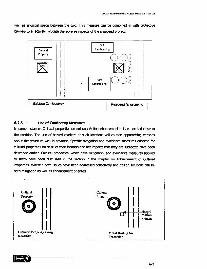
Gujamt -2ite Highways oject Fhase B - Vol. rTF
well as physical space between the two. This measure can be combined in with protective
barriers to effectively mitigate the adverse impacts of the proposed project.
I ~~~~~~~~SoftILandscaping I
1< ~I (3 oI
|Existing Carriageway |Propoased landscaping |
6.2.5 * Use of Caubionary MeasuresIn some instances Cultural properties do not qualify for enhancement but are located dose tothe corrdor. The use of hazard markers at such locations will caution approadhing vehides
about the structure well in advance. Spedific mitigation and avoidance measures adopted forcultural properties on basis of their location and the impacts that they are subjected have beendescnbed earlier. Cultural properties, which have mitigation, and avoidance measures appliedto them have been discussed in the section in the chapter on enhancement of CulturalProperties. Wherein both issues have been addressed collectively and design solutions can be
both mitigabion as well as enhancement oriented.
Cultural Irpr Clontur eal Ri infoPRopdside Perotecio
'0' 0'~~~~~~~~~Hard 0~~~~~aar
Cusm nsacsGltural Property o nt uaong b ehacmental u Raieln orae oet
Rboadhesid ctrePrl navnc.Sefcmtiainadaotcioancemaue dpe o
65

Chapter - 6: Avoidarce & Mitigation of Impact
6.3 Criteria for Mitigation
In the final road design, it is not always possible to avoid all the cultural properties. Often there
has to be a compromise in the larger interest of the society to achieve good geometric design
etc. Although the emphasis of the project is to avoid as many cultural properties as possible,
mitigation is often resorted to as the second resort. Properties, which are considered for
mitigation, are:
* Properties, which cannot be avoided completely by the road design, are considered for
mitigation
* Properties in the RoW, espedally in the CoI are considered for mitigation. Properties
located within the edge of the Carriageway and till the end of the CoI, especially qualify
for mitigation
* Extent of mitigation depends upon the significance and level of impacts on the
concemed property.
* The type of mitigation measure applied again depends on the significance of the
property and its proximity to the road.
6.4 Safety/Precautionary/Cautionary Measures for Mitigation of impacts.
Locations where hazard markers are proposed to be put up are listed in Table 6.2. The hazard
mnarkers will be put up at the location at the edge of the usable shoulder. Hazard markers will
be especially helpful where the road geometry is poor such as at sharp horizontal curves.
The shrine on the Vadodra - Padra -
Jambusar corridor located at a sharp
horizontal curve is not visible to
approaching vehides and comes into view
abruptly endangering the shrine and its
- This small shrine at Ch 23.05 stands on
the inside of a horizontal curve' of the
Shrine at ch. 23.05 on Vadodara -i-adra -Jambusar corridor. As this well maintained shrinestands vulnerably just on the edge of the
corridor the only suitable solution seems to be re-align the centreline of the corridor away from
the structure and put up a hazard marker at the location. There is not space to put up a
protective railing. Hazard rmarkers will be effective in such cases.
6-6

Gujarat State High ways Project: Phase lIB - Vol IIF
Table 6.2 Proposed Corridor wise locations for putting up hazard Markers.
_ F Dist. ACh. ID Place Cultural Side From (n Condit Size Owne Evir Possibility Details
Properties edge of ion rship rnent_ CW years) Relocation
DHOLKA-BAGODRA
4.463 S Gangad Jogni Ma Shrine R 0.67 35 SP S C AL
Viramiigamii-
I-laIvad
74 32 T Melody Mata R 3.04 P L C RA N AslraiiTIemple opIposite
131.30 S Soladi Samadhi R 1.8 S RA
135.665 5 Chulita Melody Mata R i.S - S p AL Ashram behindShrine shrine
145.18 S = Hanuman Shrine R 1.5 SP s Ashram behind
VADODRA-PADRA-JAMBUSAR
6 9 T Atladra Verainata Tcmple L 8 0 25 0 P M C SJA
17 20 S A'hulbar Seriia L 0.7 Pp L S C SA T2 sl_ri__cs
23 08 S Navpura Shrinie R II I S C RA
24 10 S Navpura Shrine R 2.53 = S C [RA Village shrinie
.JETPUR-.JUNAGARH
73 84 | S I Jetalsa | Shiline R 1.17 |K S C P| A
NN'ATAMIAN-PIPI
70 80 1 S I Devputra Shrille R 3.509 |P S Al |
DHROL-KHA,NBAl,IA
68.80 S Silirine | 1 3 5
73.88 s S|irinie R 0.9
74 90 S Sll-ile R 4.2
120.80 S Slhrinie R 3 861 SP S SIJA
6.5 Relocation
Although relocation is the best possible option to clear the RoW, it is not always possible toavoid all the cultural properties. vVherever such relocation of cultural and religious properties
are not possible for relocation, in the larger interests of the society it is more important to have
roads with good geometric design in all respects. Although the project has tried to minimize
damaging any of the cultural properties, it has not been teasible to save some of the
properties.
6-7


Gularat State Hi,ghways Project Phase 11B - Vol IIF
7. ENHANCEMENT OF CULTURAL PROPERTIES
The aim of the enhancement of Cultural Properties is to promote qualitative development and
infuse greater meaning in the road environment. Its secondary objective is:
. To beautify and enhance the experience of travelling by beautifying the
cultural assets of the highway
a To restrict the cultural properties from further encroaching upon the RoW, and
also.
* To develop some cultural properties as rest areas so that the road travelers
and local community benefit from them.
To forms of enhancement selected are influenced by the location f cultural properties and their
physical relationship with the corridor. Measures that are maintenance free and functional have
been proposed.
7.1 ENHANCEMENT MEASURES
Every effort has been made to employ local materials including Stone in the Jetpur-Junagarh
corridor. Bricks and tiles in Viramgam - Dhangadhra-Halvad corridor Stone is also available
here. The existence of 5 brick kilns in the Dhoka-Bagodra corridor means brick is easily
available here. Black stone is easily available, due to the presence of 7-8 quarries, on the
Jamnagar-Khamballa corridor. Morvi on the Rajkot-Morvi. Using local reduces costs and retains
the vernacular block of the corridor issue based enhancement in Table 7.1
7.1.1 PROVIDING AND/OR IMPROVING ACCESS
Shrines along highways are often isolated from the surrounding environs. Depending upon site-
specific situations the project will strive to improve access to these properties by providing
walkways from the highway. Locally available materials will be preferred and using different
paving patterns and materials will create interesting ground surfaces. The intention is to enrich
the roadside places.
7.1.2 IMPROVING, DEFINING, REDEFINING THE PRECINCTS
In addition to providing access emphasis will be given to defining the precinct or area of
immediate influence of the property. Hard landscaping measures a described earlier will be
used in continuation with the access pathway to form the precinct of the structure. Particular
attention will be paid entry areas of cultural properties.
7-1

Gopirat Slate Highways Project PhaselJIB - Vol I/F
7.1.3 CREATING SEATING SPACES AND REST AREA
Formal or informal seating and rest areas adopted to scale of the property will be done. The
project will explore avenues for creation of rest areas along the highway. Rest areas will be
developed especially temples where space and drinking water are available.
7.1.4 PLANTATION
Trees not only enrich the visual quality of a space but also act as buffer to pollution, define
areas and provide shade. Plantation of trees is a prime enhancement as well as mitigation
measure in the project. Tree bases will be built around existing as well as proposed shade trees
to form informal seating spaces, which are evidently preferred to the formal seating spaces.
7.1.5 OTHERS
Minor improvements such as proposed shade trees to provide informal sealing spaces, which
are evidently preferred to the formal ones. Plastering and whitewashing shrines will be
considered Zebra crossings and signage will also considered. Issues based enhancement
measures have been presented in a matrix form in table.
Table 7.1 Matrix showing enhancements for specific issues1 2 3 4 5 6 7 8 9 10 11 12 13 14
m lm~~~~~~~~~~~Enhancement St _
Danger~~~~ ~ to stutr * _ _ * lLack of visiblilty * * _ _-
Archeoloicalvalu *U * * * s .- * . lPedestnan~~~~~ ~ trfi *> **
Drainage issues C. _lCse to the Cm * _ _ _ l~~~ EU ~ 9 II e or r
@3 0. 0 EU0 m
Issues iz EU X @3 EU 0 EU EU (A
Unkempt Site 6
Lack of proper Access 0 _ _Danqer to structure 0 t C
Lack of visibility 0 s o tNeed for visibility during night p sre -apc -arArchaeological value 0 0 000 0
Pedestrian traffic s t -
Availability of shade and space___- - __
Undefined spillover space - -0 - - __
Drainage issues __
Closeness to the Carriageway to try to brn tfo
Lack of Ambience
7.2 SCREENING FOR ENHANCEMENT
Phase 115 has screened all the Cultural Properties and enhanced selected cultural properties
based on the significance of the cultural property. The significance of the cultural property has
been decided on basis of the primary survey. The aspect of assigning a particular signiflcance
to any cultural property is quite a subjective task in itself and difficult to quantify. Yet the
project makes an attempt to try to bring these values to a common platform in order to select
7-2

Gujarat State Hlfghways Project. Pl?ase 118 - Vol IIF
properties to be enhanced. The significance of a certain property comes into question when
deciding the mitigation, avoidance or enhancement level to be applied to it. This does not
mean that one cultural property is superior to another for e.g. A small shrine may not be
significance enough to warrant realignment of the corridor and from its significance value a
particular mitigation measure could be most: appropriate for it. The cultural properties were
evaluated on basis of several factors. In addition some thumb rules have been adopted for
sake of simplicity. Private shrines or properties taken care of by trusts etc. will not be enhanced
as the project focuses on the overall benefit of the society. Shrines, which even though located
in the CoI but built as homage to victims of road accidents have not been selected for
enhancement for the same reason state above. Significance of all the cultural properties has
been determined on basis of the following criteria.
7.2.1 SIZE
Size of the cultural property is not an indicator of its significance but it becomes important in
terms of "relocation". Such as is quite easy to relocate a shrine, but more the issue is complex
in case of bigger properties such as temples, wherein the cost of reconstruction and cost of
acquisition of land, need to be considered. Cultural properties have been categorized as small
(upto 1.5 m x 1.5 m), medium (upto 4m x 4 m) and large (above 4 m x 4m)
7.2.2 BUILDING MATERIAL
Materials used to build cultural properties are an indication of its significance. The properties
have been classified in terms of Pucca, semi-pucca and Kaccha
7.2.3 VALUE
Three types of value have been assigned to the cultural property-emotional, cultural and use
value. While the emotional value may not be quantitative the use value can be judged from
siting and use of the property by the conimunity. Cultural properties sometimes assume
importance because of their location and proximity to other community resources such as a
well, a big shade tree, the village bust stop or common gathering space. In such instances
relocating the cultural property also destroy its ambience. Social importance attached to the
cultural property have been categorised as Significance, Average and Poor.
7.2.4 OWNERSHIP
We feel that it is fair to assume that benefits to large segments of society are more important
than those to a single individual or smaller segment. Community cultural resources have
therefore been given preference over private ones only in terms of enhancement. Equal merit
has been given to both in mitigation and avoidance of impacts. The significance to the
community has been determined on the basis of ownership (public, private or trust) and use.
Using the preceding criteria the following properties in Table 7.2 qualify for enhancement.
7-3

Gijlarat State Highways P'oject Phase 118 - Vol IIF
Table 7.2: Cultural Properties on Phase IIB proposed to be EnhancedCh. ID Place Cultural Side DIst. Age Condit Size Owne Enviro Possib Details
Properties From (In ion rship nment ility ofedge years Reloc
_______ i____ of CW ationDholka-Bagodra3.95 S Nagar Viltage Jogni Mata R 7 2 20 nS |C AL A
l Shrine l | | ! entrance*Viramgam-Halvad
142.70 | SW | Step Well R 12.9 P M | L ___ -
Vadodara-Padra-3ambusar12.50 D Laxmipura Hazrat Plr R 8.5 10 0 p M RA
flSyed Ali! Dargah _ _ . .___ _-
14.00 D Govindpura Idgah R 10 6 >50 p M SUA _____16.70 T Phulbag Temple R 7 0 p M C SUA
18.88 S Dhabhasa Rd Shrine R 5.113 p _ RA j
Jetpur-lunagarh
74.10 S Jetalsar Hanuman R 4.8 5 0 p | C ALI_ shrine I I I __________I
77.0 T Dedwara Mahadev L| 10.98 p LTemple I I I I I I I I I
91.37 T Wadal Chetan R 4.4 p M | C SUAHanuman
92. 5 - _ __ ___ __ T em ple __ __ __ _ _ __ __ __ _ _ ____|_|
92.95 D Dargah | R | 5.29 |P L j_Raikot-Morvi
3.20 5 Jakatnaka Kodiyar shrine L 5.5 15.0 p S C RA
4.10 5 Morvi Road Melody Ma L 3.2 18.0 p S C SUA No31.40 G M|tana - Shnne _ _ _ _____|_-_
31.40 | G M _ -tana Graveyard R 5.95 _ _ _ L C I_I _I
58 80 T Sakat Temple L 8.0 p M C SUAI___ _ 1 Sanada
74.145 T Devpura Bhavani R 18.225 >100 p M AL N Pond a,_________ | ___________ _ |Temple _ _ backaroc
Dhrol-Khambalia104.00 | D Vasal Cherla Dada R 9.0 30 SP M RA
00 D Vas argahBharuch-Dahei38.521 S Near Dahn |Shrine L 1.147 PC
______ _ | Bypass j18.037 T Dundi Temple R 2.14 5< P S C SV P
4.3 CORRIDOR WISE ENHANCEMENTS OF CULTURAL PROPERTIES
Following is a corridor wise description of the proposed enhancement for cultural
properties.
4.3.1 CORRIDOR 26: Jetput-Junagarh:
Ch-92.95, Dargah
The Dargah is at 4.4 m from the edge of the road, which leaves no space for enhancement. It is
proposed to paint the boundary wall of the structure with a top band of reflectorising paint so
as to improve visibility at night. Refer Drg. 7.1
Table 7.3: Enhancement for Dargah at Ch. 92.951 2 3 4 5 6 7 8 9 1011121314
Unkempt Site *Danger to structure | *Lack of visibility |Need for visibility during night |Closeness to the carriageway | |

Gularat State Highways Poyjct. pl,ase //B - Vol. I/IF
Ch- 74.1, Hanuman Shrines
Local residents frequent this medium sized shrine on the edge of an agricultural field veryoften. Since it is located .in the RoW, the structure and its users will be in danger due to vehiclemovement. Also given its significance to the community it is proposed to rehabilitate theexisting paved frontage and to erect a protective metal barrier. A hazard marker will alsoindicate its presence, especially during night. Refer Drg. 7.2.
Table 7.4: Enhancement for Shrines at Ch. 74.11_2 3 4 5 6 7 8 9 10 11 12 13 14
Unkempt Site * _ _Lack of proper access . .Danger to structure _ _ .Lack of visibilityNeed for visibility during night __ _ *Closeness to,the carriageway _
Ch-77.0, Mahadev Temple
This temple located 10.98m away from the centre of the road is the node or community
gathering space of the surrounding settlement. Un-maintained hedges that detract from its
ambience demarcate its entrance. It is proposed to redefine this front boundary by means of a
metal railing, which will also enhance the purpose of safety. The length of this new frontage
will be. equal to the length of the existing liedge. The enhancement measure will not only
improve the visibility of the temple from the road, but also defer any kind of future expansion
by the temple towards the roadside. Refer. Drg. 7.3.
Table 7'5: Enhancement for Temple at Ch. 77.01 2 3 4 5 6 7 8 9 10 11 12 13 14
Lack of visibility * * 0Need for visibility during nightFrontage improvement _ .
Ch-91.37, Hanuman TempleThis brightly painted medium sized temple of the monkey god 'Hanuman' is located on the very
edge of the corridor, at Vadal. Behind it is an arcade of commercial activity. The structure is
exposed to the risk of collision with speeding vehicles. Its plinth on the road ward size is used
as a sitting platform by the local person waiting for the buses, which endangers their life. The
mitigation measures are to extend the existing railing on the road ward side of the temple.
Gaps will be left in the railing so the local residents can continue using the plinth for seating
with reduced damages. Refer Drg 7.4.
Table 7.6: Enhanceiment for Temple at Ch. 91.371 2 3 4 5 6 7 8 9 11011.12113 14
Lack of visibility l l lNeed for visibility during night |Frontage improvement l 0
mg A,' 7-5

Gujarat State Highways Project: Phase 118 - Vol. IIF
4.3.2 Corridor 27: Rajkot-Morvi
0 Ch. - 3.2, Khodiyar ma shrine
This well maintained shrine is 3.2 m from the edge of the road. Regular Puja or religious prayers
are offered here in the dense shade of a neem tree. The proposed enhancement consists of
building low height brick lining on either side of the shrine so its space horizontally
simultaneously for seating as well as a deter the shrine from expanding. In addition, a metal
railing, painted with reflectorised paint, will warn road users of the cultural property near
vicinity. Refer Drg. 7.5.
Table 7.7: Enhancement for Shrine at Ch. 3.21 2 3 4 5 6 7 8 9 10 11 12 13 14
Danger to structure *Need for visibility during night =Pedestrian traffic _Availability of shade and space _Closeness to the carriageway *
* Ch.-4.1, Melody Ma Shrine
This small shrine beneath a pipal tree is held in great reverence by the communities. The
community strongly oppose its relocation. It is proposed to erect a metal railing. The vicinity of
the shrine will also be cleared, leveled and compacted to define its use area. Keeping in view
its significance to the community, a small seating space in the form of a low brick parapet is
also proposed. The seating is expected to curtail the expansion of the shrine along the road.
Refer Drg. 7.6.
Table 7.8: Enhancement for Shrine at Ch. 4.11 2 3 4 5 6 7 8 9 10 11 12 13 14
Unkempt site _Danger to structure 0 * 0
Need for visibility during night _
Availability of shade and space i 6 *Undefined spillover space l * l * l _
Frontage Development L _ _ l
Closeness to the carriageway _ * _ _ _l - _
* Ch. 31.5, Graveyard
The graveyard is located on the inside curve and is quite unkempt. The area is densely planted
with trees, which also border the edge of the corridor. A large samadhi is prominently visible
from the corridor. A metal railing along the length of the graveyard will define the area and
simultaneously enhance is appearance. Refer Drg. 7.7.
7-6

Gujarat State Highvways Project Phase II - Vol. .1F
Table 7.9: Enhancement for Graveyard at Ch. 31.5i_ 1 2 3 4 5 6 7 8 9 10 11 12 13 14
Unkempt site .Danger to structure _ 0 _
Need for visibility during night _LUndefined spillover space _ - _
Frontage improvement _ * _ _
Closeness to the carriageway _ *
Ch. 57.26, StepWell
This ancient stone lined stepwell close to the road is in a state of disuse and disrepair. The age
of the structure is probably more than 100 years. Despite its proximity, it is almost from the
corridor, because of the dense undergrowth and shrubbery that surrounds it. The project
attempts to treat the surrounding of the structure sensitively without physically impacting the
stepwell. It is proposed to clear an area of about 4 m on all sides of the stepwell and till the
edge of the road. In addition a liner area for about 20 m on either side of the stepwell is also
proposed to be cleared to improve the visibility of this structure. It is proposed to outline the
property with a band or brick paving to highlight the structure as well as facilitate visitors to
walk around the structure. A metal railing will also frame the paving to demarcate the area. It
is proposed to also put up a signboard to highlight the details and age of the structure. It is
proposed to build a paved access to the structure from the road.
Table 7.10: Enhancement for Stepwell at Ch. 57.261 2 3 4 5 6 7 8 9 1011 12 13 14
Unkempt site *Lack of proper access . * X
Lack of visibility * _
Archaeological value ____ Undefined spillover space 0
Frontage improprement I I *
* Ch-58, Bagg/a Mata Temple
This small shrine housed in the roofed mandap or a hall, is shaded by a neem tree with a
Chabutara around. This is a busy community space and is also used for feeding birds. This
property is at an angle to the Carriageway. In addition to putting up protective railing it is
proposed to put up cautionary signage in the form of hazard marker to mitigate danger to
structure and it users from the heavy traffic movement. Refer Drg. 7.8.
Table 7.11: Enhancement for Bagla Mata Temple at Ch. 58.01 l 1 2 3 4 5 6 7 8 9 10 11 1.2 13 14
Danger to structure l l lLack of visibility l
Need for visibility during night l l
Closeness to the carriageway 0
- ~ 7-7

Guiaral State Htghwdys Project Phase 1/8 - Vol IIF
4.3.3 Corridor Dholka-Bagodra
0 Ch-3.95, Shrine
The community uses this small shrine, at the entrance to Nagar village, intensively. The
proposed enhancement comprises of repaying the frontage of the shrine and erection of a
metal railing. In addition an access way equal to the width of the shrine, will be cleared,
leveled and compacted.
Table 7.12: Enhancement for Shrine at Ch. 3.951 2 3 4 5 6 7 8 9 10 11 1213 14
Unkempt site * _Lack of proper access *Danger to structureLack of visibility * * .Need for visibility during night -Closeness to the carriageway _
4.3.4 Corridor 28: Dhrol-Khambalia
* Ch-104, Cherdidada Dargah
The medium sized tile-roofed Dargah of Cheri Dada is located right on the edge of the
carriageway making it quite vulnerable to the adverse impacts of the highway. The unkempt
front and back of the structure will be cleared of undergrowth, leveled and compacted to
improve the ambience of the shrine. The entrance to the shrine will also be paved. The metal
railing painted with reflectorised paint will provide the desired level of safety to the structure
from the adverse impacts of the vehicles. Refer Drg. 7.9.
Table 7.13: Enhancement for Dargah at Ch. 104.01 -2 3 4 5 6 7 8 9 10 11 12 13 14
Unkempt site .
Lack of proper accessDanger to structure =Lack of visibility*.l
Need for visibility during night _*_
Closeness to the carriageway _ *
4.3.5 Corridor 02: Viramgam-Halvad
* Ch-142.75, Step Well
This ancient stonelined stepwell is 12.9 m from the road edge and is in a stage of disuse and
disrepair. The age of the structure is reckoned to be more than 100 years old. It is almost
hidden from the corridor, inspite of being so close to it because of the dense undergrowth and
shrubbery around it. It is proposed to clear an area of about 4 m on all sides of the stepwell
and till the edge of the road. In addition a linear area for about 20 m on either side of the
stepwell is also proposed to be cleared to improve the visibility of this structure. It is proposed
lm -P 7-8

Gujarat State Highways Pioject. Phase JIB - Vol. IIF
to outline the property with a band or brick paving to highlight the structure as well as facilitate
visitors to walk around the structure. Metal railing will also frame the paving to demarcate the
area it is proposed to also put up a signboard to highlight the details and age of the structure.
It is proposed to metal a band equal to the enhanced width of the structure form the edge of
the road till the brick paving around the structure.
Table 7.14:Enhancernent for Step Well at Ch. 142.751 2 3-4 5 6 7 8 9 10 11 12 13 14
Unkempt site _ _Lack of proper access 0 e
Lack of visibility = __ _ - _
Archaeological value _ 0i 0 * 0 = _0 = 0 0
Frontage improvement - _ *_ * *
4.3.6 Corridor 21: Wataman - Pipli Corridor
0 Ch-74.175, Bhavani Temple
Bhavani temple located outside the GoI has been considered for enhancement by virtue of its
architectural style. It is more than a 100 year old. Its slightly sloping butters like walls are of
specific interest. The approach to the structure will be metalled as also a part of it
surroundings. Refer. Drg 7.10.
Table 7.15: Enhancement for Temple at Ch. 74.1751 2 3 41 S 6 7 8 9 10 11 12 13 14
Unkempt site 0Lack of proper access * *
Danger to structureArchaeological value _ * * *-.
4.3.7 Corridor 15: Magdala - Sachin
* Ch-18.0, Shrine
This well maintained structure is placed at an angle to the Carriageway and faces away from the
corridor. It is proposed to put up protective railing for safety of the structure. It is also
proposed to pave apart of the surrounding of the shrine so as to enhance the appearance of
the shrine. Refer Drg. 7.11.
Table 7.16: Enhancement for Shrine at Ch. 18.01 2 3 4 5 6 7 8 9 1 10 11 12 13 14
Danger to structure 5 *Need for visibility during night |Frontage improvement l lCloseness to the carriageway |
4.3.8 Corridor 10: Vadodra-Padr a-Jambusar
* Ch-12.525,Pirdada Dargah
The medium sized Pir Dada Dargah is a visually pleasing structure on this corridor. Located on
the edge of the road it is quite vulnerable to the adverse impact of the highway. A flag post
Imp 7-9

G6,,a'at State H/ghwayv Project Phdse /B -- Vo/ IIF
also stands in front of it and closer to the highway. It is proposed to put up protective barrier
in alignment with the flag post and on either side of it. The railing will be painted with
reflectorised paid to improve visibility during night. The railing will stand on 0.15 m high and
0.3 m wide brick paved banked. This will act as a buffer between the highway and the temple.
The brick band will be curtailed at entrance points to the Dargah. Refer Drg. 7.12.
Table 7.17: Enhancement for Dargah at Ch. 12.525_ 1 2 3_ 4_ 6 7 1 8 _ 10 112 14
Unkempt site * _ -
Lack of proper access 0 _ _
Danger to structure _ - - ---
Lack of visibilityNeed for visibility durng night Closeness to the carriageway l _
0 Ch 14.0, Shrine
This small shrine with a well maintained front space is closely located to the Carriageway
outside the boundary of a residential complex. The avoidance measure comprises of a metal
railing standing on a raised brick band and a hazard marker to caution approaching vehicles.
Refer Drg. 7.13.
Table 7.18: Enhancement for Shrine at Ch. 14.01 2 3 4 5 6 7 8 9 10 11 12 13 14
Danger to structure 0
Need for visibility during night *Closeness to the carriageway 0
* Ch-18.778, Shrine
The shrine lies in the shade of a big neem tree. It is proposed to clear and compact the front of
the shrine, right till the edge of the road. /Two seats, one on either side of the neem tree, will
be retained along a brick band 1.2 m wide will be paved in brick beneath them to highlight
their setting. A area of 3 m x 3m in front of the shrine will also be paved in continuation to the
above mentioned paving A low height metal railing will be put up for safety to the users. The
railing will also frame the front open space of the shrine, with a space in between for providing
access to the shrine. Refer. Drg. 7.14.
Table 7.19: Enhancement for Shrine at Ch. 18.7781 2 3 4 5 6 7 8 1 9 10 I 11 1 12 13 14
Unkempt site 0 *Lack of proper access l .Danger to structureNeed for visibility during night | |Closeness to the carriageway
lw~o 7-10

Gujarat State HIghways Ptolect Phase 118 - Vol. IIF
Ch-16.7, Temple
This medium sized temple is flanked by a giant Banyan tree standing on the edge of the road. A
seating has been built by its side. It is proposed to build a half 'chabutara' around the tree
facing towards the temple while removing the seats alongside the tree. Metal railing painted
with reflectorising paint is proposed to be put in alignment with the ficus tree. It is also
proposed to paint the tree trunk with reflectorising paint. The undergrowth on the roadside will
be cleared for a distance of 15-20 m to enhance the ambience and increase visibility of the
place. Refer Drg 7.15.
Table 7.20:Enhancement for Temple at Ch. 16.7- 1 -1_ 4 5 6 7 8 1 9 10 11i 13 14
_____ __~~~21 __ _ ___ _f _ _
Unkempt site * -Lack of proper access _ . - - -.Danger to structureLack of visibilityNeed for visibility during night _Closeness to the carriageway _
4.3.9 Corridor 12: Bharuch - Dahej
0 Ch. - 38.62, Shrine
This small shrine is located just on the inside of the horizontal curve of the carriageway and is
shaded by a giant tree. It is proposed to clear, level compact and metal an area of 1 m x 1 m
around the shrine and the tree to highlight the setting of the shrine. Refer Drg BD1.
Table 7.21: Enhancement for Shrine at Ch. 38.621 2 3 1 4- 5 1 6 1 7 8 9 10 11 1 12 13 14
Unkempt site *Danger to structure 0 *Need for visibility during night * l
Closeness to the carriageway =
7-11


CULTURAL ENHANCEMENT DRAWINGS


JETPUR EDGE OF EXISTING CW UNGR
JUNAGARH
OSm~ 30m(typ) - -
I ~ ~ ~ ~ ~ ~~I~ HAZARD MARKER AT EDGE OFI ol -E USABLE SHOULDER
METAL RAJLING PAJNTEDJ N 0 (AS PER DETAIL H)
WITH REFLECTORISED PAINT _ O -.
ON 0 15 M WIDE X 0 15M HIGHBRICK BAND
0WELL
BANDS OF REFLECTORISED PAINT
TO BE PAINTED ON WALL
0HOME
NOTES SCALE CORRIDOR JETPUR - JUNAGARH DRAWN VINAY LASA N.0 LEA GOVERNMENT OF GUJARAT(1) REFER DETAILS ORAWNCS NO GSHP\DT-I& Dl-2 FOR DETALS CRAINAGE 92 95 CEKD TPU ROADS AND BUILDINGS DEPARTMENT12) ALL DIMENSIONS AWE IN METRE IN CASE DIMENSIONS ARE NOT WRITTEN DARGAH ON RIGHT SIDE OF CW CHECKED T PAUL
SCALE TIE DRAWING 1 15 DO CODE ENHANCEMENT OF CULTURAL PROPERTIES(3) ANY CHRNOES TO BE MADE TO RE APPROVEDB EY TFE SITE ENGINEER DESIGNED DIPAU ALONG PHASE 118 CORRIDORS
NA REVISION DATE 8Y CAD FILE, C/#PROJECT/GPCC/RASEPLAN/I,.IA.A/ch92 95 APPROVED T PAUL -EU CO-URStAW' NAP c. PIm O . / ANN 7 1


JETPUR JUNAGARH
EDGE OF EXISTING PAVEMENTACCESS AS PER
\ DETAIL - I /TO START FROM EDGEOF PROPOSED PAVEMENT
CLEARED AND COMPACTED STONE SLABs OVER DITCHPEDTALHDIC
t 2 Sm .
rLLLLLLLLLLLLLLL\ILLLLLLLLLLLLLLL~LLLLIHAWAN KUND-LLLL
L LLLLL L ~LON-H... LL , L LIL SHRINEm- L LL LL
XISLIELG LL LA L LL-J~~~ILLLLLL LL L{LLLLLLLLLLLLLLLLLLL[ LL L LLLj
* J L.±LLLW..~~~~~~i ±ij
2 3~ 2 0 I o. 03m, WIDE x 0 O3mHIGH BRICK PARAPET
EXISTING PLATFORMTO BE REHABILITATED
IN CEMENT CONCRETE TILES . - '
NOTES SCALE CORRIDOR JETPUR - JURAGARH DRAWN VINAY LASA N.D. LEA GOVERNMENT OF GUJARAT(1) REFER DETAILS ORAWNGS NO GSWP\DT-I& DT-2 FOR DETAILS CHAINAGE - 74 1 GA ROADS AND BUILDINGS DEPARTMENT(2) ALL DIMENSIONS ARE IN METRE. IN CASE OImENSIONS ARE NOT WRITTEN SHRINE ON RIGHT SIDE OF Cw CHECKED T PAULSCALE THE DRAWING I 75 SHRINEEMNONORICLTTRALDPOPERTIE(3) AAf CHANGES TO RE RAGE TO BE APPROVED BY THE SITE ENGINEER. DESIGNED DIPAUI N ALONG PHASE O CORRIDORS
No REV`ISON DATE BY CAD FILE C/#PROJECT/GPCC/BASEPLAN/l.Lp-no/ch74 1 APPROVED I PAUL GPRAIcT NAIC DAT AARA TOOT |R 110/10 I 7


MAHADEV TEMPLE
0E
~RPSDMETAL RINGPAINTEDWIETHREFLECTORISED PAINT
( AS PER DETAIL J
8~ ~ ~~~~~~~~~AN IN| RIC PAIGIRC, 5I 5 rAS PER DETAIL B 81 r-_O Sm x 0.5m 0D3m
HIGH ERICK PIER
G ESS\|;/> H 9 > *$ EI G HEDGE> v E , | ~~~~~~~~~~~~~~TO BE REMOVEDEXISTING HEDGETD BE REMOVED
ACCESS FROM EDGEOF PROPOSED ROAD(AS PER DETAIL I)
EDGE OF EXISTING CW
_ETPUR __ OF EXISTING CW JUNAGARH
NOTES SCALE CORRIDOR JETPUR - JUNAGARH DRAWN \iNAY LASA ND. LEA GOVERNMENT OF GUJARAT(l) REFER DETAILS DRAWINGS NO CSHP\DT-C& DT-2 FOR DETAILS CHIINAGE 77 000 ROADS AND BUILDINGS OEPARTMENT(2) ALL DIMENSIONS ARE IN METRE IN CASE DIMENSIONS ARE NOT WRITTEN TEMPLE ON LEFT SIDE OF Cw CHECKED r PAUL
SCALE MEL DRAWING 1 1 3D ENHANCEMENT OF CULTURAL PROPERTIES(3) ANY CI-IANGES TO BE WADE TO BE APPROYVED By TCE SITE ENGINEER DESIGNED DIPALI ALONG PHASE 118 CORRIDORS
No. REVISION DATE BY CAD FILE C/#PROJECT/GPCC/ASEPLAN/)e /h77 O APPROVED T PAUL CONTo SERI RCC / | 00 7 3 j


JETPUR EDGE OF EXISTING CARRIAGEWAY JUNAGARH
PROPOSED METAL RAILING PAINTED WITH-REFLECTORISED PAINT
AS PER DETAIL H
HAZARD MARKER 2SAS PER DETAIL J 2
EXISTING RAILING = EXISTING RAILING
.1 5 6m-
.~~~~LS NO.+ LEA GO-EN'EN O-- _'''A
NOTES SCALE CORRIDOR JETPUR - JUNAGARH DRAWN- VINAY LASA N.D. LEA GOVERNMENTSODEPAFT(1) REFER DETaLS DRAWINCS NO CSHP\DT-l& DT-2 FOR DETALS CHAINAGE 91 37 AND UILDINS DEPArMENTCHAINAGE 91 37 ~~~~~~~CHECKED T PAUL(2) ALL DIMENSIONS ARE IN METRE IN CASE DIMENSIONS ARE NOT WRITTEN CHETAN HANUMAN TEMPLE ON RIGHT SIDE OF CA E Aw
SCALE THE DFAWING 1 75 = A ENHANCEUENT OF CULTURAL PROPERTIES(3) ANY ChANGES TO RE MAADE TO BE APPROVED BY ThE SITE ENOIWEER DESIGNED DIPALI ALONG PHASE I16 CORRIDORS
No REViSION DATE RY CAD FILE C/#PROJECT/GPCC/BASEPLAN/I.tI.no./Ch91 37 APPROVED T PAUL IE TRI2Ow 4C21 z/oRPIY - 7 4


EXISTING NEEM TREE N
EXISTING PEEPAL TREE-,
S t | t ~0 3m(typ ) \ /
BRICK LINING
METAL RAILING PAINTED WITHREFLECTORISED PAINT
_:2lEDGE1OF PROPOSED CARRIAGEWAY E
"EDGE OF EXISTING CARRIAGEWAY
NOTES SCALE CORRIDOR RAJKOT - MOR8I DRAWN VINAY LASA N.D. LEA GOVERNMENT OF GLUJARAT(F) REFER DETAILS DRAWINGS NO GSHP\DT-1& D1-2 FOR DETAILS CHAINAGE 32 ROAOS AND RUILOINGS DEPARTMENT
(2) ALL DIMENSIONS ARE IN METRE IN CASE DIMENSIONS ARE NOT WRITTEN SHRINE CHECKED T PAUL E NRSCALE THE DRAWING , ,II ~ 41 -75
(3) ANY CHANGES TO BE MADE TO BE APPROVED BY THE SITE ENGINEER DESIGNED DIPALI IAENHANCEMENT OF CULTURAL PROPERTIESALONG PHASE 11R CORRIDORS
N.A REVISION DATE D AD FILE APPROVEDPC/G TLA R, b.PAUL PAD T`C =ED-(A.AFP-TCAD C/#ROJECT/PCC/RAEPLAN/RI,oF.ch3-2 APRVDT RMC CO-~C Pf II JD - 7 5 C


0.3m 0 04m HIGH
BRICK LINING X/
NG PEEPAL TREE
AREA TO BE LEVELLED.CLEARED AND COMPACTED
METAL RAILING PAiNTED WITHREFLECTORISED PAINT
3 L . EDGE OF EXISTING CARRIAGEWAY
E
NOTES SCALE CORRIDOR RA.IOT - MORBI DRAWN VINAY LASA N D. LEA GOVERNMENT OF GWARAT(1) REFER OETALS DRAWINCS NO GSSP\D7-I& ST-2 FOR DETALS CHAINAGE 4 1 ToW ROADS AND BUILDINGS DEPARTMENT(2) ALL DIVENSIONS ARE IN METRE IN CASE DIMENSIONS ARE NOT WRTTEN SHRINE CHECKED T PAUL __
SCALTHE ORAWINC 1 75 ENHA.CEMENT OF CULTUtAL PROPERTIES(3) AMY C11ANGES To BE MADE TO BE APPROVED BY TNE SITE ENCINEER DESIGNED DIPALI A PHASE OF CORRORS
No REVISION DATE BY 'CAD FILE C/#PROJECT/CPCC/BASEPLAN/Ro.I-..ob_.h4-O I APPROVED T PAUL -ICT0T CS-EYES IoT OTAYT R / |nc R 76 1RIY_ ~ ~ ~ ~ ~ ~ ~ ~ ~ ~ ~ ~ ~ ~ ~ ~ ~ ~ ~ ~ ~ ~ ~ ~~~~~~~~~~~~~~~~~~~~~~~~~~C L _~ =1 ioow, Pp 710


JR~~~~~~~~~~~~~~~~o
'C~ ~ ~ ~ ~ ~~~~~E
NO TESSCALE 5 CORRIDOR RAIKOT - 40RBI DRAWNZ VINAY LAAN..LA GOVERNMENT OF GUMARAT
()RER ETSDR INSN GS \D AD 2FO DULCIANAE-3(2) ALL DIMENSIONS ARE IN METRE IN CASE DIMENSIONS ARE NOT WRITTEN GRAVEYARDCH KE. TPU
()ANS CHANCES TO RE MAADE TO BE APPROVED By THE SITE ENGINEERDEIND IPLM ALOG HSE18CRDFS
N. ~~~~~REIASION DATE By CAD FILE C/#PROJECT/GPCC/DASEPLAN/R.1-n.rIb.1,c31-5 APPROVED T PAUL TOECI C.- SE=TOS 1. AO "-/ " 7.7


4METAL RAILING PAINTED WITH
XIl,,0$lllflif-8-@:l-lnlttltglitll,*'C EXISINGNEEMTRE
'REFLECTORISED PAINT EITN EMTE
LPA\n ,
EDGE OF PROPOSED CARRIAGEWAY
EDGE OF EXISTING CARRIAGEWAY
NOTES SCALE CORRIDOR RAtKOT - MORBI DRAWN VINAY LSA N.D. LEA GOVERNMENT OF GUEARAT11) REFER DETAI.S DRAWINCS N4O GSHP\DT-1& OT-2 FOR DETAILS CANG 80ROADS ANDNBUILDINGS DEPARTMENT(2) ALL DIMENSIONS ARE IN METRE. IAN CASE DluENSIONS ARE NOT WRITTEN SHRINE CHECKED T PAULSCALE THE DRAWING 1 75 ENHANCEMENT OF CULTURAL PROPERTIES(3) ANY CHANGES TO BE MADE TO BE APPROVED GI IKE STE ENGINEER DESIGNED DIPALI ALONG PHASE lBD CORRIDORS
No REVISION DATE BY CAD FILE C/#PROJECT/GPCC/RASEPLAN/R.1-A.Hb,Cch582-8 APPROVED T PAUL coNwT rE ROlE o 022 | A sO/RT | 7.8


LEITIIM ~ ~ ~ ~ ~ ~ ~ ~ RTEEAIEDPN
X ~~~~~~~~~~~~~~~~~~~~~~~~ENIRANCE ON CE OTSED N API
CHAINAGE 1040
K ~~~~~~~~~~~~~~~~~~~~~~~~~~~~~~~~~~~~~~EGGE OF EkGTIG C.
_ NOTES SCALE _ CORRIDOR JAMNAGAR -KHAMDALLA DRAWN MANAY LASA N.D. LEA GOL'ERNMENT OF GUJRT(I) REFER DETAILS DRAWINGS NO GSHP\DT-1& Dl-2 FOR DETAILS CHANAGE fO4 0 GAAAROADS AND B{UILDINGS DEPARTMENT(2) ALL DIMENSIONS ARE IN METRE IN CASE DIMENSIONS ARE NOI WRITTEN DARCAH ON RIGHT SIDE OF CW CHECKED T PAULSCALE ME DRAwiNG I ISO ~~~~~~~~~~~~~~~~~~~~~~~~~~~~~~~~~~ENHANCEMENT OF CULTURAL PROPERTIES
(3) AY CHANCES TO RE MADE TO BE APPROED 8Y THE SITE ENGINEER DESIGNED DIPALI ALONG PHASE nE CORRIDORSNo REVISION DATE 8Y CAD FILE C/#PROJECT/GPCC/BASEPLAN/J.m-kh.R -104 APPROVED T PAUL RIpT A CAIT MOOR TART -T |G 7 9

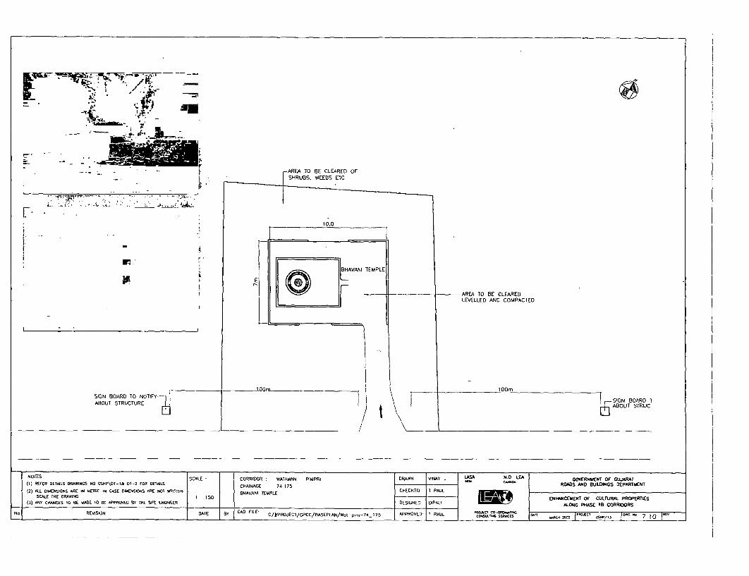
- j.
AREA TO BE CLEARED OFSHRUBS. WEEDS ETC
10~0
L ' w . ~~~~~~~-. -I
BHAVANI TEMPLE
AREA TO BE CLEAREDLEVELLED AND COMPACTED
SIGN BOARD TO NOTIFY .O| ABOUT STRUCTURE I K-~~~~~~~~~~~~~~~~~~~~~~~~~~~~~~~SIGN BOARD 1ABOUT8STRUCTURE0ABOUT STRUC
___ __ ___ __ ___ _____ -____ _ __ ________ _ _ _
NOTES SCALE CORRIDOR WATAMAN - PIMPRI DRAWN VINAY 1.D LEA GMRNMENT OF GUARAT(1) REFER DETAILS DRAWINGS NO CSHP\DT-I& 01-2 FOR DETAILS CHAINAGE 74 175 - ,AF RDADS MAD BEUILDINGS DEPARTMENT(2) ALL OAIENSKtNS ARE IN uETRE IN CASE DMENSKINS ARE NOT WRISTEN SHAVANI TEMPLE CHECKED I PAUL
SCALE THE DRAWING IIS EMHNI4CEMENT OF CULTURAkL PROPERTIES_ (3) CHANGES 10 ffE "ADE TO BE APPROED EW TAE STE ENtINEER _ DESIGNED OIPAIJ ALONG PHASE ID CORRIDORS
No REVISION DATE BY CAO FILE- C/#PROJECT/GPCC/aASEPLAN/Wo.-p.--74 175 APPROVED- T PAUL cs- sO_AcNs m __ ANJ | 7 10 |


r -
AREA TO 8E PAVEDAS PER DETAIL B AND B8
AREA TO BE LEVELLED /AND COMPACTED /
HAZARD MARKER /(AS PER DETAIL H)
EDGE OF EXISTING CW I_\
SACHINMAGDALA OF EXISTING CW
¢ | NOTES |SCALE CORRIDOR MAGDALA - SACHIN DRAWN VAY LA ND. ILA GOVERNMENT oF GWARAT(1) REFER DETALS DRAWINCS NO GSHP\DT-I& OT-2 FOR DETALS CHAINAGE 18 037 ROADS AND BUILDINGS DEPARTMENT(2) ALL DIMENSIONS ARE IN METRE IN CASE DIMENSIONS ARE NOT WRITTEN SHRINE ON LEFT SIOE OF CW CHECKED T PAULT
SCALE THE DRAwING 1 I0 OO UXLTSCALE tHE DRAMNC I 100 ~~~~~~~~~~~~~~~~~~~~~~~~~~~~~~~~~~~ENHANCEMENT OF CULTURAL PROPERTIES_ (3) ANY CHNGES TO BE MADE TO BE APPROYVED By THE STE. ENONEER _DESIGNED DIPALIP!IJ ALONG PHASE CTB CORRIDORS
N. REVTSION DATE 8Y CAD FILE C/#PROJECT/CPCC/BASEPLAN/Ich-no&-18-037 APPROVED T PAUL PECT SIAc0S- -. 2D02 | F5/I4 7.1 1 |


AREA OF 5m ON EITHER SIDE TO BE
CLEARED OF UNDER GROWIH RESIDENCE
PA CCO BAS (As PIER DETAI STAFF
METAL RAILING WITH REFLECTORISEDPAINT ON O0lSm WIDE x O.15m HIGH FL,G
PCC BASE (AS PER DETAIL J)
HA2ARD MARKER > _ 3 X |5Om 3
HAZARD MARKDETAiL -RAILING TO BE PUT IN ALIGNMENT
(AS PER DETAIL H) E WITH EXISTING FLAG STAFF
_ NOTES- SCALE | CORRIDOR VADODARA - PADRA - JAMBUSAR DRAWN VINAAY LASA N.O LEA GOVERNMENT OF GUJARAT
(I) REFER OETALS DRAWINGS NO GSHP\OT-T& Dl-2 FOR tEIALS CHAiNAGE i2 525 ROADS AND BUiLDINGS DEPARTMENT12) ALL DIMENSIONS ARE N UETRE IN CASE DIMENSIONS ARE NOT WRITEN I PIRBABA DARGAH CHECKED T PAUL E O LPE
SCALE ThE ORAWING 1 M00 .IUHO L A(3) ANY CHANGES TO BE MADE TO RE APPROVED BY ThE SITE ENGIIEER DESIGNED DIPALI ALONC PHASE 118 COUTRAlORS
No. REVISION DATE BY | CAD FILE C/#PROJECT/GPCC/BASEPLAN/Vod-p.d_..jAn2-525 APPROVED T PAUL T SEr UHF MOn 00 co C | R| 12sUw15 ~~~w -. - lP- N7.1


; X, / \ \ ~~~~~~~~~~~~~~EXISTINC BOUNDARY W^ALL
/ / I W 1 \ 2 ~ ~ ~~~~~~~7m \
E
a 0 S ' t ffi <~~~~~~~~~~~~~~~REFLECTORISED PAINTAS PER DETAIL J
-HAZARD MARKER L 0 3 WIDE 0-5OIm HIGH E
AS PER DETAIL H BAND OF CC 0
JAMBUSAR VADODARA
NOTES SCALE CORRIOOR VADODARA - PADRA - JAMBUSAR DRAWN VINAY LAS N.D. LEA GOVERNUENT OF GUJARAT
(1) REFER DET.LS DRRAWNCS NO GSIHP\DT-1& D1-2 FOR DETAILS CHAINAGE BEFORE 15 3 ROADS AND BUILDINGS DEPARTMENT(2) ALL DIMENSIONS ARE IN METRE IN CASE DIMENSIONS ARE NOT WRITTEN SHRINE ON RIGHT SIDE OF CW CHECKED T PAUL
SCALE THE DRAWING 1 75 ENHANCEMENT OF CULTURAL PROPERTIES(3) ART CHANGES TO BE MADE TO BE APPROVED ETY TIE SITE ENGINEER DESIGNED DIPALI ALONG PHASE 118 CORRIDORS
NO. REVISION DATE BY CAD FILE C/#PROJECT/GPCC/BASEPLAN/V.d-p.d-IO.-15-3 APPROVED T PAUL F WO CTlA-ONC WAR|A IDWC * 7


VADODARA EDGE OF EXISTING CW JAMBUSAR
.75 ~~~~~75AREA TO BE PAVED WITH
BRICK ON EDGE AS PER DETAIL B & Bl
METAL RAILING WITH REFLECTORISEDPAINT ON 0.15m WIDE x 0 15m HIGH CC BAND
EXISTING SEATS
EXS,TING NEEM TREE-
AREA TO BE LEVELLED.- | -COMPACTED AND PAVED IN CC TILES
O.3m WIDE x 0.4nm HIGH BRICK ;LINING AS PER DETAIL 0
I5 '
NOTES SCALE CORRIDOR VADODARA - PADRA - JAMBUSAR DRAWN VINAY LASA N.. LA GO9ERNMENT OF CUARAT(1) REFER DETWLS DRAWINGS NO GSHP\DT-1& 01-2 FOR DETLS CHAINAGE 18-8F
(2) ALL DtMENSIONS ARE IN METRE IN CASE DIMENSIONS ARE NOT WRITTEN SHRINE ON RIGHT SIDE OF CW CHECKED. T PAUL _______________OF ____________________
SCALE ME DRAWINC I : 50 ~~~~~~~~~~~~~~~~~~~~~~~~~~~~~~~~~~~ENHANCEMENT OF CULTURAL. PROPERTIES(3) ARY C-INUES TO BE "ADE TO BE APPROVED y TME SITE ENGINEER DESIGNED DIPAL; ALONG PISE [IS CORRDORS
No REVISION DATE Ir CAD FILE C/#PROJECT/GPCC/EASEPLAN/V.d-pod-,m-18-88 APPROVED T PAUL r (-WoI rTw c El 2' c 7 1 4 |


7- | ° ] 5 6m 6 9m
0.
EXISTING TEMPLE COURT
I I l
EXISTING SEATS REARRANGED
|\AREA TO BE PAVED WITH BRICK
0.4M WIDE ANP 0.45M-\* HIGH BRICK CHIABUTRA <
AROUND TREE FACING TEMPlE AREA TO BE CLEARED. LEVELLED
E ~~~~~~~~~~AND COMPACTED
HAZARD MARKER T(AS PER I DETAlL IH )//\ >
TREE TRUNI AL5 0B L/ IBTR PAINTED WITH REFLEOF XIEDTI CA /ADODAR
~~~~ / L EXIST~~~~~~~~~~~~~~~~~~~~~~ING IU 15 20 JA7MBUSAR / __EDGE OF EXISTING CW VADODARA
NOTES SCALE CORRIDOR VADODARA - PADRA -JAMBUSAR DRAWN VINAY AS NOD. LE GOVERNMENT OF GUJARAT(I) REFER DETALS DRAWNCS NO GSHE\DT-Nkl OT-2 FOR DETAILS CHAINAGE 16 7 ROADS AND EUINGS DEPARTMENT12) AILL DIMENSIONS ARE IN METRE IN CASE OIMENSIONS ARE NOT WRITTEN TEPEO IH IEIF~CHECKED T PAUL_____________________________
SCALE THE DRAWING 1 200 TEECPLE NN RIGHT SIOET OF CULTURAL PROERTIES(3) ANY CHNGES TO BE MADE TO BE APPROVED Ery THE SITE ENGINEER _ DESIGNED DIPALI ALONG P4ASE FIB CORRIDORS
NO REVISION DATE BY CAD FILE C/#PROJECT/GPCC/BASEPLAN/V.d-pod-1.o-16-7 APPROVED T PAUL ONEC Co-oCt-"RVCES -,T C EWAICT -,I. OI 7 15 |


G- _~~-
AREA TO BE CLEARED, LEVELLED
AND METALEO TILL EDGE OF ROAD
METAL RAILING WITHE ~~~~~~~~~~~~~REFLECTORISED PAINT
(AS PER DETAIL - J)
/ - // N~EW/ACCES>< \ ' NEN^ ACCESS E \
HAZARD MARKER-\(AS PER DETAIL - H)
E-EDGE Or EXISTING ROAD
BHARUCH DAHEJ______________ ____________ __ _ _ _ _ _ _ _ _ _ _ _ _ _ _ _ _ _____ _________ ~ o EXISTIN G C WF_EXISTIN G__CW
NOTES SCALE CORRIDOR RHARUCH D AHEJ DRAWN VINAY LASA NOD. LEA GOVERNMENT OF GUJJARAT
11) REFER DETAILS DRAWTNGS NO CSHP\DT-l& 0T-2 FOR DETAILS CHANAGE 38.62 ROADS AND BUILDINGS DEPARTMaENT
12) ALL DIMENSIONS ARE IN METRE IN CASE DIMENSIONS ARE NOT WRITTEN SHRINE ON LEFT SIDE OF CW CHECKED T PAUL U
SC)ALE CHANES DRABE MADE0 ENHANCEMEN7'OF CULTURAL PROPERTIES13) Rt CANCE 10 E WAETO BE APPROVED BY THE SITE ENGINEER DESIGNED DIPAU ALONG PHASE lIB CORRZIDORS
N., REVISION DATE By CAD FILE ~~~~~~~~~C/#PROJECT/CPCC/BASEPLAN/BNdh...&.2 APPROVED I PAUL EWCTRA CO E EI O 00 RNIC ~ 7
/ ~~~~~~~~~~~~~~~~~~-.-86 /L 0'. I -/ I \7\6