report to the northern area planning committee …
TRANSCRIPT

REPORT TO THE NORTHERN AREA PLANNING COMMITTEE
Date of Meeting 29 MAY 2013
Application Number N/13/00054/FUL
Site Address Field adjacent Old Inn, Upper Minety, Malmesbury, SN16 9PR
Proposal Erection of 10 Dwellings, Vehicular Access and Associated
Works
Applicant Wiltshire Rural Housing Association Limited
Town/Parish Council Minety
Electoral Division Minety Unitary Member Councillor Chuck Berry
Grid Ref 400660 190865
Type of application FULL
Case Officer
Christine Moorfield 01249 706 686 Christine.moorfield @wiltshire.gov.uk
The application was called to Committee by former division member Councillor Soden so that the committee may consider:
• The scale of the development
• The visual impact on the surrounding area.
• The relationship to adjoining properties
• The highway impact
• Potential flooding
Cllr Berry the current division member agrees with the need for the ‘call-in’:
1. Purpose of report
To consider the above application and to recommend that planning permission be GRANTED subject
to conditions and following the signing of a 106 agreement.
2. Report summary
The main issues in the consideration of this application are as follows:
• Principle of development
• Site selection process
• Impact upon highway safety
• Impact upon drainage in the location
• Impact upon visual amenity and landscape character
• Impact upon neighbour amenity
The application has generated support from Minety parish council, support from 42 residents, and 47
letters of objection from residents.

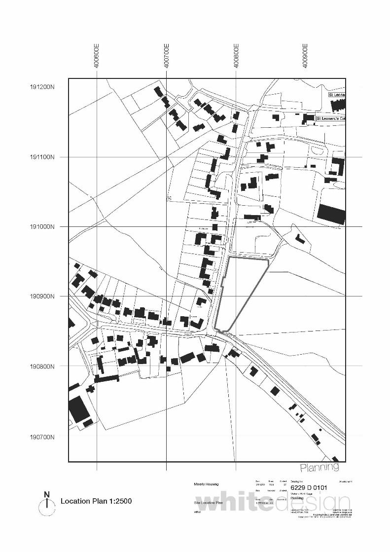
3. Site Description The site has an area of 4200sq m it is relatively flat but slopes slightly to the south. There is mature hedging around the site and within the east boundary hedging in particular there are some larger trees. The site is located adjacent to the junction of Crossing Lane and Flisteridge Road. The land is grassed and has been used for grazing/ agricultural purposes. There is a bus stop adjacent to the southern boundary. There is a drainage ditch which follows the the southern and eastern boundaries.
4. Relevant Planning History
Application Number
Proposal
Decision
N83.0662F N84.01352 FUL N99/2809OUT N89/1400F
Erection of House and Garage Erection of one dwelling and vehicle access Outline – Residential development and B1 industrial units 20 no. dwellings
REFUSED APPEAL DISMISSED REFUSED REFUSED WITHDRAWN
The 1983 application for a House and garage was refused and the applicant appealed against the decision. The appeal was dismissed. The Inspector concluded that the development would result in isolated residential intrusion upon an attractive field. The development would not form an acceptable rounding off or infilling within the village. It would detract from the rural setting and would set a precedent for further houses on this large site. The 1999 application was refused and the reasons for refusal were:
• the site is outside the framework boundary for Minety,
• the site is in the countryside away from services, and
• the junction is inadequate.
This application was for low cost market housing and in this respect the policies at the time were to restrict residential development outside village boundaries. The spirit of these policies has been further reflected in the North Wiltshire Local Plan 2011 in that residential development in the countryside outside village boundaries should be restricted to that required in connection with agriculture, forestry or other rural based enterprise only. It is not considered that these previous applications and decisions are relevant to this scheme as the nature of the housing as now proposed is specific and the site has been chosen as an exception site where the issues raised previously in terms of the type of housing would not be relevant. 5. Proposal This proposal is for the erection of 10 affordable units on a green field site within Upper Minety. The overall site has an area of approximately 4200sqm. The houses are positioned at the north end of the site. To the south of the site a shared public amenity space is provided, with a gated accessible footpath linking the housing to the existing bus stop. The 10 dwellings are arranged in four blocks, two blocks of larger semi detached dwellings and six smaller units in two terraces of three.
Each dwelling has a private garden,(approx 70sqm, containing a shed for cycle storage, water butt, composting facilities and fruit trees and bushes) and 2 accessible parking spaces (5.8m x 4.8m), accessed via a shared surface (approx 580sqm), with an additional 4 visitor parking spaces and shared bin store The units are:
• 2 x 1bed 2person dwellings (Type 1) - 60 to 65sqm • 4 x 2bed 3person dwellings (Type 2) - 72 to 75sqm • 3 x 2bed 4person dwellings (Type 3) - 82 to 85sqm • 1 x 3bed 5person dwelling (Type 4) - 97 to 100sqm
In support of the application the applicant has submitted the following information
• Extended Phase 1 Habitat Survey - Chalkhill
• Geotechnical Report - Integrale
• Housing Needs Survey - Wiltshire
• Notice on Landowners - WRHA
• Post Consultation Meeting Responses - Answers to Questions - WRHA
• Pre Consultation Meeting Handout - Questions and Answers - WRHA
• Statement of Community Involvement - WRHA
• – Tracking Plan
• –Flood Risk assessment
• Proposed Site Layout Revc - CEC
6. Planning Policy · Regional Planning Guidance 10 (now revoked)
1
· Saved policies in the Joint Wiltshire and Swindon Structure Plan · Saved policies in the North Wiltshire Local Plan 2011 H7, C3 and NE15 · Wiltshire Core Strategy Submission Document · National Planning Policy Framework 7. Consultations Environment Agency - No comment Ecology - No objection however further comments received and a condition advised in respect of the POS hedgerows being managed favourably for the conservation of brown hairstreak butterflies. WSBRC - Brown Hairstreak recorded nearby Fire and Rescue - No payment required. Public Open Space - This development generates a need for £20,130 in offsite Open Space Contribution to be used to upgrade facilities within the Parish of Minety. The Contribution would be secured by Section 106 agreement. Wessex Water - No comment Education - payment required total sum of £19,155 (due to a change in financial year this figure needs (to be confirmed). Highways - No objection subject to amendments to the site layout plan and conditions this matter is addressed in detail within the planning judgment section of this report. Footpath - No objection
1 As of 20
th May 2013;

Housing Officer - Supports the scheme stating that the homes being provided meet the housing needs of Minety as demonstrated through the housing need survey and register statistics and comply with Wiltshire Council affordable housing policies in terms of design and tenure. Minety Parish Council - submitted a very detailed letter in support of the scheme and stated that:
Councillors fully support the application and have the following comments. 1) Housing Needs. The site meets the need shown by the survey conducted recently and the unprecedented demand for the houses before any building work has started indicates that local people do want the site. As the applicants are all local residents they are aware of the lack of facilities. 2) Contained site. As this site has natural boundaries the development will not set a precedent for further development in the area. 3) Open Aspect. The low density of the site and in particular the green area at the junction will preserve the rural aspect of the site. 4) Sustainability. There are few facilities anywhere in Minety and the comments from opponents of the development about needing a car for shops and work apply to Minety as well as Upper Minety, so this would not change wherever the site was located. There are dedicated buses for both primary and secondary schools and as the bus stop is adjacent to the site and the green area will provide a safe waiting area there would be no increased risk for children. It is recognised that the sustainability of villages requires a mix of housing stock in order to allow the younger residents of the parish to remain in the village. This development will help to provide the balance required. In recent years there have been several developments of four / five bedroom properties in Upper Minety. The lack of facilities regarding the school and Playing fields etc existed then but the building was approved. Affordable housing should not be judged on different criteria. Councillors believe that despite comments to the contrary this development does conform to Core policy 44 of Wiltshire Strategy for Rural exception sites. The site does have clear support and would meet a proven need. It is not isolated from the existing built up area and will not extend the main curtilage of the village. The road between Upper Minety and Minety is not a narrow lane as suggested by some but a 2 lane metalled road with adequate room for vehicles to pass. Whilst it is unlit and not ideal for walking at night it is frequently used by joggers and cyclists. The site would fail the policy criteria on the lack of employment but this is true for the whole of Minety not just Upper Minety. 5) History. Whilst previous planning applications for development on this site have been refused the last was over twenty years ago and this application is for affordable housing only. The need for affordable housing has increased and in the current climate and the government’s pressure to supply social housing this application should be supported. 6) Junction. Opponents to the proposal have claimed that the junction of the C90 and C76 is dangerous. As far as the Parish Council is aware there have been no accidents on this junction. It is within a 30mph speed limit and providing existing hedges are kept trimmed, visibility exiting the junction is reasonable. A lot of traffic using the road is through traffic and the development will not materially affect that. 7) Flooding. This remains a concern for many residents and the Parish Council. The field itself has only ever had minor water residue, in common with the majority of Minety fields and gardens. Considerable time has been spent investigating the problem, but Councillors and residents still require assurance that the development would not adversely impact on any existing property.

8) Building Materials. This is the main area that The Parish Council has some concerns. The proposed cladding would be out of character in the area. There are no buildings with this material in the vicinity. Whilst Councillors appreciate that it is a cost consideration it is felt strongly that the use of cladding in this area would be inappropriate. 9) Footpath. Councillors like the provision of the footpath to the bus stop as this would improve the safety of both the occupants of the site and other local residents. It would be beneficial to make the footpath extend to the access point on the road so that other residents do not feel they are intruding on the site when they use it. 10) Construction. Construction vehicles should be parked on site to avoid traffic congestion and inconvenience to existing residents in the area. Parishioners have also raised concerns about the reference to street lighting in the plans. The Council has always opposed street lighting as light pollution and trust there would be consultation before any lighting is installed.
8. Publicity The planning application was advertised by site notice, press advert and neighbour consultation. These means of consultation were carried out in accordance with the Council’s code of practice which is in line with statutory requirements. Letters of consultation went out on the17/01/13 and neighbours were given until the 21/02/13 to comment. The site notice was put on site on the 8/02/13 and neighbours were given until the 1/03/13 to comment. The application was advertised in the press on the 31/01/13. Concerns have been expressed by interested parties that there was confusion in respect of the expiry date for the consultation period. It is not always possible for the expiry date for a site notice to coincide exactly with letters of consultation. In this instance the site notice expiry date was one week after the expiry date as stated in the consultation letters. In line with Council procedures all comments received to date have been taken into account. 47 letters of objection (13 objectors sent in more than one letter) and 42 letters of support have been received. Summary of key relevant points raised in support:
• Self contained site which is not isolated, that will be managed by the Housing Association
• Layout density and design of the units is good and in keeping with character of the area and
local context.(Use of cladding not supported)
• The proposal is in keeping with this part of the village and will not have a detrimental impact
on visual amenity
• Green open space provided adjacent to the road.
• There is a need for affordable housing, this number, type and part buy part rent units of
housing were proved by the housing needs survey.
• This type of accommodation for young people is needed in the village to sustain village life
and support the community.
• A mix of people will improve social structure of the village.
• Village facilities such as school, hall, sports field and bus need young people to keep them
going.
• Assumptions made by objectors on residents is unhelpful and biased
• The proposed footpath between the bus stop and Hovington Lease is a good thing and will
improve safety.
• The access and impact on highway is considered safe and adequate parking is proposed.
• There is no intention to close Crossing Lane
• The land is free draining, there is a little bit of flooding so drainage must be addressed as
soakaways are unlikely to work.

• There are some concerns in respect of facts contained within the letter from CPRE which are
not considered to be fully accurate in respect of the facilities available in the village.
• Development of the site will remove casual dumping on the land
• Confirmation should be provided from the Parish Council that meetings were conducted fairly
and correctly.
Summary of key relevant points raised objecting to the proposal: Need and process
• Housing needs survey should have looked at Minety and Upper Minety separately and these
surveys should be public documents.
• 10 houses are not needed as Minety (Upper Minety) has too many affordable units already,
the tenure reduces demand.
• Community involvement indicates other sites were looked at. The site selection process
should take into account other sites and no owners have been approached.
• Other better located sites should be considered such as the turkey farm
• The information seems biased towards those in favour.
Sustainability
• Issues of sustainability not addressed
• This is not the site closest to the amenities (other than church) 1.2 miles from Minety Village
with the school etc.
• No job opportunities poor internet access/broadband
• No shops PO to benefit from this development
• Inadequate facilities available.
• Inevitable commuting to work and services will make units unaffordable.
• Not a sustainable site apart from the church there are no other amenities such as the school
etc which can be accessed by a safe footpath. Minety is accessed along a dangerous lane
and this is family housing.
Highways
• Not enough parking and manoeuvring space within the site.
• Increased traffic on unsuitable local road network dangerous junction
• New railway track will result in level crossing closing therefore more traffic at junction.
• Insufficient parking dangerous access if crossing lane closed then all traffic at this junction.
Dangerous junction.
• There should be speed restrictions along the road and there are some issues in relation to the
local road network.
Consultation
• Site notice went up after letters
• Consultation not adequately carried out. Cllr letters of support are not disclosed and the
Parish Council has not carried out the process appropriately.
• Support from the scheme is not from the residents of Upper Minety.
History
• History of refusals for similar proposals on this site. (see history section above).
• Appeal decisions have indicated Upper Minety as an unsustainable location
• The site is not integrated into the village.
Design and layout
• Unacceptable in terms of design layout and materials

• Loss of rural character and detrimental impact on character of area
• Approval of this scheme would set a precedent for future development.
• Building up the ground level is not acceptable.
• The self contained nature of the site is irrelevant as solid boundaries are easily created.
Policy issues:
• Outside boundary limits
• Contrary to MNSG Draft neighbourhood plan
• Contrary to NWLDP framework document
• Contrary to Core Strategy and Local plan,
• Core Strategy must be a consideration.
• Contrary to Core Policy C1 and C3 of the NWLP.
• Core Policy - exception sites require a sequential test, it is not supported locally the site is not
well related to the village, detrimental environmental impact, no employment opportunities,
does not respects character.
• This is not an exception site.
• Contrary to C3 vi as it is a car dependant development
• H7 and NPPF require a sequential test to be carried out.
• Contrary to NPPF- limited bus services, not a safe environment, add to climate change.
Proposal should seek opportunities to achieve economic, social and environmental elements
to ensure sustainable development.
• This is a situation where the application fails to satisfy the sequential test impacts on one or
more factors it should be refused.
Other
• Drainage/ flooding soil is clay, contrary to PPS25
• Lighting pollution
• Detrimental impact on adjacent listed buildings
• 10% increase in population possible
• 106 payments will be used for facilities not useable by these residents
• High percentage increase in Upper Minety 9%
• Ecology implications.
• Wasted resources in producing supporting documents.
9. Planning Considerations PRINCIPLE OF DEVELOPMENT The current strategic and local planning policy for the area is provided by the Wiltshire and Swindon Structure Plan 2016 and the North Wiltshire Local Plan 2011. The majority of the policies in the Structure Plan and Local Plan have been saved until further notice. National planning policy is provided by the National Planning Policy Framework (NPPF) which came into force on the 27th March 2012. The North Wiltshire Local Plan was adopted in June 2006 and paragraph 214 of the NPPF indicates that the Local Plan policies can continue to be given full weight for 12 months from the day of adoption of the NPPF, even where there is a limited degree of conflict with the NPPF. As this 12 month period has now lapsed paragraph 215 is now relevant, which provides that due weight should be given to relevant policies in existing plans according to their degree of consistency with the NPPF (the closer the policies in the plan to the policies in the NPPF, the greater the weight that may be given). With regards to future planning policy, the Wiltshire Core Strategy Pre-submission Document has been submitted to the Secretary of State for independent examination. It is proposed that the Wiltshire Core Strategy will supersede all the Structure Plan policies which are relevant to Wiltshire, and that it will also replace a number of the policies in the North Wiltshire Local Plan. Paragraph 216 of the NPPF indicates that decision-takers may give weight to relevant policies in emerging plans according

to the stage of preparation of the plan; the extent to which there are unresolved objections to relevant policies; and the degree of consistency of the relevant policies in the emerging plan to the policies in the NPPF. The Localism Act 2011 has introduced neighbourhood plans which, when formally adopted, will form part of the development plan for the area. A number of plans are under preparation in North Wiltshire. Minety Parish Council would be the appropriate Neighbourhood Planning Body but to date no application for plan area designation has been made to Wiltshire Council. The Parish does not form part of the N-W-Villages neighbourhood planning area which is currently preparing a plan. Neither does it form part of the Malmesbury Neighbourhood (steering group) Plan or the Sherston or Cricklade Neighbourhood Plan. The Malmesbury Neighbourhood Plan covers the Malmesbury Town Council area along with the adjoining parishes of St Pauls Without and Brokenborough, as per area designation application that was submitted to Wiltshire Council on 24/10/2012 (and approved in December 2012). As no neighbourhood plan is being prepared in the Parish of Minety at the moment then neighbourhood planning bears no relevance in this case. North Wiltshire Local Plan 2011 Upper Minety is defined as a settlement in the adopted North Wiltshire Local Plan. Upper Minety has a framework boundary as per saved North Wiltshire Local Plan (Policy H3). The proposed development is located outside the framework boundary, however the development is proposed on land directly adjacent to the settlement boundary, between the Old Inn Site, Crossing Lane and the junction with Flisteridge Road to the south. In accordance with Policy H4 of the local plan residential development outside the settlement boundary is only considered acceptable where it is in connection with the essential needs of agriculture etc or is a replacement unit. Policy H7 Affordable Housing on Rural Exceptions Sites allows small affordable housing developments (10 or less) within or adjoining villages provided there is a demonstrable local need for affordable housing which cannot be met otherwise. The need is known in Minety due to up-to-date evidence that supports the emerging Wiltshire Core Strategy. ‘Demonstrable local need’ was assessed by a survey of residents conducted with the Parish Council, Housing Enabler and the Council. This was undertaken in Minety in December 2011. As a result 11 households were identified in housing need, with a mix of house types and tenures identified. Some objectors have questioned whether the recognised need could be accommodated elsewhere within the village and in particularly in Minety as opposed to Upper Minety where the village amenities are centred. Objectors have indicated that in their opinion there are specific sites which given their location would be better suited to provide these units. WRHA have submitted a document to indicate the process that is their standard approach and was undertaken to identify sites within Minety Parish, which were possibly suitable in terms of topography, location, access and availability and which fit the required policy criteria. Approval of this proposal will not prohibit or prejudice the consideration of any further sites which are presented or become known to the Council as the selection process is not seen to be exclusive. In terms of policy it is considered that the need for affordable housing would outweigh the fact that the proposal lies abutting but outside the settlement boundary and that this proposal accords with policy H7. Other Local Plan policies which are relevant to this proposal are core policies C1to3 and specific policies in relation to transport, community facilities and the natural environment. The specific policies are referred to in the relevant sections below.
• C1 Sustainability Core policy- The general focus of this policy is through development, to support the wellbeing of communities in terms of their economic health, social balance and protection of the environment.
• C2-Community Infrasturcture Core Policy- this policy requires the contribution as necessary to the community infrastructure. The relevant contributions are covered below.
• C3-Development Control Core Policy – development should be acceptable in terms of its impact on the character and appearance of the locality.
These matters are covered in the judgement section of this report. In particular objectors have raised concerns in relation to C3 vi) which requires development to be sustainable in terms of seeking to reduce the need to travel by car. The issue of sustainability is covered in detail in the relevant section below as this has been one of the main objections put forward by interested parties. Wiltshire Core Strategy Pre-Submission Document February 2012. The supply of affordable housing is a particular issue within Wiltshire which has been exacerbated by rising house prices in recent years. The Wiltshire Core Strategy once adopted will supersede the North Wiltshire Local Plan. Policy H7 of the North Wiltshire Local Plan will be superseded by Core Policies 1 and 2 in the Wiltshire Core Strategy. Upper Minety is within the Malmesbury Community Area and is defined as a small village. Core Policy 1- "Settlement Strategy" explains that small villages have a low level of services and facilities, and few employment opportunities. Development at small villages will be limited to that needed to help meet the housing needs of settlements and to improve employment opportunities, services and facilities. Core Policy 2- "Delivery Strategy" states that at small villages, development will be limited to infill within the existing built area. However, Core Policy 44 "Rural Exceptions Sites" states that at settlements defined as small villages in Core Policy 1, a proactive approach to the provision of affordable housing will be sought in conjunction with Parish Councils and working with local communities and other parties. This is subject to a number of caveats, including that the housing is being delivered to meet an:
• identified and genuine local need;
• that the proposal is within, adjoining or well related to the existing settlement;
• and that the proposal consists of 10 dwellings or fewer. The issue of identified and genuine local need is addressed in the site selection process section below and has been shown. As stated above the site sits adjacent to the settlement boundary of Upper Minety but is some 1.2 miles from Minety where the local amenities are located, except for the church and 10 dwellings. Therefore, the proposal meets the caveats as listed above, and is considered to be acceptable in principle, in terms of the emerging Core Strategy. In terms of policy therefore, it is concluded that for the reasons set out above, the proposal is considered to be acceptable where:-
1. The Parish Council and the local community are in principle supportive of the proposal; there is clear support for the scheme.
2. The development proposal satisfies requirements expressed in saved North Wiltshire Local
Plan Core Policies 1 to 3.
3. Any planning permission granted will be controlled by an appropriate legal agreement or other appropriate means to ensure the dwelling(s) remain affordable in perpetuity.

4. The Highway Authority is satisfied that the proposal is in line with Policies T1toT4, and supports the proposed access arrangements.
5. The Highway Authority is satisfied that the proposal meets the county wide parking standards.
6. The proposed development complies with the affordable housing definition in the adopted
Local Plan.
7. The units meet the standards and policies set out in the North Affordable Housing Supplementary Planning Document.
In relation to the criteria identified above officers views are as follows:
1- The Parish Council support the proposal although it is recognised that the view of residents is divided. There is a definite split between residents who are in favour of the scheme and those who object to the proposal and consider this to be the wrong location for such development. From the consultations received there is clear support from the Parish Council and many residents within Minety and the general area although it is recognised that there is strong objection from many residents primarily in Upper Minety. On balance it is considered that there is greater support for the scheme from the community as a whole than there is objection and officers consider clear support has been shown although it is clearly more balanced than overwhelming.
2- Core Policies 1-3 (addressed elsewhere in the report). 3- Any permitted affordable housing would be subject to a 106 agreement requiring the housing
to stay as such in perpetuity.
4- matters covered in the highways section below.
5- matters covered in the highways section below.
6- The scheme of housing is supported by the Councils housing officers in terms of the location size and type of housing and its proposed tenure.
National Planning Policy Framework (NPPF) 2012 Given that this application is now being determined after the 27
th March 2013 consideration needs to
be given to paragraph 215 of the NPPF which provides that due weight should be given to relevant policies in existing plans according to their degree of consistency with the NPPF (the closer the policies in the plan to the policies in the NPPF, the greater the weight that may be given). Therefore, an assessment needs to be made as to the extent to which policy H7 of the NWLP 2011 accords with the NPPF. The judgement in respect of this proposal rests on whether it is considered that the thrust of the NPPF along with the emerging Core Strategy are such that they indicate a move away from the policies within the Local Plan 2011 and in particular policy H7. If such a move is considered to be substantiated then a judgement must be made as to whether the weight given to policy H7 is reduced to such an extent that it is no longer pertinent to this proposal justifying approval of this scheme. One of the main issues raised by interested parties is in respect of the requirement for development to be sustainable as this is a specific requirement and general theme within the NPPF. The NPPF states that in order to achieve sustainable development there are three key elements economic, social and environmental. The social role recognises the need to support strong, vibrant and healthy communities, by providing the supply of housing required to meet the needs of present and future generations; by creating a high quality built environment, with accessible local services that reflect the community’s needs and support its health, social and cultural well-being. The National Planning Policy Framework does not change the statutory status of the development plan as the starting point for decision making and this means approving development proposals that

accord with the development plan without delay unless any adverse impacts of doing so would significantly and demonstrably outweigh the benefits, when assessed against the policies in the Framework taken as a whole; or specific policies in the Framework that indicate that the development should be restricted. Section 55 seeks to promote sustainable development in rural areas, housing should be located where it will enhance or maintain the vitality of rural communities and whilst this could possibly also be achieved through development in (Lower) Minety it is also specifically recognised within the NPPF that where there are groups of smaller settlements, development in one village may support services in a village nearby. This requirement accepts that not all new development will necessarily be located within walking/cycling distance or on a bus route from amenities. A positive approach is required in order to support thriving rural communities. SITE SELECTION PROCESS The process carried out in order to identify this site as suitable has been raised by interested parties. In accordance with the requirements of Policy H7 of the Local Plan 2011 this site is an exception to normal planning policies as in line with this policy small affordable housing developments will be considered within and adjoining the villages. This acceptance is on the provision that there is a demonstrable local need for affordable housing which cannot otherwise be met and proper management to ensure that the benefits of the provision of affordable housing to meet local needs will be held in perpetuity. Local needs for the purpose of policy H7 means locally resident people and those with a local connection. Local means the parish in which the site is located, together with adjoining rural parishes. A person with a local connection is someone for whom it is desirable to live in a particular parish because of family ties or support, because she or he was born and spent their formative years there, or to be near their work place, but is not resident in the parish. Demonstrable local need is normally assessed by a survey of residents conducted with the Parish Council, Rural Housing Enabler and Council. A rural housing need survey was undertaken in Minety in December 2011, which identified a housing need for 13 new affordable homes, a mix of rented and shared ownership. This proposal meets these requirements. The homes are to be built to a minimum of Code Level 3 and Homes and Communities Agency Design and Quality Standards. This proposal has been worked up with the support of the local parish council to provide much needed affordable housing within the village and is supported by the New Housing Team. Policy H7 “Affordable Housing on Rural Exceptions Sites” is clear and states: As an exception to normal planning policies small affordable housing developments will be permitted outside and adjoining the Framework Boundaries of all villages in the District provided that:
i) There is a demonstrable local need for affordable housing which cannot otherwise be met; and ii) The scheme must be capable of implementation and proper management to ensure that the benefits of the provision of affordable housing to meet local needs will be held in perpetuity.
Wiltshire Rural Housing Association (WRHA) submitted information to indicate the site search that was carried out. Unfortunately the initial information submitted was confidential in so much as the sites looked at were sites where the owners had not been approached and therefore WRHA considered it inappropriate for this information to be on the website in the public domain. It was promptly removed from the website and WRHA submitted alternative information which was placed on the Council’s website at the end of March. In order to support the choice of this site over others and to satisfy the requirement of Policy H7 to demonstrate local need for affordable housing which cannot otherwise be met the following process was undertaken. It was only after the opinion of the Council’s planning officers, who confirmed in principle this proposal may be acceptable were known and the Parish Council agreed, that the owner of the preferred site was approached. Whilst the timing of this approach to landowners has been questioned by interested parties the WRHA have found through experience that it is not appropriate to approach landowners until the suitability of sites has been considered fully.

It should be noted that Wiltshire Rural Housing Association specialises in providing affordable homes in the rural areas of Wiltshire and Swindon for local people on exceptions sites. The Association has provided over 200 homes on 28 sites in 25 villages throughout Wiltshire and Swindon. The Association confirm that they work closely with individual Parish Council’s to agree their preferred level of involvement in the site selection process. In this instance the process started by the Parish Council approaching the Councils Housing Officer to undertake a survey to identify the housing need and in December 2011 a report was published. The ‘Minety Parish Housing Needs Survey Report’ (included within the planning submission) identified that “Housing development in Minety should take account of anticipated future housing need (as described in the Wiltshire Strategic Housing Market Assessment) as well as the number of households in immediate need for more suitable accommodation”. This report identified a housing need for 13 new affordable homes. The Rural Survey provides a thorough breakdown of the housing situation in Minety and why many people are not able to afford to live in the village, it does not just relate to people who are on the Council’s waiting list. It also shows there have been ‘zero re-let rate in 2010/11: from quarter 2 2010/11 to quarter 2 2011/12, no social homes were re-let in the parish. The low levels and turnover of social housing in Minety indicate that none of the respondents to section two of the survey who are in need of affordable housing could meet their needs through access to the existing social housing of the parish. The total social housing stock in the parish is 18 homes. These properties represent just over 3% of the total housing stock in the parish, which is extremely low: the average proportion of social housing in Wiltshire is 19.2%.’ The report concluded by recommending the provision of affordable accommodation, and based on the responses to its survey outlined a need for up to 12 subsidised rented houses. Objectors have raised concerns that Upper Minety should be looked at separately to Minety as in geographic terms the two elements of the village are separate and there is a 1.2m distance between the two. However, the Parish Council cover the whole area and as many villages in Wiltshire are of a spread out nature and sometimes comprise two or more settlement areas the usual practice of the WRHA is to consider the parish as a whole rather than as two or more settlements, in this respect the Parish Council’s views are taken into account. The Parish Council has confirmed that all their involvement in relation to this application has been carried out in an appropriate manner. A summary of the process undertaken by the Association to identify a suitable site for development is attached as an appendix 1 to this report. It should be noted that prior to the submission of this application the Councils housing officers have not been approached or asked to consider any alternative sites in Minety. In particular objectors have stipulated that the applicants have not adequately addressed the issue of alternative sites being available to meet the need for affordable housing at Minety. They question that there needs to be evidence that all other suitable and available sites (including cross-subsidy sites) must be considered before an exception site can be considered. In addition objectors state that to meet the requirements of Policy H7 of the Local Plan the Council has to determine that there is a need for the affordable housing which cannot otherwise be met (policy H7) and it is quoted that there is evidence of at least two alternative sites in Minety being available to meet the need. With reference to Policy C1 (ii) of the North Wiltshire Local Plan 2011 almost all of the existing 'community infrastructure' within the Parish of Minety is at Minety, not at Upper Minety. In this respect that any site on the edge of Minety village must score higher against issues of maintaining a socially inclusive community as well as in terms of access to community infrastructure compared to any site at Upper Minety. The Design and Access Statement does not appear to address this core policy. There is no requirement in planning policy, either national or local, to carry out a formal "sequential test" in relation to rural housing exception sites, nor to submit documentation on such with the planning application. WRHA did undertake a site assessment process which is attached as appendix 1 but not a 'sequential test' as part of its site selection process, to demonstrate that the application site is the most suitable, sustainable location at Minety for the proposed affordable housing.

The NPPF does require a sequential test to be carried out in connection with the identification of urban housing sites but not rural housing sites. Officers are satisfied that the process for identifying this site has been reasonable and appropriately carried out and there is no reason to consider that there has been any inappropriate handling or misleading information submitted. As previously stated it is not considered that the acceptability of this site for affordable housing prohibits the development of other sites for affordable housing. The site is seen to be acceptable as an exception site and it is likely that there may be other sites which as judged on their merits may also be acceptable as affordable housing sites given that the requirements for such units will be likely to continue to rise. The retention of the housing as affordable housing in perpetuity would be ensured by the signing of a 106 agreement. Within their selection process the Wiltshire Rural Housing Association stipulate that sites with specific identifiable boundaries are preferred. This criteria has been questioned by objectors as they have commented that it is very easy to recreate solid boundaries by planting hedging or putting up fencing. However, the WRHA consider this to be a relevant consideration as established boundaries help to retain the built form and reduce the likelihood of their scheme setting a precedent for other development outside the framework boundary of the village. SUSTAINABILITY The issue of whether or not this is a sustainable site has been one of the main issues raised by interested parties. The Housing Needs Survey undertaken by the Councils Housing Officers, in its ‘Parish Summary’ does give a lot of detail about amenities in Minety which are as follows:
2 pubs one with a restaurant, Weekly post office operates from the sports pavilion, C of E primary school which is well supported and has achieved excellent reports and a thriving pre-school, Playing fields which are well used and support rugby, tennis and cricket clubs, Children’s play area and Village hall providing facilities for a number of clubs which is in use most days. The Parish Church is in Upper Minety.
In terms of the highway network in the larger area there are good road links between nearby towns of Cirencester, Malmesbury, Cricklade and Royal Wootton Bassett and on to Swindon. Therefore, the site is accessible, all be it primarily by car, to work opportunities. Upper and (Lower) Minety are one Parish and it is appropriate that they be treated as such, facilities in Minety are located primarily in Lower Minety but are available for residents of Upper Minety. Some residents will have groceries delivered and there is a small shop in Oaksey which is approximately 3 miles away. There is a limited bus service serving Upper and Lower Minety and surrounding villages and towns as is typical of most villages. There is a bus stop immediately adjacent to the site. It is of particular note that there is a school bus which runs from Upper Minety to the school in Lower Minety which parents have to pay for. In many of the villages where affordable housing is located homes are located about 1 and a half miles from the school and there is no such provision so in this respect this is a positive. Minety is considered to be fairly typical of most villages of this size in the County and bearing in mind that the houses are for local people many will already live in the village so will be aware of the limited local amenities. The houses themselves can be seen as an amenity and will support and potentially improve the sustainability and viability of the village as a whole and its existing facilities. Both Local Plan Policies, the emerging Core Strategy and the National Planning Policy Framework place great emphasis on the need for development to be sustainable. It is the location of this site at

Upper Minety a distance of 1.2miles from Minety and the amenities it provides that is a major concern to objectors. The route between the two village sections is not one that can be promoted as a safe walking environment as it is recognised there are no footpaths and there are no speed restriction along most of the route. Therefore it is accepted that walking from Upper Minety to Minety is not something that residents would be expected to do. As stated there is a limited bus service and there is a school bus so total reliance on a car for access to the school in particular will not be necessary. It has been stated that tenants of affordable housing will have no or less access to cars and so have to be able to walk to local facilities. The Councils housing officer has confirmed that this is not the case. The car parking standards for affordable housing units are in line with those for any other residential development and this is in recognition of the likely access to a car of residents in affordable housing. The reality is that any rural affordable housing is unlikely to have, within walking distance, basic facilities such as a shop and employment. This factor is specifically recognised in the Core Strategy policy 1 which recognises that development in small villages will be limited to that needed to help meet housing needs, and to improve employment opportunities, services and facilities. In addition to the location of the site thought has been given within the proposal to sustainable building details. The dwellings have been orientated to allow for good sunlight, simple design and quality materials are proposed thereby reducing thermal loss, insulation and air source heat pumps are proposed with opening windows supported by environment extract fans. Room depths/window sizes provide good light and natural ventilation levels. Planting reduces solar gain on south elevations. Water butts and recycling facilities are to be installed. Existing topography and vegetation has formed an integral part of the scheme. The development is targeted minimum Code for Sustainable Homes level 4. To ensure high standards of sustainable design a Code and SAP assessor has been engaged. PARISH COUNCIL COMMENTS The Minety Parish Council submitted comprehensive comments in support of this scheme and these are provided in full in the consultation section above. Some residents have questioned the way the Parish Council have handled the site selection process and public discussions in relation to this site. The Parish Council have been involved in the consideration of sites for affordable housing within Minety with WRHA. Concerns have been expressed in relation to the fact that within the Parish Council there is no Upper Minety representative, this is not a matter that the Local Planning Authority has any control over this is a matter for individuals within the Parish. It has been expressed that when the scheme was considered at the Parish Council meeting the discussion is not reflected in the subsequent comments submitted to the local planning authority by the Parish Council and they are misleading. The way Parish Council meetings are run and organised are not a matter for the local planning authority to challenge and the Parish Council have confirmed that all matters have been dealt with in an appropriate manner. The comments submitted by the Parish Council are given some weight as they are seen to represent the general view of the population within the Parish. However, the local planning authority are aware that they will not reflect the view of all residents and therefore, all other matters and concerns raised by interested parties are taken into account and addressed throughout the consideration process. The recommendation made by officers is an ‘on balance’ opinion in the light of all comments received both for and against and in line with local and government policy and guidance. ACCESS AND PARKING When planning application N/99/2809 was considered the highways team raised concerns. The decision notice included concerns relating to sustainable transport concerns (formerly PPG 13 Transport) and the suitability of the Crossing Lane / Flisteridge Road junction (C90/ C76). However since that application both highway and planning policy has changed.

With regard to sustainable transport considerations, it is accepted that the proposal is being considered against Policy H7 of the Local Plan (Affordable Housing on Rural Exceptions Sites). On the basis that the proposal satisfies this Policy in the Local Plan, then no sustainable transport objection is raised by the highway engineer. With regard to the suitability of the Crossing Lane / Flisteridge Road junction (C90/C76) to the south of the site, application N/99/2809 was subject to previous highway objection. The junction may not have altered, but the policy relating to highway visibility splay requirements in locations of this nature has now changed. Relevant guidance is in the Manual for Streets (2007) and companion document Manual for Streets 2 (2010). Manual for Streets has reduced the level of visibility splay requirements. In the vicinity of the site Crossing Lane and Flisteridge Road has frontage residential development and these roads are subject to a 30mph limit therefore the relevant guidelines are contained within Manual for Streets and its companion guide Manual for Streets 2. In Manual for Streets, the “Status and application” section states: “MfS focuses on lightly-trafficked residential streets, but many of its key principles maybe applicable to other types of street, for example high streets and lightly-trafficked lanes in rural areas…..MfS does not apply to the trunk road network. The design requirements for trunk roads are set out in the Design Manual for Roads and Bridges (DMRB)”. With regard to Manual for Streets 2 at section 1.3.6 it states: “This new document does not supersede MfS1; rather it explains how the principle of MfS1 can be applied more widely”. At section 1.3.6 Manual for Streets 2 states: “It is only where actual speeds are above 40mph for significant periods of the day that DMRB parameters for SSD are recommended. Where speeds are lower, MfS parameters are recommended.” With regard to the proposal, at the junction of Crossing Lane and Flisteridge lane (C90/C76) the visibility splay in the west direction is approximately 2.4m x 14m to the nearside carriageway; with regard to the vehicle track it measures approximately 2.4m x 24m. A visibility splay of 2.4m x 24m to the vehicle track, would comply with guidelines for a speed of 20mph in MfS. The safety record at the junction indicates that there are no recorded personal injury accidents at the junction in the last ten years. On this basis there would not appear to be a major safety issue at the junction. However, it is acknowledged that it is feasible that there may have been un-recorded non-personal accidents at the junction. Interested parties have commented that speed restrictions are necessary in this locality, the requirement for such would not be considered necessary and or justifiable in relation to this scheme. When Manual for Streets guidelines are considered against the existing level of use of Crossing Lane/ Flisteridge Road and the proposed additional movements as a result of the development, it is not consider that a highway objection on the grounds of increased use relating to the visibility splay could be substantiated at a planning appeal. Interested parties have raised concerns in respect of possible future road works/closures to the north of the site. The Highways Engineers understanding is that the works to the railway line level crossing involve the erection of new gates and CCTV. The person in the level crossing building who operates the gates will no longer be in place in the future. The gates will then be operated remotely. The road will not be permanently closed. The impact of a temporary road closure to carry out these construction works cannot be considered a significant issue relating to vehicle movements from this area on the junction in question.

The number of parking spaces and road layout is in principle acceptable. However, the layout of the scheme has been amended to address minor issues raised by the highway engineer. These matters were in respect of the provision of a 0.5m service margin in order to satisfy requirements for a section 38. The first 5m have a tarmac finish; provision for the ditch will need to be conditioned. With regard to refuse collection, a swept path analysis has been submitted to show how a refuse vehicle (2.6m x 10.8m) can enter and turning within the site. Bin storage areas have been suitably placed. A footway adjacent to the plot in the middle of the development has been removed due to shared surface. Suitable width behind parking spaces for reversing and turning has been provided at a min.of 6m. The two telecom poles have been identified as being relocated as necessary should they impact on the required 2.4m x 43m visibility splays. The possible relocation of the telegraph poles in order to provide adequate visibility has been indicated by the applicant. With regard to the maintenance of the road on the site the highway engineer has commented that as the applicants have confirmed all onsite drains and permeable paving will be maintained by private management company as appointed by Wiltshire Rural Housing Association and that all on site roads and parking areas will be constructed with permeable paving then Wiltshire Highways will not adopt the site as they do not adopt sites with permeable paving. Therefore the site will remain private, and the highway authority will issue the Advance Payment Code (APC) under the Highways Act 1980 and a bond will be required. Highways will only consider discharging the bond at a stage when a suitable management company / agreement can be demonstrated. As the road will be privately managed it is necessary for an on-site collection point to be provided for bins etc and the details of this can be the subject of a condition. On the basis the on-site roads will remain private, the surface water issue relating to the roads is not a highway concern. DRAINAGE Concerns have been raised in connection with the site and it drainage. At present there is a drainage channel along the south and west boundaries. The application has been supported by the submission of a Land Drainage Report. The land is free draining, there is a little bit of flooding so drainage was recognised as an issue to be addressed as the soakaways as originally shown were unlikely to work. Subsequent details have been submitted and the detailed design attenuates the surface water flows by retaining excess water beneath the proposed access road and releasing it slowly to mimic greenfield runoff. The Highway Engineer has commented that if the developer intends to drain the highway surface drainage by connecting to the water authority system then a S104 agreement ? will be required. If this is not proposed then it will be necessary for the Area Highway Engineer to be consulted as to whether there is suitable capacity/ or requirements within the highway drainage system. The Land Drainage report has been considered by the Council’s drainage engineer and as a result additional clarification and explanation has been required. This further information has been considered by the Council’s drainage engineer who has confirmed that he is satisfied that this scheme is acceptable. In the light of the information submitted and the views of the Council’s drainage engineer it is considered that the scheme complies with policy C3 of the NWLP 2011. It should be noted that “Atkins” have been instructed to undertake a drainage study following long held concerns about drainage in Minety and Upper Minety this is in the process of preparation. DESIGN AND LAYOUT

The units are arranged in two blocks of three two storey houses in a terrace and two semi-detached blocks (4 houses). In general terms the development has been kept to the north of the site. The site and units have been designed to Homes and Communities Agencies (HCA) design criteria and Housing Quality Indicators (HQI) - and will achieve Lifetime Homes standards. The development offers fully inclusive access, and is designed such that future adaptions can be made to the properties to accommodate specific access needs and requirements for additional working or living space without extension of the building footprint (see unit plans). The size of each dwelling fulfils the HCA HQI’s and WRHA’s Development Protocols Space and Size Requirements. The section submitted indicates that the southernmost terrace of units will have a marginally raised floor level in order to safeguard against any future drainage/flooding issues. This marginal raise in ffl is not considered to have an impact on the overall appearance of the development that would render the scheme unacceptable. The ridge height of this block will not exceed the other heights on the site. The dwellings are grouped into larger semi detached or terraced units to reflect the size and scale of recent and historic dwellings found within the immediate area and elsewhere throughout Wiltshire and the Cotswolds. Each dwelling has a private garden (approx 70sqm, containing a shed for cycle storage, water butt, composting facilities and fruit trees and bushes) and 2 accessible parking spaces (5.8m x 4.8m), accessed via a shared surface (approx 580sqm), with an additional 4 visitor parking spaces, and shared bin stores. The site is not within a designated Conservation Area and the nearest Listed Buildings are located in excess of 70m away. Whilst the site is within the locality of a Listed Building it is not a site that would be considered to impact on the setting of a Listed Building. The mass and bulk of the blocks has been kept as low as possible in order to ensure that the units are in keeping with the local context. The density of the development is low and the units have been located to the north of the site and set back from the road frontage in order to minimise their impact. The larger block is sited in the NE corner of the site. The units are designed to read as a group whilst reflecting the character of the locality. A palette of three materials has been chosen stone facing, render and timber cladding. These materials provide cohesion to the scheme whilst respecting their location. The units are well designed and emphasis has been placed on making each unit identifiable in its own right whilst being part of a group. Windows have been thoughtfully placed in order to provide passive surveillance of parking areas, the footpath and public open space. Care has been taken to ensure that the development sits comfortably on the site without having a dramatic presence. The built forms are set into the site and back from the main road. The open green space along the street frontage to the south retains the rural feel of this area and as such the scheme is seen to comply with policy NE15 of the local plan as well as Policy C3. The timber cladding is an element of the scheme that was not considered acceptable to many residents including the Parish Council. Following discussions with the applicant it was considered that the removal of the timber cladding and its replacement with more stone and or render would give the scheme a less individual appearance. The timber is seen to provide a softer agricultural appearance of the scheme. However, in recognition of local concern the timber has been removed from the units near to the street and has been put on the block that sits perpendicular to the street, the backs of which will be visible across the POS and beyond the gardens. The boundary treatment of the units is considered important and a condition to this effect is considered necessary. The design, mass, bulk and siting of the units and the layout of the development as a whole is seen to respect the local context whilst resulting in a distinctive new residential enclave and one that does not dominate the street scene or visual amenity of the locality. The scheme sits on a contained site and is not in close proximity to its neighbours. The block in the northern corner of the site sits closest to its neighbouring property. There is a bedroom window in the north elevation at second floor level however; given the distance to the neighbouring property this is not considered to create a loss of privacy problem. In this respect the scheme is seen to comply with policy C3 of the Local Plan 2011.

PUBLIC OPEN SPACE The Councils Leisure Services officer has concluded that in accordance with policy CF3 of the Local Plan 2011 This development generates a need for £20,130 in offsite Open Space Contribution to be used to upgrade facilities within the Parish of Minety. The Contribution would be secured by Section 106 agreement. The amenity land indicated within the site will need to be managed in perpetuity, the WRHA have confirmed that they will be responsible for this. EDUCATION In accordance with policy CF1 of the Local Plan 2011 a full developer contribution towards the additional secondary place required, at the current (2012/13) cost multiplier of £19,155 is required (sum to be confirmed in late observations due to change in financial year ). This sum would be secured through the relevant 106 agreement. ECOLOGY In November 2012 an extended phase1 habitat survey was completed and this was submitted with the planning application. With regard to Ecology on the site the Council’s ecologist has reviewed the available information and noted that the development will result in the loss of unimproved neutral grassland, and fragmentation of the local hedgerow and ditch network, although as none of these features meet BAP criteria there is no policy objection on these grounds. The proposals also pose a low risk to reptiles, breeding birds and great crested newt, however given the small size of the site and proposed mitigation measures this is low enough such that it does not trigger the need for detailed surveys or any statutory tests. The proposed scheme will therefore impact negatively upon the local natural environment, however not to a sufficient degree to uphold a policy or legislation related objection to the scheme on those grounds. There is a mature hedge along the boundary of the site and in particular there are several trees within the mature hedge along the eastern boundary. The scheme indicates that the hedging adjacent to the boundaries is to be retained and will be incorporated within the scheme. Within the Design and Access statement the applicant has confirmed that efforts have been made within the layout to minimise the overall impact on the existing character and habitats. There is a mature oak sited on the eastern boundary and the layout of the development has recognised the value of this tree and whilst development is within the tree canopy it is agreed that subject to suitable conditions in respect of excavation then no objection to this relationship is raised by the Council’s tree officer. It is considered appropriate for the landscaping of the site to be conditioned to ensure suitable planting within this site and particularly adjacent to this prominent corner. GROUND CONTAMINATION A Geotechnical Survey was undertaken in November 2012 (included within the planning submission). This concluded that there is no contamination on the site. However, the Council’s Senior Environmental Health Officer- Public Protection has not raised any objection to this proposal but considers that a condition to ensure that no development commence on site until an investigation of the history and current condition of the site to determine the likelihood of the existence of contamination arising from previous uses needs to be undertaken and where necessary appropriate action taken. Therefore a condition to this effect is proposed. 10. Conclusion Having taken into account all matters the location, impact on the surrounding area, scale layout and detailed design of this modest scheme are seen to be acceptable and comply with the policy framework at this time.

11. Recommendation That Authority to grant planning permission is delegated to the Area development Manager subject to the signing of a S.106 respect of the:
• Retention of the dwellings as affordable housing in perpetuity
• Education contributions of - £19155 (sum to be confirmed in late observations).
• Publc open space contributions of - £20,130 for the following reason: This proposed development for 10 affordable housing units is acceptable as it is considered to be an exception site in terms of policy H7 of the North Wiltshire Local Plan. It is considered acceptable in terms of its location, impact on the surrounding area in terms of its access and impact on the highway network and local drainage conditions, its scale layout and detailed design and complies with the policy framework at this time Subject to the following conditions:
1. The development hereby permitted shall be begun before the expiration of three years from the date of this permission.
REASON: To comply with the provisions of Section 91 of the Town and Country Planning Act 1990 as amended by the Planning and Compulsory Purchase Act 2004.
2. The development hereby permitted shall be implemented in accordance with the submitted plans and documents listed below. No variation from the approved plans should be made without the prior approval of the local planning authority. Amendments may require the submission of a further application.
6229D Design & Access Statement RevA 6229D Site Analysis 6229D 7901 External Material Schedule White Design Drawings 6229D 0101 Site Location Plan 6229D 0102 Site Context Plan 6229D 0103 Site Survey 6229D 0104C Site Proposed Layout 10
th MAY 2013
6229D 0111 Unit 1 Floor Plans 6229D 0112 Unit 2 Floor Plans 6229D 0113 Unit 3 Floor Plans 6229D 0114 Unit 4 Floor Plans 6229D 211 Unit 1 Sections 6229D 212 Unit 2 Sections 6229D 213 Unit 3 Sections 6229D 214 Unit 4 Sections 6229D 0301B Site Elevations Across Site10
th MAY 2013
6229D 0302B Site Elevations - Through Site10th
MAY 2013 6229D 0303 Site Elevations - Long10
th MAY 2013
6229D 0311A Unit 1 Elevations10
th MAY 2013
6229D 0312A Unit 2 Elevations10th
MAY 2013 6229D 0313 Unit 3 Elevations 6229D 0314 Unit 4 Elevations

6229D TRADA Feather Edged Detail 6229D 0501 Site View
Other Drawings and Docs
• Extended Phase 1 Habitat Survey - Chalkhill
• Geotechnical Report - Integrale
• Housing Needs Survey - Wiltshire
• Notice on Landowners - WRHA
• Post Consultation Meeting Responses - Answers to Questions - WRHA
• Pre Consultation Meeting Handout - Questions and Answers - WRHA
• Statement of Community Involvement - WRHA
• – Tracking Plan
• –Flood Risk assessment
• Proposed Site Layout Revc – CEC
REASON: To ensure that the development is implemented as approved.
3. All boundary hedgerows to be managed as part of the public open space shall be managed favourably for the conservation of brown hairstreak butterfly. Favourable management practices shall include:
• Hedgerows shall be trimmed no more than once every three years;
• Hedgerows shall be layed or coppiced no more than once every seven years;
• Hedgerow management shall be carried out in February; and
• Chemical treatments shall not be applied within 5m of the base of hedgerows. REASON: To conserve local populations of brown haristreak butterfly.
4. No development shall commence on site until an investigation of the history and current condition of the site to determine the likelihood of the existence of contamination arising from previous uses has been undertaken and until:
a) The Local Planning Authority has been provided with written confirmation that, in the
opinion of the developer, the site is likely to be free from contamination which may pose
a risk to people, controlled waters or the environment. Details of how this conclusion was
reached shall be included.
b) If, during development, any evidence of historic contamination or likely contamination is
found, the developer shall cease work immediately and contact the Local Planning
Authority to identify what additional site investigation may be necessary.
c) In the event of unexpected contamination being identified, all development on the site shall cease until such time as an investigation has been carried out and a written report submitted to and approved by the Local Planning Authority, any remedial works recommended in that report have been undertaken and written confirmation has been provided to the Local Planning Authority that such works have been carried out. Construction shall not recommence until the written agreement of the Local Planning Authority has been given following its receipt of verification that the approved remediation measures have been carried out.
REASON: To ensure that land contamination can be dealt with adequately prior to the use of the site hereby approved by the Local Planning Authority.
5. No demolition, site clearance or development shall commence on site until an Arboricultural Method Statement (AMS) prepared by an arboricultural consultant providing comprehensive details of construction works in relation to trees shall be submitted to, and approved in writing by, the Local Planning Authority. All works shall subsequently be carried out in strict

accordance with the approved details. In particular, the method statement must provide the following:-
§ A specification for protective fencing to trees during both demolition and construction phases which complies with BS5837:2012 and a plan indicating the alignment of the protective fencing;
§ A specification for scaffolding and ground protection within tree protection zones in accordance with BS5837:2012;
§ A schedule of tree works conforming to BS3998:2010; § Details of general arboricultural matters such as the area for storage of materials,
concrete mixing and use of fires; § A full specification for the construction of any arboriculturally sensitive structures and
sections through them, including the installation of boundary treatment works, the method of construction of the parking areas including details of the no-dig specification and extent of the areas of the parking areas to be constructed using a no-dig specification;
§ Details of all other activities, which have implications for trees on or adjacent to the site. REASON: In order that the Local Planning Authority may be satisfied that the trees to be retained on and adjacent to the site will not be damaged during the construction works and to ensure that as far as possible the work is carried out in accordance with current best practice and section 197 of the Town & Country Planning Act 1990.
6. No development shall commence on site until a scheme of hard and soft landscaping has been submitted to and approved in writing by the Local Planning Authority, the details of which shall include: (a) indications of all existing trees and hedgerows on the land; (b) details of any to be retained, together with measures for their protection in the course of
development; (c) all species, planting sizes and planting densities, spread of all trees and hedgerows
within or overhanging the site, in relation to the proposed buildings, roads, and other works;
(d) car park layouts; (e) other vehicle and pedestrian access and circulation areas; (f) hard surfacing materials; (g) minor artefacts and structures (e.g. furniture, play equipment, refuse and other storage
units, signs, lighting etc); (h) proposed and existing functional services above and below ground (e.g. drainage,
power, communications, cables, pipelines etc indicating lines, manholes, supports etc); REASON: To ensure a satisfactory landscaped setting for the development and the protection of existing important landscape features.
7. All soft landscaping comprised in the approved details of landscaping shall be carried out in
the first planting and seeding season following the first occupation of the building(s) or the completion of the development whichever is the sooner; All shrubs, trees and hedge planting shall be maintained free from weeds and shall be protected from damage by vermin and stock. Any trees or plants which, within a period of five years, die, are removed, or become seriously damaged or diseased shall be replaced in the next planting season with others of a similar size and species, unless otherwise agreed in writing by the local planning authority. All hard landscaping shall also be carried out in accordance with the approved details prior to the occupation of any part of the development or in accordance with a programme to be agreed in writing with the Local Planning Authority.
REASON: To ensure a satisfactory landscaped setting for the development and the protection of existing important landscape features.
8. No development shall commence on site until details and samples of the materials to be used
for the external walls and roofs have been submitted to and approved in writing by the Local Planning Authority. Development shall be carried out in accordance with the approved details.

REASON: In the interests of visual amenity and the character and appearance of the area. POLICY- C3
9. No development shall commence on site until details of the design, external appearance and decorative finish of all railings, fences, gates, walls, bollards and other means of enclosure have been submitted to and approved in writing by the Local Planning Authority. Development shall be carried out in accordance with the approved details prior to the development being occupied.
REASON: In the interests of visual amenity and the character and appearance of the area. POLICY-C3
10. Notwithstanding the provisions of the Town and Country Planning (General Permitted Development) Order 1995 (as amended by the Town and Country Planning (General Permitted Development) (Amendment) (No.2) (England) Order 2008 (or any Order revoking or re-enacting or amending that Order with or without modification), there shall be no additions/extensions or external alterations to any building forming part of the development hereby permitted.
REASON: In the interests of the amenity of the area and to enable the Local Planning Authority to consider individually whether planning permission should be granted for additions/extensions or external alterations.
POLICY- C3
11. No development shall commence on site until details of the design location and proposed
collection service for refuse and recycling facilities (including location and range of facilities)
have been submitted to and approved in writing by the Local Planning Authority. The
development shall not be first occupied until the approved facilities have been completed and
made available for use in accordance with the approved details and they shall be
subsequently maintained in accordance with the approved details thereafter.
REASON: In the interests of public health and safety.
POLICY- C3
12. No development shall commence on site until a scheme for the proposed bridging and piping
of the drainage ditches adjacent to the site, to include precise details of the construction of the
proposed vehicular and pedestrian accesses have been submitted to and approved in writing
by the Local Planning Authority. The development shall not be first occupied until these works
have been constructed in accordance with the approved scheme.
REASON: To ensure that the development can be adequately drained.
POLICY- C3
13. No part of the development hereby permitted shall be first brought into use until the access (including visibility splay), and parking spaces have been completed in accordance with the details shown on the approved plans (Drawing titled Site Layout – Proposed numbered 6229 D 0104 Rev c). The areas shall be maintained for those purposes at all times thereafter.
REASON: To ensure that adequate provision is made for parking within the site in the interests of highway safety.
14. The roads, including footpaths and turning spaces, shall be constructed so as to ensure that,
before it is occupied, each dwelling has been provided with a properly consolidated and surfaced footpath and carriageway to at least base course level between the dwelling and

existing highway. In line with (Drawing titled Site Layout – Proposed numbered 6229 D 0104 Rev c).
REASON: To ensure that the development is served by an adequate means of access. APPENDIX 1. Process Firstly the Housing Needs Assessment was undertaken by Wiltshire Council and this determines the size of development for any parish and following discussion with the Parish Council the preferred size of the development to be provided is agreed. In meeting this requirement the Association follows it’s well established, and nationally accepted, practice of:
• Working closely with the Parish Council and Wiltshire Council staff to identify housing need and agree the most appropriate size for the development to meet the identified need
• Working closely with the Parish Council, taking advantage of their local knowledge, to identify potential sites
• Advising the Parish Council on the suitability of the sites identified. • Liaising with Wiltshire Council over the suitability of the selected site or sites having regard to
planning policy for the area. • Taking into account of all the views expressed, bringing forward the most appropriate site.
Site requirements In order to be able to produce affordable homes to benefit local people the Association concentrates on acquiring exceptions sites. The site therefore needs to meet the criteria of an exceptions site, set out in the relevant development plan. The extant development plan for the Parish is considered and, in considering possible sites for development, regard is also taken of the emerging Wiltshire Core Strategy (WCS). Having regard to the policies in these plans for rural exception sites WRHA expects potential sites to meet the following criteria:
(i) the site should be of sufficient size to accommodate the required homes, associated amenities and open space*;
(ii) it needs to be within or adjoin the boundary of the village as shown in the development plan;
(iii) it needs to be well related to existing development; (iv) it needs good access; (v) it should ideally be contained within natural boundaries and not set a precedent for
further development. *a site for a smaller number of houses might be considered if one of sufficient size could not be found if developing a smaller site would remain financially viable.
The Housing Needs Assessment undertaken by Wiltshire Council with the support of the Parish Council identified the housing need and determines the size of site required. For example 10 affordable homes would require a site of approximately 1 acre to enable associated amenities and open space to be provided. Once a potential site or sites have been identified consideration is then given to specific aspects of the site and the subsequent development. Details are provided later in this report.

As many villages in Wiltshire are of a spread out nature and sometimes comprise two or more settlement areas our usual practice is to consider the parish as a whole rather than as two or more settlements. Again the Parish Council’s views are taken into account. Site specific considerations Consideration was given to development issues relating to sites 1 and 12, for example:
• Whether other developments have been allowed in the vicinity in recent years – it is clear that there has been a significant level of development in the vicinity of both sites. .
• Location in relation to other social housing in the parish – it is a desire of Government to see affordable housing ‘pepper potted’ amongst open market development rather than concentrated in one location.
• The availability of amenities within the parish and access to them – as is typical of Wiltshire villages amenities vary widely from one parish to another and proximity to them from individual sites also varies widely. As we provide homes for people with a local connection to the Parish those for whom the homes are intended, will be aware of the amenities available to them.
• Sustainability – the homes will be built to high sustainability standards. Residents will to a certain extent rely on private cars, as do other residents in the vicinity of the sites. Bus services vary widely in Wiltshire villages, so it is difficult to rely on this as a determining factor. As residents will be drawn from the Parish travel to work considerations will not change significantly.
• Impact on surrounding properties – we aim to provide homes where the impact on adjacent properties is kept to a minimum and the designs we put forward therefore have regard to this. We provide good sized gardens and wherever possible a good amount of open space.
• Traffic - issues relating to traffic are always of concern. As these affect existing residents note is taken as to whether other developments have been allowed in the vicinity of the sites under consideration. This is the case with both sites. Therefore informal views of Highways Officers would be sought. We have on a number of occasions extended speed restriction areas at the request of Highways Officers and we are happy to work with Parish Councils and the Council over this.
• Flooding – issues relating to potential flooding are taken into account and information is obtained from the Environment Agency any local Parish flood plans and specialist advice may also be sought. This advice would be taken into account when deciding whether to proceed with a particular site.
The next step is to make further enquiries of Wiltshire Council Planners and Highways on the preferred sites. Once their views are known and the PC agree an approach would be made to the owner of the preferred site or sites. Throughout the process the Parish Council are kept advised of progress. The Association considers that by following the above procedure it can be established that an exhaustive process to assess all possible sites has been undertaken which meets the criteria in the development plan for developments of this types and which will enable the Association to provide an affordable, attractive and well located development for local people. In support of this proposal the Housing Officer commented that Wiltshire Rural Housing Association in partnership with the Parish Council and Cllr Soden worked through a number of alternative sites, which were deemed unsuitable for development or the parish council would not support.

The HNS showed that 81% of respondents supported the provision of housing in the village, the biggest majority 34%, supported 4 – 10 homes. In summary WRHA have taken positive steps in line with policy to seek to secure this site for rural housing. This site is supported by the New Housing Team, to deliver more rural housing, which are noticeably being undelivered through s106 due viability issues and to enable the council to seek grant funding to deliver it and if it doesn’t gain planning Wiltshire Council will have lost that investment.