republic of korea - typhoon committee
TRANSCRIPT

MEMBER REPORT
ESCAPWMO Typhoon Committee 42nd Session
25-29 January 2010
Singapore
Republic of KOREA
MEMBER REPORT
ESCAPWMO Typhoon Committee 42nd Session
25-29 January 2010 Singapore
Republic of KOREA
2
CONTENTS
I Overview of tropical cyclones which have affectedimpacted Memberrsquos area since the last
Typhoon Committee Session helliphelliphelliphelliphelliphelliphelliphelliphelliphelliphelliphelliphelliphelliphelliphelliphelliphelliphelliphelliphelliphelliphelliphellip 3
II Summary of progress in Key Result Areas helliphelliphelliphelliphelliphelliphelliphelliphelliphelliphelliphelliphelliphelliphelliphelliphelliphelliphellip 9
1 Progress on Key Result Area 1 helliphelliphelliphelliphelliphelliphelliphelliphelliphelliphelliphelliphelliphelliphelliphelliphelliphelliphelliphelliphellip 9
2 Progress on Key Result Area 2 helliphelliphelliphelliphelliphelliphelliphelliphelliphelliphelliphelliphelliphelliphelliphelliphelliphelliphelliphelliphellip 22
3 Progress on Key Result Area 3 helliphelliphelliphelliphelliphelliphelliphelliphelliphelliphelliphelliphelliphelliphelliphelliphelliphelliphelliphelliphellip 26
4 Progress on Key Result Area 4 helliphelliphelliphelliphelliphelliphelliphelliphelliphelliphelliphelliphelliphelliphelliphelliphelliphelliphelliphelliphellip 27
5 Progress on Key Result Area 5 helliphelliphelliphelliphelliphelliphelliphelliphelliphelliphelliphelliphelliphelliphelliphelliphelliphelliphelliphelliphellip 32
6 Progress on Key Result Area 6 helliphelliphelliphelliphelliphelliphelliphelliphelliphelliphelliphelliphelliphelliphelliphelliphelliphelliphelliphelliphellip 34
7 Progress on Key Result Area 7 helliphelliphelliphelliphelliphelliphelliphelliphelliphelliphelliphelliphelliphelliphelliphelliphelliphelliphelliphelliphellip 44
III Resource Mobilization Activities helliphelliphelliphelliphelliphelliphelliphelliphelliphelliphelliphelliphelliphelliphelliphelliphelliphelliphelliphelliphelliphellip 49
IV Update of Memberrsquos Working Groups representatives helliphelliphelliphelliphelliphelliphelliphelliphelliphelliphelliphelliphellip 49
Summary helliphelliphelliphelliphelliphelliphelliphelliphelliphelliphelliphelliphelliphelliphelliphelliphelliphelliphelliphelliphelliphelliphelliphelliphelliphelliphelliphelliphelliphelliphelliphelliphelliphellip 50
3
I Overview of tropical cyclones which have affectedimpacted Memberrsquos area in 2009 1 Meteorological Assessment (highlighting forecasting issuesimpacts)
No typhoon landed in the Korean peninsula during the 2009 typhoon season However several typhoons presented typhoon forecasters with a greater challenge than in previous years One of them was typhoon Lupit (0920) which showed a very complicated track and extratropical transition process The typhoon was formed at 1800UTC 15 October 2009 about 630km west of Guam and first moved northwestward before changing course for the first time on 17 October 2009 It changed course once again on 23 October after which it sped up northeastward Track errors multiplied whenever the track displayed such irregularity (Figs 1 and 2) The extratropical transition (ET) time was computed as the typhoon moved northeastward KMA projected the extratropical transition to occur at 1800UTC 26 October 2009 but subsequently revised it to 18 hours earlier 0000UTC 26 October following re-analysis using its ET manual This was a case where KMA carried out re-analysis of the typhoon position prior to releasing an official forecast This experience has led KMA to recognize the importance of re-analyzing the typhoon position and to adopt a more objective scientific method
Fig1 Track of typhoon Lupit (0920) Fig2 Track error of typhoon Lupit (0920)
2 Hydrological Assessment (highlighting water-related issuesimpact) The 21st typhoon Mirinae occurred in Vietnam at 1500 (local time) on 27 October 2009 causing considerable damage with approximately 100 casualties 40 missing and 50 injured persons Typhoon Mirinae then started approaching the southern region of the Korean Peninsula KMArsquos National Typhoon Center issued a track report on Mirinaersquos approach toward the Korean Peninsula so as to prevent damage and to allow advance preparations against the projected approach Fortunately the typhoon weakened and dissipated to a tropical depression with a central pressure of 1000hPa and a wind speed of approximately 32kmh about 270km north of Ho Chi Min Vietnam at 0300 (local time) on 3 November without incurring any damage in Korea
4
Fig3 Track of typhoon Mirinae(0921) (Source Typhoon Research Center wwwtyphoonorkr)
Even though KMA tracked and issued reports on Mirinae Korea remained free of any typhoon impacteffect in 2009 for the first time since 1998 The Asian region (eg the Philippines and Vietnam) however did suffer from severe typhoons during the 2009 season and Korea was on guard to prepare against and respond to potential typhoon hazards (The typhoon name Mirinae was submitted by Korea)
Typhoon Morakot and Reservoir Flood Control This yearrsquos rainy season began three or five days later than normal on 20 June in the southern part of the country and Jeju Island and 28 June in the central region In early Changma (rainy season in Korean) the rainy front over the South Sea could not be activated because the Okhotsk High had already formed while the North Pacific High developed late As a result heavy rain was concentrated in the southern part with almost no rain (a dry Changma) in the central region Since mid-July the Changma front began to be activated as it gradually moved northward The atmosphere around the Korean Peninsula became unstable as the moderate and humid southwesterly skirted the North Pacific High and the upper cold air periodically shifted south A large amount of rain fell over the entire peninsula with this southward-northward shift Toward the end of the Changma season (end of July) the Changma front gradually started to move southward due to the weakening of the North Pacific High and the repeated expansion of the Okhotsk High finally dissipating on 29 July The temperature around the East Coast fell as an effect of the Okhotsk High Meanwhile the 8th typhoon Morakot made a weak landing near Fuzhou China in the afternoon of 9 August subsequently weakening to a tropical depression near Shanghai China in the afternoon of 10 August The weakened typhoon moved over to the Korean Peninsula on the westerly bringing much water vapor which then produced a large amount of rainfall over the entire country on 11-12 August In particular the heavy rainfall over Gyeongggi-do and Gangwon-do recorded approximately 200mm
5
Fig 4 Diagram of the atmosphere Fig 5 Diagram of the atmosphere in the early rainy season since the middle of rainy season
Fig 6 Track of typhoon Morakot and daily weather chart
Hydrological characteristics of dam basins During the rainy season the total rainfall amount at the 15 multipurpose dam basins was more than the normal year recording approximately 552mm The rainfall amount in the Han River Nakdong River Geum River and Seomjin River basins amounted to 531mm 526mm 521mm 789mm respectively an increase of 36 48 35 and 116 compared to the normal year
Also rainfall for a rainy season June 20th to July 29th amounted to 552mm and runoff rate happened about 63 percent and total runoff of 79 billion tons flowed into reservoir The total release of the Dam amounted to 43 billion tons and then approximately 35 billion tons water stored in reservoir Reservoir storage ratio went up 280 percent from 316 percent at the beginning of rainy season to 596 percent in the end
The storage rate of Han river basin rised to 23 percent and Nakdong rivers 27 percent and Keum rivers 30 percent and Seomjin rivers 54 percent at the end of rainy season Therefore most river basins carried out drought emergency action plan such as ground water supply multi-regional and state-regional water works network system and emergency drinking water supply system at the beginning of the rainy season due to severe drought condition
6
Table 1 Rainfall amount at dam basins during the rainy season (20 June to 29 July) Han Nakdong Geum Seomjin Others AvgItem
SY CJ HS AD IH HC NG MY YD DC SJ JA BA BR ZH2008 578 506 722 391 383 524 701 682 614 494 653 875 564 489 764 552
Normal 362 395 604 334 295 384 394 422 458 365 367 361 400 400 390 378 160 128 120 117 130 136 178 162 134 135 178 243 141 122 196 146
2008 531 526 521 789 627 Normal 390 356 386 365 396
136 148 135 216 158 SY Soyang CJ Chungju HS Hoengseong AD Andong IH Imha HC Hapcheon NG Namgang MY Milyang YD Yongdam DC Daecheong SJ Seomjin JA Juam BA Buan BR Boryeong ZH Jangheung
Fig 7 Storage variation in 100 million tons
Reservoir Operation During the flood season the maximum inflow rate recorded was 9369CMS at Chungju Dam 5163CMS at Soyanggang Dam and 4477CMS at Namgang Dam Sufficient flood control capacity had been secured before the rainy season began and the greater part of the flood was kept in store with the flood control rate of multi-purpose dams reaching approximately 83 At the beginning of the rainy season floodgate discharge was performed on 3 occasions at Namgang Dam and Miryang Dam because of the rainfall that was centered in the southern part of the Korean Peninsula In the latter part of the rainy season heavy rainfall due to the reactivation of the seasonal rain front necessitated floodgate discharge at Chungju Dam (1 time) Hwengseong Dam (1 time) Juam Dam (3 times) Daecheong Dam (1 time) and Guangdong Dam (2 times) When Typhoon Morakot approached the Korean peninsula flooding of the Han River was diminished to 5042CMS at the Hangang-Daegyo water level station thanks to the integrated reservoir operation of Soyang Chungju and Hoengseong dams in the Han River basin The water level at the Hangang-Daegyo water level station downstream of the dams was lowered by 19mmdashfrom 70m without dam operation to 51m with dam operationmdashas a result of these flood control measures
7
Table 2 Storage variation in Dam basins Item SY CJ HS AD IH HC NG MY YD DC SJ JA BA BR ZH Ave
milm3 1263 2426 111 351 224 208 1001 45 331 849 301 452 22 53 89 7706In flow max(CMS) 5163 9369 775 1603 1325 1356 4477 223 2327 4357 1841 2989 284 221 771
milm3 488 1898 89 51 82 14 860 14 46 443 29 227 3 11 13 4267out flow max(CMS) 246 2494 192 126 123 92 1785 28 23 704 28 514 1 4 8
620th 16784 12076 16582 13281 13855 14065 3552 17936 23846 6310 16375 8634 2948 5620 6590729th 18484 13008 17228 14483 14988 15668 4124 20060 25382 7218 19059 10273 3848 6689 7647
water level
(ELm) +- 1700 932 646 1202 1133 1603 572 2124 1536 908 2684 1639 900 1069 1057620th 1252 1030 27 287 138 158 47 26 175 562 21 67 15 21 57 3884729th 2033 1558 49 586 280 350 173 56 460 978 293 285 34 64 131 7329
storage (milm3)
+- 781 528 22 299 142 191 125 29 285 415 273 217 19 43 75 3445620th 43 38 31 23 23 20 15 36 21 38 4 15 29 18 30 32729th 70 57 57 47 47 44 56 76 56 66 63 62 67 55 69 59
storage rate () +- 27 19 25 24 24 24 41 40 35 28 59 48 38 36 39 28
SY Soyang CJ Chungju HS Hoengseong AD Andong IH Imha HC Hapcheon NG Namgang MY Milyang YD Yongdam DC Daecheong SJ Seomjin JA Juam BA Buan BR Boryeong ZH Jangheung
Table 3 Flood control effect at Hangang Daegyo in the Han River basin
Item Real value Without dam Flood control effect Date
peak flow (sec) 11488 16531 5042 water level (m) 51 70 19
12 Aug
Flood water 85m flood warning 105m
Fig 8 Flood control effect at the Hangang-Daegyo water level station
3 Socio-Economic Assessment (highlighting socio-economic and DPP issuesimpacts)
- NA 4 Regional Cooperation Assessment (highlighting regional cooperation successes and challenges)
- NA
8
II Summary of progress in Key Result Areas (For achievementsresults which apply to more than one Key Result Area please describe them under the most applicable Key Result Area Then at the end of the description place in parentheses ( ) the other applicable Key Result Areas)
1 Progress on Key Result Area 1 Reduced Loss of Life from Typhoon-related Disasters (List
progress on the Strategic Goals and Associated Activities in the Strategic Plan and progress on the 2009 Typhoon Committee Annual Operating Plan goals)
a Meteorological AchievementsResults
- NA
b Hydrological AchievementsResults
Urban Flood Disaster Management Research As a consequence of increased urbanization industrialization and population in urban areas it has become even more important to establish relevant policies and response strategies to manage risks and impacts caused by floods in a more flexible and efficient manner Environmental and economic adaptation to urban flood risks is particularly necessary given the increased frequency and intensity of water-related disasters such as typhoons associated with climate change As in other countries flood damage has shown a rapid increase in urban areas in recent years An example is Typhoon Nari in 2007 which inflicted damage on Jeju Island with flooding and landslides brought about by heavy rainfall The damage and loss was exacerbated even further due to poorly paved roads and shallow river banks Korearsquos recovery budget amounted to 13 billion USD every year in the last decade with as much as 27 billion USD in 2005 In Korea comparing between the property loss cost and rehabilitation budget the amount of rehabilitation budget is 16 times more than the property loss cost for the last 10 years (1996 to 2005) Approximately 50 of the loss was due to urban flooding
Fig 9 Flood damage in urban areas
9
In response the lsquoUrban Flood Disaster Management Research Centerrsquo was established under the Ministry of Land Transport and Maritimes Affairs (MLTM) The center initiated a project entitled lsquoUrban Flood Disaster Management Researchrsquo in 2003The vision and goals of this project which ended in 2008 are as follows - Analysis of urban flood disasters and development of design techniques - Development of techniques for a disaster prevention system that includes flood forecasting
and early warning for urban rivers - Development of design techniques for defensive facilities and infrastructures against urban
floods - Establishment of comprehensive flood control plans and strategies in urban areas with
advanced techniques for practical management and operation Project efforts led to the development of urban flood disaster management techniques and the construction of disaster prevention systems in urban areas Another outcome was the implementation of the lsquoFlood-free Cityrsquo project which aims to strengthen capacity for responding to flood risks and improve resilience to water-related urban disasters As shown in Fig 10 the project was decomposed into four components and advanced urban flood adaptation techniques were developed as sub-tasks The results included the following - Regional rainfall frequency analysis program (Fig 11) Estimation of rainfall probability using regional frequency analysis Database utilization for water infrastructure design and planning Establishment of proper flood forecasting and warning systems using regional frequency
analysis for urban watersheds
Fig 10 Project structure
10
- Urban runoff and quality analysis model (Fig 12) Analysis of pollutant conduction with urban surface runoff channel and sewer runoff and
initial overflow Practical model for estimating urban and rural flood discharge and designing pipe
networks
- Two-dimensional model for computing vegetative channel in urban rivers (Fig 13) Two-dimensional numerical model for computing vegetated open channel flow
characteristics Feature for estimating longitudinal and lateral flow characteristics at vegetated open
channels Feature for assessing water facilities with vegetation effects in flood plain planning and
utilization
- Operation of rainfall pumping station program (Fig 14) Prediction of variation in the real-time internal drainage stage and detention basin stage
using rainfall and geographic parameters Operating model(automatic) for the rainfall pumping station Enables selection of pump operation rules according to the detention basin area pump
capacity watershed area basin slope etc
- Short-time rainfall prediction model with weather radar (Fig 15) Predicts short-time rainfall variation by computing cloud migration direction and velocity Complements short-time rainfall prediction with numerical weather prediction Uses input data for rainfall runoff analysis
- Urban basin rainfall forecasting model (Fig 15)
Rainfall forecast at 30-minute intervals with up to a 4-hour lead time using weather radar reflectance and radar precipitation
Detects local heavy rain and migration of rainfall that is hard to observe by point rainfall station using high-resolution weather radar data and space-time analysis capacity
Urban flood forecasting and warning and basic rainfall analysis data using flood discharge estimation
Fig 11 Regional Rainfall Frequency Analysis
11
Fig 12 Urban runoff and quality analysis
Fig 13 Establishment of user-tailored vegetated areas
Fig 14 Real-time pumping station control graph
Fig 15 Urban basin rainfall forecasting model (left Precipitation calculation with radar
right Application to urban areas)
12
Although the lsquoUrban Flood Disaster Management Researchrsquo already brought about the development of various techniques and strategies during the 5 years (2003-2008) of its implementation the project is still relevant Efforts are under way to implement the outcomes developed as part of this project for practical use The outcomes are used to create a system for hydrological and hydraulic analysis of urban flooding and urban flood forecasting that takes into account structural and nonstructural measures The project is expected to help establish comprehensive flood control measures for urban river basins and an urban flood defense system which in turn will help reduce casualties and economic loss and eventually establish the lsquoFlood-free Cityrsquo project in each Member country in the region
Four Major Rivers Restoration Project The lsquoFour Major Rivers Restoration Projectrsquo is currently one of the Korean governmentrsquos key agenda items The fundamental objective of the project is to prepare more efficient measures to respond to floods and droughts caused by climate change The project will help produce more secure river spaces with diverse usages through riverbank reinforcement riverside reservoir redevelopment and ecosystem restoration The need for fundamental flood control measures is increasingly felt in Korea as a result of repeated and frequent flood damage The average yearly precipitation in Korea is 1245mm with two thirds falling in the summer Therefore preparations against summertime heavy rainfall floods and typhoons are very important Rivers in Korea are generally short and highly sloped exhibiting large fluctuations in river discharge As a result the possibility of floods is significantly high in Korea Yearly flood damage is 23 billion USD and rehabilitations cost 35 billion USD Korea government is increasing investment for projects research infrastructure and technologies to strengthen flood control and plans with a view to maximizing investment efficiency through prioritizing It has also been developing flood control measures for each river basin and devising ways to implement these measures The lsquoFour Major Rivers Restoration Projectrsquo bears a close relation to these policies and strategies Ultimately the project aims to prepare rivers so that they may withstand floods and water-related disasters for 200 years Existing levees will be fortified and mega-scale levees will be constructed as safeguards against flooding Furthermore small- and mid-sized dams and retention areas will be established to enhance flood control within river basins and excessive deposits will be dredged to identify possible floodways
Fig 16 Illustration of waterfront improvement
13
Upon completion of this project damage (27 trillion KRW per year) and restoration costs (42 trillion KRW per year) due to flooding are expected to decline thanks to the reinforced riverbanks small- and medium-sized dams and flood control areas The following are the master plans for each of the four major riversmdashHan River Geum River Nakdong River and Yeongsan Rivermdashas regards flood control and water-related disaster prevention
- Han River
Lower flood level (04~39m) by dredging deposits Increase flood control capacity by creating riverside flood control spaces and reservoirs Reinforce old riverbanks to improve flood control safety (131km)
- Geum River Flood countermeasures Increase flood control capacity to 100 million m3
- Nakdong River Establish 8 levees to strengthen water storage capacity Improve locks to lower water level
- Yeongsan River Flood countermeasures Increase flood control capacity to 120 million m3
In addition to providing enhanced flood control capacity the project is expected to enable storage of abundant water resources to create eco-friendly spaces for better lives to restore the ecosystem and environment in rivers and to develop rural communities and areas The project which was launched this year is scheduled for completion in early 2012 (Sources www4riversgokr wwwmltmgokr)
Fig 17 Map of the Four Rivers Project
14
Fig 18 Project work on the Nakdong River (Before and After)
c Disaster Prevention and Preparedness AchievementsResults Development of interactive methodology for CCTV operation
Korearsquos National Emergency Management Agency (NEMA) established interactive methodology to integrate disaster-related information such as rainfall water surface elevation discharge snow depth and CCTV data collected by various related organizations and local governments of cities and districts CCTVs are an especially important tool given their locations in key areas although most of their application so far has been in law enforcement rather than disaster management NEMA has developed an integrated operation system to connect all disaster-related information and represent them on GIS maps for real-time linking of monitoring meteorological and hydrological data including CCTV images The system is equipped with an advanced monitoring function facilitated by color- and shape-coding These integrated measurements on GIS maps will significantly contribute to decision-making for managing extreme events on a local scale
Fig19 Integrated Measurement Information System
15
- Information from local measuring station Information from the local measuring stations such as water surface elevation discharge
rainfall snow depth and CCTV data Natural disaster information such as CCTV images of inundation landslides flooding
debris flow and damage collected by the local measuring stations Natural disaster information such as CCTV images of fire wild fires collapses and
explosions from the local measuring stations Update of information on automatic local measuring stations through continuous video
capture
- Information from related organizations Water surface elevation rainfall snow depth and CCTV data collected by KWater (Korea
Water Resources Corporation) measuring stations AWS information and 3-hour weather information from KMA (Korea Meteorological
Administration)
- GIS-based integrated measurement information system CCTVs are classified according to their use and grouped by region or specific disasters on
GIS maps Information including CCTV images are displayed according to specific parametersmdashview
of the river typhoon trajectory selected region(s) etc CCTV images are displayed with a warning when disasters occur
The National Institute for Disaster Prevention (NIDP) developed an automatic damage detecting system for disaster management which detects damage by comparing before and after images of a given site and issues warnings to decision-makers For example color changes in a specific area may indicate a wild fire while geological information helps identify landslides and water surface elevation over the warning line indicates flooding The system may also help decision-making for managing extreme events on a local scale
Fig 20 Related organizations information system
16
Development of decision-making system for disaster response or management NEMA established a decision-making system to effectively respond to expected extreme events based on analyzed results from monitoring modeling and statistical analysis of meteorological elements and rainfall runoff The system facilitates accurate and fast analysis by flagging areas vulnerable to flooding and landslides displaying all the relevant information on GIS maps for decision-makers The system is equipped with the following decision-making support functions using GIS-based observational information
- Link of the observational information
The system links water surface elevation rainfall snow depth and CCTV data collected by related organizations
- Decision-making support Function for analyzing disaster-related information with information on consequences and
damage Establishment of warning and notification system to communicate disaster information
and development of countermeasures based on collected information Reference function for watershed or administrative information Function for decision-making to reduce inundation damage with inundation maps
developed using inundation data from 1995 to 2007 Distributed rainfall runoff model to represent expected inundation areas using expected
rainfall data
Fig 21 Decision-making system main page
17
Fig22 MAPLE data analysis system
Development of System for Disaster Situation Analysis and Decision Making The National Institute for Disaster Prevention (NIDP) developed a system called System for Disaster Situation Analysis and Decision Making for rapid disaster response such as evacuation and traffic cutoff The system seeks to improve upon the existing disaster management system using general analysis of vulnerable zones based on historic damage information This development project consists of the following key features - Estimate typhoon trajectories using reports from the Korea Meteorological Administration
(KMA) the Joint Typhoon Warning Center (JTWC) the Regional Specialized Meteorological Center (RSMC) and the Hong Kong Observatory (HKO) as well as vulnerability analysis based on historic damage information soil moisture content shape of the basin and degree of soil saturation
- Establish systems for monitoring water levels of the major rivers collecting information on tide levels dam management river management and digital forecasting
- Support monitoring-based decision-making for disaster management in vulnerable zones The system will mainly concentrate on the following
- Preliminary characteristic analysis of administrative districts divided by GIS information (digital map land cover map land use map soil type map) and meteorological information
- Vulnerability analysis by linking meteorological information and hydrological information (runoff coefficient running water direction soil moisture content)
- Preliminary forecasting and warning on vulnerable zones to support disaster management decisions
18
Fig 23 Disaster Information Sharing System
Fig 24 Disaster Monitoring System
19
Fig 25 Disaster Risk Analysis System
d Research Training and Other AchievementsResults
Policy amp Research for Global Disaster Management (PR4GDM) The National Emergency Management Agency (NEMA) organized the Policy amp Research for Global Disaster Management (PR4GDM) so as to create a new environment for research and development activities that seek to address climate change and reinforce future disaster management capabilities Fifty-two experts from universities government and public research institutes in the USA Japan Canada China Norway the UN and Korea attended PR4GDM in Seoul from 11 to 13 November The keynote speeches covered areas such as major RampD policies future disaster prospects and international cooperation Six additional presentations were given on i) Green Growth and climate change ii) firefighting and emergency rescue iii) education and training iv) firefighting and natural disaster prevention technologies v) firefighting and public safety and vi) IT and spatial information The meeting also consisted of in-depth discussion on the science of disaster management and explored development schemes helping worldwide promotion of RampD for disaster prevention technological cooperation and the basis of a national disaster prevention network to cope with climate issues
20
Fig 26 Policy amp Research for Global Disaster Management
d Regional Cooperation AchievementsResults - NA
f Identified OpportunitiesChallenges for Future AchievementsResults
- NA
21
2 Progress on Key Result Area 2 Minimized Typhoon-related Social and Economic Impacts (List progress on the Strategic Goals and Associated Activities in the Strategic Plan and progress on the 2009 Typhoon Committee Annual Operating Plan goals)
a Meteorological AchievementsResults
b Hydrological AchievementsResults
Development of Flood Control Measure Assessment System The frequency and intensity typhoons and floods in the region including Southeast Asia has recently increased due to accelerating urbanization industrial activity highly dense land use heavy construction of infrastructure and especially climate change impact This threat extends not only to human lives but is also causing significant economic loss which is gradually increasing In view of such a threat it is necessary to develop and secure more advanced and standardized methods to assess the efficiency of flood control plans and to establish a comprehensive and integrated system to identify optimal flood control measures by eliminating uncertainties of socio-economic impacts Economic damage attributable to floods in Korea is steadily increasing with an increase of close to 11 times in three decades Even more alarming is the fact that this trend is also seen around the world A project entitled lsquoFlood Control Measure Assessment Systemrsquo was launched in 2008 under the leadership of Korearsquos Ministry of Land Transport and Maritime Affairs (MLTM) This long-term project will be completed in 2012 with the yearly targets shown in Fig 27 There is now clear recognition of the importance of basin-unit flood control measures To reduce loss and damage caused by floods it is necessary to develop basin-unit flood control measures instead of mere 1-dimensional river-unit flood measures for long-term general use Basin-unit flood control measures are nonetheless free from weaknesses some of which include the following
Fig 27 Annual task targets (2008-2012)
22
- Deduction and selection of flood control measures that rely on the experience of experts - Absence of a unified procedure or system - Estimation of the economical efficiency of flood control measures based solely on structural
damage
Moreover criteria for selecting certain flood control measures over others are unclear giving rise to considerable vagueness and confusion Although basin-unit flood control has been attracting more attention since the launch of the integrated basin flood control project an integrated process or system is yet to be developed for assessing and preparing basin-unit flood control plans The eventual objective of this research is to establish a standardized and integrated assessment system for flood control measures so that these measures can ultimately find practical use in Member countries of the TC community to reduce socio-economic damage caused by typhoons and floods in the region The assessment system may make it possible to implement pre-assessment steps to select economically optimal flood control measures which would then enable Member countries to develop their own capacity against floods while also strengthening international cooperation among Members
- Proposal of a scheme for an integrated assessment system of flood control measures - Establishment of a scheme to select economically optimal flood control measures - Construction of a viable assessment system for Typhoon Committee Members
- Construction of a reasonable and integrated flood control measure assessment system - Utilization as a future pre-assessment system - Enhancement of international cooperation among Members in the region
Since its inception the project has surveyed and analyzed the current status of flood control measures in Korea and Member countries including several developed countries To understand the weaknesses of each existing assessment system or framework information was collected on flood response measures from major related organizations It was also necessary to analyze each flood control measure assessment system implemented by developed countries and Members Analysis was conducted of each Memberrsquos needs and expectations regarding such an assessment system as well as technical information and data required to build such a system to help design a preliminary assessment system This was followed by constructing a database to manage inputsoutputs of each assessment factor Finally a basic design for the assessment system was developed upon which to devise a master plan for a flood control measure assessment system that will eventually satisfy the identified goals and requirements As mentioned above and shown in Fig 28 the goal of this project is not only to evaluate structural measures but also to propose a process and methodology to properly determine
23
flood discharge in basins and river channels and non-structural measures such as gradation of protection levels according to flood control regions and allocation of flood discharge Research and analysis are currently under way on hydrological results and socio-economic impacts caused by each existing flood measure HAZUS-MH a standardized system for quantified analysis and data developed by the US FEMA serves as a model of the prospective assessment system and key reference for this project HAZUS-MH enables integrated assessment of flood damage and unifies operational procedures and systems At the same time HAZUS-MH is equipped with a general-purpose database structure By implementing an analysis of each module the assessment system that this project seeks to realize is being refined The project will be completed in 2012 with an integrated and comprehensive flood control measure assessment system that will help minimize socio-economic damage caused by floods Ultimately the final assessment system will be used to establish more efficient flood control measures and at an international level to strengthen technical and information-oriented cooperation among Members in the region
Fig 28 Preliminary design of measure classification system
c Disaster Prevention and Preparedness AchievementsResults
Foundation of promotion corps to reinforce vulnerable zones Korearsquos National Emergency Management Agency (NEMA) founded a promotion corps on 28 October 2009 to reinforce vulnerable zones and energize the regional economies of these zones Government support will include a budget of 888 million USD for Year 2010 to
24
strengthen disaster prevention in disaster-prone regions rural streams and construction sites The promotion corps composed a technical support team consisting of government officers of NIDP and university researchers to help minimize budget waste and prepare countermeasures for vulnerable zones
If the budget for disaster prevention projects is invested appropriately according to plan improvement projects for 791 disaster-vulnerable zones will be completed bringing capacity up to date by 5 years Improvement projects will also be implemented for 14 disaster prevention facilities including the Nohak drain pump in Sokcho Gangwon-do showing an upgrading for 3 years compared to its pre-project status
d Research Training and Other AchievementsResults
- NA
e Regional Cooperation AchievementsResults - NA
f Identified OpportunitiesChallenges for Future AchievementsResults
- NA
25
3 Progress on Key Result Area 3 Enhanced Beneficial Typhoon-related Effects for the Betterment of Quality of life (List progress on the Strategic Goals and Associated Activities in the Strategic Plan and progress on the 2009 Typhoon Committee Annual Operating Plan goals)
a Meteorological AchievementsResults
- NA
b Hydrological AchievementsResults - NA
c Disaster Prevention and Preparedness AchievementsResults - NA
d Research Training and Other AchievementsResults - NA
e Regional Cooperation AchievementsResults - NA
f Identified OpportunitiesChallenges for Future AchievementsResults - NA
26
4 Progress on Key Result Area 4 Improved Typhoon-related Disaster Risk Management in Various Sectors (List progress on the Strategic Goals and Associated Activities in the Strategic Plan and progress on the 2009 Typhoon Committee Annual Operating Plan goals)
a Meteorological AchievementsResults - NA
b Hydrological AchievementsResults
- NA
c Disaster Prevention and Preparedness AchievementsResults
Enhanced WEB GIS Based Typhoon Committee Disaster Information System The National Institute for Disaster Prevention (NIDP) officially launched the WEB GIS Based Typhoon Committee Disaster Management System (WGTCDIS) which enables sharing of Typhoon Committee Membersrsquo disaster information including typhoon damage disaster management system and early warning system The system provides a variety of additional services including tracking of similar typhoons retrieval of damage information on multiple disasters meteorological information and regional weather risk analysis
Fig 29 Main features of WEB GIS based TCDIS
27
Fig 29 (Contrsquod)
NIDP-led efforts to promote the WEB GIS based TCDIS (WGTCDIS) to TC Members will continue in 2010 TC Members such as the Philippines Lao PDR and Thailand are to provide GIS meteorological and disaster information for WGTCDIS by end of 2009 and NIDP will provide expert missions to set up WGTCDIS for TC Members and improve WGTCDIS usage NEMA-led efforts will also continue in 2010 to enhance WGTCDIS and establish a methodology to assess socio-economic impacts of disasters TC Members such as the Philippines Lao PDR Malaysia Hong Kong Macao Cambodia the USA Viet Nam the Republic of Korea and Thailand will submit disaster information on one to two cases of typhoon damage in their countries NIDP will compile this information into a report for presentation at the 5th WGDPP meeting in Seoul Korea 2010 will furthermore see the continued review of the WGTCDIS progress and activities to enhance TCrsquos effectiveness and efficiency in meeting its mandate as stated in the Statute of the Typhoon Committee WGDPP will participate in a focused integrated WGM WGH WGDPP TRCG and AWG Workshop with specific deliverables defined in addition to evaluating the progress of the WGTCDIS project and future WGDPP activities To ensure continued relevance of the WGTCDIS project it is necessary to validate Viet Namrsquos WGTCDIS and to secure typhoon and damage-related data from new Members Viet Nam will identify joint activities and inform Members for validation of its WGTCDIS Thailand Lao PDR (5 years) the Philippines and Hong Kong (5 years) will prepare data for developing their own WGTCDIS Once WGTCDIS for these four Members has been constructed expert missions to these members will be conducted to provide information on the system and its application These expert teams which will be organized at the TC Sessions will be implemented once the Member completes installation of its WGTCDIS In 2010 WGTCDIS will see improved user convenience and accessibility through integration of the two above-mentioned services and a wealth of contents for Members WGTCDIS will be applied to three additional members during this yearmdashLao PDR Thailand and the Philippines
28
d Research Training and Other AchievementsResults
Expert missions In 2005 NEMArsquos National Institute for Disaster Prevention (NIDP) started developing TCDIS the first project of TCrsquos Working Group on Disaster Prevention and Preparedness (WGDPP) The first version of TCDIS was made available to the public in 2006 with a revised version launched in 2007 TCDIS is a system for sharing typhoon information of TC Members including their disaster management system early warning system disaster statistics disaster reports and WGDPP activities Since active assistance from TC Members is vital to the successful completion of the project expert missions were provided to encourage voluntary support from Members The first expert mission was dispatched to four membersmdashLao PDR Viet Nam Thailand and the Philippines on 11-20 May 2008 The executive secretary and the chairman of WGDPP participated in the first expert mission whose smooth progress was facilitated by active assistance from the four Members The 2nd expert mission was implemented to introduce the new system and provide instructions on usage and data input into WGTCDIS The expert mission to Viet Nam decided at the 41st TC Session in Chiang Mai assisted Members with data collection and promoted TCDIS by demonstrating how TCDIS can help Members prepare timely and efficient response to typhoons and related disasters TCDIS can also be used as a platform for information exchange to reduce damage from typhoon-related disasters and as a source of information on essential typhoon-related disasters for decision-makers NIDP a member of the Typhoon Committee Working Group for Disaster Prevention and Preparedness (TCWGDPP) developed the WEB-GIS based TCDIS as the second project for the Working Group The new WEB-GIS based TCDIS saw significant aesthetic improvements adopting the style of the WMO website Features for estimating similar typhoon trajectories and typhoon damage were also upgraded with Member data The 2008 expert mission contributed data for TCDIS such as GIS weather station data and typhoon-related damage The WEB-GIS based TCDIS for Viet Nam was developed based on the information collected from Viet Nam The main objectives of the expert missions are to i) promote the usage and benefits of the WEB-GIS based TCDIS to the governmental agencies of Viet Nam ii) identify needs and gaps of participating Members in relation to the implementation of the WEB GIS Based TCDIS as an early warning system and acquisition of the necessary information for the WEB GIS Based TCDIS and iii) explore whether there is a need for public outreach initatives in relation to EWS disaster prevention and preparedness in participating Members
- Expert mission plan
Dates 2 March (Mon) ndash 7 March (Sat) Participating Member(s) Viet Nam 0 Expert team Dr Yi (Chair of WGDPP) Dr Tae Sung Cheong (NIDP) Dr Eun-Mi Chang
(KSIC)
29
- Program Country Date Contents Presenters
Ha Noi Viet Nam
2 Mar (Mon)
middot Flight to Hanoi from Incheon middot 1500-1530 Briefing on expert mission middot 1530-1620 Briefing on WEB-GIS based TCDIS middot 1630-1900 Demonstration and discussion
Chair (Dr Yi) Dr Chang Dr Cheong
Da Nang Viet Nam
3 Mar (Tue)
middot Flight to Da Nang from Hanoi middot 1400-1430 Opening ceremony middot 1430-1530 Briefing on expert mission middot 1600-1800 Briefing on WEB-GIS based TCDIS
Host Chair (Dr Yi) Dr Chang
Da Nang Viet Nam
4 Mar (Wed) middot 0900-1000 Briefing and discussion of disaster maps middot 1100-1800 Demonstration and discussion (TCDIS dMap)
Dr Cheong All
Da Nang Viet Nam
5 Mar (Thu)
middot 0900-1030 Decision support system for inundation damage reduction middot 1030-1200 Disaster management system of Viet Nam middot Flight to Ho Chi Min from Da Nang
Dr Cheong Nguyen Viet Tien
Hochi Minh Viet Nam
6 Mar (Fri)
middot 0900-0930 Opening ceremony middot 0930-1000 Briefing on expert mission middot 1020-1200 Briefing on WEB-GIS based TCDIS middot 1400-1540 Briefing and discussion of disaster maps middot 1600-1800 Demonstration and discussion (TCDIS dMap)
Host Chair (Dr Yi) Dr Chang Dr Cheong All
Hochi Minh Viet Nam
7 Mar (Sat) middot 0900-1200 Demonstration and discussion (TCDIS dMap) middot Flight to Incheon from Hanoi
All
- Schedule
Date From To Details Person in Charge
2 Mar (Mon)
Incheon
Ha Noi
KE5683 Departure 1015 Arrival 1315
Dr Yi Dr Chang Dr Cheong
3 Mar (Tue)
Ha Noi
Da Nang
VN0315 Departure 1010 Arrival 1125
Dr Yi Dr Chang Dr Cheong
5 Mar (Thu)
Da Nang
Hochi Minh
KE5683 Departure 1740 Arrival 1850
Dr Yi Dr Chang Dr Cheong
7 Mar (Sat)
Hochi Minh
Incheon
KE0682 Departure 2350 Arrival 0650
Dr Yi Dr Chang Dr Cheong
Fig 30 Expert mission in Ha Noi
30
Fig 31 Expert Mission in Da Nang
Fig 32 Expert mission in Ho Chi Minh
e Regional Cooperation AchievementsResults
- NA
f Identified OpportunitiesChallenges for Future AchievementsResults - NA
31
5 Progress on Key Result Area 5 Strengthened Resilience of Communities to Typhoon-related Disasters (List progress on the Strategic Goals and Associated Activities in the Strategic Plan and progress on the 2009 Typhoon Committee Annual Operating Plan goals)
a Meteorological AchievementsResults
-NA
b Hydrological AchievementsResults - NA
c Disaster Prevention and Preparedness AchievementsResults - NA
g Research Training and Other AchievementsResults
Opening of the UNISDR Education and Training Institute UNISDR Northeast Asia Office for Urban Risk Reduction The government of the Republic of Korea is establishing strategies and plans for climate change response viewing the next 2-3 years as the crucial and defining moment After signing an MOU with the United Nations NEMA opened the Office for Urban Risk Reduction and the ISDR Education and Training Institute on 11 August 2009 The ISDR Education and Training Institute for Urban Risk Reduction is the first United Nations educational and research facility for professional urban planners city managers and officials of local authorities in the field of disaster risk reduction It will cultivate establish and vitalize networks of Disaster Risk Reduction specialists through extensive education and training of disaster-related government officials and NGO officers worldwide It will also help science and technology sharing for disaster risk reduction and stimulate the exchange of disaster-related information and data Simultaneously it is expected to help propel Korearsquos high-tech IT DRR technologies and Green Growth industry onto the international stage With official operations scheduled to start in 2010 NIDP organized two pilot training programs in September and November based on survey of trainee demands from various countries NIDP plans to operate the Institute like no other existing institutes by introducing a new form of special support educational program to maximize the practical value of all training offered at the institute The program was developed to provide close-proximity training on Korearsquos policies in the area of disaster prevention and mitigation as well as situation management by showcasing model policies technologies and systems The main topics included the following Establishment of DRR planning for urban areas Regional safety diagnosis systems Comprehensive Meteo-hydrological disaster reduction plans Disaster insurance programs Region autonomous risk reduction Situation analysisdecision systems and Early warning systems
Disaster management officials from 10 Members of the Association of South East Asian Nations (ASEAN) and 8 Members of the South Asian Association for Regional Cooperation (SAARC) participated in the 1st pilot training Disaster management officials from Northeast Asia and the Middle East participated in the 2nd pilot raining Guided by the Hyogo Framework for Action (HFA) the UNISDR Office will provide technical assistance to the
32
ISDR Education and Training Institute for Urban Risk Reduction The ISDR Education and Training Institute will assist in providing good international practices in the forecast of and response to common disasters such as typhoons Asian Dust earthquakes and droughts cooperation in and sharing of technologies for forecast and observation for risk reduction and support of DRR programs
Fig 33 Opening ceremony of the UNISDR Education and Training Institute
UNISDR Northeast Asia Office for Urban Risk Reduction Disaster Management Education and Training Programs
NEMArsquos NIDP invites high-ranking officials from Bangladesh to its disaster management education training program NEMA and the Korea International Cooperation Agency (KOICA) organize the education program where participants can benefit from Korearsquos experience in national disaster control by studying Korearsquos national disaster information system and prediction and prevention system The ten Bangladeshi delegates will also be exposed to traditional Korean culture during the three-week program Bangladesh which sustains tremendous damage from floods every year decided to dispatch ten high-ranking public officers in charge of the countryrsquos disaster management overseas to gain insights from industrialized countries in advancing the countryrsquos disaster control system NIDP also provided a disaster management education program to government officials from Paraguay in May 2008 It plans to further expand cooperation with other countries by offering disaster management education to public officers from ten countries including China Nicaragua and Indonesia in the second half of this year
e Regional Cooperation AchievementsResults - NA
f Identified OpportunitiesChallenges for Future AchievementsResults - NA
33
6 Progress on Key Result Area 6 Improved Capacity to Generate and Provide Accurate Timely and understandable Information on Typhoon-related Threats (List progress on the Strategic Goals and Associated Activities in the Strategic Plan and progress on the 2009 Typhoon Committee Annual Operating Plan goals)
a Meteorological AchievementsResults
Update of Operational Tropical Cyclone Analysis System KMA has been operating a typhoon analysis system based on MTSAT-1R satellite data since 2005 This typhoon analysis system utilizes the Advanced Objective Dvorak Technique (AODT) which is based on satellite observations (Dvorak Technique) from SSECUW-Madison (Space Science Engineering CenterUniversity of Wisconsin-Madison) KMArsquos typhoon analysis system has been in operation using AODT and producing statistical results However AODT is difficult to directly apply to the Northwest Pacific region as it was initially developed mainly for hurricanes in the Atlantic KMA developed a user-friendly web-based SATellite Image analysis System (SATIS) in 2006 recently adding new functions that make it possible to search and download past typhoon analysis data from the database SATIS is easier to use for analyzing tropical cyclones especially for detecting similarities in the database Once a typhoon name and its year are chosen the search results can be saved in the user directory as text files Fig 34 illustrates a full search list of similar tropical cyclones from SATIS which includes eye position intensity (CI index) eye temperature scene type and radius maximum wind (RMW) along with image data
Fig 34 Full search results of past data on tropical cyclones from SATIS
34
Expansion and Improvement of KMArsquos Upper-air Observation Network
Since 2003 KMA has been developing the KMA wind profiler network (KWPN) which comprises ten wind profilers to improve the temporal and spatial resolution of its upper-air observation network Beginning with Munsan and Gangneung in 2003 wind profilers were installed in Gunsan in 2004 and Masan in 2005 In 2007 five additional wind profilers were installed in Uljin Chupungnyeong Wonju Cheolwon and the Base Station of Oceanic-Meteorological Observation 75km off the west coast of Korea thus completing the KWPN KMA currently operates ten wind profilers including one installed in Haenam by its research arm NIMR (National Institute of Meteorological Research) The horizontal resolution of the upper-air observation network in Korea has dramatically improved as a result from 128 km in 2002 to 74 km in 2007 Wind data up to 5 km are collected every 10 minutes through the KWPN and are subsequently assimilated in the operational regional numerical model following an automated quality control process These data help improve the accuracy of heavy rain heavy snow and typhoon track predictions Nine microwave radiometers were also installed at the wind profiler sites in 2009 to collect information on a variety of upper-air elements such as wind temperature humidity and liquid water content KMA plans to further integrate its upper-air observation network to include a GPS observation network in addition to the existing wind profilers and microwave radars
Fig 35 KMArsquos upper-air observation network and wind profiler sites
Establishment of K-ROC (Korea Radar Operations Center) and Radar Replacement The Korea Meteorological Administration (KMA) installed its first radar in Seoul (Mt Gwanak) in 1969 Since then KMA has built a radar network consisting of 10 radars that provide nationwide coverage KMA plans to establish K-ROC (Korea Radar Operations Center) in 2010 The Center will enhance the efficiency of KMArsquos radar operations by enabling integrated operations of KMArsquos weather radar observation network and the establishment of standard operations procedures It is also expected to help raise the quality of
35
radar products develop application techniques and improve observation accuracy thereby enabling maximum use of these products In addition KMA plans to relocate the Donghae radar to Gangneung and replace outdated equipment with the state-of-the-art radar with operations scheduled to start in the first half of 2010 These measures will provide a solution to the observational blind spot in the northern part of the Gangwon region
Fig 36 Working process of K-ROC (Korea Radar Operations Center)
a) (b)
Fig 37 (a) KMArsquos weather radar network (b) Gangneung weather radar site
36
Adoption of 4DVAR
Based on KMArsquos strategic plans the current operational NWP system will be replaced with the UKrsquos Met Office Unified Model (UM) in 2010 and the data assimilation method will be upgraded to 4DVAR With help from the Australian Bureau of Meteorology the UMrsquos MetDB (Meteorological Data Bank) will be replaced with the ODB (Observation Data Base) to maximize portability and scalability of its OPS (Observation Processing System) Since April 2009 KMA has been running 4DVAR every 6 hours with a 6-hour window on the locally received observations in parallel with the existing operational NWP system so as evaluate the performance of the UM prior to full operation The performance of the UM has so far proven promising with support from the large volume of data assimilated in 4DVAR The volume of satellite data has considerably increased with the adoption of 4DVAR Satellite data is needed to fill data void areas such as the ocean where typhoons may linger More AMV data from GOES MTSAT and METEOSAT have been used in 4DVAR on the UM compared with the existing operational NWP system The quantity of ATOVS and MODIS data has also increased considerably SSMI AIRS and ASCAT data which were not used in the existing operational NWP system were newly assimilated with 4DVAR Fig 38 illustrates the horizontal distribution of the observations received through GTS and ftp for a day in October Data coverage over the ocean is greatly enhanced by satellite observations and the reliability of typhoon forecast is expected to improve significantly as well The data quantity used in one cycle of 4DVAR is listed in table 1 Recently IASI (Infrared Atmospheric Sounding Interferometer) data were assimilated into the UM and their impact was evaluated The RMSE of 5-day forecast GPH is reduced 1-5 with the IASI data The improvement is large in the tropics where typhoons form
Fig 38 Horizontal distribution of observations received through GTS and ftp
37
Table 4 Quantity of received and assimilated data in the UM at 00UTC on the same day as in Fig 38
5day fcst 500H rmse over TR
0
2
4
6
8
10
12
14
099
13
099
15
099
18
099
20
099
23
099
25
099
27
099
29
0910
3
0910
7
0910
9
0910
11
Date
RM
SE
(m)
-200
000
200
400
600
800
1000
1200
5day fcst 500H rmse over TR
0
2
4
6
8
10
12
14
099
13
099
15
099
18
099
20
099
23
099
25
099
27
099
29
0910
3
0910
7
0910
9
0910
11
Date
RM
SE
(m)
-200
000
200
400
600
800
1000
1200
Fig 39 Impact of IASI data in tropical areas in KMA UMS 4DVAR (KO_CYCLG Without IASI KO_CYCLG (w IASI) With IASI)
In 2010 GPSRO and SSMIS will be assimilated in 4DVAR for global application of the UM Direct readout satellite data such as ATOVS and AIRS will be assimilated in the regional application of the UM with the least latency time High temporal and spatial resolution AMV data retrieved from COMS (Communication Ocean and Meteorological Satellite) scheduled for launch in early 2010 will be evaluated with 4DVAR in the UM to produce better typhoon location and intensity forecasts Adoption of the Unified Model as KMArsquos Next-generation NWP System
KMA decided to adopt the Unified Model (UM) of the UK Met Office and has been developing a new next-generation NWP system based on the UM since 2008 A preliminary global UM suite using initial conditions from the UK Met Office started operations in June 2008 Results are provided to forecasters who use them as auxiliary material to help produce weather products such as accurate and timely typhoon forecasts
38
Recently a global 4DVAR data assimilation system was added to the global UM suite along with observation pre-processing procedures for various observations to produce more accurate and consistent numerical weather predictions
KMA conducted a UM re-run project for the past 3 years (2006-2008) Although the main objective of the project was to produce UM-based forecast guidance using MOS (Model Output Statistics) the results are expected to prove useful for various purposes such as model performance assessment in the East Asian region etc In a preliminary analysis forecast fields were verified relative to tropical cyclone (typhoon) tracks issued in the Northwest Pacific region The UM system shows improved typhoon track forecast skill compared to the operational global (GDAPS) prediction The 3-day (5-day) typhoon position prediction error of the UM is 360 km (420 km) on average (50 of cumulative frequency) which is far smaller than errors of GDAPS (490 km and 510 km for 3- and 5-day forecasts respectively) In fact the 5-day typhoon position prediction of the UM is better than the 3-day prediction of GDAPS The global UM-4DVAR suite is slated to become KMArsquos next-generation NWP system replacing the existing GDAPS system in 2010
Typhoon Distance Error Comparision (GDPS vs UM)
Typhoon Distance Error [Km]
0 100 200 300 400 500 600 700 800 900
lti 0
10
20
30
40
50
60
70
80
90
100
GDP S( +72Hr) GDP S(+120Hr)UM(+72Hr)UM(+120Hr)
Fig 40 A comparison of typhoon track forecast errors of the operational global model (GDAPS red lines) and UM (black lines) for 72-hour (solid lines) and 120-hour (dashed lines) forecasts The selected tropical cyclones are those observed in the Northwest Pacific during the period 2006- 2008
39
KMArsquos 3rd Super computer System KMA will install its 3rd supercomputer system in three stages in 2009 and 2010 The 3rd supercomputer system is a CRAY XT5 Baker consisting of AMD multi-core processors The CRAY XT5 was installed as the interim system in November 2009 The CRAY XT5 will be installed as the initial system in the first quarter of 2010 with the CRAY Baker installed as the final system in the last quarter of 2010 The peak performances of each system are over 14 Tflops 27 Tflops and 680 Tflops respectively Baker the final system will consist of two clusters each of which will in turn comprise over 40000 AMD multi-core processors
The 3rd supercomputer system will be installed at the National Supercomputer Center for Meteorology located 100 km south of the KMA headquarters The 3rd supercomputer system will be connected to the KMA headquarters via high-performance 4-gigabit dedicated leased lines From 2010 the KMA will start to run its next-generation NWP system based on the UK Met Office Unified Model N320L50 as the operational model on the 3rd supercomputer system From the last quarter of the 2010 the KMA will run the higher-resolution Unified Model N512L76 as the operational model for better weather forecasting
Component Installation 201012 System Cray Baker Peak Performance 6829Tflops Memory 1198TB Disk 2073TB VTL 507TB Tape 4PB
Fig 41 KMArsquos 3rd supercomputer system
Fig 42 National Supercomputer Center for Meteorology
40
b Hydrological AchievementsResults
Construction of National Quality Control System for Hydrological Data at Geum River This project seeks to develop standards on quality control of hydrological data and to initiate the creation of a national quality control system for hydrological data for the Han River water system in 2007 expanding this system to the Nakdong Geum and Yeongsan rivers by 2011 2009 saw the development of quality control standards for hydrological data for the Geum River water system as well as the construction and reinforcement of the national quality control system for hydrological data for the Geum River water system The project aims first to strengthen the existing hydrological data management system by developing and adopting a quality control system for national hydrological data for the Geum River and second to secure data reliability These objectives were set to address the current situation in the country where data handling standards methods and data publishing formats differ from one hydrological data measurement organization to another and to facilitate the third phase of the project whose goal is to build a system which can easily be used in the field Quality control methods according to hydrological data and observation methods of rainfall and water level which are continuous time-series hydrological data can be largely classified into the three following categories
- Inspection of hydrological observatories and management of checked results (Field quality control)
- Automatic review and handling of hydrological data (Automatic quality control) - Manual review and handling of hydrological data (Manual quality control)
It is difficult to realize a fully automated computer-based system to control the quality of hydrological data and furthermore such a system may give rise to undesirable results Therefore a manual review and handling process is necessary for all data with outlier determination rules and treatment procedures and methods determined in advance Fig 43 illustrates the general quality control procedures data management method for time-series hydrological data which were applied to the Geum River system
To build the quality control system for the Geum River area in 2009 the research committee assessed the quality control status of the Geum River Flood Control Center and analyzed the function and status of the data management system in use The committee determined a quality control method for water flux volume data with rainfall volume and water level data which was then used to modifycomplement the quality control system
To enhance the viability of the quality control task the committee encouraged on-demand education for the staff in charge and suggested a modificationsupplementation method and improvement plan for the system and standard inspection based on evaluations of the systemrsquos operation results By establishing guidelines for daily quality control tasks the committee put forth a framework for systematization It also facilitated continued adjustments to the system by proposing a sustainable management plan to ensure superior hydrological data quality
41
Fig 43 Quality control procedure of time-series rainfall volume and water level data
(a) Status of basins (b) Water level data at each forecasting point
(c) Revision of water level TM data (d) Water level change graph
Fig 44 Screenshots of the quality control system
42
The project will help build a consensus among the experts regarding the importance of hydrological observations and hydrological data management and quality control through continued implementation of tasks that contribute to higher-quality national hydrological data A number of national initiatives will be promoted alongside to guarantee the essentials of a quality life through active management of water resources and information campaigns to raise public awareness about the importance of national water resources which are expected to play a significant role in changing public perception regarding water resources activities for the better Ultimately the newly created quality control system for hydrological data which will enable quality control that takes into account field characteristics and hydrological data for each observation point will lay the groundwork for improving the overall reliability of national hydrological data and minimizing loss of hydrological data
c Disaster Prevention and Preparedness AchievementsResults
-NA
d Research Training and Other AchievementsResults - NA
e Regional Cooperation AchievementsResults
- NA
f Identified OpportunitiesChallenges for Future AchievementsResults - NA
43
7 Progress on Key Result Area 7 Enhanced Typhoon Committeersquos Effectiveness and International Collaboration (List progress on the Strategic Goals and Associated Activities in the Strategic Plan and progress on the 2009 Typhoon Committee Annual Operating Plan goals)
a Meteorological AchievementsResults
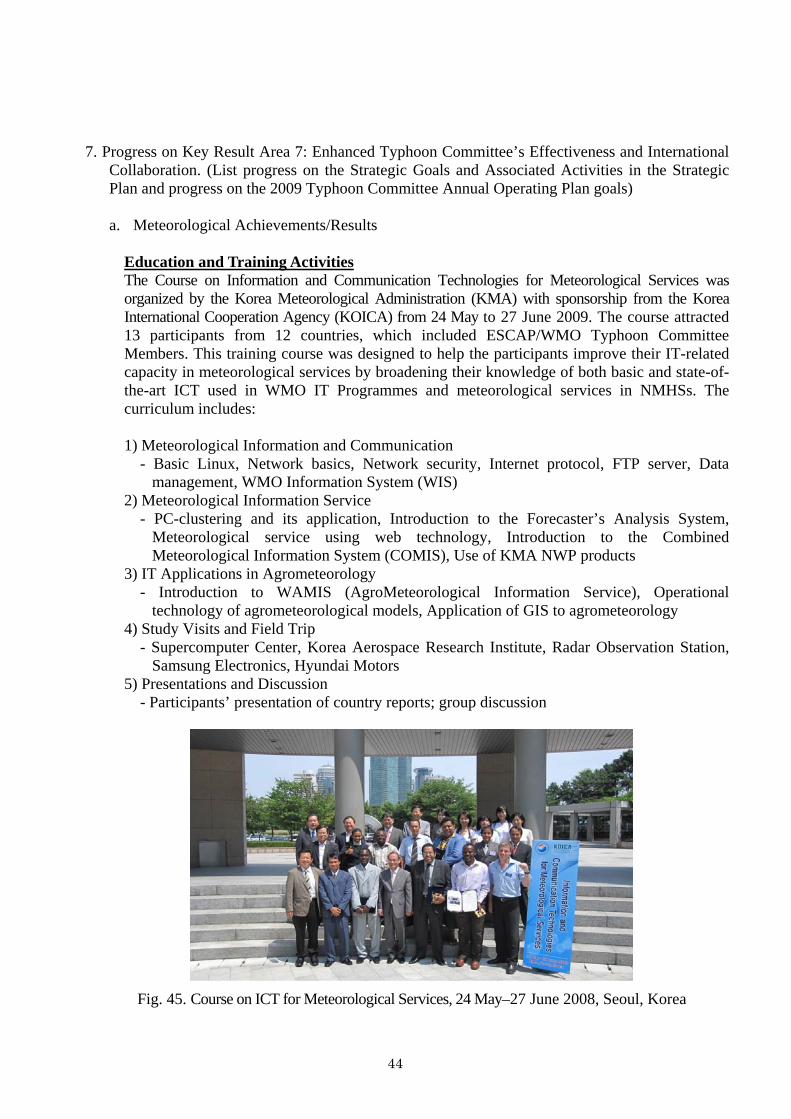
Education and Training Activities The Course on Information and Communication Technologies for Meteorological Services was organized by the Korea Meteorological Administration (KMA) with sponsorship from the Korea International Cooperation Agency (KOICA) from 24 May to 27 June 2009 The course attracted 13 participants from 12 countries which included ESCAPWMO Typhoon Committee Members This training course was designed to help the participants improve their IT-related capacity in meteorological services by broadening their knowledge of both basic and state-of-the-art ICT used in WMO IT Programmes and meteorological services in NMHSs The curriculum includes 1) Meteorological Information and Communication
- Basic Linux Network basics Network security Internet protocol FTP server Data management WMO Information System (WIS)
2) Meteorological Information Service - PC-clustering and its application Introduction to the Forecasterrsquos Analysis System
Meteorological service using web technology Introduction to the Combined Meteorological Information System (COMIS) Use of KMA NWP products
3) IT Applications in Agrometeorology - Introduction to WAMIS (AgroMeteorological Information Service) Operational
technology of agrometeorological models Application of GIS to agrometeorology 4) Study Visits and Field Trip
- Supercomputer Center Korea Aerospace Research Institute Radar Observation Station Samsung Electronics Hyundai Motors
5) Presentations and Discussion - Participantsrsquo presentation of country reports group discussion
Fig 45 Course on ICT for Meteorological Services 24 Mayndash27 June 2008 Seoul Korea
44
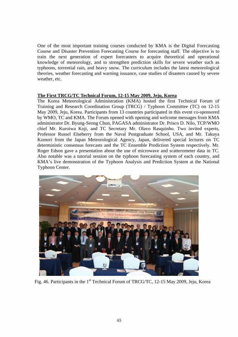
One of the most important training courses conducted by KMA is the Digital Forecasting Course and Disaster Prevention Forecasting Course for forecasting staff The objective is to train the next generation of expert forecasters to acquire theoretical and operational knowledge of meteorology and to strengthen prediction skills for severe weather such as typhoons torrential rain and heavy snow The curriculum includes the latest meteorological theories weather forecasting and warning issuance case studies of disasters caused by severe weather etc The First TRCGTC Technical Forum 12-15 May 2009 Jeju Korea The Korea Meteorological Administration (KMA) hosted the first Technical Forum of Training and Research Coordination Group (TRCG) Typhoon Committee (TC) on 12-15 May 2009 Jeju Korea Participants from 13 countries participated in this event co-sponsored by WMO TC and KMA The Forum opened with opening and welcome messages from KMA administrator Dr Byung-Seong Chun PAGASA administrator Dr Prisco D Nilo TCPWMO chief Mr Kuroiwa Koji and TC Secretary Mr Olavo Rasquinho Two invited experts Professor Russel Elseberry from the Naval Postgraduate School USA and Mr Takuya Komori from the Japan Meteorological Agency Japan delivered special lectures on TC deterministic consensus forecasts and the TC Ensemble Prediction System respectively Mr Roger Edson gave a presentation about the use of microwave and scatterometer data in TC Also notable was a tutorial session on the typhoon forecasting system of each country and KMArsquos live demonstration of the Typhoon Analysis and Prediction System at the National Typhoon Center
Fig 46 Participants in the 1st Technical Forum of TRCGTC 12-15 May 2009 Jeju Korea
45
The 2nd China-Korea Joint Workshop on Tropical Cyclones 19-23 Dec Shanghai China The Korea Meteorological Administration (KMA) and China Meteorological Administration (CMA) hosted the second joint workshop on tropical cyclones which was held on 19-23 December 2009 in Shanghai China Almost 50 experts in typhoons and related fields participated from National Typhoon CenterKMA Korea Meteorological Satellite CenterKMA National Institute of Meteorological ResearchKMA Shanghai Typhoon Institute (STI)CMA Nanjing University Nanjing University of Information Sciences and Technology the University of Maryland and the University of Utah 26 papers were presented at the workshop on a wide range of topics such as typhoon-related disasters the climate and typhoons typhoon forecasting technology typhoon genesis and structure changes in the development and decay stages KMA and CMA agreed that the third workshop will be held in 2010 in Korea with more experts from other countries and affirmed their commitment to future cooperation in typhoon research forecast and related areas
Fig 47 Participants in the 2nd China-Korea Joint Workshop on Tropical Cyclones 19-23 Dec 2009 Shanghai China
b Hydrological AchievementsResults
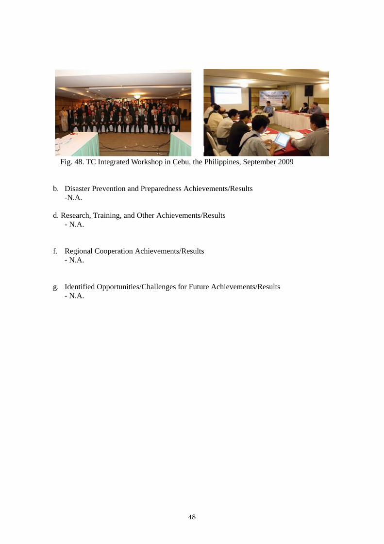
Participation in the Integrated Workshop of TC in Cebu the Philippines From 13 to 18 September 2009 lsquoIntegrated Workshop Building Sustainability amp Resilience in High Risk Areas of the Typhoon Committee Assessment amp Actionrsquo was held in Cebu the Philippines Approximately 100 experts and researchers from 14 Member countries in the region attended the workshop to share advanced knowledge and to discuss typhoon-related issues in the region From the Republic of Korea experts from 6 organizations took part in this workshop to share developed techniques and strategies relevant to water-related disasters caused by typhoons with other Members especially developing countries As shown in Table 5 each organization represented is a specialized and professional water-sector organization in Korea
46
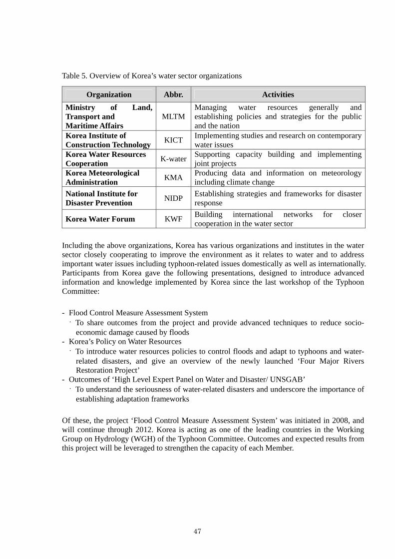
Table 5 Overview of Korearsquos water sector organizations
Organization Abbr Activities Ministry of Land Transport and Maritime Affairs
MLTMManaging water resources generally and establishing policies and strategies for the public and the nation
Korea Institute of Construction Technology KICT Implementing studies and research on contemporary
water issues Korea Water Resources Cooperation K-water Supporting capacity building and implementing
joint projects Korea Meteorological Administration KMA Producing data and information on meteorology
including climate change National Institute for Disaster Prevention NIDP Establishing strategies and frameworks for disaster
response
Korea Water Forum KWF Building international networks for closer cooperation in the water sector
Including the above organizations Korea has various organizations and institutes in the water sector closely cooperating to improve the environment as it relates to water and to address important water issues including typhoon-related issues domestically as well as internationally Participants from Korea gave the following presentations designed to introduce advanced information and knowledge implemented by Korea since the last workshop of the Typhoon Committee
- Flood Control Measure Assessment System
To share outcomes from the project and provide advanced techniques to reduce socio-economic damage caused by floods
- Korearsquos Policy on Water Resources To introduce water resources policies to control floods and adapt to typhoons and water-
related disasters and give an overview of the newly launched lsquoFour Major Rivers Restoration Projectrsquo
- Outcomes of lsquoHigh Level Expert Panel on Water and Disaster UNSGABrsquo To understand the seriousness of water-related disasters and underscore the importance of
establishing adaptation frameworks
Of these the project lsquoFlood Control Measure Assessment Systemrsquo was initiated in 2008 and will continue through 2012 Korea is acting as one of the leading countries in the Working Group on Hydrology (WGH) of the Typhoon Committee Outcomes and expected results from this project will be leveraged to strengthen the capacity of each Member
47
Fig 48 TC Integrated Workshop in Cebu the Philippines September 2009
b Disaster Prevention and Preparedness AchievementsResults
-NA
d Research Training and Other AchievementsResults - NA
f Regional Cooperation AchievementsResults - NA
g Identified OpportunitiesChallenges for Future AchievementsResults - NA
48
III Resource Mobilization Activities -NA
IV Update of Memberrsquos Working Groups representatives
1 Working Group on Meteorology Dr Won-Tae Yun Director International Cooperation Division Korea Meteorological Administration 45 Gisangcheong-gil Dongjak-gu Seoul156-720 Republic of Korea Tel +82-2-2181-0372 Fax +82-2-836-2386 E-mail pb_intkmagokr
2 Working Group on Hydrology
Dr Hong Il-Pyo (Vice-Chair) Senior Researcher Water Resources Research Department Korea Institute of Construction Technology 2311 Daehwa ilsan Goyang City Gyeonggi Republic of Korea Tel +82-31-910-0264 Fax +82-31-910-0251 E-mail iphongkictrekr
3 Working Group on Disaster Prevention and Preparedness
Dr Waon-Ho Yi Director National Institute for Disaster Prevention 253-42 Gongdeok-2Dong Mapo-Gu Seoul 121-719 Republic of Korea Tel +82-2-3271-3201 Fax +82-2-3271-3209 E-mail whyi1208nemagokr
4 Training and Research Coordinating Group
Dr KiRyong Kang Senior Researcher National Typhoon Center Korea Meteorological Administration 76-2 Hannam-ri Namwon-eup Seogwipo Jeju 699-942 Republic of Korea Tel +82-64-801-0224 Fax +82-64-805-0366 E-mail krkangkmagokr
5 Resource Mobilization Group
Dr Hee-Dong Yoo (Chairperson) Director Numerical Model Development Division Korea Meteorological Administration 45 Gisangcheong-gil Dongjak-gu Seoul 156-720 Republic of Korea Tel +82-2-2181-0672 Fax +82-2-2181-0689 E-mail hyookmagokr
49
MEMBER REPORT
ESCAPWMO Typhoon Committee 42nd Session
25-29 January 2010 Singapore
Republic of KOREA
2
CONTENTS
I Overview of tropical cyclones which have affectedimpacted Memberrsquos area since the last
Typhoon Committee Session helliphelliphelliphelliphelliphelliphelliphelliphelliphelliphelliphelliphelliphelliphelliphelliphelliphelliphelliphelliphelliphelliphelliphellip 3
II Summary of progress in Key Result Areas helliphelliphelliphelliphelliphelliphelliphelliphelliphelliphelliphelliphelliphelliphelliphelliphelliphelliphellip 9
1 Progress on Key Result Area 1 helliphelliphelliphelliphelliphelliphelliphelliphelliphelliphelliphelliphelliphelliphelliphelliphelliphelliphelliphelliphellip 9
2 Progress on Key Result Area 2 helliphelliphelliphelliphelliphelliphelliphelliphelliphelliphelliphelliphelliphelliphelliphelliphelliphelliphelliphelliphellip 22
3 Progress on Key Result Area 3 helliphelliphelliphelliphelliphelliphelliphelliphelliphelliphelliphelliphelliphelliphelliphelliphelliphelliphelliphelliphellip 26
4 Progress on Key Result Area 4 helliphelliphelliphelliphelliphelliphelliphelliphelliphelliphelliphelliphelliphelliphelliphelliphelliphelliphelliphelliphellip 27
5 Progress on Key Result Area 5 helliphelliphelliphelliphelliphelliphelliphelliphelliphelliphelliphelliphelliphelliphelliphelliphelliphelliphelliphelliphellip 32
6 Progress on Key Result Area 6 helliphelliphelliphelliphelliphelliphelliphelliphelliphelliphelliphelliphelliphelliphelliphelliphelliphelliphelliphelliphellip 34
7 Progress on Key Result Area 7 helliphelliphelliphelliphelliphelliphelliphelliphelliphelliphelliphelliphelliphelliphelliphelliphelliphelliphelliphelliphellip 44
III Resource Mobilization Activities helliphelliphelliphelliphelliphelliphelliphelliphelliphelliphelliphelliphelliphelliphelliphelliphelliphelliphelliphelliphelliphellip 49
IV Update of Memberrsquos Working Groups representatives helliphelliphelliphelliphelliphelliphelliphelliphelliphelliphelliphelliphellip 49
Summary helliphelliphelliphelliphelliphelliphelliphelliphelliphelliphelliphelliphelliphelliphelliphelliphelliphelliphelliphelliphelliphelliphelliphelliphelliphelliphelliphelliphelliphelliphelliphelliphelliphellip 50
3
I Overview of tropical cyclones which have affectedimpacted Memberrsquos area in 2009 1 Meteorological Assessment (highlighting forecasting issuesimpacts)
No typhoon landed in the Korean peninsula during the 2009 typhoon season However several typhoons presented typhoon forecasters with a greater challenge than in previous years One of them was typhoon Lupit (0920) which showed a very complicated track and extratropical transition process The typhoon was formed at 1800UTC 15 October 2009 about 630km west of Guam and first moved northwestward before changing course for the first time on 17 October 2009 It changed course once again on 23 October after which it sped up northeastward Track errors multiplied whenever the track displayed such irregularity (Figs 1 and 2) The extratropical transition (ET) time was computed as the typhoon moved northeastward KMA projected the extratropical transition to occur at 1800UTC 26 October 2009 but subsequently revised it to 18 hours earlier 0000UTC 26 October following re-analysis using its ET manual This was a case where KMA carried out re-analysis of the typhoon position prior to releasing an official forecast This experience has led KMA to recognize the importance of re-analyzing the typhoon position and to adopt a more objective scientific method
Fig1 Track of typhoon Lupit (0920) Fig2 Track error of typhoon Lupit (0920)
2 Hydrological Assessment (highlighting water-related issuesimpact) The 21st typhoon Mirinae occurred in Vietnam at 1500 (local time) on 27 October 2009 causing considerable damage with approximately 100 casualties 40 missing and 50 injured persons Typhoon Mirinae then started approaching the southern region of the Korean Peninsula KMArsquos National Typhoon Center issued a track report on Mirinaersquos approach toward the Korean Peninsula so as to prevent damage and to allow advance preparations against the projected approach Fortunately the typhoon weakened and dissipated to a tropical depression with a central pressure of 1000hPa and a wind speed of approximately 32kmh about 270km north of Ho Chi Min Vietnam at 0300 (local time) on 3 November without incurring any damage in Korea
4
Fig3 Track of typhoon Mirinae(0921) (Source Typhoon Research Center wwwtyphoonorkr)
Even though KMA tracked and issued reports on Mirinae Korea remained free of any typhoon impacteffect in 2009 for the first time since 1998 The Asian region (eg the Philippines and Vietnam) however did suffer from severe typhoons during the 2009 season and Korea was on guard to prepare against and respond to potential typhoon hazards (The typhoon name Mirinae was submitted by Korea)
Typhoon Morakot and Reservoir Flood Control This yearrsquos rainy season began three or five days later than normal on 20 June in the southern part of the country and Jeju Island and 28 June in the central region In early Changma (rainy season in Korean) the rainy front over the South Sea could not be activated because the Okhotsk High had already formed while the North Pacific High developed late As a result heavy rain was concentrated in the southern part with almost no rain (a dry Changma) in the central region Since mid-July the Changma front began to be activated as it gradually moved northward The atmosphere around the Korean Peninsula became unstable as the moderate and humid southwesterly skirted the North Pacific High and the upper cold air periodically shifted south A large amount of rain fell over the entire peninsula with this southward-northward shift Toward the end of the Changma season (end of July) the Changma front gradually started to move southward due to the weakening of the North Pacific High and the repeated expansion of the Okhotsk High finally dissipating on 29 July The temperature around the East Coast fell as an effect of the Okhotsk High Meanwhile the 8th typhoon Morakot made a weak landing near Fuzhou China in the afternoon of 9 August subsequently weakening to a tropical depression near Shanghai China in the afternoon of 10 August The weakened typhoon moved over to the Korean Peninsula on the westerly bringing much water vapor which then produced a large amount of rainfall over the entire country on 11-12 August In particular the heavy rainfall over Gyeongggi-do and Gangwon-do recorded approximately 200mm
5
Fig 4 Diagram of the atmosphere Fig 5 Diagram of the atmosphere in the early rainy season since the middle of rainy season
Fig 6 Track of typhoon Morakot and daily weather chart
Hydrological characteristics of dam basins During the rainy season the total rainfall amount at the 15 multipurpose dam basins was more than the normal year recording approximately 552mm The rainfall amount in the Han River Nakdong River Geum River and Seomjin River basins amounted to 531mm 526mm 521mm 789mm respectively an increase of 36 48 35 and 116 compared to the normal year
Also rainfall for a rainy season June 20th to July 29th amounted to 552mm and runoff rate happened about 63 percent and total runoff of 79 billion tons flowed into reservoir The total release of the Dam amounted to 43 billion tons and then approximately 35 billion tons water stored in reservoir Reservoir storage ratio went up 280 percent from 316 percent at the beginning of rainy season to 596 percent in the end
The storage rate of Han river basin rised to 23 percent and Nakdong rivers 27 percent and Keum rivers 30 percent and Seomjin rivers 54 percent at the end of rainy season Therefore most river basins carried out drought emergency action plan such as ground water supply multi-regional and state-regional water works network system and emergency drinking water supply system at the beginning of the rainy season due to severe drought condition
6
Table 1 Rainfall amount at dam basins during the rainy season (20 June to 29 July) Han Nakdong Geum Seomjin Others AvgItem
SY CJ HS AD IH HC NG MY YD DC SJ JA BA BR ZH2008 578 506 722 391 383 524 701 682 614 494 653 875 564 489 764 552
Normal 362 395 604 334 295 384 394 422 458 365 367 361 400 400 390 378 160 128 120 117 130 136 178 162 134 135 178 243 141 122 196 146
2008 531 526 521 789 627 Normal 390 356 386 365 396
136 148 135 216 158 SY Soyang CJ Chungju HS Hoengseong AD Andong IH Imha HC Hapcheon NG Namgang MY Milyang YD Yongdam DC Daecheong SJ Seomjin JA Juam BA Buan BR Boryeong ZH Jangheung
Fig 7 Storage variation in 100 million tons
Reservoir Operation During the flood season the maximum inflow rate recorded was 9369CMS at Chungju Dam 5163CMS at Soyanggang Dam and 4477CMS at Namgang Dam Sufficient flood control capacity had been secured before the rainy season began and the greater part of the flood was kept in store with the flood control rate of multi-purpose dams reaching approximately 83 At the beginning of the rainy season floodgate discharge was performed on 3 occasions at Namgang Dam and Miryang Dam because of the rainfall that was centered in the southern part of the Korean Peninsula In the latter part of the rainy season heavy rainfall due to the reactivation of the seasonal rain front necessitated floodgate discharge at Chungju Dam (1 time) Hwengseong Dam (1 time) Juam Dam (3 times) Daecheong Dam (1 time) and Guangdong Dam (2 times) When Typhoon Morakot approached the Korean peninsula flooding of the Han River was diminished to 5042CMS at the Hangang-Daegyo water level station thanks to the integrated reservoir operation of Soyang Chungju and Hoengseong dams in the Han River basin The water level at the Hangang-Daegyo water level station downstream of the dams was lowered by 19mmdashfrom 70m without dam operation to 51m with dam operationmdashas a result of these flood control measures
7
Table 2 Storage variation in Dam basins Item SY CJ HS AD IH HC NG MY YD DC SJ JA BA BR ZH Ave
milm3 1263 2426 111 351 224 208 1001 45 331 849 301 452 22 53 89 7706In flow max(CMS) 5163 9369 775 1603 1325 1356 4477 223 2327 4357 1841 2989 284 221 771
milm3 488 1898 89 51 82 14 860 14 46 443 29 227 3 11 13 4267out flow max(CMS) 246 2494 192 126 123 92 1785 28 23 704 28 514 1 4 8
620th 16784 12076 16582 13281 13855 14065 3552 17936 23846 6310 16375 8634 2948 5620 6590729th 18484 13008 17228 14483 14988 15668 4124 20060 25382 7218 19059 10273 3848 6689 7647
water level
(ELm) +- 1700 932 646 1202 1133 1603 572 2124 1536 908 2684 1639 900 1069 1057620th 1252 1030 27 287 138 158 47 26 175 562 21 67 15 21 57 3884729th 2033 1558 49 586 280 350 173 56 460 978 293 285 34 64 131 7329
storage (milm3)
+- 781 528 22 299 142 191 125 29 285 415 273 217 19 43 75 3445620th 43 38 31 23 23 20 15 36 21 38 4 15 29 18 30 32729th 70 57 57 47 47 44 56 76 56 66 63 62 67 55 69 59
storage rate () +- 27 19 25 24 24 24 41 40 35 28 59 48 38 36 39 28
SY Soyang CJ Chungju HS Hoengseong AD Andong IH Imha HC Hapcheon NG Namgang MY Milyang YD Yongdam DC Daecheong SJ Seomjin JA Juam BA Buan BR Boryeong ZH Jangheung
Table 3 Flood control effect at Hangang Daegyo in the Han River basin
Item Real value Without dam Flood control effect Date
peak flow (sec) 11488 16531 5042 water level (m) 51 70 19
12 Aug
Flood water 85m flood warning 105m
Fig 8 Flood control effect at the Hangang-Daegyo water level station
3 Socio-Economic Assessment (highlighting socio-economic and DPP issuesimpacts)
- NA 4 Regional Cooperation Assessment (highlighting regional cooperation successes and challenges)
- NA
8
II Summary of progress in Key Result Areas (For achievementsresults which apply to more than one Key Result Area please describe them under the most applicable Key Result Area Then at the end of the description place in parentheses ( ) the other applicable Key Result Areas)
1 Progress on Key Result Area 1 Reduced Loss of Life from Typhoon-related Disasters (List
progress on the Strategic Goals and Associated Activities in the Strategic Plan and progress on the 2009 Typhoon Committee Annual Operating Plan goals)
a Meteorological AchievementsResults
- NA
b Hydrological AchievementsResults
Urban Flood Disaster Management Research As a consequence of increased urbanization industrialization and population in urban areas it has become even more important to establish relevant policies and response strategies to manage risks and impacts caused by floods in a more flexible and efficient manner Environmental and economic adaptation to urban flood risks is particularly necessary given the increased frequency and intensity of water-related disasters such as typhoons associated with climate change As in other countries flood damage has shown a rapid increase in urban areas in recent years An example is Typhoon Nari in 2007 which inflicted damage on Jeju Island with flooding and landslides brought about by heavy rainfall The damage and loss was exacerbated even further due to poorly paved roads and shallow river banks Korearsquos recovery budget amounted to 13 billion USD every year in the last decade with as much as 27 billion USD in 2005 In Korea comparing between the property loss cost and rehabilitation budget the amount of rehabilitation budget is 16 times more than the property loss cost for the last 10 years (1996 to 2005) Approximately 50 of the loss was due to urban flooding
Fig 9 Flood damage in urban areas
9
In response the lsquoUrban Flood Disaster Management Research Centerrsquo was established under the Ministry of Land Transport and Maritimes Affairs (MLTM) The center initiated a project entitled lsquoUrban Flood Disaster Management Researchrsquo in 2003The vision and goals of this project which ended in 2008 are as follows - Analysis of urban flood disasters and development of design techniques - Development of techniques for a disaster prevention system that includes flood forecasting
and early warning for urban rivers - Development of design techniques for defensive facilities and infrastructures against urban
floods - Establishment of comprehensive flood control plans and strategies in urban areas with
advanced techniques for practical management and operation Project efforts led to the development of urban flood disaster management techniques and the construction of disaster prevention systems in urban areas Another outcome was the implementation of the lsquoFlood-free Cityrsquo project which aims to strengthen capacity for responding to flood risks and improve resilience to water-related urban disasters As shown in Fig 10 the project was decomposed into four components and advanced urban flood adaptation techniques were developed as sub-tasks The results included the following - Regional rainfall frequency analysis program (Fig 11) Estimation of rainfall probability using regional frequency analysis Database utilization for water infrastructure design and planning Establishment of proper flood forecasting and warning systems using regional frequency
analysis for urban watersheds
Fig 10 Project structure
10
- Urban runoff and quality analysis model (Fig 12) Analysis of pollutant conduction with urban surface runoff channel and sewer runoff and
initial overflow Practical model for estimating urban and rural flood discharge and designing pipe
networks
- Two-dimensional model for computing vegetative channel in urban rivers (Fig 13) Two-dimensional numerical model for computing vegetated open channel flow
characteristics Feature for estimating longitudinal and lateral flow characteristics at vegetated open
channels Feature for assessing water facilities with vegetation effects in flood plain planning and
utilization
- Operation of rainfall pumping station program (Fig 14) Prediction of variation in the real-time internal drainage stage and detention basin stage
using rainfall and geographic parameters Operating model(automatic) for the rainfall pumping station Enables selection of pump operation rules according to the detention basin area pump
capacity watershed area basin slope etc
- Short-time rainfall prediction model with weather radar (Fig 15) Predicts short-time rainfall variation by computing cloud migration direction and velocity Complements short-time rainfall prediction with numerical weather prediction Uses input data for rainfall runoff analysis
- Urban basin rainfall forecasting model (Fig 15)
Rainfall forecast at 30-minute intervals with up to a 4-hour lead time using weather radar reflectance and radar precipitation
Detects local heavy rain and migration of rainfall that is hard to observe by point rainfall station using high-resolution weather radar data and space-time analysis capacity
Urban flood forecasting and warning and basic rainfall analysis data using flood discharge estimation
Fig 11 Regional Rainfall Frequency Analysis
11
Fig 12 Urban runoff and quality analysis
Fig 13 Establishment of user-tailored vegetated areas
Fig 14 Real-time pumping station control graph
Fig 15 Urban basin rainfall forecasting model (left Precipitation calculation with radar
right Application to urban areas)
12
Although the lsquoUrban Flood Disaster Management Researchrsquo already brought about the development of various techniques and strategies during the 5 years (2003-2008) of its implementation the project is still relevant Efforts are under way to implement the outcomes developed as part of this project for practical use The outcomes are used to create a system for hydrological and hydraulic analysis of urban flooding and urban flood forecasting that takes into account structural and nonstructural measures The project is expected to help establish comprehensive flood control measures for urban river basins and an urban flood defense system which in turn will help reduce casualties and economic loss and eventually establish the lsquoFlood-free Cityrsquo project in each Member country in the region
Four Major Rivers Restoration Project The lsquoFour Major Rivers Restoration Projectrsquo is currently one of the Korean governmentrsquos key agenda items The fundamental objective of the project is to prepare more efficient measures to respond to floods and droughts caused by climate change The project will help produce more secure river spaces with diverse usages through riverbank reinforcement riverside reservoir redevelopment and ecosystem restoration The need for fundamental flood control measures is increasingly felt in Korea as a result of repeated and frequent flood damage The average yearly precipitation in Korea is 1245mm with two thirds falling in the summer Therefore preparations against summertime heavy rainfall floods and typhoons are very important Rivers in Korea are generally short and highly sloped exhibiting large fluctuations in river discharge As a result the possibility of floods is significantly high in Korea Yearly flood damage is 23 billion USD and rehabilitations cost 35 billion USD Korea government is increasing investment for projects research infrastructure and technologies to strengthen flood control and plans with a view to maximizing investment efficiency through prioritizing It has also been developing flood control measures for each river basin and devising ways to implement these measures The lsquoFour Major Rivers Restoration Projectrsquo bears a close relation to these policies and strategies Ultimately the project aims to prepare rivers so that they may withstand floods and water-related disasters for 200 years Existing levees will be fortified and mega-scale levees will be constructed as safeguards against flooding Furthermore small- and mid-sized dams and retention areas will be established to enhance flood control within river basins and excessive deposits will be dredged to identify possible floodways
Fig 16 Illustration of waterfront improvement
13
Upon completion of this project damage (27 trillion KRW per year) and restoration costs (42 trillion KRW per year) due to flooding are expected to decline thanks to the reinforced riverbanks small- and medium-sized dams and flood control areas The following are the master plans for each of the four major riversmdashHan River Geum River Nakdong River and Yeongsan Rivermdashas regards flood control and water-related disaster prevention
- Han River
Lower flood level (04~39m) by dredging deposits Increase flood control capacity by creating riverside flood control spaces and reservoirs Reinforce old riverbanks to improve flood control safety (131km)
- Geum River Flood countermeasures Increase flood control capacity to 100 million m3
- Nakdong River Establish 8 levees to strengthen water storage capacity Improve locks to lower water level
- Yeongsan River Flood countermeasures Increase flood control capacity to 120 million m3
In addition to providing enhanced flood control capacity the project is expected to enable storage of abundant water resources to create eco-friendly spaces for better lives to restore the ecosystem and environment in rivers and to develop rural communities and areas The project which was launched this year is scheduled for completion in early 2012 (Sources www4riversgokr wwwmltmgokr)
Fig 17 Map of the Four Rivers Project
14
Fig 18 Project work on the Nakdong River (Before and After)
c Disaster Prevention and Preparedness AchievementsResults Development of interactive methodology for CCTV operation
Korearsquos National Emergency Management Agency (NEMA) established interactive methodology to integrate disaster-related information such as rainfall water surface elevation discharge snow depth and CCTV data collected by various related organizations and local governments of cities and districts CCTVs are an especially important tool given their locations in key areas although most of their application so far has been in law enforcement rather than disaster management NEMA has developed an integrated operation system to connect all disaster-related information and represent them on GIS maps for real-time linking of monitoring meteorological and hydrological data including CCTV images The system is equipped with an advanced monitoring function facilitated by color- and shape-coding These integrated measurements on GIS maps will significantly contribute to decision-making for managing extreme events on a local scale
Fig19 Integrated Measurement Information System
15
- Information from local measuring station Information from the local measuring stations such as water surface elevation discharge
rainfall snow depth and CCTV data Natural disaster information such as CCTV images of inundation landslides flooding
debris flow and damage collected by the local measuring stations Natural disaster information such as CCTV images of fire wild fires collapses and
explosions from the local measuring stations Update of information on automatic local measuring stations through continuous video
capture
- Information from related organizations Water surface elevation rainfall snow depth and CCTV data collected by KWater (Korea
Water Resources Corporation) measuring stations AWS information and 3-hour weather information from KMA (Korea Meteorological
Administration)
- GIS-based integrated measurement information system CCTVs are classified according to their use and grouped by region or specific disasters on
GIS maps Information including CCTV images are displayed according to specific parametersmdashview
of the river typhoon trajectory selected region(s) etc CCTV images are displayed with a warning when disasters occur
The National Institute for Disaster Prevention (NIDP) developed an automatic damage detecting system for disaster management which detects damage by comparing before and after images of a given site and issues warnings to decision-makers For example color changes in a specific area may indicate a wild fire while geological information helps identify landslides and water surface elevation over the warning line indicates flooding The system may also help decision-making for managing extreme events on a local scale
Fig 20 Related organizations information system
16
Development of decision-making system for disaster response or management NEMA established a decision-making system to effectively respond to expected extreme events based on analyzed results from monitoring modeling and statistical analysis of meteorological elements and rainfall runoff The system facilitates accurate and fast analysis by flagging areas vulnerable to flooding and landslides displaying all the relevant information on GIS maps for decision-makers The system is equipped with the following decision-making support functions using GIS-based observational information
- Link of the observational information
The system links water surface elevation rainfall snow depth and CCTV data collected by related organizations
- Decision-making support Function for analyzing disaster-related information with information on consequences and
damage Establishment of warning and notification system to communicate disaster information
and development of countermeasures based on collected information Reference function for watershed or administrative information Function for decision-making to reduce inundation damage with inundation maps
developed using inundation data from 1995 to 2007 Distributed rainfall runoff model to represent expected inundation areas using expected
rainfall data
Fig 21 Decision-making system main page
17
Fig22 MAPLE data analysis system
Development of System for Disaster Situation Analysis and Decision Making The National Institute for Disaster Prevention (NIDP) developed a system called System for Disaster Situation Analysis and Decision Making for rapid disaster response such as evacuation and traffic cutoff The system seeks to improve upon the existing disaster management system using general analysis of vulnerable zones based on historic damage information This development project consists of the following key features - Estimate typhoon trajectories using reports from the Korea Meteorological Administration
(KMA) the Joint Typhoon Warning Center (JTWC) the Regional Specialized Meteorological Center (RSMC) and the Hong Kong Observatory (HKO) as well as vulnerability analysis based on historic damage information soil moisture content shape of the basin and degree of soil saturation
- Establish systems for monitoring water levels of the major rivers collecting information on tide levels dam management river management and digital forecasting
- Support monitoring-based decision-making for disaster management in vulnerable zones The system will mainly concentrate on the following
- Preliminary characteristic analysis of administrative districts divided by GIS information (digital map land cover map land use map soil type map) and meteorological information
- Vulnerability analysis by linking meteorological information and hydrological information (runoff coefficient running water direction soil moisture content)
- Preliminary forecasting and warning on vulnerable zones to support disaster management decisions
18
Fig 23 Disaster Information Sharing System
Fig 24 Disaster Monitoring System
19
Fig 25 Disaster Risk Analysis System
d Research Training and Other AchievementsResults
Policy amp Research for Global Disaster Management (PR4GDM) The National Emergency Management Agency (NEMA) organized the Policy amp Research for Global Disaster Management (PR4GDM) so as to create a new environment for research and development activities that seek to address climate change and reinforce future disaster management capabilities Fifty-two experts from universities government and public research institutes in the USA Japan Canada China Norway the UN and Korea attended PR4GDM in Seoul from 11 to 13 November The keynote speeches covered areas such as major RampD policies future disaster prospects and international cooperation Six additional presentations were given on i) Green Growth and climate change ii) firefighting and emergency rescue iii) education and training iv) firefighting and natural disaster prevention technologies v) firefighting and public safety and vi) IT and spatial information The meeting also consisted of in-depth discussion on the science of disaster management and explored development schemes helping worldwide promotion of RampD for disaster prevention technological cooperation and the basis of a national disaster prevention network to cope with climate issues
20
Fig 26 Policy amp Research for Global Disaster Management
d Regional Cooperation AchievementsResults - NA
f Identified OpportunitiesChallenges for Future AchievementsResults
- NA
21
2 Progress on Key Result Area 2 Minimized Typhoon-related Social and Economic Impacts (List progress on the Strategic Goals and Associated Activities in the Strategic Plan and progress on the 2009 Typhoon Committee Annual Operating Plan goals)
a Meteorological AchievementsResults
b Hydrological AchievementsResults
Development of Flood Control Measure Assessment System The frequency and intensity typhoons and floods in the region including Southeast Asia has recently increased due to accelerating urbanization industrial activity highly dense land use heavy construction of infrastructure and especially climate change impact This threat extends not only to human lives but is also causing significant economic loss which is gradually increasing In view of such a threat it is necessary to develop and secure more advanced and standardized methods to assess the efficiency of flood control plans and to establish a comprehensive and integrated system to identify optimal flood control measures by eliminating uncertainties of socio-economic impacts Economic damage attributable to floods in Korea is steadily increasing with an increase of close to 11 times in three decades Even more alarming is the fact that this trend is also seen around the world A project entitled lsquoFlood Control Measure Assessment Systemrsquo was launched in 2008 under the leadership of Korearsquos Ministry of Land Transport and Maritime Affairs (MLTM) This long-term project will be completed in 2012 with the yearly targets shown in Fig 27 There is now clear recognition of the importance of basin-unit flood control measures To reduce loss and damage caused by floods it is necessary to develop basin-unit flood control measures instead of mere 1-dimensional river-unit flood measures for long-term general use Basin-unit flood control measures are nonetheless free from weaknesses some of which include the following
Fig 27 Annual task targets (2008-2012)
22
- Deduction and selection of flood control measures that rely on the experience of experts - Absence of a unified procedure or system - Estimation of the economical efficiency of flood control measures based solely on structural
damage
Moreover criteria for selecting certain flood control measures over others are unclear giving rise to considerable vagueness and confusion Although basin-unit flood control has been attracting more attention since the launch of the integrated basin flood control project an integrated process or system is yet to be developed for assessing and preparing basin-unit flood control plans The eventual objective of this research is to establish a standardized and integrated assessment system for flood control measures so that these measures can ultimately find practical use in Member countries of the TC community to reduce socio-economic damage caused by typhoons and floods in the region The assessment system may make it possible to implement pre-assessment steps to select economically optimal flood control measures which would then enable Member countries to develop their own capacity against floods while also strengthening international cooperation among Members
- Proposal of a scheme for an integrated assessment system of flood control measures - Establishment of a scheme to select economically optimal flood control measures - Construction of a viable assessment system for Typhoon Committee Members
- Construction of a reasonable and integrated flood control measure assessment system - Utilization as a future pre-assessment system - Enhancement of international cooperation among Members in the region
Since its inception the project has surveyed and analyzed the current status of flood control measures in Korea and Member countries including several developed countries To understand the weaknesses of each existing assessment system or framework information was collected on flood response measures from major related organizations It was also necessary to analyze each flood control measure assessment system implemented by developed countries and Members Analysis was conducted of each Memberrsquos needs and expectations regarding such an assessment system as well as technical information and data required to build such a system to help design a preliminary assessment system This was followed by constructing a database to manage inputsoutputs of each assessment factor Finally a basic design for the assessment system was developed upon which to devise a master plan for a flood control measure assessment system that will eventually satisfy the identified goals and requirements As mentioned above and shown in Fig 28 the goal of this project is not only to evaluate structural measures but also to propose a process and methodology to properly determine
23
flood discharge in basins and river channels and non-structural measures such as gradation of protection levels according to flood control regions and allocation of flood discharge Research and analysis are currently under way on hydrological results and socio-economic impacts caused by each existing flood measure HAZUS-MH a standardized system for quantified analysis and data developed by the US FEMA serves as a model of the prospective assessment system and key reference for this project HAZUS-MH enables integrated assessment of flood damage and unifies operational procedures and systems At the same time HAZUS-MH is equipped with a general-purpose database structure By implementing an analysis of each module the assessment system that this project seeks to realize is being refined The project will be completed in 2012 with an integrated and comprehensive flood control measure assessment system that will help minimize socio-economic damage caused by floods Ultimately the final assessment system will be used to establish more efficient flood control measures and at an international level to strengthen technical and information-oriented cooperation among Members in the region
Fig 28 Preliminary design of measure classification system
c Disaster Prevention and Preparedness AchievementsResults
Foundation of promotion corps to reinforce vulnerable zones Korearsquos National Emergency Management Agency (NEMA) founded a promotion corps on 28 October 2009 to reinforce vulnerable zones and energize the regional economies of these zones Government support will include a budget of 888 million USD for Year 2010 to
24
strengthen disaster prevention in disaster-prone regions rural streams and construction sites The promotion corps composed a technical support team consisting of government officers of NIDP and university researchers to help minimize budget waste and prepare countermeasures for vulnerable zones
If the budget for disaster prevention projects is invested appropriately according to plan improvement projects for 791 disaster-vulnerable zones will be completed bringing capacity up to date by 5 years Improvement projects will also be implemented for 14 disaster prevention facilities including the Nohak drain pump in Sokcho Gangwon-do showing an upgrading for 3 years compared to its pre-project status
d Research Training and Other AchievementsResults
- NA
e Regional Cooperation AchievementsResults - NA
f Identified OpportunitiesChallenges for Future AchievementsResults
- NA
25
3 Progress on Key Result Area 3 Enhanced Beneficial Typhoon-related Effects for the Betterment of Quality of life (List progress on the Strategic Goals and Associated Activities in the Strategic Plan and progress on the 2009 Typhoon Committee Annual Operating Plan goals)
a Meteorological AchievementsResults
- NA
b Hydrological AchievementsResults - NA
c Disaster Prevention and Preparedness AchievementsResults - NA
d Research Training and Other AchievementsResults - NA
e Regional Cooperation AchievementsResults - NA
f Identified OpportunitiesChallenges for Future AchievementsResults - NA
26
4 Progress on Key Result Area 4 Improved Typhoon-related Disaster Risk Management in Various Sectors (List progress on the Strategic Goals and Associated Activities in the Strategic Plan and progress on the 2009 Typhoon Committee Annual Operating Plan goals)
a Meteorological AchievementsResults - NA
b Hydrological AchievementsResults
- NA
c Disaster Prevention and Preparedness AchievementsResults
Enhanced WEB GIS Based Typhoon Committee Disaster Information System The National Institute for Disaster Prevention (NIDP) officially launched the WEB GIS Based Typhoon Committee Disaster Management System (WGTCDIS) which enables sharing of Typhoon Committee Membersrsquo disaster information including typhoon damage disaster management system and early warning system The system provides a variety of additional services including tracking of similar typhoons retrieval of damage information on multiple disasters meteorological information and regional weather risk analysis
Fig 29 Main features of WEB GIS based TCDIS
27
Fig 29 (Contrsquod)
NIDP-led efforts to promote the WEB GIS based TCDIS (WGTCDIS) to TC Members will continue in 2010 TC Members such as the Philippines Lao PDR and Thailand are to provide GIS meteorological and disaster information for WGTCDIS by end of 2009 and NIDP will provide expert missions to set up WGTCDIS for TC Members and improve WGTCDIS usage NEMA-led efforts will also continue in 2010 to enhance WGTCDIS and establish a methodology to assess socio-economic impacts of disasters TC Members such as the Philippines Lao PDR Malaysia Hong Kong Macao Cambodia the USA Viet Nam the Republic of Korea and Thailand will submit disaster information on one to two cases of typhoon damage in their countries NIDP will compile this information into a report for presentation at the 5th WGDPP meeting in Seoul Korea 2010 will furthermore see the continued review of the WGTCDIS progress and activities to enhance TCrsquos effectiveness and efficiency in meeting its mandate as stated in the Statute of the Typhoon Committee WGDPP will participate in a focused integrated WGM WGH WGDPP TRCG and AWG Workshop with specific deliverables defined in addition to evaluating the progress of the WGTCDIS project and future WGDPP activities To ensure continued relevance of the WGTCDIS project it is necessary to validate Viet Namrsquos WGTCDIS and to secure typhoon and damage-related data from new Members Viet Nam will identify joint activities and inform Members for validation of its WGTCDIS Thailand Lao PDR (5 years) the Philippines and Hong Kong (5 years) will prepare data for developing their own WGTCDIS Once WGTCDIS for these four Members has been constructed expert missions to these members will be conducted to provide information on the system and its application These expert teams which will be organized at the TC Sessions will be implemented once the Member completes installation of its WGTCDIS In 2010 WGTCDIS will see improved user convenience and accessibility through integration of the two above-mentioned services and a wealth of contents for Members WGTCDIS will be applied to three additional members during this yearmdashLao PDR Thailand and the Philippines
28
d Research Training and Other AchievementsResults
Expert missions In 2005 NEMArsquos National Institute for Disaster Prevention (NIDP) started developing TCDIS the first project of TCrsquos Working Group on Disaster Prevention and Preparedness (WGDPP) The first version of TCDIS was made available to the public in 2006 with a revised version launched in 2007 TCDIS is a system for sharing typhoon information of TC Members including their disaster management system early warning system disaster statistics disaster reports and WGDPP activities Since active assistance from TC Members is vital to the successful completion of the project expert missions were provided to encourage voluntary support from Members The first expert mission was dispatched to four membersmdashLao PDR Viet Nam Thailand and the Philippines on 11-20 May 2008 The executive secretary and the chairman of WGDPP participated in the first expert mission whose smooth progress was facilitated by active assistance from the four Members The 2nd expert mission was implemented to introduce the new system and provide instructions on usage and data input into WGTCDIS The expert mission to Viet Nam decided at the 41st TC Session in Chiang Mai assisted Members with data collection and promoted TCDIS by demonstrating how TCDIS can help Members prepare timely and efficient response to typhoons and related disasters TCDIS can also be used as a platform for information exchange to reduce damage from typhoon-related disasters and as a source of information on essential typhoon-related disasters for decision-makers NIDP a member of the Typhoon Committee Working Group for Disaster Prevention and Preparedness (TCWGDPP) developed the WEB-GIS based TCDIS as the second project for the Working Group The new WEB-GIS based TCDIS saw significant aesthetic improvements adopting the style of the WMO website Features for estimating similar typhoon trajectories and typhoon damage were also upgraded with Member data The 2008 expert mission contributed data for TCDIS such as GIS weather station data and typhoon-related damage The WEB-GIS based TCDIS for Viet Nam was developed based on the information collected from Viet Nam The main objectives of the expert missions are to i) promote the usage and benefits of the WEB-GIS based TCDIS to the governmental agencies of Viet Nam ii) identify needs and gaps of participating Members in relation to the implementation of the WEB GIS Based TCDIS as an early warning system and acquisition of the necessary information for the WEB GIS Based TCDIS and iii) explore whether there is a need for public outreach initatives in relation to EWS disaster prevention and preparedness in participating Members
- Expert mission plan
Dates 2 March (Mon) ndash 7 March (Sat) Participating Member(s) Viet Nam 0 Expert team Dr Yi (Chair of WGDPP) Dr Tae Sung Cheong (NIDP) Dr Eun-Mi Chang
(KSIC)
29
- Program Country Date Contents Presenters
Ha Noi Viet Nam
2 Mar (Mon)
middot Flight to Hanoi from Incheon middot 1500-1530 Briefing on expert mission middot 1530-1620 Briefing on WEB-GIS based TCDIS middot 1630-1900 Demonstration and discussion
Chair (Dr Yi) Dr Chang Dr Cheong
Da Nang Viet Nam
3 Mar (Tue)
middot Flight to Da Nang from Hanoi middot 1400-1430 Opening ceremony middot 1430-1530 Briefing on expert mission middot 1600-1800 Briefing on WEB-GIS based TCDIS
Host Chair (Dr Yi) Dr Chang
Da Nang Viet Nam
4 Mar (Wed) middot 0900-1000 Briefing and discussion of disaster maps middot 1100-1800 Demonstration and discussion (TCDIS dMap)
Dr Cheong All
Da Nang Viet Nam
5 Mar (Thu)
middot 0900-1030 Decision support system for inundation damage reduction middot 1030-1200 Disaster management system of Viet Nam middot Flight to Ho Chi Min from Da Nang
Dr Cheong Nguyen Viet Tien
Hochi Minh Viet Nam
6 Mar (Fri)
middot 0900-0930 Opening ceremony middot 0930-1000 Briefing on expert mission middot 1020-1200 Briefing on WEB-GIS based TCDIS middot 1400-1540 Briefing and discussion of disaster maps middot 1600-1800 Demonstration and discussion (TCDIS dMap)
Host Chair (Dr Yi) Dr Chang Dr Cheong All
Hochi Minh Viet Nam
7 Mar (Sat) middot 0900-1200 Demonstration and discussion (TCDIS dMap) middot Flight to Incheon from Hanoi
All
- Schedule
Date From To Details Person in Charge
2 Mar (Mon)
Incheon
Ha Noi
KE5683 Departure 1015 Arrival 1315
Dr Yi Dr Chang Dr Cheong
3 Mar (Tue)
Ha Noi
Da Nang
VN0315 Departure 1010 Arrival 1125
Dr Yi Dr Chang Dr Cheong
5 Mar (Thu)
Da Nang
Hochi Minh
KE5683 Departure 1740 Arrival 1850
Dr Yi Dr Chang Dr Cheong
7 Mar (Sat)
Hochi Minh
Incheon
KE0682 Departure 2350 Arrival 0650
Dr Yi Dr Chang Dr Cheong
Fig 30 Expert mission in Ha Noi
30
Fig 31 Expert Mission in Da Nang
Fig 32 Expert mission in Ho Chi Minh
e Regional Cooperation AchievementsResults
- NA
f Identified OpportunitiesChallenges for Future AchievementsResults - NA
31
5 Progress on Key Result Area 5 Strengthened Resilience of Communities to Typhoon-related Disasters (List progress on the Strategic Goals and Associated Activities in the Strategic Plan and progress on the 2009 Typhoon Committee Annual Operating Plan goals)
a Meteorological AchievementsResults
-NA
b Hydrological AchievementsResults - NA
c Disaster Prevention and Preparedness AchievementsResults - NA
g Research Training and Other AchievementsResults
Opening of the UNISDR Education and Training Institute UNISDR Northeast Asia Office for Urban Risk Reduction The government of the Republic of Korea is establishing strategies and plans for climate change response viewing the next 2-3 years as the crucial and defining moment After signing an MOU with the United Nations NEMA opened the Office for Urban Risk Reduction and the ISDR Education and Training Institute on 11 August 2009 The ISDR Education and Training Institute for Urban Risk Reduction is the first United Nations educational and research facility for professional urban planners city managers and officials of local authorities in the field of disaster risk reduction It will cultivate establish and vitalize networks of Disaster Risk Reduction specialists through extensive education and training of disaster-related government officials and NGO officers worldwide It will also help science and technology sharing for disaster risk reduction and stimulate the exchange of disaster-related information and data Simultaneously it is expected to help propel Korearsquos high-tech IT DRR technologies and Green Growth industry onto the international stage With official operations scheduled to start in 2010 NIDP organized two pilot training programs in September and November based on survey of trainee demands from various countries NIDP plans to operate the Institute like no other existing institutes by introducing a new form of special support educational program to maximize the practical value of all training offered at the institute The program was developed to provide close-proximity training on Korearsquos policies in the area of disaster prevention and mitigation as well as situation management by showcasing model policies technologies and systems The main topics included the following Establishment of DRR planning for urban areas Regional safety diagnosis systems Comprehensive Meteo-hydrological disaster reduction plans Disaster insurance programs Region autonomous risk reduction Situation analysisdecision systems and Early warning systems
Disaster management officials from 10 Members of the Association of South East Asian Nations (ASEAN) and 8 Members of the South Asian Association for Regional Cooperation (SAARC) participated in the 1st pilot training Disaster management officials from Northeast Asia and the Middle East participated in the 2nd pilot raining Guided by the Hyogo Framework for Action (HFA) the UNISDR Office will provide technical assistance to the
32
ISDR Education and Training Institute for Urban Risk Reduction The ISDR Education and Training Institute will assist in providing good international practices in the forecast of and response to common disasters such as typhoons Asian Dust earthquakes and droughts cooperation in and sharing of technologies for forecast and observation for risk reduction and support of DRR programs
Fig 33 Opening ceremony of the UNISDR Education and Training Institute
UNISDR Northeast Asia Office for Urban Risk Reduction Disaster Management Education and Training Programs
NEMArsquos NIDP invites high-ranking officials from Bangladesh to its disaster management education training program NEMA and the Korea International Cooperation Agency (KOICA) organize the education program where participants can benefit from Korearsquos experience in national disaster control by studying Korearsquos national disaster information system and prediction and prevention system The ten Bangladeshi delegates will also be exposed to traditional Korean culture during the three-week program Bangladesh which sustains tremendous damage from floods every year decided to dispatch ten high-ranking public officers in charge of the countryrsquos disaster management overseas to gain insights from industrialized countries in advancing the countryrsquos disaster control system NIDP also provided a disaster management education program to government officials from Paraguay in May 2008 It plans to further expand cooperation with other countries by offering disaster management education to public officers from ten countries including China Nicaragua and Indonesia in the second half of this year
e Regional Cooperation AchievementsResults - NA
f Identified OpportunitiesChallenges for Future AchievementsResults - NA
33
6 Progress on Key Result Area 6 Improved Capacity to Generate and Provide Accurate Timely and understandable Information on Typhoon-related Threats (List progress on the Strategic Goals and Associated Activities in the Strategic Plan and progress on the 2009 Typhoon Committee Annual Operating Plan goals)
a Meteorological AchievementsResults
Update of Operational Tropical Cyclone Analysis System KMA has been operating a typhoon analysis system based on MTSAT-1R satellite data since 2005 This typhoon analysis system utilizes the Advanced Objective Dvorak Technique (AODT) which is based on satellite observations (Dvorak Technique) from SSECUW-Madison (Space Science Engineering CenterUniversity of Wisconsin-Madison) KMArsquos typhoon analysis system has been in operation using AODT and producing statistical results However AODT is difficult to directly apply to the Northwest Pacific region as it was initially developed mainly for hurricanes in the Atlantic KMA developed a user-friendly web-based SATellite Image analysis System (SATIS) in 2006 recently adding new functions that make it possible to search and download past typhoon analysis data from the database SATIS is easier to use for analyzing tropical cyclones especially for detecting similarities in the database Once a typhoon name and its year are chosen the search results can be saved in the user directory as text files Fig 34 illustrates a full search list of similar tropical cyclones from SATIS which includes eye position intensity (CI index) eye temperature scene type and radius maximum wind (RMW) along with image data
Fig 34 Full search results of past data on tropical cyclones from SATIS
34
Expansion and Improvement of KMArsquos Upper-air Observation Network
Since 2003 KMA has been developing the KMA wind profiler network (KWPN) which comprises ten wind profilers to improve the temporal and spatial resolution of its upper-air observation network Beginning with Munsan and Gangneung in 2003 wind profilers were installed in Gunsan in 2004 and Masan in 2005 In 2007 five additional wind profilers were installed in Uljin Chupungnyeong Wonju Cheolwon and the Base Station of Oceanic-Meteorological Observation 75km off the west coast of Korea thus completing the KWPN KMA currently operates ten wind profilers including one installed in Haenam by its research arm NIMR (National Institute of Meteorological Research) The horizontal resolution of the upper-air observation network in Korea has dramatically improved as a result from 128 km in 2002 to 74 km in 2007 Wind data up to 5 km are collected every 10 minutes through the KWPN and are subsequently assimilated in the operational regional numerical model following an automated quality control process These data help improve the accuracy of heavy rain heavy snow and typhoon track predictions Nine microwave radiometers were also installed at the wind profiler sites in 2009 to collect information on a variety of upper-air elements such as wind temperature humidity and liquid water content KMA plans to further integrate its upper-air observation network to include a GPS observation network in addition to the existing wind profilers and microwave radars
Fig 35 KMArsquos upper-air observation network and wind profiler sites
Establishment of K-ROC (Korea Radar Operations Center) and Radar Replacement The Korea Meteorological Administration (KMA) installed its first radar in Seoul (Mt Gwanak) in 1969 Since then KMA has built a radar network consisting of 10 radars that provide nationwide coverage KMA plans to establish K-ROC (Korea Radar Operations Center) in 2010 The Center will enhance the efficiency of KMArsquos radar operations by enabling integrated operations of KMArsquos weather radar observation network and the establishment of standard operations procedures It is also expected to help raise the quality of
35
radar products develop application techniques and improve observation accuracy thereby enabling maximum use of these products In addition KMA plans to relocate the Donghae radar to Gangneung and replace outdated equipment with the state-of-the-art radar with operations scheduled to start in the first half of 2010 These measures will provide a solution to the observational blind spot in the northern part of the Gangwon region
Fig 36 Working process of K-ROC (Korea Radar Operations Center)
a) (b)
Fig 37 (a) KMArsquos weather radar network (b) Gangneung weather radar site
36
Adoption of 4DVAR
Based on KMArsquos strategic plans the current operational NWP system will be replaced with the UKrsquos Met Office Unified Model (UM) in 2010 and the data assimilation method will be upgraded to 4DVAR With help from the Australian Bureau of Meteorology the UMrsquos MetDB (Meteorological Data Bank) will be replaced with the ODB (Observation Data Base) to maximize portability and scalability of its OPS (Observation Processing System) Since April 2009 KMA has been running 4DVAR every 6 hours with a 6-hour window on the locally received observations in parallel with the existing operational NWP system so as evaluate the performance of the UM prior to full operation The performance of the UM has so far proven promising with support from the large volume of data assimilated in 4DVAR The volume of satellite data has considerably increased with the adoption of 4DVAR Satellite data is needed to fill data void areas such as the ocean where typhoons may linger More AMV data from GOES MTSAT and METEOSAT have been used in 4DVAR on the UM compared with the existing operational NWP system The quantity of ATOVS and MODIS data has also increased considerably SSMI AIRS and ASCAT data which were not used in the existing operational NWP system were newly assimilated with 4DVAR Fig 38 illustrates the horizontal distribution of the observations received through GTS and ftp for a day in October Data coverage over the ocean is greatly enhanced by satellite observations and the reliability of typhoon forecast is expected to improve significantly as well The data quantity used in one cycle of 4DVAR is listed in table 1 Recently IASI (Infrared Atmospheric Sounding Interferometer) data were assimilated into the UM and their impact was evaluated The RMSE of 5-day forecast GPH is reduced 1-5 with the IASI data The improvement is large in the tropics where typhoons form
Fig 38 Horizontal distribution of observations received through GTS and ftp
37
Table 4 Quantity of received and assimilated data in the UM at 00UTC on the same day as in Fig 38
5day fcst 500H rmse over TR
0
2
4
6
8
10
12
14
099
13
099
15
099
18
099
20
099
23
099
25
099
27
099
29
0910
3
0910
7
0910
9
0910
11
Date
RM
SE
(m)
-200
000
200
400
600
800
1000
1200
5day fcst 500H rmse over TR
0
2
4
6
8
10
12
14
099
13
099
15
099
18
099
20
099
23
099
25
099
27
099
29
0910
3
0910
7
0910
9
0910
11
Date
RM
SE
(m)
-200
000
200
400
600
800
1000
1200
Fig 39 Impact of IASI data in tropical areas in KMA UMS 4DVAR (KO_CYCLG Without IASI KO_CYCLG (w IASI) With IASI)
In 2010 GPSRO and SSMIS will be assimilated in 4DVAR for global application of the UM Direct readout satellite data such as ATOVS and AIRS will be assimilated in the regional application of the UM with the least latency time High temporal and spatial resolution AMV data retrieved from COMS (Communication Ocean and Meteorological Satellite) scheduled for launch in early 2010 will be evaluated with 4DVAR in the UM to produce better typhoon location and intensity forecasts Adoption of the Unified Model as KMArsquos Next-generation NWP System
KMA decided to adopt the Unified Model (UM) of the UK Met Office and has been developing a new next-generation NWP system based on the UM since 2008 A preliminary global UM suite using initial conditions from the UK Met Office started operations in June 2008 Results are provided to forecasters who use them as auxiliary material to help produce weather products such as accurate and timely typhoon forecasts
38
Recently a global 4DVAR data assimilation system was added to the global UM suite along with observation pre-processing procedures for various observations to produce more accurate and consistent numerical weather predictions
KMA conducted a UM re-run project for the past 3 years (2006-2008) Although the main objective of the project was to produce UM-based forecast guidance using MOS (Model Output Statistics) the results are expected to prove useful for various purposes such as model performance assessment in the East Asian region etc In a preliminary analysis forecast fields were verified relative to tropical cyclone (typhoon) tracks issued in the Northwest Pacific region The UM system shows improved typhoon track forecast skill compared to the operational global (GDAPS) prediction The 3-day (5-day) typhoon position prediction error of the UM is 360 km (420 km) on average (50 of cumulative frequency) which is far smaller than errors of GDAPS (490 km and 510 km for 3- and 5-day forecasts respectively) In fact the 5-day typhoon position prediction of the UM is better than the 3-day prediction of GDAPS The global UM-4DVAR suite is slated to become KMArsquos next-generation NWP system replacing the existing GDAPS system in 2010
Typhoon Distance Error Comparision (GDPS vs UM)
Typhoon Distance Error [Km]
0 100 200 300 400 500 600 700 800 900
lti 0
10
20
30
40
50
60
70
80
90
100
GDP S( +72Hr) GDP S(+120Hr)UM(+72Hr)UM(+120Hr)
Fig 40 A comparison of typhoon track forecast errors of the operational global model (GDAPS red lines) and UM (black lines) for 72-hour (solid lines) and 120-hour (dashed lines) forecasts The selected tropical cyclones are those observed in the Northwest Pacific during the period 2006- 2008
39
KMArsquos 3rd Super computer System KMA will install its 3rd supercomputer system in three stages in 2009 and 2010 The 3rd supercomputer system is a CRAY XT5 Baker consisting of AMD multi-core processors The CRAY XT5 was installed as the interim system in November 2009 The CRAY XT5 will be installed as the initial system in the first quarter of 2010 with the CRAY Baker installed as the final system in the last quarter of 2010 The peak performances of each system are over 14 Tflops 27 Tflops and 680 Tflops respectively Baker the final system will consist of two clusters each of which will in turn comprise over 40000 AMD multi-core processors
The 3rd supercomputer system will be installed at the National Supercomputer Center for Meteorology located 100 km south of the KMA headquarters The 3rd supercomputer system will be connected to the KMA headquarters via high-performance 4-gigabit dedicated leased lines From 2010 the KMA will start to run its next-generation NWP system based on the UK Met Office Unified Model N320L50 as the operational model on the 3rd supercomputer system From the last quarter of the 2010 the KMA will run the higher-resolution Unified Model N512L76 as the operational model for better weather forecasting
Component Installation 201012 System Cray Baker Peak Performance 6829Tflops Memory 1198TB Disk 2073TB VTL 507TB Tape 4PB
Fig 41 KMArsquos 3rd supercomputer system
Fig 42 National Supercomputer Center for Meteorology
40
b Hydrological AchievementsResults
Construction of National Quality Control System for Hydrological Data at Geum River This project seeks to develop standards on quality control of hydrological data and to initiate the creation of a national quality control system for hydrological data for the Han River water system in 2007 expanding this system to the Nakdong Geum and Yeongsan rivers by 2011 2009 saw the development of quality control standards for hydrological data for the Geum River water system as well as the construction and reinforcement of the national quality control system for hydrological data for the Geum River water system The project aims first to strengthen the existing hydrological data management system by developing and adopting a quality control system for national hydrological data for the Geum River and second to secure data reliability These objectives were set to address the current situation in the country where data handling standards methods and data publishing formats differ from one hydrological data measurement organization to another and to facilitate the third phase of the project whose goal is to build a system which can easily be used in the field Quality control methods according to hydrological data and observation methods of rainfall and water level which are continuous time-series hydrological data can be largely classified into the three following categories
- Inspection of hydrological observatories and management of checked results (Field quality control)
- Automatic review and handling of hydrological data (Automatic quality control) - Manual review and handling of hydrological data (Manual quality control)
It is difficult to realize a fully automated computer-based system to control the quality of hydrological data and furthermore such a system may give rise to undesirable results Therefore a manual review and handling process is necessary for all data with outlier determination rules and treatment procedures and methods determined in advance Fig 43 illustrates the general quality control procedures data management method for time-series hydrological data which were applied to the Geum River system
To build the quality control system for the Geum River area in 2009 the research committee assessed the quality control status of the Geum River Flood Control Center and analyzed the function and status of the data management system in use The committee determined a quality control method for water flux volume data with rainfall volume and water level data which was then used to modifycomplement the quality control system
To enhance the viability of the quality control task the committee encouraged on-demand education for the staff in charge and suggested a modificationsupplementation method and improvement plan for the system and standard inspection based on evaluations of the systemrsquos operation results By establishing guidelines for daily quality control tasks the committee put forth a framework for systematization It also facilitated continued adjustments to the system by proposing a sustainable management plan to ensure superior hydrological data quality
41
Fig 43 Quality control procedure of time-series rainfall volume and water level data
(a) Status of basins (b) Water level data at each forecasting point
(c) Revision of water level TM data (d) Water level change graph
Fig 44 Screenshots of the quality control system
42
The project will help build a consensus among the experts regarding the importance of hydrological observations and hydrological data management and quality control through continued implementation of tasks that contribute to higher-quality national hydrological data A number of national initiatives will be promoted alongside to guarantee the essentials of a quality life through active management of water resources and information campaigns to raise public awareness about the importance of national water resources which are expected to play a significant role in changing public perception regarding water resources activities for the better Ultimately the newly created quality control system for hydrological data which will enable quality control that takes into account field characteristics and hydrological data for each observation point will lay the groundwork for improving the overall reliability of national hydrological data and minimizing loss of hydrological data
c Disaster Prevention and Preparedness AchievementsResults
-NA
d Research Training and Other AchievementsResults - NA
e Regional Cooperation AchievementsResults
- NA
f Identified OpportunitiesChallenges for Future AchievementsResults - NA
43
7 Progress on Key Result Area 7 Enhanced Typhoon Committeersquos Effectiveness and International Collaboration (List progress on the Strategic Goals and Associated Activities in the Strategic Plan and progress on the 2009 Typhoon Committee Annual Operating Plan goals)
a Meteorological AchievementsResults
Education and Training Activities The Course on Information and Communication Technologies for Meteorological Services was organized by the Korea Meteorological Administration (KMA) with sponsorship from the Korea International Cooperation Agency (KOICA) from 24 May to 27 June 2009 The course attracted 13 participants from 12 countries which included ESCAPWMO Typhoon Committee Members This training course was designed to help the participants improve their IT-related capacity in meteorological services by broadening their knowledge of both basic and state-of-the-art ICT used in WMO IT Programmes and meteorological services in NMHSs The curriculum includes 1) Meteorological Information and Communication
- Basic Linux Network basics Network security Internet protocol FTP server Data management WMO Information System (WIS)
2) Meteorological Information Service - PC-clustering and its application Introduction to the Forecasterrsquos Analysis System
Meteorological service using web technology Introduction to the Combined Meteorological Information System (COMIS) Use of KMA NWP products
3) IT Applications in Agrometeorology - Introduction to WAMIS (AgroMeteorological Information Service) Operational
technology of agrometeorological models Application of GIS to agrometeorology 4) Study Visits and Field Trip
- Supercomputer Center Korea Aerospace Research Institute Radar Observation Station Samsung Electronics Hyundai Motors
5) Presentations and Discussion - Participantsrsquo presentation of country reports group discussion
Fig 45 Course on ICT for Meteorological Services 24 Mayndash27 June 2008 Seoul Korea
44
One of the most important training courses conducted by KMA is the Digital Forecasting Course and Disaster Prevention Forecasting Course for forecasting staff The objective is to train the next generation of expert forecasters to acquire theoretical and operational knowledge of meteorology and to strengthen prediction skills for severe weather such as typhoons torrential rain and heavy snow The curriculum includes the latest meteorological theories weather forecasting and warning issuance case studies of disasters caused by severe weather etc The First TRCGTC Technical Forum 12-15 May 2009 Jeju Korea The Korea Meteorological Administration (KMA) hosted the first Technical Forum of Training and Research Coordination Group (TRCG) Typhoon Committee (TC) on 12-15 May 2009 Jeju Korea Participants from 13 countries participated in this event co-sponsored by WMO TC and KMA The Forum opened with opening and welcome messages from KMA administrator Dr Byung-Seong Chun PAGASA administrator Dr Prisco D Nilo TCPWMO chief Mr Kuroiwa Koji and TC Secretary Mr Olavo Rasquinho Two invited experts Professor Russel Elseberry from the Naval Postgraduate School USA and Mr Takuya Komori from the Japan Meteorological Agency Japan delivered special lectures on TC deterministic consensus forecasts and the TC Ensemble Prediction System respectively Mr Roger Edson gave a presentation about the use of microwave and scatterometer data in TC Also notable was a tutorial session on the typhoon forecasting system of each country and KMArsquos live demonstration of the Typhoon Analysis and Prediction System at the National Typhoon Center
Fig 46 Participants in the 1st Technical Forum of TRCGTC 12-15 May 2009 Jeju Korea
45
The 2nd China-Korea Joint Workshop on Tropical Cyclones 19-23 Dec Shanghai China The Korea Meteorological Administration (KMA) and China Meteorological Administration (CMA) hosted the second joint workshop on tropical cyclones which was held on 19-23 December 2009 in Shanghai China Almost 50 experts in typhoons and related fields participated from National Typhoon CenterKMA Korea Meteorological Satellite CenterKMA National Institute of Meteorological ResearchKMA Shanghai Typhoon Institute (STI)CMA Nanjing University Nanjing University of Information Sciences and Technology the University of Maryland and the University of Utah 26 papers were presented at the workshop on a wide range of topics such as typhoon-related disasters the climate and typhoons typhoon forecasting technology typhoon genesis and structure changes in the development and decay stages KMA and CMA agreed that the third workshop will be held in 2010 in Korea with more experts from other countries and affirmed their commitment to future cooperation in typhoon research forecast and related areas
Fig 47 Participants in the 2nd China-Korea Joint Workshop on Tropical Cyclones 19-23 Dec 2009 Shanghai China
b Hydrological AchievementsResults
Participation in the Integrated Workshop of TC in Cebu the Philippines From 13 to 18 September 2009 lsquoIntegrated Workshop Building Sustainability amp Resilience in High Risk Areas of the Typhoon Committee Assessment amp Actionrsquo was held in Cebu the Philippines Approximately 100 experts and researchers from 14 Member countries in the region attended the workshop to share advanced knowledge and to discuss typhoon-related issues in the region From the Republic of Korea experts from 6 organizations took part in this workshop to share developed techniques and strategies relevant to water-related disasters caused by typhoons with other Members especially developing countries As shown in Table 5 each organization represented is a specialized and professional water-sector organization in Korea
46
Table 5 Overview of Korearsquos water sector organizations
Organization Abbr Activities Ministry of Land Transport and Maritime Affairs
MLTMManaging water resources generally and establishing policies and strategies for the public and the nation
Korea Institute of Construction Technology KICT Implementing studies and research on contemporary
water issues Korea Water Resources Cooperation K-water Supporting capacity building and implementing
joint projects Korea Meteorological Administration KMA Producing data and information on meteorology
including climate change National Institute for Disaster Prevention NIDP Establishing strategies and frameworks for disaster
response
Korea Water Forum KWF Building international networks for closer cooperation in the water sector
Including the above organizations Korea has various organizations and institutes in the water sector closely cooperating to improve the environment as it relates to water and to address important water issues including typhoon-related issues domestically as well as internationally Participants from Korea gave the following presentations designed to introduce advanced information and knowledge implemented by Korea since the last workshop of the Typhoon Committee
- Flood Control Measure Assessment System
To share outcomes from the project and provide advanced techniques to reduce socio-economic damage caused by floods
- Korearsquos Policy on Water Resources To introduce water resources policies to control floods and adapt to typhoons and water-
related disasters and give an overview of the newly launched lsquoFour Major Rivers Restoration Projectrsquo
- Outcomes of lsquoHigh Level Expert Panel on Water and Disaster UNSGABrsquo To understand the seriousness of water-related disasters and underscore the importance of
establishing adaptation frameworks
Of these the project lsquoFlood Control Measure Assessment Systemrsquo was initiated in 2008 and will continue through 2012 Korea is acting as one of the leading countries in the Working Group on Hydrology (WGH) of the Typhoon Committee Outcomes and expected results from this project will be leveraged to strengthen the capacity of each Member
47
Fig 48 TC Integrated Workshop in Cebu the Philippines September 2009
b Disaster Prevention and Preparedness AchievementsResults
-NA
d Research Training and Other AchievementsResults - NA
f Regional Cooperation AchievementsResults - NA
g Identified OpportunitiesChallenges for Future AchievementsResults - NA
48
III Resource Mobilization Activities -NA
IV Update of Memberrsquos Working Groups representatives
1 Working Group on Meteorology Dr Won-Tae Yun Director International Cooperation Division Korea Meteorological Administration 45 Gisangcheong-gil Dongjak-gu Seoul156-720 Republic of Korea Tel +82-2-2181-0372 Fax +82-2-836-2386 E-mail pb_intkmagokr
2 Working Group on Hydrology
Dr Hong Il-Pyo (Vice-Chair) Senior Researcher Water Resources Research Department Korea Institute of Construction Technology 2311 Daehwa ilsan Goyang City Gyeonggi Republic of Korea Tel +82-31-910-0264 Fax +82-31-910-0251 E-mail iphongkictrekr
3 Working Group on Disaster Prevention and Preparedness
Dr Waon-Ho Yi Director National Institute for Disaster Prevention 253-42 Gongdeok-2Dong Mapo-Gu Seoul 121-719 Republic of Korea Tel +82-2-3271-3201 Fax +82-2-3271-3209 E-mail whyi1208nemagokr
4 Training and Research Coordinating Group
Dr KiRyong Kang Senior Researcher National Typhoon Center Korea Meteorological Administration 76-2 Hannam-ri Namwon-eup Seogwipo Jeju 699-942 Republic of Korea Tel +82-64-801-0224 Fax +82-64-805-0366 E-mail krkangkmagokr
5 Resource Mobilization Group
Dr Hee-Dong Yoo (Chairperson) Director Numerical Model Development Division Korea Meteorological Administration 45 Gisangcheong-gil Dongjak-gu Seoul 156-720 Republic of Korea Tel +82-2-2181-0672 Fax +82-2-2181-0689 E-mail hyookmagokr
49
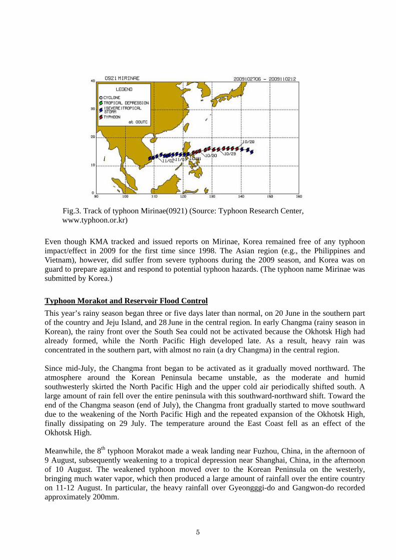
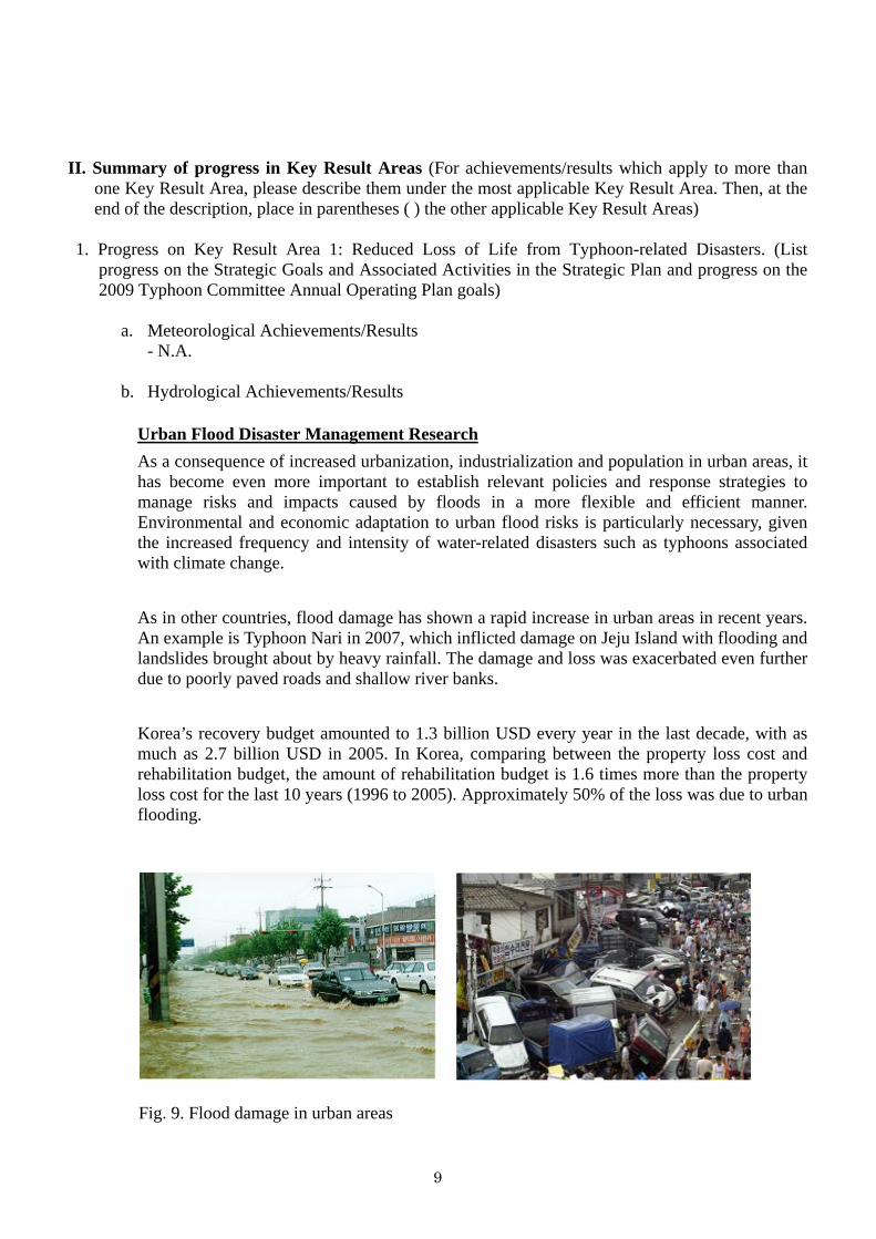
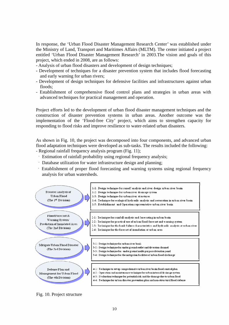
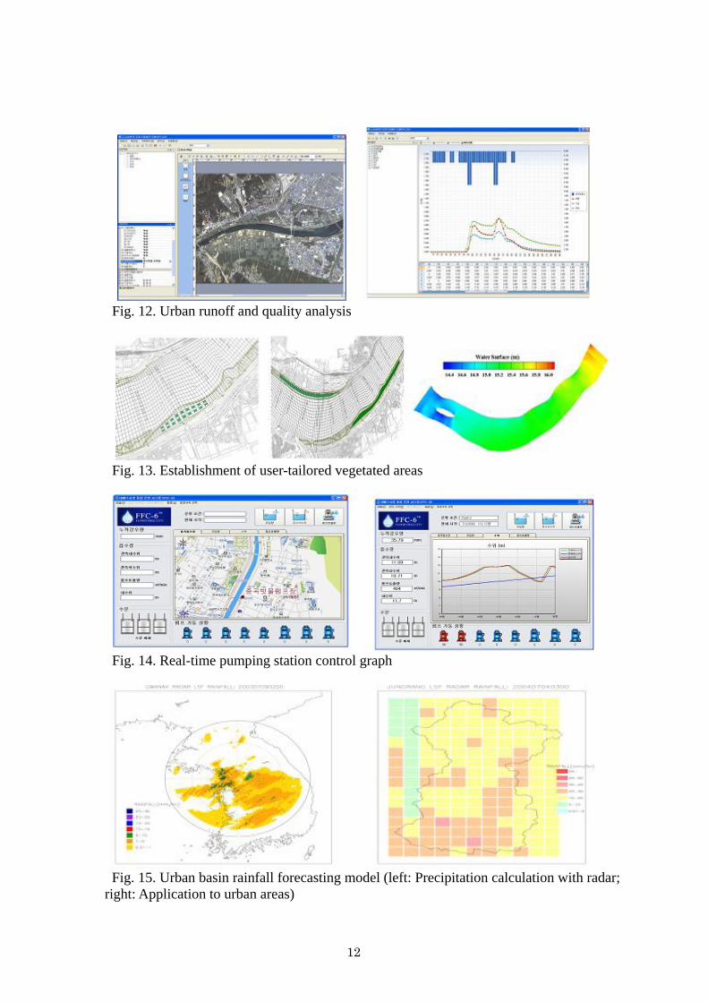
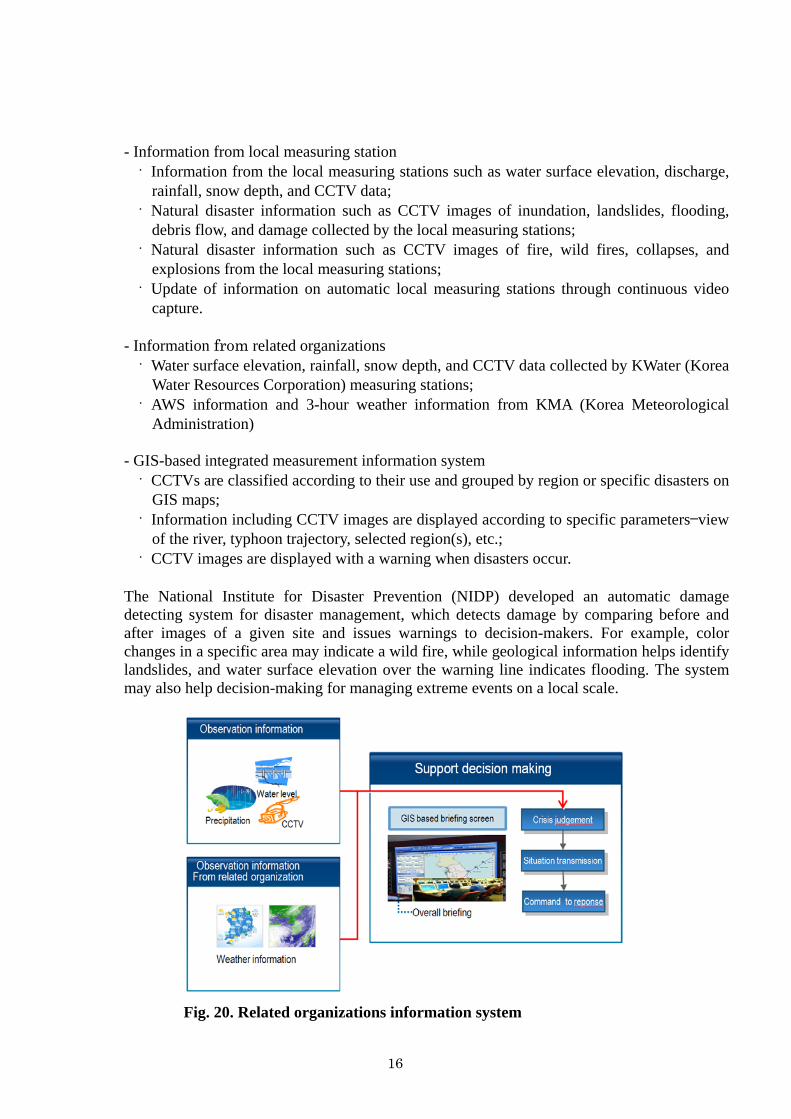
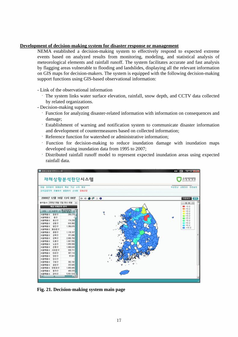
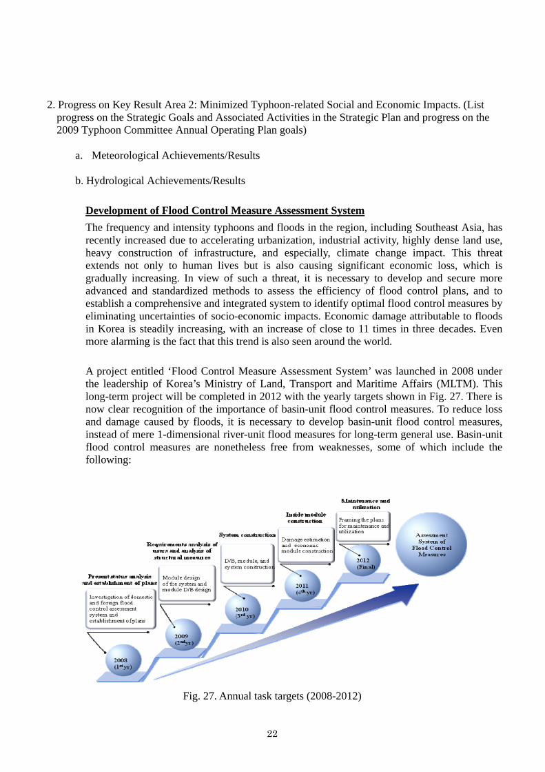
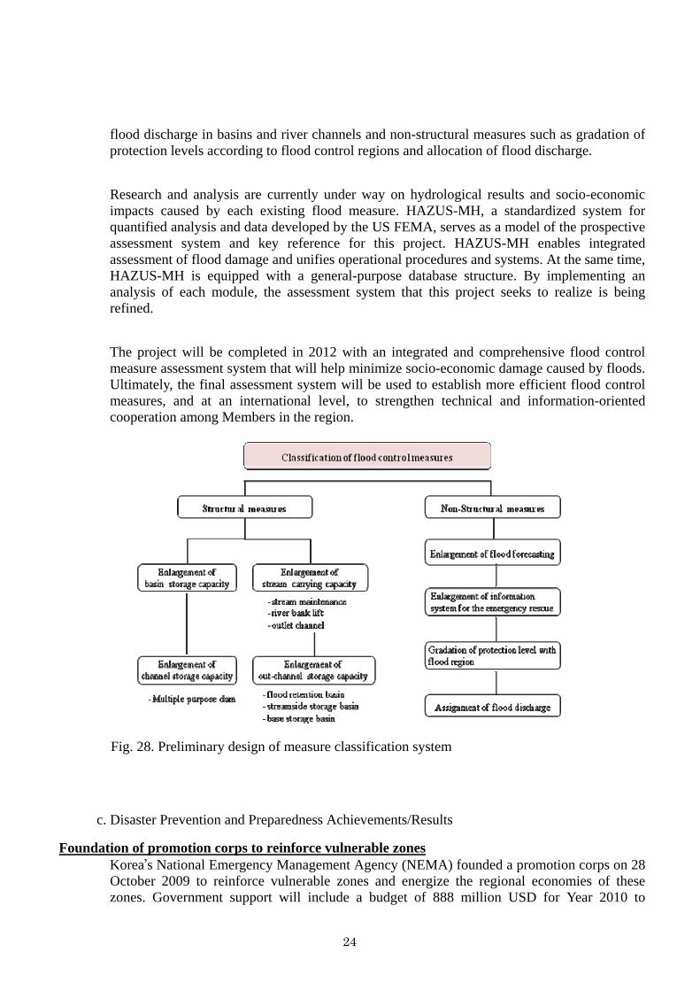
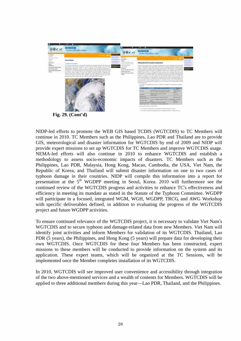
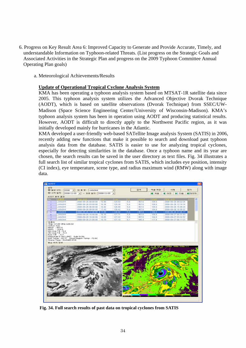
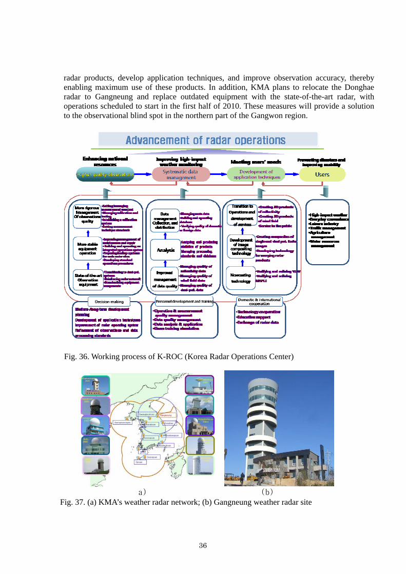
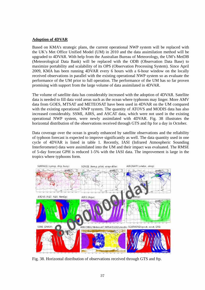
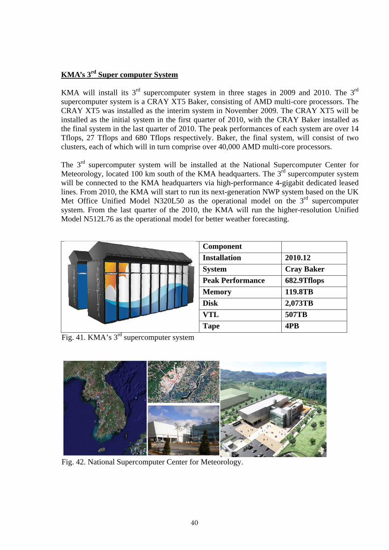
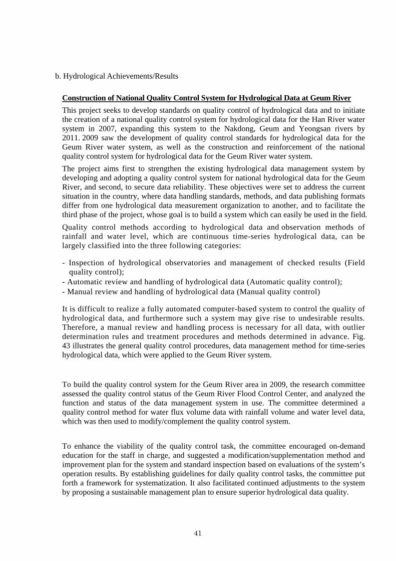
b Hydrological AchievementsResults
Construction of National Quality Control System for Hydrological Data at Geum River This project seeks to develop standards on quality control of hydrological data and to initiate the creation of a national quality control system for hydrological data for the Han River water system in 2007 expanding this system to the Nakdong Geum and Yeongsan rivers by 2011 2009 saw the development of quality control standards for hydrological data for the Geum River water system as well as the construction and reinforcement of the national quality control system for hydrological data for the Geum River water system The project aims first to strengthen the existing hydrological data management system by developing and adopting a quality control system for national hydrological data for the Geum River and second to secure data reliability These objectives were set to address the current situation in the country where data handling standards methods and data publishing formats differ from one hydrological data measurement organization to another and to facilitate the third phase of the project whose goal is to build a system which can easily be used in the field Quality control methods according to hydrological data and observation methods of rainfall and water level which are continuous time-series hydrological data can be largely classified into the three following categories
- Inspection of hydrological observatories and management of checked results (Field quality control)
- Automatic review and handling of hydrological data (Automatic quality control) - Manual review and handling of hydrological data (Manual quality control)
It is difficult to realize a fully automated computer-based system to control the quality of hydrological data and furthermore such a system may give rise to undesirable results Therefore a manual review and handling process is necessary for all data with outlier determination rules and treatment procedures and methods determined in advance Fig 43 illustrates the general quality control procedures data management method for time-series hydrological data which were applied to the Geum River system
To build the quality control system for the Geum River area in 2009 the research committee assessed the quality control status of the Geum River Flood Control Center and analyzed the function and status of the data management system in use The committee determined a quality control method for water flux volume data with rainfall volume and water level data which was then used to modifycomplement the quality control system
To enhance the viability of the quality control task the committee encouraged on-demand education for the staff in charge and suggested a modificationsupplementation method and improvement plan for the system and standard inspection based on evaluations of the systemrsquos operation results By establishing guidelines for daily quality control tasks the committee put forth a framework for systematization It also facilitated continued adjustments to the system by proposing a sustainable management plan to ensure superior hydrological data quality
41
Fig 43 Quality control procedure of time-series rainfall volume and water level data
(a) Status of basins (b) Water level data at each forecasting point
(c) Revision of water level TM data (d) Water level change graph
Fig 44 Screenshots of the quality control system
42
The project will help build a consensus among the experts regarding the importance of hydrological observations and hydrological data management and quality control through continued implementation of tasks that contribute to higher-quality national hydrological data A number of national initiatives will be promoted alongside to guarantee the essentials of a quality life through active management of water resources and information campaigns to raise public awareness about the importance of national water resources which are expected to play a significant role in changing public perception regarding water resources activities for the better Ultimately the newly created quality control system for hydrological data which will enable quality control that takes into account field characteristics and hydrological data for each observation point will lay the groundwork for improving the overall reliability of national hydrological data and minimizing loss of hydrological data
c Disaster Prevention and Preparedness AchievementsResults
-NA
d Research Training and Other AchievementsResults - NA
e Regional Cooperation AchievementsResults
- NA
f Identified OpportunitiesChallenges for Future AchievementsResults - NA
43
7 Progress on Key Result Area 7 Enhanced Typhoon Committeersquos Effectiveness and International Collaboration (List progress on the Strategic Goals and Associated Activities in the Strategic Plan and progress on the 2009 Typhoon Committee Annual Operating Plan goals)
a Meteorological AchievementsResults
Education and Training Activities The Course on Information and Communication Technologies for Meteorological Services was organized by the Korea Meteorological Administration (KMA) with sponsorship from the Korea International Cooperation Agency (KOICA) from 24 May to 27 June 2009 The course attracted 13 participants from 12 countries which included ESCAPWMO Typhoon Committee Members This training course was designed to help the participants improve their IT-related capacity in meteorological services by broadening their knowledge of both basic and state-of-the-art ICT used in WMO IT Programmes and meteorological services in NMHSs The curriculum includes 1) Meteorological Information and Communication
- Basic Linux Network basics Network security Internet protocol FTP server Data management WMO Information System (WIS)
2) Meteorological Information Service - PC-clustering and its application Introduction to the Forecasterrsquos Analysis System
Meteorological service using web technology Introduction to the Combined Meteorological Information System (COMIS) Use of KMA NWP products
3) IT Applications in Agrometeorology - Introduction to WAMIS (AgroMeteorological Information Service) Operational
technology of agrometeorological models Application of GIS to agrometeorology 4) Study Visits and Field Trip
- Supercomputer Center Korea Aerospace Research Institute Radar Observation Station Samsung Electronics Hyundai Motors
5) Presentations and Discussion - Participantsrsquo presentation of country reports group discussion
Fig 45 Course on ICT for Meteorological Services 24 Mayndash27 June 2008 Seoul Korea
44
One of the most important training courses conducted by KMA is the Digital Forecasting Course and Disaster Prevention Forecasting Course for forecasting staff The objective is to train the next generation of expert forecasters to acquire theoretical and operational knowledge of meteorology and to strengthen prediction skills for severe weather such as typhoons torrential rain and heavy snow The curriculum includes the latest meteorological theories weather forecasting and warning issuance case studies of disasters caused by severe weather etc The First TRCGTC Technical Forum 12-15 May 2009 Jeju Korea The Korea Meteorological Administration (KMA) hosted the first Technical Forum of Training and Research Coordination Group (TRCG) Typhoon Committee (TC) on 12-15 May 2009 Jeju Korea Participants from 13 countries participated in this event co-sponsored by WMO TC and KMA The Forum opened with opening and welcome messages from KMA administrator Dr Byung-Seong Chun PAGASA administrator Dr Prisco D Nilo TCPWMO chief Mr Kuroiwa Koji and TC Secretary Mr Olavo Rasquinho Two invited experts Professor Russel Elseberry from the Naval Postgraduate School USA and Mr Takuya Komori from the Japan Meteorological Agency Japan delivered special lectures on TC deterministic consensus forecasts and the TC Ensemble Prediction System respectively Mr Roger Edson gave a presentation about the use of microwave and scatterometer data in TC Also notable was a tutorial session on the typhoon forecasting system of each country and KMArsquos live demonstration of the Typhoon Analysis and Prediction System at the National Typhoon Center
Fig 46 Participants in the 1st Technical Forum of TRCGTC 12-15 May 2009 Jeju Korea
45
The 2nd China-Korea Joint Workshop on Tropical Cyclones 19-23 Dec Shanghai China The Korea Meteorological Administration (KMA) and China Meteorological Administration (CMA) hosted the second joint workshop on tropical cyclones which was held on 19-23 December 2009 in Shanghai China Almost 50 experts in typhoons and related fields participated from National Typhoon CenterKMA Korea Meteorological Satellite CenterKMA National Institute of Meteorological ResearchKMA Shanghai Typhoon Institute (STI)CMA Nanjing University Nanjing University of Information Sciences and Technology the University of Maryland and the University of Utah 26 papers were presented at the workshop on a wide range of topics such as typhoon-related disasters the climate and typhoons typhoon forecasting technology typhoon genesis and structure changes in the development and decay stages KMA and CMA agreed that the third workshop will be held in 2010 in Korea with more experts from other countries and affirmed their commitment to future cooperation in typhoon research forecast and related areas
Fig 47 Participants in the 2nd China-Korea Joint Workshop on Tropical Cyclones 19-23 Dec 2009 Shanghai China
b Hydrological AchievementsResults
Participation in the Integrated Workshop of TC in Cebu the Philippines From 13 to 18 September 2009 lsquoIntegrated Workshop Building Sustainability amp Resilience in High Risk Areas of the Typhoon Committee Assessment amp Actionrsquo was held in Cebu the Philippines Approximately 100 experts and researchers from 14 Member countries in the region attended the workshop to share advanced knowledge and to discuss typhoon-related issues in the region From the Republic of Korea experts from 6 organizations took part in this workshop to share developed techniques and strategies relevant to water-related disasters caused by typhoons with other Members especially developing countries As shown in Table 5 each organization represented is a specialized and professional water-sector organization in Korea
46
Table 5 Overview of Korearsquos water sector organizations
Organization Abbr Activities Ministry of Land Transport and Maritime Affairs
MLTMManaging water resources generally and establishing policies and strategies for the public and the nation
Korea Institute of Construction Technology KICT Implementing studies and research on contemporary
water issues Korea Water Resources Cooperation K-water Supporting capacity building and implementing
joint projects Korea Meteorological Administration KMA Producing data and information on meteorology
including climate change National Institute for Disaster Prevention NIDP Establishing strategies and frameworks for disaster
response
Korea Water Forum KWF Building international networks for closer cooperation in the water sector
Including the above organizations Korea has various organizations and institutes in the water sector closely cooperating to improve the environment as it relates to water and to address important water issues including typhoon-related issues domestically as well as internationally Participants from Korea gave the following presentations designed to introduce advanced information and knowledge implemented by Korea since the last workshop of the Typhoon Committee
- Flood Control Measure Assessment System
To share outcomes from the project and provide advanced techniques to reduce socio-economic damage caused by floods
- Korearsquos Policy on Water Resources To introduce water resources policies to control floods and adapt to typhoons and water-
related disasters and give an overview of the newly launched lsquoFour Major Rivers Restoration Projectrsquo
- Outcomes of lsquoHigh Level Expert Panel on Water and Disaster UNSGABrsquo To understand the seriousness of water-related disasters and underscore the importance of
establishing adaptation frameworks
Of these the project lsquoFlood Control Measure Assessment Systemrsquo was initiated in 2008 and will continue through 2012 Korea is acting as one of the leading countries in the Working Group on Hydrology (WGH) of the Typhoon Committee Outcomes and expected results from this project will be leveraged to strengthen the capacity of each Member
47
Fig 48 TC Integrated Workshop in Cebu the Philippines September 2009
b Disaster Prevention and Preparedness AchievementsResults
-NA
d Research Training and Other AchievementsResults - NA
f Regional Cooperation AchievementsResults - NA
g Identified OpportunitiesChallenges for Future AchievementsResults - NA
48
III Resource Mobilization Activities -NA
IV Update of Memberrsquos Working Groups representatives
1 Working Group on Meteorology Dr Won-Tae Yun Director International Cooperation Division Korea Meteorological Administration 45 Gisangcheong-gil Dongjak-gu Seoul156-720 Republic of Korea Tel +82-2-2181-0372 Fax +82-2-836-2386 E-mail pb_intkmagokr
2 Working Group on Hydrology
Dr Hong Il-Pyo (Vice-Chair) Senior Researcher Water Resources Research Department Korea Institute of Construction Technology 2311 Daehwa ilsan Goyang City Gyeonggi Republic of Korea Tel +82-31-910-0264 Fax +82-31-910-0251 E-mail iphongkictrekr
3 Working Group on Disaster Prevention and Preparedness
Dr Waon-Ho Yi Director National Institute for Disaster Prevention 253-42 Gongdeok-2Dong Mapo-Gu Seoul 121-719 Republic of Korea Tel +82-2-3271-3201 Fax +82-2-3271-3209 E-mail whyi1208nemagokr
4 Training and Research Coordinating Group
Dr KiRyong Kang Senior Researcher National Typhoon Center Korea Meteorological Administration 76-2 Hannam-ri Namwon-eup Seogwipo Jeju 699-942 Republic of Korea Tel +82-64-801-0224 Fax +82-64-805-0366 E-mail krkangkmagokr
5 Resource Mobilization Group
Dr Hee-Dong Yoo (Chairperson) Director Numerical Model Development Division Korea Meteorological Administration 45 Gisangcheong-gil Dongjak-gu Seoul 156-720 Republic of Korea Tel +82-2-2181-0672 Fax +82-2-2181-0689 E-mail hyookmagokr
49
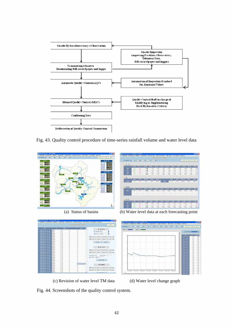