research into seismic design and performance of … papers...christchurch 6th international...
TRANSCRIPT

6th International Conference on Earthquake Geotechnical Engineering 1-4 November 2015 Christchurch, New Zealand
Research into Seismic Design and Performance of High Cut Slopes in
New Zealand
P. Brabhaharan1, D. Mason2, E. Gkeli3
ABSTRACT A research program is currently being carried out into the seismic design and performance of high
slopes for the New Zealand Transport Agency, aiming at the development of new design principles and guidelines for the design of cut slopes in New Zealand. One of the key aspects of the research is to understand the potential for topographic amplifications and its application to design, given New Zealand’s topography and seismicity. The first stage of the research completed included a review of literature on the earthquake performance of slopes and damage observed in past New Zealand and selected international earthquakes, and of theoretical studies of seismic behaviour of slopes and topographic effects. New Zealand’s topography and seismicity were also characterised. This paper presents the initial results of this research and draws lessons for consideration in the development of guidelines for New Zealand. The paper also presents a review of current design practice in New Zealand and overseas. The literature and standards review provides useful conclusions for developing the framework of the new design recommendations for New Zealand.
Introduction
New Zealand lacks specific design recommendations for seismic design of high cut slopes, although earthquakes commonly affect high cuts and steep slopes along transportation infrastructure. The objective of this research funded by the New Zealand Transport Agency is to develop design guidelines, and more specifically what topographic amplification factors may be suited to typical New Zealand hilly terrain and local geological conditions. This paper presents the findings of the review of international literature on the earthquake performance of slopes in earthquakes, research into topographic amplification, and an overview of the design practice in NZ and overseas. This review is part of the first stage of the research program and aims to draw useful conclusions regarding the main parameters that play a significant role in the amplification and de-amplification of the seismic motions on slopes.
Lessons from Past Earthquakes
Hancox (2015) has carried out a detailed review of coseismic landsliding and the performance of slopes during historical New Zealand earthquakes. This has been supplemented by a literature review to ascertain the effects of large earthquakes on slope performance in past worldwide
1Technical Principal Geotechnical Earthquake Engineering & Resilience, Opus, New Zealand, [email protected] 2Senior Engineering Geologist, Opus International Consultants, Wellington, New Zealand, [email protected] 3 Associate Engineering Geologist, Coffey Geotechnics NZ Ltd., Wellington, New Zealand, [email protected]

earthquakes. The literature search covered reconnaissance reports of earthquake damage to slopes and case histories of slope performance from New Zealand and around the world, to gather data regarding the types and size of slope failures, shape of slopes, local and regional geology, seismotectonics, as well as recorded ground shaking recordings and observed seismicity effects. Types of common slope failures The general pattern of damage observed in recent large earthquakes is of widespread slope failures characterised by shallow (generally up to a few metres), disaggregated or disrupted landslides in the surficial layers of regolith and immediately underlying weak, brittle and dilated rock mass in the upper parts of steep slopes. The common failure mechanisms associated with these types of slope failures are sliding along a stepped path of short-persistence, interconnecting, sub-parallel defects in the surficial zone of weak rock/regolith. Large or very large landslides are comparatively rare in number and extent compared to the shallow, disaggregated slides, however these tend to be much larger in volume and consequently cause much greater damage. Topographic and geological characteristics Observations of slope performance in past New Zealand and worldwide earthquakes show that widespread slope failures have occurred on slopes steeper than 40° to 50° that are underlain by young (Miocene or younger) sedimentary rocks, which have been observed to be particularly prone to these types of landslides (e.g., Parise & Jibson, 2000; Khazai & Sitar, 2003; Sepulveda et al., 2005; Chigira et al., 2010). Steep slopes in competent bedrock are prone to more localised failures (shallow rock slides and rock falls), as well as less common, but larger, defect-controlled failures.
The middle to upper parts of hillslopes are most susceptible to landslides, due to a combination of steep slope angles, weaker rock strength (due to the effects of weathering, dilation, fracturing etc.) and topographic amplification of ground motions in those parts of the slopes. Seismicity effects and seismotectonic regime Hanging wall, topographic amplification and attenuation/directivity effects result in asymmetric patterns of slope failure around the fault rupture, with larger ground motions and consequently more slope failures located at greater distances from the fault in areas that exhibit these effects. The common focal mechanism for earthquakes exhibiting these effects is thrust/reverse faulting.
Topography Effects Early numerical studies on the effect of topography on seismic response considered simple topographic configurations (generally isolated 2D ridges in homogeneous half-space) carried out by 2D numerical methods. Geli et al. (1988) reviewed these studies and noted that while there is qualitative agreement between the studies and the observed topographic effects, the seismic ground motions are often quantitatively underestimated by numerical analyses of simplified
topographic and subsurface geological conditions. Hill sides undergo complex amplification - de-amplification patterns and also significant differential motions, especially in the upper part of the hill. Neighbouring ridges may have greater effect on site response than soil layering. Geli et al. also found a relation of the maximum amplification with the frequency of the seismic wave, corresponding to wavelengths slightly longer than the mountain width. This relation was also demonstrated by Çelebi (1991), who showed amplification of the horizontal motion up to ~10%, for ridge crests relative to adjacent canyon bases, at frequencies 2-4 Hz and 8 Hz. Ashford et al. (1997) and Ashford & Sitar (2002) carried out studies of earthquake damage to step-like steep coastal bluffs in brittle, weakly cemented, sandy soils in California. They concluded that soil amplification effects in the free field behind the slope crest dominate the response, and consequently it is important to differentiate between topographic and soil amplification. Parametric analysis of the effects of slope inclination (i), height (H), wave type (P, SH and SV), wavelength (λ), and angle of wave incidence (b) showed that peak amplification of motion at the slope crest occurs at a normalized frequency of H/λ = 0.2. Ashford & Sitar (2002) proposed a simplified procedure for taking into account topographic effects in seismic slope stability analysis. Bouckovalas & Papadimitriou (2004, 2005, and 2006) also analysed step-like (terrace) topography for vertically propagating SV waves. Their results showed horizontal acceleration generates significant parasitic vertical acceleration due to reflection of incoming SV waves on the inclined free surface forming reflected P, SV and Rayleigh waves. Their analyses also show de-amplification near the toe of the slope. In contrast to the findings of Ashford et al. (1997) and Ashford & Sitar (2002), Bouckovalas & Papadimitriou note that the presence of bedrock below the slope has an important effect on topographic amplification and cannot always be decoupled from the effect of the free-field site period. Bouckovalas & Papadimitriou observed that the slope angle, the normalized height (H/λ) and the distance to the free field have a significant influence on horizontal and vertical amplification factors. Assimaki et al. (2005) carried out an extensive study of the topography effects and seismic behaviour of the Kifissos Canyon slopes during the Athens 1999 earthquake. They particularly noted the non-uniform damage observed in the town of Adames, located along the crest of Kifissos River slopes that could not be explained by topography effects only. They demonstrated a number of parameters that may have influenced the complex slope behaviour: (i) slope subsoil conditions (ii) presence of soft surface soil layer, that significantly aggravate the amplitude of vertical parasitic acceleration (iii) 2D inelastic soil response introducing localized patches of yielded material, which equivalent to a random medium, amplify high-frequency components and further enhance the vertical response and reduce the radiation damping (iv) soil–structure interaction on stiff soil deposits filters the high frequencies of the horizontal motion. They also concluded that weak motion data can be successfully used as a valuable guidance in reconnaissance studies, but they are not adequate to describe topography effects associated with strong-motions. Assimaki et al. also proposed a methodology for estimating topography amplification effects introducing a Topography Aggravation Factor (TAF). Observation from the 1994 Northridge and 1999 Chi-Chi earthquakes by Meunier et al. (2008) showed that earthquake-induced landslides were strongly clustered in the upper parts of hill

slopes. Numerical modeling of the observations showed that the maximum amplification of peak ground accelerations occurs in the upper quartile of slopes facing away from the wave source, with de-amplification along the base of the slope facing towards the incoming seismic wave. Local convexities on the slope profile can introduce important changes to the pattern of surface ground acceleration, such as amplification of the vertical component of incoming S waves. Relevant studies in New Zealand include Buech et al. (2010) and Kaiser et al. (2014). Buech demonstrated that maximum amplification occurs along the ridge crest while de-amplification occurs at the slope toe and mid-height. He also demonstrated the relationship of the amplification to the frequency of the seismic wave corresponding to a wavelength equal to the half width or mountain height (λ1 ≈ 0.5 wmtn ≈ hmtn). Kaiser presented analyses of ground motions recorded in the Port Hills suburbs of Christchurch in the Canterbury earthquake sequence. Their analyses showed topographic amplification at 1-3 Hz at ridge tops, with the wavelength of amplification strongly correlated with the ridge width. The degree of amplification is also linked to ridge shape, with sharp, narrow ridges showing the strongest amplification. Significant local variability of high frequency ground motions was observed, as well as variability resulting from the site-to-source azimuth, with the greatest amplification observed when sources were aligned with the major ridge axis, resulting in preferential amplification in the ridge-perpendicular direction. The following conclusions are drawn from the literature review, regarding topography effects: (1) Amplification effects due to topography are mainly concentrated at the top of two
dimensional step-like slopes and isolated cliffs or steep ridges. De-amplification is observed at the mid-height and near the base of slopes and canyons.
(2) The amplification of the seismic motion near the crest has been demonstrated in the numerical studies qualitatively, but was underestimated quantitatively. Time - domain crest:base amplification ratios from the theoretical and numerical studies do not exceed the value of 2, while values as high as 10 were observed during microtremors (Assimaki et al. 2005).
(3) High amplification of the seismic motions at a zone near the crest of the slopes occurs due to a combination of the primary SV waves and reflected P, SV and Rayleigh waves. A parasitic vertical component of these waves superimposed on the incoming seismic excitation appears to be of importance.
(4) The ground motion amplification near the crest of step-like slopes or top of ridges is strongly related to the frequency of the seismic wave. Amplification effects are pronounced for wavelengths comparable to the shape characteristics (width of base, height and inclination) of the slope or ridge. Topographic amplifications are negligible for wavelengths significantly longer than the dimensions of the asperity (Assimaki et al. 2005).
(5) The magnitude of the amplification effect near the crest of the slope is also influenced by local parameters such as highly irregular and complex topographies, the presence of a soft soil layer near the crest, soil structure interaction, the presence of geological discontinuities such as faults (Bouckovalas et al. 1999 and Massa et al, 2014). Such parameters may also explain the deviation between the numerical studies and actual strong seismic motion observations.

Characterisation of New Zealand’s topography and geology
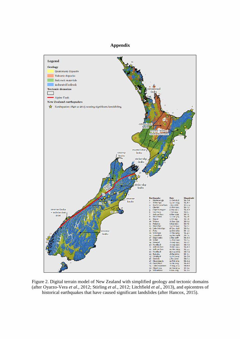
Given recent appreciation of the importance of topographic amplification and observations, New Zealand’s topography has been characterised to identify areas where susceptible topography and geology are important for considering earthquake effects on cut slopes along transportation corridors. New Zealand straddles the plate boundary zone between the Pacific and Australian plates, tectonic deformation across which has controlled the evolution and shape of the present topography. The topographies in areas where transportation corridors pass through hilly terrain include (1) very steep, mountainous/alpine areas, (2) steep, dissected hill country, (3) rolling/undulating hill country, (4) rounded and incised peneplains, (5) undulating volcanic plateaux with steep-sided, deeply incised gullies, (6) uplifted marine terraces with steep inter-terrace slopes; and (7) uplifted recent alluvial terraces with steep inter-terrace slopes. We have grouped the topographies of New Zealand into three broad categories as presented in Table 1. Observations from past earthquakes in New Zealand and overseas show that seismicity effects such as topographic amplification can have a significant effect on the distribution and concentration of earthquake-induced slope failures, particularly in areas of compressional tectonic regimes dominated by reverse or thrust faulting. The land mass of New Zealand has been characterised based on the seismotectonic type of active deformation, as shown in Figure 2 in the Appendix. The seismotectonic regimes vary from the subduction zone and fold-thrust belt in the eastern North Island, dextral oblique-slip faults through the central part of New Zealand, reverse faults in the northwest and east of the South Island, normal faults associated with volcanic rifting on the central North Island volcanic plateau, and low seismicity areas in northwest North Island and southeast South Island, away from the active areas. Similarly, the review of published literature documenting the performance of slopes in different materials shows that young (Miocene or younger) sedimentary rocks are particularly prone to widespread shallow landslides in large earthquakes, with hard bedrock more prone to localised wedge failures and rock falls. Figure 2 also shows a simplified geological grouping of formations into three broad categories: indurated bedrock, soft rock materials, volcanic deposits and Quaternary soil deposits, and is based on the 1:250,000 QMAP regional geology maps.
International design standards Eurocode The provisions for slope stability analysis are included in Eurocode 8, Parts 1 and 5 (EN-1998-1:2004 and EN-1998-5:2004). The design PGA (ag) is a function of the importance factor γ1 of the structure and a soil factor relative to seven ground types (A, B, C, D, E, S1 and S2). EC8 allows the use of dynamic analysis (such as finite elements) or rigid block models, or simplified pseudo-static methods, including horizontal and vertical inertia forces applied to every portion of the soil mass and to any gravity loads acting on top of the slope.

Table 1. Characteristic topographies where transportation corridors pass through hilly terrain
Hilly/mountainous terrain
Characteristics Example geographic areas
Sharp, narrow ridges flanked by steep, concave-up hillslopes alternating with deep valleys and narrow tributary spurs. This terrain is found in areas where rates of uplift and downcutting/incision are high, resulting in steep relief and frequent slope instability.
Commonly underlain by indurated bedrock and soft rock materials, in areas of high seismicity dominated by strike slip and reverse faults.
Bedrock: » North Island axial ranges* » Wellington region* » Northwest Nelson to Buller* » Marlborough & Kaikoura Ranges* » North Canterbury* » Christchurch Port Hills* » Southern Alps & Fiordland*
Soft rock: » Eastern Bay of Plenty to East Cape* » Gisborne to Wairarapa* » South Waikato to Northern Manawatu
Alternating narrow ridges and deep valleys Individual/isolated steep hills
Undulating/rolling hills
Characteristics Example geographic areas
Characterised by rounded slopes varying from flat, broad ridge tops with moderate to steep hillslopes. This terrain is often accompanied with narrow incised gorges between the ridges such as incised peneplains in central Otago.
Bedrock: » Central Otago
Soft rock: » Northland
Quaternary deposits:
» Bay of Plenty, central volcanic plateau
» Inland Wairarapa
Alternating undulating hills Individual/broad rolling hills
Terraces
Characteristics Example geographic areas
This terrain category consists of broad, flat-topped hills or terraces with sharp edges and steep slopes (often 45°+) below the terrace edge. Terraces occur in alluvial, marine and volcanic terrain, often associated with high rates of uplift and/or erosion.
Bedrock: » Coastal Marlborough/Kaikoura* Soft rock: » Wanganui
» Northern Manawatu
Quaternary deposits:
» Coastal Taranaki » Coastal Wanganui Manawatu » Canterbury Plains
* Areas where significant landslides occurred during historical earthquakes (after Hancox, 2015).

When the stability analysis is carried out by simplified pseudo-static analysis, both horizontal and vertical components FH and FV of the seismic inertia forces are taken into account in design, with the horizontal being the design acceleration multiplied by 0.5 and the vertical being equal to the horizontal factored by 0.33 to 0.5. A topographic amplification factor is introduced, ranging between 1.2 and 1.4 depending on the shape of the slope (isolated slopes or ridges) and independent of the fundamental period of vibration. Topography amplification factors should be applied at two-dimensional topographic irregularities, such as long ridges and cliffs of height H >30 m and average slope angles i> 15°. Specific studies are recommended in the case of strongly irregular local topography. Topographic effects are considered largest and mostly superficial along ridge crests, and much smaller on deep seated landslides where the failure surface passes near to the base. In the latter case topographic effects may be neglected. The highest values apply near the top of the slopes while the amplification factor can be assumed to linearly decrease towards the base, where it becomes unity. The suggested amplification factors are increased by at least 20% in case of an existing surficial zone more than 5 m thick. Paolucci (2002, 2006) compared 3D and 2D numerical analyses results for an actual slope in Italy and compared the results with the topographic amplification factors of EC8. It turned out that the EC8 recommendations in terms of topographic amplification factors are generally satisfactory, except for specific cases, where the EC8 factor underestimates the numerical value by 40%. These cases include isolated cliffs with heights H > 60 m, slopes of similar dimensions of the width (W) and length (L) of the crest (e.g., 1/3 < L/W < 3) and slopes with average angle > 30° and maximum angle > 60°. For these cases, a topographic amplification factor ST ≥ 1.7 was suggested, subject to verification with further 3D numerical simulations. Bouckovalas and Papadimitriou (2006) note that the parasitic vertical component of the topography amplification factor is of importance and should be taken into account. They also noted that the horizontal distance to the free field is not clearly defined in the Eurocode. Further, there is no specific suggestion for the reduction of the amplification factor with depth within the slope. They suggested changing of the slope geometry criteria for applying topography aggravation effects to be function of the slope height, slope inclination and predominant wavelength of the shear waves λ. However, they concluded that the lower bound of the proposed topography amplification factors in the Eurocode have good agreement with their analysis for slopes with Vs>400 m/s (stiff soils and soft rocks), H>13 m and i>17o. The Provisions of the French Seismic Code PS-92 regarding Topographic amplification Precedent to the Eurocode, the French Seismic Code PS-92, AFNOR (1995) included provisions related to the topographic aggravation of seismic motion. The French Seismic code introduced a topography aggravation factor τ to the design peak acceleration, ranging from 1.00 to 1.40 as a function of the slope inclination. The factor was applied along the slope as shown in Figure 1. The factor was suggested to be applied to the upper part of the slope, of height equal to one third of the height of the slope, measured from the crest. The distance to the free field above the slope crest is defined as a function of the inclination and the height of the slope.

Figure 1. Variation of the topography aggravation factor τ, as proposed by PS 92 Recommended Procedures in California, US The Southern California Earthquake Centre (2002) provides guidelines for analysing and mitigating landslide hazards in California that was developed by a committee of the Los Angeles Section Geotechnical Group of the American Society of Civil Engineers. There are two elements associated with a pseudo-static slope stability analysis procedure. First, a horizontal destabilizing seismic coefficient (k), which represents the fraction of the weight of the sliding mass that is applied as an equivalent horizontal force acting through the centroid of the mass. Second, a minimum acceptable Factor of Safety (FS) must be specified for the slope with the pseudo-static seismic force applied to it. A screening analysis procedure is specified, where if the FS>1, the slope passes the screen. The seismic coefficient to be used in the analysis is taken as
Keq=feq x (MHAr/g) (1) where MHAr is the maximum horizontal acceleration at the site for a soft rock site condition; g = acceleration of gravity. The Californian code introduces a factor, feq related to the seismicity of the site. The values of feq are a function of magnitude (as represented by M) and site-source distance (as represented by r). Magnitude- and distance-dependent feq values have been developed using a model for seismic slope displacements based on a Newmark-type analysis, using the Bray and Rathje (1998) model for estimating Newmark displacements (u) as a function of ky/kmax, kmax, and D5-95. Two threshold values are assumed for the slope displacements of 5 cm and 15 cm. Based on the above, the feq values that cause the probability that seismic slope displacement would exceed 5 cm or 15 cm to be 50% are estimated. This methodology for evaluating feq was developed in order to avoid unnecessary conservatism, with respect to previously followed practice, where a single value for feq was assumed, making implicit, and usually very conservative assumptions about the magnitude of earthquakes causing the design-basis MHAr. The estimated feq with the new proposed procedure takes into account large and smaller magnitude earthquakes, as large magnitude earthquakes have longer durations of shaking.
Discussion A common element in the international design practice followed for pseudo-static slope stability analysis, is factoring of the horizontal seismic acceleration applied for the calculation of the equivalent acting force on the sliding mass. A factor of 0.5 is used in the Eurocode, of which we have not been able to clarify the background, and a factor feq is used in the Californian Code Amplification of seismic waves due to topographic irregularities has generally received limited attention in the context of design codes and standards. Recommendations were only found in the French Code PS-92 and the Eurocode. Both codes have considered step-like slopes and refer to the topography effects as an amplification of the seismic motion at the upper part of the slope. In the French Code the value and application of suggested topography aggravation effect is a function of the inclination of the height of slope and distance to the free field behind the crest. The suggestions of the Eurocode are of a similar philosophy, however several authors have identified a number of limitations: (i) the recommendations are general and simplifying of a complex phenomenon (ii) there are no specific instructions of how to consider de-amplification towards the toe of the slope (iii) there is no specific definition of the distance to the free field (iv) the recommendations are considered satisfactory for step – like slopes in stiff soils or soft rocks with H>13 m and i>17o. The use of the proposed factors for higher and steeper isolated cliffs or ridges are considered to underestimate the topographical amplification.
Design practice in New Zealand In New Zealand, NZS 1170.5, Earthquake Actions – New Zealand, Standards New Zealand, (2004) provides guidance on the selection of earthquake loading for structural design actions. Unfortunately, NZS 1170.5 specifically excludes the parts of the built environment associated with slopes including slope stability, liquefaction, retaining walls, dams and bunds. Similarly Geotechnical Earthquake Engineering Practice, Module 1 (Draft), New Zealand Geotechnical Society, (2014) provides guidance on the assessment of liquefaction, but does not provide any advice on the assessment or design of cut slopes. It is only the Bridge Manual third edition (New Zealand Transport Agency, 2014) that provides specific recommendations on design standards and selection of seismic design parameters for slopes associated with state highways in New Zealand. The Bridge Manual provides earthquake loading parameters, such as Peak Ground Acceleration (PGA) and the Effective Magnitude by classifying the roads depending on their level of importance. It should be noted that the Bridge Manual requires cut slopes to be designed to a lower level of earthquake hazard, compared to other structures (bridges, retaining and fill structures) along state highways. It is not clear why cut slopes are required to have a lower level of earthquake performance although failure of cut slopes can give rise to closure of important primary lifeline routes for six months or more (Opus, 2012), or as observed in the failure of slopes along State Highway 3 in the Manawatu Gorge, which was closed for more than 12 months. Further, no allowance is made in the Bridge Manual for factoring seismic actions, either to allow for amplification (such as due to topographical effects) or reductions (to allow for incoherence of

motions where the slopes are of significant height). Where slopes are to be designed for permitting displacement under earthquake loading, specific guidance is provided for engineered fills and retaining walls but not for cut slopes.The common engineering practice followed by the industry for slope stability analysis is to apply the provisions of NZS 1170.5:2004, with respect to the limit state requirements (Ultimate Limit State and Serviceability Limit State) and NZS 1170.5:2004 or the Bridge Manual for estimating the design actions. When simplified pseudo-static methods of analysis are followed, only the horizontal component of the seismic inertia forces are taken into account, without any factoring to account for topographic amplification near the crest or de-amplification near the base. Similar assumptions are made when a displacement based design is carried out.
Conclusions for Development of the new Guidelines for New Zealand The main aspects that need to be covered in design guidelines to be developed are the following: (1) Appropriate topographic amplification and de-amplification factors for the slope geometries. (2) Provision of specific instructions on what part of the slope to apply the amplification effect. (3) Guidelines on slope failure mechanisms that should be considered in the design of cut
slopes.
Acknowledgements The authors thank the New Zealand Transport Agency and Opus International Consultants for permission to publish this paper. The contribution of Graham Hancox from GNS Science is acknowledged for literature research on landslides in historical New Zealand earthquakes.
References
Assimaki D, Gazetas G, Kausel E. Effects of Local Soil Conditions on the Topographic Aggravation of Seismic Motion: Parametric Investigation and Recorded Field Evidence from the 1999 Athens Earthquake, Bulletin of the Seismological Society of America, Vol 95, No. 3, June 2005.
Ashford, S.A., Sitar, N., Lysmer, J., Deng, N. (1997). Topographic effects on the seismic response of steep slopes. Bulletin of the Seismological Society of America 87: 701-709.
Ashford, S.A., Sitar, N. (2002). Simplified method for evaluating seismic stability of steep slopes. Journal of Geotechnical and Geoenvironmental Engineering 128: 119-128.
Assimaki, D., Kausel, E., Gazetas, G (2005). Soil-Dependent topographic effects: A case study from the 1999 Athens Earthquake. Earthquake Spectra 21: 929-966.
Bouckovalas, G.D., Papadimitriou, A.G. (2005). Numerical evaluation of slope topography effects on seismic ground motion. Soil Dynamics and Earthquake Engineering 25: 547-558.
Bouckovalas, G.D., Papadimitriou, A.G. (2006). Aggravation of seismic ground motion due to slope topography. 1st European Conference on Earthquake Engineering and Seismology, Geneva, 3 - 8 September, paper no. 1171.
Buech, F., Davies, T.R., Pettinga, J.R. (2010). The Little Red Hill seismic experimental study: topographic effects on ground motion at a bedrock-dominated mountain edifice. Bull Seismological Society of America 100: 2219-2229.
Çelebi, M. (1991). Topographical and geological amplification: case studies and engineering implications. Structural Safety 10: 199-217.
Chigira, M., Wu, X., Inokuchi, T., Wang, G. (2010). Landslides induced by the 2008 Wenchuan earthquake, Sichuan, China Geomorphology 118: 225-238.

European Seismic Code (EC8). Design provisions for earthquake resistance of structures, Part 1: General rules-seismic actions and rules for building, EN 1998-1:2004, Part 5: Foundations, Retaining Structures and geotechnical aspects, EN 1998-5:2004. Brussels, 2004.
Geli L, Bard PY, Jullien B. The effect of topography on earthquake ground motion: a review and new results, Bull. Seism. Soc. Am. 78, 42–63.
Hancox, G. (2015). Performance of slopes in past New Zealand earthquakes: Literature review and lessons learned from historical earthquakes. GNS Science Report CR2015/04. Prepared by Hancox, G.T., March 2015, 66 p.
Kaiser, A., Holden, C., Massey, C. (2014). Site amplification, polarity and topographic effects in the Port Hills during the Canterbury earthquake sequence. GNS Science Consultancy Report 2014/121, 33 p.
Khazai, B., Sitar, N. (2003). Evaluation of factors controlling earthquake-induced landslides caused by Chi-Chi earthquake and comparison with the Northridge and Loma Prieta events. Engineering Geology 71: 79-95.
Litchfield, N., Van Dissen, R., Sutherland, R., Barnes, P., Cox, S., Norris, R., Beavan, R., Langridge, R., Villamor, P., Berryman, K., Stirling, M., Nicol, A., Nodder, S., Lamarche, G., Barrell, D., Pettinga, J., Little, T., Pondard, N., Mountjoy, J., Clark, K. (2013). A model of active faulting in New Zealand. New Zealand Journal of Geology and Geophysics 57: 32-56
Massa, M., Barani, S., Lovati, S. (2014). Overview of topographic effects based on experimental observations: Meaning, causes and possible interpretations. Geophysical Journal International 197: 1537-1550.
Meunier, P., Hovius, N., Haines, J.A. (2008). Topographic site effects and the location of earthquake induced landslides. Earth and Planetary Science Letters 275: 221-232.
Oyarzo-Vera, C.A. McVerry, G.H., Ingham, J.M. (2012). Seismic zonation and default suite of ground-motion records for time-history analysis in the North Island of New Zealand. Earthquake Spectra 28: 667-688.
Parise, M., Jibson, R. (2000). A seismic landslide susceptibility rating of geologic units based on analysis of characteristics of landslides triggered by the 17 January, 1994 Northridge, California earthquake. Engineering Geology 58: 251-270.
Sepulveda, S.A., Murphy, W., Petley, D.N. (2005). Topographic controls on coseismic rock slides during the 1999 Chi-Chi earthquake, Taiwan. Quarterly Journal of Engineering Geology and Hydrogeology 38: 189-196.
Stirling, M., McVerry, G., Gerstenberger, M., Litchfield, N., Van Dissen, R., Berryman, K., Barnes, P., Wallace, L., Villamor, P., Langridge, R., Lamarche, G., Nodder, S., Reyners, M., Bradley, B., Rhoades, D., Smith, W., Nicol, A., Pettinga, J., Clark, K., Jacobs, K. (2012). National seismic hazard model for New Zealand: 2010 Update. Bulletin of the Seismological Society of America 102: 1514-1542.
Appendix
Figure 2. Digital terrain model of New Zealand with simplified geology and tectonic domains (after Oyarzo-Vera et al., 2012; Stirling et al., 2012; Litchfield et al., 2013), and epicentres of
historical earthquakes that have caused significant landslides (after Hancox, 2015).