resolving interstate water conflicts: a...
TRANSCRIPT

RESOLVING INTERSTATE WATER CONFLICTS:
A Comparison of the Way India and the United States
Address Disputes on Interstate Rivers
Daniel SELIGMAN
JUNE 2011
Serial No.IWP/WP/No.2/2011
Working Paper Series
www.lkyspp.nus.edu.sg/iwp
The author wishes to thanks the staff of the Central Water Commission in New Delhi,
India, for meeting with him and providing information about the resolution of interstate
water disputes. The author also wishes to express
former secretary to the Ministry of Water Resources of India, whose comments on a draft
of this research paper proved extremely helpful.
ACKNOWLEDGEMENTS
hor wishes to thanks the staff of the Central Water Commission in New Delhi,
India, for meeting with him and providing information about the resolution of interstate
water disputes. The author also wishes to express appreciation to Mr. Ramaswamy Iyer,
former secretary to the Ministry of Water Resources of India, whose comments on a draft
of this research paper proved extremely helpful.
hor wishes to thanks the staff of the Central Water Commission in New Delhi,
India, for meeting with him and providing information about the resolution of interstate
appreciation to Mr. Ramaswamy Iyer,
former secretary to the Ministry of Water Resources of India, whose comments on a draft
RESOLVING INTERSTATE WATER DISPUTES
Table of Contents
Page
I. INTRODUCTION 1
II. COMPARING INDIA AND THE UNITED STATES 3
III. LEGAL HERITAGE 6
IV. THE MEANING OF EQUITABLE APPORTIONMENT 7
V. INTERSTATE WATER DISPUTES IN THE UNITED STATES 10
A. The Role of the Federal Government
B. The Constitution
C. The Legal Mechanisms for Resolving Disputes
VI. INTERSTATE WATER DISPUTES IN INDIA 21
A. The Role of the Central Government
B. The Constitution
C. The Legal Mechanisms for Resolving Disputes
VII. CASE STUDY IN INDIA: 35
THE KRISHNA RIVER
VIII. CASE STUDY IN THE UNITED STATES: 40
THE POTOMAC RIVER
IX. AN ALTERNATIVE TO LITIGATION: 44
COOPERATIVE AGREEMENTS ON SHORTAGES
X. COMPARATIVE EVALUATION AND CONCLUSION 47
ANNEX: Key Features of the Legal Systems in India and the United States
REFERENCES

1
I. INTRODUCTION
India and the United States are both federations with distinct regions and complex
water problems. Their internal borders, however, reflect the vagaries of history and
political compromise and bear little relation to the natural contours of river basins.
The same can be said for virtually every other nation. What makes India and the
United States unique is the size of the two countries and the number of States within
their respective borders: 28 in India and 48 in the continental United States. Small
wonder is that both countries have serious interstate water disputes, some of which
linger for years.
In 1901, the year that Queen Victoria died and Rudyard Kipling wrote Kim, the State
of Kansas sued the State of Colorado for diverting so much water from the Arkansas
River in the central United States that it ran dry in summer. The two States eventually
signed a contract with each other1 but they became embroiled in a dispute over what
the terms of the agreement meant. Legal battles continued intermittently until the U.S.
Supreme Court issued a decision in 2004.2
The disputes in India over the Cauvery River began in 1807, the year Beethoven first
performed his Fourth Symphony and 12 years before Sir Stamford Raffles landed in
Singapore. In that year, the Presidency of Madras (now the State of Tamil Nadu)
complained about excessive upstream use of Cauvery River water by the Princely
State of Mysore (now Karnataka).3 The dispute led to an 1892 agreement, followed
1 The Arkansas River Compact of 1949, Pub. L. No. 81-82, 63 Stat. 145.
2 Kansas v. Colorado, 543 U.S. 86 (2004).
3 Dodda Srinivasa Rao, Inter-state Water Disputes in India (Deep & Deep Publications
1998), at p. 65.
2
by another dispute, an arbitration decision, an appeal of the arbitration decision to the
Secretary of State in London, and then another agreement in 1924. That agreement
ultimately proved inadequate to solve modern-day needs and led to a new round of
disagreements, which continued intermittently until a tribunal in India issued an award
in 2007, two hundred years after the first recorded disagreement. And yet the dispute
continues, even to this day, because several parties have filed appeals in the Supreme
Court.
In this paper, we take a closer look at the causes and solutions of interstate river
disputes within India and the United States. By “interstate,” we mean a river that
crosses an internal State border or that serves as the State border. We do not address
international water disagreements that India and the United States have had with
neighboring countries. Rather, we focus on how India and the United States divide
water between their own respective States and how they resolve competing claims,
particularly during shortages.
The rest of the paper is organized as follows:
• Section II provides background information about India and the United States
and how they use water.
• Section III summarizes the common legal heritage of both countries.
• Section IV contains an overview of the mechanics of the doctrine of “equitable
apportionment.”
• Section V describes how the United States resolves interstate water disputes.
• Section VI describes how India resolves interstate water disputes.
• Section VII examines a case study in India: the Krishna River.
• Section VIII examines a case study in the United States: the Potomac River.
• Section IX describes alternatives to litigation as a means of resolving interstate
river conflicts, particularly in times of drought.
• Finally, the concluding section contains a comparative evaluation of how India
and the United States resolve interstate water disputes.
3
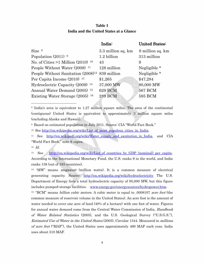
II. COMPARING INDIA AND THE UNITED STATES
India is roughly 40% of the size of the continental United States but has four times the
number of people (See Table 1). Few cities in India, including those with a population
more than one million, have a clean, predictable water supply. Two-thirds of India’s
population still lacks access to basic sanitation facilities. Rapid population growth and
industrialization have severely damaged water quality of many rivers. India’s
challenge is therefore to provide clean water for its population while at the same time
expanding its economy and creating jobs in the competitive international marketplace.
But India faces a water storage problem.4 Its annual demand for water is more than
two times the available storage behind reservoirs. In the United States, in contrast,
annual water demand and storage are roughly equal. The lack of significant reservoir
storage in India puts it at a disadvantage: it must rely on precipitation during the
annual monsoon season (usually May through September).5 In many areas of the
country, only 10-15 days a year bring most of the rainfall.6 Farmers are especially
vulnerable to those weather patterns because they depend heavily on river water for
irrigation. Approximately 83% of India’s diversions from rivers go for irrigation.7
4 Water storage need not only occur behind large dams. Decentralized storage – such as
“rainwater harvesting,” which involves the accumulation and storing of rainwater before
it reaches a river or aquifer – is an option. Another option is aquifer storage and recovery,
where water is stored underground and pumped to the surface when needed.
5 Biswas, A.K., Rangachari, R., and Tortajada, Cecilia, Water Resources of the Indian
Continent (Oxford University Press 2008) at p.180.
6 Id. at p.180. See, also, Central Water Commission, 2009-10 Annual Report (inset),
“India – Land and Water Resources: Facts.” The regional variation in precipitation is
significant. India’s arid parts (e.g., in the northwest) receive only 100 mm (3.9 inches)
per year but the wettest part of the country (e.g., the eastern river deltas) can receive as
much about 11,000 mm (433 inches).
7 Biswas, note 5 supra, at p.158.
4
Table 1
India and the United States at a Glance
IndiaIndiaIndiaIndia:::: United StatesUnited StatesUnited StatesUnited States::::
Size 8 3.3 million sq. km 8 million sq. km
Population (2011) 9 1.2 billion 313 million
No. of Cities >1 Million (2010) 10 43 9
People Without Water (2008) 11 128 million Negligible *
People Without Sanitation (2008)12 839 million Negligible *
Per Capita Income (2010) 13 $1,265 $47,284
Hydroelectric Capacity (2009) 14 37,000 MW 80,000 MW
Annual Water Demand (2005) 15 629 BCM 567 BCM
Existing Water Storage (2005) 16 289 BCM 595 BCM
8 India’s area is equivalent to 1.27 million square miles. The area of the continental
(contiguous) United States is equivalent to approximately 3 million square miles
(excluding Alaska and Hawaii).
9 Based on estimated population in July 2011. Source: CIA “World Fact Book.”
10 See http://en.wikipedia.org/wiki/List_of_most_populous_cities_in_India.
11 See http://en.wikipedi.org/wiki/Water_supply_and_sanitation_in_India, and CIA
“World Fact Book,” note 9 supra.
12 Id.
13 See http://en.wikipedia.org/wiki/List_of_countries_by_GDP_(nominal)_per_capita.
According to the International Monetary Fund, the U.S. ranks 9 in the world, and India
ranks 138 (out of 183 countries).
14 “MW” means megawatt (million watts). It is a common measure of electrical
generating capacity. Source: http://en.wikipedia.org/wiki/hydroelectricity The U.S.
Department of Energy lists a total hydroelectric capacity of 95,000 MW, but this figure
includes pumped-storage facilities. www.energy.gov/energysources/hydropower.htm.
15 “BCM” means billion cubic meters. A cubic meter is equal to .0008107 acre feet (the
common measure of reservoir volume in the United States). An acre foot is the amount of
water needed to cover one acre of land (40% of a hectare) with one foot of water. Figures
for annual water demand come from the Central Water Commission of India, Handbook
of Water Related Statistics (2005), and the U.S. Geological Survey (“U.S.G.S.”),
Estimated Use of Water in the United States (2005), Circular 1344. Measured in millions
of acre feet (“MAF”), the United States uses approximately 460 MAF each year. India
uses about 510 MAF.
5
* The number of people in the United States without any water or sanitation facilities is extremely
small and is generally limited to rural isolated communities.
_________
Groundwater, in contrast, typically supplies cities. In some areas of the country,
India’s groundwater supplies are plentiful.17
In other regions, however, there are
worrisome indications that groundwater “mining” for commercial purposes is far
outstripping natural replenishment.18
The United States, with an established industrialized economy, has its own set of
water problems. They may pale in comparison with India’s but they exist, nonetheless.
Much of the U.S. water distribution infrastructure is aging, particularly in the older
eastern cities. The population is also increasing – albeit at a rate much slower than
India’s – but the United States will likely face serious water shortages in certain parts
of the country, particularly in the arid Southwest.
In the United States, half of all water diverted from rivers is used for generating
electricity in thermal power plants (coal and nuclear). Only about 31% of the water
goes for agriculture.19
This figure changes in the American West, where agriculture
depends heavily on sophisticated irrigation infrastructure (e.g., dams, canals, pumping
16 Id. Measured in MAF, the United States has reservoir storage of approximately 482
MAF. India can store 234 MAF.
17 Central Water Commission of India, 2009-10 Annual Report, note 6, supra. See, also,
Biswas, note 5 supra, at pp. 154-156, identifying groundwater extraction areas where the
water table is falling.
18 See National Geographic News, “Mining” Groundwater in India Reaches New Lows,
December 2010. Over-pumping has led to legal proceedings. In 2010, for example, the
State of Kerala charged Coca Cola with depleting and polluting groundwater, and it
recommended the company pay the equivalent of US $48 million in damages.
19 See U.S. Geological Survey publication, note 15 supra, at p.8 (Table 2B).

6
stations) to move water, sometimes hundreds of miles.20
III. LEGAL HERITAGE
The American and Indian legal systems bear a striking resemblance when it comes to
the mechanisms for addressing interstate water disputes, despite differences between
the two countries in culture, history and religion.
Both countries were once part of the British Empire, and their jurisprudence, even to
this day, reflects elements of that common legal heritage. In the intervening years
since they became independent (the United States in 1783 and India in 1947), both
countries have established procedures for adjudicating interstate water rights. In both
countries, “equitable apportionment” is commonly accepted as the preferred means for
dividing interstate waters. Both countries permit their States to sign contracts with
each other to allocate water from rivers. Both countries have attempted to create
special boards or commissions to manage rivers, or parts of rivers, in a more
coordinated and efficient manner. [See Annex for a summary of the key features of the
legal systems in both countries.]
On paper, India has adopted a cooperative, non-litigation means of resolving interstate
water problems. In 1956, Parliament enacted the River Boards Act that allows the
20 In the Colorado River Basin in the Southwest part of the United States, for example,
approximately two-thirds of the water goes for irrigation. That figure is likely to drop in
the future. The demands of cities, particularly in Southern California, have put
pressure to transfer water from farms to cities, a change with significant social and
economic impacts.
7
Central Government, upon request and after consultation with the States, to create
basin-wide river boards to provide advice on virtually every aspect of river
management, including flood control, navigation, irrigation, power generation and
environmental issues. But this authority has never been invoked in the 55 years since
it was authorized by the Parliament because of State Government suspicions of
Central Government control.21
The United States has no similar national mechanism, but it is home to a number of
established river commissions and innovative water sharing agreements involving
water banking, sharing of operation and maintenance expenses and other mechanisms
that will likely prove more durable than court decisions.
IV. THE MEANING OF EQUITABLE APPORTIONMENT
“Equitable apportionment” is the term commonly used to denote the division of water
among competing parties.22
It is usually a slow and sometimes contentious process
21 River boards cannot build infrastructure or allocate water. But the proposed range of
their activities in providing advice suggests they could foster basin-wide cooperation in a
number of important areas. The river boards can prepare plans for the States to
execute and can advise States on implementing the scheme.
22 This paper focuses on “equitable apportionment” in the context of domestic interstate
rivers, though the principle (sometimes called “equitable and reasonable utilization”) is
used in the field of international law. See, for example, the 1966 “Helsinki Rules” of the
International Law Association, and the 1997 U.N. Convention on the Law of the
Non-Navigational Uses of International Watercourses, 36 I.L.M. 700. The U.N. General
Assembly approved the Convention but it is not in force because a sufficient number of
nations have not ratified it. A detailed discussion of equitable apportionment on

8
that involves hydrology, economics, engineering, law and sometimes the resolution of
ethnic politics or historical claims from decades ago. Equitable apportionment, the
U.S. Supreme Court has said, is a flexible doctrine that calls for the “exercise of an
informed judgment” after considering many factors, including physical conditions and
climate, the use of water, the character and rate of return flows, the extent of
established uses, the availability of storage water and the practical effects of wasteful
uses.23
In this context, “equity” is clearly an elusive concept. By definition, it implicates
issues of fairness, a subjective standard. Most vested interests in a river basin want
more than their current share of the water in the name of “fairness.” Other interests in
the basin typically do not want to accommodate the request because they have a
different (and sometimes more parochial) idea of “equity.” This is a zero-sum game:
when one party (a State, city or industry) gets a larger share, it comes at the expense
of someone else.
And even if the parties reach agreement, new problems potentially threaten the accord.
Rising population, pollution, and the effects of floods or drought can force the parties
to go back and re-open prior decisions.
Nonetheless, there are a number of workable interstate agreements (some decided
voluntarily, others imposed by a court) in both India and the United States. The
international rivers (i.e., that cross international borders) is beyond the scope of this
paper.
23 Colorado v. New Mexico, 459 U.S. 176, 183 (1982)(“Vermejo I”), quoting Nebraska v.
Wyoming, 325 U.S. 589 (1945).

9
details of these agreements are often fiendishly complex but they come down to three
basic approaches:
• The States can divide the water by territory or by the amount of flow that each
State contributes. If, for example, State A occupies 60% of the basin or
contributes 60% of the flow, then it gets 60% of the water. (If a State
occupies 60% of the land area but contributes 30% of the flow then some sort
of compromise is required.)
• The States can divide the water based on historical claims. A State that has
traditionally used 60% of the water in the river in the past can assert a claim
based on prior diversions. “We used the river before you did” is the assertion
a State makes to its neighbor. This is the “prior appropriation” approach:
first in time, first in right.
• The States can divide the water based on a priority of uses. Irrigation and
municipal (domestic) supply, for example, could take priority over industrial
uses and navigation, or vice versa. Environmental protection – water for a
river delta to sustain fisheries, for example – could receive higher or lower
protection depending on the value the States place on ecological (and related
economic) benefits.
Sometimes all three of those approaches are mixed together in a complex compromise
agreed upon voluntarily by the States themselves or imposed by the courts.24
24 States in India and the United States often rely on a combination of approaches and
factors, tempered by political considerations, when they negotiate equitable
10
V. INTERSTATE WATER DISPUTES IN THE UNITED STATES
The United States contains some of the largest interstate river basins in the world.
The Mississippi River, for example, drains roughly 40% of the continental United
States. In size, it is roughly equal to the entire area of India. Other large river basins
include the Columbia, which begins in Canada and empties into the Pacific Ocean,
west of Portland, in the State of Oregon. In the desert Southwest, the Colorado River
and Rio Grande play a huge impact, providing water for irrigation and drinking water.
The internal borders of the continental (contiguous) United States are comparatively
stable: the State boundaries have not changed significantly for 100 years.25
India,
however, redrew its State boundaries in 1956 and has added new States since then.
apportionment agreements. As a result, there is no easy way to classify interstate
contracts by approach (e.g., territory, historical claims, usage). In the case of the Colorado
River in the United States, for example, the basin States agreed in 1922 to divide up the
water equally between the Upper Basin (which contained most of water) and the arid
Lower Basin by allocating 7.5 MAF per year per basin. The agreement was based in large
part on a political compromise that recognized California’s use of water for irrigation and
municipal purposes under the prior appropriations doctrine (and by implication, its
political clout to maintain its share of Colorado River water). When it came time to divide
the water within the Upper Basin, however, the States in 1948 apportioned the Upper
Basin according to what each State historically contributed to annual flows. Thus, each
State in the Upper Basin was given a fixed percent allocation (e.g., the State of Colorado
received a permanent 51.75% share of annual flows.)
25 The States of New Mexico and Arizona, for example, joined the Union in 1912 but they
were both territories in their own right before that date, and their boundaries did not
change significantly. The two newest States, Alaska and Hawaii, are not in the
continental U.S. and have no interstate rivers.

11
A. The Role of the Federal Government
In the United States, the federal (central) government plays a dominant role in the
construction and operation of dams, locks, canals and other infrastructure on interstate
rivers. The two lead federal agencies are the U.S. Army Corps of Engineers (“Army
Corps”) and the U.S. Bureau of Reclamation.26
The Army Corps is the oldest of the dam-building agencies and traces its origins to the
War of Independence from Great Britain (1775-1783). Over the years, the Army Corps
has built dozens of dams for flood control, navigation, power and other purposes. It is
not limited to a geographic area, though historically the agency has not built dams for
water supply and irrigation, which means that in many parts of the American West, its
role is limited.27
The Army Corps has exclusive responsibility for flood control and navigation. It owns
and maintains a network of 19,000 kilometers (12,000 miles) of inland and coastal
waterways. Among its facilities are 200 navigation locks.
The Bureau of Reclamation was created 1902 to build irrigation and water storage
projects in the arid West – usually defined as the area west of the Mississippi River.
The wide swaths of desert were virtually useless without water. The Bureau’s mission
was to “reclaim” them, to turn remote, uninhabited scrubland into productive farmland,
26 The Army Corps is part of the U.S. Department of Defense. The Bureau of
Reclamation is part of the U.S. Department of Interior.
27 See the U.S. Army Corps of Engineers website, www.usace.army.mil.
12
to make “the desert bloom.” In the last century, the Bureau has done just that.
The Bureau has constructed an extensive network of dams and irrigation canals for
moving water in 17 western States. In some cases, the Bureau transports water
hundreds of miles through harsh terrain and high mountains.28
A third federal agency, the Tennessee Valley Authority (“TVA”), has a regional
mission in a seven-State area in the South. TVA is a federal corporation, created in
1933 in the early days of the New Deal, soon after Franklin D. Roosevelt was elected
president.29
Because of the extensive investment in dams, locks and irrigation canals, virtually all
interstate rivers and many intrastate rivers in the United States have been
“federalized,” meaning that the central government manages the river in one form or
another. Furthermore, the Federal Energy Regulatory Commission (“FERC”) issues
construction and operating permits for non-federal dams. As a result, there is often an
uneasy relationship between the two levels of government.
Water rights -- the issue of who gets what from the rivers -- remain a State issue.
The States are the ones who issue permits for water diversions, and their procedures
28 See the U.S. Bureau of Reclamation website, www.usbr.gov. The Bureau has created
a reclamation history website and posted an extensive bibliography there,
www.usbr.gov/history/index.html. For a critic’s view of the Bureau’s activities, see Marc
Reisner, Cadillac Desert: The American West and Its Disappearing Water (Penguin
Books 1993).
29 See the Tennessee Valley Authority website, www.tva.gov.
13
differ significantly between States.30
The distribution of water to retail consumers is typically the responsibility of local
governments -- counties, cities and towns that have their own water utilities. About
90% of the American public is served by these public entities. In the West, several
investor-owned utilities (corporations listed on the New York Stock Exchange) own
large dams, but the primary purpose of these structures is to generate electricity, not
irrigate land or supply retail consumers with water.31
B. The Constitution
The U.S. Constitution makes no mention of water. But the document, which went into
effect in 1789, addresses the role of the federal government and States, and expressly
grants powers to Congress to regulate interstate commerce.32
As early as the 1800s, the
30 In eastern States (usually defined as east of the Mississippi River), the traditional
riparian rights model prevails. “The fundamental principle of the riparian doctrine is
that the owner of land bordering a waterbody acquires certain rights to use the water.
Each landowner bordering on a waterway may [therefore] make reasonable use of the
water on riparian land if the use does not interfere with reasonable uses of other
riparians.” David H. Getches, Water Law in a Nutshell, Third Edition (West Publishing
1997) at p.15. In western States, the “prior appropriation” model of State water rights is
common. It was developed in the 19th century and is based on the principle of “first in
time, first in right.” Under the prior appropriation doctrine, owners of land (even if they
are not adjacent to the river) can claim water based on diversions for beneficial use. If
they used the water before someone else, they have priority. A number of States have
enacted hybrid statutes that rely on both riparian and prior appropriation principles.
31 Idaho Power Corp., with headquarters in Boise (State of Idaho), is an example. The
company owns large hydroelectric dams on the Snake River, a tributary of the Columbia
River.
32 Article I, § 8, cl. 3. The power of Congress includes the authority to “regulate
commerce with foreign nations, and among the several States, and with the Indian

14
U.S. Supreme Court held that interstate commerce included shipping and navigation.33
In more recent times, the U.S. Supreme Court has held that water sold across state
lines implicates the interstate commerce clause; States may therefore not impose
unreasonable bans or restrictions on the movement of interstate water.34
C. The Legal Mechanisms for Resolving Disputes
There are three different legal mechanisms in the United States for apportioning
(dividing) water and resolving disputes on interstate rivers.
1. Congressional Apportionment
Congress may apportion waters in an interstate river by statute, though it has done so
only twice in U.S. history. The complexity of most water allocation schemes, the
competing State interests and the sheer amount of time needed to understand the
technical issues have all deterred Congress from allocating interstate waters itself.
The first time occurred in 1928, when Congress approved the Boulder Canyon Project
Act that authorized construction of Boulder (now Hoover) Dam on the Colorado
River.35
Congress also consented in the Act to the Colorado River Compact of 1922
that divided the waters of the river between an Upper and Lower Basin.36
In addition,
Congress also consented in advance to a proposed interstate compact that apportioned
Tribes.”
33 Gibbons v. Ogden, 22 U.S. 1 (1824).
34 Sporhase v. Nebraska, ex. rel. Douglas, 458 U.S. 941 (1982).
35 43 U.S.C. § 617.
36 The Colorado River drains parts of seven States: Colorado; New Mexico; Utah;
Wyoming; Arizona; California; and Nevada.

15
waters between three States in the Lower Basin: Arizona, California and Nevada.
Thirty-five years later, in response to litigation brought by Arizona, the U.S. Supreme
Court held that Congress had apportioned the waters in the Lower Basin when it
passed the Boulder Canyon Project Act. Although the three States had not approved
the compact, Congress gave the U.S. Bureau of Reclamation broad legal authority to
sign water supply contracts with the three States, apportioning water from the
Colorado River in the same formula as the proposed interstate compact.37
And the
States had voluntarily signed those contracts. Under those circumstances, the Supreme
Court concluded that Congress had in effect divided the waters of the Lower Basin.
As a result, the three States were entitled to (and bound by) the Congressional
apportionment.
The second time Congress apportioned water occurred in 1990, when it enacted the
Truckee-Carson-Pyramid Lake Water Settlement Act affecting waters in Nevada and
California.38
With the exception of those two statutes, Congress has never
apportioned waters of an interstate river.
2. State Petitions to the U.S. Supreme Court for An Equitable Apportionment
The U.S. Constitution allows States to sue each other in the Supreme Court, which has
original jurisdiction for those types of cases.39
When a State files a petition under this
37 Arizona v. California, 373 U.S. 546 (1963). See, also, Arizona v. California, 376 U.S.
340 (1964)(decree).
38 Pub. L. No. 101-618, Title II, 104 Stat. 3294.
39Article III, § 2, cl. 1. The judicial power of the United States extends to all cases
including controversies between two or more States. In those disputes, the Supreme
16
part of the Constitution, the case goes directly to the Supreme Court, which appoints a
Special Master (an independent fact-finder) to take evidence and make preliminary
rulings.40
If the issue implicates an interstate water dispute, the Special Master
conducts hearings and proposes an equitable apportionment of the river. This process
has taken years on some rivers.41
The Supreme Court can then approve, reject or
modify the Special Master’s findings.
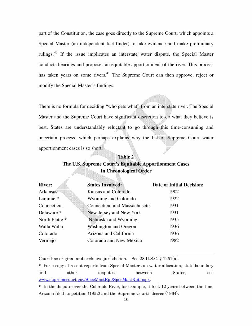
There is no formula for deciding “who gets what” from an interstate river. The Special
Master and the Supreme Court have significant discretion to do what they believe is
best. States are understandably reluctant to go through this time-consuming and
uncertain process, which perhaps explains why the list of Supreme Court water
apportionment cases is so short.
Table 2
The U.S. Supreme Court’s Equitable Apportionment Cases
In Chronological Order
River: States Involved: Date of Initial Decision:
Arkansas Kansas and Colorado 1902
Laramie * Wyoming and Colorado 1922
Connecticut Connecticut and Massachusetts 1931
Delaware * New Jersey and New York 1931
North Platte * Nebraska and Wyoming 1935
Walla Walla Washington and Oregon 1936
Colorado Arizona and California 1936
Vermejo Colorado and New Mexico 1982
Court has original and exclusive jurisdiction. See 28 U.S.C. § 1251(a).
40 For a copy of recent reports from Special Masters on water allocation, state boundary
and other disputes between States, see
www.supremecourt.gov/SpecMastRpt/SpecMastRpt.aspx.
41 In the dispute over the Colorado River, for example, it took 12 years between the time
Arizona filed its petition (1952) and the Supreme Court’s decree (1964).
17
* Indicates cases that culminated in a final apportionment decree. The initial decision was often
followed by years of subsequent litigation.
____
To date, the Supreme Court has received equitable apportionment petitions on eight
rivers but approved a final decree for only three: the Delaware; the Laramie; and the
North Platte. In the other five petitions, the Court held that the complaining State did
not provide clear and convincing evidence to obtain an apportionment decree.42
3. Interstate Compacts
The States themselves may solve their water dispute by signing a “compact” with each
other, subject to approval by Congress.43
A compact is a contract, a binding legal
document that has the force of law.
The authority for States to sign these agreements is the “compact clause” of the U.S.
Constitution.44
Congress approved the first interstate compact soon after the
Constitution took effect. That agreement, like many others that followed, altered
42 The “clear and convincing evidence” standard can be difficult for the complaining State
to meet. See the U.S. Supreme Court’s analysis of this issue in Colorado v. New Mexico,
467 U.S. 310, 316 (1984)(“Vermejo II”). This case was preceded by Colorado v. New
Mexico, 459 U.S. 176 (1982)(“Vermejo I”), see note 23, supra.
43 The origins of the compact go back to the nation’s colonial period, when royal land
charters left borders subject to frequent change. To settle disputes, the colonies
negotiated boundary compromises submitted for approval to the Privy Council in
England.
44 Article 1, § 10, cl. 3 of the U.S. Constitution states:
“No state shall, without the consent of Congress…enter into any agreement or
compact with another state, or with a foreign power….”
18
boundary lines between States and did not directly address water issues or problems.
Compacts between two or more States now address such diverse subjects as child
custody, bridge tolls, nuclear waste, taxes and water. The Council of State
Governments in Lexington, State of Kentucky, maintains a repository of these
agreements.45
The first compact that apportioned interstate waters was signed in 1925. It divided the
waters of a small river, the La Plata River between the States of Colorado and New
Mexico. The most recent interstate water apportionment compact was executed in
1980. In total, Congress has consented to 22 interstate compacts that apportion water
on interstate rivers.46
In general, States are not free to sign interstate water apportionment contracts without
seeking Congressional consent.47
When Congress consents, it passes a statute. The
45 See the compilation of interstate compacts at the Council of State Governments
website, www.csg.org/knowledgecenter/Old%20Pages/ncic/database/search.aspx. The
website of the International Water Law Project also contains a list of the U.S. interstate
water compacts and the text of the agreements,
http://internationalwaterlaw.org/documents/interstate_us.html.
46 Congress has also consented to a number of interstate compacts that address water
quality and related natural resource issues. See, for example, the Great Lakes-St.
Lawrence River Basin Water Resources Compact, which Congress approved in 2008.
Those compacts do not allocate or apportion water.
47 The Supreme Court has held that not all interstate compacts require Congressional
consent. Virginia v. Tennessee, 148 U.S. 503 (1893). The Court’s reasoning was that if the
subject of the compact was within the sole jurisdiction of the States, requiring
Congressional approval would improperly diminish State control and independence.
But in the case of water allocation contracts, the subject is rarely (if ever) within the sole
power of the States to decide. There are inevitably federal interests at stake. Thus, as a
general rule, an interstate water apportionment compact requires consent from

19
compact therefore becomes a binding legal agreement between the States and a
federal statute at the same time. As a result, the States cannot amend their compact
without returning to Congress and asking it to pass an amended statute.48
Some compacts create an interstate commission to interpret or implement its terms
and conditions. Other compacts do not. Some compacts have been the subject of
prolonged litigated before the Supreme Court. Others have proceeded smoothly.
There is no uniform experience.
A violation of the terms and conditions of an interstate compact gives rise to a contract
claim for breach. These claims are filed with the U.S. Supreme Court, which is the
only forum to resolve the disputes (if they are between States, as opposed to private
parties and a State).
Over the years, the Supreme Court has interpreted a number of interstate compacts but
its role is different than when it apportions a river without a compact. In the latter
circumstance, there is no agreement between the States and the Supreme Court
equitably divides the river as best it can. If, however, the Supreme Court is
interpreting an interstate compact, it looks to the terms and conditions that the States
themselves have accepted. The Court’s role is more limited: it is reluctant to disturb
the compact terms, even if they result in an impasse, as they did on the Pecos River
Congress.
48 The same principle applies if the States were to undo the compact entirely: Congress
would have to repeal its prior consent, unless the compact itself spelled out the
conditions for termination. .g., if the Compact itself expires automatically on a date
certain, Congress need take no action.

20
Compact between the States of New Mexico and Texas.49
In that case, the State of New Mexico asked the Supreme Court to “reform” the
compact by allowing a non-voting federal member of the Pecos River Commission to
end years of deadlock between the two States (who had one vote each). The Supreme
Court declined to do so. The solution, the Supreme Court said, was for the States of
New Mexico and Texas to amend their compact. Once Congress consented to a
compact, as it had done here, the agreement was transformed into the law of the
United States, and “no court may order relief inconsistent with its express terms.”50
The Supreme Court can, however, order money or water remedies if it finds a
violation of the compact terms. It can direct an upstream State to supply water, for
example, to a downstream State, or it can impose money penalties for failure to abide
by the terms of the compact.
Finally, the Supreme Court can appoint a special “river master” to account for water
diversions and provide technical information after its decision. The Supreme Court
has taken that step only twice: once in a dispute involving the Delaware River
between the States of New Jersey and New York51
; the other in the litigation between
49 Texas v. New Mexico, 482 U.S. 124, 128 (1987). “[A] compact when approved by
Congress becomes a law of the United States.…It remains a legal document that must be
construed and applied in accordance with its terms.” See, also, Montana v. Wyoming,
No. 137, Orig. (slip opinion, May 2, 2011), available at
www.supremecourt.gov/opinions/slipopinions.aspx.
50 Texas v. New Mexico, 482 U.S. at 564.
51 New Jersey v. New York, 347 U.S. 995 (1954)(amended decree).

21
the States of New Mexico and Texas over the Pecos River.52
VI. INTERSTATE WATER DISPUTES IN INDIA
More than 80% of India lies within an interstate river basin.53
Thus, the resolution of
interstate conflicts affects virtually every area of the country and virtually every part
of the economy, from irrigation to industrial uses.
Even before independence from Great Britain in 1947, the boundaries of India’s States
(then called “Princely States” or kingdoms) changed regularly. At the time of
independence in 1947, India consisted of 11 provinces and 562 Princely States, of
which 147 were vested with some degree of autonomous legal authority. The
Constitution of India, which came into force in 1950, consolidated these units into
several dozen States.
Six years later, India redrew its State boundaries when Parliament approved the States
Reorganization Act of 1956. The legislation re-configured most State borders based on
language -- “linguistic boundaries” that reflected the diverse ethnic background and
52 Texas v. New Mexico, 485 U.S. 388 (1988).
53 The Central Water Commission (“CWC”) defines a “major river basin” as those greater
than 20,000 square kilometers (7,722 square miles). See 2009-10 Annual Report (inset),
“India – Land and Water Resources: Facts.” The CWC identifies 12 major basins: the
Indus; Ganga-Brahmaputra-Barak (a tributary to the Meghna); Sabarmati; Mahi;
Narmada; Tapi; Brahmani; Mahanadi; Godavari; Krishna; Pennar; and Cauvery. See
Table 1.4 Catchment Area of Major River Basins in the CWC’s Handbook of Water
Resource Statistics, available at www.cwc.nic.in/main/webpages/publications.html.

22
languages of the Indian population.54
In 2000, three new States -- Uttarakhand,
Jharkhand and Chhattisgarh -- joined the Union. India is currently considering the
creation of more States. A proposal to create a new State, Telangana in central India, is
now under discussion.
A. The Role of the Central Government
The national government in India is commonly referred to as the “Central Government”
or “the Centre.” It typically does not own large dams for irrigation. That responsibility
falls to the States, which have taken the lead for the last 100 or more years to build
and manage dams across India’s large rivers.
As early as the 1850s, the British developed elaborate plans for the Princely States to
construct irrigation and navigation canals, and generate revenue. The goal was to tame
the rivers of India and prevent the extremes of flooding and destruction, drought and
famine.
Some of those ambitious plans remained on the books and were never implemented.
Other plans became reality and transformed India’s rivers in virtually every part of the
country, from the Ravi-Beas in the northwest to the Godavari, Krishna and Cauvery in
54 According to the 2001 Census of India, 29 languages are spoken by more than one
million native speakers. In addition to Hindi, which is the official language of India, the
10 major languages are: Bengali (83 million); Telugu (74 million); Marathi (72 million);
Tamil (61 million);Urdu (52 million); Gujarati (46 million); Kannada (38 million);
Malayalam (33 million); Oriya (33 million); and Punjabi (29 million). See
http://en.wikipedia.org/wiki/Languages_of_India.

23
peninsular India (central and south).55
Despite the historical role of the States, the Central Government has established
several corporations that are in the dam-building business, albeit with limited
missions:
• The National Hydro Power Corporation (“NHPC”) is a federal enterprise that
constructs and manages hydroelectric dams. The NHPC does not build dams,
canals or pumping stations for irrigation.
• The Central Government has created several joint ventures with States to build
dams. The Nathpa Jhakri Power Corp. (between the Central Government and
the State of Himachal Pradesh) and Tehri Hydro Development Corp., Ltd.
(between the Central Government and the State of Uttar Pradesh), are
examples.
• The Damodar Valley Corporation (“DVC”) is a public entity with a regional
mission in northeast India. The DVC was created in 1948 and has built dams to
control floods, generate electricity and supply water for irrigation and other
uses in the Damodar River Basin.56
The basin drains part of two States:
55 See the accomplishments of Sir Arthur Cotton (1803-1899), a British general and
irrigation engineer. http://en.wikipedia.org/wiki/Arthur_Cotton.
56 The Damodar Valley Corporation was approved by Parliament two years before the
Constitution of India went into force. See Act. No. XIV of 1948, enacted pursuant to the
1935 Government of India Act. For more information, see www.dvcindia.org. The DVC
also owns thermal power (coal) plants. It is located in Kolkata (Calcutta).

24
Jharkhand, formerly called Bihar; and West Bengal. The DVC is modeled
loosely on the Tennessee Valley Authority (“TVA”) in the United States.
The absence of federal infrastructure on most interstate rivers in India means that the
Central Government has little leverage to assert itself – it does not own the dams,
locks, canals and pumping stations.
Nonetheless, the Central Government’s Ministry of Water Resources in India plays an
important role in India. It monitors water resource development and provides technical
information and assistance to other parts of the Central Government and to State
governments, as well. The Ministry’s Central Water Commission remains the best
source for understanding legal issues involved in interstate and international water
issues.57
B. The Constitution
India is a Union of States governed by a Constitution, which, among other things,
establishes Parliament as the legislative branch. India consists of 28 States and seven
Union territories.58
The Government has more authority over Union territories
(former colonial territories) than it does over States, which maintain a
semi-independent role in the federation.
The Constitution of India went into force in 1950, three years after India achieved
57 The CWC publishes four volumes of legal instruments, available at its website,
www.cwc.nic.in/main/webpages/publications.html.
58 The Union Territories include the National Capital Territory of Delhi (“New Delhi”).

25
independence from Great Britain. The official language is Hindi. English is the
secondary (subsidiary) official language. The Constitution lists additional languages
which it refers to as “national languages” of India.59
Article 246 of the Constitution of India creates three Lists (categories) of subject
matter that fall within the authority of the Union (the Central Government), or the
States, or that are subject to concurrent (dual) jurisdiction. The Lists identify the
subjects on which the Union or the States can legislate:
• List I contains those “entries” (specific subjects) that are the exclusive
jurisdiction of the Union. Entry 56 covers the regulation and development of
interstate rivers and river valleys “to the extent to which such regulation and
development under the control of the Union is declared by Parliament by law to
be expedient in the public interest.”
• List II contains entries that are the exclusive jurisdiction of the States. Entry
17 makes clear that everything related to water, except for an interstate river,
remains under the exclusive control of States. “Water, that is to say, water
supplies, irrigation and canals, drainage and embankments, water storage and
water power, subject to the provisions of Entry 56 of List I [the Union]”
remains within State authority.
59 Section 345 of the Constitution allows States to designate their own official languages.

26
• List III contains entries that form the “Concurrent List” over which the Union
and States have dual authority. There is no mention of water in this list.
Thus, interstate waters remain under Central Government control if Parliament enacts
legislation pursuant to Entry 56. Every other aspect of water and river management
remains under State control.
If there is a conflict between States over the meaning of those provisions, the States
may take their dispute to the Supreme Court, which has original jurisdiction to hear
cases between States (like the Supreme Court of the United States).60
But there is one important difference between India and the United States. In India,
the Constitution expressly authorizes Parliament to provide for a special adjudication
process for interstate rivers and, if Parliament so chooses, to prohibit (divest) the
Supreme Court from deciding those disputes.61
The Constitution creates no other
exemption to the Supreme Court’s authority to decide cases. Only in the area of
interstate water disputes may Parliament intervene and strip the Court of its ability to
adjudicate disputes by creating an alternative tribunal. In 1956, only six years after the
60 Article 131 of the Constitution.
61 Article 262 of the Constitution states:
Adjudication of disputes relating to waters of interAdjudication of disputes relating to waters of interAdjudication of disputes relating to waters of interAdjudication of disputes relating to waters of inter----state rivers or valleys.state rivers or valleys.state rivers or valleys.state rivers or valleys.
(1) Parliament may by law provide for the adjudication of any dispute or
complaint with respect to the use, distribution or control of the waters of, or in,
any inter-state river or river valley.
(2) Notwithstanding anything in this Constitution, Parliament may by law
provide that neither the Supreme Court nor any other court shall exercise
jurisdiction in respect of any such dispute or complaint as is referred to in
clause (1).

27
Constitution went into force, Parliament did just that.
C. The Legal Mechanisms for Resolving Disputes
The year 1956 was important in India’s history. Parliament that year passed the States
Reorganization Act, which redrew State boundaries to consolidate populations who
spoke the same language. With these redrawn boundaries came a host of new
problems on interstate rivers. Management of these waterways became more
fragmented: new States now had a river in their territory and they had their own issues
and solutions they wanted to implement. Consensus became more difficult.
In response, Parliament enacted two companion statutes. The first statute authorized
creation of interstate “river boards” to advise and help develop interstate rivers.
The second statute created special tribunals to adjudicate interstate water rights (e.g.,
in circumstances when the cooperative approach of the river boards does not work or
when the States do not want to create a river board in the first place).62
1. The River Boards Act of 1956
The River Boards Act allows States to request that the Central Government create a
62 States do not need to try a cooperative approach before seeking to adjudicate water
rights. Instead, Parliament created a two-track approach that gives States a choice:
one option (the river board) facilitates river-basin planning and long-term collaboration;
the other option (the interstate water disputes tribunal) adjudicates the rights of the
parties in an adversarial legal process. Both options are voluntary. The States are not
under any obligation to create a river board nor are they under an obligation to ask the
Central Government to establish an interstate water disputes tribunal.

28
board to advise the governments on any matter concerning an interstate river and to
help prepare “multi-purpose schemes” for regulating or developing these waterways.
The list of potential activities is comprehensive: the conservation, control and
optimum use of water resources, as well as the promotion and operation of schemes
for irrigation, water supply, drainage, hydroelectric power, flood control, navigation,
reforestation, soil erosion and pollution.63
Nonetheless, the River Boards Act has remained dormant. No river boards have been
created in the last 55 years, a reflection of the high degree of suspicion by States, who
fear that the river boards will give the Central Government too much influence over
State infrastructure, particularly irrigation canals.64
2. The Inter-State Water Disputes Act of 1956
The Inter-State Water Disputes Act allows States to file complaints with the Central
Government and request the creation of a special court -- a tribunal -- to adjudicate
water disputes.65
If the Central Government concludes the dispute cannot be settled
by negotiations, it creates a Water Disputes Tribunal under the Act.66
63 Article 13 of the River Boards Act, 1956.
64 In recent years, the Central Government has created a number of boards and
commissions to address issues on rivers but those entities are far more limited in
authority and scope than the independent basin-wide boards contemplated by the River
Boards Act. [See discussion at pp. 29-31 of this paper]
65 Section 2c of the Inter-State Water Disputes Act, 1956. The Act defines “water
dispute” to mean any dispute or difference between two or more States with respect to
“the use, distribution or control of the waters of, or in, any inter-State river or river valley,
or the interpretation of the terms of any agreement relating to the use, distribution or
control of such waters or the implementation of such agreement.”
66 Id. at section 4(1).

29
On some rivers, the Central Government tried to broker a negotiated agreement,
calling meeting after meeting of State officials to reach an accord. Several years
lapsed after the initial State request for a Tribunal. When the Central Government
finally concluded the negotiation effort was fruitless, it established an interstate
Tribunal.
Under the Act, Tribunal members include a Chairman and two other members,
nominated by the Chief Justice of the Supreme Court, who are current judges of the
Supreme Court or a High Court.67
The Tribunal hires two or more “assessors” who
provide a range of scientific, engineering and other technical advice.68
The Central
Government plays no role in fact-finding. When the Tribunal is finished, it issues a
written decision called an “award.”69
The typical award is a lengthy document
addressing each State’s complaint and the resolution.
67 Id. at section 4(2).
68 Id. at section 4(3).
69 Id. at section 5(2).

30
Table 3
Interstate Water Disputes Tribunals in India
In Chronological Order
Name of Tribunal: Start Date: Final Award: Time:
Krishna River I 1969 1976 7 years
Narmada River 1969 1979 10
Godavari River 1969 1980 11
Ravi-Beas Rivers 1986 None * 25
Cauvery River 1990 2007 17
Krishna River II 2004 2010 6
Vansadhara River 2010 None __
Mahadayi River 2010 None __
* The Ravi Beas Tribunal issued an award in 1987 but it was never implemented. The parties referred
certain issues back to the Tribunal, which is where matters remain to this day.
_____________
The Tribunals have typically relied on the principle of equitable apportionment to
divide the rivers and settle conflicting State claims. But equitable apportionment --
whether in India or the United States -- is something of a vague concept. The Tribunal
must balance the competing factors that go into apportioning the waters, such as
population, existing and prior uses, hydrology, the State’s contribution to river flow
and other variables.
After the Tribunal’s decision is released, the States or the Central Government may
(after 90 days) request an explanation or clarification.70
Until those follow-on issues
are resolved, the Central Government will not certify the Tribunal decision and
publish the final award. Delays of months or even years are common. When the
clarification process is finished, the Central Government publishes the Tribunal’s
decision in the Official Gazette and its decision then becomes binding -- at least in
70 Id. at section 5(3).

31
theory -- on the States.71
Under a strict reading of the Inter-States Water Disputes Act, a Tribunal’s decision is
final. The Act clearly seems to prohibit appeals from a Tribunal to the Supreme Court:
Bar of jurisdiction of Supreme Court and other courts.
Notwithstanding anything contained in any other law, neither the Supreme
Court nor any other court shall have or exercise jurisdiction in respect of any
water dispute which may be referred to a Tribunal under this Act.72
But in practice the Supreme Court has allowed limited appeals to proceed. In 2007, for
example, several States filed special petitions in the Supreme Court, seeking to review
the 2007 award by an Inter-States Water Disputes Tribunal for the Cauvery River in
peninsula India. Four years after receiving the appeal, the Supreme Court has not
issued an opinion.
Even more troubling is the attempt at nullification now before the Supreme Court
concerning the award of a 1986 Tribunal in the long-standing dispute over water in the
Ravi-Beas Rivers in northwest India. The Central Government has yet to publish the
final award. In 2004, the State of Punjab passed a law expressly disavowing any
responsibilities to the neighboring State of Haryana to supply surplus water from the
Ravi-Beas system. Seven years after receiving a “Presidential Reference” for an
opinion, the Supreme Court has not issued an opinion.73
71 Id. at section 6(1).
72 Id. at section 11.
73 The Supreme Court of India may issue advisory opinions when specific questions of
law are referred to it by the President. The request is known as a “Presidential
Reference.”

32
Adding to this backlog are petitions filed in 2011 by the States of Karnataka and
Andhra Pradesh challenging the 2010 Krishna II Tribunal decision. [See part VII of
this paper for details.]
3. Voluntary Agreements Between the States
States in India may also settle water disputes by signing agreements among
themselves. In India, unlike the United States, the Constitution is silent about
interstate agreements. They are not expressly authorized or prohibited. But there are
several statutes, including the Inter-State Water Disputes Act itself, which by
implication assume that the States can -- and will -- sign agreements among
themselves to address common problems.
Unfortunately, these agreements are rarely analyzed in academic research.
According to the Central Water Commission, there are 125 separate interstate water
agreements. Some agreements date back to the time when India was a British colony.
Others were executed in the early 1990s. But the Central Water Commission itself has
not published interstate water agreements since 1995.74
Three examples illustrate the diversity in these interstate water contracts. In
southwestern India, water from behind a dam built in 1886 on the Periyar River in the
74 Central Water Commission, Legal Instruments of Rivers in India, Vol. III, available at
www.cwc.nic.in/main/webpages/publications.html.

33
State of Kerala (formerly the Maharaja of Travancore) is diverted into canals and
moved to the State of Tamil Nadu, pursuant to the terms of a 999-year lease
agreement.75
In northwest India, the Gang Canal, one of the oldest irrigation systems
in the State of Rajasthan, diverts water from the Sutlej River in what is now the State
of Punjab, pursuant to a contract signed in 1920.76
An agreement in 1994 created the
Upper Yamuna River Board to manage part of the Yamuna River north of Delhi.77
4. The Central Government’s Boards, Commissions and Authorities
A final way to resolve interstate disputes is for the Central Government to create its
own board, commission or authority composed of Central Government and State
officials to manage certain aspects of an interstate river. These entities are typically
not created by contract but by special legislation or a memorandum of understanding.
75 Id. at pp. 389-392.
76 Id. at pp. 8-14.
77 Id. at pp. 166-168.

34
Table 4
River Boards, Commissions and Authorities
Created by the Central Government (In Chronological Order)
Name of Board: Date Created:
Tungabhadra Board 1953
Bhakra-Beas Management Board 1966
Ganga Flood Control Commission 1972
Betwa River Board 1976
Bansagar Control Board 1976
Brahmaputra Board 1980
Narmada Control Authority * 1980
Upper Yamuna River Board 1994
Krishna River Implementation Board * 2010
* Indicates a board created to implement an award of an interstate water dispute Tribunal.
_____
The boards, commissions and authorities rely on the Central Government to play a
dominant role and are under its control. They are not the “river boards” contemplated
by the River Boards Act of 1956, which anticipated that the States would form
interstate boards with minimal oversight by the Central Government.
Some boards, like the Tungabhadra and Bansagar, manage a single hydroelectric and
irrigation diversion project. Others, such as the Ganga Flood Control Commission,
provide advice. The Brahmaputra Board covers seven States in northeast India that lie
within the Brahmaputra River watershed (shared with Bangladesh) but it has no power
to allocate water among the seven States in India. Rather, its duties include the
preparation of a master plan for India’s share of Brahmaputra waters. The Upper
Yamuna River Board allocates waters and provides coordinated management on the

35
Yamuna River between its source in the Himalayan Mountains and Okhala Barrage
near Delhi, a distance of approximately 350 kilometers (213 miles).78
VII. CASE STUDY IN INDIA: THE KRISHNA RIVER
The Krishna River begins in the Western Ghats, a mountain range that runs
north-south along the western coast of India.79
From its source the Krishna River
flows east for 1,392 km (870 miles) before emptying into the Bay of Bengal. The river
drains parts of three States: Maharashtra (where the river begins); Karnataka (the
middle riparian) and Andhra Pradesh (the furthest downstream). The Krishna River
basin is home to 74 million people. Parts of the basin are heavily industrialized with
hundreds of factories.
Except for the upstream area in the Western Ghats, the Krishna basin is largely arid
and receives approximately 90% of its annual rainfall during the six-month monsoon
season (May to October). The first irrigation projects in the basin were built in 1855,
when India was part of the British Empire.
As the basin population grew, the States signed water allocation agreements with each
other, first in 1892 and again in 1933, 1944 and 1946.80
In 1951, three of the States
78 The Upper Yamuna River drains parts of five States (Himachal Pradesh, Uttar
Pradesh, Uttarakhand, Haryana and Rajasthan) as well as Delhi. See the Board’s
website, http://uyrb.gov.in.
79 The Western Ghats, also known as the Sahyadri Mountains, run 1,600 kilometers (976
miles) along the western coast of India.
80 Krishna II Tribunal Report (2010) at p.16.

36
(then known as Bombay, Hyderabad and Madras) signed a new water allocation
agreement. But the fourth State, Mysore (now Karnataka), refused to ratify the
agreement, and the interstate disputes lingered.
Two pieces of legislation -- the 1953 statute creating a new State of Andhra Pradesh
and the 1956 States Reorganization Act -- changed important boundaries in the
Krishna River basin and consolidated a number of States. But disagreements over
water continued.
Then, in 1969, in response to a petition from three States, the Central Government
invoked the Inter-State Water Disputes Act and created the Krishna Water Disputes
Tribunal, the first time the government had established a tribunal under the
legislation.81
Four years later, the Krishna Tribunal issued its award. Additional
requests from the States for clarification forced the Tribunal to reexamine certain
assumptions and decisions.
As a result, it was not until 1976 that the Tribunal published its final award, which
contained the following conclusions:82
81 Two States, Madhya Pradesh and Orissa, were parties to the original 1969 dispute but
withdrew their claims in 1971. The three remaining States -- Maharashtra, Karnataka
and Andhra Pradesh -- continued their dispute.
82 The Tribunal is also known as the “Bachawat Tribunal” after retired Supreme Court
Justice R.S. Bachawat, who served as its chairman.

37
• The Tribunal did not evaluate the adequacy of groundwater supplies. Each
State was free to make use of underground water within its respective
territory.83
• The Tribunal found that the 1951 agreement, signed by three of the four basin
States, was not valid. Furthermore, the Tribunal’s order superseded previous
agreements signed by the States (or their predecessors) in 1892, 1933, 1944 and
1946.84
• The Tribunal evaluated two alternative solutions, which it called “Scheme A”
and “Scheme B.”
• Scheme A was based on an apportionment based on the annual availability of
2,060 TMC (thousand million cubic feet)(or 47.3 MAF) of water in the basin.85
• The Tribunal allocated this water to the States of Andhra Pradesh, Karnataka
and Maharashtra. The Tribunal used the principle of equitable apportionment to
give Andhra Pradesh 39% of the annual flow; Karnataka, 34%; and
Maharashtra, 27%.
• Those allocations were a fraction of what each State wanted. The Tribunal
noted that the States’ collective demands for water totaled 4,147 TMC (95.2
MAF), twice the available amount of water in the river.86
• The Tribunal based Scheme A on what it called “75% dependability,” meaning
the river would provide the necessary flows 75% of the time, or three out of
every four years. Thus, even the annual allocation of 2,060 TMC was not
83 Krishna I Tribunal Order (1976), Clause II.
84 Id., Clause XI.
85 Id., Clause III.
86 See discussion in Krishna I Tribunal Report (1973) at pp. 4-5.

38
assured in times of drought. What would happen during periods of shortage
(one out of every four years)? The Tribunal did not explain.
• The Tribunal allocated the surplus (the amount of available water above 2,060
TMC) to the State of Andhra Pradesh but it did not acquire a permanent
(vested) right to those waters.87
• The Tribunal’s second alternative, Scheme B, contemplated the creation of a
Krishna Valley Authority, a basin-wide government entity, to allocate water and
manage the river, including surplus flows. Two upstream States, Maharashtra
and Karnataka, endorsed this alternative. The State of Andhra Pradesh did not.
The Tribunal said the Authority could come into existence only if Andhra
Pradesh changed its mind and supported the alternative or if Parliament created
the Authority.
• Because the three States did not collectively agree to create a Krishna Valley
Authority (and because Parliament had not acted), the Tribunal did not adopt
Scheme B.88
Instead, the Tribunal endorsed Scheme A and its allocations.
• The Tribunal allowed the States to re-open the water allocations after May 31,
2000.89
87 Krishna I Tribunal Order (1976), Clause V.
88 The State of Karnataka sought to compel the Central Government to create the
Authority and filed suit in the Supreme Court. It argued, among other things, that the
State of Andhra Pradesh was not entitled to surplus waters if Scheme B was not
implemented. The Supreme Court rejected those claims. State of Andhra Pradesh v.
State of Karnataka & ORS (25 April 2000), available at
www.indiankanoon.org/doc/953049.
89 Krishna I Tribunal Order (1976), Clause XIV. Commentators found this provision to
be self-defeating. “This single clause has made this [the Tribunal’s] report incapable of
giving lasting peace and harmony between the sharing States.” S.K. Garg,
International and Interstate River Water Disputes & Interlinking of Rivers (Khanna
Publishers 1999) at p. 37.

39
After the final Tribunal award was published, the States began building new dams on
their share of the river, all but guaranteeing that a new Tribunal would have to grapple
with the next generation of water problems.90
The next round of adjudication began in 2004 with the formation of a second Krishna
River Tribunal. Its 800-page decision, announced six years later in 2010, concluded
that the Krishna River held more water than previously thought.
As a result, the Krishna II Tribunal increased the amount of annual allocable water to
2,578 TMC (approximately 59 MAF).91
But the Tribunal made those additional
allocations less dependable than the base allocations in 1976. The Tribunal calculated
the amount of additional flows based on 65% dependability, not 75%, as it had done
for the base allocations.
The additional flows are therefore likely to occur only two out of three years.92
The
90 The State of Andhra Pradesh, for example, built Srisailam Dam in 1984. The State of
Karnataka completed Almatti Dam in 1999.
91 See Krishna II Tribunal Order (2010) at pp. 802-804. The Tribunal did not allocate
surplus waters only to the State of Andhra Pradesh, as the 1976 Tribunal had done.
Instead, it divided the water evenly between the three States. Clauses VI and VII. In
the case of Andhra Pradesh, for example, the Tribunal began with the 1976 award of 811
TMC and added Andhra Pradesh’s pro rata share of additional water at 65%
dependability and its share of surplus flows and its share of minimum flows for a total
supplemental allocation. Andhra Pradesh’s annual allocation of water therefore
increased from 811 to 1,001 TMC (23 MAF). Clause VIII. The Tribunal used the same
approach (methodology) for the two other States.
92 The Tribunal permitted the State of Karnataka to raise the height of Almatti Dam by
4.7 meters (approximately 15.4 feet), despite objections of Andhra Pradesh, the

40
Tribunal, like its predecessor, did not explain what happens when there is not enough
water in the river to satisfy demands in drought (e.g., less than average water
conditions). It did not adequately address shortages. The Tribunal called for the
creation of a Krishna Water Decision Implementation Board to administer its
findings.93
The Tribunal said the States could re-open the Tribunal’s order after May
31, 2050.94
Meanwhile, two of the States, Karnataka and Andhra Pradesh, have filed
petitions in the Supreme Court, challenging the award.95
VIII. CASE STUDY IN THE UNITED STATES: THE POTOMAC RIVER
The Potomac River runs through Washington, D.C., and supplies most of the drinking
water to six million people.96
The river is only 628 kilometers (383 miles) long but it
drains parts of four States -- Maryland, Pennsylvania, Virginia and West Virginia,
along with the District of Columbia itself. Most of the basin is forested. The river
empties into Chesapeake Bay on the Atlantic Ocean. There is little heavy industry in
the basin.
Unlike many areas of the American West, which were first settled by Europeans only
in the mid-1800s, the eastern coast of the United States was home to British
downstream State.
93 Krishna II Tribunal Order (2010), Clauses XIV and XVIII. See, also, Appendix-I.
94 Id., Clause XVI.
95 The Hindu, “A.P. moves Supreme Court against Krishna Tribunal award,” March 29,
2011.
96 The U.S. Constitution allows for the creation of a special district to serve as the
national capital. Article 1, § 8, cl. 17. Washington in the District of Columbia (“D.C.”)
was created in 1790 and is not part of any U.S. State.

41
settlements dating back to the 1600s. King James I gave the first land charter in the
Potomac River Basin to the London Company in 1609. The grant was followed by
competing charters granted by kings.
As the population grew, Congress authorized the U.S. Army Corps of Engineers in
1859 to build an aqueduct for the city. Then, in 1940, faced with pollution (i.e.,
untreated sewage) problems, Congress consented to the creation of the Interstate
Commission on the Potomac River Basin (“ICPRB”) to help the States and the federal
government to protect and conserve water and land resources. The ICPRB consisted
of a member from the four States, the District of Columbia and the federal
government.97
By the late 1960s, Congress and the basin States became concerned about a new
problem: pending water shortages. In response, the parties to the 1940 compact agreed
in 1970 to expand the ICPRB’s authority to collect data on water consumption and to
establish a cooperative organization to coordinate water withdrawals during drought
conditions.98
The ICPRB, however, had no regulatory authority (nor does it have
regulatory power now).
The impetus for these expanded duties came from demographic changes in the basin:
the population growth occurred in the suburbs, outside of the District of Columbia
itself. The responsibility for water supply therefore fell primarily to two water
97 54 Stat. 748, 33 U.S.C. §567(b). For the commission website, see
www.potomacriver.org.
98 33 U.S.C. § 567(b)-1, Pub. L. No. 91-407, 84 Stat. 856 (Amended Compact).

42
agencies, the Washington Suburban Sanitary Commission in the State of Maryland,
and the Fairfax County Water Authority in the State of Virginia.
In 1978, the entities in the basin (along with the Washington Aqueduct Division of the
Army Corps of Engineer) agreed to a cooperative agreement that addressed over-use
and drought. The agreement was followed by a 1982 water supply coordination
agreement which, among other things, allows the water agencies to purchase storage
rights at Jennings Randolph Dam, an Army Corps dam in West Virginia, and to
coordinate the flow of water in times of drought from four other dams, as if they were
all operated by a single entity.99
Legal ownership remains in the hands of the entities that built the dams (e.g., Jennings
Randolph Dam remains under Army Corps ownership). But a number of flexible
contracts allow for a collaborative approach to river management. In some of the
transactions, money changes hand: one government entity buys “watershed services”
from another entity. The Army Corps and the two water agencies (Washington
Sanitation and Fairfax County), for example, pay a certain part of the operation and
maintenance costs at a State of Maryland dam in exchange for rights to demand the
release of water in drought.
The ICPRB’s work is notable for two reasons. First, the ICPRB is one of three
working interstate commissions (along with the Delaware and Susquehanna) that
attempts to resolve conflicts on rivers that cross State boundaries. Second, the
99 The vehicle for these contractual arrangements is a section of the ICPRB called the
Cooperative Water Supply Operations on the Potomac (“CO-OP”).

43
ICPRB’s ability to enforce or implement a decision is limited – it must rely on
negotiation and facilitation.
The Delaware River Basin Commission, in contrast, has more legal authority. It was
created in 1961 and consists of the States of New York, New Jersey, Pennsylvania and
Delaware. The federal government is a signatory and has its own representatives on
the Commission.100
At the time of its creation, 43 State agencies, 14 interstate
agencies and 19 federal agencies exercised fractured control over the river. Major
cities in the basin include Philadelphia, Pennsylvania; Trenton and Camden, New
Jersey; and Wilmington, Delaware. Eight million people live in the basin. There are
many industries, port facilities and power plants along the river.
Prior to creation of the Delaware River Basin Commission, litigation over withdrawals
in the basin had gone to the U.S. Supreme Court. In 1929, the State of New Jersey
sought to prevent the State of New York from diverting water in the upstream basin to
supply New York City. The Supreme Court’s opinion in 1931 allowed for limited
diversions but required the State of New York to maintain specified downstream flows.
“A river is more than an amenity, it is a treasure,” the Court said in words now quoted
in other judicial decisions around the world (including by the Supreme Court in India).
A river “offers a necessity of life that must be rationed among those who have power
over it.”101
100 Pub. L. No 87-328, 75 Stat. 688. The website for the Delaware River Basin
Commission is www.state.nj.us/drbc.
101 New Jersey v. New York, 283 U.S. 336, 342 (1931). In 1954, the U.S. Supreme Court
issued an amended decree allowing greater diversions, New Jersey v. New York, 347 U.S.
995 (1954).

44
The Delaware River Basin Commission can plan for the basin, allocate water, build
new reservoirs, prevent floods and control pollution. The Commission has not
exercised all of its legal authority – for example, it has not allocated water – but it
remains one of the best examples of regional river cooperation in the United States.
The same is true for the Susquehanna River Basin Commission, created in 1970 to
primarily address diversions outside of the river basin.102
The States in the basin
include New York, Pennsylvania and Maryland. The federal government is also a
signatory to the compact and has a seat on the commission. Water from the
Susquehanna River supplies approximately 5.5 million people.
IX. AN ALTERNATIVE TO LITIGATION: COOPERATIVE
AGREEMENTS ON SHORTAGES
Adjudication -- the process of going to court -- offers only a limited solution to the
complex problems of interstate river management in any country. Courts are generally
not well-equipped to resolve convoluted problems of hydrology, economics,
engineering and law. Litigation takes too long and is too expensive.
As a result, there is no easy “legal fix” in India or the United States that allows for the
speedy and fair division of water from an interstate river, particularly a river that
crosses multiple State boundaries and that is already used for multiple purposes (e.g.,
102 Pub. L. No. 91-575, 84 Stat. 1509. The website for the Susquehanna River Basin
Commission is www.srbc.net.

45
irrigation, power generation, navigation, etc.).103
The better approach is to rely on a system of cooperative mechanisms that allows
States to manage a river as if the infrastructure were owned by a single entity.
Among the most promising of these tools are transactions called “payments for
watershed services,” where one State pays another for enhanced flood control
protection or where one utility leases upstream reservoir storage in case of drought, or
where one State “banks” (stores) water with another State to use later.104
Those types
of transactions are in their infancy in the United States but are infrequently analyzed
in India.
On the Colorado River, for example, the States in the Lower Basin have adopted
innovative interstate water banking arrangements. These transactions allow States to
store water in another State. The State (or local agency) that wants to “bank” the water
pays the other State (or local agency) a fee. This is a financial as well as an
operational arrangement. The transactions occur pursuant to federal regulations
103 Some veteran lawyers and observers in India have proposed legal reforms to expedite
the interstate water disputes process. See, for example, Fali S. Nariman’s essay,
Inter-State Water Disputes: A Nightmare! in Ramaswamy R. Iyer (ed.), Water and the
Laws in India (Sage Publications 2009) at pp. 32-57. Nariman concludes that interstate
water disputes tribunals do not work efficiently and that Parliament should allow States
to go directly to the Supreme Court. But the delays in obtaining decisions from the
Supreme Court suggest this approach comes with its own problems and obstacles.
104 “Payments for watershed services” are defined broadly to mean any voluntary
transaction between two or more parties for a service or benefit in a river basin.
Sometimes, they involve environmental benefits, such as payments by a downstream
landowner to an upstream landowner to reduce logging by a river or to protect
biodiversity. Other transactions involve agreements between water agencies or utilities
to improve system efficiency or other benefits (e.g., sharing the cost of a reservoir, etc.).

46
allowing States to use store their “unused apportionment” of water.105
Based on the
adoption of those regulations in 1999, the Southern Nevada Water Authority signed
water banking agreements with the Arizona Water Banking Authority and the
Metropolitan Water District of Southern California.106
The Lower Basin of the Colorado River is also home to one of the best examples of
cooperative investments in infrastructure improvements. The All-American Canal,
built pursuant to the Boulder Canyon Project Act of 1928, was unlined for years. It
lost large amount of water from leaks and seepage. The canal, which runs east-west
near the U.S.-Mexico border, delivers water from the Colorado River to irrigation
districts in southern California.
In 2003, various parties (both federal and State) agreed to line the canal (or build new
concrete-lined canals parallel to the old canal) and share the saved water. The San
Diego County Water Authority helped pay for those efforts and, in return, received a
portion of the water previously lost from leaks.107
Those types of mechanisms are rarely used on interstate waters in India; there is little
public discussion of the merits that these mechanisms might offer for India’s interstate
water stalemate. The 2002 National Water Policy of India, for example, calls for
improved water resources planning but makes no mention of payments for watershed
services or flexible cooperative agreements. The 2011 National Water Mission
105 43 C.F.R. § 414.
106 See the Arizona Water Banking Authority’s website, www.azwaterbank.gov.
107 See the San Diego County Water Authority’s website, www.sdcwa.org/history.

47
endorsed basin-wide river planning but did not analyze the potential benefits of
collaborative mechanisms to more efficiently manage interstate rivers.
Yet the cooperative transactions from the United States illustrate the potential for
resolving interstate water disputes without litigation. The transactions above were not
imposed by a court or by Congress, though they often occur in river basins, like the
Colorado, that have seen decades of litigation. In some case, the transactions were
authorized or encouraged by the federal government, but the arrangements themselves
represented an imaginative and collaborative approach between the States and other
entities, not an edict from Washington, D.C.
X. COMPARATIVE EVALUATION AND CONCLUSION
History provides painful reminders of how fragile the civil peace is during disputes
over water and how easy it is for politicians (in India, the United States or elsewhere)
to posture over perceived grievances.
In 1934, the State of Arizona was embroiled in a dispute with the federal government
over the Colorado River. The federal government wanted to build Parker Dam across
the river between the States of California and Arizona, and to allow the diversion of
large amount water to Southern California for irrigation. Congress had not approved
the project. In Arizona, opposition to Parker Dam was fierce. Arizona feared
California would grab the available water and leave Arizona as a poor, desolate State.
Arizona Governor B.B. Moeur ordered State troops to arm themselves and block
construction of the dam on the Arizona side of the river. At the last minute, the State

48
troops (pejoratively called the “Arizona Navy”) were recalled when federal officials
agreed to temporarily halt construction.
In the end, the battle over Parker Dam went to court, where Arizona prevailed. The
U.S. Supreme Court held that the federal government could not build a dam across an
interstate river without consent from Congress.108
In response, Congress authorized
Parker Dam but it also approved construction of the federal Gila River irrigation
project in central Arizona. Both States got what they wanted. California obtained
water from Parker Dam. Arizona obtained water from the Gila River.
Twenty years later, in the mid-1950s, the United States and Canada engaged in
posturing over dams on the Columbia River. There was no Navy and no threatened
use of force, but tensions between the two countries ran high.
The conflict was precipitated by U.S. attempts to build Libby Dam, a huge
hydroelectric project, on the Kootenai River in the State of Montana.109
The river
begins in Canada, flows into the United States and then crosses the border back into
Canada, where it feeds into the Columbia River. The problem was that Libby Dam
would back up waters into part of British Columbia, Canada. The United States
offered to compensate Canada for the area to be inundated but refused to sell
electricity from the dam. In response, Canadian officials threatened to build their own
dam that would divert a large part of the flow of the Columbia River before it entered
108 United States v. Arizona, 295 U.S. 174 (1935). The Court held that the River and
Harbor Act of 1899, 33 U.S.C. § 401, required specific Congressional approval before the
federal government could build Parker Dam.
109 The river is spelled “Kootenay” in Canada.

49
into the United States. The conflict threatened to generate into a “if you do this to us,
we will do worse to you” dispute.
Canada’s threats proved idle, and two countries ultimately reached an agreement on
joint uses of the Columbia River and its tributaries. The Columbia River is now
managed for flood control and power generation as if it were under the control of a
single entity, as if borders do not matter.
India has a good reason to pursue similar non-litigation alternatives. The jurisdictional
conflicts between the Inter-States Water Disputes Tribunal and the Supreme Court add
years of delay and make the process of equitable apportionment an opaque exercise.
Several States in India have now attempted to have the Supreme Court rule on issues
that are directly related to river management, despite the language in the Inter-State
Water Disputes Act that appears to divest the Supreme Court of such jurisdiction.
Furthermore, the Supreme Court has taken years to decide these cases.
Ironically, States in India can -- at least on paper -- reach agreement between
themselves easier than States in the United States, where a water apportionment
agreement requires Congressional consent. In India, no such consent is required.
Furthermore, States in India can, if they wish, request that the Central Government
constitute a river board to engage in comprehensive basin-wide planning. They have
not done so. As a result, many of the interstate agreements in India are old or they
address operations at a single dam or project. They lack the innovative terms, for
example, found in interstate water banking agreements on the lower Colorado River or
the drought management agreements on the Potomac River.

50
So perhaps it is time for India to reconsider other options, to survey the cooperative
agreements elsewhere (including but not limited to the United Sates) and to assess
whether similar agreements could facilitate the resolution of water disputes in India.
Several rivers in India may offer good opportunities. The Central Government in India
established two Tribunals in 2010, one for the Vansadhara River (in a dispute between
the States of Orissa and Andhra Pradesh), the other for the Mahadayi River (in a
dispute between the States of Goa, Karnataka and Maharashtra).110
Those States may
not have staked out entrenched legal positions, as is the situation on other
long-litigated rivers, and they may be more inclined to mediate their disagreements.
Other interstate rivers, now the focus of basin-wide planning efforts, may offer
additional opportunities for analyzing (and eventually enacting) collaborative
management agreements.111
Cooperative agreements elsewhere, like those adopted in the Potomac River in the
United States, may hold promise for those rivers. Others may not. There is no
“one-size fits all” arrangement. What is clear is that India needs to find an alternative
mechanism for resolving interstate water disputes. Prolonged litigation before a
Tribunal created under the Inter-State Water Disputes Act of 1956, or before the
Supreme Court, is not likely to work. The experience in both India and the United
States shows that litigating equitable apportionment is a long, contentious and
unpredictable affair. Bilateral or multilateral negotiations between States are the
110 For a summary of the interstate river disputes, see the Ministry of Water Resources
website, www.wrmin.nic.in.
111 The Australian government, for example, is funding an integrated water resource
planning effort on the Mahanadi River in India in cooperation with technical institutes in
India and the Monash (Australia) Sustainability Institute. The Asian Development is
funding similar planning efforts on other rivers in India.

51
preferred tool.

52
ANNEX
Interstate Water Resources:
A Checklist of Key Features of the Legal Systems
in India and the United States
Feature India U.S.
Federation of States Yes Yes
Both India and the United States are federations with major interstate rivers that flow
between the States and/or that serve as the borders of States. India has 28 States and 7
territories. The United States has 50 States but two (Alaska and Hawaii) are not contiguous
with the rest of the country. The States have significant legal powers over water resource
issues in both countries.
The Constitution Yes Yes
The U.S. Constitution went into effect in 1789. The Indian Constitution went into effect in
1950. The U.S. Constitution does not address water resources, though it gives Congress the
authority to legislate over interstate commerce, a field that includes navigation and, by
implication, interstate river management. The Indian Constitution expressly states that
interstate water issues are the exclusive concern of the central (federal) government, if
Parliament chooses to legislate in this area. The remaining issues (e.g., irrigation) are vested
with the States.
Supreme Court Yes Yes
The U.S. Supreme Court has original jurisdiction to hear disputes between two or more States.
The same general principle is true in India except that the Constitution expressly allows
Parliament to divest the Supreme Court of hearing interstate water disputes by creating an
alternative tribunal. Parliament did so in the 1956 Inter-state Water Disputes Act. Although
the Act would seem to preclude States from suing each other in the Supreme Court over
interstate water disputes, several petitions are now pending in the Court.

53
Common Law Yes Yes
Courts in India and the United States rely on the common law, a tradition that reflects their
British legal heritage. The common law consists of principles and rules developed by courts,
as opposed to the statutes or rules enacted by legislatures. The U.S. Supreme Court and the
water disputes tribunals in India both use the common law doctrine of “equitable
apportionment” (i.e., a fair division of the waters) to settle interstate river disputes.
Contracts Between States Yes Yes
States in both India and the United States can sign contracts (compacts) with each other to
apportion (divide) waters or address common river management problems. Consent by
Parliament is not required in India. Consent by Congress, however, is required in the United
States.
Federal Statutes on Water Disputes Yes No
In 1956, the Parliament of India enacted the Inter-state Water Disputes Act, which created an
alternative tribunal system to resolve interstate water disputes. There is no such law in the
United States. In 1956, the Parliament of India also enacted the River Boards Act, which
authorized creation of interstate river boards to plan for and cooperatively address interstate
water conflicts. No river boards have been established under the Act. There is no such law in
the United States, though Congress has on occasion consented to compacts that create
interstate river commissions (e.g., for the Delaware, Potomac and Susquehanna Rivers).

54
REFERENCES
Biswas, A.K., Rangachari, R. and Tortajada, Cecilia, Water Resources of the Indian
Continent (Oxford University Press 2008).
Chauhan, B.R., Settlement of International and Inter-State Water Disputes in India
(India Law Institute 1992).
Garg, S.K., International and Interstate River Water Disputes & Interlinking of Rivers
(Khanna Publishers 1999).
Getches, David H., Water Law in a Nutshell, Third Edition (West Publishing 1997).
Gundimeda, Haripriya and Howe, Charles W., Interstate River Conflicts: Lessons
Learned from India and the U.S., in Water International Journal, Vol. 33, No. 4 (2008),
pp. 395-405.
Iyer, Ramaswamy R., Towards Water Wisdom (Sage Publications 2007).
Iyer, Ramaswamy R. (ed.), Water and the Laws of India (Sage Publications 2009).
Jain, S.N., Interstate Water Disputes in India (N.M. Tripathi Pvt. Ltd. 1971).
Ramana, M.V.V., Inter-State River Water Disputes in India (Orient Longman 1992).
Rao, Dodda Srinivasa, Inter-State Water Disputes in India: Constitutional and
Statutory Provisions and Settlement Machinery (Deep & Deep Publications 1998).
Seligman, Daniel, Laws of the Rivers: The Legal Regimes of Major Interstate River
Systems in the United States (Colorado River Commission of Nevada 2006).
Seligman, Daniel, World’s Major Rivers: An Introduction to International Water Law
with Case Studies (Colorado River Commission of Nevada 2008).
Shah, R.B., Inter-State Water Disputes: A Historical Review, in International Journal
of Water Resources Development, Vol. 10, No. 2 (1994), pp. 175-189.

55
Sherk, George W., Dividing the Waters: The Resolution of Interstate Water Conflicts
in the United States (Kluwer Law International 2000).