restoration waterway map waterways 2025 · waterways 2025 our vision for the shape of the waterway...
TRANSCRIPT

WATERWAYS 2025OUR VISION FOR THE SHAPE OF THE WATERWAY NETWORK
British Waterways
Willow Grange
Church Road
Watford
WD17 4QA
United Kingdom
T +44 (0) 1923 201120
F +44 (0) 1923 201400
www.britishwaterways.co.uk
Discover the best of the UK’s waterside with Waterscape.com
This document is printed on Greencoat Plus paper. The paper is 80% recycled, 20% pulp from sustainable sources and totally chlorine free. The paper has been awarded the NAPM and Eugropa recycled marks and is printed using soya based inks.Designed and produced by écoutez limited. June 2004.
R E S T O R A T I O NWATE RWAY MAP

CONTENTS
● Introduction 2
● Benefits of Waterway Restoration and Creation 2
● Recent Projects 3-4
● Waterway Restoration Today 5
● How Does BW Assess the Restoration Projects
it will Support 5
● Assessment Process 5
● Assessment Criteria 7
● The Projects BW will Support 7
● Realising the Vision 9
● Appendix 11-28
– Rationale
– Map
Waterways 2025 – the British Waterways vision document is alsoavailable at http://www.britishwaterways.co.uk/waterways2025
1

INTRODUCTION
British Waterways (BW) cares for and manages a 2,000-mile
nationwide network of canals and rivers. We are a public
corporation sponsored by the Department for Environment, Food
and Rural Affairs in England and Wales and the Enterprise,
Transport and Lifelong Learning Department in Scotland. We also
work closely with the Department of Economic Development and
Transport in Wales. We work in partnership with private
companies, local authorities, voluntary groups and other
government agencies. Together we ensure that our inland
waterways are appreciated and enjoyed by all, now and for many
years to come.
Our vision is that by 2012 we will have created an expanded,
vibrant, largely self-sufficient BW waterway network used by
twice as many people as in 2002. It will be regarded as one of
the nation’s most important and valued national assets. Visitors
will be delighted with the quality of the experience and as a
consequence many will become active participants.
This document explains how we will seek to expand our network
by encouraging waterway restoration and creation. There are
currently more than 100 restoration and development projects of
varying sizes and at different stages of completion. We would like
to help all of these projects but this is impractical given our
limited resources. We have therefore decided to focus our efforts
on a number of projects which, in our judgment, are likely to
contribute the most to our own waterways. We have prioritised
these projects, but this should not be taken to suggest that those
which are a lower priority for us, or which are not mentioned, are
less important or worthwhile. Each, in varying ways, is capable of
delivering benefits to local communities and the wider inland
waterway system.
BENEFITS OF WATERWAYRESTORATION AND CREATION
The restoration to navigation of canals and rivershas ‘revitalised key parts of the country’s transportand industrial heritage, generated jobs anddevelopment and increased opportunities for leisure,recreation and tourism’. Waterways for Tomorrow (2000)
Canals make a significant contribution to theScottish economy. They provide a valuable localamenity and resource for education, recreation andtourism as well as acting as a catalyst for changeand creating the opportunity for renaissance formany communities. Scotland’s Canals – An Assetfor the Future (2002)
There are 5,400 miles of inland waterway in Britain and BW is
responsible for 2,000 miles of them. Over 30 navigation
authorities – some public bodies and others private – manage the
remaining waterways.
Governments in Westminster and Edinburgh want to increase the
economic and social benefits generated by waterways through
their development and restoration.
Waterways for Tomorrow, the government’s policy document
setting out its proposals for the future of English and Welsh
inland waterways recognises the benefits of restoring disused
waterways to navigation; this has ‘revitalised key parts of the
country’s transport and industrial heritage, generated jobs and
development and increased opportunities for leisure, recreation
and tourism.’
In 2002 the Scottish Executive published Scotland’s Canals –An
Asset for the Future, the first ever policy document for Scotland’s
canals. This document recognises the impact that the restoration
of the Scottish canals can have.
Government encourages navigation authorities to form partnerships
with the public, private and voluntary sectors to achieve waterway
restoration. It has issued guidance to protect the lines of disused
waterways proposed for restoration, and to ensure that navigable
crossings are provided when new roads are built across these
waterways. Regional Development Agencies, the lottery and local
authorities have all been generous and enthusiastic funders of
waterway restoration schemes in the past. They will continue to be
the main source of funds for future restoration schemes. This level
of support for restoration hugely encourages navigation authorities
and volunteers, putting an onus on us to be clear as to our policies
and priorities.
RECENT PROJECTS
The last few years have seen much work carried out to restore
the nation’s derelict waterways. Restoration of all, or most of, six
major waterways (Huddersfield Narrow, Rochdale, Kennet & Avon,
Chesterfield, Forth & Clyde and Union canals) has been
completed; a new navigation (Ribble Link) has been created; and
a major structure (Anderton Boat Lift) has been restored to
working order. 220 miles of navigable waterway has been added
to the nation’s infrastructure. As part of these projects BW has
also created three tourist attractions: Standedge Visitor Centre,
Anderton Boat Lift Operations Centre and The Falkirk Wheel. The
experience gained from these projects and the perception of their
success is proving a powerful driver for further restoration
schemes.
All of these projects have brought benefits to their local areas
and the communities that they serve. Here we list the key
benefits that the Kennet & Avon, and the Forth & Clyde and
Union canals restoration schemes have provided.
KENNET & AVON CANALConnecting the River Thames at Reading with the Bristol Avonwest of Bath; the project to restore the Kennet & Avon wascompleted in December 2002.
BenefitsAccess to Heritage 161 listed structures are now being preserved.
Learning & Skills Development An education pack that ties in with the national curriculum hasbeen produced and job opportunities have been created forpeople with learning disabilities.
Environment OpportunitiesA habitat for water voles, frogs, kingfishers, owls anddragonflies has now been awarded the Rolls Royce Award forEngineering in the Natural Environment at the EngineeringCouncil’s 2001 Environment Award for Engineers.
Quality of Life There are now 87 miles of fairly flat towpath, some of which ispart of the Sustrans national cycle network.
Boosting Local Employment Restoration has supported the creation of 413 new jobs locally(180 new tourism and leisure jobs plus 233 new development-related jobs) and 80% of leisure and tourism businesses havehad an increase in turnover over the last three years, with 46%reporting an increase in staff.
Regeneration £350 million has been invested in 23 commercialdevelopments, with 18 on brownfield sites.
Visitors7.7 million trips each year have been made and spending is up20% from 1995 to £26 million pa.
32
Der
elic
t Cae
n H
ill F
light
, Dev
izes
, in
the
198
0s
The
rest
ored
Cae
n H
ill F
light
, sum
mer
200
2

WATERWAY RESTORATION TODAY
The desire to restore waterways is strong and there are currently
more than 100 projects of different sizes and at different stages
of progress. Each has the potential to bring a variety of benefits
to the local community and the waterway system as a whole.
Partnerships between the voluntary sector, local authorities, BW
and other navigation authorities have achieved a great deal in the
past. However, competition for funding has become fiercer. While
we would like to help every project we feel it is right for us to
focus our efforts on a number of projects which can contribute
the most towards enhancing our network having taken into
account potential availability of funding, as well as the benefits
the schemes can deliver for users, local economies and people,
and the environment.
HOW DOES BW ASSESS THERESTORATION PROJECTS IT WILLSUPPORT?
The Assessment Process
We have assessed restoration projects against a series of criteria
(see assessment criteria page 7) and tempered this by what we
think might realistically be achieved within a 20-year time horizon.
A team comprising BW managers, with expertise in restoration
and regeneration, economic development, engineering, heritage &
environment and marketing, reviewed the documents listed below
and made an initial outline assessment of the schemes. After this
initial assessment, a more detailed screening of the most
promising schemes was carried out.
The documents reviewed were
Inland Waterways Amenity Advisory Council (IWAAC): A Second
Waterway Age – Review of Waterway Restoration and
Development Priorities (2001) This document reviewed progress
of over 100 restoration schemes in the United Kingdom, listing
projects in terms of how advanced they were in achieving their
restoration goals.
Association of Inland Navigation Authorities (AINA): A Vision for
the Strategic Enhancement of Britain’s Inland Navigation
Network (2001) This strategic look at the waterway network by
AINA identified projects which would open up broad trunk
navigable routes connecting the main river estuaries in England.
British Waterways (BW): Unlocked & Unlimited –Waterways: A
Link to the Future (2002) Following the successful completion of
a number of major canal restoration schemes in 2001-2002, BW
published its plans for a further round of restorations schemes.
THE FORTH & CLYDE AND UNIONCANALS – THE MILLENNIUM LINK Reconnecting Glasgow and Edinburgh and coast to coast
across Scotland. The project known as the Millennium Link was
completed in May 2002.
Access to HeritageThe Forth & Clyde and Union canals are Scheduled Ancient
Monuments and they now have a secure future, along with the
historic structures and buildings which make up the unique
waterway environment.
Learning & Skills Development 357 person/months of training were provided during
construction and over 20 young people were employed under
the government’s ‘New Deal’ scheme. 35 local people were
trained under the Glasgow North Canal Employment Scheme to
carry out environmental and access improvements.
Environment OpportunitiesOver 120 hectares of adjacent land have benefited from
environmental improvements, and a sheltered habitat for
endangered species like otters, water voles and bats and one
of the world’s rarest plants – Bennett’s Pondweed has now
been provided. Breeding swans have returned to the canals and
in Edinburgh 800 trees have been planted by school children.
Quality of Life There is improved access and facilities for people who are
disabled, elderly or have restricted mobility.
Boosting Local EmploymentWithin the next five years over 1,000 additional jobs are
expected to be supported through increased tourism and
recreation activity, together with associated business
development.
RegenerationOver 50 development projects are stimulating wider economic
regeneration in the canal corridor from the major rebuild of
Edinburgh Quay in central Edinburgh, to an arts and learning
centre in Kirkintilloch.
VisitorsThe target figure of 3.5 million additional visits each year has
already been achieved and spending from additional visitors is
estimated at £1.4 million.
54
The
Fort
h &
Cly
de C
anal
und
er c
onst
ruct
ion
The
open
ing
of th
e Fo
rth
& C
lyde
Can
al

The Assessment Criteria
These criteria assess the three broad areas of relevance to BW:
● need
● sustainability
● network
Need
Economic – the impact of the scheme in terms of
employment and other economic activity, taking account of
the need for economic regeneration of the local area.
Social – the potential impact of the scheme in terms of
promoting social inclusion and community capacity building
in the vicinity of the waterway, taking account of need (as
measured by the Index of Multiple Deprivation).
Market – the potential use of the waterway by boating and
towpath visitors and opportunities for creating new
business enterprises.
Local support – the degree of local authority, community
and waterway interest group support for implementing the
project.
Sustainability
Financial – the potential availability of funding both to
implement the scheme and for managing the waterway
afterwards. We wish to ensure that no additional long-term
financial liability to BW will arise from schemes.
Environment & Heritage – the degree to which the
scheme will benefit, secure, or at least have limited adverse
impact upon the natural environment, cultural heritage and
landscapes of the waterway.
Technical feasibility – the degree of difficulty for
implementing the project from an engineering, water
supply and land assembly perspective.
Network
‘Pressure valve’ – the degree to which opening up the
waterway will relieve pressure on recreational resources
(including other waterways) in the vicinity.
Network extension – the degree to which the canal
extends or links up parts of our network.
THE PROJECTS BW WILL SUPPORT
Through our assessment process, we identified 18 schemes that
might be completed within the 20-year horizon which we decided
we wished to support. Detailed assessments and a map showing
the identified schemes are contained as an Appendix to this
document.
The 18 schemes, which we believe might be completed by
2025, are shown on this page and overleaf.
Ashby Canal
Re-opening the final stretch of canal from the current terminus
at Snarestone to Measham and ultimately Moira.
Bedford & Milton Keynes Waterway
Construction of a new broad waterway, linking the Grand
Union Canal at Milton Keynes with the River Great Ouse
near Bedford.
Bow Back Rivers
Restoration of a network of canals and river channels, adjacent
to the Lee Navigation and at the centre of London’s biggest
regeneration project.
Cotswold Canals
Restoration of the Stroudwater Navigation and Thames &
Severn Canal across the Cotswolds, linking the River Thames
with the Gloucester & Sharpness Canal.
Droitwich Canals
Restoration of the Droitwich Barge & Junction Canals, linking
the Worcester & Birmingham Canal with the River Severn
through the town of Droitwich.
Fens Waterways Link
Creation of a broad beam link between the River Witham near
Boston and the River Great Ouse at Ely, via the Rivers Glen,
Welland and Nene. The Link would involve making the
Forty Foot Drain navigable between the Rivers Witham and
Glen and creating a new link between the Rivers Welland and
Nene.
Grantham Canal
Restoration of the Grantham Canal between Grantham and
Nottingham, including the construction of a new link to the
River Trent.
76Opposite: The Falkirk Wheel, Scotland

REALISING THE VISION
British Waterways:
● is committed to waterway restoration
● takes a long-term view of waterway restoration
● will focus its resources and efforts strategically
● will keep its strategic vision under regular review
Despite considerable support for waterway restoration, the
process of turning the vision of a waterway restoration into a
completed reality can be lengthy.
It is also true that circumstances surrounding a project can
change significantly for better or worse over the 20-year
timescale we are considering. Nevertheless, given our current
knowledge and the scale of effort needed to complete projects of
this kind, we believe it is important to focus our resources.
Using our assessment criteria which takes account of the current
feasibility and complexity of undertaking works and the likely
availability of funding, we have grouped the projects we wish to
support into three broad priority levels. The Priority One schemes
confirm our view of ‘Tranche Two’ announced in ‘Unlocked and
Unlimited’ with the exception of Foxton Inclined Plane. We have
now begun the redevelopment of Foxton and we feel it is more
relevant to consider the Inclined Plane as a heritage/development
project, rather than a restoration or new link scheme (given that
the canal at Foxton is already fully navigable). We plan to develop
the site as a visitor destination.
We know that each of these projects will only be delivered in
partnership with others. For each of our Priority One projects we
will set ourselves targets and regularly review progress against
key objectives.
We recognise that circumstances change. For example there is
currently growing interest in funding for the Bradford and the
Grantham canals. Some Priority One projects may fail to achieve
key objectives over time and some projects from Priority Two or
from elsewhere may become more feasible.
There are many projects, which after this analysis, we have not
included in our priority listings. We do not want to discourage the
advocates of these projects because we are committed to
waterway restoration. Whilst we cannot spread our scarce
resources to give them significant assistance, we will try to offer
informal advice and ideas wherever this can be helpful.
Priority One projects are therefore those which appear to us to
deliver the greatest benefit to our network and have the greatest
chance of funding. We will concentrate our resources in helping to
develop, promote and facilitate these projects. Our input will reflect
the level of support and commitment from other supporters and
funders and therefore may fluctuate from time to time.
PRIORITY ONE
Ashby Canal (to Measham)
Bedford & Milton Keynes Waterway*
Bow Back Rivers
Cotswold Canals (Phase One)
Droitwich Canals
Fens Waterways Link
Liverpool Link
Manchester, Bolton & Bury Canal
Montgomery Canal
Northern Reaches, Lancaster Canal
River Carron Navigation
PRIORITY TWO
Ashby Canal (to Moira)
Cotswold Canals (Phase Two)
Grantham Canal
Lichfield Canal
Monmouthshire & Brecon Canal
River Leven
St. Helens (Sankey) Canal
Wendover Arm
Wiltshire & Berkshire Canal
PRIORITY THREE
Slough – Windsor Link
Higher Avon Extension
Wey & Arun Canal
*Currently, it is proving difficult to achieve the necessary levels of funding needed forthe construction of the Bedford & Milton Keynes Waterway. We are committed tosupporting it, and it will remain a Priority One project. We will endeavour to ensurethe line of the canal is safeguarded by planners in the hope that funding can begenerated.
Lichfield Canal
Restoration of the Lichfield Canal between the Coventry Canal
and the under-used northern Birmingham Canal Navigations.
This will form the first stage of creating a new canal network
in the region through providing a further link to the
Staffordshire & Worcestershire Canal by restoring the
Hatherton Canal.
Liverpool Link
Creation of a canal link across the Pier Head area in Liverpool
between the South and North Docks complexes, thus linking
the South Docks with the canal network via the Leeds &
Liverpool Canal
Manchester, Bolton & Bury Canal
Linkage of isolated in-water stretches of canal between the
River Irwell in Salford and the towns of Bolton and Bury.
Monmouthshire & Brecon Canal
Restoration of the southern section of the canal from its
current terminus near Pontypool to the Usk estuary at
Newport.
Montgomery Canal
Completion of the restoration of the Montgomery Canal, from
Frankton Junction (Llangollen Canal) to near Newtown.
Northern Reaches, Lancaster Canal
Restoration of the Lancaster Canal from its current terminus at
Tewitfield to Kendal, providing a new water link to the Lake
District.
River Carron Navigation
Canalisation of a short stretch of the River Carron near
Grangemouth in Scotland to improve access to the eastern
end of the Forth & Clyde Canal.
River Leven
Securing navigation on the River Leven between Loch Lomond
and the River Clyde, Scotland.
St. Helens (Sankey) Canal
Restoration of the St. Helens Canal between the River Mersey
near Widnes and St. Helens, with the possibility of linking to
the Leeds & Liverpool Canal.
Wendover Arm
Restoration of the canal link between the Grand Union Canal
main line and the town of Wendover in Buckinghamshire.
Wiltshire & Berkshire Canal
Restoration of the canal link between the River Thames at
Abingdon and the Kennet & Avon Canal near Melksham via
Swindon. The scheme will include restoration of the North
Wiltshire branch, which will connect the main line of the canal
near Swindon with the restored Cotswold Canals in the vicinity
of the Cotswold Water Park.
In addition, we identified three other schemes that would
contribute significantly to the wider waterway system, but either
have lesser relevance to BW or have major technical/ funding
issues that still have to be resolved. This makes their completion
within the timeframe much more uncertain. These are:
Slough – Windsor Link
Construction of a new short canal link between the River
Thames at Windsor and the Slough Arm of the Grand
Union Canal.
Higher Avon Extension
Making navigable the upper stretch of the Warwickshire Avon
between Stratford-upon-Avon and Leamington Spa, providing
a link between the River and the Grand Union Canal at
Leamington.
Wey & Arun Canal
Restoration of the canal link between the River Wey (and
ultimately the River Thames) and the Sussex coast at
Littlehampton via the River Arun.
98

APPENDIX
Rationale for schemes selected
The Appendix sets out the rationale for selecting the 18 schemes
BW wishes to support. A map follows the rationale and shows the
18 schemes alongside the existing waterway system.
In the following tables:
- The criteria number refers to the assessment criteria used to
select schemes
- Impact refers to the degree to which the scheme fulfils the
relevant assessment criteria on a scale of High (H) Medium (M)
Low (L)
ASHBY CANAL
CRITERIA IMPACT NOTE
NEED
Economic M Locally important for the regeneration of a former mining area.
Social M In an area of deprivation.
Market M Relatively low boating density on immediately adjacent navigable section of the Ashby Canal
(c3,000 movements per year). However its restoration will lead to more boats travelling to head
of navigation because of the extended cruising opportunities and will create opportunities for
developing moorings on the re-opened length. Potential for links to National Forest and other
local attractions in the area.
Local support H Considerable local support.
SUSTAINABILITY
Financial H/M Not in a development area, but strong support from local interests. Restoration to Measham
likely to go ahead in short term; extension to Moira will be longer term.
Environment & Heritage M Opportunity to create new wetlands and enhance biodiversity on restored length.
However re-opening may lead to increased boat traffic through the SSSI section of the
existing cruiseway.
Technical feasibility H/M No insuperable engineering constraints.
NETWORK
Pressure valve L Limited impact on other waterways (excluding existing Ashby cruiseway) anticipated.
Network extension L Local extension of navigation only.
1110Opposite: Banbury, Oxford Canal

BEDFORD & MILTON KEYNES WATERWAY
CRITERIA IMPACT NOTE
NEED
Economic M Major population growth area as indicated in Sustainable Communities for the South East.
Potential for new waterway related tourism particularly linked to a landmark structure at
Brogborough Hill. Opportunity for flood and drainage attenuation, water sales and waste
transfer particularly from Milton Keynes.
Social M New local recreation resource created. Relatively low deprivation in vicinity (wards within 2
miles – 55% mean corridor IMD %age rank; 2 wards in top 20% most deprived in England).
Potential ethnic minority involvement (1991 census: 7% of 2 km population catchment,
particularly in Bedford).
Market H High boating density on adjacent stretches of Grand Union Canal (c9,000 movements per
year). 1,000 BW boat owners live within 40 miles. Potential to reverse falling boat numbers on
Gt.Ouse / Fens waterways in recent years. Medium local population within 2 km catchment
(1991 census – 57,000), but population is set to expand significantly. New water-based tourist
attraction for the area, linking country parks etc. Potential to develop major tourist attraction
along the route.
Local support H Strong community and local and regional political support. Tested by a Citizen’s Jury in 2002.
Active local Trust.
SUSTAINABILITY
Financial L If constructed as an integral part of the residential expansion - demonstrable ability to deliver
higher densities. However, currently support from developers is proving difficult to achieve.
Environment & Heritage H Opportunity to provide for significant mitigation for proposed major residential and transport
infrastructure development as well as past and current landfill operations. Opportunity to create
new wetland habitats through sound environmental management. Potential to create heritage
for the future, through visionary visitor attraction. Integration with residential expansion has the
potential to promote high quality design and a linear park for the enjoyment of existing and
new communities.
Technical feasibility M No insuperable engineering constraints – however costs high particularly due to need to go
under the M1 and cross Brogborough Hill. Land purchase required, but canal will count as
public open space within developments.
NETWORK
Pressure valve H Relief of boat traffic pressures on northern Grand Union. Creation of new marina development
opportunities.
Network extension H Opens up the waters of the East of England to the canal system. Complementary to the
proposed Fens Waterway Link.
CRITERIA IMPACT NOTE
NEED
Economic H High unemployment in the corridor (wards within 2 miles: 7% mean corridor employment
IMD %age rank; 47 wards in top 20% most deprived in England). High regeneration
potential, given proximity to Stratford Channel Tunnel Rail Link, Crossrail, Newham’s Arc of
Opportunity and The Golden Triangle (Canary Wharf/Wood Wharf-Stratford City-Royal Docks).
At the heart of plans for the 2012 Olympic Games and Thames Gateway. UDC lead
development of the area. Opportunities for new waterway-related tourism businesses. Potential
for freight use - construction materials and waste by water.
Social H Within area of high deprivation (wards within 2 miles – 6% mean corridor IMD %age rank;
50 wards in top 20% most deprived in England). Essential ethnic minority involvement (1991
census: 35% of 2 km population catchment.). Significant positive impact on existing
communities and emerging new communities resulting from extensive housing development
and employment opportunities in the area. Will provide new public access and green space in
areas currently with low provision.
Market H Low levels of boat traffic on adjacent waterways (c1-2,000 boat movements per year).
Opportunities to develop moorings in area of high demand. Large local population
catchment within 2 kms (1991 census – 305,000), suggesting local use of the restored
network would be high. Potential tourist destination as area is redeveloped – linking with other
tourism venues in east London. Excellent proximity to public transport allows for high
quality mixed use development.
Local support M Local support, including local authority, Lee Valley Regional Park Authority and business,
environmental and boating interests. Now recognised as a strategic requirement for the
wider regeneration of the area adjacent to Stratford City and for the London 2012 Olympics
bid. Strategic support from LDA, including Mayoral commitment to restore the network
within The London Plan.
SUSTAINABILITY
Financial H LDA and ODPM priority area – strong likelihood of funding. HLF-probable interest derived
from historical context of network and, importantly, the social agenda. Improved opportunities
available through planning gain.
Environment & Heritage M Links to historic features of the area eg. Three Mills. Full environmental assessment essential.
Significant opportunities for habitat improvement and increased biodiversity
Technical feasibility M Restoration feasible and all in BW ownership. However, flood management and environmental
issues must be addressed through design development.
NETWORK
Pressure valve M Limited need to reduce navigational pressures on neighbouring waterways. However will
provide opportunities for developing much needed additional moorings in London.
Network extension M Creation of local cruising network in east London. Will provide link to proposed canal within
the Newham Arc of Opportunity project and improve water borne freight and other sustainable
transport opportunities.
BOW BACK RIVERS
1312

COTSWOLD CANALS
CRITERIA IMPACT NOTE
NEED
Economic M Potential to create employment and reduce trends for out commuting from Stroud District by
acting as the catalyst for regeneration of brownfield sites. Will link the Upper Thames and
market towns to the Cotswold Water Park creating the opportunity for rural regeneration.
Possible long-term potential for water transfer from the River Severn to the River Thames and
local supply within Stroud.
Social L Low deprivation in vicinity (wards within 2 miles – 72% mean corridor %age IMD rank; 0 wards
in top 20% most deprived in England) but an opportunity exists to increase intellectual and
physical access to the canals through interpretation, education, training, access for all provision, etc.
Market H Medium boating density on adjacent waterways (eg.c5,000 movements per year on Gloucester
& Sharpness Canal). 2,370 BW boat owners live within 20 miles, but a new catchment area
could be opened up around Swindon. Low local population (1991 census – 69,000) within
2 km catchment, given length of canal. Half hour drive time from Oxford (M40), Gloucester
(M5) and Swindon (M4) offers opportunities for new tourist products through link with
Cotswold Water Park. New catchment for boat ownership in Swindon area opened up. Long
distance trails offer scope to grow market (Thames-Cotswolds-Severn link) and it will link six
long distance paths.
Local support M Strong support amongst local communities, local and regional government, politicians and
statutory agencies. Very active local Trust with over 4,500 members
SUSTAINABILITY
Financial M Substantial funding commitments in place from both the voluntary and public sectors.
Environment & Heritage H Over 170 canal structures of primary or contributory heritage significance including
Sapperton tunnel and the five roundhouses. Whole canal from Saul to Daneway resides within
the Stroud Industrial Heritage Conservation Area; the central section of the canal passes
through the Cotswold AONB. Potential for landscape improvements beside the canal.
Opportunity to restore and create habitats and enhance biodiversity through innovative
environmental management. Conservation Management Plan in place 2004.
Technical feasibility M No insuperable engineering constraints, but cost of works high. Land assembly required
particularly for Thames & Severn Canal. The canal is included in the Environment Agency’s
National Water Resources Strategy to potentially provide a transfer route for public water
supply by 2025.
NETWORK
Pressure valve H Creation of new marina development opportunities – alternative location for boating base to
popular Braunston/Napton area and Kennet & Avon Canal.
Network extension H Direct broad canal link between upper Thames and Midlands canal network via. Gloucester &
Sharpness Canal. Part of proposed Wessex Waterways Ring.
CRITERIA IMPACT NOTE
NEED
Economic M Relatively low unemployment in the corridor (wards within 2 miles: 66% mean corridor
employment IMD %age rank; 0 wards in top 20% most deprived in England). Creates short
break route adding to product range of existing local boat hire bases and tourism potential of
Worcester and Droitwich.
Social M Within area of relatively low deprivation.
Market M Median levels of boat traffic on adjacent waterways (4,000 boat movements per year Worcs &
Birmingham Canal; c8,000 boat movements per year R.Severn). Opportunities to develop
moorings close to areas of high demand. Relatively small local population catchment within
2 km (1991 census – 32,000). Creates short break cruising ring for existing hire bases and
further choice for moorers.
Local support H High local public and political support including local authorities and other local and regional
statutory bodies and agencies.
SUSTAINABILITY
Financial H Substantial funding from Local Authorities in place and stage 1 approvals from AWM and
HLF secured.
Environment & Heritage M Conservation of one of the oldest and one of the newest canals juxtaposed with remnants of
the salt industry creating opportunities for interpretation and education. Conservation of canal
structures. Barge Canal passes through Scheduled Ancient Monument in Droitwich Town
Centre, scheduled for it’s salt production remains. Net increase in reedbed habitat planned
through the scheme (priority within Worcestershire BAP). Conservation Plan produced and
consulted upon, Biodiversity Action Plan prepared and EIA being undertaken.
Technical feasibility H Restoration feasible and majority of the canal is in the ownership of the Partners. Key issues
are associated with canalisation of a short section of river and tunnelling beneath the A449.
Possible water supply issues due to need to supplement supply from existing BW network.
NETWORK
Pressure valve M Limited need to reduce navigational pressures on neighbouring waterways. However will
provide opportunities for developing additional moorings both online and through potential
offline marina devlopments.
Network extension M Creation of new link and cruising rings in local network.
DROITWICH CANALS
1514

GRANTHAM CANAL
CRITERIA IMPACT NOTE
NEED
Economic L Unemployment in the area is currently low. However the scheme will encourage
agricultural diversification.
Social M Low deprivation in vicinity (wards within 2 miles – 63% mean corridor IMD %age rank; 0 wards
in top 20% most deprived in England). Potential ethnic minority involvement (1991 census: 7%
of 2 km population catchment, particularly in Nottingham). Broad towpath gives opportunities
for multi-use & access for all initiatives.
Market H Median boating density on adjacent River Trent (c5,000 movements per year). 4,200 BW boat
owners live within 20 miles. Relatively high population within 2 km catchment – mainly due to
proximity to Nottingham (1991 census – 97,000). However canal passes through an entirely
rural area.
Local support H Local political support.
SUSTAINABILITY
Financial M Not in a development area, although within 2 km of 6 Ob.2 wards in Nottingham. Early positive
feedback from local authorities. Potential of developer contributions from possible extensive
new developments in Nottingham urban fringe.
Environment & Heritage H Opportunity to enhance wetland through sound environmental management of rural corridor.
Canal heritage will be secured and opened up.
Technical feasibility M No insuperable engineering constraints. All in BW ownership, but construction of new link to
River Trent will be costly. Back-pumping from River Trent likely to be necessary.
NETWORK
Pressure valve M Creation of new marina development opportunities, to provide moorings for boats on River
Trent as well as on the canal.
Network extension M Creates additional 33 miles of cruising with destinations in the attractive rural vale of Belvoir.
16 17
CRITERIA IMPACT NOTE
NEED
Economic H £14m per annum in revenue generation is expected when the scheme is completed, through
increases in boating visitors and those attracted to the waterside. Construction of the waterway
together with ongoing maintenance will generate employment in the area. 1750 full-time
equivalent direct jobs will be generated with an 80/20% split in favour of the local area workforce.
Social M Will help retain and establish rural services. Some areas of deprivation in vicinity (wards within
2 miles – 46% mean corridor IMD %age rank; 7 wards in top 20% most deprived in England).
Market H The Link will provide a new inland navigation link connecting the BW broad beam navigations of
the Trent, Fossdyke and Witham with the River Nene, which in turn connects with the Ouse, Middle
Levels and the Grand Union Canal. If the Bedford & Milton Keynes Waterway is successful the
Fens Waterways Link will connect these waterways and bring additional benefits. It will be an
important sport and recreational resource, contributing to the health and well being of local
communities. It will be a tourism asset in its own right, providing a connection between existing
and new attractions and will link urban and rural areas. It will support the holiday industry by
creating opportunities for water based activities. It will provide a local and regional transport route
and act as a water-borne transport corridor for people and freight.
Local support H Being promoted by Environment Agency and local authorities. Strong community, local and
regional political support. Scheme promoted by regional strategic partnership. The Link is
encompassed in draft local authority plans both as a route and for development potential i.e.
marinas in Peterborough and Boston.
SUSTAINABILITY
Financial H Lincolnshire County Council has £9.7m set aside for the development of waterways in
Lincolnshire, of which the Link is part. £900k revenue already acquired for promoting link and
providing facilities to assist with promotion.
Environment & Heritage H Possible creation of new wetland habitat working with RSPB and others. Contribute to the
diversity of the natural environment by sustaining habitats and supporting rare species.
Contribute to open space provision. Provide a resource for water supply and land drainage
Form a unique heritage, cultural, educational landscape and environmental asset.
Technical feasibility H A major study has been undertaken to assess the technical feasibility of the route. Extensive
engineering works will need to be carried out to create the link, but these works are not
considered technically difficult. A full Strategic Appraisal has been undertaken including
consultation with 600 key stakeholders. A basic water resource study has been produced,
showing there is enough water available for the scheme. It has been identified that the link
presents an opportunity for wider water resource management.
NETWORK
Pressure valve L Limited opportunities to reduce recreational pressures elsewhere.
Network extension H Strategic route between East Midlands / Lincolnshire and Fens / Cambridge / Bedford.
Creation of broad beam canal link between Thames and Humber estuaries, provided
Bedford & Milton Keynes Waterway is also completed.
FENS WATERWAYS LINK
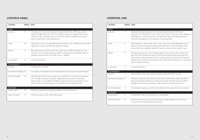
LIVERPOOL LINK
CRITERIA IMPACT NOTE
NEED
Economic H Employment through regeneration of the Leeds & Liverpool Canal / North Docks /
Liverpool Link / South Docks corridor – wards within 2 miles – 1% mean corridor employment
IMD %age rank; 14 wards in top 20% most deprived in England). Possible opportunity to
provide flow attenuation and flood routing for new developments.
Social H High deprivation in vicinity (wards within 2 miles – 2% mean corridor IMD %age rank; 14
wards in top 20% most deprived in England). Potential ethnic minority involvement (1991
census: 9% of 2 km population catchment.). Need to overcome security issues for users.
Market H Although boating density on the connecting stretch of the Leeds & Liverpool Canal is low
(less than 100 movements per year), the scheme will animate the water space within the
South Docks through developing new forms of boating activity. The South Docks complex is
already a major city centre visitor attraction, which will be further developed from a recreational
point of view by the new link.
Local support H Local political support.
SUSTAINABILITY
Financial H High likelihood of securing funding from Liverpool Vision and EU Ob.1 sources.
Environment & Heritage H Potential to animate the water space within the historic South Docks complex (esp. Albert
Dock) and positively contribute to the setting of Liverpool’s waterfront (a proposed World
Heritage Site). Scheme will contribute to major regeneration and public realm work.
Technical feasibility H No insuperable engineering constraints, but additional water supply will have to be secured.
NETWORK
Pressure valve L Limited need to reduce visitor pressure on local waterways.
Network extension H Extends the network through Liverpool. Will help encourage boating on the under-used
Liverpool section of the Leeds & Liverpool Canal.
18 19
LICHFIELD CANAL
CRITERIA IMPACT NOTE
NEED
Economic H Unemployment in the corridor relatively low (wards within 2 miles: 63% mean corridor
employment IMD %age rank; 1 ward in top 20% most deprived in England). However the
scheme will open up boating activity on the northern reaches of the BCN network, which
passes through areas of high unemployment.
Social M Deprivation in vicinity is not particularly high (wards within 2 miles – 65% mean corridor IMD
%age rank; 2 wards in top 20% most deprived in England).
Market H Boat traffic density on the Coventry Canal is quite high ( c7-8,000 movements per year),
whereas it is low on the BCN system (c1-2,000 movements per year). Relatively high local
population catchment within 2 km (1991 census – 65,000).
Local support H Local political support.
SUSTAINABILITY
Financial L Funding sources uncertain.
Environment & Heritage M Conservation of lock flights. Environmental improvement in the urban fringe of Birmingham.
Technical feasibility M Although need to resolve road crossings are a constraint, the construction of an aqueduct
across the M6 toll has been completed. Fragmented land ownership. Potential water
supply problems – more detailed investigation required. However, it would provide a more
effective route for transferring water from the BCN to the Trent & Mersey Canal.
NETWORK
Pressure valve M Will provide opportunities for developing additional moorings in the area.
Network extension H Will open up access to the northern BCN system.

CRITERIA IMPACT NOTE
NEED
Economic H Unemployment within the canal corridor remains relatively high especially given the recent
closure of Corus and the Pantag Steel Works in the City and County of Newport and Cwmbran.
Development master plans are being developed for central Newport and the town centre of
Cwmbran, which includes the regeneration of the canal. The Monmouthshire & Brecon Canal
regeneration partnership recognises the potential of the waterway corridor to draw additional
visitors to the area, which is recognised as one of the most attractive natural and man-made
landscapes in South East Wales including the Brecon Beacons National Park.
Social M Passes through some areas of high deprivation although overall IMD is relatively low.
Market M Medium level of boat traffic on cruiseway section of canal. Plans to increase the level of
boating activities on the canal include a marina and inland cruising base on the River Usk at
Newport, part of the master plan for the Development of Central Newport for sea going boats
from the Bristol Channel and beyond.
Local support H High local political and community support, justified through two recent surveys carried out in
Cwmbran and Newport, indicating 95% support for creating a complete navigable canal from
Brecon to Newport and Cwmcarn on the Crumlin Arm. Regeneration of the canal is a
commitment in the local authorities UDP plans.
SUSTAINABILITY
Financial M Funding sources at present providing financial support to the regeneration of the canal include
Landfill Tax Credits, Objective ll, Interreg lllb, Community First and direct investment from all the
authorities partnering in the Monmouthshire & Brecon Canal Regeneration Partnership.
Environment & Heritage M The canal corridor passes through a unique landscape which is both natural and scarred by the
industrial revolution of the 19th Century, now recognised at Blaenavon which has recently been
given World Heritage Status. The City of Newport has developed a strategy to restore the
Fourteen Locks Flight (Ancient Monument Status) on the Crumlin Arm which is associated with
the restoration works already underway between Newport and Cwmbran including a corridor
study being undertaken on the western section of the Crumlin Arm.
Technical feasibility M Restoration is achievable, although there are road crossing issues in the Cwmbran area and
water supply issues linked to improved management of the available water.
NETWORK
Pressure valve L Completing restoration will help reduce the already increasing pressure for moorings and
recreational activities on the cruiseway section of the canal owned by BW.
Network extension M Creating a complete waterway as existed in the 19th Century will provide an extension to the
inland waterways cruising routes to Newport, Cwmcarn and to the inland cruising system of
England through Bristol to the Kennet & Avon and Sharpness to the Gloucester and Sharpness
canals. The planned marina at Newport will provide safe moorings for coastal cruising to the
West Country, Ireland and beyond.
MONMOUTHSHIRE & BRECON CANAL (SOUTHERN SECTION)
2120
MANCHESTER, BOLTON & BURY CANAL
CRITERIA IMPACT NOTE
NEED
Economic H Unemployment in the corridor is relatively high (wards within 2 miles: 23% mean corridor
employment IMD %age rank; 15 wards in top 20% most deprived in England). High
regeneration potential particularly along the course of the canal in Salford. Also town centre
regeneration potential in Bury and Radcliffe. In known area of high flood risk – opportunity to
provide flow attenuation and flood routing benefits for existing and new developments adjacent
to the canal route.
Social H Passes through an area of relatively high deprivation (wards within 2 miles – 25% mean
corridor IMD %age rank; 16 wards in top 20% most deprived in England). Potential ethnic
minority involvement (1991 census: 4% of 2 km population catchment.).
Market H Boat traffic on adjacent BW waterways at median levels – Bridgewater Canal is relatively well
used. Traffic levels on the canals through Manchester are currently low, but expected to grow as
the impacts of the Huddersfield Narrow and Rochdale restorations take effect. Relatively high local
population catchment within 2 km (1991 census – 153,000), suggesting local use potential is high.
Local support M Local political support, but realistic scheme is of relatively recent origin. Active canal society.
SUSTAINABILITY
Financial H Funding sources uncertain, but within Ob.2 area. RDA showing interest. Private finance from
adjacent developments will be essential.
Environment & Heritage M Creation of new urban green corridor, with range of habitats and landscapes. Will secure
historic features on the canal – tunnels, aqueducts and lock flight.
Technical feasibility M Restoration feasible, although much of route through Salford is built upon or infilled.
Fragmented land ownership, except for stretches still owned by BW. Possible water supply
difficulties will have to be overcome – resource assessment underway.
NETWORK
Pressure valve L Limited need to reduce navigational pressures in the area, given recent restorations.
Network extension M Creation of additional cruising opportunities in Manchester area.

CRITERIA IMPACT NOTE
NEED
Economic M Unemployment in the area is currently low, but the scheme will have a positive local impact in
Kendal. The area was badly hit by Foot and Mouth Disease and the scheme will encourage
agricultural diversification. Opportunities to provide land drainage, flow attenuation and flood
routing benefits for new residential and commercial developments along the route.
Social L Low deprivation in vicinity (wards within 2 miles – 63% mean corridor IMD %age rank; 0 wards
in top 20% most deprived in England).
Market H High boating density on central sections of Lancaster Canal (up to c9,000 movements per
year) and rapid growth of boat ownership. 1,200 BW boat owners live within 20 miles.
Potential for attracting boatowners from Lake Windermere. Low local population within 2 km
catchment (1991 census – 31,000). However high tourist potential from visitors to the Lake
District and adjacent AONBs.
Local support H Local political support. Active restoration / canal society.
SUSTAINABILITY
Financial M Interest expressed by RDA. Funding already committed for feasibility studies. Newly
established Rural Enterprise Zone offers scope for further funding.
Environment & Heritage H Opportunity to enhance varied scenic landscapes through sound environmental management of
rural corridor. Canal heritage will be secured and opened up.
Technical feasibility M No insuperable engineering constraints. Partly in BW ownership – limited land assembly
elsewhere. However potential problems with water supply.
NETWORK
Pressure valve H Creation of new marina development opportunities to relieve pressure from growth in demand
on cruising stretch of Lancaster Canal. Opening of Ribble Link has increased demand. Relief of
visitor pressure on Lake District by development of new attraction at the gateway to the Lakes.
Network extension H Extension of cruising opportunities on the Lancaster Canal to visitor destination in Kendal.
NORTHERN REACHES, LANCASTER CANAL
2322
CRITERIA IMPACT NOTE
NEED
Economic M Unemployment in the corridor is currently low. However the scheme will encourage
agricultural diversification and rural tourism initiatives.
Social M Low deprivation in vicinity (wards within 2 miles – IMD index comparable with Grantham
Canal and Northern Reaches). However, integration of the rural community is a central theme
of the restoration’s corridor approach.
Market H Very high boating density on adjacent Llangollen Canal (c12,000 movements per year).
2,000 BW boat owners live within 20 miles. Low rural population within 2 km catchment
(1991 census – 12,000). Increases in navigation will have to be introduced within a
sustainable management framework. However, there is potential for a wide range of tourist
activity within the canal corridor, facilitated by the restoration.
Local support H Local political support and funding. Restoration being achieved on incremental basis. Strong
voluntary support from canal society.
SUSTAINABILITY
Financial M European funding possible especially targetted at the unique aspects of the restoration.
Funding from Welsh sources such as WDA possible. HLF funding commitment likely following
a successful conclusion to the conservation management strategy which they have supported.
Environment & Heritage H The canal is highly valued for biodiversity and built heritage. The conservation management
strategy approach will create a uniquely sustainable experience with protection of and positive
benefits to these special interests integrated into increased use of the wider corridor.
Technical feasibility H No insuperable engineering constraints. All in BW ownership. Water supply is protected by the
Montgomery Canal Act and operating agreement with the Environment Agency.
NETWORK
Pressure valve M Potential to relieve boating pressures on the Llangollen Canal, although this is tempered
through need to take account of ecological considerations.
Network extension H Creates additional cruising with destinations in attractive countryside in rural Wales.
MONTGOMERY CANAL

CRITERIA IMPACT NOTE
NEED
Economic H High unemployment in the area. Will encourage boat and tourism traffic to the river corridor,
linking to the newly-established Loch Lomond National Park and the Gateway Centre at Balloch.
Social H Relatively high deprivation in vicinity (wards within 2 miles – 35% mean corridor IMD %age
rank; 6 wards in top 20% most deprived in Scotland).
Market H Potential for high levels of boat use, given possibility of passage between Loch Lomond and
the R.Clyde / Forth & Clyde Canal. Potential stop-off point for tourists and day trippers
between Glasgow and the West Highlands.
Local support M Project in early stages. Therefore local support difficult to gauge. However project is included
in Scottish Executive’s ‘Scotland’s Canals: An Asset for the Future’ paper.
SUSTAINABILITY
Financial M Potential to secure funds.
Environment & Heritage L Possible adverse environmental impacts will require sensitive design and management.
Technical feasibility M Restoration feasibility still to be determined, but likely to be possible.
NETWORK
Pressure valve L Some need to reduce navigational pressures on Loch Lomond. However it may encourage
additional boats to visit the Loch.
Network extension H Creation of destination for boats using the Forth & Clyde Canal.
RIVER LEVEN
2524
CRITERIA IMPACT NOTE
NEED
Economic H Encourage regeneration of the Grangemouth Docks area.
Social L Limited impact on deprivation likely, due to localised nature of the scheme.
Market H Will improve passage to and from the Forth & Clyde Canal. Moorings could be provided for
sea-going craft using the Firth of Forth (an area of shortage).
Local support H Support for improving access to Forth & Clyde Canal.
SUSTAINABILITY
Financial M Potential to secure funding – Scottish Executive priority.
Environment & Heritage M May help clean up environment of Carron estuary, through dealing with problems caused by
sewage discharges.
Technical feasibility H Canalisation likely to be straightforward. Type of navigational improvements still being
investigated. Initial funding for early feasibilty studies has been agreed.
NETWORK
Pressure valve L Unlikely to be significant in reducing recreational pressures elsewhere.
Network extension H Will improve passage to and from the Forth & Clyde Canal, thus potentially increasing use of
the canal for through passages.
RIVER CARRON NAVIGATION
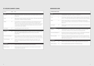
CRITERIA IMPACT NOTE
NEED
Economic L Limited potential for regeneration in area of low unemployment.
Social L Limited impact on deprivation, due to low levels of deprivation in vicinity of canal (wards within
2 miles – 91% mean corridor IMD %age rank; 0 wards in top 20% most deprived in England).
Market H Attractive waterway adjacent to a well-used stretch of the Grand Union Canal. Provides
access to the popular walking / mountain biking areas of the Chilterns and the Ridgeway long
distance trail.
Local support M Originally opposition locally but support is growing with strong support from local canal society
and volunteers.
SUSTAINABILITY
Financial M Limited potential to secure funding. However it may be possible to take elements forward
using voluntary contributions with some relatively minor third party gap funding.
Environment & Heritage M Restoration will need to be carried out sensitively to ensure no overall adverse environmental
impacts improvements where practicable. Will secure heritage of the canal.
Technical feasibility H Restoration is straightforward from an engineering point of view. Historic leakage and water
supply problems should be remedied through restoration works. Issues relating to the raising of
water levels need to be overcome.
NETWORK
Pressure valve M Potential to reduce water losses in respect of supply to the Grand Union Canal main line.
Network extension M Will create additional attractive destination on the Grand Union Canal.
WENDOVER ARM
2726
Criteria Impact Note
NEED
Economic H High regeneration potential – mostly within EU Ob.1 area. Potential to alleviate some local
flooding issues.
Social H High potential for impact on deprivation (wards within 2 miles – 23% mean corridor IMD %age
rank; 28 wards in top 20% most deprived in England).
Market M It may be difficult to encourage large-scale boating use of the canal because the canal is
isolated from the rest of the network, except via the tidal waters of the Mersey estuary.
However large local population means that recreational use of the towpath is likely to be high
– provides focus for Sankey Valley Park. Also pre-feasibility study for new link to Leeds &
Liverpool Canal has been undertaken.
Local support M Local political support and active canal society.
SUSTAINABILITY
Financial M Good potential to secure funding, although in competition with other more advanced projects
within region. Detailed feasibility study proposed, may include link to the Leeds &
Liverpool Canal.
Environment & Heritage H Secures wetland resource. Will secure heritage of the canal- historically the original Sankey
Navigation (1757) was the first canal constructed in England during the 18th Century Canal Age.
Technical feasibility M Stretches of the canal have been restored by the canal society / Groundwork / local
authorities. No insuperable engineering obstacles, provided sufficient water supply can
be secured.
NETWORK
Pressure valve L Unlikely to be significant in reducing recreational pressures elsewhere.
Network extension L Isolated waterway with link through tidal waters to rest of network, new link to Leeds &
Liverpool Canal would address this.
ST. HELENS (SANKEY) CANAL

28
CRITERIA IMPACT NOTE
NEED
Economic M Unemployment in the corridor low (wards within 2 miles: 78% mean corridor employment
IMD %age rank; 2 wards in top 20% most deprived in England). However canal passes
through a largely rural area and the scheme will help further agricultural diversification.
Potential to help improve and support market towns and villages along the route eg. Cricklade,
Melksham. Considerable potential linking restoration with Swindon expansion.
Social L Overall deprivation in vicinity is low, although there are local problems in Swindon (wards within
2 miles – 71% mean corridor IMD %age rank; 2 wards in top 20% most deprived in England).
Scheme will help retain services in rural area.
Market H Boat traffic on adjacent waterways at median levels (eg. c3-4,000 boat movements on Kennet
& Avon Canal). However opportunities to develop moorings on the canal to boost traffic levels.
Also creates critical mass for substantial local network, with Cotswold Canals / Kennet & Avon
Canal / River Thames. Relatively high local population catchment within 2 km (1991 census –
119,000). This is concentrated in Swindon area and the rural stretches are relatively less
densely populated. Not in a well-known tourist area, unlike the Cotswold Canals, although this
gives opportunities for creating new tourism businesses. Potential to link Upper Thames with the
Cotswold Water Park and Swindon.
Local support H Local political support. Well established partnership with local authorities etc. Some reluctance
from land owners.
SUSTAINABILITY
Financial L Funding sources uncertain, given likely demands of the Cotswold Canals restoration.
Environment & Heritage M Creation of new wetlands – especially with Cotswold Water Park and Cotswold Canals
restoration. Conservation of locally important structures, creation of new habitats. Potential for
solving drainage issues on developments in the Swindon area and Melksham already being
demonstrated.
Technical feasibility M Complex and large scale restoration, although feasible from an engineering point of view.
Fragmented land ownership. Water supply reliant on Cotswolds.
NETWORK
Pressure valve M Will provide relief to growing pressures on the Kennet & Avon Canal in particular.
Network extension H Creation of new canal cruising network, linking the Cotswold Canals / Kennet & Avon Canal/
River Thames.
Note: Because of the complexity of the scheme, we feel that it is unlikely that the whole canal will be re-opened by 2025.
WILTSHIRE & BERKSHIRE CANAL

RIVE
R SEV
ERN
RIVE
RSE
VERN
RIVER
AVO
NRIV
ER A
VON
RIVER
AVO
N
RIVER
DEE
RIVER
DEE
RIVER
RIV
ER
HULL
HULL
RIVER
HU
LL
RIVER
PARR
ETT
RIVER
PARR
ETT
RIVER
PARR
ETT
ULLS
WATE
RUL
LSWA
TER
ULLS
WATE
R
BASS
ENTH
W AITE
BASS
ENTH
W AITE
BASS
ENTH
W AITE
L AKE
DIST
RICT
L AKE
DIST
RICT
L AKE
DIST
RICT
NEAT
H &
NEAT
H &
TENN
ANT
TENN
ANT
CANA
LCA
NAL
EXET
ER S
HIP
EXET
ER S
HIP
CANA
LCA
NAL
GRAN
D W
ESTE
RN
GRAN
D W
ESTE
RN
BUDE
CAN
ALBU
DE C
ANAL
NEW
NE
W
BEDF
ORD
BEDF
ORD
RIVE
RRI
VER
ELY
OUSE
EL
Y OU
SE
SIXT
EEN
SIXT
EEN
FOOT
FOOT
MID
DLE
LEVE
L M
IDDL
E LE
VEL
OLD
BEDF
ORD
OLD
BEDF
ORD
RIVE
R RI
VER
RIVE
R CA
MRI
VER
CAM
RIVE
R ST
OUR
RIVE
R ST
OUR
CHEL
MER
&
CHEL
MER
&
BLAC
KWAT
ER
BLAC
KWAT
ER
NAVI
GATI
ONNA
VIGA
TION
RIVE
R M
EDW
AYRI
VER
MED
WAYRIVE
R LA
RKRI
VER
LARK
TEN
MIL
E OU
SETE
N M
ILE
OUSE
RIVE
R LI
TTLE
OUS
ERI
VER
LITT
LE O
USE
RIVE
R W
ISSE
YRI
VER
WIS
SEY
GREA
T OU
SE R
IVER
GR
EAT
OUSE
RIV
ER
THE
BROA
DSTH
E BR
OADS
LOUT
H LO
UTH
NAVI
GATI
ONNA
VIGA
TION
UPPE
R AV
ONUP
PER
AVON
UPPE
R AV
ONNA
VIGA
TION
NAVI
GATI
ONNA
VIGA
TION
LOW
ER A
VON
LOW
ER A
VON
LOW
ER A
VON
NAVI
GATI
ONNA
VIGA
TION
NAVI
GATI
ON
RIVE
RRI
VER
RIVE
RW
YEW
YEW
YE
NEAT
H &
TENN
ANT
CANA
L
EXET
ER S
HIP
CANA
L
GRAN
D W
ESTE
RN
BUDE
CAN
AL
RIVE
R GR
EAT
OUSE
RIVE
R GR
EAT
OUSE
RIVE
R GR
EAT
OUSE
OLD
WES
T RI
VER
OLD
WES
T RI
VER
OLD
WES
T RI
VER
NEW
BE
DFOR
D RI
VER
ELY
OUSE
SIXT
EEN
FOOT
MID
DLE
LEVE
L NA
VIGA
TION
SNA
VIGA
TION
SNA
VIGA
TION
S
RIVE
RNE
NERI
VER
NENE
RIVE
RNE
NE
RIVE
R GL
ENRI
VER
GLEN
RIVE
R GL
ENRI
VER
WEL
LAND
RIVE
RW
ELLA
NDRI
VER
WEL
LAND
RIVE
RNE
NERI
VER
NENE
RIVE
RNE
NE
OLD
BEDF
ORD
RIVE
R
RIVE
R CA
M
RIVE
R ST
OUR
CHEL
MER
&
BLAC
KWAT
ER
NAVI
GATI
ON
RIVE
R W
EYRI
VER
WEY
RIVE
R W
EY
RIVE
R M
EDW
AYBA
SING
STOK
E CA
NAL
BASI
NGST
OKE
CANA
LBA
SING
STOK
E CA
NAL
RIVE
R AR
UNRI
VER
ARUN
RIVE
R AR
UN
RIVE
R LA
RK
LOCH
LOCH
LOCH
LOMO
NDLO
MOND
LOMO
ND
TEN
MIL
E OU
SE
RIVE
R LI
TTLE
OUS
E
RIVE
R W
ISSE
Y
GREA
T OU
SE R
IVER
THE
BROA
DS
RIVE
R TH
AMES
RIVE
R TH
AMES
RIVE
R TH
AMES
RIVE
RRI
VER
RIVE
R
DRIF
F IEL
DDR
IFFI
ELD
DRIF
FIEL
D
RIVE
RRI
VER
RIVE
RAN
CHOL
ME
ANCH
OLM
EAN
CHOL
ME
LOUT
H NA
VIGA
TION
CANA
LCA
NAL
CANA
L
MARK
ET H
ARBO
ROUG
H ARM
MARK
ET H
ARBO
ROUG
H ARM
RIPO
N RI
PON
CANA
LCA
NAL
TEES
NAV
IGATIO
N TE
ES N
AVIGA
TION
AND B
ARRA
GEAN
D BAR
RAGE
RIVE
R SOA
RRI
VER S
OAR
WITH
AM
WITH
AM
NAVIG
ATIO
NNA
VIGAT
ION
BRID
GWAT
ER &
BR
IDGW
ATER
&
TAUN
TON
CANA
LTA
UNTO
N CA
NAL
SWAN
SEA
SWAN
SEA
CANA
LCA
NAL
NOTT
INGH
AM &
NO
TTIN
GHAM
&
BEES
TON
CANA
LBE
ESTO
N CA
NAL
EREW
ASH
EREW
ASH
CANA
LCA
NAL
C
UNIO
N UN
ION
CANA
LCA
NAL
CRIN
AN
CRIN
AN
CANA
LCA
NAL
CALE
DONI
AN
CALE
DONI
AN
CANA
LCA
NAL
LOCH
OIC
HLO
CH O
ICH
LOCH
NES
SLO
CH N
ESS
LOCH
LOCH
YLO
CH LO
CHY
RIV E
R STO
RT
RIVE
R STO
RT
SEVE
RNSE
VERN
SEVE
RN
NAVIG
ATIO
NNA
VIGAT
ION
NAVIG
ATIO
N
BROA
D CAN
ALBR
OAD C
ANAL
BROA
D CAN
AL
MARK
ET H
ARBO
ROUG
H ARM
RIPO
N CA
NAL
TEES
NAV
IGATIO
N AN
D BAR
RAGE
URE N
AVIGA
TION
URE N
AVIGA
TION
URE N
AVIGA
TION
RIVE
R SOA
R
WITH
AM
NAVIG
ATIO
N
GLOU
CEST
ER &
SHAR
PNES
SGL
OUCE
STER
& SH
ARPN
ESS
GLOU
CEST
ER &
SHAR
PNES
S
DOCK
SDO
CKS
DDDOCK
S
BRID
GWAT
ER &
TA
UNTO
N CA
NAL
KENN
ET &
AVON
KENN
ET &
AVON
KENN
ET &
AVON
CANA
LCA
NAL
CANA
L
SWAN
SEA
CANA
L
RIVE
RRI
VER
RIVE
R NOTT
INGH
AM &
BE
ESTO
N CA
NAL
EREW
ASH
CANA
L
TREN
T & M
ERSE
YTR
ENT &
MER
SEY
TRE
TRE
TREN
T & M
ERSE
YCA
NAL
CANA
LCCCA
NAL
CALD
ONCA
LDON
CALD
ONCA
NAL
CANA
LCA
NAL
STAF
FS &
WOR
CSST
AFFS
& W
ORCSRCR
STAF
FS &
WOR
CSCA
NAL
CANA
LALALCA
NAL
TREN
TTR
ENT
TREN
T
MONK
LAND
MONK
LAND
MONK
LAND
CANA
LCA
NAL
CANA
L
UNIO
N CA
NAL
CRIN
AN
CANA
L
FORT
H & C
LYDE
FORT
H & C
LYDE
FORT
H & C
LYDE
CANA
LCA
NAL
CANA
L
CALE
DONI
AN
CANA
LLO
CH O
ICH
LOCH
NES
S
LOCH
LOCH
Y
LANC
ASTE
RLA
NCAS
TER
LANC
ASTE
RCA
NAL
CANA
LCA
NAL
NAVIG
ATIO
NNA
VIGAT
ION
ION
ION
NAVIG
ATIO
N
SHEF
FIELD
&
SHEF
FIELD
&
SSSHEF
FIELD
&
MACC
LESF
IELD C
ANAL
MACC
LESF
IELD C
ANAL
MACC
LESF
IELD C
ANAL
LEIC
ESTE
R LIN
ELE
ICES
TER L
INEEE
LEIC
ESTE
R LIN
E
GRAN
DGR
AND
GRAN
DUN
ION
CANA
LUN
ION
CANA
LUN
ION
CANA
L
DOCK
LAND
SDO
CKLA
NDSS
DOCK
LAND
S
OXFO
RDOX
FORD
OXFO
RDCA
NAL
CANA
LCA
NAL
AYLE
SBUR
Y ARM
AYLE
SBUR
Y ARM
AYLE
SBUR
Y ARM
GRAN
D UNI
ONGR
AND U
NION
GRAN
D UNI
ONCA
NAL
CANA
LCA
NAL
RIV E
R LEE
NAV
IGAT IO
NRI
V ER L
EE N
AVIGA
T ION
RIV E
R LEE
NAV
IGAT IO
N
RIV E
R STO
RT
NAVI G
ATIO
NNA
VI GAT
ION
NAVI G
ATIO
N
OXFO
RD C
ANAL
OXFO
RD C
ANAL
OXFO
RD C
ANAL
SHRO
PSHI
RESH
ROPS
HIRE
SHRO
PSHI
REUN
ION
CANA
LUN
ION
CANA
LUN
ION
CANA
L
CALD
ER &
CALD
ER &
CA
LCA
LCA
LDER
&
RIBB
LERI
BBLE
RIBB
LE
WEY &
ARUN
CAN
ALWE
Y & AR
UN C
ANAL
WEY &
ARUN
CAN
AL
WILTS
HIRE
&WI
LTSHI
RE &
WI
LTSHI
RE &
BERK
SHIR
E CAN
ALBE
RKSH
IRE C
ANAL
BERK
SHIR
E CAN
AL
WEND
OVER
ARM
WEND
OVER
ARM
WEND
OVER
ARM
GRAN
THAM
GR
ANTH
AM
CANA
LCA
NAL
GRAN
THAM
CA
NAL
CANA
LCA
NAL
CANA
LC
MONM
OUTH
SHIR
EMO
NMOU
THSH
IRE
MONM
OUTH
SHIR
E&
BREC
ON C
ANAL
& BR
ECON
CAN
AL&
BREC
ON C
ANAL
* Th
e fir
st s
ectio
n of
the
Ashb
y Ca
nal (
to M
eash
am) i
s a
Prio
rity
One
proj
ect.
Th
e As
hby
Cana
l (to
Moi
ra) i
s a
Prio
rity
Two
proj
ect.
RIVE
R CAR
RON
RIVE
R CAR
RON
RIVE
R CAR
RON
RIVE
RLEV
ENRI
VERL
EVEN
RIVE
RLEV
EN
LIVER
POOL
LINK
LIVER
POOL
LINK
LIVER
POOL
LINK
CANA
LCA
NAL
CANA
L
BEDF
ORD &
MILT
ON
BEDF
ORD &
MILT
ONBE
DFOR
D & M
ILTON
KEYN
ES W
ATER
WAY
KEYN
ES W
ATER
WAY
KEYN
ES W
ATER
WAY
RE
ST
OR
AT
IO
NW
AT
ER
WA
Y M
AP
RE
STO
RAT
ION
KE
Y
SC
ALE
Man
aged
by
Brit
ish
Wat
erw
ays
Oth
er A
INA
Wat
erw
ays
Pri
ori
ty O
ne
pro
ject
s
Pri
ori
ty T
wo
pro
ject
s
Pri
ori
ty T
hre
e p
roje
cts
050
kilo
met
res
010
2030
mile
s
Repro
duce
d from
the O
rdnan
ce S
urvey
map
ping w
ith th
e perm
ission
of th
e Con
trolle
r of
Her M
ajesty
’s Sta
tione
ry Of
fice ©
Crow
n cop
yrigh
t.Una
uthori
sed r
eprod
uctio
n infr
inges
Cr
own c
opyri
ght a
nd m
ay le
ad to
pros
ecuti
on or
civil
proce
eding
s. Br
itish W
aterw
ays,
AL51
127A
.
This
map i
nclud
es w
aterw
ays m
anag
ed by
mem
bers
of the
Ass
ociat
ion of
Inlan
d Nav
igatio
n Au
thoriti
es (A
INA)
as w
ell as
BW’
s curr
ent p
lanne
d res
torati
on an
d new
build
proje
cts.
There
are o
ther i
nland
wate
rway
s tha
t hav
e not
been
inclu
ded,
but c
an be
foun
d on m
ore
detai
led m
aps (
conta
ct BW
Cus
tomer
Servi
ce C
entre
for m
ore in
forma
tion).
©
Briti
sh W
aterw
ays 2
004
For f
urth
er in
form
atio
n pl
ease
con
tact
:Br
itish
Wat
erwa
ys C
usto
mer
Ser
vice
Cent
reW
illow
Gran
ge C
hurc
h Ro
ad W
atfo
rd W
D17
4QA
T 01
923
2011
20 F
019
23 2
0130
4E
enqu
iries
.hq@
britis
hwat
erwa
ys.co
.uk
Find
out a
bout
BW
: www
.brit
ishwa
terw
ays.c
o.uk
Disc
over
the
best
of th
e UK
’s wa
tersi
de w
ith w
ater
scap
e.com
This document contains our plans for our waterway network over
the next 20 years, based on current information and knowledge.
We have no control over the external environment, and recognise
that as circumstances change we may have to adapt these plans.
Cover: Banbury, Oxford Canal