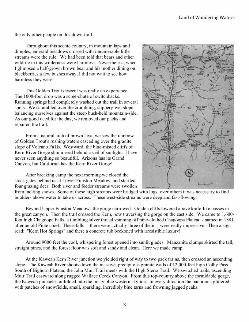
robertson land of wandering waters 1964 of wandering waters 2 with patches of obsidian chippings....
TRANSCRIPT

1
Land of Wandering Waters By Dorothy Robertson
Desert Magazine – August 1964
SOME HIKERS park their cars at one of the short roads leaving U.S. 395-6 and hike up trails to the high Sierra's mountain lakes. But not us. We're the kind who go all the way. When my husband read in DESERT about a hiking trip in Utah, he took off his glasses, leaned back into his chair and said, "Every able-bodied American ought to backpack into the wilderness at least once in his life."
"Okay," I said, "Let's go!" We went about it sensibly. The Sierras are
closest to our Southern California home, so we plotted a 10-day, 80-mile excursion into them for this able-bodied adventure. Each eve ning we astonished neighbors by setting forth on a two-mile hike, always breaking into a run on the last quarter. By summer we were ready.
Because our loop trip included some
decidedly rugged country to the Western Divide and back, we decided to fly to Temple Meadows over the Sierra Crest. A pilot named Bob White, who maintains an Aero Service in Lone Pine, accommodated the two of us in his plane for $35 and within 20 minutes we had landed and were waving him a hearty farewell. On the cleared airstrip were two other planes flown in by parties who come here regularly to fish.
My pack, weighing 35 pounds, felt heavy at first, but an exhilaration which grew boundless with
flower-starred meadows and fragrant pines soon had it floating along with my spirits. Up here the country is rugged. Wind-tossed pines are widely spaced, ridges bare. But the meadows sparkle with glacial streams meandering through wild iris, yellow, blue and white, and bushes laden with ruby currants. This is the heart of the summer deer country. It is also well-stocked with Owens Valley ranch cattle out to pasture.
The High Sierra Trail led us down through Ramshaw Meadows where,
surrounded by gaunt, wind-scoured granite hills speckled with wind-bent pines, we decided to try our luck fishing, then make camp for the night. This was Golden Trout country. Here evolved the four famed species from the ancient family of Salmonadie, native to this particular region: the Kern or Gilberti Rainbow, South Fork Golden, White's Golden and the Roosevelt Golden.
Our first supper was dried potatoes mixed with water, cooked over the
campfire and mashed, with golden trout 10 inches long and a fresh-gathered salad of watercress. Dessert was fresh-picked ruby currants. Camp chores over, we searched for arrow-heads on the hillside slope. The area was strewn

LandofWanderingWaters
2
with patches of obsidian chippings. For hundreds of years the Piutes from Owens Valley on the east side of the Sierra had toiled over the steep passes to summer in this string of mountain meadows, hunting, fishing and pine-nutting. Our camp was upon one of their old campgrounds. Main east-west trails from the desert side follow the old Indian trails.
When the silver stars began to
glitter through the pine needles, we zipped ourselves into our mummy-bags. Oh, this was the life. Sometime in the night I awoke, uneasy. Immediately above me, a hunk of cow breathed into
my face. I froze. My husband said very softly: "Lie still and don't move!" Centuries later the cow moved away and I began to breathe again. "Just curious!" Al said smugly, and turned over on his side.
At dawn the shrill, hysterical voices of hunting coyotes awakened
us. We lay listening to the blend of sound: keening coyotes, twittering birds, swift-flowing water and morning breeze. Our only worries were: shall we fish first or eat oatmeal cooked with mixed-dried-fruit-and-brown sugar? We were not bothered with weighty packages. We had pre-packed every bit of food, putting up each meal's allotment in individual plastic bags sealed with rubber bands. We brought some fresh fruit for the first day and we did carry two cans of bacon. You need some fat in the cold, high country.
The trail to Tunnel Meadows wound steeply up heavily bouldered
volcanic country spotted with gnarled pines. Waterfalls cascaded down dull rocky escarpments. Soon we came to a stream above the falls where dam-happy beavers had built their lodges. The water was so clear we could see every darting fish, each grain of sand in the bottom.
Immediately above Tunnel Ranger Station, the headwaters of the
South Fork of the Kern and Golden Trout Creek are but a few hundred feet apart. Here, in the late '80s, a group of South Fork cowmen began a tunnel to divert the Golden Trout waters into the South Fork waters. In true Western style, this venture was opposed, successfully, by the Kern County Land and Water Company. A shooting war was barely averted.
At the Tunnel Meadows Fork we turned west down Golden Trout
Trail, crossing and re-crossing this creek at least five times. We passed Groundhog Meadows with its perfect little arcadian campground, then Little Whitney Meadows and the Tourist Pastures, where we glimpsed
#$%&!'(!)$%&*+,%-!)$.*+/!!!
! 1!
the only other people on this down-trail. Throughout this scenic country, in mountain laps and
dimples, emerald meadows crossed with innumerable little streams were the rule. We had been told that bears and other wildlife in this wilderness were harmless. Nevertheless, when I glimpsed a half-grown brown bear and his mother dining on blackberries a few bushes away, I did not wait to see how harmless they were.
This Golden Trout descent was really an experience.
The 1000-foot drop was a scree-chute of switchbacks. Running springs had completely washed out the trail in several spots. We scrambled over the crumbling, slippery-wet slope balancing ourselves against the steep bush-held mountain-side. As our good deed for the day, we removed our packs and repaired the trail.
From a natural arch of brown lava, we saw the rainbow
of Golden Trout's rushing waters cascading over the granite slope of Volcano Fa1ls. Westward, the blue-misted cliffs of Kern River Gorge shimmered behind a veil of sunlight. I have never seen anything so beautiful. Arizona has its Grand Canyon, but California has the Kern River Gorge!
After breaking camp the next morning we closed the
stock gates behind us at Lower Funston Meadow, and startled four grazing deer. Both river and feeder streams were swollen from melting snows. Some of these high streams were bridged with logs; over others it was necessary to find boulders above water to take us across. These west-side streams were deep and fast-flowing.
Beyond Upper Funston Meadows the gorge narrowed. Golden cliffs towered above knife-like passes in
the great canyon. Then the trail crossed the Kern, now traversing the gorge on the east side. We came to 1,600-foot high Chagoopa Falls, a tumbling silver thread spinning off pine-clothed Chagoopa Plateau - named in 1881 after an old Piute chief. These falls -- there were actually three of them -- were really impressive. Then a sign read: "Kern Hot Springs" and there a concrete tub beckoned with irresistible luxury!
Around 9000 feet the cool, whispering forest opened into sunlit glades. Manzanita clumps skirted the tall,
straight pines, and the forest floor was soft and sandy and clean. Here we made camp. At the Kaweah Kern River junction we yielded right of way to two pack trains, then crossed an ascending
slope. The Kaweah River shoots down the massive, precipitous granite walls of 12,000-feet high Colby Pass. South of Bighorn Plateau, the John Muir Trail meets with the High Sierra Trail. We switched trails, ascending Muir Trail eastward along rugged Wallace Creek Canyon. From this top-country above the formidable gorge, the Kaweah pinnacles unfolded into the misty blue western skyline. In every direction the panorama glittered with patches of snowfields, small, sparkling, incredibly blue tarns and frowning jagged peaks.

LandofWanderingWaters
4
That night we camped at 11,000 feet but were snug in our mummy-bags. The western skyline grew increasingly red. Smoky clouds billowed above. Forest fire! I knew panic. A trail crew hurried by on horses. They reassured us. The fire was a long way off; over in the Middle Fork country, safely across the great gorge.
Between-meal hunger we conquered with snacks of Hi-Proteen chocolate-flavored tablets, non-melt
chocolate bars, raisins and salted sunflower seeds -- all nutritious and light-weight. Above lavishly flowered Wallace Meadows the alpine winds blew cold. Now we could see the
northwestward sweep of the Great Western Divide with its magnificent panorama of peaks, each over 13,000 feet.
The trail to Sandy Meadow, a sparsely grassed plateau, passed through twisted, wind-torn timber clinging
stubbornly to the slopes. Crabtree Meadow, with its dancing, blue Whitney Creek, was a welcome sight after the grueling climb. That night we camped with a view of Mt. Whitney's naked, pinnacled flanks. With no firewood above timberline, we cooked a potful of chili beans and saved some to carry with us.
Early next morning we began the climb to Trail Crest, 1500 feet above our heads. The last lap of the loop,
Whitney's jagged pinnacle dared us to think we could assault it with impunity. Timberline Lake was the last wood-camp. After the jewel-like setting of Guitar Lake, the country's physical aspect changed. Patches of snow hugged the north and east sides of the glaciated peaks. Bushy-tailed golden marmots lumbered sluggishly toward rocky dens. From Mt. Whitney's bare talus slopes, we counted ten rock-bound blue tarns shimmering in the sunlight. The silence enfolding these heights was unbeliveable.
Below us, we saw fellow hikers, dwarfed by the immensity of the surroundings, clinging like human flies
to the precipitous switchback ascent. Yet the Sierra Crest above us appeared to retreat as we climbed, a sky-borne eyrie. At several points we felt we were hanging in midair. A horse and rider hove into view. The animal's rump hung over nothingness as it negotiated a sharp turn. I pressed against the mountain and shut my eyes.
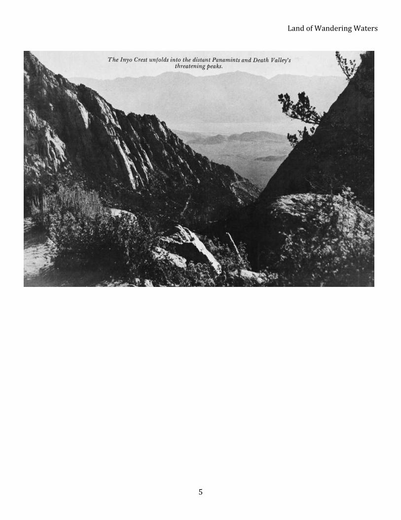
At last, atop Trail Crest, we stopped to view the full-circle panorama. On Mt. Whitney's mighty spine,
14,000-feet high, we were treading on clouds. East of us the Inyo and Panamint Ranges glowed in pink and gold afternoon splendor. Owens Valley fell into a blue haze. Directly below us on the east side of the Sierra, icy blue-black lakes nestled amid beds of snow-ice. Oh, how worthwhile this trip had been!
Descending the 108 steep switch-backs was easier, but we were still 11.5 miles from pine-dotted Whitney
Portal. Now the pot of pre-cooked chili beans came in handy. We were starving, and still above the timberline. Camping in a sheltered place among the rocks, we called it a day. Tomorrow we would be down in Lone Pine.
This 80-mile loop trip over the top of the Sierra through an enchanting wilderness had opened up an
entirely new world. Indeed, every able-bodied American should experience at least one backpack trip in his lifetime -- although ours is going to include more. Next year we will return again to this land of wandering waters.
LandofWanderingWaters
5