rolta - vessel traffic management system · vessel traffic management system rolta vessel traffic...
TRANSCRIPT
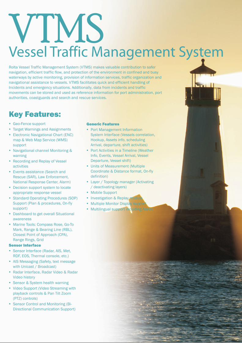
VTMSVessel Traffic Management SystemRolta Vessel Traffic Management System (VTMS) makes valuable contribution to safer navigation, efficient traffic flow, and protection of the environment in confined and busy waterways by active monitoring, provision of information services, traffic organization and navigational assistance to vessels. VTMS facilitates quick and efficient handling of Incidents and emergency situations. Additionally, data from incidents and traffic movements can be stored and used as reference information for port administration, port authorities, coastguards and search and rescue services.
Key Features:�Geo-Fence support
�Target Warnings and Assignments
�Electronic Navigational Chart (ENC) map & Web Map Service (WMS) support
�Navigational channel Monitoring & warning
�Recording and Replay of Vessel activities
�Events assistance (Search and Rescue (SAR), Law Enforcement, National Response Center, Alarm)
�Decision support system to locate appropriate response vessel
�Standard Operating Procedures (SOP) Support (Plan & procedures, On-fly support)
�Dashboard to get overall Situational awareness
�Marine Tools: Compass Rose, Go-To Mark, Range & Bearing Line (RBL), Closest Point of Approach (CPA), Range Rings, Grid
Sensor Interface
�Sensor Interface (Radar, AIS, Met, RDF, EOS, Thermal console, etc.)
�AIS Messaging (Safety, text message with Unicast / Broadcast)
�Radar Interface, Radar Video & Radar Video history
�Sensor & System health warning
�Video Support (Video Streaming with playback controls & Pan Tilt Zoom (PTZ) controls)
�Sensor Control and Monitoring (Bi-Directional Communication Support)
Generic Features
�Port Management Information System Interface (Vessels correlation, Hookup, Assets info, scheduling Arrival, departure, shift activities)
�Port Activities in a Timeline (Weather Info, Events, Vessel Arrival, Vessel Departure, Vessel shift)
�Units of Measurement (Multiple Coordinate & Distance format, On-fly definition)
�Layer / Topology manager (Activating / deactivating layers)
�Mobile Support
�Investigation & Replay module
�Multiple Monitor Display support
�Multilingual support including Arabic
�VTMS Application Areas:
�High traffic density & Traffic carrying hazardous cargoes
�Conflicting and complex navigation patterns & Environmental considerations
�Interference by vessel traffic with other waterborne activities
�Existing or planned vessel traffic services on adjacent waterways and the need for cooperation between neighboring states
�Narrow channels, port configuration, bridges, locks, bends and similar areas where the progress of vessels to be restricted
Rolta provides comprehensive solution for Security of ports & strategic coastal areas of interests including vessels traffic and other maritime operations. The system provides vital information and automated alerting on violation and reports on vessels traffic, port information and share events information to the police and other security agencies for preventing any troublesome incidents or for investigations.
Rolta VTMS monitors, records, analyses, alerts operator with appropriate info and updates the port MIS online for all vessels entering and leaving harbor. Use of multiple layers of day and night sensors with reassuring levels of redundancy makes it a fail-safe system.
Rolta VTMS is an information system as well a security surveillance, wherein any unidentified vessel automatically becomes a suspect element from security aspect. Once, envisaged registration and identification of fishing vessels and other recreational crafts
operating in the port premises are in place, they can also be embedded into the Rolta VTMS system to aid security surveillance.
The VHF Radio and Direction Finding (RDF) component of VTMS can be expanded for aiding security application as well. Thus, while Rolta VTMS is an inescapable system for any busy port for traffic management, it is also a dependable application for port security as it could give intelligence inputs to the security agencies for forming a Coherent Intelligence Picture.

Functionalities
Rolta VTMS can be seamlessly integrated with:-
�Radar System
�Day and night vision tracking systems
�Automatic Identification Systems (AIS),
�Communication and Direction Finding (DF) Systems
�Electronic Navigation Charts (ENC)
�Sonar System
�Meteorological & Hydrological sensors
�Current and forecasted weather adaptation
�Marine VHF communication system
�Acquisition of targets and continuous tracking of vessels in the surveillance area
�Communicates with variety of sensors to perceive the threat information
�Detection of anomaly behavior, supervision and control of incoming and outgoing vessel traffic
�Monitoring vessel movement and the co-ordination of traffic movement.
�Co-ordination of Search and Rescue activities.
�Provision of information to vessels to safely and expeditiously enable navigation.
�Archiving of vessels’ information for statistical analysis and reporting
�Provide investigation analysis tool to replay the vessels activities to analyze the incident in detail
�Enables monitoring of the health condition of Sensor and systems
�View the Situation of Security across the port boundary
�Share the event / Control center operation effectives with stake holders
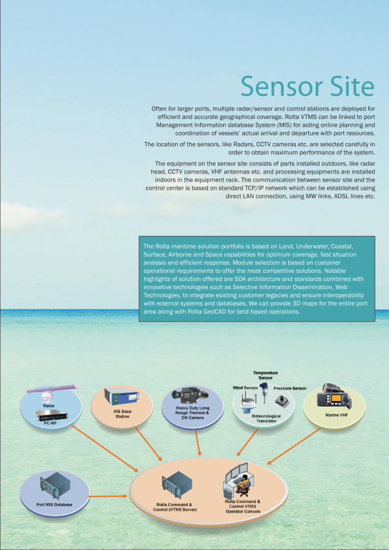
Components
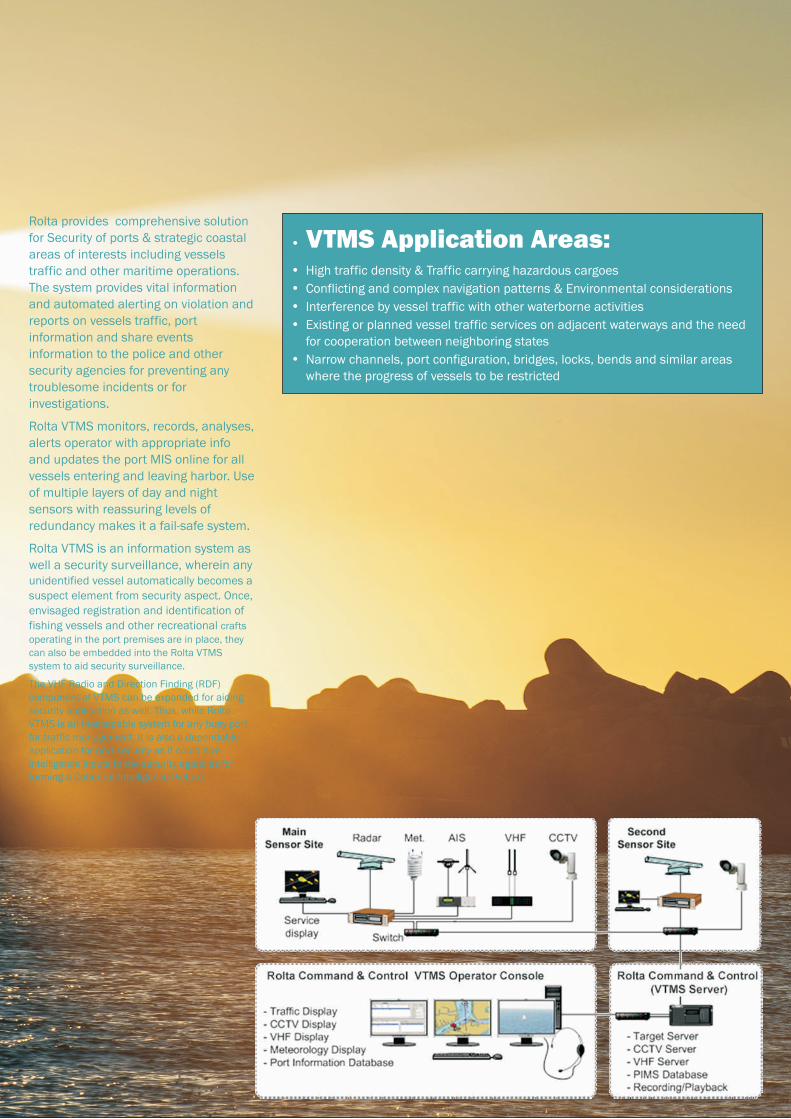
Sensor SiteOften for larger ports, multiple radar/sensor and control stations are deployed for
efficient and accurate geographical coverage. Rolta VTMS can be linked to port Management Information database System (MIS) for aiding online planning and
coordination of vessels’ actual arrival and departure with port resources.
The location of the sensors, like Radars, CCTV cameras etc. are selected carefully in order to obtain maximum performance of the system.
The equipment on the sensor site consists of parts installed outdoors, like radar head, CCTV cameras, VHF antennas etc. and processing equipments are installed
indoors in the equipment rack. The communication between sensor site and the control center is based on standard TCP/IP network which can be established using
direct LAN connection, using MW links, ADSL lines etc.
The Rolta maritime solution portfolio is based on Land, Underwater, Coastal, Surface, Airborne and Space capabilities for optimum coverage, fast situation analysis and efficient response. Module selection is based on customer operational requirements to offer the most competitive solutions. Notable highlights of solution offered are SOA architecture and standards combined with innovative technologies such as Selective Information Dissemination, Web Technologies, to integrate existing customer legacies and ensure interoperability with external systems and databases. We can provide 3D maps for the entire port area along with Rolta GeoCAD for land based operations.
Functionalities
Rolta VTMS can be seamlessly integrated with:-
�Radar System
�Day and night vision tracking systems
�Automatic Identification Systems (AIS),
�Communication and Direction Finding (DF) Systems
�Electronic Navigation Charts (ENC)
�Sonar System
�Meteorological & Hydrological sensors
�Current and forecasted weather adaptation
�Marine VHF communication system
�Acquisition of targets and continuous tracking of vessels in the surveillance area
�Communicates with variety of sensors to perceive the threat information
�Detection of anomaly behavior, supervision and control of incoming and outgoing vessel traffic
�Monitoring vessel movement and the co-ordination of traffic movement.
�Co-ordination of Search and Rescue activities.
�Provision of information to vessels to safely and expeditiously enable navigation.
�Archiving of vessels’ information for statistical analysis and reporting
�Provide investigation analysis tool to replay the vessels activities to analyze the incident in detail
�Enables monitoring of the health condition of Sensor and systems
�View the Situation of Security across the port boundary
�Share the event / Control center operation effectives with stake holders
Components
Sensor SiteOften for larger ports, multiple radar/sensor and control stations are deployed for
efficient and accurate geographical coverage. Rolta VTMS can be linked to port Management Information database System (MIS) for aiding online planning and
coordination of vessels’ actual arrival and departure with port resources.
The location of the sensors, like Radars, CCTV cameras etc. are selected carefully in order to obtain maximum performance of the system.
The equipment on the sensor site consists of parts installed outdoors, like radar head, CCTV cameras, VHF antennas etc. and processing equipments are installed
indoors in the equipment rack. The communication between sensor site and the control center is based on standard TCP/IP network which can be established using
direct LAN connection, using MW links, ADSL lines etc.
The Rolta maritime solution portfolio is based on Land, Underwater, Coastal, Surface, Airborne and Space capabilities for optimum coverage, fast situation analysis and efficient response. Module selection is based on customer operational requirements to offer the most competitive solutions. Notable highlights of solution offered are SOA architecture and standards combined with innovative technologies such as Selective Information Dissemination, Web Technologies, to integrate existing customer legacies and ensure interoperability with external systems and databases. We can provide 3D maps for the entire port area along with Rolta GeoCAD for land based operations.

Key FeaturesCommand & Control: Situational awareness�Complete Security Situation
Awareness across the facility
�Common Operating Picture of the Safety & Security across the operators and responders
�Geospatial Visualization
�Support for OGC “WMS services” and “ENC”
�Displays composite track, radar track,
sensors, zones, etc. on a Map
�Supports “Clustering” functions.
�“Route” and “monitoring parameters” definition
�Business Rules�Assists to define various “Watch
Rules”
�Provision to “Sort”, “Group” and “Filter” the watch rules
�In-built/custom defined “Standard Operating Procedures”
Alert Manager�“Prioritization” of alerts.
Sensor Integration & Data Correlation Interface:�Enables collection of safety and
security risks from large variety of sensors.
�Correlation of sensor information.
�Management of sensor through operational controls.
�Sensors supported (Radar, AIS, Video Sensors, Sonar System, Weather Sensors, RDF, VHF).
�Supports IMO guidelines
Rolta Command & Control is industry proven leading edge technology designed to address the Safety and Security requirements of both Land and Maritime environment. It empowers navy, coast guards, port authorities, critical infrastructure securing agencies, to achieve affordable, truly collaborative situation awareness and manage the security threats. This web-based technology feeds sharply focused relevant information along with actionable recommendations to the intelligence analyst/security experts. Advanced anomaly detection techniques applied to information, automatically generate tailored alerts to right users at right time, thus enabling them handle threats efficiently.
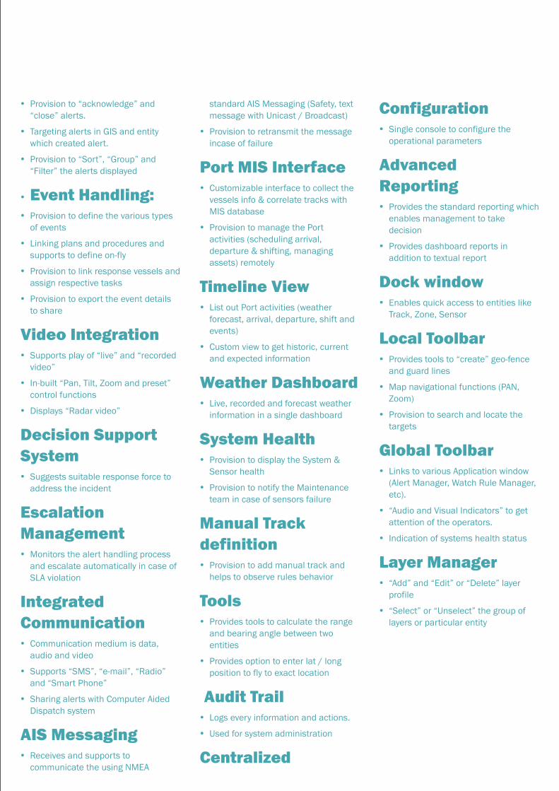
Rolta Command & Control�Provision to “acknowledge” and
“close” alerts.
�Targeting alerts in GIS and entity which created alert.
�Provision to “Sort”, “Group” and “Filter” the alerts displayed
�Event Handling:�Provision to define the various types
of events
�Linking plans and procedures and supports to define on-fly
�Provision to link response vessels and assign respective tasks
�Provision to export the event details to share
Video Integration�Supports play of “live” and “recorded
video”
�In-built “Pan, Tilt, Zoom and preset” control functions
�Displays “Radar video”
Decision Support System�Suggests suitable response force to
address the incident
Escalation Management�Monitors the alert handling process
and escalate automatically in case of SLA violation
Integrated Communication�Communication medium is data,
audio and video
�Supports “SMS”, “e-mail”, “Radio” and “Smart Phone”
�Sharing alerts with Computer Aided Dispatch system
AIS Messaging�Receives and supports to
communicate the using NMEA
Configuration�Single console to configure the
operational parameters
Advanced Reporting�Provides the standard reporting which
enables management to take decision
�Provides dashboard reports in addition to textual report
Dock window�Enables quick access to entities like
Track, Zone, Sensor
Local Toolbar�Provides tools to “create” geo-fence
and guard lines
�Map navigational functions (PAN, Zoom)
�Provision to search and locate the targets
Global Toolbar�Links to various Application window
(Alert Manager, Watch Rule Manager, etc).
�“Audio and Visual Indicators” to get attention of the operators.
�Indication of systems health status
Layer Manager�“Add” and “Edit” or “Delete” layer
profile
�“Select” or “Unselect” the group of layers or particular entity
standard AIS Messaging (Safety, text message with Unicast / Broadcast)
�Provision to retransmit the message incase of failure
Port MIS Interface�Customizable interface to collect the
vessels info & correlate tracks with MIS database
�Provision to manage the Port activities (scheduling arrival, departure & shifting, managing assets) remotely
Timeline View�List out Port activities (weather
forecast, arrival, departure, shift and events)
�Custom view to get historic, current and expected information
Weather Dashboard�Live, recorded and forecast weather
information in a single dashboard
System Health�Provision to display the System &
Sensor health
�Provision to notify the Maintenance team in case of sensors failure
Manual Track definition�Provision to add manual track and
helps to observe rules behavior
Tools�Provides tools to calculate the range
and bearing angle between two entities
�Provides option to enter lat / long position to fly to exact location
Audit Trail�Logs every information and actions.
�Used for system administration
Centralized
Key FeaturesCommand & Control: Situational awareness�Complete Security Situation
Awareness across the facility
�Common Operating Picture of the Safety & Security across the operators and responders
�Geospatial Visualization
�Support for OGC “WMS services” and “ENC”
�Displays composite track, radar track,
sensors, zones, etc. on a Map
�Supports “Clustering” functions.
�“Route” and “monitoring parameters” definition
�Business Rules�Assists to define various “Watch
Rules”
�Provision to “Sort”, “Group” and “Filter” the watch rules
�In-built/custom defined “Standard Operating Procedures”
Alert Manager�“Prioritization” of alerts.
Sensor Integration & Data Correlation Interface:�Enables collection of safety and
security risks from large variety of sensors.
�Correlation of sensor information.
�Management of sensor through operational controls.
�Sensors supported (Radar, AIS, Video Sensors, Sonar System, Weather Sensors, RDF, VHF).
�Supports IMO guidelines
Rolta Command & Control is industry proven leading edge technology designed to address the Safety and Security requirements of both Land and Maritime environment. It empowers navy, coast guards, port authorities, critical infrastructure securing agencies, to achieve affordable, truly collaborative situation awareness and manage the security threats. This web-based technology feeds sharply focused relevant information along with actionable recommendations to the intelligence analyst/security experts. Advanced anomaly detection techniques applied to information, automatically generate tailored alerts to right users at right time, thus enabling them handle threats efficiently.
Rolta Command & Control�Provision to “acknowledge” and
“close” alerts.
�Targeting alerts in GIS and entity which created alert.
�Provision to “Sort”, “Group” and “Filter” the alerts displayed
�Event Handling:�Provision to define the various types
of events
�Linking plans and procedures and supports to define on-fly
�Provision to link response vessels and assign respective tasks
�Provision to export the event details to share
Video Integration�Supports play of “live” and “recorded
video”
�In-built “Pan, Tilt, Zoom and preset” control functions
�Displays “Radar video”
Decision Support System�Suggests suitable response force to
address the incident
Escalation Management�Monitors the alert handling process
and escalate automatically in case of SLA violation
Integrated Communication�Communication medium is data,
audio and video
�Supports “SMS”, “e-mail”, “Radio” and “Smart Phone”
�Sharing alerts with Computer Aided Dispatch system
AIS Messaging�Receives and supports to
communicate the using NMEA
Configuration�Single console to configure the
operational parameters
Advanced Reporting�Provides the standard reporting which
enables management to take decision
�Provides dashboard reports in addition to textual report
Dock window�Enables quick access to entities like
Track, Zone, Sensor
Local Toolbar�Provides tools to “create” geo-fence
and guard lines
�Map navigational functions (PAN, Zoom)
�Provision to search and locate the targets
Global Toolbar�Links to various Application window
(Alert Manager, Watch Rule Manager, etc).
�“Audio and Visual Indicators” to get attention of the operators.
�Indication of systems health status
Layer Manager�“Add” and “Edit” or “Delete” layer
profile
�“Select” or “Unselect” the group of layers or particular entity
standard AIS Messaging (Safety, text message with Unicast / Broadcast)
�Provision to retransmit the message incase of failure
Port MIS Interface�Customizable interface to collect the
vessels info & correlate tracks with MIS database
�Provision to manage the Port activities (scheduling arrival, departure & shifting, managing assets) remotely
Timeline View�List out Port activities (weather
forecast, arrival, departure, shift and events)
�Custom view to get historic, current and expected information
Weather Dashboard�Live, recorded and forecast weather
information in a single dashboard
System Health�Provision to display the System &
Sensor health
�Provision to notify the Maintenance team in case of sensors failure
Manual Track definition�Provision to add manual track and
helps to observe rules behavior
Tools�Provides tools to calculate the range
and bearing angle between two entities
�Provides option to enter lat / long position to fly to exact location
Audit Trail�Logs every information and actions.
�Used for system administration
Centralized

North America HeadquartersRolta International Inc.
Rolta Center, 5865 North Point Parkway
Alpharetta, GA 30022, USA.
Tel : +1 (678) 942 5000
Email : [email protected]
European HeadquartersRolta UK Ltd.
100 Longwater Avenue, Green Park,
Reading RG2 6GP, United Kingdom
Tel +44 (0)118 945 0450
Email : [email protected]
Middle-East Regional OfficeRolta Saudi Arabia Ltd.
Office Nos. 200 & 201, Wardat AI Salam Bldg.
P O Box 68371, Riyadh (11527), Kingdom of
Saudi Arabia.
Tel : +966 (1) 460 1818
International OfficesRolta International, Inc. — Chicago
333 E. Butterfield Road, Suite 900, Lombard,
IL 60148, USA.
Tel : +1 (630) 960 2909
Tel: +(905) 754 8100
Rolta Canada Ltd.
140 Allstate Parkway, Suite 503 Markham,
Ontario L3R 5Y8, Canada.
Rolta Benelux BV
Jupiterstraat 96, Building Pluspoint Nr. 2,
2132 HE,
Hoofddorp, Postbus 190, 2130 AD Hoofddorp,
Netherlands.
Tel : +31 (23) 557 1916
Corporate and Global HeadquartersRolta India Limited
Rolta Tower A,
Rolta Technology Park, MIDC,
Andheri (East), Mumbai 400 093. India
Tel : +91 (22) 2926 6666, 3087 6543
Fax : +91 (22) 2836 5992
Email : [email protected]
Middle-East HeadquartersRolta Middle East FZ-LLC
Office No. 209-211, Building No. 9,
P.O. Box 500106 Dubai Internet City,
Dubai, United Arab Emirates
Tel : +971 (4) 391 5212
Email : [email protected]
About RoltaRolta is a leading provider of innovative IT
solutions for many vertical segments,
including Federal and State Governments,
Defense/HLS, Utilities, Process, Power,
Financial Services, Manufacturing, Retail,
and Healthcare. By uniquely combining its
expertise in the IT, Engineering and
Geospatial domains, Rolta develops
exceptional solutions for these segments. The
Company leverages its industry-specific
know-how, rich repository of intellectual
property that spans photogrammetry, image
processing, geospatial applications, business
intelligence, analytics, field-proven solution
frameworks, and deep expertise in cutting-
edge technologies like Geo BI, Cloud
computing, Software Defined Infrastructure
and Big Data for providing sophisticated
enterprise-level integrated solutions. Rolta is
a multinational organization headquartered
in India. The Company operates from 40
locations worldwide through its subsidiaries,
and has executed projects in over 45
countries. The Company benchmarks its
quality processes to the world’s best
standards, like successful assessment for
Software Application Development and
Maintenance at the highest Level 5 of SEI's
CMMI® version 1.3. Rolta is listed on the
Bombay Stock Exchange & National Stock
Exchange, and forms part of various indices
on BSE/NSE in India. The Company's GDRs
are listed on the Main Board of London Stock
Exchange. The Company’s ‘Senior Notes’ are
listed on Singapore Stock Exchange.