roseberry topping and cook's monument - north …€¦ · and explorer captain cook – just...
TRANSCRIPT
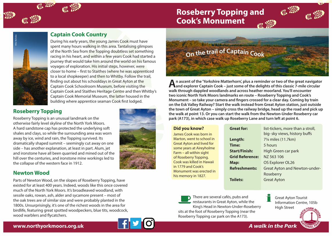
An ascent of the ‘Yorkshire Matterhorn’, plus a reminder or two of the great navigator and explorer Captain Cook – just some of the delights of this classic 7-mile circular
walk through dappled woodlands and across heather moorland. You’ll encounter two iconic North York Moors landmarks en route – Roseberry Topping and Cook’s Monument – so take your camera and fingers crossed for a clear day. Coming by train on the Esk Valley Railway? Start the walk instead from Great Ayton station, just outside the town of Great Ayton – simply cross the railway bridge, head up the road and pick up the walk at point 13. Or you can start the walk from the Newton-Under Roseberry car park (A173), in which case walk up Roseberry Lane and turn left at point 6.
Captain Cook CountryDuring his early years, the young James Cook must have spent many hours walking in this area. Tantalising glimpses of the North Sea from the Topping doubtless set something racing in his heart, and within a few years Cook had started a journey that would take him around the world on his famous voyages of exploration. His initial steps, however, were closer to home – first to Staithes (where he was apprenticed to a local shopkeeper) and then to Whitby. Follow the trail, finding out about his schooldays in Great Ayton at the Captain Cook Schoolroom Museum, before visiting the Captain Cook and Staithes Heritage Centre and then Whitby’s Captain Cook Memorial Museum, the latter housed in the building where apprentice seaman Cook first lodged.
Roseberry ToppingRoseberry Topping is an unusual landmark on the otherwise fairly level skyline of the North York Moors. A hard sandstone cap has protected the underlying soft shales and clays, so while the surrounding area was worn away by ice, wind and rain, the Topping survived. Its dramatically shaped summit – seemingly cut away on one side – has another explanation, at least in part. Alum, jet and ironstone have all been quarried and mined out of the hill over the centuries, and ironstone mine workings led to the collapse of the western face in 1912.
Newton WoodParts of Newton Wood, on the slopes of Roseberry Topping, have existed for at least 400 years. Indeed, woods like this once covered much of the North York Moors. It’s broadleaved woodland, with sessile oaks, rowan, ash, alder and sycamore present – most of the oak trees are of similar size and were probably planted in the 1800s. Unsurprisingly, it’s one of the richest woods in the area for birdlife, featuring great spotted woodpeckers, blue tits, woodcock, wood warblers and flycatchers.
Roseberry Topping andCook’s Monument
On the trail of Captain Cook
Great for: list-tickers, more than a stroll, big- sky views, history buffsLength: 7¼ miles (11.7km)Time: 5 hoursStart/Finish: High Green car parkGrid Reference: NZ 563 106Map: OS Explorer OL26Refreshments: Great Ayton and Newton-under- RoseberryToilets: Great Ayton
A walk in the Park
Did you know?James Cook was born in Marton, went to school in Great Ayton and lived for some years at Aireyholme Farm – all within sight of Roseberry Topping. Cook was killed in Hawaii in 1779 and Cook’s Monument was erected in his memory in 1827.
There are several cafés, pubs and restaurants in Great Ayton, while the King’s Head in Newton-Under-Roseberry
sits at the foot of Roseberry Topping (near the Roseberry Topping car park on the A173).
Great Ayton Tourist Information Centre, 105b High Street
www.northyorkmoors.org.uk
Mik
e N
icho
las
Mik
e N
icho
las
Mik
e N
icho
las
Please keep dogs on a short lead or to heel at all times on both the moorland and woodland
sections of this walk. In moorland areas, dogs should be kept on a short lead between 1 March and 31 July when birds are nesting on the ground. Please also keep dogs on a short lead where livestock is present.
. . . on the trail of Captain Cook . . .
The climb up Roseberry Topping (1,050 feet/320 metres), is a steep ascent up a stone stepped path and stone tracks – there’s also another (gentler) ascent from Gribdale Gate
to Cook’s Monument. Once you’re up, the going is relatively straightforward, along well-defined moorland tracks, and obvious grass and woodland paths. Please take care on the return where the path crosses the railway line.
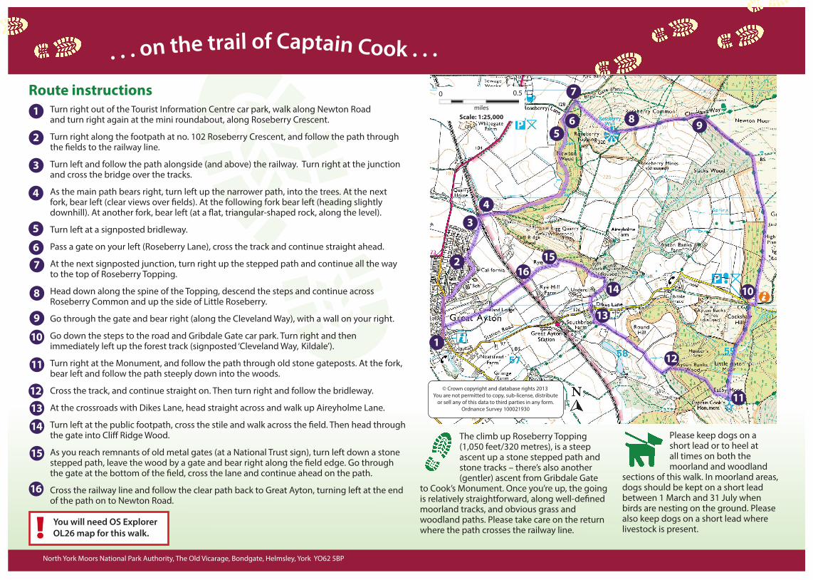
Route instructions Turn right out of the Tourist Information Centre car park, walk along Newton Road and turn right again at the mini roundabout, along Roseberry Crescent.
Turn right along the footpath at no. 102 Roseberry Crescent, and follow the path through the fields to the railway line.
Turn left and follow the path alongside (and above) the railway. Turn right at the junction and cross the bridge over the tracks.
As the main path bears right, turn left up the narrower path, into the trees. At the next fork, bear left (clear views over fields). At the following fork bear left (heading slightly downhill). At another fork, bear left (at a flat, triangular-shaped rock, along the level).
Turn left at a signposted bridleway.
Pass a gate on your left (Roseberry Lane), cross the track and continue straight ahead.
At the next signposted junction, turn right up the stepped path and continue all the way to the top of Roseberry Topping.
Head down along the spine of the Topping, descend the steps and continue across Roseberry Common and up the side of Little Roseberry.
Go through the gate and bear right (along the Cleveland Way), with a wall on your right.
Go down the steps to the road and Gribdale Gate car park. Turn right and then immediately left up the forest track (signposted ‘Cleveland Way, Kildale’).
Turn right at the Monument, and follow the path through old stone gateposts. At the fork, bear left and follow the path steeply down into the woods.
Cross the track, and continue straight on. Then turn right and follow the bridleway.
At the crossroads with Dikes Lane, head straight across and walk up Aireyholme Lane.
Turn left at the public footpath, cross the stile and walk across the field. Then head through the gate into Cliff Ridge Wood.
As you reach remnants of old metal gates (at a National Trust sign), turn left down a stone stepped path, leave the wood by a gate and bear right along the field edge. Go through the gate at the bottom of the field, cross the lane and continue ahead on the path.
Cross the railway line and follow the clear path back to Great Ayton, turning left at the end of the path on to Newton Road.
1
2
3
4
5
67
© Crown copyright and database rights 2013You are not permitted to copy, sub-license, distribute
or sell any of this data to third parties in any form.Ordnance Survey 100021930
1
2
3
4
56
7
North York Moors National Park Authority, The Old Vicarage, Bondgate, Helmsley, York YO62 5BP
8
9
10
11
1213
14
8 9
10
11
12
13
14
15
Scale: 1:25,000miles
0 0.5
16
You will need OS ExplorerOL26 map for this walk.
1615