rrac final
TRANSCRIPT

Califo
rnia
Sta
te O
ffice, S
acra
men
to
BL
M
Bureau of Land Management Bureau of Land Management Recreation Resource Advisory CommitteeRecreation Resource Advisory Committee
August 2013August 2013
CaliforniaCalifornia San Joaquin River Gorge

California Developed Recreation Sites on Bureau of Land Management Public Lands
Public lands in the Golden State offers many recreation opportunities. Enjoy a leisurely drift in a canoe on a Class II river or an exciting ride on Class IV river
for the more experienced white water adventurist. Camp in serene locations such as the ancient redwood forest of the Headwaters Forest Reserve or the tower-
ing desert dunes of the Imperial Sand Dunes Recreation Area. Hike, bike or ride horses on hundreds of miles of trails or experience many of our exceptional
Off-highway Vehicle areas.
Mattole
Horse Mountain Tolkan

Wailaki Honeydew Creek
California Developed Recreation Sites
Field Office Area Name of Recreation
Site Fee Amenities Location Open Dates
Arcata King Range NCA Mattole $8/night
14 tent/trailer campsites, picnic tables, fire rings, vault toilets, no hookups, potable water, parking area, wheel chair accessible. No OHV access.
North end of King Range at the beach. U.S. 101 at Garberville, South Fork/Honeydew, or Fern-dale exits. Follow signs toward Petrolia, turn on Lighthouse Road to ocean.
open all year
Arcata King Range NCA Honeydew Creek $8/night
5 tent/trailer campsites with picnic tables, fire rings, vault toilets. No water (campground is near creek; treat water before drinking), no hookups. Wheelchair accessible.
U.S. 101 at South/Fork Honeydew exit. Follow signs to Honeydew, turn south onto Wilder Ridge Road toward Ettersburg for 1 mile.
open all year
Arcata King Range NCA Hourse Mountain $5/night
9 tent/trailer campsites with picnic tables, fire rings, pit toilets. No water. No hookups.
U.S. 101 to Redway, west 22 miles on
Briceland/Shelter Cove Road, then 6.5 miles
north on King Peak Road. open all year
Arcata King Range NCA Tolkan $8/night
5 trailer/4 tent campsites with picnic tables, fire rings, vault toilets. No hookups. Wheelchair accessible. This campground provides easy access to the Paradise Royale Mountain Bike Trail.
U.S. 101 to Redway, west 22 miles on Briceland/Shelter Cove Road, then 3.5 miles north on King Peak Road. open all year
Arcata King Range NCA Nadelos $8/night
8 tent campsites with picnic tables, fire rings, vault toilets. No hookups. Wheelchair accessible. Chemise Mtn. Trail-head. Entire campground may be reserved for overnight group use for $85 per night. Minimum number of people in group is 20, and maximum group number is 60. All appli-cations and fees must be received 30 days prior to the first use day. To request a permit application please call the BLM King Range Project Office at 707-986-5400. NO group reservations are available Memorial Day weekend, Fourth of July weekend or Labor Day weekend.
U.S. 101 to Redway, west 22 miles on Briceland/Shelter Cove Road, south 1.5 miles on Chemise Mountain Road.
open all year
Arcata King Range NCA Wailaki $8/night
13 tent/trailer campsites with picnic tables, fire rings, vault toilets. No hookups. Wheelchair accessible. Chemise Mtn. Trailhead.
U.S. 101 to Redway, west 22 miles on Briceland/Shelter Cove Road, south 2 miles on Chemise Mountain Road.
open all year
Arcata Arcata Lacks Creek Free
tent campsites at Lacks Creek trailhead with picnic tables, fire rings, vault toilet. No reservations are available. Camp-ing in other designated sites is allowed. See map for des-ignated sites. In winter and spring, call (707) 825-2300 for road conditions.
Drive east on Highway 299 for 17.8 miles from Highway 101. Turn left at the Redwood Valley turn off (Bair Road) and travel 3.9 miles. Make a right turn at the sign that reads "Hoopa - 22 miles", and travel 5.9 miles up this windy gravel road. The entrance is a left turn.
Open all year


California Developed Recreation Sites
Field Office Area Name of Recreation Site Fee Amenities Location Open Dates
Redding Trinity River Douglas City $10 (per vehicle/
night)
20 tent/trailer campsites, MAX trailer length is 28 feet, group picnic area, picnic tables, telephone, beach, paved loop road, flush and vault toilets, potable water, and fire rings.
Along the Trinity River. Follow State Highway 299 to Steiner Flat Road, one-half mile west of Douglas City. May 1- Oct. 30
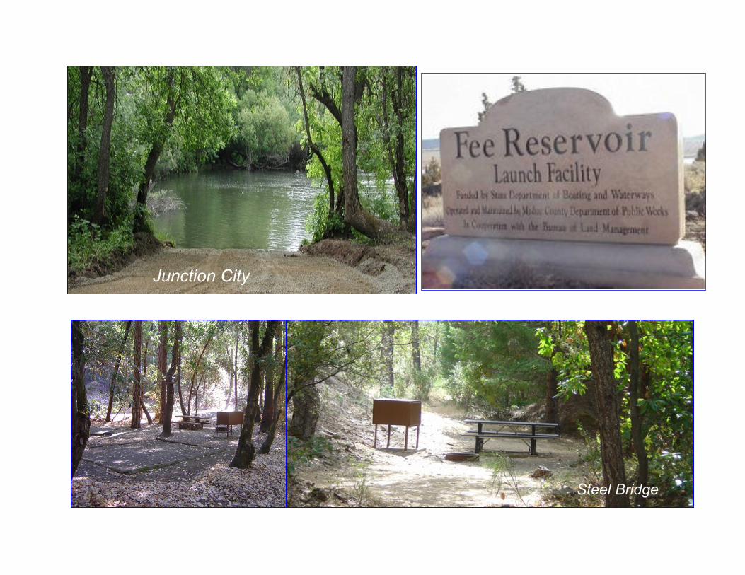
Redding Trinity River Junction City $10 (per vehicle/
night)
22 tent/trailer campsites, paved loop road, vault toilets, potable water, fire rings, and picnic tables. MAX trailer length is 40 feet.
1-1/2 miles west of Junction City on State Highway 299. May1- Nov 30
Redding Trinity River Steel Bridge $5/night
9 camping sites with picnic tables and fire rings, day-use parking area, vault toilet. No potable water. MAX trailer length is 20 feet.
About three miles east of Douglas City on State Highway 299, then two miles north on Steel Bridge Road.
open all year
Redding Trinity River Steiner Flat no fees No toilets, no potable water. Public lands along the Trinity River on Steiner
Flat Road, past Douglas City campground. open all year
Redding Klamath
River Stateline on the Klamath
River no fees
Primitive boat ramp, picnic tables, and vault toilets. About 6.5 miles north of Copco Lake on Ager-Beswick Road open all year
Redding Copco Lake Mallard Cove no fees
Boat ramp, RV parking and camping for 6 trailers, 4 campsites with picnic tables, toilet, fire rings, no potable water. Co-managed with Pacific Power Co.
6.5 miles east of Hornbrook, CA, on Ager Road, then 15 miles north on Copco Lake Road.
Alturas Pit River Pit River Recreation Area $8/night
Group $12/night
8 campsites with tables, fire rings. Located on the Pit
River with access for fishing, canoeing or rafting.
From Redding, CA, take Highway 299 East toward Burney, CA. After Burney, go 12 miles east until you see the sign "Pit Power House" road.
May1- Nov 30
Surprise East of Fort Bidwell, CA
Fee Reservoir no fees
Campsites, group, toilet, semi-primitive camp sites, vault toilets, 7 sites with enclosed fire rings and picnic tables, 20 - 24 ft. trailers/RVs possible, approximately 30 Miles to nearest food/gasoline/hospital, no drinking water available on site.
From Cedarvile, CA, take Surprise Valley
Road north 20 - 25 miles turning right (east)
onto Fee Reservoir Road. Take it 6 - 8 miles
to the reservoir site.
open all year
Surprise High Rock
Canyon High Rock Canyon no fees
Pack-in, Pack-out camping, group, no campsites, no camping amenities, approximately 47 miles to nearest food/gasoline/hospital, no drinking water available. There is a 14 day maximum stay limit.
Hays Canyon Route: 4WD required. Head south
on Co. Rd. 1 out of Cedarville for 15 miles. Turn
left on County Road 38. Continue for 7 miles
onto Hays Canyon road. Once you reach the
summit, turn left and follow signs to
campground. Camp will be on your left.
open 2nd weekend in
May thru Feb-ruary 1st
Surprise
North End of High Rock
Canyon Stevens Camp no fees
Four established camping areas at Stevens Camp, including a large site near the free use cabin. The cabin site(s) includes amenities such as a vault toilet, picnic tables, fire pits and a grill. The cabin itself is available for public use on a first-come first-served basis and includes amenities such as running water (must be treated prior to drinking), a wood stove, a shower and hot water heater, and connections for generator to pro-vide power and lights to the cabin. Approximately 42 Miles to nearest food/gasoline/hospital. There is a 14 day maximum stay limit.
Head East on 299E out of Cedarville toward Vya
for 20 miles. Turn right on HWY 8A toward
Sheldon NWR. Continue on 8A for 12 miles.
Take a right on Stevens Camp Road. Follow signs
for 10 miles. The cabin will be on your left. open all year
weather permit-ting
Douglas City
Steel Bridge
Junction City

California Campgrounds
Field Office Area Name of Recreation Site Fee Amenities Location Open Dates
Eagle Lake North Eagle Lake $8/night
20 sites in a pine and juniper forest. Vault toilets and drinking water are available. Some campsites can accommodate RV's up to 35 feet long. A campgroundhost is available.
30 miles north of Susanville on Highway 139 and a half-mile west on Lassen County Road A-1.
Mid-May to mid-Nov.
Eagle Lake Rocky Point Donations
A vault toilet is available. Campers must pack out all items that they bring with them.
From Susanville travel north on Highway 139 for 30 miles. Turn west (left) on County Road A-1 and travel approximately 6 miles. Turn south (left) at the bottom of a mile long grade.
open all year
Eagle Lake Ramhorn Donations 10 sites with picnic tables and fire rings, one accessi-ble vault toilet and a small horse corral.
Small desert canyon east of Highway 395, 45 miles north of Susanville. open all year
Eagle Lake Dodge Donations
11 campsites with picnic tables, and fire rings and one accessible vault toilet. There is no drinking water.
17 miles northeast of Ravendale, CA, beside Dodge Reservoir in the high desert setting of sagebrush hills with scattered junipers. open all year
North Eagle Lake
Ukiah South
Cow Mountain Buckhorn no fees
4 sites, toilet facilities, picnic tables and fire grates/ BBQs.
In Ukiah, exit U.S. 101 South at Talmage
Road, then 1.5 miles east to Eastside Road.
Turn right and proceed 0.3 mile to Mill Creek
Road. Follow Mill Creek Road 5 miles to
staging area, veer right where road forks
(there is a directional sign) and continue
about 3.5 miles on turning at the trail #20.
open all year
Ukiah North
Cow Mountain Goat Rock no fees
2 units, water for animals, picnic tables, and fire grates/ BBQs.
In Ukiah, exit U.S. 101 South at Talmage
Road, then 1.5 miles east to Eastside Road.
Turn right and proceed 0.3 mile to Mill Creek
Road. Turn left and proceed 3 miles to Men-
do Rock Road, park at Mendo Rock Road.
Take Glen Eden trail east about 4 miles:
hiking or horseback access only.
open all year
Ukiah North
Cow Mountain Mayacmas no fees
6 units, toilet facilities, water for animals, picnic tables, and fire grates/ BBQs.
In Ukiah, exit U.S. 101 South at Talmage
Road, then 1.5 miles east to Eastside Road.
Turn right and proceed 0.3 mile to Mill Creek
Road. Turn left and proceed 3 miles to Men-
do Rock Road, and follow to site, about 10
miles.
open all year
Ukiah South
Cow Mountain Red Mountain no fees
11 Units, picnic tables, and fire grates/ BBQs. In Ukiah, exit U.S. 101 South at Talmage
Road, then 1.5 miles east to Eastside Road.
Turn right and proceed 0.3 mile to Mill Creek
Road. Follow Mill Creek Road 5 miles to
staging area, veer right where road forks
(there is a directional sign) and continue 2.5
miles.
open all year
Ukiah Cow Mountain
(detached) Sheldon Creek no fees
5 units, picnic tables, and fire grates/ BBQs. U.S. 101 to Hopland Road in Hopland, east 3
miles to Old Toll Road, 8 miles south on a
gravel road. open all year
Ukiah Indian Valley
Reservoir Blue Oak no fees
6 units, toilet facilities, picnic tables, and fire grates/ BBQs.
From Highway 20, go north on Walker Ridge
Road 5.4 miles to "T" intersection. Turn left
and proceed 2.4 miles to campground. open all year
Ukiah Indian Valley
Reservoir Kowalski no fees
Primitive camping with no developed facilities. This is
hike-in or boat-in access only.
From Highway 20, go north on Walker Ridge
Road 5.4 miles to "T" intersection. Turn left
and proceed 4 miles to Indian Valley Reser-
voir. To hike to site, cross Indian Valley dam
to trailhead. Hike 2.5 miles to campsites. To
boat to site, proceed northwest approximately
1 mile to site.
open all year
Ukiah Knoxville Lower Hunting Creek no fees
5 sites with shade structures, vault toilet, trash cans,
and 3 overflow campsites. There is no potable water at
the site.
Located at the intersection of Dunnigan Hill
Road and Hunting Creek Road at Hunting
Creek. open all year
California Developed Recreation Sites
Field Office Area Name of Recreation Site Fee Amenities Location Open Dates
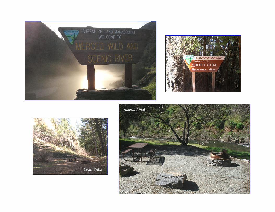
South Yuba
Railroad Flat

California Campgrounds
Field Office Area Name of Recreation Site Fee Amenities Location Open Dates
Mother Lode Merced River McCabe Flat $10/night
11 Walk-in campsites, 3 Vehicle/RV campsites, pit toilets, and composting toilets, picnic tables, fire grills, and garbage collection.
From Mariposa, follow Hwy 140 to Briceburg, then river road to site. April 30- Sept. 5
Mother Lode Merced River Willow Placer $10/night
9 Walk-in campsites, 1 Large group site, pit toilets, and composting toilets, picnic tables, fire grills, and garbage collection.
From Mariposa, follow Hwy 140 to Briceburg, then river road to site. April 30- Sept. 5
Mother Lode Merced River Railroad flat $10/night
3 Walk-in campsites, 6 Vehicle/RV campsites, pit toilets, and composting toilets, picnic tables, fire grills, and garbage collection.
From Mariposa, follow Hwy 140 to Briceburg, then river road to site. April 30- Sept. 5
Mother Lode South Yuba
River South Yuba $5/night
16 campsites for tents or RV's, piped water, pit toilets (wheelchair bound person will require assis-tance), picnic tables, fire grills, garbage collection.
From Nevada City, follow Highway 49 to North Bloomfield Road and travel ten (10) miles to South Yuba Recreation Lands. From the one lane bridge at Edwards Crossing it is approximately 1-1/2 miles on a dirt/gravel road to the campground.
April- Oct. 15th
Hollister
Sam Benito
County
Condon Peak Recreation Area
no fees
Primarily an RV-type campground, with pit toilets and trash dumpsters. No electricity, water, or hook-ups, no picnic tables, and no potable or running water. There is natural asbestos in the soils and water.
From Hollister go south on State Highway 25 and turn left at Coalinga Road heading east. Continue approximately 21 miles to the Access point on your left at the San Benito-Fresno County line.
open all year
Hollister
Sam Benito
County
Laguna Mountain Recrea-tion Area
no fees
2 campgrounds (Laguna & Sweetwater) each with developed campsites including level RV pads, fire rings, shade structures, picnic benches, vault toilets, and a kiosk providing an interpretive panel, a map, and information about the area. No electricity, trash collection, or running water.
From Hollister take State Highway 25 south. Turn left onto Coalinga Road and look for the access points located on the west side of the road. From Coalinga take Gale Avenue west which turns into Derrick Avenue. Turn left on Los Gatos Creek Road. Los Gatos Road turns into Coal-inga Road at the Fresno County line. Continue on Coalinga Road and look for the access points located on the west side of the road.
open all year
Hollister
Sam Benito
County
Willams Hill Recreation Area no fees
7 campsites with: vault toilets, shaded picnic ta-bles, fire-pits, and a kiosk providing an interpretive panel, a map, and information about the area. No electricity, trash collection, or running water.
Primary access is from U.S. Highway 101. Take the San Ardo exit and travel west onto Paris Valley Road, turn left onto Lockwood-San Ardo Road.
open all year

Aholul Group Camp
Yeh-Gub-Weh-Tuh Double Site
Yeh-Gub-Weh-Tuh Campground
McCabe Flat
California Developed Recreation Sites
Field Office Area Name of Recreation Site Fee Amenities Location Open Dates
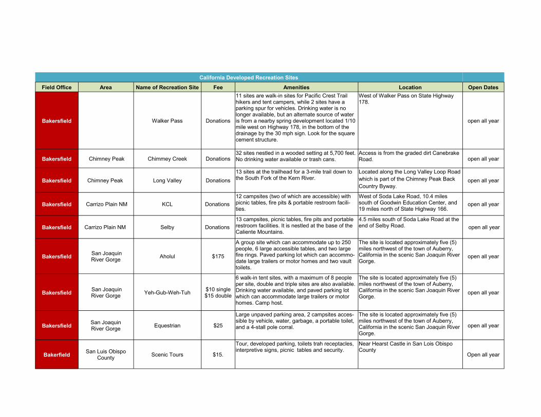
Bakersfield Walker Pass Donations
11 sites are walk-in sites for Pacific Crest Trail hikers and tent campers, while 2 sites have a parking spur for vehicles. Drinking water is no longer available, but an alternate source of water is from a nearby spring development located 1/10 mile west on Highway 178, in the bottom of the drainage by the 30 mph sign. Look for the square cement structure.
West of Walker Pass on State Highway 178.
open all year
Bakersfield Chimney Peak Chimmey Creek Donations 32 sites nestled in a wooded setting at 5,700 feet. No drinking water available or trash cans.
Access is from the graded dirt Canebrake Road. open all year
Bakersfield Chimney Peak Long Valley Donations
13 sites at the trailhead for a 3-mile trail down to the South Fork of the Kern River.
Located along the Long Valley Loop Road
which is part of the Chimney Peak Back
Country Byway. open all year
Bakersfield Carrizo Plain NM KCL Donations
12 campsites (two of which are accessible) with picnic tables, fire pits & portable restroom facili-ties.
West of Soda Lake Road, 10.4 miles south of Goodwin Education Center, and 19 miles north of State Highway 166.
open all year
Bakersfield Carrizo Plain NM Selby Donations
13 campsites, picnic tables, fire pits and portable restroom facilities. It is nestled at the base of the Caliente Mountains.
4.5 miles south of Soda Lake Road at the end of Selby Road. open all year
Bakersfield San Joaquin River Gorge
Aholul $175
A group site which can accommodate up to 250 people, 6 large accessible tables, and two large fire rings. Paved parking lot which can accommo-date large trailers or motor homes and two vault toilets.
The site is located approximately five (5) miles northwest of the town of Auberry, California in the scenic San Joaquin River Gorge.
open all year
Bakersfield San Joaquin River Gorge
Yeh-Gub-Weh-Tuh $10 single $15 double
6 walk-in tent sites, with a maximum of 8 people per site, double and triple sites are also available. Drinking water available, and paved parking lot which can accommodate large trailers or motor homes. Camp host.
The site is located approximately five (5) miles northwest of the town of Auberry, California in the scenic San Joaquin River Gorge.
open all year
Bakersfield San Joaquin River Gorge
Equestrian $25
Large unpaved parking area, 2 campsites acces-sible by vehicle, water, garbage, a portable toilet, and a 4-stall pole corral.
The site is located approximately five (5) miles northwest of the town of Auberry, California in the scenic San Joaquin River Gorge.
open all year
Bakerfield San Luis Obispo
County Scenic Tours $15.
Tour, developed parking, toilets trah receptacles, interpretive signs, picnic tables and security.
Near Hearst Castle in San Lois Obispo County
Open all year

Fossil Falls
Pleasant Valley Pit
Fossil Falls
Crowley Lake
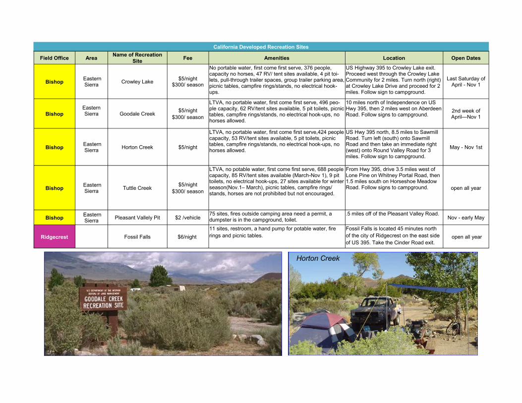
Field Office Area Name of Recreation
Site Fee Amenities Location Open Dates
Bishop Eastern Sierra
Crowley Lake $5/night
$300/ season
No portable water, first come first serve, 376 people, capacity no horses, 47 RV/ tent sites available, 4 pit toi-lets, pull-through trailer spaces, group trailer parking area, picnic tables, campfire rings/stands, no electrical hook-ups.
US Highway 395 to Crowley Lake exit. Proceed west through the Crowley Lake Community for 2 miles. Turn north (right) at Crowley Lake Drive and proceed for 2 miles. Follow sign to campground.
Last Saturday of April - Nov 1
Bishop
Eastern Sierra
Goodale Creek
$5/night
$300/ season
LTVA, no portable water, first come first serve, 496 peo-ple capacity, 62 RV/tent sites available, 5 pit toilets, picnic tables, campfire rings/stands, no electrical hook-ups, no horses allowed.
10 miles north of Independence on US Hwy 395, then 2 miles west on Aberdeen Road. Follow signs to campground.
2nd week of April—Nov 1
Bishop Eastern Sierra
Horton Creek $5/night
LTVA, no portable water, first come first serve,424 people capacity, 53 RV/tent sites available, 5 pit toilets, picnic tables, campfire rings/stands, no electrical hook-ups, no horses allowed.
US Hwy 395 north, 8.5 miles to Sawmill Road. Turn left (south) onto Sawmill Road and then take an immediate right (west) onto Round Valley Road for 3 miles. Follow sign to campground.
May - Nov 1st
Bishop Eastern Sierra
Tuttle Creek $5/night
$300/ season
LTVA, no potable water, first come first serve, 688 people capacity, 85 RV/tent sites available (March-Nov 1), 9 pit toilets, no electrical hook-ups, 27 sites available for winter season(Nov.1– March), picnic tables, campfire rings/stands, horses are not prohibited but not encouraged.
From Hwy 395, drive 3.5 miles west of Lone Pine on Whitney Portal Road, then 1.5 miles south on Horseshoe Meadow Road. Follow signs to campground. open all year
Bishop Eastern Sierra
Pleasant Vallely Pit $2 /vehicle 75 sites, fires outside camping area need a permit, a dumpster is in the campground, toilet.
.5 miles off of the Pleasant Valley Road. Nov - early May
Ridgecrest Fossil Falls $6/night
11 sites, restroom, a hand pump for potable water, fire
rings and picnic tables.
Fossil Falls is located 45 minutes north
of the city of Ridgecrest on the east side
of US 395. Take the Cinder Road exit. open all year
California Developed Recreation Sites
Horton Creek

Coon Hollow
Afton Canyon
Corn Springs
Owl Canyon
Owl Canyon
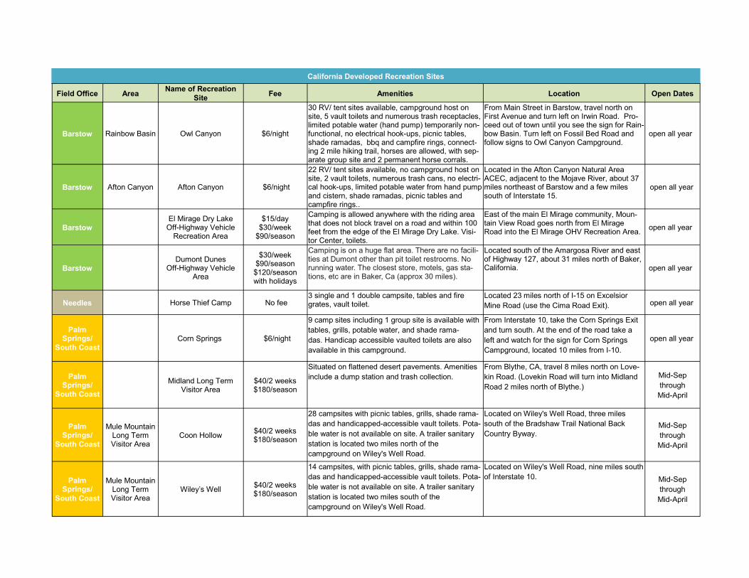
Field Office Area Name of Recreation
Site Fee Amenities Location Open Dates
Barstow Rainbow Basin Owl Canyon $6/night
30 RV/ tent sites available, campground host on site, 5 vault toilets and numerous trash receptacles, limited potable water (hand pump) temporarily non-functional, no electrical hook-ups, picnic tables, shade ramadas, bbq and campfire rings, connect-ing 2 mile hiking trail, horses are allowed, with sep-arate group site and 2 permanent horse corrals.
From Main Street in Barstow, travel north on First Avenue and turn left on Irwin Road. Pro-ceed out of town until you see the sign for Rain-bow Basin. Turn left on Fossil Bed Road and follow signs to Owl Canyon Campground.
open all year
Barstow Afton Canyon Afton Canyon $6/night
22 RV/ tent sites available, no campground host on site, 2 vault toilets, numerous trash cans, no electri-cal hook-ups, limited potable water from hand pump and cistern, shade ramadas, picnic tables and campfire rings..
Located in the Afton Canyon Natural Area ACEC, adjacent to the Mojave River, about 37 miles northeast of Barstow and a few miles south of Interstate 15.
open all year
Barstow El Mirage Dry Lake
Off-Highway Vehicle Recreation Area
$15/day $30/week
$90/season
Camping is allowed anywhere with the riding area that does not block travel on a road and within 100 feet from the edge of the El Mirage Dry Lake. Visi-tor Center, toilets.
East of the main El Mirage community, Moun-tain View Road goes north from El Mirage Road into the El Mirage OHV Recreation Area.
open all year
Barstow Dumont Dunes
Off-Highway Vehicle Area
$30/week $90/season $120/season with holidays
Camping is on a huge flat area. There are no facili-ties at Dumont other than pit toilet restrooms. No running water. The closest store, motels, gas sta-tions, etc are in Baker, Ca (approx 30 miles).
Located south of the Amargosa River and east of Highway 127, about 31 miles north of Baker, California. open all year
Needles Horse Thief Camp No fee 3 single and 1 double campsite, tables and fire grates, vault toilet.
Located 23 miles north of I-15 on Excelsior
Mine Road (use the Cima Road Exit). open all year
Palm Springs/
South Coast
Corn Springs $6/night
9 camp sites including 1 group site is available with
tables, grills, potable water, and shade rama-
das. Handicap accessible vaulted toilets are also
available in this campground.
From Interstate 10, take the Corn Springs Exit
and turn south. At the end of the road take a
left and watch for the sign for Corn Springs
Campground, located 10 miles from I-10.
open all year
Palm Springs/
South Coast
Midland Long Term
Visitor Area $40/2 weeks $180/season
Situated on flattened desert pavements. Amenities
include a dump station and trash collection.
From Blythe, CA, travel 8 miles north on Love-
kin Road. (Lovekin Road will turn into Midland
Road 2 miles north of Blythe.)
Mid-Sep
through
Mid-April
Palm Springs/
South Coast
Mule Mountain Long Term Visitor Area
Coon Hollow $40/2 weeks $180/season
28 campsites with picnic tables, grills, shade rama-
das and handicapped-accessible vault toilets. Pota-
ble water is not available on site. A trailer sanitary
station is located two miles north of the
campground on Wiley's Well Road.
Located on Wiley's Well Road, three miles
south of the Bradshaw Trail National Back
Country Byway. Mid-Sep
through
Mid-April
Palm Springs/
South Coast
Mule Mountain Long Term Visitor Area
Wiley’s Well $40/2 weeks $180/season
14 campsites, with picnic tables, grills, shade rama-
das and handicapped-accessible vault toilets. Pota-
ble water is not available on site. A trailer sanitary
station is located two miles south of the
campground on Wiley's Well Road.
Located on Wiley's Well Road, nine miles south
of Interstate 10. Mid-Sep
through
Mid-April
California Developed Recreation Sites

Long Term Visitor Area
Buttercup Ranger Station
North Dunes Recreation
Camping Along Gecko Road

Field Office Area Name of Recreation
Site Fee Amenities Location Open Dates
El Centro Hot Spring Long Term
Visitor Area $40/2 weeks $180/
season
Vault toilets are located across the street from Hot
Spring North. Dump station and water facilities
located in Holtville.
I-8 (West from Yuma, AZ/East from El Centro, CA) to 115 North/Van Der Linden (Exit 131). East on Evan Hewes for 3.8 miles.
Mid-Sep
through
Mid-April
El Centro Pilot Knob Long term
Visitor Area $40/2 weeks $180/
season
Tent/trailer spaces and refuse containers. Nearest
facilities are located in Yuma, AZ, seven miles east
of Pilot Knob.
I-8 (West from Yuma, AZ/East from El Centro,
CA) to Sidewinder Rd. (Exit 164). South on
Sidewider Rd.
Mid-Sep
through
Mid-April
El Centro Tamarisk Long Term
Visitor Area $40/2 weeks $180/
season
Tent/trailer spaces and refuse containers. Nearest
facilities are located in Yuma, AZ or Holtville, CA.
I-8 (West from Yuma, AZ/East from El Centro,
CA) to Hwy. 98 (Exit 143.) Continue west on
Hwy 98 for approximately 2.7 miles. Turn south
onto a dirt road. Tamarisk LTVA will be on the
west side of the road.
Mid-Sep
through
Mid-April
El Centro
Imperial Sand Dunes
Recreation Area
North Dunes Campgrounds
$35/ Off-site week $50/ On-site weekly
$150/season
Gravel or paved surfaces for campers, toilets. From Yuma, take I-8 East toward El Centro, CA (12 mi), take Ogilby Rd exit, turn Right on Ogil-by Rd/CR-S34 (24 mi), turn Left onto CA-78 (9 mi).
open all year /
Fee Oct 1
through April 15
El Centro
Imperial Sand Dunes
Recreation Area
South Dunes Campgrounds
$35/ Off-site week $50/ On-site weekly
$150/season
Gravel or paved surfaces for campers, toilets. From Yuma, take I-10 West toward Los Ange-les, CA (31 mi), merge onto AZ-85 South to-ward I-8/Yuma, AZ (37 mi), continue on I-8 BL West (1 mi), continue on Pima St (1 mi), take I-8 West toward San Diego, CA (128 mi.\), Buttercup: Take Greys Well Rd. Exit South , Dunebuggy Flats: Take Gordons Well Exit North.
open all year /
Fee Oct 1
through April 15
El Centro McCain Valley
Cottonwood $6/night
25 developed campsites, fire rings, tables, and vault toilets. Horses are allowed only in the east loop.
From Interstate 8, take the Boulevard exit. Proceed south to the first stop sign. Turn left/east on Old Highway 80.After approximately 2 miles, turn left on McCain Valley Road.
open all year
El Centro
McCain Valley
Lark Canyon $6/night
15 developed campsites. Fire rings, tables, water (not tested safe for drinking), and six vault toilets are found in the campground. Group camping sites are available.
From Interstate 8, take the Boulevard exit. Proceed south to the stop sign at Old Highway 80.Turn east (left) on Old Highway 80.At ap-proximately two miles, turn north (left) on McCain Valley Road. Continue on McCain Valley Road for approximately four miles.
open all year
California Developed Recreation Sites
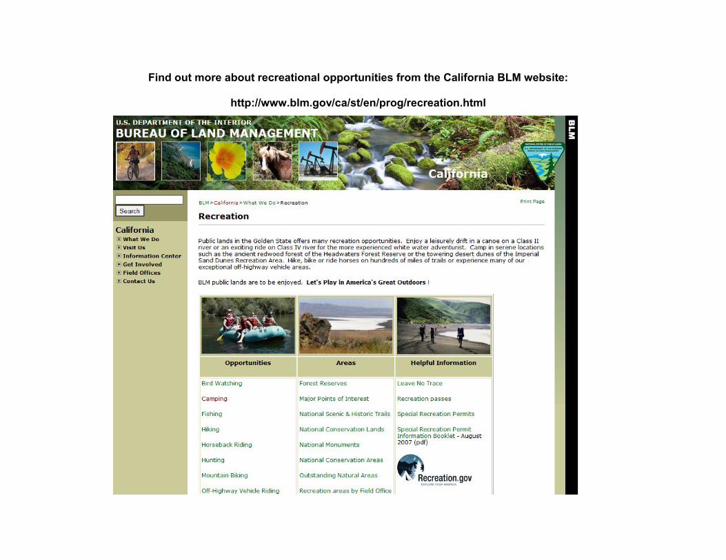
Find out more about recreational opportunities from the California BLM website:
http://www.blm.gov/ca/st/en/prog/recreation.html
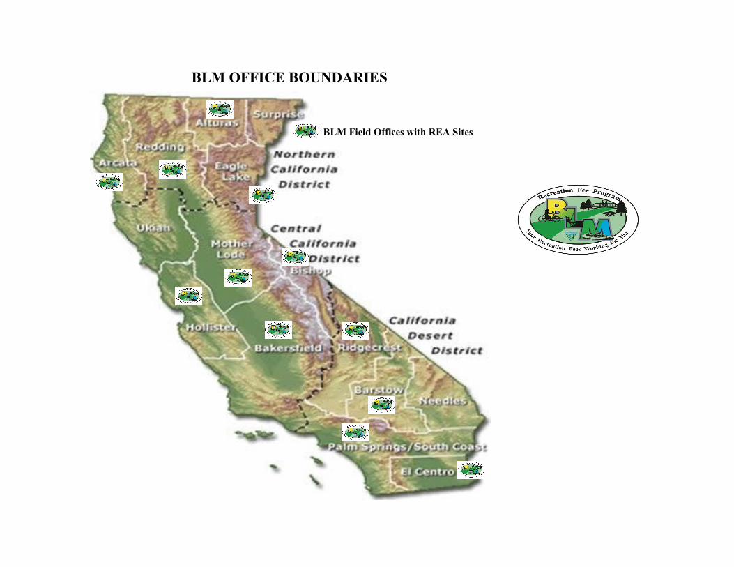
BLM OFFICE BOUNDARIES
BLM Field Offices with REA Sites