salmon river fire safe council cecilville community ... · salmon river fire safe council...
TRANSCRIPT

Salmon River Fire Safe Council Cecilville Community Wildfire Protection Plan
Page 1 of 14
Background Salmon River Subbasin Fire History The entire Salmon River watershed is at risk of catastrophic fire. One hundred plus years of fire suppression has had its effect on the fuels build up of the area. In 1911, the United States Congress passed the Weeks Act. Uncontrolled aboriginal and European settler burning practices and a severe fire year in 1910, particularly in the western U.S, precipitated this Act. The Act set up the collaboration between federal and state fire agencies for the purpose of systematically and efficiently suppressing forest fires. Since 1911, records show that 44% of the basin has burned. Suppression, coupled with an abnormally wet century (increased vegetation growth), and federal agency management activities (such as logging with insufficient fuel cleanup and silvicultural practices), have contributed to the increased fire risk and damage in our forests. The Salmon River watershed is one of the highest risk fire areas on the Klamath National Forest. It has a high natural frequency of lightning occurrence. In recent years the Offield Fire (1973) burned the area near the river confluence. The Hog Fire (1977) burned extensively in the lower North and South Fork watershed and in Nordheimer and Crapo Creeks. The total area was about 58,000 acres. In 1987, wildfires burned over 90,000 acres in four separate areas, covering much of the Salmon River subbasin, intensely re-burning many areas that had burned in the ’77 fire. In the Cecilville area, the drainages of St. Claire, Plummer, and Horse Mountain burned. In 1994, the Specimen fire burned approximately 7,000 acres (3,045 acres within the LSR). In 2002 the Forks fire, burned 1,400 acres to the north and east of Forks of Salmon. A snow/wind storm in the winter of 1996 exacerbated the heavy fuels condition by breaking out the tops of trees and knocking trees over throughout the watershed. Previous years of drought and overstocking have also resulted in areas of heavy mortality. The conditions and threats in the watershed mandate that we identify needs and prioritize and complete projects in a timely manner to protect life, property, and this unique ecosystem. We must also reintroduce a natural fire regime to the Salmon River watershed. Suppression and fuels reduction activities are currently being used in the watershed. There is a critical need for more fuels reduction. As we look at the range of conditions and concerns, we can begin to piece together a cohesive strategy that will detail areas needing specific treatment or protective measures. The identification of priority areas will include the influence of these areas on each other and on adjacent areas – this will allow us to treat smaller areas that will have an impact on the larger landscapes in the basin. Project Background In 2004, the Salmon River Restoration Council (SRRC) received a grant from the BLM, through the California Fire Safe Council. This grant calls for development of a detailed fire and fuel management plan for the private properties in the Cecilville Townsite and surrounding neighborhoods. The grant also funds the performance of some recommended fuel reduction activities on the project properties. Many of the properties in the Cecilville area have had some fuels reduction activities performed under previous grants. The overall goals of the Plan and project activities are to: 1) identify the current conditions of the properties and adjacent land as they relate to fire. 2) reduce fuels in the

Salmon River Fire Safe Council Cecilville Community Wildfire Protection Plan
Page 2 of 14
planning area to a safe level that will maximize safety and protection of life and property, while eventually allowing fire to resume a more natural role in the area. This is a cooperative planning document that suggests fuels reduction, and other activities that could protect life and property when future fires occur. This is not a binding agreement and no parties will be held responsible for not meeting any of the recommendations. In fact, it is expected that only some of the recommendations will be accomplished in the near future. However, this plan lays the groundwork for future fuels reduction activities and fire safe improvements when and if funding becomes available. This plan will help to procure funding for future fuels reduction and fire-safing by prioritizing areas of work and possible prescriptions to be done in these areas. Land boundaries and other data layers (streams, roads, etc.) are approximate; inclusion of these layers in this plan does not constitute agreement by any parties involved in the planning process. Cecilville Historical and Current Background Prior to occupation of the Cecilville area by Euro-American and Chinese settlers, spawned by the California Gold Rush of 1849, Native American Tribes populated the region. The major Tribes were the Konomihu, the Shasta, and the Karuk. Of these tribes, the Karuk is currently the only federally recognized Tribe, although the Shasta Tribe still has descendants living on the river. First known as Sisselville, the town was founded by John B. Sissel. Both town and the nearby creek were named after him. Town and creek both carried this spelling until the town was mined out and moved down the river to its current site, at which time the spelling of the creek and town changed from Sissel to Cecil. The old Cecilville occupied both sides of the river upriver and downriver of the current bridge across the Salmon River just downstream from Cecil Creek. The town had been second in size and importance only to Petersburg. The billiard-saloon had been brought from Buell’s Post in 1858. The dates vary, but sometime between 1873 and 1890, the town, except for the school, moved downriver to Crawford Creek. The school is currently used as a community center. Although uncertain of the date of the move, it is clear that George Sightman had bought what was left of Cecilville by 1890. At that time there was a post office, a store, a hotel, a saloon, and a livery stable located on the flat that runs along Crawford Creek, across from the current store at Doyle’s Camp. George Sightman was host, storekeeper, bartender, hostler, and U.S. Postmaster in the early 1890’s. He had cattle, which roamed wild in the mountains. Sightman sold beef on the hoof; the buyer had to find and shoot and the animal. Sightman charged four cents a pound for the dressed meat. Sightman and his boarding housekeeper, Carrie Roff (later Mrs. Clifford Phares), were Cecilville’s only full-time residents. George Green Brown of Brownsville on the East Fork came frequently to keep books for Sightman. George Sightman was a kind and generous man, and extended credit to all. In 1897 he lost the store to his primary creditor, the Denny Bar Co. of Callahan.

Salmon River Fire Safe Council Cecilville Community Wildfire Protection Plan
Page 3 of 14
The new owners put Thomas Markham in charge. Clifford Phares became postmaster. Sightman lived with the Phares family until his death in 1903. He was buried in the cemetery near Cecilville. The store passed from the Denny Bar Co. to John McBroom in 1921, who continued the store and ran a pack train. The post office was moved upstream when John McBroom’s daughter, Frances (Dove) Kaiser, became postmaster. The post office was merged into the Forks of Salmon post office in 1972. The store was purchased by Joe and Eileen Snipes in 1977. The old store and the one remaining old cabin were destroyed by a fire in 1987. The Snipes built a new store and bar across the road from the old site and continued operating them until 1999, when Jim and Leni Doyle purchased them. The major economy in Cecilville from 1850 through the 1930s was mining. In its early days much of the surrounding timberlands were denuded of trees and vegetation for lumber to build houses, businesses, and other structures. Mining timbers were also used in great quantities to shore up the underground hard rock and placer mines that proliferated in the area. The miners may have also intentionally started fires so they could get a better look at potential mining ground. From the mid 1960’s through the mid 1990’s logging held a major role in the local economy. Much of the watershed was impacted by this activity. This maximum extraction and destruction of resources were in stark contrast to pre-mining and forest management and use by Native Americans. The Cecilville community includes four neighborhoods within three miles of the downtown area. The neighborhoods are Downtown Cecilville, Lower Cecilville, Old Cecilville, and Taylor Creek. The residences in Cecilville have varying individual water systems, maintained by the owners. Water is supplied to the Downtown area by resident maintained water systems originating in Crawford Creek. In Lower Cecilville water supplies come from Orton and Indian Gulches and individual wells. Old Cecilville is supplied by Cecil Creek and individual wells. Taylor Creek supplies all of the residences in the Taylor Creek neighborhood. Cecilville Fire History and Current Fuels Conditions Like Sawyers Bar, early day miners cut timber for wood and burned off the surrounding landscape. More recent fire history shows fire burned down to the river below Cecilville in the 1987 Plummer/St. Claire Fire. Fuel reduction projects have been completed on portions of the private properties Cecilville neighborhoods. However, some of the private property still has hazardous fuels, and fuel reduction work continues. Emergency Response In terms of emergency fire response, the Cecilville Hose Company, a part of Salmon River Volunteer Fire & Rescue, has a 300 gallon fire engine housed at the Cecilville Community Center. The Salmon River Volunteer Fire and Rescue also have a 160-gallon fire engine and a water tanker that are housed in Forks of Salmon, and can respond within

Salmon River Fire Safe Council Cecilville Community Wildfire Protection Plan
Page 4 of 14
30 minutes. The Forest Service station at Petersburg has a Type 3 Model 62, 500-gallon tanker that can respond within 10 minutes, when manned during fire season. Methods The purpose of the Cecilville Fire Safe Plan is to guide fuel reduction activities designed to create a future condition that will minimize the risk of loss of life, property, and resources from fire. This Desired Future Condition will mimic the historic fire regime while protecting high value residential and resource areas from future fires. The Plan is being developed using the Fire Plan Framework created by the Salmon River Fire Safe Council. This framework identifies these planning steps:
1. Identify existing information: a. Identify Fuel Modification Zones b. Evacuation Plan (Emergency Access)
i. Notification Procedures ii. Guidelines for evacuation
iii. Availability of Emergency Services iv. High risk individuals (i.e. medical concerns, age factors) v. Location of Helicopter landings
vi. Location of Safe Areas in Neighborhoods 2. Identify High Risk Areas (also identify low and medium risk areas) 3. Identify Opportunities 4. Identify Water Sources for fire protection efforts 5. Update Pre-Fire Plan (Residential Risk Assessment) 6. Identify Resource Values and Prioritize (Assets at Risk)
a. Manmade b. Cultural c. Natural
A Fuel Modification Zone (FMZ) is any area being assessed for the benefit of reducing fire risk, actions within a FMZ can include anything from no action, to shaded fuel breaks, to areas cleared to bare ground. The SRFSC’s fuel reduction prescription policy was used to prescribe ground fuel reduction activities; this prescription policy recommends distances and types of fuel reduction activities that need to occur in different areas. The Cecilville properties have slopes less than 100%, so the techniques mainly call for a standard Shaded Fuel Break that breaks up fuel continuity and the fuel ladder and leaves at least 60-100% canopy cover (if available). The theory of a Shaded Fuel Break is that thinning out flammable and overstocked vegetation as well as dead and down fuel will reduce a future fire’s ability to move through the forest with high (and destructive) flame lengths. It must be understood that a Shaded Fuel Break will not stop a fire, but will give suppression forces and landowners extra time for safely fighting the fire and accessing or evacuating the fire area. The trimming of the branches for 6-8 feet up the stem of the remaining trees will reduce a future fire’s ability to climb the “Fuel Ladder” and burn the crowns of the remaining trees. Selection of plants to thin is based on density and flammability, with the idea of fire being reintroduced at some point in the future.

Salmon River Fire Safe Council Cecilville Community Wildfire Protection Plan
Page 5 of 14
Specifically, we want to maintain diversity of species and age classes while reducing the risk of future stand replacing fire. Other variations on the standard Shaded Fuel Break will be used on some properties. The above steps were accomplished by:
1. Creating a GIS (Geographical Information System) map of Cecilville that will identify steps 1, 2, 3, 4, and 6 above.
2. Conducting a field visit with a planning team. The planning team consists of: Property owners – Steve and Diane Adams, Gene Adams, Daniel Adams, Natalie Elder, Jim Doyle, Jonna Mullette, George Martin and Sharon Hoppas, Steve and Christy Gunther, Jonathan Nichol and Nadine Zarkowski, Clarence Hagmeier. SRRC Staff – Jim Villeponteaux, Petey Brucker; Salmon River Volunteer Fire and Rescue – Robert Will.
3. The field team looked over the Cecilville properties and made recommendations for what should be done to identify and protect the high value areas and reduce fuels in the high-risk areas. The team also discussed recommendations for landowners’ maintenance of their defensible spaces. The surrounding public property was discussed and recommendations were made for fuel reduction projects and fuel break construction on the public property portion of the Cecilville watersheds.
Risks and Mitigation Measures – What are the specific risks affecting the Cecilville
community? 1. Risk: Residences/structures have numerous potential ignition sources. These
ignition sources include indoor and outdoor cooking facilities, propane appliances and propane tanks, wood burning stoves, firewood piles, kerosene lamps, welding equipment, and generators. These structures are constructed of wood with metal roofing for the most part. Many of the structures are built on post and beam, are wood-sided, and have wooden decks around them. These ignition sources have the potential to threaten both private and public property. Mitigation Measures: The majority of residences are well maintained, with yards, open areas and well spaced, limbed trees. Maintenance of these structures and their grounds reduces the risk of fire starts and hazard to people. Wooden decks could be replaced with non-flammable materials. The underside of balconies and above ground decks should be enclosed with fire resistant materials. It is recommended that any future building projects rely on fire resistant materials where practicable. Fuels cleanup should be conducted within 100 feet of the structures, especially those structures that have vegetation encroaching around them, removing any dead and flammable debris that have accumulated. New residents and visitors should be briefed on fire safe practices.
2. Risk: Several properties are only occupied seasonally. During most of the
year, buildings and properties of absentee owners tend to be neglected.

Salmon River Fire Safe Council Cecilville Community Wildfire Protection Plan
Page 6 of 14
Without maintenance, buildup of vegetation, accumulation of roof litter, and degradation of plumbing and water systems can occur. Mitigation Measures: Absentee and seasonal landowners should be conscientious of the upkeep on their properties. They should be encouraged to participate in fuel reduction programs available to them – reducing fire risk on their property will also reduce the risk to other properties and the public land. Residents should have an emergency fire plan including suppression and evacuation plans in place. New residents and visitors should be briefed on fire safe practices.
3. Risk: The Cecilville community’s water systems are diverse and generally
low tech, and marginal in efficiency. Many are in need of repair and upgrading. Water supplies are limited in summer months. Mitigation Measures: The Crawford Creek water system, supplies 9 residences in the Downtown Cecilville vicinity. Adequate at best, it is now being taxed with increased usage. Water conservation should be employed by residents using this water source. Other sources need to be explored and developed to meet the water needs in this neighborhood. Individual residential water systems should be maintained and upgraded, with an emphasis on greater water storage. It is recommended that property owners should have a minimum storage supply of 2,500 gallons. All Residents should be encouraged to conserve water in the dry months by the use of low volume sprinklers and drip systems on timers. Low volume sprinklers could be placed along the eaves of buildings, to be used during a fire event. A RAC grant is being submitted to acquire and install two 2,500 gallon water tanks at the Cecilville Community Club. These tanks would be used for emergency fire use.
4. Risk: The emergency access routes from Cecilville include the county road 1C02 that runs north east to Callahan and northwest down the South Fork, to Forks of Salmon. South Eddy Gulch Road runs up to Black Bear saddle and on to Sawyers or Forks. These roads are narrow, winding, and often have high fuel loading on both sides. During large fire events, smoke can cause very low visibility, making driving more hazardous. Mitigation Measures: Fuel reduction along these routes, where applicable, would make access and egress safer. Within the town, grass, sweet pea plants, and berry vines should be weed whacked every year before they become a fire hazard. All of the emergency access routes, roads and trails, should be regularly maintained and kept free of rocks, fuels and debris. CB Radios should be used during high traffic, low visibility times.
5. Risk: All the private property in the Cecilville project area is surrounded by National Forest land, which through years of fire suppression and neglect has high fuel loading. Mitigation Measures: Over the past several years, the Forest Service has been doing a substantial amount of under-burning above and around Cecilville
Salmon River Fire Safe Council Cecilville Community Wildfire Protection Plan
Page 7 of 14
and in the Taylor Creek project area. These projects are not complete and fuel reduction activities should continue to be performed on public lands in the “wildland urban interface.” Prescriptions such as shaded fuel breaks and controlled under-burns should be employed to create buffers around private property and in water supply drainages.
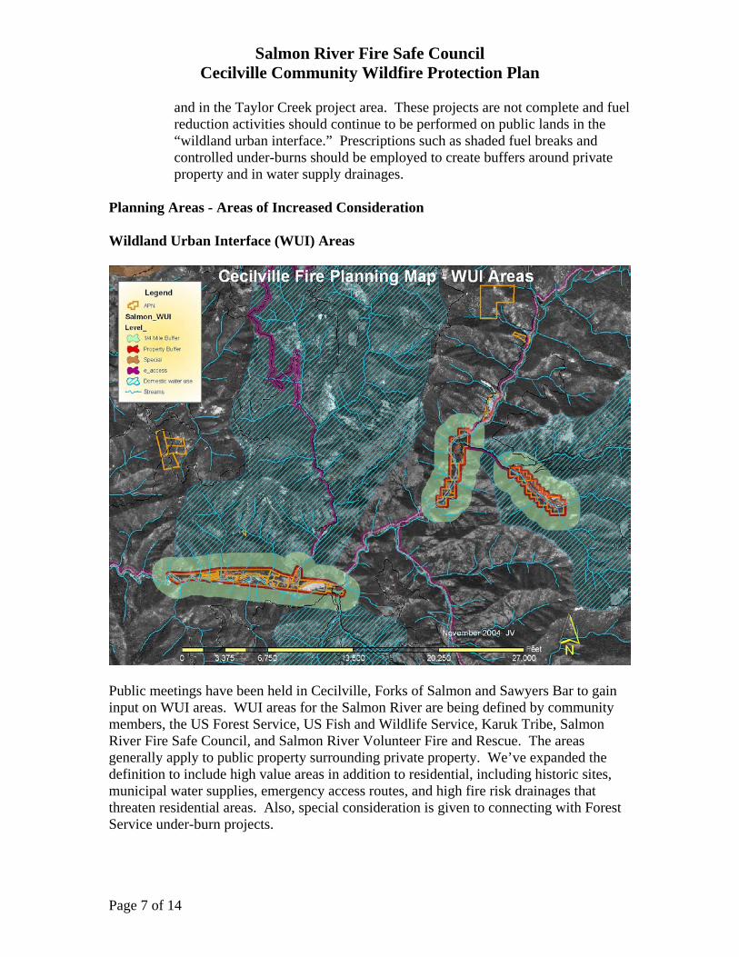
Planning Areas - Areas of Increased Consideration Wildland Urban Interface (WUI) Areas
Public meetings have been held in Cecilville, Forks of Salmon and Sawyers Bar to gain input on WUI areas. WUI areas for the Salmon River are being defined by community members, the US Forest Service, US Fish and Wildlife Service, Karuk Tribe, Salmon River Fire Safe Council, and Salmon River Volunteer Fire and Rescue. The areas generally apply to public property surrounding private property. We’ve expanded the definition to include high value areas in addition to residential, including historic sites, municipal water supplies, emergency access routes, and high fire risk drainages that threaten residential areas. Also, special consideration is given to connecting with Forest Service under-burn projects.

Salmon River Fire Safe Council Cecilville Community Wildfire Protection Plan
Page 8 of 14
We have divided prescriptions into several initial categories that are rated by the level of fire risk (High, Medium, and Low) (See appendix for prescription policy tables). Fire risk is defined as the fuel loading in an area combined with other factors (i.e. ignition sources, slope, aspect, and elevation). The technique generally used for the fuel reduction prescriptions mainly call for a standard Shaded Fuel Break that breaks up fuel continuity and the fuel ladder and leaves canopy cover of at least 60%. As shown in numbers 2 and 3, proximity to a structure or other high value area would prescribe more vegetative material removed (with higher maintenance) than in outlying areas. 1 Sensitive and Unique Areas (i.e. ESA, Historical sites, and other Special areas on
private and public properties). Shall be analyzed on a site-specific basis with input from all appropriate federal, state, and tribal agencies that have responsibility for the resources at risk.
2 Residences and High Value Areas (i.e. water tanks, communication systems, fuel
storage, etc.). New State law defines the minimum distance of defensible space surrounding a residence as 100ft.
3 Emergency Access (and egress) Routes – Does not guarantee that fire fighters will
be able to access area under extreme fire conditions. The Salmon River Fire Safe Council is responsible for helping to plan, implement and monitor the reinstatement of natural fire regimes in the Salmon River ecosystem in a manner that protects life, property, improves forest health, and enhances the resources valued by its stakeholders. Along with cooperators, the FSC is developing prescriptions for fuel reduction activities in WUI areas. These treatment variations are described below for the 5 different WUI area types that have been established.
1. Emergency Access Routes – Approximately 300 feet above and below road (Use number 3 in prescription policy tables).
2. Property Buffers – Approximately 300 foot areas on public property surrounding individual properties, neighborhoods, and towns (Use number 2 in prescription policy tables).
3. Domestic Water Use – Use handpiling in jackpot areas, pullback from leave trees where appropriate, and underburning to achieve fuel reduction and watershed protection. 300 foot Shaded Fuel Breaks on ridge tops to protect watershed from outside fires, where appropriate.
4. ¼ Mile Buffers - On public property surrounding individual properties, neighborhoods, and towns. Use handpiling in jackpot areas, pullback from leave trees where appropriate, and underburning to achieve fuel reduction and watershed protection.
5. Special Areas – These would include areas below properties located high on slopes, as well as biologically significant areas (Use number 1 in prescription policy tables).

Salmon River Fire Safe Council Cecilville Community Wildfire Protection Plan
Page 9 of 14
These are suggested treatments; actual projects will dictate treatments in specific areas. Treatment areas will also be prioritized based on maximum benefit to private residences, other high value areas and protection of public resources. High Value Areas The areas we identified as high value fell into several categories:
1. Residence areas – we identified over 30 residences and 40 other structures within the Cecilville neighborhoods (see map 2 – Structures)
2. Community safety area – Old Cecilville Flat (High Value polygon # 471). 3. Community water system – The Crawford Creek water system provides
domestic water to 9 residences in the Downtown Cecilville Area. This system originates in the Crawford Creek watershed.
4. Historic Sites – historic buildings and sites (Community Club and Cecilville Hose Co. Barn, McBroom family cemetery.
Emergency Access Routes Safe access to the property by emergency personnel, as well as egress by residents and other individuals, is a high priority for fire planning. There are two main routes accessing Cecilville. Cecilville Road (1C02) runs northeast up the South Fork to Callahan (48 miles), and down the Mainstem to Forks of Salmon (18 miles). Salmon River Road (2B01) runs northwest down the Mainstem to Somes Bar and Highway 96 (17 miles). All Cecilville neighborhoods lie along these main roads. In addition, South Eddy Gulch Road runs from Cecilville, to Black Bear Saddle and continues on to Sawyers Bar or Forks. These roads are narrow, winding, and often have high fuel loading on both sides. CB Radios are recommended in times of heavy traffic. High Risk Areas Fire risk is defined as the fuel loading in an area combined with other factors (i.e. ignition sources, slope, aspect, and elevation). We identified areas with various levels of fire risk. These areas are identified on the GIS map as colored polygons. Each polygon is numbered and has a team-assigned priority. These areas overlap with other area types. Fuel reduction and/or maintenance activities will be performed on most of these areas (residential, water system, and safety zone).
Plan Recommendations Suppression, Prevention, Restoration, and Maintenance Recommendations Reducing fuels within the property will help protect structures from burning should a fire come onto the properties, but fire can still threaten yard and house. According to a Los Angeles Times analysis of the 2003 San Diego County Cedar Fire, “Fire-resistant construction and vigilant removal of flammable vegetation significantly improved the odds of a home’s survival.” They found that vegetation was the largest single factor in whether a house burned.

Salmon River Fire Safe Council Cecilville Community Wildfire Protection Plan
Page 10 of 14
Other studies have reached different conclusions. Jack Cohen (USFS, Rocky Mountain Research Station, Fire Sciences Laboratory) found the following: “Case studies of home ignitions from crown fires or torching have shown that firebrands are a principal ignition factor for homes. Firebrands that result in ignitions can originate from wildfires up to 2 miles away. Firebrands have even carried to homes from fires in low shrubs over ½-mile away. Homes are threatened if the firebrands directly ignite the homes or ignite adjacent flammable materials that then ignite the homes. This is particularly problematic with ‘highly ignitable’ homes. Analysis of home ignitions from two fires that burned over 900 homes showed that ignitions depended upon characteristics of the homes and their immediate environments. Home survival was over 85% for homes with nonflammable roofs and vegetation clearances of at least 33 feet. Home survival was 70% for homes with only nonflammable roofs and 19% for those with flammable roofs. Fuel treatments beyond the 200 foot radius ‘home ignition zone’ surrounding homes are both inefficient and ineffective in reducing home losses from wildfire. Destruction of homes depends principally on home ignitability and is largely independent of landscape fuel reduction efforts. A low home ignition potential reduces the chances of destruction even without extensive wildland fuel reduction. Conversely, effective landscape fuel reduction might be insufficient for reducing the destruction of highly ignitable homes. This is due to the improbability that landscape fuel reductions will eliminate all crowning fires, including torching, that will loft firebrands. When planning landscape fuel hazard reduction projects for protecting homes, an analysis specific to home ignitability should determine treatment effectiveness. ” There are many things you can do to reduce the risk of households catching fire. Some suggestions on how to make your home and property more fire safe:
• keep grass short and/or green in open spaces and community safety areas • inspect and maintain town water system, and tanker fill sites • if possible, work with your neighbors to establish a community water
storage/hydrant system • have a minimum water storage supply of 2,500 gallons on your property. Clearly
mark all emergency water sources • install sprinkler systems, and maintain outdoor faucets and hoses to protect houses
in case of fire • roads should have adequate turnouts for traffic, and continue to be well
maintained to accommodate firefighting equipment. Roads should be clear of rocks and other obstacles, and road sides should be free of highly combustible fuels, and overhanging limbs
• buildings should be made of fire-resistant materials whenever possible • cover eaves, leaving only a few well screened ventilation openings, to prevent
embers from lodging there in a fire • Remove dead leaves and needles from your roof and gutters. • select fire-resistant vegetation for landscaping, and keep the ground 30-50’ from
structures clear or green (see appendix for fire safe plants)

Salmon River Fire Safe Council Cecilville Community Wildfire Protection Plan
Page 11 of 14
• maintain the grassy and landscaped areas around structures on an annual basis to refresh their fire-resistant properties
• create a “defensible space” by removing all flammable vegetation at least 30 feet from all structures
• stack woodpiles at least 30 feet from all structures and remove vegetation within 10 feet of woodpiles
• Locate propane tanks at least 30 feet from any structure and maintain 10 feet of clearance
• Cover burn barrels with non-flammable screen with mesh no larger than ¼ inch • target firewood gathering in areas with higher fuels concentrations and increased
dead and down material (and clean up areas where firewood is collected) • update the residential risk assessment • create a Structure Fire Evacuation & Suppression Plan for all structures • create guide to fire safe and unsafe practices and go over these practices with
visitors and new residents • consider quarterly fire drills so everyone knows what to do in an emergency – this
may also provide indications of areas that need work • establish a system of emergency communications for Cecilville neighborhoods • create fire sheds (preferably out of fire proof and/or fire resistant materials) that
would house fire tools, water pump, emergency fire equipment (such as fire shelters, oxygen, fire extinguishers, etc.), and a copy of the Structure Fire Evacuation & Suppression Plan for all structures
• consider purchasing a small foam unit that can be used to protect your home in the case a wildfire is close (talk to Salmon River Fire Safe Council or Salmon River Volunteer Fire and Rescue for more information)
• consider installing a low volume misting system on the outside of your house that can protect your home in the case a wildfire is close (talk to Salmon River Fire Safe Council or Salmon River Volunteer Fire and Rescue for more information)
Other suggestions for making your home fire safe are listed in the CDF Brochure: “Fire Safe, California.” Be aware that there could be federal, state or county laws/regulations pertaining to fire safety. A USFS Fire Prevention Specialist or other fire specialist from the community would be glad to personally visit the property and give specific recommendations for fire safe building, fuel storage, water storage, and fire safe landscaping.

Salmon River Fire Safe Council Cecilville Community Wildfire Protection Plan
Page 12 of 14
Risk Area Priorities and Recommendations The field planning team identified specific locations and made recommendations intended to decrease the risk of future fires destroying homes and other high value areas. The Priority maps (above and below) show areas within the property that have been prioritized by the team.
1. The red-shaded areas are the #1 (highest) priority for action (polygons 432, 447, 458, 497, 498, 499, 506). They are areas of high fuel loads and are at risk of fire threat to residents, historical buildings and public use sites. The 1st priority polygons will use a standard shaded fuel break with hand piling. The distances along the roads for treatment are 150’ above the road and 200’ below the road, where practicable. In residence areas, the ground 100’ from structures needs to be clear or kept watered and green with spaces between trees and shrubs. Trees in this area should also be limbed up 6-12’ depending on the tree height.
2. The tan-shaded areas on the map are the 2nd priority (polygons 449, 454, 460, 463, 465, 466, 468, 473, 477, 479, 481, 483, 484, 491, 492, 495, 496, 501, 502, 503). All of the Priority 2 areas should be treated using a standard shaded fuel break.
3. The yellow-shaded areas are the 3rd priority (polygons 440, 441, 442, 444, 445, 446, 448, 451, 472, 474, 475, 482, 485, 486, 487, 488, 490, 494, 500, 505, 509). These areas should have a standard shaded fuel break.
4. The powder blue-shaded areas are the 4th priority (polygons 452, 462, 467, 469, 470, 471, 476, 478, 489, 493, 504, 507, 508). We recommend using a standard shaded fuel break technique for these areas.

Salmon River Fire Safe Council Cecilville Community Wildfire Protection Plan
Page 13 of 14
Priority Areas (See discussion on previous page)
Maintenance Cecilville Landowners need to consider a maintenance schedule for any fuel reduction activities completed on their properties. These maintenance activities may include annual fire safe landscaping near residence areas, annual cutting of vegetation in open or vacant spaces, ongoing water system maintenance and upgrade, and periodic maintenance of standard shaded fuel breaks. The standard shaded fuel breaks can be kept up with quick annual or biannual maintenance, but there will probably be a need for more labor-intensive maintenance every 5 to 10 years. This maintenance schedule could be coordinated to distribute the workload evenly over time. Funding may be available for the 5 to 10 year maintenance activities. We encourage the landowners to stay involved with the Salmon River Restoration Council and the Salmon River Fire Safe Council for upcoming information and opportunities. During the annual Fire Awareness Week, community members highlight a specific private property in need of work, and do volunteer fuels reduction. Public use sites, open areas and roadsides would benefit from yearly maintenance to keep back encroaching seedlings and brush. Maintenance could be accomplished through activities such as routine yard and garden maintenance, firewood gathering, livestock grazing, and/or annual burning. Maintenance is important for the long-term success of fuels reduction and fire-safing activities. Although it is highly recommended, landowners are not bound to perform this maintenance.
Salmon River Fire Safe Council Cecilville Community Wildfire Protection Plan
Page 14 of 14
Conclusion The area around Cecilville experienced a major fire event in 1987. The previously burned areas continue to be high risk, brush dominated hillsides. Although the neighborhoods lie in advantageous slope positions, at river level, there are high risk fuels areas surrounding them. Much of the private properties are surrounded by public land which has not yet been treated to reduce high fuel concentrations. Most of the houses are old and made of materials that are highly vulnerable to fire. The defensible space in Cecilville can be improved with fuel reduction, maintenance of homes and yards for both full time, and seasonal residents, the use of fire-resistant building materials, and water system improvements. There is also a good opportunity for coordination between the Fire Safe Council, landowners, and the Forest Service on mutually beneficial activities.