satellite activities at the bureau of meteorology
TRANSCRIPT

Satellite
Activities at the
Bureau of
Meteorology
Dr Boris Kelly-Gerreyn
Acting Chief Data Officer

The Bureau's
Satellite
Network

Direct
Broadcast
Network
DB-Net
Critical for
NWP
BoM data contribution
to DBNet:
• ATOVS
• S-NPP and NOAA-
20 ATMS and CrIS
data from Crib
Point and
Learmonth by end
of 2019
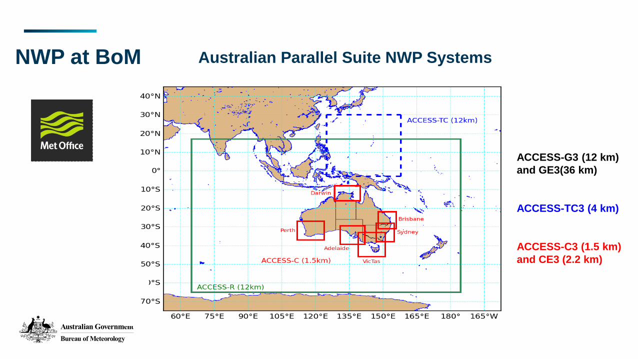
NWP at BoM
ACCESS-G3 (12 km)
and GE3(36 km)
ACCESS-TC3 (4 km)
ACCESS-C3 (1.5 km)
and CE3 (2.2 km)
Australian Parallel Suite NWP Systems

Data
Assimilation
Platform Instruments/Products
NOAA-15, NOAA-18 AMSU-A
NOAA-19 AMSU-A, MHS
GCOM-W1 AMSR-2
MetOp-A, Metop-B IASI, AMSU-A, MHS, ASCAT, GNSS-RO
MetOp-C GNSS-RO
DMSP-17 SSMIS
Terra AIRS, AMV
GOES-15, GOES-16, Meteosat-8, Meteosat-11 AMV
FY3-C, TerraSAR-X, COSMIC2 GNSS-RO
NOAA-20 CrIS (FSR/NSR) + ATMS
Suomi-NPP CrIS + ATMS
Himawari-8 CSR, AMV
SARAL, Jason-2/3 Altimeter wave/winds, sea surface heights
Geostationary / Polar Orbiting satellites Atmospheric Motion Vectors
Sea Surface Temperatures
Scatterometer Wind Vectors
> 20 satellites and instruments
• NOAA-20 ATMS and CrIS
• ScatSat-1
• Metop-C GRAS
• Preparation for Metop-C AMSU/MHS and IASI
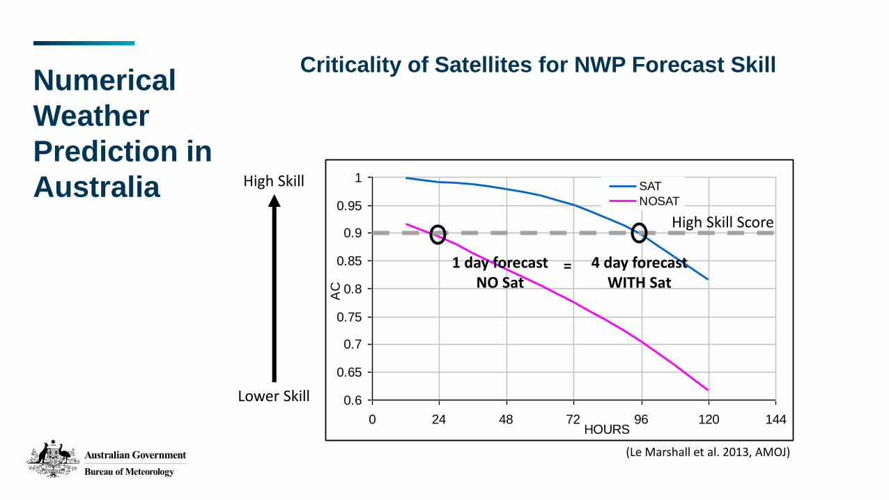
Numerical
Weather
Prediction in
Australia
Criticality of Satellites for NWP Forecast Skill
0.6
0.65
0.7
0.75
0.8
0.85
0.9
0.95
1
0 24 48 72 96 120 144HOURS
SAT
NOSAT
AC
(Le Marshall et al. 2013, AMOJ)
High Skill
Lower Skill
1 day forecastNO Sat
4 day forecastWITH Sat
=
High Skill Score
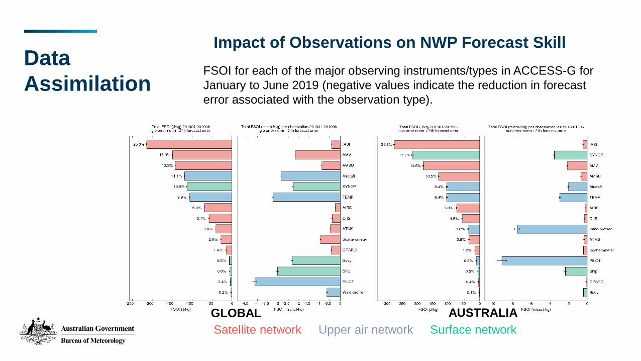
Data
Assimilation
Impact of Observations on NWP Forecast Skill
Satellite network Upper air network Surface network
FSOI for each of the major observing instruments/types in ACCESS-G for
January to June 2019 (negative values indicate the reduction in forecast
error associated with the observation type).
GLOBAL AUSTRALIA
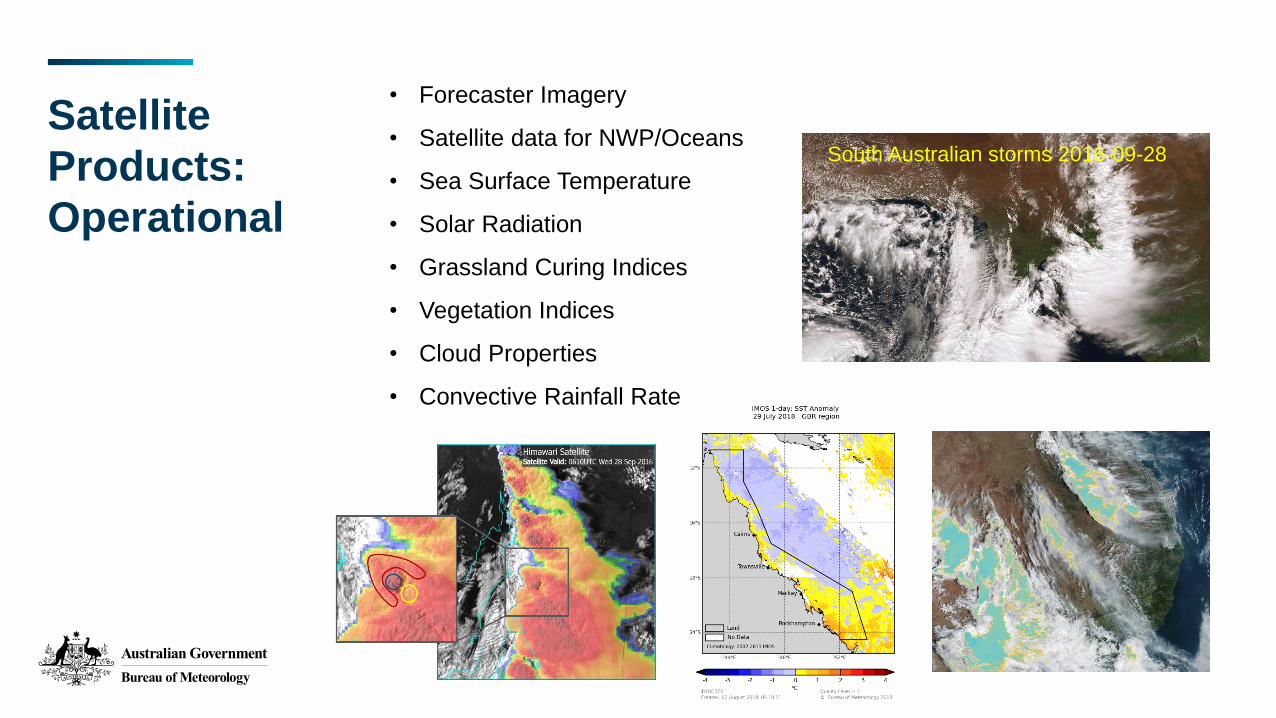
Satellite
Products:
Operational
• Forecaster Imagery
• Satellite data for NWP/Oceans
• Sea Surface Temperature
• Solar Radiation
• Grassland Curing Indices
• Vegetation Indices
• Cloud Properties
• Convective Rainfall Rate
South Australian storms 2016-09-28
Satellite
Products:
Operational
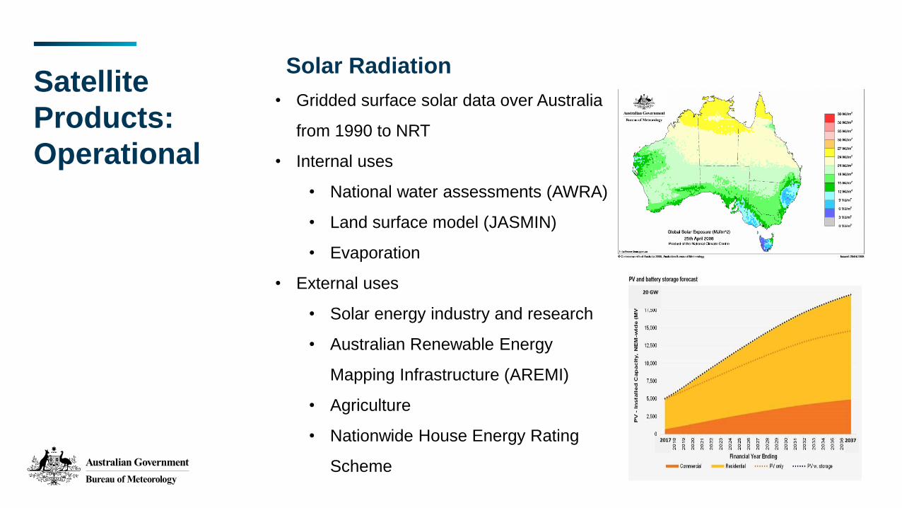
• Gridded surface solar data over Australia
from 1990 to NRT
• Internal uses
• National water assessments (AWRA)
• Land surface model (JASMIN)
• Evaporation
• External uses
• Solar energy industry and research
• Australian Renewable Energy
Mapping Infrastructure (AREMI)
• Agriculture
• Nationwide House Energy Rating
Scheme
Solar Radiation
20 GW
2017 2037
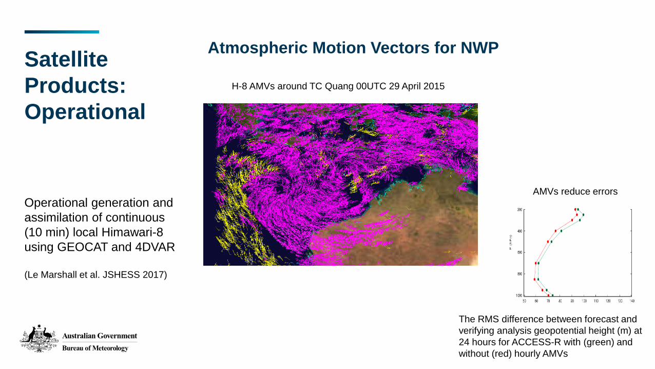
Atmospheric Motion Vectors for NWP
Operational generation and
assimilation of continuous
(10 min) local Himawari-8
using GEOCAT and 4DVAR
(Le Marshall et al. JSHESS 2017)
H-8 AMVs around TC Quang 00UTC 29 April 2015
The RMS difference between forecast and
verifying analysis geopotential height (m) at
24 hours for ACCESS-R with (green) and
without (red) hourly AMVs
Satellite
Products:
Operational
AMVs reduce errors
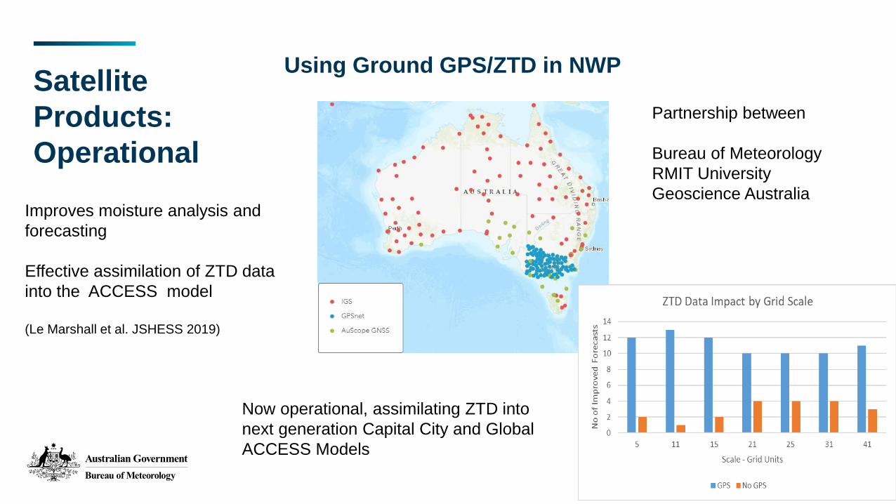
Using Ground GPS/ZTD in NWP
Improves moisture analysis and
forecasting
Effective assimilation of ZTD data
into the ACCESS model
(Le Marshall et al. JSHESS 2019)
Satellite
Products:
Operational
Partnership between
Bureau of Meteorology
RMIT University
Geoscience Australia
Now operational, assimilating ZTD into
next generation Capital City and Global
ACCESS Models

Satellite
Products:
Under
Development
• Blended precipitation combining NWP, radar, Himawari (+delayed
Microwave/GPM)
• Improved storm cell tracking (collaboration with EUMETSAT)
• Emergency services and air quality
• Fire detection & fire front tracking
• Coastal / high resolution Sea Surface Temperature
• Aviation products: Fog detection & dissipation; High Ice Water
Content

Satellite
Products:
Under
Development
Fire Temperature Enhancement
Himawari-8: 2019-03-02
Himawari-8: 2019-03-02
http://www.virtuallab.bom.gov.au/
archive/regional-focus-group-
recordings/
Sharing Data -
National
Environmental
Information
Infrastructure
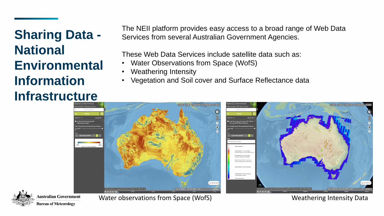
The NEII platform provides easy access to a broad range of Web Data
Services from several Australian Government Agencies.
These Web Data Services include satellite data such as:
• Water Observations from Space (WofS)
• Weathering Intensity
• Vegetation and Soil cover and Surface Reflectance data
Water observations from Space (WofS) Weathering Intensity Data
Thank you