satellite mission index (alphabetically ordered)instruct.uwo.ca/envir-sc/350g/miss_inst_2005.pdf ·...
TRANSCRIPT
- 1 -
Satellite Mission Index (alphabetically ordered) ACRIMSAT (Active Cavity Radiometer Irradiance Monitor) NASA........................................................................................................................................................15 ADM-Aeolus (Atmospheric Dynamics Mission (Earth Explorer Core Mission)) ESA .............................................................................................................................15 ALOS (Advanced Land Observing Satellite) JAXA ...............................................................................................................................................................................15 Aqua (Aqua (formerly EOS PM-1)) NASA.............................................................................................................................................................................................15 Aura (Aura (formerly EOS Chemistry)) NASA.......................................................................................................................................................................................16 Baumanets ROSKOSMOS ..................................................................................................................................................................................................................16 BelKA ROSKOSMOS ..........................................................................................................................................................................................................................16 BIRD (Bi-spectral Infrared Detection) DLR............................................................................................................................................................................................16 BISSAT ((Bistatic SAR mission)) ASI....................................................................................................................................................................................................17 CALIPSO (Cloud-Aerosol Lidar and Infrared Pathfinder Satellite Observations) NASA........................................................................................................................17 CARTOSAT-1 (Indian Remote Sensing Satellite - P5) ISRO................................................................................................................................................................17 CARTOSAT-2 ISRO ............................................................................................................................................................................................................................17 CBERS-2 (China Brazil Earth Resources Satellite - 2) CAST...............................................................................................................................................................18 CBERS-2B (China Brazil Earth Resources Satellite - 2B) CAST ..........................................................................................................................................................18 CBERS-3 (China Brazil Earth Resources Satellite - 3) CAST...............................................................................................................................................................18 CBERS-4 (China Brazil Earth Resources Satellite - 4) CAST...............................................................................................................................................................18 CHAMP (Challenging Mini-Satellite Payload for Geophysical Research and Application) DLR ............................................................................................................19 CloudSat (CloudSat) NASA ..................................................................................................................................................................................................................19 COSMO - SkyMed (COnstellation of small Satellites for Mediterranean basin Observation) ASI..........................................................................................................19 CRYOSAT (CryoSat (Earth Explorer Opportunity Mission)) ESA..........................................................................................................................................................19 DEMETER (Detection of Electro-Magnetic Emissions Transmitted from Earthquake Regions) CNES .................................................................................................20 Diademe 1&2 CNES ............................................................................................................................................................................................................................20 DMSP F-13 (Defense Meteorological Satellite Program F-13) NOAA...................................................................................................................................................20 DMSP F-15 (Defense Meteorological Satellite Program F-15) NOAA...................................................................................................................................................20 DMSP F-16 (Defense Meteorological Satellite Program F-16) NOAA...................................................................................................................................................21 DMSP F-17 (Defense Meteorological Satellite Program F-17) NOAA...................................................................................................................................................21 DMSP F-18 (Defense Meteorological Satellite Program F-18) NOAA...................................................................................................................................................21 DMSP F-19 (Defense Meteorological Satellite Program F-19) NOAA...................................................................................................................................................21 DMSP F-20 (Defense Meteorological Satellite Program F-20) NOAA...................................................................................................................................................22 DSCOVR (DSCOVR (formerly Triana)) NASA......................................................................................................................................................................................22 Elektro-L (Geostationary Operational Meteorological Satellite - 2) ROSHYDROMET...........................................................................................................................22 Envisat (Environmental Satellite) ESA ..................................................................................................................................................................................................22 ERBS (Earth Radiation Budget Satellite) NASA....................................................................................................................................................................................23 ERS-2 (European Remote Sensing satellite - 2) ESA...........................................................................................................................................................................23 ESA Future Missions (ESA Future Missions) ESA................................................................................................................................................................................23 FedSat (Federation Satellite) CSIRO....................................................................................................................................................................................................23 FY-2C (FY-2C Geostationary Meteorological Satellite) NRSCC ...........................................................................................................................................................24 FY-2D (FY-2D Geostationary Meteorological Satellite) NRSCC ...........................................................................................................................................................24 FY-2E (FY-2E Geostationary Meteorological Satellite) NRSCC............................................................................................................................................................24
- 2 -
FY-3A (FY-3A Polar-orbiting Meteorological Satellite) NRSCC.............................................................................................................................................................24 FY-3B (FY-3B Polar-orbiting Meteorological Satellite) NRSCC.............................................................................................................................................................25 FY-3C (FY-3C Polar-orbiting Meteorological Satellite) NRSCC ............................................................................................................................................................25 FY-3D (FY-3D Polar-orbiting Meteorological Satellite) NRSCC ............................................................................................................................................................25 FY-3E (FY-3E Polar-orbiting Meteorological Satellite) NRSCC.............................................................................................................................................................25 FY-3F (FY-3F Polar-orbiting Meteorological Satellite) NRSCC .............................................................................................................................................................26 FY-3G (FY-3G Polar-orbiting Meteorological Satellite) NRSCC............................................................................................................................................................26 GCOM-C (Global Climate Observation Mission-C) JAXA .....................................................................................................................................................................26 GCOM-W (Global Climate Observation Mission-W) JAXA....................................................................................................................................................................26 Glory (Glory) NASA ..............................................................................................................................................................................................................................27 GMS-5 (Geostationary Meteorogical Satellite - 5) JAXA.......................................................................................................................................................................27 GOCE (Gravity Field and Steady-State Ocean Circulation Explorer (Earth Explorer Core Mission)) ESA ............................................................................................27 GOES-9 (Geostationary Operational Environmental Satellite - 9) NOAA..............................................................................................................................................27 GOES-10 (Geostationary Operational Environmental Satellite - 10) NOAA..........................................................................................................................................28 GOES-11 (Geostationary Operational Environmental Satellite - 11) NOAA..........................................................................................................................................28 GOES-12 (Geostationary Operational Environmental Satellite - 12) NOAA..........................................................................................................................................28 GOES-N (Geostationary Operational Environmental Satellite - N) NOAA.............................................................................................................................................28 GOES-O (Geostationary Operational Environmental Satellite - O) NOAA ............................................................................................................................................29 GOES-P (Geostationary Operational Environmental Satellite - P) NOAA .............................................................................................................................................29 GOES-R (Geostationary Operational Environmental Satellite - R) NOAA.............................................................................................................................................29 GOSAT (Greenhouse gases Observing Satellite) JAXA .......................................................................................................................................................................29 GPM Constellation (Global Precipitation Measurement Mission Constellation spacecraft) NASA.........................................................................................................30 GPM Core (Global Precipitation Measurement Mission Core spacecraft) NASA ..................................................................................................................................30 GRACE (Gravity Recovery and Climate Experiment) NASA.................................................................................................................................................................30 HJ-1A (Disaster and Environment Monitoring and Forecast Small Satellite A) CAST...........................................................................................................................30 HJ-1B (Disaster and Environment Monitoring and Forecast Small Satellite B) CAST...........................................................................................................................31 HJ-1C (Disaster and Environment Monitoring and Forecast Small Satellite B) CAST...........................................................................................................................31 HY-1B (Ocean color satellite B) CAST..................................................................................................................................................................................................31 HYDROS (Hydrosphere State) NASA...................................................................................................................................................................................................31 Hyperspectral Mission (Hyperspectral Earth Observer) ASI..................................................................................................................................................................32 ICESat (Ice, Cloud, and Land Elevation Satellite) NASA ......................................................................................................................................................................32 IGPM ASI.............................................................................................................................................................................................................................................32 INSAT-2E (Indian National Satellite - 2E) ISRO....................................................................................................................................................................................32 INSAT-3A (Indian National Satellite - 3A) ISRO....................................................................................................................................................................................33 INSAT-3D (Indian National Satellite - 3D) ISRO ...................................................................................................................................................................................33 IRS-P4 (OCEANSAT-1) ISRO ..............................................................................................................................................................................................................33 Jason (Ocean surface topography) NASA ............................................................................................................................................................................................33 Jason-2 (also known as OSTM) (Ocean Surface Topography Mission) NASA .....................................................................................................................................34 KALAPANA (Meteorological satellite) ISRO..........................................................................................................................................................................................34 Kanopus-Vulkan ROSKOSMOS ..........................................................................................................................................................................................................34 KOMPSAT-1 (Korea Multi-Purpose Satellite 1) KARI ...........................................................................................................................................................................34
- 3 -
KOMPSAT-2 (Korea Multi-Purpose Satellite 2) KARI ...........................................................................................................................................................................35 LAGEOS-1 (Laser Geodynamics Satellite - 1) NASA ...........................................................................................................................................................................35 LAGEOS-2 (Laser Geodynamics Satellite - 2) NASA ...........................................................................................................................................................................35 LAGEOS-3 (Laser Geodynamics Satellite - 3) NASA ...........................................................................................................................................................................35 Landsat-5 USGS..................................................................................................................................................................................................................................36 Landsat-7 USGS..................................................................................................................................................................................................................................36 MEGHA-TROPIQUES CNES...............................................................................................................................................................................................................36 METEOR-3M N1 ROSHYDROMET.....................................................................................................................................................................................................36 METEOR-3M N2 ROSHYDROMET.....................................................................................................................................................................................................37 Meteor-M No1 ROSHYDROMET.........................................................................................................................................................................................................37 Meteor-M No2 ROSHYDROMET.........................................................................................................................................................................................................37 METEOSAT-5 (Meteosat-5) EUMETSAT .............................................................................................................................................................................................37 METEOSAT-6 (Meteosat-6) EUMETSAT .............................................................................................................................................................................................38 METEOSAT-7 (Meteosat-7) EUMETSAT .............................................................................................................................................................................................38 METEOSAT-8 (Meteosat Second Generation-1) EUMETSAT..............................................................................................................................................................38 METEOSAT-9 (Meteosat Second Generation-2) EUMETSAT..............................................................................................................................................................38 METEOSAT-10 (Meteosat Second Generation-3) EUMETSAT............................................................................................................................................................39 METEOSAT-11 (Meteosat Second Generation-4) EUMETSAT............................................................................................................................................................39 METOP-1 (Meteorological Operational Polar Satellite - 1) EUMETSAT................................................................................................................................................39 METOP-2 (Meteorological Operational Polar Satellite - 2) EUMETSAT................................................................................................................................................39 METOP-3 (Meteorological Operational Polar Satellite - 3) EUMETSAT................................................................................................................................................40 Monitor-E ROSKOSMOS.....................................................................................................................................................................................................................40 MTSAT-1R (Multi-functional Transport Satellite) JMA...........................................................................................................................................................................40 MTSAT-2 (Multi-functional Transport Satellite) JMA .............................................................................................................................................................................40 NMP EO-1 (New Millenium Program Earth Observing-1) NASA...........................................................................................................................................................41 NMP EO-3 GIFTS (New Millenium Program EO-3 - Geosynchronous Imaging Fourier Transform Spectrometer - (GIFTS)) NASA.....................................................41 NOAA-12 (National Oceanic and Atmospheric Administration - 12) NOAA...........................................................................................................................................41 NOAA-14 (National Oceanic and Atmospheric Administration - 14) NOAA...........................................................................................................................................41 NOAA-15 (National Oceanic and Atmospheric Administration - 15) NOAA...........................................................................................................................................42 NOAA-16 (National Oceanic and Atmospheric Administration - 16) NOAA...........................................................................................................................................42 NOAA-17 (National Oceanic and Atmospheric Administration - M) NOAA............................................................................................................................................42 NOAA-N (National Oceanic and Atmospheric Administration - N) NOAA .............................................................................................................................................42 NOAA-N' (National Oceanic and Atmospheric Administration - N') NOAA ............................................................................................................................................43 NPOESS-1 (National Polar-orbiting Operational Environmental Satellite System - 1) NOAA ...............................................................................................................43 NPOESS-2 (National Polar-orbiting Operational Environmental Satellite System - 2) NOAA ...............................................................................................................43 NPOESS-3 (National Polar-orbiting Operational Environmental Satellite System - 3) NOAA ...............................................................................................................43 NPOESS-4 (National Polar-orbiting Operational Environmental Satellite System - 4) NOAA ...............................................................................................................44 NPOESS-5 (National Polar-orbiting Operational Environmental Satellite System - 4) NOAA ...............................................................................................................44 NPOESS-6 (National Polar-orbiting Operational Environmental Satellite System - 4) NOAA ...............................................................................................................44 NPP (NPOESS (National Polar-orbiting Operational Environmental Satellite System) Preparatory Project) NOAA..............................................................................44 OCEANSAT-2 (Ocean satellite-2) ISRO ...............................................................................................................................................................................................45
- 4 -
OCO (Orbiting Carbon Observatory) NASA ..........................................................................................................................................................................................45 Odin SNSB ..........................................................................................................................................................................................................................................45 PARASOL (Polarization and Anisotropy of Reflectances for Atmospheric Science coupled with Observations from a LIDAR) CNES .................................................45 PICARD CNES ....................................................................................................................................................................................................................................46 Pleiades 1 CNES .................................................................................................................................................................................................................................46 Pleiades 2 CNES .................................................................................................................................................................................................................................46 QuikSCAT (Quick Scatterometer) NASA ..............................................................................................................................................................................................46 RADARSAT-1 (Radar satellite-1) CSA .................................................................................................................................................................................................47 RADARSAT-2 (Radar satellite-2) CSA .................................................................................................................................................................................................47 RapidEye (RapidEye) DLR ...................................................................................................................................................................................................................47 RESOURCESAT-1 (Resource satellite-1) ISRO...................................................................................................................................................................................47 RESOURCESAT-2 (Resource satellite-2) ISRO...................................................................................................................................................................................48 Resurs DK ROSKOSMOS ...................................................................................................................................................................................................................48 RISAT-1 (Radar Imaging Satellite) ISRO..............................................................................................................................................................................................48 SAC-C CONAE....................................................................................................................................................................................................................................48 SAC-D/Aquarius CONAE.....................................................................................................................................................................................................................49 SAC-E/SABIA CONAE.........................................................................................................................................................................................................................49 SAC-F CONAE ....................................................................................................................................................................................................................................49 SAOCOM 1A CONAE..........................................................................................................................................................................................................................49 SAOCOM 1B CONAE..........................................................................................................................................................................................................................50 SAOCOM-2B (1) CONAE ....................................................................................................................................................................................................................50 SAOCOM-2B (2) CONAE ....................................................................................................................................................................................................................50 SCD-1 (Data Collecting Satellite 1) INPE..............................................................................................................................................................................................50 SCD-2 (Data Collecting Satellite 2) INPE..............................................................................................................................................................................................51 SCISAT-1 (SCISAT-I/ACE) CSA...........................................................................................................................................................................................................51 SICH-1M NSAU...................................................................................................................................................................................................................................51 SICH-2 NSAU......................................................................................................................................................................................................................................51 SMOS (Soil Moisture and Ocean Salinity (Earth Explorer Opportunity Mission)) ESA..........................................................................................................................52 SORCE (Solar Radiation and Climate Experiment) NASA....................................................................................................................................................................52 SPOT-2 (Satellite Pour l'Observation de la Terre - 2) CNES ................................................................................................................................................................52 SPOT-4 (Satellite Pour l'Observation de la Terre - 4) CNES ................................................................................................................................................................52 SPOT-5 (Satellite Pour l'Observation de la Terre - 5) CNES ................................................................................................................................................................53 SSR-1 (Remote Sensing Satellite 1) INPE............................................................................................................................................................................................53 SSR-2 (Remote Sensing Satellite 2) INPE............................................................................................................................................................................................53 STARLETTE CNES .............................................................................................................................................................................................................................53 STELLA CNES ....................................................................................................................................................................................................................................54 Swarm (Earth's Magnetic Field and Environment Exploreres; Constellation of three satellites) ESA....................................................................................................54 Terra (Terra (formerly EOS AM-1)) NASA ............................................................................................................................................................................................54 TerraSAR-L (TerraSAR L band) BNSC.................................................................................................................................................................................................54 TerraSAR-X (TerraSAR-X) DLR ...........................................................................................................................................................................................................55 TES (Technology Experimental Satellite) ISRO....................................................................................................................................................................................55
- 5 -
THEOS (Thailand Earth Observation System) GISTDA........................................................................................................................................................................55 TIMED (Thermosphere Ionosphere Mesosphere Energetics and Dynamics mission) NASA................................................................................................................55 Topex-Poseidon (Topographic Experiment/Poseidon) NASA ...............................................................................................................................................................56 TopSat (Optical Imaging Satellite) BNSC..............................................................................................................................................................................................56 UARS (Upper Atmosphere Research Satellite) NASA ..........................................................................................................................................................................56 UK-DMC (UK Disaster Monitoring Constellation) BNSC .......................................................................................................................................................................56 Vulkan-Kompas-2 ROSKOSMOS........................................................................................................................................................................................................57
- 6 -
Satellite Instrument Index (Alphabetical) AATSR Advanced Along-Track Scanning Radiometer BNSC...............................................................................................................................................................58 ABI Advanced Baseline Imager NOAA .................................................................................................................................................................................................58 ACC Accelerometer ESA......................................................................................................................................................................................................................58 ACE-FTS Atmospheric Chemistry Experiment (ACE) mission CSA......................................................................................................................................................58 ACRIM II Active Cavity Radiometer Irradiance Monitor NASA ..............................................................................................................................................................58 ACRIM III Active Cavity Radiometer Irradiance Monitor NASA .............................................................................................................................................................59 A-DCS ARGOS-Data Collection System NOAA....................................................................................................................................................................................59 AIRS Atmospheric Infra-red Sounder NASA .........................................................................................................................................................................................59 ALADIN Atmospheric Laser Doppler Instrument ESA...........................................................................................................................................................................59 ALI Advanced Land Imager NASA........................................................................................................................................................................................................59 ALT Altimeter NOAA.............................................................................................................................................................................................................................59 AMI/SAR/Image Active Microwave Instrumentation. Image Mode ESA ................................................................................................................................................60 AMI/SAR/wave Active Microwave Instrumentation. Wave mode ESA...................................................................................................................................................60 AMI/scatterometer Active Microwave Instrumentation. Wind mode ESA ..............................................................................................................................................60 AMSR follow-on Advanced Microwave Scanning Radiometer follow-on JAXA .....................................................................................................................................60 AMSR-E Advanced Microwave Scanning Radiometer-EOS JAXA (NASA) ..........................................................................................................................................60 AMSU-A Advanced Microwave Sounding Unit-A NOAA (BNSC)..........................................................................................................................................................61 AMSU-B Advanced Microwave Sounding Unit-B NOAA (BNSC)..........................................................................................................................................................61 APS Aerosol Polarimetry Sensor NOAA ...............................................................................................................................................................................................61 Aquarius NASA (CONAE)....................................................................................................................................................................................................................61 ARGOS CNES (NASA)........................................................................................................................................................................................................................61 Arina ROSKOSMOS............................................................................................................................................................................................................................62 ASAR Advanced Synthetic-Aperture Radar ESA..................................................................................................................................................................................62 ASAR (image mode) Advanced Synthetic Aperture Radar (Image mode) ESA ....................................................................................................................................62 ASAR (wave mode) Advanced Synthetic Aperture Radar (Wave mode) ESA ......................................................................................................................................62 ASCAT Advanced Scatterometer EUMETSAT (ESA)...........................................................................................................................................................................62 ASM Absolute Scalar Magnetometer ESA (CNES)...............................................................................................................................................................................62 ASTER Advanced Spaceborne Thermal Emission and Reflection Radiometer METI (Japan) (NASA).................................................................................................63 ATLID ATmospheric LIDar ESA............................................................................................................................................................................................................63 ATMS Advanced Technology Microwave Sounder NOAA (NASA) .......................................................................................................................................................63 ATSR/M CNES ....................................................................................................................................................................................................................................63 ATSR-2 Along Track Scanning Radiometer - 2 BNSC (CSIRO) ...........................................................................................................................................................63 AVHRR/2 Advanced Very High Resolution Radiometer/2 NOAA..........................................................................................................................................................63 AVHRR/3 Advanced Very High Resolution Radiometer/3 NOAA..........................................................................................................................................................64 AVNIR-2 Advanced Visible and Near Infra-red Radiometer type 2 JAXA .............................................................................................................................................64 AWiFS Advanced Wide Field Sensor ISRO..........................................................................................................................................................................................64 BISSAT Bissat Passive Radar ASI .......................................................................................................................................................................................................64 CALIOP Cloud-Aerosol Lidar with Orthogonal Polarization NASA ........................................................................................................................................................64 CCD (CBERS) High Resolution CCD Camera CAST (INPE)................................................................................................................................................................64
- 7 -
CCD (HJ, HY) CCD camera CAST .......................................................................................................................................................................................................64 CCD camera ISRO ..............................................................................................................................................................................................................................65 CERES Cloud and the Earth's Radiant Energy System NASA .............................................................................................................................................................65 CHAMP GPS Sounder GPS TurboRogue Space Receiver (TRSR) NASA (DLR) ................................................................................................................................65 CHAMP gravity package (Accelerometer+GPS) STAR Accelerometer CNES (DLR) ...........................................................................................................................65 CHAMP magnetometry package (1 Scalar + 2 Vector Magnetometer) Overhauser Magnetometer and Fluxgate Magnetometer DLR ................................................65 CIA Advanced Hyperspectral camera ASI ............................................................................................................................................................................................66 CLAES Cryogenic Limb Array Etalon Spectrometer instrument NASA .................................................................................................................................................66 Cloud Sensor Cloud and aerosol sensor JAXA.....................................................................................................................................................................................66 CMIS Conical-scanning Microwave Imager/Sounder NOAA.................................................................................................................................................................66 COCTS Ocean colour scanner CAST...................................................................................................................................................................................................66 Communications payload (Ka and UHF band) CSIRO.........................................................................................................................................................................66 CPR Cloud Profiling Radar ESA ...........................................................................................................................................................................................................67 CPR (Cloudsat) Cloud Profiling Radar NASA .......................................................................................................................................................................................67 CrIS Cross-track Infrared Sounder NOAA (NASA)................................................................................................................................................................................67 CZI Coast region imager CAST ............................................................................................................................................................................................................67 DCP (SCD) Data Collecting Platform Transponder INPE......................................................................................................................................................................67 DCS (CAST) Data Collecting System Transponder (CAST) CAST.......................................................................................................................................................67 DCS (JAXA) Data Collection System (JAXA) JAXA..............................................................................................................................................................................67 DCS (NOAA) Data Collection System (NOAA) NOAA ..........................................................................................................................................................................68 DCS (ROSHYDROMET) Data Collection System ROSHYDROMET (ROSKOSMOS) .........................................................................................................................68 DMC Imager Disaster Management Constellation Imager BNSC .........................................................................................................................................................68 DORIS Doppler Orbitography and Radio-positioning Integrated by Satellite CNES..............................................................................................................................68 DORIS-NG Doppler Orbitography and Radio-positioning Integrated by Satellite-NG CNES.................................................................................................................68 DPR Dual-frequency Precipitation Radar JAXA (NASA).......................................................................................................................................................................68 DRF ROSKOSMOS.............................................................................................................................................................................................................................68 ECHO-V ROSKOSMOS ......................................................................................................................................................................................................................69 EFI Electric Field Instrument ESA (CSA) ..............................................................................................................................................................................................69 EGG 3-Axis Electrostatic Gravity Gradiometer ESA .............................................................................................................................................................................69 EHIS Energetic Heavy Ion Sensor NOAA.............................................................................................................................................................................................69 ENVISAT Comms Communications package on ENVISAT ESA ..........................................................................................................................................................69 EOC Electro-Optical Camera KARI.......................................................................................................................................................................................................69 EPIC Earth PolyChromatic Imaging Camera NASA..............................................................................................................................................................................69 ERBE Earth Radiation Budget Experiment (non-scanner) NASA .........................................................................................................................................................69 ERBS Earth Radiation Budget Sensor NOAA.......................................................................................................................................................................................70 ERS Comms Communication package for ERS ESA ...........................................................................................................................................................................70 ETM+ Enhanced Thematic Mapper Plus USGS ...................................................................................................................................................................................70 EUVS Extreme Ultraviolet Sensor NOAA..............................................................................................................................................................................................70 Fluxgate magnetometer CRCSS..........................................................................................................................................................................................................70 GALS-M Galactic space rays detector ROSHYDROMET .....................................................................................................................................................................70 Geomicrowave sounder NOAA............................................................................................................................................................................................................70
- 8 -
Geoton-L1 ROSKOSMOS ...................................................................................................................................................................................................................71 GERB Geostationary Earth Radiation Budget EUMETSAT (ASI) .........................................................................................................................................................71 GGAK-E Heliogeophysical hardware complex ROSKOSMOS..............................................................................................................................................................71 GGAK-M Heliogeophysical hardware complex ROSKOSMOS .............................................................................................................................................................71 GHG Sensor Greenhouse gases observing sensor JAXA ....................................................................................................................................................................71 GID-12T ROSKOSMOS.......................................................................................................................................................................................................................71 GIFTS Geosynchronous Imaging Fourier Transform Spectrometer NASA ...........................................................................................................................................71 GLAS Geoscience Laser Altimeter System NASA................................................................................................................................................................................72 GLI follow-on Global Imager follow-on JAXA ........................................................................................................................................................................................72 GLM GEO Lightning Mapper NOAA .....................................................................................................................................................................................................72 GMI GPM Microwave Imager NASA .....................................................................................................................................................................................................72 GMS Comms Communications package on GMS JAXA (JMA) ............................................................................................................................................................72 GOES Comms Communications package on GOES NOAA.................................................................................................................................................................73 GOLPE GPS Occultation and Passive reflection Experiment NASA.....................................................................................................................................................73 GOME Global Ozone Monitoring Experiment ESA ...............................................................................................................................................................................73 GOME-2 Global Ozone Monitoring Experiment - 2 EUMETSAT (ESA) ................................................................................................................................................73 GOMOS Global Ozone Monitoring by Occultation of Stars ESA (CNES)..............................................................................................................................................73 GPS (ESA) GPS receiver ESA .............................................................................................................................................................................................................73 GPS (GRACE) Global Positioning System Receiver NASA..................................................................................................................................................................73 GPS receiver CRCSS..........................................................................................................................................................................................................................74 GPSDR GPS Demonstration Receiver CONAE (NASA).......................................................................................................................................................................74 GRAS GNSS Receiver for Atmospheric Sounding EUMETSAT (ESA).................................................................................................................................................74 HAIRS High Accuracy Inter-satellite Ranging System NASA................................................................................................................................................................74 HALOE Halogen Occultation Experiment NASA...................................................................................................................................................................................74 HES Hyperspectral Environmental Suite NOAA ...................................................................................................................................................................................74 HiRDLS High Resolution Dynamics Limb Sounder NASA (BNSC) .......................................................................................................................................................75 HIRS/2 High Resolution Infra-red Sounder/2 NOAA .............................................................................................................................................................................75 HIRS/3 High Resolution Infra-red Sounder/3 NOAA .............................................................................................................................................................................75 HIRS/4 High Resolution Infra-red Sounder/4 NOAA .............................................................................................................................................................................75 HRDI High Resolution Doppler Imager NASA.......................................................................................................................................................................................75 HRG High Resolution Geometry CNES ................................................................................................................................................................................................76 HRMS High Resolution Multi-spectral Scanner CONAE .......................................................................................................................................................................76 HR-PAN High Resolution Panchromatic Camera ISRO........................................................................................................................................................................76 HRS High Resolution Stereoscopy CNES ............................................................................................................................................................................................76 HRTC High Resolution Panchromatic Camera CONAE........................................................................................................................................................................76 HRV High Resolution Visible CNES......................................................................................................................................................................................................76 HRVIR High Resolution Visible and Infra-red CNES.............................................................................................................................................................................77 HSB Humidity Sounder/Brazil INPE (NASA).........................................................................................................................................................................................77 HSC High Sensitivity Camera CONAE .................................................................................................................................................................................................77 HSI (HJ-1A) Hyper Spectrum Imager CAST .........................................................................................................................................................................................77 HSMS High Swath Multi-spectral Scanner CONAE ..............................................................................................................................................................................77
- 9 -
HSRS Hot Spot Recognition System DLR ............................................................................................................................................................................................77 HSS Hyper-spectral Scanner CONAE ..................................................................................................................................................................................................77 HSTC High Sensitivity Technological Camera CONAE ........................................................................................................................................................................77 HYC HYperspectral Camera ASI ..........................................................................................................................................................................................................78 HYDROS NASA...................................................................................................................................................................................................................................78 Hyperion Hyperspectral Imager NASA..................................................................................................................................................................................................78 IAP Instrument for plasma analysis CNES............................................................................................................................................................................................78 IASI Infra-red Atmospheric Sounding Interferometer CNES (EUMETSAT)...........................................................................................................................................78 ICARE Influence of Space Radiation on Advanced Components CNES...............................................................................................................................................78 ICE Instrument for Electric Field CNES.................................................................................................................................................................................................78 IDP Instrument For Plasma Detection CNES........................................................................................................................................................................................79 IGPM radiometer IGPM microwave radiometer ASI..............................................................................................................................................................................79 IGPM rain radar ASI ............................................................................................................................................................................................................................79 IIR Imaging infrared radiometer CNES .................................................................................................................................................................................................79 IKFS-2 Fourier spectrometer ROSHYDROMET ...................................................................................................................................................................................79 IKOR-M The modernized measuring instrument of short-wave reflected radiation ROSKOSMOS .......................................................................................................79 Imager NOAA ......................................................................................................................................................................................................................................79 Imager (INSAT) ISRO..........................................................................................................................................................................................................................80 IMAGER/MTSAT-1R Imager/MTSAT JMA............................................................................................................................................................................................80 IMAGER/MTSAT-2 Imager/MTSAT JMA ..............................................................................................................................................................................................80 IMSC Instrument Search Coil Magnetometer CNES.............................................................................................................................................................................80 IMWTS Improved MicroWave Temperature Sounder NRSCC (CAST) .................................................................................................................................................80 INES Italian Navigation Experiment ASI ...............................................................................................................................................................................................80 IR (HJ-1B) Infrared Camera CAST .......................................................................................................................................................................................................80 IR Camera (SAOCOM) CONAE...........................................................................................................................................................................................................81 IRAS InfraRed Atmospheric Sounder NRSCC (CAST) .........................................................................................................................................................................81 IR-MSS Infrared Multispectral Scanner CAST (INPE)...........................................................................................................................................................................81 IRS CAST (INPE) ................................................................................................................................................................................................................................81 ISAMS Improved Stratospheric and Mesospheric Sounder instrument NASA ......................................................................................................................................81 ISL Langmuir probes CNES..................................................................................................................................................................................................................81 IST Italian Star Tracker ASI ..................................................................................................................................................................................................................81 IVISSR (FY-2) Improved Multispectral Visible and Infra-red Spin Radiometer (5 channels) NRSCC (CAST) .......................................................................................82 JMR 'JASON Microwave Radiometer NASA.........................................................................................................................................................................................82 KGI-4C Module for Geophysical Measurements ROSHYDROMET......................................................................................................................................................82 Klimat Scanning IR radiometer ROSHYDROMET ................................................................................................................................................................................82 KMSS Medium range multi-spectral scanner ROSHYDROMET (ROSKOSMOS) ................................................................................................................................82 LAC Laser Atmospheric Corrector NASA..............................................................................................................................................................................................82 Landsat Comms Communications package for Landsat USGS ............................................................................................................................................................82 Laser reflectors CNES .........................................................................................................................................................................................................................82 Laser reflectors (ESA) Laser reflectors ESA .........................................................................................................................................................................................83 L-band SAR INPE................................................................................................................................................................................................................................83
- 10 -
LISS-III Linear Imaging Self Scanner - III ISRO ....................................................................................................................................................................................83 LISS-IV Linear Imaging Self Scanner - IV ISRO ...................................................................................................................................................................................83 LRA Laser Retroreflector Array NASA (ASI) .........................................................................................................................................................................................83 LRA (LAGEOS) Laser Retroreflector Array NASA (ASI) .......................................................................................................................................................................83 L-SAR L-Band SAR BNSC ...................................................................................................................................................................................................................83 MADRAS CNES ..................................................................................................................................................................................................................................84 MAESTRO Measurements of Aerosol Extinction in the Stratosphere and Troposphere Retrieved by Occultation CSA .......................................................................84 Magnetometer (NOAA) Magnetometer NOAA ......................................................................................................................................................................................84 MASTER ESA......................................................................................................................................................................................................................................84 MBEI Multi-band Earth Imager NSAU...................................................................................................................................................................................................84 MCP Meteorological Communications Package (MCP) EUMETSAT....................................................................................................................................................85 MERIS Medium-Resolution Imaging Spectrometer ESA.......................................................................................................................................................................85 MERSI Moderate Resolution Spectral Imager NRSCC (CAST) ............................................................................................................................................................85 METEOSAT Comms Communications package for METEOSAT EUMETSAT .....................................................................................................................................85 MHS Microwave Humidity Sounder EUMETSAT ..................................................................................................................................................................................85 MIPAS Michelson Interferometric Passive Atmosphere Sounder ESA..................................................................................................................................................85 MIRAS Multichannel Infrared Atmospheric Sounder NRSCC (CAST)...................................................................................................................................................86 MIRAS (SMOS) 2-D Passive L-Band Microwave Interferometer ESA...................................................................................................................................................86 MIREI Middle IR Earth Imager NSAU ...................................................................................................................................................................................................86 MISR Multi-angle Imaging SpectroRadiometer NASA ..........................................................................................................................................................................86 MIVZA Microwave scanning radiometer ROSHYDROMET...................................................................................................................................................................86 MLS Microwave Limb Sounder NASA ..................................................................................................................................................................................................86 MMP Magnetic Mapping Payload CONAE (DSRI (Denmark)) ..............................................................................................................................................................87 MMRS Multispectral Medium Resolution Scanner CONAE...................................................................................................................................................................87 MOC Multi-spectral Optical Camera CONAE........................................................................................................................................................................................87 MODIS MODerate-Resolution Imaging Spectroradiometer NASA ........................................................................................................................................................87 MOPITT Measurements Of Pollution In The Troposphere CSA............................................................................................................................................................87 MPS Magnetospheric Particle Sensor NOAA .......................................................................................................................................................................................87 MR-2000M1 Scanning visible radiometer ROSHYDROMET ................................................................................................................................................................88 MS (GISTDA) Multi spectral imager GISTDA........................................................................................................................................................................................88 MSC Multi-Spectral Camera KARI ........................................................................................................................................................................................................88 MSG Comms Communications package for MSG EUMETSAT............................................................................................................................................................88 MSGI-MKA Spectrometer ROSHYDROMET ........................................................................................................................................................................................88 MSI Multi Spectral Imager DLR.............................................................................................................................................................................................................88 MSMR Multifrequency Scanning Microwave Radiometer ISRO............................................................................................................................................................89 MSS Multispectral Scanner USGS........................................................................................................................................................................................................89 MSS (Roskosmos) Multispectral film-making system ROSKOSMOS ...................................................................................................................................................89 MSS-BIO Polyzonal scanning system of bioefficiency of sea water areas ROSKOSMOS....................................................................................................................89 MSTE-5E Multichannel system of geoactive measurements ROSHYDROMET ...................................................................................................................................89 MSU Microwave Sounding Unit NOAA .................................................................................................................................................................................................89 MSU-E Multispectral high resolution electronic scanner ROSHYDROMET ..........................................................................................................................................89
- 11 -
MSU-EU Multi-Spectral Radiometer with High Resolution NSAU .........................................................................................................................................................90 MSU-GS Multispectral scanning imager-radiometer ROSHYDROMET ................................................................................................................................................90 MSU-M Multi-Spectral Low Resolution Scanning System NSAU ..........................................................................................................................................................90 MSU-MR Images of clouds, snow, ice and land cover ROSHYDROMET .............................................................................................................................................90 MSU-SM Multi-Spectral Medium Resolution Scanning System ROSHYDROMET ...............................................................................................................................90 MTSAT Comms Communications package for MTSAT JMA (JAXA) ....................................................................................................................................................90 MTVZA Scanning microwave radiometer ROSHYDROMET.................................................................................................................................................................90 MTVZA-OK Scanning microwave radiometer ROSHYDROMET ..........................................................................................................................................................91 MUX Multispectral CCD Camera CAST (INPE) ....................................................................................................................................................................................91 MVIRI METEOSAT Visible and Infra-Red Imager EUMETSAT (ESA) ..................................................................................................................................................91 MWHS MicroWave Humidity Sounder NRSCC (CAST)........................................................................................................................................................................91 MWR (BNSC) Microwave Radiometer BNSC .......................................................................................................................................................................................91 MWR (CONAE) Microwave radiometer CONAE ...................................................................................................................................................................................92 MWRI MicroWave Radiation Imager NRSCC (CAST) ..........................................................................................................................................................................92 MWTS MicroWave Temperature Sounder NRSCC (CAST)..................................................................................................................................................................92 NIRST New Infrared Sensor Technology CONAE ................................................................................................................................................................................92 NISTAR NIST Advanced Radiometer NASA.........................................................................................................................................................................................92 NOAA Comms Communications package for NOAA NOAA .................................................................................................................................................................92 NVK Low-frequency wave complex ROSKOSMOS ..............................................................................................................................................................................92 OBA Observador Brasileiro da Amazonia INPE....................................................................................................................................................................................93 OCM Ocean Colour Monitor ISRO........................................................................................................................................................................................................93 OCO Orbiting Carbon Observatory NASA ............................................................................................................................................................................................93 OEA Optical-electronic equipment ROSKOSMOS................................................................................................................................................................................93 OLS Operational Linescan System NOAA (US DoD)............................................................................................................................................................................93 OMI Ozone Measuring Instrument NASA (NIVR (Netherland)) .............................................................................................................................................................93 OMPS Ozone Mapping and Profiler Suite NOAA..................................................................................................................................................................................94 OP Ozone Profiler NRSCC (CAST) ......................................................................................................................................................................................................94 OSIRIS Optical Spectrograph and Infra-Red Imaging System CSA......................................................................................................................................................94 OSMI Ocean Scanning Multispectral Imager KARI ...............................................................................................................................................................................94 PALSAR Phased Array type L-band Synthetic Aperture Radar JAXA (METI (Japan))..........................................................................................................................94 Pamela ROSKOSMOS ........................................................................................................................................................................................................................95 PAN Panchromatic and multispectral imager CAST .............................................................................................................................................................................95 PAN (Cartosat-1) Panchromatic sensor ISRO ......................................................................................................................................................................................95 PAN (GISTDA) Panchromatic imager GISTDA.....................................................................................................................................................................................95 PEM Particle Environment Monitor NASA.............................................................................................................................................................................................95 Plasma-Mag NASA..............................................................................................................................................................................................................................95 Pleiades HR High Resolution Optical Imaging CNES ...........................................................................................................................................................................95 POLDER-P POLarization and Directionality of the Earth's Reflectances (PARASOL version) CNES ...................................................................................................96 POSEIDON-1 (SSALT-1) Positioning Ocean Solid Earth Ice Dynamics Orbiting Navigator (Single frequency solid state radar altimeter) CNES ...............................96 POSEIDON-2 (SSALT-2) Positioning Ocean Solid Earth Ice Dynamics Orbiting Navigator (Single frequency solid state radar altimeter) CNES ................................96 POSEIDON-3 Positioning Ocean Solid Earth Ice Dynamics Orbiting Navigator (Single frequency solid state radar altimeter) CNES ..................................................96
- 12 -
PREMOS PREcision Monitoring of Solar variability CNES ...................................................................................................................................................................96 PRISM Panchromatic Remote-sensing Instrument for Stereo Mapping JAXA......................................................................................................................................97 PSA Panchromatic film-making equipment ROSKOSMOS...................................................................................................................................................................97 PSS Panchromatic film-making system ROSKOSMOS ........................................................................................................................................................................97 RA Radar Altimeter ESA.......................................................................................................................................................................................................................97 RA-2 Radar Altimeter - 2 ESA...............................................................................................................................................................................................................97 RADARSAT DTT X band (downlink of payload) CSA ...........................................................................................................................................................................97 RADARSAT TTC S band (Tracking, Telemetry and Command) CSA...................................................................................................................................................97 Radiomet ROSKOSMOS .....................................................................................................................................................................................................................97 RBE ROSKOSMOS.............................................................................................................................................................................................................................98 RCHA ROSKOSMOS ..........................................................................................................................................................................................................................98 RDSA The film-making equipment of the allocated access ROSKOSMOS...........................................................................................................................................98 RIMS-M Mass-spectrometer ROSHYDROMET ....................................................................................................................................................................................98 RLSBO Side looking microwave radar ROSKOSMOS (NIIRI) ..............................................................................................................................................................98 RM-08 Scanning Microwave Radiometer ROSHYDROMET (NSAU)....................................................................................................................................................98 ROSA formerly called Lagrange ASI.....................................................................................................................................................................................................98 RRA Retroreflector Array CNES ...........................................................................................................................................................................................................98 S&R (GOES) Search and Rescue NOAA .............................................................................................................................................................................................99 S&R (NOAA) Search and Rescue Satellite Aided Tracking NOAA .......................................................................................................................................................99 SABER Sounding of the Atmosphere usingBroadband Emission Radiometry NASA............................................................................................................................99 SAGE II Stratospheric Aerosol and Gas Experiment-II NASA...............................................................................................................................................................99 SAGE III Stratospheric Aerosol and Gas Experiment-III NASA (ROSKOSMOS) ..................................................................................................................................99 SAPHIR CNES (ISRO) ......................................................................................................................................................................................................................100 SAR (RADARSAT) Synthetic Aperture Radar (CSA) C band CSA .....................................................................................................................................................100 SAR (RADARSAT-2) Synthetic Aperture Radar (CSA) C band CSA ..................................................................................................................................................100 SAR (RISAT) ISRO............................................................................................................................................................................................................................100 SAR (ROSHYDROMET) Synthetic Aperture Radar ROSHYDROMET (ROSKOSMOS) ....................................................................................................................101 SAR (SAOCOM) Synthetic Aperture Radar (CONAE) CONAE...........................................................................................................................................................101 SAR 2000 Multi-Mode Synthetic Aperture Radar ASI .........................................................................................................................................................................101 SARSAT Search and Rescue Satellite Aided Tracking NOAA............................................................................................................................................................101 S-band SAR S-band Synthetic Aperture Radar CAST ........................................................................................................................................................................101 SBUV/2 Solar Backscattter Ultra-Violet Instrument/2 NOAA...............................................................................................................................................................102 ScaRaB Scanner for Earth's Radiation Budget CNES (NPO "PLANETA") .........................................................................................................................................102 Scatterometer (ISRO) ISRO ..............................................................................................................................................................................................................102 Scatterometer (JAXA) Scatterometer JAXA........................................................................................................................................................................................102 SCIAMACHY Scanning Imaging Absorption Spectrometer for Atmospheric Chartography ESA ........................................................................................................102 SeaWinds NASA (JAXA) ...................................................................................................................................................................................................................102 SEM (GOES) Space Environment Monitor NOAA ..............................................................................................................................................................................102 SEM (POES) Space Environment Monitor NOAA...............................................................................................................................................................................103 SESS Space Environmental Sensor Suite NOAA...............................................................................................................................................................................103 SEVIRI Spinning Enhanced Visible and Infra-Red Imager EUMETSAT (ESA) ...................................................................................................................................103
- 13 -
SFM-2 UV limb spectrometer ROSHYDROMET.................................................................................................................................................................................103 SGPS Solar and Galactic Proton Sensor NOAA.................................................................................................................................................................................103 SIM Spectral Irradiance Monitor NASA...............................................................................................................................................................................................104 SIRAL SAR Interferometer Radar Altimeter ESA................................................................................................................................................................................104 SKL-M Solar ray spectrometer ROSHYDROMET...............................................................................................................................................................................104 SMR Submillimetre Radiometer SNSB ...............................................................................................................................................................................................104 SODAD Orbital System for an Active Detection of Debris CNES........................................................................................................................................................104 SODISM SOlar Diameter Imager and Surface Mapper CNES ............................................................................................................................................................104 SOLSTICE SOLar STellar Irradiance Comparison Experiment NASA................................................................................................................................................105 Sounder NOAA..................................................................................................................................................................................................................................105 Sounder (INSAT) ISRO......................................................................................................................................................................................................................105 SOVAP SOlar Variability Picard radiometer CNES.............................................................................................................................................................................105 SPECTRA Surface Processes and Ecosystem Changes Through Response Analysis ESA ..............................................................................................................105 SSB/X-2 Special Sensor Gamma Ray Particle Detector NOAA (US DoD)..........................................................................................................................................105 SSIES-2 Special Sensor Ionospheric Plasma Drift/Scintillation Meter NOAA (US DoD) .....................................................................................................................106 SSIES-3 Special Sensor Ionospheric Plasma Drift/Scintillation Meter NOAA (US DoD) .....................................................................................................................106 SSJ/4 Special Sensor Precipitating Plasma Monitor NOAA (US DoD)................................................................................................................................................106 SSJ/5 Special Sensor Precipitating Plasma Monitor NOAA (US DoD)................................................................................................................................................106 SSM Special Sensor Magnetometer NOAA (US DoD)........................................................................................................................................................................106 SSM/I Special Sensor Microwave Imager NOAA (US DoD)................................................................................................................................................................106 SSM/T-1 Special Sensor Microwave Temperature Sounder NOAA (US DoD)....................................................................................................................................107 SSM/T-2 Special Sensor Microwave Water Vapor Sounder NOAA (US DoD) ....................................................................................................................................107 SSMIS Special Sensor Microwave Imager Sounder NOAA (US DoD)................................................................................................................................................107 SSU Stratospheric Sounding Unit NOAA............................................................................................................................................................................................107 SSULI Special Sensor Ultraviolet Limb Imager NOAA........................................................................................................................................................................107 SSUSI Special Sensor Ultraviolet Spectrographic Imager NOAA .......................................................................................................................................................107 SSZ NOAA (US DoD) ........................................................................................................................................................................................................................108 STR Star Tracker ESA........................................................................................................................................................................................................................108 SUSIM (UARS) Solar Ultraviolet Irradiance Monitor NASA.................................................................................................................................................................108 SXI Solar X-ray Imager NOAA (USAF) ...............................................................................................................................................................................................108 SXS Solar X-Ray Sensor NOAA.........................................................................................................................................................................................................108 TerraSAR-X X-Band Synthetic Aperture Radar DLR ..........................................................................................................................................................................108 TES Tropospheric Emission Spectrometer NASA...............................................................................................................................................................................109 TIM Total Irradiance Monitor NASA ....................................................................................................................................................................................................109 TIS (CONAE) Thermal IR Scanner CONAE........................................................................................................................................................................................109 TM Thematic Mapper USGS...............................................................................................................................................................................................................109 TMR TOPEX Microwave Radiometer NASA.......................................................................................................................................................................................109 TOM Total Ozone Mapper NRSCC (CAST)........................................................................................................................................................................................109 TOPEX TOPEX NASA Radar Altimeter NASA ...................................................................................................................................................................................109 TOPSAT telescope BNSC .................................................................................................................................................................................................................110 TRSR Turbo-Rogue Space Receiver NASA .......................................................................................................................................................................................110
- 14 -
TSIS Total Solar Irradiance Sensor NOAA .........................................................................................................................................................................................110 Variant ROSKOSMOS.......................................................................................................................................................................................................................110 VEGETATION CNES (EEC) ..............................................................................................................................................................................................................110 VFM Vector Magnetometer ESA.........................................................................................................................................................................................................110 VHRR Very High Resolution Radiometer ISRO ..................................................................................................................................................................................110 VIIRS Visible/Infrared Imager Radiometer Suite NOAA (NASA) .........................................................................................................................................................111 VIRR Multispectral Visible and Infra-red Scan Radiometer (10 channels) NRSCC (CAST) ................................................................................................................111 VISSR (GMS-5) Visible and Infra-red Spin Scan Radiometer (GMS-5) JAXA (JMA) ..........................................................................................................................111 WAOSS-B Wide-Angle Optoelectronic Stereo Scanner DLR..............................................................................................................................................................111 WEFAX Weather Facsimile NOAA .....................................................................................................................................................................................................111 WFC Wide Field Camera NASA .........................................................................................................................................................................................................111 WFI Wide Field Imager CAST (INPE) .................................................................................................................................................................................................111 WFI-2 Wide Field Imager 2 CAST (INPE) ...........................................................................................................................................................................................112 WiFS Wide Field Sensor ISRO ...........................................................................................................................................................................................................112 WINDII CNES (NASA) .......................................................................................................................................................................................................................112 WTE Whale Tracker Experiment CONAE...........................................................................................................................................................................................112 XPS XUV Photometer System NASA .................................................................................................................................................................................................112
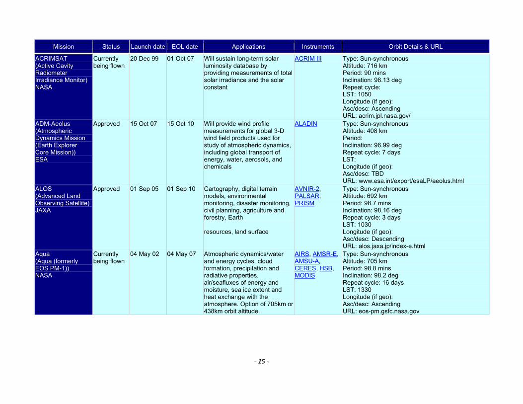
Mission Status Launch date EOL date Applications Instruments Orbit Details & URL
- 15 -
ACRIMSAT (Active Cavity Radiometer Irradiance Monitor) NASA
Currently being flown
20 Dec 99 01 Oct 07 Will sustain long-term solar luminosity database by providing measurements of total solar irradiance and the solar constant
ACRIM III Type: Sun-synchronous Altitude: 716 km Period: 90 mins Inclination: 98.13 deg Repeat cycle: LST: 1050 Longitude (if geo): Asc/desc: Ascending URL: acrim.jpl.nasa.gov/
ADM-Aeolus (Atmospheric Dynamics Mission (Earth Explorer Core Mission)) ESA
Approved 15 Oct 07 15 Oct 10 Will provide wind profile measurements for global 3-D wind field products used for study of atmospheric dynamics, including global transport of energy, water, aerosols, and chemicals
ALADIN Type: Sun-synchronous Altitude: 408 km Period: Inclination: 96.99 deg Repeat cycle: 7 days LST: Longitude (if geo): Asc/desc: TBD URL: www.esa.int/export/esaLP/aeolus.html
ALOS (Advanced Land Observing Satellite) JAXA
Approved 01 Sep 05 01 Sep 10 Cartography, digital terrain models, environmental monitoring, disaster monitoring, civil planning, agriculture and forestry, Earth resources, land surface
AVNIR-2, PALSAR, PRISM
Type: Sun-synchronous Altitude: 692 km Period: 98.7 mins Inclination: 98.16 deg Repeat cycle: 3 days LST: 1030 Longitude (if geo): Asc/desc: Descending URL: alos.jaxa.jp/index-e.html
Aqua (Aqua (formerly EOS PM-1)) NASA
Currently being flown
04 May 02 04 May 07 Atmospheric dynamics/water and energy cycles, cloud formation, precipitation and radiative properties, air/seafluxes of energy and moisture, sea ice extent and heat exchange with the atmosphere. Option of 705km or 438km orbit altitude.
AIRS, AMSR-E, AMSU-A, CERES, HSB, MODIS
Type: Sun-synchronous Altitude: 705 km Period: 98.8 mins Inclination: 98.2 deg Repeat cycle: 16 days LST: 1330 Longitude (if geo): Asc/desc: Ascending URL: eos-pm.gsfc.nasa.gov
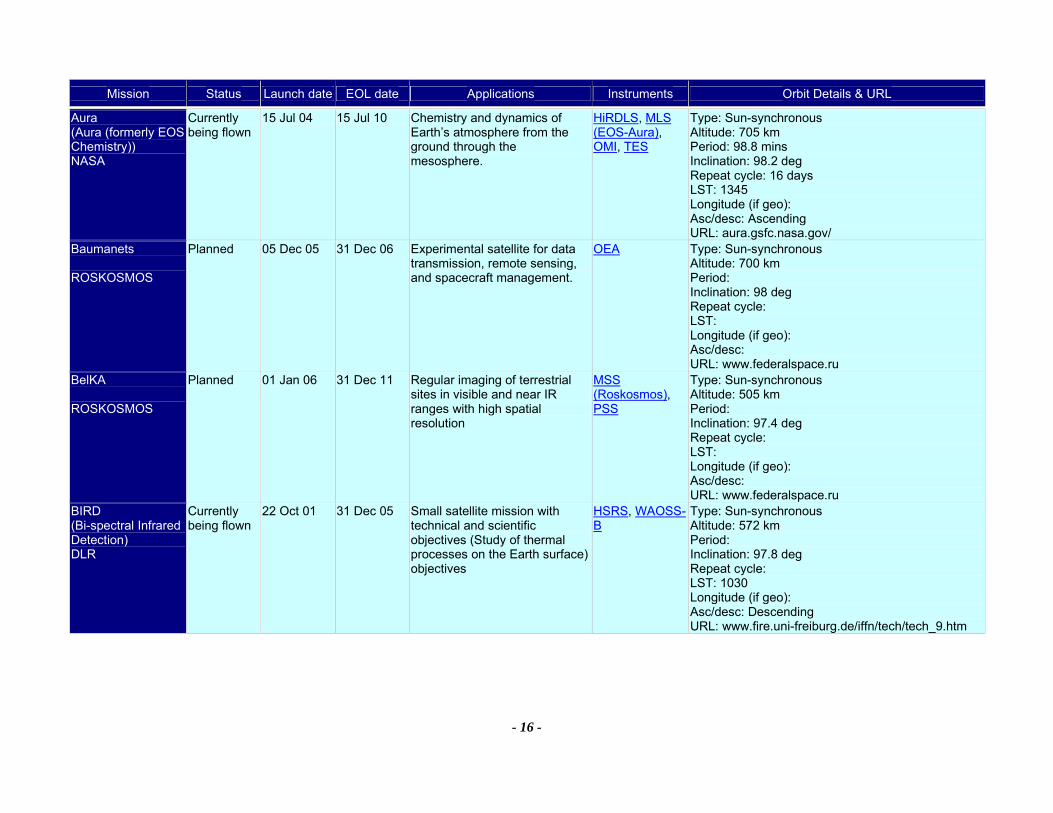
Mission Status Launch date EOL date Applications Instruments Orbit Details & URL
- 16 -
Aura (Aura (formerly EOS Chemistry)) NASA
Currently being flown
15 Jul 04 15 Jul 10 Chemistry and dynamics of Earth’s atmosphere from the ground through the mesosphere.
HiRDLS, MLS (EOS-Aura), OMI, TES
Type: Sun-synchronous Altitude: 705 km Period: 98.8 mins Inclination: 98.2 deg Repeat cycle: 16 days LST: 1345 Longitude (if geo): Asc/desc: Ascending URL: aura.gsfc.nasa.gov/
Baumanets ROSKOSMOS
Planned 05 Dec 05 31 Dec 06 Experimental satellite for data transmission, remote sensing, and spacecraft management.
OEA Type: Sun-synchronous Altitude: 700 km Period: Inclination: 98 deg Repeat cycle: LST: Longitude (if geo): Asc/desc: URL: www.federalspace.ru
BelKA ROSKOSMOS
Planned 01 Jan 06 31 Dec 11 Regular imaging of terrestrial sites in visible and near IR ranges with high spatial resolution
MSS (Roskosmos), PSS
Type: Sun-synchronous Altitude: 505 km Period: Inclination: 97.4 deg Repeat cycle: LST: Longitude (if geo): Asc/desc: URL: www.federalspace.ru
BIRD (Bi-spectral Infrared Detection) DLR
Currently being flown
22 Oct 01 31 Dec 05 Small satellite mission with technical and scientific objectives (Study of thermal processes on the Earth surface) objectives
HSRS, WAOSS-B
Type: Sun-synchronous Altitude: 572 km Period: Inclination: 97.8 deg Repeat cycle: LST: 1030 Longitude (if geo): Asc/desc: Descending URL: www.fire.uni-freiburg.de/iffn/tech/tech_9.htm

Mission Status Launch date EOL date Applications Instruments Orbit Details & URL
- 17 -
BISSAT ((Bistatic SAR mission)) ASI
Considered 01 Jan 06 01 Jan 08 Evaluation of bistatic radar cross section of natural and man-made targets, image classification, land surface. Receive-only satellite in formation with main mission COSMO-Skymed
BISSAT Type: Sun-synchronous Altitude: Period: Inclination: Repeat cycle: LST: Longitude (if geo): Asc/desc: TBD URL:
CALIPSO (Cloud-Aerosol Lidar and Infrared Pathfinder Satellite Observations) NASA
Approved 15 Apr 05 15 Apr 08 Measurements of aerosol & cloud properties for climate predictions, using a 3 channel lidar and passive instruments in formation with Aqua and CloudSat for coincident observations of radiative fluxes and atmospheric state.
CALIOP, IIR, WFC
Type: Sun-synchronous Altitude: 705 km Period: 98.8 mins Inclination: 98.2 deg Repeat cycle: LST: 1330 Longitude (if geo): Asc/desc: Ascending URL: www-calipso.larc.nasa.gov/
CARTOSAT-1 (Indian Remote Sensing Satellite - P5) ISRO
Approved 15 Mar 05 01 Jul 09 High precision large-scale cartographic mapping of 1:10000 scale and thematic applications (with merged XS data) at 1:4000 scales
PAN (Cartosat-1)
Type: Sun-synchronous Altitude: 630 km Period: 97.178 mins Inclination: 97.87 deg Repeat cycle: LST: Longitude (if geo): Asc/desc: Descending URL: www.isro.org/
CARTOSAT-2 ISRO
Approved 31 Dec 05 01 Jan 10 High precision large-scale cartographic mapping of 1:10000 scale and thematic applications (with merged XS data) at 1:4000 scales
HR-PAN Type: Sun-synchronous Altitude: Period: Inclination: Repeat cycle: LST: Longitude (if geo): Asc/desc: Descending URL: www.isro.org/
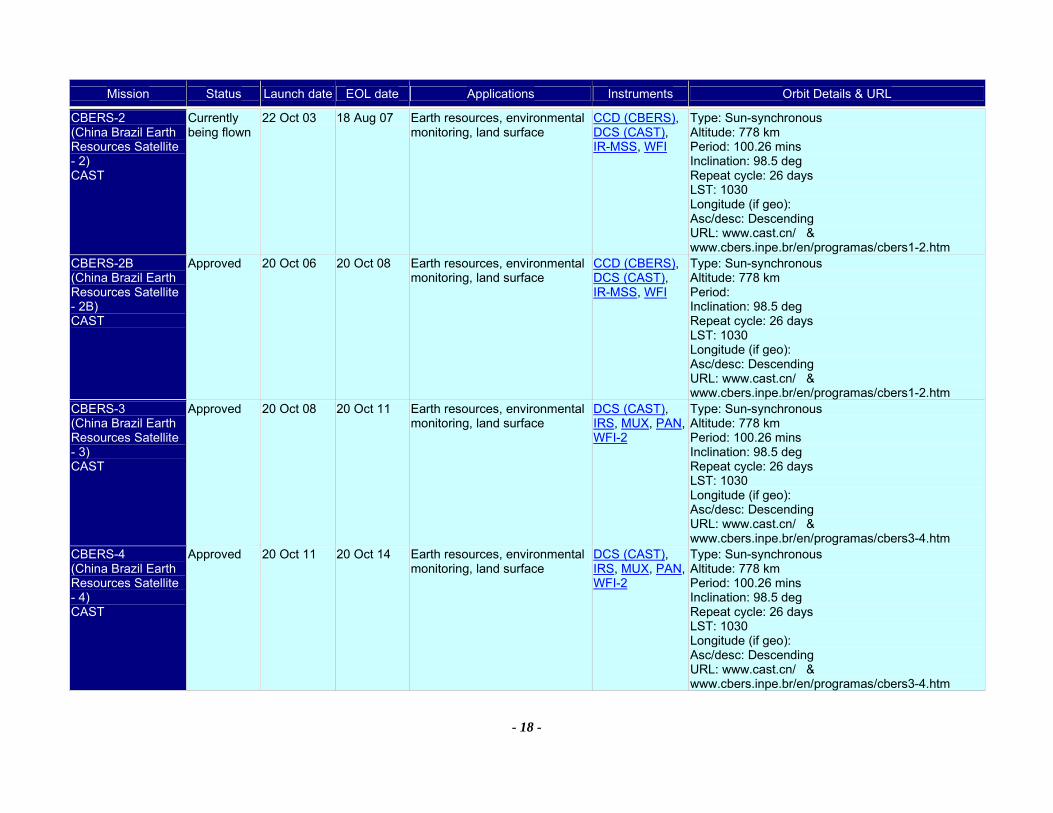
Mission Status Launch date EOL date Applications Instruments Orbit Details & URL
- 18 -
CBERS-2 (China Brazil Earth Resources Satellite - 2) CAST
Currently being flown
22 Oct 03 18 Aug 07 Earth resources, environmental monitoring, land surface
CCD (CBERS), DCS (CAST), IR-MSS, WFI
Type: Sun-synchronous Altitude: 778 km Period: 100.26 mins Inclination: 98.5 deg Repeat cycle: 26 days LST: 1030 Longitude (if geo): Asc/desc: Descending URL: www.cast.cn/ & www.cbers.inpe.br/en/programas/cbers1-2.htm
CBERS-2B (China Brazil Earth Resources Satellite - 2B) CAST
Approved 20 Oct 06 20 Oct 08 Earth resources, environmental monitoring, land surface
CCD (CBERS), DCS (CAST), IR-MSS, WFI
Type: Sun-synchronous Altitude: 778 km Period: Inclination: 98.5 deg Repeat cycle: 26 days LST: 1030 Longitude (if geo): Asc/desc: Descending URL: www.cast.cn/ & www.cbers.inpe.br/en/programas/cbers1-2.htm
CBERS-3 (China Brazil Earth Resources Satellite - 3) CAST
Approved 20 Oct 08 20 Oct 11 Earth resources, environmental monitoring, land surface
DCS (CAST), IRS, MUX, PAN, WFI-2
Type: Sun-synchronous Altitude: 778 km Period: 100.26 mins Inclination: 98.5 deg Repeat cycle: 26 days LST: 1030 Longitude (if geo): Asc/desc: Descending URL: www.cast.cn/ & www.cbers.inpe.br/en/programas/cbers3-4.htm
CBERS-4 (China Brazil Earth Resources Satellite - 4) CAST
Approved 20 Oct 11 20 Oct 14 Earth resources, environmental monitoring, land surface
DCS (CAST), IRS, MUX, PAN, WFI-2
Type: Sun-synchronous Altitude: 778 km Period: 100.26 mins Inclination: 98.5 deg Repeat cycle: 26 days LST: 1030 Longitude (if geo): Asc/desc: Descending URL: www.cast.cn/ & www.cbers.inpe.br/en/programas/cbers3-4.htm
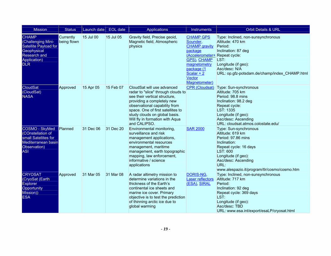
Mission Status Launch date EOL date Applications Instruments Orbit Details & URL
- 19 -
CHAMP (Challenging Mini-Satellite Payload for Geophysical Research and Application) DLR
Currently being flown
15 Jul 00 15 Jul 05 Gravity field, Precise geoid, Magnetic field, Atmospheric physics
CHAMP GPS Sounder, CHAMP gravity package (Accelerometer+GPS), CHAMP magnetometry package (1 Scalar + 2 Vector Magnetometer)
Type: Inclined, non-sunsynchronous Altitude: 470 km Period: Inclination: 87 deg Repeat cycle: LST: Longitude (if geo): Asc/desc: N/A URL: op.gfz-potsdam.de/champ/index_CHAMP.html
CloudSat (CloudSat) NASA
Approved 15 Apr 05 15 Feb 07 CloudSat will use advanced radar to "slice" through clouds to see their vertical structure, providing a completely new observational capability from space. One of first satellites to study clouds on global basis. Will fly in formation with Aqua and CALIPSO.
CPR (Cloudsat) Type: Sun-synchronous Altitude: 705 km Period: 98.8 mins Inclination: 98.2 deg Repeat cycle: LST: 1335 Longitude (if geo): Asc/desc: Ascending URL: cloudsat.atmos.colostate.edu/
COSMO - SkyMed (COnstellation of small Satellites for Mediterranean basin Observation) ASI
Planned 31 Dec 06 31 Dec 20 Environmental monitoring, surveillance and risk management applications, environmental resources management, maritime management, earth topographic mapping, law enforcement, informative / science applications
SAR 2000 Type: Sun-synchronous Altitude: 619 km Period: 97.86 mins Inclination: Repeat cycle: 16 days LST: 600 Longitude (if geo): Asc/desc: Ascending URL: www.alespazio.it/program/tlr/cosmo/cosmo.htm
CRYOSAT (CryoSat (Earth Explorer Opportunity Mission)) ESA
Approved 31 Mar 05 31 Mar 08 A radar altimetry mission to determine variations in the thickness of the Earth’s continental ice sheets and marine ice cover. Primary objective is to test the prediction of thinning arctic ice due to global warming
DORIS-NG, Laser reflectors (ESA), SIRAL
Type: Inclined, non-sunsynchronous Altitude: 717 km Period: Inclination: 92 deg Repeat cycle: 369 days LST: Longitude (if geo): Asc/desc: TBD URL: www.esa.int/export/esaLP/cryosat.html
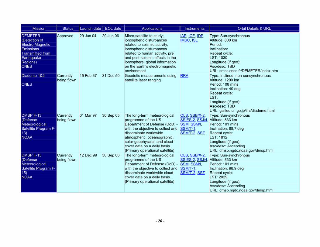
Mission Status Launch date EOL date Applications Instruments Orbit Details & URL
- 20 -
DEMETER (Detection of Electro-Magnetic Emissions Transmitted from Earthquake Regions) CNES
Approved 29 Jun 04 29 Jun 06 Micro-satellite to study; ionospheric disturbances related to seismic activity, ionospheric disturbances related to human activity, pre and post-seismic effects in the ionosphere, global information on the Earth's electromagnetic environment
IAP, ICE, IDP, IMSC, ISL
Type: Sun-synchronous Altitude: 800 km Period: Inclination: Repeat cycle: LST: 1030 Longitude (if geo): Asc/desc: TBD URL: smsc.cnes.fr/DEMETER/index.htm
Diademe 1&2 CNES
Currently being flown
15 Feb 67 31 Dec 50 Geodetic measurements using satellite laser ranging
RRA Type: Inclined, non-sunsynchronous Altitude: 1200 km Period: 108 mins Inclination: 40 deg Repeat cycle: LST: Longitude (if geo): Asc/desc: TBD URL: galileo.crl.go.jp/ilrs/diademe.html
DMSP F-13 (Defense Meteorological Satellite Program F-13) NOAA
Currently being flown
01 Mar 97 30 Sep 05 The long-term meteorological programme of the US Department of Defense (DoD) - with the objective to collect and disseminate worldwide atmospheric, oceanographic, solar-geophyscial, and cloud cover data on a daily basis. (Primary operational satellite)
OLS, SSB/X-2, SSIES-2, SSJ/4, SSM, SSM/I, SSM/T-1, SSM/T-2, SSZ
Type: Sun-synchronous Altitude: 833 km Period: 101 mins Inclination: 98.7 deg Repeat cycle: LST: 1812 Longitude (if geo): Asc/desc: Ascending URL: dmsp.ngdc.noaa.gov/dmsp.html
DMSP F-15 (Defense Meteorological Satellite Program F-15) NOAA
Currently being flown
12 Dec 99 30 Sep 06 The long-term meteorological programme of the US Department of Defense (DoD) - with the objective to collect and disseminate worldwide cloud cover data on a daily basis. (Primary operational satellite)
OLS, SSB/X-2, SSIES-2, SSJ/4, SSM, SSM/I, SSM/T-1, SSM/T-2, SSZ
Type: Sun-synchronous Altitude: 833 km Period: 101 mins Inclination: 98.9 deg Repeat cycle: LST: 2029 Longitude (if geo): Asc/desc: Ascending URL: dmsp.ngdc.noaa.gov/dmsp.html
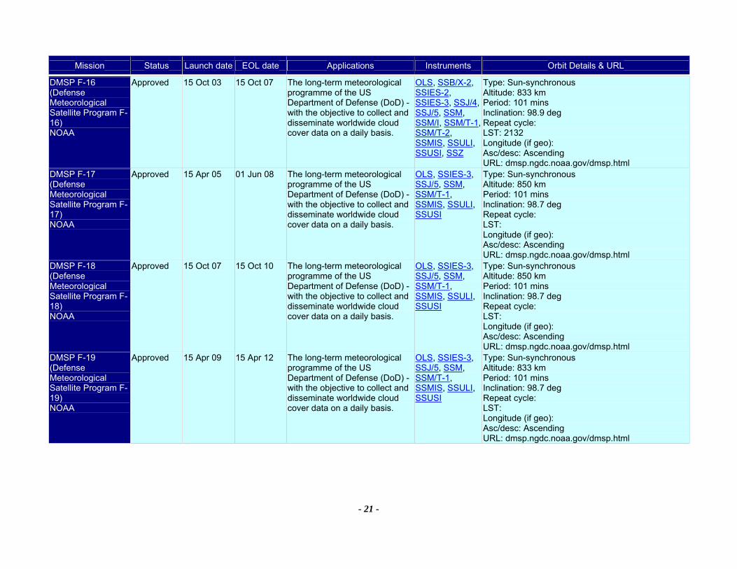
Mission Status Launch date EOL date Applications Instruments Orbit Details & URL
- 21 -
DMSP F-16 (Defense Meteorological Satellite Program F-16) NOAA
Approved 15 Oct 03 15 Oct 07 The long-term meteorological programme of the US Department of Defense (DoD) - with the objective to collect and disseminate worldwide cloud cover data on a daily basis.
OLS, SSB/X-2, SSIES-2, SSIES-3, SSJ/4, SSJ/5, SSM, SSM/I, SSM/T-1, SSM/T-2, SSMIS, SSULI, SSUSI, SSZ
Type: Sun-synchronous Altitude: 833 km Period: 101 mins Inclination: 98.9 deg Repeat cycle: LST: 2132 Longitude (if geo): Asc/desc: Ascending URL: dmsp.ngdc.noaa.gov/dmsp.html
DMSP F-17 (Defense Meteorological Satellite Program F-17) NOAA
Approved 15 Apr 05 01 Jun 08 The long-term meteorological programme of the US Department of Defense (DoD) - with the objective to collect and disseminate worldwide cloud cover data on a daily basis.
OLS, SSIES-3, SSJ/5, SSM, SSM/T-1, SSMIS, SSULI, SSUSI
Type: Sun-synchronous Altitude: 850 km Period: 101 mins Inclination: 98.7 deg Repeat cycle: LST: Longitude (if geo): Asc/desc: Ascending URL: dmsp.ngdc.noaa.gov/dmsp.html
DMSP F-18 (Defense Meteorological Satellite Program F-18) NOAA
Approved 15 Oct 07 15 Oct 10 The long-term meteorological programme of the US Department of Defense (DoD) - with the objective to collect and disseminate worldwide cloud cover data on a daily basis.
OLS, SSIES-3, SSJ/5, SSM, SSM/T-1, SSMIS, SSULI, SSUSI
Type: Sun-synchronous Altitude: 850 km Period: 101 mins Inclination: 98.7 deg Repeat cycle: LST: Longitude (if geo): Asc/desc: Ascending URL: dmsp.ngdc.noaa.gov/dmsp.html
DMSP F-19 (Defense Meteorological Satellite Program F-19) NOAA
Approved 15 Apr 09 15 Apr 12 The long-term meteorological programme of the US Department of Defense (DoD) - with the objective to collect and disseminate worldwide cloud cover data on a daily basis.
OLS, SSIES-3, SSJ/5, SSM, SSM/T-1, SSMIS, SSULI, SSUSI
Type: Sun-synchronous Altitude: 833 km Period: 101 mins Inclination: 98.7 deg Repeat cycle: LST: Longitude (if geo): Asc/desc: Ascending URL: dmsp.ngdc.noaa.gov/dmsp.html
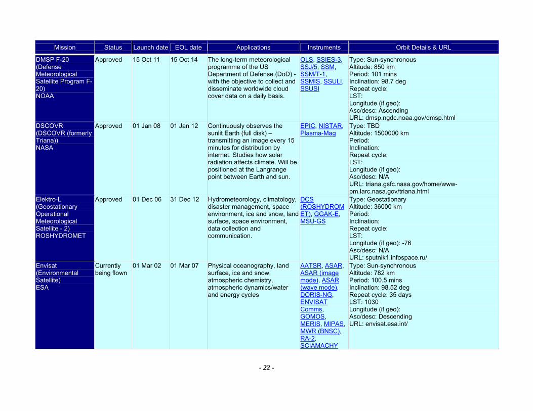
Mission Status Launch date EOL date Applications Instruments Orbit Details & URL
- 22 -
DMSP F-20 (Defense Meteorological Satellite Program F-20) NOAA
Approved 15 Oct 11 15 Oct 14 The long-term meteorological programme of the US Department of Defense (DoD) - with the objective to collect and disseminate worldwide cloud cover data on a daily basis.
OLS, SSIES-3, SSJ/5, SSM, SSM/T-1, SSMIS, SSULI, SSUSI
Type: Sun-synchronous Altitude: 850 km Period: 101 mins Inclination: 98.7 deg Repeat cycle: LST: Longitude (if geo): Asc/desc: Ascending URL: dmsp.ngdc.noaa.gov/dmsp.html
DSCOVR (DSCOVR (formerly Triana)) NASA
Approved 01 Jan 08 01 Jan 12 Continuously observes the sunlit Earth (full disk) – transmitting an image every 15 minutes for distribution by internet. Studies how solar radiation affects climate. Will be positioned at the Langrange point between Earth and sun.
EPIC, NISTAR, Plasma-Mag
Type: TBD Altitude: 1500000 km Period: Inclination: Repeat cycle: LST: Longitude (if geo): Asc/desc: N/A URL: triana.gsfc.nasa.gov/home/www-pm.larc.nasa.gov/triana.html
Elektro-L (Geostationary Operational Meteorological Satellite - 2) ROSHYDROMET
Approved 01 Dec 06 31 Dec 12 Hydrometeorology, climatology, disaster management, space environment, ice and snow, land surface, space environment, data collection and communication.
DCS (ROSHYDROMET), GGAK-E, MSU-GS
Type: Geostationary Altitude: 36000 km Period: Inclination: Repeat cycle: LST: Longitude (if geo): -76 Asc/desc: N/A URL: sputnik1.infospace.ru/
Envisat (Environmental Satellite) ESA
Currently being flown
01 Mar 02 01 Mar 07 Physical oceanography, land surface, ice and snow, atmospheric chemistry, atmospheric dynamics/water and energy cycles
AATSR, ASAR, ASAR (image mode), ASAR (wave mode), DORIS-NG, ENVISAT Comms, GOMOS, MERIS, MIPAS, MWR (BNSC), RA-2, SCIAMACHY
Type: Sun-synchronous Altitude: 782 km Period: 100.5 mins Inclination: 98.52 deg Repeat cycle: 35 days LST: 1030 Longitude (if geo): Asc/desc: Descending URL: envisat.esa.int/
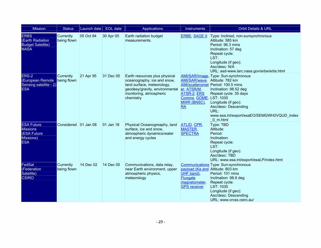
Mission Status Launch date EOL date Applications Instruments Orbit Details & URL
- 23 -
ERBS (Earth Radiation Budget Satellite) NASA
Currently being flown
05 Oct 84 30 Apr 05 Earth radiation budget measurements.
ERBE, SAGE II Type: Inclined, non-sunsynchronous Altitude: 585 km Period: 96.3 mins Inclination: 57 deg Repeat cycle: LST: Longitude (if geo): Asc/desc: N/A URL: asd-www.larc.nasa.gov/erbe/erbs.html
ERS-2 (European Remote Sensing satellite - 2) ESA
Currently being flown
21 Apr 95 31 Dec 05 Earth resources plus physical oceanography, ice and snow, land surface, meteorology, geodesy/gravity, environmental monitoring, atmospheric chemistry
AMI/SAR/Image, AMI/SAR/wave, AMI/scatterometer, ATSR/M, ATSR-2, ERS Comms, GOME, MWR (BNSC), RA
Type: Sun-synchronous Altitude: 782 km Period: 100.5 mins Inclination: 98.52 deg Repeat cycle: 35 days LST: 1030 Longitude (if geo): Asc/desc: Descending URL: www.esa.int/export/esaEO/SEMGWH2VQUD_index_0_m.html
ESA Future Missions (ESA Future Missions) ESA
Considered 01 Jan 08 01 Jan 18 Physical Oceanogreaphy, land surface, ice and snow, atmospheric dynamics/water and energy cycles
ATLID, CPR, MASTER, SPECTRA
Type: TBD Altitude: Period: Inclination: Repeat cycle: LST: Longitude (if geo): Asc/desc: TBD URL: www.esa.int/export/esaLP/index.html
FedSat (Federation Satellite) CSIRO
Currently being flown
14 Dec 02 14 Dec 05 Communications, data relay, near Earth environment, upper atmospheric physics, meteorology
Communications payload (Ka and UHF band), Fluxgate magnetometer, GPS receiver
Type: Sun-synchronous Altitude: 803 km Period: 101 mins Inclination: 98.6 deg Repeat cycle: LST: 1030 Longitude (if geo): Asc/desc: Descending URL: www.crcss.csiro.au/

Mission Status Launch date EOL date Applications Instruments Orbit Details & URL
- 24 -
FY-2C (FY-2C Geostationary Meteorological Satellite) NRSCC
Currently being flown
19 Oct 04 19 Oct 07 Meteorology and environmental monitoring Data collection and redistribution
IVISSR (FY-2) Type: Geostationary Altitude: 36000 km Period: Inclination: Repeat cycle: LST: Longitude (if geo): -105 Asc/desc: TBD URL:
FY-2D (FY-2D Geostationary Meteorological Satellite) NRSCC
Planned 31 Dec 06 31 Dec 09 Meteorology and environmental monitoring Data collection and redistribution
IVISSR (FY-2) Type: Geostationary Altitude: 36000 km Period: Inclination: Repeat cycle: LST: Longitude (if geo): -105 Asc/desc: TBD URL:
FY-2E (FY-2E Geostationary Meteorological Satellite) NRSCC
Planned 31 Dec 09 31 Dec 12 Meteorology and environmental monitoring Data collection and redistribution
IVISSR (FY-2) Type: Geostationary Altitude: 36000 km Period: Inclination: Repeat cycle: LST: Longitude (if geo): -105 Asc/desc: TBD URL:
FY-3A (FY-3A Polar-orbiting Meteorological Satellite) NRSCC
Planned 01 Jan 06 01 Jan 08 Meteorology and environmental monitoring Data collection and redistribution
IRAS, MERSI, MWRI, MWTS, OP, TOM, VIRR
Type: Sun-synchronous Altitude: Period: Inclination: Repeat cycle: LST: Longitude (if geo): Asc/desc: TBD URL:

Mission Status Launch date EOL date Applications Instruments Orbit Details & URL
- 25 -
FY-3B (FY-3B Polar-orbiting Meteorological Satellite) NRSCC
Planned 31 Dec 06 31 Dec 08 Meteorology and environmental monitoring Data collection and redistribution
IRAS, MERSI, MWRI, MWTS, OP, TOM, VIRR
Type: Sun-synchronous Altitude: Period: Inclination: Repeat cycle: LST: Longitude (if geo): Asc/desc: TBD URL:
FY-3C (FY-3C Polar-orbiting Meteorological Satellite) NRSCC
Planned 31 Dec 08 31 Dec 10 Meteorology and environmental monitoring Data collection and redistribution
IMWTS, IRAS, MERSI, MIRAS, MWHS, MWRI, OP, TOM, VIRR
Type: Sun-synchronous Altitude: Period: Inclination: Repeat cycle: LST: Longitude (if geo): Asc/desc: TBD URL:
FY-3D (FY-3D Polar-orbiting Meteorological Satellite) NRSCC
Planned 31 Dec 10 31 Dec 12 Meteorology and environmental monitoring Data collection and redistribution
IMWTS, IRAS, MERSI, MIRAS, MWHS, MWRI, OP, TOM, VIRR
Type: Sun-synchronous Altitude: Period: Inclination: Repeat cycle: LST: Longitude (if geo): Asc/desc: TBD URL:
FY-3E (FY-3E Polar-orbiting Meteorological Satellite) NRSCC
Planned 31 Dec 12 31 Dec 14 Meteorology and environmental monitoring Data collection and redistribution
IMWTS, IRAS, MERSI, MIRAS, MWHS, MWRI, OP, TOM, VIRR
Type: Sun-synchronous Altitude: Period: Inclination: Repeat cycle: LST: Longitude (if geo): Asc/desc: TBD URL:
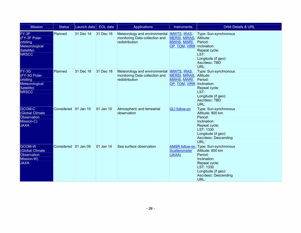
Mission Status Launch date EOL date Applications Instruments Orbit Details & URL
- 26 -
FY-3F (FY-3F Polar-orbiting Meteorological Satellite) NRSCC
Planned 31 Dec 14 31 Dec 16 Meteorology and environmental monitoring Data collection and redistribution
IMWTS, IRAS, MERSI, MIRAS, MWHS, MWRI, OP, TOM, VIRR
Type: Sun-synchronous Altitude: Period: Inclination: Repeat cycle: LST: Longitude (if geo): Asc/desc: TBD URL:
FY-3G (FY-3G Polar-orbiting Meteorological Satellite) NRSCC
Planned 31 Dec 16 31 Dec 18 Meteorology and environmental monitoring Data collection and redistribution
IMWTS, IRAS, MERSI, MIRAS, MWHS, MWRI, OP, TOM, VIRR
Type: Sun-synchronous Altitude: Period: Inclination: Repeat cycle: LST: Longitude (if geo): Asc/desc: TBD URL:
GCOM-C (Global Climate Observation Mission-C) JAXA
Considered 01 Jan 10 01 Jan 15 Atmospheric and terrestrial observation
GLI follow-on Type: Sun-synchronous Altitude: 800 km Period: Inclination: Repeat cycle: LST: 1330 Longitude (if geo): Asc/desc: Descending URL:
GCOM-W (Global Climate Observation Mission-W) JAXA
Considered 01 Jan 09 01 Jan 14 Sea surface observation AMSR follow-on, Scatterometer (JAXA)
Type: Sun-synchronous Altitude: 800 km Period: Inclination: Repeat cycle: LST: 1330 Longitude (if geo): Asc/desc: Descending URL:
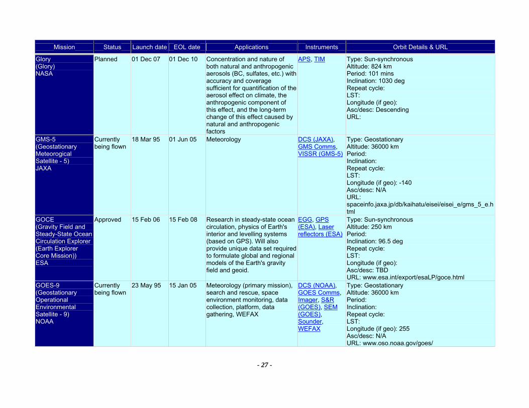
Mission Status Launch date EOL date Applications Instruments Orbit Details & URL
- 27 -
Glory (Glory) NASA
Planned 01 Dec 07 01 Dec 10 Concentration and nature of both natural and anthropogenic aerosols (BC, sulfates, etc.) with accuracy and coverage sufficient for quantification of the aerosol effect on climate, the anthropogenic component of this effect, and the long-term change of this effect caused by natural and anthropogenic factors
APS, TIM Type: Sun-synchronous Altitude: 824 km Period: 101 mins Inclination: 1030 deg Repeat cycle: LST: Longitude (if geo): Asc/desc: Descending URL:
GMS-5 (Geostationary Meteorogical Satellite - 5) JAXA
Currently being flown
18 Mar 95 01 Jun 05 Meteorology DCS (JAXA), GMS Comms, VISSR (GMS-5)
Type: Geostationary Altitude: 36000 km Period: Inclination: Repeat cycle: LST: Longitude (if geo): -140 Asc/desc: N/A URL: spaceinfo.jaxa.jp/db/kaihatu/eisei/eisei_e/gms_5_e.html
GOCE (Gravity Field and Steady-State Ocean Circulation Explorer (Earth Explorer Core Mission)) ESA
Approved 15 Feb 06 15 Feb 08 Research in steady-state ocean circulation, physics of Earth's interior and levelling systems (based on GPS). Will also provide unique data set required to formulate global and regional models of the Earth's gravity field and geoid.
EGG, GPS (ESA), Laser reflectors (ESA)
Type: Sun-synchronous Altitude: 250 km Period: Inclination: 96.5 deg Repeat cycle: LST: Longitude (if geo): Asc/desc: TBD URL: www.esa.int/export/esaLP/goce.html
GOES-9 (Geostationary Operational Environmental Satellite - 9) NOAA
Currently being flown
23 May 95 15 Jan 05 Meteorology (primary mission), search and rescue, space environment monitoring, data collection, platform, data gathering, WEFAX
DCS (NOAA), GOES Comms, Imager, S&R (GOES), SEM (GOES), Sounder, WEFAX
Type: Geostationary Altitude: 36000 km Period: Inclination: Repeat cycle: LST: Longitude (if geo): 255 Asc/desc: N/A URL: www.oso.noaa.gov/goes/
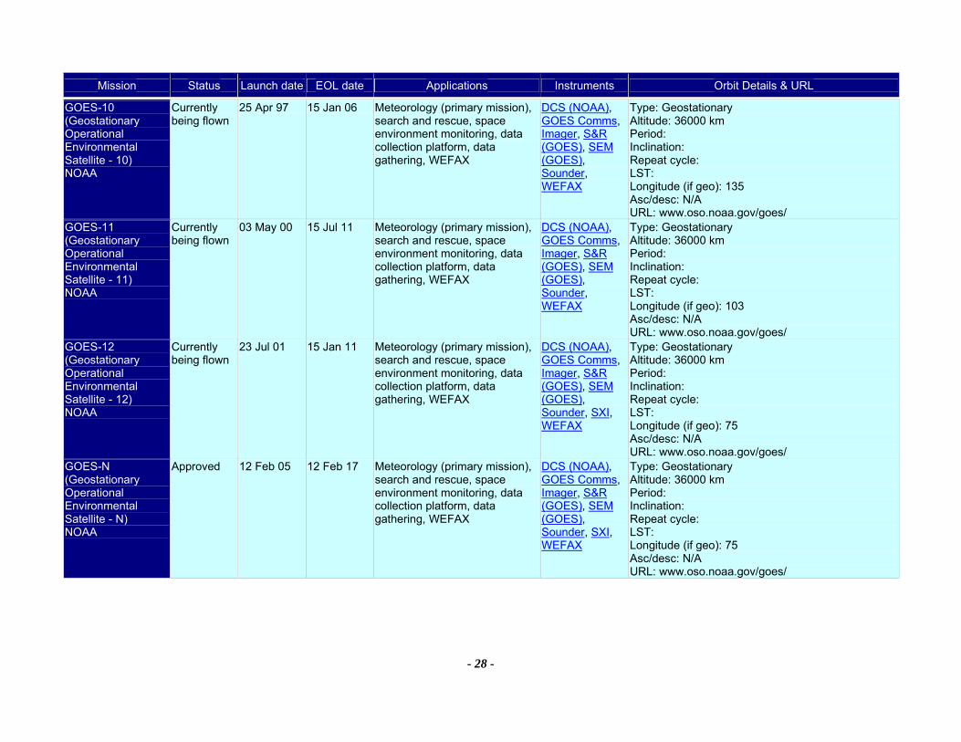
Mission Status Launch date EOL date Applications Instruments Orbit Details & URL
- 28 -
GOES-10 (Geostationary Operational Environmental Satellite - 10) NOAA
Currently being flown
25 Apr 97 15 Jan 06 Meteorology (primary mission), search and rescue, space environment monitoring, data collection platform, data gathering, WEFAX
DCS (NOAA), GOES Comms, Imager, S&R (GOES), SEM (GOES), Sounder, WEFAX
Type: Geostationary Altitude: 36000 km Period: Inclination: Repeat cycle: LST: Longitude (if geo): 135 Asc/desc: N/A URL: www.oso.noaa.gov/goes/
GOES-11 (Geostationary Operational Environmental Satellite - 11) NOAA
Currently being flown
03 May 00 15 Jul 11 Meteorology (primary mission), search and rescue, space environment monitoring, data collection platform, data gathering, WEFAX
DCS (NOAA), GOES Comms, Imager, S&R (GOES), SEM (GOES), Sounder, WEFAX
Type: Geostationary Altitude: 36000 km Period: Inclination: Repeat cycle: LST: Longitude (if geo): 103 Asc/desc: N/A URL: www.oso.noaa.gov/goes/
GOES-12 (Geostationary Operational Environmental Satellite - 12) NOAA
Currently being flown
23 Jul 01 15 Jan 11 Meteorology (primary mission), search and rescue, space environment monitoring, data collection platform, data gathering, WEFAX
DCS (NOAA), GOES Comms, Imager, S&R (GOES), SEM (GOES), Sounder, SXI, WEFAX
Type: Geostationary Altitude: 36000 km Period: Inclination: Repeat cycle: LST: Longitude (if geo): 75 Asc/desc: N/A URL: www.oso.noaa.gov/goes/
GOES-N (Geostationary Operational Environmental Satellite - N) NOAA
Approved 12 Feb 05 12 Feb 17 Meteorology (primary mission), search and rescue, space environment monitoring, data collection platform, data gathering, WEFAX
DCS (NOAA), GOES Comms, Imager, S&R (GOES), SEM (GOES), Sounder, SXI, WEFAX
Type: Geostationary Altitude: 36000 km Period: Inclination: Repeat cycle: LST: Longitude (if geo): 75 Asc/desc: N/A URL: www.oso.noaa.gov/goes/
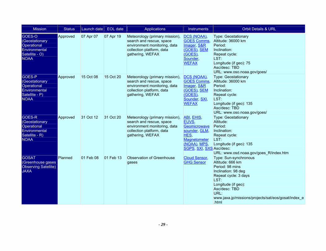
Mission Status Launch date EOL date Applications Instruments Orbit Details & URL
- 29 -
GOES-O (Geostationary Operational Environmental Satellite - O) NOAA
Approved 07 Apr 07 07 Apr 19 Meteorology (primary mission), search and rescue, space environment monitoring, data collection platform, data gathering, WEFAX
DCS (NOAA), GOES Comms, Imager, S&R (GOES), SEM (GOES), Sounder, WEFAX
Type: Geostationary Altitude: 36000 km Period: Inclination: Repeat cycle: LST: Longitude (if geo): 75 Asc/desc: TBD URL: www.oso.noaa.gov/goes/
GOES-P (Geostationary Operational Environmental Satellite - P) NOAA
Approved 15 Oct 08 15 Oct 20 Meteorology (primary mission), search and rescue, space environment monitoring, data collection platform, data gathering, WEFAX
DCS (NOAA), GOES Comms, Imager, S&R (GOES), SEM (GOES), Sounder, SXI, WEFAX
Type: Geostationary Altitude: 36000 km Period: Inclination: Repeat cycle: LST: Longitude (if geo): 135 Asc/desc: TBD URL: www.oso.noaa.gov/goes/
GOES-R (Geostationary Operational Environmental Satellite - R) NOAA
Approved 31 Oct 12 31 Oct 20 Meteorology (primary mission), search and rescue, space environment monitoring, data collection platform, data gathering, WEFAX
ABI, EHIS, EUVS, Geomicrowave sounder, GLM, HES, Magnetometer (NOAA), MPS, SGPS, SXI, SXS
Type: Geostationary Altitude: Period: Inclination: Repeat cycle: LST: Longitude (if geo): 135 Asc/desc: URL: www.osd.noaa.gov/goes_R/index.htm
GOSAT (Greenhouse gases Observing Satellite) JAXA
Planned 01 Feb 08 01 Feb 13 Observation of Greenhouse gases
Cloud Sensor, GHG Sensor
Type: Sun-synchronous Altitude: 666 km Period: 98 mins Inclination: 98 deg Repeat cycle: 3 days LST: Longitude (if geo): Asc/desc: TBD URL: www.jaxa.jp/missions/projects/sat/eos/gosat/index_e.html

Mission Status Launch date EOL date Applications Instruments Orbit Details & URL
- 30 -
GPM Constellation (Global Precipitation Measurement Mission Constellation spacecraft) NASA
Planned 01 Nov 10 01 Nov 14 Study of global precipitation, evaporation, and cycling of water are changing. The mission comprises a primary spacecraft with active and passive microwave instruments, and a number of ‘constellation spacecraft with passive microwave instruments.
GMI Type: Inclined, non-sunsynchronous Altitude: 600 km Period: Inclination: Repeat cycle: LST: Longitude (if geo): Asc/desc: TBD URL: gpm.gsfc.nasa.gov/
GPM Core (Global Precipitation Measurement Mission Core spacecraft) NASA
Planned 01 Nov 09 01 Nov 13 Study of global precipitation, evaporation, and cycling of water are changing. The mission comprises a primary spacecraft with active and passive microwave instruments, and a number of ‘constellation spacecraft with passive microwave instruments
DPR, GMI Type: Inclined, non-sunsynchronous Altitude: 400 km Period: Inclination: 65 deg Repeat cycle: LST: Longitude (if geo): Asc/desc: TBD URL: gpm.gsfc.nasa.gov/gpm.gsfc.nasa.gov/
GRACE (Gravity Recovery and Climate Experiment) NASA
Currently being flown
17 Mar 02 01 Mar 07 Extremely high precision gravity measurements for use in construction of gravity field models
GPS (GRACE), HAIRS
Type: Inclined, non-sunsynchronous Altitude: 400 km Period: 94 mins Inclination: 89 deg Repeat cycle: LST: Longitude (if geo): Asc/desc: TBD URL: www.csr.utexas.edu/grace/
HJ-1A (Disaster and Environment Monitoring and Forecast Small Satellite A) CAST
Planned 01 Dec 06 01 Dec 09 Disaster and Environment Monitoring and Forecast
CCD (HJ, HY), HSI (HJ-1A)
Type: Sun-synchronous Altitude: 649 km Period: Inclination: 97.9 deg Repeat cycle: 31 days LST: 1030 Longitude (if geo): Asc/desc: Descending URL: www.cast.cn/
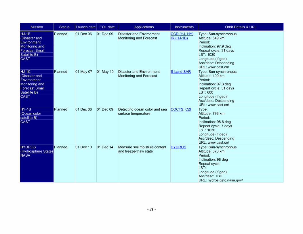
Mission Status Launch date EOL date Applications Instruments Orbit Details & URL
- 31 -
HJ-1B (Disaster and Environment Monitoring and Forecast Small Satellite B) CAST
Planned 01 Dec 06 01 Dec 09 Disaster and Environment Monitoring and Forecast
CCD (HJ, HY), IR (HJ-1B)
Type: Sun-synchronous Altitude: 649 km Period: Inclination: 97.9 deg Repeat cycle: 31 days LST: 1030 Longitude (if geo): Asc/desc: Descending URL: www.cast.cn/
HJ-1C (Disaster and Environment Monitoring and Forecast Small Satellite B) CAST
Planned 01 May 07 01 May 10 Disaster and Environment Monitoring and Forecast
S-band SAR Type: Sun-synchronous Altitude: 499 km Period: Inclination: 97.3 deg Repeat cycle: 31 days LST: 600 Longitude (if geo): Asc/desc: Descending URL: www.cast.cn/
HY-1B (Ocean color satellite B) CAST
Planned 01 Dec 06 01 Dec 09 Detecting ocean color and sea surface temperature
COCTS, CZI Type: Altitude: 798 km Period: Inclination: 98.6 deg Repeat cycle: 7 days LST: 1030 Longitude (if geo): Asc/desc: Descending URL: www.cast.cn/
HYDROS (Hydrosphere State) NASA
Planned 01 Dec 10 01 Dec 14 Measure soil moisture content and freeze-thaw state
HYDROS Type: Sun-synchronous Altitude: 670 km Period: Inclination: 98 deg Repeat cycle: LST: Longitude (if geo): Asc/desc: TBD URL: hydros.gsfc.nasa.gov/
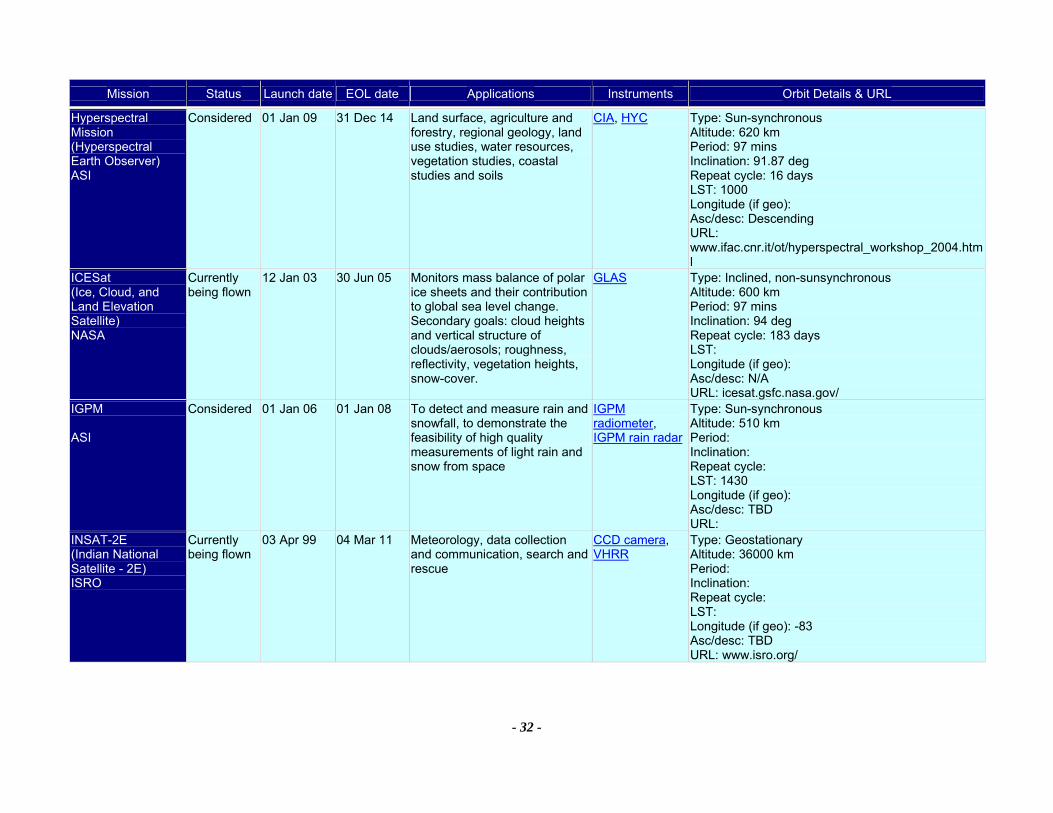
Mission Status Launch date EOL date Applications Instruments Orbit Details & URL
- 32 -
Hyperspectral Mission (Hyperspectral Earth Observer) ASI
Considered 01 Jan 09 31 Dec 14 Land surface, agriculture and forestry, regional geology, land use studies, water resources, vegetation studies, coastal studies and soils
CIA, HYC Type: Sun-synchronous Altitude: 620 km Period: 97 mins Inclination: 91.87 deg Repeat cycle: 16 days LST: 1000 Longitude (if geo): Asc/desc: Descending URL: www.ifac.cnr.it/ot/hyperspectral_workshop_2004.html
ICESat (Ice, Cloud, and Land Elevation Satellite) NASA
Currently being flown
12 Jan 03 30 Jun 05 Monitors mass balance of polar ice sheets and their contribution to global sea level change. Secondary goals: cloud heights and vertical structure of clouds/aerosols; roughness, reflectivity, vegetation heights, snow-cover.
GLAS Type: Inclined, non-sunsynchronous Altitude: 600 km Period: 97 mins Inclination: 94 deg Repeat cycle: 183 days LST: Longitude (if geo): Asc/desc: N/A URL: icesat.gsfc.nasa.gov/
IGPM ASI
Considered 01 Jan 06 01 Jan 08 To detect and measure rain and snowfall, to demonstrate the feasibility of high quality measurements of light rain and snow from space
IGPM radiometer, IGPM rain radar
Type: Sun-synchronous Altitude: 510 km Period: Inclination: Repeat cycle: LST: 1430 Longitude (if geo): Asc/desc: TBD URL:
INSAT-2E (Indian National Satellite - 2E) ISRO
Currently being flown
03 Apr 99 04 Mar 11 Meteorology, data collection and communication, search and rescue
CCD camera, VHRR
Type: Geostationary Altitude: 36000 km Period: Inclination: Repeat cycle: LST: Longitude (if geo): -83 Asc/desc: TBD URL: www.isro.org/
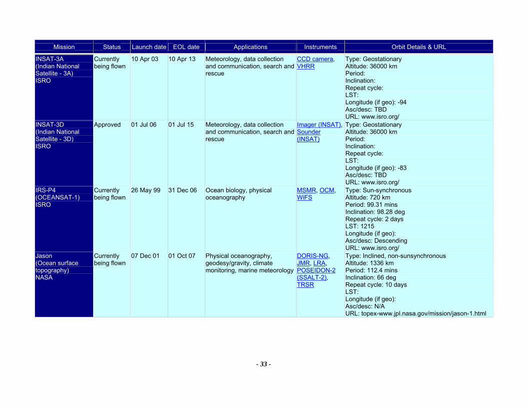
Mission Status Launch date EOL date Applications Instruments Orbit Details & URL
- 33 -
INSAT-3A (Indian National Satellite - 3A) ISRO
Currently being flown
10 Apr 03 10 Apr 13 Meteorology, data collection and communication, search and rescue
CCD camera, VHRR
Type: Geostationary Altitude: 36000 km Period: Inclination: Repeat cycle: LST: Longitude (if geo): -94 Asc/desc: TBD URL: www.isro.org/
INSAT-3D (Indian National Satellite - 3D) ISRO
Approved 01 Jul 06 01 Jul 15 Meteorology, data collection and communication, search and rescue
Imager (INSAT), Sounder (INSAT)
Type: Geostationary Altitude: 36000 km Period: Inclination: Repeat cycle: LST: Longitude (if geo): -83 Asc/desc: TBD URL: www.isro.org/
IRS-P4 (OCEANSAT-1) ISRO
Currently being flown
26 May 99 31 Dec 06 Ocean biology, physical oceanography
MSMR, OCM, WiFS
Type: Sun-synchronous Altitude: 720 km Period: 99.31 mins Inclination: 98.28 deg Repeat cycle: 2 days LST: 1215 Longitude (if geo): Asc/desc: Descending URL: www.isro.org/
Jason (Ocean surface topography) NASA
Currently being flown
07 Dec 01 01 Oct 07 Physical oceanography, geodesy/gravity, climate monitoring, marine meteorology
DORIS-NG, JMR, LRA, POSEIDON-2 (SSALT-2), TRSR
Type: Inclined, non-sunsynchronous Altitude: 1336 km Period: 112.4 mins Inclination: 66 deg Repeat cycle: 10 days LST: Longitude (if geo): Asc/desc: N/A URL: topex-www.jpl.nasa.gov/mission/jason-1.html
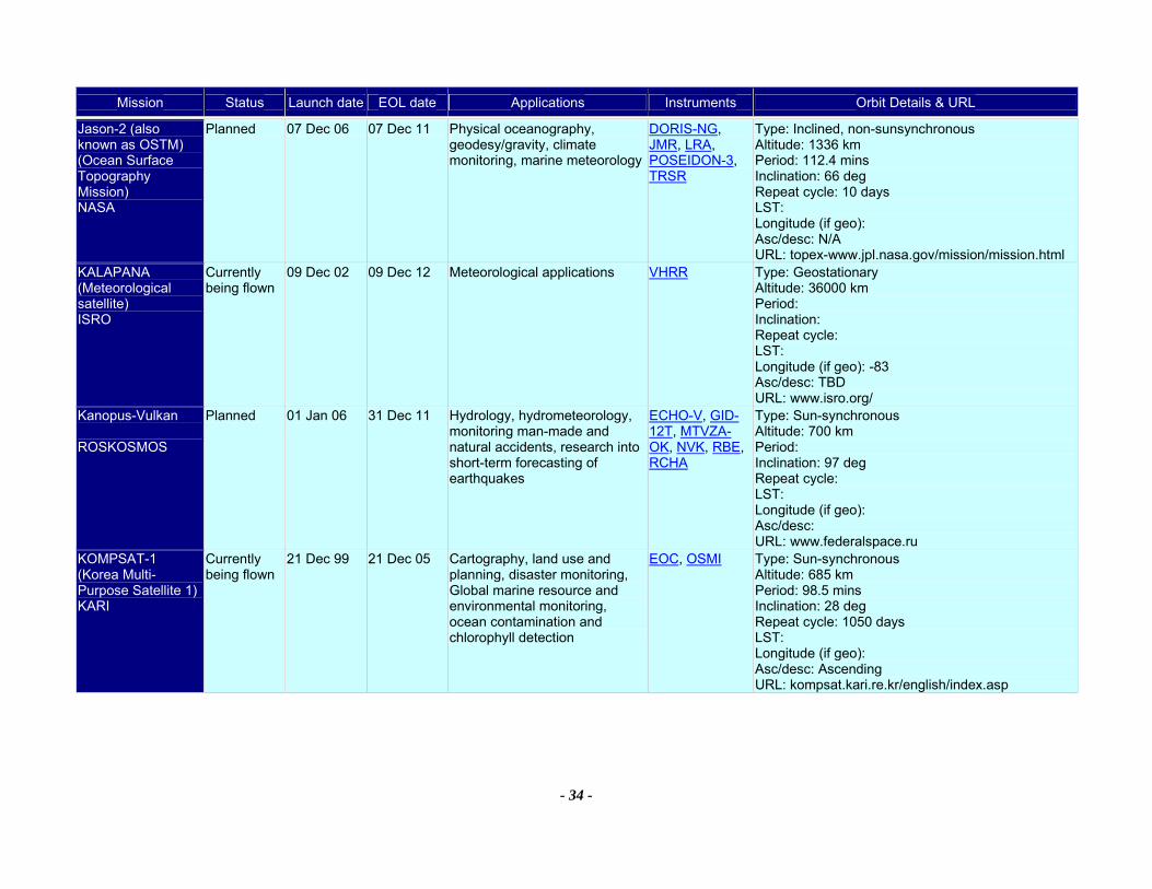
Mission Status Launch date EOL date Applications Instruments Orbit Details & URL
- 34 -
Jason-2 (also known as OSTM) (Ocean Surface Topography Mission) NASA
Planned 07 Dec 06 07 Dec 11 Physical oceanography, geodesy/gravity, climate monitoring, marine meteorology
DORIS-NG, JMR, LRA, POSEIDON-3, TRSR
Type: Inclined, non-sunsynchronous Altitude: 1336 km Period: 112.4 mins Inclination: 66 deg Repeat cycle: 10 days LST: Longitude (if geo): Asc/desc: N/A URL: topex-www.jpl.nasa.gov/mission/mission.html
KALAPANA (Meteorological satellite) ISRO
Currently being flown
09 Dec 02 09 Dec 12 Meteorological applications VHRR Type: Geostationary Altitude: 36000 km Period: Inclination: Repeat cycle: LST: Longitude (if geo): -83 Asc/desc: TBD URL: www.isro.org/
Kanopus-Vulkan ROSKOSMOS
Planned 01 Jan 06 31 Dec 11 Hydrology, hydrometeorology, monitoring man-made and natural accidents, research into short-term forecasting of earthquakes
ECHO-V, GID-12T, MTVZA-OK, NVK, RBE, RCHA
Type: Sun-synchronous Altitude: 700 km Period: Inclination: 97 deg Repeat cycle: LST: Longitude (if geo): Asc/desc: URL: www.federalspace.ru
KOMPSAT-1 (Korea Multi-Purpose Satellite 1) KARI
Currently being flown
21 Dec 99 21 Dec 05 Cartography, land use and planning, disaster monitoring, Global marine resource and environmental monitoring, ocean contamination and chlorophyll detection
EOC, OSMI Type: Sun-synchronous Altitude: 685 km Period: 98.5 mins Inclination: 28 deg Repeat cycle: 1050 days LST: Longitude (if geo): Asc/desc: Ascending URL: kompsat.kari.re.kr/english/index.asp

Mission Status Launch date EOL date Applications Instruments Orbit Details & URL
- 35 -
KOMPSAT-2 (Korea Multi-Purpose Satellite 2) KARI
Approved 01 Oct 05 01 Oct 08 Cartography, land use and planning, disaster monitoring
MSC Type: Sun-synchronous Altitude: 685 km Period: 98.5 mins Inclination: 28 deg Repeat cycle: 1050 days LST: Longitude (if geo): Asc/desc: Ascending URL: kompsat.kari.re.kr/english/index.asp
LAGEOS-1 (Laser Geodynamics Satellite - 1) NASA
Currently being flown
04 May 76 04 May 16 Geodesy, crustal motion and gravity field measurements by laser ranging
LRA (LAGEOS) Type: Inclined, non-sunsynchronous Altitude: 6000 km Period: 225 mins Inclination: 110 deg Repeat cycle: LST: Longitude (if geo): Asc/desc: N/A URL: ilrs.gsfc.nasa.gov/satellite_missions/list_of_satellites/lagoes.html
LAGEOS-2 (Laser Geodynamics Satellite - 2) NASA
Currently being flown
22 Oct 92 22 Oct 32 Geodesy, crustal motion and gravity field measurements by laser ranging
LRA (LAGEOS) Type: Inclined, non-sunsynchronous Altitude: 5900 km Period: 223 mins Inclination: 52 deg Repeat cycle: LST: Longitude (if geo): Asc/desc: N/A URL: ilrs.gsfc.nasa.gov/satellite_missions/list_of_satellites/lagoes.htmlNASA\NASA_Agency_Missions1x2.doc
LAGEOS-3 (Laser Geodynamics Satellite - 3) NASA
Planned 01 Jan 06 01 Jan 46 Geodesy, crustal motion and gravity field measurements by laser ranging. Launch TBD - dates given are for illustration only.
LRA (LAGEOS) Type: Inclined, non-sunsynchronous Altitude: 5900 km Period: Inclination: Repeat cycle: LST: Longitude (if geo): Asc/desc: TBD URL: www.laeff.esa.es/eng/laeff/activity/lageos3.html
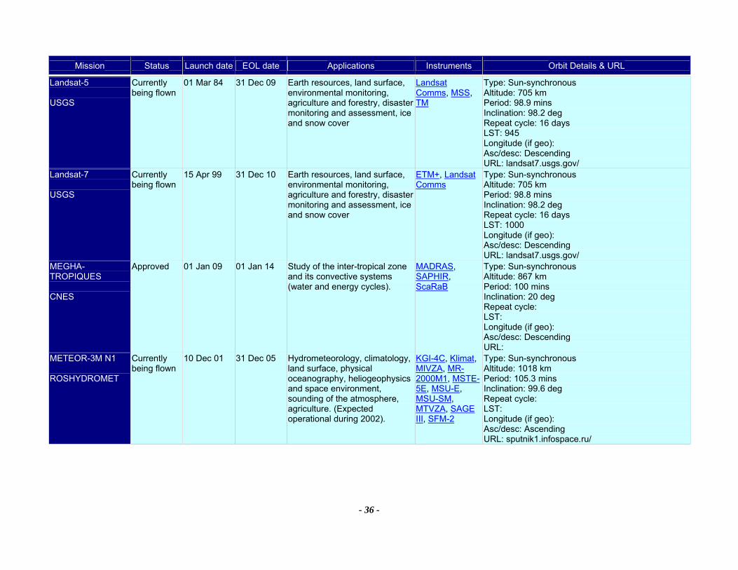
Mission Status Launch date EOL date Applications Instruments Orbit Details & URL
- 36 -
Landsat-5 USGS
Currently being flown
01 Mar 84 31 Dec 09 Earth resources, land surface, environmental monitoring, agriculture and forestry, disaster monitoring and assessment, ice and snow cover
Landsat Comms, MSS, TM
Type: Sun-synchronous Altitude: 705 km Period: 98.9 mins Inclination: 98.2 deg Repeat cycle: 16 days LST: 945 Longitude (if geo): Asc/desc: Descending URL: landsat7.usgs.gov/
Landsat-7 USGS
Currently being flown
15 Apr 99 31 Dec 10 Earth resources, land surface, environmental monitoring, agriculture and forestry, disaster monitoring and assessment, ice and snow cover
ETM+, Landsat Comms
Type: Sun-synchronous Altitude: 705 km Period: 98.8 mins Inclination: 98.2 deg Repeat cycle: 16 days LST: 1000 Longitude (if geo): Asc/desc: Descending URL: landsat7.usgs.gov/
MEGHA-TROPIQUES CNES
Approved 01 Jan 09 01 Jan 14 Study of the inter-tropical zone and its convective systems (water and energy cycles).
MADRAS, SAPHIR, ScaRaB
Type: Sun-synchronous Altitude: 867 km Period: 100 mins Inclination: 20 deg Repeat cycle: LST: Longitude (if geo): Asc/desc: Descending URL:
METEOR-3M N1 ROSHYDROMET
Currently being flown
10 Dec 01 31 Dec 05 Hydrometeorology, climatology, land surface, physical oceanography, heliogeophysics and space environment, sounding of the atmosphere, agriculture. (Expected operational during 2002).
KGI-4C, Klimat, MIVZA, MR-2000M1, MSTE-5E, MSU-E, MSU-SM, MTVZA, SAGE III, SFM-2
Type: Sun-synchronous Altitude: 1018 km Period: 105.3 mins Inclination: 99.6 deg Repeat cycle: LST: Longitude (if geo): Asc/desc: Ascending URL: sputnik1.infospace.ru/
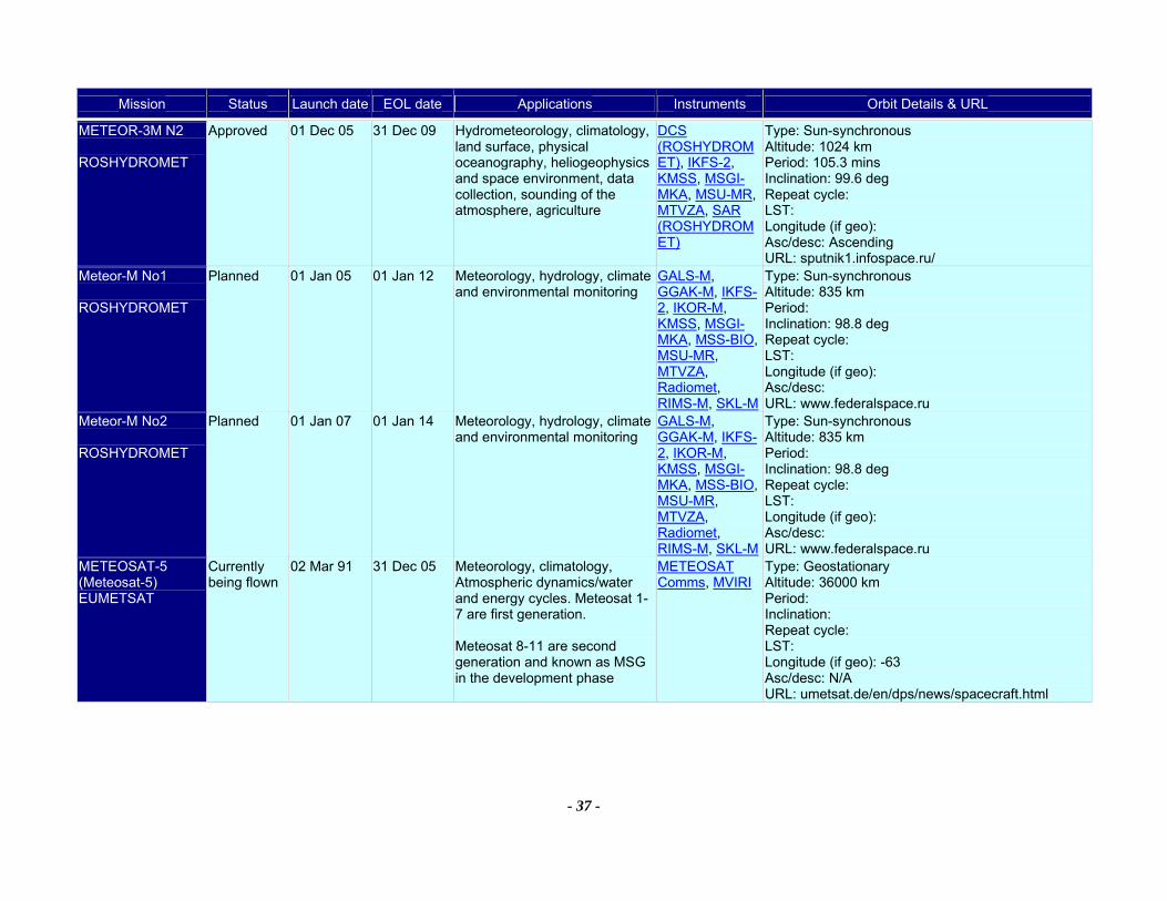
Mission Status Launch date EOL date Applications Instruments Orbit Details & URL
- 37 -
METEOR-3M N2 ROSHYDROMET
Approved 01 Dec 05 31 Dec 09 Hydrometeorology, climatology, land surface, physical oceanography, heliogeophysics and space environment, data collection, sounding of the atmosphere, agriculture
DCS (ROSHYDROMET), IKFS-2, KMSS, MSGI-MKA, MSU-MR, MTVZA, SAR (ROSHYDROMET)
Type: Sun-synchronous Altitude: 1024 km Period: 105.3 mins Inclination: 99.6 deg Repeat cycle: LST: Longitude (if geo): Asc/desc: Ascending URL: sputnik1.infospace.ru/
Meteor-M No1 ROSHYDROMET
Planned 01 Jan 05 01 Jan 12 Meteorology, hydrology, climate and environmental monitoring
GALS-M, GGAK-M, IKFS-2, IKOR-M, KMSS, MSGI-MKA, MSS-BIO, MSU-MR, MTVZA, Radiomet, RIMS-M, SKL-M
Type: Sun-synchronous Altitude: 835 km Period: Inclination: 98.8 deg Repeat cycle: LST: Longitude (if geo): Asc/desc: URL: www.federalspace.ru
Meteor-M No2 ROSHYDROMET
Planned 01 Jan 07 01 Jan 14 Meteorology, hydrology, climate and environmental monitoring
GALS-M, GGAK-M, IKFS-2, IKOR-M, KMSS, MSGI-MKA, MSS-BIO, MSU-MR, MTVZA, Radiomet, RIMS-M, SKL-M
Type: Sun-synchronous Altitude: 835 km Period: Inclination: 98.8 deg Repeat cycle: LST: Longitude (if geo): Asc/desc: URL: www.federalspace.ru
METEOSAT-5 (Meteosat-5) EUMETSAT
Currently being flown
02 Mar 91 31 Dec 05 Meteorology, climatology, Atmospheric dynamics/water and energy cycles. Meteosat 1-7 are first generation. Meteosat 8-11 are second generation and known as MSG in the development phase
METEOSAT Comms, MVIRI
Type: Geostationary Altitude: 36000 km Period: Inclination: Repeat cycle: LST: Longitude (if geo): -63 Asc/desc: N/A URL: umetsat.de/en/dps/news/spacecraft.html
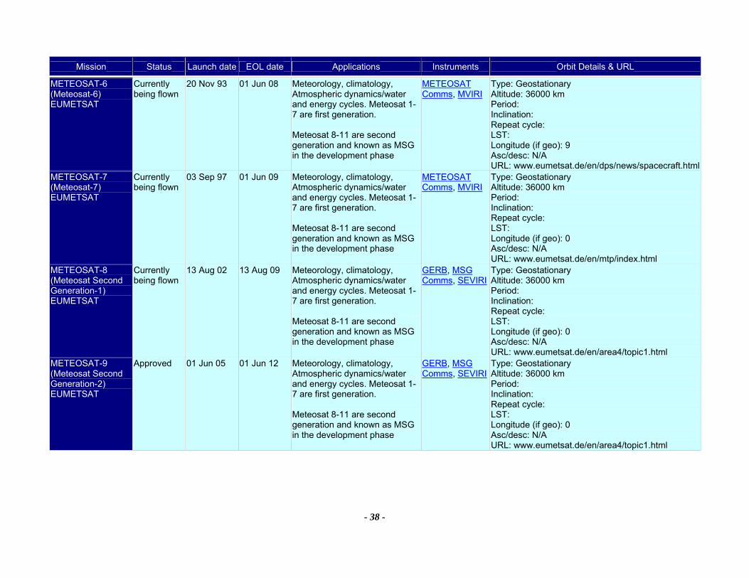
Mission Status Launch date EOL date Applications Instruments Orbit Details & URL
- 38 -
METEOSAT-6 (Meteosat-6) EUMETSAT
Currently being flown
20 Nov 93 01 Jun 08 Meteorology, climatology, Atmospheric dynamics/water and energy cycles. Meteosat 1-7 are first generation. Meteosat 8-11 are second generation and known as MSG in the development phase
METEOSAT Comms, MVIRI
Type: Geostationary Altitude: 36000 km Period: Inclination: Repeat cycle: LST: Longitude (if geo): 9 Asc/desc: N/A URL: www.eumetsat.de/en/dps/news/spacecraft.html
METEOSAT-7 (Meteosat-7) EUMETSAT
Currently being flown
03 Sep 97 01 Jun 09 Meteorology, climatology, Atmospheric dynamics/water and energy cycles. Meteosat 1-7 are first generation. Meteosat 8-11 are second generation and known as MSG in the development phase
METEOSAT Comms, MVIRI
Type: Geostationary Altitude: 36000 km Period: Inclination: Repeat cycle: LST: Longitude (if geo): 0 Asc/desc: N/A URL: www.eumetsat.de/en/mtp/index.html
METEOSAT-8 (Meteosat Second Generation-1) EUMETSAT
Currently being flown
13 Aug 02 13 Aug 09 Meteorology, climatology, Atmospheric dynamics/water and energy cycles. Meteosat 1-7 are first generation. Meteosat 8-11 are second generation and known as MSG in the development phase
GERB, MSG Comms, SEVIRI
Type: Geostationary Altitude: 36000 km Period: Inclination: Repeat cycle: LST: Longitude (if geo): 0 Asc/desc: N/A URL: www.eumetsat.de/en/area4/topic1.html
METEOSAT-9 (Meteosat Second Generation-2) EUMETSAT
Approved 01 Jun 05 01 Jun 12 Meteorology, climatology, Atmospheric dynamics/water and energy cycles. Meteosat 1-7 are first generation. Meteosat 8-11 are second generation and known as MSG in the development phase
GERB, MSG Comms, SEVIRI
Type: Geostationary Altitude: 36000 km Period: Inclination: Repeat cycle: LST: Longitude (if geo): 0 Asc/desc: N/A URL: www.eumetsat.de/en/area4/topic1.html
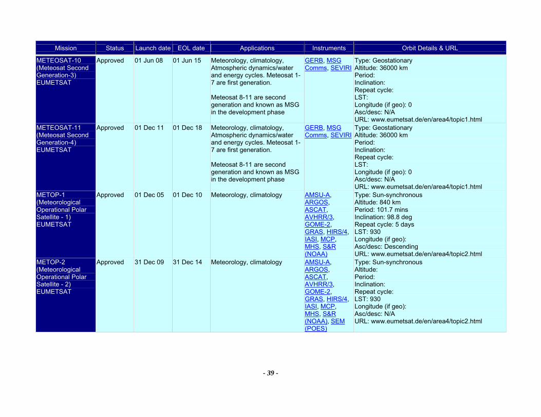
Mission Status Launch date EOL date Applications Instruments Orbit Details & URL
- 39 -
METEOSAT-10 (Meteosat Second Generation-3) EUMETSAT
Approved 01 Jun 08 01 Jun 15 Meteorology, climatology, Atmospheric dynamics/water and energy cycles. Meteosat 1-7 are first generation. Meteosat 8-11 are second generation and known as MSG in the development phase
GERB, MSG Comms, SEVIRI
Type: Geostationary Altitude: 36000 km Period: Inclination: Repeat cycle: LST: Longitude (if geo): 0 Asc/desc: N/A URL: www.eumetsat.de/en/area4/topic1.html
METEOSAT-11 (Meteosat Second Generation-4) EUMETSAT
Approved 01 Dec 11 01 Dec 18 Meteorology, climatology, Atmospheric dynamics/water and energy cycles. Meteosat 1-7 are first generation. Meteosat 8-11 are second generation and known as MSG in the development phase
GERB, MSG Comms, SEVIRI
Type: Geostationary Altitude: 36000 km Period: Inclination: Repeat cycle: LST: Longitude (if geo): 0 Asc/desc: N/A URL: www.eumetsat.de/en/area4/topic1.html
METOP-1 (Meteorological Operational Polar Satellite - 1) EUMETSAT
Approved 01 Dec 05 01 Dec 10 Meteorology, climatology AMSU-A, ARGOS, ASCAT, AVHRR/3, GOME-2, GRAS, HIRS/4, IASI, MCP, MHS, S&R (NOAA)
Type: Sun-synchronous Altitude: 840 km Period: 101.7 mins Inclination: 98.8 deg Repeat cycle: 5 days LST: 930 Longitude (if geo): Asc/desc: Descending URL: www.eumetsat.de/en/area4/topic2.html
METOP-2 (Meteorological Operational Polar Satellite - 2) EUMETSAT
Approved 31 Dec 09 31 Dec 14 Meteorology, climatology AMSU-A, ARGOS, ASCAT, AVHRR/3, GOME-2, GRAS, HIRS/4, IASI, MCP, MHS, S&R (NOAA), SEM (POES)
Type: Sun-synchronous Altitude: Period: Inclination: Repeat cycle: LST: 930 Longitude (if geo): Asc/desc: N/A URL: www.eumetsat.de/en/area4/topic2.html
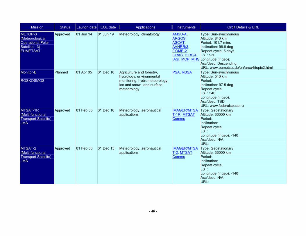
Mission Status Launch date EOL date Applications Instruments Orbit Details & URL
- 40 -
METOP-3 (Meteorological Operational Polar Satellite - 3) EUMETSAT
Approved 01 Jun 14 01 Jun 19 Meteorology, climatology AMSU-A, ARGOS, ASCAT, AVHRR/3, GOME-2, GRAS, HIRS/4, IASI, MCP, MHS
Type: Sun-synchronous Altitude: 840 km Period: 101.7 mins Inclination: 98.8 deg Repeat cycle: 5 days LST: 930 Longitude (if geo): Asc/desc: Descending URL: www.eumetsat.de/en/area4/topic2.html
Monitor-E ROSKOSMOS
Planned 01 Apr 05 31 Dec 10 Agriculture and forestry, hydrology, environmental monitoring, hydrometeorology, ice and snow, land surface, meteorology
PSA, RDSA Type: Sun-synchronous Altitude: 540 km Period: Inclination: 97.5 deg Repeat cycle: LST: 540 Longitude (if geo): Asc/desc: TBD URL: www.federalspace.ru
MTSAT-1R (Multi-functional Transport Satellite) JMA
Approved 01 Feb 05 31 Dec 10 Meteorology, aeronautical applications
IMAGER/MTSAT-1R, MTSAT Comms
Type: Geostationary Altitude: 36000 km Period: Inclination: Repeat cycle: LST: Longitude (if geo): -140 Asc/desc: N/A URL:
MTSAT-2 (Multi-functional Transport Satellite) JMA
Approved 01 Feb 06 31 Dec 15 Meteorology, aeronautical applications
IMAGER/MTSAT-2, MTSAT Comms
Type: Geostationary Altitude: 36000 km Period: Inclination: Repeat cycle: LST: Longitude (if geo): -140 Asc/desc: N/A URL:

Mission Status Launch date EOL date Applications Instruments Orbit Details & URL
- 41 -
NMP EO-1 (New Millenium Program Earth Observing-1) NASA
Currently being flown
21 Nov 00 30 Sep 05 Land surface, earth resources ALI, Hyperion, LAC
Type: Sun-synchronous Altitude: 705 km Period: 99 mins Inclination: 98.2 deg Repeat cycle: 16 days LST: 1030 Longitude (if geo): Asc/desc: Descending URL: eo1.gsfc.nasa.gov/
NMP EO-3 GIFTS (New Millenium Program EO-3 - Geosynchronous Imaging Fourier Transform Spectrometer - (GIFTS)) NASA
Considered 01 Oct 06 01 Oct 08 Continuous observation of atmospheric temperature, water vapour content and distribution, and the concentration of certain other atmospheric gases as a function of altitude over time - providing a new way to observe weather and the changing atmosphere.
GIFTS Type: Geostationary Altitude: 36000 km Period: Inclination: Repeat cycle: LST: Longitude (if geo): -83 Asc/desc: N/A URL: nmp.jpl.nasa.gov/eo3/index.html
NOAA-12 (National Oceanic and Atmospheric Administration - 12) NOAA
Currently being flown
14 May 91 31 Dec 05 Meteorology, agriculture and forestry, environmental monitoring, climatology, physical oceanography, Volcanic eruption monitoring, ice and snow cover, total ozone studies, space environment, solar flux analysis
ARGOS, AVHRR/2, HIRS/2, MSU, NOAA Comms, SEM (POES), SSU
Type: Sun-synchronous Altitude: 850 km Period: 101.3 mins Inclination: 98.5 deg Repeat cycle: LST: 449 Longitude (if geo): Asc/desc: Descending URL: www.oso.noaa.gov/poes/
NOAA-14 (National Oceanic and Atmospheric Administration - 14) NOAA
Currently being flown
30 Dec 94 31 Dec 05 Meteorology, agriculture and forestry, environmental monitoring, climatology, physical oceanography, Volcanic eruption monitoring, ice and snow cover, total ozone studies, space environment, solar flux analysis
ARGOS, AVHRR/2, HIRS/2, MSU, NOAA Comms, S&R (NOAA), SBUV/2, SEM (POES), SSU
Type: Sun-synchronous Altitude: 850 km Period: 102.1 mins Inclination: 99.1 deg Repeat cycle: LST: 1752 Longitude (if geo): Asc/desc: Ascending URL: www.oso.noaa.gov/poes/

Mission Status Launch date EOL date Applications Instruments Orbit Details & URL
- 42 -
NOAA-15 (National Oceanic and Atmospheric Administration - 15) NOAA
Currently being flown
01 May 98 31 Dec 06 Meteorology, agriculture and forestry, environmental monitoring, climatology, physical oceanography, Volcanic eruption monitoring, ice and snow cover, space environment, solar flux analysis, search and rescue
AMSU-A, AMSU-B, ARGOS, AVHRR/3, HIRS/3, NOAA Comms, S&R (NOAA), SBUV/2, SEM (POES)
Type: Sun-synchronous Altitude: 813 km Period: 101.4 mins Inclination: 98.6 deg Repeat cycle: LST: 708 Longitude (if geo): Asc/desc: Descending URL: www.oso.noaa.gov/poes/
NOAA-16 (National Oceanic and Atmospheric Administration - 16) NOAA
Currently being flown
21 Sep 00 31 Dec 06 Meteorology, agriculture and forestry, environmental monitoring, climatology, physical oceanography, Volcanic eruption monitoring, ice and snow cover, total ozone studies, space environment, solar flux analysis, search and rescue
AMSU-A, AMSU-B, ARGOS, AVHRR/3, HIRS/3, NOAA Comms, S&R (NOAA), SBUV/2, SEM (POES)
Type: Sun-synchronous Altitude: 870 km Period: 102 mins Inclination: 98.8 deg Repeat cycle: LST: 1354 Longitude (if geo): Asc/desc: Ascending URL: www.oso.noaa.gov/poes/
NOAA-17 (National Oceanic and Atmospheric Administration - M) NOAA
Currently being flown
24 Jun 02 01 Mar 06 Meteorology, agriculture and forestry, environmental monitoring, climatology, physical oceanography, Volcanic eruption monitoring, ice and snow cover, total ozone studies, space environment, solar flux analysis, search and rescue
AMSU-A, AMSU-B, ARGOS, AVHRR/3, HIRS/3, NOAA Comms, S&R (NOAA), SBUV/2, SEM (POES)
Type: Sun-synchronous Altitude: 833 km Period: 101.4 mins Inclination: 98.75 deg Repeat cycle: LST: 1000 Longitude (if geo): Asc/desc: Descending URL: www.oso.noaa.gov/poes/
NOAA-N (National Oceanic and Atmospheric Administration - N) NOAA
Approved 11 Feb 05 30 Nov 08 Meteorology, agriculture and forestry, environmental monitoring, climatology, physical oceanography, Volcanic eruption monitoring, ice and snow cover, total ozone studies, space environment, solar flux analysis, search and rescue
AMSU-A, ARGOS, AVHRR/3, HIRS/4, MHS, NOAA Comms, S&R (NOAA), SBUV/2, SEM (POES)
Type: Sun-synchronous Altitude: 870 km Period: 102.1 mins Inclination: 98.75 deg Repeat cycle: LST: 1400 Longitude (if geo): Asc/desc: Ascending URL: www.oso.noaa.gov/poes/
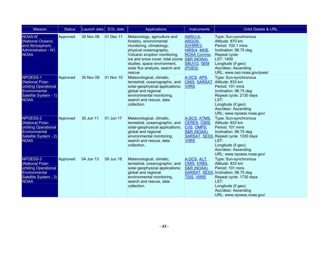
Mission Status Launch date EOL date Applications Instruments Orbit Details & URL
- 43 -
NOAA-N' (National Oceanic and Atmospheric Administration - N') NOAA
Approved 30 Nov 08 01 Dec 11 Meteorology, agriculture and forestry, environmental monitoring, climatology, physical oceanography, Volcanic eruption monitoring, ice and snow cover, total ozone studies, space environment, solar flux analysis, search and rescue
AMSU-A, ARGOS, AVHRR/3, HIRS/4, MHS, NOAA Comms, S&R (NOAA), SBUV/2, SEM (POES)
Type: Sun-synchronous Altitude: 870 km Period: 102.1 mins Inclination: 98.75 deg Repeat cycle: LST: 1400 Longitude (if geo): Asc/desc: Ascending URL: www.oso.noaa.gov/poes/
NPOESS-1 (National Polar-orbiting Operational Environmental Satellite System - 1) NOAA
Approved 30 Nov 09 01 Nov 15 Meteorological, climatic, terrestrial, oceanographic, and solar-geophysical applications; global and regional environmental monitoring, search and rescue, data collection.
A-DCS, APS, CMIS, SARSAT, VIIRS
Type: Sun-synchronous Altitude: 833 km Period: 101 mins Inclination: 98.75 deg Repeat cycle: 2130 days LST: Longitude (if geo): Asc/desc: Ascending URL: www.npoess.noaa.gov/
NPOESS-2 (National Polar-orbiting Operational Environmental Satellite System - 2) NOAA
Approved 30 Jun 11 01 Jun 17 Meteorological, climatic, terrestrial, oceanographic, and solar-geophysical applications; global and regional environmental monitoring, search and rescue, data collection.
A-DCS, ATMS, CERES, CMIS, CrIS, OMPS, S&R (NOAA), SARSAT, SESS, VIIRS
Type: Sun-synchronous Altitude: 833 km Period: 101 mins Inclination: 98.75 deg Repeat cycle: 1330 days LST: Longitude (if geo): Asc/desc: Ascending URL: www.npoess.noaa.gov/
NPOESS-3 (National Polar-orbiting Operational Environmental Satellite System - 3) NOAA
Approved 04 Jun 13 09 Jun 18 Meteorological, climatic, terrestrial, oceanographic, and solar-geophysical applications; global and regional environmental monitoring, search and rescue, data collection.
A-DCS, ALT, CMIS, ERBS, S&R (NOAA), SARSAT, SESS, TSIS, VIIRS
Type: Sun-synchronous Altitude: 833 km Period: 101 mins Inclination: 98.75 deg Repeat cycle: 1730 days LST: Longitude (if geo): Asc/desc: Ascending URL: www.npoess.noaa.gov/

Mission Status Launch date EOL date Applications Instruments Orbit Details & URL
- 44 -
NPOESS-4 (National Polar-orbiting Operational Environmental Satellite System - 4) NOAA
Approved 01 Nov 15 06 Nov 20 Meteorological, climatic, terrestrial, oceanographic, and solar-geophysical applications; global and regional environmental monitoring, search and rescue, data collection.
A-DCS, APS, CMIS, SARSAT, SESS, VIIRS
Type: Sun-synchronous Altitude: 833 km Period: 101 mins Inclination: 98.75 deg Repeat cycle: 2130 days LST: Longitude (if geo): Asc/desc: Ascending URL: www.npoess.noaa.gov/
NPOESS-5 (National Polar-orbiting Operational Environmental Satellite System - 4) NOAA
Approved 01 Jan 18 01 Jun 23 Meteorological, climatic, terrestrial, oceanographic, and solar-geophysical applications; global and regional environmental monitoring, search and rescue, data collection.
A-DCS, ATMS, CERES, CMIS, CrIS, OMPS, S&R (NOAA), SARSAT, SESS, VIIRS
Type: Sun-synchronous Altitude: 833 km Period: 101 mins Inclination: 98.75 deg Repeat cycle: 1330 days LST: Longitude (if geo): Asc/desc: Ascending URL: www.npoess.noaa.gov/
NPOESS-6 (National Polar-orbiting Operational Environmental Satellite System - 4) NOAA
Approved 09 May 19 01 May 24 Meteorological, climatic, terrestrial, oceanographic, and solar-geophysical applications; global and regional environmental monitoring, search and rescue, data collection.
A-DCS, ALT, CMIS, ERBS, S&R (NOAA), SARSAT, SESS, TSIS, VIIRS
Type: Sun-synchronous Altitude: 833 km Period: 101 mins Inclination: 98.75 deg Repeat cycle: 1730 days LST: Longitude (if geo): Asc/desc: Ascending URL: www.npoess.noaa.gov/
NPP (NPOESS (National Polar-orbiting Operational Environmental Satellite System) Preparatory Project) NOAA
Approved 31 Oct 06 26 Oct 11 Meteorological, climatic, terrestrial, and oceanographic applications; global and regionalenvironmental monitoring. (Joint mission with NASA)
ATMS, CrIS, OMPS, VIIRS
Type: Sun-synchronous Altitude: 833 km Period: 101 mins Inclination: 1030 deg Repeat cycle: LST: Longitude (if geo): Asc/desc: Descending URL: jointmission.gsfc.nasa.gov/

Mission Status Launch date EOL date Applications Instruments Orbit Details & URL
- 45 -
OCEANSAT-2 (Ocean satellite-2) ISRO
Planned 01 Jan 07 01 Jan 11 Ocean and atmosphere applications
OCM, Scatterometer (ISRO)
Type: Sun-synchronous Altitude: 720 km Period: 99.31 mins Inclination: 98.28 deg Repeat cycle: 2 days LST: 1200 Longitude (if geo): Asc/desc: Descending URL: www.isro.org/
OCO (Orbiting Carbon Observatory) NASA
Planned 01 Aug 07 01 Aug 09 High resolution carbon dioxide measurements to characterize sources and sinks on regional scales and quantify their variability over the seasonal cycle
OCO Type: Sun-synchronous Altitude: 705 km Period: 98.8 mins Inclination: 98.2 deg Repeat cycle: LST: Longitude (if geo): Asc/desc: TBD URL: essp.gsfc.nasa.gov/oco/index.html
Odin SNSB
Currently being flown
20 Feb 01 30 Mar 05 Atmospheric research, stratospheric ozone chemistry, mesospheric ozone science, summer mesospheric science
OSIRIS, SMR Type: Sun-synchronous Altitude: 590 km Period: 97.6 mins Inclination: 97.8 deg Repeat cycle: LST: 1800 Longitude (if geo): Asc/desc: Ascending URL: www.ssc.se
PARASOL (Polarization and Anisotropy of Reflectances for Atmospheric Science coupled with Observations from a LIDAR) CNES
Approved 10 Dec 04 01 Dec 06 Micro-satellite with the aim of characterisation of the clouds and aerosols microphysical and radiative properties, needed to understand and model the radiative impact of clouds and aerosols.
POLDER-P Type: Sun-synchronous Altitude: 700 km Period: 98.8 mins Inclination: Repeat cycle: LST: 1200 Longitude (if geo): Asc/desc: TBD URL: smsc.cnes.fr/PARASOL/index.htm
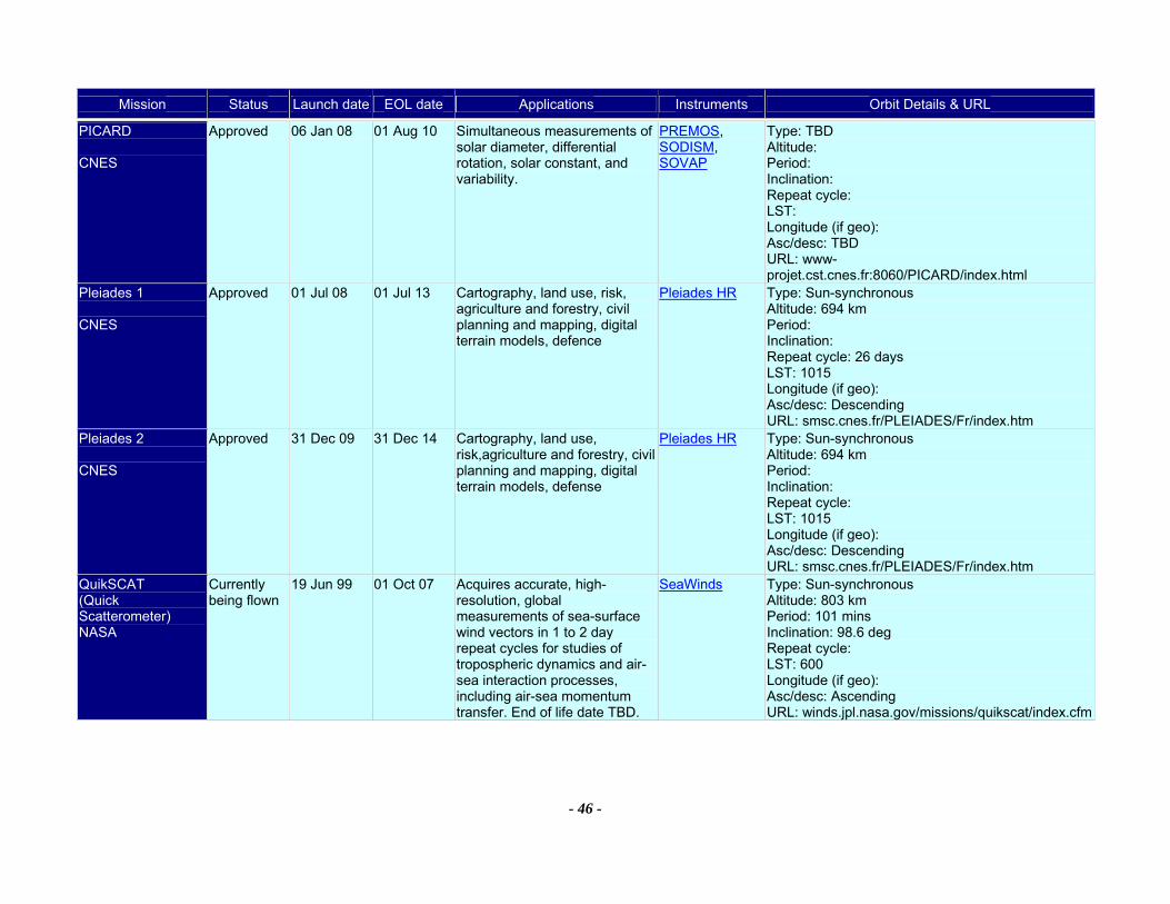
Mission Status Launch date EOL date Applications Instruments Orbit Details & URL
- 46 -
PICARD CNES
Approved 06 Jan 08 01 Aug 10 Simultaneous measurements of solar diameter, differential rotation, solar constant, and variability.
PREMOS, SODISM, SOVAP
Type: TBD Altitude: Period: Inclination: Repeat cycle: LST: Longitude (if geo): Asc/desc: TBD URL: www-projet.cst.cnes.fr:8060/PICARD/index.html
Pleiades 1 CNES
Approved 01 Jul 08 01 Jul 13 Cartography, land use, risk, agriculture and forestry, civil planning and mapping, digital terrain models, defence
Pleiades HR Type: Sun-synchronous Altitude: 694 km Period: Inclination: Repeat cycle: 26 days LST: 1015 Longitude (if geo): Asc/desc: Descending URL: smsc.cnes.fr/PLEIADES/Fr/index.htm
Pleiades 2 CNES
Approved 31 Dec 09 31 Dec 14 Cartography, land use, risk,agriculture and forestry, civil planning and mapping, digital terrain models, defense
Pleiades HR Type: Sun-synchronous Altitude: 694 km Period: Inclination: Repeat cycle: LST: 1015 Longitude (if geo): Asc/desc: Descending URL: smsc.cnes.fr/PLEIADES/Fr/index.htm
QuikSCAT (Quick Scatterometer) NASA
Currently being flown
19 Jun 99 01 Oct 07 Acquires accurate, high-resolution, global measurements of sea-surface wind vectors in 1 to 2 day repeat cycles for studies of tropospheric dynamics and air-sea interaction processes, including air-sea momentum transfer. End of life date TBD.
SeaWinds Type: Sun-synchronous Altitude: 803 km Period: 101 mins Inclination: 98.6 deg Repeat cycle: LST: 600 Longitude (if geo): Asc/desc: Ascending URL: winds.jpl.nasa.gov/missions/quikscat/index.cfm
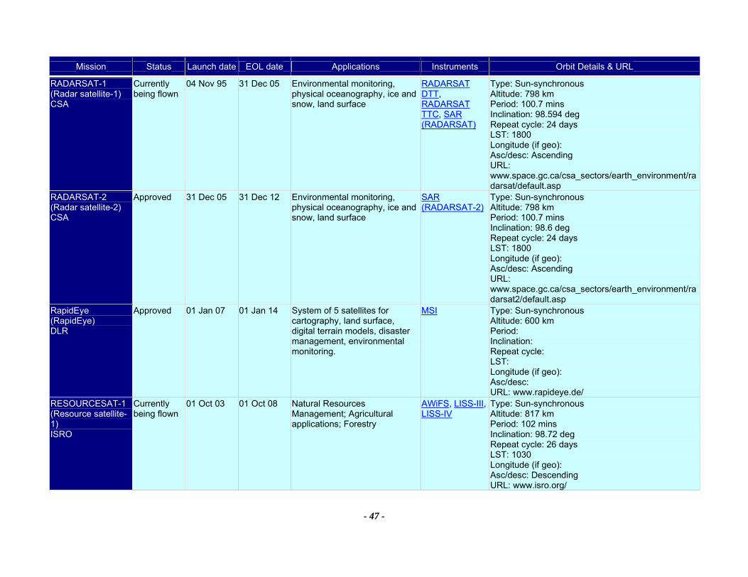
Mission Status Launch date EOL date Applications Instruments Orbit Details & URL
- 47 -
RADARSAT-1 (Radar satellite-1) CSA
Currently being flown
04 Nov 95 31 Dec 05 Environmental monitoring, physical oceanography, ice and snow, land surface
RADARSAT DTT, RADARSAT TTC, SAR (RADARSAT)
Type: Sun-synchronous Altitude: 798 km Period: 100.7 mins Inclination: 98.594 deg Repeat cycle: 24 days LST: 1800 Longitude (if geo): Asc/desc: Ascending URL: www.space.gc.ca/csa_sectors/earth_environment/radarsat/default.asp
RADARSAT-2 (Radar satellite-2) CSA
Approved 31 Dec 05 31 Dec 12 Environmental monitoring, physical oceanography, ice and snow, land surface
SAR (RADARSAT-2)
Type: Sun-synchronous Altitude: 798 km Period: 100.7 mins Inclination: 98.6 deg Repeat cycle: 24 days LST: 1800 Longitude (if geo): Asc/desc: Ascending URL: www.space.gc.ca/csa_sectors/earth_environment/radarsat2/default.asp
RapidEye (RapidEye) DLR
Approved 01 Jan 07 01 Jan 14 System of 5 satellites for cartography, land surface, digital terrain models, disaster management, environmental monitoring.
MSI Type: Sun-synchronous Altitude: 600 km Period: Inclination: Repeat cycle: LST: Longitude (if geo): Asc/desc: URL: www.rapideye.de/
RESOURCESAT-1 (Resource satellite-1) ISRO
Currently being flown
01 Oct 03 01 Oct 08 Natural Resources Management; Agricultural applications; Forestry
AWiFS, LISS-III, LISS-IV
Type: Sun-synchronous Altitude: 817 km Period: 102 mins Inclination: 98.72 deg Repeat cycle: 26 days LST: 1030 Longitude (if geo): Asc/desc: Descending URL: www.isro.org/
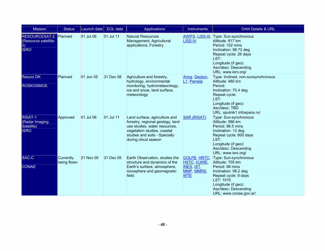
Mission Status Launch date EOL date Applications Instruments Orbit Details & URL
- 48 -
RESOURCESAT-2 (Resource satellite-2) ISRO
Planned 01 Jul 06 01 Jul 11 Natural Resources Management; Agricultural applications; Forestry
AWiFS, LISS-III, LISS-IV
Type: Sun-synchronous Altitude: 817 km Period: 102 mins Inclination: 98.72 deg Repeat cycle: 26 days LST: Longitude (if geo): Asc/desc: Descending URL: www.isro.org/
Resurs DK ROSKOSMOS
Planned 01 Jun 05 31 Dec 08 Agriculture and forestry, hydrology, environmental monitoring, hydrometeorology, ice and snow, land surface, meteorology
Arina, Geoton-L1, Pamela
Type: Inclined, non-sunsynchronous Altitude: 480 km Period: Inclination: 70.4 deg Repeat cycle: LST: Longitude (if geo): Asc/desc: TBD URL: sputnik1.infospace.ru/
RISAT-1 (Radar Imaging Satellite) ISRO
Approved 01 Jul 06 01 Jul 11 Land surface, agriculture and forestry, regional geology, land use studies, water resources, vegetation studies, coastal studies and soils - Specially during cloud season
SAR (RISAT) Type: Sun-synchronous Altitude: 586 km Period: 96.5 mins Inclination: 12 deg Repeat cycle: 600 days LST: Longitude (if geo): Asc/desc: Descending URL: www.isro.org/
SAC-C CONAE
Currently being flown
21 Nov 00 31 Dec 05 Earth Observation, studies the structure and dynamics of the Earth’s surface, atmosphere, ionosphere and geomagnetic field.
GOLPE, HRTC, HSTC, ICARE, INES, IST, MMP, MMRS, WTE
Type: Sun-synchronous Altitude: 705 km Period: 98 mins Inclination: 98.2 deg Repeat cycle: 9 days LST: 1015 Longitude (if geo): Asc/desc: Descending URL: www.conae.gov.ar/

Mission Status Launch date EOL date Applications Instruments Orbit Details & URL
- 49 -
SAC-D/Aquarius CONAE
Approved 11 Sep 08 11 Sep 11 Earth observation studies; measurement of ocean salinity; emergency management
Aquarius, HSC, ICARE, MWR (CONAE), NIRST, ROSA, SODAD
Type: Sun-synchronous Altitude: 705 km Period: 98 mins Inclination: 98.2 deg Repeat cycle: 9 days LST: 1015 Longitude (if geo): Asc/desc: Descending URL: www.conae.gov.ar/
SAC-E/SABIA CONAE
Planned 21 Nov 09 01 Dec 14 Food production;environmental monitoring; inner coastal and water quality
MOC Type: Sun-synchronous Altitude: 705 km Period: 98 mins Inclination: 98.2 deg Repeat cycle: 9 days LST: 1015 Longitude (if geo): Asc/desc: Descending URL: www.conae.gov.ar/
SAC-F CONAE
Planned 21 Nov 07 01 Dec 11 Earth observation studies; emergency management;landscape epidemiology
HRMS, HSMS, HSS, TIS (CONAE)
Type: Sun-synchronous Altitude: 705 km Period: 98 mins Inclination: 98.2 deg Repeat cycle: 9 days LST: 1015 Longitude (if geo): Asc/desc: Descending URL: www.conae.gov.ar/
SAOCOM 1A CONAE
Approved 01 Oct 07 01 Oct 11 Earth Observation and Emergency management with an L-band SAR
IR Camera (SAOCOM), SAR (SAOCOM)
Type: Sun-synchronous Altitude: 629 km Period: 96 mins Inclination: 98 deg Repeat cycle: 16 days LST: 600 Longitude (if geo): Asc/desc: Descending URL: www.conae.gov.ar/
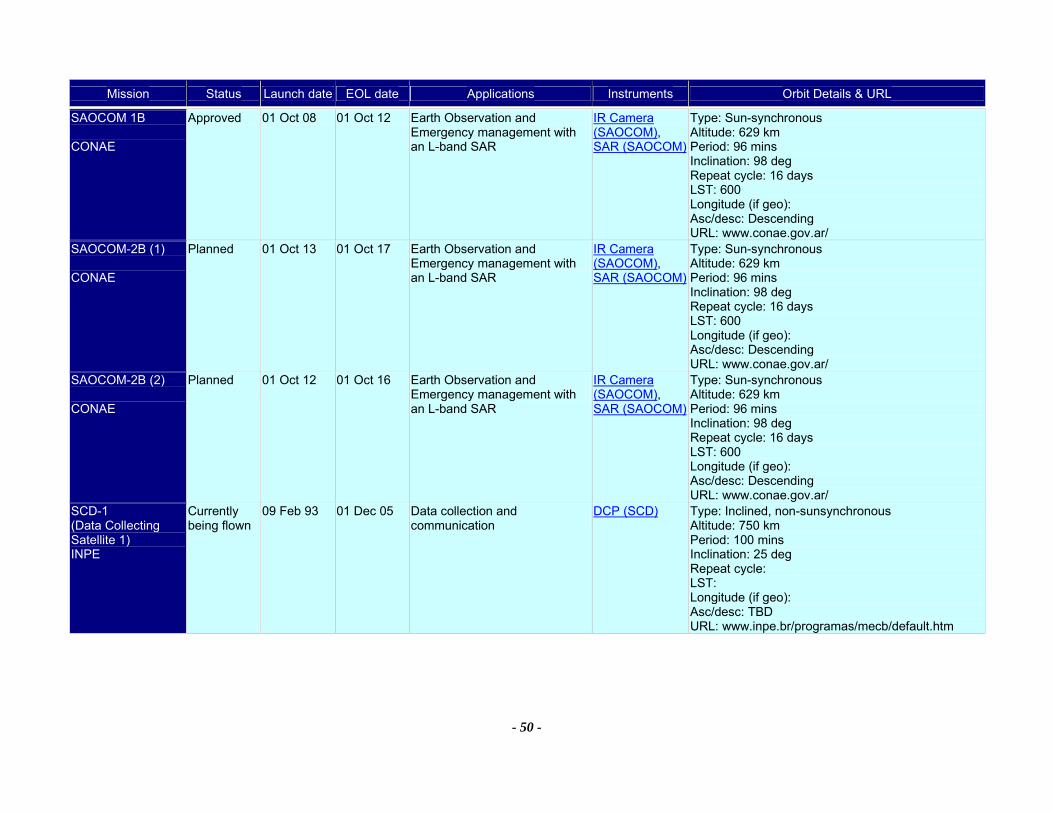
Mission Status Launch date EOL date Applications Instruments Orbit Details & URL
- 50 -
SAOCOM 1B CONAE
Approved 01 Oct 08 01 Oct 12 Earth Observation and Emergency management with an L-band SAR
IR Camera (SAOCOM), SAR (SAOCOM)
Type: Sun-synchronous Altitude: 629 km Period: 96 mins Inclination: 98 deg Repeat cycle: 16 days LST: 600 Longitude (if geo): Asc/desc: Descending URL: www.conae.gov.ar/
SAOCOM-2B (1) CONAE
Planned 01 Oct 13 01 Oct 17 Earth Observation and Emergency management with an L-band SAR
IR Camera (SAOCOM), SAR (SAOCOM)
Type: Sun-synchronous Altitude: 629 km Period: 96 mins Inclination: 98 deg Repeat cycle: 16 days LST: 600 Longitude (if geo): Asc/desc: Descending URL: www.conae.gov.ar/
SAOCOM-2B (2) CONAE
Planned 01 Oct 12 01 Oct 16 Earth Observation and Emergency management with an L-band SAR
IR Camera (SAOCOM), SAR (SAOCOM)
Type: Sun-synchronous Altitude: 629 km Period: 96 mins Inclination: 98 deg Repeat cycle: 16 days LST: 600 Longitude (if geo): Asc/desc: Descending URL: www.conae.gov.ar/
SCD-1 (Data Collecting Satellite 1) INPE
Currently being flown
09 Feb 93 01 Dec 05 Data collection and communication
DCP (SCD) Type: Inclined, non-sunsynchronous Altitude: 750 km Period: 100 mins Inclination: 25 deg Repeat cycle: LST: Longitude (if geo): Asc/desc: TBD URL: www.inpe.br/programas/mecb/default.htm
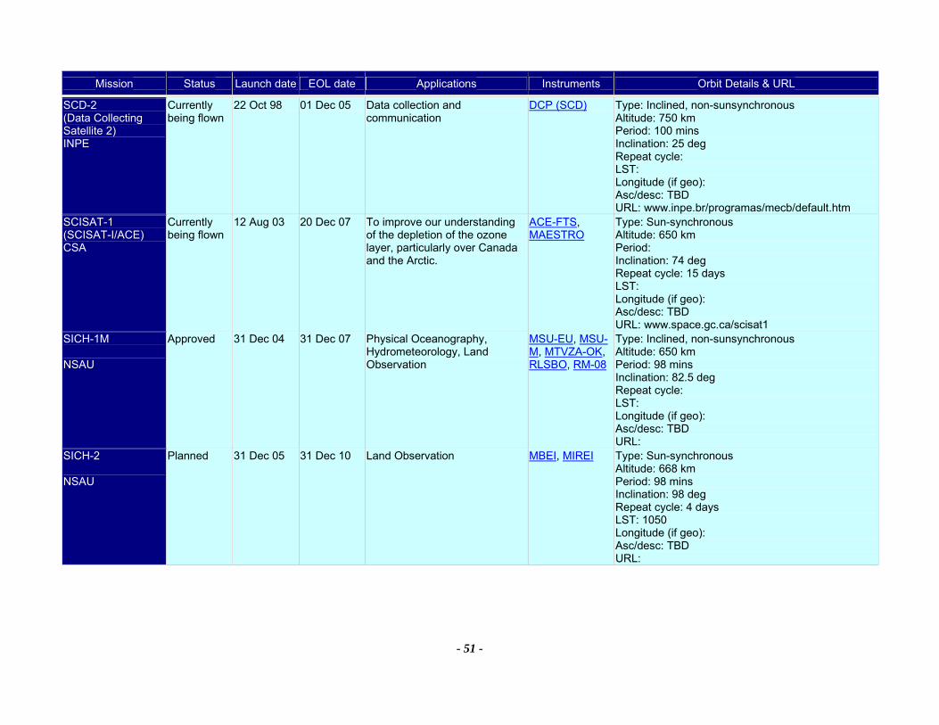
Mission Status Launch date EOL date Applications Instruments Orbit Details & URL
- 51 -
SCD-2 (Data Collecting Satellite 2) INPE
Currently being flown
22 Oct 98 01 Dec 05 Data collection and communication
DCP (SCD) Type: Inclined, non-sunsynchronous Altitude: 750 km Period: 100 mins Inclination: 25 deg Repeat cycle: LST: Longitude (if geo): Asc/desc: TBD URL: www.inpe.br/programas/mecb/default.htm
SCISAT-1 (SCISAT-I/ACE) CSA
Currently being flown
12 Aug 03 20 Dec 07 To improve our understanding of the depletion of the ozone layer, particularly over Canada and the Arctic.
ACE-FTS, MAESTRO
Type: Sun-synchronous Altitude: 650 km Period: Inclination: 74 deg Repeat cycle: 15 days LST: Longitude (if geo): Asc/desc: TBD URL: www.space.gc.ca/scisat1
SICH-1M NSAU
Approved 31 Dec 04 31 Dec 07 Physical Oceanography, Hydrometeorology, Land Observation
MSU-EU, MSU-M, MTVZA-OK, RLSBO, RM-08
Type: Inclined, non-sunsynchronous Altitude: 650 km Period: 98 mins Inclination: 82.5 deg Repeat cycle: LST: Longitude (if geo): Asc/desc: TBD URL:
SICH-2 NSAU
Planned 31 Dec 05 31 Dec 10 Land Observation MBEI, MIREI Type: Sun-synchronous Altitude: 668 km Period: 98 mins Inclination: 98 deg Repeat cycle: 4 days LST: 1050 Longitude (if geo): Asc/desc: TBD URL:

Mission Status Launch date EOL date Applications Instruments Orbit Details & URL
- 52 -
SMOS (Soil Moisture and Ocean Salinity (Earth Explorer Opportunity Mission)) ESA
Approved 15 Feb 07 15 Feb 10 Overall objectives are to provide global observations of two crucial variables for modelling the weather and climate, Soil Moisture and Ocean Salinity. It will also monitor the vegetation water content, snow cover and ice structure.
MIRAS (SMOS) Type: Sun-synchronous Altitude: 756 km Period: Inclination: 98.45 deg Repeat cycle: 165 days LST: 600 Longitude (if geo): Asc/desc: Ascending URL: www.esa.int/export/esaLP/smos.html
SORCE (Solar Radiation and Climate Experiment) NASA
Currently being flown
25 Jan 03 25 Jan 09 Continues the precise, long-term measurements of total solar irradiance at UV and VNIR wavelengths. Daily measurements of solar UV. Precise measurements of visible solar irradiance for climate studies.
SIM, SOLSTICE, TIM, XPS
Type: Inclined, non-sunsynchronous Altitude: 600 km Period: Inclination: 40 deg Repeat cycle: LST: Longitude (if geo): Asc/desc: TBD URL: lasp.colorado.edu/sorce/
SPOT-2 (Satellite Pour l'Observation de la Terre - 2) CNES
Currently being flown
22 Jan 90 31 Dec 05 Cartography, land surface, agriculture and forestry, civil planning and mapping, digital terrain models, environmental monitoring
DORIS, HRV Type: Sun-synchronous Altitude: 832 km Period: 101 mins Inclination: 98.7 deg Repeat cycle: 26 days LST: 1030 Longitude (if geo): Asc/desc: Descending URL: www.spotimage.fr/html/_167_224_229_.php
SPOT-4 (Satellite Pour l'Observation de la Terre - 4) CNES
Currently being flown
24 Mar 98 31 Dec 05 Cartography, land surface, agriculture and forestry, civil planning and mapping, digital terrain models, environmental monitoring
DORIS, HRVIR, VEGETATION
Type: Sun-synchronous Altitude: 832 km Period: 101 mins Inclination: 98.7 deg Repeat cycle: 26 days LST: 1030 Longitude (if geo): Asc/desc: Descending URL: www.spotimage.fr/html/_167_224_229_.php
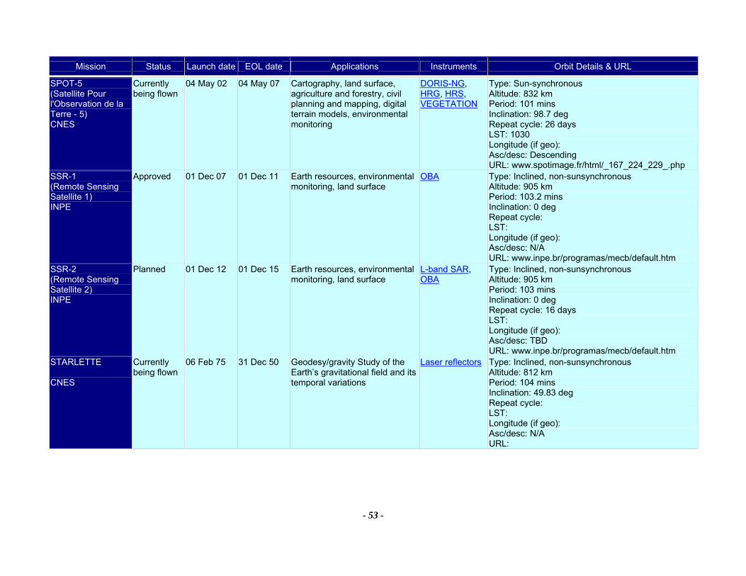
Mission Status Launch date EOL date Applications Instruments Orbit Details & URL
- 53 -
SPOT-5 (Satellite Pour l'Observation de la Terre - 5) CNES
Currently being flown
04 May 02 04 May 07 Cartography, land surface, agriculture and forestry, civil planning and mapping, digital terrain models, environmental monitoring
DORIS-NG, HRG, HRS, VEGETATION
Type: Sun-synchronous Altitude: 832 km Period: 101 mins Inclination: 98.7 deg Repeat cycle: 26 days LST: 1030 Longitude (if geo): Asc/desc: Descending URL: www.spotimage.fr/html/_167_224_229_.php
SSR-1 (Remote Sensing Satellite 1) INPE
Approved 01 Dec 07 01 Dec 11 Earth resources, environmental monitoring, land surface
OBA Type: Inclined, non-sunsynchronous Altitude: 905 km Period: 103.2 mins Inclination: 0 deg Repeat cycle: LST: Longitude (if geo): Asc/desc: N/A URL: www.inpe.br/programas/mecb/default.htm
SSR-2 (Remote Sensing Satellite 2) INPE
Planned 01 Dec 12 01 Dec 15 Earth resources, environmental monitoring, land surface
L-band SAR, OBA
Type: Inclined, non-sunsynchronous Altitude: 905 km Period: 103 mins Inclination: 0 deg Repeat cycle: 16 days LST: Longitude (if geo): Asc/desc: TBD URL: www.inpe.br/programas/mecb/default.htm
STARLETTE CNES
Currently being flown
06 Feb 75 31 Dec 50 Geodesy/gravity Study of the Earth’s gravitational field and its temporal variations
Laser reflectors Type: Inclined, non-sunsynchronous Altitude: 812 km Period: 104 mins Inclination: 49.83 deg Repeat cycle: LST: Longitude (if geo): Asc/desc: N/A URL:
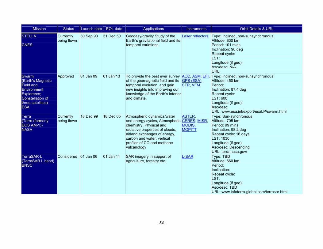
Mission Status Launch date EOL date Applications Instruments Orbit Details & URL
- 54 -
STELLA CNES
Currently being flown
30 Sep 93 31 Dec 50 Geodesy/gravity Study of the Earth’s gravitational field and its temporal variations
Laser reflectors Type: Inclined, non-sunsynchronous Altitude: 830 km Period: 101 mins Inclination: 98 deg Repeat cycle: LST: Longitude (if geo): Asc/desc: N/A URL:
Swarm (Earth's Magnetic Field and Environment Exploreres; Constellation of three satellites) ESA
Approved 01 Jan 09 01 Jan 13 To provide the best ever survey of the geomagnetic field and its temporal evolution, and gain new insights into improving our knowledge of the Earth’s interior and climate.
ACC, ASM, EFI, GPS (ESA), STR, VFM
Type: Inclined, non-sunsynchronous Altitude: 450 km Period: Inclination: 87.4 deg Repeat cycle: LST: 600 Longitude (if geo): Asc/desc: URL: www.esa.int/export/esaLP/swarm.html
Terra (Terra (formerly EOS AM-1)) NASA
Currently being flown
18 Dec 99 18 Dec 05 Atmospheric dynamics/water and energy cycles, Atmospheric chemistry, Physical and radiative properties of clouds, airland exchanges of energy, carbon and water, vertical profiles of CO and methane vulcanology
ASTER, CERES, MISR, MODIS, MOPITT
Type: Sun-synchronous Altitude: 705 km Period: 99 mins Inclination: 98.2 deg Repeat cycle: 16 days LST: 1030 Longitude (if geo): Asc/desc: Descending URL: terra.nasa.gov/
TerraSAR-L (TerraSAR L band) BNSC
Considered 01 Jan 06 01 Jan 11 SAR imagery in support of agriculture, forestry etc.
L-SAR Type: TBD Altitude: 660 km Period: Inclination: Repeat cycle: LST: Longitude (if geo): Asc/desc: TBD URL: www.infoterra-global.com/terrasar.html
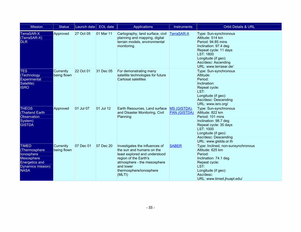
Mission Status Launch date EOL date Applications Instruments Orbit Details & URL
- 55 -
TerraSAR-X (TerraSAR-X) DLR
Approved 27 Oct 05 01 Mar 11 Cartography, land surface, civil planning and mapping, digital terrain models, environmental monitoring.
TerraSAR-X Type: Sun-synchronous Altitude: 514 km Period: 94.85 mins Inclination: 97.4 deg Repeat cycle: 11 days LST: 1800 Longitude (if geo): Asc/desc: Ascending URL: www.terrasar.de/
TES (Technology Experimental Satellite) ISRO
Currently being flown
22 Oct 01 31 Dec 05 For demonstrating many satellite technologies for future Cartosat satellites
Type: Sun-synchronous Altitude: Period: Inclination: Repeat cycle: LST: Longitude (if geo): Asc/desc: Descending URL: www.isro.org/
THEOS (Thailand Earth Observation System) GISTDA
Approved 01 Jul 07 01 Jul 12 Earth Resources, Land surface and Disaster Monitoring, Civil Planning
MS (GISTDA), PAN (GISTDA)
Type: Sun-synchronous Altitude: 822 km Period: 101 mins Inclination: 98.7 deg Repeat cycle: 35 days LST: 1000 Longitude (if geo): Asc/desc: Descending URL: www.gistda.or.th
TIMED (Thermosphere Ionosphere Mesosphere Energetics and Dynamics mission) NASA
Currently being flown
07 Dec 01 07 Dec 20 Investigates the influences of the sun and humans on the least explored and understood region of the Earth's atmosphere - the mesosphere and lower thermosphere/ionosphere (MLTI)
SABER Type: Inclined, non-sunsynchronous Altitude: 625 km Period: Inclination: 74.1 deg Repeat cycle: LST: Longitude (if geo): Asc/desc: URL: www.timed.jhuapl.edu/
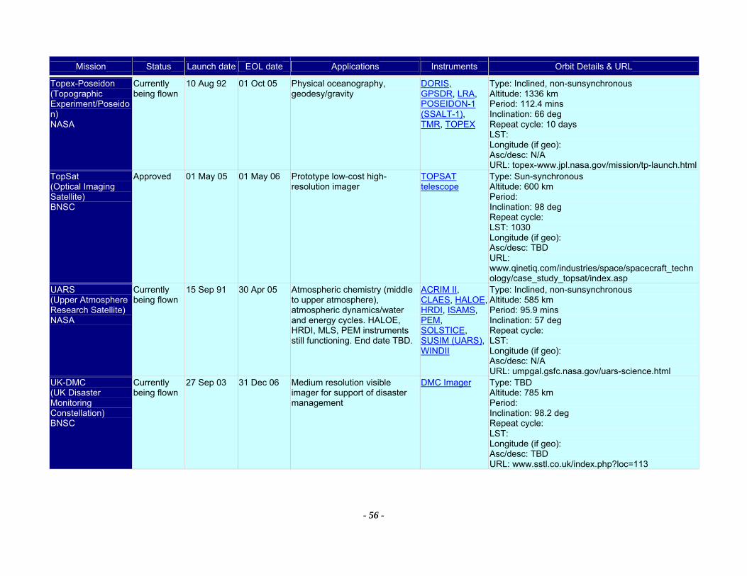
Mission Status Launch date EOL date Applications Instruments Orbit Details & URL
- 56 -
Topex-Poseidon (Topographic Experiment/Poseidon) NASA
Currently being flown
10 Aug 92 01 Oct 05 Physical oceanography, geodesy/gravity
DORIS, GPSDR, LRA, POSEIDON-1 (SSALT-1), TMR, TOPEX
Type: Inclined, non-sunsynchronous Altitude: 1336 km Period: 112.4 mins Inclination: 66 deg Repeat cycle: 10 days LST: Longitude (if geo): Asc/desc: N/A URL: topex-www.jpl.nasa.gov/mission/tp-launch.html
TopSat (Optical Imaging Satellite) BNSC
Approved 01 May 05 01 May 06 Prototype low-cost high-resolution imager
TOPSAT telescope
Type: Sun-synchronous Altitude: 600 km Period: Inclination: 98 deg Repeat cycle: LST: 1030 Longitude (if geo): Asc/desc: TBD URL: www.qinetiq.com/industries/space/spacecraft_technology/case_study_topsat/index.asp
UARS (Upper Atmosphere Research Satellite) NASA
Currently being flown
15 Sep 91 30 Apr 05 Atmospheric chemistry (middle to upper atmosphere), atmospheric dynamics/water and energy cycles. HALOE, HRDI, MLS, PEM instruments still functioning. End date TBD.
ACRIM II, CLAES, HALOE, HRDI, ISAMS, PEM, SOLSTICE, SUSIM (UARS), WINDII
Type: Inclined, non-sunsynchronous Altitude: 585 km Period: 95.9 mins Inclination: 57 deg Repeat cycle: LST: Longitude (if geo): Asc/desc: N/A URL: umpgal.gsfc.nasa.gov/uars-science.html
UK-DMC (UK Disaster Monitoring Constellation) BNSC
Currently being flown
27 Sep 03 31 Dec 06 Medium resolution visible imager for support of disaster management
DMC Imager Type: TBD Altitude: 785 km Period: Inclination: 98.2 deg Repeat cycle: LST: Longitude (if geo): Asc/desc: TBD URL: www.sstl.co.uk/index.php?loc=113
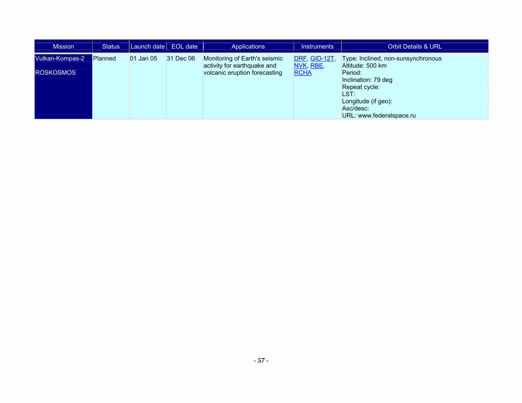
Mission Status Launch date EOL date Applications Instruments Orbit Details & URL
- 57 -
Vulkan-Kompas-2 ROSKOSMOS
Planned 01 Jan 05 31 Dec 06 Monitoring of Earth's seismic activity for earthquake and volcanic eruption forecasting
DRF, GID-12T, NVK, RBE, RCHA
Type: Inclined, non-sunsynchronous Altitude: 500 km Period: Inclination: 79 deg Repeat cycle: LST: Longitude (if geo): Asc/desc: URL: www.federalspace.ru
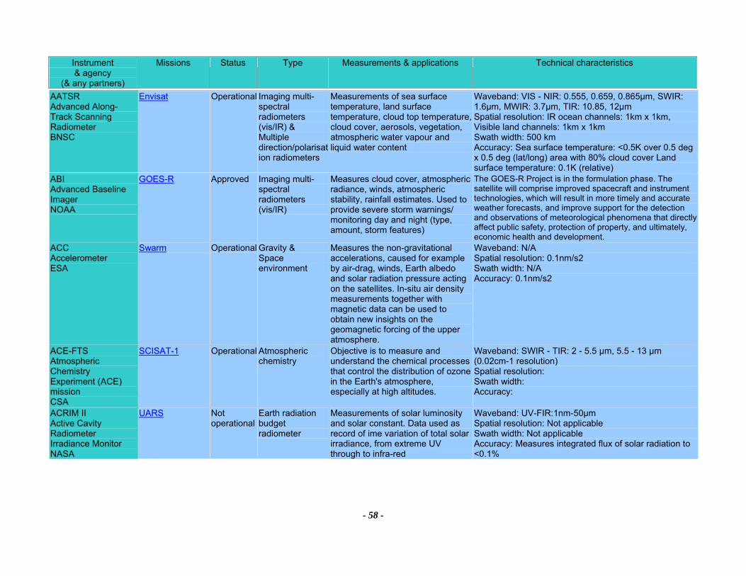
Instrument & agency
(& any partners)
Missions Status Type Measurements & applications Technical characteristics
- 58 -
AATSR Advanced Along-Track Scanning Radiometer BNSC
Envisat Operational Imaging multi-spectral radiometers (vis/IR) & Multiple direction/polarisation radiometers
Measurements of sea surface temperature, land surface temperature, cloud top temperature, cloud cover, aerosols, vegetation, atmospheric water vapour and liquid water content
Waveband: VIS - NIR: 0.555, 0.659, 0.865µm, SWIR: 1.6µm, MWIR: 3.7µm, TIR: 10.85, 12µm Spatial resolution: IR ocean channels: 1km x 1km, Visible land channels: 1km x 1km Swath width: 500 km Accuracy: Sea surface temperature: <0.5K over 0.5 deg x 0.5 deg (lat/long) area with 80% cloud cover Land surface temperature: 0.1K (relative)
ABI Advanced Baseline Imager NOAA
GOES-R Approved Imaging multi-spectral radiometers (vis/IR)
Measures cloud cover, atmospheric radiance, winds, atmospheric stability, rainfall estimates. Used to provide severe storm warnings/ monitoring day and night (type, amount, storm features)
The GOES-R Project is in the formulation phase. The satellite will comprise improved spacecraft and instrument technologies, which will result in more timely and accurate weather forecasts, and improve support for the detection and observations of meteorological phenomena that directly affect public safety, protection of property, and ultimately, economic health and development.
ACC Accelerometer ESA
Swarm Operational Gravity & Space environment
Measures the non-gravitational accelerations, caused for example by air-drag, winds, Earth albedo and solar radiation pressure acting on the satellites. In-situ air density measurements together with magnetic data can be used to obtain new insights on the geomagnetic forcing of the upper atmosphere.
Waveband: N/A Spatial resolution: 0.1nm/s2 Swath width: N/A Accuracy: 0.1nm/s2
ACE-FTS Atmospheric Chemistry Experiment (ACE) mission CSA
SCISAT-1 Operational Atmospheric chemistry
Objective is to measure and understand the chemical processes that control the distribution of ozone in the Earth's atmosphere, especially at high altitudes.
Waveband: SWIR - TIR: 2 - 5.5 µm, 5.5 - 13 µm (0.02cm-1 resolution) Spatial resolution: Swath width: Accuracy:
ACRIM II Active Cavity Radiometer Irradiance Monitor NASA
UARS Not operational
Earth radiation budget radiometer
Measurements of solar luminosity and solar constant. Data used as record of ime variation of total solar irradiance, from extreme UV through to infra-red
Waveband: UV-FIR:1nm-50µm Spatial resolution: Not applicable Swath width: Not applicable Accuracy: Measures integrated flux of solar radiation to <0.1%
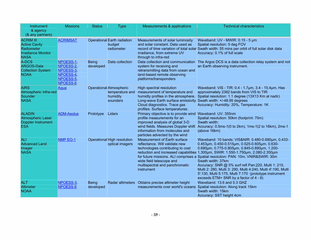
Instrument & agency
(& any partners)
Missions Status Type Measurements & applications Technical characteristics
- 59 -
ACRIM III Active Cavity Radiometer Irradiance Monitor NASA
ACRIMSAT Operational Earth radiation budget radiometer
Measurements of solar luminosity and solar constant. Data used as record of time variation of total solar irradiance, from extreme UV through to infra-red
Waveband: UV - MWIR: 0.15 - 5 µm Spatial resolution: 5 deg FOV Swath width: 55 mins per orbit of full solar disk data Accuracy: 0.1% of full scale
A-DCS ARGOS-Data Collection System NOAA
NPOESS-1, NPOESS-2, NPOESS-3, NPOESS-4, NPOESS-5, NPOESS-6
Being developed
Data collection Data collection and communication system for receiving and retransmitting data from ocean and land-based remote observing platforms/transponders
The Argos DCS is a data collection relay system and not an Earth observing instrument.
AIRS Atmospheric Infra-red Sounder NASA
Aqua Operational Atmospheric temperature and humidity sounders
High spectral resolution measurement of temperature and humidty profiles in the atmosphere. Long-wave Earth surface emissivity. Cloud diagnostics. Trace gas profiles. Surface temperatures.
Waveband: VIS - TIR: 0.4 - 1.7µm, 3.4 - 15.4µm, Has approximately 2382 bands from VIS to TIR Spatial resolution: 1.1 degree (13X13 Km at nadir) Swath width: +/-48.95 degrees Accuracy: Humidity: 20%, Temperature: 1K
ALADIN Atmospheric Laser Doppler Instrument ESA
ADM-Aeolus Prototype Lidars Primary objective is to provide wind profile measurements for an improved analysis of global 3-D wind fields. Measures Doppler shift information from molecules and particles advected by the wind
Waveband: UV: 355nm Spatial resolution: 50km (footprint: 70m) Swath width: Accuracy: 0.5ms-1(0 to 2km), 1ms-1(2 to 16km), 2ms-1 (above 16km)
ALI Advanced Land Imager NASA
NMP EO-1 Operational High resolution optical imagers
Measurement of Earth surface reflectance. Will validate new technologies contributing to cost reduction and increased capabilities for future missions. ALI comprises a wide field telescope and multispectral and panchromatic instrument
Waveband: 10 bands: VIS&NIR: 0.480-0.690µm, 0.433-0.453µm, 0.450-0.515µm, 0.525-0.605µm, 0.630-0.690µm, 0.775-0.805µm, 0.845-0.890µm, 1.200-1.300µm, SWIR: 1.550-1.750µm, 2.080-2.350µm Spatial resolution: PAN: 10m, VNIR&SWIR: 30m Swath width: 37km Accuracy: SNR @ 5% surf refl Pan:220, Multi 1: 215, Multi 2: 280, Multi 3: 290, Multi 4:240, Multi 4':190, Multi 5':130, Multi 5:175, Multi 7:170 (prototype instrument exceeds ETM+ SNR by a factor of 4 - 8)
ALT Altimeter NOAA
NPOESS-3, NPOESS-6
Being developed
Radar altimeters Obtains precise altimeter height measurements over world's oceans
Waveband: 13.6 and 5.3 GHZ Spatial resolution: Along track 15km Swath width: 15km Accuracy: SST height 4cm
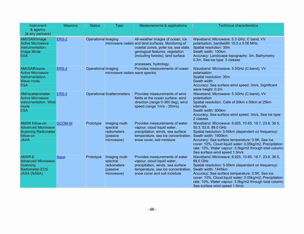
Instrument & agency
(& any partners)
Missions Status Type Measurements & applications Technical characteristics
- 60 -
AMI/SAR/Image Active Microwave Instrumentation. Image Mode ESA
ERS-2 Operational Imaging microwave radars
All-weather images of ocean, ice and land surfaces. Monitoring of coastal zones, polar ice, sea state, geological features, vegetation (including forests), land surface processes, hydrology.
Waveband: Microwave: 5.3 GHz, C band, VV polarisation, bandwidth 15.5 ± 0.06 MHz Spatial resolution: 30m Swath width: 100km Accuracy: Landscape topography: 3m, Bathymetry: 0.3m, Sea ice type: 3 classes
AMI/SAR/wave Active Microwave Instrumentation. Wave mode ESA
ERS-2 Operational Imaging microwave radars
Provides measurements of ocean wave spectra
Waveband: Microwave: 5.3GHz (C-band), VV polarisation Spatial resolution: 30m Swath width: Accuracy: Sea surface wind speed: 3m/s, Significant wave height: 0.2m
AMI/scatterometer Active Microwave Instrumentation. Wind mode ESA
ERS-2 Operational Scatterometers Provides measurements of wind fields at the ocean surface, wind direction (range 0-360 deg), wind speed (range 1m/s - 30m/s)
Waveband: Microwave: 5.3GHz (C-band), VV polarisation Spatial resolution: Cells of 50km x 50km at 25km intervals Swath width: 500km Accuracy: Sea surface wind speed: 3m/s, Sea ice type: 2 classes
AMSR follow-on Advanced Microwave Scanning Radiometer follow-on JAXA
GCOM-W Prototype Imaging multi-spectral radiometers (passive microwave)
Provides measurements of water vapour, cloud liquid water, precipitation, winds, sea surface temperature, sea ice concentration, snow cover, soil moisture
Waveband: Microwave: 6.925, 10.65, 18.7, 23.8, 36.5, 50.3, 52.8, 89.0 GHz Spatial resolution: 5-50km (dependent on frequency) Swath width: 1600km Accuracy: Sea surface temparature: 0.5K, Sea ice cover: 10%, Cloud liquid water: 0.05kg/m2, Precipitation rate: 10%, Water vapour: 3.5kg/m2 through total column, Sea surface wind speed 1.5m/s
AMSR-E Advanced Microwave Scanning Radiometer-EOS JAXA (NASA)
Aqua Prototype Imaging multi-spectral radiometers (passive microwave)
Provides measurements of water vapour, cloud liquid water, precipitation, winds, sea surface temperature, sea ice concentration, snow cover and soil moisture
Waveband: Microwave: 6.925, 10.65, 18.7, 23.8, 36.5, 89.0 GHz Spatial resolution: 5-50km (dependent on frequency) Swath width: 1445km Accuracy: Sea surface temparature: 0.5K, Sea ice cover: 10%, Cloud liquid water: 0.05kg/m2, Precipitation rate: 10%, Water vapour: 3.5kg/m2 through total column, Sea surface wind speed 1.5m/s
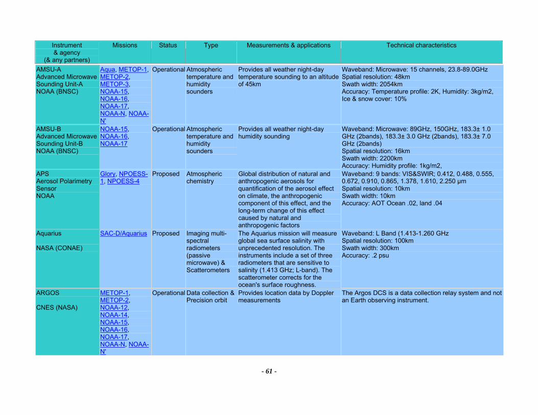
Instrument & agency
(& any partners)
Missions Status Type Measurements & applications Technical characteristics
- 61 -
AMSU-A Advanced Microwave Sounding Unit-A NOAA (BNSC)
Aqua, METOP-1, METOP-2, METOP-3, NOAA-15, NOAA-16, NOAA-17, NOAA-N, NOAA-N'
Operational Atmospheric temperature and humidity sounders
Provides all weather night-day temperature sounding to an altitude of 45km
Waveband: Microwave: 15 channels, 23.8-89.0GHz Spatial resolution: 48km Swath width: 2054km Accuracy: Temperature profile: 2K, Humidity: 3kg/m2, Ice & snow cover: 10%
AMSU-B Advanced Microwave Sounding Unit-B NOAA (BNSC)
NOAA-15, NOAA-16, NOAA-17
Operational Atmospheric temperature and humidity sounders
Provides all weather night-day humidity sounding
Waveband: Microwave: 89GHz, 150GHz, 183.3± 1.0 GHz (2bands), 183.3± 3.0 GHz (2bands), 183.3± 7.0 GHz (2bands) Spatial resolution: 16km Swath width: 2200km Accuracy: Humidity profile: 1kg/m2,
APS Aerosol Polarimetry Sensor NOAA
Glory, NPOESS-1, NPOESS-4
Proposed Atmospheric chemistry
Global distribution of natural and anthropogenic aerosols for quantification of the aerosol effect on climate, the anthropogenic component of this effect, and the long-term change of this effect caused by natural and anthropogenic factors
Waveband: 9 bands: VIS&SWIR; 0.412, 0.488, 0.555, 0.672, 0.910, 0.865, 1.378, 1.610, 2.250 µm Spatial resolution: 10km Swath width: 10km Accuracy: AOT Ocean .02, land .04
Aquarius NASA (CONAE)
SAC-D/Aquarius Proposed Imaging multi-spectral radiometers (passive microwave) & Scatterometers
The Aquarius mission will measure global sea surface salinity with unprecedented resolution. The instruments include a set of three radiometers that are sensitive to salinity (1.413 GHz; L-band). The scatterometer corrects for the ocean's surface roughness.
Waveband: L Band (1.413-1.260 GHz Spatial resolution: 100km Swath width: 300km Accuracy: .2 psu
ARGOS CNES (NASA)
METOP-1, METOP-2, NOAA-12, NOAA-14, NOAA-15, NOAA-16, NOAA-17, NOAA-N, NOAA-N'
Operational Data collection &Precision orbit
Provides location data by Doppler measurements
The Argos DCS is a data collection relay system and not an Earth observing instrument.
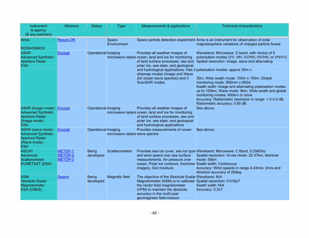
Instrument & agency
(& any partners)
Missions Status Type Measurements & applications Technical characteristics
- 62 -
Arina ROSKOSMOS
Resurs DK Space Environment
Space particle detection experiment Arina is an instrument for observation of solar magnetosphere variations of charged particle fluxes.
ASAR Advanced Synthetic-Aperture Radar ESA
Envisat Operational Imaging microwave radars
Provides all weather images of ocean, land and ice for monitoring of land surface processes, sea and polar ice, sea state, and geological and hydrological applications. Has 2 stripmap modes (Image and Wave (for ocean wave spectra)) and 3 ScanSAR modes
Waveband: Microwave: C-band, with choice of 5 polarisation modes (VV, HH, VV/HH, HV/HH, or VH/VV)Spatial resolution: Image, wave and alternating polarisation modes: approx 30m x 30m, Wide swath mode: 150m x 150m, Global monitoring mode: 950mm x 950m Swath width: Image and alternating polarisation modes: up to 100km, Wave mode: 5km, Wide swath and global monitoring modes: 400km or more Accuracy: Radiometric resolution in range: 1.5-3.5 dB, Radiometric accuracy: 0.65 dB
ASAR (image mode) Advanced Synthetic Aperture Radar (Image mode) ESA
Envisat Operational Imaging microwave radars
Provides all weather images of ocean, land and ice for monitoring of land surface processes, sea and polar ice, sea state, and geological and hydrological applications
See above.
ASAR (wave mode) Advanced Synthetic Aperture Radar (Wave mode) ESA
Envisat Operational Imaging microwave radars
Provides measurements of ocean wave spectra
See above.
ASCAT Advanced Scatterometer EUMETSAT (ESA)
METOP-1, METOP-2, METOP-3
Being developed
Scatterometers Provides sea ice cover, sea ice type and wind speed over sea surface measurements. Air pressure over ocean, Polar ice contours, Ice/snow imagery, Soil moisture.
Waveband: Microwave: C Band, 5.256Ghz Spatial resolution: Hi-res mode: 25-37km, Nominal mode: 50km Swath width: Continuous Accuracy: Wind speeds in range 4-24m/s: 2m/s and direction accuracy of 20deg
ASM Absolute Scalar Magnetometer ESA (CNES)
Swarm Being developed
Magnetic field The objective of the Absolute Scalar Magnetometer (ASM) is to calibrate the vector field magnetometer (VFM) to maintain the absolute accuracy in the multi-year geomagnetic field mission.
Waveband: N/A Spatial resolution: 0.016pT Swath width: N/A Accuracy: 0.3nT

Instrument & agency
(& any partners)
Missions Status Type Measurements & applications Technical characteristics
- 63 -
ASTER Advanced Spaceborne Thermal Emission and Reflection Radiometer METI (Japan) (NASA)
Terra Operational High resolution optical imagers
Surface and cloud imaging with high spatial resolution, stereoscopic observation of local topography, cloud heights, volcanic plumes, and generation of local surface digital elevation maps. Surface temperature and emissivity
Waveband: VIS&NIR: 3 bands in 0.52-0.86µm, SWIR: 6 bands in 1.6-2.43µm, TIR: 5 bands in 8.125-11.65µm Spatial resolution: VNIR: 15m, stereo: 15m horizontally and 25m vertical, SWIR: 30m, TIR: 90m Swath width: 60km Accuracy: VNIR and SWIR: 4% (absolute), TIR: 4K, Geolocation: 7m
ATLID ATmospheric LIDar ESA
ESA Future Missions
Prototype Lidars Provides measurements of cloud top heights, aerosol properties, troposphere height, vertical distribution of cloud, boundary layer height.
Waveband: UV: 355nm Spatial resolution: footprint: 30m Swath width: Nadir Accuracy: Detection of cirrus cloud with optical thickness 1 with 15% error
ATMS Advanced Technology Microwave Sounder NOAA (NASA)
NPOESS-2, NPOESS-5, NPP
Approved Atmospheric temperature and humidity sounders
Collects microwave radiance data that when combined with the CrIS data will permit calculation of atmospheric temperature and water vapor profiles.
Waveband: Microwave: 22 bands, 23-184 GHz Spatial resolution: 5.2 deg - 1.1 deg Swath width: 2300 km Accuracy: 0.75 K - 3.60 K
ATSR/M CNES
ERS-2 Operational Imaging multi-spectral radiometers (passive microwave)
Part of the ATSR payload on board ERS1 and ERS2
See ATSR-2.
ATSR-2 Along Track Scanning Radiometer - 2 BNSC (CSIRO)
ERS-2 Operational Imaging multi-spectral radiometers (vis/IR) & Multiple direction/polarisation radiometers
Provides measurements of sea surface temperature, land surface temperature, cloud top temperature and cloud cover, aerosols, vegetation, atmospheric water vapour and liquid water content
Waveband: VIS-SWIR: 0.65, 0.85, 1.27, and 1.6µm, SWIR-TIR: 1.6, 3.7, 11 and 12µm, Microwave: 23.8, 36.5GHz (bandwidth of 400MHz) Spatial resolution: IR ocean channels: 1km x 1km, Microwave near-nadir viewing: 20km instantaneous field of view Swath width: 500km Accuracy: Sea surface temperature to <0.5K over 0.5 deg x 0.5 deg (lat/long) area with 80% cloud cover, Land surface temperature: 0.1K
AVHRR/2 Advanced Very High Resolution Radiometer/2 NOAA
NOAA-12, NOAA-14
Operational Imaging multi-spectral radiometers (vis/IR)
Provides measurements of land and sea surface temperature, cloud cover, snow and ice cover, soil moisture and vegetation indices. Data also used for volcanic eruption monitoring
Waveband: VIS: 0.58-0.68µm, NIR: 0.725-1.1µm, MWIR: 3.55-3.93µm, TIR: 10.3-11.3µm, 11.5-12.5µm Spatial resolution: 1.1km Swath width: 3000km approx Accuracy:
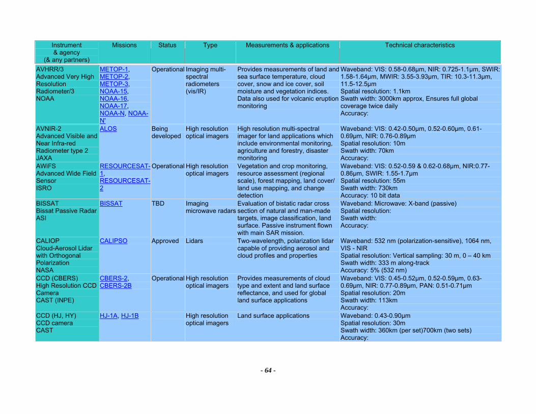
Instrument & agency
(& any partners)
Missions Status Type Measurements & applications Technical characteristics
- 64 -
AVHRR/3 Advanced Very High Resolution Radiometer/3 NOAA
METOP-1, METOP-2, METOP-3, NOAA-15, NOAA-16, NOAA-17, NOAA-N, NOAA-N'
Operational Imaging multi-spectral radiometers (vis/IR)
Provides measurements of land and sea surface temperature, cloud cover, snow and ice cover, soil moisture and vegetation indices. Data also used for volcanic eruption monitoring
Waveband: VIS: 0.58-0.68µm, NIR: 0.725-1.1µm, SWIR: 1.58-1.64µm, MWIR: 3.55-3.93µm, TIR: 10.3-11.3µm, 11.5-12.5µm Spatial resolution: 1.1km Swath width: 3000km approx, Ensures full global coverage twice daily Accuracy:
AVNIR-2 Advanced Visible and Near Infra-red Radiometer type 2 JAXA
ALOS Being developed
High resolution optical imagers
High resolution multi-spectral imager for land applications which include environmental monitoring, agriculture and forestry, disaster monitoring
Waveband: VIS: 0.42-0.50µm, 0.52-0.60µm, 0.61-0.69µm, NIR: 0.76-0.89µm Spatial resolution: 10m Swath width: 70km Accuracy:
AWiFS Advanced Wide Field Sensor ISRO
RESOURCESAT-1, RESOURCESAT-2
Operational High resolution optical imagers
Vegetation and crop monitoring, resource assessment (regional scale), forest mapping, land cover/ land use mapping, and change detection
Waveband: VIS: 0.52-0.59 & 0.62-0.68µm, NIR:0.77-0.86µm, SWIR: 1.55-1.7µm Spatial resolution: 55m Swath width: 730km Accuracy: 10 bit data
BISSAT Bissat Passive Radar ASI
BISSAT TBD Imaging microwave radars
Evaluation of bistatic radar cross section of natural and man-made targets, image classification, land surface. Passive instrument flown with main SAR mission.
Waveband: Microwave: X-band (passive) Spatial resolution: Swath width: Accuracy:
CALIOP Cloud-Aerosol Lidar with Orthogonal Polarization NASA
CALIPSO Approved Lidars Two-wavelength, polarization lidar capable of providing aerosol and cloud profiles and properties
Waveband: 532 nm (polarization-sensitive), 1064 nm, VIS - NIR Spatial resolution: Vertical sampling: 30 m, 0 – 40 km Swath width: 333 m along-track Accuracy: 5% (532 nm)
CCD (CBERS) High Resolution CCD Camera CAST (INPE)
CBERS-2, CBERS-2B
Operational High resolution optical imagers
Provides measurements of cloud type and extent and land surface reflectance, and used for global land surface applications
Waveband: VIS: 0.45-0.52µm, 0.52-0.59µm, 0.63-0.69µm, NIR: 0.77-0.89µm, PAN: 0.51-0.71µm Spatial resolution: 20m Swath width: 113km Accuracy:
CCD (HJ, HY) CCD camera CAST
HJ-1A, HJ-1B High resolution optical imagers
Land surface applications Waveband: 0.43-0.90µm Spatial resolution: 30m Swath width: 360km (per set)700km (two sets) Accuracy:
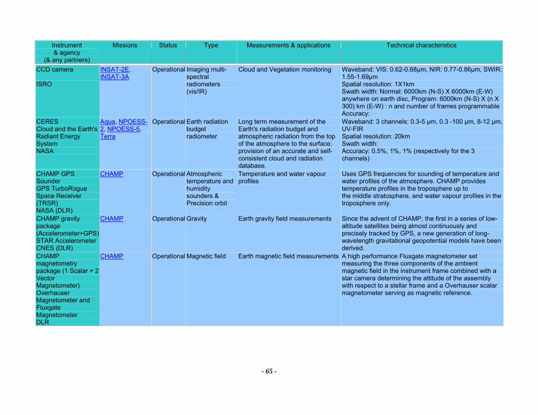
Instrument & agency
(& any partners)
Missions Status Type Measurements & applications Technical characteristics
- 65 -
CCD camera ISRO
INSAT-2E, INSAT-3A
Operational Imaging multi-spectral radiometers (vis/IR)
Cloud and Vegetation monitoring Waveband: VIS: 0.62-0.68µm, NIR: 0.77-0.86µm, SWIR: 1.55-1.69µm Spatial resolution: 1X1km Swath width: Normal: 6000km (N-S) X 6000km (E-W) anywhere on earth disc, Program: 6000km (N-S) X (n X 300) km (E-W) : n and number of frames programmableAccuracy:
CERES Cloud and the Earth's Radiant Energy System NASA
Aqua, NPOESS-2, NPOESS-5, Terra
Operational Earth radiation budget radiometer
Long term measurement of the Earth's radiation budget and atmospheric radiation from the top of the atmosphere to the surface; provision of an accurate and self-consistent cloud and radiation database.
Waveband: 3 channels: 0.3-5 µm, 0.3 -100 µm, 8-12 µm, UV-FIR Spatial resolution: 20km Swath width: Accuracy: 0.5%, 1%, 1% (respectively for the 3 channels)
CHAMP GPS Sounder GPS TurboRogue Space Receiver (TRSR) NASA (DLR)
CHAMP Operational Atmospheric temperature and humidity sounders & Precision orbit
Temperature and water vapour profiles
Uses GPS frequencies for sounding of temperature and water profiles of the atmosphere. CHAMP provides temperature profiles in the troposphere up to the middle stratosphere, and water vapour profiles in the troposphere only.
CHAMP gravity package (Accelerometer+GPS) STAR Accelerometer CNES (DLR)
CHAMP Operational Gravity Earth gravity field measurements Since the advent of CHAMP, the first in a series of low-altitude satellites being almost continuously and precisely tracked by GPS, a new generation of long-wavelength gravitational geopotential models have been derived.
CHAMP magnetometry package (1 Scalar + 2 Vector Magnetometer) Overhauser Magnetometer and Fluxgate Magnetometer DLR
CHAMP Operational Magnetic field Earth magnetic field measurements A high performance Fluxgate magnetometer set measuring the three components of the ambient magnetic field in the instrument frame combined with a star camera determining the attitude of the assembly with respect to a stellar frame and a Overhauser scalar magnetometer serving as magnetic reference.
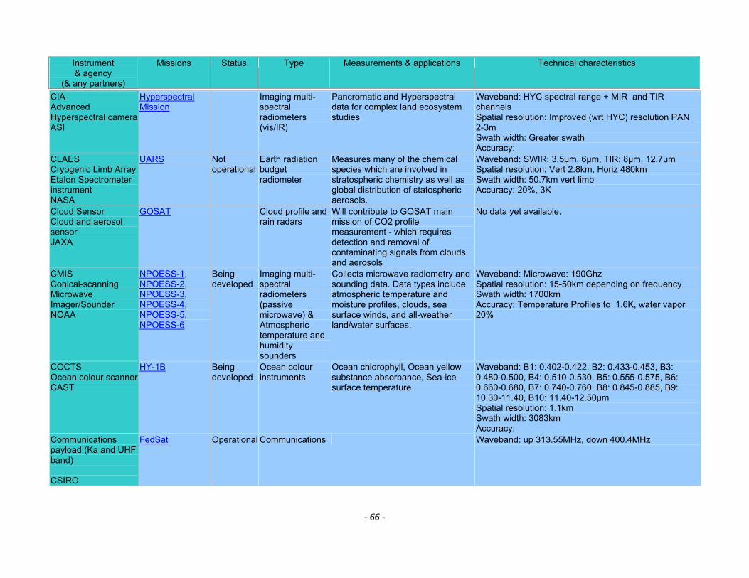
Instrument & agency
(& any partners)
Missions Status Type Measurements & applications Technical characteristics
- 66 -
CIA Advanced Hyperspectral camera ASI
Hyperspectral Mission
Imaging multi-spectral radiometers (vis/IR)
Pancromatic and Hyperspectral data for complex land ecosystem studies
Waveband: HYC spectral range + MIR and TIR channels Spatial resolution: Improved (wrt HYC) resolution PAN 2-3m Swath width: Greater swath Accuracy:
CLAES Cryogenic Limb Array Etalon Spectrometer instrument NASA
UARS Not operational
Earth radiation budget radiometer
Measures many of the chemical species which are involved in stratospheric chemistry as well as global distribution of statospheric aerosols.
Waveband: SWIR: 3.5µm, 6µm, TIR: 8µm, 12.7µm Spatial resolution: Vert 2.8km, Horiz 480km Swath width: 50.7km vert limb Accuracy: 20%, 3K
Cloud Sensor Cloud and aerosol sensor JAXA
GOSAT Cloud profile and rain radars
Will contribute to GOSAT main mission of CO2 profile measurement - which requires detection and removal of contaminating signals from clouds and aerosols
No data yet available.
CMIS Conical-scanning Microwave Imager/Sounder NOAA
NPOESS-1, NPOESS-2, NPOESS-3, NPOESS-4, NPOESS-5, NPOESS-6
Being developed
Imaging multi-spectral radiometers (passive microwave) & Atmospheric temperature and humidity sounders
Collects microwave radiometry and sounding data. Data types include atmospheric temperature and moisture profiles, clouds, sea surface winds, and all-weather land/water surfaces.
Waveband: Microwave: 190Ghz Spatial resolution: 15-50km depending on frequency Swath width: 1700km Accuracy: Temperature Profiles to 1.6K, water vapor 20%
COCTS Ocean colour scanner CAST
HY-1B Being developed
Ocean colour instruments
Ocean chlorophyll, Ocean yellow substance absorbance, Sea-ice surface temperature
Waveband: B1: 0.402-0.422, B2: 0.433-0.453, B3: 0.480-0.500, B4: 0.510-0.530, B5: 0.555-0.575, B6: 0.660-0.680, B7: 0.740-0.760, B8: 0.845-0.885, B9: 10.30-11.40, B10: 11.40-12.50µm Spatial resolution: 1.1km Swath width: 3083km Accuracy:
Communications payload (Ka and UHF band) CSIRO
FedSat Operational Communications Waveband: up 313.55MHz, down 400.4MHz
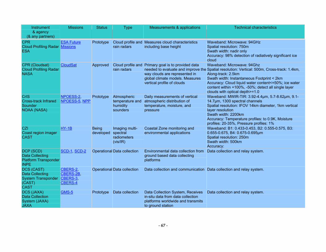
Instrument & agency
(& any partners)
Missions Status Type Measurements & applications Technical characteristics
- 67 -
CPR Cloud Profiling Radar ESA
ESA Future Missions
Prototype Cloud profile and rain radars
Measures cloud characteristics including base height
Waveband: Microwave: 94GHz Spatial resolution: 750m Swath width: nadir only Accuracy: 98% detection of radiatively significant ice cloud
CPR (Cloudsat) Cloud Profiling Radar NASA
CloudSat Approved Cloud profile and rain radars
Primary goal is to provided data needed to evaluate and improve the way clouds are represented in global climate models. Measures vertical profile of clouds
Waveband: Microwave: 94Ghz Spatial resolution: Vertical: 500m, Cross-track: 1.4km, Along-track: 2.5km Swath width: Instantaneous Footprint < 2km Accuracy: Cloud liquid water content<=50%; ice water content within +100%, -50%; detect all single layer clouds with optical depth>=1.0
CrIS Cross-track Infrared Sounder NOAA (NASA)
NPOESS-2, NPOESS-5, NPP
Prototype Atmospheric temperature and humidity sounders
Daily measurements of vertical atmospheric distribution of temperature, moisture, and pressure
Waveband: MWIR-TIR: 3.92-4.4µm, 5.7-8.62µm, 9.1-14.7µm, 1300 spectral channels Spatial resolution: IFOV 14km diameter, 1km vertical layer resolution Swath width: 2200km Accuracy: Temperature profiles: to 0.9K, Moisture profiles: 20-35%, Pressure profiles: 1%
CZI Coast region imager CAST
HY-1B Being developed
Imaging multi-spectral radiometers (vis/IR)
Coastal Zone monitoring and environmental applications
Waveband: B1: 0.433-0.453, B2: 0.555-0.575, B3: 0.655-0.675, B4: 0.675-0.695μm Spatial resolution: 250m Swath width: 500km Accuracy:
DCP (SCD) Data Collecting Platform Transponder INPE
SCD-1, SCD-2 Operational Data collection Environmental data collection from ground based data collecting platforms
Data collection and relay system.
DCS (CAST) Data Collecting System Transponder (CAST) CAST
CBERS-2, CBERS-2B, CBERS-3, CBERS-4
Operational Data collection Data collection and communication Data collection and relay system.
DCS (JAXA) Data Collection System (JAXA) JAXA
GMS-5 Prototype Data collection Data Collection System, Receives in-situ data from data collection platforms worldwide and transmits to ground station
Data collection and relay system.
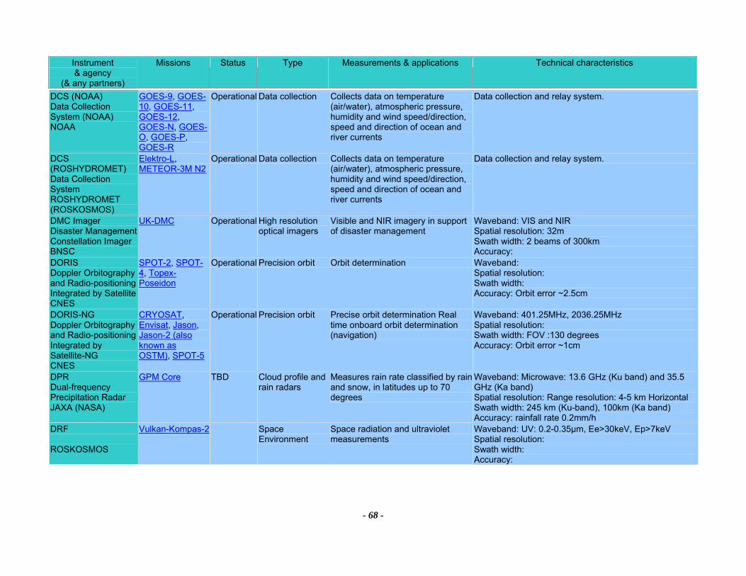
Instrument & agency
(& any partners)
Missions Status Type Measurements & applications Technical characteristics
- 68 -
DCS (NOAA) Data Collection System (NOAA) NOAA
GOES-9, GOES-10, GOES-11, GOES-12, GOES-N, GOES-O, GOES-P, GOES-R
Operational Data collection Collects data on temperature (air/water), atmospheric pressure, humidity and wind speed/direction, speed and direction of ocean and river currents
Data collection and relay system.
DCS (ROSHYDROMET) Data Collection System ROSHYDROMET (ROSKOSMOS)
Elektro-L, METEOR-3M N2
Operational Data collection Collects data on temperature (air/water), atmospheric pressure, humidity and wind speed/direction, speed and direction of ocean and river currents
Data collection and relay system.
DMC Imager Disaster Management Constellation Imager BNSC
UK-DMC Operational High resolution optical imagers
Visible and NIR imagery in support of disaster management
Waveband: VIS and NIR Spatial resolution: 32m Swath width: 2 beams of 300km Accuracy:
DORIS Doppler Orbitography and Radio-positioning Integrated by Satellite CNES
SPOT-2, SPOT-4, Topex-Poseidon
Operational Precision orbit Orbit determination Waveband: Spatial resolution: Swath width: Accuracy: Orbit error ~2.5cm
DORIS-NG Doppler Orbitography and Radio-positioning Integrated by Satellite-NG CNES
CRYOSAT, Envisat, Jason, Jason-2 (also known as OSTM), SPOT-5
Operational Precision orbit Precise orbit determination Real time onboard orbit determination (navigation)
Waveband: 401.25MHz, 2036.25MHz Spatial resolution: Swath width: FOV :130 degrees Accuracy: Orbit error ~1cm
DPR Dual-frequency Precipitation Radar JAXA (NASA)
GPM Core TBD Cloud profile and rain radars
Measures rain rate classified by rain and snow, in latitudes up to 70 degrees
Waveband: Microwave: 13.6 GHz (Ku band) and 35.5 GHz (Ka band) Spatial resolution: Range resolution: 4-5 km Horizontal Swath width: 245 km (Ku-band), 100km (Ka band) Accuracy: rainfall rate 0.2mm/h
DRF ROSKOSMOS
Vulkan-Kompas-2 Space Environment
Space radiation and ultraviolet measurements
Waveband: UV: 0.2-0.35µm, Ee>30keV, Ep>7keV Spatial resolution: Swath width: Accuracy:
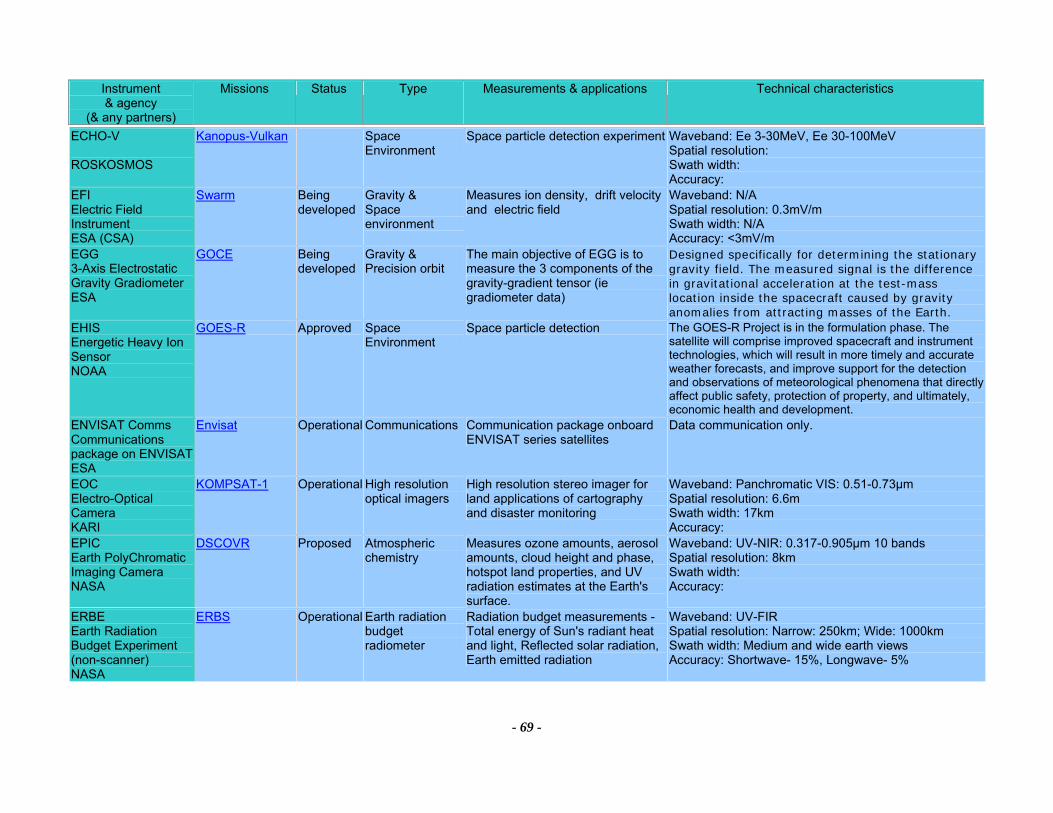
Instrument & agency
(& any partners)
Missions Status Type Measurements & applications Technical characteristics
- 69 -
ECHO-V ROSKOSMOS
Kanopus-Vulkan Space Environment
Space particle detection experiment Waveband: Ee 3-30MeV, Ee 30-100MeV Spatial resolution: Swath width: Accuracy:
EFI Electric Field Instrument ESA (CSA)
Swarm Being developed
Gravity & Space environment
Measures ion density, drift velocity and electric field
Waveband: N/A Spatial resolution: 0.3mV/m Swath width: N/A Accuracy: <3mV/m
EGG 3-Axis Electrostatic Gravity Gradiometer ESA
GOCE Being developed
Gravity & Precision orbit
The main objective of EGG is to measure the 3 components of the gravity-gradient tensor (ie gradiometer data)
Designed specifically for determining the stationary gravity field. The measured signal is the difference in gravitational acceleration at the test-mass location inside the spacecraft caused by gravity anomalies from attracting masses of the Earth.
EHIS Energetic Heavy Ion Sensor NOAA
GOES-R Approved Space Environment
Space particle detection The GOES-R Project is in the formulation phase. The satellite will comprise improved spacecraft and instrument technologies, which will result in more timely and accurate weather forecasts, and improve support for the detection and observations of meteorological phenomena that directly affect public safety, protection of property, and ultimately, economic health and development.
ENVISAT Comms Communications package on ENVISAT ESA
Envisat Operational Communications Communication package onboard ENVISAT series satellites
Data communication only.
EOC Electro-Optical Camera KARI
KOMPSAT-1 Operational High resolution optical imagers
High resolution stereo imager for land applications of cartography and disaster monitoring
Waveband: Panchromatic VIS: 0.51-0.73µm Spatial resolution: 6.6m Swath width: 17km Accuracy:
EPIC Earth PolyChromatic Imaging Camera NASA
DSCOVR Proposed Atmospheric chemistry
Measures ozone amounts, aerosol amounts, cloud height and phase, hotspot land properties, and UV radiation estimates at the Earth's surface.
Waveband: UV-NIR: 0.317-0.905µm 10 bands Spatial resolution: 8km Swath width: Accuracy:
ERBE Earth Radiation Budget Experiment (non-scanner) NASA
ERBS Operational Earth radiation budget radiometer
Radiation budget measurements - Total energy of Sun's radiant heat and light, Reflected solar radiation, Earth emitted radiation
Waveband: UV-FIR Spatial resolution: Narrow: 250km; Wide: 1000km Swath width: Medium and wide earth views Accuracy: Shortwave- 15%, Longwave- 5%

Instrument & agency
(& any partners)
Missions Status Type Measurements & applications Technical characteristics
- 70 -
ERBS Earth Radiation Budget Sensor NOAA
NPOESS-3, NPOESS-6
TBD Earth radiation budget radiometer
Measures Earth radiation gains and losses on regional, zonal and global scales
Waveband: 0.3-50µm Spatial resolution: 25km Swath width: 2200Km Accuracy: DLR/DSR10 watts/m2net solar 3w/m2OLR 5w/m2
ERS Comms Communication package for ERS ESA
ERS-2 Operational Communications Communication package onboard ERS series satellites
Data communication only.
ETM+ Enhanced Thematic Mapper Plus USGS
Landsat-7 Operational Imaging multi-spectral radiometers (vis/IR)
Measures surface radiance and emittance, land cover state and change (eg vegetation type). Used as multi-purpose imagery for land applications
Waveband: VIS-TIR: 8 channels: 0.45-12.5µm, Panchromatic channel: VIS 0.5-0.9µm Spatial resolution: Pan: 15m, Vis-SWIR: 30m, TIR: 60mSwath width: 185km Accuracy: 50-250m systematically corrected geodetic accuracy
EUVS Extreme Ultraviolet Sensor NOAA
GOES-R Approved Other Solar EUV radiation is a dominant energy source for the upper atmosphere and the ionizing radiation produces the ionosphere. Solar variability at these wavelengths is one of the primary drivers of thermospheric/ ionospheric variability. EUVS will measure this radiation.
The GOES-R Project is in the formulation phase. The satellite will comprise improved spacecraft and instrument technologies, which will result in more timely and accurate weather forecasts, and improve support for the detection and observations of meteorological phenomena that directly affect public safety, protection of property, and ultimately, economic health and development.
Fluxgate magnetometer CRCSS
FedSat Approved Magnetic field Measures electrical currents and perturbations in the Earth's magnetic field in the range 0.1Hz to 1kHz.
A high precision instrument designed to measure magnetic fields at all latitudes at an 800 km altitude over a range of ±65,000 nT.
GALS-M Galactic space rays detector ROSHYDROMET
Meteor-M No1, Meteor-M No2
TBD Space Environment
Space environment monitoring Waveband: protons fluxes density > 600 MeV Spatial resolution: Swath width: Accuracy:
Geomicrowave sounder NOAA
GOES-R Approved Atmospheric temperature and humidity sounders
For geo oribit, will provides atmospheric soundings and data on atmospheric stability and thermal gradient winds
The GOES-R Project is in the formulation phase. The satellite will comprise improved spacecraft and instrument technologies, which will result in more timely and accurate weather forecasts, and improve support for the detection and observations of meteorological phenomena that directly affect public safety, protection of property, and ultimately, economic health and development.
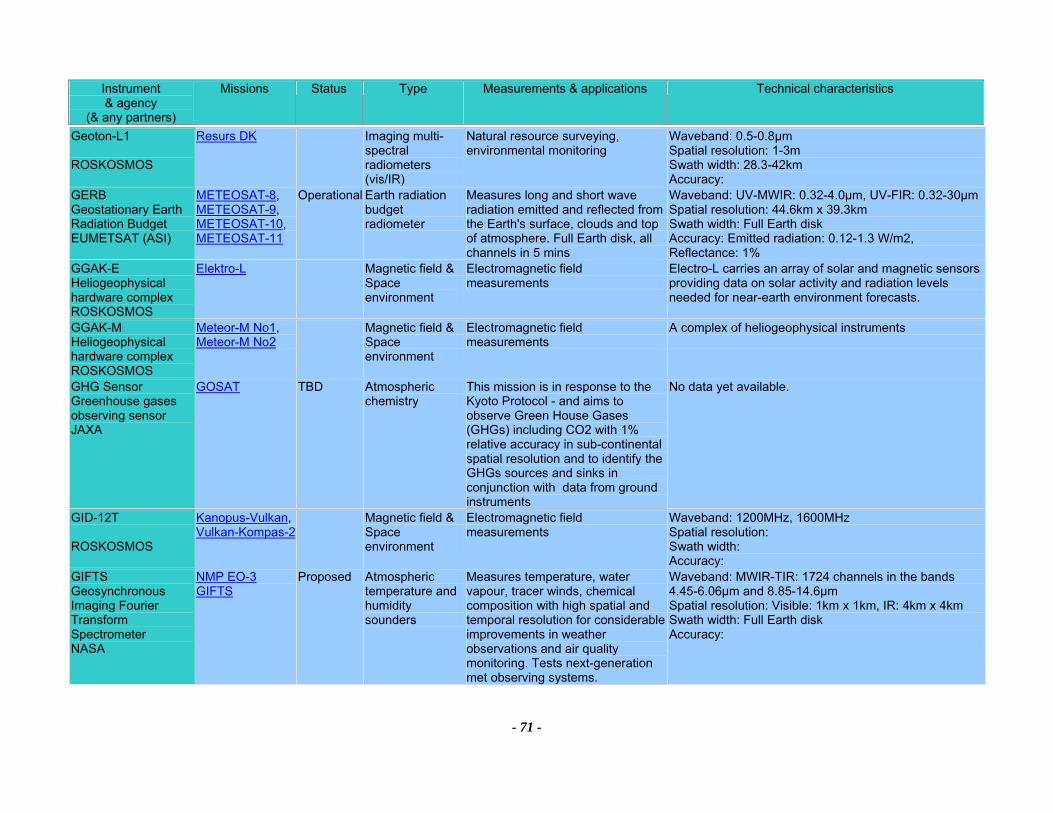
Instrument & agency
(& any partners)
Missions Status Type Measurements & applications Technical characteristics
- 71 -
Geoton-L1 ROSKOSMOS
Resurs DK Imaging multi-spectral radiometers (vis/IR)
Natural resource surveying, environmental monitoring
Waveband: 0.5-0.8µm Spatial resolution: 1-3m Swath width: 28.3-42km Accuracy:
GERB Geostationary Earth Radiation Budget EUMETSAT (ASI)
METEOSAT-8, METEOSAT-9, METEOSAT-10, METEOSAT-11
Operational Earth radiation budget radiometer
Measures long and short wave radiation emitted and reflected from the Earth's surface, clouds and top of atmosphere. Full Earth disk, all channels in 5 mins
Waveband: UV-MWIR: 0.32-4.0µm, UV-FIR: 0.32-30µmSpatial resolution: 44.6km x 39.3km Swath width: Full Earth disk Accuracy: Emitted radiation: 0.12-1.3 W/m2, Reflectance: 1%
GGAK-E Heliogeophysical hardware complex ROSKOSMOS
Elektro-L Magnetic field &Space environment
Electromagnetic field measurements
Electro-L carries an array of solar and magnetic sensors providing data on solar activity and radiation levels needed for near-earth environment forecasts.
GGAK-M Heliogeophysical hardware complex ROSKOSMOS
Meteor-M No1, Meteor-M No2
Magnetic field &Space environment
Electromagnetic field measurements
A complex of heliogeophysical instruments
GHG Sensor Greenhouse gases observing sensor JAXA
GOSAT TBD Atmospheric chemistry
This mission is in response to the Kyoto Protocol - and aims to observe Green House Gases (GHGs) including CO2 with 1% relative accuracy in sub-continental spatial resolution and to identify the GHGs sources and sinks in conjunction with data from ground instruments
No data yet available.
GID-12T ROSKOSMOS
Kanopus-Vulkan, Vulkan-Kompas-2
Magnetic field &Space environment
Electromagnetic field measurements
Waveband: 1200MHz, 1600MHz Spatial resolution: Swath width: Accuracy:
GIFTS Geosynchronous Imaging Fourier Transform Spectrometer NASA
NMP EO-3 GIFTS
Proposed Atmospheric temperature and humidity sounders
Measures temperature, water vapour, tracer winds, chemical composition with high spatial and temporal resolution for considerable improvements in weather observations and air quality monitoring. Tests next-generation met observing systems.
Waveband: MWIR-TIR: 1724 channels in the bands 4.45-6.06µm and 8.85-14.6µm Spatial resolution: Visible: 1km x 1km, IR: 4km x 4km Swath width: Full Earth disk Accuracy:

Instrument & agency
(& any partners)
Missions Status Type Measurements & applications Technical characteristics
- 72 -
GLAS Geoscience Laser Altimeter System NASA
ICESat Operational Lidars Provision of data on ice sheet height/thickness, land altitude, aerosol height distributions, cloud height and boundary layer height
Waveband: VIS-NIR: Laser emits at 1064nm (for altimetry) and 532nm (for atmospheric measurements) Spatial resolution: 66m spots separated by 170m Swath width: N/A Accuracy: Aerosol profile: 20%, Ice elevation: 20cm, Cloud top height: 75m, Land elevation: 20cm, geoid: 5m
GLI follow-on Global Imager follow-on JAXA
GCOM-C Prototype Imaging multi-spectral radiometers (vis/IR) & Ocean colour instruments
Measures water vapour, aerosols, cloud cover, cloud top height/temp, ocean colour, sea surface temperature, land surface temparature, glacier extent, icebergs, sea ice and snow cover, photosynthetically active radiation, vegetation type and land cover
Waveband: VIS&NIR: 23 bands (380-830nm), NIR-SWIR: 6 bands (1050-2215nm), MWIR-TIR: 7 bands (3.75-11.95µm) Spatial resolution: 1km for 28 bands, 250m for 6 bands Swath width: 1600km Accuracy: Specific humidity profile: 0.5g/m2 through total column, Surface temp 0.4-0.5K, Cloud top temp: 0.5K, Cloud cover: 3%, Cloud top height: 0.5km, Ice and snow cover: 5%
GLM GEO Lightning Mapper NOAA
GOES-R Approved Lightning imager The GOES-R Project is in the formulation phase. The satellite will comprise improved spacecraft and instrument technologies, which will result in more timely and accurate weather forecasts, and improve support for the detection and observations of meteorological phenomena that directly affect public safety, protection of property, and ultimately, economic health and development.
GMI GPM Microwave Imager NASA
GPM Constellation, GPM Core
Proposed Imaging multi-spectral radiometers (passive microwave)
Measures rainfall rates over oceans and land, combined rainfall structure and surface rainfall rates with associated latent heating. Used to produce three hour, daily, and monthly total rainfall maps over oceans and land.
Waveband: Microwave: 10.65, 19.4, 21.3, 37, and 85.5 GHz Spatial resolution: Horizontal: 36 km cross-track at 10.65 GHz (required - Primary Spacecraft, goal - Constellation Spacecraft); 10 km along-track and cross-track (goal - Primary Spacecraft) Swath width: 800km (Primary Spacecraft) 1300 km (Constellation Spacecraft) Accuracy: NEDT 0.5 K - 1.0 K
GMS Comms Communications package on GMS JAXA (JMA)
GMS-5 Prototype Communications Communication package onboard GMS series satellites
Data communication only.
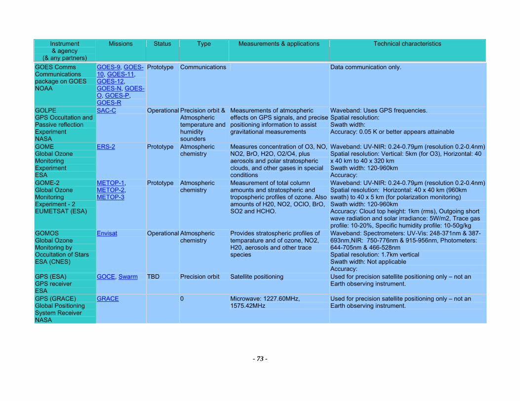
Instrument & agency
(& any partners)
Missions Status Type Measurements & applications Technical characteristics
- 73 -
GOES Comms Communications package on GOES NOAA
GOES-9, GOES-10, GOES-11, GOES-12, GOES-N, GOES-O, GOES-P, GOES-R
Prototype Communications Data communication only.
GOLPE GPS Occultation and Passive reflection Experiment NASA
SAC-C Operational Precision orbit &Atmospheric temperature and humidity sounders
Measurements of atmospheric effects on GPS signals, and precise positioning information to assist gravitational measurements
Waveband: Uses GPS frequencies. Spatial resolution: Swath width: Accuracy: 0.05 K or better appears attainable
GOME Global Ozone Monitoring Experiment ESA
ERS-2 Prototype Atmospheric chemistry
Measures concentration of O3, NO, NO2, BrO, H2O, O2/O4, plus aerosols and polar stratospheric clouds, and other gases in special conditions
Waveband: UV-NIR: 0.24-0.79µm (resolution 0.2-0.4nm) Spatial resolution: Vertical: 5km (for O3), Horizontal: 40 x 40 km to 40 x 320 km Swath width: 120-960km Accuracy:
GOME-2 Global Ozone Monitoring Experiment - 2 EUMETSAT (ESA)
METOP-1, METOP-2, METOP-3
Prototype Atmospheric chemistry
Measurement of total column amounts and stratospheric and tropospheric profiles of ozone. Also amounts of H20, NO2, OClO, BrO, SO2 and HCHO.
Waveband: UV-NIR: 0.24-0.79µm (resolution 0.2-0.4nm) Spatial resolution: Horizontal: 40 x 40 km (960km swath) to 40 x 5 km (for polarization monitoring) Swath width: 120-960km Accuracy: Cloud top height: 1km (rms), Outgoing short wave radiation and solar irradiance: 5W/m2, Trace gas profile: 10-20%, Specific humidity profile: 10-50g/kg
GOMOS Global Ozone Monitoring by Occultation of Stars ESA (CNES)
Envisat Operational Atmospheric chemistry
Provides stratospheric profiles of temparature and of ozone, NO2, H20, aerosols and other trace species
Waveband: Spectrometers: UV-Vis: 248-371nm & 387-693nm,NIR: 750-776nm & 915-956nm, Photometers: 644-705nm & 466-528nm Spatial resolution: 1.7km vertical Swath width: Not applicable Accuracy:
GPS (ESA) GPS receiver ESA
GOCE, Swarm TBD Precision orbit Satellite positioning Used for precision satellite positioning only – not an Earth observing instrument.
GPS (GRACE) Global Positioning System Receiver NASA
GRACE 0 Microwave: 1227.60MHz, 1575.42MHz
Used for precision satellite positioning only – not an Earth observing instrument.
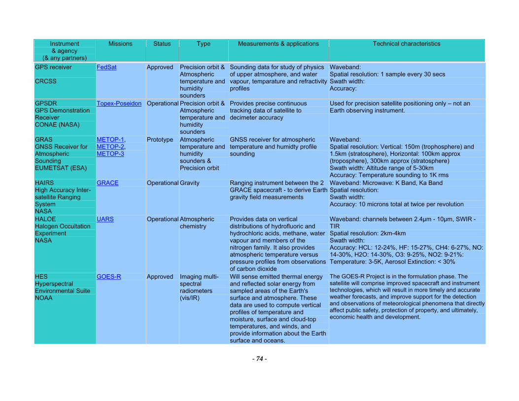
Instrument & agency
(& any partners)
Missions Status Type Measurements & applications Technical characteristics
- 74 -
GPS receiver CRCSS
FedSat Approved Precision orbit &Atmospheric temperature and humidity sounders
Sounding data for study of physics of upper atmosphere, and water vapour, temparature and refractivity profiles
Waveband: Spatial resolution: 1 sample every 30 secs Swath width: Accuracy:
GPSDR GPS Demonstration Receiver CONAE (NASA)
Topex-Poseidon Operational Precision orbit &Atmospheric temperature and humidity sounders
Provides precise continuous tracking data of satellite to decimeter accuracy
Used for precision satellite positioning only – not an Earth observing instrument.
GRAS GNSS Receiver for Atmospheric Sounding EUMETSAT (ESA)
METOP-1, METOP-2, METOP-3
Prototype Atmospheric temperature and humidity sounders & Precision orbit
GNSS receiver for atmospheric temperature and humidty profile sounding
Waveband: Spatial resolution: Vertical: 150m (trophosphere) and 1.5km (stratosphere), Horizontal: 100km approx (troposphere), 300km approx (stratosphere) Swath width: Altitude range of 5-30km Accuracy: Temperature sounding to 1K rms
HAIRS High Accuracy Inter-satellite Ranging System NASA
GRACE Operational Gravity Ranging instrument between the 2 GRACE spacecraft - to derive Earth gravity field measurements
Waveband: Microwave: K Band, Ka Band Spatial resolution: Swath width: Accuracy: 10 microns total at twice per revolution
HALOE Halogen Occultation Experiment NASA
UARS Operational Atmospheric chemistry
Provides data on vertical distributions of hydrofluoric and hydrochloric acids, methane, water vapour and members of the nitrogen family. It also provides atmospheric temperature versus pressure profiles from observations of carbon dioxide
Waveband: channels between 2.4µm - 10µm, SWIR - TIR Spatial resolution: 2km-4km Swath width: Accuracy: HCL: 12-24%, HF: 15-27%, CH4: 6-27%, NO: 14-30%, H2O: 14-30%, O3: 9-25%, NO2: 9-21%: Temperature: 3-5K, Aerosol Extinction: < 30%
HES Hyperspectral Environmental Suite NOAA
GOES-R Approved Imaging multi-spectral radiometers (vis/IR)
Will sense emitted thermal energy and reflected solar energy from sampled areas of the Earth's surface and atmosphere. These data are used to compute vertical profiles of temperature and moisture, surface and cloud-top temperatures, and winds, and provide information about the Earth surface and oceans.
The GOES-R Project is in the formulation phase. The satellite will comprise improved spacecraft and instrument technologies, which will result in more timely and accurate weather forecasts, and improve support for the detection and observations of meteorological phenomena that directly affect public safety, protection of property, and ultimately, economic health and development.
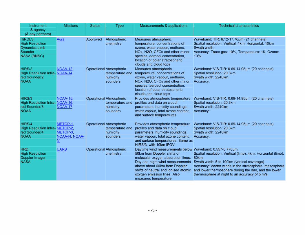
Instrument & agency
(& any partners)
Missions Status Type Measurements & applications Technical characteristics
- 75 -
HiRDLS High Resolution Dynamics Limb Sounder NASA (BNSC)
Aura Approved Atmospheric chemistry
Measures atmospheric temperature, concentrations of ozone, water vapour, methane, NOx, N2O, CFCs and other minor species, aerosol concentration, location of polar stratospheric clouds and cloud tops
Waveband: TIR: 6.12-17.76µm (21 channels) Spatial resolution: Vertical: 1km, Horizontal: 10km Swath width: Accuracy: Trace gas: 10%, Temparature: 1K, Ozone: 10%
HIRS/2 High Resolution Infra-red Sounder/2 NOAA
NOAA-12, NOAA-14
Operational Atmospheric temperature and humidity sounders
Measures atmospheric temperature, concentrations of ozone, water vapour, methane, NOx, N2O, CFCs and other minor species, aerosol concentration, location of polar stratospheric clouds and cloud tops
Waveband: VIS-TIR: 0.69-14.95µm (20 channels) Spatial resolution: 20.3km Swath width: 2240km Accuracy:
HIRS/3 High Resolution Infra-red Sounder/3 NOAA
NOAA-15, NOAA-16, NOAA-17
Operational Atmospheric temperature and humidity sounders
Provides atmospheric temperature profiles and data on cloud parameters, humidity soundings, water vapour, total ozone content, and surface temperatures
Waveband: VIS-TIR: 0.69-14.95µm (20 channels) Spatial resolution: 20.3km Swath width: 2240km Accuracy:
HIRS/4 High Resolution Infra-red Sounder/4 NOAA
METOP-1, METOP-2, METOP-3, NOAA-N, NOAA-N'
Operational Atmospheric temperature and humidity sounders
Provides atmospheric temperature profiles and data on cloud parameters, humidity soundings, water vapour, total ozone content, and surface temperatures. Same as HIRS/3, with 10km IFOV
Waveband: VIS-TIR: 0.69-14.95µm (20 channels) Spatial resolution: 20.3km Swath width: 2240km Accuracy:
HRDI High Resolution Doppler Imager NASA
UARS Operational Atmospheric chemistry
Daytime wind measurements below 50km from Doppler shifts of molecular oxygen absorption lines. Day and night wind measurements above about 60km from Doppler shifts of neutral and ionised atomic oxygen emission lines. Also measures temperature
Waveband: 0.557-0.776µm Spatial resolution: Vertical (limb): 4km, Horizontal (limb): 80km Swath width: 5 to 100km (vertical coverage) Accuracy: Vector winds in the stratosphere, mesosphere and lower thermosphere during the day, and the lower thermosphere at night to an accuracy of 5 m/s
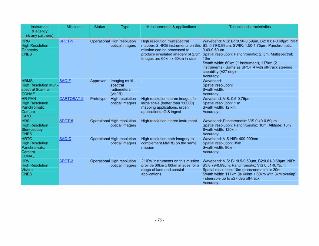
Instrument & agency
(& any partners)
Missions Status Type Measurements & applications Technical characteristics
- 76 -
HRG High Resolution Geometry CNES
SPOT-5 Operational High resolution optical imagers
High resolution multispectral mapper. 2 HRG instruments on this mission can be processed to produce simulated imagery of 2.5m. Images are 60km x 60km in size
Waveband: VIS: B1:0.50-0.59µm, B2: 0.61-0.68µm, NIR: B3: 0.79-0.89µm, SWIR: 1.50-1.75µm, Panchromatic: 0.49-0.69µm Spatial resolution: Panchromatic: 2, 5m, Multispectral: 10m Swath width: 60km (1 instrument), 117km (2 instruments). Same as SPOT 4 with off-track steering capability (±27 deg) Accuracy:
HRMS High Resolution Multi-spectral Scanner CONAE
SAC-F Approved Imaging multi-spectral radiometers (vis/IR)
Waveband: Spatial resolution: Swath width: Accuracy:
HR-PAN High Resolution Panchromatic Camera ISRO
CARTOSAT-2 Prototype High resolution optical imagers
High resolution stereo images for large scale (better than 1:0000) mapping applications, urban applications, GIS ingest
Waveband: VIS: 0.5-0.75µm Spatial resolution: 1 m Swath width: 12 km Accuracy:
HRS High Resolution Stereoscopy CNES
SPOT-5 Operational High resolution optical imagers
High resolution stereo instrument Waveband: Panchromatic: VIS 0.49-0.69µm Spatial resolution: Panchromatic: 10m, Altitude: 15m Swath width: 120km Accuracy:
HRTC High Resolution Panchromatic Camera CONAE
SAC-C Operational High resolution optical imagers
High resolution eath imagery to complement MMRS on the same mission
Waveband: VIS-NIR: 400-900nm Spatial resolution: 35m Swath width: 90km Accuracy:
HRV High Resolution Visible CNES
SPOT-2 Operational High resolution optical imagers
2 HRV instruments on this mission provide 60km x 60km images for a range of land and coastal applications
Waveband: VIS: B1:0.5-0.59µm, B2:0.61-0.68µm, NIR: B3:0.79-0.89µm, Panchromatic: VIS 0.51-0.73µm Spatial resolution: 10m (panchromatic) or 20m Swath width: 117km (ie 60km + 60km with 3km overlap) - steerable up to ±27 deg off-track Accuracy:
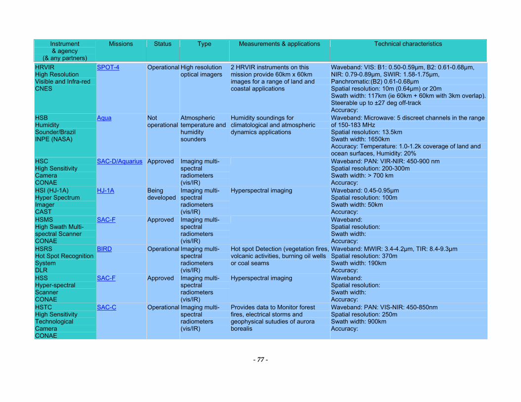
Instrument & agency
(& any partners)
Missions Status Type Measurements & applications Technical characteristics
- 77 -
HRVIR High Resolution Visible and Infra-red CNES
SPOT-4 Operational High resolution optical imagers
2 HRVIR instruments on this mission provide 60km x 60km images for a range of land and coastal applications
Waveband: VIS: B1: 0.50-0.59µm, B2: 0.61-0.68µm, NIR: 0.79-0.89µm, SWIR: 1.58-1.75µm, Panchromatic:(B2) 0.61-0.68µm Spatial resolution: 10m (0.64µm) or 20m Swath width: 117km (ie 60km + 60km with 3km overlap). Steerable up to ±27 deg off-track Accuracy:
HSB Humidity Sounder/Brazil INPE (NASA)
Aqua Not operational
Atmospheric temperature and humidity sounders
Humidity soundings for climatological and atmospheric dynamics applications
Waveband: Microwave: 5 discreet channels in the range of 150-183 MHz Spatial resolution: 13.5km Swath width: 1650km Accuracy: Temperature: 1.0-1.2k coverage of land and ocean surfaces, Humidity: 20%
HSC High Sensitivity Camera CONAE
SAC-D/Aquarius Approved Imaging multi-spectral radiometers (vis/IR)
Waveband: PAN: VIR-NIR: 450-900 nm Spatial resolution: 200-300m Swath width: > 700 km Accuracy:
HSI (HJ-1A) Hyper Spectrum Imager CAST
HJ-1A Being developed
Imaging multi-spectral radiometers (vis/IR)
Hyperspectral imaging Waveband: 0.45-0.95µm Spatial resolution: 100m Swath width: 50km Accuracy:
HSMS High Swath Multi-spectral Scanner CONAE
SAC-F Approved Imaging multi-spectral radiometers (vis/IR)
Waveband: Spatial resolution: Swath width: Accuracy:
HSRS Hot Spot Recognition System DLR
BIRD
Operational Imaging multi-spectral radiometers (vis/IR)
Hot spot Detection (vegetation fires, volcanic activities, burning oil wells or coal seams
Waveband: MWIR: 3.4-4.2µm, TIR: 8.4-9.3µm Spatial resolution: 370m Swath width: 190km Accuracy:
HSS Hyper-spectral Scanner CONAE
SAC-F Approved Imaging multi-spectral radiometers (vis/IR)
Hyperspectral imaging Waveband: Spatial resolution: Swath width: Accuracy:
HSTC High Sensitivity Technological Camera CONAE
SAC-C Operational Imaging multi-spectral radiometers (vis/IR)
Provides data to Monitor forest fires, electrical storms and geophysical sutudies of aurora borealis
Waveband: PAN: VIS-NIR: 450-850nm Spatial resolution: 250m Swath width: 900km Accuracy:
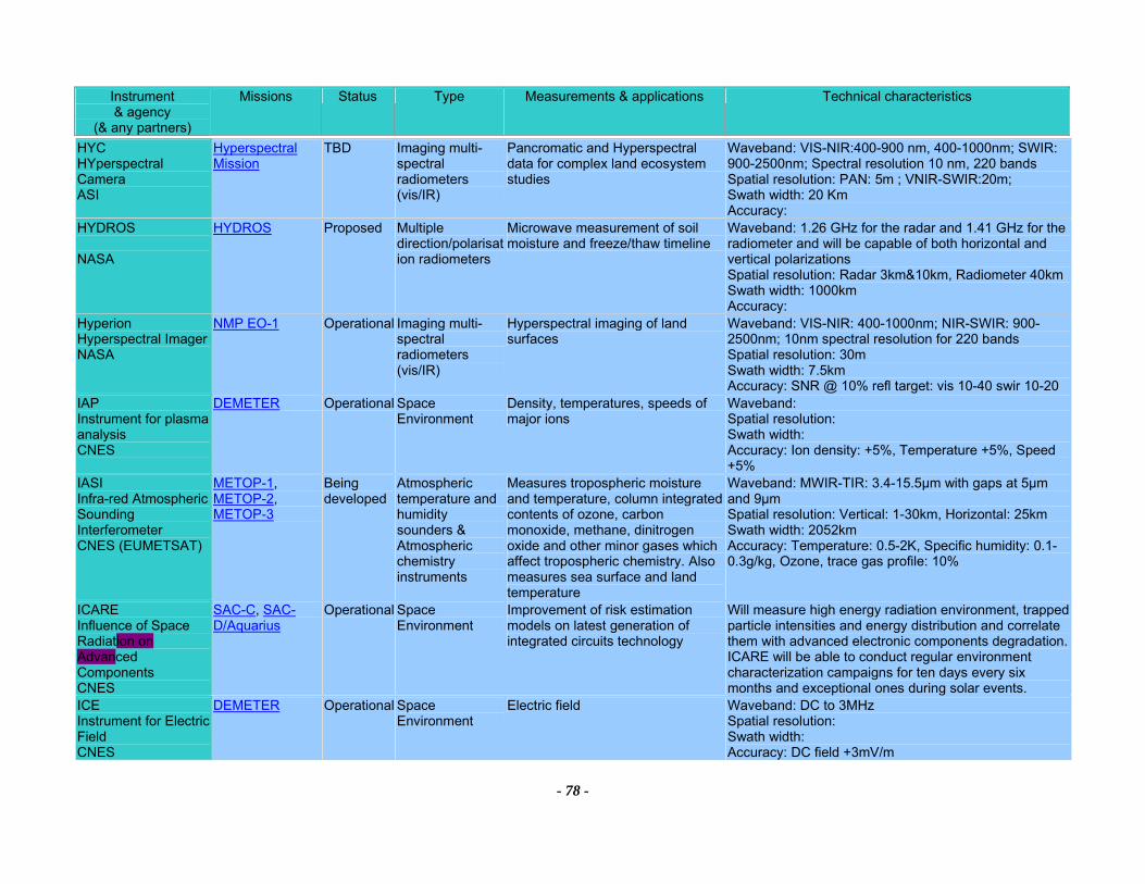
Instrument & agency
(& any partners)
Missions Status Type Measurements & applications Technical characteristics
- 78 -
HYC HYperspectral Camera ASI
Hyperspectral Mission
TBD Imaging multi-spectral radiometers (vis/IR)
Pancromatic and Hyperspectral data for complex land ecosystem studies
Waveband: VIS-NIR:400-900 nm, 400-1000nm; SWIR: 900-2500nm; Spectral resolution 10 nm, 220 bands Spatial resolution: PAN: 5m ; VNIR-SWIR:20m; Swath width: 20 Km Accuracy:
HYDROS NASA
HYDROS Proposed Multiple direction/polarisation radiometers
Microwave measurement of soil moisture and freeze/thaw timeline
Waveband: 1.26 GHz for the radar and 1.41 GHz for the radiometer and will be capable of both horizontal and vertical polarizations Spatial resolution: Radar 3km&10km, Radiometer 40kmSwath width: 1000km Accuracy:
Hyperion Hyperspectral Imager NASA
NMP EO-1 Operational Imaging multi-spectral radiometers (vis/IR)
Hyperspectral imaging of land surfaces
Waveband: VIS-NIR: 400-1000nm; NIR-SWIR: 900-2500nm; 10nm spectral resolution for 220 bands Spatial resolution: 30m Swath width: 7.5km Accuracy: SNR @ 10% refl target: vis 10-40 swir 10-20
IAP Instrument for plasma analysis CNES
DEMETER Operational Space Environment
Density, temperatures, speeds of major ions
Waveband: Spatial resolution: Swath width: Accuracy: Ion density: +5%, Temperature +5%, Speed +5%
IASI Infra-red Atmospheric Sounding Interferometer CNES (EUMETSAT)
METOP-1, METOP-2, METOP-3
Being developed
Atmospheric temperature and humidity sounders & Atmospheric chemistry instruments
Measures tropospheric moisture and temperature, column integrated contents of ozone, carbon monoxide, methane, dinitrogen oxide and other minor gases which affect tropospheric chemistry. Also measures sea surface and land temperature
Waveband: MWIR-TIR: 3.4-15.5µm with gaps at 5µm and 9µm Spatial resolution: Vertical: 1-30km, Horizontal: 25km Swath width: 2052km Accuracy: Temperature: 0.5-2K, Specific humidity: 0.1-0.3g/kg, Ozone, trace gas profile: 10%
ICARE Influence of Space Radiation on Advanced Components CNES
SAC-C, SAC-D/Aquarius
Operational Space Environment
Improvement of risk estimation models on latest generation of integrated circuits technology
Will measure high energy radiation environment, trapped particle intensities and energy distribution and correlate them with advanced electronic components degradation. ICARE will be able to conduct regular environment characterization campaigns for ten days every six months and exceptional ones during solar events.
ICE Instrument for Electric Field CNES
DEMETER Operational Space Environment
Electric field Waveband: DC to 3MHz Spatial resolution: Swath width: Accuracy: DC field +3mV/m
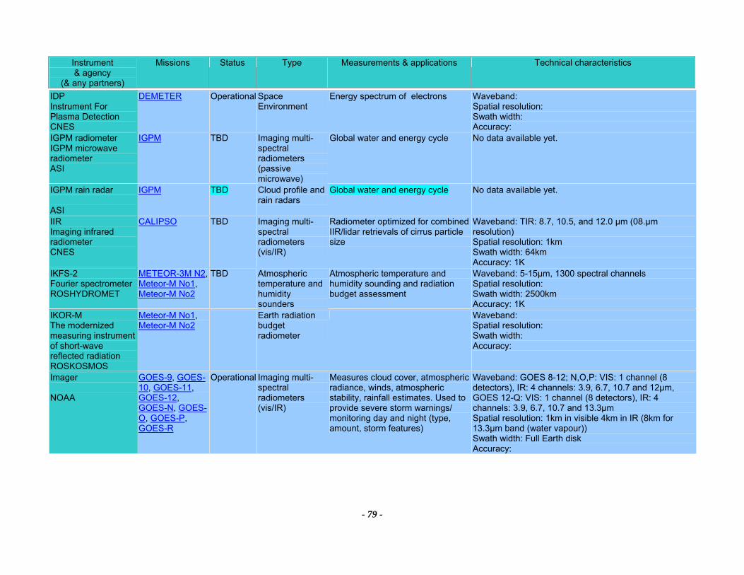
Instrument & agency
(& any partners)
Missions Status Type Measurements & applications Technical characteristics
- 79 -
IDP Instrument For Plasma Detection CNES
DEMETER Operational Space Environment
Energy spectrum of electrons Waveband: Spatial resolution: Swath width: Accuracy:
IGPM radiometer IGPM microwave radiometer ASI
IGPM TBD Imaging multi-spectral radiometers (passive microwave)
Global water and energy cycle No data available yet.
IGPM rain radar ASI
IGPM TBD Cloud profile and rain radars
Global water and energy cycle No data available yet.
IIR Imaging infrared radiometer CNES
CALIPSO TBD Imaging multi-spectral radiometers (vis/IR)
Radiometer optimized for combined IIR/lidar retrievals of cirrus particle size
Waveband: TIR: 8.7, 10.5, and 12.0 µm (08.µm resolution) Spatial resolution: 1km Swath width: 64km Accuracy: 1K
IKFS-2 Fourier spectrometer ROSHYDROMET
METEOR-3M N2, Meteor-M No1, Meteor-M No2
TBD Atmospheric temperature and humidity sounders
Atmospheric temperature and humidity sounding and radiation budget assessment
Waveband: 5-15µm, 1300 spectral channels Spatial resolution: Swath width: 2500km Accuracy: 1K
IKOR-M The modernized measuring instrument of short-wave reflected radiation ROSKOSMOS
Meteor-M No1, Meteor-M No2
Earth radiation budget radiometer
Waveband: Spatial resolution: Swath width: Accuracy:
Imager NOAA
GOES-9, GOES-10, GOES-11, GOES-12, GOES-N, GOES-O, GOES-P, GOES-R
Operational Imaging multi-spectral radiometers (vis/IR)
Measures cloud cover, atmospheric radiance, winds, atmospheric stability, rainfall estimates. Used to provide severe storm warnings/ monitoring day and night (type, amount, storm features)
Waveband: GOES 8-12; N,O,P: VIS: 1 channel (8 detectors), IR: 4 channels: 3.9, 6.7, 10.7 and 12µm, GOES 12-Q: VIS: 1 channel (8 detectors), IR: 4 channels: 3.9, 6.7, 10.7 and 13.3µm Spatial resolution: 1km in visible 4km in IR (8km for 13.3µm band (water vapour)) Swath width: Full Earth disk Accuracy:
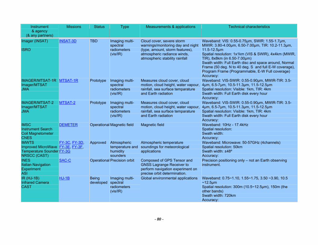
Instrument & agency
(& any partners)
Missions Status Type Measurements & applications Technical characteristics
- 80 -
Imager (INSAT) ISRO
INSAT-3D TBD Imaging multi-spectral radiometers (vis/IR)
Cloud cover, severe storm warnings/monitoring day and night (type, amount, storm features), atmospheric radiance winds, atmospheric stability rainfall
Waveband: VIS: 0.55-0.75µm, SWIR: 1.55-1.7µm, MWIR: 3.80-4.00µm, 6.50-7.00µm, TIR: 10.2-11.3µm, 11.5-12.5µm Spatial resolution: 1x1km (VIS & SWIR), 4x4km (MWIR, TIR), 8x8km (in 6.50-7.00µm) Swath width: Full Earth disc and space around, Normal Frame (50 deg. N to 40 deg. S and full E-W coverage), Program Frame (Programmable, E-W Full coverage) Accuracy:
IMAGER/MTSAT-1R Imager/MTSAT JMA
MTSAT-1R Prototype Imaging multi-spectral radiometers (vis/IR)
Measures cloud cover, cloud motion, cloud height, water vapour, rainfall, sea surface temparature and Earth radiation
Waveband: VIS-SWIR: 0.55-0.90µm, MWIR-TIR: 3.5-4µm, 6.5-7µm, 10.5-11.3µm, 11.5-12.5µm Spatial resolution: Visible: 1km, TIR: 4km Swath width: Full Earth disk every hour Accuracy:
IMAGER/MTSAT-2 Imager/MTSAT JMA
MTSAT-2 Prototype Imaging multi-spectral radiometers (vis/IR)
Measures cloud cover, cloud motion, cloud height, water vapour, rainfall, sea surface temparature and Earth radiation
Waveband: VIS-SWIR: 0.55-0.90µm, MWIR-TIR: 3.5-4µm, 6.5-7µm, 10.5-11.3µm, 11.5-12.5µm Spatial resolution: Visible: 1km, TIR: 4km Swath width: Full Earth disk every hour Accuracy:
IMSC Instrument Search Coil Magnetometer CNES
DEMETER Operational Magnetic field Magnetic field Waveband: 10Hz - 17.4kHz Spatial resolution: Swath width: Accuracy:
IMWTS Improved MicroWave Temperature Sounder NRSCC (CAST)
FY-3C, FY-3D, FY-3E, FY-3F, FY-3G
Approved Atmospheric temperature and humidity sounders
Atmospheric temperature soundings for meteorological applications
Waveband: Microwave: 50-57GHz (4channels) Spatial resolution: 50km Swath width: ±48º Accuracy:
INES Italian Navigation Experiment ASI
SAC-C Operational Precision orbit Composed of GPS Tensor and GNSS Lagrange Receiver to perform navigation experiment on precise orbit determination.
Precision positioning only – not an Earth observing instrument.
IR (HJ-1B) Infrared Camera CAST
HJ-1B Being developed
Imaging multi-spectral radiometers (vis/IR)
Global environmental applications Waveband: 0.75~1.10, 1.55~1.75, 3.50 ~3.90, 10.5 ~12.5µm Spatial resolution: 300m (10.5~12.5μm), 150m (the other bands) Swath width: 720km Accuracy:
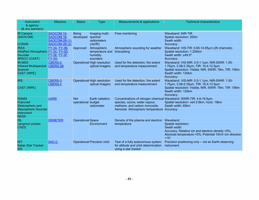
Instrument & agency
(& any partners)
Missions Status Type Measurements & applications Technical characteristics
- 81 -
IR Camera (SAOCOM) CONAE
SAOCOM 1A, SAOCOM 1B, SAOCOM-2B (1), SAOCOM-2B (2)
Being developed
Imaging multi-spectral radiometers (vis/IR)
Fires monitoring Waveband: NIR-TIR Spatial resolution: 200m Swath width: Accuracy:
IRAS InfraRed Atmospheric Sounder NRSCC (CAST)
FY-3A, FY-3B, FY-3C, FY-3D, FY-3E, FY-3F, FY-3G
Approved Atmospheric temperature and humidity sounders
Atmospheric sounding for weather forecasting
Waveband: VIS-TIR: 0.65-14.95µm (26 channels) Spatial resolution: 1.254km Swath width: ±49.5º Accuracy:
IR-MSS Infrared Multispectral Scanner CAST (INPE)
CBERS-2, CBERS-2B
Operational High resolution optical imagers
Used for fire detection, fire extent and temperature measurement
Waveband: VIS-NIR: 0.5-1.1µm, NIR-SWIR: 1.55-1.75µm, 2.08-2.35µm, TIR: 10.4-12.5µm Spatial resolution: Visible, NIR, SWIR: 78m, TIR: 156m Swath width: 120km Accuracy:
IRS CAST (INPE)
CBERS-3, CBERS-4
Operational High resolution optical imagers
Used for fire detection, fire extent and temperature measurement
Waveband: VIS-NIR: 0.5-1.1µm, NIR-SWIR: 1.55-1.75µm, 2.08-2.35µm, TIR: 10.4-12.5µm Spatial resolution: Visible, NIR, SWIR: 78m, TIR: 156m Swath width: 120km Accuracy:
ISAMS Improved Stratospheric and Mesospheric Sounder instrument NASA
UARS Not operational
Earth radiation budget radiometer
Concentrations of nitrogen chemical species, ozone, water vapour, methane, and carbon monoxide. Aerosols. Atmospheric temperature
Waveband: SWIR-TIR: 4.6-16.6µm Spatial resolution: vert 2.6km, horiz: 18km Swath width: 65km Accuracy:
ISL Langmuir probes CNES
DEMETER Operational Space Environment
Density of the plasma and electron temperature
Waveband: Spatial resolution: Swath width: Accuracy: Relative ion and electron density <5%, Absolute temperature <5%, Potential 10mV Ion direction +15°
IST Italian Star Tracker ASI
SAC-C Operational Precision orbit Test of a fully autonomous system for attitude and orbit determination using a star tracker
Precision positioning only – not an Earth observing instrument.
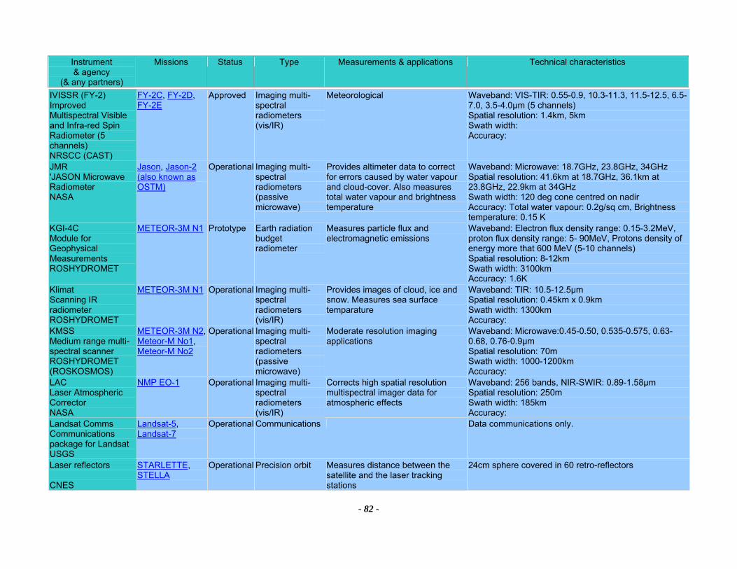
Instrument & agency
(& any partners)
Missions Status Type Measurements & applications Technical characteristics
- 82 -
IVISSR (FY-2) Improved Multispectral Visible and Infra-red Spin Radiometer (5 channels) NRSCC (CAST)
FY-2C, FY-2D, FY-2E
Approved Imaging multi-spectral radiometers (vis/IR)
Meteorological Waveband: VIS-TIR: 0.55-0.9, 10.3-11.3, 11.5-12.5, 6.5-7.0, 3.5-4.0µm (5 channels) Spatial resolution: 1.4km, 5km Swath width: Accuracy:
JMR 'JASON Microwave Radiometer NASA
Jason, Jason-2 (also known as OSTM)
Operational Imaging multi-spectral radiometers (passive microwave)
Provides altimeter data to correct for errors caused by water vapour and cloud-cover. Also measures total water vapour and brightness temperature
Waveband: Microwave: 18.7GHz, 23.8GHz, 34GHz Spatial resolution: 41.6km at 18.7GHz, 36.1km at 23.8GHz, 22.9km at 34GHz Swath width: 120 deg cone centred on nadir Accuracy: Total water vapour: 0.2g/sq cm, Brightness temperature: 0.15 K
KGI-4C Module for Geophysical Measurements ROSHYDROMET
METEOR-3M N1 Prototype Earth radiation budget radiometer
Measures particle flux and electromagnetic emissions
Waveband: Electron flux density range: 0.15-3.2MeV, proton flux density range: 5- 90MeV, Protons density of energy more that 600 MeV (5-10 channels) Spatial resolution: 8-12km Swath width: 3100km Accuracy: 1.6K
Klimat Scanning IR radiometer ROSHYDROMET
METEOR-3M N1 Operational Imaging multi-spectral radiometers (vis/IR)
Provides images of cloud, ice and snow. Measures sea surface temparature
Waveband: TIR: 10.5-12.5µm Spatial resolution: 0.45km x 0.9km Swath width: 1300km Accuracy:
KMSS Medium range multi-spectral scanner ROSHYDROMET (ROSKOSMOS)
METEOR-3M N2, Meteor-M No1, Meteor-M No2
Operational Imaging multi-spectral radiometers (passive microwave)
Moderate resolution imaging applications
Waveband: Microwave:0.45-0.50, 0.535-0.575, 0.63-0.68, 0.76-0.9µm Spatial resolution: 70m Swath width: 1000-1200km Accuracy:
LAC Laser Atmospheric Corrector NASA
NMP EO-1 Operational Imaging multi-spectral radiometers (vis/IR)
Corrects high spatial resolution multispectral imager data for atmospheric effects
Waveband: 256 bands, NIR-SWIR: 0.89-1.58µm Spatial resolution: 250m Swath width: 185km Accuracy:
Landsat Comms Communications package for Landsat USGS
Landsat-5, Landsat-7
Operational Communications Data communications only.
Laser reflectors CNES
STARLETTE, STELLA
Operational Precision orbit Measures distance between the satellite and the laser tracking stations
24cm sphere covered in 60 retro-reflectors
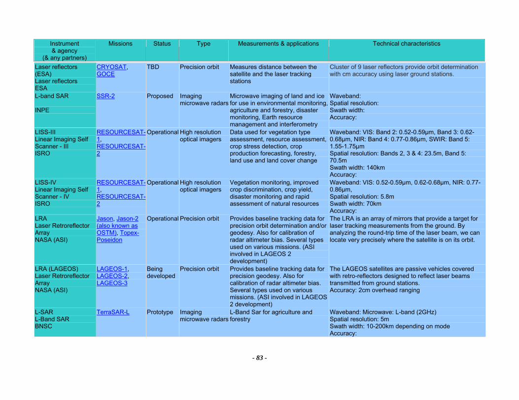
Instrument & agency
(& any partners)
Missions Status Type Measurements & applications Technical characteristics
- 83 -
Laser reflectors (ESA) Laser reflectors ESA
CRYOSAT, GOCE
TBD Precision orbit Measures distance between the satellite and the laser tracking stations
Cluster of 9 laser reflectors provide orbit determination with cm accuracy using laser ground stations.
L-band SAR INPE
SSR-2 Proposed Imaging microwave radars
Microwave imaging of land and ice for use in environmental monitoring, agriculture and forestry, disaster monitoring, Earth resource management and interferometry
Waveband: Spatial resolution: Swath width: Accuracy:
LISS-III Linear Imaging Self Scanner - III ISRO
RESOURCESAT-1, RESOURCESAT-2
Operational High resolution optical imagers
Data used for vegetation type assessment, resource assessment, crop stress detection, crop production forecasting, forestry, land use and land cover change
Waveband: VIS: Band 2: 0.52-0.59µm, Band 3: 0.62-0.68µm, NIR: Band 4: 0.77-0.86µm, SWIR: Band 5: 1.55-1.75µm Spatial resolution: Bands 2, 3 & 4: 23.5m, Band 5: 70.5m Swath width: 140km Accuracy:
LISS-IV Linear Imaging Self Scanner - IV ISRO
RESOURCESAT-1, RESOURCESAT-2
Operational High resolution optical imagers
Vegetation monitoring, improved crop discrimination, crop yield, disaster monitoring and rapid assessment of natural resources
Waveband: VIS: 0.52-0.59µm, 0.62-0.68µm, NIR: 0.77-0.86µm, Spatial resolution: 5.8m Swath width: 70km Accuracy:
LRA Laser Retroreflector Array NASA (ASI)
Jason, Jason-2 (also known as OSTM), Topex-Poseidon
Operational Precision orbit Provides baseline tracking data for precision orbit determination and/or geodesy. Also for calibration of radar altimeter bias. Several types used on various missions. (ASI involved in LAGEOS 2 development)
The LRA is an array of mirrors that provide a target for laser tracking measurements from the ground. By analyzing the round-trip time of the laser beam, we can locate very precisely where the satellite is on its orbit.
LRA (LAGEOS) Laser Retroreflector Array NASA (ASI)
LAGEOS-1, LAGEOS-2, LAGEOS-3
Being developed
Precision orbit Provides baseline tracking data for precision geodesy. Also for calibration of radar altimeter bias. Several types used on various missions. (ASI involved in LAGEOS 2 development)
The LAGEOS satellites are passive vehicles covered with retro-reflectors designed to reflect laser beams transmitted from ground stations. Accuracy: 2cm overhead ranging
L-SAR L-Band SAR BNSC
TerraSAR-L Prototype Imaging microwave radars
L-Band Sar for agriculture and forestry
Waveband: Microwave: L-band (2GHz) Spatial resolution: 5m Swath width: 10-200km depending on mode Accuracy:
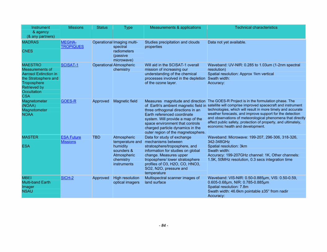
Instrument & agency
(& any partners)
Missions Status Type Measurements & applications Technical characteristics
- 84 -
MADRAS CNES
MEGHA-TROPIQUES
Operational Imaging multi-spectral radiometers (passive microwave)
Studies precipitation and clouds properties
Data not yet available.
MAESTRO Measurements of Aerosol Extinction in the Stratosphere and Troposphere Retrieved by Occultation CSA
SCISAT-1 Operational Atmospheric chemistry
Will aid in the SCISAT-1 overall mission of increasing our understanding of the chemical processes involved in the depletion of the ozone layer.
Waveband: UV-NIR: 0.285 to 1.03um (1-2nm spectral resolution) Spatial resolution: Approx 1km vertical Swath width: Accuracy:
Magnetometer (NOAA) Magnetometer NOAA
GOES-R Approved Magnetic field Measures magnitude and direction of Earth's ambient magnetic field in three orthogonal directions in an Earth referenced coordinate system. Will provide a map of the space environment that controls charged particle dynamics in the outer region of the magnetosphere.
The GOES-R Project is in the formulation phase. The satellite will comprise improved spacecraft and instrument technologies, which will result in more timely and accurate weather forecasts, and improve support for the detection and observations of meteorological phenomena that directly affect public safety, protection of property, and ultimately, economic health and development.
MASTER ESA
ESA Future Missions
TBD Atmospheric temperature and humidity sounders & Atmospheric chemistry instruments
Data for study of exchange mechanisms between stratosphere/troposphere, and information for studies on global change. Measures upper troposphere/ lower stratosphere profiles of O3, H2O, CO, HNO3, SO2, N2O, pressure and temperature
Waveband: Microwave: 199-207, 296-306, 318-326, 342-348GHz Spatial resolution: 3km Swath width: Accuracy: 199-207GHz channel: 1K, Other channels: 1.5K, 50MHz resolution, 0.3 secs integration time
MBEI Multi-band Earth Imager NSAU
SICH-2 Approved High resolution optical imagers
Multispectral scanner images of land surface
Waveband: VIS-NIR: 0.50-0.885µm, VIS: 0.50-0.59, 0.605-0.68µm, NIR: 0.785-0.885µm Spatial resolution: 7.8m Swath width: 46.6km pointable ±35° from nadir Accuracy:
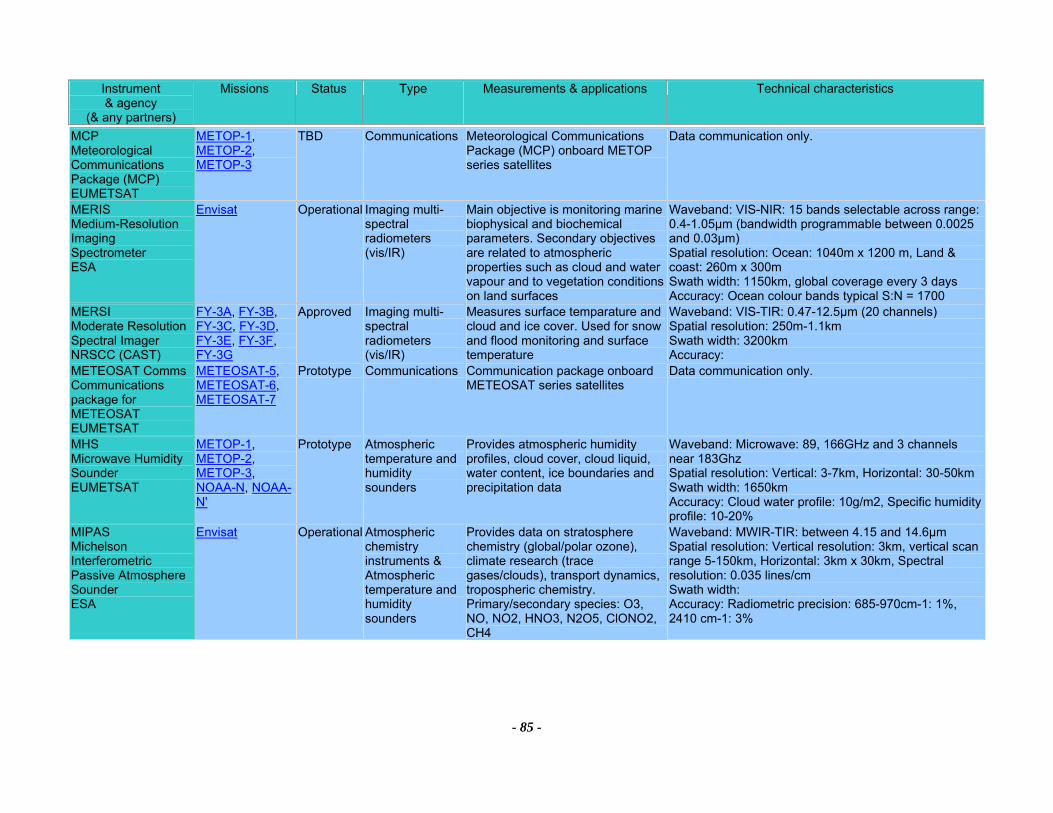
Instrument & agency
(& any partners)
Missions Status Type Measurements & applications Technical characteristics
- 85 -
MCP Meteorological Communications Package (MCP) EUMETSAT
METOP-1, METOP-2, METOP-3
TBD Communications Meteorological Communications Package (MCP) onboard METOP series satellites
Data communication only.
MERIS Medium-Resolution Imaging Spectrometer ESA
Envisat Operational Imaging multi-spectral radiometers (vis/IR)
Main objective is monitoring marine biophysical and biochemical parameters. Secondary objectives are related to atmospheric properties such as cloud and water vapour and to vegetation conditions on land surfaces
Waveband: VIS-NIR: 15 bands selectable across range: 0.4-1.05µm (bandwidth programmable between 0.0025 and 0.03µm) Spatial resolution: Ocean: 1040m x 1200 m, Land & coast: 260m x 300m Swath width: 1150km, global coverage every 3 days Accuracy: Ocean colour bands typical S:N = 1700
MERSI Moderate Resolution Spectral Imager NRSCC (CAST)
FY-3A, FY-3B, FY-3C, FY-3D, FY-3E, FY-3F, FY-3G
Approved Imaging multi-spectral radiometers (vis/IR)
Measures surface temparature and cloud and ice cover. Used for snow and flood monitoring and surface temperature
Waveband: VIS-TIR: 0.47-12.5µm (20 channels) Spatial resolution: 250m-1.1km Swath width: 3200km Accuracy:
METEOSAT Comms Communications package for METEOSAT EUMETSAT
METEOSAT-5, METEOSAT-6, METEOSAT-7
Prototype Communications Communication package onboard METEOSAT series satellites
Data communication only.
MHS Microwave Humidity Sounder EUMETSAT
METOP-1, METOP-2, METOP-3, NOAA-N, NOAA-N'
Prototype Atmospheric temperature and humidity sounders
Provides atmospheric humidity profiles, cloud cover, cloud liquid, water content, ice boundaries and precipitation data
Waveband: Microwave: 89, 166GHz and 3 channels near 183Ghz Spatial resolution: Vertical: 3-7km, Horizontal: 30-50kmSwath width: 1650km Accuracy: Cloud water profile: 10g/m2, Specific humidity profile: 10-20%
MIPAS Michelson Interferometric Passive Atmosphere Sounder ESA
Envisat Operational Atmospheric chemistry instruments & Atmospheric temperature and humidity sounders
Provides data on stratosphere chemistry (global/polar ozone), climate research (trace gases/clouds), transport dynamics, tropospheric chemistry. Primary/secondary species: O3, NO, NO2, HNO3, N2O5, ClONO2, CH4
Waveband: MWIR-TIR: between 4.15 and 14.6µm Spatial resolution: Vertical resolution: 3km, vertical scan range 5-150km, Horizontal: 3km x 30km, Spectral resolution: 0.035 lines/cm Swath width: Accuracy: Radiometric precision: 685-970cm-1: 1%, 2410 cm-1: 3%
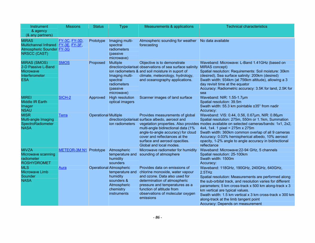
Instrument & agency
(& any partners)
Missions Status Type Measurements & applications Technical characteristics
- 86 -
MIRAS Multichannel Infrared Atmospheric Sounder NRSCC (CAST)
FY-3C, FY-3D, FY-3E, FY-3F, FY-3G
Prototype Imaging multi-spectral radiometers (passive microwave)
Atmospheric sounding for weather forecasting
No data available
MIRAS (SMOS) 2-D Passive L-Band Microwave Interferometer ESA
SMOS Proposed Multiple direction/polarisation radiometers &Imaging multi-spectral radiometers (passive microwave)
Objective is to demonstrate observations of sea surface salinity and soil moisture in suport of climate, meteorology, hydrology, and oceanography applications.
Waveband: Microwave: L-Band 1.41GHz (based on MIRAS concept) Spatial resolution: Requirements: Soil moisture: 30km (desired), Sea surface salinity: 200km (desired) Swath width: 934km (at 756km altitude), allowing a 3 day revisit time at the equator Accuracy: Radiometric accuracy: 3.5K for land, 2.5K for sea
MIREI Middle IR Earth Imager NSAU
SICH-2 Approved High resolution optical imagers
Scanner images of land surface Waveband: NIR: 1.55-1.7µm Spatial resolution: 39.5m Swath width: 55.3 km pointable ±35° from nadir Accuracy:
MISR Multi-angle Imaging SpectroRadiometer NASA
Terra Operational Multiple direction/polarisation radiometers
Provides measurements of global surface albedo, aerosol and vegetation properties. Also provides multi-angle bidirectional data (1% angle-to-angle accuracy) for cloud cover and reflectances at the surface and aerosol opacities. Global and local modes.
Waveband: VIS: 0.44, 0.56, 0.67µm, NIR: 0.86µm Spatial resolution: 275m, 550m or 1.1km, Summation modes available on selected cameras/bands: 1x1, 2x2, 4x4, 1x4. 1 pixel = 275m x 275m Swath width: 360km common overlap of all 9 cameras Accuracy: 0.03% hemispherical albedo, 10% aerosol opacity, 1-2% angle to angle accuracy in bidirectional reflectance
MIVZA Microwave scanning radiometer ROSHYDROMET
METEOR-3M N1 Prototype Atmospheric temperature and humidity sounders
Microwave radiometer for humidity sounding of atmosphere
Waveband: Microwave:22-94 GHz, 5 channels Spatial resolution: 25-100km Swath width: 1500m Accuracy:
MLS Microwave Limb Sounder NASA
Aura Operational Atmospheric temperature and humidity sounders & Atmospheric chemistry instruments
Provides data on emissions of chlorine monoxide, water vapour and ozone. Data also used for determination of atmospheric pressure and temperatures as a function of altitude from observations of molecular oxygen emissions
Waveband: 118GHz, 190GHz, 240GHz, 640GHz, 2.5THz Spatial resolution: Measurements are performed along the sub-orbital track, and resolution varies for different parameters; 5 km cross-track x 500 km along-track x 3 km vertical are typical values. Swath width: 1.5 km vertical x 3 km cross-track x 300 km along-track at the limb tangent point Accuracy: Depends on measurement
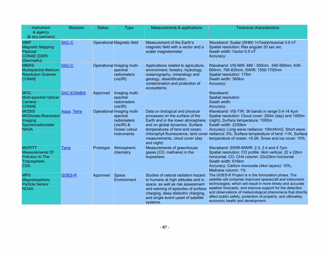
Instrument & agency
(& any partners)
Missions Status Type Measurements & applications Technical characteristics
- 87 -
MMP Magnetic Mapping Payload CONAE (DSRI (Denmark))
SAC-C Operational Magnetic field Measurement of the Earth’s magnetic field with a vector and a scalar magnetometer
Waveband: Scalar (SHM) 1nTeslaVectorial 3-5 nT Spatial resolution: Res angular 20 sec arc Swath width: Vector 0.5 nT Accuracy:
MMRS Multispectral Medium Resolution Scanner CONAE
SAC-C Operational Imaging multi-spectral radiometers (vis/IR)
Applications related to agriculture, environment, forestry, hydrology, oceanography, mineralogy and geology, desertification, contamination and protection of ecosystems.
Waveband: VIS-NIR: 480 - 500nm, 540-560nm, 630-690nm, 795-835nm, SWIR: 1550-1700nm Spatial resolution: 175m Swath width: 360km Accuracy:
MOC Multi-spectral Optical Camera CONAE
SAC-E/SABIA Approved Imaging multi-spectral radiometers (vis/IR)
Waveband: Spatial resolution: Swath width: Accuracy:
MODIS MODerate-Resolution Imaging Spectroradiometer NASA
Aqua, Terra Operational Imaging multi-spectral radiometers (vis/IR) & Ocean colour instruments
Data on biological and physical processes on the surface of the Earth and in the lower atmosphere, and on global dynamics. Surface temperatures of land and ocean, chlorophyll fluorescence, land cover measurements, cloud cover (day and night)
Waveband: VIS-TIR: 36 bands in range 0.4-14.4µm Spatial resolution: Cloud cover: 250m (day) and 1000m (night), Surface temperature: 1000m Swath width: 2330km Accuracy: Long wave radiance: 100nW/m2, Short wave radiance: 5%, Surface temperature of land: <1K, Surface temperature of ocean: <0.2K, Snow and ice cover: 10%
MOPITT Measurements Of Pollution In The Troposphere CSA
Terra Prototype Atmospheric chemistry
Measurements of greenhouse gases (CO, methane) in the troposhere
Waveband: SWIR-MWIR: 2.3, 2.4 and 4.7µm Spatial resolution: CO profile: 4km vertical, 22 x 22km horizontal, CO, CH4 column: 22x22km horizontal Swath width: 616km Accuracy: Carbon monoxide (4km layers): 10%, Methane column: 1%
MPS Magnetospheric Particle Sensor NOAA
GOES-R Approved Space Environment
Studies of natural radiation hazard to humans at high altitudes and in space, as well as risk assessment and warning of episodes of surface charging, deep dielectric charging, and single event upset of satellite systems.
The GOES-R Project is in the formulation phase. The satellite will comprise improved spacecraft and instrument technologies, which will result in more timely and accurate weather forecasts, and improve support for the detection and observations of meteorological phenomena that directly affect public safety, protection of property, and ultimately, economic health and development.
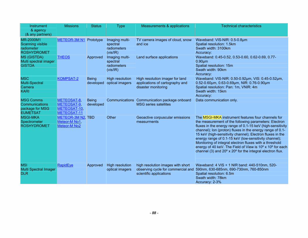
Instrument & agency
(& any partners)
Missions Status Type Measurements & applications Technical characteristics
- 88 -
MR-2000M1 Scanning visible radiometer ROSHYDROMET
METEOR-3M N1 Prototype Imaging multi-spectral radiometers (vis/IR)
TV camera images of cloud, snow and ice
Waveband: VIS-NIR: 0.5-0.8µm Spatial resolution: 1.5km Swath width: 3100km Accuracy:
MS (GISTDA) Multi spectral imager GISTDA
THEOS Approved Imaging multi-spectral radiometers (vis/IR)
Land surface applications Waveband: 0.45-0.52, 0.53-0.60, 0.62-0.69, 0.77-0.90µm Spatial resolution: 15m Swath width: 90km Accuracy:
MSC Multi-Spectral Camera KARI
KOMPSAT-2 Being developed
High resolution optical imagers
High resolution imager for land applications of cartography and disaster monitoring
Waveband: VIS-NIR: 0.50-0.92µm, VIS: 0.45-0.52µm, 0.52-0.60µm, 0.63-0.69µm, NIR: 0.76-0.90µm Spatial resolution: Pan: 1m, VNIR: 4m Swath width: 15km Accuracy:
MSG Comms Communications package for MSG EUMETSAT
METEOSAT-8, METEOSAT-9, METEOSAT-10, METEOSAT-11
Being developed
Communications Communication package onboard MSG series satellites
Data communication only.
MSGI-MKA Spectrometer ROSHYDROMET
METEOR-3M N2, Meteor-M No1, Meteor-M No2
TBD Other Geoactive corpuscular emissions measurments
The MSGI-MKA instrument features four channels for the measurement of the following parameters: Electron fluxes in the energy range of 0.1-15 keV (high-sensitivity channel); Ion (proton) fluxes in the energy range of 0.1-15 keV (high-sensitivity channel); Electron fluxes in the energy range of 0.1-15 keV (low-sensitivity channel); Monitoring of integral electron fluxes with a threshold energy of 40 keV. The Field of View is 10º x 10º for each channel (3) and 20º x 20º for the integral electron flux.
MSI Multi Spectral Imager DLR
RapidEye Approved High resolution optical imagers
high resolution images with short observing cycle for commercial and scientific applications
Waveband: 4 VIS + 1 NIR band: 440-510nm, 520-590nm, 630-685nm, 690-730nm, 760-850nm Spatial resolution: 6.5m Swath width: 78km Accuracy: 2-3%
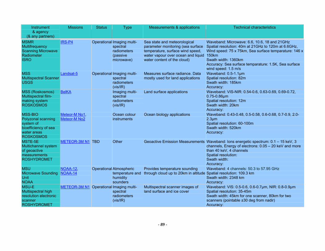
Instrument & agency
(& any partners)
Missions Status Type Measurements & applications Technical characteristics
- 89 -
MSMR Multifrequency Scanning Microwave Radiometer ISRO
IRS-P4 Operational Imaging multi-spectral radiometers (passive microwave)
Sea state and meteorological parameter monitoring (sea surface temperature, surface wind speed, water vapour over ocean and liquid water content of the cloud)
Waveband: Microwave: 6.6, 10.6, 18 and 21GHz Spatial resolution: 40m at 21GHz to 120m at 6.6GHz, Wind speed: 75 x 75km, Sea surface temparature: 146 x 150km Swath width: 1360km Accuracy: Sea surface temparature: 1.5K, Sea surface wind speed: 1.5 m/s
MSS Multispectral Scanner USGS
Landsat-5 Operational Imaging multi-spectral radiometers (vis/IR)
Measures surface radiance. Data mostly used for land applications
Waveband: 0.5-1.1µm Spatial resolution: 82m Swath width: 185km Accuracy:
MSS (Roskosmos) Multispectral film-making system ROSKOSMOS
BelKA Imaging multi-spectral radiometers (vis/IR)
Land surface applications Waveband: VIS-NIR: 0.54-0.6, 0.63-0.69, 0.69-0.72, 0.75-0.86µm Spatial resolution: 12m Swath width: 20km Accuracy:
MSS-BIO Polyzonal scanning system of bioefficiency of sea water areas ROSKOSMOS
Meteor-M No1, Meteor-M No2
Ocean colour instruments
Ocean biology applications Waveband: 0.43-0.48, 0.5-0.58, 0.6-0.68, 0.7-0.9, 2.0-2.3µm Spatial resolution: 60-100m Swath width: 520km Accuracy:
MSTE-5E Multichannel system of geoactive measurements ROSHYDROMET
METEOR-3M N1 TBD Other Geoactive Emission Measurements Waveband: Ions energetic spectrum: 0.1 – 15 keV, 3 channels, Energy of electrons: 0.05 – 20 keV and more than 40 keV, 4 channels Spatial resolution: Swath width: Accuracy:
MSU Microwave Sounding Unit NOAA
NOAA-12, NOAA-14
Operational Atmospheric temperature and humidity sounders
Provides temperature sounding through cloud up to 20km in altitude
Waveband: 4 channels: 50.3 to 57.95 GHz Spatial resolution: 109.3 km Swath width: 2348 km Accuracy:
MSU-E Multispectral high resolution electronic scanner ROSHYDROMET
METEOR-3M N1 Operational Imaging multi-spectral radiometers (vis/IR)
Multispectral scanner images of land surface and ice cover
Waveband: VIS: 0.5-0.6, 0.6-0.7µm, NIR: 0.8-0.9µm Spatial resolution: 35-45m Swath width: 45km for one scanner, 80km for two scanners (pointable ±30 deg from nadir) Accuracy:
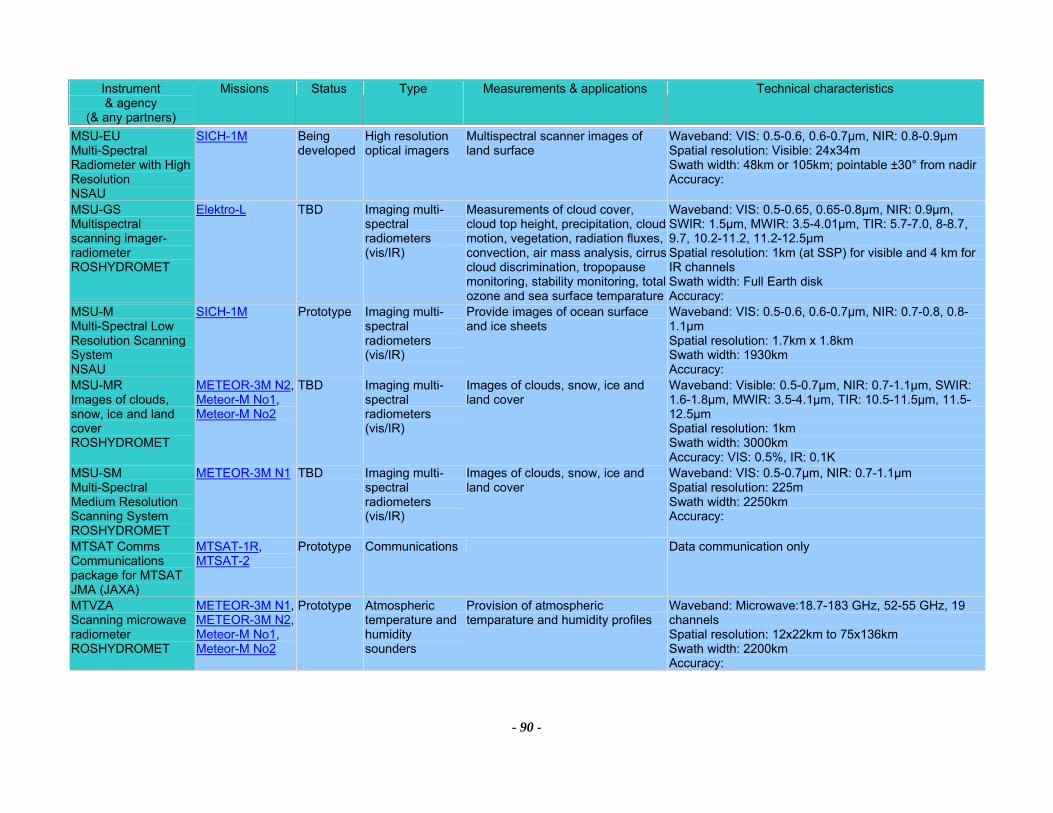
Instrument & agency
(& any partners)
Missions Status Type Measurements & applications Technical characteristics
- 90 -
MSU-EU Multi-Spectral Radiometer with High Resolution NSAU
SICH-1M Being developed
High resolution optical imagers
Multispectral scanner images of land surface
Waveband: VIS: 0.5-0.6, 0.6-0.7µm, NIR: 0.8-0.9µm Spatial resolution: Visible: 24x34m Swath width: 48km or 105km; pointable ±30° from nadirAccuracy:
MSU-GS Multispectral scanning imager-radiometer ROSHYDROMET
Elektro-L TBD Imaging multi-spectral radiometers (vis/IR)
Measurements of cloud cover, cloud top height, precipitation, cloud motion, vegetation, radiation fluxes, convection, air mass analysis, cirrus cloud discrimination, tropopause monitoring, stability monitoring, total ozone and sea surface temparature
Waveband: VIS: 0.5-0.65, 0.65-0.8µm, NIR: 0.9µm, SWIR: 1.5µm, MWIR: 3.5-4.01µm, TIR: 5.7-7.0, 8-8.7, 9.7, 10.2-11.2, 11.2-12.5µm Spatial resolution: 1km (at SSP) for visible and 4 km for IR channels Swath width: Full Earth disk Accuracy:
MSU-M Multi-Spectral Low Resolution Scanning System NSAU
SICH-1M Prototype Imaging multi-spectral radiometers (vis/IR)
Provide images of ocean surface and ice sheets
Waveband: VIS: 0.5-0.6, 0.6-0.7µm, NIR: 0.7-0.8, 0.8-1.1µm Spatial resolution: 1.7km x 1.8km Swath width: 1930km Accuracy:
MSU-MR Images of clouds, snow, ice and land cover ROSHYDROMET
METEOR-3M N2, Meteor-M No1, Meteor-M No2
TBD Imaging multi-spectral radiometers (vis/IR)
Images of clouds, snow, ice and land cover
Waveband: Visible: 0.5-0.7µm, NIR: 0.7-1.1µm, SWIR: 1.6-1.8µm, MWIR: 3.5-4.1µm, TIR: 10.5-11.5µm, 11.5-12.5µm Spatial resolution: 1km Swath width: 3000km Accuracy: VIS: 0.5%, IR: 0.1K
MSU-SM Multi-Spectral Medium Resolution Scanning System ROSHYDROMET
METEOR-3M N1 TBD Imaging multi-spectral radiometers (vis/IR)
Images of clouds, snow, ice and land cover
Waveband: VIS: 0.5-0.7µm, NIR: 0.7-1.1µm Spatial resolution: 225m Swath width: 2250km Accuracy:
MTSAT Comms Communications package for MTSAT JMA (JAXA)
MTSAT-1R, MTSAT-2
Prototype Communications Data communication only
MTVZA Scanning microwave radiometer ROSHYDROMET
METEOR-3M N1, METEOR-3M N2, Meteor-M No1, Meteor-M No2
Prototype Atmospheric temperature and humidity sounders
Provision of atmospheric temparature and humidity profiles
Waveband: Microwave:18.7-183 GHz, 52-55 GHz, 19 channels Spatial resolution: 12x22km to 75x136km Swath width: 2200km Accuracy:
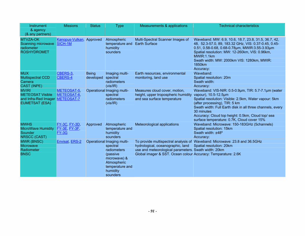
Instrument & agency
(& any partners)
Missions Status Type Measurements & applications Technical characteristics
- 91 -
MTVZA-OK Scanning microwave radiometer ROSHYDROMET
Kanopus-Vulkan, SICH-1M
Approved Atmospheric temperature and humidity sounders
Multi-Spectral Scanner Images of Earth Surface
Waveband: MW: 6.9, 10.6, 18.7, 23.8, 31.5, 36.7, 42, 48, 52.3-57.0, 89, 183.32 GHz, VIS: 0.37-0.45, 0.45-0.51, 0.58-0.68, 0.68-0.78µm, MWIR:3.55-3.93µm Spatial resolution: MW: 12-260km, VIS: 0.96km, MWIR:1.1km Swath width: MW: 2000km VIS: 1280km, MWIR: 1850km Accuracy:
MUX Multispectral CCD Camera CAST (INPE)
CBERS-3, CBERS-4
Being developed
Imaging multi-spectral radiometers (vis/IR)
Earth resources, environmental monitoring, land use
Waveband: Spatial resolution: 20m Swath width: Accuracy:
MVIRI METEOSAT Visible and Infra-Red Imager EUMETSAT (ESA)
METEOSAT-5, METEOSAT-6, METEOSAT-7
Operational Imaging multi-spectral radiometers (vis/IR)
Measures cloud cover, motion, height, upper tropospheric humidity and sea surface temperature
Waveband: VIS-NIR: 0.5-0.9µm, TIR: 5.7-7.1µm (water vapour), 10.5-12.5µm Spatial resolution: Visible: 2.5km, Water vapour: 5km (after processing), TIR: 5 km Swath width: Full Earth disk in all three channels, every 30 minutes Accuracy: Cloud top height: 0.5km, Cloud top/ sea surface temperature: 0.7K, Cloud cover 15%
MWHS MicroWave Humidity Sounder NRSCC (CAST)
FY-3C, FY-3D, FY-3E, FY-3F, FY-3G
Approved Atmospheric temperature and humidity sounders
Meteorological applications Waveband: Microwave: 150-183GHz (5channels) Spatial resolution: 15km Swath width: ±48º Accuracy:
MWR (BNSC) Microwave Radiometer BNSC
Envisat, ERS-2 Operational Imaging multi-spectral radiometers (passive microwave) & Atmospheric temperature and humidity sounders
To provide multispectral analysis of hydrological, oceanographic, land use and meteorological parameters. Global imager & SST. Ocean colour
Waveband: Microwave: 23.8 and 36.5GHz Spatial resolution: 20km Swath width: 20km Accuracy: Temparature: 2.6K
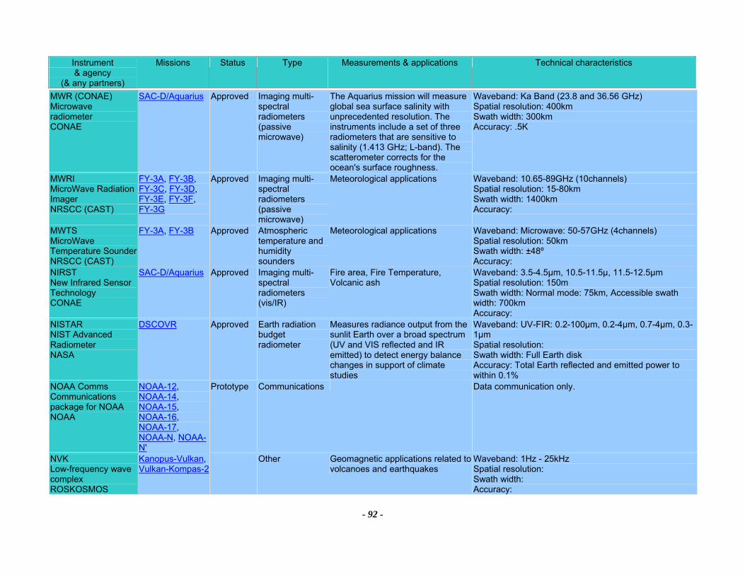
Instrument & agency
(& any partners)
Missions Status Type Measurements & applications Technical characteristics
- 92 -
MWR (CONAE) Microwave radiometer CONAE
SAC-D/Aquarius Approved Imaging multi-spectral radiometers (passive microwave)
The Aquarius mission will measure global sea surface salinity with unprecedented resolution. The instruments include a set of three radiometers that are sensitive to salinity (1.413 GHz; L-band). The scatterometer corrects for the ocean's surface roughness.
Waveband: Ka Band (23.8 and 36.56 GHz) Spatial resolution: 400km Swath width: 300km Accuracy: .5K
MWRI MicroWave Radiation Imager NRSCC (CAST)
FY-3A, FY-3B, FY-3C, FY-3D, FY-3E, FY-3F, FY-3G
Approved Imaging multi-spectral radiometers (passive microwave)
Meteorological applications Waveband: 10.65-89GHz (10channels) Spatial resolution: 15-80km Swath width: 1400km Accuracy:
MWTS MicroWave Temperature Sounder NRSCC (CAST)
FY-3A, FY-3B Approved Atmospheric temperature and humidity sounders
Meteorological applications Waveband: Microwave: 50-57GHz (4channels) Spatial resolution: 50km Swath width: ±48º Accuracy:
NIRST New Infrared Sensor Technology CONAE
SAC-D/Aquarius Approved Imaging multi-spectral radiometers (vis/IR)
Fire area, Fire Temperature, Volcanic ash
Waveband: 3.5-4.5µm, 10.5-11.5µ, 11.5-12.5µm Spatial resolution: 150m Swath width: Normal mode: 75km, Accessible swath width: 700km Accuracy:
NISTAR NIST Advanced Radiometer NASA
DSCOVR Approved Earth radiation budget radiometer
Measures radiance output from the sunlit Earth over a broad spectrum (UV and VIS reflected and IR emitted) to detect energy balance changes in support of climate studies
Waveband: UV-FIR: 0.2-100µm, 0.2-4µm, 0.7-4µm, 0.3-1µm Spatial resolution: Swath width: Full Earth disk Accuracy: Total Earth reflected and emitted power to within 0.1%
NOAA Comms Communications package for NOAA NOAA
NOAA-12, NOAA-14, NOAA-15, NOAA-16, NOAA-17, NOAA-N, NOAA-N'
Prototype Communications Data communication only.
NVK Low-frequency wave complex ROSKOSMOS
Kanopus-Vulkan, Vulkan-Kompas-2
Other Geomagnetic applications related to volcanoes and earthquakes
Waveband: 1Hz - 25kHz Spatial resolution: Swath width: Accuracy:
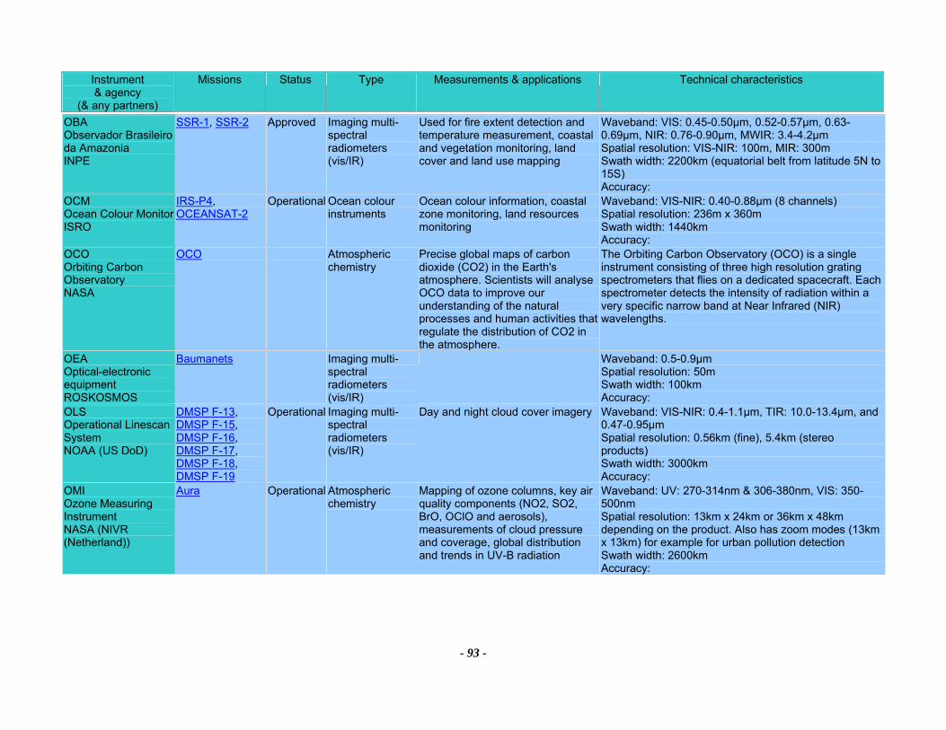
Instrument & agency
(& any partners)
Missions Status Type Measurements & applications Technical characteristics
- 93 -
OBA Observador Brasileiro da Amazonia INPE
SSR-1, SSR-2 Approved Imaging multi-spectral radiometers (vis/IR)
Used for fire extent detection and temperature measurement, coastal and vegetation monitoring, land cover and land use mapping
Waveband: VIS: 0.45-0.50µm, 0.52-0.57µm, 0.63-0.69µm, NIR: 0.76-0.90µm, MWIR: 3.4-4.2µm Spatial resolution: VIS-NIR: 100m, MIR: 300m Swath width: 2200km (equatorial belt from latitude 5N to 15S) Accuracy:
OCM Ocean Colour Monitor ISRO
IRS-P4, OCEANSAT-2
Operational Ocean colour instruments
Ocean colour information, coastal zone monitoring, land resources monitoring
Waveband: VIS-NIR: 0.40-0.88µm (8 channels) Spatial resolution: 236m x 360m Swath width: 1440km Accuracy:
OCO Orbiting Carbon Observatory NASA
OCO Atmospheric chemistry
Precise global maps of carbon dioxide (CO2) in the Earth's atmosphere. Scientists will analyse OCO data to improve our understanding of the natural processes and human activities that regulate the distribution of CO2 in the atmosphere.
The Orbiting Carbon Observatory (OCO) is a single instrument consisting of three high resolution grating spectrometers that flies on a dedicated spacecraft. Each spectrometer detects the intensity of radiation within a very specific narrow band at Near Infrared (NIR) wavelengths.
OEA Optical-electronic equipment ROSKOSMOS
Baumanets Imaging multi-spectral radiometers (vis/IR)
Waveband: 0.5-0.9µm Spatial resolution: 50m Swath width: 100km Accuracy:
OLS Operational Linescan System NOAA (US DoD)
DMSP F-13, DMSP F-15, DMSP F-16, DMSP F-17, DMSP F-18, DMSP F-19
Operational Imaging multi-spectral radiometers (vis/IR)
Day and night cloud cover imagery Waveband: VIS-NIR: 0.4-1.1µm, TIR: 10.0-13.4µm, and 0.47-0.95µm Spatial resolution: 0.56km (fine), 5.4km (stereo products) Swath width: 3000km Accuracy:
OMI Ozone Measuring Instrument NASA (NIVR (Netherland))
Aura Operational Atmospheric chemistry
Mapping of ozone columns, key air quality components (NO2, SO2, BrO, OClO and aerosols), measurements of cloud pressure and coverage, global distribution and trends in UV-B radiation
Waveband: UV: 270-314nm & 306-380nm, VIS: 350-500nm Spatial resolution: 13km x 24km or 36km x 48km depending on the product. Also has zoom modes (13km x 13km) for example for urban pollution detection Swath width: 2600km Accuracy:
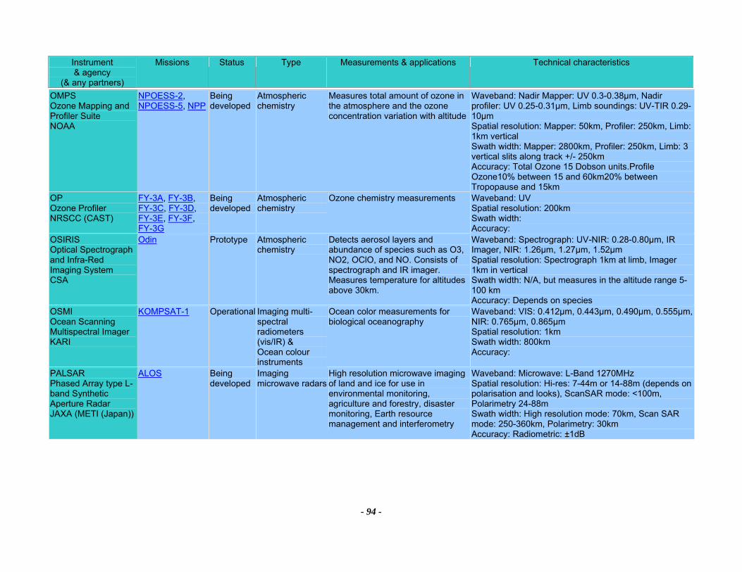
Instrument & agency
(& any partners)
Missions Status Type Measurements & applications Technical characteristics
- 94 -
OMPS Ozone Mapping and Profiler Suite NOAA
NPOESS-2, NPOESS-5, NPP
Being developed
Atmospheric chemistry
Measures total amount of ozone in the atmosphere and the ozone concentration variation with altitude
Waveband: Nadir Mapper: UV 0.3-0.38µm, Nadir profiler: UV 0.25-0.31µm, Limb soundings: UV-TIR 0.29-10µm Spatial resolution: Mapper: 50km, Profiler: 250km, Limb: 1km vertical Swath width: Mapper: 2800km, Profiler: 250km, Limb: 3 vertical slits along track +/- 250km Accuracy: Total Ozone 15 Dobson units.Profile Ozone10% between 15 and 60km20% between Tropopause and 15km
OP Ozone Profiler NRSCC (CAST)
FY-3A, FY-3B, FY-3C, FY-3D, FY-3E, FY-3F, FY-3G
Being developed
Atmospheric chemistry
Ozone chemistry measurements Waveband: UV Spatial resolution: 200km Swath width: Accuracy:
OSIRIS Optical Spectrograph and Infra-Red Imaging System CSA
Odin Prototype Atmospheric chemistry
Detects aerosol layers and abundance of species such as O3, NO2, OClO, and NO. Consists of spectrograph and IR imager. Measures temperature for altitudes above 30km.
Waveband: Spectrograph: UV-NIR: 0.28-0.80µm, IR Imager, NIR: 1.26µm, 1.27µm, 1.52µm Spatial resolution: Spectrograph 1km at limb, Imager 1km in vertical Swath width: N/A, but measures in the altitude range 5-100 km Accuracy: Depends on species
OSMI Ocean Scanning Multispectral Imager KARI
KOMPSAT-1 Operational Imaging multi-spectral radiometers (vis/IR) & Ocean colour instruments
Ocean color measurements for biological oceanography
Waveband: VIS: 0.412µm, 0.443µm, 0.490µm, 0.555µm, NIR: 0.765µm, 0.865µm Spatial resolution: 1km Swath width: 800km Accuracy:
PALSAR Phased Array type L-band Synthetic Aperture Radar JAXA (METI (Japan))
ALOS Being developed
Imaging microwave radars
High resolution microwave imaging of land and ice for use in environmental monitoring, agriculture and forestry, disaster monitoring, Earth resource management and interferometry
Waveband: Microwave: L-Band 1270MHz Spatial resolution: Hi-res: 7-44m or 14-88m (depends on polarisation and looks), ScanSAR mode: <100m, Polarimetry 24-88m Swath width: High resolution mode: 70km, Scan SAR mode: 250-360km, Polarimetry: 30km Accuracy: Radiometric: ±1dB
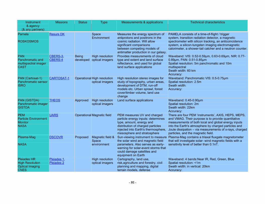
Instrument & agency
(& any partners)
Missions Status Type Measurements & applications Technical characteristics
- 95 -
Pamela ROSKOSMOS
Resurs DK Space Environment
Measures the energy spectrum of antiprotons and positrons in the cosmic radiation. Will allow significant comparisons between competing models of antimatter production in our galaxy.
PAMELA consists of a time-of-flight / trigger system, transition radiation detector, a magnetic spectrometer with silicon tracking, an anticoincidence system, a silicon-tungsten imaging electromagnetic calorimeter, a shower-tail catcher and a neutron counter.
PAN Panchromatic and multispectral imager CAST
CBERS-3, CBERS-4
Being developed
High resolution optical imagers
Provides measurements of cloud type and extent and land surface reflectance, and used for global land surface applications
Waveband: VIS: 0.52-0.59µm, 0.63-0.69µm, NIR: 0.77-0.89µm, PAN: 0.51-0.85µm Spatial resolution: 5m panchromatic and 10m multispectral Swath width: 60 km Accuracy:
PAN (Cartosat-1) Panchromatic sensor ISRO
CARTOSAT-1 Operational High resolution optical imagers
High resolution stereo images for study of topography, urban areas, development of DTM, run-off models etc. Urban sprawl, forest cover/timber volume, land use change
Waveband: Panchromatic VIS: 0.5-0.75µm Spatial resolution: 2.5m Swath width: Accuracy:
PAN (GISTDA) Panchromatic imager GISTDA
THEOS Approved High resolution optical imagers
Land surface applications Waveband: 0.45-0.90µm Spatial resolution: 2m Swath width: 22km Accuracy:
PEM Particle Environment Monitor NASA
UARS Operational Magnetic field PEM measures UV and charged particle energy inputs: determines type, amount, energy and distribution of charged particles injected into Earth's thermosphere, mesosphere and stratosphere
There are four PEM ‘instruments’, AXIS, HEPS, MEPS, and VMAG. Their purpose is to provide quantitative measurements of both local and global energy inputs into the Earth's atmosphere by charged particles and Joule dissipation – via measurements of x-rays, charged particles, and the magnetic field.
Plasma-Mag NASA
DSCOVR
Proposed Magnetic field &Space environment
Sun-viewing instrument to measure the solar wind and magnetic field parameters. Also serves as early-warning for solar-event storms that could damage satellites and equipment on Earth
Plasma-Mag contains a triaxal fluxgate magnetometer that will investigate solar- wind magnetic fields with a sensitivity level of better than 0.1nT.
Pleiades HR High Resolution Optical Imaging CNES
Pleiades 1, Pleiades 2
High resolution optical imagers
Cartography, land use, risk,agriculture and forestry, civil planning and mapping, digital terrain models, defense
Waveband: 4 bands:Near IR, Red, Green, Blue Spatial resolution: <1m Swath width: in vertical: 20km Accuracy:
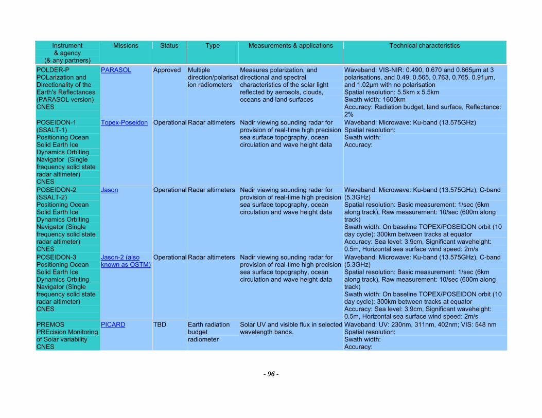
Instrument & agency
(& any partners)
Missions Status Type Measurements & applications Technical characteristics
- 96 -
POLDER-P POLarization and Directionality of the Earth's Reflectances (PARASOL version) CNES
PARASOL Approved Multiple direction/polarisation radiometers
Measures polarization, and directional and spectral characteristics of the solar light reflected by aerosols, clouds, oceans and land surfaces
Waveband: VIS-NIR: 0.490, 0.670 and 0.865µm at 3 polarisations, and 0.49, 0.565, 0.763, 0.765, 0.91µm, and 1.02µm with no polarisation Spatial resolution: 5.5km x 5.5km Swath width: 1600km Accuracy: Radiation budget, land surface, Reflectance: 2%
POSEIDON-1 (SSALT-1) Positioning Ocean Solid Earth Ice Dynamics Orbiting Navigator (Single frequency solid state radar altimeter) CNES
Topex-Poseidon Operational Radar altimeters Nadir viewing sounding radar for provision of real-time high precision sea surface topography, ocean circulation and wave height data
Waveband: Microwave: Ku-band (13.575GHz) Spatial resolution: Swath width: Accuracy:
POSEIDON-2 (SSALT-2) Positioning Ocean Solid Earth Ice Dynamics Orbiting Navigator (Single frequency solid state radar altimeter) CNES
Jason Operational Radar altimeters Nadir viewing sounding radar for provision of real-time high precision sea surface topography, ocean circulation and wave height data
Waveband: Microwave: Ku-band (13.575GHz), C-band (5.3GHz) Spatial resolution: Basic measurement: 1/sec (6km along track), Raw measurement: 10/sec (600m along track) Swath width: On baseline TOPEX/POSEIDON orbit (10 day cycle): 300km between tracks at equator Accuracy: Sea level: 3.9cm, Significant waveheight: 0.5m, Horizontal sea surface wind speed: 2m/s
POSEIDON-3 Positioning Ocean Solid Earth Ice Dynamics Orbiting Navigator (Single frequency solid state radar altimeter) CNES
Jason-2 (also known as OSTM)
Operational Radar altimeters Nadir viewing sounding radar for provision of real-time high precision sea surface topography, ocean circulation and wave height data
Waveband: Microwave: Ku-band (13.575GHz), C-band (5.3GHz) Spatial resolution: Basic measurement: 1/sec (6km along track), Raw measurement: 10/sec (600m along track) Swath width: On baseline TOPEX/POSEIDON orbit (10 day cycle): 300km between tracks at equator Accuracy: Sea level: 3.9cm, Significant waveheight: 0.5m, Horizontal sea surface wind speed: 2m/s
PREMOS PREcision Monitoring of Solar variability CNES
PICARD TBD Earth radiation budget radiometer
Solar UV and visible flux in selected wavelength bands.
Waveband: UV: 230nm, 311nm, 402nm; VIS: 548 nm Spatial resolution: Swath width: Accuracy:
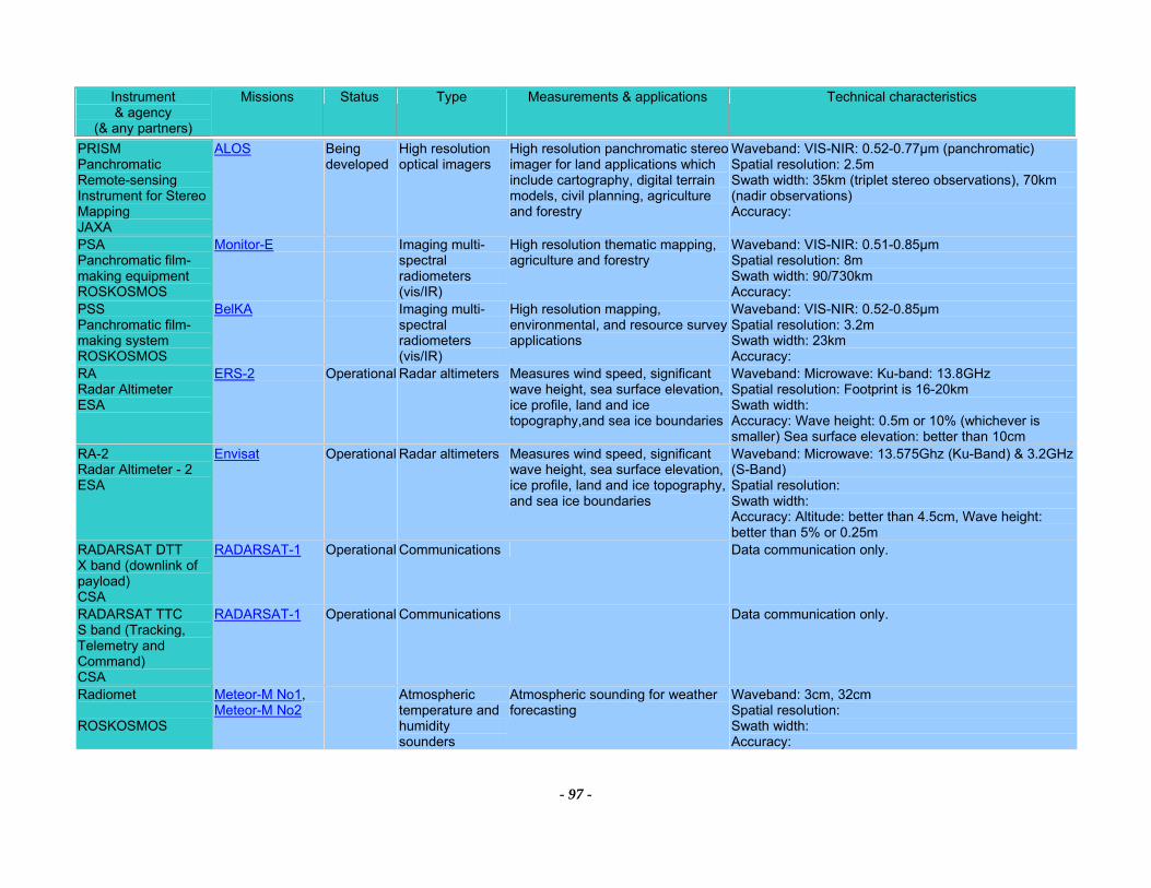
Instrument & agency
(& any partners)
Missions Status Type Measurements & applications Technical characteristics
- 97 -
PRISM Panchromatic Remote-sensing Instrument for Stereo Mapping JAXA
ALOS Being developed
High resolution optical imagers
High resolution panchromatic stereo imager for land applications which include cartography, digital terrain models, civil planning, agriculture and forestry
Waveband: VIS-NIR: 0.52-0.77µm (panchromatic) Spatial resolution: 2.5m Swath width: 35km (triplet stereo observations), 70km (nadir observations) Accuracy:
PSA Panchromatic film-making equipment ROSKOSMOS
Monitor-E Imaging multi-spectral radiometers (vis/IR)
High resolution thematic mapping, agriculture and forestry
Waveband: VIS-NIR: 0.51-0.85µm Spatial resolution: 8m Swath width: 90/730km Accuracy:
PSS Panchromatic film-making system ROSKOSMOS
BelKA Imaging multi-spectral radiometers (vis/IR)
High resolution mapping, environmental, and resource survey applications
Waveband: VIS-NIR: 0.52-0.85µm Spatial resolution: 3.2m Swath width: 23km Accuracy:
RA Radar Altimeter ESA
ERS-2 Operational Radar altimeters Measures wind speed, significant wave height, sea surface elevation, ice profile, land and ice topography,and sea ice boundaries
Waveband: Microwave: Ku-band: 13.8GHz Spatial resolution: Footprint is 16-20km Swath width: Accuracy: Wave height: 0.5m or 10% (whichever is smaller) Sea surface elevation: better than 10cm
RA-2 Radar Altimeter - 2 ESA
Envisat Operational Radar altimeters Measures wind speed, significant wave height, sea surface elevation, ice profile, land and ice topography, and sea ice boundaries
Waveband: Microwave: 13.575Ghz (Ku-Band) & 3.2GHz (S-Band) Spatial resolution: Swath width: Accuracy: Altitude: better than 4.5cm, Wave height: better than 5% or 0.25m
RADARSAT DTT X band (downlink of payload) CSA
RADARSAT-1 Operational Communications Data communication only.
RADARSAT TTC S band (Tracking, Telemetry and Command) CSA
RADARSAT-1 Operational Communications Data communication only.
Radiomet ROSKOSMOS
Meteor-M No1, Meteor-M No2
Atmospheric temperature and humidity sounders
Atmospheric sounding for weather forecasting
Waveband: 3cm, 32cm Spatial resolution: Swath width: Accuracy:
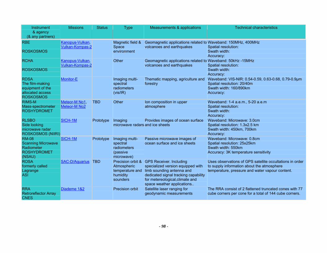
Instrument & agency
(& any partners)
Missions Status Type Measurements & applications Technical characteristics
- 98 -
RBE ROSKOSMOS
Kanopus-Vulkan, Vulkan-Kompas-2
Magnetic field &Space environment
Geomagnetic applications related to volcanoes and earthquakes
Waveband: 150MHz, 400MHz Spatial resolution: Swath width: Accuracy:
RCHA ROSKOSMOS
Kanopus-Vulkan, Vulkan-Kompas-2
Other Geomagnetic applications related to volcanoes and earthquakes
Waveband: 50kHz -15MHz Spatial resolution: Swath width: Accuracy:
RDSA The film-making equipment of the allocated access ROSKOSMOS
Monitor-E Imaging multi-spectral radiometers (vis/IR)
Thematic mapping, agriculture and forestry
Waveband: VIS-NIR: 0.54-0.59, 0.63-0.68, 0.79-0.9µm Spatial resolution: 20/40m Swath width: 160/890km Accuracy:
RIMS-M Mass-spectrometer ROSHYDROMET
Meteor-M No1, Meteor-M No2
TBD Other Ion composition in upper atmosphere
Waveband: 1-4 a.e.m., 5-20 a.e.m Spatial resolution: Swath width: Accuracy:
RLSBO Side looking microwave radar ROSKOSMOS (NIIRI)
SICH-1M Prototype Imaging microwave radars
Provides images of ocean surface and ice sheets
Waveband: Microwave: 3.0cm Spatial resolution: 1.3x2.5 km Swath width: 450km, 700km Accuracy:
RM-08 Scanning Microwave Radiometer ROSHYDROMET (NSAU)
SICH-1M Prototype Imaging multi-spectral radiometers (passive microwave)
Passive microwave images of ocean surface and ice sheets
Waveband: Microwave: 0.8cm Spatial resolution: 25x25km Swath width: 550km Accuracy: 3K temperature sensitivity
ROSA formerly called Lagrange ASI
SAC-D/Aquarius TBD Precision orbit &Atmospheric temperature and humidity sounders
GPS Receiver. Including specialized version equipped with limb sounding antenna and dedicated signal tracking capability for metereological,climate and space weather applications..
Uses observations of GPS satellite occultations in order to supply information about the atmosphere temperature, pressure and water vapour content.
RRA Retroreflector Array CNES
Diademe 1&2 Precision orbit Satellite laser ranging for geodynamic measurements
The RRA consist of 2 flattened truncated cones with 77 cube corners per cone for a total of 144 cube corners.
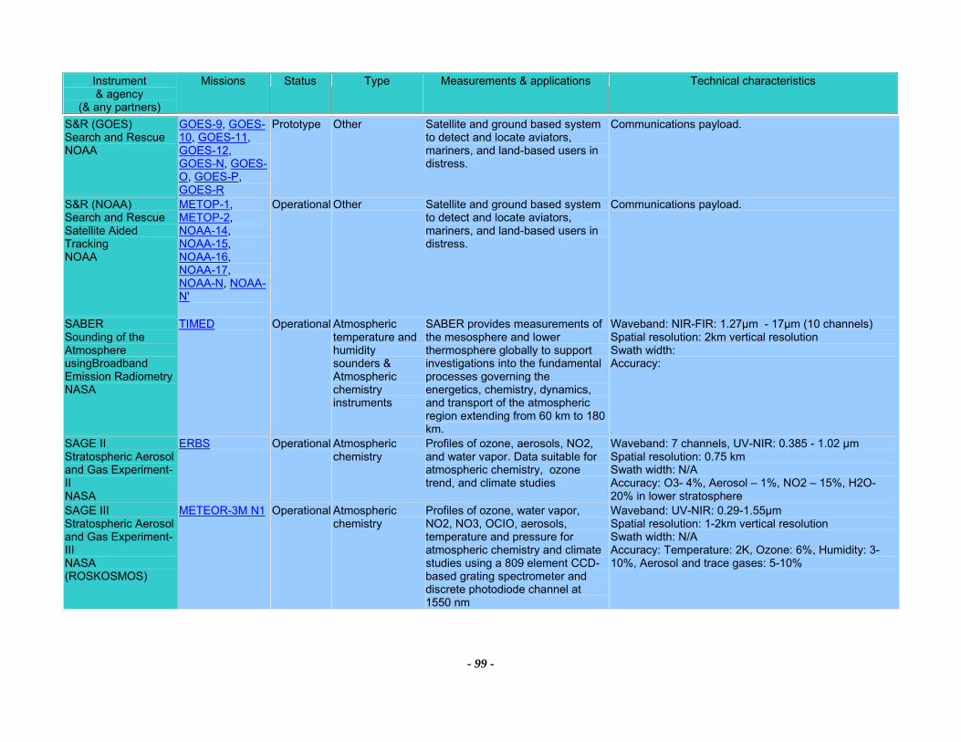
Instrument & agency
(& any partners)
Missions Status Type Measurements & applications Technical characteristics
- 99 -
S&R (GOES) Search and Rescue NOAA
GOES-9, GOES-10, GOES-11, GOES-12, GOES-N, GOES-O, GOES-P, GOES-R
Prototype Other Satellite and ground based system to detect and locate aviators, mariners, and land-based users in distress.
Communications payload.
S&R (NOAA) Search and Rescue Satellite Aided Tracking NOAA
METOP-1, METOP-2, NOAA-14, NOAA-15, NOAA-16, NOAA-17, NOAA-N, NOAA-N'
Operational Other Satellite and ground based system to detect and locate aviators, mariners, and land-based users in distress.
Communications payload.
SABER Sounding of the Atmosphere usingBroadband Emission Radiometry NASA
TIMED Operational Atmospheric temperature and humidity sounders & Atmospheric chemistry instruments
SABER provides measurements of the mesosphere and lower thermosphere globally to support investigations into the fundamental processes governing the energetics, chemistry, dynamics, and transport of the atmospheric region extending from 60 km to 180 km.
Waveband: NIR-FIR: 1.27µm - 17µm (10 channels) Spatial resolution: 2km vertical resolution Swath width: Accuracy:
SAGE II Stratospheric Aerosol and Gas Experiment-II NASA
ERBS Operational Atmospheric chemistry
Profiles of ozone, aerosols, NO2, and water vapor. Data suitable for atmospheric chemistry, ozone trend, and climate studies
Waveband: 7 channels, UV-NIR: 0.385 - 1.02 µm Spatial resolution: 0.75 km Swath width: N/A Accuracy: O3- 4%, Aerosol – 1%, NO2 – 15%, H2O- 20% in lower stratosphere
SAGE III Stratospheric Aerosol and Gas Experiment-III NASA (ROSKOSMOS)
METEOR-3M N1 Operational Atmospheric chemistry
Profiles of ozone, water vapor, NO2, NO3, OCIO, aerosols, temperature and pressure for atmospheric chemistry and climate studies using a 809 element CCD-based grating spectrometer and discrete photodiode channel at 1550 nm
Waveband: UV-NIR: 0.29-1.55µm Spatial resolution: 1-2km vertical resolution Swath width: N/A Accuracy: Temperature: 2K, Ozone: 6%, Humidity: 3-10%, Aerosol and trace gases: 5-10%

Instrument & agency
(& any partners)
Missions Status Type Measurements & applications Technical characteristics
- 100 -
SAPHIR CNES (ISRO)
MEGHA-TROPIQUES
Approved Atmospheric temperature and humidity sounders
Cross-track sounder with the objective of measuring water vapour profiles in the troposphere in six layers from 2-12km altitudes.
Waveband: Microwave: 183.3GHz (6 channels) Spatial resolution: 10km Swath width: Accuracy:
SAR (RADARSAT) Synthetic Aperture Radar (CSA) C band CSA
RADARSAT-1 Operational Imaging microwave radars
Provides all-weather images of ocean, ice and land surfaces. Used for monitoring of coastal zones, polar ice, sea ice, sea state, geological features, vegetation and land surface processes
Waveband: Microwave: C band: 5.3GHz, HH polarisation Spatial resolution: Standard: 25 x28 m (4 looks), Wide beam (1/2):48-30 x 28m/ 32-25 x 28m (4 looks), Fine resolution: 11-9 x 9m (1 look), ScanSAR (N/W): 50 x 50m/ 100 x 100m (2-4/4-8 looks), Extended (H/L): 22-19x28m/ 63-28 x 28m (4 looks) Swath width: Standard: 100km Wide: 150km, Fine: 45km, ScanSAR Narrow: 300km, ScanSAR Wide: 500km, Extended (H): 75km, Extended (L): 170km Accuracy: Geometric distortion: < 40m, Radiometric: 1.0dB
SAR (RADARSAT-2) Synthetic Aperture Radar (CSA) C band CSA
RADARSAT-2 Being developed
Imaging microwave radars
Provides all-weather images of ocean, ice and land surfaces. Used for monitoring of coastal zones, polar ice, sea ice, sea state, geological features, vegetation and land surface processes
Waveband: Microwave: C band 5.405 GHz: HH, VV, HV, VH polarisation - includes fully polarimetric imaging modes, and left- and right-looking capability Spatial resolution: Standard: 25 x28 m (4 looks), Wide beam (1/2):48-30 x 28m/ 32-25 x 28m (4 looks), Fine resolution: 11-9 x 9m (1 look), ScanSAR (N/W): 50 x 50m/ 100 x 100m (2-4/4-8 looks), Extended (H/L): 22-19x28m/ 63-28 x 28m (4 looks), Ultrafine: 3m Swath width: Standard: 100km (20-49deg), Wide beam (1/2): 165km/ 150km (20-31/ 31-39deg), Fine resolution: 45km (37- 48deg), ScanSAR (W): 510km (20-49deg), Extended (H/L): 75km/170km (50-60/ 10-23deg), Ultrafine: 10-20km Accuracy: Geometric distortion: < 40m, Radiometric: 1.0dB
SAR (RISAT) ISRO
RISAT-1 Proposed Imaging microwave radars
Radar backscatter measurements of land, water and ocean surfaces for applications in soil moisture, crop applications (under cloud cover), terrain mapping etc
Waveband: C-Band (5.350 Ghz) Spatial resolution: 3-6m (FRS-1), 9-12m (FRS-2), 25/50m (MRS/CRS) Swath width: 10km (HRS), 30km (FRS-1/FRS-2), 120/240km (MRS/CRS) Accuracy:
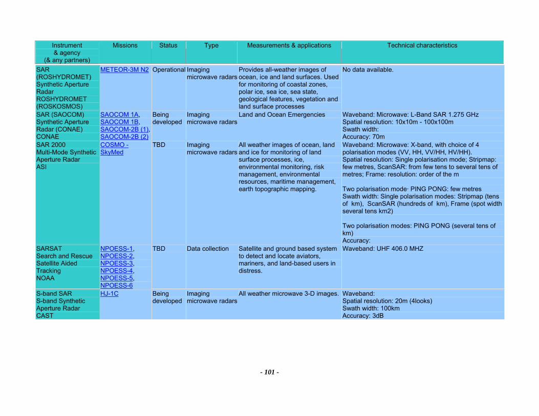
Instrument & agency
(& any partners)
Missions Status Type Measurements & applications Technical characteristics
- 101 -
SAR (ROSHYDROMET) Synthetic Aperture Radar ROSHYDROMET (ROSKOSMOS)
METEOR-3M N2 Operational Imaging microwave radars
Provides all-weather images of ocean, ice and land surfaces. Used for monitoring of coastal zones, polar ice, sea ice, sea state, geological features, vegetation and land surface processes
No data available.
SAR (SAOCOM) Synthetic Aperture Radar (CONAE) CONAE
SAOCOM 1A, SAOCOM 1B, SAOCOM-2B (1), SAOCOM-2B (2)
Being developed
Imaging microwave radars
Land and Ocean Emergencies Waveband: Microwave: L-Band SAR 1.275 GHz Spatial resolution: 10x10m - 100x100m Swath width: Accuracy: 70m
SAR 2000 Multi-Mode Synthetic Aperture Radar ASI
COSMO - SkyMed
TBD Imaging microwave radars
All weather images of ocean, land and ice for monitoring of land surface processes, ice, environmental monitoring, risk management, environmental resources, maritime management, earth topographic mapping.
Waveband: Microwave: X-band, with choice of 4 polarisation modes (VV, HH, VV/HH, HV/HH). Spatial resolution: Single polarisation mode; Stripmap: few metres, ScanSAR: from few tens to several tens of metres; Frame: resolution: order of the m Two polarisation mode· PING PONG: few metres Swath width: Single polarisation modes: Stripmap (tens of km), ScanSAR (hundreds of km), Frame (spot width several tens km2) Two polarisation modes: PING PONG (several tens of km) Accuracy:
SARSAT Search and Rescue Satellite Aided Tracking NOAA
NPOESS-1, NPOESS-2, NPOESS-3, NPOESS-4, NPOESS-5, NPOESS-6
TBD Data collection Satellite and ground based system to detect and locate aviators, mariners, and land-based users in distress.
Waveband: UHF 406.0 MHZ
S-band SAR S-band Synthetic Aperture Radar CAST
HJ-1C Being developed
Imaging microwave radars
All weather microwave 3-D images. Waveband: Spatial resolution: 20m (4looks) Swath width: 100km Accuracy: 3dB
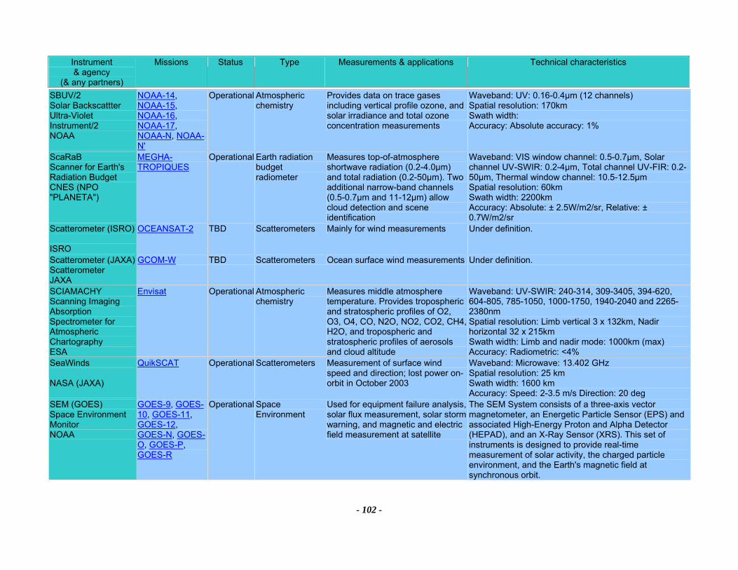
Instrument & agency
(& any partners)
Missions Status Type Measurements & applications Technical characteristics
- 102 -
SBUV/2 Solar Backscattter Ultra-Violet Instrument/2 NOAA
NOAA-14, NOAA-15, NOAA-16, NOAA-17, NOAA-N, NOAA-N'
Operational Atmospheric chemistry
Provides data on trace gases including vertical profile ozone, and solar irradiance and total ozone concentration measurements
Waveband: UV: 0.16-0.4µm (12 channels) Spatial resolution: 170km Swath width: Accuracy: Absolute accuracy: 1%
ScaRaB Scanner for Earth's Radiation Budget CNES (NPO "PLANETA")
MEGHA-TROPIQUES
Operational Earth radiation budget radiometer
Measures top-of-atmosphere shortwave radiation (0.2-4.0µm) and total radiation (0.2-50µm). Two additional narrow-band channels (0.5-0.7µm and 11-12µm) allow cloud detection and scene identification
Waveband: VIS window channel: 0.5-0.7µm, Solar channel UV-SWIR: 0.2-4µm, Total channel UV-FIR: 0.2-50µm, Thermal window channel: 10.5-12.5µm Spatial resolution: 60km Swath width: 2200km Accuracy: Absolute: ± 2.5W/m2/sr, Relative: ± 0.7W/m2/sr
Scatterometer (ISRO) ISRO
OCEANSAT-2 TBD Scatterometers Mainly for wind measurements Under definition.
Scatterometer (JAXA) Scatterometer JAXA
GCOM-W TBD Scatterometers Ocean surface wind measurements Under definition.
SCIAMACHY Scanning Imaging Absorption Spectrometer for Atmospheric Chartography ESA
Envisat Operational Atmospheric chemistry
Measures middle atmosphere temperature. Provides tropospheric and stratospheric profiles of O2, O3, O4, CO, N2O, NO2, CO2, CH4, H2O, and tropospheric and stratospheric profiles of aerosols and cloud altitude
Waveband: UV-SWIR: 240-314, 309-3405, 394-620, 604-805, 785-1050, 1000-1750, 1940-2040 and 2265-2380nm Spatial resolution: Limb vertical 3 x 132km, Nadir horizontal 32 x 215km Swath width: Limb and nadir mode: 1000km (max) Accuracy: Radiometric: <4%
SeaWinds NASA (JAXA)
QuikSCAT Operational Scatterometers Measurement of surface wind speed and direction; lost power on-orbit in October 2003
Waveband: Microwave: 13.402 GHz Spatial resolution: 25 km Swath width: 1600 km Accuracy: Speed: 2-3.5 m/s Direction: 20 deg
SEM (GOES) Space Environment Monitor NOAA
GOES-9, GOES-10, GOES-11, GOES-12, GOES-N, GOES-O, GOES-P, GOES-R
Operational Space Environment
Used for equipment failure analysis, solar flux measurement, solar storm warning, and magnetic and electric field measurement at satellite
The SEM System consists of a three-axis vector magnetometer, an Energetic Particle Sensor (EPS) and associated High-Energy Proton and Alpha Detector (HEPAD), and an X-Ray Sensor (XRS). This set of instruments is designed to provide real-time measurement of solar activity, the charged particle environment, and the Earth's magnetic field at synchronous orbit.
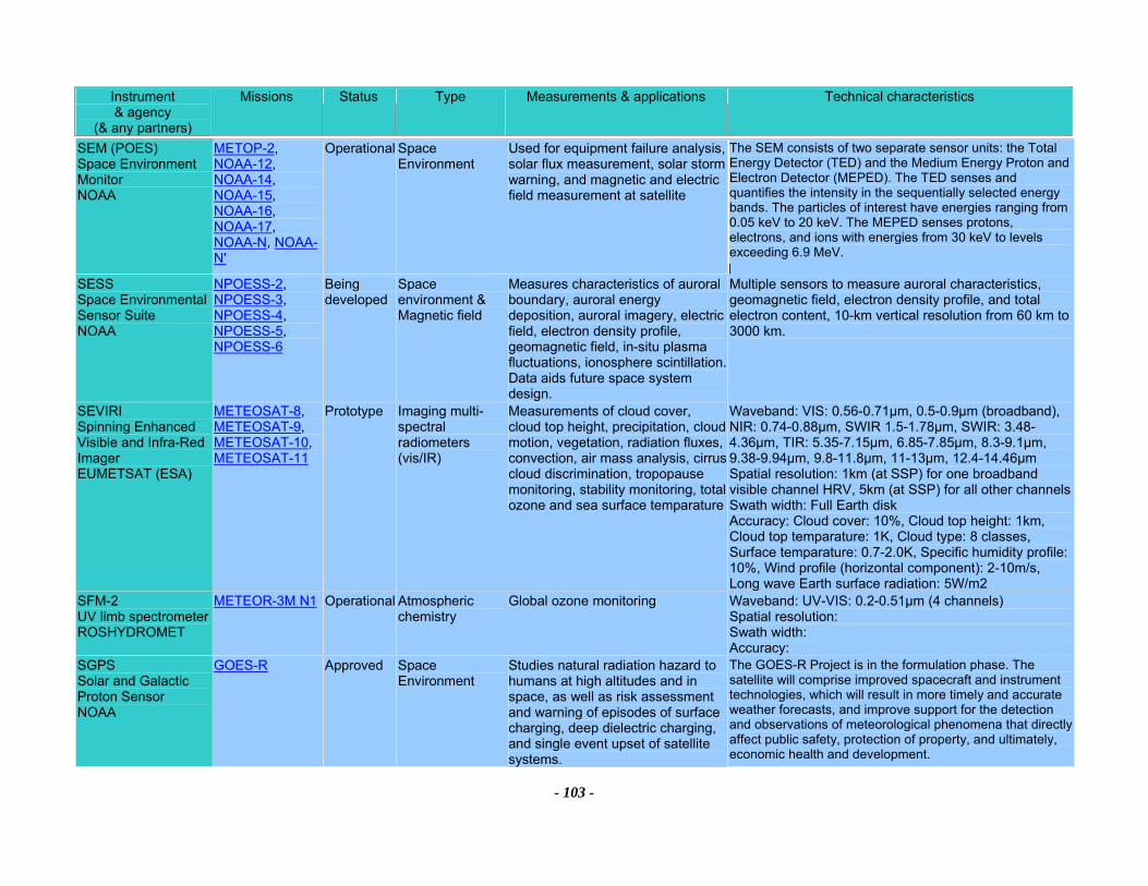
Instrument & agency
(& any partners)
Missions Status Type Measurements & applications Technical characteristics
- 103 -
SEM (POES) Space Environment Monitor NOAA
METOP-2, NOAA-12, NOAA-14, NOAA-15, NOAA-16, NOAA-17, NOAA-N, NOAA-N'
Operational Space Environment
Used for equipment failure analysis, solar flux measurement, solar storm warning, and magnetic and electric field measurement at satellite
The SEM consists of two separate sensor units: the Total Energy Detector (TED) and the Medium Energy Proton and Electron Detector (MEPED). The TED senses and quantifies the intensity in the sequentially selected energy bands. The particles of interest have energies ranging from 0.05 keV to 20 keV. The MEPED senses protons, electrons, and ions with energies from 30 keV to levels exceeding 6.9 MeV.
SESS Space Environmental Sensor Suite NOAA
NPOESS-2, NPOESS-3, NPOESS-4, NPOESS-5, NPOESS-6
Being developed
Space environment & Magnetic field
Measures characteristics of auroral boundary, auroral energy deposition, auroral imagery, electric field, electron density profile, geomagnetic field, in-situ plasma fluctuations, ionosphere scintillation. Data aids future space system design.
Multiple sensors to measure auroral characteristics, geomagnetic field, electron density profile, and total electron content, 10-km vertical resolution from 60 km to 3000 km.
SEVIRI Spinning Enhanced Visible and Infra-Red Imager EUMETSAT (ESA)
METEOSAT-8, METEOSAT-9, METEOSAT-10, METEOSAT-11
Prototype Imaging multi-spectral radiometers (vis/IR)
Measurements of cloud cover, cloud top height, precipitation, cloud motion, vegetation, radiation fluxes, convection, air mass analysis, cirrus cloud discrimination, tropopause monitoring, stability monitoring, total ozone and sea surface temparature
Waveband: VIS: 0.56-0.71µm, 0.5-0.9µm (broadband), NIR: 0.74-0.88µm, SWIR 1.5-1.78µm, SWIR: 3.48-4.36µm, TIR: 5.35-7.15µm, 6.85-7.85µm, 8.3-9.1µm, 9.38-9.94µm, 9.8-11.8µm, 11-13µm, 12.4-14.46µm Spatial resolution: 1km (at SSP) for one broadband visible channel HRV, 5km (at SSP) for all other channels Swath width: Full Earth disk Accuracy: Cloud cover: 10%, Cloud top height: 1km, Cloud top temparature: 1K, Cloud type: 8 classes, Surface temparature: 0.7-2.0K, Specific humidity profile: 10%, Wind profile (horizontal component): 2-10m/s, Long wave Earth surface radiation: 5W/m2
SFM-2 UV limb spectrometer ROSHYDROMET
METEOR-3M N1 Operational Atmospheric chemistry
Global ozone monitoring Waveband: UV-VIS: 0.2-0.51µm (4 channels) Spatial resolution: Swath width: Accuracy:
SGPS Solar and Galactic Proton Sensor NOAA
GOES-R Approved Space Environment
Studies natural radiation hazard to humans at high altitudes and in space, as well as risk assessment and warning of episodes of surface charging, deep dielectric charging, and single event upset of satellite systems.
The GOES-R Project is in the formulation phase. The satellite will comprise improved spacecraft and instrument technologies, which will result in more timely and accurate weather forecasts, and improve support for the detection and observations of meteorological phenomena that directly affect public safety, protection of property, and ultimately, economic health and development.
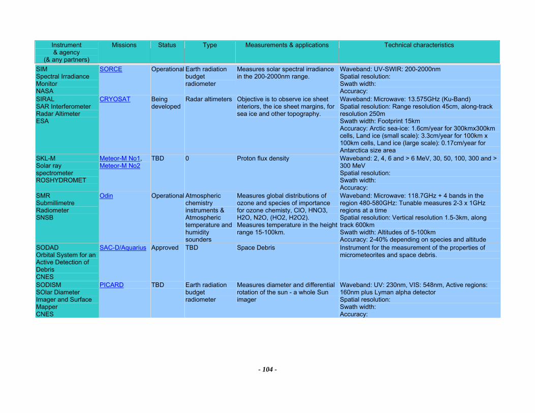
Instrument & agency
(& any partners)
Missions Status Type Measurements & applications Technical characteristics
- 104 -
SIM Spectral Irradiance Monitor NASA
SORCE Operational Earth radiation budget radiometer
Measures solar spectral irradiance in the 200-2000nm range.
Waveband: UV-SWIR: 200-2000nm Spatial resolution: Swath width: Accuracy:
SIRAL SAR Interferometer Radar Altimeter ESA
CRYOSAT Being developed
Radar altimeters Objective is to observe ice sheet interiors, the ice sheet margins, for sea ice and other topography.
Waveband: Microwave: 13.575GHz (Ku-Band) Spatial resolution: Range resolution 45cm, along-track resolution 250m Swath width: Footprint 15km Accuracy: Arctic sea-ice: 1.6cm/year for 300kmx300km cells, Land ice (small scale): 3.3cm/year for 100km x 100km cells, Land ice (large scale): 0.17cm/year for Antarctica size area
SKL-M Solar ray spectrometer ROSHYDROMET
Meteor-M No1, Meteor-M No2
TBD 0 Proton flux density Waveband: 2, 4, 6 and > 6 MeV, 30, 50, 100, 300 and > 300 MeV Spatial resolution: Swath width: Accuracy:
SMR Submillimetre Radiometer SNSB
Odin Operational Atmospheric chemistry instruments & Atmospheric temperature and humidity sounders
Measures global distributions of ozone and species of importance for ozone chemisty, ClO, HNO3, H2O, N2O, (HO2, H2O2). Measures temperature in the height range 15-100km.
Waveband: Microwave: 118.7GHz + 4 bands in the region 480-580GHz: Tunable measures 2-3 x 1GHz regions at a time Spatial resolution: Vertical resolution 1.5-3km, along track 600km Swath width: Altitudes of 5-100km Accuracy: 2-40% depending on species and altitude
SODAD Orbital System for an Active Detection of Debris CNES
SAC-D/Aquarius Approved TBD Space Debris Instrument for the measurement of the properties of micrometeorites and space debris.
SODISM SOlar Diameter Imager and Surface Mapper CNES
PICARD TBD Earth radiation budget radiometer
Measures diameter and differential rotation of the sun - a whole Sun imager
Waveband: UV: 230nm, VIS: 548nm, Active regions: 160nm plus Lyman alpha detector Spatial resolution: Swath width: Accuracy:
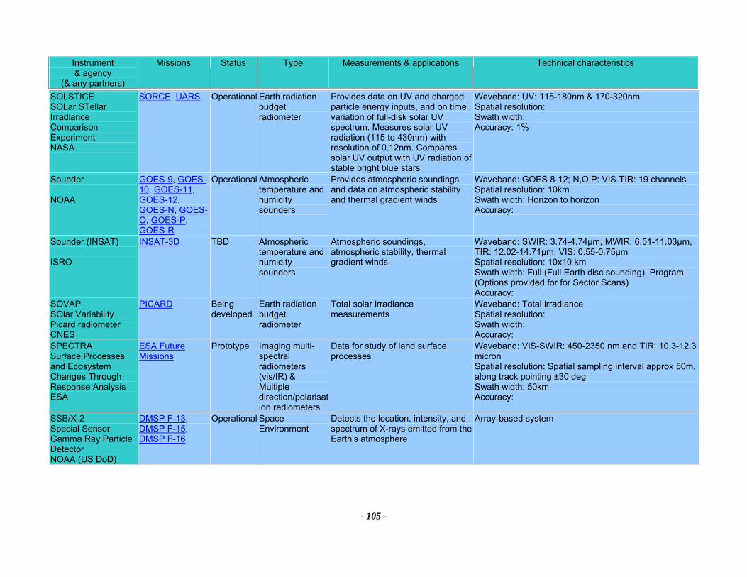
Instrument & agency
(& any partners)
Missions Status Type Measurements & applications Technical characteristics
- 105 -
SOLSTICE SOLar STellar Irradiance Comparison Experiment NASA
SORCE, UARS Operational Earth radiation budget radiometer
Provides data on UV and charged particle energy inputs, and on time variation of full-disk solar UV spectrum. Measures solar UV radiation (115 to 430nm) with resolution of 0.12nm. Compares solar UV output with UV radiation of stable bright blue stars
Waveband: UV: 115-180nm & 170-320nm Spatial resolution: Swath width: Accuracy: 1%
Sounder NOAA
GOES-9, GOES-10, GOES-11, GOES-12, GOES-N, GOES-O, GOES-P, GOES-R
Operational Atmospheric temperature and humidity sounders
Provides atmospheric soundings and data on atmospheric stability and thermal gradient winds
Waveband: GOES 8-12; N,O,P: VIS-TIR: 19 channels Spatial resolution: 10km Swath width: Horizon to horizon Accuracy:
Sounder (INSAT) ISRO
INSAT-3D TBD Atmospheric temperature and humidity sounders
Atmospheric soundings, atmospheric stability, thermal gradient winds
Waveband: SWIR: 3.74-4.74µm, MWIR: 6.51-11.03µm, TIR: 12.02-14.71µm, VIS: 0.55-0.75µm Spatial resolution: 10x10 km Swath width: Full (Full Earth disc sounding), Program (Options provided for for Sector Scans) Accuracy:
SOVAP SOlar Variability Picard radiometer CNES
PICARD Being developed
Earth radiation budget radiometer
Total solar irradiance measurements
Waveband: Total irradiance Spatial resolution: Swath width: Accuracy:
SPECTRA Surface Processes and Ecosystem Changes Through Response Analysis ESA
ESA Future Missions
Prototype Imaging multi-spectral radiometers (vis/IR) & Multiple direction/polarisation radiometers
Data for study of land surface processes
Waveband: VIS-SWIR: 450-2350 nm and TIR: 10.3-12.3 micron Spatial resolution: Spatial sampling interval approx 50m, along track pointing ±30 deg Swath width: 50km Accuracy:
SSB/X-2 Special Sensor Gamma Ray Particle Detector NOAA (US DoD)
DMSP F-13, DMSP F-15, DMSP F-16
Operational Space Environment
Detects the location, intensity, and spectrum of X-rays emitted from the Earth's atmosphere
Array-based system
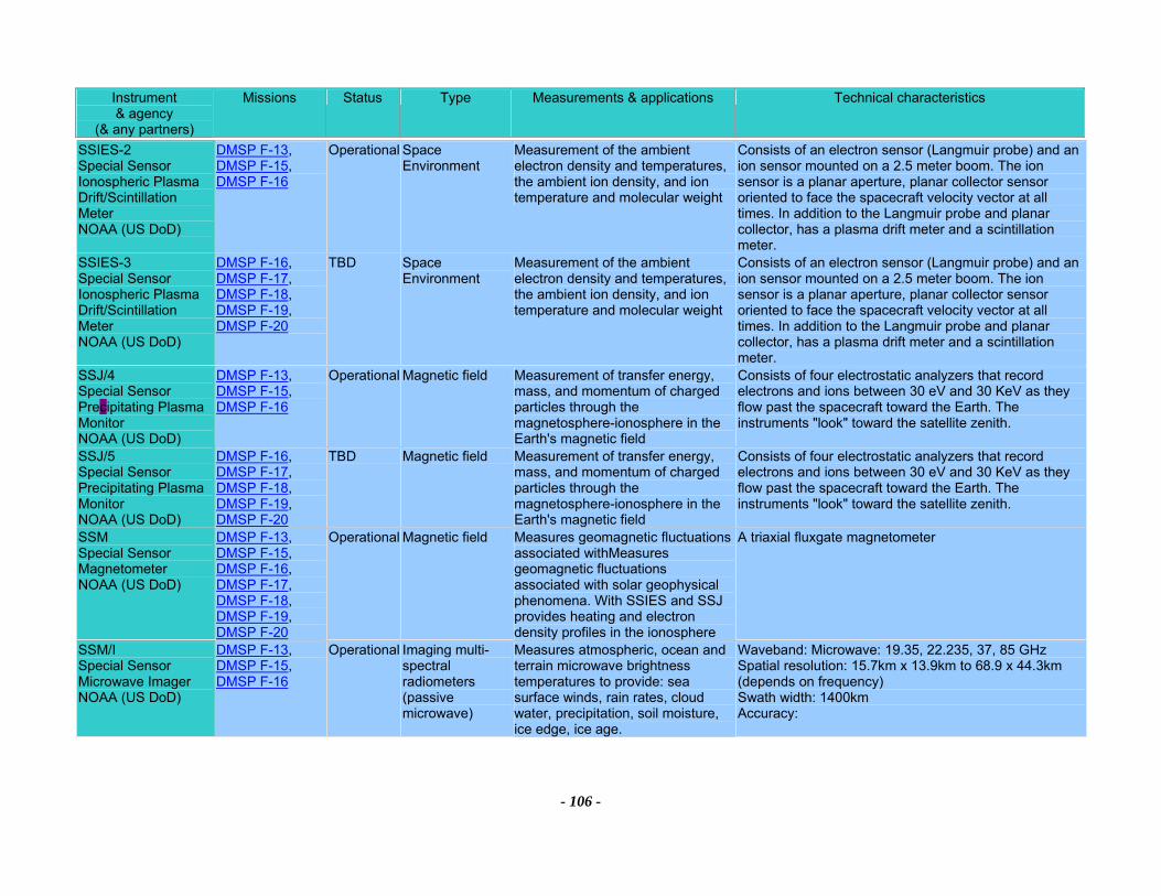
Instrument & agency
(& any partners)
Missions Status Type Measurements & applications Technical characteristics
- 106 -
SSIES-2 Special Sensor Ionospheric Plasma Drift/Scintillation Meter NOAA (US DoD)
DMSP F-13, DMSP F-15, DMSP F-16
Operational Space Environment
Measurement of the ambient electron density and temperatures, the ambient ion density, and ion temperature and molecular weight
Consists of an electron sensor (Langmuir probe) and an ion sensor mounted on a 2.5 meter boom. The ion sensor is a planar aperture, planar collector sensor oriented to face the spacecraft velocity vector at all times. In addition to the Langmuir probe and planar collector, has a plasma drift meter and a scintillation meter.
SSIES-3 Special Sensor Ionospheric Plasma Drift/Scintillation Meter NOAA (US DoD)
DMSP F-16, DMSP F-17, DMSP F-18, DMSP F-19, DMSP F-20
TBD Space Environment
Measurement of the ambient electron density and temperatures, the ambient ion density, and ion temperature and molecular weight
Consists of an electron sensor (Langmuir probe) and an ion sensor mounted on a 2.5 meter boom. The ion sensor is a planar aperture, planar collector sensor oriented to face the spacecraft velocity vector at all times. In addition to the Langmuir probe and planar collector, has a plasma drift meter and a scintillation meter.
SSJ/4 Special Sensor Precipitating Plasma Monitor NOAA (US DoD)
DMSP F-13, DMSP F-15, DMSP F-16
Operational Magnetic field Measurement of transfer energy, mass, and momentum of charged particles through the magnetosphere-ionosphere in the Earth's magnetic field
Consists of four electrostatic analyzers that record electrons and ions between 30 eV and 30 KeV as they flow past the spacecraft toward the Earth. The instruments "look" toward the satellite zenith.
SSJ/5 Special Sensor Precipitating Plasma Monitor NOAA (US DoD)
DMSP F-16, DMSP F-17, DMSP F-18, DMSP F-19, DMSP F-20
TBD Magnetic field Measurement of transfer energy, mass, and momentum of charged particles through the magnetosphere-ionosphere in the Earth's magnetic field
Consists of four electrostatic analyzers that record electrons and ions between 30 eV and 30 KeV as they flow past the spacecraft toward the Earth. The instruments "look" toward the satellite zenith.
SSM Special Sensor Magnetometer NOAA (US DoD)
DMSP F-13, DMSP F-15, DMSP F-16, DMSP F-17, DMSP F-18, DMSP F-19, DMSP F-20
Operational Magnetic field Measures geomagnetic fluctuations associated withMeasures geomagnetic fluctuations associated with solar geophysical phenomena. With SSIES and SSJ provides heating and electron density profiles in the ionosphere
A triaxial fluxgate magnetometer
SSM/I Special Sensor Microwave Imager NOAA (US DoD)
DMSP F-13, DMSP F-15, DMSP F-16
Operational Imaging multi-spectral radiometers (passive microwave)
Measures atmospheric, ocean and terrain microwave brightness temperatures to provide: sea surface winds, rain rates, cloud water, precipitation, soil moisture, ice edge, ice age.
Waveband: Microwave: 19.35, 22.235, 37, 85 GHz Spatial resolution: 15.7km x 13.9km to 68.9 x 44.3km (depends on frequency) Swath width: 1400km Accuracy:
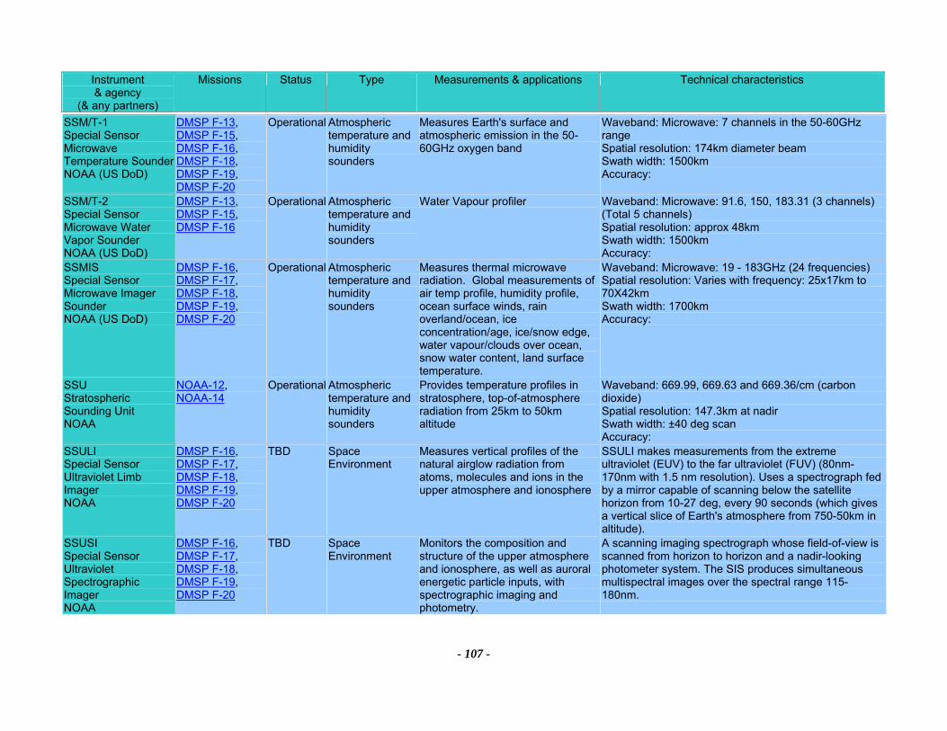
Instrument & agency
(& any partners)
Missions Status Type Measurements & applications Technical characteristics
- 107 -
SSM/T-1 Special Sensor Microwave Temperature Sounder NOAA (US DoD)
DMSP F-13, DMSP F-15, DMSP F-16, DMSP F-18, DMSP F-19, DMSP F-20
Operational Atmospheric temperature and humidity sounders
Measures Earth's surface and atmospheric emission in the 50-60GHz oxygen band
Waveband: Microwave: 7 channels in the 50-60GHz range Spatial resolution: 174km diameter beam Swath width: 1500km Accuracy:
SSM/T-2 Special Sensor Microwave Water Vapor Sounder NOAA (US DoD)
DMSP F-13, DMSP F-15, DMSP F-16
Operational Atmospheric temperature and humidity sounders
Water Vapour profiler Waveband: Microwave: 91.6, 150, 183.31 (3 channels) (Total 5 channels) Spatial resolution: approx 48km Swath width: 1500km Accuracy:
SSMIS Special Sensor Microwave Imager Sounder NOAA (US DoD)
DMSP F-16, DMSP F-17, DMSP F-18, DMSP F-19, DMSP F-20
Operational Atmospheric temperature and humidity sounders
Measures thermal microwave radiation. Global measurements of air temp profile, humidity profile, ocean surface winds, rain overland/ocean, ice concentration/age, ice/snow edge, water vapour/clouds over ocean, snow water content, land surface temperature.
Waveband: Microwave: 19 - 183GHz (24 frequencies) Spatial resolution: Varies with frequency: 25x17km to 70X42km Swath width: 1700km Accuracy:
SSU Stratospheric Sounding Unit NOAA
NOAA-12, NOAA-14
Operational Atmospheric temperature and humidity sounders
Provides temperature profiles in stratosphere, top-of-atmosphere radiation from 25km to 50km altitude
Waveband: 669.99, 669.63 and 669.36/cm (carbon dioxide) Spatial resolution: 147.3km at nadir Swath width: ±40 deg scan Accuracy:
SSULI Special Sensor Ultraviolet Limb Imager NOAA
DMSP F-16, DMSP F-17, DMSP F-18, DMSP F-19, DMSP F-20
TBD Space Environment
Measures vertical profiles of the natural airglow radiation from atoms, molecules and ions in the upper atmosphere and ionosphere
SSULI makes measurements from the extreme ultraviolet (EUV) to the far ultraviolet (FUV) (80nm-170nm with 1.5 nm resolution). Uses a spectrograph fed by a mirror capable of scanning below the satellite horizon from 10-27 deg, every 90 seconds (which gives a vertical slice of Earth's atmosphere from 750-50km in altitude).
SSUSI Special Sensor Ultraviolet Spectrographic Imager NOAA
DMSP F-16, DMSP F-17, DMSP F-18, DMSP F-19, DMSP F-20
TBD Space Environment
Monitors the composition and structure of the upper atmosphere and ionosphere, as well as auroral energetic particle inputs, with spectrographic imaging and photometry.
A scanning imaging spectrograph whose field-of-view is scanned from horizon to horizon and a nadir-looking photometer system. The SIS produces simultaneous multispectral images over the spectral range 115-180nm.
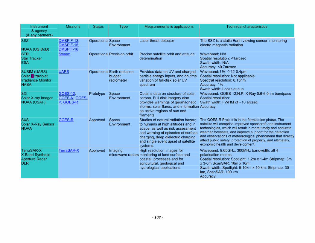
Instrument & agency
(& any partners)
Missions Status Type Measurements & applications Technical characteristics
- 108 -
SSZ NOAA (US DoD)
DMSP F-13, DMSP F-15, DMSP F-16
Operational Space Environment
Laser threat detector The SSZ is a static Earth viewing sensor, monitoring electro magnetic radiation
STR Star Tracker ESA
Swarm Operational Precision orbit Precise satellite orbit and attitude determination
Waveband: N/A Spatial resolution: <1arcsec Swath width: N/A Accuracy: <0.7arcsec
SUSIM (UARS) Solar Ultraviolet Irradiance Monitor NASA
UARS Operational Earth radiation budget radiometer
Provides data on UV and charged particle energy inputs, and on time variation of full-disk solar UV spectrum
Waveband: UV: 0.12-0.4µm Spatial resolution: Not applicable Spectral resolution: 0.15nm Accuracy: 1% Swath width: Looks at sun
SXI Solar X-ray Imager NOAA (USAF)
GOES-12, GOES-N, GOES-P, GOES-R
Prototype Space Environment
Obtains data on structure of solar corona. Full disk imagery also provides warnings of geomagnetic storms, solar flares, and information on active regions of sun and filaments
Waveband: GOES 12,N,P: X-Ray 0.6-6.0nm bandpass Spatial resolution: Swath width: FWHM of ~10 arcsec Accuracy:
SXS Solar X-Ray Sensor NOAA
GOES-R Approved Space Environment
Studies of natural radiation hazard to humans at high altitudes and in space, as well as risk assessment and warning of episodes of surface charging, deep dielectric charging, and single event upset of satellite systems.
The GOES-R Project is in the formulation phase. The satellite will comprise improved spacecraft and instrument technologies, which will result in more timely and accurate weather forecasts, and improve support for the detection and observations of meteorological phenomena that directly affect public safety, protection of property, and ultimately, economic health and development.
TerraSAR-X X-Band Synthetic Aperture Radar DLR
TerraSAR-X Approved Imaging microwave radars
High resolution images for monitoring of land surface and coastal processes and for agricultural, geological and hydrological applications
Waveband: 9.65GHz, 300MHz bandwidth, all 4 polarisation modes Spatial resolution: Spotlight: 1,2m x 1-4m Stripmap: 3m x 3-6m ScanSAR: 16m x 16m Swath width: Spotlight: 5-10km x 10 km, Stripmap: 30 km, ScanSAR: 100 km Accuracy:
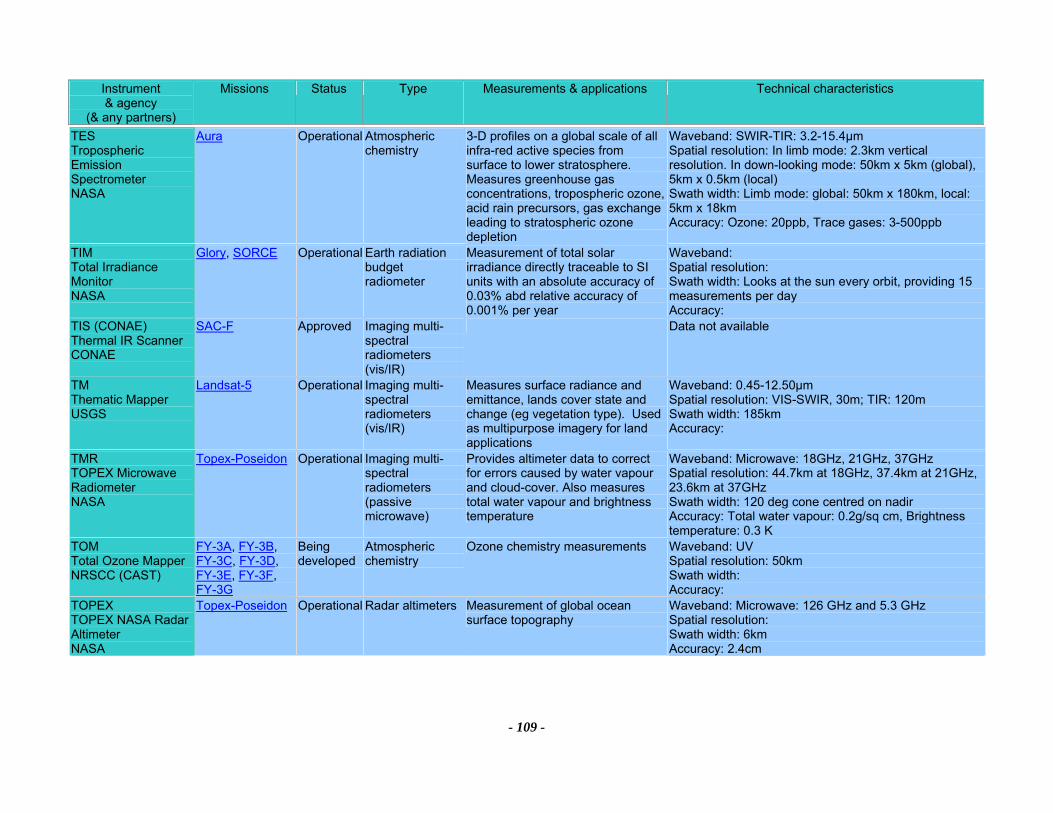
Instrument & agency
(& any partners)
Missions Status Type Measurements & applications Technical characteristics
- 109 -
TES Tropospheric Emission Spectrometer NASA
Aura Operational Atmospheric chemistry
3-D profiles on a global scale of all infra-red active species from surface to lower stratosphere. Measures greenhouse gas concentrations, tropospheric ozone, acid rain precursors, gas exchange leading to stratospheric ozone depletion
Waveband: SWIR-TIR: 3.2-15.4µm Spatial resolution: In limb mode: 2.3km vertical resolution. In down-looking mode: 50km x 5km (global), 5km x 0.5km (local) Swath width: Limb mode: global: 50km x 180km, local: 5km x 18km Accuracy: Ozone: 20ppb, Trace gases: 3-500ppb
TIM Total Irradiance Monitor NASA
Glory, SORCE Operational Earth radiation budget radiometer
Measurement of total solar irradiance directly traceable to SI units with an absolute accuracy of 0.03% abd relative accuracy of 0.001% per year
Waveband: Spatial resolution: Swath width: Looks at the sun every orbit, providing 15 measurements per day Accuracy:
TIS (CONAE) Thermal IR Scanner CONAE
SAC-F Approved Imaging multi-spectral radiometers (vis/IR)
Data not available
TM Thematic Mapper USGS
Landsat-5 Operational Imaging multi-spectral radiometers (vis/IR)
Measures surface radiance and emittance, lands cover state and change (eg vegetation type). Used as multipurpose imagery for land applications
Waveband: 0.45-12.50µm Spatial resolution: VIS-SWIR, 30m; TIR: 120m Swath width: 185km Accuracy:
TMR TOPEX Microwave Radiometer NASA
Topex-Poseidon Operational Imaging multi-spectral radiometers (passive microwave)
Provides altimeter data to correct for errors caused by water vapour and cloud-cover. Also measures total water vapour and brightness temperature
Waveband: Microwave: 18GHz, 21GHz, 37GHz Spatial resolution: 44.7km at 18GHz, 37.4km at 21GHz, 23.6km at 37GHz Swath width: 120 deg cone centred on nadir Accuracy: Total water vapour: 0.2g/sq cm, Brightness temperature: 0.3 K
TOM Total Ozone Mapper NRSCC (CAST)
FY-3A, FY-3B, FY-3C, FY-3D, FY-3E, FY-3F, FY-3G
Being developed
Atmospheric chemistry
Ozone chemistry measurements Waveband: UV Spatial resolution: 50km Swath width: Accuracy:
TOPEX TOPEX NASA Radar Altimeter NASA
Topex-Poseidon Operational Radar altimeters Measurement of global ocean surface topography
Waveband: Microwave: 126 GHz and 5.3 GHz Spatial resolution: Swath width: 6km Accuracy: 2.4cm
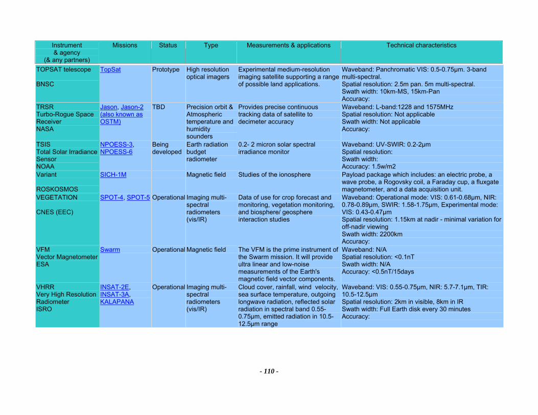
Instrument & agency
(& any partners)
Missions Status Type Measurements & applications Technical characteristics
- 110 -
TOPSAT telescope BNSC
TopSat Prototype High resolution optical imagers
Experimental medium-resolution imaging satellite supporting a range of possible land applications.
Waveband: Panchromatic VIS: 0.5-0.75µm. 3-band multi-spectral. Spatial resolution: 2.5m pan. 5m multi-spectral. Swath width: 10km-MS, 15km-Pan Accuracy:
TRSR Turbo-Rogue Space Receiver NASA
Jason, Jason-2 (also known as OSTM)
TBD Precision orbit &Atmospheric temperature and humidity sounders
Provides precise continuous tracking data of satellite to decimeter accuracy
Waveband: L-band:1228 and 1575MHz Spatial resolution: Not applicable Swath width: Not applicable Accuracy:
TSIS Total Solar Irradiance Sensor NOAA
NPOESS-3, NPOESS-6
Being developed
Earth radiation budget radiometer
0.2- 2 micron solar spectral irradiance monitor
Waveband: UV-SWIR: 0.2-2µm Spatial resolution: Swath width: Accuracy: 1.5w/m2
Variant ROSKOSMOS
SICH-1M Magnetic field Studies of the ionosphere Payload package which includes: an electric probe, a wave probe, a Rogovsky coil, a Faraday cup, a fluxgate magnetometer, and a data acquisition unit.
VEGETATION CNES (EEC)
SPOT-4, SPOT-5 Operational Imaging multi-spectral radiometers (vis/IR)
Data of use for crop forecast and monitoring, vegetation monitoring, and biosphere/ geosphere interaction studies
Waveband: Operational mode: VIS: 0.61-0.68µm, NIR: 0.78-0.89µm, SWIR: 1.58-1.75µm, Experimental mode: VIS: 0.43-0.47µm Spatial resolution: 1.15km at nadir - minimal variation for off-nadir viewing Swath width: 2200km Accuracy:
VFM Vector Magnetometer ESA
Swarm Operational Magnetic field The VFM is the prime instrument of the Swarm mission. It will provide ultra linear and low-noise measurements of the Earth's magnetic field vector components.
Waveband: N/A Spatial resolution: <0.1nT Swath width: N/A Accuracy: <0.5nT/15days
VHRR Very High Resolution Radiometer ISRO
INSAT-2E, INSAT-3A, KALAPANA
Operational Imaging multi-spectral radiometers (vis/IR)
Cloud cover, rainfall, wind velocity, sea surface temperature, outgoing longwave radiation, reflected solar radiation in spectral band 0.55-0.75µm, emitted radiation in 10.5-12.5µm range
Waveband: VIS: 0.55-0.75µm, NIR: 5.7-7.1µm, TIR: 10.5-12.5µm Spatial resolution: 2km in visible, 8km in IR Swath width: Full Earth disk every 30 minutes Accuracy:
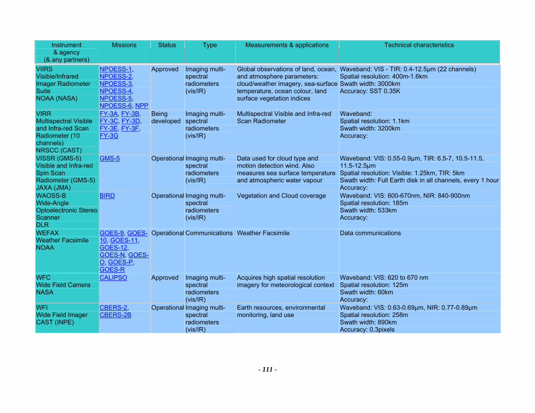
Instrument & agency
(& any partners)
Missions Status Type Measurements & applications Technical characteristics
- 111 -
VIIRS Visible/Infrared Imager Radiometer Suite NOAA (NASA)
NPOESS-1, NPOESS-2, NPOESS-3, NPOESS-4, NPOESS-5, NPOESS-6, NPP
Approved Imaging multi-spectral radiometers (vis/IR)
Global observations of land, ocean, and atmosphere parameters: cloud/weather imagery, sea-surface temperature, ocean colour, land surface vegetation indices
Waveband: VIS - TIR: 0.4-12.5µm (22 channels) Spatial resolution: 400m-1.6km Swath width: 3000km Accuracy: SST 0.35K
VIRR Multispectral Visible and Infra-red Scan Radiometer (10 channels) NRSCC (CAST)
FY-3A, FY-3B, FY-3C, FY-3D, FY-3E, FY-3F, FY-3G
Being developed
Imaging multi-spectral radiometers (vis/IR)
Multispectral Visible and Infra-red Scan Radiometer
Waveband: Spatial resolution: 1.1km Swath width: 3200km Accuracy:
VISSR (GMS-5) Visible and Infra-red Spin Scan Radiometer (GMS-5) JAXA (JMA)
GMS-5 Operational Imaging multi-spectral radiometers (vis/IR)
Data used for cloud type and motion detection wind. Also measures sea surface temperature and atmospheric water vapour
Waveband: VIS: 0.55-0.9µm, TIR: 6.5-7, 10.5-11.5, 11.5-12.5µm Spatial resolution: Visible: 1.25km, TIR: 5km Swath width: Full Earth disk in all channels, every 1 hour Accuracy:
WAOSS-B Wide-Angle Optoelectronic Stereo Scanner DLR
BIRD Operational Imaging multi-spectral radiometers (vis/IR)
Vegetation and Cloud coverage Waveband: VIS: 600-670nm, NIR: 840-900nm Spatial resolution: 185m Swath width: 533km Accuracy:
WEFAX Weather Facsimile NOAA
GOES-9, GOES-10, GOES-11, GOES-12, GOES-N, GOES-O, GOES-P, GOES-R
Operational Communications Weather Facsimile Data communications
WFC Wide Field Camera NASA
CALIPSO Approved Imaging multi-spectral radiometers (vis/IR)
Acquires high spatial resolution imagery for meteorological context
Waveband: VIS: 620 to 670 nm Spatial resolution: 125m Swath width: 60km Accuracy:
WFI Wide Field Imager CAST (INPE)
CBERS-2, CBERS-2B
Operational Imaging multi-spectral radiometers (vis/IR)
Earth resources, environmental monitoring, land use
Waveband: VIS: 0.63-0.69µm, NIR: 0.77-0.89µm Spatial resolution: 258m Swath width: 890km Accuracy: 0.3pixels
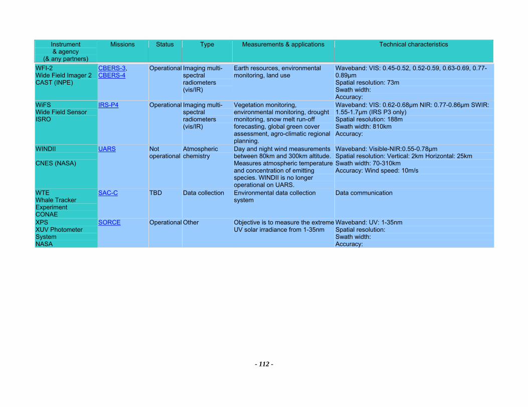
Instrument & agency
(& any partners)
Missions Status Type Measurements & applications Technical characteristics
- 112 -
WFI-2 Wide Field Imager 2 CAST (INPE)
CBERS-3, CBERS-4
Operational Imaging multi-spectral radiometers (vis/IR)
Earth resources, environmental monitoring, land use
Waveband: VIS: 0.45-0.52, 0.52-0.59, 0.63-0.69, 0.77-0.89µm Spatial resolution: 73m Swath width: Accuracy:
WiFS Wide Field Sensor ISRO
IRS-P4 Operational Imaging multi-spectral radiometers (vis/IR)
Vegetation monitoring, environmental monitoring, drought monitoring, snow melt run-off forecasting, global green cover assessment, agro-climatic regional planning.
Waveband: VIS: 0.62-0.68µm NIR: 0.77-0.86µm SWIR: 1.55-1.7µm (IRS P3 only) Spatial resolution: 188m Swath width: 810km Accuracy:
WINDII CNES (NASA)
UARS Not operational
Atmospheric chemistry
Day and night wind measurements between 80km and 300km altitude. Measures atmospheric temperature and concentration of emitting species. WINDII is no longer operational on UARS.
Waveband: Visible-NIR:0.55-0.78µm Spatial resolution: Vertical: 2km Horizontal: 25km Swath width: 70-310km Accuracy: Wind speed: 10m/s
WTE Whale Tracker Experiment CONAE
SAC-C TBD Data collection Environmental data collection system
Data communication
XPS XUV Photometer System NASA
SORCE Operational Other Objective is to measure the extreme UV solar irradiance from 1-35nm
Waveband: UV: 1-35nm Spatial resolution: Swath width: Accuracy: