sca 15: lundy
TRANSCRIPT

North Devon and Exmoor Seascape Character Assessment 122 November 2015
SCA 15: Lundy
SCTs within the SCA: 6 Offshore Islands; 8A Rocky Open Waters with Reefs.
Lundy is a flat-topped island located within the Bristol Channel between the North Devon coast and the Gower and Pembrokeshire coasts in Wales and forms an important focal point in views from these coasts and within the channel. Spectacular cliffs define its coasts edge, and to the west it is battered by waves and winds from the Atlantic. It is an area particularly rich in marine habitats and archaeological remains and is a highly popular destination for visitors who come for a range of experiences and recreational activities. It is a place valued and studied by many with rare qualities of peace and tranquillity.
Lundy is defined as a Heritage Coast.
© Jerome Murray
Click here to return to interactive overview map of the Seascape Character Areas (SCAs)

North Devon and Exmoor Seascape Character Assessment 123 November 2015
Key characteristics Natural / physical influences
A flat-topped island (the largest in the Bristol Channel) formed primarily of Tertiary granite, with Devonian slates revealed along the south-east peninsula. Intrusions by vertical dykes reveal the island’s volcanic past. Small streams cascade down the cliffs.
Spectacular cliffs reaching over 100 metres; the west coast battered by the waves and winds of the Atlantic resulting in a rugged, exposed coastline with features including the Devil’s Limekiln sea cave. More sheltered eastern side, with vegetated slopes and secluded rocky coves.
Surrounded by strong tidal races and overfalls associated with granite/slate reefs extending 1km offshore, rocks and sand banks at East Bank, Stanley Bank and North West Bank; presenting notorious hazards to navigation.
Diverse complex of marine habitats in a small area; circalittoral rock and biogenetic reefs, coarse sediments and dynamic banks of sand sediment supporting a varied marine life, designated as Marine Conservation Zone and marine SAC13.
Rich marine plants and animals; many rare species of seaweed, anemones, sea squirts and bryzoans, soft coral, sea fan, erect branching sponges and all five British species of cup coral. Home to a colony of 120 grey seals as well as visiting basking sharks, sunfish, dolphins, porpoises, pilot and minke whales and orca.
Range of commercially and recreationally important fish and shellfish, including species of crab, lobster, prawn, and crawfish; fish such as wrasse, pollock and dogfish; and molluscs including cuttlefish, limpets, scallops and whelks.
Nationally important cliff-top habitats (most of the island is SSSI) including heath and maritime grasslands with unique flora and fauna, including the endemic Lundy cabbage.
Known for its seasonal colonies of seabirds, including Manx shearwaters, guillemots, razorbills, shags, gulls and the emblematic puffin (the Norse translation of Lundy=Puffin Island). A new breeding population of storm petrels has become established; previously confined in the region to the Isles of Scilly.
Cultural and social influences (past and present)
High concentrations of archaeological remains including over forty Scheduled Monuments, including Bronze Age burial mounds and an early Christian cemetery at Beacon Hill with four inscribed 6th century standing stones.
13th century Marisco Castle, built to try to establish the rule of law on the island. Named after island legend William de Marisco, who fled to the island to become a
13 The Lundy MCZ was the first to be designated in the UK in 2013. Prior to this, the island was the UK’s first voluntary Marine Nature Reserve, established in 1971.
‘virtual king’ after being linked to attempts on the real King Henry III’s life. He was later captured by Henry’s army and hung, drawn and quartered for treason.
Another legendary Lundy resident, Thomas Bushell, held the island as a fortified outpost for King Charles I during the English Civil War, rebuilding Marisco Castle and garrisoning the island at his own expense. Bushell had connections with the silver mining industry at Combe Martin.
Lundy’s chequered past also includes its role as a base for marauders (including allegedly the Barbary Pirates), a retreat for disgraced nobility and the centre of an ingenious tobacco smuggling operation. A lawless period of ownership under Thomas Benson MP saw the island used for housing convicts whom he was tasked with deporting.
Range of other historical relics across the island including 19th century quarries and gun emplacements. Historic navigational features including the landmark early 19th century lighthouse (‘Old Light’) and Tibbett’s Hill lookout; today night-time navigation is provided by two powerful lights at either end of the island.
Over 200 ships lost to the island’s turbulent seas, ten wrecks are recognised dive sites. These include the Iona II protected wreck; a paddle steamer lost in 1864 on its way to America to begin its new occupation as a Confederate blockade-runner during the American Civil War. Regular dive surveys monitor the condition of the wrecks.
Military associations including the wreck of the Royal Navy battleship HMS Montagu, which ran aground near Shutter Rock in heavy fog in 1906. Strenuous salvage efforts failed; the ship sold for scrap at the scene but now another popular dive site, complete with armour plate and shells. Two WWII Heinkel bombers crashed into the island in 1941, with wreckage still visible.
After apparently being won by two gentlemen in a card game in the 1800s, Lundy passed through various hands before a successful fundraising campaign led to National Trust ownership in 1969, leased to the conservation charity The Landmark Trust who manages the island and the passenger ship MS Oldenburg.
Many of the island’s historic buildings, with their distinctive granite vernacular, can be rented for holiday use. The island also has its own campsite and tavern.
A ‘jewel in North Devon’s crown’, valued for a range of experiences and activities both above and below the water; birdwatching, walking, Lundy letterboxing, climbing, diving, kayaking, paddle-boarding, warden-led guided walks and snorkel trips. The east coast’s clear waters are a particular draw for divers and snorkelers.
Long-standing connections with Bideford and Ilfracombe as disembarkation points for trips to Lundy (including on the island’s own MS Oldenburg, as well as the historic cruisers the Waverley and Balmoral). Charter boats bring people for diving, fishing, sightseeing and wildlife watching.
Rich waters used for carefully controlled recreational and commercial fishing using a zoned approach (e.g. the east coast’s No Take Zone; and the Ray Box). The outer waters of the SCA are unrestricted, used by commercial trawlers from Ilfracombe, Appledore and Bideford and further afield.

North Devon and Exmoor Seascape Character Assessment 124 November 2015
Perceptual and aesthetic influences
A unique cultural identity defined by a small close-knit working community far-removed from 21st century influences. Mysterious maritime qualities emphasised by the bright beams of the two lighthouses sweeping across dark night skies.
Island at the mercy of the elements, defined by the ever-present influence of the sea. The seascape presents a challenging and exhilarating ‘wilderness’ experience to visitors arriving from the mainland.
Apart from the landing beach, there is limited access to the foreshore surrounding the island – enhancing its remote and highly tranquil and value as a sanctuary for wildlife.
Lundy forms an important seascape feature visible from all along the North Devon coast as well as the Gower and Pembrokeshire coasts in Wales.
Square granite tower of St Helena’s Church (dating from the 1890s) and the old lighthouse (also granite) forming prominent vertical elements rising up from the plateau, visible from across Bideford Bay.
Expansive views from the island featuring the lighthouse at Hartland Point and stretching as far as the west Exmoor coast, as well as Woolacombe Down, Baggy Point and Saunton Down. The moving blades of the Fullabrook turbines are visible in the distance in clear conditions. In turn, all these locations include views back to Lundy.
The arrival of boats and the helicopter bringing passengers from the mainland introduces noise, movement and activity for short spells of time; after which the island reverts to its remote and wild nature, the sounds of the sea and wind once again dominating the soundscape.
Recently constructed access road snaking along the south-east peninsular to link the landing bay with the village. The road and landing bay is visible in views from the wider bay, introducing a rare element of modern influence.
Lundy is loved and studied by many; a sanctuary and refuge from the modern world with rare true qualities of peace, tranquillity and a sense of being ‘close to nature’.
It is also one of only a few remaining places where views of shooting stars and the Milky Way patterning a clear dark night sky can be marvelled. The island is designated as a Dark Sky Discovery Site.
© Joshua Day

North Devon and Exmoor Seascape Character Assessment 125 November 2015
Special qualities and key seascape sensitivities
The special qualities of this seascape that would be most sensitive to change include:
Truly unique, with unrivalled levels of peace, tranquillity and dark night skies – a breathtaking sanctuary.
Fascinating history, a rich concentration of nationally important archaeological sites, old granite buildings and legends of the island’s chequered past.
Nationally and internationally important coastal and marine wildlife (including seabirds, seals, Lundy cabbage); clear seas revealing a colourful world of natural and historic curiosities – including in views from the cliffs.
Unrivalled opportunities to explore above and below the water, increasing public understanding and appreciation for marine wildlife and seascape.
Long, panoramic and uninterrupted views across Bideford Bay to the North Devon coast, and northwards to South Wales – also experienced by visitors during their exhilarating journey from the mainland.
A ‘jewel in the view’ and focal point in the wider seascape; key to the maritime settings of the North Devon AONB, Exmoor National Park, Gower AONB and Pembrokeshire Coast National Park.
© Jerome Murray

North Devon and Exmoor Seascape Character Assessment 126 November 2015
Forces for change affecting seascape character and condition
Coastal land / marine resource management
Spread of rhododendron, particularly along the east coast, affecting the island’s unique biodiversity – particularly the Lundy Cabbage. A clearance programme as part of the island’s Higher Level Stewardship (HLS) agreement aims to eradicate the species from the island by 2025 (currently around 75% clear).
Historic issues of fluctuating grazing levels by feral goats, sika deer, rabbits and Soay sheep addressed through HLS; an annual vegetation survey carried out in partnership with the National Trust to help inform appropriate stocking levels.
Rapid 20th century decline in Lundy’s seabird population seeing dramatic reversal following the successful eradication of rats from the island. This includes puffin numbers increasing from just five in 2003 to 80 in 2014 (anecdotal evidence suggesting there could now be as many as 300). Breeding storm petrel have been recorded on the island for the first time.
Potential increases in dredging activity in the wider Bristol Channel (including licenced zones in Welsh waters to the north-east of the island) disrupting sediment flow and load, having the potential to affect the island’s distinctive clear waters and conditions favoured by species such as cup corals and pink sea fans.
Potential increases in shipping in the Bristol Channel leading to pollution and an increase in waste/litter washed in from the sea, as well as a greater risk of major pollution incidences. Increased pollution from a greater number of charter boats visiting the island is also a concern.
Need for a co-ordinated approach and overarching framework to manage the island’s nationally and internationally important marine habitats and species. A Marine Protected Area Management Plan will be prepared in 2015/16.
Aquaculture and fishing
Impacts of commercial and recreational fishing on the marine resource being addressed through a number of long-term and more recent byelaws and zoned restrictions14, including a recent extension of protection to the southern reef. Ensuring compliance with the restrictions relies on monitoring and enforcement by the Devon and Severn IFCA and the Marine Management Organisation (MMO).
Perceived conflicts between the conservation of the marine resource and the economic importance of fishing activity to the wider North Devon (and South Wales) economy. This is being addressed across North Devon by ongoing dialogue and research by the Devon and Severn Inshore Fisheries Conservation Authority (IFCA), the Marine Management Organisation (MMO), Natural England, the North Devon Fishermen’s Association and the North Devon Biosphere Marine Working Group. Locally, issues are discussed via Lundy’s own Management Forum and Marine Protected Area Advisory Group.
14 See http://www.lundymcz.org.uk/conserve/zoning-scheme

North Devon and Exmoor Seascape Character Assessment 127 November 2015
Access, recreation and tourism Increasing popularity of UK-based holidays leading to the potential for higher visitor demand to the island (currently at capacity at 20,000 visitors per year). This could put pressure on natural resources and popular walking routes, increasing incidences of wildlife disturbance and impact on tranquillity.
Growing demand for water-based recreation and increased number/size of visiting boats raising concerns over wreck and wildlife disturbance (particularly sea birds, grey seals and cetaceans). These concerns are being addressed and promoted through a Code of Conduct developed and promoted by the North Devon Biosphere Reserve and Landmark Trust. An accreditation scheme for responsible charter companies is also being developed.
Increased number of jet skiers travelling to and around the island, intermittently breaking levels of tranquillity and also raising concerns about wildlife disturbance.
Arrival of visitors by helicopter impacting on levels of tranquillity, although these are low in frequency and duration (and key to providing year-round access opportunities to the island) – therefore not seen as a major concern.
Other development pressures / impacts Recent access road constructed from the Landing Beach as a result of cliff erosion threatening the previous road. This has introduced a prominent man-made feature to the south-eastern coastline.
Strong tidal energy resource around Lundy and the surrounding seas may see future proposals for tidal energy schemes. The North Devon Tidal Zone is situated offshore from the Exmoor coast (covering SCAs 3, 5, 6, 7, 8 and 9); it may be possible that future structures relating to tidal stream devices are visible in distant views from Lundy.
Ongoing national demand for alternative sources of renewable energy production; although the Atlantic Array proposal did not proceed, future offshore wind energy schemes may still come forward – impacting on Lundy’s special qualities.
Natural processes and climate change Impacts of climate change on the distribution of the island’s unique habitats and species, including an increased prevalence of pests, diseases and invasive species. A Biosecurity Plan also seeks to reduce the risk of invasive species arriving on the island (including rats). Sea level rise, increased frequency and intensity of storms, and more rapid coastal erosion as a result of climate change, leading to unstable sections of cliffs, more frequent landslides, the ‘squeeze’ of coastal habitats and potential loss of cliff-top archaeology. The Atlantic-facing west coast is particularly vulnerable.

© Crown Copyright, 2015. All rights reserved. License No. EK001-310466. Not to be used for navigation.Service Layer Credits: Sources: Esri, GEBCO, NOAA, National Geographic, DeLorme, HERE, Geonames.org, and other contributors
CB:VG EB:Goosen_V LUCGLA 6500-01_023_TEMPLATE_VRM_A4L_SCA15only 05/11/2015
Map Scale @ A4: 1:300,000
Source:
North Devon & Exmoor Seascape Character Assessment
15: Lundy
Value
<20 (lowest)21 - 4041 - 6061 - 8080 - 100 (highest)
0 2 4 6 8kmE
Land with Views of: 15:Lundy
This Visual Resource Map (VRM)provides a more detailed spatialrepresentation of the visibility of thisSCA from the surrounding land inEngland and Wales.
This map shows land with views to thisSCA. The darker shading (blues)indicates land from where more of theSCA is visible. Lighter shades (yellows)indicate that there are views of the SCAfrom those locations, but they are notextensive.
Please note that the VRM is based on a bare ground model. Where an SCA encompasses land and sea, only views of areas below the HWM within the SCA have been analysed (locations above the HWM within the SCA have been excluded). Please refer to the technical report for an explanation of how these maps were generated and how they should be interpreted.

North Devon and Exmoor Seascape Character Assessment 129 November 2015
SCA 16: Lundy North
12
13
SCTs within the SCA: 8B Coarse Open Waters
The outer 'Atlantic' part of the study area, forming the western edge of the Bristol Channel where it meets the Celtic Sea, this area is highly remote, located up to 70km from Hartland Point and the Pembrokeshire coast. It forms an important open seascape setting to Lundy in views from both North Devon and South Wales. It is underlain by a bedrock geology of Jurassic sedimentary mudstone and sands, covered by coarse sediments of sands and gravels which provide valued marine habitats, including for commercially fished species. Strong tidal currents and Atlantic swells from the south-west can be hazardous to navigation. The area contains a number of shipwrecks, two of which were torpedoed during WW1. © Joshua Day
Click here to return to interactive overview map of the Seascape Character Areas (SCAs)

North Devon and Exmoor Seascape Character Assessment 130 November 2015
Key characteristics Natural / physical influences
The outer 'Atlantic' part of the North Devon seascape, the SCA forms the western edge of the Bristol Channel where it meets the Celtic Sea.
Deep waters ranging 50 and 60 metres in depth, with a tidal range of over seven metres.
Mixed bedrock geology of sedimentary mudstones and sandstones and limestones, predominantly Jurassic in age.
Major fault zone trending NW-SE known as the Sticklepath-Lustleigh fault, extending across the Bristol Channel through to Bovey Tracey and Newton Abbot.
Occasional small-scale seismic movements relating to the fault zone, last experienced on Lundy in February 2014; faulting rocks are seen along the southern Lundy coast (SCA 15).
Seabed covered by shallow coarse circalittoral sediments of sand and gravel, exposed to a moderate energy water environment. The sediments are punctuated by areas of boulders and bedrock protrusions.
The mobile sediments can create isolated asymmetric sand waves up to 10m in height. They also support relatively high biodiversity across the area.
Diverse marine species associated with the mobile seabed sediments including polychaete worms, bivalves and amphipods; as well as an interesting epifaunal community of tubeworms, barnacles, echinoderms, bryozoans and hydroids.
Important spawning area for commercially fished species including sprat, cod, sole, whiting and plaice. Seasonal populations of squid and sharks are also found in the area.
Harbour porpoises and dolphins are known to frequent the waters.
Area of strong tidal currents and open to Atlantic swells from the south-west, creating hazardous seas.
Cultural and social influences (past and present)
Vessels guided through the hazardous seas by the long flashing beams of Lundy North Light (SCA 15), established in 1897, and Bull Point Lighthouse, established in 1879 (SCA 11).
Several wrecks dispersed across the seabed, many associated with WWI. These include The Sovereign, a Canadian sailing ship; the Admiral Zede, a steam ship en route from Buenos Aires to Newport when it was torpedoed and sunk by a German submarine, and the Aghios Spyridon, a Greek steamer en-route from Swansea to Naples when she was also sunk by torpedo.
Wrecks providing artificial reefs; occasional destinations for fishing and diving charters from Wales and North Devon.
Historical fishing ground, with fishing activities thought to date from the medieval period.
Continuing importance as an offshore fishery of UK boats and some visiting Belgian and French trawlers, targeting demersal flatfish, roundfish and squid, plus some limited netting.
East of Lundy, fishing regulations limit larger vessels, with the majority of the catch fished by local trawlers and landed in the North Devon ports of Ilfracombe and Appledore. Much of the seascape is also covered by the voluntary Ray Box and Whelk Box initiatives.
Commercial shipping routes crossing through the area - shipping density ranges from low to moderate with up to 5,000 ships passing through the area annually, travelling to/from the region’s major ports including Avonmouth.
Seabed crossed by several disused and active trans-Atlantic telecommunications cables, including the recently completed Hibernia Express network connecting North America, the UK and Europe.
The area is a Royal Yacht Association sailing area, with routes linking Lundy with the Welsh coast and Padstow.
Perceptual and aesthetic influences
Part of wide expanse of sea; up to 70 kilometres between Hartland Point and St Govan’s Head in Pembrokeshire creating a strong sense of remoteness and isolation.
Perceptual character strongly influenced by weather and atmospheric conditions; the sounds of winds and waves overwhelming the senses.
Strong connections and intervisibility between the Gower and Pembrokeshire nationally protected coastal landscapes to the north, and the North Devon AONB and Exmoor National Park coasts to the south and east.
In clear conditions views are available between Lundy and Caldey Island (Pembrokeshire), with potential mythological/cultural links between them.
Forms an important open seascape setting to Lundy in views from both North Devon and South Wales, allowing the distinctive profile of the island to be perceived against an open, empty horizon.
Sense of isolation and remoteness broken by passing maritime transport and fishing trawlers, introducing bursts of colour, movement and noise.

North Devon and Exmoor Seascape Character Assessment 131 November 2015
Special qualities and key seascape sensitivities
The special qualities of this seascape that would be most sensitive to development-led change include:
A large unbroken expanse of sea, open to the Atlantic Ocean.
A wild, remote seascape at the mercy of the elements; perceptual character strongly influenced by weather and atmospheric conditions.
Shipwrecks illustrating the maritime heritage of the area and WWI activity; now valued scuba diving and fishing sites.
The open seascape setting provided to Lundy in views from North Devon and South Wales, allowing the island’s distinctive profile to be perceived.
Historically important fishing grounds – key to sustaining the traditional economy and heritage of local ports and harbours.
Part of the wider seascape setting of North Devon AONB, Exmoor National Park, Gower AONB and Pembrokeshire Coast National Park.
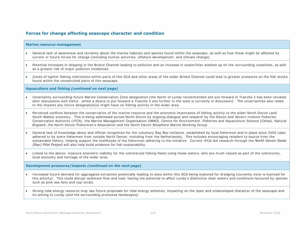
North Devon and Exmoor Seascape Character Assessment 132 November 2015
Forces for change affecting seascape character and condition
Marine resource management
General lack of awareness and certainty about the marine habitats and species found within the seascape, as well as how these might be affected by current or future forces for change (including human activities, offshore development, and climate change).
Potential increases in shipping in the Bristol Channel leading to pollution and an increase in waste/litter washed up on the surrounding coastlines, as well as a greater risk of major pollution incidences.
Zones of tighter fishing restrictions within parts of this SCA and other areas of the wider Bristol Channel could lead to greater pressures on the fish stocks found within the unrestricted parts of this seascape.
Aquaculture and fishing (continued on next page)
Uncertainty surrounding future Marine Conservation Zone designation (the North of Lundy recommended site put forward in Tranche 2 has been revoked after discussions with Defra , whilst a desire to put forward a Tranche 3 site further to the west is currently in discussion). The uncertainties also relate to the impacts any future designation(s) might have on fishing activity in the wider area.
Perceived conflicts between the conservation of the marine resource and the economic importance of fishing activity to the wider North Devon (and South Wales) economy. This is being addressed across North Devon by ongoing dialogue and research by the Devon and Severn Inshore Fisheries Conservation Authority (IFCA), the Marine Management Organisation (MMO), Centre for Environment, Fisheries and Aquaculture Science (Cefas), Natural England, the North Devon Fishermen’s Association and the North Devon Biosphere Marine Working Group.
General lack of knowledge about and official recognition for the voluntary Ray Box initiative, established by local fishermen and in place since 2005 (also adhered to by some fishermen from outside North Devon, including from the Netherlands). This includes encouraging retailers to source from the sustainable fishery, helping support the livelihoods of the fishermen adhering to the initiative. Current IFCA-led research through the North Devon Skate (Ray) Pilot Project will also help build evidence for fish sustainability.
Linked to the above; insecure economic viability for the commercial fishing fleets using these waters, who are much valued as part of the community, local economy and heritage of the wider area.
Development pressures/impacts (continued on the next page)
Increased future demand for aggregates extraction potentially leading to sites within this SCA being explored for dredging (currently none is licenced for this activity). This could disrupt sediment flow and load, having the potential to affect Lundy’s distinctive clear waters and conditions favoured by species such as pink sea fans and cup corals.
Strong tidal energy resource may see future proposals for tidal energy schemes, impacting on the open and undeveloped character of the seascape and its setting to Lundy (and the surrounding protected landscapes).

North Devon and Exmoor Seascape Character Assessment 133 November 2015
Ongoing national demand for alternative sources of renewable energy production; although the Atlantic Array proposal did not proceed, it would have been located within this SCA owing to the optimum wind resources found here. Due to this technical potential, offshore wind energy schemes may still come forward which could impact on the simple, open character of the sea and its crucial maritime setting to Lundy.
Natural processes and climate change
Increased frequency of storm surges and sea level rise as a result of climate change, accelerating the shifting nature of the sand/gravel sediments within the SCA; disrupting sediment flow/load within the waters; and putting coastal communities at greater risk of coastal flooding, erosion and storm damage.

© Crown Copyright, 2015. All rights reserved. License No. EK001-310466. Not to be used for navigation.Service Layer Credits: Sources: Esri, GEBCO, NOAA, National Geographic, DeLorme, HERE, Geonames.org, and other contributors
CB:VG EB:Goosen_V LUCGLA 6500-01_023_TEMPLATE_VRM_A4L_SCA16only 05/11/2015
Map Scale @ A4: 1:500,000
Source:
North Devon & Exmoor Seascape Character Assessment
16: Lundy North
Value
<20 (lowest)21 - 4041 - 6061 - 8080 - 100 (highest)
0 2 4 6 8kmE
Land with Views of: 16:Lundy North
This Visual Resource Map (VRM)provides a more detailed spatialrepresentation of the visibility of thisSCA from the surrounding land inEngland and Wales.
This map shows land with views to thisSCA. The darker shading (blues)indicates land from where more of theSCA is visible. Lighter shades (yellows)indicate that there are views of the SCAfrom those locations, but they are notextensive.
Please note that the VRM is based on a bare ground model. Where an SCA encompasses land and sea, only views of areas below the HWM within the SCA have been analysed (locations above the HWM within the SCA have been excluded). Please refer to the technical report for an explanation of how these maps were generated and how they should be interpreted.

North Devon and Exmoor Seascape Character Assessment 201 November 2015
SCA 27: Lundy South
18
19
SCTs within the SCA: 8B Coarse Open Waters.
Located within the outer ‘Atlantic’ part of the North Devon seascape study area, to the south of Lundy, this SCA forms the western edge of the Bristol Channel where it meets the Celtic Sea, comprising deep waters of up to 60m. The strong tidal currents and open to Atlantic swells from the south-west create hazardous seas. A remote area of sea which forms an important open seascape setting to Lundy; strongly intervisible with the Hartland/Clovelly coast. Long views are also afforded north to Pembrokeshire Coast National Park in clear conditions.
Click here to return to interactive overview map of the Seascape Character Areas (SCAs)

North Devon and Exmoor Seascape Character Assessment 202 November 2015
Key characteristics Natural / physical influences
Located within the outer ‘Atlantic’ part of the North Devon seascape study area, tothe south of Lundy, forming a gateway into Bideford Bay and the BristolChannel.
Waters ranging in depth from 35 to 60 metres in the SCA’s western extent, with atidal range of more than seven metres.
Undulating seabed predominantly formed of Devonian and Carboniferousmudstones and sandstones, with some bands of halite and lignite.
Rocky seafloor covered in parts by shallow coarse circalittoral sediments ofsand and gravel, exposed to a moderate energy water environment. Thesediments are punctuated by areas of boulders and bedrock protrusions.
Areas of biogenetic reef extending south from Lundy and in the western part of theSCA; the varied subtidal habitats supporting a range of species.
Important spawning area for commercially fished species including sprat, cod,sole, whiting and plaice. Seasonal populations of squid and sharks are also found inthe area.
Harbour porpoises, grey seals and dolphins known to frequent the waters.
Area of strong tidal currents and open to Atlantic swells from the south-west creating hazardous seas.
Cultural and social influences (past and present)
Vessels guided through the hazardous seas by the long flashing beams of LundySouth Light (SCA 15), established in 1897, and Hartland Point Lighthouse,established in 1874 (SCA 25).
Hazardous seas represented by a number of submerged wrecks, manyunidentified and still being discovered, but including the City of Exeter, a steamshipwhich sank in 1887.
A number of ships bombed and torpedoed during the two World Wars also lieon the seabed, including the cargo ship the Teneriffa, bombed in 1941 but all thecrew rescued; and the Bessie Stephens, a merchant ship sunk by a Germansubmarine in 1918.
The HMS Glenart Castle, a Royal Navy hospital ship, was also torpedoed by aGerman submarine in 1918 with the loss of 162 lives. Along with others it is apopular dive and charter fishing site. A memorial plaque to this loss is sited onHartland Point (SCA 25).
Submarine telephone cables crossing the sea bed, linking the UK and Europe.These make landfall at Saunton Sands (SCA 8).
Used by smaller coastal shipping, with main shipping approach for large vesselsbeing to the north of Lundy – closer to the main Bristol Channel ports and harboursincluding Avonmouth.
Historically important offshore fishery for UK boats and some visiting Belgian andFrench trawlers, targeting demersal flatfish, sharks and roundfish, pluslimited netting.
Fishing grounds sustaining local North Devon and Cornwall ports andharbours, including Ilfracombe, Appledore, Bideford and Clovelly.
Perceptual and aesthetic influences
Part of a wide expanse of sea between the North Devon and South Walescoasts, the western area adjoining the open Atlantic Ocean.
With parts up to 40 kilometres away from the nearest point on the mainland atHartland Point, the seascape is associated with a strong sense of isolation.
Long-ranging intervisibility with Pembrokeshire Coast National Park to thenorth, and the North Devon AONB to the south and east. Distant glimpses ofdevelopment and lighting around the Taw/Torridge Estuary dilute overall feelingsof remoteness.
Forms an important open seascape setting to Lundy in views from the Clovellyand Hartland coastline; in turn creates the distinctive maritime setting to the AONBcoastline, including Hartland Point with its landmark lighthouse.
Characterised by the backdrop and focal point provided by the end-on formof Lundy, including its southern lighthouse, landing beach and landmarks of OldLight and the island’s church tower.
Perceptual character strongly influenced by weather and atmosphericconditions - tranquillity on calm days can be quickly replaced by wild andforbidding conditions as gales and storms sweep in from the west.
Sense of isolation and remoteness broken by passing maritime transport andfishing trawlers, introducing intermittent bursts of colour, movement and noise.

North Devon and Exmoor Seascape Character Assessment 203 November 2015
Special qualities and key seascape sensitivities
The special qualities of this seascape that would be most sensitive to development-led change include:
Open water with a simple, consistent and unified marine character – a gateway into the enclosed seascapes of Bideford Bay and the Bristol Channel.
Tranquillity on calm days quickly replaced by wild and forbidding conditions as gales and storms sweep in from the west.
Shipwrecks illustrating the maritime heritage of the area and past conflicts; now valued scuba diving and fishing sites.
Historically important fishing grounds – key to sustaining the traditional economy and heritage of local ports and harbours.
Strong intervisibility with the North Devon AONB (including Hartland Point with its lighthouse) and Lundy; with far-reaching and uninterrupted views toPembrokeshire Coast National Park.

North Devon and Exmoor Seascape Character Assessment 204 November 2015
Forces for change affecting seascape character and condition
Marine resource management
General lack of awareness and certainty about the marine habitats and species found within the seascape, as well as how these might be affected bycurrent or future forces for change (including human activities, offshore development, and climate change).
Potential increases in shipping in the Bristol Channel leading to pollution and an increase in waste/litter washed up on the surrounding coastlines, as wellas a greater risk of major pollution incidences.
Zones of tighter fishing restrictions within other areas of the Bristol Channel (including Lundy) could lead to greater pressures on the fish stocks foundwithin this seascape.
Aquaculture and fishing
Perceived conflicts between the conservation of the marine resource and the economic importance of fishing activity to the wider North Devon (andSouth Wales) economy. This is being addressed across North Devon by ongoing dialogue and research by the Devon and Severn Inshore FisheriesConservation Authority (IFCA), the Marine Management Organisation (MMO), Centre for Environment, Fisheries and Aquaculture Science (Cefas), NaturalEngland, the North Devon Fishermen’s Association and the North Devon Biosphere Marine Working Group.
Insecure economic viability for the commercial fishing fleets using these waters, who are much valued as part of the community, local economy andheritage of the wider area.
Development pressures/impacts
Increased future demand for aggregates extraction potentially leading to sites within this SCA being explored for dredging (currently none is licenced forthis activity). This could disrupt sediment flow and load, having the potential to affect Lundy’s distinctive clear waters and conditions favoured by speciessuch as pink sea fans and cup corals.
Strong tidal energy resource may see future proposals for tidal energy schemes, impacting on the open and undeveloped character of the seascape andits setting to Lundy and the Hartland/Clovelly coast of the North Devon AONB.
Ongoing national demand for alternative sources of renewable energy production; although the Atlantic Array proposal did not proceed, future offshorewind energy schemes may still come forward – impacting on the simple, open character of the sea and its crucial maritime setting to Lundy.
Natural processes and climate change
Increased frequency of storm surges and sea level rise as a result of climate change, accelerating the shifting nature of the sand/gravel sediments withinthe SCA; disrupting sediment flow/load within the waters; and putting coastal communities at greater risk of coastal flooding, erosion and storm damage.

© Crown Copyright, 2015. All rights reserved. License No. EK001-310466. Not to be used for navigation.Service Layer Credits: Sources: Esri, GEBCO, NOAA, National Geographic, DeLorme, HERE, Geonames.org, and other contributors
CB:VG EB:Goosen_V LUCGLA 6500-01_023_TEMPLATE_VRM_A4L_SCA27only 05/11/2015
Map Scale @ A4: 1:400,000
Source:
North Devon & Exmoor Seascape Character Assessment
27: Lundy South
Value
<20 (lowest)21 - 4041 - 6061 - 8080 - 100 (highest)
0 2 4 6 8kmE
Land with Views of: 27:Lundy South
This Visual Resource Map (VRM)provides a more detailed spatialrepresentation of the visibility of thisSCA from the surrounding land inEngland and Wales.
This map shows land with views to thisSCA. The darker shading (blues)indicates land from where more of theSCA is visible. Lighter shades (yellows)indicate that there are views of the SCAfrom those locations, but they are notextensive.
Please note that the VRM is based on a bare ground model. Where an SCA encompasses land and sea, only views of areas below the HWM within the SCA have been analysed (locations above the HWM within the SCA have been excluded). Please refer to the technical report for an explanation of how these maps weregenerated and how they should be interpreted.