scottish natural heritage the siting and design of ... 2011 - the siting and...1.3.3 supplementary...
TRANSCRIPT

Scottish Natural Heritage
The siting and design of aquaculture in the landscape: visual and landscape considerations

Section 1 Introduction 11.1 Landscape 21.2 Theaimsofthisguidance 31.3 Landscapeandvisualconsiderations
inthelanduseplanningsystem 31.3.1 Scottishplanningpolicy 31.3.2 Developmentplans 31.3.3 Supplementaryplanningguidelines 31.3.4 Environmentalassessment 31.3.5 Preparingplanningapplications 31.4 Howtousethisguidance 4
Section 2 Choosing a Location 52.1 Locationoptions 62.2 Newdevelopments 62.3 Consolidatingexistingdevelopments 62.4 Location 62.5 NationalMarinePlan 72.6 DevelopmentPlanpolicies 72.7 Designatedareas 82.8 Remotenessand‘isolatedcoast’ 92.9 Landscapecharacterassessment 102.10 Visualimpact 102.11 Cumulativedevelopment 11
Section 3 Siting and Layout: Landscape Character 143.1 Landscapecharacter 153.2 Coastallandscapecharacter 153.3 Usingthissection 173.4 Steep-sidednarrowlochs 183.4.1 Keycharacteristics 183.4.2 Implicationsforsitingandlayout 193.5 Shelteredbutexpansivelochs 213.5.1 Keycharacteristics 213.5.2 Implicationsforsitingandlayout 223.6 Indentedcoasts,baysandnarrowstraits 243.6.1 Keycharacteristics 243.6.2 Implicationsforsitingandlayout 253.6.3 Keycharacteristics 263.7 Openandexpansivecoasts 283.7.1 Keycharacteristics 283.7.2 Implicationsforsitingandlayout 283.8 Landusepattern 303.8.1 Settlementandinfrastructure 303.8.2 Landmanagement 323.8.3 Shore-basedfacilities 32
Section 4 Siting and Layout: Visual Character 344.1 Keyconsiderationsfromhigh-levelviewpoints 354.2 Keyconsiderationsfromlow-levelviewpoints 364.3 Contextofview 374.3.1 Keyvisualsensitivities 37
Section 5 Detail Design 395.1 Designingstructures 405.2 Finfishfarmwater-basedstructures 405.2.1 Finfishcagesandtopnets 415.2.2 Feedbarges,liftinggearandon-farm
accommodationforstaff,ancillaryraftsforgeneratorsandotherinfrastructure 42
5.2.3 Feedpipes 435.2.4 Lighting 435.3 Shellfishfarmwater-basedstructures 445.3.1 Buoysandlong-lines 445.3.2 Raftsandotherwater-basedstructures 455.4 Land-linkedpontoonsandjetties 455.5 On-shoreandshoreline-baseddevelopment 455.5.1 Buildings,yardsandassociatedinfrastructure 46
Section 6 Oyster Farms 476.1 Oystertrestles 486.2 BSTadjustablelonglines 49
Conclusions 50
Annex OneEnvironmental Assessment 51
Annex Two Acronyms and Glossary 52
Annex Three Bibliography and Useful Publications 53
Annex Four Useful Websites 54
Contents
Thesitinganddesignofaquacultureinthelandscape:visualandlandscapeconsiderations.November2011.PreparedbyAlisonGrant,LandscapeArchitect.

1
Section 1 Introduction
Marine finfish and shellfish farming in Scotland are now well established. While salmon and mussel farming is still the mainstay of the industry, oyster farming, scallop lines and other types of finfish farming now also contribute to the expansion and development of this dynamic industry.

2
ThisdocumentupdatesGuidancethatwasfirstpublishedbySNHin20001.Therevisionsreflectthechangestotheindustryintheinterveningdecade.Sincethepublicationoftheoriginalguidancetherehavebeennumerouschangesinthefinfish-farmingsector.Evolvingtechnology,forexample,offersthepotentialtositefishfarmsinlessshelteredlocationsandenvironmentalregulationsencouragetheuseofwell-flushedsites.Asaresult,finfishfarmsmaybefoundinmoreexposedlocations,cagesandfeedstoragebargesmaybelargerandoffshoreaccommodationforstaffmayneedtobeprovided.Inaddition,economiesofscalemayencourageoperatorsofbothshellfishandfinfishfarmstoconsiderexpansionofinstallationsonexistingsites.Insomelocations,operatorsmaywishtoconsolidatesites,orchangethetypeofaquaculturefromfinfishtoshellfishdevelopment,orviceversa.
Thisrevisedguidancethereforetakesintoaccountthewiderrangeofaquaculturedevelopments,andalsothecurrenttrendsinsitingandtechnology.Sections2to5considerissuesrelatedtofinfishandmarine-basedshellfishfarming,whilelandscapeandvisualconsiderationsforoysterfarmingassociatedwiththeintertidalzoneareconsideredinSection6.
Thisguidanceoffersadviceonhowtoassessandaddressthelandscapeandvisualimpactofmarineaquaculturedevelopments.Itdoesnotdealwiththeotherenvironmental,socialoreconomicissuesraisedbythistypeofdevelopment.Itaimstoensurethatthoseinvolvedinaquaculturedevelopmentsarewellinformedonlandscapeissues,andprovidesthemwithaclearframeworkformakingpositivedecisionsaboutthesitinganddesignofbothonshoreandmarinebasedfacilities.
Nevertheless,wherelandscapesarecomplexincharacterorsensitivetochange,developersshouldconsideremployingalandscapearchitecttoadviseonthepotentiallandscapeandvisualimpactsofaproposal,andhowthesemightberesolved.
1.1 Landscape
TheEuropeanLandscapeConventiondefineslandscapeas‘anarea,asperceivedbypeople,whosecharacteristheresultoftheactionandinteractionofnaturaland/orhumanfactors2.Scottishplanningpolicyadoptsthisdefinitionandstatesthat‘alllandscapesrequireconsiderationandcare.Differentlandscapeswillhaveadifferentcapacitytoaccommodatenewdevelopment,andthesitinganddesignofdevelopmentshouldbeinformedbylocallandscapecharacter.’3
ThelandscapesofScotlandarearichphysicalandscenicresource.Thetourismandrecreationindustries,includingsea-basedrecreationinterestssuchassailingandseakayakingdependonthediversityandqualityofthelandscape.Otherindustries,suchasaquaculture,benefitintheirmarketingfromthepromotionofthepositiveimageofthislandscapeintheUKandabroad.Communitiesidentifywiththequalityandindividualityoftheirlocallandscapesandpeoplearealsoinspiredbythem.Newdevelopmentofallkindsshouldthereforerespondsensitivelytothequalityandvarietyofcoastallandscapes,aimingtorespectboththerangeofcharactertypesandthescenicqualitieswhichmakeeachareadistinctive.
Thisguidanceconsidersnewsitesandexpansionsofexistingdevelopments.Manypotentiallyappropriatesitesinshelteredwatersarealreadyoccupied.Thismakesitmoredifficulttofindsuitablenewsitesinsomecoastallandscapes.
TheincrementalexpansionofindividualfishandshellfishfarmsinsitumayalsobedifficulttoaccommodatewithinareasofmoreintimatescalearoundScotland’scoastline.Well-locatedanddesigneddevelopmentshowever,cancomplementlandscapecharacter,particularlywheretheycanreinforcekeycharacteristics,suchasthoseassociatedwithaworkingenvironmentandarealsomorelikelytobewelcomedbylocalpeople.
Therichvarietyanddistinctivenessofthecharacterofallourlandscapesisrecognisedasanimportantasset.Perceivedwildnessandsenseofremoteness,qualitieswhichareassociatedwiththelessdevelopedstretchesofourcoastline,arefurthervaluedasadiminishingresource.Alldevelopmentsareexpectedtorespectthelandscapecharacterwithinwhichtheyarelocatedandsustainthequalitieswhichreinforceexperienceofplace.Withcarefulchoiceoflocation,sitingandlayout,aquaculturecanmakeapositivecontributiontothelandscape,forexamplethroughreusingredundantbuildingsand,whereappropriate,reinforcinganenergisingsenseofhumanactivity.
ThenatureofScotland’scoastlinemeansthataquaculturedevelopmentisoftenhighlyvisible,eitherfromlandorsea.Theimportanceofvisibility,whetherinrelationtoclassicvistas,orasacontributiontotheexperienceofplace,cannotbeunderestimated.Aquacultureneednotbehiddenfromview,butshouldbewellenoughsitedanddesignedtofitinwiththesurroundingcharacterandcontributetoalived-inlandscape.
1 Scottish Natural Heritage, (2000) ‘Marine Aquaculture and the Landscape: The siting and design of marine aquaculture developments in the landscape’.
2 Council of Europe, (2004) European Landscape Convention, Chapter 1, Article 1
3 Scottish Government, Scottish National Planning Policy, February 2010, para 127

3
1.2 The aims of this guidance
ThisguidancewascommissionedbyScottishNaturalHeritage(SNH)andhasinvolvedconsultationwithrepresentativesoftheindustryandtheplanningauthorities.Itisexpectedtobeusedbythosewhodevelopandmanageaquaculturefacilities,thosewhoareconsultedonnewfacilitiesandthosecommentingandmakingdecisionsondevelopmentapplications.
Withthisinmind,theaimsofthisguidanceareto:
– Giveguidanceonhowtodeterminethemostappropriatelocationforaquaculturedevelopmentinrelationtothelandscape;
– IndicateandexplainissuesoflandscapesignificancewhichmayneedtobeaddressedinanEnvironmentalImpactAssessment(EIA)forfinfishfarming;
– Explainhowtoassessthelandscapeandvisualimpactsofaquaculturedevelopment;– Offerguidanceonhowtositeanddesignaquaculturedevelopmentstoreduceboththeirvisual
impactandtheirimpactonlandscapecharacter;– Encouragetheaquacultureindustrytoconsiderlandscapecharacteranddesignissuesduring
theongoingmanagement,updatingandcontinuousdevelopmentofexistingsites;and– Promoteappropriatedetaildesignandlayoutofstructuresanddevelopments.
1.3 Landscape and visual considerations in the land use planning system
1.3.1 Scottish planning policy
Thestatutoryplanningsystemcoversmarinefinfishandshellfishfarmsouttothreenauticalmiles.NationalplanningpolicyforfishfarmingissetoutintheScottishPlanningPolicy4.However,likeotherformsofdevelopment,aquacultureneedstotakeintoaccountallrelevantsectionsoftheScottishPlanningPolicy,includingtheoverarchingpoliciesofSustainableDevelopment,aswellasthesectionsonCoastalPlanning,LandscapeandNaturalHeritageandtheHistoricEnvironment.
1.3.2 Development plans
Developmentplanssetoutlocalplanningpolicies.Policiestoguideaquaculturedevelopmentwillgenerallybesetoutascriteria-basedplanningpolicies.Developmentproposalswillalsohavetobeconsistentwithotherdevelopmentplanpolicies,includingthoseassociatedwiththeenvironmentandthelandscape.
1.3.3 Supplementary planning guidelines
Inaddition,planningauthoritiesareexpectedtodevelopspatialpolicies,which“identifyareaswhicharepotentiallysuitablefornewormodifiedfishfarmdevelopmentandsensitiveareaswhichareunlikelytobeappropriateforsuchdevelopment.”5Thesespatialpolicieswilltakeintoaccountcarryingcapacity,landscapeandothernaturalandculturalheritageissuesaswellaspotentialconflictwithotherusersofthemarineenvironment.Thesearelikelytobeincludedassupplementaryplanningguidance(SPG)tothemainDevelopmentPlan.SPGswillbecomestatutorywhendevelopmentplansthatarecurrentlybeingpreparedareadoptedinthefuture.
ExamplesofspatialpolicyataplanningauthoritylevelincludetheIntegratedCoastalZoneManagementplanspreparedbytheArgyllandButeandHighlandCouncils,andtheAquacultureFrameworkPlanspreparedbyHighlandCouncil.
1.3.4 Environmental assessment
Whenchoosingalocationforafinfishfarmdevelopment,adevelopershouldconsider,andwherenecessaryobtainadvicefromtheplanningauthorityontheprocessbywhichtheneedforanEnvironmentalImpactAssessment(EIA)maybeestablished.FurtherinformationonpreparingthelandscapeandvisualinformationthatshouldbeassessedwhenundertakinganEIAisincludedinAnnexOne.
1.3.5 Preparing planning applications
Whendeterminingapplicationsfornewaquaculturedevelopments,oramendmentstoexistingdevelopments,planningauthoritieswillconsidertheproposalinlightofrelevantnationalplanningpolicy,developmentplanandspatialpolicies,allofwhichtakeintoaccountvisualimpactandtheeffectsofthedevelopmentonthelandscape.Planningauthoritieswillalsoconsidercumulativelandscapeandvisualeffectsandwillweighuptheseandotherenvironmentalissuesalongsidesocialandeconomicpolicieswhendeterminingaplanningapplication.
4 Scottish Government, Scottish National Planning Policy, February 2010, paras 104 – 109
5 Scottish Government, Scottish National Planning Policy, February 2010, para 105

4
Applicantsarethereforeexpectedtodemonstratehowtheyhavetakenintoaccountplanningpolicies,avoidedorminimisedvisualintrusionandmitigatedagainstanynegativelandscapeeffects.Theguidanceofferedinthisdocumentmaybeusedtoassistintheidentificationandpresentationofthelandscapeandvisualevidencerequiredtosupportaplanningapplication.
1.4 How to use this guidance
Thisguidanceisdividedintofivesectionsinadditiontothisintroduction.Thefirstfourreflectthekeydecisionsapotentialdevelopermakeswhenlocating,sitinganddesigningaquaculturedevelopment.Section6identifiesissueswhichrelatetooysterfarming.Thesesectionsaresummarisedbelow:
Section 2: Choosing a location
Thissectionexplainshowtoidentifyanappropriatelocationfordevelopmentfromalandscapeperspective.Itoutlinesthelocationalguidanceavailable,andidentifiesthekeyissuesofstrategicsignificancetoconsiderwhenassessingpotentialdevelopmentwithinabroadlandscapearea.
Section 3: Siting and layout
Thissectiongoesontoexplainlandscapecharacterandvisualassessmentindetail.Ithighlightstheissuesmostrelevanttothesitingandlayoutofaquaculturedevelopmentwithinachosenlocation.
Section 4: Visual assessment
Thissectiondescribeshowtoundertakeavisualassessmentforaquaculturedevelopment,offeringadviceonexploringvisualoptions.Itincludesanon-sitechecklistwhichcanbeusedforcarryingoutalandscapeandvisualassessment.
Section 5: Detail design
Thissectionillustratesdetaildesignconsiderations,includingthosewhichrelatetotheonshorefacilitieswhichmayaccompanysomeoffshoredevelopments.
Section 6: Oyster farming
Thissectiondescribesthelandscapeandvisualissueswhicharelikelytobeofparticularrelevancetooysterfarming.
Finally,thisreportcomplementsotherpublisheddocuments,whicharelistedinAnnexThree.

5
Section 2 Choosing a Location
Scotland is a small country. While its coastline is relatively extensive, it is often intimate in scale and highly visible. A series of even modest developments can quickly make a disproportionately much larger impact in such an open and intricate landscape. Likewise, even a single poorly sited or designed development in a landscape valued for its special scenic qualities or located on a stretch of isolated coast may erode the national resource of these now relatively rare landscapes.

6
2.1 Location options
Optionsforlocatingaquaculturedevelopmentarelikelytobestronglyinfluencedbynon-landscapeconsiderations,suchasdepthofwaterortidalreachandthebestsitestomeetregulatoryandotherenvironmentalandmarineusersneeds.Itisneverthelessimportanttoexploreoptionstoidentifyoptimalsites,whichtakeonboardandbalancethepotentialconflictinginterests,includinglandscapeandvisualinterests.Itisusuallyhelpfuliftherationalebehindanycompromisesmadebythepotentialdeveloperisclearlyexpressedintheapplication.
2.2 New developments
Manyofthemostappropriateandoftenmostshelteredcoastalsitesforaquaculturearelikelytobealreadydeveloped,andthereisnowmoreemphasisonexpansionandconsolidationofexistingsites.Wheretherearecoastallandscapesthatofferopportunitiestoaccommodatenewaquaculturedevelopment,choosinganappropriatelocationfordevelopmentisthefirst,andperhapsthemostimportant,stepinensuringthataquaculturedevelopmentfitsinwellwiththelandscape.Amendmentstolayoutanddetaildesigncancreateamoreattractiveandappropriatestructure,butareunlikelytomitigatethenegativeeffectsofapoorlysiteddevelopmentinthefirstplace.
2.3 Consolidating existing developments
Thisstage–choosingalocation–isalsolikelytobeimportantforanyoperatorplanningtoconsolidateorrationaliseanumberofdevelopments.
Consolidatingorrationalisingdevelopmentsmayofferopportunitiestoremove,amendorre-designanystructureswhicharepoorlysitedordesigned,whichinturnislikelytoimprovelandscapecharacterandvisualamenity.
Consideringthepotentialeffectsofdifferentlocationsonthelandscapeandvisual,aswellaseconomicandotherenvironmentaleffects,islikelytobepartofanystrategicrationalisationprocess.
2.4 Location
Thelocationisthegeneralareawithinwhichadevelopmentwillbesited.Whenfirstconsideringaquaculturedevelopment,ifpossible,developersshouldassessanumberofpotentiallocations,possiblyalongalengthofcoastlineandwithinanumberoflochs.Thiswillensurethatatanearlystage:
– Areaswhereaquaculturedevelopmentisinappropriateinprincipleareidentified;– Forfinfishfarming,issuesoflandscapesignificancewhichmightindicatetheneedforanEIA
canbeidentifiedatanearlystage;and– Thenationalandregionalsignificanceofthelandscapeasdescribedintherelevantspatial
policiesiswellunderstood.
Thissectionexplainstheissueswhichshouldbeaddressedwhenassessingthepotentialopportunitiesandconstraintsofalocation.
Thisprocessshouldtakeintoaccount:
– TheforthcomingNationalMarinePlanandrelatedRegionalMarinePlans– DevelopmentPlanpolicies,includingintegratedcoastalplans,aquacultureframeworkplans
andpoliciessetoutindevelopmentplanspreparedbyrelevantplanningauthorities– Designatedareas– Remotenessand‘isolatedcoast’– Landscapecharacterassessment– Visualimpact– Cumulativeimpact
Thissectionoftheguidanceidentifiesbroadstrategicissues,itisimportanttorecognisethattherelevantspatialplanswillidentifyopportunitiesandconstraintsforaquaculturedevelopment.

7
2.5 National Marine Plan
TheMarine(Scotland)Act2010,requiresScottishMinisterstoprepareandadopta‘nationalmarineplanfortheScottishmarinearea’.Thisplanislikelytobeavailablein2012.Thepurposeofthenationalmarineplanisto‘guidedecisionmakingwithinthemarineplanningsystem’.ItislikelytoprovideaframeworkforthesustainabledevelopmentoftheScottishmarinearea,settingeconomic,socialandmarineecosystemobjectiveswhichwillassistindecisionmaking.Furthermore,thenationalmarineplanwillsetthecontextforsubsequentRegionalMarinePlans.Thesearealllikelytoberelevantconsiderationswhendeterminingapplicationsforaquaculturedevelopmentinthefuture.
2.6 Development Plan policies
CurrentScottishplanningpolicyrequiresplanningauthoritiesto‘identifycoastalareaslikelytobesuitablefordevelopment,areassubjecttosignificantconstraintsandareaswhichareconsideredunsuitablefordevelopmentsuchastheisolatedcoast.Theidentificationofcoastallocationswhicharesuitablefordevelopmentshouldbebasedonaclearunderstandingofthephysical,environmental,economicandsocialcharacteristicsofthecoastalareaandthelikelyeffectsofclimatechange.’6
Furthermore,planningauthoritiesarespecificallyrequiredto‘identifyareaswhicharepotentiallysuitablefornewormodifiedfishfarmdevelopmentandsensitiveareaswhichareunlikelytobeappropriateforsuchdevelopment.’7
Itislikelythatmostplanningauthoritieswillpresentthisspatialpolicyassupplementaryplanningguidance,possiblyspecificallyrelatedtofishfarming,orasacoastalframeworkorintegratedcoastalzonemanagementplan.Oftenthesespatialpolicieswillseektobalancetheneedsofcompetinginterestsalongthecoast,andaimtoidentifypositiveopportunitiesfordevelopmentaswellasindicatingconstraints.Thesedocumentswillbematerialconsiderationswhendeterminingaplanningapplicationforaquaculturedevelopment.
Someplanningauthoritieshaveusedlandscape/seascapecapacityassessmentforaquaculture8,toinformspatialpolicy.Otherplanningauthoritieshavetakenintoaccountlandscapeandvisualissues,suchasnationalandlocallandscapedesignations,visualsensitivityandlandscapecharacter,toinformtheselectionofareassuitablefordevelopment.Theseassessmentswillaimtoidentifypositiveopportunitiesforaquaculturedevelopment,aswellasconstraints.
Asaresult,applicantsshouldbearinmindthattheseplansarealreadyinformedbyastrategicanalysisoflandscapeandvisualsensitivities.Thesedocumentsarethereforeinvaluableasasourceofbaselineinformation,andwhenlookingforappropriatelocationsforaquaculturedevelopment,theycanbeusedtohelpsteerdevelopmenttowardssuitablesitesfromtheoutset.
Inaddition,andespeciallyintheabsenceofsuchspatialpolicies,planningauthoritiesandScottishNaturalHeritagecanadviseonthepossiblelandscapeissuesassociatedwithdevelopingspecifiedlocations.
6 Scottish Government, Scottish National Planning Policy, February 2010, para 100
7 Scottish Government, Scottish National Planning Policy, February 2010, para 105
8 Scottish Natural Heritage (2008) ‘Guidance on Landscape/Seascape Capacity for Aquaculture’

8
NSA Small Isles view to Rum NSA Shetland St Ninians Bay
2.7 Designated areas
Anareaisdesignatedbecauseitcontainscharacteristicsorfeatureswhichareparticularlyvalued.Thesequalitieshavebeenassessedandevaluatedbythedesignatingbody,andaresupportedbyScottishGovernmentandlocalplanningauthoritypolicies.Developmentshouldnotunderminethespecialfeaturesorqualitieswhichthedesignationwasestablishedtoprotect.Consequentlytherewillbemoreconstraintsondevelopment(notonlyaquaculture)intheseareas.Indeed,developmentinsomelocationswithinthedesignatedareamaywellbeinappropriateinprinciple,regardlessofdesign.Anyapplicantshouldestablishearlyintheplanningprocess,priortoassessingtheproposal’slandscapeandvisualimpacts,therangeofcharacteristicsandqualitieswhichhaveledtothedesignation.Itwillbenecessarytodemonstratethataproposeddevelopmentwillnotsignificantlyadverselyaffectthereasonsforwhichadesignationhasbeenidentified.Ifthereareotherrelevantmaterialplanningconsiderationsthatoutweightheneedtoprotectthedesignatedinterests,theseneedclearjustification.
Themostsignificantdesignationsinrelationtolandscapeare:
– NationalScenicAreas(NSAs),firstidentifiedin1978,arelandscapesdesignatedbecauseoftheiroutstandingscenicvalue;
– NationalParks,whichareareasofnationalimportancefortheirnaturalandculturalheritage;and
– Locallandscapedesignations,whicharedesignatedbyplanningauthoritiesandareidentifiedinthelocaldevelopmentplan.Theseareareaswhichareconsideredtoberegionallyorlocallyimportantintermsoftheirlandscapecharacterandvisualquality.
Informationonthesedesignationsisavailablefromtherelevantplanningauthorities,whowillbeabletoofferadviceonwhetherornotproposalsarelikelytoaffectthevaluedqualitiesofindividualdesignations.SNHalsohasanimportantroleasguardianofNSAsandhasrecentlyproducedanup-to-datelistofthelandscapequalitiesthatmakeeachonespecial9.
Aquacultureinstallations,alongwithanyotherformsofdevelopment,maynotbecompatiblewiththescenicqualitiesortheintegrityofthespecificlandscapecharacterwhichisvaluedandunderpinsthedesignation.Inthesecircumstances,itislikelythattheproposeddevelopmentwillreceiveanobjectioninprinciple.DevelopersshouldthereforeseekadvicefromtheplanningauthorityandSNHatanearlystageifaproposeddevelopmentislikelytobelocatedinoradjacenttoadesignatedarea.
9 http://www.snh.gov.uk/protecting-scotlands-nature/protected-areas/national-designations/nsa/special-qualities/
9
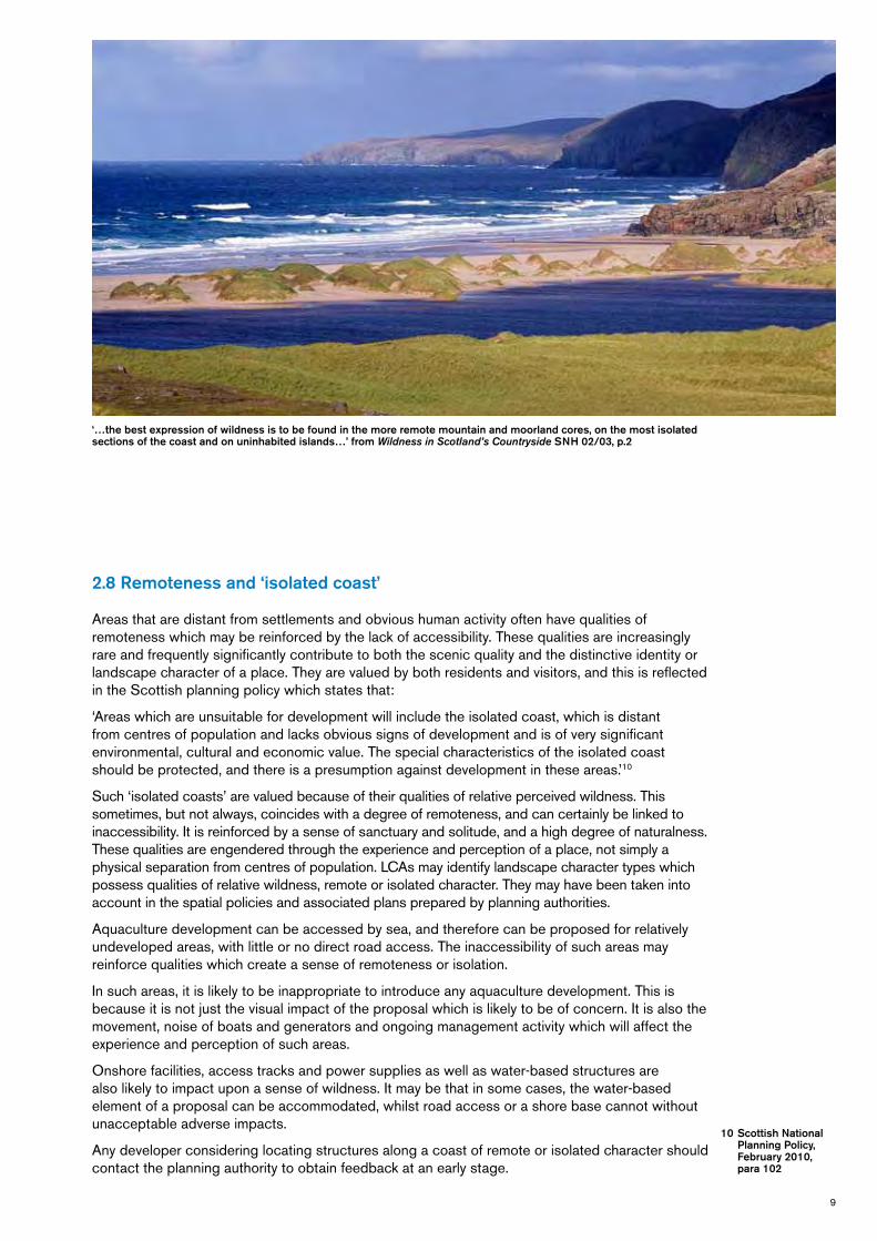
2.8 Remoteness and ‘isolated coast’
Areasthataredistantfromsettlementsandobvioushumanactivityoftenhavequalitiesofremotenesswhichmaybereinforcedbythelackofaccessibility.Thesequalitiesareincreasinglyrareandfrequentlysignificantlycontributetoboththescenicqualityandthedistinctiveidentityorlandscapecharacterofaplace.Theyarevaluedbybothresidentsandvisitors,andthisisreflectedintheScottishplanningpolicywhichstatesthat:
‘Areaswhichareunsuitablefordevelopmentwillincludetheisolatedcoast,whichisdistantfromcentresofpopulationandlacksobvioussignsofdevelopmentandisofverysignificantenvironmental,culturalandeconomicvalue.Thespecialcharacteristicsoftheisolatedcoastshouldbeprotected,andthereisapresumptionagainstdevelopmentintheseareas.’10
Such‘isolatedcoasts’arevaluedbecauseoftheirqualitiesofrelativeperceivedwildness.Thissometimes,butnotalways,coincideswithadegreeofremoteness,andcancertainlybelinkedtoinaccessibility.Itisreinforcedbyasenseofsanctuaryandsolitude,andahighdegreeofnaturalness.Thesequalitiesareengenderedthroughtheexperienceandperceptionofaplace,notsimplyaphysicalseparationfromcentresofpopulation.LCAsmayidentifylandscapecharactertypeswhichpossessqualitiesofrelativewildness,remoteorisolatedcharacter.Theymayhavebeentakenintoaccountinthespatialpoliciesandassociatedplanspreparedbyplanningauthorities.
Aquaculturedevelopmentcanbeaccessedbysea,andthereforecanbeproposedforrelativelyundevelopedareas,withlittleornodirectroadaccess.Theinaccessibilityofsuchareasmayreinforcequalitieswhichcreateasenseofremotenessorisolation.
Insuchareas,itislikelytobeinappropriatetointroduceanyaquaculturedevelopment.Thisisbecauseitisnotjustthevisualimpactoftheproposalwhichislikelytobeofconcern.Itisalsothemovement,noiseofboatsandgeneratorsandongoingmanagementactivitywhichwillaffecttheexperienceandperceptionofsuchareas.
Onshorefacilities,accesstracksandpowersuppliesaswellaswater-basedstructuresarealsolikelytoimpactuponasenseofwildness.Itmaybethatinsomecases,thewater-basedelementofaproposalcanbeaccommodated,whilstroadaccessorashorebasecannotwithoutunacceptableadverseimpacts.
Anydeveloperconsideringlocatingstructuresalongacoastofremoteorisolatedcharactershouldcontacttheplanningauthoritytoobtainfeedbackatanearlystage.
‘…the best expression of wildness is to be found in the more remote mountain and moorland cores, on the most isolated sections of the coast and on uninhabited islands…’ from Wildness in Scotland’s Countryside SNH 02/03, p.2
10 Scottish National Planning Policy, February 2010, para 102

10
2.9 Landscape character assessment
Physicalcharacter,humanactivity,visualqualitiesandexperienceofplacecombinetocreatealandscapecharacterwhichisdistinctacrossageographicarea.
Oneoftheaimsoflocatinganddesigningadevelopmentwithcare,istoensurethattheproposaldoesnotunderminecharacteristicswhichmostsignificantlycontributetothelandscapecharacterofanarea.Wherepossible,newdevelopmentsshouldrelatetothekeycharacteristicsofanarea.Theprocessbywhichthesekeycharacteristicsareidentifiedandassessediscalledlandscapecharacterassessment.
AnationalprogrammeoflandscapecharacterassessmentwascommissionedbySNHwhichnowcoversthewholeofScotland.Individuallandscapecharacterassessmentreports(LCAs)11foreachplanningauthorityareaareavailablefromSNH.Insomeareas,however,amoredetailedcharacterassessmentofthecoastallandscapehasbeencarriedouttoinformspatialplanningpolicieswithinthedevelopmentplan,andthisislikelytobemorerelevantthanthemorestrategicLCA.
2.10 Visual impact
Structuresinandonthewaterareoftenveryvisibledueto:
– Thecontrastintexturebetweenthecages,linesorbuoysandthesmooth,reflectivesurfaceofthewater,particularlyincalmweather;
– Thecontrastbetweentheverticalsidesoffinfishcagesandinfrastructureandtheflatwatersurface;
– Theconstantchangesinlightconditionscanonemomentcastastructureintoshadow,andthenextreflectbrightlightuponit;
– Thesize,typeorextentofthestructures,includingthefeedstoragebargesorlightingassociatedwithfinfishfarms,ornumerousbuoysassociatedwithshellfishlines;
– Thechangesinseacolourandtone,whichcanoftencamouflagethestructuresonemoment,butthenemphasisethestructureindramaticcontrastthenext;
– Thecontrastbetweentheoftenveryregularandgeometricshapeandalignmentofcagesorlinesandthemorefluidandorganicshapeofthelandformandcoastline.
Asaresult,water-baseddevelopmentcanbeveryeasytosee.Thisisanotherreasonforcareinchoosinganappropriatelocation.Thisdoesnotmeanthatstructuresshouldalwaysberemovedfromview,butanassessmentofvisualimpactshouldbeanintegralstageofchoosingapreferredlocationfordevelopment.Todothis,developersshouldestablishtheextentofvisibilityofsiteswhicharebeingconsideredforwater-basedinstallations.Thismayalsobenecessaryforsiteswhicharebeingconsideredforshore-basedfacilities.Avisibilityassessmentcanbeundertakenusingmapsandsitesurveywork.Ifindoubt,computer-aidedassessmentsoftheoreticalvisibilitycanbeused.
Shifting lighting conditions, changes in sea colour and tone emphasise the importance of investigating both the location and detailed design.
11 http://www.snh.org.uk/pubs/results.asp?Q=landscape+character+assessment&rpp=10
11
Thelikelyvisualimpactofproposedonshoreandwater-baseddevelopmentsfromthemostfrequentlyvisitedormostsensitiveviewpointsshouldalsobeconsidered.Suchviewpointsinclude:
– Establishedsettlements– Wellusedvantagepoints– Sitesorvillagesofhistoric,architecturalorculturalimportancewherethewiderlandscape
settingisimportantforvisitorexperience– Viewsfromapopularroadoraroutepromotedasatouristattraction– Coastalfootpaths– Popularferryroutes
Applicantsarestronglyrecommendedtoconsultwiththelocalplanningauthoritytoidentifyandagreethesignificantviewpointsinadvanceofundertakingadetailedvisibilityanalysis.
Insomecircumstancesitmaybeinappropriatetolocatedevelopmentwithinsightofasignificantviewpoint.Thiscanonlybedeterminedonanindividualcasebasis.Ifindoubt,potentialdevelopersshouldconsultwiththeplanningauthority,SNHorHistoricScotlandasappropriateatanearlystage.
FurtherinformationonundertakingavisualassessmentforaquaculturedevelopmentseeSection4ofthisguidanceonpagesXX.
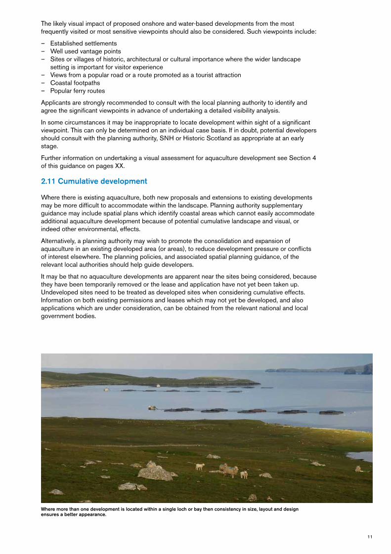
2.11 Cumulative development
Wherethereisexistingaquaculture,bothnewproposalsandextensionstoexistingdevelopmentsmaybemoredifficulttoaccommodatewithinthelandscape.Planningauthoritysupplementaryguidancemayincludespatialplanswhichidentifycoastalareaswhichcannoteasilyaccommodateadditionalaquaculturedevelopmentbecauseofpotentialcumulativelandscapeandvisual,orindeedotherenvironmental,effects.
Alternatively,aplanningauthoritymaywishtopromotetheconsolidationandexpansionofaquacultureinanexistingdevelopedarea(orareas),toreducedevelopmentpressureorconflictsofinterestelsewhere.Theplanningpolicies,andassociatedspatialplanningguidance,oftherelevantlocalauthoritiesshouldhelpguidedevelopers.
Itmaybethatnoaquaculturedevelopmentsareapparentnearthesitesbeingconsidered,becausetheyhavebeentemporarilyremovedortheleaseandapplicationhavenotyetbeentakenup.Undevelopedsitesneedtobetreatedasdevelopedsiteswhenconsideringcumulativeeffects.Informationonbothexistingpermissionsandleaseswhichmaynotyetbedeveloped,andalsoapplicationswhichareunderconsideration,canbeobtainedfromtherelevantnationalandlocalgovernmentbodies.
Where more than one development is located within a single loch or bay then consistency in size, layout and design ensures a better appearance.

12
Examples of cumulative landscape and visual effects
Asisillustratedhere,awell-located,appropriatelyscaledproposalmaybeeasilyaccommodatedinthelandscape.
Whereasoneindividualdevelopmentmayactasalandscapefeature,anumberofdevelopmentscancreateakeycharacteristicofthelandscape,alteringthelandscapecharacter.
Expansionofseveralexistingdevelopmentsmightalsocreatesimilarcumulativelandscapeorvisualissuesasthestructuresbecomemoredominantastheygetbigger.
Anumberofdevelopmentsoccupyingthesamelochmaybedifferentintype,butinthisillustrationthecommonorientation,similarsizes,simple,unclutteredstructuresanddispersedspacinghelptoaccommodateanumberofdevelopments.

13
Whenanumberofdevelopmentsoccupyingthesamelocharenotcoordinatedintermsofsiting,orientation,layoutanddesign,negativecumulativeeffectscanoccur,asshownhere.Proposalstochangealease,forexamplefromafinfishfarmtoshellfishlines,shouldalsotakethisintoaccount.
Thisillustrationdemonstratesthesenseofclutterintroducedbyanadditionaldevelopmentbeingorientateddifferentlyfromoriginaldevelopments.Inaddition,becausethenewlinesareclosetoexistinglines,theshellfishlinesonthelochoverallseemmuchmoreextensive–althoughindividuallytheyaremodest.
Furtherdevelopment,hereofdifferenttypes,sizesandorientation,aswellassimplyalargequantityofdevelopmentrelativetothesizeofthelochcancreateagreatdealofvisualclutteranddistractcompletelyfromthelandscape.
Thisillustrationdemonstratesadifferenttypeofcumulativeeffect.Ifsmallinletsorbaysaregraduallyfilledupwithdevelopmentindentationsalongthecoastlinebecomedifficulttoread,astheeye‘jumps’alongtheseawardedgeofthestructures.

14
Section 3 Siting and Layout
Our generation has a responsibility to maintain and enhance landscapes of quality and exceptional diversity of character in Scotland. It is of benefit to many industries if this clean and attractive environment is managed sympathetically. New development should therefore respond sensitively to the quality and variety of coastal landscapes, and this section of the guidance sets out key issues which should be taken into account when thinking about the siting, orientation, size and layout of aquaculture installations in the wide range of Scotland’s coastal landscapes.

15
Planningauthoritiesexpectdeveloperstodemonstratehowtheyhavereducedpotentialadverseimpactsonlocallandscapecharacterandvisualamenitywhendecidingonorientation,micro-sitingandthesizeandlayoutofaquacultureinstallations.Thissectionprovidesinformationwhichwillhelpadeveloperanalyseandtakeintoaccounttheselandscapeandvisualissues.
3.1 Landscape character
Understandingthecharacterofthelandscapeandhowitisexperiencedisafirststeptowardssitingandplanningthelayoutofafinfishorshellfishfarmproposal.Inparticular,landscapecharacterassessmentshouldassistin:
– Planningthescaleofthedevelopment;– Positioningbothonshoreandwater-basedstructures;– Aligningthewaterbasedstructures– Advisingontherelationshipbetweentheproposeddevelopmentandexistingaquaculture
developments;and– Planningthelayoutandscaleofboththewaterbasedstructuresandanynecessaryonshore
facilitiesandinfrastructure
3.2 Coastal landscape character
Coastallandscapecharacter,whichissometimescalled‘seascape’characterwhenitisdominatedbyopenwater,ismadeupofmanyelements.Someofthese,liketheshapeofthecoastline,itsreliefandpatternoflanduse,arephysical.Others,suchassenseofopennessorenclosureanddegreeofshelterorexposure,areexperiencedbypeoplewhentheymovearoundaplace.
Theprocessofcharacterassessmentanalysesthecoastallandscapeandidentifieswhichelementsandexperiencesofthecoastarethemosttypicalanddistinctivetothearea.Whenassessingthepotentialimpactofadevelopment,itisthenpossibletoassesshowaneworamendeddevelopmentmightaffectorrelatetothesekeycharacteristics.Eachplaceisdifferent,andwillhavecharacteristicsthatreflectthatdifference.However,broadlyspeaking,aquaculturedevelopmentismostlikelytoinfluenceoneormoreofthegenericcoastallandscapecharacteristicssetoutinBox1.
Steep-sided enclosed lochs
Indented coasts, bays and narrow straits
Sheltered but expansive lochs
Open and expansive coasts

16
Box 1: An introduction to assessing coastal landscape character for aquaculture development
Likely opportunities Likely constraints
Shape and scale of coastal edge Long,regular,straightcoastlinessetagainstthebackdropofanopenseamayoffermoreopportunitiesforsitinglargersizeddevelopmentsofsimple,regularlyspacedstructures.
Averyindented,irregularandintricatelyscaledcoast,possiblywithoffshoreislandsisunlikelytobeabletoeasilyaccommodatelarge,simplyshapeddevelopments.Thetinysizeofsomeindentations,theorganicshapesandthediverse,irregularpatternofskerries,islands,littlebaysandpromontoriesarealllikelytomakeacoastlinemoresensitivetodevelopment.
Openness and expansiveness of the coast and sea
Expansivestretchesofseaalongthehorizon,creatingasenseofbigspaceandopennesswilloften‘diminish’therelativesizeofastructure.Smallerandlowerstructures,includingshellfishlines,arelikelytofitinmoreeasilytosmallerspaces,buteventhen,thesizeandextentofthestructureasawholeshouldaimtoavoiddominatingthesizeofthespace.
Enclosedsealochs,narrowcoastalstraits,smallbayswithlimitedvisuallinkstothesea,stretchesofwaterframedbypeninsulasandislands,areallmoreeasilyoverwhelmedbylargerstructures–simplybecausetheyaresmallerspaces.
Narrowspacescanalsobequickly‘filledup’bydevelopmentextendingacrossthelochorvoefromonesidetotheother.
Character of the hinterland Darkvegetation,orsteeplandformwhichcastsshadowsacrossthewaterforalargepartoftheday,cancreateabackdropagainstwhichastructurecanberelativelydifficulttosee.
Inaddition,suchabackdropisrelatively‘stable’,andnotassubjecttothevariationsinlightwhicharecharacteristicofmoreopencoasts.
Managedconiferwoodlandandfarmedlandwithwelldefinedfieldpatterns,bothoffera‘worked’landscapecontextwhichmaymorereadilyaccommodatedevelopment.
Moreopen,sparselyvegetatedandlesssettledcoastlines,withlimitedtreecoverprovidefewer‘features’withwhichaproposeddevelopmentcanbeassociated.Thiseffectmaybeaccentuatedwhentheareahaslowrelief.
Landmarks and features Siteswhichdonotcompetewithiconicorimportantfeatureseithervisuallyorintermsofsettingorcontext.
Thesettingofkeycoastalfeatures,suchashistoricsites,naturalarches,headlands,extensivetidalreaches,groupsofislandsorstacks,orotherlandmarkfeaturesarealllikelytobesensitivetoanydevelopment.
Isolation or ‘wildness’ Lessremoteandrelativelyaccessiblestretchesofcoast,orareassetwithinacontextofinhabitedormoredevelopedstretchesofcoastline,loch,voeorsea.
Areascharacterisedbyactivity,andwherethepresenceofthebustleoffrequentmaritimetrafficisakeycharacteristic.
Landscapeswherethehinterlandisclearlymanaged,withabackdropofforestryorfields.
Relativelyremoteandlessaccessiblestretchesofcoastline,wherethecharacteroftheareaisdominatedbyasenseofseclusionandrelativewildness,andtheareaseemssetapartformthemainbustleofmaritimetrafficanddevelopment.
Insuchareas,thecoastandhinterlandwillbelargelyundeveloped,generallycharacterisedbymoorland,roughopengrasslandorsemi-naturalwoodland.
17
3.3 Using this section
ThefollowingguidancesetsouthowtointegrateaquaculturewiththeprincipallandscapecharacteristicsoftheScottishcoastline.Itdoesthisbydescribingfourbroadcategoriesofcoastallandscapecharacter,andillustratingwhattoconsiderwhensitingandaligningbothwater-basedandonshorestructures.
Thefourbroadcategoriesoflandscapecharacterare:
– Steep-sidedenclosedlochs– Shelteredbutexpansivelochs– Indentedcoasts,baysandnarrowstraits– Openandexpansivecoasts
Thesefourbroadcategoriesbroadlyprogressfromnarrow,confinedandsmallerscalelandscapestolarger,moreexposedandopenlandscapes.Insomeplaces,however,bothsmallandlarge-scalelandscapeswillcometogetherinoneview.
Developersshouldusethissectionbyreadingthedescriptionsofeachbroadlandscapecharactercategory.Theyshouldidentifywhichcategoryofcoastlineismostsimilartotheirchosenlocationfordevelopment.Somelocationsmayhavecharacteristicswhichrelatetomorethanonecategory,andapplicantswillneedtostudytheguidanceforthesecategoriesaccordingly.
Theguidanceonsitingandlayoutappropriatetoeachcategoryfolloweachcharacterdescription.
Thissectionalsodescribestheimplicationsoflanduseandsettlementpatternonlandscapecharacterandhowthatmightaffectdecisionsaboutthesitingandlayoutofaquaculturedevelopments.

18
3.4 Steep-sided narrow lochs
3.4.1 Key characteristics
– Thecoastlineisdominatedbysteepmountainorhillsideswhichplungeintothesea,creatingasenseofdrama.
– Thesteep-sidedtopographycancreatedenseshadow,andthesheltered,oftencalmwatersofferopportunitiesfordistinctreflections.
– Oftenthischaractertypeisdominatedbythesenseofenclosureandintimacy,emphasisedbytheverticalityofthesurroundinglandform.
– Viewsaredrawnalongthelengthof,ordirectlyacross,theloch,ratherthanalongthehilltops.– Thecoastlineoftheselochscanberelativelysimple,withfewindentations.– Roadsoftenapproachtheselochsoverhighpasses,givingelevatedviews,oraretuckedalong
theloch-side,constrainedbythesteeplandform,resultinginlow-levelviewsdirectlyacrosstheloch.
– Bridgescrossingriversattheheadofthelochareoftenfocalpointsinthelandscape,andactaskeyviewpoints,too.
In these relatively narrow, intimate lochs the simplicity, scale and expanse of the water surface is important. Too many water-based structures or one large development can quickly lead to overcrowding, and divert views away from the central loch space.
Here development relates clearly to one side of the loch, so as not to subdivide the central loch space or visual focus along loch length.

19
3.4.2 Implications for siting and layout
Theseintimatelochsarecharacterisedbytherelativelynarrowexpanseofthewatersurface,thesenseofenclosureandoftenthestraightshorelines.Inthesenarrowspaces,severalwater-basedstructures,oronelargedevelopmentcanquicklyleadtoovercrowding.
Ofteninsteep-sidedenclosedlochs,thecoastaledgeisstraight,withrelativelyfewindentations.Thevisualaxisofthelochisalongitslength.Wherepossibletherefore,cagesandlinesshouldaimtoreflectthischaracteristicandappearassimple,linearconfigurationsalignedbroadlyparallelwiththelongaxisoftheloch.
Ifpossible,trytositethedevelopmentwhereitrelatesclearlytoonesideofthelochortheother,asinthisillustration–trytoavoidlocatingthestructuresothatitsitsinthemiddleoftheloch,asthistendstodisruptthevisualfocuswhichextendsalongthelengthoftheloch.

20
Structuresreachingacrossthewholeofthecentrallochspaceororientatedouttowardsthecentralaxisshouldbeavoided.Thesewillfragmentandsubdividetheloch,asinthisillustration.
Duetothesteepsidesoftheseenclosedlochs,theremaybeareaswhichareindeepshadowformuchoftheday.Offshoreandshore-basedfacilitieswillbelessobviousifsitedagainstabackdropofshadows,loch-sidewoodlandandrisingground.

21
3.5 Sheltered but expansive lochs
3.5.1 Key characteristics
– Theselochsaregenerallyenclosedbyhillsandoftenfeelquiteseparatefromtheopensea.Theyarebroaderrelativetotheirlengthandfeellessconfinedthansteep-sidedlochs.Becauseofthewiderextentofthewatersurfaceandthelesspronouncedenclosurecreatedbythesurroundinglowhillstheyfeellesscontained.
– Thelandformneartothewateredgeisfrequentlygentleingradient,sometimeswithlowrockyoutcropsorledges,creatingagradualtransitionfromtheflatwatersurfacetothesteeperhillsides.
– Often,theeyeisdrawntoaskylineofhilltopsoveranexpanseofwater.– Thecoastlineisgenerallyindentedwithsmallbaysandsometimesislandsorskerries.– Roadstendtobelessconstrainedbythesurroundingtopographysotheyarelesslikelytorun
closetotheedgeofthelochandmayriseupsurroundinghillslopes– Viewsfromroadspartofthewayupthehillsideallowviewerstolookdownuponthewater.
Viewsofthelochfromlow-levelviewsmaybeintermittentbecauseofinterveninggroundandwoodland.
In these landscapes, cages and lines can readily dominate the water surface of small bays and lochside indentations, resulting in the loss of a key characteristic. Often the relative intimacy of the coastline makes it difficult to accommodate the mass of large cages or extensive areas of lines.

22
3.5.2 Implications for siting and layout
Thesebroadlochsmaybeabletoaccommodateproportionatelylargerdevelopments–butsometimestheselochsarenotasexpansiveastheyseem,andlargestructurescanquicklyoverwhelmthem.
Careshouldbetakennotto‘fillup’theselochswithdevelopment–trytomakesurethat‘undeveloped’watersurfacedominatesover‘developed’watersurfaceswhenvisiblefromkeyviews,asinthisillustration.
Tallerstructures,suchascagesandfeedbarges,willbemoreeasilyaccommodatedwheretheycanbeseentoclearlyrelatetoonesideofthelochortheotherratherthanhoverinthemiddleoftheloch.
Low profile, tidy, elongated fish farm cages match the low lying relief and horizontal emphasis of the surrounding landform.

23
Cagesandlinescanreflectthehorizontalemphasisinthesewider,morelow-lyinglandscapes,byreinforcingthealignmentoflong,lowlandformsandelongatedspurs.
Whereaseriesofsmallbayscreateanindentedcoastaledge,trytoavoid‘fillingin’eachsuccessivesmallbaywithadevelopment.Theindentationsalongthecoastlineshouldbeallowedtodominate,sothatyoureyecangenerallyfollowtheconvolutionsofthecoastwithouttoomuchobstruction,asillustratedhere.

24
3.6 Indented coasts, bays and narrow straits
3.6.1 Key characteristics
– Indentedcoastsaremoreopentotheseathanshelteredsealochsandvoes,butindentations,bays,straits,andpromontoriesmaystillcreatearelativelyshelteredsetting,atleastinplaces.
– Thiscoastaledgeoftenformsdistinctivebaysandinlets,includingstraitsandtidalnarrows.Itmaybepunctuatedwithislandsorskerries,allofwhichhaveincommonarelativelysmallscale.
– Thelandformaroundthiscoastisoftenrelativelygentle,withlowhills,rockyknollsandlowsweepingheadlands,howeverinsomeareasthecoastisdominatedbyrockyoutcropsandcliffs.
– Oftenthischaractertypeisvisuallydominatedbytheindentationsorcomplexitiesofthecoastaledgeor,whereitisvisible,theflathorizonofthesea,sometimesbrokenbyislandsormoredistantpromontories
– Roadstendtobelessconstrainedbythesurroundingtopographysotheymaylieclosetotheedgeoftheloch,orextendupsurroundinghillslopes
– Viewsoftenalternatebetweentheintimateandthepanoramicasroadsorfootpathswindaroundthecoastaledge.Viewsmightembracethesweepofasmallbay,thelongerlengthofthecoastorextendouttosea.Oftenviewsalongthecoastaledgearepartial,brokenbyheadlands,islandsandpromontories.Therearealsolikelytobeviewsfromferriesandothermarinetraffic.
Implications for siting and layout: In these landscapes, cages and lines which are too large or too numerous can visually coalesce, obscuring the distinct pattern and scale of skerries and the indented coastline.

25
3.6.2 Implications for siting and layout
Theseoftenquiteintricateshorelinesaresetwithinacontextofthelarger,sweepingscaleofawidercoastallandscape.Whensitingadevelopment,andthinkingabouttheappropriatesize,thedeveloperwillneedtodecidewhetherornotthedevelopmentshouldrelatetotheexpansivesea,orthemoreintricatecoast.
Intheselandscapes,largerstructurescanbemoreeasilyaccommodatedwheretheycanbesetagainstabackdropofthesea.
Smallerfinfishandshellfishfarmscanoftenbesitedtoreflectthepatternandlayoutofskerriesandislands,orbesetagainstshelteredpromontoriesorheadlands.
Aimtositedevelopmentwherethecoastlineismostregularandstraight,awayfromtheindentedsectionsofcoast.Thesimple,oftenrelativelyorderedpatternofthestructurescanreflectthemoresimple,regularcoastlines.
Ifpossible,trytoalignshellfishlinesandlinearcagestructurestobebroadlyparallelwiththemostdominantcoastaledge.Itmaynotbepossibletoachievethisfromallviewpoints,soagreewiththeplanningauthoritieswhichonesaremosttheimportant.
Ifthestructuresliewithinasmallbay,aimtoretainamuchlargerproportionofundevelopedwatersurface,sothattheinstallationdoesnotdominatethebay.

26
Ifstructuresneedtobesitedclosetowherethebaymeetstheopensea,placethemtothesidesofbays,awayfromthemiddleofthemouthofthebay–thisavoidsadevelopmentappearingtoblocktheentrancetoabay,orseparateabayfromtheopensea.
3.6.3 Key characteristics
– Smallgroups,orsingleislands,oftenformlandscapefeaturesorfocalpointswithinawidercoastallandscape
– Therelativelysmallscaleandintricatepattern,aswellasinterlockingformsofislands,areoftenwelldefinedbythecontrastbetweenlandandsea
– Small,lowislandscanappeartochangeinsizeandvisualprominenceasthetiderisesandfalls,withsomeskerriescompletelydisappearingfromviewathightide
– Thecomplexitiesofthecoastaledgeofislandstendtobelessvisiblefromlowleveldistantviewpoints
– Islandsarefocalpointsinviews,oftenseenwithinthecontextofamoresweepingvistaalongthecoastorextendingouttosea
– Astheyaredetachedandself-contained,peopletendtofindislandsinherentlyattractiveandmayprojectontothemcharacteristics,qualities,orassociationswhichtheywouldnotprojectontoacomparablepieceofthemainland
– Theyarepopularplacestovisitbyboatorkayakbecauseoftheirnaturalfocus
Groups of islands, islets and skerries seen within a panoramic seascape, lead gradually from the interior landmass to open sea. Land and sea appear ‘interlocked’.

27
Itisnoteasytositeaninstallationneartoasingleisland,asitdistractsfromthevisualfocus.Thisshouldonlybeconsiderediftheinstallationismuchsmallerthantheisland.
Thisillustrationshowshowalargedevelopmentcaneasilydominateanddistractfromanisland,orevenagroupofskerriesorsmallislands.Introducingalargerscalestructure,whichdisruptsthehierarchyofislands,baysandcoastallandformsshouldbeavoided.Thesizeofadevelopmentmustrelatetothesizeoftheislandsathightide.

28
3.7 Open and expansive coasts
3.7.1 Key characteristics
– Thiscoastischaracterisedbyitsjuxtapositionwiththeextensiveandexpansiveopennessofthesea,whichdominatesintermsofextentandscale
– Frequentlyexposed,thecoastlineislikelytoberelativelyregularandstraight,andmayberocky,sometimeswithcliffs,stonybeachesandinfrequentshallowbays
– Oftenthischaractertypeisdominatedbythechangingpatternoflightandmovementassociatedwiththesea,withlessfocusonthelandoreventhecoast,exceptwheretherearelandmarkfeatures,suchascliffs,distinctpromontoriesorhistoricfeatures.
– Roadstendtofollowthecoastline,althoughthiscanbequiteelevated,andmaybesetwellbackfromtheimmediatecoastaledge.Theremaybelongstretcheswhereaccessislimitedoronlypossibleonfoot
– Viewsareoftenpanoramic,embracingawideexpanseofsea.Therearelikelytobeviewsfromferriesandothermarinetraffic
3.7.2 Implications for siting and layout
Thesestretchesofcoastlinetendtobeheavilydominatedbytheopenseaandasenseofvastdistance,providinganexpansivesettingforstructures.Long,elevatedpromontoriesandsweepingbaysallreinforcethesenseoflargescale.
Intheselandscapes,largerstructurescanbemoreeasilyaccommodatedwheretheycanbesetagainstabackdropoftheseaorwherealongstretchofthecoastlineisrelativelystraight.
Thedominanttrendoftheselandscapesis‘horizontal’,madeupofthehorizon,long,lowprofilesofadjacenthills,promontoriesordistantislands,whichcanmakeiteasiertoaccommodatelong,lowprofiledstructures.
Large structures are easily accommodated as they can be set against a backdrop of sea, or alongside a relatively straight coastal stretch.

29
Theexpanseoftheseamaypotentiallyabsorbevenverylargestructures.Bylocatinglargestructureswheretherearefew–ifany–otherreferencepoints(exceptforperhapstheoccasionalpassingship)thestructureswillappearsmallwithinthelargerseascape,whenviewedfromland.
Trytoavoidunnecessaryclutterandirregularcagesizesorpatterns.Anorderedpatternofcagesandsimplefeedbargestructureswillmoreappropriatelyreflectthesimplicityoftheopensea.
Thesecoastlinesarelikelytobetooexposedforshellfishlines,whicharelikelyonlytobeaccommodatedperhapsintheleeofheadlands.
Where sea is expansive it may absorb even very large structures. Long, elevated promontories and high viewpoints reinforce this sense of large scale.

30
3.8 Land use pattern
Thefourlandscapecharactercategoriesexplainedabovewilloftencontainsomedegreeofsettlement,landmanagementorinfrastructure.Thislandusepatternalsocontributestolandscapecharacter,andcaninfluencethesitinganddesignofaquacultureproposals.
3.8.1 Settlement and infrastructure
Coastalvillagescanbelinear,forexample,stretchedalongalochsideroadorpeninsula,orclustered,perhapsattheheadofalochatakeybridgingpointorwithintheshelterofabay.Inmoreruralareas,settlementcanalsobe‘dispersed’,withhousesandfarmsperhapsinaregularlyspacedpattern,orasindividualbuildingsscatteredmorerandomlyacrossthelandscape.
Thepresenceofsettlementcaninfluencethesiting,scaleandlayoutofbothonshoreandoffshoredevelopment.Aquaculturemaynotbeacceptableifitistoonearasettlementorcloselyoverlookedbyhouses,andoftentheneedforcleanwater,accessiblepiers,accessibilityforlargevehiclesandonsitesecurity,makeitdifficultforbothoffshorestructuresandonshorestoragebasestobesitedclosetoasettlement.
Nevertheless,theactivity,bustleandgeneraldevelopedcharacterofareaswithsomesettlementorotherinfrastructure,suchasroads,piers,ruralindustriessuchasquarriesorforestry,canallprovideasuitablecontextforaquaculturedevelopment.Inaddition,theseareasaremorelikelytohaveeasyaccesstoexistingroadsandotherinfrastructure,suchaselectricity,whichwillmakeonshoredevelopmentmorecost-effective.
Concentrated settlement: Where settlement is clustered it often forms a focal point within the landscape.
Concentrated settlement: Careful consideration of aquaculture development – including shore-based facilities – is essential, taking account of their siting in relation to views, the landscape character and setting of villages.

31
Scattered settlement: Here housing, often linked to the pattern of crofting land, creates a series of point features in the landscape. The pattern can be very dispersed and any aquaculture development is best related to the scattered nature of the land-based structures.
It is difficult and may not be desirable to introduce new roads and buildings into areas characterised by a sense of remoteness.

32
3.8.2 Land management
Evenwheretherearefewbuildingsinalandscape,thereareoftenothersignsofhumanactivity,suchasforestry,quarrying,pylonlines,roadsorfarmedland.These,too,contributetolandscapecharacter,andcancreateanappropriatecontextfornewbuildings,oroffshorestructuresinawaywhichmakesthemostofkeycharacteristics.
Keyprinciplestoconsiderwhensitingaquaculturedevelopmentare:
– Forestry,orotherwoodland,canofferadarkcolouredbackdroptolowcagesorbuoys,makingthemlessvisible.Thebusynessoractivityassociatedwithaquaculturewillalsobepresentinforestryandfarming.
– Regularpatterns,forexamplethosearisingfromfieldboundaries,introduceelementswhichmaybereflectedinthepatternanddistributionoflinesandcages.
3.8.3 Shore-based facilities
Keyprinciplestoconsiderwhensitingshore-basedfacilitiesare:
– Theinfrastructureassociatedwithsomeshorebases,suchasroads,storageyardsandlighting,ismorelikelytobeinkeepingwithareaswherethereissomeexistingdevelopmentratherthanrelativelyremotelandscapesor‘isolatedcoast’.
– Shore-baseddevelopmentshouldbelocatedwithinashelteredbayorinlet,intheleeofapromontoryorarockoutcrop,woodland,oranotherexistingfeature.Suchlocationsaremorelikelytobeappropriatethanmoreopenandexposedcoastallandscapes.
– Ifpossible,makeuseofexistingroadsandpowerlines.Inmoreremotelocations,youmaybeexpectedtoundergroundpowerlinesasaconditionofplanningpermission.
– Anynewdevelopmentshouldaimtoreflectthescaleanddistributionofexistingbuiltpatternifpossible.Itmayevenbepossiblenotonlytouseexistingroadsandotherinfrastructure,butalsore-useormodifyexistingbuildings.
Forestry and aquaculture activity.

33
Excavationoflandformonsteepslopesforaccesstracksorshorebasescancauseconsiderablelongtermscarringofthelandscape.Shore-basedfacilitiesshouldbesitedwhereneitherthebuildingsnortheaccessroadsresultinexcessiveearthmoving.Appropriatesitestendtobesetbackagainstabreakinslopeandawayfrompromontories.Buildingsshouldaimtositlowinthelandscape,avoidbreachingtheskylineandbecontainedbyabackdropofrisinglandform.
Shore-basedfacilitiesshould,wherepossible,nestleintorockyoutcropsandlowledges.Theremaybeanopportunitytouseexistingwoodlandtocreateasettingforthebuildings.Alternatively,woodlandcouldbeestablishedtolinkinwithexistingvegetationpatternstocreateasettingforthebuildingsorpartiallyscreendevelopment.
34
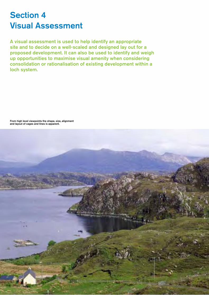
Section 4 Visual Assessment
A visual assessment is used to help identify an appropriate site and to decide on a well-scaled and designed lay out for a proposed development. It can also be used to identify and weigh up opportunities to maximise visual amenity when considering consolidation or rationalisation of existing development within a loch system.
From high level viewpoints the shape, size, alignment and layout of cages and lines is apparent.

35
Alltherelevantelementsoftheproposeddevelopmentshouldbeincludedinavisualassessmentincludinganyvisualisationsorphotomontagesusedtosupportaplanningapplication.Avisualassessmentofoffshoreequipmentshouldincludethecages,buoysandlines,feedbargesandfeedpipes,rafts,topnets,liftinggearandlighting,hutsandaccommodationblocks.Anyonshoreelementsthatarepartoftheproposal,e.g.buildings,jetties/pontoons,feedhoppers,accessroadsandanyotherrelevantstructuresshouldalsobeincludedinthevisualassessment.
Anintroductiontovisualassessment,includingidentifyingkeyviewpointsandassessingthesignificanceofviewpointsisgiveninSection2,onpageXXpara2.7.Box2(laterthissection)illustratesamoredetailedchecklistofstepstobeconsideredwhenundertakingavisualassessment.
Thevisualassessmentprocessallowsapplicantstoexplorethedesignoftheproposal.Thisincludesexamininganymitigationmeasuresthatmaylinktheproposalvisuallywiththesurroundinglandscape,perhapsbylocatingthestructuresagainstastraightstretchofcoast,orillustratinghowbigthesizeofthestructureisinrelationtothescaleofthelandscape.Atamoredetailedlevel,illustrationsorphotomontagescanbeusedtoexplainhowstructureshavebeensetagainsttreesordarkvegetation,orsitedandarrangedtoreflectaregularlandusepattern.
Viewpoint selection:inassessingthevisualimpactofaquaculturedevelopment,itisimportanttoconsiderboththeelevationoftheviewpointandtheproximityoftheviewertothedevelopment.Formoststructures,unlesstheyarewellouttosea,therewillbebothhigh-levelandlow-levelviewpoints,andbothdistantand‘closeup’views.Itisdifficulttodesignastructurewhichalwayslooksgoodfromeveryviewpoint.Theplanningauthorityshouldbeabletohelpyoudecidewhichviewpointsarethemostimportant.
4.1 Key considerations from high-level viewpoints
– Fromahigh-levelviewpoint,thecontrastintexturebetweenfishfarmstructuresandthesmooth,reflectivesurfaceofthewaterismoreobvious.Thegeometricshapesoflinesandcagesarealsoclearlyvisible.
– High-levelviewswhereadramaticpanoramais‘revealed’suddenlyandallatoncewhenaroadorfootpathcrestsahighpointorapassareusuallyverysensitive–peopleanticipateaspectacularview,andthereforethisviewisscrutinisedclosely.
– Fromhighup,itiseasytoseehowtheshape,size,alignmentandlayoutofcagesrelatetotheshapeandscaleofthecoastline.Itisalsoveryobviousiflinesandcagesdonotlieparalleltothecoast,forexample,sothinkingabouttherelationshipbetweenthealignmentofstructuresandtheshapeofthecoastislikelytobeamoreimportantconsiderationfromhigh-levelviewpointsthanlow-levelviewpoints.
– Wheredevelopmentislocatedfurtherouttosea,thenfromhigh-levelviewpointsadevelopmentmayappearmoreobvious,butalsosmaller,asthereare36
– fewerreferencepoints,orotherfeatureswithwhichitcanbecomparedinsize.Thevastnessoftheseacanhelpabsorbthesizeofthedevelopment.
– Fromhigh-levelviewpoints,itisalsoeasytoseethebroadpatternsofthesurroundingsettlementandlanduse.Itmightbepossibletolinkaquaculturedevelopmentstothepatternofthevegetation.Wherethereisachoice,forexample,theremaybeanopportunitytositeoffshorestructuresoppositeastretchofwoodland,oraseriesoffarmedfields.
From high level viewpoints a development may be obvious, but where there are few reference points its apparent size may be small.
Well sited and scaled fish farm. Its regular, ordered layout relates to the coastline and to one side of the strait; smaller than the islands, islets and promontories in scale, it does not dominate the natural landform.

36
4.2 Key considerations from low-level viewpoints
– Fromalow-levelviewpoint,includingfromtheseaitself,waterbasedstructurescanbehardertoseeiftheyaresetagainstadarkbackdropoflandformandvegetation,oriftheyareoftenseeninshadow.
– Whenviewedcloseup,cagesandbuoysareofcourselikelytobemorevisible.Whereexistingtreesarepartofthecharacter,plantingtreesalongtheshoreline,betweentheroadandthestructures,canbreakupthevisibility.
– Thesizeofalargestructuremaybeeasiertoabsorbifitisseenagainsttheexpanseoftheopensea–thestructuresappearsmallerandthewateritselfprovidesawell-scaledsetting.Sitingastructureatadistancefromtheviewer,perhapsonalongexpanseofhorizonassociatedwiththeopensea,willmakethestructureseemsmallerinsize.
– Ifyouhavethechoiceandyouwanttoreducevisualimpact,aimtositeastructurewhereitisvisiblefromastretchofroadwherepeoplearelikelytobedrivingfast,andcertainlytrytoavoidsitingstructuresadjacenttolay-bysandotherviewpointsfromwhichtherewillbestaticviewsofthestructure.
– Visualforeshorteningoccurswhenthelevelsurfaceofwhatappearstobealargeexpanseofwateronplantakesuponlyasmallpartofaview.Asaresult,verticalstructuresviewedfromalow-levelviewpointcanhaveaproportionatelyhigherimpact,takingupproportionatelymore‘visualspace’thanthewater.
– Conversely,lowstructuresonaflatsurface,suchaslinesofbuoys,canmergetogethersothattheyappeartoonlyoccupyasmallamountofthewatersurface,especiallyiflocatedfurtherawayfromtheviewer,asforeshorteningbecomesmorepronouncedwithdistance.
– Structuressuchastopnets,feedbargesandaccommodationmodulescontrastmostsignificantlywiththelevelwatersurface.Theywillbelessvisibleiftheyarekeptclosetothewatersurface.
When viewed from a low level viewpoint and backed by a land formation, it can be difficult to distinguish cages.
Cages viewed from a low level viewpoint are absorbed by background vegetation.

37
4.3 Context of view
Itisthereforeusefultothinkaboutthewaytheproposeddevelopmentwillbeviewedandthetypesofviewpointfromwhichitwillbeseen.Pointstoconsider,forexampleare:
4.3.1 Key visual sensitivities
– Alocationwherethereisonewell-knownviewpoint,oronlyonepanoramicviewofaloch,forexampleifthelochissurroundedbywoodlandandislargelyhidden.Thiswillmakethatsingleviewpointmoreimportant.
– Sometimestheviewofastretchofcoastorsealochisthefirstglimpseoftheseavisibleaftertravellingalongalengthystretchofinlandroad.Thiswillmakethatviewmoresensitive.
– High-levelviewswhichare‘revealed’asdramaticpanoramasaftertravellinguparoadorfootpathtoahighpass,ridge,summitorcrestofahillwillalwaysbeimportantviews.
– Viewstofocalpoints,suchasthemountainsattheendofaloch,oracastleoranotherfeature,arelikelytobehighlysensitive.
– Thevisualsettingoffeaturesandlandmarksofculturalornaturalimportance,forexamplehistoricbuildingsorsitesorvisuallydramaticfeatures.
A site can provide a complementary context to fish cages, especially where activities relate to the shore and aquaculture structures are kept close to the water surface, as here at Lyness.
View One
Thelinesseenrelativelyclosetotheshore
View Two
Thelinesarelocatedfurtherawayfromtheshore,andappeartooccupylessspacebecauseofvisualforeshortening,althoughtheymaybemorevisible,orappeartooclosetothecentreofthelochfromanotherviewpoint.
What is foreshortening?
Foreshorteningiswhenthespacebetweenobjectsviewedacrossaplanebecomeslessvisiblewithdistance.When,forexample,longlinesareviewedfromalowlevelviewpointacrossthesea,thespacebetweenthelinesappearstobereducedwithdistance.Thiscanalsohavetheeffectof‘bunching’thebuoystogethersothattheyappearasamoresolidmasswhenoutatsea.

38
Box 2: Visual Assessment
Thisguidanceonundertakingvisualassessmentcomplementsthatgiveninotherdocuments,inparticularthe‘GuidanceforLandscapeandVisualImpactAssessment’12publishedjointlybytheInstituteofEnvironmentalassessmentandtheLandscapeInstitute.
Whenassessingthepotentialvisualimpactofaproposal,developersshould:
Preparation – identify key viewpoints
– Identifytheextentofvisibilityandtheproximityofviewpointstothedevelopment.Ifnecessary,thiscanbecommissionedasacomputer-generatedmap(calledmappingtheZoneofTheoreticalVisualInfluence).Separatemapsmayberequiredforonshoreandthewater-basedstructures.
– Havingidentifiedtheextentofpotentialvisibility,selectkeyviewpoints,inconsultationwiththeplanningauthority.
Site survey – think about the type of views
– Isthedevelopmentseeninaglimpseview,apanorama,oraseriesofsustainedviews?– Doesitreappearfrequently,orisitasingle,sustainedview?– Fromwhatthedistanceisitvisible,andfromhowmanyviewpoints?
Site survey – identify the viewpoints and those who will use them
– Identifyhowpeopleviewallelementsofthedevelopment.Arepeoplewalking,withsustainedviewsoftheproposal,oraretheytravellingbycar,withthepotentialdevelopmentglimpsedbehindlandformortrees?
– Considerhowviewswillchangeduetoseasonalchanges,suchaswhentreeslosetheirleaves,orwhenthesummersunisatitshighest.Willthedevelopmentbelit,andthereforevisibleatnight?
– Identifywhetherornottheproposalhasasignificanteffectonthesequenceofviewsexperiencedwhentravellingalongaroad,footpathorestablishedboatroute.
– Identifywhetherthemainviewsofasitearefromlow-levelvantagepointsorfromviewpointswhichallowresidentsandvisitorstolookdownuponthesitefromabove.
Analysis – consider options for layout within the landscape context
– Considerwhetherviewsaremainlygoingtobefromadistance,withthedevelopmentsetagainstabackdropofhills,orfromanearbyviewpoint,wherethedevelopmentwilltakeupmoreoftheforegroundoftheview.Canthestructurebemovedtotakeadvantageofanotherfeature,suchasawoodlandbackdrop?
– Looktoseehowitcouldbesitedtorelatetootherfeaturesinthelandscape,suchaslandscapepatterns,aswellasotherexistingaquacultureinstallations
– Ifyouhavetheopportunity,usephotomontagesorbuoysplacedonthewaterduringasitevisit,toexperimentwithdifferentlocationsandconfigurations.Forexample,severallargercagesmayappearbetterscaledthanalargernumberofsmallercages;orshorter,butmorenumerous,mussellinesmayoccupylessoftheperceivedwaterspacethanasmallernumberoflongerlines
– Seeifyoucantakeadvantageofforeshortening–doesmovingthestructurefurtherfromtheshorebyasmallamountmakeitlookmuchsmallerforexample,ordoesitsimplymakeitmoreprominentfromanearbyhighlevelorotherviewpoint?
Alltheseconsiderationscanbereadilypresentedusingmaps,photographs,photomontagesorcomputer-generatedperspectives.
12 Guidelines for Landscape and Visual Impact Assessment, 2nd edition, 2002, Institute of Environmental Management and Assessment. (at the time of going to press, this version is being updated)

39
Section 5 Detail Design
The most successful aquaculture development will be arranged and designed to integrate with the landscape, through positively building on the landscape characteristics and using the most appropriate detail design.

40
Itisimportanttostress,however,thatnomatterhowwelldesignedthestructureis,ifitispoorlylocated,badlysitedorinappropriatelylaidout,itwillnotintegratewiththelandscape.Wellthoughtoutdetaildesignwillnotmakeupforapoorchoiceoflocationorabadlysitedandlaidoutproposal.Detaildesigncanonlybeofassistanceonceanappropriatelocationhasbeenselected,andalayouthasbeenplannedwhichtakesintoaccountthesurroundinglandscapecharacter.
Whensubmittingaplanningapplicationforaquaculturedevelopment,itisimportantthatalldetailsofthedevelopmentaredescribed.Inaddition,itisimportanttoconsidernotonlywhatstructuresarerequiredwhenaproposalisfirstsubmittedforapproval,butalsohowthedevelopmentmightchangeorexpand.Anyproposedexpansionoramendmentstotheoriginalapproveddesignwillrequireplanningpermission,soitisusefultoensurethatthelandscapewillbeabletoaccommodatepotentialfuturechangesiftheyarelikelytoberequired.
Thissectiondescribesexamplesofgoodpracticeinrelationtothedetaildesignofbothonshoreandoffshorestructures.Themostappropriatedesignwillreinforcethewayinwhichadevelopmentreflectsthelandscapecharacterofitslocation.Detaildesignwillthereforeaimtoreinforcethekeycharacteristicsofthelandscapetype,forexamplebyreflectingcolourandtexture,respondingtolandformshapeandusingexistingvegetationpattern.
5.1 Designing structures
Themainelementsofastructurewillbesubjecttoplanningcontrolandthismaybereflectedintheconditionsofyourplanningpermission.
Itisadvisabletoconsultwiththeplanningauthorityonthedesignandcolourofanystructureinadvanceofsubmittingtheplanningapplication,orifyouaregoingtomakeanyamendmentstoanapprovedscheme.
If,asacompany,youareplanningtochangeorreplaceequipment,itisalsolikelytobeworthwhilespeakingtotheplanningauthoritiesorSNHinadvanceoforderingnewequipment,asthiscanbeanopportunitytomitigatepotentialdesignimpacts.
Ifthereismorethanoneaquacultureinstallationonaloch,theywillappearlessintrusiveifthesameappropriatetypes,sizesandcoloursofstructuresareused.
Theappearanceofsomestructures,bothoffshoreandonshore,canbeletdownbypoormaintenance,especiallyiftheyarenotregularlyrepaintedorthereisgeneraluntidiness.Thisisapooradvertisementfortheindustryandcanunderminegoodworkundertakeninsiteplanninganddesign.
Theremainderofthissectionisdividedintothefollowingsubsections:
– Finfishfarmwater-basedstructures– Shellfishfarmwater-basedstructures– Land-linkedpontoonsandjetties– Onshoreandshorelinebaseddevelopment
DetaileddesignconsiderationsrelevanttooysterfarmingareincludedinSection6.
5.2 Finfish farm water-based structures
Water-baseddevelopmentsinclude:
– Finfishcages,on-farmfeedhoppersandtopnets– Feedbarges,liftinggear,on-farmaccommodationforstaff,ancillaryraftsforgeneratorsand
otherinfrastructure– Feedpipes– Aboveandbelowsea-levellighting

41
5.2.1 Finfish cages and top nets
– Mostfinfishcagesarenowcircular,anddarkgreyincolour.Thisstandardisedformmakesiteasiertodesignanorderedlayout.Allcagesinonedevelopmentshouldbethesamesize.
– Topnetsmaybemorevisuallyintrusivethanthecages.Thisisbecausetheyrisefarabovethewatersurface,andsometimesbecausetheyareabrightcolour.Thevisualimpactisgreatlyincreasedasthecagesgetbiggerandthetopnetsconsequentlytaller.Topnetsarealsomorevisiblewherethemeshofthenetissmall.Inthesecircumstances,thedensemeshcreatesanalmostsolidblock.Largermeshandlightercolourednetsarelesslikelytobevisuallyprominent.Thelargerandmorevisuallyprominentthesestructuresare,themorelikelyitisthattheywillbedifficulttoaccommodatewithinsmall-scalecoastallandscapes.Brightlycolouredtopnetsshouldberestrictedtoareaswherebirdstrikeisarisk,andavoidedwithinsensitiveanddesignatedlandscapes.
– Ifindividualfeedhoppersareused,attachedtoindividualcages,thentheyshouldbepaintedadarkcolour–sometimestheycanbemorevisiblethanthecages
Light weight top nets minimise visual impact
Top net colour can affect visual impact
Larger top nets with feed hoppers make for greater visual impact

42
5.2.2 Feed barges, lifting gear and on-farm accommodation for staff, ancillary rafts for generators and other infrastructure
– Feedbargescanbeparticularlyprominent,especiallythosewhicharetall.Whereverpossible,aimtouselow-profilestructures.
– Large,bulky‘box-like’structuresarealsolikelytobevisuallyintrusive–whereverpossible,trytodividethemassofthefeedbargeintoseveralconjoinedsmallerblockswhichwillbreakuptheoutline;
– Feedbargesshouldbelocatedtoassociatewell,andlogicallywiththecagelayout–acentralposition,oronewherethebargeismooredtoalignwiththecentreofthecagesonthelongaxistendstobetheneatestarrangement
– Largestructures,forexampleincludingaccommodationmodules,willbedifficulttoaccommodatewithinsmall-scalecoastallandscapes
– Ingeneral,themoreelementsincludedonabarge,themorefragmentedthestructureislikelytobecome.Trytoavoidclutterbydesigningasmanyoftheelementsintothestructurefromtheoutset,andusingthesamecolourtounifytheindividualelements.
– Darkmutedcoloursandmattfinishestendtobelessobtrusive.Darkmattgreyandrecessivecoloursspecifictothesurroundingcontextareusedtominimisethevisibilityofstructuresfeedbarges;insomelocations,forexample,darkgreenhasworkedwell.
– Alternatively,insomeareas,especiallywherethereisfrequentwater-basedactivity,feedbargeshavebeenpaintedin‘boat-like’colours.Thisismostlikelytoworkifthefeedbargeisasimilarsizeandshapetoaboat.
A feed barge similar in size and shape to a boat with ‘boat-like’ paint scheme.
Ordered cage layout, lighter top nets and alignment of feed barge make for a coherent image
43
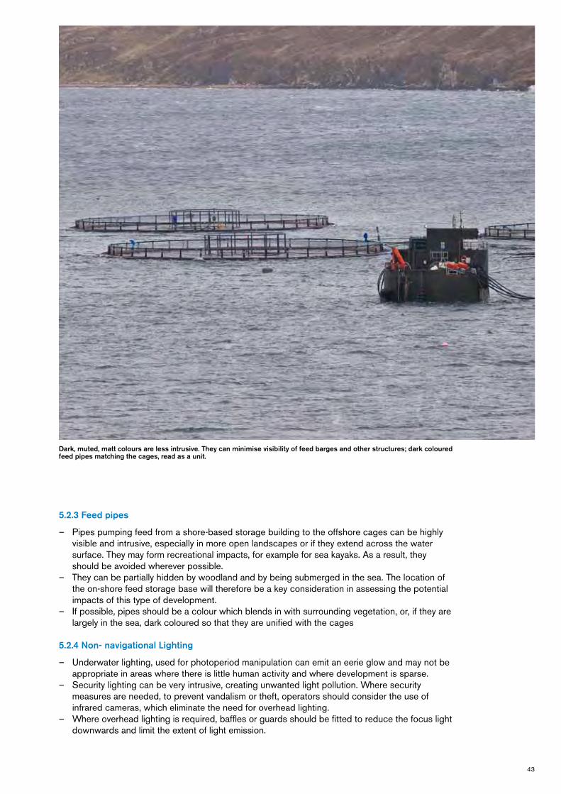
Dark, muted, matt colours are less intrusive. They can minimise visibility of feed barges and other structures; dark coloured feed pipes matching the cages, read as a unit.
5.2.3 Feed pipes
– Pipespumpingfeedfromashore-basedstoragebuildingtotheoffshorecagescanbehighlyvisibleandintrusive,especiallyinmoreopenlandscapesoriftheyextendacrossthewatersurface.Theymayformrecreationalimpacts,forexampleforseakayaks.Asaresult,theyshouldbeavoidedwhereverpossible.
– Theycanbepartiallyhiddenbywoodlandandbybeingsubmergedinthesea.Thelocationoftheon-shorefeedstoragebasewillthereforebeakeyconsiderationinassessingthepotentialimpactsofthistypeofdevelopment.
– Ifpossible,pipesshouldbeacolourwhichblendsinwithsurroundingvegetation,or,iftheyarelargelyinthesea,darkcolouredsothattheyareunifiedwiththecages
5.2.4 Non- navigational Lighting
– Underwaterlighting,usedforphotoperiodmanipulationcanemitaneerieglowandmaynotbeappropriateinareaswherethereislittlehumanactivityandwheredevelopmentissparse.
– Securitylightingcanbeveryintrusive,creatingunwantedlightpollution.Wheresecuritymeasuresareneeded,topreventvandalismortheft,operatorsshouldconsidertheuseofinfraredcameras,whicheliminatetheneedforoverheadlighting.
– Whereoverheadlightingisrequired,bafflesorguardsshouldbefittedtoreducethefocuslightdownwardsandlimittheextentoflightemission.

44
5.3 Shellfish farm water-based structures
Water-baseddevelopmentsinclude:
– Buoysandlong-lines– Raftsandotherstructures
5.3.1 Buoys and long-lines
– Mostlong-linebuoysarebarrel-shapedandblackordarkgreyincolour.Thestandardisedshapemakesiteasiertodesignanorderedlayout.Thedarkgreybarrelsarelikelytobelessvisuallyintrusivethantheblackbuoys.Alllinebuoysinonedevelopmentshouldbethesamesize.Itisrecognisedthatnavigationandcornerbuoysneedtobebrightlycolouredandmaybeadifferentsize.
– Thepatternofbuoysshouldbekeptsimpleandrelativelyordered,forexamplebymaintainingthesamedistancebetweenthelinesandreflecting,asfaraspossible,thealignmentofthecoastline
– Currentsandthewindmightmovethelinesslightly,whichmakesthemlessgeometricandsimplyreflectsthedynamismofthesea.
Buoy pattern: simple and ordered, reflecting alignment of coastline, with constant distance between buoys.
Long-line buoys in an ordered layout, located in-shore can respect on-shore activities.
Regular pattern of buoys and rafts complementing buoy pattern. Trees and vegetation along a shoreline can break up visibility.

45
5.3.2 Rafts and other water-based structures
– Rafts,hutsorotherstructuresassociatedwithlong-linesandmooredonthewatershouldbelocatedwheretheycomplementthelayoutofthelines,forexample,mooredtoalignwiththecentreofthelinesoneitheraxis
– Largestructureswillbedifficulttoaccommodatewithinsmallscalecoastallandscapes– Ingeneral,themoreelementsincluded,themorefragmentedthestructureislikelytobecome.
Trytoavoidclutterbydesigningasmanyoftheelementsintothestructurefromtheoutset,andusingthesamecolourtounifytheindividualelements.
– Whereverpossible,choosematerialswhichhaveamatt,unreflectivesurface,astheyarelesslikelytocatchthelightandattractattention.
5.4 Land-linked pontoons and jetties
– Whereverpossible,choosematerialswhichhaveamatt,unreflectivesurface,astheyarelesslikelytocatchthelightandattractattention.
– Largestructureswillbedifficulttoaccommodatewithinsmallscalecoastallandscapes
5.5 On-shore and shoreline-based development
On-shorefacilitieshavethepotentialtobepermanentstructures.Theimplicationsofsitinganddesignthereforehavetobeconsideredintermsoftheirlongtermimpact.
Inadditiontobuildingsandstorageyards,abasemayneedon-shoreliftinggear,anewaccessroadandapowersupply,allofwhichcanaccumulatetomakeaverysignificantimpact,especiallyinanareawithfeworevennobuiltstructures.
Shore-baseddevelopmentsinclude:
– Buildings,yardsandassociatedinfrastructure
Water-based structures can appear cluttered and visually prominent where many diverse elements, forms and varied colours are used.

46
5.5.1 Buildings, yards and associated infrastructure
– Redundantbuildingscanoffertheopportunityforconversionintoofficesandstoragesheds.Thereuseofredundantbuildingsorslipwaysisoftenapositivecontributiontothelandscape.
– Evenifexistingbuildingsarenotavailableforre-use,considerusingexistingaccesstracksandotherinfrastructure,suchasslipways,ifpossible
– Depotsanddepurationfacilitiesoftenneedaccesstowaterandwillneedtobelocatedonthecoastorlochshore.Thisisoftenasensitivelocation,especiallyinareaswheredevelopmentbetweenaroadandtheseaisrestrictedtomaintainviewsofthewaterfromroadsorexistinghousingandvillages.
– Aimtositebuildingslowinthelandscape,possiblytuckedagainstalowhummockorrockyoutcrop,oradjacenttowoodland,allofwhichcanprovideasettingforthedevelopment
– Consideraninnovativeandecologicallysoundbuildingstyleifnewbuildisrequired,indiscussionwiththelocalplanningauthority.
– Ensurethatstoragespaceisbigenoughtoaccommodateallstorageneedsnowandreasonablyfarinthefuture,eitherthroughwell-scaledbuildingsororganisedandadequateexternalstoragespace.Carparkingareas,too,oftenneedtobelargerthanatfirstconsidered.
– Thesizeofshore-basedbuildingsandcompoundsshouldreflecttheformandscaleofotherbuildings.Largebuildingswillstandout.Considerbreakingthemintosmallerunits.Whereverpossible,buildingsshouldbeorientatedandalignedtofitinwithlocallycharacteristicdesignsandlayout.
– Ifalargestorageshedisrequired,considerbreakingupthemassofthebuildingtoreduceitsscale.
– Avoidexcavatingasteepslopeandexcessiveunder-building,andfitthebuildingsintothegradient.
– Aimtocreateanappropriatesettingforbuildingsbyusingfenceorwallmaterialsanddesignswhichrelatetothecharacterofthelandscape.Avoidurbanandsuburbansolutions.
– Althoughtheymaytakelongertoestablishthan‘instant’fencingbarriers,well-establishedandmaintainedplantingmaybemoreeffectiveinthelongterm.Atsomesites,fencingcouldbeusedtocreateasettingforabuildinguntilplantingisestablished.
– Securitylightingcanbeveryintrusive,creatingunwantedlightpollution.Wheresecuritymeasuresareneeded,topreventvandalismortheft,operatorsshouldconsidertheuseofinfraredcameras,whicheliminatetheneedforoverheadlighting.
– Whereoverheadlightingisrequired,bafflesorguardsshouldbefittedtoreducethefocuslightdownwardsandlimittheextentoflightemission.

47
Section 6 Oyster Farms
Oyster farming differs from other forms of finfish and shellfish farming because it is located in the intertidal zone. It is also limited to sites where there is a relatively accessible foreshore and where the intertidal is shallow, accessible and sheltered.

48
6.1 Oyster trestles
Oystertimberormetaltrestlesareplacedintheintertidalzone,wheretheyaresubmergedexceptatlowtide,whenthehandlercangainaccesstoturnandcleantheoysterbags.Theyarethereforeonlyvisiblewhenthetideisout,andthenusuallyonlywhenthetidesareverylow.Trestlesarealsolow-lying,whichreducestheiroverallwidervisibilityandmakesthemeasiertoaccommodateinlong,lowcoastallandscapes.
Thetrestlesoccupytheforeshorewheretheseaandlandmeetatlowtides,andthereforecanrestrictaccesstotheseaatlowtide.Theytendtobelocatedonaccessiblestretchesofbeachwhichslopegentlyintothewaterandtheremaybesomeconflictbetweenthetrestlesandrecreationalusersofbeachesandinshorewaters.
Trestlesarerectangularinshape,andoftenarrangedinrows,creatingageometricpattern.Whilesmallerfarmsaregenerallymanagedbyhand,accesstolargerfarmscaninvolvewheeledvehicles,whichcanleavetracksontheforeshore.Beforetheincomingtidedispersesthesetracks,thechurnedupbeachcreatesamoremanagedandfragmentedcharacter.
Keysitinganddesignissuestoconsiderwhenpreparingadevelopmentapplicationare:
– Theuseofthebeachorintertidalareaforrecreation,includingthepopularityofaccessbothfromthelandandthesea.Thepotentialimpactontheexperienceoftheintertidalareamaybeaconstrainttodevelopingallorpartoftheforeshore;
– Thevisualsensitivityoftheshoreline.Oystertrestlesareonlyvisibleintermittently,buttheymaystillimpactonsensitiveviews.Section4setsoutkeyconsiderationsforassessingvisualsensitivity,muchofwhichisrelevanttoassessingthepotentialvisualeffectsofoystertrestles.
– Theregularityofthetrestlelayout.Itmaybepossibletomitigatetheimpactofthedevelopmentbyalteringthealignmentofthetrestlestoreflecttheshapeofthecoastline,tomakethearrangementlessregular;
– Thescaleormassingofthetrestles.Itmaybepossibletobreakupthetrestlesintosmallergroups.Alternatively,trestlesmayoccupyonlypartoftheshoreline,andfocusdevelopmentatoneortwolocations,allowingtheundevelopedintertidalareatodominate.
– Theuseofmachinery.Iftractorsorothermachinesareusedtoaccessandmanagethetrestles,thisislikelytohaveamuchbiggerimpactontheforeshorethanmanagementbyhand.Theeffectsmayonlytemporary–asthetracksbelowthehighwatermarkaredispersedbytheincomingtideshiftingthesand–butonalargedevelopment,theycanbeoneofthemostdisruptiveelements.
– Thedegreeofremoteness.Aswithothercoastaldevelopments,areasidentifiedas‘isolatedcoast’arelikelytomoresensitivetodevelopmentthancoastswhichhavealandscapecontextofmanagedforestry,farmlandorwhicharenotespeciallyremote.
Oyster trestles in intertidal zone. Here they are arranged in lines that reflect the prevailing grain of the rock outcrops along the foreshore. Careful siting and design means need not preclude other, recreational users.

49
6.2 BST adjustable long lines
BSTlinesinvolvesinstallinglinesofpostsfixedatrightanglestothecoast,andsuspendingbasketsorbagsofoystersfromwiresattachedtotheposts.Theyhavebeendevelopedforbothsub-tidalandinter-tidaloysterfarming.Thewirescanberaisedorloweredonthepoststomaximiseefficiency.Linesaregenerallyaccessedbyboat.
Postsareusuallysetoutat3mcentres,andcanbesetoutinsingle,double,tripleor‘quad’(four)linesystems.Wherethereismorethanonelineinasystem,thespacebetweentheindividuallinesvariesbutisapproximately700mmapart.Multiplesofthesesystemscanbeused.Theytendtobelocatedonaccessiblestretchesofshallowintertidalclosetotheshoreandtheremaybesomeconflictbetweentheselinesandrecreationalusersofbeachesandinshorewaters.
Thissystemismorevisiblethanthetrestles,asthepostsappearabovethewaterlineforlongerthanthelow-lyingtrestles.
Keysitinganddesignissuestoconsiderwhenpreparingadevelopmentproposalarelikelytobe:
– Theuseofthebeachorintertidalforrecreation,includingthepopularityofaccessbothfromthelandandthesea.Thepotentialimpactontheexperienceoftheintertidalareamaybeaconstrainttodevelopingallorpartoftheintertidalorsub-tidalarea;
– Thevisualsensitivityoftheshoreline.Thepostsarenotalwaysvisible,andthepostsclosertoshorearelikelytobemorevisiblemoreofthetimethanthosefurtheroutatsea.Nevertheless,theymaystillimpactonsensitiveviews.Section4setsoutkeyconsiderationsforassessingvisualsensitivity,muchofwhichisrelevanttoassessingthepotentialvisualeffectsofBSTlonglines.
– Theuprightnessoftheposts.Theverticalityofthepostsmakesthemmorevisiblethantrestles;– Thenumberofthelinesanddensityoftheposts.Thevisualimpactofaproposeddevelopment
islikelytorelatestronglytothenumberoflinesandtheirrelativeproximity.Whenseverallinesarelocatedclosetogether,the‘thicket’ofpostsbecomesmoredenseandvisible.Itmaybepossibletobreakupthenumberoflines,adoptingoccasionalsingleratherthanmoredensepatternsoflinesoverawiderarea.Alternatively,focusingdevelopmentmoredenselyatoneortwolocations,allowingtheundevelopedintertidalareatodominate,maybemoreappropriateinsomeareas.Optionsforsitingandarrangementshouldbeexploredwiththeplanningauthority.
– Thedegreeofremoteness.Aswithothercoastaldevelopments,areasidentifiedas‘isolatedcoast’arelikelytomoresensitivetodevelopmentthancoastswhichhavealandscapecontextofmanagedforestry,farmlandorarenotespeciallyremote.Thismayappeartoconflictwithadviceonlimitingdevelopmenton‘popularandaccessible’coastlines.
Vehicular access is needed for management of the oyster trestles, so access routes to the foreshore need to be planned.

50
Conclusions
This guidance describes and promotes the landscape character and design issues which it is appropriate to consider when developing new fish or shellfish farm, or extending an existing one.
FurtheradviceonlandscapeissuesraisedbythisguidanceisavailablefromplanningauthoritiesandSNHlocalandregionaloffices.Localcontactaddressesandtelephonenumbersareavailablefromtherelevantwebpages.
Theissuesraisedinthisguidanceservetoemphasisethatgooddetaildesignalonecannotlimittheimpactofastructure–itisveryimportantthatdevelopmentsareinlocationswherestructuresandactivityareappropriateinthefirstplace.Onlythis,combinedwithwell-sited,appropriatelyscaledandcarefullylaidoutfacilitieswillensurethataquacultureintegratessuccessfullyintotheScottishlandscape.

51
Annex One Environmental Assessment
When choosing a location for a finfish farm development, a developer is well advised to discuss the potential site (or site options) with the local planning authority and other relevant statutory consultees prior to submitting a formal planning application. This can help to minimise delays or difficulties at later stages in the application process. For applications which may require EIA, screening and scoping will help to establish the detailed information which will be required to be assessed.
GuidanceonthepreparationofanEIAcanbefoundonlinefromtheScottishAquacultureResearchForumat:http://www.sarf.org.uk/SARF024.htm
PreparinganEIAwillincludeundertakingalandscapeandvisualimpactassessment.GenericguidanceonthepreparationofanLVIAcanbefoundintheGuidanceforLandscapeandVisualImpactAssessment13.Inaddition,Section4ofthisguidanceonpageXXsummarisesthekeystepsrequiredtoprepareavisualassessmentforaquaculturedevelopment.
AchecklistofstepstobeconsideredwhenundertakingthelandscapecomponentofanenvironmentalimpactassessmentisgiveninBox3.
13 Landscape Institute and Institute of Environmental Management and Assessment (2002). Guidelines for Landscape and Visual Impact Assessment, 2nd edition (This edition is under review)
Box 3: Environmental Impact Assessment for finfish farms – a summary of landscape issues
InpreparingthelandscapecomponentofanEnvironmentalStatement(ES),adevelopershould:
– Demonstratetheoptionswhichhavebeenconsideredforlocatingtheproposeddevelopment,includinganexplanationofwhytheparticularlocationhasbeenchosen.Thisexplanationshouldincludeenvironmentalaswellaseconomic,socialandpracticalconsiderations;
– Explainhowtheproposalrelatestorelevantplanningguidancefortheareaandthepoliciesofotherconsultees;and
– Iftheproposedlocationiswithinorneartoadesignatedarea,consideranddescribethelikelyimpactwhichtheproposeddevelopmentwouldhaveonthequalitiesforwhichtheareahasbeendesignated.
Inadditiontotheabove,developersarerequiredtopresentbothanassessmentoftheimpactofaschemeonthelandscapeandthemitigatingmeasureswhichhavebeentakentoreduceanyidentifiedsignificantadverseimpacts.TheESisthereforealsolikelytoinclude:
– Informationfromtheappropriatespatialplansanddevelopmentplanpolicies,includinghowtherelevantadviceandguidancehasbeenusedtohelplocateanddesigntheproposal;
– Anexplanationofhowtheproposedschemerespondstothekeycharacteristicsofthelocalcoastallandscape,includingdetailsofhowanypredictedadverseimpactsonthelandscapecharacterorvisualamenitywillbemitigated;
– Ifappropriate,anexplanationofhowtheproposalwillavoidcreatinganadversecumulativeimpactonthelandscape;
– Avisualimpactassessment(seeSection4ofthisguidance);and– Amapindicatingkeyviewpoints,accompaniedbyillustrationsorphotomontages.These
shouldillustratehowthefinal,mitigatedproposalwillbeseenincontext.

52
Annex Two Acronyms And GlossaryEA EnvironmentalAssessment
EIA EnvironmentalImpactAssessment
ES EnvironmentalStatement
LCA LandscapeCharacterAssessment
LVIA LandscapeandVisualImpactAssessment
NSA NationalScenicArea
SNH ScottishNaturalHeritage
SPG SupplementaryPlanningGuidance
ZTV ZoneofTheoreticalVisibility
Aesthetic Quality
Avalueplacedonthelandscape,aspartoftheassessmentprocess,whichrelatestoitsaestheticappeal.
Aesthetic Qualities
Thoseaspectsofthelandscapewhich,inthejudgementoftheassessors,contributetothepositiveaestheticappreciationofthelandscape.
Experiential Characteristics
Thoseaspectsoflandscapecharacterwhichmaybeperceivedvisually,butare,likescaleandspace,oftenperceivedthroughothersensesalso.Inaddition,thesecharacteristicscanoftenbeenhancedbythemovementoftheobserver,suchasthedramaexperiencedwhenarrivingatthecrestofahillfromwhereapanoramaissuddenlyrevealed,orthesenseoftravellingupanddownthroughanundulatinglandscape.
Landscape Capacity
‘Thedegreetowhichaparticularlandscapecharactertypeorareaisabletoaccommodatechangewithoutsignificanteffectsonitscharacter,oroverallchangeoflandscapecharactertype’(Swanwick,C.andLandUseConsultants,2002,page53)
Landscape Character
‘Adistinct,recognisableandconsistentpatternofelementsinthelandscapethatmakesonelandscapedifferentfromanother’(Swanwick,C.andLandUseConsultants,2002,page8)
Landscape Unity
Alandscapewhereelementscreateapatternwhichisstronglyrelatedtotheunderlyingphysicalcapabilityofthelandscape.Thisoftenresultsina‘logical’landscapewheretherelationshipbetweenelementsiseasytointerpret,oratleastcanbeunderstoodwithabitofbackgroundknowledge.Theresultinglandscapeisoftenseenasvisuallyharmonious.
Scenic Quality
Inthisreporttheterm‘scenicquality’hasbeenusedasdefinedinSNH’sLandscapePolicyFramework14:‘theaestheticvalueplacedonthelandscape,basedprimarilyonthevisualsenses.Thisvalueisnotabsoluteandtendstoreflectprevailingideasaboutwhichlandscapesofferaparticularaesthetic.’
Seascape
Thevisualandphysicalconjunctionoflandandseawhichcombinesmaritime,coastandhinterlandcharacter.
14 SNH Policy Statement No 05/01 December 2005

53
Annex Three Bibliography and Useful PublicationsCouncilofEurope,2000/2004.EuropeanLandscapeConvention(CouncilofEuropeTreatySeriesNo176),availableat:http://www.coe.int/t/dg4/cultureheritage/heritage/landscape/default_en.asp
CountrysideCommissionforScotland,1978.Scotland’s Scenic Heritage.ForfurtherinformationonNationalScenicAreas,seealso:http://www.snh.gov.uk/protecting-scotlands-nature/protected-areas/national-designations/nsa/special-qualities/
TheLandscapeInstituteandtheInstituteofEnvironmentalManagementandAssessment,2002.Guidelines for Landscape and Visual Impact Assessment.2nded.SponPress.(Notethatthiseditionisunderreview).
ScottishNaturalHeritage2008.Guidance on Landscape/Seascape Capacity for Aquaculture.Availablefrom:http://www.snh.gov.uk/publications-data-and-research/publications/search-the-catalogue/publication-detail/?id=976
Swanwick,C.andLandUseConsultants,2002.Landscape Character Assessment: Guidance for England and Scotland.CountrysideAgencyandScottishNaturalHeritage

54
Annex Four Useful Websites
Association of Scottish Shellfish Growers
http://assg.org.uk/
Crown Estate
http://www.thecrownestate.co.uk/scotland
Scottish Government Planning
http://www.scotland.gov.uk/Topics/Built-Environment/planning
Scottish Government Marine and Fisheries
http://www.scotland.gov.uk/Topics/marine
Scottish Natural Heritage
http://www.snh.gov.uk/
Scottish Salmon Producers Organisation
http://www.scottishsalmon.co.uk/
The Landscape Institute
http://www.landscapeinstitute.org/

Illustrations
Alison Grant
Photographs
George Logan: SNH Front cover, 1,10, 21, 32, 33, 39, 43, 45; Hjaltland Seafarms Ltd: 42T; James Bromham: Highland Council 42B; Krystyna Campbell: SNH 8, 15BL, 26, 29, 30B, 31, 35L, 36, 37, 41B, 44TL, 48, 49, 50; Lakeland Marine: 11; Lorne Gill: SNH 5; Mark Steward: 41TL, 41TR; Pat and Angus MacDonald: 27; SNH: 9, 14, 15 TL TR BR, 18, 24, 28, 30T, 34, 44 TR, B; Scottish Salmon Producers’ Organisation: 22/23, 35R
www.snh.gov.uk
© Scottish Natural Heritage
ISBN 978-1-85397-827-2