screening statement on the determination of the need for … results of the process must be...
TRANSCRIPT

Screening Statement on the determination of the need for a Strategic Environmental Assessment (SEA) in accordance with the Environmental Assessment of Plans and Programmes Regulations 2004 and European Directive 2001/42/EC for the Headington Neighbourhood Plan February 2016 Introduction
1. This screening report is used to determine whether or not the contents of the Headington Neighbourhood Plan require a Strategic Environmental Assessment (SEA) in accordance with the European Directive 2001/42/EC (hereafter ‘the Directive’) and associated Environmental Assessment of Plans and Programmes Regulations 2004 (hereafter ‘the Regulations’). These require an SEA to be undertaken on any land use plan or programme ‘which sets the framework for future development or for future development consent of projects”.
2. However, there are exceptions to this requirement for plans ‘which determine the use of a small area at a local level’, or which only propose ‘minor modifications to a plan’, if it is determined that the plan is unlikely to have significant environmental effects’.
3. The National Planning Policy Framework, paragraph 167, advises that assessments should be proportionate, and should not repeat policy assessments that have already taken place.
4. To assess whether an SEA is required a screening process must be undertaken based on a standard set of criteria. This must be subject to consultation with the Environment Agency, Historic England and Natural England. The results of the process must be documented in a Screening Statement, available to the public.
Headington Neighbourhood Plan 5. The Headington Neighbourhood Plan contains policies to guide the
development of the Headington Area1. The policies cover six different areas:
• Green Spaces and Amenity (planning and community policies) • Business and Retail (community policies only) • Character and Identity (planning and community policies) • Education (planning policies only) • Housing (planning and community policies) • Transport (planning and community policies)
6. It is worth noting that it is only the planning policies that are the subject of this
assessment
7. The plan also proposes a series of development guidelines through character assessments. The plan does not allocate any sites for development.
1 The Headington Area Map is shown at Appendix 1

The Screening Process 8. The key to the screening decision is the determination of whether the Plan is
likely to have any significant environmental effects on the environment, using the criteria set out in Annex II of the Directive and Schedule 1 of the Regulations. These criteria are set out in the table at Appendix 3.
9. An extract from ‘A Practical Guide to the Strategic Environmental Assessment’ (set out at Appendix 2) provides a flow diagram to demonstrate the SEA screening process. This flow diagram sets out the process to be undertaken in order to ascertain whether or not an SEA is required for the Headington Neighbourhood Plan.
10. Part of the screening process is a requirement to consider whether the Plan requires a Habitat Regulations Assessment (HRA). An HRA Screening has been undertaken, and can be found at Appendix 4. An assessment of likely significance of effects on the environment has also been undertaken, which can be found at Appendix 5. These two assessments feed into Table 1 and the SEA Screening Assessment.
11. Responses to the consultation from the statutory consultees have been set out at Appendix 6.
Statutory Consultees 12. The initial Screening Opinion was sent to the Environment Agency, Historic
England and Natural England for comment on 7th December 2015.
13. The Environment Agency stated:
14. Thank you for consulting us on this screening opinion. We do not consider there are any significant environmental issues that fall within our remit, which would require an SEA.
15. Historic England stated:
16. Although Headington has a number of designated heritage assets such that there could be potential for significant effects on the historic environment, based on the information in your Opinion, particularly that the Plan does not allocate sites for development, Historic England agrees with your conclusion that the Headington Neighbourhood Development Plan is unlikely to lead to any significant environmental effects and that, therefore, a Strategic Environmental Assessment is not required for the Plan. However, should the nature of the Plan change from that set out in your Opinion we should be informed as we may wish to review our position.
17. Although a formal Strategic Environmental Assessment is not currently believed to be necessary, we would nevertheless suggest that the Plan is subject to a form of sustainability appraisal to assess and monitor the Plan’s policies and proposals against a set of agreed objectives.
18. Natural England did not comment.

Conclusion
19. Oxford City Council considers that the Headington Neighbourhood Plan will not have any significant impacts on the environment and as such does not require a Strategic Environmental Assessment (SEA) as required by the Environmental Assessment of Plans and Programmes Regulations 2004.
20. The City Council notes Historic England’s comments in relation to the undertaking of some form of appraisal of the sustainability of the policies in the plan and suggests that the Headington Neighbourhood Forum gives this due consideration.

Appendix 1: Headington Neighbourhood Plan Area

Appendix 2 – Extract from ‘A Practical Guide to the Strategic Environmental Assessment Directive’, DCLG, 2005.

Appendix 3: Application of the SEA Directive as shown in Appendix 2. Stage Yes/
No Explanation
1. Is the Neighbourhood Plan subject to preparation and/ or adoption by a national, regional or local authority OR prepared by an authority for adoption through a legislative procedure by Parliament or Government? (Art. 2(a))
Yes The preparation and adoption of the Neighbourhood Plan is allowed under the Town and Country Planning Act 1990 as amended by the Localism Act 2011. The Neighbourhood Plan will be prepared by the Headington Neighbourhood Forum (as the ‘relevant body’) and be “made” by Oxford City Council as the Local Authority. The preparation of Neighbourhood Plans is subject to the following regulations: The Neighbourhood Planning (General) Regulations 2012 and the Neighbourhood Planning (referendums) Regulations 2012.
2. Is the Neighbourhood Plan required by legislative, regulatory or administrative provisions? (Art. 2(a))
No Whilst Neighbourhood Planning is not a requirement, it is optional under the provisions of the Town and Country Planning Act 1990 as amended by the Localism Act 2011. It will, if “made”, form part of the Development Plan for the City. It is therefore important that the screening process considers whether the Neighbourhood Plan is likely to have significant environmental effects and hence whether SEA is required under the Directive.
3. Is the Neighbourhood Plan prepared for agriculture, forestry, fisheries, energy, industry, transport, waste management, water management, telecoms, tourism, town and country planning or land use, AND does it set a framework for future development consent of projects in Annexes I and II (see Appendix 5) of the EIA Directive? (Art 3.2(a))
Yes The Neighbourhood Plan is prepared for town and country planning and land use. The Headington Neighbourhood Plan does not set a framework for future development consent of projects in Annexes I and II of the EIA Directive.

4. Will the Neighbourhood Plan, in view of its likely effect on sites, require an assessment for future development under Article 6 or 7 of the Habitats Directive? (Art 3.2(b))
No See Habitat Regulations Assessment (HRA) Screening Opinion for the Headington Neighbourhood Plan at Appendix 4. If No, go to Step 6 of the Flow Chart
5. Does the Neighbourhood Plan determine the use of small areas at local level, OR is it a minor modification of a PP subject to Art 3.2? (Art 3.3)
N/A N/A
6. Does the Neighbourhood Plan set the future development consent of projects (not just projects in Annexes to the EIA Directive? (Art 3.4)
Yes The Headington Neighbourhood Plan will be used to determine future planning applications. If Yes, go to Step 8 of the Flow Chart
7. Is the Neighbourhood Plan’s sole purpose to serve the national defence or civil emergency, OR is it a financial or budget PP, OR is it co-financed by structural funds by EAGGF programmes 2000 to 2006/7? (Art 3.8, 3.9)
N/A N/A
8. Is it likely to have significant effects on the environment?
No See Assessment of Significant Effects on the Environment Likely (Appendix 5)

Appendix 4 – Habitat Regulations Assessment (HRA) Screening Opinion for the Headington Neighbourhood Plan Introduction
1. Oxford City Council has undertaken this Habitat Regulations Assessment
(HRA) “in-house”. This report discusses Stage 1 – Screening.
2. This Screening Assessment relates to a Neighbourhood Development Plan (Headington Neighbourhood Plan) that will be in general conformity with the higher level strategic plan (Oxford’s Local Plan). This Screening Assessment uses the Oxford Core Strategy HRA as its basis for assessment. From this, the Local Authority will determine whether the Headington Neighbourhood Plan is likely to result in significant impacts on ‘European’ sites and therefore whether an ‘Appropriate Assessment’ is required.
Requirements of the Habitats Directive
3. Appropriate Assessment of plans that could affect Special Areas of Conservation (SACs), Special Protection Areas (SPAs) and Ramsar sites (jointly called ‘European sites’) is required by Article 6(3) of the European Habitats Directive2, which states: “Any plan or project not directly connected with or necessary to the management of the [European] site but likely to have significant effect thereon, either individually or in combination with other plans or projects, shall be subject to appropriate assessment of its implications for the site in view of the site’s conservation objectives. In light of the conclusions of the assessment of the implications for the site and subject to the provisions in paragraph 4, the competent national authorities shall agree to the plan or project only after having ascertained that it will not adversely affect the integrity of the site concerned and, if appropriate having obtained the opinion of the general public.”
4. Article 6(4) of the Habitats Directive discusses alternative solutions, the test of “imperative reasons of over-riding public interest” (IROPI) and compensatory measures. “If, in spite of a negative assessment of the implications for the site and in the absence of alternative solutions, a plan or project must nevertheless be carried out for imperative reasons of over-riding public interest, including those of social and economic nature, the Member State shall take compensatory measures necessary to ensure that the overall coherence of Natura 2000 is protected. It shall inform the Commission of the compensatory measures adopted.
2 Directive 92/43/EEC on the Conservation of Natural Habitats and Wild Flora and Fauna

5. The Habitats Directive applies the precautionary principle to European sites. Plans and projects can only be permitted if it can be shown that they will have no significant adverse effect on the integrity of any European site, or if there are no alternatives to them and there are imperative reasons of over-riding public interest as to why they should go ahead. In such cases, compensation will be necessary to ensure the overall integrity of the site network.
6. The Habitat Directive was implemented into UK legislation through the Conservation of Habitats and Species Regulations 2010 (as amended3). This piece of legislation is generally known as the Habitats Regulations.
Methodology used for this assessment 7. Habitat Regulations Assessment can involve up to a four stage process.
1. Screening: Determining whether a plan ‘alone, or in combination’ is likely
to have a significant effect on a European site 2. Appropriate Assessment: Determining whether, in view of the site’s
conservation objectives, the plan ‘alone or in combination’ would have an adverse effect (or risk of this) on the integrity of the site. If not, the plan can proceed
3. Assessment of Alternative Solutions: Where a plan is assessed as having an adverse effect (or risk of this) on the integrity of a site, there should be an examination of alternatives.
4. Assessment where no alternative solutions remain and where adverse impacts remain
8. The HRA covers stage one of the process. This was carried out in November/ December 2015. Broadly, the HRA process involved:
• Identification of European sites that could possibly be affected by the Headington Neighbourhood Plan, qualifying features of those sites and, where available, key environmental conditions to support the sites’ integrity. This process relied on information used in the Core Strategy HRA, which was updated through the Sites and Housing Plan HRA and most recently through the HRA for the Northern Gateway Area Action Plan;
• Identification of possible impacts arising from the Headington Neighbourhood Plan;
• Identification of impacts and policies that could be screened out, and those that were likely to require more detailed appropriate assessment;
• Consultation with Natural England to confirm that the proposed approach for the Habitat Regulations Assessment was acceptable, and what additional information (if any) was required to complete the analysis.
9. This report discusses Stage 1 (screening) only.
3 The Conservation of Habitats and Species Regulations 2010 as amended by The Conservation of Habitats and Species (Amendment) Regulations 2012.

Screening European Sites
10. Table 1 lists all European sites that area within 20km of the boundary of Oxford City Council.
Name of site
Distance from boundary
Reason for designation4
Oxford Meadows SAC
Within the City Boundary, extending into administrative area for Cherwell District Council and into the administrative boundary of West Oxfordshire District Council.
Annex I habitats that area primary reason for selection of this site Oxford Meadows represents lowland meadows in the Thames Valley centre of distribution. The site includes vegetation communities that are perhaps unique in the world reflecting the influence of long-term grazing and hay-cutting on lowland meadows. The site has benefited from the survival of traditional management, which has been undertaken for several centuries, and so exhibits good conservation of structure and function. Annex II species that are a primary reason for selection of this site Oxford Meadows is selected because Port Meadow is the larger of only two known sites in the UK for creeping marshwort Apium repens.
Cothill Fen SAC
Located 7km from the City boundary
Annex I habitats that area primary reason for selection of this site This lowland valley mire contains one of the largest surviving examples of alkaline fen vegetation in central England, a region where fen vegetation is rare. The M13 Schoenus nigricans – Juncus subnodulosus vegetation found here occurs under a wide range of hydrological conditions, with frequent bottle sedge Carex rostrata, grass-of-Parnassus Parnassia palustris, common butterwort Pinguicula vulgaris and marsh helleborine Epipactis palustris. The alkaline fen vegetation forms transitions to other vegetation types that are similar to M24 Molinia caerulea – Cirsium dissectum fen-meadow and S25 Phragmites australis – Eupatorium cannabinum tall-herb fen and wet alder Alnus spp. Wood
Little Wittenham SAC
Located 19km from the City Boundary
Annex II species that are a primary reason for selection of this site One of the best-studied great crested newt sites in the UK, Little Wittenham comprises two main ponds set in a predominantly woodland context (broad-leaved and conifer woodland is present). There are also areas of grassland, with sheep grazing and arable bordering the woodland to the south and west. The River Thames is just to the north of the site, and a hill fort to the south. Large numbers of great crested newts Triturus cristatus have been recorded in the two main ponds, and research has revealed that they range several hundred metres into the woodland blocks.
4 Source: www.jncc.gov.uk

Oxford Core Strategy 11. An HRA was carried out for the Oxford Core Strategy. The Oxford Core
Strategy sets out the strategic locations for housing and employment developments within Oxford, identifies a hierarchy of centres and sets a number of more general policies on climate change, housing, transport and employment. The Oxford Core Strategy also sets out the amount of housing required up to 2026.
12. The HRA for the Core Strategy examined whether the policies within the Core Strategy would adversely affect the integrity of any European Sites within 20km of the City. Of the three sites that were within 20km of the Oxford, two were screened out, and an Appropriate Assessment was undertaken on the Oxford Meadows SAC.
13. The HRA concluded that none of the policies in the Oxford 2026 Core Strategy were likely to have adverse effects on the integrity of the Oxford Meadows SAC with regard to the following environmental requirements of the site:
• Maintenance of traditional hay cut and light aftermath grazing • Absence of direct fertilisation • Minimal air pollution • Absence of nutrient enrichment of waters; good water quality • Balanced hydrological regime • Recreational pressures
Content of the Headington Neighbourhood Plan
14. Headington Neighbourhood Plan provides a series of policies to:
• Conserve and enhance public open spaces and biodiversity within Headington Neighbourhood Area;
• Increase the amount of public open space provided within new developments;
• Protect locally important views • Create innovatively designed developments • Protect important assets • Deliver key-worker housing • Reduce transport impacts in the area
Other Plans and Projects
15. In compliance with Article 6(3) of the Habitats Directive, the City Council must consider the implications of the Headington Neighbourhood Plan for relevant sites ‘in combination’ with other plans or projects that might have significant impacts for these sites. The HRA for the Core Strategy, and more recently the HRA for the Northern Gateway, considered many of these documents, but since those assessments were made, some projects have progressed. The following list updates those projects set out in the HRA for the Core Strategy and those in the HRA for the Northern Gateway.
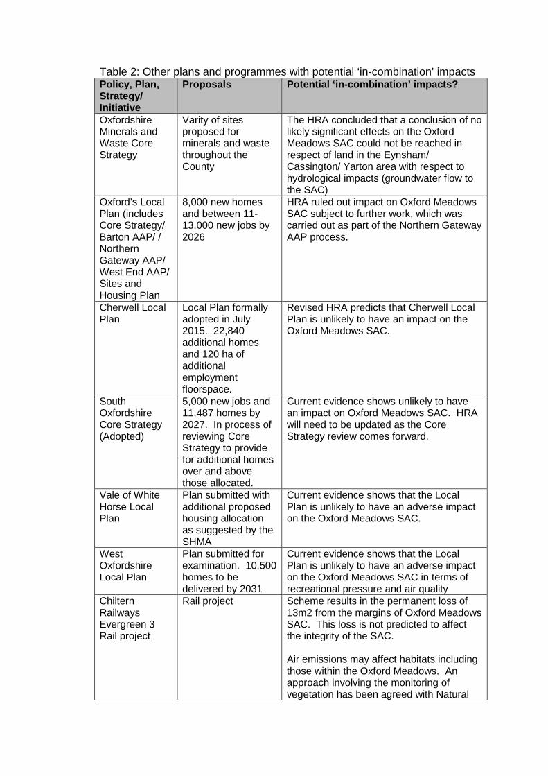
Table 2: Other plans and programmes with potential ‘in-combination’ impacts Policy, Plan, Strategy/ Initiative
Proposals Potential ‘in-combination’ impacts?
Oxfordshire Minerals and Waste Core Strategy
Varity of sites proposed for minerals and waste throughout the County
The HRA concluded that a conclusion of no likely significant effects on the Oxford Meadows SAC could not be reached in respect of land in the Eynsham/ Cassington/ Yarton area with respect to hydrological impacts (groundwater flow to the SAC)
Oxford’s Local Plan (includes Core Strategy/ Barton AAP/ / Northern Gateway AAP/ West End AAP/ Sites and Housing Plan
8,000 new homes and between 11-13,000 new jobs by 2026
HRA ruled out impact on Oxford Meadows SAC subject to further work, which was carried out as part of the Northern Gateway AAP process.
Cherwell Local Plan
Local Plan formally adopted in July 2015. 22,840 additional homes and 120 ha of additional employment floorspace.
Revised HRA predicts that Cherwell Local Plan is unlikely to have an impact on the Oxford Meadows SAC.
South Oxfordshire Core Strategy (Adopted)
5,000 new jobs and 11,487 homes by 2027. In process of reviewing Core Strategy to provide for additional homes over and above those allocated.
Current evidence shows unlikely to have an impact on Oxford Meadows SAC. HRA will need to be updated as the Core Strategy review comes forward.
Vale of White Horse Local Plan
Plan submitted with additional proposed housing allocation as suggested by the SHMA
Current evidence shows that the Local Plan is unlikely to have an adverse impact on the Oxford Meadows SAC.
West Oxfordshire Local Plan
Plan submitted for examination. 10,500 homes to be delivered by 2031
Current evidence shows that the Local Plan is unlikely to have an adverse impact on the Oxford Meadows SAC in terms of recreational pressure and air quality
Chiltern Railways Evergreen 3 Rail project
Rail project Scheme results in the permanent loss of 13m2 from the margins of Oxford Meadows SAC. This loss is not predicted to affect the integrity of the SAC. Air emissions may affect habitats including those within the Oxford Meadows. An approach involving the monitoring of vegetation has been agreed with Natural

England, to identify any habitat changes, and to ensure that timely measures can be taken, if necessary to prevent adverse effects on the integrity of the Oxford Meadows SAC. 5
Oxford Flood Risk Management Strategy
Flooding improvements across Oxford and surrounds.
Report suggests that there may be impacts on Oxford Meadows SAC from flood risk management and water resource plans. There are some uncertainties regarding operation of a flood storage area and potential impacts on Oxford Meadows SAC. To address these uncertainties, the Environment Agency is recommending further research. If this work shows that there would be significant impacts to designated nature conservation sites which could not be mitigated or compensated for, then the flood storage area will not be implemented. However there are no likely significant impacts on the SAC from current water abstraction activities. 6
Headington Neighbourhood Plan
16. The planning policies in the Headington Neighbourhood Plan have been assessed in Table 3. The table shows that there are no policies within the Neighbourhoood Plan which are likely to have an adverse impact on the Oxford Meadows SAC.
17. Table 3 shows that none of the policies within the Headington Neighbourhood Plan are likely to have an adverse impact on the Oxford Meadows SAC.
18. Categorisation of the effects of elements of the Headington Neighbourhood Plan A – Policies or proposals cannot have any negative impact B – Effects will be addressed in assessments “down the line”, including project assessment under Regulation 48 C – Could have an effect, but would not be likely to have a significant (negative) effect (alone or in combination with other plans or projects D – Likely to have a significant effect alone and would require an Appropriate Assessment E – Likely to have a significant effect in combination with other plans or projects and which require Appropriate Assessment of those combinations F – Likely to have a significant effect, alone or in combination with other plans or projects, but which would not adversely affect the integrity of a European site
5 Chiltern Railways (Bicester to Oxford Improvements) Order Environmental Statement NTS January 2010 6 Page 39 of report and confirmed in Supporting Guidance: Habitat Directive: (Appendix 21) Proforma for Stage 3 of Assessment of Adverse Effect on Site Integrity – Review of Consents (EA, 11/07/05)

G – Likely to have a significant effect, alone or in combination with other plans or projects, and for which it cannot be ascertained that they would not adversely affect the integrity of a European site

Table 3 showing the likely key environmental considerations that are likely to give rise to significant effects as a result of the policies in the Headington Neighbourhood Plan Policy Categorisation
of the effects of elements of the Headington NP
If policy has no effect, then reasons why Key environmental considerations likely to give rise to significant effects
GSP1 – Conserving and enhancing Public Access Green Space
A Policy seeking to protect and enhance green spaces within the Headington Neighbourhood Plan area.
GSP2 – Provision of Green Space within developments
A Policy setting out the amount and type of green space to be provided within developments in the Headington Neighbourhood Plan area.
GSP3 – Preserving and enhancing biodiversity
A Policy seeking to preserve and enhance biodiversity as part of development proposals within the Headington Neighbourhood Plan area.
GSP4 – Protecting Tree Cover
A Policy seeking the protection of trees within the Headington Neighbourhood Plan area
GSP5 – Protection of the Green Setting
A Policy seeking to protect the Green Setting of Headington
GSP6 – Provision of Allotment Land
A Policy seeking to protect Allotments from development and encourage the creation of new allotments within the Headington Neighbourhood Plan area.
AMP1 – Protecting and enhancing sports, leisure and community facilities
A Policy seeking the protection, enhancement and/ or suitable replacement of sports, leisure and community facilities within the Headington Neighbourhood Plan area.

Policy Categorisation of the effects of elements of the Headington NP
If policy has no effect, then reasons why Key environmental considerations likely to give rise to significant effects
CIP1 – Development to respect existing local character
A Policy seeking new developments respect and enhance local character within the HNP area
CIP2 – Protecting locally important views
A Policy seeking to minimise the visual impacts of development within the HNP area.
CIP3 – Innovative Design
A Policy seeking innovative and contemporary design as part of development proposals within the HNP area.
CIP4 – Protecting important assets
A Policy seeking to protect important assets as set out in the character appraisals and their surroundings within the HNP area.
EDP1 – New Education Provision
A Policy seeking to support new education premises for young people living or working in the HNP area.
HGP1 – Affordable Homes for Key Workers from Large Housing Sites
A Policy seeking to promote key worker housing as part of the affordable housing element of large housing schemes.
TRP1 – Parking provision at major employment sites
A Policy seeking to limit additional car parking places at major employment sites within the HNP area.
TRP2 – Parking at Multi-unit developments
A Policy seeking to support parking spaces for car-clubs as part of large residential developments within the HNP area.
TRP3 – Connectedness
A Policy seeking to ensure that developments within Headington are linked for use by sustainable transport modes namely, walking and cycling.

Policy Categorisation of the effects of elements of the Headington NP
If policy has no effect, then reasons why Key environmental considerations likely to give rise to significant effects
TRP4 – Travel Plans
A Policy seeking new business developments to produce travel plans within the HNP area.
TRP5 – Provision for people with disabilities to use active forms of transport
A Policy seeking “active transport provision” for people with disabilities within the HNP Area.
TRP6 – Promotion of cycling and walking
A Policy seeking to ensure that new development makes provision for cycle storage

Environmental Requirements for European Sites Oxford Meadows SAC
19. The citation for the Oxford Meadows SAC states that:
Oxford Meadows includes vegetation communities that are perhaps unique in reflecting the influence of long-term grazing and hay-cutting on lowland hay meadows. The site has benefited from the survival of traditional management, which has been undertaken for several centuries, and so exhibits good conservation structure and function. Port Meadow is the largest of only two known sites in the UK for creeping marshwort Apium repens. Qualifying habitats: The site is designated under article 4(4) of the Directive (92/43/EEC) as it hosts the following habitats listed in Annex I:
• Lowland hay meadows (Aloperecurus pratensis, Sanguisorba officinalis)
Qualifying species: The site is designated under article 4(4) of the Directive (92/43/EEC) as it hosts the following species listed in Annex II:
• Creeping marshwort Apium Repens
20. Natural England’s report on the condition of Oxford Meadows notes that the most recent surveys took place in 2010 and 2011. These report that the Oxford Meadows SAC is in a favourable condition.
21. The following key environmental requirements to support the integrity of the Oxford Meadows SAC were agreed at a screening workshop for the South East Plan and are as follows: 1. Minimal air pollution; 2. Absence of nutrient enrichment of waters; good water quality; 3. Balanced hydrological regime – alteration to adjacent rivers may alter
flooding regime and reduce botanical diversity; 4. Maintenance of traditional hay cut and light aftermath grazing; 5. Absence of direct fertilisation.
22. A further workshop on HRA for the Core Strategy raised the additional issue of ensuring that recreational pressures are maintained at a reasonable level.
Screening Conclusions 23. It is worth noting that the HRA for the Core Strategy screened out the two
other European sites within 20km of Oxford. These sites are Cothill Fen SAC and Little Wittenham SAC. The screening conclusions from the Core Strategy HRA have been summarised below for completeness
Cothill Fen SAC
24. It is considered that the Oxford Core Strategy could not have an adverse impact on Cothill Fen SAC. Cothill Fen is an alkaline fen dependent on a high

water table and calcareous, base rich water supply. As Cothill Fen is in the catchment of the River Ock, which is a different river catchment, the Oxford Core Strategy could not have an adverse impact on this Designated Site. Cothill Fen SAC is in a relatively remote location and can only be accessed by private car, or by local residents travelling on foot. Recreational pressure is therefore likely to be slight as a result of the proposed new development in the Oxford Core Strategy. Development within Oxford is likely to feature new green spaces which will ease recreational pressure recreational pressure on the Cothill Fen.
Little Wittenham SAC
25. Little Wittenham has been designated because it contains two ponds with large populations of great crested newts. These areas have restricted access which is designed to prevent conflicts between the visiting public, the newts and their habitat. As development in Oxford will not affect the habitat in the ponds or the newts foraging habitat around them, the Oxford Core Strategy could not have an adverse impact on this site. The site has therefore been excluded from further assessment.
Oxford Meadows SAC 26. In the case of the HRA for the Headington Neighbourhood Plan it has been
possible to screen out all of the impacts on the Oxford Meadows SAC.
• Air Pollution; • Water Quality; • Balanced Hydrological Regime; • Increased Recreational Pressure; • Maintenance of traditional hay cut and light aftermath grazing* • Absence of direct fertilisation*
* These conservation objectives have been screened out as they are related to activities directly at the site which the Headington Neighbourhood Plan will not affect
Air Pollution 27. The HRA for the Core Strategy referred to EA Interim advice note 61/05
“Guidance for Undertaking Environmental Assessment of Air Quality for Sensitive Ecosystems in Internationally Designated Nature Conservation Sites and SSSIs”, which states: “If there are no Designated Sites within 200m of an affected road, there is no need to proceed any further with [the] air quality assessment. If there is a Designated Site within 2km of a scheme but there is no significant change in emissions from roads within 200m of the site, then the scheme will not result in a significant change in air quality and the effects of change in air quality can be assumed to be negligible”
28. The closest boundary of the Headington Neighbourhood Plan area is over 2km away and as such this rules out any air quality impacts associated with the Plan on the air quality at the Oxford Meadows SAC.

29. The Headington Neighbourhood Plan does not include any additional
development that was not assessed as part of the HRA for the Core Strategy.
30. Given this, and the fact that the closest boundary to of the Headington Neighbhourhood Plan area is over 2km away, this conservation objective has been screened out of the assessment.
Balanced Hydrological Regime 31. The HRA for the Core Strategy states that “Oxford Meadows SAC straddles
the north western boundary of Oxford. Most of it is therefore upstream of the large urban areas of Oxford”. The Headington Neighbourhood Plan area lies over 2km to the east of the Oxford Meadows SAC. The HRA for the Core Strategy continues, “… a study of ‘The Hydrology of the Oxford Meadows’ states that ‘[t]he Second Terrace Gravels (Summertown Radley Terrace) on which much of Oxford is built appears to be a source of groundwater recharge (Eyles, 1986) with groundwater/ surface water flowing south and west across Port Meadow to the Seacourt Stream.”
32. The Headington Neighbourhood Plan area is situated primarily on a variety of different rock types including Beckley Sandstone and Wheatly Limestone7. The geology present under the area of the Headington Neighbourhood Plan area is not the type associated with groundwater recharge for the Oxford Meadows SAC. As such this objective has been screened out from the assessment.
Recreational Pressure 33. The Core Strategy HRA assessed the impacts of recreational pressure from
8,000 new homes on the Oxford Meadows SAC. The HRA for the Core Strategy stated that “[p]ublic consultation carried out by Scott Wilson as part of their “Oxford City Green Space Study” revealed that people are willing to walk approximately 1,900m to important green spaces such as Oxford Meadows SAC, which includes Port Meadow.” The Headington Neighbhourhood Plan area is over 2km away from the Oxford Meadows SAC, and there are other large green spaces closer, such as Bury Knowle Park, South Park and Headington Hill Park which are much close to the Headington Neighbourhood Plan area. Given this range of alternative recreational green spaces within and adjacent to the Headington Neighbourhood Plan area this conservation objective has been screened out of the assessment.
Conclusion 34. The Oxford Meadows SAC is currently judged by Natural England to be in
favourable condition. This Habitat Regulations Assessment has concluded that none of the policies within the Headington Neighbourhood Plan are likely to have adverse effects on the integrity of the Oxford Meadows SAC either ‘alone or in combination’ with other plans, projects or programmes.
7 Taken from the British Geological Survey http://www.bgs.ac.uk/discoveringGeology/geologyOfBritain/viewer.html

Appendix 4: Assessment of the likely significance of effects on the environment
1. Characteristics of the plan, having regard to: (a) The degree to which
the plan or programme sets a framework for projects and other activities, either with regard to the location, size and operating conditions or by allocating resources.
The Headington Neighbourhood Plan would, if adopted, form part of the Statutory Development Plan and as such does contribute to the framework for future development consent of projects. However, the Plan sits within the wider framework set by the National Planning Policy Framework, Oxford’s Local Plan (including the saved policies within the Adopted Local Plan 2001-2016, the Core Strategy, Sites and Housing Plan and Area Action Plans). The projects for which the Headington Neighbourhood Plan helps to set a framework are local in nature and have limited resource implications.
(b) The degree to which the plan or programme influences other plans or programmes including those in a hierarchy.
The Headington Neighbourhood Plan will be in conformity with the National Planning Policy Framework. The policies within the document will conform with the Council’s strategic policies and compliment Oxford’s Local Plan. The Headington Neighbourhood Plan is unlikely to influence other plans or programmes within the within the Statutory Development Plan.
(c) The relevance of the plan or programme for the integration of environmental considerations in particular with a view to promoting sustainable development
The Headington Neighbourhood Plan contains policies relating to environmental considerations such as biodiversity, the historic environment, housing and sustainable transport. These policies will be in conformity with national and local policies as required by the basic conditions. The Neighbourhood Plan will have to contribute to the achievement of sustainable development to be approved at examination and “made” by the City Council. Development would also be subject to the policies in Oxford’s Local Plan and therefore all environmental considerations would be covered by policy.
(d) Environmental problems relevant to the plan or programme
The Neighbourhood Plan area contains three conservation areas – Old Headington; Headington Hill and Headington Quarry. It also contains a number of Listed Buildings. The whole of the Neighbourhood Plan area is within Flood Zone 1. The Headington Neighbourood Plan area contains two complete SSSIs (geological): Rock Edge; and Magdalen Quarry. It also contains one of the SSSI units that makes up the Lye Valley SSSI. There are several local nature sites including Rock Edge Nature Reserve and Lye Valley Local Wildlife Site. Both of the SSSI units at Lye Valley are in

“unfavourable – recovering” condition according to the most recent assessment undertaken by Natural England in 2010. As Headington Neighbourhood Plan does not allocate sites it is unlikely that the policies in it will have a negative impact on any of the nature sites, in fact, the plan contains a policy on improving biodiversity so it is likely that there will be small-scale positive local impacts as a result.
(e) The relevance of the plan or programme for the implementation of Community legislation on the environment (for example plans and programmes linked to waste management or water protection.
The Headington Neighbourhood Plan is not directly relevant to any of these.
2. Characteristics of the effects and of the area likely to be affected, having regard, in particular to:
a) The probability, duration, frequency and reversibility of the effects
The Headington Neighbourhood Plan is likely to have some modest but enduring positive environmental effects, especially given its focus on green spaces, trees and biodiversity. Any negative effects of the plan are not likely to be reversible however they will all be all be of a local scale.
b) The cumulative nature of the effects
Any cumulative impacts will result from the application of policies with the Headington Neighbourhood Plan and Oxford’s Local Plan, as well projects being delivered through Oxford’s Local Transport Plan. It is likely that any cumulative effects will not be magnified in a negative manner given the positive and protective nature of the policies with Headington’s Neighbourhood Plan.
c) The transboundary nature of the effects
It is unlikely that the plan will have any transboundary impacts the plan does not allocate sites over and above those allocated through Oxford’s Local Plan. Policies within the plan relate to the Headington Neighbourhood Plan area only.
d) The risks to human health or the environment (for example, due to accidents)
There are no significant risks to human health or the environment. The plan is likely to improve human health through sustainable transport policies and its ambitions to improve the public access green space network within the Headington Neighbourhood Plan area.
e) The magnitude and spatial extent of the
The Headington Neighbourhood Plan relates to the area as shown in the map at Appendix 1. The

effects (geographical area and size of the population likely to be affected)
magnitude and spatial extent of any effects of the plan are likely to be small. As the plan does not allocate sites, it is not likely to attract additional development to the Headington area beyond that set out in Oxford’s Local Plan.
f) The value and vulnerability of the area likely to be affected due to: (i) special natural
characteristics or cultural heritage;
(ii) exceeded environmental quality standards or limit values; or
(iii) intensive land-use
The Headington Neighbourhood Plan does not allocate sites it is unlikely that any of the policies in the plan will impact in a negative manner, special natural characteristics or cultural heritage in the area; cause environmental quality standards or limit values to be exceeded or intensify land-use. The majority of the policies are protection orientated and as such are likely to of benefit to such areas.
g) The effects on areas or landscapes which have a recognised national, Community or international protection status
There are no areas or landscapes with recognised national, Community or international protection status.