seaham swamp final - office of environment and heritage
TRANSCRIPT

SEAHAM SWAMP NATURE RESERVE
PLAN OF MANAGEMENT
NSW National Parks and Wildlife Service Part of the Department of Environment and Climate Change November 2008

This plan of management was adopted by the Minister for Climate Change and the Environment on 14th November 2008. Acknowledgments This plan of management is based on a draft plan prepared by staff of Hunter Region of NPWS. Valuable information and comments were provided by • Members of the Hunter Regional Advisory Committee and • Dr Max Maddock. Inquiries about Seaham Swamp Nature Reserve should be directed to the ranger at the NPWS Hunter Coast Area Office, 12B Teramby Road, Nelson Bay or by telephone on 02 4984 8251. Cover photo by Max Maddock © Department of Environment and Climate Change (NSW) 2008: Use permitted with appropriate acknowledgment. ISBN 978 1 74232 053 3 DECC 2008/621

FOREWORD Seaham Swamp Nature Reserve is 11 hectares in size and is located approximately 40 kilometres north of Newcastle. Seaham Swamp Nature Reserve is characteristic of the freshwater swamps that were once a common feature of the Hunter Valley. It provides breeding, roosting, shelter and feeding habitats for a range of migratory and local waterbirds, including species listed as threatened and/or listed under treaties with overseas countries. The reserve includes the Edgeworth David Quarry, which was gazetted for scientific purposes in 1925. Professor Edgeworth David discovered rocks of glacial origin in the quarry whilst undertaking a survey for coal deposits in the Hunter Valley in 1884. The reserve also contains an historic slab cottage which was moved to its current location some time in the early 1900s. The wetlands and the Edgeworth David Quarry are important educational resources and used for a range of research projects by local educational institutions. Volunteer groups have been particularly valuable in assisting with waterbird surveys, weed control and bush regeneration projects in the reserve. The New South Wales National Parks and Wildlife Act 1974 requires that a plan of management be prepared for each nature reserve. A plan of management is a legal document that outlines how an area will be managed in the years ahead. A draft plan of management for Seaham Swamp Nature Reserve was placed on public exhibition from 29th December 2006 until 2nd April 2007. The submissions received were carefully considered before adopting this plan. This plan contains a number of actions to achieve “Better environmental outcomes for native vegetation, biodiversity, land, rivers, and coastal waterways” (Priority E4 in the State Plan) including rehabilitation of cleared areas to provide future roosting and nesting sites for waterbirds, liaison with other authorities to restore water quality and flow, and reduction of the distribution and spread of introduced species in the reserve. The plan also contains a number of actions to help achieve Priority E8 in the State Plan “More people using parks, sporting and recreational facilities, and participating in the arts and cultural activity”, such as preparation of a brochure for the reserve, provision of directional and interpretation signs, and development of a walking track between the nature reserve and the adjoining Seaham Park. This plan of management establishes the scheme of operations for Seaham Swamp Nature Reserve. In accordance with section 73B of the National Parks and Wildlife Act 1974, this plan of management is hereby adopted.
Carmel Tebbutt MP


TABLE OF CONTENTS
1. MANAGEMENT CONTEXT.................................................................................................1
1.1. LEGISLATIVE AND POLICY FRAMEWORK .................................................................1
1.2. MANAGEMENT PURPOSES AND PRINCIPLES.........................................................1
1.3. MANAGEMENT DIRECTIONS .........................................................................................2
2. SEAHAM SWAMP NATURE RESERVE..........................................................................4
2.1. LOCATION, GAZETTAL AND REGIONAL SETTING....................................................4
2.2. LANDSCAPE .....................................................................................................................4
2.3. NATURAL AND CULTURAL HERITAGE........................................................................5
2.3.1 Landform, Geology, Soil and Water Quality.............................................................5
2.3.2 Native Plants.................................................................................................................6
2.3.3 Native Animals .............................................................................................................7
2.3.4 Aboriginal Heritage......................................................................................................8
2.3.5 Non-Aboriginal Heritage .............................................................................................9
2.4. PUBLIC USE.....................................................................................................................10
2.4.1 Infrastructure ...............................................................................................................10
2.4.2 Education and Research ..........................................................................................11
2.5. THREATS TO RESERVE VALUES ..............................................................................11
2.5.1. Water Quality .............................................................................................................11
2.5.2. Introduced Species ...................................................................................................13
2.5.3 Fire Management.......................................................................................................13
3. MANAGEMENT ISSUES AND STRATEGIES...............................................................15
4. REFERENCES....................................................................................................................23

1
1. MANAGEMENT CONTEXT 1.1. LEGISLATIVE AND POLICY FRAMEWORK The management of nature reserves in NSW is in the context of a legislative and policy framework, primarily the National Parks and Wildlife Act 1974 (NPW Act), the NPW Regulation, the Threatened Species Conservation Act 1995 (TSC Act) and the policies of the National Parks and Wildlife Service (NPWS). Section 72AA of the NPW Act lists the matters to be considered in the preparation of a plan of management. The policies are arise from the legislative background and internationally accepted principles of park management. They relate to nature conservation, Aboriginal and historic heritage conservation, recreation, commercial use, research and communication. Other legislation, international agreements and charters may also apply to management of the area. In particular, the Environmental Planning and Assessment Act 1979 (EPA Act) may require the assessment and mitigation of the environmental impacts of works proposed in this plan. A large area of the reserve was listed in the year 2000 under the State Environmental Planning Policy 14 (SEPP 14) which controls developments at or near coastal wetlands. The Commonwealth Environment Protection and Biodiversity Conservation Act 1999 (EPBC Act) also applies in relation to actions that may impact on migratory species listed under international agreements ratified by the Australian Government. These agreements are: • The Agreement between the Government of Australia and the Government of Japan for
the Protection of Migratory Birds and Birds in Danger of Extinction and their environment (JAMBA); and
• The Agreement between the Government of Australia and the Peoples Republic of China for the Protection of Migratory Birds and their Environment (CAMBA).
A plan of management is a statutory document under the NPW Act. Once the Minister has adopted this plan, no operations may be undertaken within Seaham Swamp Nature Reserve except in accordance with the plan. The plan will also apply to any future additions to Seaham Swamp Nature Reserve. Where management strategies or works are proposed for the nature reserve or any additions that are not consistent with this plan, an amendment to the plan will be required. 1.2. MANAGEMENT PURPOSES AND PRINCIPLES Nature reserves are reserved under the NPW Act to protect and conserve areas containing outstanding, unique or representative ecosystems, species, communities or natural phenomena. Under the Act, nature reserves are managed to: • conserve biodiversity, maintain ecosystem functions, and protect geological and
geomorphological features and natural phenomena; • conserve places, objects, features and landscapes of cultural value; • promote public appreciation, enjoyment and understanding of the reserve’s natural and
cultural values; and • provide for appropriate research and monitoring.

2
1.3. MANAGEMENT DIRECTIONS The specific management directions for the reserves are: • To protect, and where necessary improve the ecological condition of Seaham Swamp
Nature Reserve so as to: − maintain and promote the population numbers and species diversity of waterfowl
and migratory species, including JAMBA and CAMBA species, threatened and regionally significant species;
− restore water quality, re-establish native aquatic plants and investigate the status and influence of drains linking the wetland with the Williams River and the need for flood gates;
− reduce the distribution and/or spread of introduced species in the reserve; and − rehabilitate cleared areas to assist in the recruitment of native vegetation for future
roost and nesting sites for bird species. • Liaise closely with Port Stephens Council and Hunter Wetlands Centre at Shortland for
a collaborative approach to management of the reserve. • Encourage education and research programs, in conjunction with local institutions and
community organisations, into the values and the management of wetlands. • Support the Hunter / Central Rivers Catchment Management Authority and its programs
to protect and enhance the catchment values of Seaham Swamp and the Williams River.

3
RESERVE MAP

4
2. SEAHAM SWAMP NATURE RESERVE 2.1. LOCATION, GAZETTAL AND REGIONAL SETTING Seaham Swamp Nature Reserve (referred to as the ‘reserve’ in this plan) is located approximately 40 kilometres north of Newcastle, and is situated west of the Williams River. The reserve is located within the township of Seaham, is 11 hectares in size and was gazetted in July 1975. It includes the Edgeworth David Quarry which was gazetted for scientific purposes in 1925. The surrounding area is residential and agricultural, primarily for dairy and beef grazing purposes, and a number of hobby farms also exist. Port Stephens Council, Forests NSW and Hunter Water Corporation lands are also in the vicinity of the reserve. The reserve is within the Port Stephens Council Local Government Area, Maitland Rural Lands Protection Board Area, the Hunter/Central Rivers Catchment Management Authority and the Worimi Local Aboriginal Land Council area. The reserve is within the country of the Worimi Nation. The reserve lies within the NPWS Hunter Coast Area of Hunter Region. Other reserves that are located in close proximity to the reserve include Wallaroo Nature Reserve, Karuah Nature Reserve, Karuah State Conservation Area and Medowie State Conservation Area. 2.2. LANDSCAPE Natural and cultural heritage and on-going use are strongly inter-related and together form the landscape of an area. Much of the Australian environment has been influenced by past Aboriginal and non-Aboriginal land use practices, and the activities of modern day Australians continue to influence bushland through recreational use, cultural practices, the presence of introduced plants and animals and in some cases air and water pollution. The geology, landform, climate and plant and animal communities of the area, plus its location, have determined how the reserve has been used by humans. The reserve protects areas of open water, a fringing paperbark (Melaleuca quinquinervia) forest, an open forest which contains spotted gum (Corymbia maculata) and narrow-leafed ironbark (Eucalyptus crebra), as well as lands which were previously cleared for grazing. The reserve is rich in food and other natural resources such as paperbark and waterfowl which may have been used by Aboriginal people. The Williams River would also have provided fish and other crustaceans as a natural resource for use. Both Aboriginal and non-Aboriginal people place cultural values on natural areas, including aesthetic, social, spiritual, recreational and other values. Cultural values may be attached to the landscape as a whole or to individual components, for example to plant and animal species used by Aboriginal people. This plan of management aims to conserve both natural and cultural values. For reasons of clarity and document usefulness natural and cultural heritage, non-human threats and on-going use are dealt with individually, but their inter-relationships are recognised.

5
2.3. NATURAL AND CULTURAL HERITAGE 2.3.1 Landform, Geology, Soil and Water Quality The reserve is mainly a freshwater wetland located on the lower Williams River floodplain in the eastern section of the Hunter Valley. The land above the wetland rises to the west of the reserve to a hill that is 60 metres above sea level. Seaham Swamp has two distinct water bodies, the northern and larger swamp (referred to as “north section”) is entirely within the reserve, the southern swamp (“south section”) is partially within the reserve and partially within Seaham Park, a reserve managed by Port Stephens Council (refer to Reserve Map). Another water body (not shown on the map) is located to the south east of the southern swamp on council land and private property. The wetland was drained some time last century and used to graze stock (Heinrich, 1997). The reserve is described as ‘Characteristic of the once common permanent freshwater swamps of the Hunter Valley and an example of a complex hydrosere’ (Gilligan 1979). A hydrosere is an ecological community that results when vegetation moves into open water and decomposes. The reserve is situated on the Hexham Land system that consists of freshwater swamps on quaternary alluvial material near sea-level with ponds being formed by subsidence of low lying areas. Dark and acidic swamp sediments lie below the swamp and the surface contains a large amount of mineral matter and peat. The Edgeworth David Quarry area of the reserve was dedicated for preservation in 1925 for scientific purposes. Professor Edgeworth David discovered the quarry whilst undertaking a survey for coal deposits in the Hunter Valley in 1884. The rocks are of glacial origin, with an estimated age of between 298 and 313 million years old (Geoscience Australia, 2004). The material of the rock is streaky in appearance, the result of the forces of moving ice overriding the sediments forming in glacial lakes (Hunter et al. 2002). Each pair of streaks in the rock represents the annual winter and summer deposits. The quarry also exposes arching layers in places, which is due to the dragging force of glacier ice or icebergs (Hunter et al. 2002). Potential acid sulphate soils occur in most of the wetland areas of the reserve (exclusive of the quarry). Numerous facets of the water quality of the wetland have been studied by Heinrich (1997). These included the effects of flooding and drying on the macro invertebrates, phytoplankton, plants and the physio-chemical aspects. Heinrich (1997) indicated that at the time of the study the wetland was ‘highly eutrophic and had a dominance of blue green algae'. Furthermore that the wetland contained a diversity of fringing vegetation, however lacked submerged or emergent aquatic plants and the macro invertebrate abundance was high, however the diversity was very low. Gilligan (1979) also studied the water level, water temperature and the dissolved oxygen of the wetland. Indications were given that the water level can exceed 200cm in depth during flood peaks, however the average water depth is between 50cm and 80cm. The surface water is presumed to be productive based on the dissolved oxygen concentrations, however, due to the lack of light and the decomposing material on the bottom of the wetland, the lower water level is presumed to be less productive.

6
Blue green algae (Microcystis sp.), which is a sign of poor water quality, has been an issue in the reserve since 1995 and was most recently recorded in February 2006 (Heinrich 1997). The cause of the blooms is believed to be due to a number of factors, including run-off from residential and agricultural areas, faecal material from cattle egrets (Ardea ibis) and other bird species using the swamp, and a lack of aquatic plants. Sediment and nutrient accumulation within the system may be an impediment to improving the health of the aquatic system. The wetland also contains two artificial drains, constructed prior to 1979, which connect it to the Williams River. The drain in the north is located in the reserve, and the other is located in Seaham Park (refer to 2.3.5 Non-Aboriginal Heritage). The status and functionality of the drains is currently unknown. 2.3.2 Native Plants The reserve contains a range of freshwater wetland habitats such as open water, mud flats, emergent and fringing Melaleuca forest, open woodlands and pasture. The dominant tree species of the larger swamp in the north of the reserve include broad-leaved paperbark (Melaleuca quinquenervia), swamp oak (Casuarina glauca), spotted gum (Corymbia maculata), narrow-leafed ironbark (Eucalyptus crebra), swamp mahogany (Eucalyptus robusta) and forest red gum (Eucalyptus tereticornis). In the late 1970s, the swamp vegetation was dominated by broad-leaved paperbarks with water couch (Paspalum distichum), smartweeds (Polygonum species) and rushes (Eleocharis sphacelata) on the shoreline, and water ribbons (Triglochin procerum and T. striatum), duckweeds (Spirodella pusilla and Lemna minor), floating azolla (Azolla filiculoides) and floating liverwort (Ricciocarpus natans) on the open water (Gilligan 1979). Today there is little aquatic vegetation present in the larger swamp of the reserve. The loss of native aquatic species in recent years can be attributed to a number of factors, including: the spraying of water hyacinth (Eichhornia crassipes) and subsequent breakdown of dead plant matter; increased nutrients from urban run-off and input from bird communities; adverse effects of toxins and increased turbidity from blue green algae (Microcystis); and increased mineral and organic nutrients promoting algal growth. The smaller swamp in the southern section of the reserve has broad-leaved paperbark and prickly-leaved paperbark (Melaleuca styphelioides) fringing the swamp. This area contains more aquatic vegetation than the northern swamp. The broad-leaved paperbark is significant in the reserve as it provides important habitat requirements for the cattle egrets and other bird species that utilise the reserve to roost and nest. The future viability of this habitat is under pressure due to senescence of the older trees, stress from roosting and nesting birds, increased nutrient levels and smothering of mature trees by weed species. The reduced levels of regeneration occurring compound these pressures. The ecosystem types found in the reserve are similar to those at Shortland Wetlands, which are subject to the same pressures. A large number of trees were planted in 1997 and 2000, by the Seaham Swamp Landcare Group, around the fringe of the swamp and below Torrence Street. These plantings were

7
undertaken to provide future habitat primarily for the cattle egret. Swamp oak (Casuarina glauca) have also been used in the past for nesting purposes and more recently nests were made in the papyrus (Cyperus papyrus). The Seaham Swamp Landcare Group established in 1996 under the Williams River Total Catchment Management Committee, has also undertaken a range of other revegetation projects in the reserve and adjacent Seaham Park. Revegetation projects have also been undertaken in conjunction with Seaham Public School and the Seaham Scouts in 2002 and 2006. Two vegetation surveys have been conducted in the reserve by Gilligan (1979) and Heinrich (1997). No threatened plant species have been recorded in the reserve. 2.3.3 Native Animals Though the reserve is relatively small, the diverse range of ecosystems provides habitat for a variety of fauna species, of which waterbirds are the most significant. A survey of bird species in the reserve in 1979 recorded 101 birds (Gilligan 1979). A number of endangered and threatened species listed on the TSC Act have been observed within the reserve. These include the endangered black-necked stork (Ephippiorhynchus asiaticus) and the vulnerable magpie goose (Anseranas semipalmata), comb-crested jacana (Irediparra gallinacea) and grey-crowned babbler (Pomatostomus temporalis temporalis). A Threatened Species Priorities Action Statement has been prepared which identifies actions and priorities for threatened species, population and ecological community within the state. The reserve provides breeding, roosting, shelter and feeding habitats for a range of migratory and local species (Gilligan, 1979; Heinrich, 1997). Table 1 lists the migratory bird species that visit the reserve which are listed under the JAMBA and CAMBA agreements (see section 1.1 Legislative and Policy Framework). Table1 Migratory Bird species recorded in the reserve that are listed under
JAMBA and/or CAMBA CAMBA JAMBA cattle egret (Ardeola ibis) cattle egret (Ardeola ibis) great egret (Egretta alba) fork tailed swift (Apus pacificus) Latham’s snipe (Gallinago hardwickii) crested tern (Sterna bergii) white bellied sea eagle (Haliaeetus leucogaster)
fork tailed swift (Apus pacificus) glossy ibis (Plegadis falcinellus) The cattle egret has become a breeding resident with birds present year round. The reserve is also used seasonally in the summer months for nesting and as a night roost during the winter migration from northern New South Wales and southern Queensland to southern New South Wales, Tasmania and Victoria (Maddock, cited in Hunter et al. 2002). The reserve is one of three known breeding sites in the Hunter for the cattle egret. The

8
other known breeding sites include Toronto Swamp and Shortland Wetlands (Maddock pers comm 2004). The reserve also provides a refuge for a number of inland bird species during drought periods. It is also important in relation to the re-introduction of the Magpie Goose in the Hunter region. The Hunter Wetlands Centre, at Shortland Wetlands, initiated the reintroduction of magpie geese into the Hunter in 1987 and the records of magpie geese at Seaham Swamp is most likely due to this. Dr Max Maddock, under Project Egret Watch, has been monitoring the cattle egret roosting and nesting population at Seaham Swamp since 1984. The nest counts have indicated a declining trend in numbers since 1999. A general decline in the diversity and abundance of waterbird species has also been noted for the area (Maddock pers comm 2005). Roosting and nesting cattle egrets are subject to various forms of disturbance, primarily from passing traffic, in particular on Torrence Street which passes under the key roost trees. The eastern grey kangaroo (Macropus giganteus) has recently been observed in the reserve, however no other marsupials or mammals have been reported. There is a population of the eastern snake-necked turtle (Chelodina longicollis) which can be seen on warm days basking within the reserve. Koalas (Phascolarctos cinereus) have been recorded in the nearby Wallaroo Nature Reserve and it is presumed that koalas would have used the reserve in the past as suitable food trees are present. 2.3.4 Aboriginal Heritage Aboriginal communities have an association and connection to the land. The land and water biodiversity values within a landscape are central to Aboriginal spirituality and contribute to Aboriginal identity. Aboriginal communities associate natural resources with the use and enjoyment of foods and medicines, caring for the land, passing on cultural knowledge and strengthening social bonds. Aboriginal heritage and nature are inseparable from each other and need to be managed in an integrated manner across the landscape. The Worimi people inhabited the area prior to and after European settlement. Kattang was the traditional language of the Worimi tribe and was spoken in the area. There is little information about the usage of the area by the Worimi people. The reserve and adjoining Williams River would have provided a large number of resources such as waterfowl and fish species. In addition, the Melaleuca trees would have provided an important source of paperbark that was used for cooking. The bark of a number of tree species may have been utilised for the making of coolamons and other wooden implements. Some of the grasses in the reserve may also have been utilised for basket weaving and possibly provided some seed for grinding to make dough. The reserve lies within the area of Worimi Local Aboriginal Land Council boundary. There are currently no Aboriginal sites recorded within the reserve. The closest recorded site is approximately 1.5 kilometres from the reserve.

9
10
2.3.5 Non-Aboriginal Heritage The first recorded non-Aboriginal person to visit Seaham was Captain Paterson as he sailed up the then Williams River. By 1823, grants of land were made in the area that is now occupied by the township of Seaham and the families of Torrence, Warren, Dixon and Scott had settled on properties. These family names are now reflected in street names in the township of Seaham. However, Seaham was not declared a village until 26 July 1838. It was subsequently named a town on the 20 March 1885 and the township and suburban boundaries were gazetted on the 15 July 1883 (Hunter et al. 2002). In September 1910 a small section of Seaham Swamp was reserved for water supply and the adjoining Seaham Park was dedicated for recreation in the same year. In the mid 1960s, during the drought period, a permissive occupancy was granted over a portion of the reserve for access, drainage and grazing purposes. Cattle, in varying numbers, grazed on the reserve for a number of years until the permissive occupancy was revoked in 1979. Prior to the granting of the permissive occupancy, the area was used as pasture during dry periods. A well was sunk in the northern section of the swamp, the exact location of which is not known, and two drains were constructed to allow for enhancement of the pasture (Gilligan 1979). Only the northern drain is in the reserve (refer to 2.3.1 Landform, Geology, Soils and Water Quality). By the end of the 1960s the wetlands were known to a number of naturalists for its waterbirds (Gilligan 1979). Local community and naturalist recognition of the conservation values of the area prompted an investigation as a nature reserve by the National Parks and Wildlife Service in the early 1970s. Edgeworth David Quarry was dedicated for preservation in 1925 for scientific purposes. Prior to 1925, international geologists attending the Pan Pacific Geology Congress visited the quarry to inspect the unique formation (Hunter et al. 2002). The proposal to protect the site was driven by recognition of the significance of the quarry’s geology, highlighted at the Congress. A dedication ceremony was conducted at the quarry in August 1925 with a number of dignitaries and eminent scientists present. Sir T W Edgeworth David (1858 – 1934), who first recognised the significance of the quarry, was a pioneering geologist, Antarctic pioneer, soldier and lecturer at Sydney University, whose achievements included the Hunter Valley coal discovery and writing the first comprehensive record of the geography of Australia. A historic cottage is located in the reserve known as Tom’s Cottage (Tom McLellans’ cottage). The slab cottage is an example of a typical rural dwelling of the colonial era. The cottage was formerly located on the Brandon Estate, the principal estate south of Seaham Village, and moved to its current location some time in the early 1900s (the exact date is unclear) (Hunter 1999, Hunter et al. 2002). It was built for Tom’s mother, Mary McLellan to retire to after 50 years employment for the Fisher family on a local farm. Mary lived in the cottage until she passed away in 1947 at the age of 85. Mary’s son, Tom, later lived in the cottage and cultivated the adjacent fields and kept a small number of cattle until about 1975. Other historic structures that were associated with the cottage include an external bathroom, chicken shed and a fence.

11
In the early 1990s the NPWS undertook a state-wide hut study which included Tom’s Cottage. The study detailed conservation works that had to be undertaken urgently to ensure that the structure was sound. Works undertaken in the 1992 included improvements to the front door, windows, chimney, internal floors, verandah and roof. Additional works were undertaken in 2006 and included the reconstruction of a collapsed gutter, installation of gutters and downpipes, treatment of external timbers and capping of the chimneys. Tom’s Cottage and the Edgeworth David quarry are identified in the Port Stephens Local Government Area Heritage Study (Hunter, 1999) and listed as sites of local significance in the Port Stephens Local Environmental Plan 2000. 2.4. PUBLIC USE 2.4.1 Infrastructure The diversity of waterbirds that frequent the reserve provides an opportunity for bird enthusiasts to observe the birds in their natural state. A bird observation tower was completed in 2001. It was initiated by representatives of the Wetlands Centre (Australia), NPWS, Port Stephens Council, Friends of Seaham Quarry and local residents and funded by a Natural Heritage Trust grant. The bird observation tower provides an excellent opportunity for viewing birds and also provides interpretative material on species that are likely to be seen in the reserve. Information on the breeding cycle of the cattle egret is also provided in the bird observation tower. The footprint of land on which the tower was built was transferred from Council to the NPWS in 2003. An interpretive sign was erected at the Edgeworth David Quarry as part of the dedication ceremony in 1925, explaining the geological significance of the site. NPWS installed a replica of the original sign in 1993. In 1994 NPWS erected an interpretive plaque, off Seaham Rd near Saint Andrews Anglican Church, outlining information on the history of Tom’s cottage. The information and sign require updating and relocation to a more strategic position, presenting an opportunity to incorporate information on the broader history and significance of the reserve. Pedestrian access in the reserve is limited to slashed management trails. The trails provide pedestrian access for bird enthusiasts and others to the wetland and Tom’s Cottage (refer to map). Other recreational pursuits that are undertaken in the reserve include photography, artwork, nature appreciation and carp fishing. There are a number of facilities that are located in close proximity to the reserve. These include picnic tables adjacent to the bird observation tower, and Seaham Park, which is managed by Port Stephens Council, contains barbecue and toilet facilities. There is community support for a trail to join the reserve to Seaham Park and the provision of a gate through the existing fence to allow pedestrian access between the parcels of land. Environmental assessment will be undertaken to determine the location for this trail. Hunter Water Board lands also provides the public with a park in close proximity to the reserve which features barbecue, toilet and playground facilities.
12
2.4.2 Education and Research Since 1985 there has been research undertaken on the cattle egrets nesting and roosting in the reserve. The research is referred to as ‘Project Egret Watch’ and is an initiative of The Wetlands Centre Australia at Shortland. Dr Max Maddock undertakes the project with the assistance of volunteers and pupils from Seaham Public School which has the cattle egret as it logo. The aim of the project is to tag the cattle egrets that are nesting within the reserve to gain a better understanding of the biology, ecology and migration of the birds. Cattle egrets are also tagged at the Hunter Wetlands Centre, at several other colonies in northern New South Wales and Queensland, and at one location in Gippsland, Victoria. Other species of egret are also tagged as one part of the project including the great egret (Ardea alba), intermediate egret (Ardea intermedia) and little egret (Egretta garzetta). The University of Newcastle uses Edgeworth David Quarry to educate students on the varveshale deposit and has also undertaken research on the vegetation of the swamp by taking core samples and evaluating the vegetation of the Holocene period (last 10,000 years). Seaham School uses the reserve as a focus in its environmental education program and also propagates locally endemic species, including broad-leaved paperbark, which have been used for the revegetation of the reserve and habitat enhancement for the egret species. The Seaham Scout Group has used the reserve to conduct activities and have also assisted in organising field days that have undertaken weed removal and the planting of native species including the broad-leaved paperbark. 2.5. THREATS TO RESERVE VALUES 2.5.1. Water Quality Water run off from urban and agricultural areas surrounding the reserve and leaching from septic systems increase nutrients and phosphorous levels of the wetlands. There are currently no storm water management devices in place to filter run-off from these lands or from nearby roads. Roosting bird populations and nesting cattle egrets further contribute to increased nutrient levels (Heinrich 1997). The wetland is highly eutrophic and periodically blue green algae, including Microcystis, is recorded, most recently in February 2006. A blue green algal bloom was previously recorded in 1997/8, resulting in eel and bird deaths (Maddock cited in Hunter et al. 2002). Water quality is likely to detrimentally impact on the aquatic vegetation and the macroinvertebrate, zooplankton and phytoplankton that are important in the ecosystem of the wetland. The eutrophic condition of the water and presence of blue green algae may prevent the germination and growth of aquatic plants (Heinrich 1997).

13
2.5.2. Introduced Species There are a number of weed species in the reserve which pose a threat to native vegetation. Water hyacinth (Eichornia crassipes) has been in the reserve since approximately 1974. This species can spread rapidly and cover areas of open water, which prevents access for waterbirds and prevents sunlight getting to other wetland vegetation. Water hyacinth may re-enter via a drain that is connected to the Williams River or storm water run-off. The seed bank in the swamp is also likely to be responsible for reinfestations. Water hyacinth is a declared noxious weed in the Port Stephens Local Government Area. Papyrus (Cyperus papyrus) has been recorded in the reserve intermittently since 1976. Papyrus is a rapidly growing species that spreads to cover areas of open water, thus preventing other aquatic species from growing and reducing sunlight exposure to deeper parts of the swamp. Papyrus has been used by cattle egrets in the past for nesting. Papyrus has been targeted for removal in pest management programs since 2002 and the remaining plants were removed in 2005. Kikuyu (Pennisetum clandestinum) is present in the north eastern and southern end of the reserve, resulting from previous clearing and grazing activities. This species is a threat to the future viability of the native vegetation as it does not allow natural regeneration to occur. The land surrounding the southern section of the reserve is also dominated by other exotic grasses, in particular kikuyu and purple top (Verbena bonariensis). Understorey species such as lantana (Lantana camera), purple top (Verbena bonariensis), blackberry (Rubus fruticosus agg.), kikuyu and morning glory (Ipomoea sp.) are also present in the reserve and decrease opportunities for endemic species to regenerate. Control programs have been instigated for a number of these species and this will need to continue. Other weed species that are present in reserve include camphor laurel (Cinnamomum camphora), fennel (Foeniculum vulgare), tobacco bush (Solanum mauritianum), spear thistle (Cirsium vulgare) and the declared weed noogoora burr (Xanthium occidentale). Mother of millions (Bryophyllum delagoense) occurs in the Edgeworth David Quarry and will require ongoing control. Removal of the species must avoid manual pulling as this technique has a potential detrimental impact to the quarry, as pieces of varveshale can also be removed. Carp (Cyprinus carpio) are identified as an emerging issue for the reserve in the Hunter Region Pest Management Strategy (NSW NPWS, 2002). Carp have been present in the reserve since approximately the early 1970s. The presence of this species is known to have significant impacts, including an increase in water turbidity due to the sediment disturbance, the destruction of aquatic vegetation (specifically species with soft stems and shallow roots), increased nutrient concentrations and changes in macro invertebrate populations (Koehn et al. 2000). It is possible that carp have undercut the banks on the edge of the swamp with their feeding habits, which may be causing erosion and damage to aquatic and riparian vegetation.

14
A significant fish kill episode occurred in February 2006, with approximately 400 to 500 European carp removed from the surface of the large swamp and banks. Possible contributing factors to the fish deaths include; suspected low dissolved oxygen levels in the water, high ambient temperature, decreased water level and the presence of blue green algae. Cats and dogs, both domestic and feral, have an impact on the waterbirds that use the reserve. The remains of waterbirds can be occasionally seen on the water edge. 2.5.3 Fire Management Fire is a natural feature of many environments and is essential to the survival of some plant communities. Inappropriate fire regimes, however, can lead to loss of particular plant and animal species and communities. Fire can also damage cultural heritage, recreation and management facilities and can threaten visitors and neighbouring land. There has been one recorded wildfire in the reserve since gazettal. The wildfire was in 1991 and burnt 4.35 hectares of the southern end of the reserve and damaged the chimney and verandah of Tom’s Cottage. There has been only one hazard reduction burn in the reserve since gazettal, on 13 August 1986. There are a number of assets that border the reserve, with the key ones being residential premises, Seaham Park facilities and the Anglican Church. Assets within the reserve include Tom’s Cottage and other associated structures and the boundary fence of the reserve. The assets outside the reserve are not considered to be at a high risk from fires on the reserve due to the wetland vegetation and the surrounding roads. The NPWS uses a zoning system for bushfire management in NPWS reserves. NPWS zones are compatible with the system adopted by the Bushfire Coordinating Committee for use in District Bushfire Management Committee (DBFMC) bushfire risk management plans. In regard to the reserve, fire management strategies are included in this plan of management. NPWS has assessed the reserve for fire management planning and has zoned the reserve as a Land Management Zone (LMZ). The primary fire management objectives within this zone is to protect natural and cultural heritage values. The reserve has been designated as a LMZ because it is not adjacent to built assets which would be exposed to a high level of bushfire risk, does not have a history of bushfire ignitions or known areas of high bushfire behaviour potential. The LMZ does not require intensive management and focuses on those actions appropriate to conserve biodiversity and cultural heritage including exclusion of fire from the reserve. Protection of the historic sites in the reserve will include the regular slashing around all of the historic structures. Requirements for most plant species can be summarised on the basis of vegetation communities and there is a threshold in fire regime variability, which marks a critical change from a high species diversity to low species diversity. The following regime guidelines have been identified for the reserve.

15
Table 2. Fire Interval Guidelines for Protection of Vegetation Communities.
Vegetation Community Minimum Interval (years)
Maximum Interval (years)
Notes
Saline wetland n/a n/a Fire should be avoided Wet sclerophyll forest 25 60 Crown fires should be
avoided at the lower end of the interval range
Swamp sclerophyll forest 7 35 Sclerophyll grassy woodland 5 40 Grassland (native and exotic) 2 10* Some intervals greater
than 7 years should be included in coastal areas.
Source: Bradstock et al (2003). * intervals given are tentative due to insufficient data. Wetland vegetation in the reserve is sensitive to fire and requires protection. The wetland is vital in providing habitat and resources to a large number of birds both seasonally and throughout the year and also acts as a drought refuge for inland waterbirds (Maddock cited in Hunter et al. 2002). The suggested fire regime for swamp sclerophyll forests and freshwater wetlands is a minimum interval of 7 years and maximum interval of 35 years. The reserve is isolated from surrounding vegetation by roads and urban clearing therefore will not be influenced by these areas. However the vegetation provides valuable habitat to the water birds that use the reserve for nesting and roosting at all times of the year therefore it would optimal to exclude fire from the reserve to prevent deleterious impacts on fauna. NPWS maintains cooperative arrangements with surrounding landowners, RFS brigades and is actively involved in the Lower Hunter Zone Bush Fire Management Committee. Cooperative arrangements include approaches to fuel management, support for neighbours fire management efforts and information sharing.
16
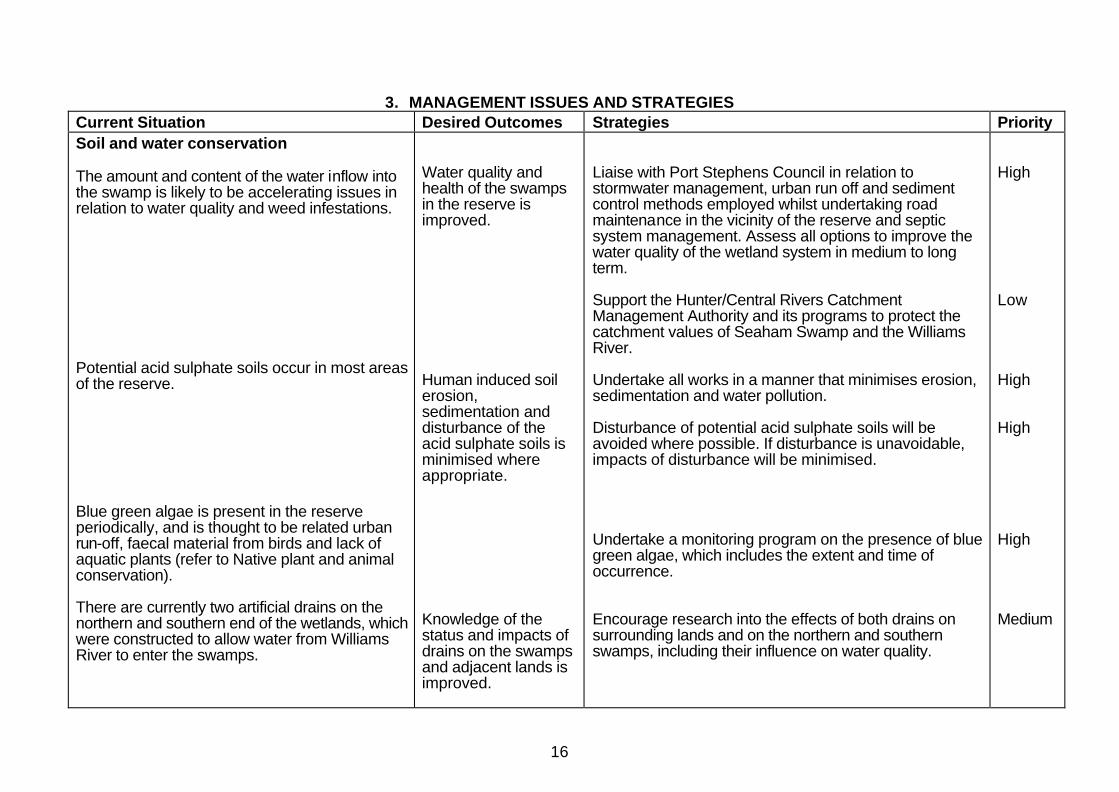
3. MANAGEMENT ISSUES AND STRATEGIES Current Situation Desired Outcomes Strategies Priority Soil and water conservation The amount and content of the water inflow into the swamp is likely to be accelerating issues in relation to water quality and weed infestations. Potential acid sulphate soils occur in most areas of the reserve. Blue green algae is present in the reserve periodically, and is thought to be related urban run-off, faecal material from birds and lack of aquatic plants (refer to Native plant and animal conservation). There are currently two artificial drains on the northern and southern end of the wetlands, which were constructed to allow water from Williams River to enter the swamps.
Water quality and health of the swamps in the reserve is improved. Human induced soil erosion, sedimentation and disturbance of the acid sulphate soils is minimised where appropriate. Knowledge of the status and impacts of drains on the swamps and adjacent lands is improved.
Liaise with Port Stephens Council in relation to stormwater management, urban run off and sediment control methods employed whilst undertaking road maintenance in the vicinity of the reserve and septic system management. Assess all options to improve the water quality of the wetland system in medium to long term. Support the Hunter/Central Rivers Catchment Management Authority and its programs to protect the catchment values of Seaham Swamp and the Williams River. Undertake all works in a manner that minimises erosion, sedimentation and water pollution. Disturbance of potential acid sulphate soils will be avoided where possible. If disturbance is unavoidable, impacts of disturbance will be minimised. Undertake a monitoring program on the presence of blue green algae, which includes the extent and time of occurrence. Encourage research into the effects of both drains on surrounding lands and on the northern and southern swamps, including their influence on water quality.
High Low High High High Medium

17
Native plant and animal conservation A number of studies have been undertaken in the reserve, which have included vegetation and bird surveys and research into wetland dynamics. The reserve, including the Edgeworth David Quarry, has been subject to clearing in the past. The native vegetation within the reserve is subject to ongoing threats, including smothering by weed species, reduced recruitment and the potential undercutting of the banks of the swamps by the introduced carp. The restoration of native vegetation on the reserve will assist in filtering, and thus improving, the water quality of stormwater run-off into the reserve. A number of threatened species have been recorded in the reserve including the black-necked stork, magpie goose, comb crested jacana and the grey crowned babbler. These species have not been sighted in the area in recent years, which may be due to the loss of habitat and disturbance both in the swamp and the surrounding lands. Seaham Swamp is important habitat for at least six migratory species of bird that are protected under the JAMBA and CAMBA agreements. Bird species that utilise the reserve, in particular
All native plant and animal species and communities are conserved. There is regeneration of native vegetation communities. The reserve provides improved habitat for waterbirds and other native species, including threatened and migratory species.
Continue to monitor wetland dynamics, fauna and flora species, vegetation communities, and changes in usage patterns by migratory bird species. Prepare and implement a revegetation plan for vegetation throughout the reserve (incorporating Seaham Park in order to foster a more coordinated and integrated management approach for the area). This plan will focus on the planting of broad-leaved paperbark (Melalueca quinquinervia) to provide habitat for the cattle egret and other species and re-establishment of native aquatic species. Implement actions set out in recovery plans, threat abatement plans or priority action statements that are developed for species identified as occurring within the reserve. Liaise with Port Stephens Council in relation to the management of Seaham Park in order to foster a more coordinated and cooperative approach to habitat management.
High High Low Medium
18
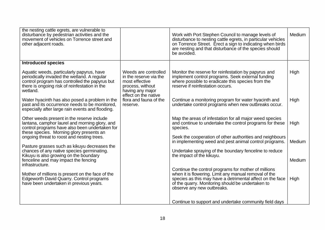
the nesting cattle egrets, are vulnerable to disturbance by pedestrian activities and the movement of vehicles on Torrence street and other adjacent roads.
Work with Port Stephen Council to manage levels of disturbance to nesting cattle egrets, in particular vehicles on Torrence Street. Erect a sign to indicating when birds are nesting and that disturbance of the species should be avoided.
Medium
Introduced species Aquatic weeds, particularly papyrus, have periodically invaded the wetland. A regular control program has controlled the papyrus but there is ongoing risk of reinfestation in the wetland. Water hyacinth has also posed a problem in the past and its occurrence needs to be monitored, especially after large rain events and flooding. Other weeds present in the reserve include lantana, camphor laurel and morning glory, and control programs have also been undertaken for these species. Morning glory presents an ongoing threat to roost and nesting trees. Pasture grasses such as kikuyu decreases the chances of any native species germinating. Kikuyu is also growing on the boundary fenceline and may impact the fencing infrastructure. Mother of millions is present on the face of the Edgeworth David Quarry. Control programs have been undertaken in previous years.
Weeds are controlled in the reserve via the most effective process, without having any major effect on the native flora and fauna of the reserve.
Monitor the reserve for reinfestation by papyrus and implement control programs. Seek external funding where possible to eradicate this species from the reserve if reinfestation occurs. Continue a monitoring program for water hyacinth and undertake control programs when new outbreaks occur. Map the areas of infestation for all major weed species and continue to undertake the control programs for these species. Seek the cooperation of other authorities and neighbours in implementing weed and pest animal control programs. Undertake spraying of the boundary fenceline to reduce the impact of the kikuyu. Continue the control programs for mother of millions when it is flowering. Limit any manual removal of the species as this may have a detrimental affect on the face of the quarry. Monitoring should be undertaken to observe any new outbreaks. Continue to support and undertake community field days
High High High Medium Medium High

19
The presence of stray cats and dogs in the reserve poses a large threat to both the waterbirds and other native fauna of the area. Carp have been recorded in the swamp since the 1970s.
Introduced animals are controlled and domestic animals do not enter the reserve.
that will encompass the planting of native species and weed control programs. Investigate initiating a Friends of Seaham or other equivalent community groups. Undertake an education program in the Seaham locality through distribution of a brochure highlighting the impact of dogs and cats on Seaham Swamp Nature Reserve. Highlight the impact of stray cats and dogs in the reserve when undertaking field days. Undertake trapping for feral cats and dogs. Prepare and implement a Carp Management Plan in consultation with NSW Department of Primary Industries.
Low Medium Medium Low High
Cultural heritage There are currently no Aboriginal sites recorded in the reserve and little information about the usage of the area by the Worimi people. However, it is likely that the reserve would have been used by Aboriginal people as the wetland and the adjoining Williams River would have provided food and other resources. An old well is reputed to be present on the reserve but its location and history are unknown. A basic assessment of Tom’s Cottage and associated structures was undertaken and
Aboriginal and historic features and values are identified and protected. Aboriginal people are involved in management of the Aboriginal cultural values in the reserve.
Consult and involve the Worimi Local Aboriginal Land Council and other relevant Aboriginal community organisations in research into and the management of any Aboriginal sites, places and values, including interpretation of places or values. Undertake literature review and field assessment to locate well, and implement appropriate safeguards if necessary.
High Low
20
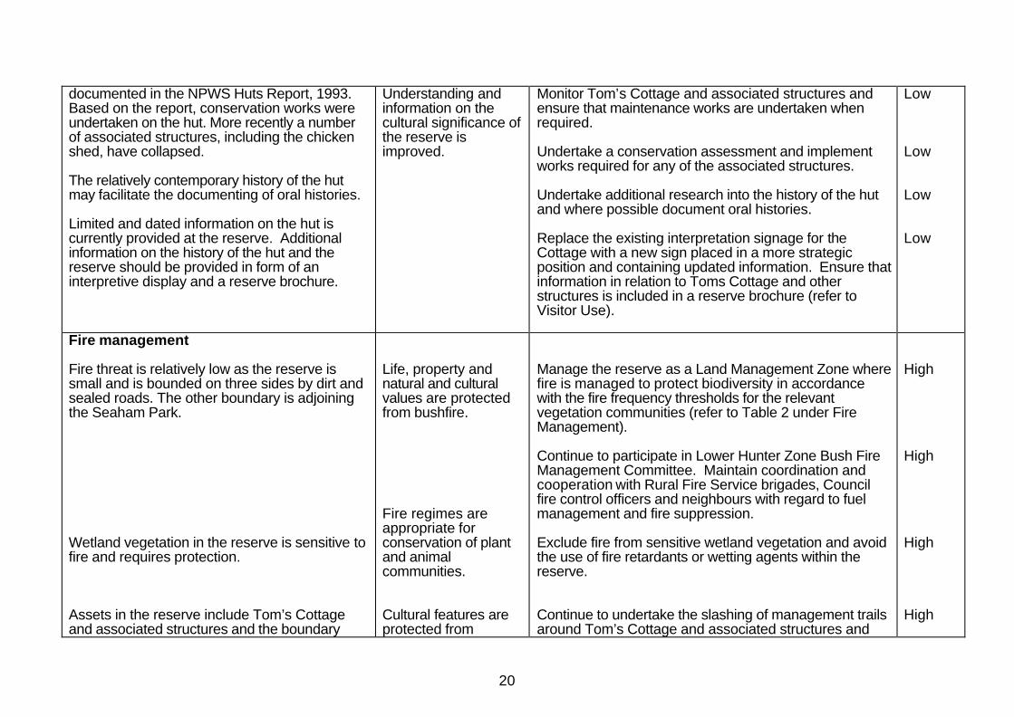
documented in the NPWS Huts Report, 1993. Based on the report, conservation works were undertaken on the hut. More recently a number of associated structures, including the chicken shed, have collapsed. The relatively contemporary history of the hut may facilitate the documenting of oral histories. Limited and dated information on the hut is currently provided at the reserve. Additional information on the history of the hut and the reserve should be provided in form of an interpretive display and a reserve brochure.
Understanding and information on the cultural significance of the reserve is improved.
Monitor Tom’s Cottage and associated structures and ensure that maintenance works are undertaken when required. Undertake a conservation assessment and implement works required for any of the associated structures. Undertake additional research into the history of the hut and where possible document oral histories. Replace the existing interpretation signage for the Cottage with a new sign placed in a more strategic position and containing updated information. Ensure that information in relation to Toms Cottage and other structures is included in a reserve brochure (refer to Visitor Use).
Low Low Low Low
Fire management Fire threat is relatively low as the reserve is small and is bounded on three sides by dirt and sealed roads. The other boundary is adjoining the Seaham Park. Wetland vegetation in the reserve is sensitive to fire and requires protection. Assets in the reserve include Tom’s Cottage and associated structures and the boundary
Life, property and natural and cultural values are protected from bushfire. Fire regimes are appropriate for conservation of plant and animal communities. Cultural features are protected from
Manage the reserve as a Land Management Zone where fire is managed to protect biodiversity in accordance with the fire frequency thresholds for the relevant vegetation communities (refer to Table 2 under Fire Management). Continue to participate in Lower Hunter Zone Bush Fire Management Committee. Maintain coordination and cooperation with Rural Fire Service brigades, Council fire control officers and neighbours with regard to fuel management and fire suppression. Exclude fire from sensitive wetland vegetation and avoid the use of fire retardants or wetting agents within the reserve. Continue to undertake the slashing of management trails around Tom’s Cottage and associated structures and
High High High High

21
fences. These areas are regularly slashed to protect from threat of wildfire.
damage by fire.
along fences.
Visitor use Use of the reserve must be carefully managed since it is a relatively small and significant area of wetland and remnant vegetation. There is currently no information brochure on reserve and its values. Promotion of community understanding and appreciation of the conservation values of the reserve will be important for minimising damaging activities and maximising visitor enjoyment. The bird observation tower currently contains information on the migration cycle of the cattle egret and other wetland species that may be seen in the reserve. Small interpretive signs are situated at the Edgeworth David Quarry and the track head to Tom’s Cottage. There is currently no trail to provide pedestrian access between Seaham Park to the reserve. There is currently no directional signage to the Edgeworth David Quarry. There is also no area
Visitor use is ecologically sustainable, in accordance with management principles. The local and wider community is aware of the values of the reserve and of management programs.
Permit low impact activities such as birdwatching, walking, cycling on management trails and carp fishing within the reserve. Install signs indicating that cycling is permitted on management trails. Permit organised group recreational or educational visits, subject to limits on numbers and other conditions if necessary to minimise impacts. Develop an information brochure that outlines the important values of the reserve and permitted activities. Distribute brochures in the local store and provide to the relevant visitor information centres. Provide additional interpretive material, on a two-sided interpretive shelter, outlining the history of Tom’s Cottage and associated structures, the Edgeworth David Quarry and information in relation to the natural heritage values of the reserve. In consultation with Port Stephens Shire Council construct a gate in the south eastern corner of the reserve and slash a trail to allow pedestrian access between the reserve and Seaham Park. In consultation with Port Stephens Council erect a directional sign to the Edgeworth David Quarry. This sign
Medium Medium Low Medium High Medium Medium

22
for parking for visitors at the quarry. This poses a safety issue to users of the reserve.
will also direct people to park at the bird observation tower, approximately 250 metres from the quarry.
Research Further research will improve understanding of the reserve’s natural and cultural heritage, the processes that affect them and the requirements for management of particular species or sites. Project Cattle Egret Watch is a research program currently being undertaken in the reserve by Dr Max Maddock and volunteers and is an initiative of the Wetlands Centre at Shortland. The wetlands and the Edgeworth David Quarry are used for educational purposes and a range of research projects by the local school and university.
Research enhances the management information base and has minimal environmental impact.
Encourage research to improve knowledge and management of natural and cultural heritage. Focus research on the following topics: • Interrelationship between the wetland and the
Williams River; • Improving water quality; and • Control and management of carp. Encourage and support Project Egret Watch in the reserve and provide assistance when resources are available. Establish relationships and encourage Seaham Public School, community groups and the University of Newcastle to continue using the reserve for educational purposes and for research that will benefit the management of the reserve.
Medium High Low
Management operations There is currently a slashed management trail on the western side of the swamp and through the centre of the reserve to Tom’s Cottage. Slashing is also undertaken in the north eastern corner of the reserve and also the section of the reserve where the Edgeworth David Quarry is situated. This slashing encourages the growth of
Management facilities adequately serve management needs and have acceptable impact.
Continue to undertake the slashing of the management trails (see reserve map). Extend the management trail to Seaham Park (location and nature of the proposed trail is to be determined). As rehabilitation works are undertaken in the north east corner of the reserve and the Edgeworth quarry, cease slashing in these areas.
High High

23
exotic grasses. Bird observation tower, interpretation signs, reserve boundary fence, park signs and access gates in the reserve require ongoing maintenance.
Reserve infrastructure is maintained and replaced as required.
Monitor and undertake maintenance work or replacement activities as required on the reserve infrastructure.
High
High priority activities are those imperatives to achievement of the objectives and desired outcomes. They must be undertaken in the near future to avoid significant deterioration in natural, cultural or management resources. Medium priority activities are those that are necessary to achieve the objectives and desired outcomes but are not urgent. Low priority activities are desirable to achieve management objectives and desired outcomes but can wait until resources become available.

24
4. REFERENCES Bradstock, R, Kenny, B and Tasker, E. (2003). Guidelines for Ecological Sustainable Management. Final Report for NSW Biodiversity Strategy. Department of Environment and Conservation, Hurstville. Geoscience Australia 2004, Stratigraphic Units Database. Gilligan, B.J. 1974, A preliminary study of the physico-chemical environment of Seaham Swamp. Unpublished Master of Arts Qualifying Thesis, University of Newcastle Gilligan, B.J. 1979, Seaham Swamp Nature Reserve: Waterbird Usage and Wetland Management. Unpublished Master of Arts Thesis, University of Newcastle Heinrich, A. 1997, Wetland Dynamics after experimental flooding: plants, invertebrates, phytoplankton and nutrients. Unpublished Honours thesis University of New England, Armidale. Hunter, C. 1999, Port Stephens Local Government Area Heritage Study, Port Stephens Shire Council, Raymond Terrace. Hunter, C., McDonald, K., Maddock., Mcleod, M. & Holroyde., D. 2002, Essays on Seaham, Seaham Public School P&C Association, Seaham. Koehn, J., Brumley, A., Gehrke, P. 2000, Managing the Impacts of Carp, Bureau of Rural Sciences (Department of Agriculture, Fisheries and Forestry – Australia), Canberra. Maddock, M., 2004, personal communication. Maddock, M., 2005, personal communication. NSW National Parks and Wildlife Service. 1993. Huts Study: Part A Service Overview. Prepared by Geoff Ashley for NPWS. NSW National Parks and Wildlife Service. 2002, Hunter Region Pest Management Strategy, NSW National Parks and Wildlife Service, Nelson Bay. NSW National Parks and Wildlife Service. 2003, Hunter Region Cultural Heritage Management Strategy, NSW National Parks and Wildlife Service, Nelson Bay.

East Seaham Rd
Torrence StSe
aham
Rd
Cross S
t
Torrence St
Midd
le Cr
esce
nt St
EdgeworthDavid Quarry
Jimmy ScottBridge
Willia
ms
R
iver
Drain
SeahamPark
Church
TASMAN SEA
Newcastle
Maitland
SeahamSwamp NR
Pacific
Hwy
Glenrock SCA
Kooragang NR
Wallaroo NR
RaymondTerrace
LOCALITY MAP
Seaham SwampNature Reserve
LegendTom's Cottage
Management Trail / Walking Track
0 20 40 60 80Metres
Public Road - Sealed
Locked Gate
Seaham Swamp Nature Reserve
Public Road - Unsealed
Viewing Platform
Swamp