second international symposium on climate and earth · pdf filesecond international symposium...
TRANSCRIPT
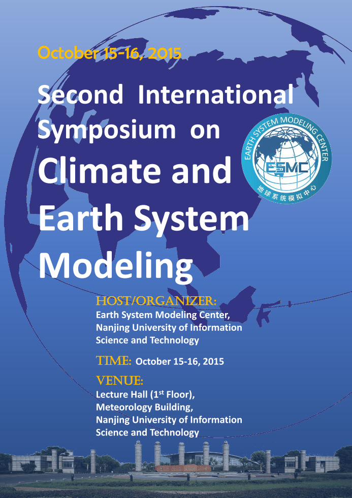
Second International Symposium on
Climate and Earth System Modeling
October 15-16, 2015
HOST/ORGANIZER:
Earth System Modeling Center, Nanjing University of Information Science and Technology
TIME: October 15-16, 2015
VENUE:
Lecture Hall (1st Floor), Meteorology Building,Nanjing University of Information Science and Technology
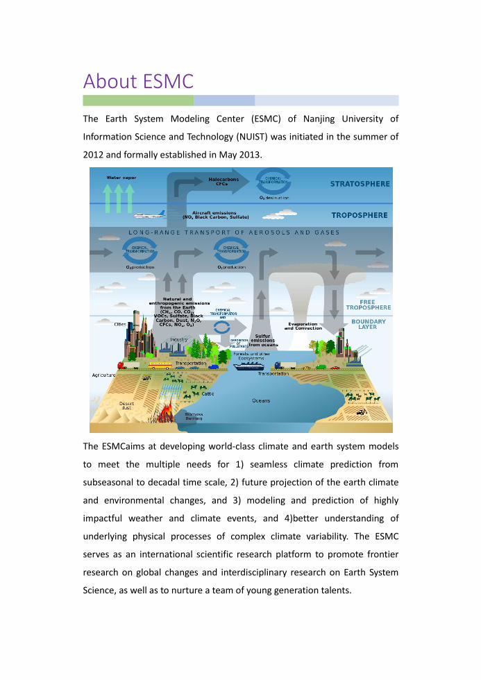
About ESMC
The Earth System Modeling Center (ESMC) of Nanjing University of
Information Science and Technology (NUIST) was initiated in the summer of
2012 and formally established in May 2013.
The ESMCaims at developing world-class climate and earth system models
to meet the multiple needs for 1) seamless climate prediction from
subseasonal to decadal time scale, 2) future projection of the earth climate
and environmental changes, and 3) modeling and prediction of highly
impactful weather and climate events, and 4)better understanding of
underlying physical processes of complex climate variability. The ESMC
serves as an international scientific research platform to promote frontier
research on global changes and interdisciplinary research on Earth System
Science, as well as to nurture a team of young generation talents.

i
Agenda
October 15, 2015(Thursday)
08:30-09:00 Opening Ceremony
09:00-09:15 Photo
09:15-12:00 Session I –1 Model Development
Chair: Xiuqun Yang/Hong Liao
09:15-09:40 AGCM with Cloud Microphysics In-Sik Kang (Seoul National University)
09:40-10:05 GFDL’s Unified Weather-Climate Model Developments Shian-Jiann Lin (GFDL/NOAA, UCAR)
10:05-10:25 Development of TaiESM Chein-Jung Shiu (RCEC, Academia Sinica, Taiwan)
10:25-10:45 Convective Parameterization in the High Resolution Modeling Era Guangjun Zhang (Tsinghua University & Scripps Institution of Oceanography)
10:45-11:05 A Brief Introduction to an ESM+CEM Model Wenjie Dong (Beijing Normal University)
11:05-11:25 Revisiting the Double ITCZ Problem in Coupled Climate Models Baoqiang Xiang (GFDL/NOAA, UCAR)
11:25-11:45 Finite-volume Atmospheric Model of the IAP/LASG (FAMIL) Qing Bao (IAP, Chinese Academy of Sciences)
11:45-12:00 FIO-ESM: the Earth System Model with Surface Gravity Waves Zhenya Song (First Institute of Oceanography, SOA)
12:10 Lunch
14:00-15:30 Special Session - ESMC Reports
Chair: Tim Li
14:00-14:20 The Progress of the NUIST Model Development Bin Wang (University of Hawaii/NUIST)
14:20-14:30 Understanding of Tropical Cyclone Climate Change over the Western North Pacific Liguang Wu (NUIST)
14:30-14:40 An Atmospheric Origin of the Multi-decadal Bipolar Seesaw Zhaomin Wang (NUIST)
14:40-14:50 Can the Tibetan Plateau Snow Cover Influence the Interannual Variations of Eurasian Heat Wave Frequency? Zhiwei Wu (NUIST)

ii
Agenda
October 15, 2015(Thursday)
14:50-15:00 Climate Variability and Future Projection Pang-chi Hsu (NUIST)
15:00-15:10 Analysis of Seasonal Ozone Budget in the Boundary Layer of the Asia-Pacific Region Xuewei Hou (NUIST)
15:10-15:20 Size-resolved Aerosol Module: Model Development and Climatic Effect Xiaoyan Ma (NUIST)
15:20-15:30 Some Advances in Paleoclimate Simulation and Analysis of NUIST Earth System Model Fei Liu (NUIST)
15:30-15:40 Coffee Break
15:40-18:10 Session II –1 Model Application
Chair: Wenjie Dong/Zhiwei Wu
15:40-16:05 Prospects for Prediction of Sub-seasonal to Seasonal Climate James L. Kinter III (George Mason University)
16:05-16:30 Preliminary Results of Global Monsoon Modeling Intercomparison Project Tianjun Zhou (IAP,Chinese Academy of Sciences)
16:30-16:50 Arctic Sea Ice Simulation and Projection: How Credible Are the State-Of-The-Art Climate Models? Xiangdong Zhang (IARC, University of Alaska Fairbanks)
16:50-17:10 Transient Response of an Atmospheric GCM to External Forcings Laurent Li (CNRS, UPMC)
17:10-17:30 Using Satellite Data to Represent Multi-scale Ocean-Atmosphere Processes for Improved Climate Modeling Ronghua Zhang (IOCAS, Chinese Academy of Sciences)
17:30-17:50 Future Projection of the Extreme Rainfall Frequency of Taiwan Mei-Yu Downscaled from the CMIP3 and CMIP5 Models Mong-Ming Lu (Centeral Weather Bureau, Taiwan)
17:50-18:10 Arctic Sea Ice in CMIP5 Climate Model Projections and Their Seasonality Variabilities Fei Huang (Ocean University of China)
18:20 Reception
iii
Agenda
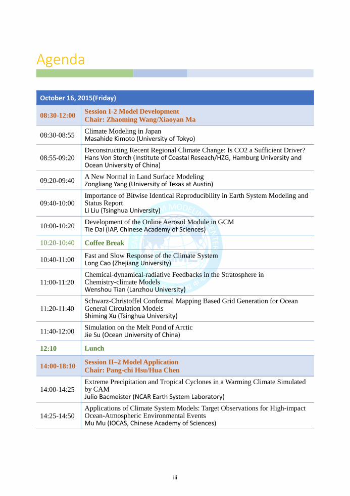
October 16, 2015(Friday)
08:30-12:00 Session I-2 Model Development
Chair: Zhaoming Wang/Xiaoyan Ma
08:30-08:55 Climate Modeling in Japan Masahide Kimoto (University of Tokyo)
08:55-09:20 Deconstructing Recent Regional Climate Change: Is CO2 a Sufficient Driver? Hans Von Storch (Institute of Coastal Reseach/HZG, Hamburg University and Ocean University of China)
09:20-09:40 A New Normal in Land Surface Modeling Zongliang Yang (University of Texas at Austin)
09:40-10:00 Importance of Bitwise Identical Reproducibility in Earth System Modeling and Status Report Li Liu (Tsinghua University)
10:00-10:20 Development of the Online Aerosol Module in GCM Tie Dai (IAP, Chinese Academy of Sciences)
10:20-10:40 Coffee Break
10:40-11:00 Fast and Slow Response of the Climate System Long Cao (Zhejiang University)
11:00-11:20 Chemical-dynamical-radiative Feedbacks in the Stratosphere in Chemistry-climate Models Wenshou Tian (Lanzhou University)
11:20-11:40 Schwarz-Christoffel Conformal Mapping Based Grid Generation for Ocean General Circulation Models Shiming Xu (Tsinghua University)
11:40-12:00 Simulation on the Melt Pond of Arctic Jie Su (Ocean University of China)
12:10 Lunch
14:00-18:10 Session II–2 Model Application
Chair: Pang-chi Hsu/Hua Chen
14:00-14:25 Extreme Precipitation and Tropical Cyclones in a Warming Climate Simulated by CAM Julio Bacmeister (NCAR Earth System Laboratory)
14:25-14:50 Applications of Climate System Models: Target Observations for High-impact Ocean-Atmospheric Environmental Events Mu Mu (IOCAS, Chinese Academy of Sciences)

iv
Agenda
October 16, 2015(Friday)
14:50-15:10 Probabilistic versus Deterministic Skill in Predicting the Western North Pacific-East Asian Summer Monsoon Variability with Multi-Model Ensembles Xiuqun Yang (Nanjing University)
15:10-15:30 What Causes the Divergent Projections of ENSO Amplitude Changes under Global Warming Tim Li (University of Hawaii)
15:30-15:50 The Most Disturbing Tendency Error of Zebiak-Cane Model Associated with El Nino Predictions and Its Implications WansuoDuan (IAP,Chinese Academy of Sciences)
15:50-16:10 Impact of Biogenic Emissions on Climate Change Feng Liu (University of Illinois at Urbana-Champaign)
16:10-16:20 Coffee Break
16:20-16:40 The Simulation of Past and Future Changes in Tropospheric Ozone and Aerosols in China Hong Liao (IAP, Chinese Academy of Sciences)
16:40-17:00 Land Surface Model Calibration at Grid-scale trough Mcrowave Data Assimilation for Improving Soil Moisture Simulations Kun Yang (ITP, Chinese Academy of Sciences)
17:00-17:20 Paleoclimate: ESM Used in Understanding Geological Questions Zhongshi Zhang (IAP, Chinese Academy of Sciences)
17:20-17:40 China’s Air Pollution: New Perspectives on Global Sources and Transport Jintai Lin (Peking University)
17:40-18:00 Unrealistic Treatment of Detrained Water Substance in FGOALS-s2 and its Influence on the Model’s Climate Sensitivity Bian He (IAP, Chinese Academy of Sciences)
18:00-18:10 Closing Remarks
18:20 Banquet
1
Abstract
AGCM with Cloud Microphysics
In-Sik Kang
School of Earth Environment Sciences, Seoul National University, Seoul, Korea
The present study demonstrates that a general circulation model (GCM) requires
a full representation of cloud microphysics to simulate the extreme precipitation
frequency close to the observation. GCMs with conventional convective
parameterizations produce common bias in precipitation frequency: they
overestimate light precipitation and underestimate heavy precipitation with
respect to observed values. This frequency shift toward light precipitation is
attributed here to a lack of consideration of cloud microphysical processes
related to heavy precipitation. The budget study of cloud microphysical
processes using a cloud-resolving model shows that the melting of graupel and
accretion of cloud water by graupel and rainwaterare important processes in the
generation of heavy precipitation. However, those processes are not expressed
explicitly in conventional GCMs with convective parameterizations. In the
present study, the cloud microphysics is modified to allow its implementation
into a GCM with a horizontal resolution of 50 km. This coarse-resolution GCM
with cloud microphysics requires an additional vertical mixing process in the
lower troposphere. The newly developed GCM, which includes explicit cloud
microphysics and additional vertical mixing, produces more heavy precipitation
and less light precipitation than conventional GCMs, thus simulating a
precipitation frequency that is closer to the observed.
2
Abstract
GFDL’s Unified Weather-climate Model Developments
Shian-Jiann Lin
Geophysical Fluid Dynamics Laboratory
The NOAA/Geophysical Fluid Dynamics Laboratory has been developing a
unified regional-global modeling system with variable resolution capabilities
that can be used for severe weather predictions (e.g., tornado outbreak events
and cat-5 hurricanes) and ultra-high-resolution (1-km) regional climate
simulations within a consistent global modeling framework. The foundation of
this flexible modeling system is the non-hydrostatic extension of the vertically
Lagrangian dynamical core (Lin 2004, Monthly Weather Review) known in the
community as FV3 (finite-volume on the cubed-sphere). Because of its
flexability and computational efficiency, the FV3 is one of the final candidates of
NOAA‘s Next Generation Global Prediction System (NGGPS). We have built
into the modeling system a stretched (single) grid capability, a two-way
(regional-global) nested grid capability, and the combination of the stretched and
two-way nests, so as to make sub 1-km resolution regional climate simulation
within a consistent global modeling system feasible using today High
Performance Computing System.
One of our main scientific goals is to enable simulations of high impact weather
phenomena (such as tornadoes, thunderstorms, category-5 hurricanes) within an
IPCC-class climate modeling system previously regarded as impossible. In this
presentation I will demonstrate that it is computationally feasible to simulate not
only super-cell thunderstorms, but also the subsequent genesis of tornadoes
using a global model that was originally designed for century long climate
simulations. As a unified weather-climate modeling system, we evaluated the
performance of the model with horizontal resolution ranging from 1 km to as
low as 200 km. In particular, for down-scaling studies, we have developed
various tests to ensure that the large-scale circulation within the global variable
resolution modeling system is well simulated while the small-scale can also be
accurately simulated with the targeted high resolution region.
3
Abstract
Development of TaiESM
Huang-Hsiung Hsu, Wei-Liang Lee, Chein-Jung Shiu*, Yi-Chi Wang, I-Chun Tsai, Min-Hui Lo,
Chao-An Chen, and Yung-Yao Lan
Research Center for Environmental Changes, Academia Sinica
* Corresponding author: [email protected]
Many efforts are devoted to building a new earth system model i.e.,Taiwan Earth
System Model (TaiESM) which is developed based on Community Earth System
Model (CESM) from NCAR. To better simulate small-scale and short-term
variability, we have implemented the deep convection, shallow convection, and
planetary boundary layer schemes from NCEP Global Forecast System Model
into CESM and TaiESM. In addition, a new cloud fraction scheme based on
triangle probability distribution function of total water is used to replace that
with assumption of critical relative humidity. Implementation of these new moist
processes is able to improve simulations in the weather-scale, such as the diurnal
cycle and intensity of extreme precipitation. A parameterization for the 3-D
topography effect on surface solar radiation is also implemented to evaluate the
shading and reflection of sunlight in mountainous areas. This effect can enhance
snowmelt in the sunward side of mountains. We have integrated an ocean mixed
layer model with a very high vertical resolution in CESM to simulate fast
changes in sea surface temperature (SST), and it can significantly improve
simulations for Madden-Julian Oscillation. Furthermore, a new three-moment
aerosol parameterization is also implemented into TaiESM to have seamless
coupling with a full two-moment bulk cloud in the near future. For land model, a
surface irrigation scheme is also implemented into TaiESM. In the presentation,
we will demonstrate some improvements corresponding to individual
implementation of physical processes as well as some promising preliminary
global model results of TaiESM both from short-term prescribed SST and fully
coupled global simulations.
4
Abstract
Convective Parameterization in the High Resolution Modeling Era
Guangjun Zhang
Center for Earth System Science, Tsinghua University
&Scripps Institution of OceanographyLa Jolla, CA 92093-0221
Convective parameterization schemes were originally developed for use in
general circulation models (GCMs) with spatial resolutions on the order of
several hundred kilometers. Later it was also used in numerical weather
prediction (NWP) models with higher resolutions. Today, GCMs typically have
spatial resolutions of about 100 km and NWP models have spatial resolutions of
20 to 50 km. Yet, the same old convective parameterization schemes are used.
Are fundamental assumptions that were used in convective parameterization
development still valid at high resolutions? As the computing power increases
dramatically in recent years, high-resolution cloud models can be run globally.
Is convective parameterization coming to an end?
In this talk, recent developments in convection simulation in GCMs will be
briefly reviewed, followed by the analysis of cloud model simulation for use in
the development of scale-aware convective parameterization schemes. In
particular, I will focus on the closure issue. Closure is an importantcomponent of
convective parameterization schemes and it determines the amount of convection
with the aid of large-scale variables. Different types of closures exist in current
convective parameterization schemes, from convective quasi-equilibrium, CAPE
removal to moisture convergence and boundary layer control. I will examine the
relationship between commonly used coarse-grained closure variables and
convection for a range of GCM horizontal resolutions. Cloud resolving model
simulations of tropical convective systems from the ARM TWP-ICE field
experiment are used to create domain averages representing different GCM
horizontal resolutions. I will show that moisture convergence and large-scale
CAPE generation (dCAPE)-based closures workwell. Other closures, such as
CAPE and PBL turbulent kinetic energy (TKE)-based closures do not capture the
variation of convection with the large-scale fields. It is found that the correlation
between moisture convergence and convective precipitation is largest when
moisture convergence leads convection. This correlation weakens as the
subdomain size decreases to 8 km or smaller. Although convective precipitation
and mass flux increase with moisture convergence or CAPE generation by GCM
grid-scale circulation at a given subdomain size, as the subdomain size increases,
the rate at which they increase becomes smaller. It suggests that moisture
convergence and dCAPE-based closures should scale down the predicted
convective precipitation as GCM resolution increases, implying that
scale-awareness should be factored into convective parameterization closures as GCM resolution increases.
5
Abstract
A Brief Introduction to an ESM (Earth System Model)
+CEM(Climate Economy Model) Model
Wenjie Dong1, 2, Jieming Chou1, 2, Shili Yang1, 2, Wenping Yuan1, 2, Zhigang Wei1, 2, Xiaodong Yan1, 2, Yan
Guo1, 2, Xian Zhu1, 2, Haiqing Huang1, 2, Juan Chen2, Xing Wei 2, Wen Shi1, 2, Zhiguo Zhang2, Song Yang2,3,
Zhiping Wen2,3, Guoling Feng 2,4, Yundi Jiang 2,4, Hui Ling2,5, Ming Chen2,5, Yuping Guan2,6, Juan Dong2,7,
Yexing Li2,7, Zhongkui Wu 2, and Deliang Chen2,8
1State Key Laboratory of Earth Surface Processes and Resource Ecology, Beijing Normal University,
Beijing 100875,China;2 Zhuhai Joint Innovative Center for Climate-Environment-Ecosystem, Future
Earth Research Institute, Beijing Normal University, Zhuhai 519087, China; 3 Department of Atmospheric
Physics, SUN YAT-SEN UNIVERSITY, Guangzhou 510275,China;4National Climate Center, China
Meteorological Administration, Beijing 100086, China;5Institute of Space and Earth Information Science,
The Chinese University of Hong Kong, HKSAR, China;6South China Sea Institute of Oceanology,
Chinese Academy of Sciences, Guangzhou510301, China; 7 Zhuhai Meteorological Bureau, Zhuhai
519000, China;8Department of Earth Sciences, University of Gothenburg, Box 460, S-405 30 Gothenburg,
Swede
Corresponding E-mail: [email protected]; [email protected]
This study first reviews the concept and methods of Orderly Human Activities
proposed by Prof. Y.E. Du-Zheng et al in 2003, and then its practice and
Feasibility in the coupled climate economy model and earth system model in
current research needs. Moreover, the advantages and limitations of the coupled
earth system model and integrated assessment models in the application of
global change research are discussed. Finally, the approach and the latest
preliminary progress in earth system model +climate economy model and
coupling system are briefly introduced. In order to build up such an earth system
+ human society system model, a joint effort from social economic science,
natural science, and other research community, even from policy makers and end
usersis required. This research could also be used to promote the development of
innovative talent and teamswith multiple disciplines. Hopefully, in the near
future, significant progress will be made in the coupling of these two models for
successful use in the research of Orderly Human Activities.

6
Abstract
Revisiting the Spurious Double ITCZ Problem in Coupled Climate
Models
Baoqiang Xiang
Geophysical Fluid Dynamics Laboratory
As a long standing issue, many coupled climate models suffers the spurious
double Inter-tropical Convergence Zone (ITCZ) (DI) problem while the
corresponding AMIP runs usually do not. This study aims to investigate the
mechanisms responsible for the formation of DI by examining 20 CMIP5 models
and a series of sensitivity experiments using a Geophysical Fluid Dynamics
Laboratory (GFDL) model. Results demonstrate that the DI is mainly originating
from the tropics (insufficient tropical meridional SST bias) while the remote
forcing from extra-tropical bias is secondary. The zonal pattern of SST bias does
not contribute to the global DI but is critical in modulating the precipitation
pattern as well as regional DI.The tight linkage between DI and the SST bias in
the region with relative high low-cloud fraction suggests that the
underrepresentation of low-cloud in atmospheric model is likely the major
source for tropical SST bias as well as the DI problem.
7
Abstract
Finite-volume Atmospheric Model of the IAP/LASG (FAMIL)
Qing Bao
Institute of Atmospheric Physics, Chinese Academy of Sciences, Beijing 100029
The Finite-volume Atmospheric Model of the IAP/LASG (FAMIL) is introduced
in this work. FAMIL has the flexible horizontal and vertical resolutions up to
25km and 1Pa respectively, which currently running on the “Tianhe 1A&2”
supercomputers. FAMIL is the atmospheric component of the third-generation
Flexible Global Ocean–Atmosphere–Land climate System model (FGOALS3)
which will participate in the Coupled Model Intercomparison Project Phase 6
(CMIP6). In addition to describing the dynamical core and physical
parameterizations of FAMIL, this talk describes the simulated characteristics of
energy and water balances, precipitation, Asian Summer Monsoon and
stratospheric circulation, and compares them with observational/reanalysis data.
Finally, the model biases as well as possible solutions are discussed.

8
Abstract
FIO-ESM: the Earth System Model with Surface Gravity Waves
Zhenya Song1,2, Fangli Qiao1,2, and Ying Bao1,2
1 First Institute of Oceanography, SOA, Qingdao 266061, China
2 Laboratory for Regional Oceanography and Numerical Modeling, Qingdao National Laboratory for
Marine Science and Technology, Qingdao, 266237, China
The critical role of oceanic surface waves in climate system is receiving more
and more attention. We set up an Earth System Model (ESM) in 2013, which is
the first climate model with surface gravity waves and named as the First
Institute of Oceanography-Earth System Model (FIO-ESM), composed of a
coupled physical climate model and a coupled carbon cycle model. In the
coupled physical climate model, a surface wave model is introduced through
coupler by including the non-breaking wave-induced vertical mixing into the
ocean circulation model. Surface waves can improve the performance of climate
model especially in the simulation of upper ocean mixed layer depth in the
southern ocean, and in the reduction of tropical biases. The FIO-ESM version
1.0 was employed to conduct Coupled Model Intercomparison Project Phase 5
(CMIP5) experiments. Now, the new version of FIO-ESM (FIO-ESM version 2)
is under development. Its framework is similar to FIO-ESM version 1, but the
model components, physical processes and resolution will be much improved. It
will be employed to take part in CMIP6.
9
Abstract
Prospects for Prediction of Sub-seasonal to Seasonal Climate
James L. Kinter III
Center for Ocean-Land-Atmosphere Studies, George Mason University, Fairfax, Virginia, USA
Substantial progress has been made over the past several decades in numerical weather prediction (NWP), due to advances in atmospheric observing systems, atmospheric models, high-end computing, and data assimilation methods. Climate simulations have likewise benefited from advances in computing and Earth system observations (such as moored buoys and drifting profiling floats in the global ocean), as well as increasingly realistic representations of the interactions between the atmosphere, ocean and land surface in coupled climate models. Advances in climate prediction have also been driven by our improving understanding of the sources of seasonal to annual predictability, including El Niño and the Southern Oscillation (ENSO), soil moisture anomalies in transition regions and seasons, and the secular temperature trend associated with global climate change. The net result has been that model-based prediction systems can now provide credible predictions of the global climate up to one year in advance.
Between the time scales of NWP and seasonal climate predictions, there is a gap at the subseasonal to seasonal (S2S) time scale. This gap has been identified as a high priority for both the research and operational prediction communities. Hoskins (2013) has noted that there is predictive potential at all time scales, including S2S, because of processes such as (i) persistent blocking states, (ii) interactions between the tropics and extratropics expressed, for example, in the dispersion of Rossby waves in response to tropical tropospheric heating, (iii) persistent ocean anomalies in both the tropics and extratropics, and (iv) persistent soil moisture anomalies that alter surface fluxes and atmospheric boundary layer stability. Considerable research on the Madden-Julian Oscillation (MJO) has demonstrated S2S predictability beyond NWP time scales. There is also evidence that predictive information can be obtained from the state of the North Atlantic Oscillation (NAO), and the influence of the stratosphere.
There are very few operational forecast products at this time scale, and the problem of subseasonal prediction in particular has only recently garnered attention. The demand for S2S predictions arises from a diverse set of information requirements in agriculture, transportation, energy resource management, and other sectors. The presentation will summarize recent advances in prediction of sub-seasonal to seasonal climate variations and indicate areas for research that are needed to reach a state of maturity for forecasting at these time scales.
10
Abstract
Overview of Global Monsoons Modeling Inter-comparison Project
(GMMIP)
Tianjun Zhou
Institute of Atmospheric Physics, Chinese Academy of Sciences, China ([email protected])
Monsoons occur in various regions around the world. Prediction of the monsoon
rainfall change in the coming decades is of deep societal concern and vital for
infrastructural planning, water resource management, and sustainable economic
development. Climate models are useful tools in climate variability and climate
change studies. However, the performance of the current state-of-the-art climate
models is very poor and needs to be greatly improved over the monsoon domains.
The Global Monsoons Modelling Inter-comparison Project (hereafter GMMIP)
aims to improve our understanding of physical processes in global monsoon
systems and to better simulate the mean state, interannual variability and
long-term change of global monsoons by performing multi-model
inter-comparisons. The contributions of internal variability (IPO-Interdecadal
Pacific Oscillation, AMO-Atlantic Multidecadal Oscillation) and external
anthropogenic forcing to the historical evolution of global monsoons in the 20th
and 21st century will be addressed. This talk will present an overview of GMMIP
project and show some preliminary results of GMMIP Tier-1 and Tier-2
Experiments.
11
Abstract
Arctic Sea Ice Simulation and Projection:
How Credible Are the State-Of-The-Art Climate Models?
Xiangdong Zhang
International Arctic Research Center and Department of Atmospheric Sciences, University of Alaska
Fairbanks, Fairbanks, AK 99775, USA
Rapid changes have occurred in the Arctic climate system, representatively
evidenced by the decade-long acceleration of sea ice reduction and the extreme
sea ice loss in the summers of 2007 and 2012. However, the phase 3 and 5 of
Coupled Model Intercomparison Project (CMIP3 and CMIP5) climate models
continually exhibit substantially large uncertainties in simulating and projecting
Arctic climate change and variability. To better understand the uncertainties and
enhance credibility of climate change projections, we evaluate performance of
sea ice simulations in these models against observations, and identify sources of
model discrepancies and uncertainties. To this end, we introduced and employed
a transient climate sensitivity analysis approach. The result suggests that the
model uncertainties result from the large range of sensitivities involved in the
simulation of sea ice mass balance. Perturbations in model initialization can also
cause different feedback strength in the ensemble runs. Finally, the results
demonstrate that the transient climate sensitivity approach can help constrain
diversity of model results, and obviously reduce spread of Arctic sea ice and
surface air temperature predictions and projections from decadal to century time
scales.
12
Abstract
Transient Response of an Atmospheric GCM to External Forcings
Zhaoxin Laurent Li ([email protected])
Laboratoire de meteorology dynamique (LMD),
IPSL/CNRS, University Pierre and Marie Curie,
Paris, France
Atmospheric responses to an external forcing may manifest at different time
scales, from an almost immediate response to a delay of a few tens of days. The
immediate response is generally direct and linear, but the delayed response is
often indirect and resulted from complex non-linear processes in the atmosphere.
An experimental protocol is proposed to assess these different responses within
an atmospheric general circulation model. It consists of running the model in a
transient manner and examining the temporal evolution of the response.
However due to the chaotic behavior of the atmospheric flow, the noise quickly
surpasses the signal. It thus needs an ensemble approach. Two examples will be
shown to study how atmospheric circulation evolves with time as responses to
SST anomalies in the north Atlantic and the Mediterranean Sea, respectively.
Both sectors experience typical mid-latitude transient circulations. In both cases,
a baroclinic response is quickly formed over the anomalous-SST area. A few
days later, equivalent barotropic structures can be observed all through the globe.
These results are helpful to understand physical mechanisms of atmospheric
teleconnections and the multi-scale characteristics of ocean-atmosphere
interaction. The experimental protocol can also be applied to tropical SST
anomalies and perturbations in land surface properties.
13
Abstract
Using Satellite Data to Represent Ocean Biology-induced Negative
Feedbackon ENSO in a Hybrid Coupled Model of the Tropical
Pacific
Rong-Hua Zhang
Key Laboratory of Ocean Circulation and Waves, Institute of Oceanology,
Chinese Academy of Sciences, Qingdao, 266071
Biological conditions in the tropical Pacific Ocean (e.g., phytoplankton biomass)
are strongly regulated by physical changes associated with the El Niño-Southern
Oscillation (ENSO). The existence and variation of phytoplankton biomass, in turn,
act to modulate the vertical penetration of the incoming sunlight in the upper ocean,
presenting an ocean biology-induced heating (OBH) effect on the climate system.
Previously, a penetration depth of solar radiation in the upper ocean (Hp) is defined
to describe the related bio-climate connections. Parameterized in terms of its
relationship with the sea surface temperature (SST) in the tropical Pacific, an
empirical model for interannualHp variability has been derived from remotely
sensed ocean color data, which is incorporated into a hybrid coupled model (HCM)
to represent OBH effects. In this work, various HCM experiments are performed to
demonstrate the bio-feedback onto ENSO, including a climatological Hp run (in
which Hp is prescribed as seasonally varying only), interannualHp runs (with
different intensities of interannually varying OBH effects), and a run in which the
sign of the OBH effect is artificially reversed. Significant modulating impacts on
interannual variability are found in the HCM, characterized by a negative feedback
between ocean biology and the climate system in the tropical Pacific: the stronger
the OBH feedback, the weaker the interannual variability. Processes involved in
the feedback are analyzed; it is illustrated that the SST is modulated indirectly by
ocean dynamical processes induced by OBH. The significance and implication of
the OBH effects are discussed for their roles in ENSO variability and model biases
in the tropical Pacific.
14
Abstract
Future Projection of the Extreme Rainfall Frequency of Taiwan
Mei-Yu Downscaled from the CMIP3 and CMIP5 Models
Mong-Ming Lu* and Yin-Ming Cho
Central Weather Bureau, Taipei, Taiwan
*Email: [email protected]
The large-scale circulation condition favorable to the extreme Taiwan Mei-yu
rainfall event was identified using 64 years of daily precipitation data at 10
meteorological stations and the 850-hPa winds of the NCEP/NCAR reanalysis
data set during the period of 1951-2014. An extreme event is identified when
the daily rainfall total is larger than a threshold value determined on the station
basis. The result shows that the circulation pattern of a cyclonic flow over
southern part of China and Taiwan and an anticyclonic flow over the South
China Sea and the Philippine Sea, that induces strong westerly winds at the
area with strong vorticity gradient, is favorable to the occurrence of the
extreme event. A southwesterly flow index (SWFI) was defined to describe the
circulation and strong southwesterly wind condition. The SWFI can capture
the above and below normal variations with above 60% hit rate for the
prediction period. The SWFI is proved as a useful downscaling approach by
applying it to six CMIP3 and ten CMIP5 models to project how Taiwan
extreme Mei-yu rainfall frequency changes under different global warming
scenarios. The same downscaling approach can also be used in the S2S
prediction of the frequency of extreme rainfall events in Taiwan Mei-yu
season.

15
Abstract
Arctic Sea Ice in CMIP5 Climate Model Projections and Their
Seasonality Variabilities
FeiHuang, HongWangand Xiao Zhou
Physical Oceanography Laboratory and Key Laboratory of Ocean-Atmospheric Interaction and Climate in
Universities of Shandong, Ocean University of China, Qingdao 266100, China
This paper focus on the seasonality change of Arctic sea ice extent (SIE) from
1979 to 2100 using newly available simulations from the Coupled Model
Intercomparison Project Phase 5(CMIP5). A new approach to compare the
simulation metric of Arctic SIE between observation and 31 CMIP5 models was
established. The approach is based onfour factors including the climatological
average, linear trend of SIE, span of melting season and annual range of SIE. It
is more objective and can be popularized to other comparison of models. Six
best models (GFDL-CM3, CESM1-BGC, MPI-ESM-LR, ACCESS-1.0,
HadGEM2-CC and HadGEM2-AO in turn)were found which meet the criterion
closely based on above approach. Based on ensamble mean of the six models,
we found that the Arctic sea ice will continue declining in each season and firstly
drop below 1 million km2 (defined as the ice-free state) on September in 2065
under RCP4.5 scenario and on September in 2053 under RCP8.5 scenario.We
also focused on the annual cycle of the Arctic SIE and found out the duration of
Arctic summer (melting season) will increase by about 100 days under RCP4.5
scenario and about 200 days under RCP8.5 scenario relative to current
circumstance by the end of the 21st century. Annual range of SIE (seasonal
melting ice extent) will increase almost linearly in the near future 30-40 years
before the Arctic appears ice-free ocean, indicating the more ice melting in
summer, the more ice freezing in winter, which may cause more extreme weather
events in both winter and summer in the future years. The Arctic sea ice spatial
patterns of annual and semi-annual cycle modes from history to future under
different scenarios were also compared.
Keywords:Arctic; Arctic sea ice; CMIP5; seasonality; annual cycle

16
Abstract
Climate Modeling in Japan
Masahide Kimoto
Atmosphere and Ocean Research Institute,
The University of Tokyo
An overview of recent activities on climate modeling in Japan will be given
together with some science results with models such as a coupled
atmosphere-ocean model, MIROC, its earth system model version,
MIROC-ESM, and a global cloud-system resolving model, NICAM. Following
topics will be covered: multi-year prediction by MIROC, carbon cycle modeling
with MIROC-ESM, and tropical intraseasonal predictability by NICAM. An
initial attempt at a 150-yr coupled reanalysis using MIROC and a coupled
ensemble Kalman filter data assimilation will also be introduced.
17
Abstract
Deconstructing Recent Regional Climate Change: Is CO2 a
Sufficient Driver?
Hans von Storch
Institute of Coastal Reseach/HZG, Hamburg University and Ocean University of China
Regional and global climate conditions undergo permanent variations; in the past
this was due to the ubiquitous natural variability of the high-dimensional,
multiply chaotic weather system; additionally slow natural factors had an imprint.
To this complex mix of drivers causing the climate system to exhibit variations
of the weather statistics (i.e., its climate), humans are now adding factors
which act on time scales of decades – namely foremost greenhouse gas
emissions, but also contributions to more, or less, aerosol loads and changing
surface conditions. For responding properly to these changing conditions it is
useful if one would know if ongoing changes will prevail for a long time and
will possibly even become stronger, or if they will persist for a limited time
(such as an ENSO event or the impact of volcanoes). For sorting this out, a
methodology has been developed, named “detection and attribution”, which
allows to first identify changes beyond the range of natural variations, and then
determine which mix of causes is most plausible in dynamically explain the
changes. Here, simulations with climate models play a key role, namely in
estimating the level of natural variations, and in suggesting the space/time
patterns, which are supposedly characteristic for which driver.
In the past the methodology has been mostly used on the global and on
continental scales. We have now used the methodology for examining ongoing
climate change in sub-continental parts of Europe (Baltic Sea Basin and
Mediterranean Region). We found changes beyond the range of natural
variations, so that external drivers are needed for explanation. While greenhouse
gases turned out to provide plausible explanations in some seasons, in others
they were insufficient, and additional other drivers are needed. Such drivers
could be the reduction of aerosols in the regional atmosphere.

18
Abstract
The New Normal in Land Surface Modeling
Dr. Zong-Liang Yang ([email protected]),Professor and Jackson Chair
Director, Center for Integrated Earth System Science, Jackson School of Geosciences
University of Texas at Austin, Austin, Texas USA 78712-0254
The rapid development of land surface models (LSMs) over the past three
decades has reached a point that these LSMs can adequately represent the
surface energy, water, and carbon balances spanning a wide range of space and
time scales, as judged by comparison with a wealth of surface and remote
sensing datasets. LSMs have been used in various weather forecasting and
climate change studies, such as assessing the coupling strength between the land
surface and the atmosphere, understanding climate and carbon interaction and
feedbacks, and quantifying the impacts of land use and land cover change on
climate change. Recently, LSMs are being merged with other types of models
including surface hydrology (river flows with implications for flooding and
drought, soil chemistry, nutrient transport, and freshwater inflow to coastal
zones), groundwater (aquifers, irrigation, and human withdrawals), ecology
(vegetation growth and health, crop yield, wetlands, and riverine ecosystems),
air quality (biogenic emissions, dust emissions, aerosols, urban canopy layer,
and dry/wet deposition), and urban flood early warning. New data assimilation
methods are being explored to take advantage of remote sensing products,
surface flux network measurements, and aircraft datasets to improve LSMs’
predictive skills. Multi-physics (or multi-parameterization) frameworks have
been incorporated in LSMs to allow for multi-hypothesis testing and uncertainty
quantification. Hyperresolution modeling at scales of O(100 m) is being
proposed to take advantage of the emerging petascale computational resources.
Therefore, next-generation LSMs are becoming more complex as we are facing
unprecedented challenges to understand variability and change on all time and
space scales, and to quantify the climatic impacts on energy and water resources,
agriculture, ecosystems, and environmental conditions for decision-making. As a
result, the new development of these LSMs demands much more coordinated
and integrated efforts from multi-disciplinary groups.
19
Abstract
Importance of Bitwise Identical Reproducibility in
Earth System Modeling and Status Report
L. Liu1,2, S. Peng1, C. Zhang3, R. Li3, B. Wang1,2,4, C. Sun1, Q. Liu1, L. Dong4, L. Li4, Y. Shi1, Y. He1, W.
Zhao1, and G. Yang3,1,2
1Ministry of Education Key Laboratory for Earth system modeling, Center for Earth System Science
(CESS), Tsinghua University, Beijing, China.
2Joint Center for Global Change Studies (JCGCS), Beijing, 100875
3Department of Computer Science and Technology, Tsinghua University, Beijing, China.
4State Key Laboratory of Numerical Modelling for Atmospheric Sciences and Geophysical Fluid
Dynamics (LASG), Institute of Atmospheric Physics, Chinese Academy of Sciences, Beijing, China.
Correspondence to: L. Liu ([email protected]), B. Wang ([email protected]), G. Yang
Reproducibility is a fundamental principle of scientific research. Bitwise
identical reproducibility, i.e., bitwise computational results can be reproduced,
guarantees the reproduction of exactly the same results. Here we show the
importance of bitwiseidentical reproducibility to Earth system modeling but the
importance has not yet been widely recognized. Modeled mean climate states,
variability and trends at different scales may be significantly changed or even
lead to opposing results due to a slight change in the original simulation setting
during a reproduction. Out of the large body of Earth system modeling
publications, few thoroughly describe the whole original simulation setting. As a
result, the reproduction of a particular simulation experiment by fellow scientists
heavily depends on the interaction withthe original authors, which is often
inconvenient or even impossible. We anticipate bitwise identical reproducibility
to be promoted as a worldwide standard, to guarantee the independent
reproduction of simulation results and to further improve model development
and scientific research.
20
Abstract
Development of the Online Aerosol Module in GCM
Tie Dai1, Xiaofei Wu1, Qing Bao1, Daisuke Goto2,Guangyu Shi1, Teruyuki Nakajima2
1State Key Laboratory of Numerical Modeling for Atmospheric Sciences and Geophysical Fluid
Dynamics, Institute of Atmospheric Physics, Chinese Academy of Sciences, Beijing 100029
2National Institute for Environmental Studies, Tsukuba, Japan
3Earth Observation Research Center, Japan Aerospace Exploration Agency, Tsukuba, Japan
There are still large uncertainties to simulate the aerosol composition and its
associated optical properties with aerosol module coupled with GCM. The
aerosol optical properties simulated by a flexible high resolution global to
regional climate model (NICAM-Chem) are evaluated using the space-based and
ground-based observations. For each aerosol species, the mean AOT is within
the range of the AeroCom models. For the 3-year mean AODs and AEs for all
sites show the correlations between model and AERONET of 0.753 and 0.735,
respectively, and 82.1% of the modeled AODs agree within a factor of two with
the retrieved AODs. The primary model deficiency is an underestimation of fine
mode aerosol AOD and a corresponding underestimation of AE over pollution
region. The effects of cloud on aerosol model evaluation are also considered with
the MODIS cloud observations. The differences between clear-sky and all-sky
AODs are larger over polluted regions. The aerosol processes over East Asia
including emission, transport, and deposition are compared between multiple
aerosol models, and the general similarities and differences are found. The
similar aerosol module are coupling with the LASGGCM model, our preliminary
results indicate the natural aerosol component emissions are estimated well
including the seasonal variations. After the comparisons, the aerosol assimilation
system for the NICAM-Chem is further developed to improve the model
performances. Assimilation leads to significantly positive effect on the simulated
AOD field, improving agreement with all of the 12 AERONET sites over the
Eastern Asia based on both the correlation coefficient and the root mean square
difference (assimilation efficiency). Meanwhile, better agreement of the
Ångström Exponent (AE) field is achieved for 8 of the 12 sites due to the
assimilation of AOD only.
21
Abstract
Using the Framework of Fast Response and Slow Feedback to
Understand Climate Change
Long Cao
School of Earth Sciences, Zhejiang University, Hangzhou, China
A key issue in projection of future climate change is to understand the response
of climate system to external forcings, such as changes in greenhouse gas and
aerosol concentrations. Traditionally, climate response to a change in external
forcing is analyzed in terms of equilibrium response of the climate system or
climate evolution on different timescales ranging from years to centuries. Over
the past decade, the framework of fast response and slow feedback has emerged
as a useful paradigm for understanding climate change. Fast response refers to
rapid climate adjustment to a change in external forcing that occurs before
substantial change in global mean surface temperature, and slow feedback refers
to climate response that is associated with the change in surface temperature.
In this study I will show some examples that utilize the conceptual
response-feedback framework to understand climate change in response to
external forcings. First, the different characteristics of climate response to CO2
forcing and solar forcing are investigated using the framework of fast response
and slow feedback; Second, model-simulated climate response to solar
geoengineering is analyzed in the context of the response-feedback framework;
Third, utility and limitation of the linear response-feedback paradigm in
representing total climate change is discussed. It is shown that the
response-feedback framework provides new insight into the understanding of the
behavior the climate system.
Key words: climate change, fast response, slow feedback, climate modeling
22
Abstract
Chemical-dynamical-radiative Feedbacks in the Stratosphere
in Chemistry-climate Models
Wenshou Tian
College of Atmospheric Sciences, Lanzhou University, China
Developing chemistry-climate models to understand
chemical-dynamical-radiative feedbacks in the atmosphere is a hot topic in
recent years. Some previous modeling and observational studies have showed
that the chemical-dynamical-radiative feedbacks in the atmosphere play an
important role in climate system. Our chemistry-climate simulations reveal that
the stratospheric ozone, nitrous oxide, methane and water changes can cause
significant temperature and circulation changes both in the stratosphere and
troposphere, while the effects of those tracer gas changes on the climate are
largely modulated by CO2, SST changes and solar variations. The stratospheric
ozone, which has undergone a declining trend since 1980s and then an expected
recovery in the future, is particularly important in various
chemical-dynamical-radiative feedbacks in the atmosphere and may lead to
potential climate changes in the future. These results also imply that a better
understanding of climate changes requires fully interactive chemistry-climate
models in which the stratospheric processes, particularly, chemical processes
should be properly coupled, otherwise, the effects of human activities on the
earth's climate could be misevaluated.

23
Abstract
Schwarz-Christoffel Conformal Mapping Based Grid Generation
for Ocean General Circulation Models
Shiming Xu
Tsinghua University
We propose two new grid generation algorithms for ocean general circulation
models (OGCMs). Contrary to conventional, analytical forms based dipolar or
tripolar grids, these new methods are based on Schwarz-Christoffel conformal
mappings which map regions of user-specified irregular boundaries to regularly
shaped regions (i.e., disks, slits, etc.). The conventional grid design objectives
such as pole relocation are addressed, as well as more advanced issues, including:
(1) the enlargement of latitudinal-longitudinal portion of the grid, and (2) the
new perspectives arisen from high-resolution and multi-scale modeling. The
generated grids could potentially achieve the alignment of grid lines to coastlines,
enhanced spatial resolution in coastal regions, and easier computational load
balance. Due to that the grids are orthogonal curvilinear, they can be easily
utilized by the majority of OGCMs which assume grid orthogonality. The
proposed grid generation algorithms can also be applied to regional ocean
modeling when complex land-sea distribution is present.

24
Abstract
Simulation on the Melt Pond of Arctic
Jie Su1, Chuanyin Wang1, Hongjie Liang1, and Matti Leppäranta2
1 Ocean University of China, Qingdao, China
2 Helsinky University, Helsinky, Finish
During melt season, melt pond is significant phenomena on the sea ice surface.
The accuracy of melt pond fraction simulation is important to understand the heat
budget of the atmosphere-ice-ocean system. Melt water sources from melting
snow, ice and liquid precipitation. In CICE 5.0+ model, three melt pond
parameterization schemes have different processes on the melt pond’s generation,
melt water distribution and frozen. In numerical simulation based on CICE model,
the simulation results of ‘topo’ scheme, when use the freezing conditions as that
of ‘cesm’ scheme, have tendency of more matching MODIS retrieval results data
than the other two schemes in the aspect of the inter-annual variability of spatial
averaged melt pond fractions of Arctic, melt ponds coverage extent, the length of
maximum melt season and its amplitude of interannual variation. Snow
infiltration effect is introduced in ‘topo’ scheme in our study which leads to a
more reasonable spatial evolution of melt pond. But in the current simulation, the
melt pond coverage extent as well as the melt pond fraction snow infiltration is
too small on the multiyear ice. The loss of melt water volume is also analyzed in
our study.
25
Abstract
Extreme Precipitation and Tropical Cyclones in a Warming
Climate Simulated by CAM
Julio Bacmeister
National Center for Atmospheric Research
Projections for future tropical cyclone activity are made with the Community
Atmosphere model at 28km horizontal resolution. Future SSTs are constructed
from coupled runs using a bias correction technique based on present day
coupled model biases. Results for RCP4.5 and RCP8.5 warming scenarios are
compared. The impact of different future SSTs is also explored. We find
substantial decreases in overall N Atlantic TC activity, but increases in the
frequency of major storms in the NW Pacific. While these results are relatively
robust in terms of general character we find important sensitivities to the future
SSTs used. Changes in TC related precipitation are also examined. We find large
increases in extreme precipitation frequency for all future SSTs. Mitigation to
RCP4.5 is seen to significantly reduce the risk of extreme TC precipitation.

26
Abstract
Applications of Climate System Models: Target Observations for
High-impact Ocean-Atmospheric Environmental Events
Mu Mu1, Wansuo Duan2 and Rong Feng2
1Institute of Oceanology, Chinese Academy of Sciences, Qingdao266071 2LASG, Institute of Atmospheric Physics, Chinese Academy of Sciences, Beijing 100029
High-impact ocean-atmospheric environmental events, such as El Niño-Southern
Oscillation (ENSO), Indian Ocean Dipole (IOD), tropical cyclone (TC), and the
Kuroshio large meander (KLM), etc. are defined asthe oceanic, weather or
climate events that often induce aggressively large economic and societal loss on
regional or global scales. Sufficient observations are required to properly
determine the initial fields for skillful predictions of these events. A strategy
called “target observation” has been developed since 1990s. In this presentation,
we will review some progresses of the authors’ group in target observation of
ENSO and IOD.
First, to investigate the sensitive area for ENSO forecasting, we applied the
conditional nonlinear optimal perturbation (CNOP), by using the Zebiak-Cane
model, to determine the most sensitive patterns for El Niño forecasting.
Furthermore, it is shown that these sensitive patterns of initial errors also exist in
the initial analysis fields of the ENSO hindcasts generated by FGOALS-g and
LDEO5 models. The largest values of CNOP-type errors are found in the eastern
equatorial Pacific, indicating that the initial errors in this region make the largest
contribution to the errors at the prediction time and therefore can be considered a
sensitive area for El Niño forecasting.
Then, we present the results for IOD, by using Geophysical Fluid Dynamics
Laboratory Climate Model version 2p1 (GFDL CM2p1). It is found that the
initial errors with an east-west dipole pattern are more likely to result in a
significant winter predictability barrier (WPB) than special distributed random
initial errors; the areas where the large values of the dipole pattern initial errors
are located have great effect on the prediction uncertainties and provide useful
information for targeting. Further, the prediction uncertainties in winter are more
sensitive to the initial errors in the subsurface sensitive areas than to those in the
surface ones.

27
Abstract
What Controls the Divergent Projection ofENSO Amplitude
Change under Global Warming?
Tim Li, Lin Chen andYongqiang Yu*
University of Hawaii and NUIST
*Institute of Atmospheric Physics, Chinese Academy of Sciences
An important issue facing the climate community is how ENSO amplitude will
change under global warming. Diagnosis of 20 CMIP5 models shows that these
models projected a divergent future ENSO amplitude change under global
warming (GW). Some models projected a statistically significant increase in
ENSO amplitude, whereas others projected a statistically significant decrease.
The spread among the CMIP5 models is in a way similar to that in the CMIP3
models. Given that the same set of the CMIP5 models projected a consistent
mean state change (e.g., a greater polar warming than a tropical warming and an
El Nino like wamring in the equatorial Pacific), one may wonder why the ENSO
projection is so divergent, and what are key factors that control the ENSO
amplitude change across these CMIP5 models?
In this study we develop a step-by-step approach to address the above questions.
Given that ENSO development undergoes various positive and negative
feedback processes, the first question we address is what feedback process is
most critical for the divergent ENSO amplitude change.Our results show that the
Bjerknes thermocline and zonal advective feedbacks are the major drivers for the
divergent projection of ENSO amplitude change.
The second question is, given that both the Bjerknes and zonal advective
feedbacks involve the mean state and perturbation changes, what are their
relative roles?Our diagnosis shows that the perturbation change is critical.
Thirdly, given that the Bjerknes feedback involves the following three processes,
atmospheric wind response to SSTA forcing, ocean thermocline response to wind
forcing, and ocean subsurface temperature response to thermocline change,
which of the above processes is critical? Our diagnosis shows that the ocean
thermocline response to the wind forcing plays the most important role. Fourthly,
given the same Niño4wind stress forcing, why somemodels generate a stronger
thermocline response while others generate a weaker response? The answer is
that it is attributed to the divergent change of ENSO meridional structure, which
is further controlled by the change of climatologic subtropical cell (STC) in the
Pacific. Finally a strategy is developed to project future ENSO amplitude change
based on both the robust mean state projection and the physics-based ENSO
amplitude - mean STC relationship.
28
Abstract
The Most Disturbing Tendency Error of Zebiak-Cane Model
Associated with El Nino Predictions and its Implications
WansuoDuan and Peng Zhao
(Institute of Atmospheric Physics, Chinese Academy of Sciences, Beijing 100029, China)
The nonlinear forcing singular vector (NFSV) is used to identify the most
disturbing tendency error of the Zebiak-Cane model associated with El Nino
predictions. The results show that only one NFSV exists for each of the
predictions for the given El Niño events. These NFSVs cause the largest
prediction error for the El Nino event. It is found that the NFSVs often present
large-scale zonal dipolar structures and are dependent on the prediction periods.
The NFSVs associated with the predictions crossing through the growth phase of
El Niño tend to exhibit a zonal dipolar pattern with positive anomalies in the
equatorial central-western Pacific and negative anomalies in the equatorial
eastern Pacific (denoted as “NFSV1”). Meanwhile, those associated with the
predictions through the decaying phase of El Niño are inclined to present another
zonal dipolar pattern (denoted as “NFSV2”), which is almost opposite to the
NFSV1. Similarly, the linear forcing singular vectors (FSVs), which are
computed based on tangent linear model, can also be classified into two types
“FSV1” and “FSV2”. We find that both FSV1 and NFSV1 often cause negative
prediction errors for Niño-3 SSTA of the El Niño events, while the FSV2 and
NFSV2 usually yield positive prediction errors. However, due to the effect of
nonlinearities, the NFSVs usually have the western pole of the zonal dipolar
pattern much farther west, and covering much broader region. The nonlinearities
have a suppression effect on the growth of the prediction errors caused by the
FSVs and the particular structure of the NFSVs tends to reduce such suppression
effect of nonlinearities, finally making the NFSV-type tendency error yield much
large prediction error for Niño-3 SSTA of El Niño events. The NFSVs, compared
to the FSVs, are more applicable in describing the most disturbing tendency
error of the Zebiak–Cane model since they consider the effect of nonlinearities.
The NFSV-type tendency errors may provide information concerning the
sensitive areas where the model errors are much more likely to yield large
prediction errors for El Niño events.
29
Abstract
Land Surface Model Calibration through Microwave Data
Assimilation for Improving Soil Moisture Simulations
Kun Yang ([email protected])
Institute of Tibetan Plateau Research, Chinese Academy of Sciences
CAS Center for Excellence in Tibetan Plateau Earth Sciences
Soil moisture is a key variable in climate system, and its accurate simulation
needs effective soil parameter values. Conventional approaches may obtain soil
parameter values at point scale, but they are costly and not efficient at grid scale
(~10 km) of current climate models. This study explores the possibility to
estimate soil parameter values by assimilating microwave brightness temperature
(TB) data. In the assimilation system, the TB is simulated by the coupled system
of a land surface model (LSM) and a radiative transfer model (RTM), and the
simulation errors highly depend on parameters in both the LSM and the RTM.
Thus, sensitive soil parameters may be inversely estimated through minimizing
the TB errors. The effectiveness of the estimated parameter values is evaluated
against intensive measurements of soil parameters and soil moisture in three
grasslands of the Tibetan Plateau and the Mongolian Plateau. The results indicate
that LSM simulations with the estimated parameter values reasonably reproduce
the measured soil moisture. This demonstrates it is feasible to calibrate LSMs for
soil moisture simulations at grid scale by assimilating microwave satellite data,
although more efforts are expected to improve the robustness of the model
calibration.
30
Abstract
Paleoclimate: ESM Used in Understanding Geological Questions
Zhongshi Zhang
Department of atmospheric science, China University of Geosciences, 430074 Wuhan, China
Uni Research Climate and Bjerknes Centre for Climate Research, 5007 Bergen, Norway
Nansen-Zhu International Research Centre, IAP, Chinese Academy of Sciences, 100029 Beijing, China
Paleoclimate studies are often carried out on three different time scales,
sub-orbital, orbital and tectonic time scales. On the sub-orbital scale, climate
changes for hundreds or thousands of years are considered. On the orbital time,
climate changes for tens or hundreds of thousand years are considered. On the
tectonic time scales, climate changes for million years are considered. Therefore,
on the longer time scales, the crossing between climate science and geological
science becomes more obvious.
How modern climate comes into being? This is a basic scientific question on the
tectonic time scales. In this talk, based on the modelling with an ESM, I will use
one simple example to show how desert climate comes into being in north
Africa.
It is widely believed that the Sahara desert is no more than ~2–3 million years
(Myr) old, with geological evidence showing a remarkable aridification of north
Africa at the onset of the Quaternary ice ages. Before that time, north African
aridity was mainly controlled by the African summer monsoon (ASM), which
oscillated with Earth’s orbital precession cycles. Afterwards, the Northern
Hemisphere glaciation added an ice volume forcing on the ASM, which
additionally oscillated with glacial–interglacial cycles. These findings led to the
idea that the Sahara desert came into existence when the Northern Hemisphere
glaciated ~2–3 Myr ago. The later discovery, however, of aeolian dune deposits
~7 Myr old suggested a much older age, although this interpretation is hotly
challenged and there is no clear mechanism for aridification around this time. Here
we use climate model simulations to identify the Tortonian stage (~7–11 Myr ago)
of the Late Miocene epoch as the pivotal period for triggering north African aridity
and creating the Sahara desert. Through a set of experiments with the Norwegian
Earth System Model and the Community Atmosphere Model, we demonstrate that
the African summer monsoon was drastically weakened by the Tethys Sea
shrinkage during the Tortonian, allowing arid, desert conditions to expand across
north Africa. Not only did the Tethys shrinkage alter the mean climate of the
region, it also enhanced the sensitivity of the African monsoon to orbital forcing,
which subsequently became the major driver of Sahara extent fluctuations. These
important climatic changes probably caused the shifts in Asian and African flora
and fauna observed during the same period, with possible links to the emergence
of early hominins in north Africa.

31
Abstract
China’s Air Pollution: New Perspectives on Global Sources and
Transport
Jintai Lin
Peking University
China has become the world’s top emitter of anthropogenic aerosol and gaseous
pollution. The severity of China’s pollution not only has caused dramatic
domestic environmental problems, but has also raised concerns of long-range
pollution transport to downwind regions. China is also the world’s top trading
country, and it manufactures and exports large amounts of industrial products to
supply foreign consumption. This means significant implicit pollution transport
from foreign countries to China through international trade. China’s domestic
pollution is further complicated by inter-provincial trade that supplies both
Chinese and foreign consumption. In this study, we will analyze China’s
pollution sources and transport by combining satellite measurements, chemical
transport modeling, emission calculation, and economic analysis. We will
demonstrate that China’s pollution is connected to other countries via both
atmospheric and economic mechanisms. Solving global pollution problems
needs interdisciplinary and comprehensive thinking.

32
Abstract
Unrealistic Treatment of Detrained Water Substance in
FGOALS-s2 and its Influence on the Model’s Climate Sensitivity
Bian He
State Key Laboratory of Numerical Modeling for Atmospheric Sciences and Geophysical Fluid Dynamics,
Institute of Atmospheric Physics, Chinese Academy of Sciences, Beijing 100029
Key Laboratory of Meteorological Disaster of Ministry of Education, Nanjing University of Information
Science and Technology, Nanjing 210044
Based on a series of aqua-planet and air-sea coupled experiments, the influence
of unrealistic treatment of water substance in FGOALS-s2 on the model’s
climate sensitivityis investigated in this paper. Because the model do not adopt
an explicit microphysics scheme, the detrained water substance from the
convection scheme has been converted back to the humidity. This procedure
could lead to an additional increase of water vapor in the atmosphere which
could strengthen the model’s climate sensitivity. Further sensitive experiments
confirm this deduction. After removing the water vapor which converted from
the detrained water substance, the water vapor reduced significantly in the upper
troposphere and the high clouds also reduced. Quantitative calculations show
that the water vapor almost reduced 10% of the total water vapor and 50% at
150hPa when the detrained water substance is removed, contribute to the 30% of
the Atmospheric Surface Temperature (AST) increasing. This study calls for an
explicitmicrophysics scheme should be introduced to the model in order to
handle the detrained water vapor to improve the model’s simulation skill.
Keywords: FGOALS-s2, climate sensitivity, cloud radiation, global warming

33
Abstract
Uncertainty in Model Climate Sensitivity Traced to
Representations of Cumulus Precipitation Microphysics
Ming Zhao
Geophysical Fluid Dynamics Laboratory
Uncertainty in equilibrium climate sensitivity impedes accurate future climate
projections. While the spread across climate models is known to arise primarily
from model differences in cloud feedback, the exact processes responsible for the
spread across models remain unclear. Here we show that model estimates of
climate sensitivity are strongly affected by the manner through which cumulus
cloud condensate is converted into precipitation in a model's convection
parameterization, processes that are only crudely accounted for in GCMs. Using
a developmental version of the next generation Geophysical Fluid Dynamics
Laboratory GCM, we demonstrate that two commonly used methods for
converting cumulus condensate into precipitation (threshold versus fractional
removal and associated treatment in mixed- and ice-phased cloud precipitation)
can lead to drastically different climate sensitivity, as estimated here with an
atmosphere/land model by increasing sea surface temperatures uniformly and
examining the response in the top-of-atmosphere energy balance. The effect can
be quantified through a bulk convective detrainment efficiency, which measures
the ability of cumulus convection to generate clouds and moisten the free
troposphere per unit precipitation. Given current uncertainties in representing
convective precipitation microphysics, this study suggests that one can engineer
climate sensitivity in a GCM without impacting the quality of the simulation of
the climate appreciably. In the absence of clear observational constraints on
these processes, the implications of having this ability to engineer climate
sensitivity needs to be considered when estimating the uncertainty in climate
projections.
34
Abstract
Influence of Latent Heating over Southern Asia on Sahel Summer
Rainfall
Shan He, Song Yang, and Zhenning Li
Department of Atmospheric Sciences, Sun Yat-sen University, Guangzhou, Guangdong, China
The summer rainfall in the Sahel region shows an apparent decreasing trend since
the 1950s. This decreasing rainfall trend is related to variations of global summer
sea surface temperature (SST) including an increase of SST in the Asian
monsoon region (AMR). Analysis also indicates that the anomalous rising motion
over AMR and anomalous sinking motion over the Sahel region are associated
with the decrease in the African rainfall since the 1970s.
The U.S. NCAR Community Atmospheric Model version 4 is applied to
investigate the influence of latent heating anomaly associated with the Asian
summer monsoon on the Sahel summer rainfall. When the condensation latent
heating rate of deep convection over AMR in summer is increased to 1.1 folds,
the response of the model to the heating anomaly matches the general features of
circulation anomalies that have been observed. The model features of anomalous
rainfall in the Sahel region are also similar to those observed. Hence, it is
concluded that the teleconnection between the increase in summer SST over
AMR and the decrease in summer rainfall in the Sahel region is resulted from the
positive condensation latent heating anomaly of deep convection over AMR
under the global warming background.
35
Abstract
Scheme Development of Convection and Cloud Processes of
TaiESM
Yi-Chi Wang*, Chein-Jung Shiu, Hua-Lu Pan, Jen-Ping Chen and Huang-Hsiung Hsu
Research Center for Environmental Changes, Academia Sinica, Taipei, Taiwan
*Correspondence to: [email protected]
As convection and cloud processes continue to be major challenges for earth
system models, our group in the Research Center for Environmental Changes,
Academia Sinica, has especially devoted to the development of the model
physics of convection and clouds for the Taiwan Earth System Model (TaiESM).
The major developments of convection and cloud processes of TaiESM include
(1) improvement of convective triggering of the deep convection scheme, (2)
development of PDF-consistent macrophysics scheme, and (3) implementation
of a full two-moment microphysics scheme.
Currently, the first two developments will be included in the first version of
TaiESM, while the development of microphysics scheme would be included in
the later version of TaiESM. The cloud microphysical scheme used is based on
CLR (Chen and Liu, 2004; Cheng et al., 2007, 2010). This scheme is capable of
simulating aerosol-cloud interactions through detailed coupling between cloud
and aerosol microphysical processes. This work describes the developments of
convection and cloud processes of TaiESM and their impacts on climate
simulations in contrast to the Community Earth System Model developed by
NCAR, which is the base model of TaiESM.
Simulations driven by climatological sea surface temperature with TaiESM show
the observed diurnal to synoptic scales of rainfall variability are better
reproduced over the coastal and land regions due to improved convective
triggering. In the meantime, with the modified cloud scheme, the
TaiESM-simulated cloud fields show better consistency with humidity, and
associated biases of shortwave and longwave cloud radiative forcing are reduced
in the tropics.

36
Abstract
Changes and Influences of Latent Heating Released by Deep
Convection over the South China Sea and the Philippine Sea
during Boreal Spring under the Background of Global Warming
Zhenning Li and Song Yang
Department of Atmospheric Sciences, Sun Yat-sen University, Guangzhou, Guangdong, China
Long-term trends of several climate variables during boreal spring in the last 3
decades are investigated. For precipitation, both Climate Prediction Center (CPC)
Merged Analysis of Precipitation (CMAP) and Global Precipitation Climatology
Project (GPCP) datasets show significant increasing trends over the South China
Sea (SCS) and the Philippine Sea (PS, 0⁰-15⁰N, 110⁰E-155⁰E) during boreal
spring. In the NCEP Climate Forecast System Reanalysis (CFSR) datasets, the
significant increasing trend of latent heating released from deep convections is
also found over this region. The latent heating has intensified in the whole
column of the atmosphere, especially among 600-300hPa level. The maximum
heating level has been lifted about 50hPa/30yr in the last 30 years during spring.
Meanwhile, significant decreasing trend of spring-time rainfall is found over
southern China.
In order to figure out the influences of latent heating changes over the SCS and
the PS, and to capture the possible linkage between the spring-time rainfall over
this region and southern China, a series of fully-coupled earth system model
experiments are conducted using the NCAR Community Earth System Model
(CESM). Results indicate that the spring-time latent heating over the SCS and
the PS have a strong link to the rainfall over southern China. Specifically, the
climate system response over southern China to the latent heating changes over
the SCS and the PS is very similar with the observed long-term trend,
corresponding to significantly less precipitation in southern China and much
more precipitation over the SCS and the PS. The increased latent heating causes
an anomalous cyclone over the SCS and the PS, resulting in in-situ convergence
and intensified deep convection. Northwestern part of the anomalous cyclone
weakens the seasonal mean southwesterly over southern China, which causes
less moisture transported to southern China and suppresses the spring-time
rainfall.

Convenience Information
• Transportation
(a) Nanjing Lukou International Airport:
1. Metro:
Nanjing Lukou International Airport—>Line S1 or Shuttle Bus Line 2—>Nanjing South Station
—>Line 3—>Taifenglu —>Line S8—>NUIST—>NUSIT Hotel
Nanjing Lukou International Airport—>Line S1 or Shuttle Bus Line 2—>Nanjing South Station
—>Line 3—>Taifenglu —>Line S8—>Dachang—>Jinling New Town Hotel
2. Taxi:
It takes about one hour from the airport to the two hotels by taxi and may cost
about $40-$50 (300 YUAN).

Convenience Information
• Transportation
(b) Nanjing South Station:
1. Metro:
Nanjing South Station—>Line 3—>Taifenglu—>Line S8—>NUIST—>NUSIT Hotel
Nanjing South Station—>Line 3—>Taifenglu —>Line S8—>Dachang—>Jinling New Town Hotel
2. Taxi:
It takes about 40 min from the railway station to the two hotels by taxi and may cost about
$25 (150 YUAN).
• Hotel Information
(a) NUIST hotel (Nanqi Hotel):
No.219, Ningliu Road, Pukou District, Nanjing
500m from the Conference Hall of NUIST
(b) Jinling New Town Hotel:
No. 488, Yuanxi Road, Dachang, Liuhe District, Nanjing
6km from the Conference Hall of NUIST; shuttle bus will be provided.
• Weather
Average minimum temperature 13 ℃, average maximum temperature 22 ℃, and monthly
average rainfall 54 mm.
• Currency
The currency in Nanjing is the Chinese Yuan. Foreign currency and traveler’s checks can be
exchanged into Chinese Yuan at foreign exchange banks or Jinling New Town Hotel. Exchange
rates are subject to market fluctuations, but as of date, 1 USD = 6.2 Yuan approximately.
• Local Organizing Committee
Dr. Weiyu Pan: +86-25-58695723/13913831176, [email protected]
Ms. Ying Han: 15996371050, [email protected]