section 2 watershed geography: geology, … · watershed geography: geology, topography, history,...
TRANSCRIPT
SECTION 2
Watershed Geography: Geology, Topography, History, Economics, and Land
Ownership/Management

This page left intentionally blank.

Gila River WIPS June 2009
2-2
WATERSHED GEOGRAPHY
The physical and human geography of the Gila watershed—its topography, climate, land settlement patterns, and economic structure—reflect the interaction between events of the geologic past and the cultural traits of human groups who have occupied the region over the past centuries. The following sections describe these interactions and their ramifications for current watershed condition.
TOPOGRAPHY AND ITS INFLUENCE
Across the Gila watershed, different topographic and climatic zones are compressed over relatively short distances. This creates abrupt transitions from steep slopes, covered with higher-elevation tree species like Ponderosa pine and spruce, through gentler hills of Chihuahuan grassland, to near-arid deserts of cholla and saguaro cactus (Corle, 1951).
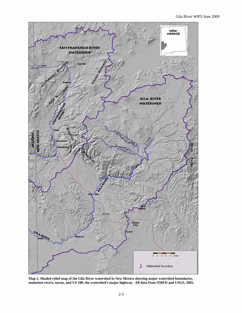
Much of the watershed lies with the Transition Zone between the Colorado Plateau and Basin and Range province, reflecting its complex geologic history, including relatively recent volcanic events (Trauger, 1972). The river's headwaters arise in complicated, mountainous terrain (Map 2). The 10,000-foot peaks of the Mogollon Mountains, near the western boundary of the Gila National Forest (GNF), create the divide between waters tributary to the Gila River in New Mexico and those that reach the San Francisco within the state. The Gila's western headwaters flow from the east-facing slopes of the Mogollons. To the northwest, the San Francisco and Tularosa Mountain ranges contain the San Francisco's headwaters. Near the eastern boundary of the GNF, the Black Range forms part of the Continental Divide that separates the Gila and Rio Grande watersheds. The southernmost New Mexico reaches of the river are entrenched in the aggraded desert plains of the Mexican Highlands, typified by generally low relief. However, the Gila River has cut sharply 300 to 500 feet into the plains and has developed a flat-bottomed inner valley up to a mile wide in the vicinity of Virden and Red Rock. (NM WQCC, 2004).
Daniel Conner traveled along the upper Gila in 1863 and was impressed by its unique character. Among other observations, he commented, "I will venture to assert that the Gila is the longest river of its size in the world and that it drains more country than any other stream of its width and depth and yet it has time to go dry in places" (1956, p. 45). The characteristics he noticed can all be considered as consequences of the geologic past. Until about 60 million years ago (MYA), the Gila River watershed was for millions of years part of a vast marsh extending across what is now southern New Mexico and Arizona. Until the Rocky Mountains began to form, this entire region was of relatively low relief that allowed the swamp-like conditions to prevail. The river flowed west, as it does today, from slightly higher terrain in western New Mexico and eastern Arizona toward seas whose outlines changed over time.
The uplift that created the Rocky Mountains began around 60 MYA, at the beginning of the Cenozoic era, and dramatically elevated the landscape encompassing the Gila and San Francisco headwaters. At their highest points, the headwaters now emerge at elevations above 10,000 feet. The steepened slopes of the river and its tributaries changed their character from slow, wandering streams to rapid torrents that incised the landscape, creating the canyons that characterize the region today.
Gila River WIPS June 2009
2-3
Map 2. Shaded relief map of the Gila River watershed in New Mexico showing major watershed boundaries, mainstem rivers, towns, and US 180, the watershed's major highway. All data from NMED and USGS, 2005.
Gila River WIPS June 2009
2-4
Other geologic changes forced the retreat of the shallow sea that once reached to southwestern Arizona, while the rise of the Sierra Nevada in California changed climate patterns throughout the region, capturing Pacific moisture on its western slopes and creating the rain shadow to the east that continues to enhance arid conditions into Arizona, Nevada, Utah, and New Mexico. As a consequence, it is altitude and its effect on average annual precipitation that exert the strongest influence on ecosystems or "life zones" here. In New Mexico, the Gila watershed traverses elevations ranging from over 10,000 feet to near 3,700 feet at the Arizona state line. This elevation and precipitation gradient supports a variety of forest and plant types ranging from the high elevation Canadian zone, or spruce-fir habitat, through a Transition zone of Ponderosa pine that grades into pinyon/oak/ juniper woodland, and into the shrubby Chaparral zone of mountain mahogany, buckthorn, and manzanita. The semi-desert habitat of remnant Chihuahuan grassland covers broad areas across the watershed's lowest elevations in New Mexico. This ecological diversity offers habitat for a wide array of species, including many species whose survival status is of concern.
HUMAN OCCUPATION
Humans have lived in the Gila region for more than 20,000 years; perhaps considerably more. Only scant evidence of the ancient populations remains, but the remnants of later occupation are more obvious. People of the Mogollon culture inhabiting the higher elevations of the watershed built pit houses and produced quality pottery and fine cotton fabrics. Their transition to building pueblo-type houses by about 1000 A.D. probably followed contact with peoples of the Anasazi culture to the north, whose structures at places like Chaco Canyon are renowned. The best-known of the Mogollon structures are at the Gila Cliff Dwellings National Monument (Map 1). The Mogollon people were hunters who relied on the atlatl, an ingenious invention that enabled them to hurl a spear fast and far, and only later adopted the bow and arrow. They were also agriculturists who grew maize, beans, and squash, constructing devices to spread and capture water in the process. Olmsted (1919) noted remnants of their stone and earthen dams and terraces throughout the areas they inhabited.
The Mogollon abandoned the region by about 1400 A.D., leaving it "open" for western Apache, an Athapascan people. Spanish sorties sent from Mexico, including Coronado's infamous 1540 expedition, avoided the upper Gila watershed and no written record exists of Apache presence in southwestern New Mexico before the 17th century.
It is nonetheless likely that they immigrated to the area between 1500 and 1600 (Spicer, 1992), and certain that they had acquired Spanish guns, knives, and horses by that time. They proved particularly adept at incorporating the horse into their culture, expanding their range and their threat to other tribes. By the late 1600s, Spanish missionary and settlement efforts had been extended into southern New Mexico. Fighting and raiding between the Spanish and virtually all of the native tribes developed throughout a 250-mile-wide corridor stretching north and south of the Gila River. The intensity
Gila River WIPS June 2009
2-5
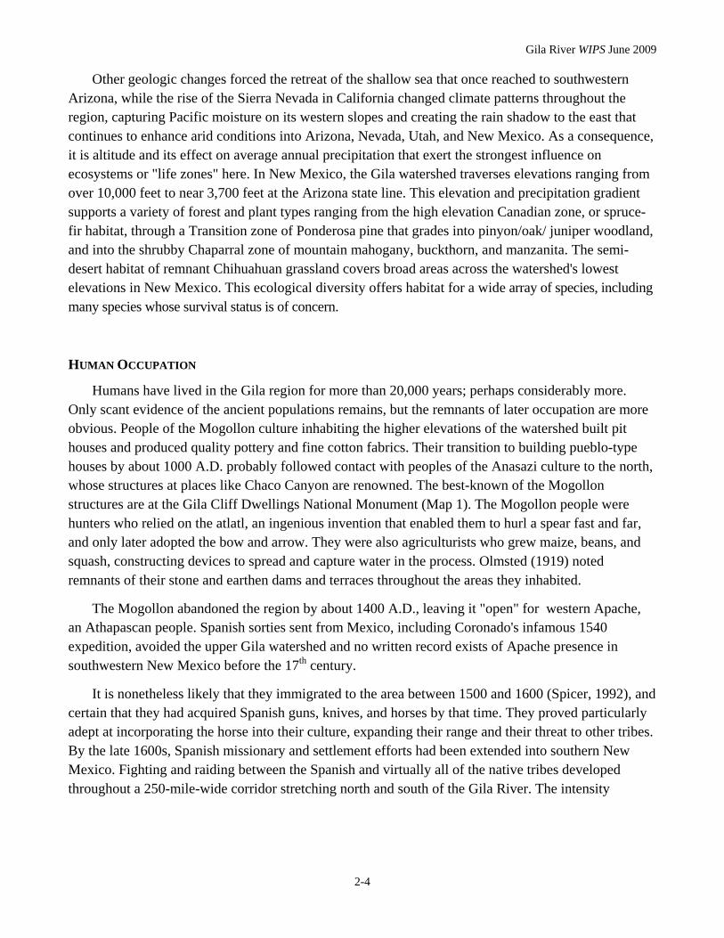
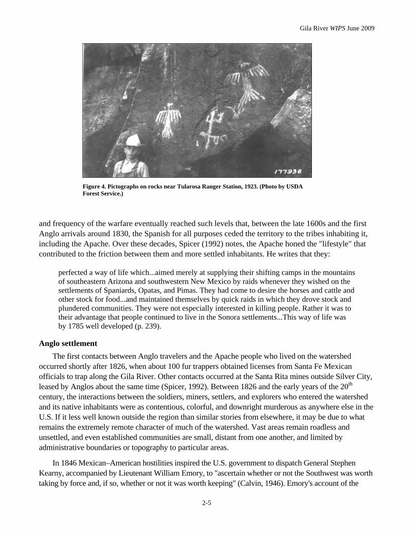
Figure 4. Pictographs on rocks near Tularosa Ranger Station, 1923. (Photo by USDA Forest Service.)
and frequency of the warfare eventually reached such levels that, between the late 1600s and the first Anglo arrivals around 1830, the Spanish for all purposes ceded the territory to the tribes inhabiting it, including the Apache. Over these decades, Spicer (1992) notes, the Apache honed the "lifestyle" that contributed to the friction between them and more settled inhabitants. He writes that they:
perfected a way of life which...aimed merely at supplying their shifting camps in the mountains of southeastern Arizona and southwestern New Mexico by raids whenever they wished on the settlements of Spaniards, Opatas, and Pimas. They had come to desire the horses and cattle and other stock for food...and maintained themselves by quick raids in which they drove stock and plundered communities. They were not especially interested in killing people. Rather it was to their advantage that people continued to live in the Sonora settlements...This way of life was by 1785 well developed (p. 239).
Anglo settlement The first contacts between Anglo travelers and the Apache people who lived on the watershed
occurred shortly after 1826, when about 100 fur trappers obtained licenses from Santa Fe Mexican officials to trap along the Gila River. Other contacts occurred at the Santa Rita mines outside Silver City, leased by Anglos about the same time (Spicer, 1992). Between 1826 and the early years of the 20th century, the interactions between the soldiers, miners, settlers, and explorers who entered the watershed and its native inhabitants were as contentious, colorful, and downright murderous as anywhere else in the U.S. If it less well known outside the region than similar stories from elsewhere, it may be due to what remains the extremely remote character of much of the watershed. Vast areas remain roadless and unsettled, and even established communities are small, distant from one another, and limited by administrative boundaries or topography to particular areas.
In 1846 Mexican–American hostilities inspired the U.S. government to dispatch General Stephen Kearny, accompanied by Lieutenant William Emory, to "ascertain whether or not the Southwest was worth taking by force and, if so, whether or not it was worth keeping" (Calvin, 1946). Emory's account of the

Gila River WIPS June 2009
2-6
"reconnoissance," which took the group down the Rio Grande, west to the Mimbres River and Mangas Creek, and then down the Gila, became a classic. The Treaty of Guadalupe Hidalgo, ending the war, formalized New Mexico as a U.S. territory. But warfare between the U.S. military (and settlers) and the Apache accelerated, not ending until near the start of the 20th century (Spicer, 1992). Anglo settlement of much of the New Mexico portion of the watershed was slow and sporadic. At higher elevations on the watershed, settlement was concentrated in the valley bottoms where agriculture seemed possible. Early settlers, arriving in the mid- to late 1870s, must have seen great promise in farming these river bottoms, since contemporary accounts emphasize their constant fear of raiding and attack by the Apache.
For instance, an 1868 attempt by Missouri immigrants to settle in the Cliff-Gila Valley ended within six months when local Apaches "[ran] off every hoof of stock [leaving them] on the border of destitution" (Calvin, 1946). Farming at Alma, on the San Francisco River, began in 1879; the following year, 31 people were killed between Alma and Silver City during a series of raids and
retaliations. (Alma hosted other colorful characters with a disposition to violence. Butch Cassidy and a number of the Wild Bunch took a break from their outlaw careers for employment as hands on the WS Ranch near Alma in the late 1800s. Ranch managers seemed happy with their work since cattle rustling apparently stopped during this interval. After some of them robbed a train near Folsom in 1899, however, the remaining members fled the area (Gibson, 2006; Stanley, n.d.).
Many settlers found early success in agriculture. Anglo settlers in the Cliff-Gila Valley established a foothold by 1875 and constructed their first irrigation works (which remain in use today); by 1880, wheat, oats and corn were being grown in the valley. In 1927, Black reported that "corn, alfalfa, garden truck, melons, and deciduous fruits" were produced from irrigated farms on nearly 3,000 acres there. Substantial corn and alfalfa
Figure 5. Alma, about 1913. The San Francisco River flows behind stores owned by Hugh McKeen (left) and the Jones Bros. (right). Courtesy Silver City Museum, all rights reserved.
Figure 6. Same view as in Figure 3, October 2006. The river's appearance has changed considerably since 1913. Photo courtesy NMED, Silver City.
Gila River WIPS June 2009
2-7
crops were produced on Duck Creek through the early part of the 20th century (Mogollon Mines, 1916). In Alma, a settler wrote in 1882 that "every foot of irrigated land along the Frisco River is owned by somebody, and the owners are making ready to harvest big crops. Fruit trees and garden seeds are being ordered in vast quantities..." (Stanley, n.d.). By 1905, settlers had "patented" (claimed title to) virtually all of the region's available arable land and permanent water sources (Wooton, 1908). Local ore discoveries and mining booms boosted farmers' hopes for expanded markets. Copper mining began at Tyrone, in the Mangas Creek headwaters, in 1879. A short-lived silver and gold mining boom brought miners to the Mogollon Mountains between 1880 and about 1910. Valuable deposits were found near Mogollon, Cooney, (in the headwaters of Mineral and Mogollon Creeks) and Graham, on Whitewater Creek (Figure 7).
However, speculators and others who ventured into the territory between 1850 and 1880 quickly identified its potential for cattle and sheep production. Accounts from the period are filled with references to abundant grama grass and "good water." The scale of these operations soon overshadowed farm production.
Setting the patterns of land management and ownership
When the U. S. acquired the territory comprising Arizona and New Mexico by treaty with Mexico in 1848, lands not already in private ownership or designated as Indian reservations became part of the public domain. Public lands were opened, under various laws, to settlement, purchase, and use. Railroads were a major beneficiary of the public land domain, and their construction provided the genesis of many present-day towns in the Southwest. Local forests generally supplied construction timbers, ties, and fuel. Construction of rail lines through the new territory was an early priority, and favored routes included one along the 32nd line of latitude, just south of the Gila River's course into Arizona. The Southern Pacific railway line from Yuma across southern Arizona and New Mexico met the existing line at El Paso in 1883.
To support railroad construction, the federal government typically gave away forty alternate sections (a square mile each) for every mile of track built. Railroads also often had rights to “lieu lands” in exchange for previously taken private holdings along their rights of way. As a result, they generally controlled, and sold, vast amounts of land. In fact, the Santa Fe Railroad was second only to the federal General Land Office (GLO) in land acreage sold in New Mexico (USDA Forest Service, 2006b). These land sales served their long-term financial interests: towns, farmers, and ranchers became their customers; access to rail shipment for cattle accelerated livestock production.
The GLO, which had jurisdiction over the Federal lands, was primarily interested in selling them. The minimum price was $1.25 per acre. Homestead laws were generous: settlers could claim 160 acres for each adult family member. In the half century before 1900, the population of Arizona and New Mexico increased from about 62,000 to 320,000 (USDA Forest Service, 2006b). The population growth represented, in part, a triumph of the national policy of encouraging Anglo land settlement of the Western territories. But the late 19th century marked something of a shift in Federal land management priorities and the policies shaped by them. The new policies were spurred to some extent by growing evidence of deteriorated land, water, and wildlife conditions. Lands designated as the first
Gila River WIPS June 2009
2-8
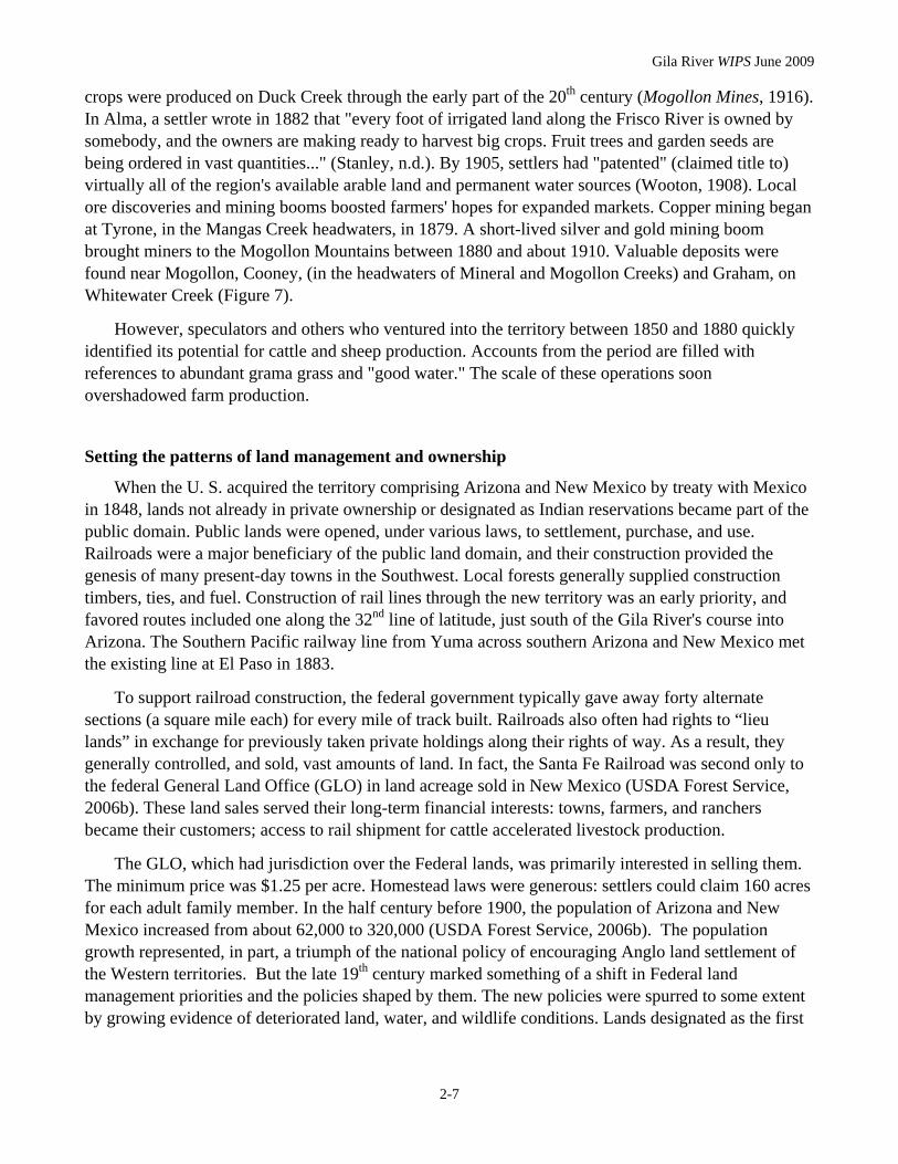
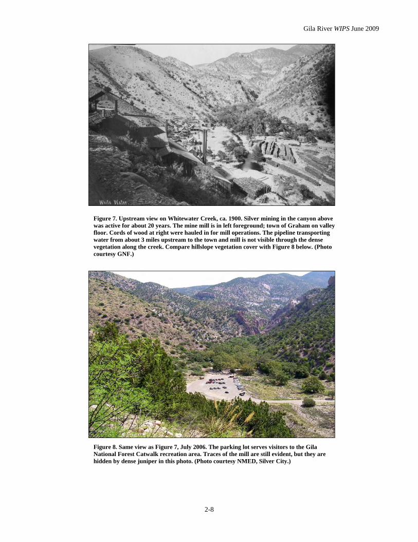
Figure 7. Upstream view on Whitewater Creek, ca. 1900. Silver mining in the canyon above was active for about 20 years. The mine mill is in left foreground; town of Graham on valley floor. Cords of wood at right were hauled in for mill operations. The pipeline transporting water from about 3 miles upstream to the town and mill is not visible through the dense vegetation along the creek. Compare hillslope vegetation cover with Figure 8 below. (Photo courtesy GNF.)
Figure 8. Same view as Figure 7, July 2006. The parking lot serves visitors to the Gila National Forest Catwalk recreation area. Traces of the mill are still evident, but they are hidden by dense juniper in this photo. (Photo courtesy NMED, Silver City.)
Gila River WIPS June 2009
2-9
national parks, forests, and wildlife refuges were withdrawn from settlement and reserved for public ownership during this period (BLM, 2005). The tension between these two impulses—on the one hand, to put lands to direct economic use; on the other, to restrict such uses in favor of protecting an area's other resource values—remains a potent force.
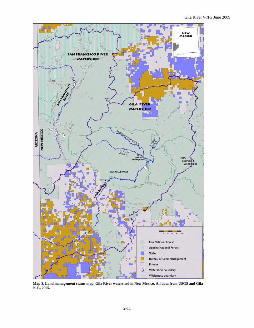
In 1891, Presidential authority to create forest reserves was granted by Congress—and then restricted, in 1897, to specific purposes such as preserving timber and protecting watersheds. The Gila National Forest (or Gila River Forest Reserve, as it was originally named) was established in 1899. Parts of what later became the Apache National Forest were designated at about the same time. Today, almost 70% of the Gila watershed is on lands managed by the US Forest Service (Map 3 and Table 2). "Multiple use" of Forest Reserve lands was an early-established principle, but designation of specific Forest Reserve lands was also intended as a means of managing that use. Regardless, early use of Forest Reserve lands for grazing and other private economic purposes remained generally unconstrained by all but topography (USDA Forest Service, 2006b). The tradition of public land use for production was already well established. Private landowners retained de facto control of adjoining public lands. In the Southwest, those who owned lands with springs or perennial surface water in effect controlled large tracts of adjacent dry land.
The introduction in 1905 of grazing fees and restrictions on the use of Forest lands encountered widespread resentment. Still, private landowners continued to benefit from adjacent public lands. In New Mexico, about 30 million acres of farm and ranch land were privately owned in 1945, while 74 million acres of public lands were available for grazing (USDA Forest Service, 2006b).
However, special designations for a particular use of federal lands have also limited other uses. Wilderness designations are probably the prime example of these on the Gila watershed. Aldo Leopold (1887–1948) is generally credited as the founder of designated wilderness in the U.S. Famously, Leopold's support for wilderness developed from a change in his views on the role of predators in the ecosystem. He published his first proposal for wilderness establishment on the Gila in 1922, proposing some 500,000 acres of the Gila Forest as official wilderness without roads and only minimum trails. The proposal became reality in 1924, when the Gila Wilderness was designated, joined later by the Aldo Leopold Wilderness and the Blue Range Primitive Area. More than a quarter of USFS lands on the watershed are now designated as wilderness.
Like other forested lands in the Southwest, those now known as the Apache and Gila National Forests occur on the highest elevations, where annual rates of precipitation are enough to sustain timber
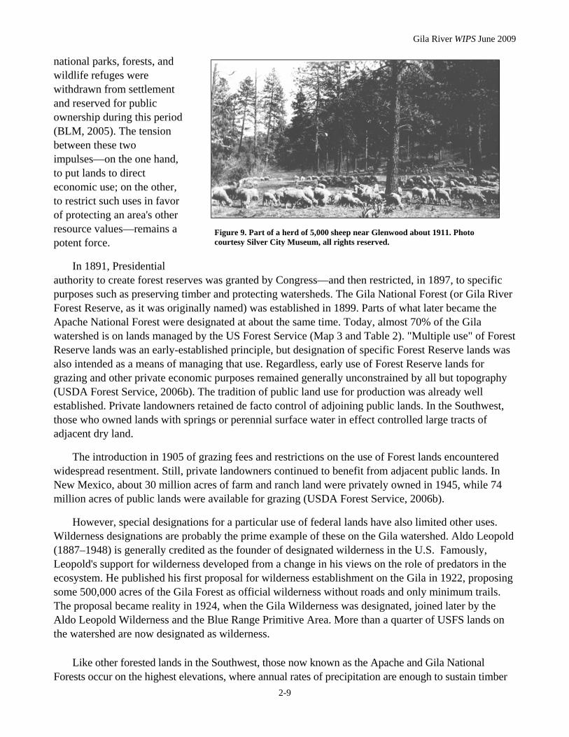
Figure 9. Part of a herd of 5,000 sheep near Glenwood about 1911. Photo courtesy Silver City Museum, all rights reserved.
Gila River WIPS June 2009
2-10
growth. But lower elevations offered plenty of public land as well. On the Gila watershed in New Mexico, these were typically located in the Chihuahuan grassland and chaparral zones, around elevations of 3000 to 5000 feet. These areas seemed to offer vast promise as grazing rangeland or farm land, but usually contained less surface water than the mountainous region. As a general rule, the public rangelands purchased by private landowners from the GLO were those with the best availability of surface or near-surface water sources.
The resulting pattern appears on Map 3. Although smaller streams like Duck, Mangas, and Mule Creeks are not delineated on the map, their general locations are nonetheless evident. Most of the private lands outside of National Forest boundaries occupy accessible lands around the Gila River and these creeks, which generally traverse the large block of mostly private land across the south-central part of the watershed. Most of these lands probably went into private ownership prior to 1934, when the Taylor Grazing Act was passed. The Act, a response to the environmental devastation of the Dust Bowl era, closed most of the remaining public grasslands to homesteading. The system of Soil & Water Conservation Districts, made
Figure 11. The Gila River Lower Box, on land managed by the BLM between Virden and Redrock. December 2005.
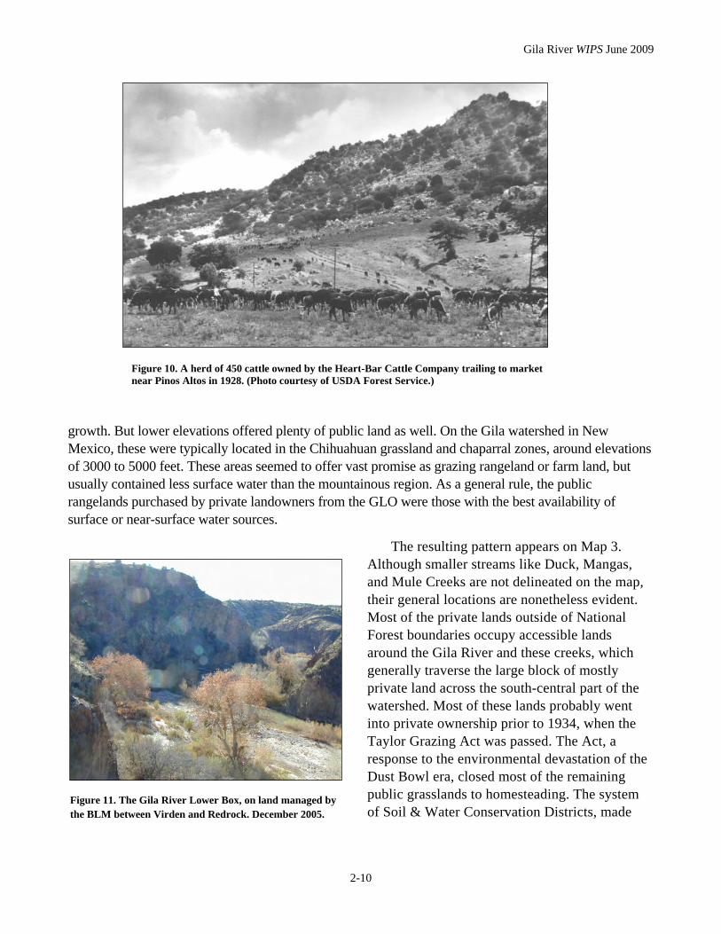
Figure 10. A herd of 450 cattle owned by the Heart-Bar Cattle Company trailing to market near Pinos Altos in 1928. (Photo courtesy of USDA Forest Service.)
Gila River WIPS June 2009
2-11
Map 3. Land management status map, Gila River watershed in New Mexico. All data from USGS and Gila N.F., 2005.

Gila River WIPS June 2009
2-12
up of local livestock producers, was established to manage them as a public grazing resource (Worster, 1979). The Act also created the federal Grazing Service. In 1946, the GLO and Grazing Service were merged to create the Bureau of Land Management (BLM; 2005).
Other federal lands were ceded to new territories and states, typically to provide revenue to support their public schools. It took 62 years, from 1850 to 1912, for New Mexico to move from Territory status to statehood. Legislation in 1898 and 1910 granted the Territory what were known as “school sections”: Sections 16 and 36 and 2 and 32, respectively, in every public lands township. (Land sales and exchanges have modified this pattern somewhat over the decades.) Later legislation also provided mineral estate royalties to the state from school lands. Authority to manage the lands and the royalties generated from them was given to the State Land Office. Revenue from each acre of state trust lands is designated in support of a particular institution. Particularly today, these lands form a substantial part of state revenues. In the 2006 fiscal year, state land revenues, generated from 9 million acres of surface land and 13 million oil, gas, and mineral acres, totaled nearly $415 million (New Mexico SLO, 2006). State trust lands comprise about 5% (160,000 acres) of the Gila watershed in New Mexico.
Table 2. Approximate current distribution of management and ownership of Gila and San Francisco Rivers watershed lands within New Mexico (data from US Geological Survey, 2005).
Management agency or owner Gila, mi2
(% of total) San Francisco, mi2
(% of total) Total (mi2)
US Forest Service 1966 (56%) 1709 (92%) 3675
Bureau of Land Management (BLM) 538 (15%) <1 (< 1%) 539
State 245 (7%) 5 (<1%) 250
Private 736 (21%) 141 (7%) 877
National Park Service 1 (<1%) -- 1
Total 3486 1856 5342
It took only about 60 years to set the watershed's present land ownership and management patterns in place, but they can profoundly influence watershed condition and practices aimed at its improvement. For example, many river bottom lands are irrigated for pasture or for alfalfa or crop production: these small-scale irrigation withdrawals from the Gila and San Francisco River basins total about 50,000 acre-feet (a-f) annually, nearly all from surface flows (Wilson, 1998). Such small diversions for irrigation have been constructed on the Gila watershed for centuries. However, no major dams have been constructed on its mainstem rivers or tributaries. (A current proposal to divert an average of 14,000 acre-feet of water from the Gila and San Francisco Rivers as part of the Arizona Water Settlement Act is under study, with a recommendation due to the Secretary of the Interior by 2014. See New Mexico OSE/ISC, 2006 for more details.)
The greatest hydrologic alteration to streamflows may therefore come in the form of shallow groundwater withdrawals.To date, there are no large towns or extensive developments anywhere on the watershed. Yet the area's remoteness and beauty have attracted and continue to attract new residents. Private lands in small river valleys occupy some of the watershed's most biologically productive zones;

Gila River WIPS June 2009
2-13
they are also among the most aesthetically desirable. As elsewhere in the western U.S., these could become the areas where subdivision and development are most likely to occur. Groundwater withdrawals from alluvial aquifers consequent to increased development could be significant; where domestic wells are concentrated, they can stress groundwater supplies and cause significant depletions in stream flow (OSE, 2006).
In addition, the varying land management designations across the watershed create a patchwork of stewardship responsibilities. About 84% of the Gila watershed is on public lands. BLM and state lands often occur in non-contiguous parcels spottily interspersed among private lands; private lands within
National Forest boundaries are predominantly located in stream valleys (Map 3). These legal boundaries often do not correspond with the topography that describes the limits of each subbasin within the greater watershed. It is generally recognized that the most effective practices for improving watershed function are holistic, in recognition of the interconnections among all the components of the watershed landscape. Yet even on small watersheds, coordinating improvement strategies across the variety of owners and managers responsible for their stewardship can represent a major challenge—or opportunity—for successful implementation.
Figures 12 and 13. View upstream through the valley of Reserve. Top, in 1923. Bottom, 2006.
Gila River WIPS June 2009
2-14
ECONOMICS AND DEMOGRAPHICS
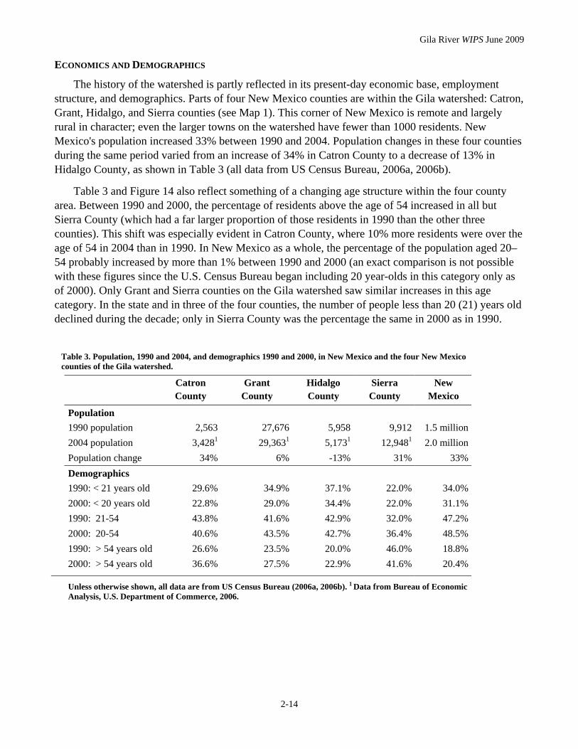
The history of the watershed is partly reflected in its present-day economic base, employment structure, and demographics. Parts of four New Mexico counties are within the Gila watershed: Catron, Grant, Hidalgo, and Sierra counties (see Map 1). This corner of New Mexico is remote and largely rural in character; even the larger towns on the watershed have fewer than 1000 residents. New Mexico's population increased 33% between 1990 and 2004. Population changes in these four counties during the same period varied from an increase of 34% in Catron County to a decrease of 13% in Hidalgo County, as shown in Table 3 (all data from US Census Bureau, 2006a, 2006b).
Table 3 and Figure 14 also reflect something of a changing age structure within the four county area. Between 1990 and 2000, the percentage of residents above the age of 54 increased in all but Sierra County (which had a far larger proportion of those residents in 1990 than the other three counties). This shift was especially evident in Catron County, where 10% more residents were over the age of 54 in 2004 than in 1990. In New Mexico as a whole, the percentage of the population aged 20–54 probably increased by more than 1% between 1990 and 2000 (an exact comparison is not possible with these figures since the U.S. Census Bureau began including 20 year-olds in this category only as of 2000). Only Grant and Sierra counties on the Gila watershed saw similar increases in this age category. In the state and in three of the four counties, the number of people less than 20 (21) years old declined during the decade; only in Sierra County was the percentage the same in 2000 as in 1990.
Table 3. Population, 1990 and 2004, and demographics 1990 and 2000, in New Mexico and the four New Mexico counties of the Gila watershed.
Catron County
Grant County
Hidalgo County
Sierra County
New Mexico
Population 1990 population 2,563 27,676 5,958 9,912 1.5 million 2004 population 3,4281 29,3631 5,1731 12,9481 2.0 million Population change 34% 6% -13% 31% 33% Demographics 1990: < 21 years old 29.6% 34.9% 37.1% 22.0% 34.0% 2000: < 20 years old 22.8% 29.0% 34.4% 22.0% 31.1% 1990: 21-54 43.8% 41.6% 42.9% 32.0% 47.2% 2000: 20-54 40.6% 43.5% 42.7% 36.4% 48.5% 1990: > 54 years old 26.6% 23.5% 20.0% 46.0% 18.8% 2000: > 54 years old 36.6% 27.5% 22.9% 41.6% 20.4%
Unless otherwise shown, all data are from US Census Bureau (2006a, 2006b). 1 Data from Bureau of Economic Analysis, U.S. Department of Commerce, 2006.

Gila River WIPS June 2009
2-15
Figure 14. Demographic changes in the four New Mexico counties on the Gila River watershed and in New Mexico, 1990–2000 (see also Table 3). * In 2000, the U.S. Census Bureau began including 20 year-olds in this age group; they were excluded in 1990.
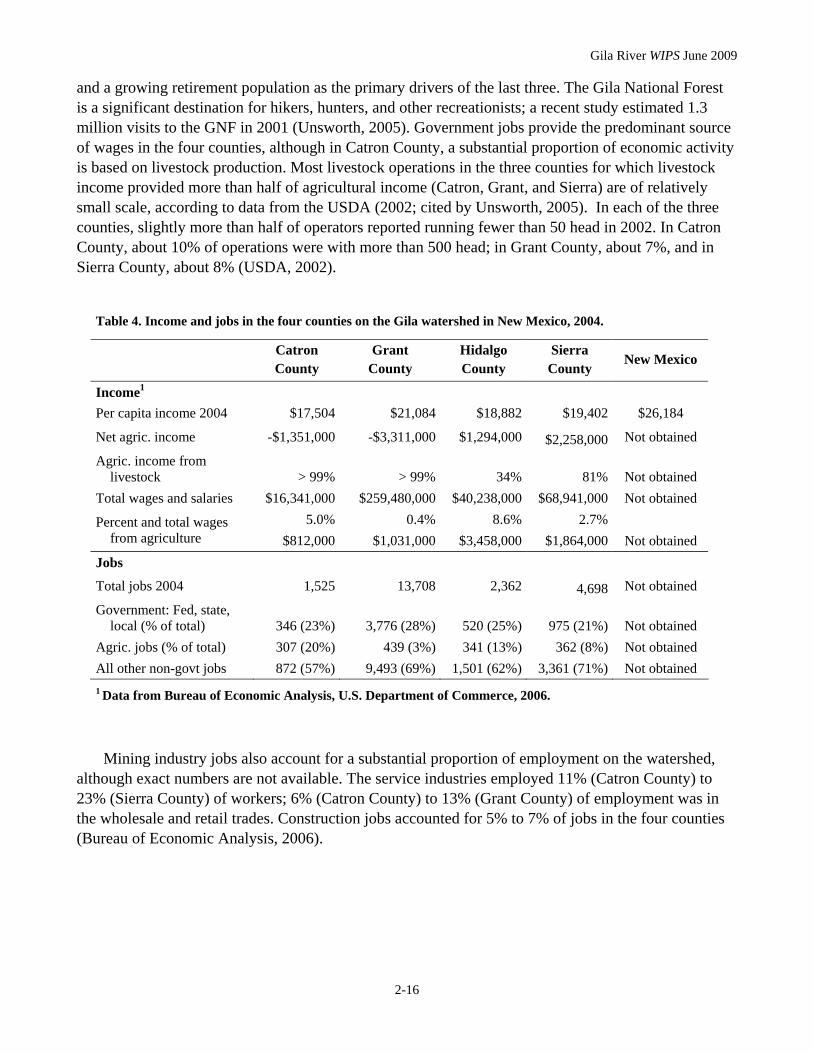
Table 4 shows general information from 2004 on job categories and wage sources for the four counties. According to the Bureau of Economic Analysis (2006), per capita income in the four-county area rose eight to ten percent between 2003 and 2004. Per capita income remains well below the state average, however. Generally, the economic activities within the small communities of the watershed are mostly in agriculture, services, retail trade, and construction; Unsworth et al. (2005) cited tourism
Gila River WIPS June 2009
2-16
and a growing retirement population as the primary drivers of the last three. The Gila National Forest is a significant destination for hikers, hunters, and other recreationists; a recent study estimated 1.3 million visits to the GNF in 2001 (Unsworth, 2005). Government jobs provide the predominant source of wages in the four counties, although in Catron County, a substantial proportion of economic activity is based on livestock production. Most livestock operations in the three counties for which livestock income provided more than half of agricultural income (Catron, Grant, and Sierra) are of relatively small scale, according to data from the USDA (2002; cited by Unsworth, 2005). In each of the three counties, slightly more than half of operators reported running fewer than 50 head in 2002. In Catron County, about 10% of operations were with more than 500 head; in Grant County, about 7%, and in Sierra County, about 8% (USDA, 2002).
Table 4. Income and jobs in the four counties on the Gila watershed in New Mexico, 2004.
Catron County
Grant County
Hidalgo County
Sierra County
New Mexico
Income1 Per capita income 2004 $17,504 $21,084 $18,882 $19,402 $26,184
Net agric. income -$1,351,000 -$3,311,000 $1,294,000 $2,258,000 Not obtained
Agric. income from livestock > 99% > 99% 34% 81% Not obtained
Total wages and salaries $16,341,000 $259,480,000 $40,238,000 $68,941,000 Not obtained Percent and total wages
from agriculture 5.0%
$812,0000.4%
$1,031,0008.6%
$3,458,0002.7%
$1,864,000 Not obtained Jobs
Total jobs 2004 1,525 13,708 2,362 4,698 Not obtained
Government: Fed, state, local (% of total) 346 (23%) 3,776 (28%) 520 (25%) 975 (21%) Not obtained
Agric. jobs (% of total) 307 (20%) 439 (3%) 341 (13%) 362 (8%) Not obtained All other non-govt jobs 872 (57%) 9,493 (69%) 1,501 (62%) 3,361 (71%) Not obtained
1 Data from Bureau of Economic Analysis, U.S. Department of Commerce, 2006.
Mining industry jobs also account for a substantial proportion of employment on the watershed, although exact numbers are not available. The service industries employed 11% (Catron County) to 23% (Sierra County) of workers; 6% (Catron County) to 13% (Grant County) of employment was in the wholesale and retail trades. Construction jobs accounted for 5% to 7% of jobs in the four counties (Bureau of Economic Analysis, 2006).

This page left intentionally blank.