upper neversink watershed geology - city of new york · upper neversink watershed geology geology...
TRANSCRIPT

N e v e r s i n k R i v e r S t r e a m M a n a g e m e n t P l a n S e c t i o n 2 . 4 . 1
Section 2.4
Upper Neversink Watershed Geology
Geology is the study of the Earth, its composition, structure and the dynamic processes that affect change over
the duration of Earth history. Over the passage of millions of years, the interaction of the climate and geology
of the upper Neversink watershed has created the high relief southern front of the Catskill Mountains. The
streams that carry the water and sediment out of these mountains reflect the geologic composition, structure
and process (Figure 1).
Figure 1. Bedrock reach along the West Branch Neversink River
The Catskill Mountains are unlike many other mountains often formed from the uplifting of folded and faulted
rocks during continental collisions. The Catskills are a gentler sort of mountains crafted from eons of scouring
stream water and carving glacial ice as the terrain slowly uplifted as a plateau over millions of years. This
stream dissected plateau in the southern and eastern Catskills is characterized by steep mountain valleys
carved in sedimentary bedrock from the mid to late-Devonian period (390 – 360 million years ago). These
valleys are also filled with the deposits left behind from the last Ice Age that ended ~10 thousand years ago.
Following the retreat of the continental ice sheet out of the Catskills, streams got back to work in shaping the
valley bottoms. The sedimentary bedrock framework and Ice Age glacial legacy deposits are largely what
control valley bottom characteristics such as slope, valley and stream confinement; in streams, the geology

N e v e r s i n k R i v e r S t r e a m M a n a g e m e n t P l a n S e c t i o n 2 . 4 . 2
influences channel morphology such as bedform, planform, and alluvial versus non-alluvial boundary
conditions. Water quality is directly and indirectly influenced by geology. For example, the potential for
acidic stream waters stems from acidic deposition on a terrain with poor buffering capacity. Wise stream
management requires a good foundation in understanding the regional and local geologic controls on stream
geomorphic, ecologic, and water quality condition.
This section of the plan briefly covers the general geologic history of the watershed region, and highlights the
key geologic features with implications for stream management (lithology or composition, valley and stream
morphology, and water quality. We encourage the interested reader/researcher to check out the more detailed
sources of information on the regional geology and related issues included in the bibliography at the end of this
section. The section also includes a list of research topics that if pursued would be beneficial to stream
management
General Geologic History
The Catskill Mountains that comprise the NYC Catskill and Delaware water supply watersheds are a noted
example of cyclic patterns in geology. In the mid to late Devonian period of earth’s history the towering
Acadian mountains to the east eroded into vast deltaic plains of meandering and braided rivers sloping into an
inland sea (about where Binghamton is now). Robert Titus compares it to the modern Bangladesh river
complex draining the Himalayan Mountains in geologic setting (Titus, 1998). Those vast ancient river deltas
laid down layer upon layer of sediment: stream gravels and sand, and floodplain silt and clay, creating the
Catskill Delta (Isachsen et al, 2000). These were not barren deltas; there were fern tree forests and fish in the
waters. Over time, these deposits were buried and turned to rock only to be upthrust again to the surface
encountering the force of eroding water and inexorable return to stream sediment: a cycle of mountains to
rivers to mountains to rivers.
The high peaks of the Catskill Mountains all have a similar range in elevation from 3,000 – 4,000 ft in
elevation above sea level. The common interpretation of this relatively unique condition is that the Catskills
are an example of an eroded peneplain. That means the mountain tops were once part of a flat plain that
probably had additional rock layers above the Devonian rocks. The plain was then uplifted as part of the
Alleghany plateau (Isachsen, et al, 2000). The streams that meandered across that ancient plain were
steepened and eroded away the rock above the Devonian strata and carved valleys out of the uplifting terrain.
The more erosion resistant sandstone and conglomerate caps of the current mountain tops yielded a mountain
range with very similar heights.
The Ice Ages of the last 1.6 million years (Pleistocene Epoch) have left the latest mark on the Catskill
landscape. Vast continental ice sheets, and in some of the high peaks, smaller local mountain glaciers scoured
the mountains and left thick deposits of scoured sediment in the valleys. The last ice sheet (the “Laurentide
Ice Sheet”) reached maximum thickness over the Catskills about 22,000 years ago (Isachsen, et al., 2000) and

N e v e r s i n k R i v e r S t r e a m M a n a g e m e n t P l a n S e c t i o n 2 . 4 . 3
had fully retreated by 12,000 years ago (Figure 2).
As measured on the scale of geologic time this
was a very recent event. The ice sheet covering
Greenland is a modern day analog to those
Pleistocene conditions. Continental glaciers
scoured and moved vast amounts of sediment
across the landscape. Once the ice sheet started
melting back into the Hudson River valley and to
the north, smaller alpine glaciers possibly formed
in the mountains and further sculpted the
landscape. The glaciers left a legacy that still
profoundly influences hill slope and stream
channel stability and water quality throughout the
Catskills.
Since the Ice Ages, the return of streams and a forested landscape are the latest development influencing the
current geologic processes (streams eroding and depositing sediment).
Bedrock Geology and Implications for Stream Management
Bedrock Geology Composition
The bedrock composition of the upper Neversink watershed is entirely sedimentary rocks: shales, siltstones,
sandstones, and at higher elevations conglomerate. Figure 3 is a bedrock geology map for the watershed based
on the NYS Museum’s state series geologic maps and charts (Fischer, et al, 1970). The mapped geologic
formations that make up most of the watershed are the Upper Walton formation comprising sandstone, shale,
and siltstone and at higher elevations the Slide Mountain and Honesdale formations comprising mostly
sandstone and conglomerate with some shale (Figure 3). These geologic map formations are just variations on
a theme of alternating layers of fine grained rocks (siltstones and shales) and coarse grained rocks (sandstones
and conglomerates). The coarse grain rocks are stream channel deposits, and you can often observe old
channel features, such as cross-bedded troughs, gravel bars, and in some rare places fossilized log jams in
outcrops. The fine grain rocks are typically the floodplain deposits. Often the red shales show old soil
horizons with fossilized root holes and in places Devonian tree parts. Each package of coarse and fine grain
rocks equals one story of a prehistoric stream channel’s meander across the Devonian delta plain.
Figure 2. Maximum extent of Laurentide ice sheet.

N e v e r s i n k R i v e r S t r e a m M a n a g e m e n t P l a n S e c t i o n 2 . 4 . 4
Figure 3. Bedrock Geology of the Upper Neverskink Watershed

N e v e r s i n k R i v e r S t r e a m M a n a g e m e n t P l a n S e c t i o n 2 . 4 . 5
Valley Morphology
The sedimentary bedrock composed of the nearly flat-lying, alternating thick layers of sandstone, shale, and at
higher elevations conglomerate are responsible for the characteristic stair-step pattern observed in the
mountain valley walls, and to some degree in the changes of valley scale slope in the valley bottom. In the
headwaters, the more resistant sandstone and conglomerate layers form the steeper valley walls and valley
grade control, while the more erodible shales tend to form the gentler slopes of the valley walls.
Most of the stream valleys draining the Southern Escarpment are oriented NE-SW, bisecting the two
predominant bedrock fracture orientations. This orientation is principally based on pre-glacial erosion of the
landscape, which was controlled by the fractured, very gently southwest dipping bedrock. The orientation of
stream valleys is important, influencing the microclimate, average depth of snowpack and local hydrological
regime in many ways.
Stream Morphology
While there are many grade and planform
controls on stream morphology at a range of
scales, from large woody debris to bridges,
bedrock is the fundamental valley scale control
for grade and channel planform. Where the
stream flows against a bedrock valley wall or
across a bedrock valley bottom the stream’s
erosional process is effectively arrested in a
timescale that matters for stream management.
There are several bedrock grade and planform
controls throughout the upper Neversink
stream network, more so in the West Branch
(Figure 4). Figure 5 shows the mapped
bedrock grade and planform control identified
in the stream feature inventory.
Figure 4. Bedrock planform control along the West Branch Neversink
River

N e v e r s i n k R i v e r S t r e a m M a n a g e m e n t P l a n S e c t i o n 2 . 4 . 6
Figure 5. Mapped bedrock grade and planform control along the Upper Neversink River

N e v e r s i n k R i v e r S t r e a m M a n a g e m e n t P l a n S e c t i o n 2 . 4 . 7
Modern stream deposits in the Catskill Mountains are principally derived from erosion of the layered
sedimentary Catskill bedrock. As a result, stream clasts (sediment particles and classes) have a low spherocity
(“roundness”), typically forming platy or disk-like particle shapes. This platy shape affects the stability of the
streambed in a number of ways. First, it allows the particles to imbricate, or stack up at an angle, forming an
overlapping pattern like fish scales or roof shingles
(Figure 6 – photo of imbricated stream deposits).
Imbricated streambeds are thus generally more stable or
“locked up”, and all other things being equal, generally
require a larger flow to mobilize the bed material than
nonimbricated beds. However this same platy shape can
also, under the right conditions, act like an airplane wing
and be lifted by the streamflow more readily than would
a spherical particle of similar weight. Once this occurs
for even a few particles, the imbrication is compromised
and significant portions of the streambed become mobile.
Surficial Geology and Implications for Stream Management
Surficial Geology Composition
Surficial geology is concerned with the material covering bedrock. In the Catskills this surface material is
principally soils and glacial deposits. The focus here is on the glacial geology of the watershed and stream
corridor. The Ulster County and Sullivan County Soil Surveys are excellent sources for examining the soils of
the Upper Neversink watershed (Tornes, 1979; Seifried, 1989).
The Pleistocene was a period of accelerated erosion in the Catskills as the flowing ice sheet bulldozed sediment
and “quarried” bedrock. Glacial erosion broke the rock down into an entrained mixture of fragments ranging
in size from boulders to clay. This mixture of saturated sediment was carried along by ice and deposited as till
(unsorted assemblage of glacial sediment; Figure 7) or as stratified “drift” (Figure 8) if the sediment was
subsequently sorted by melt-water streams. These glacial deposits filled in deep river ravines that once drained
the landscape prior to the last glacier’s advance over the mountains. Figure 9 presents the surficial geology of
the Upper Neversink watershed as mapped by Cadwell (1987). Note that this map is a t 1:250,000 scale and
significantly oversimplifies the distribution of varied glacial deposits.
As the climate warmed and ice thinned, the landscape was deglaciated – lobes of the continental ice sheet
melted back from the Catskills in periodic stages. Meltwater from the decaying ice left a complex array of
stream (outwash plain) and ice-contact (kame) sand and gravel deposits. Pro-glacial lakes would have formed
where mountains, recessional moraines (deposits at former glacial margins) and ice impounded water and left
deposits of layered silt and clay.
Figure 6. Example of imbricated Catskill stream
sediment

N e v e r s i n k R i v e r S t r e a m M a n a g e m e n t P l a n S e c t i o n 2 . 4 . 8
Figure 7. Glacial till exposure along the stream
Figure 8. Stratified drift exposed in an eroding kame terrace

N e v e r s i n k R i v e r S t r e a m M a n a g e m e n t P l a n S e c t i o n 2 . 4 . 9
Figure 9. Surficial geology of the Upper Neversink watershed
N e v e r s i n k R i v e r S t r e a m M a n a g e m e n t P l a n S e c t i o n 2 . 4 . 1 0
The glacial geology of the Catskills can be quite complex given a very complex and poorly understood
deglaciation, or melting of the retreating ice. Previous research by Rich (1934) and Ozvath and Coates (1986)
indicate that the drainages of the southern escarpment of the Catskills (Beaver Kill, Neversink, and Rondout)
were subjected to a chaotic retreat of ice with massive blocks of ice stagnating and melting in place. Rich also
hypothesized that local alpine glaciers may have descended down each of the Branches from the Southern
Escarpment. Subsequent work has disputed this hyposthesis but there has been little research in this area to
conclude the debate.
The ice age deposits typically found in the upper Neversink watershed are generally directly from ice contact -
glacial till (Figure 7); or from melt water deposits along the ice margin and the valley walls – kame terraces, or
in meltwater streams discharging from the melting ice - outwash (Figure 8). There is not much evidence at the
surface for large pro-glacial lakes that would have received the meltwater. Previous surficial geologic mapping
efforts have not noted much presence of the layered silt and clay glacial lake deposits that make the adjacent
Esopus Creek watershed very prone to muddy water. Observations from a streamside landowner of “chunks”
of layered lake deposits in post-flood bar deposits show that they are present but not all that exposed.
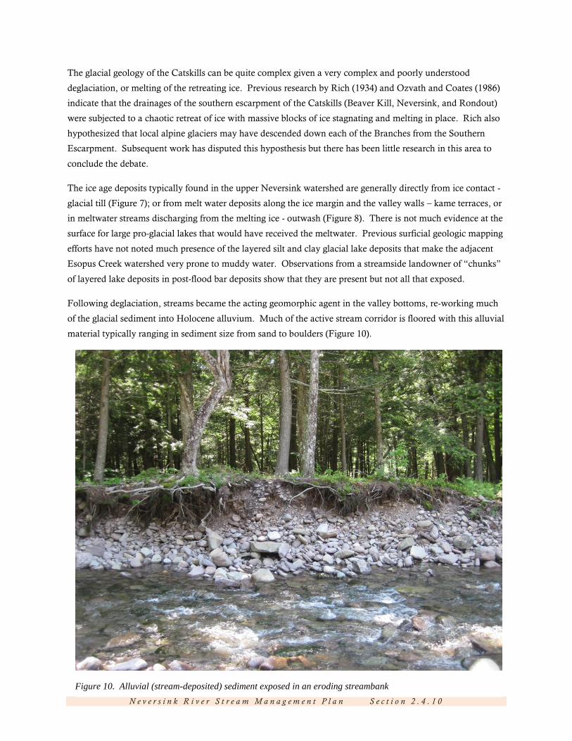
Following deglaciation, streams became the acting geomorphic agent in the valley bottoms, re-working much
of the glacial sediment into Holocene alluvium. Much of the active stream corridor is floored with this alluvial
material typically ranging in sediment size from sand to boulders (Figure 10).
Figure 10. Alluvial (stream-deposited) sediment exposed in an eroding streambank

N e v e r s i n k R i v e r S t r e a m M a n a g e m e n t P l a n S e c t i o n 2 . 4 . 1 1
The stream feature inventory completed for the Stream Management Plan includes mapping active streambank
and adjacent hill slope erosion. The geologic material exposed in the banks and hill slopes is recorded and can
be used to show the distribution of stream channel geology as presented in Figure 11.
Figure 11. Stream channel surficial geology map derived from the Stream Feature Inventory

N e v e r s i n k R i v e r S t r e a m M a n a g e m e n t P l a n S e c t i o n 2 . 4 . 1 2
Valley Morphology
Glacial geology sets the geologic framework for most of the Upper Neversink stream system, controlling such
characteristics as depth of alluvium (water worked sediments), presence of non-alluvial boundary conditions
(bedrock, till and glacial lake sediments), sediment supply and stream channel slope and geometry. For
example, glacial depositional features that partially fill river valleys, such as recessional moraines or kame
terraces along the valley wall, influence valley slope and cause valley constriction, both of which limit the
lateral extension of the river channel in its floodplain.
Glacial landscape features, such as moraines and glacial terraces influence valley cross sectional morphology.
Glacial till is more resistant to erosion than former stream deposits and it can locally influence planform and
grade control. Rich (1934) notes several locations in both branches where glacial moraines force the current
stream channel to one side of the valley and often in contact with bedrock. Also, these morainal valley
obstructions tend to induce the development of wide valley alluvial plains upstream of the obstruction (e.g.
valley floor between Fall Brook and Biscuit Brook). Outwash terraces along the valley margins are mapped by
Rich along portions of both Branches. These features can further confine the active channel corridor and be a
source of bedload material supply.
Stream Morphology
Alluvial channels are stream channels with stream-deposited sediment on all boundaries. Non-alluvial
channels are stream channels are with a direct contact with material not supplied by the stream, such as
bedrock, glacial till or glacial lake silty clay. Erosional processes and recovery to stream channel equilibrium
will vary as a function of this alluvial/non-alluvial condition. There are many places in the upper Neversink
stream network that have non-alluvial or mixed-boundary conditions (Figures 5 and 11). Eroding “bank run”
banks (sand, gravel, cobble from glacial meltwater streams or alluvial sediment from more historic streams)
tend to experience higher lateral adjustments because the material, if not protected by roots, is easily entrained
and mobilized (Figure 10). These banks, if not exposed to lots of recurrent shear stress can recover to a stable
slope and vegetate quickly. Non-alluvial stream boundary material tends to erode geotechnically rather than
hydraulically. Dense glacial till banks will tend to form steep high banks from mass failures and take a long
time to recover (Figure 7). Stream banks with glacial lake deposits tend to be the result of slumping and easy
toe erosion and consequently can be active for along period of time. The stream feature inventory did not
reveal the presence of this condition that is so common in the central Catskill stream corridors.

N e v e r s i n k R i v e r S t r e a m M a n a g e m e n t P l a n S e c t i o n 2 . 4 . 1 3
Bibliography of Relevant Geology Publications
1. Geology of New York: A Simplified Account. Isachsen et al. 2000 NYSM Educational Leaflet 28
2. Glacial Geology of the Catskills. Rich, J.L. 1934. NYSM Bulletin 299
3. The Wisconsinan Stage of the First Geological District, Eastern New York. Cadwell, D.H. editor,
1986. NYSM Bulletin 455
4. Soil Survey of Ulster County, New York. Tornes, L.A. 1979. USDA SCE and Cornell Agricultural
Experiment Station
5. Soil Survey of Sullivan County, New York. Seifried, S. T. 1989. USDA SCE and Cornell
Agricultural Experiment Station.
6. The Catskills: A geological Guide. Titus, R. 1998. Purple Mountain Press. Fleischmanns, NY
7. The Catskills in the Ice Age. Titus, R. 1996 Purple Mountain Press. Flesichmanns, NY
8. Geologic Map of New York State: Hudson-Mohawk Sheet. Fischer, D.W., Y.W. Isachsen, and L.V.
Rickard. 1970. NYS Museum.

N e v e r s i n k R i v e r S t r e a m M a n a g e m e n t P l a n S e c t i o n 2 . 4 . 1 4
Figures
Figure 1. Bedrock reach along the West Branch Neversink River
Figure 2. (a) map of Laurentide ice sheet. (b) Photo of Greenland ice sheet in mountainous terrain.
Figure 3. Bedrock Geology of the Upper Neverskink Watershed
Figure 4. Bedrock planform control along the West Branch Neversink River
Figure 5. Mapped bedrock grade and planform control along the Upper Neversink River
Figure 6. Example of imbricated Catskill stream sediment
Figure 7. Glacial till exposure along the stream
Figure 8. Stratified drift exposed in an eroding kame terrace
Figure 9. Surficial geology of the Upper Neversink watershed
Figure 10. Alluvial (stream-deposited) material exposed in an eroding bank
Figure 11. Stream channel surficial geology map derived from the SFI