section iii.p recreation - california state parks · diamonds, athletic fields, ... indicated on...
TRANSCRIPT

III.P-1
Chapter III Environmental Setting, Impacts, and Mitigation Measures
Section III.P Recreation
Candlestick Point–Hunters Point Shipyard
Phase II Development Plan EIR
SFRA File No. ER06.05.07
Planning Department Case No. 2007.0946E
Draft EIR
November 2009
SECTION III.P RECREATION
III.P.1 Introduction
This section of the EIR analyzes whether the Project would (1) increase the use of existing parks and
recreational facilities such that substantial physical deterioration or degradation of the facilities would
occur or be accelerated or that new or expanded facilities would be required; (2) result in substantial
adverse construction-related effects associated with the provision of new or physically altered parks and
recreational facilities, whether on site or off site; and/or (3) adversely affect existing recreational facilities.
This section analyzes the potential for both Project level and cumulative environmental impacts. The
analysis in this section concludes that no potentially significant or significant environmental impacts
would result from the Project; therefore, no mitigation measures are included.
Data used in this section includes information obtained from the San Francisco Recreation and Park
Department (SFRPD), the California Department of Parks and Recreation (CDPR), as well as the
California Department of Parks and Recreation Candlestick Point State Recreation Area General Plan (CPSRA
General Plan), Association of Bay Area Governments (ABAG) San Francisco Bay Trail Plan, ESA
Windsurfing Memorandum (refer to Appendix P1 [Windsurfing Report]), San Francisco Bay Conservation
and Development Commission San Francisco Bay Plan, San Francisco Bay Conservation and Development
Commission Bay Area Water Trail Plan, and the City of San Francisco General Plan.
III.P.2 Setting
Existing Parks and Recreational Facilities
For purposes of this analysis, parks are generally defined as areas of land set aside for various recreational
opportunities for the public. Recreational facilities are those structures and/or improvements that are
built at parks (e.g., benches, picnic tables, tennis courts, etc.). Open space areas are typically unimproved
parkland. Therefore, parks and recreational facilities are typically used interchangeably, whereas open
space areas refer to those areas where the land is either kept in its natural state or enhanced in order to
return the land to its natural state. However, when calculating the City‘s overall park acreage, open space
areas are considered part of the overall total.
Citywide and Regional Resources
Property in San Francisco that is permanently dedicated to publicly-accessible park and recreational uses
totals approximately 5,886 acres.961 The population of San Francisco as of January 1, 2008, was
824,525,962 yielding a ratio of, or 7.1 acres per 1,000 San Francisco residents. The City has not established
a citywide target ratio of parkland to residents, nor has it adopted a Quimby Act ordinance requiring land
961 San Francisco Planning Department, personal communication, Sue Exline, October 26, 2009. 962 California Department of Finance, E-1 Population Estimates for Cities, Counties, and the State with Annual Percent Change—January 1, 2008 and 2009 http://www.dof.ca.gov/research/demographic/reports/estimates/e-1_2006-07(accessed online June 12, 2009), and Section III.,C (Population, Employment, and Housing).
III.P-2
Chapter III Environmental Setting, Impacts, and Mitigation Measures
Section III.P Recreation
Candlestick Point–Hunters Point Shipyard
Phase II Development Plan EIR
SFRA File No. ER06.05.07
Planning Department Case No. 2007.0946E
Draft EIR
November 2009
dedications or in-lieu fees, because San Francisco‘s population density, small land mass, and other
development constraints make such policies infeasible.963
The SFRPD maintains more than 200 parks, playgrounds, and open spaces throughout the City, as well
as 15 recreation centers, nine swimming pools, five golf courses, and a number of tennis courts, ball
diamonds, athletic fields, and basketball courts. The SFRPD also manages the Marina Yacht Harbor,
Candlestick Park stadium, and the Lake Merced Complex. The CDPR owns approximately 120.2 acres at
Candlestick Point State Recreation Area (CPSRA) within the Project site, as stated in Table II-4
(Candlestick Point Proposed Land Use Summary) in Chapter II (Project Description). (This acreage does
not include the Yosemite Slough Restoration area, which is approximately 34 acres.) The San Francisco
Bay Trail (Bay Trail) is a multipurpose recreational trail that, when complete, will encircle San Francisco
and San Pablo Bays with a continuous 400-mile network of bicycling and hiking trails. It will connect the
shoreline of all nine Bay Area counties, link 47 cities, and cross the major bridges in the region. To date,
approximately 290 miles of the alignment have been completed.964
In the vicinity of the Project site, a segment of the Bay Trail runs from Heron‘s Head Park around the
India Basin Shoreline, with a gap in the middle of the segment near the north side of HPS. In addition, a
segment of the trail runs from Candlestick Park south to the southern boundary of Candlestick Point.
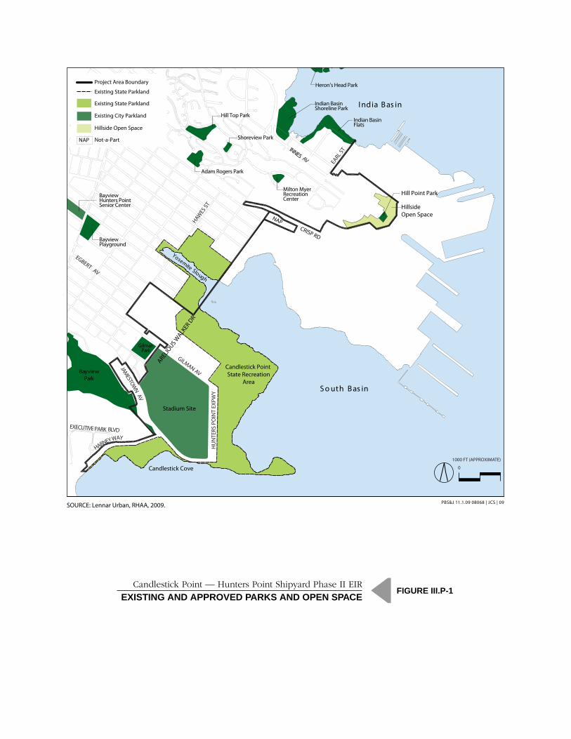
As shown in Figure III.P-1 (Existing and Approved Parks and Open Space) there are numerous existing
public parks and open spaces located within the Project site and in the nearby vicinity.
Resources on the Project Site
Two existing parks and recreational facilities, encompassing approximately 203 acres, are located within
the Candlestick Point site, as illustrated by Figure III.P-1. These existing parks include the CPSRA and
Candlestick Park (home of the existing 49ers stadium). There are no existing public open space areas at
the HPS Phase II site.
CPSRA
CPSRA (120.2 acres), on the shoreline of Candlestick Point, was acquired by the State in 1977 for
development as a State recreation area. The southern portion of the park is the most developed and
actively used area (totaling approximately 47 acres), while the northern areas are unimproved and
underutilized (totaling approximately 73 acres). The southern portions of the CPSRA include picnic
areas, a fitness course for seniors, a bike path, shoreline access to the Bay for water-dependent recreation,
and recreational trails (Photo 1). CPSRA land to the north and east of the Candlestick Park stadium is
currently used for stadium parking; this area total approximately 40 acres. Other portions of the CPSRA
site contain construction rubble and debris, such as the Last Rubble Pile Disposal Site (Photo 2). Until
recently, the Last Rubble area was characterized by large piles of rubble and debris, remnants of the site‘s
963 City of San Francisco General Plan, Recreation and Open Space Element, 1986. 964 Association of Bay Area Governments (ABAG), San Francisco Bay Trail Overview, 2008. http://www.abag.ca.gov/bayarea/baytrail/overview.html (accessed August 2, 2009).
NAPH
UN
TERS
PO
INT
EXPW
Y
Stadium Site
INNES AV EARL S
T
I ndia B as in
Yosemite Slough
HAWES
ST
EXECUTIVE PARK BLVD
GILMAN AV
GilmanPark
EGBERT AV
CRISP RD
Heron’s Head Park
Indian Basin Shoreline Park
BayviewPark
Candlestick Point State Recreation
Area
Bayview Playground
Adam Rogers Park
Milton MyerRecreation Center
Bayview Hunters Point Senior Center
Hill Point Park
Hillside Open Space
JAMESTOW
N AV
HARNEY WAY
S o uth B as in
ARELIO
US WALK
ER D
R
Candlestick Cove
Existing State Parkland
Existing State Parkland
Existing City Parkland
Project Area Boundary
Hillside Open Space
Hill Top Park
Shoreview Park
Indian Basin Flats
Not-a-Part NAP
Candlestick Point — Hunters Point Shipyard Phase II EIREXISTING AND APPROVED PARKS AND OPEN SPACE
FIGURE III P-1
SOURCE: Lennar Urban, RHAA, 2009. PBS&J 08068 | JCS | 09
1000 FT (APPROXIMATE)
0
SOURCE: Lennar Urban, RHAA, 2009.
Candlestick Point — Hunters Point Shipyard Phase II EIREXISTING AND APPROVED PARKS AND OPEN SPACE
FIGURE III.P-1
PBS&J 11.1.09 08068 | JCS | 09
III.P-4
Chapter III Environmental Setting, Impacts, and Mitigation Measures
Section III.P Recreation
Candlestick Point–Hunters Point Shipyard
Phase II Development Plan EIR
SFRA File No. ER06.05.07
Planning Department Case No. 2007.0946E
Draft EIR
November 2009
previous use as a dumping ground. The California Integrated Waste Management Board completed a
rubble and debris removal project in April 2009. As a result of this, the majority of the rubble and debris
was either removed or crushed on site. Yosemite Slough is part of the CPSRA, but is not within the
Project site.
The annual visitation for day use at CPSRA for 2007/2008 was reported as 15,200 paid day-use passes
and 200,283 free day-use visitors, for a total of 215,483965.
Candlestick Park
Candlestick Park (83 acres),966 is the site of the stadium owned by the SFRPD and leased by the San
Francisco 49ers National Football League team. The existing stadium, built in 1960, seats 70,000 and is
used for football games and other non-football entertainment events.
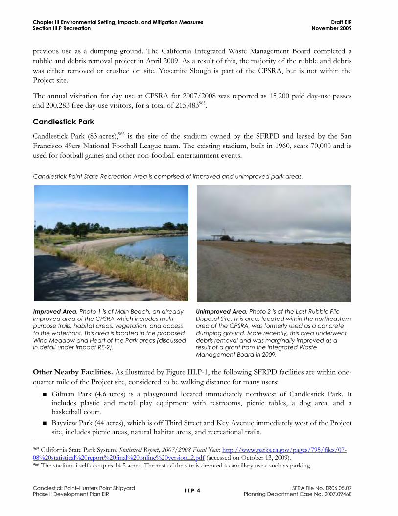
Candlestick Point State Recreation Area is comprised of improved and unimproved park areas.
Improved Area. Photo 1 is of Main Beach, an already
improved area of the CPSRA which includes multi-
purpose trails, habitat areas, vegetation, and access
to the waterfront. This area is located in the proposed
Wind Meadow and Heart of the Park areas (discussed
in detail under Impact RE-2).
Unimproved Area. Photo 2 is of the Last Rubble Pile
Disposal Site. This area, located within the northeastern
area of the CPSRA, was formerly used as a concrete
dumping ground. More recently, this area underwent
debris removal and was marginally improved as a
result of a grant from the Integrated Waste
Management Board in 2009.
Other Nearby Facilities. As illustrated by Figure III.P-1, the following SFRPD facilities are within one-
quarter mile of the Project site, considered to be walking distance for many users:
■ Gilman Park (4.6 acres) is a playground located immediately northwest of Candlestick Park. It includes plastic and metal play equipment with restrooms, picnic tables, a dog area, and a basketball court.
■ Bayview Park (44 acres), which is off Third Street and Key Avenue immediately west of the Project site, includes picnic areas, natural habitat areas, and recreational trails.
965 California State Park System, Statistical Report, 2007/2008 Fiscal Year. http://www.parks.ca.gov/pages/795/files/07-08%20statistical%20report%20final%20online%20version_2.pdf (accessed on October 13, 2009). 966 The stadium itself occupies 14.5 acres. The rest of the site is devoted to ancillary uses, such as parking.
III.P-5
Chapter III Environmental Setting, Impacts, and Mitigation Measures
Section III.P Recreation
Candlestick Point–Hunters Point Shipyard
Phase II Development Plan EIR
SFRA File No. ER06.05.07
Planning Department Case No. 2007.0946E
Draft EIR
November 2009
■ India Basin Shoreline Park (11.8 acres), on the India Basin Shoreline north of Innes Avenue, includes two children‘s playgrounds, picnic areas, shoreline access to the Bay for water-dependent recreation, and recreational trails.
■ India Basin Flats (also called India Basin Open Space) is unimproved SFRPD property on the Bay periphery of India Basin, northwest of the Project site, off of Innes Avenue. India Basin Flats consists of about 4.5 acres967 of public land (also referred to as ―India Basin Open Space‖, as indicated on Figure III.P-1, as well as additional, adjacent acreage that is privately held (and not indicated on Figure III.P-1).
■ Milton Myer Recreation Center at Kiska Road is a multipurpose facility with meeting spaces, an indoor gymnasium, outdoor game courts, and a children‘s playground.
■ New parks and open spaces (approximately 36 acres) are under development at the HPS Phase I site, adjacent to HPS Phase II.968 Those parks would provide passive open space, gathering areas, tot lots, trails, view terraces, and picnic facilities.
Other facilities (most of which are operated by the SFPRD) that are located beyond a quarter mile of the
Project site, but within approximately one-half-mile of the Project site, include the following:
■ LeConte Avenue Mini Park (0.5 acre) is adjacent to and west of Bayview Park (just west of the area shown on Figure III.P-1).
■ Bayview Playground (4.6 acres) is a children‘s playground on Third Street between Armstrong and Carroll Streets that also contains a pool and a softball field.
■ The Bayview Hunters Point Multipurpose Senior Center, at Yosemite Avenue and Third Street, offers a range of services and activities for seniors. The Senior Center is not operated by the SFPRD.
■ Heron‘s Head Park (24 acres), formerly known as Pier 98, is a restored wetland owned by the Port of San Francisco and used for research, education, afterschool activities, and natural habitat.
■ Other nearby parks also include Hill Top Park (3.4 acres), which includes grassy areas and walking paths; Adam Rogers Park (2.8 acres), which is just south of Hill Top Park, and contains a basketball court, a children‘s playground, a restroom, and a community garden; and Shoreview Park (0.5 acre), just east of Hill Top Park and on the opposite side of the Jedediah Smith School, contains a children‘s playground and an open grassy area. Shoreview Park is not operated by the SFPRD.
A number of other small neighborhood parks, playgrounds, and recreational facilities are located beyond
a half-mile of the Project site, but within zip code 94124 (east of I-280 and US-101). These include
Ridgetop Plaza (0.3 acre), Youngblood-Coleman Playground (6.1 acres), the Joseph Lee Recreation
Center (1.9 acres), the Palou-Phelps Mini-Park (3.6 acres), and the Silver Terrace Playground (5.5 acres).
While these uses are more than one-half mile from the Project site, they are accessible via direct street
connections and are not separated from the Project site by freeways or other physical barriers. Significant
other regional recreational resources and parks in the City include Golden Gate Park, Crissy Field, Lake
Merced Park, McLaren Park and the Presidio.
967 San Francisco Planning Department, Draft India Basin Shoreline Subarea Plan, June 2009. 968 San Francisco Redevelopment Agency, Phase I Disposition Development Agreement, Exhibit D (Public Open Space), 2001. http://www.sfgov.org/site/sfra_page.asp?id=5588 (accessed August 3, 2009). This parkland is expected to be available for use in 2012.

III.P-6
Chapter III Environmental Setting, Impacts, and Mitigation Measures
Section III.P Recreation
Candlestick Point–Hunters Point Shipyard
Phase II Development Plan EIR
SFRA File No. ER06.05.07
Planning Department Case No. 2007.0946E
Draft EIR
November 2009
Existing Users
People living and working in a specified area generate local demand for parks and recreational facilities.
The current population at Candlestick Point is about 1,113 persons (refer to Table III.C-1 [Existing
Population (2005)] in Section III.C [Population, Housing, and Employment]). As stated above, there are
a total of approximately 203 acres of existing parks (including the 83-acre stadium site) at the Project site.
The local population, however, does not have access to the stadium for general park and recreational use.
Therefore, based on a park estimate of 120.2 acres (203 acres less the 83-acre stadium), the existing ratio
of persons to acres of parkland is 108 acres per 1,000 residents, which is very high because the site is
primarily non-residential and includes the large CPSRA969.
III.P.3 Regulatory Framework
Federal
Land and Water Conservation Fund Act of 1965
The Land and Water Conservation Fund Act of 1965 (LWCFA) was enacted to assist in preserving,
developing and assuring accessibility to outdoor recreation resources and to strengthen the health and
vitality of US citizens. The LWCFA accomplishes these goals by providing funds and authorizing
assistance to states in planning, acquiring, and developing land and water areas and facilities, including
through the Land and Water Conservation Fund.
Land that has been acquired or developed with the assistance of the federally created Land and Water
Conservation Fund cannot be converted to uses other than public outdoor recreation without meeting
certain requirements. Any such conversion requires approval by the Secretary of the Interior to ensure
that substitute recreation lands of at least equal fair market value and reasonably equivalent usefulness
and location are provided. The California Park and Recreation Commission (CPRC) received three
LWCFA grants between 1979 and 1981 to assist with the development of trails, picnic areas, and other
amenities on approximately 35 acres of the CPSRA. The reconfiguration of the CPSRA, discussed
further below, would comply with the LWCFA. Compliance would require the determination of the fair
market value of any of these lands that the Project converts to uses other than public outdoor recreation
and the provision of replacement lands of at least equal fair market value and reasonably equivalent
usefulness and location.
State
Candlestick Point State Recreation Area General Plan
Refer to Section III.B regarding a description of the CPSRA General Plan and its application to the
Project. The following information about the CPSRA General Plan is related to the Recreation analysis. 969 This park-to-population ratio assumes a population of 1,113, as identified in Table III.C-1 (Existing Population [2005]) in Section III.C (Population, Housing, and Employment). The population of 1,113 correlates to the total number of households in the Traffic Analysis Zone, which includes more than the 256 households located in the Candlestick portion of the Project site (e.g., 292). It is likely, therefore, that the population within the Candlestick portion of the Project site is less than 1,113, which would only increase the existing park-to-population ratio.
III.P-7
Chapter III Environmental Setting, Impacts, and Mitigation Measures
Section III.P Recreation
Candlestick Point–Hunters Point Shipyard
Phase II Development Plan EIR
SFRA File No. ER06.05.07
Planning Department Case No. 2007.0946E
Draft EIR
November 2009
Conceptual land uses and facilities are shown on the CPSRA General Plan Land Use and Facilities map.
The Facilities Element lists the following types of recreational uses for the park: trails (hiking, jogging,
and bicycling), group picnic areas, family picnic areas, group campgrounds, fishing piers, wind surfing
facilities, a sand beach, a quiet area in the southeastern point, scenic overlooks, and a cultural program
center. Maritime facilities include a non-powered boat/wind surfing rental facility; a boating center for
boat classes and education; a boat access facility that includes a four-lane launching ramp; a 200-space
parking area for car-boat trailers; a boat service station; and a ferry landing. A family dinner restaurant
and family picnic rest stop are proposed for the Last Port area to the west of Hermit‘s Cove, off Harney
Way.
Current uses in the park include hiking, limited bicycling, day use picnicking, group picnicking, jogging,
nature viewing, three sand beaches, undeveloped windsurfing, two piers used daily by fishermen, and
three restroom buildings. The park also includes a park staff/maintenance facility, 140 parking spaces for
the developed portion of the park, and a community garden.
Some uses have been identified within the CPSRA as potential uses, although they have not been
implemented to date, including: group campgrounds; non-powered boat/wind surfing rental facility;
boating center; boat access facility that includes a four-lane launching ramp; ferry landing; boat service
center; family restaurant and family group rest stop at Harney Way. There is a boat trailer parking area;
however, it is not used for boating activities. Every use that has not been developed is still considered a
proposed use under the CPSRA General Plan.970 As such, the CPSRA General Plan has not been fully
realized.
As part of the current General Plan process, CDPR‘s planning staff will facilitate a public planning
process to solicit comments and feedback on any new improvements intended for the park. As such,
current design and planning elements described in this document represent a proposal. The proposed
vision for the park will undergo further review and is subject to change as a result of the General Plan
process.
San Francisco Bay Trail Plan
Refer to Section III.B regarding a description of the San Francisco Bay Trail Plan and its application to
the Project. The following information about the San Francisco Bay Trail Plan is related to the
Recreation analysis.
The Project would include the construction of the Bay Trail throughout the Project. It would support the
proposed waterfront trail connection route identified within a 2005 Gap Analysis Study prepared by
ABAG for the entire Bay Trail area for the purpose of identifying gaps in the Bay Trail, as well as
strategies to complete the Bay Trail system. Following implementation of the Project, the existing trail
south of the Project would ultimately connect to the existing northern trail along the India Basin
shoreline. The Bay Trail would be accessible for pedestrians and bicyclists with connections to the
existing and new parks, from the western boundary of Candlestick Point near the Harney Way/US-101
interchange, through the CPSRA, Yosemite Slough, and HPS Phase II shoreline to India Basin.
970 California Department of Parks & Recreation, 2009. Email communication with Steve Bachman, Senior Park & Recreation Specialist, September 16.
III.P-8
Chapter III Environmental Setting, Impacts, and Mitigation Measures
Section III.P Recreation
Candlestick Point–Hunters Point Shipyard
Phase II Development Plan EIR
SFRA File No. ER06.05.07
Planning Department Case No. 2007.0946E
Draft EIR
November 2009
Relevant recreation and trail policies from the Bay Trail Plan that apply to the Project with respect to trail
alignment and trail design are listed below:
■ Trail Alignment Policies
Ensure a feasible, continuous trail around the Bay.
Minimize impacts on and conflicts with sensitive environments.
Locate trail, where feasible, close to the shoreline.
Provide a wide variety of views along the Bay and recognize exceptional landscapes.
Investigate water trails as an enhancement to the trail system where necessary or appropriate.
In selecting a route for the trail, incorporate local agency alignments where shoreline trail routes have been approved. Incorporate San Francisco Bay Conservation and Development Commission public access trails where they have been required.
Where existing trails through wetlands are well-maintained and well-managed, the Bay Trail can feasibly be routed there. In these cases, trails should be used according to current regulations. Alternate routes should be provided where necessary and additional buffering/transition areas designed to protect wetland habitats should be provided where appropriate to protect wildlife.
In selecting a trail alignment, use existing stream, creek, slough and river crossings where they are available. This may require bridge widening in some locations. In selecting trail alignments, new stream, creek and slough crossings should be discouraged. Where necessary because acceptable alternatives do not exist, bridging may be considered.
In order to minimize the use of existing staging areas along the shoreline and to reduce the need for additional staging areas, the choice of trail alignment should take full advantage of available transit, including rail service (e.g., Caltrain, BART), ferries, and bus service.
■ Trail Design Policies
Creation of a regionwide hiking and bicycling trail system can be achieved if planning for all trail facilities takes full advantage of opportunities for connections to other existing and proposed recreational systems. The proposed Bay Trail connector trails, in particular, begin to create a regional network by programming links with the Bay Area Ridge Trail.
Wherever possible, new trails should be physically separated from streets and roadways to ensure the safety of trail users.
Create a trail that is as wide as necessary to accommodate safely the intended use, with separate alignments, where feasible, to provide alternative experiences.
Highlight the interpretive potential of certain trail segments, including opportunities for interpretation, education, rest and view enjoyment.
Incorporate necessary support facilities, using existing parks, parking lots, and other staging areas wherever possible.
Design new segments of trail to meet the highest practical standards and regulations, depending on the nature and intensity of anticipated use, terrain, existing regulations, and standards on existing portions of the trail.
Minimum and maximum standards by use, width, surface, etc. should be developed, to ensure safe enjoyment of the trail and compatibility with surroundings and existing facilities, and to encourage use and design of surfaces for which long-term maintenance will be cost-effective.
III.P-9
Chapter III Environmental Setting, Impacts, and Mitigation Measures
Section III.P Recreation
Candlestick Point–Hunters Point Shipyard
Phase II Development Plan EIR
SFRA File No. ER06.05.07
Planning Department Case No. 2007.0946E
Draft EIR
November 2009
Design and route the trail to discourage use of undesignated trails.
A consistent signing program should be established throughout the trail system, using a Bay Trail logo which will identify trails within the Bay Trail system as distinct from other connecting trails. The choice of materials used should be the concern of the individual implementing jurisdictions and agencies.
The Bay Trail signing program may include necessary cautionary and regulatory signing, including warnings of seasonal trail closings and other restrictions on trail use. Interpretive signing may be provided to help educate trail users about the surrounding environment and the importance of observing trail use restrictions and staying on designated trails.
The trailhead signing program may include a variety of information which will enhance the Bay Trail experience. This may include a description of the length and relative difficulty of the trail as a guide for trail users with mobility limitations, available support facilities, available access to other connecting trails, and a description of the habitat resource which emphasizes interpretive information as well as the need to observe posted trail use restrictions.
San Francisco Bay Plan
Refer to Section III.B regarding a description of the San Francisco Bay Plan and its application to the
Project. The following information about the San Francisco Bay Plan is related to the Recreation analysis.
Recreation-related objectives and policies of the Bay Plan are contained in Part IV—Development of the
Bay and Shoreline: Findings and Policies: Recreation objectives and policies that are relevant to the
Recreation analysis emphasize the creation of diverse and accessible water-oriented recreational facilities,
such as marinas, launch ramps, beaches, and fishing piers. Such facilities should be provided to meet the
needs of a growing and diversifying population, and should be well distributed around the Bay and
improved to accommodate a broad range of water-oriented recreational activities for people of all races,
cultures, ages, and income levels. Recreational facilities, such as waterfront parks, trails, marinas, live-
aboard boats, non-motorized small boat access, fishing piers, launching lanes, and beaches, should be
encouraged and allowed by the Commission, provided they are located, improved and managed
consistent with BCDC policies. Waterfront parks should emphasize hiking, bicycling, riding trails, picnic
facilities, swimming, environmental, historical and cultural education and interpretation, viewpoints,
beaches, and fishing facilities.
San Francisco General Plan
The Recreation and Open Space Element of the San Francisco General Plan contains several policies
pertaining to the development of parks and recreational facilities. The following policies are relevant to
the development proposed under the Project:
Objective 1 Preserve large areas of open space sufficient to meet the long-range needs of the Bay region.
Policy 1.1 Protect the natural character of regional open spaces and place high priority on acquiring open spaces noted for unique natural qualities.
Objective 2 Develop and maintain a diversified and balanced citywide system of high-quality open space.

III.P-10
Chapter III Environmental Setting, Impacts, and Mitigation Measures
Section III.P Recreation
Candlestick Point–Hunters Point Shipyard
Phase II Development Plan EIR
SFRA File No. ER06.05.07
Planning Department Case No. 2007.0946E
Draft EIR
November 2009
Policy 2.1 Provide an adequate total quantity and equitable distribution of public open spaces throughout the City.
Policy 2.2 Preserve existing public open space.
Policy 2.7 Acquire additional open space for public use.
Policy 2.8 Develop a recreational trail system that links city parks and public open space, ridgelines and hilltops, the Bay and ocean, and neighborhoods, and ties into the regional hiking trail system.
Objective 3 Provide continuous public open space along the shoreline unless public access clearly conflicts with maritime uses of other uses requiring a waterfront location.
Policy 3.1 Assure that new development adjacent to the shoreline capitalizes on its unique waterfront location, considers shoreline land use provisions, improves visual and physical access to the water, and conforms to urban design policies.
Policy 3.2 Maintain and improve the quality of existing shoreline open space.
Policy 3.3 Create the Bay and Coastal Trails around the perimeter of the City which links open space along the shoreline and provides for maximum waterfront access.
Policy 3.5 Provide new public open spaces along the shoreline.
Objective 4 Provide opportunities for recreation and the enjoyment of open space in every San Francisco neighborhood.
Policy 4.3 Renovate and renew the City‘s parks and recreation facilities.
Policy 4.4 Acquire and develop new public open space in existing residential neighborhoods, giving priority to areas which are most deficient in open space.
Policy 4.6 Assure the provision of adequate public open space to serve new residential development.
Policy 4.7 Provide open space to serve neighborhood commercial districts.
III.P.4 Impacts
Significance Criteria
The City and Agency have not formally adopted significance standards for impacts related to recreation,
but generally consider that implementation of the Project would have significant impacts if it were to:
P.a Increase the use of existing neighborhood and regional parks or other recreational facilities such that substantial physical deterioration or degradation of the facilities would occur or be accelerated
P.b Result in substantial adverse physical impacts associated with the provision of, or the need for, new or physically altered park or recreational facilities, the construction of which could cause

III.P-11
Chapter III Environmental Setting, Impacts, and Mitigation Measures
Section III.P Recreation
Candlestick Point–Hunters Point Shipyard
Phase II Development Plan EIR
SFRA File No. ER06.05.07
Planning Department Case No. 2007.0946E
Draft EIR
November 2009
significant environmental impacts, in order to maintain acceptable service ratios, or other performance objectives971
P.c Include recreational facilities or require the construction or expansion of recreational facilities, which might have an adverse physical effect on the environment
P.d Adversely affect existing recreational opportunities
Analytic Method
The Project would provide a wide variety of new and improved parks and open space areas. The Project
also proposes an agreement between the CDPR and the City or the Agency to reconfigure the
boundaries of CPSRA, which would also result in improvements to the CPSRA. The potential impacts of
the proposed agreement are analyzed in Impact RE-3.
The analysis below considers the increase in use that would be generated by the Project and the ability of
existing facilities (many of which will be improved by the Project) and new open space that would be
provided by the Project to meet that demand. The analysis considers whether an increase in use would
result in the substantial physical deterioration of existing recreational facilities (e.g., disturbance of
vegetation, accelerated wear on sports facilities and fields, erosion along trails, and an increased potential
for increased graffiti and litter) or in the need for new or expanded facilities. The analysis further
considers whether the Project would diminish or otherwise adversely affect recreational opportunities at
the existing facilities (chiefly CPSRA) on the Project site. The analysis of construction impacts associated
with the development of proposed new parks and recreational facilities, which are considered as part of
the overall Project, draws on conclusions in other sections of this EIR.
The analysis uses a parkland-to-population ratio to measure demand for recreational facilities. If demand
is excessive, then use could result in or accelerate substantial physical deterioration of facilities, or could
require the construction of further facilities. If, on the other hand, demand is within an acceptable range,
then use will not lead to such impacts. The City does not have an adopted parkland-to-population ratio
standard. In the past, the National Parks and Recreation Association has recommended a parkland-to-
population ratio as high as 10 acres per 1,000 population. As noted in the Recreation and Open Space
Element of the City General Plan, however, ―[g]iven the City's existing development patterns, high
population density, and small land mass (28,918 acres), [this] standard will not be possible to achieve
within the City limits.‖ The General Plan goes on to state that ―to the extent it reasonably can, the City
should increase the per capita supply of public open space within the City‖ from the parkland-population
ratio at the time of the General Plan‘s adoption (1986), 5.5 acres per 1,000 residents. This analysis will,
therefore, use the 5.5 ratio as a benchmark: a ratio of 5.5 acres of parkland per 1,000 population is
sufficient to meet demand for recreational facilities without causing or accelerating substantial physical
deterioration of facilities or requiring the construction of further facilities.
This standard is consistent with, and in fact provides for more parkland than, other commonly used
standards. For example, the state‘s Quimby Act allows jurisdictions to select a standard from 3 to 5 acres
of parkland per 1,000 residents when imposing a parkland mitigation requirement. Other nearby Bay
971 Thresholds P.a and P.b are discussed together.

III.P-12
Chapter III Environmental Setting, Impacts, and Mitigation Measures
Section III.P Recreation
Candlestick Point–Hunters Point Shipyard
Phase II Development Plan EIR
SFRA File No. ER06.05.07
Planning Department Case No. 2007.0946E
Draft EIR
November 2009
Area jurisdictions (e.g., the City of Palo Alto and the City of Menlo Park) use a standard of 5 acres per
1,000 residents.
The Project‘s potential contribution to cumulative park and recreation impacts, if any, are also evaluated
in the context of existing, proposed, and reasonably foreseeable future development expected in the City.
Construction Impacts
Impact RE-1: Construction of Parks, Recreational Uses, and Open Space
Impact RE-1 Construction of the parks, recreational uses, and open space proposed by the Project would not result in substantial adverse physical environmental impacts beyond those analyzed and disclosed in this EIR. (Refer to the various sections identified in this impact discussion) [Criterion P.c]
The Project includes the construction and improvement of substantial new parks, recreational facilities,
and open space. At build-out, the Project would include approximately 336 acres of parks and open
space as described in Table III.P-1 (Proposed Parks and Open Space) and illustrated by Figure III.P-2
(Proposed Park and Open Space). Candlestick Point would include approximately 104.8 acres of parks
and open space, including the CPSRA; HPS Phase II would include approximately 231.6 acres of parks
and open space.
Development of the parks and recreational facilities would require construction activities, which could
vary depending the location and type of work. If existing structures are located on identified park sites,
such structures could require demolition. Sites would be cleared and graded and construction of these
new parks could include installation of utilities (electrical, water, sanitary sewer, and storm drainage);
hardscape (e.g., concrete, asphalt, stone, walls, sport-court and play area surfacing, decking/boardwalks);
new or renovated site structures (e.g., restrooms, picnic/shade shelter‘s, kiosks, pavilions, overlooks,
piers); and site furnishings (e.g., benches, picnic tables, drinking fountains, play equipment, fencing,
artwork, lighting). The installation of shoreline protection features would also occur, where necessary.
Site planting would include installation of irrigation systems and would focus on re-vegetation and
restoration of native plant communities, where possible, and may include creation of new saltwater and
freshwater habitats. Open space areas would generally not require extensive construction activities, but
could require re-vegetation, the creation of trails, and other non-invasive activities.
Construction activities associated with the proposed parks and recreational facilities are considered part
of the overall Project. A discussion of project-related construction impacts, including those associated
with the construction of parks and recreational facilities, is provided in the applicable sections of this
EIR, including Section III.D (Transportation and Circulation), Section III.H (Air Quality), Section III.I
(Noise), Section III.J (Cultural Resources and Paleontological Resources), Section III.K (Hazards and
Hazardous Materials), and Section III.M (Hydrology and Water Quality). Construction impacts would be
temporary. While it is likely that construction of the various park and recreational facilities identified in
Table III.P-1 would not result in significant impacts (either individually or combined), construction of
the entire development program, of which the parks and recreational facilities are a part, would result in
significant and unavoidable impacts related to construction noise and demolition of an historic resource;

III.P-13
Chapter III Environmental Setting, Impacts, and Mitigation Measures
Section III.P Recreation
Candlestick Point–Hunters Point Shipyard
Phase II Development Plan EIR
SFRA File No. ER06.05.07
Planning Department Case No. 2007.0946E
Draft EIR
November 2009
Table III.P-1 Proposed Parks and Open Space
Location Acres
CANDLESTICK POINT
New Parks
Alice Griffith Neighborhood Park 1.4
Candlestick Point (North) Neighborhood Park 3.1
Bayview Gardens/Wedge (Destination) Park 2.5
(Candlestick Point South) Mini-Wedge Park 1.1
Subtotal 8.1
New and Improved State Parkland (CPSRA)a
The Last Port (includes 0.4 acre of new State parkland) 14.6
The Neck (includes 3.8 acres of new State parkland) 4.9
The Heart of the Park (includes 1.5 acres of new State parkland) 15.4
The Point 6.1
Wind Meadow 11.4
The Last Rubble 24.5
Bayview Gardens North 9.5
Grasslands South 10.3
Subtotal 96.7
Total 104.8
HUNTERS POINT SHIPYARD PHASE II
New Parks
Northside Park 12.8
Waterfront Promenade 29.5
Heritage Park 15.6
Grasslands Ecology Park at Parcel E 44.9
Grasslands Ecology Park at Parcel E-2 37.2
Subtotal 140.0
New Sports Fields and Active Urban Recreation
Sports Field Complex / Game Day Stadium Parking 59.7
Waterfront Recreation Area 6.7
Multi-use lawn 25.2
Subtotal 91.6
Total 231.6
TOTAL PARKS AND OPEN SPACE
New Parks 148.1
New Sports Fields and Active Urban Recreation 91.6
New and Improved State Parkland 96.7
Total 336.4
SOURCE: Lennar Urban, 2009
a. The 120.2-acre CPSRA would be reduced by 29.2 acres, and increased by 5.7 acres for a net reduction of 23.5 acres. The Neck,
The Heart of the Park, and The Last Port are the three locations where new State Park Land would be added.

Candlestick Point — Hunters Point Shipyard Phase II EIRPROPOSED PARKS AND OPEN SPACE
FIGURE III P-2
SOURCE: Lennar Urban, RHAA, 2009. PBS&J 08068 | JCS | 09
1000 FT (APPROXIMATE)
0
NAP
1
65
7
4
8
2
3
8
Northside Park
Waterfront Promenade
Heritage Park
Multi-use Lawn
Boulevard Parks
Neighborhood Park
CP Neighborhood Park
Bayview Gardens/ Wedge Park
Mini-Wedge Park
Yosemite Slough Bridge
Boulevard ParksOpen Space
Dual Use Sports Field Complex
INNES AV
EARL S
T
SPEAR AV
India Bas in
Yosemite Slough
So uth Bas in
Candlestick Cove
HAWES
ST
EXECUTIVE PARK BLVD
GILMAN AV
WALK
ER D
R
ARELIO
US
BayviewPark
EGBERT AV
CRISP RD
Grasslands EcologyPark
Bay Naturalized Landscape
Mar
ina
Waterfront Recreation Area
JAMESTOW
N AV
Hillside Parks &
HARNEY WAY
Waterfront Promenade
Hillside Park & Open Space
1 Grasslands South2 Bayview Gardens North3 The Last Rubble4 Wind Meadow5 Heart of the Park6 The Point7 The Neck8 Last Port
Proposed Parks
Proposed Sports Fields and Recreation
Proposed State Parkland
Improved State Parkland
Hillside Parks & Open Space
Existing Bay Trail
Proposed Bay Trail
Not-a-Part NAP
Project Boundary
Candlestick Point — Hunters Point Shipyard Phase II EIR
PROPOSED PARKS AND OPEN SPACEFIGURE III P-2
SOURCE: Lennar Urban, RHAA, 2009. PBS&J 08068 | JCS | 09SOURCE: Lennar Urban, RHAA, 2009. PBS&J 11.1.09 08068 | JCS | 09
Candlestick Point — Hunters Point Shipyard Phase II EIRPROPOSED PARKS AND OPEN SPACE
FIGURE III.P-2
III.P-15
Chapter III Environmental Setting, Impacts, and Mitigation Measures
Section III.P Recreation
Candlestick Point–Hunters Point Shipyard
Phase II Development Plan EIR
SFRA File No. ER06.05.07
Planning Department Case No. 2007.0946E
Draft EIR
November 2009
all other construction-related impacts would be less than significant (in some cases, with implementation
of identified mitigation). Refer to Section III.D, Section III.H, Section III.I, Section III.J, Section III.K,
and Section III.M for the specific significance conclusions for construction-related effects.972
In addition, and as further discussed in Impact RE-2 and the cumulative impact analysis, the Project
would provide adequate parks, recreational facilities, and open space to accommodate the expected
increase in demand resulting from the Project and cumulative development. No further construction
would be required beyond that proposed by the Project.
Operational Impacts
Impact RE-2: Deterioration or Degradation of Existing Parks and Recreational
Facilities
Impact RE-2 Implementation of the Project would not increase the use of existing parks and recreational facilities that would cause the substantial physical deterioration of the facilities to occur or to be accelerated, nor would it result in the need for, new or physically altered park or recreational facilities. (Less than Significant with Mitigation) [Criterion P.a]
The Project would bring new residents to the Project site and increase the use of existing parks and
recreational facilities, but it would also provide substantial new parks and recreational facilities, improve
existing facilities, and provide long-term funding for operation and maintenance.
At build-out of the Project, the projected population within the Project site would increase from
approximately 1,113 to approximately 24,465 residents, and employment would increase from 529 to
approximately 10,730 jobs (refer to Section III.C of this EIR). The increase in population and
employment would likely result in an increase in the use of existing parks, recreational facilities, and open
space. However, new and improved parks, recreational facilities, and open space would be provided as
part of the Project to offset the increase in demand on existing parks and open space areas created by the
Project‘s new residents and employees. In fact, a total of 336.4 acres of parks, recreational facilities, and
open space would be provided at the Project site, consisting of 239.7 acres of new parks, sports fields,
and active urban recreation uses, and 96.7 acres of existing and improved parkland at the CPSRA.973
This analysis first identifies the proposed new facilities, and then analyzes whether the increase in the use
of parks would lead to the substantial physical deterioration or degradation of existing and proposed
facilities or result in the need for new or expanded facilities.
972 The impact statements provided in each technical section of the EIR differentiate between construction impacts and operational or development impacts, and all identified mitigation measures are contained in the impact analyses. In addition, Table ES-2 in the Executive Summary of this EIR also summarizes all impact statements, the level of significance before mitigation, any identified mitigation measures, and the level of significance after mitigation. 973 For comparison purposes, the Project‘s proposed 336.4 acres of parks and open space would be greater than the 141.5 acres of public open space that was to be provided under the Hunters Point Shipyard Reuse Plan Final EIR (June 2000).

III.P-16
Chapter III Environmental Setting, Impacts, and Mitigation Measures
Section III.P Recreation
Candlestick Point–Hunters Point Shipyard
Phase II Development Plan EIR
SFRA File No. ER06.05.07
Planning Department Case No. 2007.0946E
Draft EIR
November 2009
Proposed New Facilities
Overall, the Project would provide a substantial increase in the amount of developed, useable, high-
quality parks, recreational facilities, and open space within the Project site. The Project would create a
continuous network of interconnected recreational opportunities, promoting the use of the existing
parks, such as the CPSRA, as well as the 239.7 acres of new parks, sports fields, and active urban
recreation uses. The Project would provide a network of pedestrian and bike pathways that would
connect Project uses to the adjacent neighborhoods and would ensure unrestricted public access to the
parks and open space on the Project site and the Bay shoreline. Enhanced connectivity of on-site and
off-site facilities and new neighborhood parks would allow integration of new and existing facilities into
the citywide park network. The proposed bicycle and pedestrian pathways would facilitate dispersal of
future demand, which would help to reduce the potential for localized physical deterioration. The
improved connectivity would also direct regional users to proposed ―destination‖ parks, parks designed
to accommodate regional demand. In addition, the Project would provide a continuous series of
waterfront parks from the northernmost part of HPS Phase II to the southernmost part of Candlestick
Point.
In addition, proposed recreational facilities, such as paved athletic courts, plazas, and picnic areas, would
also support a large number of users within a relatively small area. Recreational facilities proposed for the
Project site also include a Sports Field Complex that would provide soccer/football, baseball, and
volleyball fields, as well as warm-up fields, restrooms, and food concessions. The parking area for the
Sports Field Complex would support parking during stadium events, but would be covered with specially
engineered soils and turf to allow dual-use of the parking lot for athletic fields. Recreational facilities
would also include a mix of active and passive areas of open lawns, dog runs, play areas, community
gardens, and court games. Moreover, improved park facilities would provide a waterfront promenade,
ecological open space areas, concessions, restrooms, and other uses that would allow the site to support a
large service population.
The discussion below identifies the specific new facilities that are planned within Candlestick Point and
HPS Phase II. These facilities are also identified in Table III.P-1, above, and shown on Figure III.P-2.
Some features, such as the Bay Trail improvements, span both areas of the Project site.
Candlestick Point
Candlestick Point would include an extensive network of parks, ranging from the CPSRA to smaller
parks distributed throughout the neighborhood. The Candlestick Point parks would be connected to
other neighborhoods and open spaces by way of pedestrian-friendly green streets.
■ The 1.4-acre Alice Griffith Neighborhood Park would extend for several blocks near the center of the neighborhood as an extension of Egbert Avenue.
■ Candlestick Point North would include a 3.1-acre Candlestick Point Neighborhood Park in the center of the district.
■ The 1.1-acre Mini-Wedge Park in the Candlestick Point South district would serve as a primary connector between Candlestick Point and the CPSRA beach area.
■ The Bayview Gardens/Wedge Park (2.5 acres) would serve as the ‗commons‘ for the Candlestick Point development and link the residences to the CPSRA through an expansive view corridor.

III.P-17
Chapter III Environmental Setting, Impacts, and Mitigation Measures
Section III.P Recreation
Candlestick Point–Hunters Point Shipyard
Phase II Development Plan EIR
SFRA File No. ER06.05.07
Planning Department Case No. 2007.0946E
Draft EIR
November 2009
Specific programming would include an ecological garden, a main plaza, passive lawns, bioswale stormwater retention, and tot lots.
These parks would be connected to other neighborhoods and open spaces within the community by way
of pedestrian-friendly green streets.
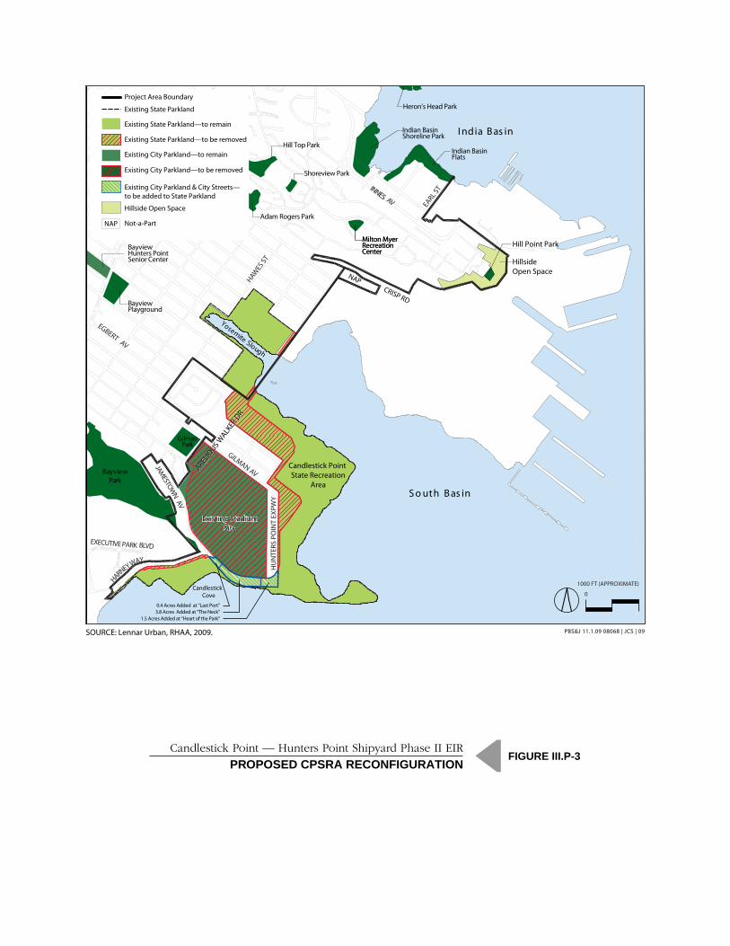
Candlestick Point State Recreation Area
Senate Bill 792 (SB 792) (refer to Appendix P2 [SB 792]) was signed by the Governor on October 11,
2009, and is codified as Chapter 203 of the Statutes of 2009. SB 792 repeals the Hunters Point Shipyard
Conversion Act of 2002, the Hunters Point Shipyard Public Trust Exchange Act, and Public Resources Code
Section 5006.8, and consolidates the key provisions of those statutes into a statute covering both the
Candlestick Point area and HPS. The statute authorizes a reconfiguration of CPSRA coupled with
improvements within the park and the provision of an ongoing source of park operation and
maintenance funding. The proposed reconfiguration would remove about 29.2 acres from the current
boundaries of CPSRA to be used for urban development, but would add about 5.7 acres not currently
included in the CPSRA to The Neck, The Heart of the Park, and The Last Port areas of the CPSRA.
These additional acres would widen the park in an area where the CPSRA boundary currently runs very
close to the shoreline, creating a very narrow ―pinch point‖ in the park. The additional acreage would
thus create a buffer between development and the shoreline and improve the recreational value of this
section of the park. In total, the area of the CPSRA (excluding the Yosemite Slough) would decrease by
about 23.5 acres at the Candlestick Point site, from 120.2 acres to 96.7 acres. Table III.P-2 (Proposed
Candlestick Point State Parks Land Agreement) presents the acreage of the areas proposed to be added
to and removed from the park. Figure III.P-3 (Proposed CPSRA Reconfiguration) illustrates the area of
CPSRA and City parkland to remain or to be removed, and the amount of CPSRA parkland to be added.
Table III.P-2 Proposed Candlestick Point State Parks Land Agreement
Candlestick Point
(acres)
Existing State Parkland at Candlestick Point 120.2
Area removed from State Parkland (29.2)
Area added to State Parkland 5.7
Proposed State Parkland at Candlestick Point 96.7
SOURCE: Lennar Urban, 2009.
The portion of the park that is currently undeveloped or used for Candlestick Park stadium parking
would be substantially improved to enhance overall park aesthetics and landscape ecology; reconnect
visitors to the bay shoreline; and provide direct access to the bay for swimming, fishing, kayaking, and
windsurfing. Proposed improvements include revegetation and landscaping, shoreline restoration and
stabilization, infrastructure improvements (such as trails, pathways, and visitor facilities), a biofiltration
pond to cleanse stormwater, the provision of habitat and opportunities for environmental education,
‗Eco-Gardens,‘ and salt-marsh restoration. Although there would be a net decrease in the total area of
the CPSRA, the recreational value of the new land with the improvements would increase the area‘s
value.
NAP
Adam Rogers Park
Milton MyerRecreation Center
Hill Top Park
Shoreview Park
HU
NTE
RS P
OIN
T EX
PWY
Existing StadiumSite
Existing StadiumSite
INNES AV EARL S
T
Yosemite Slough
HAWES
ST
EXECUTIVE PARK BLVD
GILMAN AV
GilmanPark
EGBERT AV
CRISP RD
BayviewPark
Candlestick Point State Recreation
Area
Bayview Playground
Milton MyerRecreation Center
Bayview Hunters Point Senior Center
Hill Point Park
Hillside Open Space
JAMESTOW
N AV
HARNEY WAY
S o uth B as in
ARELIO
US WALK
ER D
R
ARELIO
US WALK
ER D
R
Candlestick Cove
I ndia B as in
Heron’s Head Park
Indian Basin Shoreline Park
Indian Basin Flats
0.4 Acres Added at “Last Port”
1.5 Acres Added at “Heart of the Park”3.8 Acres Added at “The Neck”
Existing State Parkland
Existing State Parkland—to be removed
Existing State Parkland—to remain
Existing City Parkland—to remain
Existing City Parkland—to be removed
Existing City Parkland & City Streets—to be added to State Parkland
Project Area Boundary
Hillside Open Space
Not-a-PartNAP
Candlestick Point — Hunters Point Shipyard Phase II EIRPROPOSED PARKS LAND AGREEMENT
FIGURE III P-3
SOURCE: Lennar Urban, RHAA, 2009. PBS&J 08068 | JCS | 09
1000 FT (APPROXIMATE)
0
SOURCE: Lennar Urban, RHAA, 2009. PBS&J 11.1.09 08068 | JCS | 09
Candlestick Point — Hunters Point Shipyard Phase II EIRPROPOSED CPSRA RECONFIGURATION
FIGURE III.P-3

III.P-19
Chapter III Environmental Setting, Impacts, and Mitigation Measures
Section III.P Recreation
Candlestick Point–Hunters Point Shipyard
Phase II Development Plan EIR
SFRA File No. ER06.05.07
Planning Department Case No. 2007.0946E
Draft EIR
November 2009
Specific areas of improvements in the CPSRA are discussed below. The discussion is presented to
provide an overview of the conceptual design that is currently proposed. However, the ultimate
configuration of each of these areas would be at the discretion of the California Department of Parks
and Recreation through the ongoing planning process for the CPSRA.
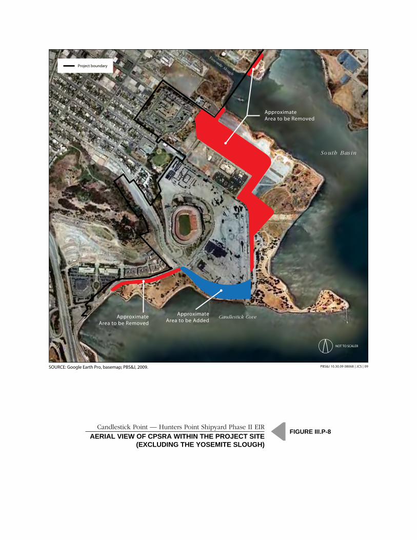
Figure III.P-4 (Photographs of Existing CPSRA—Areas 1 and 2) through Figure III.P-7 (Photographs of
Existing CPSRA—Areas 7 and 8) provide a representative photograph of each of the eight designated
areas within the CPSRA that are described below (and illustrated by Figure III.P-2). Figure III.P-8 (Aerial
View of CPSRA within the Project Site [Excluding the Yosemite Slough]) shows the existing unimproved
and improved areas of the CPSRA and indicates where land would be removed or added relative to the
existing CPSRA uses.
The Last Port
The area known as the ―Last Port‖ (south of Harney Way) is presently designated within the CPSRA
General Plan for a dinner restaurant, a family picnic rest stop, a parking area, trails, and native trees and
shrubs with open grassy areas. Current facilities here include trails, parking, family picnic areas, and a
restroom building. Landscape features include open meadow areas, berms planted with trees and shrubs,
and a beach. The Project proposes changes to the CPSRA boundary in this area to add approximately
0.4 acre of additional land. In addition, the Last Port and The Neck would include a new beach area
(refer to Figure II-21 [Natural Shoreline Recommended Work Map]).
The Project‘s landscape improvements for the ―Last Port‖ area would focus on pedestrian circulation,
safety, and wayfinding; intensifying areas for increased use; improving the overall park aesthetics and
landscape ecology; and providing new overlooks and connections to follow the bay shoreline. Native
grasslands and shorelines would be restored and stabilized, providing areas for activities such as strolling,
picnics, kite flying, fishing, and direct access to implementation of the bay for swimming, kayaking, and
windsurfing.
The Neck
The area known as ―The Neck‖ is a narrow strip of land south of Jamestown Avenue between Harney
Way and Hunters Point Expressway. This area is presently designated in the CPSRA General Plan for
native trees and shrubs with open grassy areas, trails, picnicking, fishing, and windsurfing. Currently, a
pier provides access for fishing and windsurfers use this area as a launching point, although no formal
facilities for windsurf launching or lay-down areas are currently provided. The Project proposes
reconfiguring the CPSRA boundary here to provide approximately 3.8 acres of additional land and a
wider park along the shoreline, including a new beach area. Project facilities would include trails and
overlooks, a parking lot, picnic areas, and a windsurf lay-down and launch area.
The Heart of the Park
The area known as ―The Heart of the Park‖ is located south of the main park entry on Hunters Point
Boulevard to the isthmus that connects to ―The Point.‖ This area is presently designated in the CPSRA
General Plan for native trees and shrubs with open grassy areas, trails parking, picnicking, fishing,
windsurfing, park administration, and restroom facilities. Existing facilities include the main vehicular

Area 1: Grasslands South
PBS&J 10.30.09 08068 | JCS | 09SOURCE: PBS&J, 2009.
Candlestick Point — Hunters Point Shipyard Phase II EIRPHOTOGRAPHS OF EXISTING CPSRA – AREAS 1 AND 2
FIGURE III.P-4
Area 2: Bayview Gardens North
1
2
Proposed CPSRA
Proposed CPSRA

Area 3: The Last Rubble
PBS&J 10.30.09 08068 | JCS | 09SOURCE: PBS&J, 2009.
Candlestick Point — Hunters Point Shipyard Phase II EIRPHOTOGRAPHS OF EXISTING CPSRA – AREAS 3 AND 4
FIGURE III.P-5
Area 4: Wind Meadow
3
4
Proposed CPSRA
Proposed CPSRA

Area 5: Heart of the Park
PBS&J 10.30.09 08068 | JCS | 09SOURCE: PBS&J, 2009.
Candlestick Point — Hunters Point Shipyard Phase II EIRPHOTOGRAPHS OF EXISTING CPSRA – AREAS 5 AND 6
FIGURE III.P-6
Area 6: The Point
5
6
Proposed CPSRA
Proposed CPSRA

Area 7: The Neck
PBS&J 10.30.09 08068 | JCS | 09SOURCE: PBS&J, 2009.
Candlestick Point — Hunters Point Shipyard Phase II EIRPHOTOGRAPHS OF EXISTING CPSRA – AREAS 7 AND 8
FIGURE III.P-7
Area 8: Last Port
7
8
Proposed CPSRA
Proposed CPSRA
NOT TO SCALER
SOURCE: Google Earth Pro, basemap; PBS&J, 2009.
Candlestick Point — Hunters Point Shipyard Phase II EIRAERIAL VIEW OF CPSRA WITHIN THE PROJECT SITE
(EXCLUDING THE YOSEMITE SLOUGH)
FIGURE III.P-8
PBS&J 10.30.09 08068 | JCS | 09
Yosemite Slough
So uth Bas in
Candlestick CoveApproximate
Area to be AddedApproximate
Area to be Removed
ApproximateArea to be Removed
Project boundary
III.P-25
Chapter III Environmental Setting, Impacts, and Mitigation Measures
Section III.P Recreation
Candlestick Point–Hunters Point Shipyard
Phase II Development Plan EIR
SFRA File No. ER06.05.07
Planning Department Case No. 2007.0946E
Draft EIR
November 2009
entrance and kiosk, parking lots, trails, three restrooms buildings, and group and family picnic areas.
Landscape features include open meadow areas, berms planted with trees and shrubs, and a sandy beach.
The Project proposes changes to the CPSRA boundary in this area to add approximately 1.5 acres of
additional land. The Project would retain and enhance much of the existing landscape structure. Planting
and overall aesthetics would be improved, pedestrian pathways would be renovated and added, and
program areas would be developed for greater use. Improvements are proposed to existing restrooms,
picnic areas, and trails. Additionally, new overlooks, an interpretive amphitheater, and reconfigured park
entrance and parking facilities are proposed.
The Point
The area known as ―The Point‖ is located at the end of the peninsula at the southeastern portion of the
park. This area is presently designated in the CPSRA General Plan as a ―quiet area‖ with native trees and
shrubs and open grassy areas, trails, family picnic areas, a fishing pier, and a restroom building. The
Project proposes to revitalize the existing site with improvements focused on pedestrian circulation,
safety, and wayfinding; intensifying areas for increased use; improving the overall park aesthetics and
landscape ecology; and reconnecting visitors to the bay shoreline. Native grasslands and shorelines would
be restored and stabilized and new overlook points are proposed.
Wind Meadow
The area known as ―The Phase 4 Area‖ in the CPSRA General Plan would become the ―Wind Meadow‖
after the Project‘s proposed CPSRA boundary changes. It is presently designated in the CPSRA General
Plan for native trees and shrubs with open grassy areas, trails, parking, picnicking, restrooms, and a
Cultural Program Center. Additionally, a theater is designated to accommodate a wide variety of events
such as dance, music, and theater. The CPSRA General Plan also describes children‘s play areas, a
kitchen, and food concession for this area. Existing development in this area is limited to landscape
features, such as sculptural earthwork and walls, trails, grassland and overlooks. This area is currently
used for strolling, dog-walking, fishing, and bird watching and is the home of ―Main Beach‖ (illustrated
by Photo 1 in this section). Proposed features here would include new trails, restrooms, picnic areas,
restored natural landscape areas, waterfront overlooks, and access to the water.
The Last Rubble
Until recently, the Last Rubble area was characterized by large piles of rubble and debris, remnants of the
site‘s previous use as a dumping ground. The California Integrated Waste Management Board completed
a rubble and debris removal project in April 2009. As a result of this, the majority of the rubble and
debris was either removed or crushed on site. The Last Rubble area is designated in the CPSRA General
Plan for native trees and shrubs with open grassy areas, trails, and overlooks. The area currently contains
crushed concrete rubble, trails, and a mix of native and non-native grassland and shrubland (refer to
Photo 2). The area is used for strolling, dog-walking, and bird-watching. The Project proposes changes to
the CPSRA boundary in this area. It would be transformed into a new center for the CPSRA, with a wide
variety of new program elements. The park ranger station/visitor‘s center would be located here, as well
as a ―Great Meadow‖ for passive recreational activities. In addition, The Last Rubble would contain a
new beach area and marshland (refer to Figure II-21). Other features here may include parking, picnic
areas, overlook terraces, restrooms, and a restaurant/café.

III.P-26
Chapter III Environmental Setting, Impacts, and Mitigation Measures
Section III.P Recreation
Candlestick Point–Hunters Point Shipyard
Phase II Development Plan EIR
SFRA File No. ER06.05.07
Planning Department Case No. 2007.0946E
Draft EIR
November 2009
Bayview Gardens North
This area, which is also known as the ―Boat Launch,‖ is currently used for stadium parking. It would be
transformed by the Project into ―Bayview Gardens North.‖ It is presently designated in the CPSRA
General Plan for group camping, trails, native trees and shrubs with open grassy areas, and a boat dock
for group camps. Currently, the Boat Launch area includes an unused boat ramp, parking lot, and
restroom building. Landscape features here include shoreline with riprap and pockets of wetland
vegetation. Located between the Bay and the proposed Bayview Gardens/Wedge Park, the Bayview
Gardens North area would offer the greatest integration of urban and naturalized open spaces anywhere
in the open space system and would provide strong visual gateway to the state parks and the Bay. Bio-
swales, stormwater ‗Eco-Gardens,‘ marshland (including potential salt-marsh restoration), new
boardwalks, and overlook/fishing piers are central features of this area. Refer to Figure II-21 for the
location of the new marshland.
Grasslands South
This area, which runs north along the shoreline from the Boat Launch to Arelious Walker Drive, is
currently used for stadium parking and is not available as recreation or open space land. The Project
would create grasslands and other habitats and make the area a functioning part of CPSRA‘s open space.
is presently designated in the CPSRA General Plan for parking, park administration, trails, native trees
and shrubs with open grassy areas, fishing, and a boat access facility. The boat access facility is described
as a four-lane boat launching ramp, 200 car-boat trailer parking spaces, and a concession-operated boat
service station. A protective breakwater with docking for ferryboats is also described. Currently, this area
is undeveloped and is used as parking for the Candlestick Park stadium. Existing landscape features
include shoreline with riprap and pockets of wetland vegetation. A boat ramp and associated parking and
restroom facilities have been constructed to the southeast of this area. The Project proposes to
reconfigure the boundary of this area and to improve it with trails, overlooks, native grasslands, meadow
lawns, marshland, and earthworks shaped to provide shelter from the wind and enhance views. Site
features could include overlooks, interpretive play areas, restrooms, overlook terraces, and parking. Refer
to Figure II-21 for the location of the new marshland.
The Bay Trail
As briefly described in Section III.P.3 (Regulatory Framework) discussion, and more extensively
described in Section III.B, the Bay Trail is a planned recreational corridor that, when complete, will
encircle San Francisco and San Pablo Bays with a continuous 400-mile network of bicycling and hiking
trails. The Bay Trail would be incorporated into the design of new shoreline park facilities, such as the
Waterfront Promenade, Heritage Park, Grasslands Ecology Park, and the CPSRA. It would tie together
the entire waterside park system, providing clear connections to regional greenways and connections to
waterways. The Bay Trail would encourage users from adjacent neighborhoods and other areas of San
Francisco to utilize the new open spaces of the development and provide increased access to the
shoreline. More specifically, the Project would include connections to the existing and new parks from
the western boundary of Candlestick Point near the Harney Way/US-101 interchange, through the
CPSRA, Yosemite Slough, and HPS Phase II shoreline to India Basin, connecting a gap in the Bay Trail
that currently exists between the tip of the CPSRA to Indian Basin Flats. The Bay Trail would be

III.P-27
Chapter III Environmental Setting, Impacts, and Mitigation Measures
Section III.P Recreation
Candlestick Point–Hunters Point Shipyard
Phase II Development Plan EIR
SFRA File No. ER06.05.07
Planning Department Case No. 2007.0946E
Draft EIR
November 2009
incorporated into the Yosemite Slough bridge, which would serve bus transit and pedestrian and bicycle
routes between Candlestick Point and HPS Phase II (refer to Figure III.P-2).
Other Parks and Open Space
■ Boulevard Parks within the Project site. A hybrid of street and park, the Boulevard Park Streets bring broad fingers of green space into the urban neighborhoods, linking interior parks with bay-front parks. These streets have a strong pedestrian scale and quality, and serve as public ‗front yards‘ for the neighborhoods. Broad landscaped medians or sidewalks (30-40‘ wide) are designed as mini-parks with garden seating areas. Boulevard Parks link the Alice Griffith and Central Candlestick communities with the CPSRA.
■ Hillside Parks and Open Space within the Project site. The hillside parks and open space include the eastern ‗tail‘ of Bayview Park and other hillside areas below Jamestown Road. The steeper areas will be maintained in a more natural state, while the flatter portion of Bayview Hill may be further developed as a neighborhood-serving park space.
■ Yosemite Slough. While not located within the Project site, the Yosemite Slough is located directly adjacent to the Project site and is planned for restoration by the California State Parks and the California State Parks Foundation. The restoration will focus on providing new wetland habitat and environmental education opportunities.
HPS Phase II
■ Northside Park (12.8 acres), which would be located on the north shore of HPS Phase II, would offer a full suite of passive and active uses. The most active park uses are located at the southwestern portion of the park. This area includes community gardens, basketball, tennis, and volleyball courts and shade pavilion, children‘s playground, and restroom. The open-air African Marketplace would form an east-west promenade crossing the park, with looped pathways around the multi-use lawns providing additional multi-use space. To the northeast, the park takes on a more natural and passive character, with picnic/barbeque areas and shade shelters, and waterfront pathways.
■ The Waterfront Promenade (29.5 acres) begins at the northern edge of the site and continues along the shoreline until terminating at the Waterfront Recreation Area described below. The promenade would provide evidence of the historic qualities of the industrial waterfront, which would be incorporated into tree bisques, seating areas, lawn panels, artworks, and interpretive gardens.
■ Heritage Park (15.6 acres) would retain and reuse historic resources and materials as much as possible while utilizing modern design with industrial character. Children‘s play areas and areas of open lawn would be provided.
■ Grasslands Ecology Park at Parcel E (44.9 acres) would contain native Eco-Gardens, passive lawns, native grasslands, windbreak groves, and landforms offering views of the bay and shoreline habitats. Site features could include group picnic areas, overlooks, a visitor/interpretive center, restrooms, and parking.
Grasslands Ecology Park at E-2 (37.2 acres) would provide an open space area that includes picnic areas, grassy bird watching knolls, and overlooks. This passive recreation park would focus on views toward the Yosemite Slough Wetland Restoration area and provide opportunities for environmental education. The 44.9-acre Grasslands Ecology Park at Parcel E and the 37.2-acre Grasslands Ecology Park at Parcel E-2 on HPS Phase II are contiguous to CPSRA and may be offered to the CDPR by the Agency.

III.P-28
Chapter III Environmental Setting, Impacts, and Mitigation Measures
Section III.P Recreation
Candlestick Point–Hunters Point Shipyard
Phase II Development Plan EIR
SFRA File No. ER06.05.07
Planning Department Case No. 2007.0946E
Draft EIR
November 2009
■ The Sports Field Complex would include soccer/football, baseball, and volleyball fields, as well as warm-up fields, restrooms, and food concessions. The Sports Field Complex would be used for sporting events during day- and night-time hours. The surface of the fields would be seeded grass above top soil with synthetic fibers and other base materials to support vehicle parking and tailgating for 49ers fans on game days. To prevent rutting and damage to the fields, the design will employ a fiber-reinforcement system that is incorporated into fast-draining, sandy soils.
■ A Multi-Use Lawn area would provide event-day parking for events at the stadium. At other times, this large open space would provide for informal recreational activities, sporting, and other events as needed.
The Sports Field Complex and the Multi-Use Lawn both surround the proposed 49ers Stadium,
providing parking for stadium-related events, as well as open space that would support a range of
recreational activities, as described above. The surface of the fields would be seeded grass above top soil
with synthetic fibers and other base materials to support vehicle parking.
■ The Bay Trail would be incorporated into the design of the parks described above (refer to Figure III.P-2).
■ The Waterfront Recreation Area would provide a flexible waterfront open space focused on small boat access could include education and interpretive facilities focused on San Francisco Bay.
■ Boulevard Parks. A hybrid of street and park, the Boulevard Park Streets bring broad fingers of green space into the urban neighborhoods, linking interior parks with bay-front parks. These streets have a strong pedestrian scale and quality, and serve as public ‗front yards‘ for the neighborhoods. Broad landscaped medians or sidewalks (30-40‘ wide) are designed as mini-parks with garden seating areas. Boulevard Park Streets connect the Hunters Point Hilltop community with Waterfront Park.
■ Hillside Parks and Open Space Connection. A relatively small portion of the Hillside Park and Open Space located within HPS Phase II north of Crisp Road would provide a connection to the existing Hillside Parks and Open Space constructed in the Hunters Point Phase I project.
■ Historic Landmark and Bay Naturalized Landscape. The landmark Re-Gunning Crane will be retained, providing a dramatic juxtaposition of the site‘s industrial history with the resurgence of nature at the Bay‘s edge. Trails and boardwalks would lead to overlook points providing visitors with opportunities to view Bay wildlife.
Overall, the Project would provide a substantial increase in the amount of developed, useable, high-
quality parks, recreational facilities, and open space within the Project site. The Project would create a
continuous network of interconnected recreational opportunities, promoting the use of the existing
parks, such as the CPSRA, as well as the 239.7 acres of new parks, sports fields, and active urban
recreation uses. The Project would provide a network of pedestrian and bike pathways that would
connect Project uses to the adjacent neighborhoods and would ensure unrestricted public access to the
parks and open space on the Project site and the Bay shoreline. Enhanced connectivity of on-site and
off-site facilities and new neighborhood parks would allow integration of new and existing facilities into
the citywide park network. The proposed bicycle and pedestrian pathways would facilitate dispersal of
future demand, which would help to reduce the potential for localized physical deterioration. The
improved connectivity would also direct regional users to proposed ―destination‖ parks, parks designed
to accommodate regional demand. In addition, the Project would provide a continuous series of

III.P-29
Chapter III Environmental Setting, Impacts, and Mitigation Measures
Section III.P Recreation
Candlestick Point–Hunters Point Shipyard
Phase II Development Plan EIR
SFRA File No. ER06.05.07
Planning Department Case No. 2007.0946E
Draft EIR
November 2009
waterfront parks from the northernmost part of HPS Phase II to the southernmost part of Candlestick
Point.
In addition, proposed recreational facilities, such as paved athletic courts, plazas, and picnic areas, would
also support a large number of users within a relatively small area. Recreational facilities proposed for the
Project site also include a Sports Field Complex that would provide soccer/football, baseball, and
volleyball fields, as well as warm-up fields, restrooms, and food concessions. The parking area for the
Sports Field Complex would support parking during stadium events, but would be covered with specially
engineered soils and turf to allow dual-use of the parking lot for athletic fields. Recreational facilities
would also include a mix of active and passive areas of open lawns, dog runs, play areas, community
gardens, and court games. Moreover, improved park facilities would provide a waterfront promenade,
ecological open space areas, concessions, restrooms, and other uses that would allow the site to support a
large service population.
Potential for Increase in Use of Parks
Overall, the Project would provide approximately 336 acres of new and/or improved park land and
recreational facilities to accommodate the estimated build-out population of approximately 24,465
residents within the Project site, consisting of 239.7 acres of new parkland, sports fields, and active urban
recreation uses, and 96.7 acres of existing and/or improved parkland.974 As previously described, the new
parks would include a variety of parks, including neighborhood parks, destination parks, boulevard parks,
hillside parks and open space connections, waterfront parks, and improvements to the CPSRA. Parkland
connectivity would be provided along the waterfront from the northernmost portion of HPS Phase II (at
Northside Park) to the southernmost tip of Candlestick Point (at The Last Port of the CPSRA) (refer to
Figure III.P-2), an amenity that is not provided today.
The increase in parkland would provide a ratio of about 13.7 acres of parkland per 1,000 residents within
the Project site. Although this ratio is lower than the current ratio of 108 acres per 1,000 residents, it is
substantially higher than the ratio of 5.5 acres per 1,000 residents identified in the City General Plan and
used as a benchmark for this analysis.
The project would also provide approximately 10,730 jobs, which could result in a daytime population of
35,195 (adding the resident population of 24,465, and assuming that no residents were also employees,
which is unlikely). Counting the entire daytime population as a part of the population served by the parks
on the Project site, the parks-to-population ratio would be 9.5 acres per 1,000 employees/residents,
which still exceeds the benchmark ratio of 5.5 acres per 1,000 residents.
Overall, the increase in the resident and daytime population of the Project site would not lead to
substantial physical deterioration or degradation of existing facilities, nor would it result in the need for
new or expanded facilities. The Project would, therefore, not cause a significant impact and no mitigation
is required.
974 As mentioned in the Setting section, there are approximately 203 acres of existing parkland at the Project site, consisting of 120.2 acres for the CPSRA and 83 acres for the stadium. The stadium is not included in any of the resident-to-parkland calculations as useable parkland.

III.P-30
Chapter III Environmental Setting, Impacts, and Mitigation Measures
Section III.P Recreation
Candlestick Point–Hunters Point Shipyard
Phase II Development Plan EIR
SFRA File No. ER06.05.07
Planning Department Case No. 2007.0946E
Draft EIR
November 2009
Despite the availability of sufficient park acreage on the Project site, new residents or employees of the
Project site may also choose to use existing nearby parks (refer to the Setting section for discussion of
nearby parks), which could result in the deterioration or degradation of those existing resources.
Similarly, it is possible that existing residents of the nearby area could also use parks, recreational
facilities, and open space provided by the Project. Thus, this analysis considers the parkland-population
ratio for the broader Bayview community, including the Project site and adjacent areas.
According to the 2000 US Census, the population of the BVHP area in zip code 94124 was 33,170.975
The boundaries of zip code 94124 are formed by Cesar Chavez Street to the north, US-101 to the west,
the Bay to the east, and the southern tip of the CPSRA to the south. Adding the Project population of
24,465 and the Project employee population of 10,730 to the existing (2000) population for Bayview was
added to yields a total of 68,365 people potentially using the parks in the area.
There are a total of 181.2 acres of additional park resources in zip code 94124. The major parklands in
this zip code area include Gilman Park (4.6 acres), Bayview Park (44 acres), India Basin Shoreline Park
(11.8 acres), the new parks and open spaces proposed for HPS Phase I (36 acres)976, Le Conte Avenue
Mini-Park (0.5 acre), Heron‘s Head Park (24 acres), Hill Top Park (3.4 acres), Adam Rogers Park
(2.8 acres), Shoreview Park (0.5 acre), Bayview Playground (4.6 acres), Ridgetop Plaza (0.3 acre),
Youngblood-Coleman Playground (6.1 acres), the Joseph Lee Recreation Center (1.9 acres), the Palou-
Phelps Mini-Park (0.3 acre), and the Silver Terrace Playground (6.1 acres). The combined total of the
Project parks (336.4 acres) and the other parks within zip code 94124 (181.2 acres) would be 517.6 acres,
resulting in a parks-to-population ratio of 7.6 acres per 1,000 population. This exceeds the benchmark
ratio of 5.5 acres per 1,000 population. Therefore, the increase in the Project‘s resident and employee
population and the existing area population would not lead to substantial physical deterioration or
degradation of existing and proposed facilities, nor would it result in the need for new or expanded
facilities. The Project would, therefore, not cause a significant impact and no mitigation is required.
Park Phasing
The timing of Project development could result in a temporary increase in the use of parks, recreational
facilities, and open space in a manner that would cause or accelerate the substantial physical deterioration
or degradation of facilities if the development of residential and/or employment-generating uses were to
occur in advance of the development of park and recreational facilities.
The conceptual development plan described in Chapter II would result in the development of residential
units and parks during all of four stages of development. Figure 11-17 shows the particular residential
and park areas that would be developed or improved in each phase. Table III.P-3 (Residential Units and
Park Acreage Provided during Each Stage of Development) outlines the number of residential units and
the acreage of parkland to be provided during each stage of development, as well as the resulting park-to-
population ratio for residents of the Project site. As this table indicates, at the end of each phase, the
park-to-population ratio would be no lower than 13.8 acres per 1,000 residents. Similarly, if the employee
975 US Census Bureau American FactFinder, http://factfinder.census.gov/servlet/SAFFFacts?_event=Search&Geo_id=&_geoContext (accessed on October 11, 2009). 976 This park development is expected to be completed in 2012.

III.P-31
Chapter III Environmental Setting, Impacts, and Mitigation Measures
Section III.P Recreation
Candlestick Point–Hunters Point Shipyard
Phase II Development Plan EIR
SFRA File No. ER06.05.07
Planning Department Case No. 2007.0946E
Draft EIR
November 2009
population were added, the lowest park-to-population ratio at the end of a phase would be 9.5 acres per
1,000 residents/employees following the last stage of development.
Table III.P-3 Residential Units and Park Acreage Provided during Each
Stage of Development
Stage of
Development
Residential
Units Population
Total Parkland
(ac)
Park-to-Population Ratio
(acres per 1,000 Residents)
Existing 256 1,113a 120.2 108
Phase 1 3,120 7,270b 265.3 36.5
Phase 2 6,125 14,271b 261.6 18.3
Phase 3 9,345 21,774b 335.6 15.4
Phase 4 10,500 24,465b 336.4 13.8
a. Refer to Table III.C-1 (Existing Population [2005]) in Section III.C (Population, Housing, and Employment). This
population correlates to the total number of households in the Traffic Analysis Zone, which includes more
than the 256 households located in the Candlestick portion of the Project site (e.g., 292). It is likely, therefore,
that the population within the Candlestick portion of the Project site is less than 1,113, which would only
increase the existing park-to-population ratio.
b. Calculated as 2.33 people per residential unit.
During a given phase, however, park construction could lag behind residential development, leading the
parkland-to-population ratio to drop below an acceptable level. Moreover, the development plan is
conceptual, and could be modified during the entitlement and development process. Mitigation measure
MM RE-2 would ensure that the parks and recreational amenities are constructed as residential and
employment-generating uses are developed.
MM RE-2 Phasing of parkland with respect to residential and/or employment-generating uses. Development of the Project and associated parkland shall proceed in four phases, as illustrated by Figure II-16 (Proposed Site Preparation Schedule) of Chapter II (Project Description) of this EIR. To ensure that within each phase parks and population increase substantially concurrently, development shall be scheduled such that adequate parkland is constructed and operational when residential and employment-generating uses are occupied. The following standards shall be met:
■ No project development shall be granted a temporary certificate of occupancy if the City determines that the new population associated with that development would result in a parkland-to-population ratio within the Project site lower than 5.5 acres per 1,000 residents/population, as calculated by the Agency.
■ For the purposes of this mitigation measure, in order for a park to be considered in the parkland-to-population ratio, the Agency must determine that within 12 months of the issuance of the temporary certificate of occupancy, it will be fully constructed and operational, and, if applicable, operation and maintenance funding will be provided to the Agency.
Implementation of mitigation measure MM RE-2 would ensure that adequate parkland is provided as
residential and employment-generating uses are constructed and occupied, and, at no time, shall the
parkland-to-population ratio fall below 5.5 acres per 1,000 residents/population, as calculated by the
City. Impacts related to parkland development with respect to development phasing would be less than
significant.

III.P-32
Chapter III Environmental Setting, Impacts, and Mitigation Measures
Section III.P Recreation
Candlestick Point–Hunters Point Shipyard
Phase II Development Plan EIR
SFRA File No. ER06.05.07
Planning Department Case No. 2007.0946E
Draft EIR
November 2009
Impact RE-3: Adverse Effects on Existing Recreational Facilities
Impact RE-3 Implementation of the Project would decrease the size of CPSRA but would not, overall, adversely affect on the recreational opportunities offered by that park, nor would it substantially adversely affect windsurfing opportunities at the Project site. (Less than Significant) [Criterion P.d]
While the Project‘s reconfiguration of CPSRA would remove a net of 29.2 acres from the park, all of that
acreage is degraded or unimproved (and not maintained) and does not provide substantial recreation
opportunities to the community. Most of the land that would be removed from CPSRA is either
currently used for stadium parking or is directly adjacent to Harney Way. The reconfiguration would add
5.7 acres of new parkland in The Last Port, The Neck, and The Heart of the Park, all areas that are
currently developed and actively used that have high value as recreational resources. This additional
acreage would widen the park at this important point, increasing its capacity for new users. Although
there would be a net decrease in the total area of the CPSRA, that portion of the CPSRA that is currently
developed and used for recreational purposes would be further expanded (by 5.7 acres) and improved.
Moreover, the Project would provide substantial improvements throughout the CPSRA. These
improvements, which are described at length in the discussion of Impact RE-2, include revegetation and
landscaping, shoreline restoration and stabilization, infrastructure improvements (such as trails, pathways,
and visitor facilities), the provision of habitat and opportunities for environmental education, ―Eco-
Gardens,‖ and salt-marsh restoration. Figure III.P-8 shows the existing unimproved and improved areas
of the CPSRA and indicates where land would be removed or added relative to the existing CPSRA uses.
These improvements would turn portions of the Park that are used for Candlestick Park stadium parking
or are undeveloped and underutilized into functional parts of the CPSRA and of the Project‘s overall
network of parks; see, for example, the descriptions above of The Last Rubble and The Wind Meadow.
Currently improved parts of the CPSRA, such as The Heart of the Park, The Point, The Neck, and The
Last Port, would also be improved. Overall, the reconfiguration and improvements would enhance park
aesthetics and landscape ecology; provide connections throughout the CPSRA and the other Project
parks; and provide direct access to the Bay and the Bay shoreline for walking, swimming, fishing,
kayaking, and windsurfing. The Project‘s proposed reconfiguration of the CPSRA therefore would not
adversely affect the park‘s existing recreational facilities and opportunities.
The improvement and development of the CPSRA is expected to increase usage of CPSRA by visitors
from outside the immediate Project vicinity (increased usage by the Project population and nearby
residents is discussed above in Impact RE-2). While the number of additional visitors cannot be
accurately predicted at this time, the Project‘s improvement will increase the amount of land at CPSRA
that provides recreational opportunities (as discussed above), and will thus enable the park to
accommodate the new demand. Moreover, the agreement between CDPR and the City or the Agency,
providing for the reconfiguration of CPSRA, would also provide at least $10 million in funding for
operation and maintenance of the park, further enabling the park to accommodate increased demand.
Increased visitation to CPSRA would not significantly and adversely affect the park‘s existing recreational
facilities and opportunities. A less-than-significant impact would occur, and no mitigation is required.

III.P-33
Chapter III Environmental Setting, Impacts, and Mitigation Measures
Section III.P Recreation
Candlestick Point–Hunters Point Shipyard
Phase II Development Plan EIR
SFRA File No. ER06.05.07
Planning Department Case No. 2007.0946E
Draft EIR
November 2009
Windsurfing Analysis
As noted above, CPSRA is currently used by windsurfers as a launching point, and the Project proposes
enhanced direct access for windsurfers. A Technical Memorandum for Wind Conditions (Technical
Memorandum) was prepared for an adjacent development (Executive Park) to study the wind conditions
at a windsurfing launch site at the CPSRA.977 This document is included in Appendix P1. The Project
was specifically considered in the Technical Memorandum as part of the cumulative development
scenario that was analyzed for Executive Park. Wind direction is important in that an adverse direction
can make it more difficult to launch, to reach a desirable sailing area, or to return to the launch site. Wind
is necessary to launch and land, but if winds are too strong at the launch site, beginners and less-skilled
windsurfers could find it difficult to do either.
There are no specific criteria for minimum or maximum wind speeds needed to support ―good‖
windsurfing. If a project were to cause substantial wind speed reductions or increases over much of a
major windsurfing area or at an irreplaceable launching or landing site, the utility of the CPSRA and Bay
as an important windsurfing area could be affected.
The Technical Memorandum studied wind conditions at a launch site at CPSRA (in The Neck area) and
in a 55-acre portion of the Bay south of the launch site. The study found that development in the
cumulative scenario, which includes the Project, generally results in wind speed changes near the
shoreline (generally within 300 feet) ranging from no change to a 10 to 20 percent decrease in wind
speed. Approximately 7 acres near the shoreline would experience a decrease of 10 to 20 percent in wind
speed; approximately 36 acres of the Bay would experience a decrease of five to 10 percent; and
approximately 12 acres of the Bay would experience a decrease of less than five percent. The majority of
the windsurfing test area (as identified in the Technical Memorandum) would not be substantially
affected (e.g., a 10 percent decrease or less in wind speed). The Project would not significantly and
adversely affect existing windsurfing opportunities at the CPSRA. A less-than-significant impact would
occur, and no mitigation is required.
Cumulative Impacts
The geographic context for an analysis of cumulative impacts to recreational resources is the City of San
Francisco. The past and present development in San Francisco is described in the Setting section of this
chapter, representing the baseline conditions for evaluation of cumulative impacts. Reasonably
foreseeable future development forecasts are based on projections of future growth and take into
account projects going through the entitlement process, including Executive Park, Jamestown, Hunters
Point Shipyard Phase I, Hunters View, and India Basin Shoreline, as well as additional growth in the City
envisioned through 2030 (refer to analysis below).
The SFRPD maintain the City‘s parks, playgrounds, recreation centers, and open spaces throughout the
City. The California Department of Parks and Recreation owns approximately 120.2 acres at CPSRA
within the Project site. The National Park Service operates approximately 619 acres of parkland within
977 Environmental Science Associates, Potential Wind Conditions at Executive Park Development, May 4, 2009.

III.P-34
Chapter III Environmental Setting, Impacts, and Mitigation Measures
Section III.P Recreation
Candlestick Point–Hunters Point Shipyard
Phase II Development Plan EIR
SFRA File No. ER06.05.07
Planning Department Case No. 2007.0946E
Draft EIR
November 2009
the City as part of the Golden Gate National Recreation Area (GGNRA), including Alcatraz Island,
Crissy Field, the Presidio, Fort Mason, and Ocean Beach.
The City‘s Recreation and Park Acquisition Policy recognizes that the localized neighborhood service
populations‘ need for parks and recreational facilities vary based on demographic characteristics. The
cumulative projects in San Francisco could include recreational facilities or would be required to improve
or expand existing recreational facilities. Any potential impacts resulting from the construction or
improvement of new or existing park and open space facilities provided by cumulative development
would be specific to the particular project being constructed, its local context, and the specific
construction impact. For example, the Recreation and Park Acquisition Policy includes a criterion that
land purchased by the SFRPD that has a record of hazardous or toxic contamination must by fully
remediated by the seller prior to acquisition. The Department of Toxic Substances Control has adopted a
similar policy requiring land covenants at hazardous materials sites prior to redevelopment of those sites
for recreational and other uses. Additional mitigation measures would likely be required to reduce
construction-related significant impacts to air quality, traffic, noise, or other affected environmental
resources resulting from construction of cumulative recreational facilities. As noted, above, construction
activities associated with the proposed parks and recreational facilities of the Project would be temporary
and, further, mitigation measures are identified in this EIR to reduce significant impacts, although not
always to a less-than-significant level. A discussion of cumulative project-related construction impacts,
including those associated with the construction of parks and recreational facilities is provided in the
applicable sections of this EIR. (Refer to Section III.D, Section III.H, Section III.I, Section III.J,
Section III.K, and Section III.M for the cumulative analysis and conclusions.)
Development of cumulative projects, but not the Project, would result in the increased use of existing
neighborhood and regional parks and other recreational facilities by the total estimated City population
of 892,335 persons in 2030 (refer to Section III.C).978 If no new parks or recreational facilities were built
in San Francisco by 2030 and the inventory were to remain at approximately 5,886 acres979 the ratio of
acres of parkland per 1,000 residents would be approximately 6.6 acres.
At full build-out, the Project would increase the City‘s inventory of parkland to 5,989.2 acres980, and its
population to 916,800. The City‘s parkland-to-population ratio would remain approximately 6.6 acres per
1,000 residents. This is greater than the benchmark of 5.5 parkland acres per 1,000 population. In light of
978 As discussed in Section III.C (Population, Employment, and Housing), the City recently developed citywide planning projections that would capture Citywide growth expected by 2030 considering the ABAG Projections 2009 target, but also taking into account local knowledge of projects currently in various stages of the entitlement process. Specifically, the 2030 population projection of 916,800 included the Project and two other large development programs currently undergoing environmental review (Treasure Island and Park Merced). To determine the 2030 population in the absence of the Project, this analysis subtracts the Project population of 24,465 from that projection. 979 This assumption is conservative in that it is highly unlikely that there would be no additional development of parkland in the City. Future developments such as Treasure Island and Park Merced will be required to provide substantial amounts of parkland. 980 The total of 6,102.2 acres of parkland consists of 5,886 acres of existing parkland (including the 120.2 acres of the CPSRA) plus the 216.2 new parkland acres provided by the Project. This figure assumes that the Project‘s new parkland is the only new parkland in the City between now and 2030. As explained above, that is very unlikely. The actual parkland-to-population ratio in 2030 is likely to be substantially higher than the 6.5 reported here.

III.P-35
Chapter III Environmental Setting, Impacts, and Mitigation Measures
Section III.P Recreation
Candlestick Point–Hunters Point Shipyard
Phase II Development Plan EIR
SFRA File No. ER06.05.07
Planning Department Case No. 2007.0946E
Draft EIR
November 2009
the Project‘s improvements, the City‘s stock of high-quality recreation land would be substantially
increased, even as its parkland-to-population ratio remains the same.
Because there would be sufficient parkland and open space to adequately serve the projected City
population in 2030 (including the Project and other growth envisioned by the City), even without the
development of new parks and open space proposed by the Project, there is no significant impact to
recreation as a result of development of the cumulative projects. Therefore, there is no cumulative
impact to which the Project could contribute.
Refer to Section III.G (Wind) for a discussion of cumulative wind impacts.
