seismix 2010 - crustal architecture and images · 2014-05-30 · seismix 2010 post-symposium field...
TRANSCRIPT

The 14th International Symposium on "Deep Seismic Profiling of the Continents and their Margins"
SEISMIX 2010
Post-symposium Field Excursion Guidebook
4 – 7 September 2010
Transecting the Cratonic Margin in North-eastern Australia
Compiled by
Ian Withnall & Leonie Jones

�
�
�
�
�
�
�
Transecting the Cratonic Margin in North-eastern Australia
Compiled by
Ian Withnall1 & Leonie Jones
2
1Geological Survey of Queensland 2Onshore Energy & Minerals Division, Geoscience Australia

��������������� ������ � ���� � ������������ ���� ������ ������� ��������������� ������
� ���
�
�
�
�
�
�
�
�
�
�
�
�
�
�
�
�
�
�
�
�
September 2010
BIBLIOGRAPHIC REFERENCE:
Withnall, I.W. & Jones, L.E.A., (Compilers) 2010: Transecting the Cratonic Margin in North-eastern Australia. 14th International Symposium on Deep Seismic Profiling of the Continents and their Margins. Post-symposium Field Excursion Guidebook. Cairns, Australia. 81p

������� ���� ��� ����������������� �����
����
Contents
Field Excursion Overview .......................................................................................................................... 1
Field Excursion Plan .................................................................................................................................. 1
Day One...................................................................................................................................................... 4
Day Two...................................................................................................................................................... 17
Day Three................................................................................................................................................... 21
Day Four ..................................................................................................................................................... 34
Paleoproterozoic to Mesoproterozoic Geology of North Queensland...................................................... 39
Phanerozoic Geology of North Queensland.............................................................................................. 43
Geological interpretations of the 2007 Mt Isa–Georgetown–Charters Towers Deep Seismic Reflection Survey.......................................................................................................................... 59
2007 Isa-Georgetown-Charters Towers Seismic Survey – Acquisition and Processing......................... 69
References ................................................................................................................................................. 72

��������������� ������ � ���� � ������������ ���� ������ ������� ��������������� ������
� ���

������� ���� ��� ����������������� �����
��
Field Excursion Overview
The post-symposium excursion is planned to depart Cairns by bus and proceed through the Palaeozoic aged rocks of the Atherton Tableland hinterland, before following along parts of the 2007 Deep Seismic transects that cross the Tasman Line, a major north-south structure that extends for thousands of kilometres through eastern Australian, and separates largely Palaeozoic rocks to the east from the Paleoproterozoic to Mesoproterozoic rocks to the west. The Tasman Line structure continues to provide much debate amongst geologists as to its significance. The excursion then heads across part of the Paleoproterozoic to Mesoproterozoic Georgetown Province, visiting sites showing some of these older rocks as well as the site of some of Australia's youngest volcanism. The excursion will then cross back over the Tasman Line, visiting more of the Palaeozoic rocks before returning to Cairns.
The excursion is being organised with significant assistance from Geoscience Australia and the Geological Survey of Queensland, and will be led by Ian Withnall (Geological Survey of Queensland) and Bruce Goleby and Leonie Jones (Geoscience Australia)
This excursion guide contains a detailed site log along with summary papers of the geology of the region transected by the 2007 seismic survey, an interpretation of the seismic lines and details of the acquisition and processing techniques. Along with the guide, you are supplied with a package of interpreted migrated seismic sections for the AuScope Far North Queensland line 07GA-A1 (205km, survey L186), the Isa-Georgetown line 07GA-IG2 (243km, survey L184), and the Georgetown-Charters Towers line 07GA-GC1 (511 km, survey L185).
Interpreted and un-interpreted images and SEG-Y processed data can be downloaded from Geoscience Australia’s web site http://www.ga.gov.au/minerals/research/national/seismic/index.jsp
Field Excursion Plan
Day One (Saturday, 4 September)
8:30 Depart Rydges Esplanade Resort Hotel, Cairns by bus
9:15 – 9:45 Stop 1: Barron River Falls, Kuranda: cleaved metapelites of the Devonian Hodgkinson Formation
12:00 – 12:30 Stop 2: Abandoned Thornborough townsite: turbidites of the Devonian Hodgkinson Formation
12:45 – 1:45 Lunch at historic Tyrconnel mine
2:00– 2:30 Stop 3: Near Kingsborough townsite: melange in Hodgkinson Formation
4:00– 4:30 Stop 4: Burke Developmental Road: rhyolitic ignimbrite of Carboniferous Featherbed Volcanic Group
5:00 – 5:15 Stop 5: Burke Developmental Road: granite of the Kennedy Igneous Association
5:45 Overnight, Chillagoe Hotel Motel.

��������������� ������ � ���� � ������������ ���� ������ ������� ��������������� ������
� ��
Day Two (Sunday 5 September)
8:30 Depart Chillagoe Hotel Motel
8:45 – 9:30 Stop 6: Balancing Rock, Chillagoe: Silurian to Early Devonian limestone of the Chillagoe Formation, including some indigenous rock art.
10:00 – 10:30 Stop 7: Palmerville Fault, Chillagoe-Bolwarra road
3:30– 5:00 Stop 8: Undara National Park: Quaternary tour of volcanic features including lava caves
5:00 Overnight, Undara Lodge
Day Three (Monday 6 September)
8:00 Depart Undara Lodge
9:30 – 10:00 Stop 9: Eastern side of Newcastle Range on Gulf Developmental Road: faulted contact between Newcastle Range Volcanic Group and Silurian White Springs Granodiorite.
10:15 – 10:45 Stop 10: Routh Creek, Newcastle Range on Gulf Developmental Road: Carboniferous ignimbrite of the Newcastle Range Volcanic Group.
12:15 – 12:30 Stop 11: Copperfield Gorge at Einasleigh township: Quaternary basalt
12:30 – 1:30 Lunch at Copperfield Gorge (opportunity to visit Einasleigh Hotel – a genuine outback Australian pub)
1:30 – 2:00 Stop 12: Einasleigh River at old copper mine: gneiss and amphibolite of Einasleigh Metamorphics and Carboniferous microgranite ring dyke
3:00 – 3:30 Stop 13: Einasleigh-The Lynd road near ND Creek: Neoproterozoic or Cambrian Oasis Metamorphics (east of Tasman Line)
4:00-4:30 Stop 14: Lynd Highway, west of Greenvale: chloritic schist of the Cambro-Ordovician Eland Metavolcanics
5:00-5:30 Stop 15: Access road to Greenvale Nickel mine: Neoproterozoic or Cambrian schists of the Halls Reward Metamorphics and serpentinite of the Boiler Gully Complex.
6:00 Overnight – Three Rivers Hotel, Greenvale/Greenvale Caravan Park
Day Four (Tuesday 7 September)
8:00 Depart Three Rivers Hotel
9:00 – 10:00 Stop 16: Clarke River, Lynd Highway: turbidites in the Early Devonian Kangaroo Hills Formation
1:30-2:00 Lunch: Innot Hot Springs
3:00-4:00 Stop 17: Hypipamee Crater
5:30 Return to Rydges Esplanade Resort Hotel, Cairns (a)

������� ���� ��� ����������������� �����
��
Figure 1. Generalised geology showing excursion route; inset shows seismic lines

��������������� ������ � ���� � ������������ ���� ������ ������� ��������������� ������
� ��
Day One.
Leaving the centre of Cairns, the route follows the Captain Cook Highway (Highway 1) north for about 12km to the satellite suburb of Smithfield. The Cairns campus of James Cook University is located at Smithfield.
The route follows the narrow coastal plain, dominated by Quaternary sediments and bounded on the west by the steep coastal scarp that forms the eastern edge of the Atherton Tableland. Elevations range from sea level to approximately 800 metres (m). The oblique orientation of the highlands relative to the prevailing south easterlies results in a tropical wet climate for Cairns, compared to the wet/dry monsoonal climate of much of tropical Australia. A lush tropical rainforest covers the steep slopes of the escarpment and the hinterland plateau.
The main drainage features are:
• the Barron River, which rises on the Atherton Tableland and enters the coastal plain through the spectacular Barron Gorge;
• Freshwater Creek, which joins the Barron River below the Gorge and drains the Lamb and Whitfield Ranges. It is dammed at Copperload Falls to create Lake Morris - the main storage for the Cairns water supply; and,
• the network of small creeks that flow into Trinity Inlet.
Bedrock in the Cairns region consists of folded and cleaved metamorphosed Devonian sediments and Permian granite bodies. The prominent escarpments were probably formed from a modified land surface more than 65 million years old, which was formerly a continental highland. During rifting to form the Coral Sea Basin, around 60 million years ago the eastern part of the continental highland was rifted, leaving a steep eastern slope. This slope has been retreating since, and reached close to its present position about 1 million years ago. Erosion has occurred most rapidly in the metamorphosed sediments leaving the granite as isolated hills and ranges, east of the main escarpment.
At Smithfield, the route veers left and takes the Kennedy Highway towards Mareeba and begins to climb the escarpment (here named the Macalister Range) through tropical rain forest. Cuttings along the road expose cleaved metasedimentary rocks of the Hodgkinson Formation.
Stop 1: Barron Falls (Figures 2 and 3)
About 30km from Cairns, turn left off the highway to Kuranda and follow the signs to Barron Falls (about 6km), where the Barron River flows over the edge of the escarpment. Capture of some of the tributaries of the west-flowing Mitchell River, such as the Clohesy River may have strengthened the Barron River, causing it to cut back into its valley, producing the steep, narrow Barron Gorge below the falls. The falls are relatively placid at this time of year, the height of the dry season, and much of the flow of the Barron River is held back by the Tinaroo Dam and diverted into irrigation channels. In the wet season, the picture is often entirely different.
The rocks exposed in the walls of the gorge are largely cleaved low-grade pelitic metasediments. The rocks show evidence of multiple deformation ranging from Late Devonian to Permian. The apparently more complex deformation in the rocks in the Cairns area compared with to those farther west led earlier workers (e.g. de Keyser & Lucas, 1969) to suppose that these rocks were potentially older and they were assigned to the Barron River Metamorphics. More recent work has shown that the rocks grade westwards into the Hodgkinson Formation and they are now assigned to that unit. The rocks are affected by the Permian Hunter-Bowen Orogeny which in north Queensland is restricted to a narrow belt along the coast.
Return to the Kennedy Highway and continue towards Mareeba. Some cuttings along the highway show weathered exposures of bedded sedimentary rocks, typical of the Hodgkinson Formation, but safety considerations on this busy road will preclude us from stopping.

������� ���� ��� ����������������� �����
��
Figure 2: Geology of the Smithfield- Kuranda area. Units prefixed by Q - Quaternary units of the coastal plain; SDh – Hodgkinson Formation; Dgt – Formartine Granite. From Cairns 1:100 000 Special Geological Sheet. Grid squares are 1 km.
Figure 3: Barron River Falls

��������������� ������ � ���� � ������������ ���� ������ ������� ��������������� ������
� ��
Kuranda – Dimbulah-Thornborough
The country rapidly becomes drier west of Kuranda and the rainforest gives way to savannah woodland dominated by Eucalyptus and Melaleuca species. This area is the northern part of the Atherton Tableland and here country is used mainly for cattle grazing and agriculture
Mareeba was first settled in 1877 and was founded by John Atherton, whom the tablelands is named after. Traditionally an agricultural area, the rich red soil was once known mainly for tobacco, which was widely grown until the crop was deregulated in 1995. By 2002 that crop had disappeared from the region but the distinctive tobacco drying barns are still a common feature in the landscape. Tobacco was replaced by a very wide range of crops including navy beans, sugar, coffee, ti-trees, macadamias, avocados and numerous varieties of exotic tropical fruits.
We will leave the Kennedy Highway and drive through Mareeba and on towards Dimbulah.
Outcrop of the Hodgkinson Formation is limited along this section and is mostly obscured by Cainozoic colluvium and alluvium of the Barron and Walsh River valleys. Whaleback outcrops of Mareeba Granite are exposed about 10km south-west of Mareeba on the edge of a low escarpment which marks the main drainage divide (Great Dividing Range). The granite contains both muscovite and biotite and is classed as an S-type.
Just to the west of the divide is the start of one of the 2007 deep crustal seismic lines GA07-A1, which was funded jointly by Geoscience Australia and AuScope. Through this first section, the line was shot adjacent to the main road, along the left hand side in the direction we are travelling. In some places it was necessary to vibe on the edge of the bitumen due to soft road verges, in which case wooden “booties” were attached to the bottom of the base plates to prevent road damage. Traffic control was mandatory for all acquisition along roads.. Other problems for acquisition were culverts, bridges, concrete causeways, irrigation channels, pipelines, fibre optic cables and buildings. Where it was not possible to shake due to obstructions or infrastructure, VPs were skipped and makeup VPs used instead. In some places, sweeps were stacked at the same location instead of moving up. Low force was used adjacent to buildings. Group plants of geophones were used near creeks, culverts and road crossings. The buggy mounted Hemi 60 (30 tonne) vibrators exceeded the weight per axle limit on some bridges, and so it was necessary either to detour around the bridge or to transport the vibes across on a float with the weight more evenly distributed. This had some impact on production.
Several large ridges are passed on the route to Dimbulah. These are formed by the Hodgkinson Formation, but are buttressed by swarms of felsic dykes of Carboniferous to Permian age. The Permian Walsh Bluff Volcanics are visible as a range to the south. All of these igneous rocks are part of the Kennedy Igneous Association.
Because the Hodgkinson Formation is not well exposed along the seismic line, it is planned to deviate from its route at Dimbulah and examine the rocks to the north in the Thornborough area.
In the township of Dimbulah, turn right onto the Dimbulah-Wolfram road for about 2km across the Walsh River and then turn right onto the Thornborough Road and follow that north-north-west for about 33km to the site of the former township of Thornborough at the crossing of the Hodgkinson River. The topography becomes progressively more rugged and dissected away from the Walsh River, and this is typical of most of the Hodgkinson Basin.
Stop 2: Hodgkinson River crossing near Thornborough townsite. UTM 55K 287700 8125500. Figure 4)
Outcrops downstream of the crossing consist of very thick-bedded, coarse to very coarse-grained, very poorly sorted, locally pebbly litho-feldspathic sandstone, typical of the sandy facies of the Hodgkinson Formation (Figure 5). The pebbles consist of quartz and reworked sediments including shale, siltstone and chert. Volcanic fragments are noticeably absent, a feature common throughout the Hodgkinson Formation and raised as an argument against the Hodgkinson Basin being an accretionary

������� ���� ��� ����������������� �����
��
wedge in a forearc position in a subduction related setting. The dominance of quartz, feldspar and the presence of detrital mica indicate that the provenance was largely cratonic.
Bedding is poorly defined by the pebbly stringers, but appears to be steep (east) to vertical here and cut by a fracture cleavage dipping moderately to the west.
Continue along the road past the Tyrconnell mine for another 5.5km
Figure 4: Geology of the Tyrconnel area: Qa – Quaternary alluvium; Dh - Hodgkinson Formation (sandstone and mudstone in subequal proportions); Dhm mudstone with subordinate sandstone; Dhcg - conglomerate lenses. From Rumula 1:100 000 Geological Sheet. Grid squares are 1 km.
Stop 3: Hodgkinson Formation in creek crossing near Kingsborough. UTM 55K 290800 8127420 (Figure 4)
An exposure on the bank of the creek just downstream of the crossing displays a typical example of melange that occurs through the Hodgkinson Formation. The rocks were originally thin to medium-bedded turbidites consisting of alternating fine to medium-bedded quartzo-feldspathic sandstone and mudstone. Here the sandstone beds have been strongly disrupted, forming phacoids up to 50cm long in a matrix of strongly cleaved mudstone (Figure 6). The anastomosing cleavage dips steeply to the east and in places appears to be slightly oblique to the phacoids.
In the western part of the Hodgkinson Formation, the sequence is thought to have formed a series of stacked upturned horses, within which younging directions are mainly to the west. The horses are bounded by thrust planes which in some areas are represented by zones of D1-age mélange. Within the sheet area the D1 event produced mainly asymmetric F1 folds with steeply-dipping axial planes. Continued compression over-steepened the thrust planes and the bedded strata sandwiched between them, resulting in a steeply dipping, dominantly west to south-westward younging sequence.

��������������� ������ � ���� � ������������ ���� ������ ������� ��������������� ������
� �
Figure 5 (above): Pebbly sandstone of the Hodgkinson Formation at Stop 2
Figure 6 (right): Strongly boudinaged sandstone beds in a cleaved mudstone matrix in the Hodgkinson Formation at Stop 3
Following this D1 event the sheet area was subjected to a second folding event (D2), possibly resulting from renewed east-west compression. This is the main event recognisable in the area. It produced widespread, open to tight folds that have vertical axial planes, moderate to vertical plunges and are visible on air photos, and at outcrop scale. A weak to strong axial plane cleavage, S2, is associated with the folds over much of the sheet area. Following D2, a strongly heterogeneous northwest-trending shearing event was initiated (D3). It appears to have made use of some of the old lines of crustal weakness (for example the nearby Kingsborough Fault). It is most intense along these faults but also forms many anastomosing zones of high strain, often expressed as mélange or internal disruption and transposition of bedding. Some of these zones are mylonitic with moderately plunging stretching lineations indicating some transcurrent as well as vertical movement.
In this area, there are three main mélange zones; these lie along the Kingsborough Fault (the "Central Melange Zone" of Peters, 1987b), the Monarch Fault, and between the Hodgkinson River and Pennyweight Creek. There is no obvious difference between the lithologies in the zones and in the surrounding country except for their degree of deformation. The S3 cleavage generally trends north-northwest and dips 60° to 90° to the east. Lineations are quite weak, but the pitch of the phacoid-elongation ranges most commonly from 50° to 90° northeast, in the plane of S3.
The outcrop at this site lies within the Central Melange Zone. Peters (1987b) deduced a dextral shear sense in plan for the Central Melange Zone, with a substantial vertical component displacing the northeast side down. Lithological offsets noted by Peters suggest a displacement of 100 to 300 m along the shear.
At this point we can begin considering one of the themes of the field excursion, namely why are some faults reflective and others not. This topic is open for discussion. However some of the considerations might be juxtaposition of two contrasting lithologies, reflection from a broad mylonite or shear zone (tuned response), alteration along a fault zone from fluid interaction, and injection of igneous dykes into the zone of weakness. Another possibility is tectonic transport of highly reflective slivers in a fault zone, for example amphibolite lenses on line 09GA-AR1 from the recent Ararat seismic survey

������� ���� ��� ����������������� �����
!�
in Victoria. Obviously the width of the fault zone is a limitation for detection/resolution (in hard rock regions the quarter wavelength criterion results in a resolution of 25 to 30 m). Finally the dip of the fault is an important limitation with dips more than 70° not likely to be detected even up shallow in hard rock.
Lunch stop: Tyrconnel mine. UTM 55K 290750 8126550
The Hodgkinson gold field discovered by Venture Mulligan in 1875 was a reef field rather than alluvial like the more famous Palmerville gold field. By 1878 the town of Thornborough had been gazetted, followed by Northcote and Kingsborough in 1880. The total European population in 1878 was 1082, with about 1900 Chinese. Thornborough had at least 12 hotels. The field became infamous as a result of a bloody battle between European miners and Chinese sparked by a rash of claim jumping. On 9 January 1880 a clash between a digger and some claim jumpers quickly escalated into a pitched battle that left five diggers dead and 12 wounded and at least 57 Chinese dead. The Chinese fled the field.
The reefs although rich, were developed haphazardly and poorly and most miners and machines moved on to other fields, beginning with an exodus to the tin fields of Herberton in 1880 and the population of Thornborough had dropped to 50 by 1886.
Figure 7: Boilers at the Tyrconnel mine
Up to 1877, well over 3.11 tonnes of gold were recovered from alluvial and reef deposits. The principal mines were the Tyrconnel, General Grant and the Flying Pig Group, of which the latter was the major producer during this period. Most work stopped at the water table. Peak annual production was 1.257 tonnes of gold in 1878, at an average ore grade of 59 g/t gold. Despite head grades above 30 g/t, production declined from 1880 as a result of high costs due to isolation. In an effort to conserve money, miners used primitive mining methods (mostly hand shovelling and winding) and scant timbering. By 1882, there were only four mines worked by steam machinery and nine with horse-drawn whips or whims. Expensive milling machinery had been brought in but the mill owners were charging high milling costs to recoup the investment and running costs. Total gold production up to 1886 was approximately 5.40 tonnes. The advent of company mining in the early 1890's was a dismal failure. The first and longest-lasting of these companies was the Tyrconnel Gold Mining Company; it was formed to work the Tyrconnel and Lizzie Redmond lines of reef. The Tyrconnel was sunk to 131 m, the deepest mine on the field in 1884. For five years, during the depression of the 1890's, the field was virtually deserted.

��������������� ������ � ���� � ������������ ���� ������ ������� ��������������� ������
� �"
Mining at deeper levels was undertaken at the turn of the century, with the advent of cyanidation, and an injection of company funds was focussed on the General Grant mine, which was deepened to 176.8 m. The Hodgkinson United Gold Mining Company deepened the Tyrconnel mine to a record 224 m down-dip depth. High mining costs again forced closure of the mines. The larger mines were rehabilitated in the 1930's and early 1940's, during which time development work was undertaken to find additional reserves. These mines closed in the early 1940's as a result of poor profitability.
The Tyrconnel mine was reopened in 1982, and the Tyrconnel stamper battery was refurbished to treat dump material, which yielded more than 24.3 kg of gold bullion. Intermittent small-scale mining continued until 1985, when exploration intensified during the gold boom. From 1987 to 1989, Gold Copper Exploration Ltd developed an open cut mine along the Lizzie Redmond reef, drove a decline down to Level 3 in the Tyrconnel mine. Dump material from various mines was screened and, together with mined ore, was treated at their Sunnymount plant, 83 km to the southeast of Thornborough. This operation yielded 297.7 kg of bullion containing 117.5 kg of gold and 135.5 kg of silver. The average grade of the treated ore was 3 g/t Au. All operations ceased in 1989 when the company went into liquidation.
The Tyrconnel mine was sold to the Bell family which has restored the site for its historic value, and runs it as a tourist attraction. Mine tours can be arranged, including a demonstration of the historic stamper battery at work.
Mineralisation consists of gold–quartz and gold–stibnite quartz veins hosted by the Hodgkinson Formation. The quartz veins range from a few centimetres to a maximum of 3 m in width and contain only minor amounts of sulphide minerals. A marked coincidence of mine occurrences with the dominant northwest trend of the major and minor faults in the region indicates a structural control on their distribution either parallel or trending at a low angle to these regional shear zones. Most gold lodes are steeply dipping and cut across the bedding and regional foliation. The veins are a complex mixture of gouge and inclusion rich quartz. The quartz is massive, milky-white and deformed, with abundant laminations, stylolites and clear quartz veinlets. The veins show evidence of incremental quartz deposition. 'Ribbons' or laminations of dark grey country rock and associated sulphides within the quartz are commonly associated with higher gold grades, and may be concentrated on one side of the reef. Mining therefore tended to focus on the laminated quartz. The laminations are thought to have formed from a crack-seal process. Other gold-bearing vein types include massive (buck) quartz, complexly brecciated quartz, and fractured quartz. A footwall quartz-stringer zone is also present in many of the workings. Minor sulphides associated with the gold include galena, arsenopyrite, pyrite, sphalerite, chalcopyrite and stibnite. Poorly developed sericitic and argillic alteration zones form selvedges, a few centimetres wide, adjacent to the veins.
The gold–quartz and gold–stibnite quartz veins are confined to discrete structural zones where they are localised in shears and secondary brittle reactivation zones along axial planes of folds. These discontinuities are associated with larger, commonly regionally significant shear and melange zones, which show evidence of multiple deformation. The gold mineralisation in the Hodgkinson Gold Field, for example, is associated with the Retina, Monarch and Kingsborough Faults (central melange zone).
Studies of the structural, paragenetic, stable isotopic and fluid inclusion characteristics of the gold and gold—stibnite veins support a model involving a post-tectonic mineralising event for the formation of these ores. Fluid inclusion studies by -Peters (1987b) indicate no evidence of boiling and suggest mesothermal temperatures of 285-335°C.
Phillips & Powell (1992) proposed a metamorphic model for the formation of gold-only deposits similar to the Hodgkinson Gold Field. Their model has the gold scavenged from the country rocks by low salinity, high temperature (>200°C) reducing fluids derived from devolatilisation during regional metamorphism. These fluids are enriched in sulphur (due to the presence of pyrite in the host rocks) and form ideal gold transporters in a Au—S complex. The deposition of the gold is considered to occur at temperatures of between 250°C and 400°C and can be due to interaction with Fe-rich country

������� ���� ��� ����������������� �����
���
rock, a drop in temperature, or lower oxygen activity. The distribution of the fluids is controlled by major shear zones.
Dimbulah to Almaden
After lunch, we return to Dimbulah and drive towards Chillagoe along the Burke Developmental road. About 8km south-west of Dimbulah, the road begins to pass through hillier terrain formed by various units of the late Carboniferous to Permian Featherbed Volcanic Group, which were emplaced largely within a composite volcano-tectonic subsidence structure about 100 km long and 30 km wide — the Featherbed Cauldron Complex (Mackenzie 1993).
The Featherbed Cauldron Complex is the largest of a number of these structures in north Queensland, which are all part of the Kennedy Igneous Association.
This structure consists of nine overlapping collapse structures. Most are 'classic' ring fault and ring dyke-bounded cauldron collapse structures, although the Boonmoo Sag at the south-eastern end of the complex (and which is traversed by the road and seismic transect 07GA-A1) is a basin-like sag structure without peripheral ring fault(s) or ring dykes. Each cauldron contains, or is adjacent to, a unique sequence of eruptive rocks.
Total preserved volume of eruptive rocks in and around the cauldron complex is about 3000 km2, and it is estimated that between 500 m (Featherbed Cauldron) and at least 1 km (Boonmoo Cauldron) of material have been removed by erosion. About 85% by volume of the Featherbed Volcanic Group is welded rhyolitic ignimbrite, and about 10% is dacitic to andesitic ignimbrite. The remaining 5% consists of: dacitic to andesitic lavas; rhyolitic lava flows and domes; rare unwelded pyroclastic rocks including tuffs; and very rare reworked (sedimentary) volcaniclastic rocks
Stop 4: Burke Developmental Road. Rhyolitic ignimbrite of the Muirson Rhyolite. UTM 55K 284150 8083850 ~CDP 4580 on 07GA-A1. Figure 8.
The Muirson Rhyolite is the basal unit within the Boonmoo Volcanic Subgroup of the Featherbed Volcanic Group and is well exposed on a westward-facing scarp at this locality.
Although the rhyolite is well exposed in a large road cutting, outcrops on the adjacent hillside to the south of the road are equally as informative and safer points for a large group to examine the rocks. In any case, wear your visibility vest.
The rocks consist of green very crystal-rich, lithic poor rhyolitic ignimbrite. The crystal fragments consist of beta-quartz to 5mm and pink to cream feldspar. Mafic mineral clasts are less common, but include biotite and hornblende. Fiamme up to 10cm long have been recorded in this unit, but are rare at this locality.
The Muirson Rhyolite has not been dated, but a Rb-Sr total rock isochron age of 308±8 Ma has been obtained for the overlying Hopscotch Rhyolite.
Continuing west along the Burke Developmental Road, the low-lying country immediately to the west of the scarp is formed by the Retire Monzodiorite, which has a similar Rb-Sr age to the Boonmoo Volcanic Subgroup, whereas the hills to the north-west are one of the younger parts of the cauldron complex, the early Permian Wakara Volcanic Subgroup.

��������������� ������ � ���� � ������������ ���� ������ ������� ��������������� ������
� ��
.
Figure 8: Geology along the Burke Developmental Road in the Petford area. Dha – Hodgkinson Formation; units prefixed by Cb – Boonmoo Volcanic Subroup (including Cbm1 - Muirson Rhyolite); Ck – Tennyson Volcanic Subgroup; Cgo –Ootann Supersuite; Cga – Almaden Supersuite; Ctr – Tennyson Ring Dyke; Pf – Wakara Volcanic Subgroup. Purple line shows CDPs for seismic line 07GA-A1. From Chillagoe 1:100 000 Geological Sheet. Grid squares are 1 km.

������� ���� ��� ����������������� �����
���
After passing through the small settlement of Petford, the road traverses through slightly hillier country that is formed by the Petford Granite (Rb-Sr age of 305±6 Ma), a pink to grey, porphyritic hornblende-biotite granite.
About 9km from Stop 4, and just west of the railway siding at Lappa, the road crosses a northerly-trending ridge formed by rhyolite of the Tennyson Ring Dyke, which bounds one of the cauldron collapse structures. The range of hills to the south is formed by the southern part of the ring. Within the eastern part of the cauldron, outcrop consists of rhyolitic ignimbrite units with variable amounts of lithic and crystal fragments (Tennyson Volcanic Subgroup). Hodgkinson Formation crops out in the western half of the cauldron and represents the floor of the structure.
Supplementary stop 4a: Burke Developmental Road. Hodgkinson Formation. UTM 55K 264050 8077800. Figure 8.
This stop is a supplementary stop to examine the Hodgkinson Formation in the event of the road to Thornborough being deemed unsuitable for use by the bus company.
This area lies within the western part of the Tennyson cauldron structure. Hodgkinson Formation is exposed along a gully on the southern side of the road, and consists mostly of massive, grey, medium to coarse-grained, moderately sorted feldspathic sandstone. In places beds of grey siltstone are interbedded with the sandstone and strike parallel to the gully. They display partial Bouma structures with ripple cross laminae in their upper parts and indicate younging to the south.
Stop 5: Burke Developmental Road, east of Almaden township. David Granite. UTM 55K 254550 8079650 ~CDP 6050 on 07GA-A1. Figure 8.
The David Granite is exposed here as large outcrops north of the road, with multiple blasted boulders on south side for inspection. This unit has an approximate 301 Ma Rb-Sr age and belongs to the Ootann Supersuite, one of three voluminous Carboniferous to Permian granite supersuites in the local area. It is representative of the Kennedy Igneous Association. In the Almaden-Ootann area (where the seismic line goes through) these intrude through, and hence mask, the Palmerville Fault – the major crustal break in this area.
The outcrop consists of white-pink, sparsely enclave-bearing, seriate, medium to coarse-grained (mostly <1cm, up to 1-2cm), biotite monzogranite. Dominant minerals are quartz, K-feldspar and plagioclase, with lesser biotite (~6%). The granite contains grey, mostly rounded but also irregular-cuspate, equigranular to sparsely porphyritic, biotite-plagioclase enclaves, up to 5-15cm, with a microdioritic texture, and also minor thin biotite aplite veins.
The seismic line 07GA-A1 is approximately 1 km south of Stop 5, having left the Dimbulah to Almaden road to head in a more southerly direction. It thus avoided the karstic limestone formations farther to the west around Chillagoe.
This stop is on a main road so we need to be careful – wear your vest. . Remember to look both ways – cars drive on the left hand side of the road in Australia.
Almaden – Chillagoe
This is the last official stop of the day. The route to the overnight stop of Chillagoe traverses along outcrop of the Silurian to Early Devonian Chillagoe Formation (Figure 8). Outcrops of limestone and ridges of chert will be obvious along the route, but tholeiitic basalt and siliciclastic sedimentary rocks are also present. The rocks have been interpreted to have formed on a rifted continental margin in a range of environments from deep water to unstable carbonate ramps. In places, the limestone bodies are interpreted as allochthonous blocks enclosed in deeper water sediments. The geology is complicated by repetition of units by numerous thrusts.

��������������� ������ � ���� � ������������ ���� ������ ������� ��������������� ������
� ��
Figure 8: Geology along the Burke Developmental between Almaden and Chillagoe. Units to note are: those prefixed by SDc – Chillagoe Formation including SDcl limestone, SDcc chert, SDccg conglomerate, SDca sandstone-dominated, SDcb basalt); Cgo –Ootann Supersuite; Cga – Almaden Supersuite; Pf – Featherbed Volcanic Group. Pd – Dargalong Metamorphics. From Chillagoe 1:100 000 Geological Sheet. Grid squares are 1 km.
������� ���� ��� ����������������� �����
���
If we time our arrival in Chillagoe before sundown, we will visit the remains of the historic Chillagoe smelters.
‘Chillagoe’ was settled as a pastoral property by William Atherton in the late 1880s, and soon after deposits of copper, silver, lead, mica and some gold were found in surrounding areas. Fortune seeking prospecting did not occur here, because gold was not the predominant commodity and most ore found around Chillagoe required smelting. At first, small blast furnaces were used at mine sites in the surrounding area - Muldiva, Calcifer and Mungana - to process the ore. Heavy machinery and supplies were transported by horse-drawn wagons from the coastal town of Port Douglas. However, the rough terrain and distance made large-scale ore treatment impractical. �
In the late 1890s, the railway was extended from Mareeba to Chillagoe, and by June 1901, when the railway was completed, Chillagoe had become a flourishing town. The railway enabled equipment for the large, innovative Chillagoe Smelters to become operative by September 1901. The Chillagoe Company equipped its work sites with the most up-to-date machinery and the surrounding mines were worked on a large scale. At times, the mines, railway and smelter provided employment for up to 1000 workers. However, the costs of transporting both coke and ore the vast distances made the operations unprofitable and the company never paid a dividend and the smelters soon closed. In 1909, a branch railway was extended from Almaden through Mount Surprise and Einasleigh to Forsayth in the hope of tapping into new ore supplies from the Etheridge mining field. The Chillagoe smelters were reactivated profitably, but flooding and fire damage closed operations in 1914.
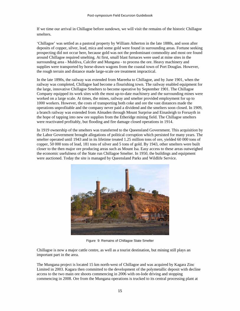
In 1919 ownership of the smelters was transferred to the Queensland Government. This acquisition by the Labor Government brought allegations of political corruption which persisted for many years. The smelter operated until 1943 and in its lifetime treated 1.25 million tons of ore, yielded 60 000 tons of copper, 50 000 tons of lead, 181 tons of silver and 5 tons of gold. By 1943, other smelters were built closer to the then major ore producing areas such as Mount Isa. Easy access to these areas outweighed the economic usefulness of the State run Chillagoe Smelter. In 1950, the buildings and equipment were auctioned. Today the site is managed by Queensland Parks and Wildlife Service.
Figure 9: Remains of Chillagoe State Smelter
Chillagoe is now a major cattle centre, as well as a tourist destination, but mining still plays an important part in the area.
The Mungana project is located 15 km north-west of Chillagoe and was acquired by Kagara Zinc Limited in 2003. Kagara then committed to the development of the polymetallic deposit with decline access to the two main ore shoots commencing in 2006 with on-lode driving and stopping commencing in 2008. Ore from the Mungana operations is trucked to its central processing plant at

��������������� ������ � ���� � ������������ ���� ������ ������� ��������������� ������
� ��
Mount Garnet where it is blended with ore from Kagara’s other mines. Kagara is actively exploring for other base-metal deposits along the Chillagoe belt and has a number of promising projects.
Mungana Goldmines was formed in early 2009 as a vehicle for Kagara's gold interests in the Chillagoe region, particularly at Mungana and Red Dome. The gold ore body at Mungana was defined over several years by Kagara, where it was developed as an adjunct to the base metal operations. The most recent resource estimate has defined an Inferred and Indicated Resource at a 0.35g/t AuEq cut-off of 32.2 million tonnes at 0.81 grams per tonne gold, 0.19% copper and 12g/t silver.
The Red Dome deposit is located 3km southeast of the Mungana mine and is a porphyry-related gold-copper-silver-molybdenum deposit which was developed as an open pit mining operation by Elders Resources and Niugini Mining between 1986 and 1996, when over 1 million ounces of gold and 30,000 tonnes of copper were produced. Kagara acquired the Red Dome deposit from Niugini Mining in 2003 and commenced deep exploration drilling to define additional resources below and adjacent to the abandoned open pit. This work culminated in the 2009 resource estimate by Kagara at 0.35g/t AuEq cut-off of 40Mt @ 0.79 g/t Au, 0.3% Cu, which was identified below and as lateral extensions of the historical Red Dome open pit. The company is aiming to increase the resource base at Mungana and Red Dome as the foundation for a Bankable Feasibility Study on a mine development in 2011.
The Mungana and Red Dome gold deposits have combined measured, indicated and inferred resources of 1.85 million ounces of gold, 180,000 tonnes of copper and 13 million ounces of silver.
Many small marble mines have opened and then closed in the area, as it has been found that although the local marble is of a very fine quality, it is not economically feasible to compete with overseas markets.
Figure 10: Geology of the Chillagoe area. Units to note are: those prefixed by Pd – Dargalong Metamorphics; Om – Mulgrave Formation; SDc – Chillagoe Formation including SDcl limestone, SDcc chert, SDccg conglomerate, SDca sandstone-dominated, SDcb basalt); Cgo –Ootann Supersuite; Cga – Almaden Supersuite; Cjr – Redcap Volcanics. From Chillagoe and Mungana 1:100 000 Geological Sheets. Grid squares are 1 km.

������� ���� ��� ����������������� �����
���
Figure 11. Balancing Rock
Day Two
Stop 6: Balancing Rock, 2.8 km south-west of Chillagoe. UTM 55K 235500 8099850. Figures 10 and 11)
The Chillagoe area is noted for its spectacular landscape of jagged limestone towers and its extensive cave systems, many of which are protected within the Chillagoe-Mungana Caves National Park. The Royal Arch Cave is located about 5km south-west of Chillagoe while the Donna, Pompeii, Bauhinia and Trezkinn caves are located 1.8 kilometres from the centre of town. Royal Arch, Donna and Trezkinn caves can be visited by guided tour only. Unfortunately time will not permit us to visit any of these, but a short visit will be made to Balancing Rock.
From the carpark, located 2.8 km from Chillagoe, a rough track climbs up the rock formation to view the spectacular limestone tower karst and the surrounding landscape of open woodland. Balancing Rock is an isolated limestone pillar, and in addition the limestone shows many other features characteristic of karst, such as fluting (rillenkarren) and joints accentuated by solution (grikes).
The Wallumba Aboriginal art site near Balancing Rock has viewing access provided by a small boardwalk.
Stop 7: Palmerville Fault (Tasman Line), Bolwarra Road, 5km south-west of Chillagoe UTM 55K 233150 8097650. Figure 10.
The Palmerville Fault is crossed by the Bolwarra Road, about 5km south-west of Chillagoe. Time will not permit detailed examination of the area, and the fault itself is not exposed. However, we may take a short drive along the road to the crossing of Cave Creek and point out where the fault is crossed.
After passing the turnoff to Royal Arch Cave, the road to Bolwarra passes through a series of ridges for about 400m. These are formed by relatively quartzose sandstone and pebble conglomeratic within the Chillagoe Formation. To the west of the ridge, the topography becomes more subdued, and this change is taken to mark the Palmerville Fault, which marks the so-called Tasman Line in this area.

��������������� ������ � ���� � ������������ ���� ������ ������� ��������������� ������
� �
West of the fault, the rocks are mapped as the Paleoproterozoic to Mesoproterozoic Dargalong Metamorphics which consist of porphyroclastic gneiss, augen gneiss, sillimanite-biotite gneiss and minor amphibolite. Siliceous mylonite with relict feldspar porphyroclasts locally occurs adjacent to the Palmerville Fault. If there are any outcrops visible close to the road in Cave Creek, we may make a brief stop.
Chillagoe to Undara
The seismic transect 07GA-A1 follows this road and crosses the interpolated position of the Palmerville Fault about 12km from the turnoff (UTM 247100 8069000) (very approximately CDP 6700; see Figure 12). However, in this area, we are entirely within Carboniferous granitoids of the Tate Batholith and the fault is not exposed. However its approximate position can be interpolated from several large screens and tongues of Dargalong and Chillagoe Formation within the batholith.
The road continues south across the Tate River, and about 12km south of the crossing swings to the south-east. From this point the seismic line follows the Almaden-Mount Surprise Railway Line. Acquisition issues along the line included the noise of trains along the spread, most probably the tourist train the Savannahlander, a classic railmotor. Rocky outcrops also created a problem in the very southern end of the line.
The road continues to the south-south-east through the Tate Batholith. Near Gingerella homestead, about 49km from the Ootann turnoff, we come to a major three-way road junction and turn to the left along the Sundown-Gingerella road. At this point we are crossing the small Gingerella Cauldron Complex, but after about 2km we pass into Silurian granodiorite of the Blackman Gap Complex, and then after about 9km pass back into Carboniferous granite, which then continues for the next 30km until we reach the Kennedy Highway between Mount Surprise and Mount Garnet.
Figure 12: Geology along the Ootann road showing the extrapolated position of the Palmerville Fault (blue line); units prefixed by Pd – Dargalong Metamorphics; Dh – Hodgkinson Formation; SDc – Chillagoe Formation; Cgo –Ootann Supersuite; Td – laterite caps. Purple line shows CDPs for seismic line 07GA-A1. From Chillagoe 1:100 000 Geological Sheet. Grid squares are 1 km.
����#��#� ���#� ����� ��#����

������� ���� ��� ����������������� �����
�!�
We turn right onto the Kennedy Highway towards Mount Surprise. For the next 29km, the route follows the line of the Great Dividing Range and outcrop is almost non-existent. The area forms part of an old land surface that has been extensively lateritised and covered by residual sand and clay. Sporadic outcrop and geophysical evidence (airborne magnetic data) indicates that the laterite is developed on a continuation of the Tate Batholith.
About 29km from the Sundown-Gingerella road, we turn to the right onto the Gulf Developmental Road towards Mount Surprise and continue for another 17km to the Undara turnoff. Outcrop consists of fresh basalt of the McBride Basalt Province, one of the major Pliocene to Recent lava fields of north Queensland.
The Undara Lava Lodge is about 14km from the turnoff. This will be our accommodation for the night. The lodge has been in operation since 1990, running tours to the lava tubes and accommodating guests in a unique atmosphere. The guides are members of the Savannah Guides organisation, a network of professional guides with an in-depth collective knowledge of the natural and cultural assets of the tropical savannahs of northern Australia.
Stop 8: Guided tour of the Undara lava tubes
The McBride Basalt Province was studied by Stephenson & Griffin (1976) and Griffin (1977), who recognised 164 volcanic centres, including remnant plugs as well as lava and cinder cones and craters. The province is a large basaltic dome about 80 km across and nearly 500 m thick. The geochronology was studied by Griffin & McDougall (1975). The oldest rocks of the group are undifferentiated basalts which comprise more than half of the province and have ages between 2.7 and 0.5 Ma. Younger Quaternary flows can be mapped out on the basis of their surface morphology (Figure 13). The most extensive unit, the Undara Basalt covers 1550 km2 and is dated by K-Ar at 0.19 Ma. It hosts the areas famous lava tubes. Lava from the Undara Crater flowed 160 km down the ancestral Elizabeth Creek into the Einasleigh River, and another flow 90 km long entered the Lynd River in the Atherton Sheet area). The youngest lavas are the Kinrara Basalt for which an apparent K-Ar age of 70 000 to 50 000 years was regarded as a maximum by Griffin & McDougall (1975). Basaltic rocks in the McBride Province are predominantly nepheline-normative and include nephelinite, basanite, hawaiite, and mugearite.
The volume of lava erupted from Undara Crater is estimated at 23km3 (Atkinson & Atkinson, 1995). Most of the lava was the fluid "pahoehoe" type. Some of the lava found its way into old watercourses, mainly to the north and northwest, and thus channelled, the lava hardened on the top and sides to form insulated tubes which allowed it to flow long distances including 160km to the northwest, reputed to be the world's longest lava flow from a single volcano.
More than 60 caves and arches have been discovered in the Undara lava Tube System. Most are less than 200m long, but one can be followed for 1.3km. The main branch of the lava tube system extends more than 110km, and includes a level ridge known as The Wall, which stands more than 20m above the surrounding country and is considered to be analogous with similar features observed on the Moon. It formed where lava flowing along an original channel built up levees.
Various interesting features can be observed within the lava tubes. Horizontal, or near horizontal ledges, termed lava level lines on tube walls reflect periods of flow at a constant height in the tube, the width of any ledge reflecting how long the lava was flowing at that height. Surges of lava left multi-layered linings on the tube walls.
Above the flow, tube walls and roofs. became glazed, often re-melting and dripping to form fragile, hollow straw stalactites and the more robust, triangular lavacicles. Dribbles of lava ran down some walls and occasionally were deflected from vertical, possibly by the blast furnace effect of an adjacent skylight.

��������������� ������ � ���� � ������������ ���� ������ ������� ��������������� ������
� �"
Figure 13: Distribution of Pliocene to Recent basalts in the Einasleigh-Mount Surprise area.
Lava ponds formed in line with, or adjacent to, some sections of the lava channel. Repeated small overflows and spatter at the margins of ponds built up levees higher than the surrounding country. While the tube was flowing, the ponds remained full, their surfaces crusting as they cooled. When the eruption ceased, the ponds drained back into the tube leaving depressions. These have since created fertile pockets where rainforest plant, insect and animal species now thrive. The rainforest in these collapsed sections is found in Madagascar and East Africa, having evolved from the time of Gondwana.
Figure 14: View of the McBride Basalt Province from The Bluff, showing some of the volcanoes on the horizon
Figure 15:Entrance to one of the large lava tubes from a collapsed section, Undara National Park
After the tour, there will be time to take short walks in the area surrounding the lodge to observe the vegetation and wildlife. At different times of the day certain animals are quite common. During the early morning and late afternoon both the Antilopine and Common Wallaroo (Euro) are common

������� ���� ��� ����������������� �����
���
sights on your tour. In the roof collapses of the lava tubes you may see the Mareeba Rock Wallaby. The best viewing times for wildlife around the Lodge is after sunrise and around sunset, particularly for the Rufous Bettong or Rat kangaroo, the smallest of the Kangaroo family, and also the large Eastern Grey Kangaroo.
A recommended walk is to The Bluff, which starts at reception and climbs the small knoll south-west of the Lodge. Take the left fork at the Atkinson’s Lookout Track intersection, climb through a gentle gully and approach the summit from the west. From the summit you have magnificent views over the wooded lava plains to many of the regions volcanoes. The Bluff consists of pink, biotite granite of the Whitewater Creek Granite of presumed Carboniferous age that formed a hill in the pre-existing landscape. It is part of much larger ‘island’ of granite that forms a range to the west.
From The Bluff you can return along the same trail to the Lodge or continue on the Bluff Circuit. When this trail meets the Swamp Track, keep left and return to the Lodge along the swamp edge.
Bluff & Back Distance: 1.5 km return Time: 25 mins return Rated: Easy; Circuit Distance: 2.3 km return Time: 40 mins return Rated: Easy.
Day Three
Undara to Newcastle Range
We return to the Gulf Developmental Road and continue 38km westwards to Mount Surprise following a branch of the Undara Basalt that flowed around the northern side of the range formed by the Whitewater Granite.
An Australian National Seismograph Station was installed in November 2002 in the horse paddock at the back of the café/grocery store in Mount Surprise. The station consists of a shallow borehole containing a three-component short-period Guralp seismometer and an equipment hut containing processing equipment (digitiser, field processor, switch, radio modem, SOH) and power equipment (batteries, charger), plus two solar panels and a radio mast for intra-site communications. The radio delivers information back to the store where a roof mounted satellite dish transmits the data back to Geoscience Australia.
The Mount Surprise station is an integral element of the Australian National Seismograph Network due to its location relative to very seismically active regions surrounding Australia, e.g. Papua New Guinea and the Solomon Islands. The Geophysical Network is responsible for bringing into Geoscience Australia data from over 300 local and international stations, including eight seismic arrays, two infrasound arrays and a hydro-acoustic station. The network forms the basis for earthquake, tsunami and nuclear testing monitoring, and it is used by Geoscience Australia, the Department of Foreign Affairs and Trade, and the Comprehensive Nuclear-Test-Ban Treaty Organisation (CTBTO).
At the township of Mount Surprise seismic lines 07GA-A1 (CDP 10977) and 07GA-IG2 (CDP 15188) crossed, and we now follow the route of the latter to the west along the Gulf Developmental Road., in the reverse direction since line 07GA-IG2 was acquired from west to east. The seismic line lies to our right along the road verge, i.e. to the north of the road. Acquisition issues included the need for low force in Mount Surprise and the need to float the vibes across creeks and rivers, for example Quartzblow Creek, Edith Creek, Stephen Creek, Junction Creek and the Einasleigh River. Unseasonal wet weather cause a shutdown of approximately three weeks to allow the road verges to dry out.

��������������� ������ � ���� � ������������ ���� ������ ������� ��������������� ������
� ��
The Undara Basalt continues for another 8km to near Junction Creek. Just before the edge of the flow is reached, the road crosses the southern part of The Wall. The western side of the wall is more conspicuous, possibly due to damming of slightly later basalt flows against the eastern side.
From Junction Creek westwards, the road traverses the Paleoproterozoic Einasleigh Metamorphics, which here include mica schist, quartzite, biotite gneiss and migmatite that passes into nebulitic granite. The metamorphic rocks have been subdivided based on different proportions of these rocks as reflected in their airborne geophysical (radiometric and magnetic) responses. Amphibolite and metagabbro sills and stocks are also present.
Along this section at the eastern end of the 07GA-IG2, the reflections appear to be folded into several antiforms, which may be hanging wall structures sitting on west-dipping low-angle faults. . These are hard linked and cut into the crust to a depth of about 4.5 s TWT (~13 km depth).The easternmost fault at CDP 15150 is possibly the Fever-and-Ague Fault, although here it is obscured by the basalt. Farther south higher-grade (granulite facies) rocks crop out on its western side compared with lower to middle amphibolite on the east, consistent with west-over-east thrusting. Another fault interpreted between nebulitic migmatites and psammo-pelitic gneisses near Quartz Blow Creek, corresponds with the westernmost fault in the seismic section at CDP 14300. These two faults appear to be weakly reflective between 1 s TWT and the surface, although the reflectivity does parallel trends in the foot wall.
Continuing westwards, we run along 07GA-GC1 which is coincident with 07GA-IG2 for about 4 km, then cross the Einasleigh River and about 15km farther on, pass out of the metamorphic rocks into the Silurian White Springs Granodiorite, which consists of grey equigranular to porphyritic muscovite-biotite and biotite granodiorite. It is a component of the voluminous Silurian (ca. 426 Ma) White Springs Supersuite – the dominant Silurian-Devonian granite supersuite in the Georgetown region. In the seismic section, it is relatively non-reflective and is interpreted as a relatively thin layer (0.5-1 s TWT or ~1.5-3 km) between CDP 12660 and 12020 and possibly underlying the metamorphic rocks to the east. The granodiorite crops out strongly for the next 13km to the edge of the Newcastle Range.
The Newcastle Range is the topographic expression of the Newcastle Range Volcanic Group, which represents one of the most extensive remnant of a Carboniferous extrusive sequence in north Queensland. It is exceeded in extent and thickness only by the Featherbed Volcanic Group near Chillagoe. It consists of a main north-south elongated composite subsidence structure with a prominent lobe to the east.
Rocks of the Newcastle Range Volcanic Group are predominantly ignimbrite, together with minor lava, unwelded pyroclastic rocks and rare sedimentary rocks. The primary eruptive rocks range in composition from rhyolite to andesite (and possibly very rare basalt) with rhyolitic rocks constituting about 85-90%, dacitic rocks about 5- 10%, and andesite the remainder of the preserved volume. These rocks have been divided into four subgroups according to which part of the composite subsidence structure they occupy.
1. The Wirra Volcanic Subgroup, which forms the southern lobe of the main north-south elongated portion of the composite subsidence structure (Wirra Cauldron).
2. The Kungaree Volcanic Subgroup, which forms a north-south ‘isthmus’ (Kungaree Trough) connecting the southern and northern lobes of the composite subsidence structure.
3. The Namarrong Volcanic Subgroup, which forms the rounded northern lobe of the main structure (Namarrong Cauldron).
4. The Eveleigh Volcanic Subgroup, which forms the eastern lobe (Eveleigh Cauldron).
Virtually all the rocks of the Newcastle Range Volcanic Group were erupted and emplaced in a subaerial environment. Volcaniclastic rocks at the base of the Wirra sequence contain lenses of plant fossil-bearing arenaceous limestone, probably deposited in a restricted lacustrine environment, and

������� ���� ��� ����������������� �����
���
other sedimentary rocks intercalated within the volcanics are fluviatile, shallow lacustrine, or mass-flow in origin.
The Gulf Developmental Road and seismic line 07GA-IG2 crosses the ‘isthmus’, which appears to be an elongate trough or rift-like structure delineated by approximately north-trending fracture systems, and is less well-defined than the other cauldron-like lobes.
Stop 9: Faulted eastern contact of the Newcastle Range Volcanic Group. Eastern escarpment of the Newcastle Range, Gulf Developmental Road. UTM 54K 794250 7973350. ~CDP 12020 on 07GA-IG2. Figure 17 .
A road cutting on the northern side of the road exposes a steeply dipping fault and dyke zone along the eastern edge of the Newcastle Range (Figure 18). The zone contains pink porphyritic microgranite, and younger altered green microdiorite or andesite dykes, and a wedge-shaped area of fluoritised microgranite-dacite breccia. The breccia was prospected by Pioneer Minerals in 1972 and besides fluorite, contains up to 150ppm uranium and 710ppm molybdenum. This U-F-Mo association is common in the Carboniferous volcanic rocks of the Kennedy Igneous Association.
To the east of the fault zone, the cutting exposes weathered, porphyritic biotite granodiorite. Routh Dacite, one of the components of the Carboniferous Newcastle Range Volcanic Group is exposed in the next cutting to the west.
The locality provides views from to the south along the eastern side of the main part of the Newcastle Range and eastwards to the eastern lobe of the range (or Eveleigh cauldron subsidence structure).
The cutting is on a busy road. Please take care crossing the road, and ensure that you stand well clear of the carriage-way – and wear your visibility vest. Remember to look both ways – cars drive on the left hand side of the road in Australia.
This eastern bounding fault appears to correspond with an interpreted westerly-dipping structure on the seismic section and an easterly-dipping structure is interpreted on the west. The base of the Newcastle Range Volcanic Group is poorly imaged on the section, but a flat-lying base has been interpreted between the faults at about 0.5 s TWT or ~1.5km. This is consistent with the inferred total thickness of the Kungaree Volcanic Subgroup (Oversby & Mackenzie, 1993, p7). However the fact that the Routh Dacite is one of the lower units of the succession and presence of stratigraphic, rather than faulted contacts only 3-4km north of the Gulf Developmental Road suggests that a sag-like geometry rather than a rift is more appropriate and would suggest that the throw on the eastern-bounding fault is much less than 1.5km.
The interpretation also suggests that the base of the granitic basement below the Newcastle Range has been displaced by about 1 s TWT or ~2-3km along the bounding structures. However, it is possible that the added thickness of granite is due to the emplacement of granite co-magmatic with the volcanic rocks beneath the Newcastle Range during the Carboniferous. The diffuse nature of the base of the volcanics may also be due to the presence of co-magmatic intrusives.
Neither of these bounding faults is reflective. The east bounding fault zone as exposed in the cutting is probably too steep to be successfully imaged as a reflector. The fault zone may be wide enough to be detected, provided there is sufficient contrast in acoustic impedance. However the dykes themselves are too narrow.

��������������� ������ � ���� � ������������ ���� ������ ������� ��������������� ������
� ��
Figure 17: Geology of part of the Kungaree Trough in the Newcastle Range. Units of note are: units prefixed by Sgw – White Springs Granodiorite; Cnh – Routh Dacite; Cnk – Kitchen Creek Rhyolite; Cnw – Corkscrew Rhyolite; CPir – intrusive Rhyolite. Proterozoic units in the bottom left corner are Pgm – Mistletoe Granite and Pe3a - Einasleigh Metamorphcs. Purple line shows CDPs for seismic line 07GA-IG2. From Georgetown 1:100 000 Geological Sheet. Grid squares are 1 km.
.
Figure 18: Faulted contact of the Newcastle Range Volcanic Group at Stop 9. The person to the right is examining an altered basalt dyke that separates the White Springs Granodiorite from a large microgranite dyke to the left
Figure 19: Crystal-rich ignimbrite in Routh Creek at Stop 10, showing abundant crystal fragments and elongate fiamme

������� ���� ��� ����������������� �����
���
Stop 10: Kitchen Creek Rhyolite of the Kungaree Volcanic Subgroup. Routh Creek on southern side of the bridge, Gulf Developmental Road. UTM 54K 786835 7975624. 7975624. ~CDP 11630 on 07GA-IG2. Figure 17
Continue west for another 8.5km to the bridge over Routh Creek. In the bed of Routh Creek, purplish brown, moderately crystal-rich rhyolitic ignimbrite with a well-developed eutaxitic fabric defined by flattened pumice fragments or fiamme is well exposed (Figure 19). Crystal fragments include both quartz and feldspar and some chlorite aggregates are present locally. This outcrop is part of a single sheet of welded ignimbrite up to 180m thick
Routh Creek to Einasleigh
Backtrack eastwards towards Mount Surprise. Turn right 4.7km east of the Einasleigh River bridge onto the unsealed Einasleigh short-cut road. We are now following the route of seismic line 07 GA -GC1, which commenced about 20km to the north-west of here.
The road between the turnoff and Einasleigh is mainly through Einasleigh Metamorphics again, but a large pluton of the Silurian White Springs Supersuite, the Puppy Camp Granodiorite, is traversed for part of the route. We also traverse the terminal part of a Quaternary basalt flow, Barkers Basalt that we will examine further at Einasleigh.
The township of Einasleigh, originally named Copperfield, was laid out in 1900 by the mining warden on a new township reserve established near the Einasleigh Company's copper mine. The town briefly became the largest population centre in the region during construction of the Chillagoe Company's Etheridge Railway in the years 1907-10. After the closure of the mine in the 1920s, however, the township almost disappeared and was saved from extinction only by its location on the railway.
Found by Richard Daintree in 1866, the Einasleigh copper deposit was one of the earliest mineral discoveries in north Queensland. Daintree is famous for being the first government geologist for North Queensland and for pioneering the use of photography in geological field work. The deposit was initially too remote to develop and was abandoned and virtually forgotten after Daintree's death. The Chillagoe Company rediscovered the Einasleigh shaft when exploring the area and began developing it in 1900 through its subsidiary, the Einasleigh Copper Mines Company. A small blast furnace was erected for smelting in 1902, but until the opening of the Etheridge Railway in 1910 operations proved uneconomical because of high transport costs. The mine closed when the Chillagoe Smelters were shut down in 1914. Acquired by the Queensland Government in 1919 as part of the assets of the Chillagoe Company, it returned to full production the following year, supplying the reopened Chillagoe Smelters. As the Einasleigh State Mine, it finally closed in 1922 as a result of depleted ore reserves and a post-war drop in the world copper price. The Einasleigh mine produced 8237 t of copper, 4083 kg of silver and 71.2 kg of gold from 136 412 t of ore.
In the early 1970s Combined Mining and Exploration N.L conducted operations at the Einasleigh Mine including mine rehabilitation and exploration. Two diamond-drill holes directed to intersect the main ore body failed to intersect ore, and operations at the mine ceased. Currently the mine is being investigated by Copper Strike Ltd in conjunction with a number of other copper and lead-zinc deposits in the surrounding area. The Einasleigh deposit has an Indicated Resource of 0.5 Mt at 4.0% Cu, 18 g/t Ag and 0.22g/t Au, and an Inferred Resource of 0.6 Mt at 1.9% Cu, 8 g/t Ag & 0.10g/t Au. A feasibility study examining the joint development of the copper and the zinc-lead deposits was completed in mid 2009.
The Einasleigh deposit is one of numerous small base metal occurrences through the Einasleigh Metamorphics that are generally thought to be stratabound and/or stratiform (see Withnall & others (1997). In regional terms, the deposits appear to be concentrated at a common stratigraphic level within the Einasleigh Metamorphics, at the transition between a lower, dominantly calcareous

��������������� ������ � ���� � ������������ ���� ������ ������� ��������������� ������
� ��
psammitic sequence and a psammopelitic sequence. Many of the other base metal sulphide deposits in the Einasleigh Metamorphics have a similar form and origin, and many of the vein deposits represent remobilised portions of stratabound deposits. The factors that controlled the distribution of clusters of deposits are not known.
More recently the Einasleigh deposit has been classified as probable IOCG type (Lees & Buckle, 2009). Mineralisation appears to be controlled by intersecting faults and pre-existing folded architecture, and occurs as infill of dilation zones (milled breccias chambers) along and within faults and as replacement of favourable (calc-silicate?) horizons. Two styles of mineralisation are present: tabular breccia bodies with semi-massive to massive sulphide matrix (po-cp-py-mt) and high copper grades; and lower grade skarn-like replacements in thin tabular stratiform bodies with stringer and disseminated sulphides.
Figure 20: Geology of the Einasleigh area. Units prefixed by Pe – Einasleigh Metamorphics (3a - biotite gneiss dominated, 1e - calc-silicate gneiss, a - amphibolite and mafic granulite), Sgo – Oak River Granodiorite, Cgc – Caterpillar Range Microgranite, Qcb – Barkers Basalt Pe3a; Qa – alluvium; Qha – active river channels. From Einasleigh 1:100 000 Geological Sheet. Grid squares are 1 km.
Stop 11. Quaternary basalt, Copperfield Gorge, Einasleigh. UTM 55K 193500 7950850.. ~CDP 4960 on 07GA-GC1. Figures 20 and 21.
On reaching Einasleigh, we will drive past the hotel to a small picnic shelter on the edge of the Copperfield River. The Copperfield River cuts a small gorge through several basalt flows. A black, highly vesicular flow overlies two other grey, less vesicular flows with prominent cooling columns (Figure 21).
The basalt flows at Einasleigh can be traced up the Einasleigh River to a crater in its headwaters known as Barkers Crater. K-Ar dating of basalt at Barkers Crater and at Einasleigh (from the middle flow) have yielded the same age (~0.26Ma – Withnall & Grimes, 1995), and although alluvium from the river has obscured the basalt for part of its course, continuity can be verified from airborne magnetic data. The basalt observed along the shortcut road is clearly part of the same series of flows

������� ���� ��� ����������������� �����
���
indicating that the lava from Barkers Crater flowed approximately 160km, a similar distance to that from the Undara Crater. In many places, the basalt appears to have been confined to the former channel of the Einasleigh River, but in places such as at Einasleigh and farther south near Lyndhurst homestead, it spread out to form a flat plain. The section exposed in the wall of the gorge indicates that the basalt was erupted in several pulses, although it is difficult to estimate the time between flows.
Figure 21: Copperfield Gorge at Einasleigh showing columnar jointed Pleistocene basalt (Barkers Basalt). The ridge in the background is formed from the Carboniferous caterpillar Range Microgranite.
Lunch
Lunch will be taken at the Copperfield Gorge picnic site, although participants may like the experience the hospitality of the Einasleigh Hotel. Of particular note is the reproduction of the painting, Chloe, the original of which hangs in Young & Jacksons Hotel, one of Melbourne’s oldest watering holes.
Stop 12: Einasleigh Metamorphics in the Einasleigh River, near the Einasleigh copper mine. UTM 55K 193900 7951300. ~ CDP4960 on 07GA-GC1. Figures 20, 22 and 23.
Large exposures in the bed of the Einasleigh River below the old Einasleigh mine site represent the type locality of the Einasleigh Metamorphics and are representative of the psammo-pelitic facies within the unit.
We will access these outcrops from the mine site but take care scrambling down the loose rubble into the river bed.
The rocks exposed consist of well-layered, multiply deformed biotite gneiss, mica schist and quartzite cut by amphibolite and later leucogranite and pegmatite dykes. The layering in the gneiss probably partly reflects an original sedimentary layering as it is parallel to the gross layering represented by the quartzite. However, it is parallel to a foliation defined by alignment of mica and has probably been modified by tectonic processes.
The numerous layers of amphibolite probably represent sills or dykes of tholeiitic basalt or dolerite. Elsewhere in the Einasleigh area, the amphibolite bodies have been dated at ~1675Ma by the SHRIMP U-Pb method on zircon (Black & others, 1998). The amphibolite locally appear to cut across
��������������� ������ � ���� � ������������ ���� ������ ������� ��������������� ������
� �
the layering and layer-parallel foliation suggesting that these formed prior to the emplacement of the mafic rocks and could represent a metamorphic event, prior to 1675Ma. Zircons in the mafic rocks also show metamorphic rims, and along with zircons from the leucogranite dykes have yielded ages of ~1560Ma, dating the peak of metamorphism.
The metamorphism was largely in the upper amphibolite facies, but locally assemblages in some of the mafic rocks contain orthopyroxene, indicating that the metamorphic grade reached granulite facies. Later retrogressive metamorphism is evident and most of the sillimanite in the pelitic rocks has been replaced by fine-grained muscovite, and garnet is retrogressed to chlorite.
The layer-parallel foliation has locally been tightly folded and a new foliation and differentiated layering has developed parallel to the axial planes of these folds.
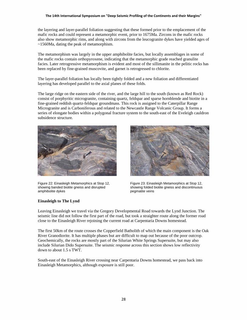
The large ridge on the eastern side of the river, and the large hill to the south (known as Red Rock) consist of porphyritic microgranite, containing quartz, feldspar and sparse hornblende and biotite in a fine-grained reddish quartz-feldspar groundmass. This rock is assigned to the Caterpillar Range Microgranite and is Carboniferous and related to the Newcastle Range Volcanic Group. It forms a series of elongate bodies within a polygonal fracture system to the south-east of the Eveleigh cauldron subsidence structure.
Figure 22: Einasleigh Metamorphics at Stop 12, showing banded biotite gneiss and disrupted amphibolite dykes
Figure 23: Einasleigh Metamorphics at Stop 12, showing folded biotite gneiss and discontinuous pegmatite veins
Einasleigh to The Lynd
Leaving Einasleigh we travel via the Gregory Developmental Road towards the Lynd Junction. The seismic line did not follow the first part of the road, but took a straighter route along the former road close to the Einasleigh River rejoining the current road at Carpentaria Downs homestead.
The first 50km of the route crosses the Copperfield Batholith of which the main component is the Oak River Granodiorite. It has multiple phases but are difficult to map out because of the poor outcrop. Geochemically, the rocks are mostly part of the Silurian White Springs Supersuite, but may also include Silurian Dido Supersuite. The seismic response across this section shows low reflectivity down to about 1.5 s TWT.
South-east of the Einasleigh River crossing near Carpentaria Downs homestead, we pass back into Einasleigh Metamorphics, although exposure is still poor.

������� ���� ��� ����������������� �����
�!�
Figure 24: Geology of The Lynd area across the Lynd Mylonite Zone (Tasman Line). Units to note are: west of the Lynd Mylonite Zone (LMZ) are Paleoproterozoic Einasleigh Metamorphics and Mesoproterozoic Mywyn Granite. Units to east of LMZ are Neoproterozoic or Cambrian Oasis Metamorphics (symbols prefixed by PCo), Ordovician Lynwater Complex (prefixed by POg) and Silurian McKinnons Creek Granite (Sgm). The Cambro-Ordovician Balcooma Metavolcanics (prefixed by COb) lie to the east of the Balcooma Mylonite Zone. Purple line shows CDPs for seismic line 07GA-GC1. From Einasleigh and Conjuboy 1:100 000 Geological Sheets. Grid squares are 1 km.
�� �!������" #��
� #$% � �� $#& % ��!�'& %!��
(�#�& & � ��
� $#& % ��!�'& % !�

��������������� ������ � ���� � ������������ ���� ������ ������� ��������������� ������
� �"
The section of road between about 15km and 23.5km from the Einasleigh River crosses a belt of Einasleigh Metamorphics bounded by two major faults, the Far East fault on the west and the Lynd Fault on the east. The rocks within this belt along the road consist of a calc-silicate gneiss facies within the Einasleigh Metamorphics and the Mesoproterozoic Mywyn Granite, but again are poorly exposed, but can be recognised on airborne magnetic images by their strong magnetic response. Farther south, where the granite is absent, the calc-silicate gneiss crops out strongly and the faults have stronger topographic expression.
The Far East Fault can be recognised on the seismic section at CDP 7100 as the western limit of a belt of west-dipping reflectors and the Lynd Mylonite Zone is inferred to be the eastern limit at CDP 7750.
The Lynd Mylonite Zone is also interpreted as the eastern limit of Paleoproterozoic to Mesoproterozoic rocks in this area, and therefore defines the Tasman Line (Fergusson & others, 2007). Rocks between the Lynd Mylonite Zone and the Far East Fault contain ~1700Ma detrital zircon and metamorphic rims of ~1560Ma (Black & others, 2005) and are assigned to the Einasleigh Metamorphics. Superficially similar rocks to the east of the Lynd Mylonite Zone contain late Neoproterozoic detrital zircon and have metamorphic overgrowths dated at ~480Ma and are therefore late Neoproterozoic or Early Cambrian (Fergusson & others, 2007) and have been assigned to the Oasis Metamorphics. These age relationships combined with the westerly dip interpreted from the seismic would suggest that the Lynd Mylonite Zone is a thrust.
Unfortunately, where the Lynd Mylonite Zone is interpolated to cross the road, outcrop is non-existent, but it has been observed to the north and south. The most spectacular outcrops are in McKinnons Creek about 6km south of the main road, but accessing them is difficult. Mylonitised granite and gneiss crop out at the site. The foliation is vertical with a down-dip stretching lineation and S-C fabrics that indicate east-block-up. This conflicts with the above interpretation for the Lynd Mylonite Zone as a thrust, and suggests that the structure may have a complex movement history.
Immediately east of the Lynd Mylonite Zone, the road traverses the Silurian McKinnons Creek Granite, which is very poorly exposed. However, east of the granite, outcrops of a calc-silicate facies of the Oasis Metamorphics are well exposed near ND Creek.
Stop 13: Calc-silicate granofels of the Oasis Metamorphics, near ND Creek. UTM 55K 237150 7910820. ~ CDP 8000 on 07GA-GC1. Figure 24.
This site consists of calc-silicate granofels, probably representing a calcareous sandstone protolith in the Oasis Metamorphics. It superficially resembles calc-silicate gneiss and granofels within the Einasleigh Metamorphics, and it was originally mapped as such (Withnall, 1989). However, it forms part of a succession that in this area has been dated as probably Cambrian (Fergusson & others, 2007 – see above).
The granofels contains two foliations. The earlier layering/foliation is the most obvious structure and is defined by compositional layering and aligned clinopyroxene and hornblende in calc-silicate gneiss, biotite, quartz and feldspar in pegmatite, biotite and quartz in schist and gneiss, and amphibole in amphibolite. The compositional layering probably reflects sedimentary layers, but could be entirely a differentiated layering. The main foliation (Sg) is locally tightly folded by plunging F2 and has an axial plane foliation developed in places (Figure 25). Amphibolite metamorphism accompanied the deformation in the Oasis Metamorphics with granitic veins and segregations (Figure 26) formed subparallel to Sg and also along the axial planes of the local mesoscopic F2 folds.

������� ���� ��� ����������������� �����
���
Figure 25: Banded calc-silicate granofels in the Oasis Metamorphics at Stop 13, showing a mineral foliation axial planar to folded compositional layering.
Figure 26: Banded calc-silicate granofels in the Oasis Metamorphics at Stop 13, showing a foliated leucogranite vein cutting across the layering.
The Lynd to Paddys Creek
About 3.8km from Stop 13, we come to a major road junction and turn to the right and continue for another 2.8km past the Oasis Roadhouse to the Lynd road junction and veer to the right. The road from here on is currently used by large road trains carrying mineral concentrate from Kagara’s Mount Garnet processing plant to the coast, and care needs to be taken if working close to the road.
Strongly weathered gneiss, schist and amphibolite of the Oasis Metamorphics and granitoids of the Early Ordovician Lynwater Complex underlie the relatively subdued topography over the next 8km. A small range of hills at this point represents the southern outcrop extent of the Late Cambrian or Early Ordovician Balcooma Metavolcanics, a suite of deformed felsic volcanics and sedimentary rocks metamorphosed in the amphibolite facies. They are correlated with the Seventy Mile Range Group that occurs in the Charters Towers Province and which are the host of significant volcanic-hosted sulphide deposits. The Balcooma Metavolcanics also hosts similar deposits, currently being mined by Kagara Zinc at Balcooma about 20km to the north.
They are bounded on their western side by the Balcooma Mylonite Zone. It has been interpreted as a west-over-east thrust (Withnall, 1989) although sinistral transcurrent movement is also evident from shear-sense indicators (Fergusson & others, 2007). It is crossed at CDP 8700 on the seismic line, but little sign of it is evident in the profile.
The metavolcanic belt is relatively narrow at this point and is intruded out by the Early Silurian Dido Batholith, a major north-north-east trending batholith, which is about 13km wide here. It is very strongly weathered and not exposed along the road.
About 20km from the Lynd Junction we again cross the ‘Great Dividing Range’. Prominent mesas along the Divide are of lateritised sediments and regolith derived from the Dido Tonalite. To the east of the Divide, the country is more dissected and outcrop is better. The rocks from here on are assigned to the Lucky Creek Metamorphic Group, and include the Lugano Metamorphics (a succession of metasedimentary rocks and abundant tholeiitic metabasalt and amphibolite) that is bounded to the east by the Eland Metavolcanics and then Paddys Creek Phyllite. The age and relationships of these rocks is not certain, but are they are probably Cambrian or Ordovician.

��������������� ������ � ���� � ������������ ���� ������ ������� ��������������� ������
� ��
Stop 14. Eland Metavolcanics, Gregory Developmental Road, 11.9km west of Greenvale township. UTM 55K 276275 7899700. ~ CDP 10250 on 07GA-GC1. Figure 27.
The Eland Metavolcanics are also thought to be correlatives of the Seventy Mile Range Group near Charters Towers. The Eland Metavolcanics consist mostly of volcaniclastic rocks of intermediate (andesitic to dacitic) composition with calc-alkaline affinities and are strongly deformed and metamorphosed to chloritic and actinolitic schists and characterised by shallowly dipping foliation and stretching lineations.
The rocks at this site do not preserve any of the clastic features, possibly because they were originally finer grained or perhaps because the deformation is more intense and relict fabrics have been destroyed. The rocks have a very strong platy foliation that dips shallowly to the north-west and have a westerly plunging stretching lineation. Crenulations plunge to the north and are related to open folds that deform the Eland Metavolcanics regionally.
Fergusson & others (2007) argued that the low-angle foliation developed by dominantly pure shearing (i.e. ductile flattening) in an extensional crustal environment consistent with the regional backarc setting as argued for the Cape River Metamorphics (Fergusson et al. 2005). Subsequent contractional deformation in the Early Silurian (Benambran) resulted in rotation of the low-angle foliation to steeper dips. A subduction-related, Late Ordovician island arc represented by a narrow belt of calc-alkaline volcanic rocks and volcaniclastic strata represented by the Everetts Creek Volcanics and Carriers Well Formation (Withnall & Lang 1993) at the western margin of the Camel Creek Subprovince south of Greenvale may have been accreted at this time.
Figure 27: Solid Geology of the Greenvale area. Units of note are the Neoproterozoic or early Cambrian Halls Reward Metamorphics (PCh), Boiler Gully Complex (prefixed by PCb) and Gray Creek Complex (PCy) – green shades are serpentinite, purple are gabbro and pyroxenite); Cambro-Ordovician Paddys Creek Phyllite (COp), Eland Metavolcanics (COa); Ordovician Judea Formation (Oj), Carriers Well Formation (Oc) and Wairuna Formation (Ow); Tb – Miocene nephelenite. Purple line shows CDPs for seismic line 07GA-GC1. From Conjuboy and Burges 1:100 000 Geological Sheets. Grid squares are 1 km.

������� ���� ��� ����������������� �����
���
Stop 15. Halls Reward Metamorphics, access road to former Greenvale lateritic nickel mine, 1.75km from the Gregory Developmental Road. UTM 55K 283600 7899900. ~ CDP 10600 on 07GA-GC1. Figure 27.
If time permits, we will stop here to briefly examine the Halls Reward Metamorphics, which form a metasedimentary tract on the edge of the Greenvale Province. Weathered outcrops at this site consist of mica schist with a weak crenulation. The grade is amphibolite facies and is noticeably higher than the Eland Metavolcanics examined at Site 14, from which they are separated by the Nickel Mine Fault. The fault is interpreted as a westerly dipping structure at ~ CDP 10450 on the seismic section GA07-GC1.
The metamorphic rocks have a Neoproterozoic or Early Cambrian protolith age, based on detrital zircons, and they were deformed in the Middle Cambrian (520-500Ma; Nishiya & others, 2003). This event correlates with the Delamerian Orogeny in southern Australia and presumably predates the Eland Metavolcanic and associated rocks in the Lucky Creek Metamorphic Group, assuming their correlation with the Seventy Mile Range Group is valid.
The Halls Reward Metamorphics are associated with mafic-ultramafic rocks (Boiler Gully Complex), which may represent an early Palaeozoic ophiolite, although the exact relationships and mode of emplacement of these rocks is uncertain. Serpentinite that forms part of this complex, and which has weathered to form the nickeliferous laterite in the nearby mine, crops out on the hill opposite and can be examined if there is time. It consists of massive greyish green serpentinite with some metagabbro layers, and veined with chalcedonic silica.
Mine turnoff to Greenvale township
After returning to the main road, it is only 4.8km to the entrance to Greenvale township. Points of note along the road include the following. The eastern margin of the Halls Reward Metamorphics occurs at Redbank Creek, where phyllonite representing the Halls Reward Fault separates the metamorphic rocks from a belt of thin to medium-bedded quartzose sandstone and strongly cleaved mudstone of the Early Ordovician Judea Formation, the oldest part of the Graveyard Creek Subprovince of the Broken River Province. About 1 km east of Redbank Creek, these rocks are faulted against another serpentinite body that is part of the Gray Creek Complex and forms Lucknow Ridge which is also capped by a nickeliferous laterite (see below).
Overnight Greenvale
Greenvale was built to service the former Greenvale nickel mine before the advent of fly-in-fly-out operations. Mining of the nickeliferous laterites commenced in 1974, and ceased in 1992. Total production was 428 762t of nickel and 35 776t of cobalt. The main orebody was developed on the serpentinite in the Boiler Gully Complex. The deposit formed by oxidation and leaching of serpentinite, and the redistribution and concentration of its metal content (originally about 0.3% Ni and 0.01% Co) by migrating acidic groundwater under sufficiently balanced rates of weathering and erosion. The orebody was crudely stratified consisting of weathered serpentinite (saprolite) overlain by limonitic laterite. The base-of-ore was very irregular and the zone was typically 5 to 10 m thick. Nickel grades averaged 1.2 to 1.4% but grades of 3% Ni were common. Cobalt grades were low and averaged about 0.25%.
Recently the Greenvale mining lease has undergone extensive exploration work by Metallica Minerals. The current Greenvale Indicated and Inferred Resource stands at 37.7Mt at 0.81% Ni and 0.05% Co, at a 0.5% Ni Cut-off grade During this most recent exploration work, the Lucknow ridge, another serpentinite body south of the township has been found to contain reserves of Scandium Oxide. Scandium Oxide is a critical component of Solid Oxide Fuel Cells.

��������������� ������ � ���� � ������������ ���� ������ ������� ��������������� ������
� ��
The township was saved from demolition after the mine closed and the houses were sold off as a low-cost housing option. Some of the residents work in nearby mines such as Balcooma.
The name Three Rivers Hotel comes from a song made famous by the late well-known Australian Country singer Slim Dusty. This is not the actual hotel where the song was penned by Stan Coster. The hotel reference is actually to the relocatable "Mess Hall" at the construction camp where Stan Coster worked as a grader operator for Thiess Brothers on the construction of the Greenvale railway line. The hotel is somewhat of a shrine to both Stan Coster and Slim Dusty.
Day Four
Greenvale to the Clarke River
This morning we will drive east of Greenvale into the Camel Creek Subprovince of the Broken River Province. These rocks are dominated by turbiditic facies and are similar to those in the Hodgkinson Province. They are probably mainly Ordovician to Early Devonian and correlate with those in the Chillagoe area. However, limestone is restricted to sporadic allochthonous blocks up to 2km long and clasts in conglomerate. Belts of alternating quartz-rich and labile (lithofeldspathic to feldspathic) turbidites have been delineated and are interpreted as stacks of thrust sheets steepened to vertical by later deformation. Younging directions are dominantly to the west and the rocks overall become younger to the east suggesting that the thrust belt verged to the east.
The first part of the route east passes through the Wairuna Formation, a heterogeneous package of quartzose turbidites and altered basalt. On the seismic section, this package shows a series of reflectors dipping to the east, soling onto an undulating surface at 0.5-2 s TWT that may represent the top of the Greenvale Province. At Porphyry Creek (CDP 11400), we pass into the Greenvale Formation, a package of lithofeldspathic turbidites. The facies range from very thick amalgamated massive sandstone beds (some of the road cuttings show no obvious breaks over more than 30m) to alternating thin to medium sandstone and mudstone showing classic Bouma structures. The topography of the Greenvale Formation is relatively subdued and contrasts with two other formations, the Pelican Range and Perry Creek Formations which form hillier topography. These units consist of more quartzose sandstone. The units are mostly unfossiliferous and the ages poorly known. The Wairuna and Pelican Range Formations may be Ordovician (quartz-rich turbidites are a feature of the Lachlan Orogen in sout-eastern Australia, whereas the Greenvale Formation may be Early Silurian. The Perry Creek Formation contains allochthonous limestone ranging from Late Ordovician to Early Silurian. One of these limestone blocks forms a prominent bluff on the northern side of the road about 5km south-east of Thatch Creek.
East of here the road passes over relatively subdued topography of the Kangaroo Hills Formation, which is probably Late Silurian to Early Devonian, based on the ages of limestone clasts in conglomerate. Sandstones are generally less lithic and more like the Hodgkinson Formation.
Stop 16: Kangaroo Hills Formation at the Clarke River bridge, 57 km south-east from Greenvale. UTM 55K 334850 7874250. ~ CDP 13600 on 07GA-GC1. Figure 28.
Typical turbidites of the Kangaroo Hills Formation are exposed in the cutting at the southern end of the bridge and in the river bed. Thin to medium-bedded, fine to medium-grained labile sandstone is interbedded with grey mudstone. The sandstones have BC Bouma structures (planar laminae and well-developed convoluted laminae indicating younging to the east-south-east). A weak slaty cleavage is present in the mudstone and the bedding is commonly dislocated by small-scale thrust faults at a low angle to bedding. The thrusts locally form small-scale duplex structures (Figure 30).

������� ���� ��� ����������������� �����
���
Figure 28: Solid geology of the Camel Creek Subprovince adjacent to seismic line 07GA-GC1. Purple line shows CDPs for seismic line. From Clarke River 1:100 000 Geological Sheet. Grid squares are 1 km.
Figure 29 (above): Cross-bedded lithofeldspathic sandstone. Kangaroo Hills Formation, upstream of Clarke River bridge.
Figure 30 (left): Thin-bedded sandstone and mudstone showing a small-scale duplex structure. Kangaroo Hills Formation, near Clarke River bridge.

��������������� ������ � ���� � ������������ ���� ������ ������� ��������������� ������
� ��
A large outcrop about 100m upstream of the bridge consists of thick to very thick-bedded medium to coarse-grained lithofeldspathic sandstone that is abruptly overlain by the thin-bedded (more distal) facies. The sandstones are massive to laminated, but cross-bedding is locally present (Figure 29). Facies variations such as observed here are common throughout the Kangaroo Hills Formation and are interpreted as alternations of proximal and distal turbidites formed as lobes prograded and then channels were filled and abandoned.
Supplementary stop 16a. Greenvale Formation in Marble Creek, Gregory Developmental road, 35km south-east from Greenvale. UTM 55K 317325 7887600. Figure 28.
If we are behind time, we may stop at this location instead of going to the Clarke River. About 30m upstream of the road bridge, thin-bedded turbidites are exposed. The outcrop consists of alternating mudstone and fine-grained lithofeldspathic sandstone in thin to medium beds. BCE and CE Bouma cycles (planar laminae and ripple cross laminations) are well developed and indicate westward younging. Small horizontal burrows occur at the base of some beds as well as minor flute and tool marks. A weak subvertical slaty cleavage is also present, which indicates that the folds are upward facing.
Greenvale to Atherton
We now begin the trip back to Cairns, by returning past Greenvale to the Lynd Junction and then turning right and heading north. For the first 30km, the road traverses subdued undulating country over the Oasis Metamorphics and Lynwater Complex before reaching the McBride Basalt Province. For most of the route back to the Mount Surprise turnoff, the road traverses undifferentiated Pliocene of Pleistocene basalt although at one point it crosses a flow of Undara Basalt, close to the Undara Crater, which is 2.7km west of the road. Basalt plugs will be visible east of the road at several points.
Travelling further north, we will pass through Mount Garnet, about 160km from the Lynd Junction. Mount Garnet has had a long history of mining, once being the centre of a thriving tin mining industry. Tin was sourced from both hard-rock and alluvial sources. Nettle Creek east of the town was the site of a large dredging operation up until the mid 1970s. In the last ten years, zinc has been mined by Kagara Zinc at the Mount Garnet mine, and the plant now serves as a central milling operation for Kagara’s mines as far afield as Chillagoe and Balcooma. Concentrate is then trucked to the Sun Metals Zinc refinery in Townsville.
If we are not too delayed by road works, we will have lunch at Innot Hot Springs. Here, underground water issues at a temperature of 74°C (although temperatures vary) - the hottest measured natural surface-level spring water temperatures in Australia.. The area was a favourite destination for campers, who were attracted by claimed curative properties of the water and compared it with famous thermal spas in Europe. Up until 1914, the mineral water was bottled and sent to Europe to be used for medicinal purposes - mules hauled the water over the Cardwell Range to Townsville for bottling at the Innot Cordial Factory. The hot springs are still commercially operated as a tourist attraction. The source of the heat is uncertain, although many of the Carboniferous granites in the region have high background values of K, U and Th and are potentially heat-producing.
A Geothermal Exploration Permit (EPG29) in the area immediately surrounding Innot Hot Springs was granted in 2010 to Gradient Energy Limited, a wholly owned subsidiary of Planet Gas. The geothermal project covers an area of 596km2 and is suitably located for future power supply into the main east coast grid. The Innot Hot Springs geothermal project is different from the hot fractured rock deep drilling geothermal projects in that there is a known geothermal spring system expressed at the surface. Temperatures in the range 144°C to 165°C are predicted at depth, meaning that off the shelf geothermal power plant technologies could be used.

������� ���� ��� ����������������� �����
���
Continuing on from Innot Hot Springs we will pass through Ravenshoe on the edge of the Atherton Tablelands. The annual rainfall increases as we travel to the north-east and the vegetation progressively changes from the Savannah style to thicker eucalypt forest and then into rainforest, although on much of the tablelands, the latter was cleared to make way for farming, in particular dairying. Remnant patches of rainforest remain and many of these are now National Parks.
Much of the Atherton Tableland is formed by basalt and the outlines of several shield volcanoes have been identified. Activity began at about 7 Ma, but the most voluminous eruptions occurred between 4 and 1.2 Ma. Lava from these flowed over the coastal escarpment down the ancient Johnstone River almost to the current position of the coast near Mourilyan Harbour. Because of the high rainfall, the basalts have weathered deeply to the fertile red soils characteristic of the area and outcrops are limited.
At about 1 Ma, the style of eruptions changed to build up small scoria cones and 35 of these have been recognised. In the last 200,000 years pulses of basalt magma encountered groundwater and the resulting phreatic eruptions have resulted in the formation of maars, of which nine are identified. Dating of sediments within the swamps and lakes that now fill them, suggest that they are between 23,000 and 9,130 years old. Aboriginal oral history tells a myth of the formation of Lakes Barrine, Eacham and Euramoo that are consistent with a volcanic eruption, placing the volcanism within times of human habitation of the area.
Stop 17: Hypipamee Crater, near the Kennedy Highway, 28km north of Ravenshoe. UTM 55K 339210 80726700. Figure 31.
From the car park, it is a 400m walk through tropical rainforest to a viewing platform at Hypipamee Crater, which is in an example of a diatreme. It is about 58m down to the water, which is 82m deep. The crater resembles a sinkhole in limestone terrain, but is in granite, belonging to the Carboniferous O’Briens Creek Supersuite. It is thought to have formed when basalt magma encountered groundwater, producing a phreatic eruption. There is little evidence of basalt, although some fragments have been found nearby in the past. Angular blocks of granite as large as refrigerators in the surrounding rainforest may have been blasted from the crater. The exact age is uncertain.
Figure 32(above): Small cinder cone, about 5km south of Atherton
Figure 31 (left): Vertical walls of Hypipamee Crater

��������������� ������ � ���� � ������������ ���� ������ ������� ��������������� ������
� �
About 25km from Hypipimee, we will come to Atherton, the main town of the tablelands. Just south of the town is a Pleistocene scoria cone Figure 32).
From Atherton to we will return to Cairns, the route being at the discretion of the driver. However, the preferred option will be through Yungaburra and down the Gillies Highway. Between Atherton and the township of Yungaburra, a group of scoria cones, the Seven Sisters to the north and south of the road and about 7.5km past Yungaburra the road skirts around the rim of Lake Barrine, one of the Holocene maars.
Views to the south-east are of the Bellenden Kerr Range, that includes Mount Bartle Frere, the highest point in Queensland at an elevation of 1622m. The range is formed from the early Permian I-type Bellenden Kerr Granite.
The road down the escarpment by the Gillies Highway is mainly through the S-type early Permian Tinaroo Granite passing into Hodgkinson Formation near the bottom. The prominent conical peak, Walsh’s Pyramid south of Gordonvale is early Permian and part of the Bellenden Kerr Batholith.
The alternative route north to Mareeba and then Cairns via the Kennedy Highway, will pass mainly over Pliocene Atherton Basalt. Hills to the west are of the Permian Walsh Bluff Volcanics.
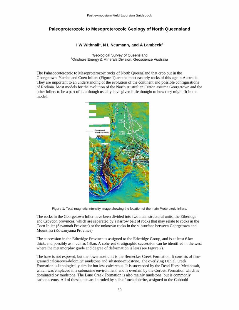
������� ���� ��� ����������������� �����
�!�
Paleoproterozoic to Mesoproterozoic Geology of North Queensland
I W Withnall1, N L Neumann2 and A Lambeck2
1Geological Survey of Queensland
2Onshore Energy & Minerals Division, Geoscience Australia
The Palaeoproterozoic to Mesoproterozoic rocks of North Queensland that crop out in the Georgetown, Yambo and Coen Inliers (Figure 1) are the most easterly rocks of this age in Australia. They are important to an understanding of the evolution of the continent and possible configurations of Rodinia. Most models for the evolution of the North Australian Craton assume Georgetown and the other inliers to be a part of it, although usually have given little thought to how they might fit in the model.
Figure 1. Total magnetic intensity image showing the location of the main Proterozoic Inliers.
The rocks in the Georgetown Inlier have been divided into two main structural units, the Etheridge and Croydon provinces, which are separated by a narrow belt of rocks that may relate to rocks in the Coen Inlier (Savannah Province) or the unknown rocks in the subsurface between Georgetown and Mount Isa (Kowanyama Province)
The succession in the Etheridge Province is assigned to the Etheridge Group, and is at least 6 km thick, and possibly as much as 13km. A coherent stratigraphic succession can be identified in the west where the metamorphic grade and degree of deformation is less (see Figure 2).
The base is not exposed, but the lowermost unit is the Bernecker Creek Formation. It consists of fine-grained calcareous-dolomitic sandstone and siltstone-mudstone. The overlying Daniel Creek Formation is lithologically similar but less calcareous. It is succeeded by the Dead Horse Metabasalt, which was emplaced in a submarine environment, and is overlain by the Corbett Formation which is dominated by mudstone. The Lane Creek Formation is also mainly mudstone, but is commonly carbonaceous. All of these units are intruded by sills of metadolerite, assigned to the Cobbold

��������������� ������ � ���� � ������������ ���� ������ ������� ��������������� ������
� �"
Metadolerite. The environment of deposition has been interpreted as an upward deepening package from shoreline to deep marine (Withnall et al., 1997). However, a more recent interpretation by one of us (A. Lambeck, unpublished data) suggests that the entire succession is deep water and includes turbidites. The mafic rocks (Dead Horse Metabasalt and Cobbold Metadolerite) are similar to relatively evolved, low-K, Fe-rich continental tholeiites and best match lavas from the ocean-continent transition region of the Early Tertiary East Greenland volcanic passive margin (Withnall, 1985; Baker, 2007).
�
Figure 2. Simplified Palaeoproterozoic-Mesoproterozoic time-space plot for the Georgetown Inlier showing time constraints based on zircon dating.
The upper part of the Etheridge Group (Townley, Heliman and Candlow Formations and Langdon River Mudstone) is variably carbonaceous siltstone and mudstone, with some sandstone composed entirely of mudclasts. Gypsum casts have been observed in places. Parts of the succession have been interpreted as shallow water in a mud-dominated tidal flat environment (Withnall et al., 1997), but other interpretations suggest that the succession is entirely deep water.
Recent SHRIMP zircon dating has provided better constraints on the age of the Etheridge Group. The lower part (Bernecker to Lane Creek Formations) is characterised by detrital zircon populations with a significant Archean to earliest Proterozoic component (up to 75%), but with younger populations of 1780-1850 Ma and rare younger grains of ~1695 Ma (N.L. Neumann, unpublished data). The Dead Horse Metabasalt has an age of 1663±13 Ma (Baker, 2007) and a leucogabbro sill intruding the Lane Creek has a precise age of 1656±2 Ma (Black et al., 1998) that provides a minimum age for the succession, which was thus deposited between 1700 and 1660Ma.
Zircons from the Townley and Heliman Formations, by contrast, have significantly diminished Archaean to earliest Proterozoic components and significant populations of ~1650-1655 Ma zircons (N.L. Neumann, unpublished data), indicating a dramatic provenance change. The host rocks also have relatively primitive �Nd values compared with those from the lower Etheridge Group, which are more evolved (A. Lambeck, unpublished data).

������� ���� ��� ����������������� �����
���
In the east, the Einasleigh Metamorphics consist of biotite and calc-silicate paragneiss, common amphibolite and rare leucogneiss (feldspathic psammite?) and orthogneiss. Extensive areas of migmatite and anatectic granite also are present. Some calc-silicate gneiss in the Einasleigh Metamorphics can be traced into rocks assigned to the Bernecker Creek Formation, and consequently the metamorphic rocks are thought to be at least partly equivalent to the lower part of the Etheridge Group, although geochemistry and detrital zircons in some rocks suggest provenance differences farther to the east in the unit (Black et al., 2005) and a fabric that pre-dates the mafic intrusives suggests that there may be some older rocks.
The main age constraints are based on zircon dates from felsic leucogneiss in the southeast of the outcrop area. These rocks, thought to be feldspathic psammite have simple populations with ages of ~1705 Ma from two samples (Black et al., 2005). Granite gneisses have been dated from three localities and give ages of 1685-1695 Ma (Black et al., 1998, N.L. Neumann, unpublished data). Amphibolite that cuts one of these gneisses has been dated at 1675±3 Ma (Black & others, 1998). Detrital ages of both biotite and calc-silicate paragneiss have been obtained, but need more interpretation. They yield a spread of ages between ~1670 and 3240 Ma, with no big groups although there are some clusters between 1700 and 1900 Ma and 2300 and 2600 Ma (N.L. Neumann, unpublished data). The current data thus suggest deposition between ~1700 and 1675 Ma for the Einasleigh Metamorphics.
The Langlovale Group unconformably overlies the Etheridge Group in the western Etheridge Province. It includes the Malacura and Yarman Formation, which were probably deposited in a marine environment. The Malacura Formation may be shallow marine, but the Yarman Formation contains turbidites. Detrital zircon from the Malacura Formation indicates a maximum depositional age of ~1625 Ma, with only very rare Archean grains.
The overlying Croydon Volcanic Group is dominated by almost flat-lying sheets of felsic ignimbrite that are undeformed and not metamorphosed. They are intruded by comagmatic granites of the Esmeralda Supersuite. Both granites and volcanics contain abundant graphitic enclaves – presumably derived from the Etheridge Group at depth. The igneous rocks are geochemically peraluminous and reduced and are S-types (or perhaps I-types drastically modified by assimilation). The Croydon Volcanic Group has given a multigrain TIMS U-Pb zircon age of 1552±2 Ma (Black and McCulloch, 1990).
The Etheridge Group is multiply deformed. The complexity of the deformation along with metamorphic grade increases to the east. Regional studies (see Withnall et al., 1997) and zircon dating (Black et al., 1998, 2005) suggests that an early north-south shortening event of unknown age (possibly ~1590Ma) was followed by east-west shortening and accompanying metamorphism and granite genesis and emplacement of the Forsayth Batholith at ~1550-1560 Ma.
More recent detailed studies by students from James Cook University involving analysis of porphyroblast inclusions (FIA analysis) and EPMA monazite dating (e.g. Cihan et al., 2006) have produced a more complex history. Reconciling some of the monazite and SHRIMP zircon ages is difficult, but a tentative deformation history is as follows.
• Possible metamorphism and deformation pre-1675 Ma (post 1690 Ma?) in the Einasleigh Metamorphics
• D1 – north-south shortening at ~1620 Ma • D2 – east-west shortening at ~1590 Ma accompanied by medium P-T metamorphism • Uplift and retrogressive metamorphism sometime between 1590 and 1560 Ma • D3 - northwest-southeast shortening and low pressure-high temperature metamorphism at
1560-1550Ma, associated with main metamorphic zircon growth and emplacement of S-type Forsayth Supersuite
• Eruption of the Croydon Volcanic Group and emplacement of the Esmeralda Supersuite in the west at ~1550 Ma – minimal deformation
��������������� ������ � ���� � ������������ ���� ������ ������� ��������������� ������
� ��
• D4 – possibly 1510 Ma • Subsequent Paleozoic events
The Langlovale Group may have undergone east-west shortening during D2, so is 1590-1625 Ma.
Other Proterozoic inliers farther north contain rocks considered to be equivalent to the Etheridge Group. In the northern part of the Georgetown Inlier (sometimes referred to as the Dargalong Inlier), the McDevitt Metamorphics are probably equivalent to the Corbett and Lane Creek Formations. However, the higher grade Dargalong Metamorphic Group contains large areas of orthogneiss dated at ~1580-1590 Ma as well as paragneiss and amphibolite that may be equivalent to the Einasleigh Metamorphics. The Yambo Metamorphic Group in the Yambo Inlier is similar to the Dargalong Metamorphic Group and yields similar ages. In the Coen Inlier, the high-grade Newberry and Coen Metamorphic Groups yield somewhat younger metamorphic ages, more like those of the Einasleigh Metamorphics (namely ~1550-1560 Ma) (Blewett et al., 1997, 1998).
In the western part of the inlier, however, the Holroyd Metamorphic Group has yielded detrital zircon ages of ~1550-1560 Ma (OZCHRON, unpublished data), suggesting that they are a younger succession and have been assigned to a separate province, the Savannah Province (Blewett et al., 1997). The Edward River Metamorphic Group farther west is also assigned to this province, although its age is not constrained isotopically. Medium-grade metamorphic rocks in the northeast near Iron Range, the Sefton Metamorphics, have ~1200 Ma detrital zircons, suggesting they are Neoproterozoic or early Paleozoic.
Maximum depositional ages for the Etheridge Group are similar to those of the Soldiers Cap and Mount Isa Groups in the Mount Isa Inlier and deformation events at Georgetown appear to correlate with phases of the Isan Orogeny. The provenance of the lower Etheridge Group, however, is very different to any Mount Isa Inlier Proterozoic sediments, suggesting the terranes were not adjacent at this time. This may be consistent with the model of Boger and Hansen (2004) that Georgetown was formerly part of the North American Craton and only became accreted to the North Australian Craton during the formation of Rodinia. The provenance of the upper Etheridge Group is similar to equivalent age rocks in the Mount Isa Inlier, and would require an east-west event between ~1660 and 1640 Ma to bring these terranes together. According to Betts et al. (2002), however, docking of the North American Craton was somewhat later and related to the ~1600-1500 Ma Mesoproterozoic orogenesis. Another anomaly with the model is the observation that deformation at Georgetown increases eastwards away from the proposed collision zone.
Other differences between Georgetown and Mount Isa terranes include:
• Georgetown metamorphic rocks show a normal geothermal gradient with a clockwise P-T-t path, on which is superimposed high temperature-low pressure event. In contrast, the Mount Isa metamorphism dominantly reflects a high geothermal gradient (anti-clockwise P-T-t) (Boger and Hansen, 2004; Cihan et al., 2006; Rubenach 1992).
• East-west versus north-south directed structural grain • S-type magmatism at Georgetown versus I- and A-type magmatism at Mount Isa at ~1555 Ma
(e.g. Black and McCulloch, 1990; Withnall et al., 1997; Wyborn, 1992)

������� ���� ��� ����������������� �����
���
Phanerozoic Geology of North Queensland
R A Henderson1 and I W Withnall2
1 School of Earth and Environmental Sciences 2 Geological Survey of Queensland
INTRODUCTION
Three successive orogenic systems, two of which are generally developed in eastern Australia, contribute to the Phanerozoic geology of north Queensland:
1. The Thomson Orogen (Neoproterozoic – Ordovician) which extends north from the Lachlan Orogen of similar age and west of the younger New England Orogen, abutting older crustal systems cratonised in the Mesoproterozoic to the west. In central Queensland the Thomson Orogen is almost entirely obscured by thin Mesozoic cover. It is comprised of a Neoproterozoic passive margin assemblage that developed after the fragmentation of Rodinia at ~800 Ma, overprinted by a Cambrian-early Ordovician (~500-460 Ma) active margin with volcano-sedimentary extensional basins and an extensive plutonic suite (Macrossan igneous association). The active margin suite reflects the inception of a convergent plate boundary which developed along the margin of east Gondwana in Late Cambrian time and persisted throughout the Palaeozoic. Three broad-scale episodes of tectonism are recognized for the Thomson Orogen: Delamerian shortening (~500 Ma), extension between ~480-460 Ma and Benambran shortening (~430 Ma).
2. The Mossman Orogen (Ordovician –Devonian) located in the coastal sector of north Queensland between Ingham and Princess Charlotte Bay and exclusive to north Queensland. It is represented by sedimentary rocks that have variously been interpreted as an accretionary, active margin association or a extensional, backarc basin association. It is faulted against Thomson Orogen tracts to the west and south which host widespread plutonic assemblages contemporaneous with the Mossman Orogen (Pama igneous association) and more localized areas of sedimentary cover. The Mossman Orogen expresses ongoing plate convergence adjacent to, and influencing, the east Gondwana margin. It was extensively deformed by ‘Tabberabberan’ shortening at the close of the Devonian (~360 Ma), lightly affected by Kanimblan contraction (~320 Ma) and its north-eastern parts were again strongly tectonised in the Hunter-Bowen orogenic episode (~280-240 Ma).
3. The New England Orogen (Devonian-Triassic) expressed in north Queensland mainly by extensive plutonic rocks and volcanics of the Kennedy igneous association hosted by older rock systems of the Thomson and Mossman Orogens. Scattered, localized extensional basins, mainly with volcano-sedimentary infill, are also represented. These rock systems are the inboard expression of the convergent plate margin which first developed in Cambrian time and their outboard counterparts are thought to be located offshore on the Coral Sea. The more southern basins were in general inverted during the Kanimblan contraction (~330 Ma) whereas those of more northern position were inverted by Hunter-Bowen (~280-240) tectonism which is also expressed by strain in some plutonic bodies.
THOMSON OROGEN
A substantial part of eastern Australia located north of the Lachlan Orogen and east of the New England Orogen, and obscured by thin Mesozoic cover, is regarded as a distinctive crustal tract which developed in the Neoproterozoic and Early Palaeozoic. It lies to the east of older crustal systems cratonised in the Mesoproterozoic. Its southern boundary against the Lachlan Orogen is marked by abrupt crustal thinning and expressed by the Olepoloko Fault, a thrust feature with
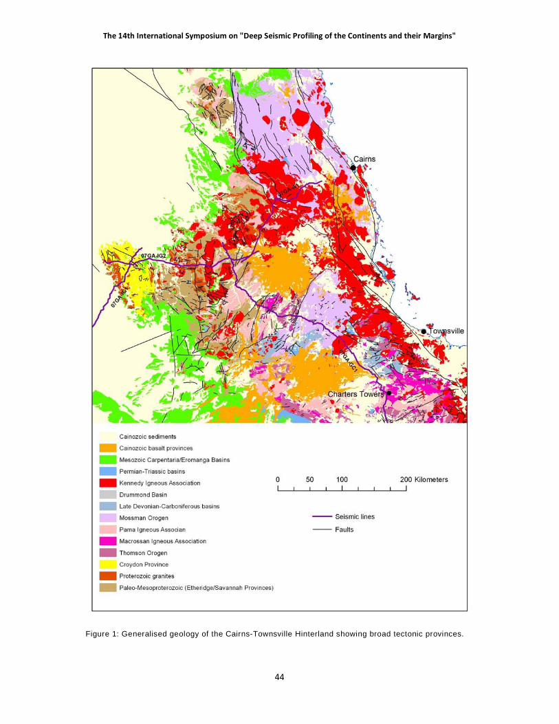
��������������� ������ � ���� � ������������ ���� ������ ������� ��������������� ������
� ��
Figure 1: Generalised geology of the Cairns-Townsville Hinterland showing broad tectonic provinces.

������� ���� ��� ����������������� �����
���
post- Late Devonian movement and likely to express contraction associated with the Early Carboniferous Alice Springs Orogen of central Australia which has collinear trends.
Over most of its distribution the orogen is obscured by Mesozoic cover sequences and is known only from gravity and magnetic trends and basement cores recovered from petroleum drilling. However its northern extremity is exposed as the Charters Towers Province and a substantial basement window near its northeastern perimeter is presented by the Anakie Province (outside the area traversed by the seismic lines and not discussed here; see Withnall & others, 1995, 1996; Fergusson & others, 2001). In addition a narrow tract of crust, the Greenvale Province adjoins Mesoproterozoic Craton of the Georgetown block and another tract along the coast, the Barnard Province, east of Mossman Province rocks represent the northern limit of the exposed Thomson Orogen.
As presently understood, the orogen is considered to consist largely of Neoproterozoic sedimentary systems which formed on the passive margin along what is now eastern Australia following the breakup of Rodinia at –700 Ma. Convergence associated with the amalgamation of Gondwana was expressed by the development in the Cambrian of a plate boundary located outboard of the east Australian margin. The mid-Cambrian Delamerian Orogeny, induced by convergence on this boundary, cratonised the Thomson Orogen. Active margin tectonism continued as an influence in Early to Middle Ordovician time with the emplacement of voluminous granitoids and the accumulation of volcano-sedimentary sequences in a population of extensional basins. These igneous suites are considered to be of inboard back-arc association; outboard elements of the active margin assemblage are not in evidence. Inversion of the extensional basins occurred in the mid Silurian as part of a contractional episode (Benambran Orogeny) generally recorded in east Australian crust.
Based this assessment, the Thomson Orogen is essentially a continuation of the RossDelamerian Orogenic Zone known for east Antarctica and southern Australia. As was the case for the southern Tasmanides, for north Queensland younger Palaeozoic orogenic systems were added east of, and overprinted, this ancestral belt.
CHARTERS TOWERS PROVINCE:
Neoproterozoic remnants of sedimentary systems (now tectonised metamorphic tracts) which host voluminous granitoid plutonics grouped as the Ravenswood and Lolworth Batholiths are the oldest elements of this province which is equivalent to the Cape River Province of Bain & Draper (1997). The batholiths are composites that include elements of the Late Cambrian-Early Ordovician Macrossan Igneous Association, the Silurian-Devonian Pama Igneous Association and the Late Carboniferous – Early Permian Kennedy Igneous Association for which volcanic and sub-volcanic rocks are also represented. The province also contains tracts of variably, but in general lightly, deformed volcanic and sedimentary basin fill of latest Cambrian - Early Ordovician and mid Devonian – Early Carboniferous ages, known as the Mount Windsor Subprovince and Burdekin Basin respectively.
Deformation: Early-phase, remnant foliations in Neoproterozoic rocks of the Cape River and Argentine terranes may record the Late Cambrian Delamerian Orogeny. An Early Ordovician extensional episode of deformation with associated broad scale foliation development is recognised for the Cape River and Argentine Terranes and similar fabrics in the Charters Towers and Running River terranes. This episode was coincident with extension inferred as the basin-forming mechanism related to deposition of the Seventy Mile Range Group within the Mount Windsor Subprovince.
Ar-Ar dates indicate Silurian compressional deformation associated with the development of penetrative fabrics for the Cape River and Argentine terranes. Penetrative fabric development

��������������� ������ � ���� � ������������ ���� ������ ������� ��������������� ������
� ��
associated with upright folding in the western part of the Mount Windsor Subprovince and in the Charters Towers metamorphic terrane is almost certainly of this age as is likely to also be the case for strain in Ordovician granitoids of the Ravenswood Batholith
Folding of Devonian and Early Carboniferous strata of the Burdekin Subprovince is ascribed to mid Carboniferous contraction (Kanimblan Orogeny) because scattered stratiform Permian rocks within the province are little disturbed indicating that Permian (Hunter-Bowen) tectonism was not of significant influence.
A suite of dykes which generally strike NW-SE are widely developed in the eastern part of the province and are considered to represent early Permian upper crustal extension.
Figure 2: Generalised geology of the Charters Towers Province
Cape River metamorphic terrane:
This element consists of metapelite and quartzite with minor associated calc-silicate rocks and amphibolite mapped as the Cape River Metamorphic Group and structurally underlain by gneissic granitoid with abundant metasedimentary enclaves mapped as the Fat Hen Complex (see Fergusson & others, 2005; Withnall & others, 1997). Both units share an amphibolite grade metamorphic signature and a common structure with a dominant foliation which was gently dipping when formed and subsequently overprinted by large-scale upright folds and associated cleavage development. Foliated microlithons at a high angle to the dominant fabric indicate a still earlier pervasive structural-metamorphic event (?Delamerian Orogeny) affected the terrane. Ages from detrital zircons obtained from quartzite units have an upper limit of ~900Ma suggesting that the sedimentary protolith was of Neoproterozoic age. Zircons from Fat Hen granitoids indicate ages from 493-455Ma

������� ���� ��� ����������������� �����
���
and are thought to be correlative with imposition of the dominant fabric. Ar-Ar agesof 410-420 Ma from metapelite micas reset during the upright folding event are considered to register exhumation following that contraction.
Charters Towers metamorphic terrane:
Small screens of amphibolite grade schist, quartzite, calc-silicate, amphibolite and gneiss within the Ravenswood Batholith in the vicinity of Charters Towers (Peters, 1987) closely resembles the Cape River metamorphic terrane. They also show a similar a similar structural history with the dominant fabric in general trending NW-SE due to an overprinting upright fold phase, and host lightly strained bodies of Bucklands Diorite of similar trend. The diorite has a zircon date of 508Ma.
Argentine metamorphic terrane.
This terrane compromises schist, meta-arenite including quartzite, amphibolite, migmatite, and minor serpentinite (Fergusson & others, 2007; Withnall & McLennan, 1991). The dominant fabric was of low dip when formed and later overprinted by an upright, N-S trending fold phase with associated cleavage. Relicts of a still earlier fabric exist as foliated microlithons. Age data for detrital zircons and a zircons from a felsic igneous clast obtained from a mafic breccia suggest that part of the sedimentary protolith is Late Cambrian in age at ~500 Ma whereas part appears to be older and of Neoproterozoic age. The dominant fabric is younger than gneissic granitoid zircon dated at 480 Ma and older than undeformed granitoid dated at 461 Ma. Ar-Ar on hornblende from amphibolite provides an age of 439Ma which is considered to register unroofing following the last (N-S) fabric-producing event which is viewed as an expression of the Benambran Orogeny.
Running River metamorphic terrane:
This terrane forms a narrow strip of multiply deformed amphibolite, migmatite, schist, quartzite and minor calc-silicate and serpentine which hosts gneissic granitoid (Falls Creek Tonalite). It is probably of similar age to the other terranes.
Mount Windsor Subprovince:
Occupying the southern part of the Charters Towers Province, this element consists of a very thick (15 km plus) succession comprising the Seventy Mile Range Group (Berry & others, 1992; Henderson, 1986; Stolz, 1995). Its lower part is siliciclastic and its upper part dominated by acid and intermediate volcanics. Graptolites and trilobites in the upper part of the succession indicate Early Ordovician ages and are of deep marine association. The Seventy Mile Range Group hosts granitoids of the Macrossan Igneous Association which are little different in age. In general, rocks of the subprovince are little deformed but its western parts, near Thalanga, show upright folding and associated cleavage. The succession is interpreted as a continental back-arc basin on the basis of volcanic geochemistry, the occurrence of basic dykes in the lower part of the stratigraphic succession and the thickness and age trends of an intermediate volcanic package.
Ravenswood and Lolworth Batholiths
Early to mid Ordovician (490 – 463 Ma) hornblende and/or biotite bearing I type granitoids dominate the Macrossan Igneous Association. They show persistent evidence of strain with common incipient fabric development and are cut by local shear zones with intense fabrics. A second assemblage of Late Silurian and Early Devonian age (418-382 Ma), part of the Pama Igneous Association, dominates the Lolworth assemblage and is also represented in the Ravenswood Batholith. Granitoids of this age group are also dominantly I type but also includes S type lithologies and characteristically show little strain.

��������������� ������ � ���� � ������������ ���� ������ ������� ��������������� ������
� �
GREENVALE PROVINCE:
This part of the Thomson Orogen is comprised of a northeast trending domain of predominantly late Neoproterozoic to early Palaeozoic sedimentary and igneous rocks now metamorphosed to greenschist or amphibolite grade (Withnall, 1989; Fergusson & others, 2007b). It adjoins the Georgetown Block which is of Paleoproterozoic to Mesoproterozoic age along a major dislocation marked by the Lynd Mylonite Zone, which is now recognised as representing the position of the Tasman Line.
The early Palaeozoic domain has a coherent structural history with an intense early foliation/cleavage considered to have been of low dip when formed and subsequently steepened by up to two overprinting folding and cleavage events. In the westernmost part of the province, a tract of metamorphic rocks and gneissic granitoid is assigned to the Oasis Metamorphic and Lynwater Complex. The age of metamorphic rims to zircon in gneisses dates the dominant fabric as 476 Ma, and a primary age of 486 Ma has been obtained from gneissic granitoid hosted by the metasedimentary suite. Protolith of the metasedimentary assemblage is interpreted to be the floor of an extensional basin, tectonised by continuation of the strain regime which sponsored extension. The overprinting upright cleavage and folding events are thought to be of Silurian age, expressing the Benambran Orogeny.
Between the Balcooma Mylonite Zone in the west and the northeast-trending Early Silurian Dido Tonalite in the east, an early Palaeozoic metavolcanic and metasedimentary succession of the Balcooma Metavolcanic Group is considered an equivalent of the Upper Cambrian to Lower Ordovician Seventy Mile Range Group in the Charters Towers Province (Huston 1990; Withnall et al. 1991, 1997). A metavolcanic assemblage, the Lucky Creek Metamorphic Group, consists of mafic to silicic volcanic and volcaniclastic rocks and dominates the Lucky Creek domain east of the Dido Tonalite (Withnall 1989). The eastern part of the Lucky Creek Metamorphic Group consists mainly of the Paddys Creek Phyllite that appears to have a more complex structural history than other units assigned to the group.
A metasedimentary tract (Halls Reward Metamorphics) with a Neoproterozoic or Early Cambrian protolith age associated with mafic-ultramafic rocks (Boiler Gully Complex), deformed in the Middle Cambrian (520-500Ma; Nishiya & others, 2003) forms an eastern bounding strip to the province.
The Dido Batholith, which shows strong local foliation, is comprised mainly of tonalite dated as Early Silurian (431 Ma) and is considered to be part of the Pama Igneous Association. Outliers of late Early Devonian marine rocks are also represented in the province. That comprised of Conjuboy Formation is gently dipping, unstrained and is nonconformable on the early Palaeozoic metasediments and metavolcanics.
BARNARD PROVINCE:
This province is comprised of multiply deformed schist, quartzite, gneiss, amphibolite, metamorphosed ultramafic lithologies and granitoid phases. It occupies a narrow coastal strip extending from Mission Beach to east of Cairns. Strongly foliated S-type granitoid and less deformed felsic I-type granitoid are SHRIMP dated at 486 and 463 Ma respectively. The assemblage closely matches early Ordovician and older rock suite of the Charters Towers Province.
BURDEKIN BASIN:
Overlying the Charters Towers Province is a Middle Devonian – Early Carboniferous sedimentary and volcanic succession some 6 km thick (Draper & Lang, 1994). It is mainly non-marine in character apart from the basal part which is shallow marine. The assemblage rests nonconformably on the Argentine metamorphic terrane and the Ravenswood Batholith and shows broad, open folds of variable orientation and is cut by common faults, many of which have substantial displacements. The basin is considered to be of back-arc, extensional association.

������� ���� ��� ����������������� �����
�!�
Figure 3: General ised geology of the Greenvale and Broken River provinces

��������������� ������ � ���� � ������������ ���� ������ ������� ��������������� ������
� �"
MOSSMAN OROGEN:
A discrete crustal element, largely of Silurian and Devonian age, is located in the coastal sector of north Queensland between Ingham and Princess Charlotte Bay. The Mossman Orogen consists of the Broken River and Hodgkinson Provinces which are separated by tracts of Late Palaeozoic igneous rocks. It abuts the Thomson Orogen in the south on the Clarke River Fault, in the southwest on the Burdekin Fault and in the southeast on the Russell-Mulgrave shear zone. To the northwest it abuts Paleoproterozoic to Mesoproterozoic crust along the Palmerville Fault.
The orogen shows a strong east-west polarity in sedimentary and structural attributes of its main rock systems which are known to overlap in age. Shallow marine strata characterised by limestone are located to the west, show no metamorphic overprint and reflect a simple structural history whereas deep marine strata of turbidite facies located to the east, show a clear metamorphic overprint and are characterised by polyphase deformation. Structural history of the turbidite assemblage records ubiquitous early-phase stratal disruption and mélange formation.
Older Paleoproterozoic to Mesoproterozoic crust to the west and south hosts a narrow zone of Silurian-Devonian granitoids stretching from the Anakie Province in the south to Cape York Peninsula. The zone is collinear with the Mossman Orogen north of Clarke River Fault and has been variously interpreted as a coeval magmatic arc, and as a zone of magmatic underplating related to backarc extension.
Although interpretation remains contentious, the orogen is regarded by all commentators as an active continental margin assemblage that formed adjacent to a plate boundary where west-directed subduction transported oceanic crust beneath the continental edge of Australia. Both backarc and forearc/subduction complex models have been applied in rationalisation of its tectonic setting. In its compass of attributes, the Mossman Orogen accords best with a forearc-subduction complex couple. It was comprehensively tectonised by crustal shortening at the close of the Devonian, broadly allied with the Tabberabberan Orogeny of the Lachlan Fold Belt. Much of its northern part, within the Hodgkinson Province, was tectonised for a second time by shortening in the Late Palaeozoic Hunter Bowen Orogeny which is best known from the New England Fold Belt.
BROKEN RIVER PROVINCE:
Two contrasting, spatially discrete assemblages are recognised: a northern and eastern tectonised suite of deep marine turbidites and associated spilitised basalt and chert that comprises the Camel Creek Subprovince whereas the smaller Graveyard Creek Subprovince located in the southwest consists largely of a thick, essentially conformable succession of shallow marine Late Silurian to early Carboniferous strata (Withnall & Lang, 1993; Henderson, 1987). Rocks of the two subprovinces are separated by the Gray Creek Fault Zone and are broadly coeval. The province is bounded by major faults, terminating in the south against the Clarke River Fault Zone. Major dislocation on this structure, timed by geological relationships as Late Devonian, juxtaposed the mid Palaeozoic rocks of the Broken River Province against older assemblages of the Charters Towers Province.
Deformation: A basement-cover unconformity within the Graveyard Creek Subprovince is attributed to the late Early Silurian (~430Ma) on the basis of the age assigned to the basal part of the cover sequence with the its associated conglomerates considered to have been of syntectonic origin. A Late Devonian contractional deformation event is represented across the province, as evidenced by unconformity relationships which constrain it as Famennian (~360Ma) and coeval major movement on the Clarke River Fault. Strain was substantial in the Camel Creek Subprovince where mesoscopic folding and a weak associated cleavage are very widely developed. A Rb-Sr age of 358 Ma has been obtained on a small syntectonic granitoid stock in the northern sector of the subprovince. Strain in the Graveyard Creek Subprovince was, by comparison, much lighter but part of the folding it shows is attributed to this event. A younger, mid or Late Carboniferous contractional

������� ���� ��� ����������������� �����
���
event is also represented, as shown by an open, NE - SW trending fold phase represented in Early Carboniferous sequences across the province. This fold event predated emplacement of granitic stocks of the Montgomery Range Igneous Complex in the southwestern part of the Graveyard Creek Subprovince which are undated but assigned as late Carboniferous.
Graveyard Creek Subprovince:
A basement assemblage is exposed immediately to the east of the Gray Creek Fault Zone and in anticlinal cores within the cover succession which comprises most of the subprovince. It consists of a variably deformed and serpentinised mafic-ultramafic assemblage (Gray Creek Complex) of unknown age and cleaved and locally sheared quartzose turbidites and associated mafic volcanics of the Judea Formation which is of Early Ordovician age. Both units are intruded by undated, pre-granitoid plutons nonconformable beneath the cover sequence and considered to be of Late Ordovician age.
An unconformity separates the basement assemblage from a thick (8km), conformable sedimentary cover succession which ranges in age from late Early Silurian to Late Devonian. At coarse scale the sequence shallows upwards. The Silurian section commenced with deep marine redeposited conglomerate that locally ranges to at least 500 m in thickness and was largely derived from lithologies represented in the underlying basement, passing up to deep marine terrigenous strata which are locally volcaniclastic in character. The Late Silurian and Devonian succession is typified by shallow marine limestone and age control for it is tightly controlled by palaeontological data. A simple structure, with broad scale upright folds and high angle reverse faults, is characteristic.
A low angle unconformity of Late Devonian (Frasnian) age separates the youngest sedimentary succession of the subprovince from slightly older strata. Conglomerates in the lower part of the overlying succession were largely from Camel Creek sandstones and jasper. This succession is of Famennian and Tournaisian ages and ranges to perhaps 7 km in thickness. It is of fluviatile
character apart from minor marine intercalations and is folded by open, upright structures with gently dipping limbs.
Camel Creek Subprovince:
Several mappable groups of sedimentary and volcanic rocks are recognised for the subprovince. Contacts between these units are invariably faulted and their internal stratigraphy has been prejudiced by the widespread occurrence of mélange and also by meso-scale folding and faulting. The most western of these groups is a distinctive association of generally labile sedimentary rocks and shallow marine fossiliferous limestone (Carriers Well Formation) and volcanics which are predominantly basic to intermediate in character but include subordinate silicic facies (Everetts Creek Volcanics). Fossils from the limestones indicates a Late Ordovician (Ashgill) age for the group. Geochemistry of the volcanics shows that they are of oceanic island arc association.
Most of the subprovince consists of quartz-intermediate to quartz-rich turbidite units of continental derivation, which commonly include also chert and spilite. Exotic blocks of limestone within the turbidites and considered to be allochthonous, some several km in length, are represented in a quartz-intermediate unit (Perry Creek Formation) in the western parts of the assemblage. Redeposited conglomerate, locally with limestone clasts, is also represented in some units. Fossils from such limestone indicate ages ranging from Late Silurian to Early Devonian, overlapping with the age of the main sedimentary succession of the Graveyard Creek Subprovince. The age of quartz-rich units is unknown.
This assemblage was tectonised, lightly metamorphosed to lower greenschist facies and unroofed prior to deposition of a cover sequence of fluviatile strata with sporadic shallow marine and volcanic

��������������� ������ � ���� � ������������ ���� ������ ������� ��������������� ������
� ��
intercalations that was deposited in the Clarke River Basin. The cover sequence is of Late Devonian – Early Carboniferous (Famennian – Tournaisian) age and locally ranges to a thickness of ~ 1500 m. It is both coeval with, and of like character to, the youngest sequences of the Graveyard Creek Subprovince and Burdekin Basin.
Structure for the subprovince is multiphase. The turbidite assemblage was extensively deformed by mélange formation and by local folding in the early stages of lithification. Tight, asymmetric meso-scale folding with western limbs dominant, and the imposition of a weak but very widespread slaty cleavage represents a succeeding structural event. The folds trend NNE-SSW for much of the subprovince and are characteristically steeply plunging. A final NE-SW trending fold phase, expressed by low to intermediate dips, is represented in the Late Devonian — Early Carboniferous cover sequence. A broad scale oroclinal bending of the mapped turbidite units, which trend almost E-W in the southern part of the subprovince and subparallel to the Clarke River Fault, rather than NNE-SSW as elsewhere, is also an expression of this structural episode.
A coarse age structure in the turbidite assemblage as a whole is suggested by a persistent westerly facing for determinations based on the grading of individual beds. However this apparent pattern is contradicted by the available age information which indicates an age progression from younger strata in the east to older in the west.
Hodgkinson Province:
The element, also referred to as the Hodgkinson Basin, trends northwards, passing under the Mesozoic Laura Basin offshore near Princess Charlotte Bay and is bounded to the west from Paleoproterozoic to Mesoproterozoic crust of the Coen, Yambo and Georgetown Inliers across the Palmerville Fault. Two contrasting sedimentary tracts are represented: the Chillagoe Subprovince which forms a narrow western sector with strata of shallow marine aspect characterised by limestone and segmented by intense faulting, and the remainder which comprises the Barron-Palmer Subprovince, a pervasively tectonised terrane of deep marine aspect comprised mainly of turbidites associated with subordinate basalt and chert (Bultitude & others,1993, 1995 and 1996). It has metamorphic overprint which ranges from sub-greenschist in the west to upper greenschist (biotite facies) in the east.
Deformation: The dominant S2 fabric and related compressional fold phase of the Barron-Palmer Subprovince is dated at 357 Ma based on the age of syntectonic Mount Formantine Granite, and is only slightly younger than the Late Devonian age of the youngest rocks it affects (Zucchetto & others, 1999). It overprints ubiquitous mélange fabrics that sporadically disrupt sedimentary layering throughout the province. Thrust faulting characteristic of the Chillagoe Subprovince is at least in part likely to be of this age and generally predates Permian plutonism. An overprinting shallowly inclined S3 fabric and associated folds sporadically developed in the Barron-Palmer Subprovince are interpreted as extensional structures and considered to be Early Permian in age (Davis & Henderson, 1999, Davis & others, 2002). A final deformational episode, although coaxial with D2, is widely expressed across the subprovince, particularly its eastern parts, by the development of S4
cleavage and associated mesoscopic folds. Dated syntectonic plutons indicate that the commencement of D4 shortening was only slightly offset in time from D3 later, and also of Early Permian age. This deformational episode represents the Hunter Bowen Orogeny.
Chillagoe Subprovince:
Rocks of this tract are less than 20 km across but extend for over 150 km. A narrow ribbon of distinctive siliciclastics abuts the Palmerville Fault, consisting of quartzose and labile turbidites with subordinate mudstone, chert and basalt (Mulgrave Formation and Van Dyke Litharenite) and massive conglomerate with limestone lenses (Mountain Creek Conglomerate). A zircon date obtained from a dacite clast has provided a Late Ordovician age (455Ma) and an unpublished age based on conodonts from the limestone listed as latest Ordovician is comparable. The Mulgrave – Van Dyke package has

������� ���� ��� ����������������� �����
���
been assigned as Ordovician, largely on this basis.
The main assemblage of the subprovince consists of intercalated, steeply dipping limestone, chert, arenite, pelite, conglomerate and basalt referred to the Chillagoe Formation. No stratigraphic sequence has been demonstrated for this unit and it is disrupted by intense faulting. Palaeontological evidence indicates ages from Early Silurian to late Early Devonian for limestone.
Figure 4: Generalised geology of the Hodgkinson Province
Barron-Palmer Subprovince:
Quartz intermediate turbidites, persistently disrupted as mélange, dominate this subprovince, but spilitised basalt, chert and redeposited conglomerate are also represented as are rare limestone bodies and serpentinite. In spite of a strike width of over 100 km, and contemporary regional geologic mapping at 1:100 000 scale, no broad-scale lithologic discrimination has proven possible and the entire assemblage has been assigned as Hodgkinson Formation. Some narrow belts of basalt and chert have along-strike continuity and have been named as members. However, discontinuous bodies of both these lithologies are characteristic of the unit as a whole. No stratigraphic properties apply to the Hodgkinson Formation and age information for it is sparse. Palaeontological data from limestone indicate an age range of Silurian to Late Devonian (Famennian) and the widespread occurrence of plant macrofossils confirm that a significant part of the assemblage is of Middle and Late Devonian age.

��������������� ������ � ���� � ������������ ���� ������ ������� ��������������� ������
� ��
Structure of the Hodgkinson Formation shows a consistent, regional pattern. Mélange is an early phase in the structural history and is ubiquitous and an early fabric (S1) coplanar with bedding is also widely developed. Tight folding at both meso- and large-scale, with the generation of intense cleavage formation (S2) ranging to an incipient foliation in east parts is characteristic of the Hodgkinson Formation throughout its distribution. An overprinting fabric (S3) which was of gentle inclination when formed, and associated mesoscopic folds are widely represented. A final overprinting fabric (S4), best expressed in the eastern and central sectors of the Hodgkinson Formation, was largely coplanar with S2 but clearly shown in some sectors.
Small tracts of Late Carboniferous and Permian sedimentary cover sequence, unconformable on the older rocks, are represented in the Barron-Palmer Subprovince. These include the Silver Hills Conglomerate and Mount Mulligan Coal Measures in its western sector which are little disturbed. The Little River Coal Measures which lie along the Palmerville Fault are steeply dipping and indicative of Permian or post-Permian movement on this structure. Sedimentary and volcanic rocks of the Permian Normandy Formation located in the eastern part of the subprovince are folded and cleaved.
Tectonic setting:
Most previous workers (e.g., Arnold, 1975; Cooper & others, 1975; Henderson, 1980) interpreted the Hodgkinson Province succession as having accumulated in a fore-arc–accretionary prism setting located to the east of an active continental magmatic arc. In at least some of these interpretations the Chillagoe Formation was regarded as a fore-arc basin sequence and the Hodgkinson Formation as an accretionary prism/subduction complex. Henderson (1987) subsequently modified his earlier model and rationalised the formation of the Hodgkinson Province in terms of oblique subduction and strike-slip faulting.
The Hodgkinson Province succession, especially the Hodgkinson Formation, does show many features that are typical of accretionary prisms or subduction complexes, in particular:
• the abundance of relatively deep-water turbidite deposits in the Hodgkinson Formation with intercalated lenses of submarine basalt and chert,
• the imbricate stacking of steeply dipping thrust slices, internally younging towards the craton but overall younging away from it (at least as far as the central part of the province), and
• the widespread distribution of melange zones.
Nevertheless, not all of the features of the province can be readily rationalised by subduction. Fawckner (1981) postulated that the tholeiitic rather than calc-alkaline character of the widespread basic lavas, and the overall scarcity of contemporaneous or penecontemporaneous intermediate to silicic volcanic detritus, indicated a model involving the development of a rifted continental margin rather than a fore-arc/accretionary prism complex (ie., overall extension rather than compression).
Hammond (1986) proposed an intracontinental thrust (foreland basin) model for the Hodgkinson Province. This model involved shedding of intraformational and basement detritus from a series of eastward-advancing thrust sheets into an adjacent basin created by crustal downwarping ahead of a propagating thrust front. The sedimentary pile was successively overridden by the advancing thrust sheet(s), resulting in deformation of the incompletely dewatered sediments to produce local zones of melange. This model is not favoured because it implies overall regional compression. A compressional model is difficult to reconcile with the lenses of basalt scattered throughout the Hodgkinson Province succession. Furthermore, the distribution of the youngest rocks in the central parts of the province with older rocks farther to the northeast is not typical of a foreland basin sequence.
������� ���� ��� ����������������� �����
���
The results of investigations of the Hodgkinson Province by the GSQ in the 1980s favoured an extensional rather than a compressional regime for the evolution of the Hodgkinson Province (Bultitude & others,1993b, 1995 and 1996). Whether a rifted continental margin as suggested by Fawckner (1981) is a more appropriate setting than a back-arc basin depends essentially on whether the relatively abundant volcanic detritus in the northeastern part of the province, as well as minor amounts elsewhere, was derived from a nearby contemporaneous magmatic arc or from an older volcanic sequence. There is as much evidence currently available in support of a rifted continental margin model for the Hodgkinson Province as there is for a back-arc basin setting.
The Silurian–Devonian sedimentary rocks which make up most of the province are, on the whole, notably poor in volcanic detritus (i.e., there is little evidence of a contemporaneous volcanic arc). Furthermore, any volcanic detritus present in rocks of this age in the western part of the province, in particular, may have had the same source as the abundant volcanic debris in the Late Ordovician rocks.
Field relationships imply that many of the basic volcanics were erupted more or less at the same time as the adjacent sediments were deposited; i.e., the basic volcanics do not represent fault slivers of underlying oceanic crust. Basalt is relatively abundant in the Chillagoe Formation in the north, where it locally makes up 50% of the unit.
The Hodgkinson Formation in the far northeast of the province contains rocks that are significantly older than those in the central parts of the province — a feature inconsistent with the progressive trenchward younging of accretionary prism rocks in normal subduction models. Early Devonian and possibly Late Silurian ages have been obtained from reportedly in situ limestones of the Hodgkinson Formation southwest of Cooktown (Donchak & others, 1992; Domagala & others, 1993).
Most of the Late Silurian–Early Devonian granites exposed west of the Palmerville Fault in the Coen Region do not have the chemical characteristics of rocks representing the root zones of a continental magmatic arc, as suggested by Henderson (1987). Volcanic arc sequences are typically dominated by calc-alkaline I-type igneous rocks of intermediate (tonalitic-granodioritic) composition, whereas most of the middle Palaeozoic granites in the Coen Region are felsic S-types.
The presence of numerous S-type Permian granites, many with inclusions of high-grade metasedimentary rocks, in the central and eastern parts of the Hodgkinson Province (Bultitude, 1993; Bultitude & Champion, 1993) implies the province was underlain by cratonic (continental) crust of significant thickness by the late Palaeozoic. These inclusions contrast markedly with the enclosing low-grade metasedimentary rocks of the Hodgkinson Formation. The chemical and isotopic characteristics of these S-type granites indicate they were derived from supracrustal rocks which are more immature and isotopically more primitive than the exposed metasedimentary rocks of the enclosing Hodgkinson Formation (Champion, 1991; Champion & Bultitude, 1994). The inference, therefore, is that older, more immature metasedimentary rocks with a volcanic (arc?) provenance, underlie the Hodgkinson Formation, rather than oceanic crust.
The Barnard Province is older than Early Ordovician and, therefore, significantly older than the nearby Hodgkinson Province succession. The Barnard Metamorphics are tectonically juxtaposed against the Hodgkinson Formation along the Russell–Mulgrave Shear Zone and may represent uplifted supracrustal basement rocks on the southeastern margin of the Hodgkinson Province.
The oldest of the Ordovician units in the west, the Mulgrave Formation, was probably deposited in a deep, rift basin, possibly reflected by the presence of tholeiitic mafic lavas. Sediments were derived from either a mature landmass of low relief, or recycled from sediments previously derived from such a source. Environments of deposition for the Mountain Creek Conglomerate and Van

��������������� ������ � ���� � ������������ ���� ������ ������� ��������������� ������
� ��
Dyke Litharenite ranged from shallow water to deep marine. The sediments were derived from a penecontemporaneous, proximal, intermediate to felsic volcanic (arc-related?) source.
DRUMMOND BASIN:
The northern tip of this province was imaged by the seismic survey. It represents an inboard element of the New England Orogen, and is extensively developed in central Queensland (Johnson & Henderson, 1991; Davis & Henderson, 1996; Davis & others, 1998; Van Heeswijck, 2004). The basinal succession is almost entirely non-marine, nonconformably overlies the Anakie metamorphic terrane and folded Early Devonian strata, and reaches a maximum thickness of some 10 km. Three coarse-scale informal stratigraphic assemblages, labeled as cycles, are recognised. Cycle 1 is characterised by silicic volcanics and volcaniclastic strata which date from the Late Devonian in the northern sector, based on palaeontological evidence, and Early Carboniferous (345Ma) further to the south, based on volcanic geochronology. Derivation of cycle 1 was primarily from the east and geochemistry of the volcanics indicates back-arc affinities. Seismic imaging of the geometry of cycle 1, and mapping of its basal contact with the Anakie metamorphic terrane, show that the basin was extensional in origin. Cycle 2 is of non-volcanic and characterised by quartzose arenite for which limited provenance age data from zircon suggest derivation largely from Tasmanide igneous assemblages of orogenic association rather than from western cratonic sources. Cycle 3 is characterised by volcaniclastic strata, also presumed to have been derived from the east. Its age is Early Carboniferous, but poorly constrained.
Deformation: The eastern part of the basin shows large-scale upright, open folding. Angular unconformity relationships show that such structure was, at least in part, initiated in the mid to Late Carboniferous but a Permian (Hunter –Bowen) contribution to strain is very likely to have occurred. To the west, spaced monoclinal flexures are developed which relate to east dipping, blind thrust faults. These structures affect Permian section of the overlying succession of the Galilee Basin and are of Hunter-Bowen generation.
KENNEDY IGNEOUS ASSOCIATION:
The term Kennedy Province was coined by Bain & Draper (1997) for early Carboniferous (ca. 340 Ma) to Permian (ca. 270 Ma) igneous rocks that extend throughout North Queensland, from its south-eastern extremity south of Bowen, north-north-westward through Cape York Peninsula and across Torres Strait, and north-westward to near Croydon. It is here referred to as the Kennedy Igneous Association. The rocks transgress all of the other older provinces. The majority of these igneous rocks are concentrated in two belts.
The larger, the Townsville-Mornington Island Belt, or TMIB, extends parallel to the coast from near Home Hill, southeast of Townsville, to the Atherton area, then west to the limit of pre-Mesozoic exposure north of Georgetown as a west-northwest-trending band, 800 km long and 100 km wide in the east and 70 km in the west. Within the exposed part of the belt generally over 70% of the rocks are Carboniferous-Permian I- and A-type granites and felsic volcanics; the remainder are Proterozoic and Early Palaeozoic metamorphic and granitic rocks. The igneous belt coincides with a prominent regional magnetic high, of 200 nT amplitude, within which “circular” areas of negative and/or low magnetisation represent cauldron-collapse structures filled with non-magnetic volcanic rocks, intruded by reverse-magnetised granitic rocks, or both. Concealed rocks of the same geophysical character and presumed age as the exposed volcanic and intrusive rocks extend at least 300 km farther west-northwest to the coast of the Gulf of Carpentaria where the TMIB abruptly loses its geophysical identity. However, granite of Early Permian age has been intersected by diamond drilling on Mornington Island, a further 200 km to the west. Much of the belt also coincides with a gravity low which is especially pronounced in the western, concealed part.

������� ���� ��� ����������������� �����
���
The second is the Badu-Weymouth Belt, is outside the study area, but extends from the Cape Weymouth area in eastern Cape York Peninsula to Badu Island in southern Torres Strait, and into Papua New Guinea.
The TMIB includes major batholiths (Ingham, Tully, Bellenden Ker, Tinaroo, Koolgarra, Herberton and Tate) and several major volcanic “fields”, including the Glen Gordon composite cauldron, the Featherbed Cauldron Complex, the Scardons and Galloway composite cauldrons, and the northern part of the Newcastle Range composite cauldron. These volcanic fields are dominated by thick piles of dacitic to rhyolitic ignimbrite, some felsic lavas and very subordinate mafic lavas.
Late Carboniferous – Early Permian age (313-277 Ma) silicic volcanic assemblages including the Nychum Volcanics and Featherbed Volcanic Group of cauldron association(Mackenzie, 1993) and the Glen Gordon Volcanics are widely developed in the southwestern and southern sectors of the Hodgkinson Province. They are little disturbed by tectonism. Granitic intrusions, mostly stocks but also more extensive and complex bodies named as batholiths, are distributed throughout the province and are geochemically diverse, including both S and I types, with seven supersuites and two groups recognised and named. Two age clusters are represented: end-of-Devonian - Early Carboniferous (357-335) and Late Carboniferous–Permian (305-270 Ma). Granitoid bodies in the eastern parts of the province commonly show zonal deformation fabrics. Basic to silicic dykes are widely represented, locally as swarms. They are poorly dated but some cut the Early Permian Nychum Volcanics. Most have NW-SE trends.
Felsic hypabyssal sills and dykes and granitoid stocks, assigned as Late Carboniferous are common in the southwestern part of the Graveyard Creek Subprovince. Large-volume granitoids dated as Late Carboniferous — Early Permian, mainly grouped as the Ingham Batholith, separate the Broken River Province from its northern counterpart, the Hodgkinson Province.
Widely scattered granitic stocks of Late Carboniferous and Early Permian ages are distributed across the Charters Towers Province and volcanics and minor sedimentary associates of these ages are extensively represented in its northeastern parts. Infill of the NW-SE trending Sybil Graben, which truncates the province bounding Clarke River Fault on its northern perimeter, is some 1600m
thick. Hypabyssal felsic rocks, represented as sills, dykes and breccia pipes are widespread in the central part of the province. A suite of basic dykes in its eastern parts show the same NW-SE orientation as the Sybil Graben. Stratiform rocks are in general little disturbed indicating that the Hunter-Bowen event had little impact on the province.
Most previous models for the tectonic setting and origin of the rocks of the Kennedy Province have involved subduction (e.g., Henderson, 1980; Bailey & others, 1982). However, major caldera-related volcanic fields elsewhere in the world are clearly in extensional settings: for example, the south-western USA (extension over a subducted spreading ridge); the Taupo Volcanic Field, northern Turkey, parts of the Andes (back-arc extension in continental crust). Oversby & Mackenzie (1995), working in the Georgetown region, interpreted the Carboniferous and Early Permian volcanics there in terms of east-west (Carboniferous) and subsequent (Early Permian) northeast-southwest extension.
Mackenzie & Wellman (in Bain & Draper, 1997, Chapter 14) proposed that the Kennedy Province is essentially the result of crustal melting in an extensional (or transtensional), possibly back-arc, tectonic environment. The wide spread of magmatism in both space and time indicates broad-scale heterogeneous thermal input, or a series of inputs, over a period of about 70 million years. At about 310 Ma, this thermal input and the resultant magma generation became focussed into a relatively narrow, elongate zone (the TMIB) with minor “leakage” to the southwest of the TMIB.
Initial, widespread, scattered magmatism could be explained by equally widespread but unevenly distributed underplating by mantle-derived mafic magma. Partial melting caused by heat input from underplated magma emplaced into the lower crust is consistent with the appearance in most volcanic sequences of the Kennedy Province of very small volumes of basaltic to (highly contaminated) andesitic rocks and the sporadic appearance of minor diorite to gabbro that appear to

��������������� ������ � ���� � ������������ ���� ������ ������� ��������������� ������
� �
be genetically unrelated to the more felsic rocks. These small volumes of mafic to intermediate rocks may represent minor “leakage” of the underplated material Underplating, heat input and magmatism may have become focussed as a result of crustal thinning and incipient failure along a relatively narrow belt (which became the TMIB) that formed in response to east-west (or east-northeast - west-southwest) extension.
EASTERN AUSTRALIAN CAINOZOIC IGNEOUS PROVINCE
Cainozoic basaltic volcanic rocks are irregularly distributed along the whole north-south length of the continental margin of north Queensland. They make up the northern part of the much larger intraplate eastern Australian volcanic province which extends southward to Tasmania and South Australia for over 4000 km and is clearly an expression of large-scale tectonic processes (Johnson & Wellman, 1989).
In the Cairns-Townsville hinterland, there are large lava fields with diameters of 20 to 100 km and erupted lava volumes of 3 to 300 km3 (Wellman 1971). The predominantly Pliocene to Recent lava-field type volcanism of North Queensland, as represented by the Atherton, McBride, Chudleigh, Nulla and Sturgeon Subprovinces, is characterised by the sporadic and rapid eruption of mafic alkaline magmas consistent with relatively extensive and mostly shallow lithospheric melting. A characteristic of some of the fields is the presence of very long lava flows, some being traceable for up to 160km from their source.
The North Queensland volcanic rocks fall within three main age groupings. By far the majority, which include the extensive lava plains, range in age from as young as <10 000 (in the Atherton area) to 11 Ma, although most are younger than 6 Ma. A second group, consisting mainly of widespread isolated plugs or groups of plugs and remnant lava flows, ranges in age from about 20 Ma to 30 Ma. The third group also consists primarily of plugs and remnant lava flows, and ranges in age from about 38 to 44 Ma.
There are arguments from geomorphology (Stephenson 1987), and gravity studies that the volcanism was associated with underplating of the crust and local uplift of the Eastern Highlands. Five of the centres of volcanism are spatially close to culminations in topography. The more northern uplift is associated with the McBride Subprovince with an erupted lava volume ~ 300 km3. The uplift is dome-shaped with a minimum size of 100 km x 100 km x 0.25 km high.
Information from earthquakes and stress measurements indicate that the post 5 Ma volcanism in North Queensland, in the Bundaberg area of south Queensland, and in western Victoria, are in areas with a present compressive environment. This compressive environment is thought to have been active over the whole 5 Ma of volcanism as the tectonic forces on the Australian Plate have been constant over the last 5 Ma. These three areas of post-5 Ma volcanism are thought to be part of the lava field volcanism that was common over the eastern margin of Australia over the last 70 Ma. In common with the older lava fields the control on the position along the Australian margin is unknown. One suggestion is that partial melting in the mantle beneath northeast Australia may have been triggered by stress-fields relating to ridge-push and slab-pull along the margin of the Indo-Australian plate superimposed on a mantle previously heated and weakened by the opening of the Coral Sea (O’Reilly & Zhang, 1995).
Geochemical trends are consistent with the mafic North Queensland Cainozoic magmas being less modified by fractional crystallisation processes than is the case in most other areas of eastern Australia, and indicate the general absence of magma chambers and high-level crystal fractionation in the upper crust. A possible explanation for such melts was suggested by Johnson et al. (1989) who noted that the McBride, Chudleigh and Atherton Subprovinces are located close to the intersection of major tectonic blocks, and suggested that any readjustment of these blocks could be expected to cause rifting and the possible opening of deep crust-mantle fractures resulting in the generation of deeply sourced basaltic magmas.

������� ���� ��� ����������������� �����
�!�
Geological interpretations of the 2007 Mt Isa–Georgetown–Charters Towers Deep Seismic Reflection Survey
I W Withnall1, R J Korsch2, L J Hutton1, P A Henson2, R S Blewett2, D L Huston2, D C Champion2, A J Meixner2, R A Henderson3 & C J Fergusson4
1. Geological Survey of Queensland 2. Onshore Energy & Minerals Division, Geoscience Australia
3. School of Earth & Environmental Sciences, James Cook University 4. School of Earth & Environmental Sciences, University of Wollongong
INTRODUCTION
During May to October 2007 Geoscience Australia in collaboration with the Geological Survey of Queensland contracted Terrex Seismic to undertake the Mt Isa–Georgetown–Charters Towers Deep Seismic Reflection Survey. This survey acquired deep seismic reflection, gravity and magnetotelluric data along three traverses, 07GA-IG1, 07GA-IG2 and 07GA-GC1 (Figure 1). Funding for this survey was provided by Geoscience Australia’s Onshore Energy Security Program and Queensland’s Smart Mining – Future Prosperity Program, with the aims of the project to image from the eastern edge of the Mt Isa Province across the Georgetown Province and southeast through the Charters Towers region into the Drummond Basin (Figure 1). A fourth traverse (07GA-A1) was funded by AuScope, an initiative established under the National Collaborative Research Infrastructure Strategy to characterise the structure and evolution of the Australian continent. This line imaged from Mareeba to Mt Surprise across the Palmerville Fault (part of the Tasman Line).
A total of 1387 km of 2D seismic reflection data were collected to 20 seconds two way travel time (TWT) over the four lines. The nominal CDP coverage was 60 fold for line 07GA-IG1 and was increased to 75 fold for the remaining three lines. Field logistics and processing were carried out by the Seismic Acquisition and Processing team from Geoscience Australia.
Results were released at a workshop held in conjunction with the North Queensland Exploration & Mining 2009 Conference at Townsville in June 2009, and extended abstracts of all of the papers are presented in the proceedings volume. Papers describing individual lines are by Korsch & others (2009), Hutton & others (2009a), Withnall & others (2009) and Henderson & others (2009).
Figure 1. Location of 2007 Isa-Georgetown-Charters Towers Seismic Survey. Deep seismic reflection lines acquired by Geoscience Australia in 1994 and 2006 are also shown along with major geological features.

��������������� ������ � ���� � ������������ ���� ������ ������� ��������������� ������
� �"
Figure 2 Uninterpreted (middle) and interpreted (upper) versions of deep seismic reflection line 07GA-IG1, and the magnetotelluric model for the line (lower)
L. Etheridge
Abingdon Seismic Province
Numil Seismic Province U. Etheridge
Langlovale Gp
Croydon Volc Gp/Esmeralda Grnt
07GA –A107GA –GC107GA –IG1
1010
55
00
Secs TWT
1515
2020
40
20
0 km
60
80
4040
2020
0 km0 km
6060
8080 Figure 3 Uninterpreted (middle) and interpreted (upper) versions of deep seismic reflection line 07GA-IG2, and the magnetotelluric model for the line (lower)

������� ���� ��� ����������������� �����
���
10
5
0
15
20
Agwamin Seismic Province
Charters Towers Province
Thalanga Subprovince
Burdekin Basin
Camel Creek Subprovince
Greenvale Province
Abingdon Seismic Province
Etheridge Province
Secs TWTLynd Mylonite Zone Halls Reward Flt Clarke R Flt
Drummond Basin
Figure 4 Uninterpreted (middle) and interpreted (upper) versions of deep seismic reflection line 07GA-GC1, and the magnetotelluric model for the line (lower)
Greenvale Province
Abingdon Seismic Province
Etheridge ProvinceHodgkinson Province
Agwamin Province
Featherbed Volcanic GpGranitoids
10
5
0 secs
15
20
07GA –IG2Granitoids
Figure 5 Uninterpreted (lower) and interpreted (upper) versions of deep seismic reflection line 07GA-A1

��������������� ������ � ���� � ������������ ���� ������ ������� ��������������� ������
� ��
SEISMIC PROVINCES
Thirteen discrete geological provinces have been interpreted on the seismic lines (Figures 2-5). Four of these, the Numil, Abingdon, Kowanyama and Abingdon Seismic Provinces, only occur in the subsurface. The Mt Isa Province occurs in the southwest of 07GA-IG1, with the Etheridge Province to the northeast and also represented on all other lines. The Millungera Basin, first observed on two seismic lines in the 2006 Mt Isa seismic survey, occurs beneath shallow cover of the Jurassic-Cretaceous Carpentaria Basin and overlies the Kowanyama Seismic Province. The upper crustal part of 07GA-GC1 is dominated by the Etheridge, Greenvale and Charters Towers Provinces, but the seismic line also crossed the Broken River Province and the Drummond and Burdekin Basins. Line 07GA-A1 also traversed the Hodgkinson Province.
MOHO
Over most of Line 07GA-IG1, the Moho is well defined, with strong reflections in the lower crust above a non-reflective upper mantle. Nevertheless, there is significant topography on the Moho, varying from a depth of 17.7 s TWT (~53 km) beneath the Mt Isa Province to ~11 s TWT (33 km) in the centre of the section (Figure 2). On the north-eastern side of the Mt Isa Province, we have interpreted the Moho to be faulted, with a vertical displacement of about 2.3 s TWT (~7 km); alternatively, it could be continuous and climb north-eastwards from a depth of 17.7 s TWT (~53 km) to about 13.7 s TWT (~41 km). A very interesting feature in the north-eastern part of the seismic line is that the Moho appears to be displaced. Here, a series of reflections in the lowermost crust appear to dip into the mantle – these reflections can be traced into the mantle to a depth of at least ~18 s TWT (~54 km). This band of reflections is ~1 s TWT (~3 km) thick. This is interpreted below as a fossil subduction zone.
In 07GA-IG2, the Moho is very well defined as the boundary between a highly reflective lower crust and a non-reflective upper mantle (Figure 3). There is a narrow zone of very strong reflections, about 0.5 s TWT (~1.5 km) thick, immediately above the Moho. The Moho is subhorizontal and varies in depth of about 12-13 s TWT, which equates to a depth of about 36-39 km.
Along 07GA-GC1, the Moho is approximately subhorizontal, has a depth of about 12.5-14 s TWT, (~37-42 km). In the north-west, as in 07GA-IG2, the Moho is well defined, with strong reflections in the lower crust above a non-reflective upper mantle, but farther south, the Moho is not as obvious because of weaker reflectivity in the lower crust.
The Moho is well defined and generally subhorizontal across most of 07GA-A1, ranging from about 12.5 s TWT (~38 km depth) in the south-west and ramps steeply to ~11 s TWT (~33 km depth)at ~9200 (CDP), maintaining this depth to the north-east. The lowermost crust is characterised by a pronounced zone of high reflectivity between 0.5 and ~1 s TWT (1.5-3 km) in thickness, with subhorizontal reflections that are laterally continuous up to 4 km horizontally. Midway along the line, an abrupt change in the depth of the Moho of about 0.5 s TWT (~2 km) is interpreted to be a thrust (northeast-side up) that has displaced the upper surface of the Abingdon Seismic Province (Figure 4).
MT ISA PROVINCE
The Mt Isa Province, at the south-eastern end of Line 07GA-IG1, has a very thick crust, is weakly to moderately reflective (but contains very few coherent reflections), and has a homogeneous, amorphous character, which is characteristic of parts of several of the seismic lines acquired during the 2006 Mt Isa seismic survey (Hutton & others, 2009a). The province has a wedge-shaped geometry and its north-eastern boundary is defined as a planar surface that extends from the surface almost to the Moho at the south-western edge of the section.
An~10 km wide essentially planar zone with an apparent dip to the southwest of about 40º, extending from the surface to the mantle, appears to form the boundary between the Mt Isa Province and the

������� ���� ��� ����������������� �����
���
Numil Seismic Province (Figure 2), although other interpretations suggest it is steeper and may be vertical. The zone has some internal reflectivity parallel to the margins of the zone. We interpret this zone to be an ancient suture zone, because it separates crust with totally different reflective character on either side. The geometry of this suture is supported by magnetotelluric data, which were also recorded along the seismic line, and record a change in resistivity of the rocks across this structure (Figure 2), with the Mt Isa province being highly resistive and the western parts of the Kowanyama and Numil Seismic Provinces being highly conductive.
NUMIL SEISMIC PROVINCE
The Numil Seismic Province extends across almost the entire section of Line 07GA-IG1, from the suture zone in the southwest to above the Abingdon Seismic Province in the north-eastern part of the section and also in the western part of 07GA-IG2. The boundary between the Numil and Abingdon Seismic Provinces is interpreted to be a low-angle, west-dipping structure in the middle of the highly reflective lower crust. The Numil Seismic Province is significantly more reflective than the western part of the Etheridge Province which sits above it, and is characterised by weak reflectivity.
This seismic province is highly reflective, with some continuity of reflections, and is highly structured. The upper boundary is defined as the top of the highly reflective lower to middle crust, with the less reflective areas above it forming the Kowanyama Seismic Province and the Etheridge Province. The boundary has variable topography, with its deepest point being at ~6.3 s TWT (~19 km). Overall, this boundary has a broad convex-up geometry, reaching ~0.8 s TWT (~2 km) below the surface. The seismic province contains a series of low-angle structures that have an apparent dip to the southwest of ~20º. These form a series of linked faults, which we interpret to cut the entire crust, extending from the surface to the Moho (Figure 2). The upper fault in this southwest-dipping series is a remarkably planar structure defining the boundary between the Kowanyama Seismic Province and the Etheridge Province, starting near the surface in the north-east and soling onto the Moho. The upper boundary of the Numil Seismic Province is truncated by shallow (5-20º), northeast-dipping faults which generally show thrust offsets, but with an occasional extensional offset. These faults generally sole onto the upper, crustal-penetrating, southwest-dipping fault. The upper culmination of the Numil Seismic Province spatially corresponds with the position where this southwest-dipping structure comes to the surface. To the east of this structure, there are no significant northeast-dipping structures in the Numil Seismic Province (with the exception of one fault near the north-eastern end of the line).
ABINGDON SEISMIC PROVINCE
The Abingdon Seismic Province forms the lower crust in the north-eastern part of 07GA-IG1 and the majority of the lower crust in 07GA-IG2. It is also imaged in 07GA-GC1. The seismic province is highly to moderately reflective, with a well-defined Moho. In 07GA-IG1, its upper boundary is defined by the major structure that extends from the 2 s TWT (~3 km) step in the Moho in the north-eastern part of 07GA-IG1, to the mid crust on seismic line 07GA-IG2. The step in the Moho is associated with the presence of reflections than can be traced below the Moho to a depth of 18 s TWT (~54 km). We interpret these reflections to represent a fossil subduction zone, after interpretations of similar reflections observed elsewhere in the world (e.g. Flannan Fault off northwest Scotland, McGeary & Warner, 1986; Proterozoic of northwest Canada, Cook & others, 1998). This geometry can be produced by the subduction of a passive continental margin, where a thin wedge of continental crust is partially subducted (e.g. Hildebrand & Bowring, 1999). The seismic character of the Numil and Abingdon Seismic Provinces, on either side of this fossil subduction zone, is very similar.
In 07GA-IG2 and the northwest of 07GA-GC1, the upper boundary is essentially subhorizontal, except for the western part, where the boundary has a gentle apparent dip to the west. The subhorizontal component of this boundary is at a depth of 4-6.3 s TWT (~12-19 km depth), deepening at the western end of the section to about 8.3 s TWT (~25 km depth). Although the seismic province is highly reflective, with laterally continuous subhorizontal reflections up to 20 km long, it is

��������������� ������ � ���� � ������������ ���� ������ ������� ��������������� ������
� ��
relatively unstructured, with no obvious major dipping structures, although several non-reflective zones up to ~8 km long and ~1 s TWT (~3 km) thick are inferred to represent granites.
Farther to the south-east in 07GA-GC1, the upper surface has an apparent dip to the southeast, and the province thins rapidly from CDP 7800, and eventually wedging out at the Moho midway along the line. In 07GA-A1, the province thins rapidly to the northeast eventually wedging out at the Moho. There appears to be a slight displacement of the Moho by this surface of about 0.6 s TWT (~2 km), and hence we interpret this upper surface of the province in this area to be a shear zone, with at least some thrust sense of movement.
KOWANYAMA SEISMIC PROVINCE
In 07GA-IG1, the Kowanyama Seismic Province (in which we include the Claraville Province; both defined by Wellman, 1997) occurs beneath a very thin cover of the Jurassic-Cretaceous Carpentaria Basin, and is in fault contact in the near surface with the Etheridge Province to the northeast. The province extends to the suture zone near the south-western end of 07GA-IG1. The seismic province is weakly reflective, but appears to be highly structured, being cut by numerous faults, most of which sole down onto the major southwest-dipping fault that cuts through the entire Numil Seismic Province to the Moho. Several zones of very low reflectivity, many of which occur immediately below the Carpentaria Basin, are interpreted as granites. In the southwest the structures dip to the northeast, whereas in the northeast they dip to the southwest, giving the appearance of a doubly-vergent or Y-front geometry. One of these northeast-dipping faults corresponds to the boundary between magnetic (Claraville Province) and non-magnetic domains.
MILLUNGERA BASIN
A previously unknown sedimentary basin, termed the Millungera Basin, has been imaged in 07GA-IG1 beneath the shallow cover of the Jurassic-Cretaceous Carpentaria Basin and above the Kowanyama Seismic Province. Relatively short segments across the western part of the basin were first observed on seismic lines 06GA-M4 and 06GA-MT5, acquired during the 2006 Mt Isa seismic survey (Hutton & others, 2009a). The basin contains mainly subhorizontal reflections is about 80km wide, and is up to ~1.4 s TWT in maximum thickness (using more realistic velocities for sedimentary rather than deep crustal rocks, this probably equates to a thickness of ~2km). Further to the northeast, a series of reflections with a similar sedimentary character occur at about CDP 16400 to about CDP 17000 and are possibly part of the same basin system. The upper and lower surfaces of the basin are both unconformable. The basin can be divided into three discrete seismic units, of approximately equal thickness. The lowest unit is highly reflective and thins to the southwest, the middle unit is essentially non-reflective, and it also thins to the southwest. The uppermost unit is highly reflective, but its geometry cannot be determined because of erosion below the unconformable Carpentaria Basin. Because the basin is not exposed, except possibly at Mount Fort Bowen and Mount Brown, the ages of the sediments in the Millungera Basin are currently unknown, although sandstone at Mount Fort Bowen has abundant detrital zircons indicating a maximum depositional age of ~1530Ma (N.L. Neumann, unpublished data). Nevertheless, the basin may be prospective for hydrocarbons, if the sediments were originally deep enough to intersect the oil window. The margins of the basin are both faulted, with the southwest boundary being limited by a south-west-dipping fault, and the northeast margin being truncated by a northeast-dipping thrust fault, which soles onto the upper boundary of the Numil Seismic Province. The north-eastern part of the basin has been cut by northeast-dipping thrust faults; with associated fault-related folds, and the sandstone cropping out at Mount Brown dips at about 10º, with a prominent fabric, that may be related to the nearby fault. The Millungera Basin overlies four prominent non-reflective zones up to 0.5 sec TWT (1.5 km) thick, which may be granites. The sediments may have formed a thermal blanket above the granites, and thus the possibility for a geothermal energy resource remains to be tested.

������� ���� ��� ����������������� �����
���
ETHERIDGE PROVINCE
The greater Etheridge Province, which for simplicity here includes the Croydon Volcanic Group in the west, occupies the entire upper crust in 07GA-IG2, as well as the north-eastern part of 07GA-IG1 and western parts of 07GA-GC1 and 07GA-A1.
The western half of the Etheridge Province, which consists of the upper part of the Etheridge Group, is relatively unreflective. The upper Etheridge Group can be tracked from the surface in the east, and is interpreted to occupy the lower part of this seismic unit immediately above the Numil Seismic Province. Although weakly reflective, it is still more reflective than the units above it. The Langlovale Group occurs to a depth of about 1.7 s TWT (~5 km) and is interpreted to have a maximum thickness of ~1 s TWT (~3 km). It is particularly non reflective. The Croydon Volcanic Group, Inorunie Group and Esmeralda Granite are very thin and in total are <0.5 s TWT thick (~1.5 km). All these units have relatively flat bases. Three low-angle, west-dipping faults with likely extensional offsets (using the base of the Langlovale Group as a marker) link together and sole out onto the upper boundary of the Numil Seismic Province.
The boundary between the eastern and western parts of the Etheridge Group has an open sigmoidal shape and dips to west. Above this boundary, rocks of the upper Etheridge Group young to the west, and have been mapped in the field as being conformable with the lower Etheridge Group. In the seismic section, the boundary cuts reflections in the lower Etheridge Group at a low angle, suggesting that it is either a fault or an unconformity. This boundary appears to be associated with a large conductivity anomaly in the magnetotelluric data. The intersection of this boundary with the top of the Numil Seismic Province is defined by reflections that are nearly orthogonal to each other, with west-dipping reflections in the eastern Etheridge Province and east-dipping ones in the Numil Seismic Province (Figure 3).
The eastern half of the Etheridge Province, which consists of the lower part of the Etheridge Group, was traversed by 07GA-IG2 and also 07GA-GC1 and 07GA-A1. It has variable reflectivity but the non-reflective zones, which commonly correspond to relative gravity lows, are interpreted to be Proterozoic and Palaeozoic granites, some of which are mapped at the surface,. They are relatively thin (1-1.5 s TWT or ~3-4 km) having a pancake-like shape. The metamorphic grade of the lower Etheridge Group generally increases towards the east, but there is no obvious change in the seismic character. At the eastern end of the line, the reflections appear to be folded into several antiforms, which may be hanging wall structures sitting on west-dipping low-angle faults. These are hard linked and cut into the crust to a depth of about 4.5 s TWT (~13 km depth). The easternmost fault at CDP 15150 is possibly the Fever-and-Ague Fault, which farther south shows higher-grade (granulite facies) rocks on its western side compared with lower to middle amphibolite on the east, consistent with west-over-east thrusting. A series of west- and east-dipping faults have been interpreted to cut to a depth of about 2 s TWT (~6 km), and some bound Late Palaeozoic volcanics, such as the Newcastle Range Volcanic Group. They appear to show extensional offsets.
At the surface along 07GA-GC1, the south-eastern extent of the Etheridge Province is defined by the Lynd Mylonite Zone, with the Neoproterozoic-Early Palaeozoic Greenvale Province cropping out to the southeast of this structure (Figure 4). In the seismic section, the Lynd Mylonite Zone has been interpreted to have an apparent dip to the northwest of about 30-40º, that is, it is a shallow fault zone that soles onto the upper boundary of the Abingdon Seismic Province. Although the Lynd Mylonite Zone is not well defined in the seismic data, a series of parallel structures are imaged to the northwest, all of which are localised towards the south-eastern margin of the Etheridge Province. The north-westernmost of these structures appears to sole onto a subhorizontal structure at about 3.5 s TWT (~10 km depth) and is subparallel to the upper boundary of the Abingdon Seismic Province. This structure also defines the top of a more reflective zone within the Etheridge Province. A section through a series of lateral ramps in a thrust stack (with transport out of the section plane to the southwest) is developed at the transition from the subhorizontal to moderate dip of the Lynd Mylonite Zone. In outcrop, the mylonite zone is a vertical feature with east-block-up shear sense (Withnall,

��������������� ������ � ���� � ������������ ���� ������ ������� ��������������� ������
� ��
1989). This is the opposite to that implied by its interpretation here as north-westerly dipping thrust, suggesting a complex movement history.
In 07GA-A1, our interpretation suggests that we can track the Etheridge Province to a depth of 5-6 s TWT (~15-18 km), where its base is in contact with the upper surface of both the Abingdon and Agwamin Seismic Provinces, overlapping their boundary. At the surface, the north-eastern extent of the Etheridge Province is terminated by the Palmerville Fault, with the early-Middle Palaeozoic Hodgkinson Province cropping out to the northeast (Figure 5). In the seismic section, this termination appears to be a thrust dislocation.
AGWAMIN SEISMIC PROVINCE
The Agwamin Seismic Province forms the lower crust in the south-eastern half of 07GA-GC1, and we also interpret it to occur in the lower crust on the north-eastern half of seismic line 07GA-A1. At its northwest margin, this province sits above the upper boundary of the Abingdon Seismic Province. The upper boundary of the province has been interpreted as the top of the strong reflections below a less reflective upper crust. A large amplitude (~6 s TWT, ~18 km), antiformal structure with its crest at a depth of ~1 s TWT (~ 3km) has internal, low-angle structures against which broad wavelength antiforms are truncated. This is interpreted as a thrust duplex or antiformal stack. Further to the southeast, the upper boundary is undulating, having the appearance of a series of antiformal structures. On the southern limb of the antiforms, there are a series of deep penetrating faults that have moderate to gentle apparent dips to the southeast. Some of the faults transect the entire crust and appear to control the location of Palaeozoic basins. There are apparent extensional offsets of the upper boundary, with the downthrown side being to the south, and apparent throws of up to 3.5 s TWT (~10 km). These faults have been interpreted to sole onto the Moho. Overall, there is little internal structure within the Agwamin Seismic Province, with the exception of the large, crustal-penetrating faults.
At its south-western margin in 07GA-A1, the Agwamin Seismic Province wedges out onto the upper boundary of the Abingdon Seismic Province. The upper boundary of the seismic province is gently undulating, and is essentially continuous, dipping shallowly to the north-east beneath the Hodgkinson and inferred Greenvale Provinces.
The Agwamin Seismic Province could represent the late Mesoproterozoic orogen inferred to be present in this approximate position by Fergusson & others (2006).
CHARTERS TOWERS AND GREENVALE PROVINCES
The terms Greenvale Province and Charters Towers Province incorporate all late Neoproterozoic- Early Palaeozoic rocks in the region and are separated in outcrop by the Broken River Province. The Greenvale Province lies between the Lynd Mylonite Zone and the Camel Creek Subprovince of the Broken River Province, whereas the Charters Towers Province lies south-east of the Broken River Province and includes the Cape River Metamorphics, Argentine Metamorphics, Running River Metamorphics and Seventy Mile Range Group. However, the provinces probably merge in the subsurface and represent the northern part of the Thompson Orogen.
In 07GA-GC1, these provinces are the least reflective province in the section. The Late Cambrian-Early Devonian Seventy Mile Range Group of the Charters Towers Province occurs to the south-eastern end of the section. At the surface in the field, the group is essentially a south-dipping (~40°), conformable succession (Henderson, 1986). This geometry is confirmed in the seismic section, with mainly south-dipping, parallel reflections but, in places, the reflections are folded into antiforms, which we interpret as hanging wall anticlines in the succession above faults that are usually bedding-parallel.
Based on three dimensional geometrical arguments (Henson & others, 2009), the Greenvale Province projects in the subsurface onto 07GA-A1. Early Palaeozoic rocks are represented at the surface as a selvage along the Palmerville Fault to the north of the section line. The province is interpreted to sit above the Etheridge Province and Agwamin Seismic Province, and below the Hodgkinson Province.

������� ���� ��� ����������������� �����
���
Its upper and lower contacts are both faults. It thickens towards the north-east, where it is about 3 s TWT (~9 km) thick at the north-eastern end of the seismic section. Here, its upper boundary is at a depth of about 3.2 s TWT (~10 km) and its lower boundary at about 6.2 s TWT (~19 km). The province is moderately reflective but there is little continuity of reflections, with some bland zones, particularly in the northeast. Some folded reflections are interpreted to represent a hanging wall anticline above the fault which defines the base of this province. This geometry is similar to that shown by parts of the Hodgkinson Province and suggests thrust movement on the fault.
BROKEN RIVER PROVINCE
The Camel Creek Subprovince of the Early-Middle Palaeozoic Broken River Province crops out along 07GA-GC1 south-east of the Halls Reward Fault and the concealed Clarke River Fault, and this interpretation suggests it is a broad “synform” with a reflective, undulating base at a depth of about 0.5-2 s TWT (~1.5-6 km). The north-western part of the Camel Creek Subprovince consists of a series of structures that have an apparent dip to the southeast and appear to sole onto the basal structure. Conversely, the south-eastern part of the Subprovince (on the southern limb of the orocline evident from surface mapping) has a series of structures that have an apparent dip to the northwest and also appear to sole onto the basal structure. These structures appear to have no relationship to the faults mapped at the surface which are steeply inclined and thought to have been originally imbricate thrust slices that dipped towards the province margins (Withnall & Lang, 1993). At CDP 11460 there is a hanging wall antiform above one of the southeast-dipping structures. The southern extension of the basal structure (at the Clarke River Fault) terminates against a bland zone, which we interpret to be younger granite (Figure 4). The other part of the Broken River Province, the Graveyard Creek Subprovince, thins structurally to a very narrow band at the surface just to the south of the seismic line and is effectively absent in the seismic section.
BURDEKIN BASIN
Portion of the middle Palaeozoic Burdekin Basin crops out along 07GA-GC1 overlying the Charters Towers Province. A series of steeply dipping (45-55º) faults that have apparent dips to both the southeast and northwest have extensional offsets, implying that they are basin-bounding faults and that the Burdekin Basin consists of a series of half grabens. Highly-reflective, laterally-continuous reflections occur between these faults, and the bases of the half grabens are discordant with the underlying reflections. The maximum thickness of the sedimentary fill in the Burdekin Basin is ~1.4 s TWT (~3 km), but on average it is less than ~1 s TWT (<2 km). Reflections interpreted as sedimentary fill mostly dip 10-30º to the northwest. There has been some inversion on the bounding faults, and locally the reflections are folded. Some of the faults that bound the half grabens of the Burdekin Basin appear to link into the faults that cut deep into the crust through the Charters Towers Province and the Agwamin Seismic Province.
DRUMMOND BASIN
The southern end of 07GA-GC1 was acquired on outcrops of the Drummond Basin. Magnetotelluric data shows that the Drummond Basin is the most conductive unit in this section. The basin-bounding fault has an apparent dip to the south of about 30º, but to the south, another steep (60-70º) south-dipping extensional fault defines a second sub-basin. The northern sub-basin has laterally discontinuous reflections overlying a zone of low reflectivity. In contrast, the southern sub-basin is highly reflective, with laterally continuous reflections defining discrete units. In this seismic section, this sub-basin is ~3 s TWT (~6+ km) thick, and the three depositional cycles recognised by Olgers (1972) can be interpreted in the section.
HODGKINSON PROVINCE
At the surface, the Hodgkinson Province is separated from the Etheridge Province by the Palmerville Fault (Figure 5), which we interpret to have a moderate apparent dip to the northeast. The fault bifurcates at depth with both dislocations showing a ramp-flat geometry, and the upper split defines a subhorizontal lower boundary to most of the province. The province is relatively non-reflective seismically in the southwest, but becomes highly reflective in the north-eastern part of the section. Bland zones in the southwest largely correspond to granites that have been mapped at the surface.
��������������� ������ � ���� � ������������ ���� ������ ������� ��������������� ������
� �
Because the north-eastern part of the province is more reflective seismically than the south-western part, it has been possible to interpret more structures in this region. This part is characterised by a series of imbricated thrust stacks, with numerous hanging wall anticlines, forming a duplex array. The faults in the array appear to sole onto the subhorizontal Palmerville Fault, which acted as the floor thrust. The Late Carboniferous to Early Permian Featherbed Volcanic Group forms a synclinal structure to a depth of ~0.8 s TWT (~2 km).
If the Hodgkinson Province is an accretionary wedge related to a west-dipping subduction system, as inferred by some geologists, then some time after its formation it has been thrust a significant distance to the west so that it now sits above older crust represented by the Agwamin and Greenvale Seismic Provinces and rocks of the Etheridge Province. This movement must have occurred in the latest Devonian Tabberabberan Orogeny because the Palmerville Fault is stitched by Late Carboniferous granites, ruling out appreciable movement on it in the Permian Hunter-Bowen Orogeny which was also responsible for contraction of the province. Alternatively, the interpretation that it is underlain by older crustal rocks supports the interpretation of it being an extensional basin in a backarc position.
NEW GEOLOGICAL INSIGHTS FOR NORTH QUEENSLAND
New insights in the geological understanding of North Queensland, based on the interpretation of this seismic line, include:
♦ Determination of a highly variable crustal thickness from 33 km to 53 km. ♦ The recognition of a major, deep crustal feature, interpreted as a suture, which defines the eastern
edge of the Mt Isa Province. ♦ Recognition of new deep crustal domains (Numil, Abingdon and Agwamin Seismic Provinces)
and their extent mapped in three dimensions. ♦ A marked step in the Moho near the eastern end of 07GA-IG1, coincident with a set of reflections
which penetrate into the upper mantle and are interpreted to be a fossil subduction zone. ♦ A previously unrecognised sedimentary basin (named the Millungera Basin), which is untested
for petroleum and geothermal resources. ♦ Geometry of the boundary between the lower and upper Etheridge Group as a west-dipping zone ♦ Recognition that changes in metamorphic grade mapped at the surface cannot be distinguished in
the seismic reflection data ♦ Geometry of the Lynd Mylonite Zone as a northwest dipping zone ♦ Interpretation of a continuous Neoproterozoic-Early Palaeozoic Greenvale Province beneath the
Palaeozoic Broken River Province merging into the Charters Towers Province southeast of the Clarke River Fault and forming basement to the Burdekin and Drummond Basins
♦ Possibility that the Broken River Province has been thrust towards the west over the Greenvale Province.
♦ Interpretation of a seismic domain equivalent to the Neoproterozoic-Early Palaeozoic Greenvale Province beneath mid Palaeozoic rocks of the Hodgkinson Province
♦ Recognition of the Palmerville Fault as a major, northeast dipping thrust fault system which penetrates to a depth of almost 7 s TWT (approximately 20 km) and separates three discrete crustal domains
♦ Suggestion that the Hodgkinson Province has been thrust westwards over older crustal domains, with the inversion being thin-skinned with individual thrusts soling onto the master Palmerville Fault
ACKNOWLEDGEMENTS
This paper is a product of the GA’s North Queensland Team in conjunction with the GSQ and staff from James Cook and Wollongong Universities. We thank other team members for their contributions: Ross Costelloe, Leonie Jones, Natalie Kositcin, Lex Lambeck, Jenny Maher, Tony Meixner, Peter Milligan, Aki Nakamura, Narelle Neumann and Indrajit Roy. In addition Bill Collins and Tom Blenkinsop from James Cook University also contributed to the interpretations. Geoscience Australia’s contribution forms part of its Onshore Energy Security Program.

������� ���� ��� ����������������� �����
�!�
2007 Isa-Georgetown-Charters Towers Seismic Survey – Acquisition and Processing
Leonie Jones, Jenny Maher, Ross Costelloe, Josef Holzschuh, Aki Nakamura and Erdinc Saygin
Onshore Energy & Minerals Division, Geoscience Australia, GPO Box 378, Canberra ACT 2601
INTRODUCTION
During May to October 2007 Geoscience Australia in collaboration with the Geological Survey of Queensland contracted Terrex Seismic to undertake the Mt Isa–Georgetown–Charters Towers Deep Seismic Reflection Survey. This survey acquired deep seismic reflection, gravity and magnetotelluric data along three traverses, 07GA-IG1, 07GA-IG2 and 07GA-GC1 (Figure 1). Funding for this survey was provided by Geoscience Australia’s Onshore Energy Security Program and Queensland’s Smart Mining – Future Prosperity Program, with the aims of the project to image from the eastern edge of the Mt Isa Province across the Georgetown Province and southeast through the Charters Towers region into the Drummond Basin (Figure 1).
Figure 1. Location of 2007 Isa-Georgetown-Charters Towers Seismic Survey. Deep seismic reflection lines acquired by Geoscience Australia in 1994 and 2006 are also shown, along with major geological features.
A fourth traverse (07GA-A1) was funded by AuScope, an initiative established under the National Collaborative Research Infrastructure Strategy to characterise the structure and evolution of the Australian continent. This line imaged from Mareeba to Mt Surprise across the Palmerville Fault (part of the Tasman Line).
A total of 1387 km of 2D seismic reflection data were collected to 20 seconds two way travel time over the four lines. The nominal CDP coverage was 60 fold for line 07GA-IG1 and was increased to 75 fold for the remaining three lines. The survey commenced on 19 May 2007 and was completed on 7 October 2007.

��������������� ������ � ���� � ������������ ���� ������ ������� ��������������� ������
� �"
SEISMIC ACQUISITION
Regional seismic reflection surveys conducted by Geoscience Australia employ the common depth (CDP) method of seismic acquisition, using a symmetrical split spread. Sources are typically 3 IVI Hemi-60 vibrators in line, providing sufficient energy to obtain reflections from the Moho. The sweep frequency range allows good resolution in the shallow section. Details of acquisition parameters are given in Table 1.
Table 1. Acquisition Parameters for the Isa-Georgetown-Charters Towers Seismic Survey
Line 07GA-IG1 07GA-IG2, 07GA-A1, 07GA-GC1 Source type 3 IVI Hemi-60 vibrators 3 IVI Hemi-60 vibrators Source array 15 m pad-pad, 15 m moveup 15 m pad-pad, 15 m moveup Sweep length 3 x 12 s 3 x 12 s Sweep frequency 6-64 Hz, 12-96 Hz, 8-72 Hz 6-64 Hz, 12-96 Hz, 8-72 Hz Vibration point (VP) interval 80 m 80 m Receiver group 12 geophones @ 3.3 m spacing 12 geophones @ 3.3 m spacing Group interval 40 m 40 m Number channels 240 300 Fold (nominal) 60 75 Record length 20 s @ 2ms 20 s @ 2ms
The recording system for the Isa-Georgetown-Charters Towers Seismic Survey was a Sercel SN388 system, recording field tapes in demultiplexed SEG-D format with 20 s record length. This was the first time this system and tape format was used by Geoscience Australia, posing challenges for field QC and processing. Another change was the move from 240 channels to 300 channels after acquisition of 07GA-IG1. Tests revealed a discernible improvement in stacked data amplitude and quality. 300 channel acquisition is now routine for Geoscience Australia’s seismic surveys.
SEISMIC REFLECTION PROCESSING
Processing for the Isa-Georgetown-Charters Towers Seismic Survey was done by the Seismic Acquisition and Processing Team in the Onshore Energy and Minerals Division at Geoscience Australia, using Disco/Focus software. An example of the processing sequence is given in Table 2. Field processing and QC used a simplified version of the processing stream for field stacks.
Table 2. Seismic reflection processing sequence for line 07GA-A1
Line geometry and crooked line definition (CDP interval 20 m) Field SEG-D to SEG-Y to “Disco” format, resampled at 4 ms Quality control displays, selected trace edits Common mid-point sort Gain recovery (spherical divergence) Spectral equalisation over 8 to 92 Hz (1000 ms AGC gate) Application floating datum residual refraction statics Velocity analysis Application of automatic residual statics Normal moveout (NMO) correction with 15% stretch mute Band pass filter Offset regularisation and dip moveout (DMO) correction Common mid-point stack Omega-x migration using 85% stacking velocity Signal enhancement (digistack 0.5 and fkpower) Application of mean datum statics, datum 600 m (AHD), replacement velocity 5500 m/s Trace amplitude scaling for display

������� ���� ��� ����������������� �����
���
Key steps in the final processing sequence are described below, these being the most critical to the quality of the processed data.
Geometry definition and CDP sorting
Source and receiver positions are input, prior to the definition of a common mid-point (CMP or CDP) line. For a horizontal reflector and a straight line, the common depth point (CDP) is the reflection point vertically below the source-receiver mid-point. For a crooked line, the mid-points lie inside the bends and the CDP line is calculated as the best fitting curve. A seismic trace is assigned to the CDP closest to the shot-receiver mid-point for that trace, and a group of such traces collected into a CDP gather. The CDP line should be used for geological interpretation.
Refraction statics
For land seismic surveys, corrections are needed for variable travel times in the regolith due to variations in surface elevation, and in regolith thickness and velocity. Otherwise, short wavelength errors will degrade the final stacked image, and long wavelength errors will introduce spurious structure. From the time delays in the first (refracted) arrivals on a seismic reflection record, a model of the near surface low velocity layer (regolith) is calculated, allowing the corrections (refraction statics) to be applied to the reflection data, in two stages using a floating or intermediate datum. Picking the times of the first arrivals (first break picking) is a necessary and time consuming task. Fine tuning of the corrections is done by aligning reflections during processing (automatic residual statics).
Spectral Equalisation
Spectral equalisation suppresses low frequency content of the seismic data and boosts the high frequency content. This reduces low frequency noise, such as ground roll and source generated noise, and improves vertical and horizontal resolution of the reflection signal, improving in particular the shallow seismic image.
Normal moveout correction, dip moveout correction and common midpoint stack
Normal moveout (NMO) correction aligns reflections across a CDP gather by correcting for the extra two way travel time (TWT) due to non-coincidence of source and receiver. The correction depends on both TWT and seismic velocity, so that stacking velocity analysis is necessary to flatten the reflection and focus the seismic image after stack. Dip moveout (DMO) correction, more properly termed partial pre-stack migration, corrects for the increase of stacking velocity with increasing reflector dip, allowing reflections from both horizontal and dipping reflectors to be stacked simultaneously. Stack refers to the summing together of traces in a CDP gather, improving the signal to random noise ratio by �n, where n is the number of traces in the gather (fold).
Post stack time migration
Migration moves dipping reflections to their correct position, resulting in steeper, shorter reflections in an updip position (Figure 2). Migration also collapses diffraction hyperbolas resulting from discontinuities such as terminations of reflectors at faults. In areas of poor signal, or near sharp bends in the line, migration artefacts can occur, such as “smiles”. The migrated seismic section should be used for interpretation, but referral to the stack can help identify migration artefacts.

��������������� ������ � ���� � ������������ ���� ������ ������� ��������������� ������
� ��
Figure 2A
Figure 2B
Figure 2. (a) Final stack section for part of seismic line 07GA-IG1, shown from 0 to 3 s two way time and from CDP 16500 to CDP 17500. (b) Corresponding migrated section for the same part of line 07GA-IG1. V/H = 1 for average crustal velocity of 6 km/s. 100 CDP = 2 km. Migration collapses the diffractions in (a) and steepens and shortens the dipping reflections
CONCLUSIONS
Almost 1400 km of 2D deep seismic reflection data were acquired along 4 seismic lines by Geoscience Australia during the 2007 Isa-Georgetown-Charters Towers Seismic Survey. Preliminary field processing by Geoscience Australia demonstrated the success of the survey in imaging the whole crust down to the Moho. Subsequent detailed processing using a well-developed, in-house processing sequence provided a much improved image of the shallow sections, particularly of dipping reflectors, allowing correlation with known geology during interpretation. The survey met the scientific objectives by providing high quality seismic images to constrain interpretations of crustal architecture and geological evolution.
ACKNOWLEDGEMENTS
Land access was organised and negotiated by Ross Hill and Bruce Goleby. Leonie Jones, Jenny Maher, Ross Costelloe, Josef Holzschuh, Aki Nakamura and Erdinc Saygin publish with the permission of the Chief Executive Officer, Geoscience Australia.
References

������� ���� ��� ����������������� �����
���
Arnold G.O. 1975: A structural and tectonic study of the Broken River Province, north Queensland. Ph.D. Thesis, James Cook University of North Queensland.
Arnold, G.O. & Fawckner, J.F., 1980: The Broken River and Hodgkinson Provinces. In Henderson, R.A. & Stephenson, P.J., (Editors): The Geology and Geophysics of Northeastern Australia. Geological Society of Australia Inc., Queensland Division, Brisbane, 175-189.
Atkinson, A. & Atkinson, V., 1995: Undara Volcano and its Lava Tubes. Vernon & Anne Atkinson, Brisbane.
Bailey, J.C., Morgan, W.R. & Black, L.P., 1982: Geochemical and isotopic evidence for the age, orogenic setting and petrogenesis of the Nychum volcanic association, North Queensland. Journal of the Geological Society of Australia, 29, 375-393.
Bain, J.H.C., Draper, J.J. (Editors) North Queensland Geology. Australian Geological Survey Organisation Bulletin 240/Queensland Geology 9
Baker, M. 2007. Geochemistry and geochronology of Palaeoproterozoic Fe-rich tholeiites and metasediments from the Georgetown Inlier, north Queensland: their petrogenesis, metamorphic history, tectonic setting and implications for relationship with the Broken Hill and Mt Isa sequences. Ph.D. Thesis, University of Tasmania.
Berry R.F., Huston D.L., Stolz A.J., Hill A.J., Beams S.D., Kuronen U. & Taube A. 1992. Stratigraphy, structure and volcanic-hosted mineralization of the Mount Windsor Subprovince, north Queensland, Australia. Economic Geology 87, 739-763.
Betts, P.G., Giles, D., Lister, G.S. & Frick, L.R., 2002. Evolution of the Australian lithosphere. Australian Journal of Earth Sciences, 49, pp661-695.
Black, L.P. & McCulloch, M.T., 1990. Isotopic evidence for the dependence of recurrent felsic magmatism on new crust formation. Geochimica et Cosmochimica Acta, 54, pp49-60.
Black, L.P., Gregory, P., Withnall, I.W. & Bain, J.H.C., 1998. U-Pb zircon age for the Etheridge Group, Georgetown region, north Queensland: implications for relationship with the Broken Hill and Mt Isa sequences. Australian Journal of Earth Sciences, 45, pp925-935.
Black, L.P., Withnall, I.W., Gregory, P., Oversby, B.S. & Bain, J.H.C., 2005. U-Pb zircon ages from leucogneiss in the Etheridge Group and their significance for the early history of the Georgetown region, north Queensland. Australian Journal of Earth Sciences, 52, pp385-401.
Blewett, R.S., Black, L.P., Sun, S.S., Knutson, J., Hutton, L.J. & Bain, J.H.C., 1998. U-Pb zircon and Sm-Nd geochronology of the Mesoproterozoic of North Queensland: implications for a Rodinian connection with the Belt supergroup of North America. Precambrian Research, 89, pp101-127.
Blewett, R.S., Denaro, T.J., Knutson, J., Wellman, P., Mackenzie, D.E., Cruikshank, B.I., Wilford, J.R., von Gnielinski, F.E., Pain, C.F., Sun, S-S. & Bultitude, R.J., 1997. Coen Region In: North Queensland Geology. Ed. Bain, J.H.C., Draper, J.J. Australian Geological Survey Organisation Bulletin 240/Queensland Geology 9, pp117-158.
Boger, S.D. & Hansen, D., 2004. Metamorphic evolution of the Georgetown Inlier, northeast Australia: evidence for an accreted Paleoproterozoic terrane? Journal of Metamorphic Geology, 22, pp511-527.
Bultitude, R.J. & Champion, D.C., 1993: New and revised granite units in the eastern part of the Cooktown and northeastern part of Mossman 1:250 000 sheet areas, north Queensland. Queensland Geological Record 1993/16.
Bultitude, R.J. & Domagala, J., 1988: Geology of the Bellevue 1:100 000 Sheet area, northeastern Queensland - preliminary data. Queensland Department of Mines Record 1988/5.
Bultitude, R.J. & Donchak, P.J.T., 1992: Pre-Mesozoic stratigraphy and structure of the Maytown region. Queensland Resource Industries Record 1992/5.
Bultitude, R.J., 1993: Granites of the Cape Melville 1:250 000 Sheet area. Queensland Geological Record 1993/10.
Bultitude, R.J., Donchak, P.J., Domagala, J. & Fordham, B.G. 1993. The pre-Mesozoic stratigraphy and structure of the western Hodgkinson Province and environs. Queensland. Queensland Geological Record 20.
Bultitude, R.J., Donchak, P.J.T., Domagala, J & Fordham, B.G., 1993b: The Pre-Mesozoic stratigraphy and structure of the western Hodgkinson Province and environs. Queensland Geological Record 1993/29.

��������������� ������ � ���� � ������������ ���� ������ ������� ��������������� ������
� ��
Bultitude, R.J., Rees, I.D. & Garrad, P.D., 1995: Bellevue region, Sheet 7764, part 7774. Geological Survey of Queensland, 1:100 000 Map Commentary.
Bultitude, R.J., Rees, I.D., Garrad, P.D., Champion, D.C. & Fanning, C.M., 1996a: Mossman, Queensland 1:250 000 Geological Series (2nd edition). Geological Survey of Queensland, Explanatory Notes SE55-1.
Champion, D.C. & Bultitude, R.J., 1994: Granites of the eastern Hodgkinson Province. II. Their geochemical and Nd-Sr isotopic characteristics and implications for petrogenesis and crustal structure in North Queensland. Queensland Geological Record 1994/1.
Champion, D.C., 1991: Petrogenesis of the felsic granitoids of far north Queensland. Ph.D. Thesis, Australian National University, Canberra.
Cihan, M., Evins, P., Lisowiec, N. & Blake, K., 2006: Time constraints on deformation and metamorphism from EPMA dating of monazite in the Proterozoic Robertson River Metamorphics, NE Australia. Precambrian Research, 145(1-2), pp1-23
Cook, F.A., van der Velden, A.J., Hall, K.W. & Roberts, B.J., 1998. Tectonic delamination and subcrustal imbrication of the Precambrian lithosphere in northwestern Canada mapped by LITHOPROBE. Geology, 26(9), pp839-842.
Cooper, J.A., Webb, A.W. & Whitaker, W.G., 1975: Isotopic measurements in the Cape York peninsula area, north Queensland. Journal of the Geological Society of Australia, 22, 285-310.
Davis, B.K. & Henderson, R.A 1999. Syn-orogenic extensional and contractional deformation related to the granite emplacement in the northern Tasman Orogenic Zone, Australia. Tectonophysics 305, 453-475.
Davis, B.K. & Henderson, R.A., 1996. Rift-phase extensional fabrics of the back-arc Drummond Basin, eastern Australia. Basin Research 8, 371-381.
Davis, B.K., Bell, C.C., Lindsay, M. & Henderson, R.A. 2002. A single late orogenic Permian episode of gold mineralisation in the Hodgkinson Province, north Queensland. Economic Geology 97, 311-322.
De Keyser, F. & Lucas, K.G., 1968: Geology of the Hodgkinson and Laura Basins, north Queensland. Bureau of Mineral Resources, Australia, Bulletin 84.
Domagala, J., Robertson, A.D. & Bultitude, R.J., 1993: Geology of the Butchers Hill 1:100 000 Sheet area, northern Queensland. Queensland Geological Record 1993/30.
Donchak, P.J.T., Bultitude, R.J., Robertson, A.D., Hegarty, R.A. & Halfpenny, R.W., 1992: Geology of the Helenvale and Mossman 1:100 000 Sheet areas, northern Queensland. Queensland Resource Industries Record 1992/15.
Draper, J.J. & Lang, S.C. 1994. Geology of the Devonian to Carboniferous Burdekin Basin. Queensland Geological Record 1994/9.
Fawckner, J.F., 1981: Structural and stratigraphic relations and a tectonic interpretation of the western Hodgkinson Province, northeastern Australia. Ph.D. Thesis, James Cook University of North Queensland.
Fergusson, C. L., Henderson, R. A., Lewthwaite, K. J., Phillips, D. & Withnall, I. W. 2005. Structure of the Early Palaeozoic Cape River Metamorphics, Tasmanides of north Queensland: evaluation of the roles of convergent and extensional tectonics. Australian Journal of Earth Sciences 52, 261-277.
Fergusson, C.L, Carr, P.F., Fanning, C.M. & Green, T.J. 2001. Proterozoic-Cambrian detrital zircon and monazite ages from the Anakie Inlier, central. Queensland: Grenville and Pacific-Gondwana signatures. Australian Journal of Earth Sciences 48, 857-866.
Fergusson, C.L., Henderson, R.A., Fanning, C.M. & Withnall, I.W., 2006. Detrital zircon ages in Neoproterozoic to Ordovician siliciclastic rocks, northeastern Australia: implications for the tectonic history of the East Gondwana continental margin. Journal of the Geological Society, London, 163, pp1-11.
Fergusson, C.L., Henderson, R.A., Withnall, I.W. & Fanning, C.M. 2007. Structural history of the Greenvale Province, north Queensland: Early Palaeozoic extension and convergence on the Pacific margin of Gondwana. Australian Journal of Earth Sciences 54, 573-595.
Fergusson, C.L., Henderson, R.A., Withnall, I.W., Fanning, C.M., Phillip,s D & Lewthwaite, K.L. 2007. Structural, metamorphic and geochronological constrains on alternating compression and extension in the Early Palaeozoic Gondwana Pacific margin, northeast Australia. Tectonics 26, 1-20.
Griffin, T.J. & McDougall, I., 1975: Geochronology of the Cainozoic McBride volcanic province, northern

������� ���� ��� ����������������� �����
���
Queensland. Journal of the Geological Society of Australia, 22, 387-397.
Griffin, T.J., 1977: The geology, mineralogy and geochemistry of the McBride basaltic province, northern Queensland. Ph.D. Thesis, James University of North Queensland.
Henderson, R. A. 1986. Geology of the Mt Windsor Subprovince – a Lower Palaeozoic volcano-sedimentary terrane in the northern Tasman Orogenic Zone. Australian Journal of Earth Sciences 33, 343-364.
Henderson, R.A. 1987. An oblique subduction and transform faulting model for the evolution of the Broken River Province, northern Tasman Orogenic Zone. Australian Journal of Earth Science 34, 237-249.
Henderson, R.A., Fergusson, C.L., Collins, W.J., Henson, P.A., Korsch, R.J., Blewett, R.S., Withnall, I.W., Hutton, L.J., Costelloe, R.D., Champion, D.C., Blenkinsop, T.G., Wormald, R. & Nicoll, M.G., 2009. Geological interpretation of deep seismic reflection line 07GA-A1: the Mt Surprise to Mareeba transect. In Camuti, K & Young, D. (Compilers) Northern Exploration and Mining 2009 and North Queensland Seismic and MT Workshop. Australian Institute of Geoscientists, Bulletin, No 49, 169-174.
Henderson, R.A. Davis, B.K. & Fanning, C.M., 1998. Stratigraphy, age relationships and tectonic setting of rift-phase infill of the Drummond Basin, central Queensland. Australian Journal of Earth Sciences 45, 579- 595.
Henderson, R.A., 1980: Structural outline and summary geological history for northeastern Australia. In Henderson, R.A. & Stephenson, P.J. (Editors): The Geology and Geophysics of Northeastern Australia. Geological Society of Australia Inc., Queensland Division, Brisbane, 1-26.
Henderson, R.A., 1986. Geology of the Mt Windsor Subprovince-a Lower Palaeozoic volcanosedimentary terrane in the northern Tasman Orogenic Zone. Australian Journal of Earth Sciences 33, pp343-364.
Henson, P.A., Blewett. R.S, Chopping, R., Champion, D.C., Korsch, R.J., Huston, D.L., Nicoll, M.G., Brennan, T., Roy, I., Hutton, L.J., Withnall, I.W., 2009. 3D geological map of North Queensland. In Camuti, K & Young, D. (Compilers) Northern Exploration and Mining 2009 and North Queensland Seismic and MT Workshop. Australian Institute of Geoscientists, Bulletin, No 49, 175-180.
Hildebrand, R.S. & Bowring, S.A., 1999. Crustal recycling by slab failure. Geology 27, pp11-14.
Huston, D.L., 1990: The stratigraphic and structural setting of the Balcooma volcanogenic massive sulphide lenses, northern Queensland. Australian Journal of Earth Sciences, 37, 423-440.
Hutton, L.J, Garrad, P.D. & Withnall, I.W. 1996. Geology of the Lolworth Batholith and adjacent igneous units, north Queensland. Queensland Geological Record 1996/7.
Hutton, L.J, Rienk,s I.P., Tenison Woods, K., Hartley, J.S. & Crouch, S.B.S. 1994. Geology of the Ravenswood Batholith, North Queensland. Queensland Geological Record 1994/4.
Hutton, L.J., Gibson, G.M., Korsch, R.J., Withnall, I.W., Henson, P.A., Costelloe, R.D., Holzschuh, J., Huston, D.L., Jones, L.E.A., Maher, J.L., Nakamura, A., Nicoll, M.G., Roy, I., Saygin, E., Murphy, F.B. & Jupp, B., 2009a. Geological Interpretation of the 2006 Mt Isa seismic survey. Australian Institute of Geoscientists, Bulletin, No 49. In Camuti, K & Young, D. (Compilers) Northern Exploration and Mining 2009 and North Queensland Seismic and MT Workshop. Australian Institute of Geoscientists, Bulletin, No 49, 137-142.
Hutton, L.J. Blewett, R.S., Henson, P.A., Withnall, I.W., Korsch, R.J., Nakamura, A., Collins, W.J., Henderson, R.A., Fergusson, C.L., Huston, D.L., Champion, D.C., Meixner, A.J., Nicoll, M.G., Blenkinsop, T.G., & Wormald, R., 2009b. Geological interpretation of deep seismic reflection line 07GA-IG2: the Croydon to Mt Surprise transect. In Camuti, K & Young, D. (Compilers) Northern Exploration and Mining 2009 and North Queensland Seismic and MT Workshop. Australian Institute of Geoscientists, Bulletin, No 49, 159-162
Johnson, S.E. & Henderson, R.A., 1991. Tectonic development of the Drummond Basin, eastern Australia: backarc extension and inversion in a Late Palaeozoic active margin setting. Basin Research 3, 197-213.
Korsch, R.J., Withnall, I.W., Hutton, L.J., Henson, P.A., Blewett, R.S., Huston, D.L., Champion, D.C., Meixner, A.J., Nicoll M.G. & Nakamura, A., 2009. Geological interpretation of deep seismic reflection line 07GA-IG1: the Cloncurry to Croydon transect. In Camuti, K & Young, D. (Compilers) Northern Exploration and Mining 2009 and North Queensland Seismic and MT Workshop. Australian Institute of Geoscientists, Bulletin, No 49, 153-158.
Lees, T. & Buckle, 2009, P., 2009. Base metal deposits in the Einasleigh area. In Camuti, K & Young, D. (Compilers) Northern Exploration and Mining 2009 and North Queensland Seismic and MT Workshop. Australian Institute of Geoscientists, Bulletin, No 49, 75-78.

��������������� ������ � ���� � ������������ ���� ������ ������� ��������������� ������
� ��
Mackenzie, D.E., 1993: Geology of the Featherbed Cauldron Complex, north Queensland: Part 1 - eruptive rocks and post- volcanic sediments. Australian Geological Survey Organisation, Record 1993/82.
McGeary, S. & Warner, M., 1986. Seismic profiling the continental lithosphere. Nature 317, pp795- 797. Wellman, P., 1997. Geophysical characteristics. In: Bain, J.H.C. & Draper, J.J. (Eds), North Queensland Geology. Australian Geological Survey Organisation, Bulletin 240/Queensland Geology 9, pp366-371.
Nishiya, T., Watanabe, T., Yokoyama, K. & Kuramoto, Y. 2003. New isotopic constraints on the age of the Halls Reward Metamorphics, North Queensland, Australia: Delamerian metamorphic ages and Grenville detrital zircons. Gondwana Research 6, 241-249.
Olgers, F., 1972. The geology of the Drummond Basin. Bureau of Mineral Resources, Geology & Geophysics, Bulletin 132.
O'Reilly, S.Y. & Ming Zhang, 1995: Geochemical characteristics of lava-field basalts from eastern Australia and inferred sources; connections with the subcontinental lithospheric mantle? Contributions to Mineralogy and Petrology, 121(2), 148-170.
Oversby, B.S. & Mackenzie, D.E.M., 1995: Geology of late Palaeozoic ignimbrites and associated rocks in the Georgetown Region, northeastern Queensland. Australian Geological Survey Organisation, Record 1994/20.
Peters, S.G. 1987. Geology and lode controls of the Charters Towers Goldfield, northeastern Queensland. Economic Geology Research Unit Contribution 19.
Peters, S.G., 1987b: Geology, lode descriptions and mineralisation of the Hodgkinson Goldfield, northeastern Queensland. James Cook University of North Queensland, Townsville, Department of Earth Sciences, Economic Geology Research Unit, Contribution 20.
Phillips, G.N. & Powell, R., 1992: Gold only provinces and their common features. James Cook University of North Queensland, Townsville, Department of Earth Sciences, Economic Geology Research Unit, Contribution 43.
Rubenach, M.J. 1992. Proterozoic low-pressure/high temperature metamorphism and an anti-clockwise P-T-t path for the Hazeldene area, Mount Isa Inlier, Queensland, Australia. Journal of Metamorphic Petrology, 10, pp333-346.
Stephenson, P.J. & Griffin, T.J., 1976b: Some long basaltic lava flows in north Queensland. In Johnson, R.W. (Editor): Intraplate Volcanism in Eastern Australia and New Zealand. Cambridge University Press, Cambridge, 41-51.
Stephenson, P.J., 1987: Landforms in north Queensland, aspects of their origin, age and evolution. In Galloway, R.W. (Compiler): The age of landforms in eastern Australia: conference summary and field trip guide (7-12 September 1986). Division of Water and Land Resources, CSIRO, Canberra, Technical Memorandum 87/2, 32- 37.
Stolz, A.J. 1995. Geochemistry of the Mount Windsor Volcanics: Implication for the tectonic setting of Cambro-Ordovician volcanic hosted massive sulphide mineralization in northeastern Australia. Economic Geology 90, 1080-1097.
Van Heeswijck, A.A. 2004. The structure and hydrocarbon potential of the northern Drummond Basin, and northeastern Galilee Basin, central Queensland, Australia. In Boult P.J. Johns D.R. & Lang S.C. (eds) East Australian Basins Symposium II, Petroleum Exploration Society of Australia, pp. 319-330.
Vos, I.M.F., Bierlein, F.W. & Webb, J. 2006. Geochemistry of Early-Middle Palaeozoic basalts in the Hodgkinson Province: a key to the tectono-magmatic evolution of the Tasman Fold Belt system in northeastern Queensland. International Journal of Earth Science 95, 569-585.
Wellman, P., 1971: The age and palaeomagnetism of the Australian Cenozoic volcanic rocks. Ph.D thesis, Australian National University, Canberra.
Withnall, I. W., Blake, P. R., Crouch, S. B. S., Tenison Woods, K., Hayward, M. A., Lam, J. S., Garrad, P. & Rees, I. D. 1995. Geology of the southern part of the Anakie Inlier, central Queensland. Queensland Geology 7, 245 p.
Withnall, I. W., Golding, S. D., Rees, I. D. & Dobos, S. K. 1996, K-Ar dating of the Anakie Metamorphic Group: evidence for an extension of the Delamerian Orogeny into central Queensland. Australian Journal of Earth Sciences 43, 567-572.
Withnall, I.W & McLennan, T.P.T. 1991. Geology of the northern part of the LolworthRavenswood

������� ���� ��� ����������������� �����
���
Province. Queensland Resource Industries Record 1991/12.
Withnall, I.W. & Grimes, K.G., 1995: Einasleigh, Queensland 1:250 000 Geological Series (2nd edition). Geological Survey of Queensland, Explanatory Notes SE55-9.
Withnall, I.W. & Lang, S.C. 1993. Geology of the Broken River Province, north Queensland. Queensland Geology 4.
Withnall, I.W., Korsch, R.J., Blewet, R.S., P A Henson, Hutton, L.J., Holzschuh, J., Saygin, E., Fergusson, C.L., Collins, W.J., Henderson, R.A., Huston, D.L., Champion, D.C., Nicoll, M.G., Blenkinsop, T.G. & Wormald, R., 2009. Geological interpretation of deep seismic reflection line 07GA-GC1: the Georgetown to Charters Towers transect. . In Camuti, K & Young, D. (Compilers) Northern Exploration and Mining 2009 and North Queensland Seismic and MT Workshop. Australian Institute of Geoscientists, Bulletin, No 49, 163-168.
Withnall, I.W. 1989. Precambrian and Palaeozoic geology of the southeastern Georgetown Inlier, north Queensland. Queensland Department of Mines Report 2.
Withnall, I.W., 1985. Geochemistry and tectonic significance of Proterozoic mafic rocks from the Georgetown Inlier, north Queensland. BMR Journal of Australian Geology and Geophysics, 9, pp339-351.
Withnall, I.W., 1989: Precambrian and Palaeozoic Geology of the southeastern Georgetown Inlier. Queensland Department of Mines, Report, 2, pp1-102.
Withnall, I.W., Black, L.P. & Harvey, K.J., 1991: Geology and geochronology of the Balcooma area - part of an early Palaeozoic magmatic belt in north Queensland. Australian Journal of Earth Sciences 38, 15-29.
Withnall, I.W., Hutton, L.J., Garrad, P.D. & Rienks I.P. 1997. Pre-Silurian rocks of the of the Lolworth-Pentland area, north Queensland. Queensland Geological Record 1997/6.
Withnall, I.W., Mackenzie, D.E., Denaro, T.J., Bain, J.H.C., Oversby, B.S., Knutson, J., Donchak, P.J.T., Champion, D.C., Wellman, P., Cruikshank, B.I., Sun, S.S. & Pain, C.F., 1997. Georgetown Region. In: Bain, J.H.C., Draper, J.J. (Editors) North Queensland Geology. Australian Geological Survey Organisation Bulletin 240/Queensland Geology 9, pp19-116.
Wyborn, L.A.I. 1992. The Williams and Naraku Batholiths, Mount Isa Inlier: an analogue of the Olympic Dam Granites. BMR Research Newsletter, 16, pp13-16.
Zucchetto, R.G., Henderson, R.A., Davis, B.K. & Wysoczanski, R. 1999. Age constraints on deformation of the eastern Hodgkinson Province, north Queensland: New perspectives on the evolution of the northern Tasman Orogenic Zone. Australian Journal of Earth Sciences 46, 105-114.