self-assessment and data management plan v1 · version number: 1.0 nature of deliverable: report...
TRANSCRIPT

HORIZON 2020
SELF-ASSESSMENT AND DATA MANAGEMENT PLAN V1
ROBORDER 740593
Deliverable Information Deliverable Number: D8.2 Work Package: 8 Date of Issue: 22/12/2017 Document Reference: 740593-ROBORDER-D8.2_Self-assessment_and_data_management_plan_V1 Version Number: 1.0 Nature of Deliverable: Report
Dissemination Level of Deliverable: Confidential
Author(s): TEKEVER AS (Responsible), CERTH, CMRE, EVERIS, FHR Keywords: Self-assessment plan, data management plan Abstract:
This document covers the first version of both the self-assessment plan and the data management plan for the ROBORDER project. In the first part, the project objectives and the respective performance indicators, target values and/or target activities, that will be used to evaluate the successful progression of the project in order to meet with the identified objectives, are presented. Moreover, the data management plan complies with the latest guidelines on ‘FAIR’ Data Management in Horizon 2020. Therefore, respects its recommended template structure; addresses the ‘FAIR’ data concept unravelling it in four subsections: ‘making data Findable’, ‘making data openly Accessible’, ‘making data Interoperable’, and ‘increase data Re-use’. In addition, the ‘allocation of resources’; ‘data security’ and ROBORDER ‘ethical aspects’ are also explained.
Ref. Ares(2017)6353808 - 22/12/2017

Self-assessment and data management plan V1
ROBORDER
740593-ROBORDER-D8.2_Self-assessment_and_data_management_plan_V1 Page 2 of 28
Document History
Date Version Remarks
03/10/2017 0.1 First draft
03/11/2017 0.2 Second draft: self-assessment plan is completed; data management plan currently in progress
07/11/2017 0.3 1st draft of the Data management plan is completed.
22/11/2017 0.4 Minor changes to self-assessment plan and DMP included. Need contributions and review from other partners.
10/12/2017 0.5 Third draft of document distributed for partners to review
18/12/2017 0.6 Final changes to the document based on partners’ review
22/12/2017 1.0 Final version
Document Authors
Entity Contributors
TEK-AS (Responsible)
André OLIVEIRA, António BRÁS MONTEIRO, Filipe RODRIGUES
CERTH Konstantinos IOANNIDIS
CMRE Giovanni MAGLIONE
EVERIS Monika KOKSTAITE
FHR Diego CRISTALLINI
Disclosure Statement: The information contained in this document is the property of ROBORDER Consortium and it shall not be reproduced, disclosed, modified or communicated to any third parties without the prior written consent of the abovementioned entities.
Self-assessment and data management plan V1
ROBORDER
740593-ROBORDER-D8.2_Self-assessment_and_data_management_plan_V1 Page 3 of 28
Executive Summary
This document is the first version of the self-assessment and data management plan, which will be updated during the project lifespan. The first part of the document covers the self-assessment plan in which the project objectives are presented and respective performance indicators, target values and/or target activities are delineated to be used to evaluate the successful progression of the project objectives. The second part of the document acts in accordance with every single one of the latest ‘Guidelines on ‘FAIR’ Data Management in Horizon 2020’ projects and its template structure. Therefore we will address key questions, such as: what is the purpose of the data collection/generation and its relation to the objectives of the project; what types and formats of data will the project generate/collect; if the Consortium will re-use any existing data and how; what is the origin of the data; what is the expected size of the data and to whom might it be useful ('data utility').

Self-assessment and data management plan V1
ROBORDER
740593-ROBORDER-D8.2_Self-assessment_and_data_management_plan_V1 Page 4 of 28
Table of Contents
Document History ...................................................................................................................2 Document Authors ..................................................................................................................2 Executive Summary................................................................................................................3 List of Tables ..........................................................................................................................5 List of Figures .........................................................................................................................5 List of Acronyms .....................................................................................................................6 1 Introduction .....................................................................................................................7 2 Self-assessment plan ......................................................................................................9
2.1 Innovation Objectives (IOs) ....................................................................................10 2.1.1 IO1: Adaptable sensing, robotics and communication technologies for different operational and environmental needs ............................................................................11 2.1.2 IO2: Detection and identification of border-related threats ...............................13 2.1.3 IO3: Tele-operation of autonomous agents through a 3D user interface and decision support ............................................................................................................16 2.1.4 IO4: ROBORDER platform development and integration ................................18
2.2 User-oriented Objectives (UOs) ..............................................................................18 2.2.1 UO1: User requirements definition, end-user evaluation and validation ...........18
2.3 Impact-making Objectives (IMOs) ..........................................................................20 2.3.1 IMO1: Dissemination and collaboration ...........................................................20 2.3.2 IMO2: Exploitation and sustainability model ....................................................20
3 Data Management Plan (DMP)......................................................................................22 3.1 Purpose of the Data Management Plan ..................................................................22 3.2 Approach ................................................................................................................23 3.3 Maintenance of the ROBORDER DMP ...................................................................23 3.4 ROBORDER data...................................................................................................23
3.4.1 ROBORDER field tests dataset .......................................................................23 3.5 Other data ..............................................................................................................26
Acknowledgements .......................................................................................................27

Self-assessment and data management plan V1
ROBORDER
740593-ROBORDER-D8.2_Self-assessment_and_data_management_plan_V1 Page 5 of 28
List of Tables
Table 1 – List of acronyms......................................................................................................6 Table 2 – Self-assessment of IO1’s activities .......................................................................13 Table 3 – Self-assessment of IO2’s activities .......................................................................16 Table 4 – Self-assessment of IO3’s activities .......................................................................18 Table 5 – Self-assessment of IO4’s activities .......................................................................18 Table 6 – Self-assessment of UA1’s activities ......................................................................19 Table 7 – Self-assessment of IMO1’s activities.....................................................................20 Table 8 – Self-assessment of IMO2’s activities.....................................................................21
List of Figures
Figure 1 - Evaluation Methodology Flow Diagram ................................................................10

Self-assessment and data management plan V1
ROBORDER
740593-ROBORDER-D8.2_Self-assessment_and_data_management_plan_V1 Page 6 of 28
List of Acronyms
Acronym Meaning AIS Automatic Identification System
AUC Area Under Curve
C2 Command and Control
C3 Command, Control and Communication
CNPC Control and Non Payload Communications
DCC Digital Curation Center
DDDAS Dynamic Data Driven Applications Systems
DMP Data Management Plan
DOA Direction Of Arrival
DSL Domain Specific Language
EC European Commission
ERC European Research Council
EU European Union
FAIR Findable, Accessible, Interoperable and Re-usable
fps Frames per second
FPS False Positive Rate
GA Grant Agreement
GDPR General Data Protection Regulation
HCI Human-Computer Interaction
HIL Hardware In Loop
IA Innovation Action
IMA Impact-Making Activity
IMO Impact-Making Objective
IO Innovation Objective
IR Infra Red
KPI Key Performance Indicator
LEA Law Enforcement Agency
QoS Quality of Service
RF Radio Frequency
SAR Synthetic Aperture Radar
SDR Software Defined Radio
SIL Software In Loop
STANAG Standardization Agreement
TOL Take-Off and Landing
TPR True Positive Rate
TRL Technology Readiness Level
UA User-oriented Activity
UAV Unmanned Aerial Vehicle
UGV Unmanned Ground Vehicle
UI User Interface
UO User-oriented Objective
USV Unmanned Surface Vehicle
wrt with respect to Table 1 – List of acronyms

Self-assessment and data management plan V1
ROBORDER
740593-ROBORDER-D8.2_Self-assessment_and_data_management_plan_V1 Page 7 of 28
1 Introduction
Taking into consideration the circulation of goods and and citizens circulation inside the EU as well as the recent pressure on its external borders, mainly due to the migration activities that are being registered on the Mediterranean and in East Europe borders, it is even more significant for every Member States, and not just for the peripherals, a better and further accurate surveillance that allows fast detection and identification of probable threats to the security and the European Citizen welfare. With the aim of developing an autonomous surveillance system, based on unmanned mobile platforms, including aerial, water surface, underwater and ground vehicles, ROBORDER will be able of carrying out both as standalone and in swarms, which will integrate multimodal sensors as part of an interoperable network. To succeed implementing an operational solution, a number of additional technologies will also be applied with the purpose of enabling the establishment of robust communication links between the command and control (C2) unit and the heterogeneous robots. ROBORDER system, developed in affiliation with several European PSOs, seeks to be a viable technical alternative that matches the current border surveillance and monitoring systems (EUROSUR), assuring high detection capabilities tied with an acquisition and operation low cost. Considering the later, it is essential to define how the consortium will evaluate the successful development of such complex system and its modules. In this sense, the first part of this document, the self-assessment plan, outlines the different types of project objectives, namely the innovation, the user-oriented and the impact-making objectives, and the respective actions envisioned to the project. In addition, it provides a first version of the respective performance indicators, target values and/or target activities that will be used to evaluate the successful progression of the respective actions of the project objectives. The second part of this document includes the data management plan which follows exactly every single one of the latest ‘Guidelines on ‘FAIR’ Data Management in Horizon 2020’ [1] projects and its template structure. Hence, this EC H2020 guidelines essay states that Data Management Plans (DMPs) are a key element of good data management. A DMP describes the data management life cycle for the data to be collected, processed and/or generated by a Horizon 2020 project. As part of making research data ‘FAIR’1, a DMP should include information on [2] [3]:
the handling of research data during and after the end of the project;
what data will be collected, processed and/or generated;
which methodology and standards will be applied;
whether data will be shared/made open access;
how data will be curated and preserved (including after the end of the project). As the project evolves and the research progresses, datasets will be created and may be subject to changes or updates [4] in terms of the types, formats and origins of the data. Furthermore, the way the data is named or made accessible may change according to consortium policy changes and/or identification of potential for exploitation by project partners. Therefore, it is expected that the DMP will not remain unaltered throughout the project’s lifespan. This document constitutes the first version of the DMP and an official deliverable of the project as defined in the Grant Agreement (GA) of ROBORDER. Therefore ROBORDER DMP will be updated at month 24 in line with the mid-term and final reviews respectively, as recommended in the EC Guidelines. The ROBORDER DMP will be
1 by ‘FAIR’ data it means, in general terms, that a research data should be Findable, Accessible, Interoperable and Re-usable.

Self-assessment and data management plan V1
ROBORDER
740593-ROBORDER-D8.2_Self-assessment_and_data_management_plan_V1 Page 8 of 28
maintained throughout the project’s lifespan by TEKEVER with support from the other partners. This activity falls under WP8 of the project (Project Management).

Self-assessment and data management plan V1
ROBORDER
740593-ROBORDER-D8.2_Self-assessment_and_data_management_plan_V1 Page 9 of 28
2 Self-assessment plan
To succeed in the implementation of an operational solution, a number of supplementary technologies will also be applied enabling the establishment of robust communication links between the C2 unit and the heterogeneous robots. On top of this, detection capabilities for early identification of criminal activities and hazardous incidents will be developed. This information will be forwarded to the C2 unit that will enable the integration of large volumes of heterogeneous sensor data and the provision of a quick overview of the situation at a glance to the operators, supporting them in their decisions. In addition, C2 functionalities will allow for the translation of the intention of the operators into remote actions, automatic selection of the most appropriate composition of hardware (robots, sensors and communication links) for each given situation and easy deployment and operation of the fleets of heterogeneous robots and sensors. Having in mind the stated in last paragraph, a series of technological challenges are inherent to the developments of the project. In this sense, section 2 of this document provides a preliminary version of the self-assessing plan of project objectives by presenting through multiple tables the quantitative measures and indicators (where appropriate) for all the activities envisioned for the several types of objectives foreseen to the project, i.e. innovation objectives (IOs), user-oriented objectives (UOs) and Impact-making objectives (IMOs). Although the information contained in this section is in accordance with what was written in the proposal phase, this will always be subject to confirmation with the requirements identified by the end-users that will be presented in Deliverable 1.1 (User requirements and pilot use cases). Moreover, the self-assessment will be in accordance with the evaluation methodology presented in Deliverable 6.1 (Evaluation Methodology using benchmarking), so it will also be updated in Deliverable 8.4 (Self-assessment plan and data management plan V2) based on the experience made in the course of the project. The mentioned evaluation methodology will be used recursively to measure the performance evolution of the proposed ROBORDER Platform during the project life cycle. The results will show how ROBORDER meets the expectations introduced in the project proposal. The Evaluation Methodology process is divided into four phases as identified in Figure 1:
1. Define the parameters of the evaluation;
2. Design the methods used for the evaluation;
3. Collect evidence;
4. Report and make decisions.

Self-assessment and data management plan V1
ROBORDER
740593-ROBORDER-D8.2_Self-assessment_and_data_management_plan_V1 Page 10 of 28
Figure 1 - Evaluation Methodology Flow Diagram
The proposed evaluation methodology envisions to use the set of identified Key Performance Indicators (KPIs) as an element to assess the ideal configuration of the whole system to cover the performance KPIs that will be identified by the end-users (according to the information contained in Deliverable 1.1). So, the proposed approach consists in assessing a set of assets’ characteristics and to use the real life system tests (e.g. demos) as a scaled down of the Pilot Use Cases (PUCs) to assess the real KPIs from the operation. Then, the data about assets and the KPIs from real life tests will be used in simulation processes in which the ideal system configuration will be assessed and verified if it meets the end-users’ needs. The simulations will be in an iterative process.
2.1 Innovation Objectives (IOs)
In ROBORDER it is predicted the use and advance of existing state-of-the-art breakthroughs in robotic, sensing, communication and information technologies to develop a series of innovative border control tools that will be combined to enhance border authorities and security officers capabilities in detecting, assessing and responding to critical situations on

Self-assessment and data management plan V1
ROBORDER
740593-ROBORDER-D8.2_Self-assessment_and_data_management_plan_V1 Page 11 of 28
the EU borders, at sea and land areas (unpopulated or scarcely populated). To this end, ROBORDER addresses a number of multidisciplinary innovation objectives (IO). Each innovation objective concerns a specific challenge defined by the border authorities’ current and foreseen needs. In the following sub-sections, a description of each IO is provided as well as the description of the respective innovation activities (IAs) the IOs consist of and how these IAs will be evaluated during the project.
2.1.1 IO1: Adaptable sensing, robotics and communication technologies for different operational and environmental needs
Under IO1, ROBORDER explores how existing border control infrastructure can exploit the current technological advancements on sensing, robotics and communication to respond to varying operational, environmental and geographical conditions. In particular, IO1 introduces a layer of base technologies for sensor optimization, robotic platform re-configuration (including changing and carrying functionalities), passive and photonics-based radar extensibility, static and mobile sensor interoperability and hierarchical, reliable and secure communication. A description of the corresponding IAs of IO1 is provided in table 2, as well as the performance indicators and target values to be used to evaluate the successful implementation of these IAs during the project.
Innovation Activities (IAs)
Description How to evaluate if IA is successfully completed
IA1.1: Hierarchical, cloudlet-based communication network architecture to support context-aware reliable and secure communications in large UxV fleets (WP2-MS2)
This IA covers the communication system of ROBORDER that is intended to be based on a portable, cloud-supported platform with open interfaces implemented to enable the integration of multiple sensors and UxVs and a robust communication protocol. The context aware link selection is thought to be based on state-of-the-art QoS (Quality of Service) algorithm.
Performance indicators: The system can communicate with several sensors and robots with different interfaces. Delay between data acquisition and availability at the decision support tool, availability of sufficient data rates to allow continuous data and CNPC communication.
IA1.2: Optimized passive radar on board UAVs and USVs (WP2-MS3,MS4)
This IA deals with enhancing the performance of ground-based coastal radars by exploiting passive radar receivers mounted on-board small moving platforms, such as UAVs and USVs. Such passive radar will rely on the signal transmitted by the coastal radar and it will receive the echoes reflected from moving objects like vehicles, small ships, or small aircrafts. The system is inherently bi-static and it will be optimized for operation on board small moving platforms.
Performance indicators: Target detection capability (exact target size and velocity to be defined later according to user needs definition and the characteristics of the signal transmitted by the ground based coastal).
Target values: passive radar sensor able to detect moving objects mounted on board a UAV and USV. Passive radar receiver hardware: size < 1m x 1m x 1m; weight < 20 kg; Passive radar operation: ≥ 2 CPIs/second; maximum detection range improvement wrt coastal radar >20%; covered area improvement wrt coastal radar >50%.
IA1.3: Passive radio-frequency signal sensor on board UxV (WP2-
This IA covers the development of a Radio Frequency (RF) communications sensor that will
Performance indicators: Volume of the sensor; Weight of the sensor; Number of channels for

Self-assessment and data management plan V1
ROBORDER
740593-ROBORDER-D8.2_Self-assessment_and_data_management_plan_V1 Page 12 of 28
Innovation Activities (IAs)
Description How to evaluate if IA is successfully completed
MS3,MS4) allow mapping and characterization of emissions on mission-relevant frequencies to monitor the threatening and non-threatening emissions of the opponent.
direction finding; Detection Range for a typical emission.
Target values: Volume: target value ≤ 300mm (Ø) x 40mm (H), Weight: target value ≤ 1kg, Number of channels: physical channels (6) – processed channels for DOA estimation 2, Detection Range: target value ≥ 1km (sea installation) ≥ 2km (air installation).
IA1.4: Optimisation of sensors for a variety of operational conditions (WP2-MS3,MS4)
Given the very high number of technologies that are addressed by ROBORDER – and which are necessary to cover the wide range of operational requirements for the addressed missions – it is essential to extract optimization guidelines and criteria in the selection of ROBORDER platforms and sensor payloads for a specific goal and in a specific environment. This will be done using SIMROB simulation environment.
Performance indicators: Use case coverage; assets coverage; computational time.
Target values: Both use case and asset coverage is expected to reach 100% while the computation time of the simulation is expected to reach 1/20 of the mission time without SIL/HIL.
IA1.5: Re-configuration of agents, including carriers and charging solutions, to adapt to extreme and adverse weather and sea conditions (WP2-MS4)
This IA covers the development of a
carrier solution that will be built upon
current a selected UGV product by
ROBOTNIK and COPTING’s light
multi-copter and tethered multi-
copter. Weather proofing will be
applied to specific sensors and to
sensitive parts of these products.
Performance indicators: Key
performance indicators will be
based on the International
Protection Marking, IEC standard
60529, which classifies and rates
the degree of protection provided
against intrusion, dust, accidental
contact, and water by mechanical
casings and electrical enclosures.
KPIs for the carrier solution
involve battery charging, TOL
capacity and overall autonomy of
the pair.
Target values: IP67 for agents
carried by the UGVs and IP68 for
agents carried by UAVs. It means
for IP67 no ingress of dust;
complete protection against
contact (dust tight) and the
ingress of water in harmful
quantity shall not be possible
when the enclosure is immersed
in water under defined conditions
of pressure and time (up to 1m of
submersion). For IP68, the case
is similar but the equipment must
be suitable for continuous
immersion in water. The target

Self-assessment and data management plan V1
ROBORDER
740593-ROBORDER-D8.2_Self-assessment_and_data_management_plan_V1 Page 13 of 28
Innovation Activities (IAs)
Description How to evaluate if IA is successfully completed operating temperature range will
be from -20ºC to +40ºC. The
carrier solution shall be able to
fully re-charge the UAV, perform
TOL operations and have an
overall autonomy of at least three
hours including 1h of flight for the
tethered solution or at least 2 re-
charge cycles for the regular
multi-copter solution.
IA1.6: Multi-static photonics-based radar network interoperable with existing infrastructure (WP2-MS4)
This IA aims to the exploitation of an innovative ground based radar network based on optical technologies for the generation, detection and distribution of the RF radar signals. An ultra-stable optical clock will be also shared among different radar sensors. The interoperability between current and photonics technologies and between the static photonic radar network and the passive radar system on the UxV platforms will be exploited to enhance detection sensitivity.
Performance indicators & Target values: MLL repetition rate (optical oscillator): 600-800 MHz, RF carriers: extension to 3 carriers (S, C and X band), instead of the current single band operations, Signal jitter: reduction of about two orders of magnitude down to 10fs [10kHz-10MHz] , Spurious-free dynamic range: at the state of the art value > 70 dBc, SNR: at the state of the art value > 80dB/1MHz, ENOB: at the state of the art value > 8 @500MHz, Maximum output peak power: 10W (required value for demonstrating all the system features), Minimum detectable signal: at the state of the art value < -90dBm, Range resolution: considerably improved < 1m, Maximum range: at the state of the art value 30km, Photonic core dimensions: 50x40x20 cm
3,
Photonic core weight < 10 kg.
Table 2 – Self-assessment of IO1’s activities
2.1.2 IO2: Detection and identification of border-related threats
Once sensor data is gathered by IO1 platforms, border authorities face the challenge of processing this amount of data as effectively and quickly as possible, detecting, classifying and identifying border-related threats and critical situations in order to inform border control investigations. To address this challenge, IO2 deploys (a) detection techniques (based both on optical and radar signals) for pollution incidents, (b) identification and tracking of illegal activities based on video, infra-red and radar data, as well as detection of radio-frequency communications signals, (c) low-level fusion techniques from heterogeneous sensing platforms and (d) detection communication-based cyber-attacks to the operation of ROBORDER’s autonomous systems. In the next table, a description of the IAs inherent to IO2 and the respective performance indicators and target values to be used to evaluate the successful implementation of these IAs during the project are provided.

Self-assessment and data management plan V1
ROBORDER
740593-ROBORDER-D8.2_Self-assessment_and_data_management_plan_V1 Page 14 of 28
Innovation Activities (IAs)
Description How to measure if IA is successfully completed
IA2.1: Detection techniques for pollution incidents (WP3-MS2,MS4)
Detection techniques for pollution incidents usually use satellite imagery, which will be supplemented in ROBORDER with video and radar data. Cameras can detect pollution as changes in sea surface, for example by modelling as a dynamic texture; applying swarm based modelling among other methods. The video analysis will complement the SAR used, e.g. near oil refineries, to provide a more accurate picture of the situation at hand, with automatic event detection and scene classification. Statistical techniques applied to optical and microwave (radar) sensors could allow fast detection of incidents rate changes in specific areas. ROBORDER can observe these phenomena using a swarm approach drastically enhancing the performance of target/event detection, identification and recognition.
Performance indicators: accuracy, detection latency, precision, radar detection probability and false positive events.
Target values: recognition accuracy gain of ~2-5%, radar detection probability greater than 80%, and false positive events of 10
-6.
IA2.2: Identification and tracking of illegal activities (WP3-MS2,MS4)
A wide range of illegal threats can be identified from the cooperative use of different sensors, such as optical and radar sensors mounted on different platforms (ground, sea, air) and can be represented by detection of suspecting vessels responsible of illegal activities. The effectiveness of automatic target recognition and activity and event detection is affected by weather and sea conditions, platforms motion changes, reflection, scintillation and much more. Automatic visual recognition techniques based on the combined use of camera, infrared (IR) and radar data will reduce false positive and missed detections, minimizing the effects of environmental clutter and sensor noise. The algorithms in the processing pipeline can span from classical detection theory to pattern recognition, deep learning and so on.
Performance indicators: accuracy, precision, classification efficiency, detection latency. For processing time: frame per second (fps) and latency. For detection accuracy: false positive rate (FPS), true positive rate (TPR) and area under curve (AUC).
Target values: 2-5% improvement in detection accuracy and speedup of algorithms used. Detection probability greater than 80%.
IA2.3: Low-level fusion to increase the recognition capabilities (WP3-MS2,MS4)
This IA deals with the multi-sensor data fusion which fuses and integrates raw data from multiple sensing platforms, including optical and thermal cameras, radars, radio-frequency communications sensors, sonar, etc. (i.e., spatially distributed sensors, sensors with different
Performance indicators: obtaining a near real time performance for event/object detection and situation assessment. Detection accuracy.
Target values: Detection accuracy should be ~80%.

Self-assessment and data management plan V1
ROBORDER
740593-ROBORDER-D8.2_Self-assessment_and_data_management_plan_V1 Page 15 of 28
Innovation Activities (IAs)
Description How to measure if IA is successfully completed
modality). Integrating the pieces of heterogeneous and complementary information from the multitude of available sensors is considered as an additional step in the signal processing in order to increase the recognition capabilities, extract meaningful information that will be used to detect and track specific targets, reduce false positives and assess threats and critical situations.
IA2.4: Detection framework for recognising cyber and cyber-physical attacks (WP3-MS2,MS4)
This IA covers the development of a framework to increase the situational awareness of agents by detecting cyber and cyber-physical attacks against them. Emphasis will be placed on confidentiality breaches, rogue insiders, jamming, spoofing and command injection attacks, especially if they lead to incorrect actuation or unreliable sensing. It will involve both lightweight early detection running on-board smaller agents with limited processing capacity as well as more advanced classification of threats running on-board more powerful agents or offloaded to remote C2 servers.
Performance indicators: accuracy, precision, recall, F-measure, classification efficiency, detection latency.
Target values: 5% improvement over the baseline, as represented by rules-based approaches.
IA2.5: Identification and tracking of unauthorized communications (WP3-MS2,MS4)
This IA tackles the developments to enable UxV platforms to detect and track unauthorized radio communications by including an RF signal sensor based on SDR (Software Defined Radio) technology, as mentioned in IA1.5. Received signals are then processed to assess their characteristics of bandwidth, transmitted power, etc. and compared to a database of spectrum allocation rules to assess the likelihood of being authorized or unauthorized. Signals are also processed to assess their azimuth of origin. When RF sensors are in use on board different unmanned vehicles or by using interferometry or power-based estimation techniques, it may be possible to triangulate the signals to compute their perceived point of origin. Furthermore, including this sensor’s results in the data fusion techniques with other sources of data, such as AIS (Automatic Identification System), provides an additional layer for detection and identification of illegal activities.
Performance indicators: signal detection performance (precision, sensitivity and detection latency) and integrability in unmanned vehicles (weight, size and power); efficiency of raised flags, false positive rate, false negative rate.
Target values: high sensitivity to detected signals according to known spectrum allocated on rules and available list of authorized signals; sensor integrated in two different unmanned vehicles that currently exist.

Self-assessment and data management plan V1
ROBORDER
740593-ROBORDER-D8.2_Self-assessment_and_data_management_plan_V1 Page 16 of 28
Table 3 – Self-assessment of IO2’s activities
2.1.3 IO3: Tele-operation of autonomous agents through a 3D user interface and decision support
There is a need to promptly aggregate information coming from IO2, with operational and other environmental/geographical factors, as well as risk models for the short-term evolution of phenomenon (e.g., diffusion models for oil spills) and the occurrence of upcoming incidents, in order to extract all threat indicators in an easy to understand and manageable fashion. In addition, the operator has to be able, without any specialized training, remotely control a single or a fleet of heterogeneous vehicles in order to turn the operator’s high-level objective/decision into real-time actionable commands for each member of the swarm and sensor network. The predicted IAs for IO3 are presented in next table, as well as the performance indicators and target values to be used to evaluate the successful implementation of these IAs during the project.
Innovation Activities (IAs)
Description How to measure if IA is successfully completed
IA3.1: Novel human-robot interface exploiting immersive 3D virtual reality environment and/or augmented reality interface (WP4-MS2,MS4)
This IA deals with virtual and augmented reality based multimodal interaction table that allows users to see and interact with UxVs. This table allows users to interact in a natural way with touch screen and other hand gestures in 3D which helps users to understand the situation better than in plain view.
Performance indicators: Situation awareness, spatial presence and error rate in mission control. Target values: 5% improvement of current state-of-the-art human-robot interfaces for situation awareness and errors rate.
IA3.2: DSL-based mission specification (WP4-MS2,MS4)
This IA deals with the Domain Specific Language (DSL) for the description of missions that will be executed by the UxVs.
Performance indicators: “Expressiveness”: how clearly the language constructs can express the developer's intentions, "Powerful": how complete it is in terms of features to express the abstraction clearly i.e. without the need to provide explicit low-level commands to UxVs.
Target values: Accurate description of the critical mission scenarios natively.
IA3.3: Resource Controller (WP4-MS2,MS4)
This IA deals with an easy-to-operate, remote control platform to allow human operators to remotely-control the swarm of autonomous heterogeneous agents, which can be either ground, underwater or aerial robots, and solely provide high-level objectives/requirements that can be then translated to real-time remote action commands for each member of the swarm. In addition, the developed platform will be adjustable and plug and play to support the planning and execution of the operator’s objectives/requirements with the swarm of autonomous heterogeneous robots in different situations and to support operator’s
Performance indicators & Target values: Accomplish the mission in all different ROBORDER pilot use cases in, at least, 50% the time required by today's best available technologies and with at least half of the personnel required today.
Self-assessment and data management plan V1
ROBORDER
740593-ROBORDER-D8.2_Self-assessment_and_data_management_plan_V1 Page 17 of 28
Innovation Activities (IAs)
Description How to measure if IA is successfully completed
feeling of control, low mental load, mission success, adaptability and fast completion time while optimizing and tailoring robotic technologies according to the missions objectives.
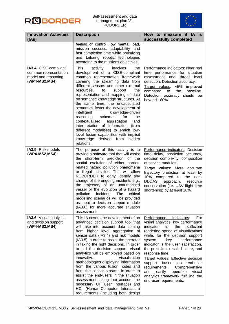
IA3.4: CISE-compliant common representation model and reasoning (WP4-MS2,MS4)
This activity involves the development of a CISE-compliant common representation framework covering the streaming data from different sensors and other external resources, to support the representation and mapping of data on semantic knowledge structures. At the same time, the encapsulated semantics foster the development of intelligent knowledge-driven reasoning schemes for the contextualised aggregation and interpretation of information (from different modalities) to enrich low-level fusion capabilities with implicit knowledge derived from hidden relations.
Performance indicators: Near real time performance for situation assessment and threat level detection. Detection accuracy.
Target values: ~5% improved compared to the baseline. Detection accuracy should be beyond ~80%.
IA3.5: Risk models (WP4-MS2,MS4)
The purpose of this activity is to provide a software tool that will assist the short-term prediction of the spatial evolution of either border-related hazard pollution phenomena or illegal activities. This will allow ROBORDER to early identify any change of the ongoing incidents e.g., the trajectory of an unauthorised vessel or the evolution of a hazard pollution incident. The critical modelling scenarios will be provided as input to decision support module (IA3.6) for more accurate situation assessment.
Performance indicators: Decision time delay, prediction accuracy, decision complexity, composition of service modules.
Target values: More accurate trajectory prediction at least by 10% compared to the non-DDDAS approach, resource conservation (i.e. UAV flight time shortening) by at least 10%.
IA3.6: Visual analytics and decision support (WP4-MS2,MS4)
This IA covers the development of an advanced decision support tool that will take into account data coming from higher level aggregation of sensor data (IA3.4) and risk models (IA3.5) in order to assist the operator in taking the right decisions. In order to aid the decision support, visual analytics will be employed based on innovative visualization methodologies displaying information from the various fusion nodes and from the sensor streams in order to assist the end-users in the situation assessment taking into account the necessary UI (User Interface) and HCI (Human-Computer Interaction) requirements (including both design
Performance indicators: For visual analytics, key performance indicator is the sufficient rendering speed of visualizations while, for the decision support system, key performance indicator is the user satisfaction, the precision, recall, f-score, and response time.
Target values: Effective decision support based on end-user requirements. Comprehensive and easily operable visual analytics framework fulfilling the end-user requirements.

Self-assessment and data management plan V1
ROBORDER
740593-ROBORDER-D8.2_Self-assessment_and_data_management_plan_V1 Page 18 of 28
Innovation Activities (IAs)
Description How to measure if IA is successfully completed
and data aggregation perspectives) in order to ensure the operational utility of the developed tools.
Table 4 – Self-assessment of IO3’s activities
2.1.4 IO4: ROBORDER platform development and integration
This objective deals with the integration of all subsystems which make part of the ROBORDER platform. The system architecture will be based on a trade off between existing open architecture frameworks that will facilitate the system design. For that, at an initial phase, a high-level description of the ROBORDER platform architecture is being prepared in which the consortium specifies the operational context of military capabilities in the form of a military Enterprise Architecture. Furthermore a system integration plan will be conceived taking special attention to the interfaces between the several subsystems of the ROBORDER project. A description of the IO4’s IAs and the respective performance indicators and target values to evaluate the successful implementation of these IAs are provided in the next table.
Innovation Activities (IAs)
Description How to measure if IA is successfully completed
IA4.1: System integration (WP5-MS1,MS2,MS3,MS4,MS5)
This IA involves a two-iteration spiral integration approach, taking into account STANAG 4559 and other relevant standards (e.g. OGC, SWE, JAUS, WMS/WFS, SensorML, GML, etc.) and the Joint C3 Information Exchange Data Model. Integrability checks will be performed during each of the following stages, leading up to the final integration campaign: initial assessment, high-level requirements, early code/mock-ups and test, complete requirements, full design, construction of complete modules, system test and acceptance.
Performance indicators: indicators: fraction of requirements met in laboratory environment, time spent, effort spent.
Target values: meeting all technical requirements in laboratory environment; completing system integration within project schedule and budget.
Table 5 – Self-assessment of IO4’s activities
2.2 User-oriented Objectives (UOs) In order to ensure a user-driven approach, ROBORDER is intended to be built upon the concept of co-design with end-users. To this end, the aforementioned innovation objectives (IO1-IO5) will be based on user-oriented objectives (UO) for addressing the user goals and requirements.
2.2.1 UO1: User requirements definition, end-user evaluation and validation
To ensure that any tools developed can be fully integrated with the operational ‘real world’ environment a user-centered design philosophy will be rigorously implemented, driven by end-users from the initial concept throughout the software development lifecycle. In table 6, a description of these User-oriented Activities (UAs) is provided, as well as the performance

Self-assessment and data management plan V1
ROBORDER
740593-ROBORDER-D8.2_Self-assessment_and_data_management_plan_V1 Page 19 of 28
indicators and target values to be used to evaluate the successful implementation of these during the project.
User-oriented Activities (UAs)
Description How to measure if UA is successfully completed
UA1.1: Use case creation and end-user requirements definition (WP1-MS1,MS3,MS4)
Nine different use cases, the targeting range of which ranges from illegal activities and illegal communications to pollution incidents occurred in land and marine borders of 9 different countries will be designed thoroughly, driven by the end-users and the real world environment in which they operate. These use cases will consider not only the current but also the future critical situations and needs faced by border authorities, therefore ensuring the focus of the ROBORDER’s development is beyond the current operational scenarios.
Performance indicators: Accuracy, reliability, concise user defined requirements are broad enough to meet the user needs.
Target values: Set of scenarios closely mapped to operational context and user needs that can effectively inform system development.
UA1.2: Test case simulations and user evaluation (WP1-MS1,MS3,MS4)
Test case simulations and user evaluation of the tools will take place in real-world operational settings to assess and validate their suitability, adaptability and effectiveness and to evaluate them using a number of measurable indicators against the objectives and expectations of the call. Evaluation will take place in an iterative cycle to ensure feedback from end-users can be incorporated into further design modifications.
Performance indicators: Specific KPIs for each use case.
Target values: The aim of the project is to achieve the level 7 of the TRL scale, so the evaluation should be focus on the achievement of this level.
UA1.3: Human-robot concept of operations (ConOps) (WP1-MS1,MS3,MS4)
A Concept of Operations for the human-robot interaction will be developed. The concept of operations demonstrates a joint cognitive system consisting of human operators, swarm of robots and automation. The roles of human operators and co-operation with other stakeholders will be defined and evaluated. The human-robot interfaces will support tele-operation of a swarm of robots while maintaining the operator’s situation awareness. The joint cognitive system can react to unexpected operational situations and adapt the operations accordingly. The training needs of operators are identified and addressed.
Performance indicators: Situational awareness of human operators. Effectiveness and efficiency of the inspection process. Handling of unexpected events. User experience of the operators.
Target values: Concept of operations balancing autonomous robot operations and human remote control will increase mission effectiveness and performance by 5% and reduce errors by the same amount.
Table 6 – Self-assessment of UA1’s activities

Self-assessment and data management plan V1
ROBORDER
740593-ROBORDER-D8.2_Self-assessment_and_data_management_plan_V1 Page 20 of 28
2.3 Impact-making Objectives (IMOs)
The impact-making objectives (IMOs) that are envisioned to ROBORDER outline the development of key strategies for 1) the exploitation of its main results, 2) exploring their wider use and sustainability, as well as their business feasibility. By involving relevant market and innovation stakeholders, ROBORDER is expected to provide a wide range of exploitation prospects, the potential for their wider use, and consequently impact to the economy and society.
2.3.1 IMO1: Dissemination and collaboration
In the context of ROBORDER, the dissemination of the project results with an emphasis in the border authorities, LEAs and security community, is one of the impact-making activities (IMAs) of the project, as well as the establishment of close collaborations with existing projects working in similar research domains and external interested bodies. A description of these IMAs as well as the target activities to ensure the successful conclusion of these IMAs, are provided in next table.
Impact-making Activities (IMAs)
Description How to measure if IMA is successfully completed
IMA1.1: Dissemination of project results (WP7-MS1,MS3,MS5)
This IMA comprises dissemination activities envisioned for the ROBORDER project, such as the presentation of project results in different workshops and user days, as well as the publication of scientific papers regarding the developments that are foresee during the project.
Target activities: To publish, at least, 15 scientific papers (to some of them, open access may be provided); to be present in several relevant scientific conferences; to organize 4 user days in order to show the ROBORDER platform to other entities than those of the ones already involved in the project; 3 demonstration workshops where the appropriate audience (LEAs) will be invited.
IMA1.2: Standardisation and collaboration with external bodies (WP7 - MS5)
This IMA deals with standardisation processes to be employed in the ROBORDER platform, as well as with the collaboration with external bodies in order to line the overall approach of the platform with similar developments currently being made in other projects in the area of border surveillance.
Target activities: To attend a minimum of 2 workshops and conferences on standardisation activities related to the use of swarm of robots in border surveillance; and to interact with at least 3 on-going projects in the area of border surveillance. These activities will be detailed in D7.7 (Report on Standards and Collaborations).
Table 7 – Self-assessment of IMO1’s activities
2.3.2 IMO2: Exploitation and sustainability model
The IMAs envisioned to IMO2 aim at analyzing market for existing solutions, elaboration of exploitation plan and the delivery of the project results by creating a product of border security use. In table 8, a description of these activities and the respective target activities to ensure the successful conclusion of these is provided.

Self-assessment and data management plan V1
ROBORDER
740593-ROBORDER-D8.2_Self-assessment_and_data_management_plan_V1 Page 21 of 28
Impact-making Activities (IMAs)
Description How to measure if IMO is successfully completed
IMA2.1: Market analysis for existing solutions (WP7 – MS3)
This IMA covers the market analysis to identify potential market for the integration of the different outcomes of the project in existing solutions.
Target activities: To perform the following – characterization and determination of market actors (service providers, manufacturers, etc), analysis of the environment, competition and trends, including a review of the main regulations in place regarding the sector/product, and to identify the potential market for ROBORDER results.
IMA2.2: Exploitation plan for the proposed tools (WP7 – MS4,MS5)
This IMA deals with the exploitation plan for the tools to be developed during the project.
Target activity: To develop the exploitation plan once the expected outcomes are fully documented.
IMA2.3: Sustainable product to be integrated to LEAs environments (WP7 - MS5)
This IMA covers the long-term sustainability plan for the delivery of a product to be integrated to LEAs environments.
Target activity: To develop a plan that identifies the innovative elements of the project and potential products.
Table 8 – Self-assessment of IMO2’s activities

Self-assessment and data management plan V1
ROBORDER
740593-ROBORDER-D8.2_Self-assessment_and_data_management_plan_V1 Page 22 of 28
3 Data Management Plan (DMP)
3.1 Purpose of the Data Management Plan A Data Management Plan (DMP) consists of a living document that describes the data management life cycle for the data collected, processed and generated by a H2020 project. It is considered a key element of good data management. The plan outlines how data will be created, managed, shared and preserved throughout the project, providing arguments for any restrictions that apply to any of these steps or any of the data. The EC encourages all projects to follow and apply principles that will allow all research data to be Findable, Accessible, Interoperable and Reusable (FAIR principles). The main goals of the DMP in ROBORDER can be summarized into the following:
Outline of the types of data already generated and/or foreseen for generation at this stage of the project;
Outline of the protocols that will be followed to assess generated/collected data with respect to their sensitiveness;
Data acquisition plan for the duration of the project;
Outline of the measures that are foreseen for the adequate management of the data from the ethical and security points of view; and,
Outline of the guidelines that will be followed in the project with respect to the Open Data initiatives.
The research data generated or created under the projects may include statistics, results of experiments, measurements, observations resulting from fieldwork, survey results, interview recordings and images. Although the consortium considered, at the proposal submission, the possibility of participating in the “Pilot on Open Research Data in Horizon 2020”, the consortium has to take into account that the majority of the deliverables that cover technological developments have as dissemination level RESTREINT UE, which means that it is not possible to provide open access to their results. The obligations to disseminate results (Article 29.1 of the GA) and to provide open access to scientific publications (Article 29.2 of the GA) do not, in any way, change the obligation of consortia to protect results, ensure confidentiality obligations and the security obligations or the obligations to protect personal data, all of which still apply. Consequently, consortium does not have to ensure open access to specific parts of their research data if the achievement of the action's main objective or the exploitation of results could be jeopardised. Whenever this is the case, the DMP will identify said data and explain the reasons for not giving access. As the project evolves and the research progresses, datasets may be created and may be subject to changes or updates in terms of the types, formats and origins of the data. Furthermore, the way the data is named or made accessible may change according to consortium policy changes and/or identification of potential for exploitation by project partners. Therefore, it is expected that the DMP will not remain unaltered throughout the project’s lifespan. This document constitutes the first version of the DMP and an official deliverable of the project as defined in the Grant Agreement (GA) of ROBORDER. The ROBORDER DMP will be updated at months 24 (April 2019) and 36 (April 2020) after the mid-term review and coincident with the final review respectively, as recommended in the EC Guidelines on FAIR Data Management in Horizon 2020.

Self-assessment and data management plan V1
ROBORDER
740593-ROBORDER-D8.2_Self-assessment_and_data_management_plan_V1 Page 23 of 28
3.2 Approach The ROBORDER DMP has been created and developed following the Guidelines on FAIR Data Management in Horizon 2020 published by the EC in 2016 as well as the UK’s Digital Curation Center (DCC) guide on How to Develop a Data Management and Sharing Plan and the European Research Council’s (ERC) Guidelines on Implementation of Open Access to Scientific Publications and Research Data from 2017. [5]
3.3 Maintenance of the ROBORDER DMP
The ROBORDER DMP will be maintained throughout the project’s lifespan by the coordinator with support from the other partners. This activity falls under WP8 of the project (Project Management).
3.4 ROBORDER data Large amounts of data in different formats will be collected and generated during the ROBORDER project. These will consist mainly into two types of data: (i) technological data, such as physical parameters, designs, blueprints for hardware, electronic circuit design, and technical data; and (ii) operational data, such as LEAs operational requirements and KPIs, current systems in use specifications, data related to its modus operandi, etc. These data will be shared only between the consortium partners and the EC within the scope of the project developments, and it will only be exploited if no sensitive data is present and only if it is according to the policies established under the Grant and Consortium Agreements of the project. Most of the data collected during the project will be placed in the official ROBORDER repository, where they will be available for authorized persons and will be properly secured against theft. Eventually, some of the data sets produced during the course of the project may be shared in the future with the scientific community in general, after ensuring that no sensitive data is present on these. The information regarding the sharing of such data sets will be included in Deliverable 8.4 which corresponds to the next version of the Data Management Plan to be submitted at month 24. At the moment of writing there are no datasets produced however, during the project lifespan, we will save all data sets (except the classified ones) in the project repository. Once the project is finished, or its results that rely on datasets are approved, the consortium will determinate the best approach to make the data sets accessible. These may be maintained in a dedicated server that will be managed by the project coordinator and its access may be done via a web channel with controlled access, that will require a registration by the interested parties directly with the coordinator (e.g. via email or project website). The following sub-sections describe the current picture of datasets to be generated or used in the project and provide answers to the questions of Annex 1 of the EC Guidelines on FAIR Data Management in Horizon 2020.
3.4.1 ROBORDER field tests dataset
3.4.1.1 Summary
3.4.1.1.1 What is the purpose of the data collection/generation and its relation to the objectives of ROBORDER?
The whole ROBORDER system will be tested in two demonstrations to address different border scenarios, namely land and maritime environments. Also, other small scale tests are

Self-assessment and data management plan V1
ROBORDER
740593-ROBORDER-D8.2_Self-assessment_and_data_management_plan_V1 Page 24 of 28
foreseen to validate and evaluate the performance of single modules in development in the scope of the project, e.g. the RF signal sensor (Task 2.3) or the Photonics-based radars (Task 2.6). The data collected under real world conditions in the demonstrations and small scale tests will be crucial to obtain data to be used to evaluate the sensors performance, to refine the algorithmic part of the system and to assess the operational capabilities of the system. Thus, the ROBORDER field test dataset is fundamental for achieving the project core objectives. It will be through this dataset that the final design of the system will be evaluated and characterized under real operational conditions.
3.4.1.1.2 What types and formats of data will ROBORDER generate/collect?
The data generated/collected within the field tests envisioned to happen during the project lifespan will consist of:
Heterogeneous data in standard formats to be decided by consortium partners (e.g. jpg for still images or h264 videos) generated by the multiple cameras and sensors installed onboard the UxVs or on top of fixed structures (e.g. optical and thermal cameras, RF signal sensor, passive radar, photonics-based radars, etc).
Performance data of the assets as well in standard formats, namely UxVs and other relevant equipment used during the field tests (e.g. in the case of the UAVs, telemetry data and system diagnosis data such as altitude, position, heading, attitude, thrust, airspeed, ground speed, battery levels, etc).
System operational data including time spent to detect and identify threats, efficiency in performing the desired tasks, time for re-adaptation to new mission requirements, etc.
3.4.1.1.3 Will you re-use any existing data and how?
During the first implementation phase of the detection and identification algorithms, various open access databases will be utilized. These databases are mostly related to visual data and refer to the deployed algorithms and their objectives, depending on the project’s real operational scenarios. Thus, relevant data and databases will be re-used accordingly to train and test the detection and identification models during the first phase of the project so that, the developed algorithms could be tested instantly when the ROBORDER dataset will be available and in real operational scenarios.
3.4.1.1.4 What is the origin of the data?
The data for the ROBORDER dataset will be generated among partners of the ROBORDER in both the small scale field tests and the demonstrations envisioned for the project. The generation procedures will be described in detail in the appropriate deliverables and associated with the dataset.
3.4.1.1.5 What is the expected size of the data?
Currently, the expected size of the dataset is unknown and no safe estimation could be valid.
3.4.1.1.6 To whom might it be useful ('data utility')?
The ROBORDER dataset will be useful to the entire consortium (namely in helping accomplish the project objectives) as well as for other researchers wishing to evolve the work of ROBORDER and potential customers interested in new security methods for mobile robots and autonomous systems based on the ROBORDER’ technology.

Self-assessment and data management plan V1
ROBORDER
740593-ROBORDER-D8.2_Self-assessment_and_data_management_plan_V1 Page 25 of 28
3.4.1.2 FAIR
3.4.1.2.1 Making data Findable (including provisions for metadata)
The ROBORDER dataset will be made discoverable through the association of metadata to the dataset. At the moment of writing the type of metadata and identification mechanism to be applied is not yet defined. The process or standard to be used to create the metadata is not clear yet. However, the consortium expects to associate the following metadata to the dataset:
Date of measurement
Target classification
Time of measurement
Location (coordinates) of measurement Files in the dataset will be clearly named. All files in the dataset will allow the clear identification of the version. This may be achieved through the addition of a version suffix to the filename or by supporting versioning in the ROBORDER repository. The chosen solution is not defined at the moment, but it may be something similar to the following: ROBORDER_UCx_Loc_Sensor_num_Version_file.exension, meaning: UCx – the x Use
Case; Loc – the location of the acquisition; Sensor – the type of the sensor; Num – the number of the data streaming; and Version – the version of the respective data.
3.4.1.2.2 Making data openly Accessible
Currently, the consortium expects to make most of the ROBORDER dataset openly available. The consortium expects to make the dataset available through the project’s repository (which is foreseen to support versioning). The repository is maintained by the project coordinator and access to it is authenticated. Access to the repository will be enabled through a web interface that only allows download of the dataset (i.e. it will not be possible to delete, upload, check-out or commit other files). Registration to the repository will be required and will consist in providing the name, entity and reason of interest or foreseen purpose of use for the ROBORDER dataset.
3.4.1.2.3 Making data Interoperable
The collected/generated data will be provided in standard formats and units as mentioned before.
3.4.1.2.4 Increase data Re-use (through clarifying licences)
It is expected that the data will not be available for re-use after the conclusion of the project. Nevertheless, it is not clear if licensing will be applied nor if an embargo period will be needed. Further to the ‘FAIR’ principles, DMPs should also address the allocation of resources; data security and the ethical aspects. Accordingly, we explain each one on the next sections.
3.4.1.3 Allocation of resources
At the moment, and based on the assumptions and plan described above, the costs for making the ROBORDER dataset FAIR will be covered by the regular testing activities of the project and by project management. Data management responsibility lies with the project coordinator through WP8. The consortium has not analysed or estimated the costs and/or potential benefits of long term preservation of the ROBORDER dataset.

Self-assessment and data management plan V1
ROBORDER
740593-ROBORDER-D8.2_Self-assessment_and_data_management_plan_V1 Page 26 of 28
3.4.1.4 Data security
ROBORDER’s dataset will not include sensitive data. The dataset will be stored in the project repository which is hosted in a server of the project coordinator’s IT infrastructure. The repository supports version control which should be enough to ensure data recovery in case of accidental deletions. Data back-ups will be done according to the internal IT policy of the project coordinator as applicable to all other relevant digital data of the company. Access to the data will only be possible through authenticated access to the repository: one account per partner and one account per external individual (i.e. not belonging to the consortium) requesting access to the data.
3.4.1.5 Ethical aspects
All kind of data sharing may well have ethical or legal issues if the controller/processor does not act in accordance with the proper set of laws as well as principles. Therefore, our WP9 is entirely dedicated to ‘Ethics requirements’ throughout its six deliverables, all confidential and only available for members of the consortium, including the Commission Services. Since copies of ethics approvals for the research with humans; authorizations or/and notifications by the appropriate National Data Protection Authorities; relevant authorisations for the use of secondary personal data if data not publicly available; approvals for the operations of UAVs; details on potential dual use implications of the project and risk-mitigation strategies and a report by the ethics Advisor that will be submitted to the Commission. WP9 fully complies with the latest H2020 ethical guidelines and with the ‘GDPR’ - General Data Protection Regulation (EU) 2016/679. Accordingly, an appropriate questionnaire named ‘Collection and Processing of Personal Data Assessment’ was build and sent to all Consortium partners in order to identify potential ethical/privacy issues raised from their activities. Informed consents will be done as well, if applicable.
3.4.1.6 Other issues
No other issues were so far identified regarding the ROBORDER dataset.
3.5 Other data At the moment of the writing of this document, no other relevant data was so far identified.

Self-assessment and data management plan V1
ROBORDER
740593-ROBORDER-D8.2_Self-assessment_and_data_management_plan_V1 Page 27 of 28
Acknowledgements
The deliverable has been completed thanks to the support of ROBORDER partners who provided their contributions to be integrated in the document, as well as participated in the review of the document’s content.

Self-assessment and data management plan V1
ROBORDER
740593-ROBORDER-D8.2_Self-assessment_and_data_management_plan_V1 Page 28 of 28
References
[1] D.-G. f. R. &. I. H. P. European Commission, Guidelines on FAIR Data Management in Horizon 2020, Version 3.0, July 2016..
[2] U. C. Dublin, Data Management Checklist, October 2017.
[3] E. D. D. Curation, Checklist for a Data Management Plan. v.4.0., 2013.
[4] J. C. Purdue University, “Data Management Plan Self‐Assessment Questionnaire and "DMP Self-Assessment Tool", West Lafayette, 2011.
[5] E. R. Council, Guidelines on Implementation of Open Access to Scientific Publications and Research Data in projects supported by the European Research Council under Horizon 2020, Version 1.1, April 2017.